cogo framework report card - the federal geographic data committee
TRANSCRIPT

COGO Framework Report Card
David Cowen
NGAC Meeting
September 18, 2012

Outline • COGO Initiative (Unanimous 11 Member organizations )–
• Purpose – Qualitative Assessment of progress to create and maintain eight framework data layers as defined in Executive Order 12906 of April 11, 1994
– completing the initial implementation of a national digital geospatial data framework ‘‘framework’’ by January 2000 and for establishing a process of ongoing data maintenance.
• Mapping Science Committee concluded in 2001 National Spatial Data Infrastructure Partnership Programs: Rethinking the Focus
“But we found a lack of procedures in the FGDC for long‐term monitoring of the progress of NSDI. Such procedures would be of great value in assessing whether the NSDI program succeeds in moving beyond the missionary phase, and in arguing for future funding allocations.
Accordingly, the committee recommends that the FGDC develop metrics that can be used to monitor long‐term progress in the adoption of the principles and programs of the NSDI among agencies at all levels of govern.”

Current list of COGO Member Organizations
• American Congress on Surveying and Mapping (ACSM)• American Society for Photogrammetry and Remote Sensing (ASPRS)• Association of American Geographers (AAG)• Cartography and Geographic Information Society (CAGIS)• GIS Certification Institute (GISCI)• International Association of Assessing Officers (IAAO)• Management Association for Private Photogrammetric Surveyors
(MAPPS)• National States Geographic Information Council (NSGIC)• United States Geospatial Intelligence Foundation (USGIF)• University Consortium for Geographic Information Science (UCGIS)• Urban and Regional Information Systems Association (URISA)

Members
• Jim Geringer – former Governor of Wyoming (Chairman)• John Bossler, PE, LS, PhD – former NOAA C&GS Director, former Ohio State
University Center for Mapping Director• Robert C. Burtch, PS, CP – Professor, Ferris State University• David Cowen, PhD – former NRC Mapping Sciences Committee Chairman• Kenneth Fleming – former photogrammetry firm owner, past President of
MAPPS, and a local government elected official (Councilman on the merged City of Louisville/Jefferson County, KY Metro Council)
• Michael Janus – Formerly VP of Tenix LADS, former Mississippi State legislator, city manager of D'Iberville, Mississippi
• Susan Carson Lambert – REP, GISP, MSC member, past NSGIC President, former KY State GIS Coordinator
• John Moeller, former FGDC Executive• Harlan Onsrud, PE, LS, JD – Professor, University of Maine – Orono, former
MSC member• Tom Rust – PE, CEO of Patton, Harris & Rust, Virginia State Legislator• Bob Welch – LS, former Wisconsin State Senate President Pro Tem

Factors to Consider
Generate a qualitative assessment (report card) of framework data
– Currentness
– Completeness (which may include interoperability & metadata)
– Scale/Resolution
– Accessibility

Executive Order 12906 of April 11, 1994
• Sec. 5. National Digital Geospatial Data Framework. In consultation with State, local, and tribal governments and within 9 months of the date of this order, the FGDC shall submit a plan and schedule to OMB for completing the initial implementation of a national digital geospatial data framework (‘‘framework’’) by January 2000 and for establishing a process of ongoing data maintenance.
• The framework shall include geospatial data that are significant, in the determination of the FGDC, to a broad variety of users within any geographic area or nationwide. At a minimum, the plan shall address how the initial transportation, hydrology, and boundary elements of the framework might be completed by January 1998 in order to support the decennial census of 2000.
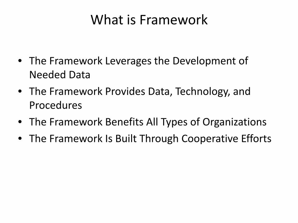
What is Framework
• The Framework Leverages the Development of Needed Data
• The Framework Provides Data, Technology, and Procedures
• The Framework Benefits All Types of Organizations
• The Framework Is Built Through Cooperative Efforts

NSDI framework layers
• Geodetic Control ‐‐ National Geodetic Survey
• Cadastral ‐‐ Bureau of Land Management
• Orthoimagery ‐‐ U. S. Geological Survey
• Elevation ‐‐ U. S. Geological Survey
• Hydrography ‐‐ U. S. Geological Survey
• Administrative Units ‐‐ U. S. Census Bureau
• Transportation ‐‐ Department of Transportation
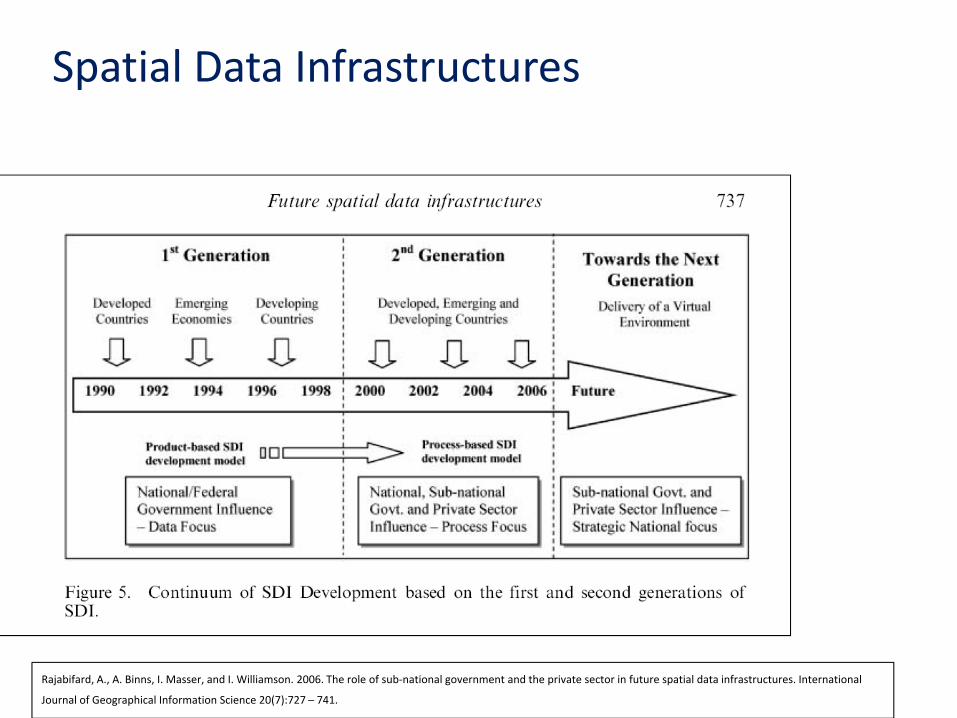
Rajabifard, A., A. Binns, I. Masser, and I. Williamson. 2006. The role of sub‐national government and the private sector in future spatial data infrastructures. International
Journal of Geographical Information Science 20(7):727 – 741.
Spatial Data Infrastructures

Extra Benefits for Early Adopters
• Innovative organizations establish their positions as leaders in their fields.
• Early development of data, services, and expertise could give your organization a market advantage.
• Early participation could speed resolution of persistent problems caused by conflicting data.
• Early participation could position you to respond quickly when a need for data arises.
• Earlier participation means greater savings because benefits and savings accrue over a longer period.
• Simple steps that lead to framework participation also benefit your GIS development and operation. By following framework guidelines, you get immediate local GIS benefits.
• Early participants will have a bigger influence on how the framework is developed.
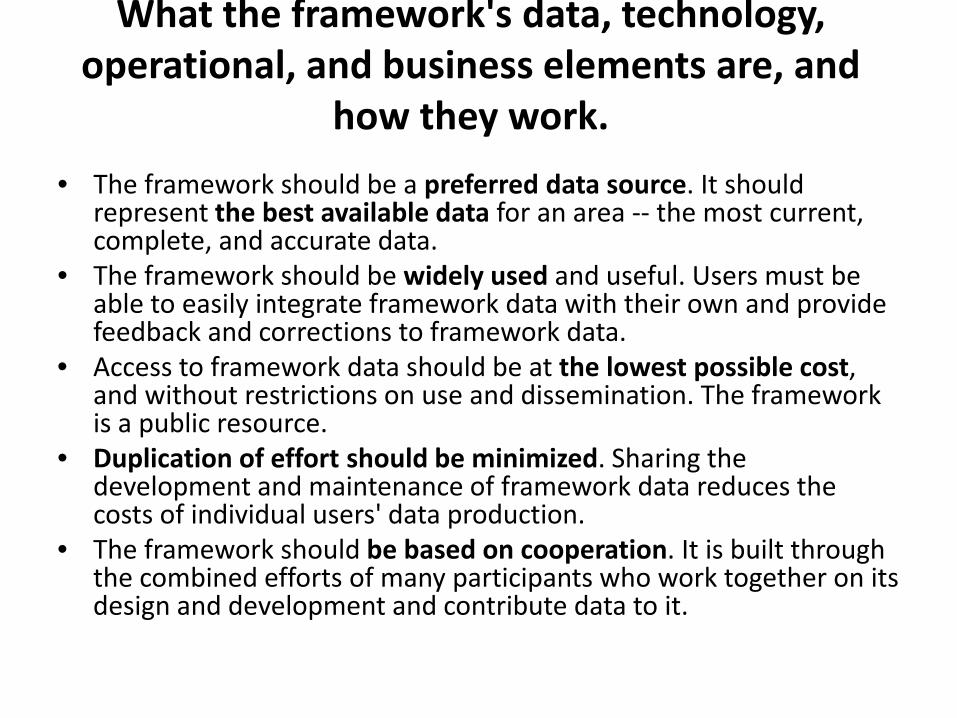
What the framework's data, technology, operational, and business elements are, and
how they work.
• The framework should be a preferred data source. It should represent the best available data for an area ‐‐ the most current, complete, and accurate data.
• The framework should be widely used and useful. Users must be able to easily integrate framework data with their own and provide feedback and corrections to framework data.
• Access to framework data should be at the lowest possible cost, and without restrictions on use and dissemination. The framework is a public resource.
• Duplication of effort should be minimized. Sharing the development and maintenance of framework data reduces the costs of individual users' data production.
• The framework should be based on cooperation. It is built through the combined efforts of many participants who work together on its design and development and contribute data to it.

Benefits of Participation
• save money by sharing the costs of data production and reducing duplicative efforts;
• develop applications faster and more easily by using existing data or data development standards;
• improve customer satisfaction through better data, faster response, and improved operations; provide better data for decision making;
• save development effort by using framework data standards and standardized data, guidelines, and tools;
• utilize data produced by others more quickly through the use of common formats and access methods;
• resolve problems created by conflicting data;
• redirect resources associated with duplicate data production and maintenance to your primary business activities;
• perform analyses, decision making, and operations in cross‐jurisdictional areas;
• reduce the load from data requests by providing direct access to your data through the framework;
• attract clients who need data that are registered to the framework;
• expand market potential and program funding through recognition and credibility as a framework participant;
• and provide consolidated direction to vendors regarding needed technical features.

Mapping Science Committee – Framework Related Studies
1990 1993 1994 1995
1997 2001 2003 2004

Mapping Science Committee – Specific Data Themes

National Spatial Data Infrastructure Partnership Programs: Rethinking the Focus
1996 —$1.1 million supported 31 projects, with an emphasis on Frameworkdevelopment.

National Spatial Data Infrastructure Partnership Programs: Rethinking the
Focus
• To be convincing, such demonstrations should satisfy certain criteria:
• Scale. Demonstrations should be large enough to provide unambiguous results, and sufficient resources should be provided to ensure that there is sufficient time for the project to be completed.
• Visibility. Demonstrations should be widely visible to the geospatial data community, and sufficient resources should be provided to ensure that results are widely disseminated. This can be in the form of virtual town hall meetings and “cookbooks” that demonstrate clear success stories that should be widely distributed at professional meetings attended by local government officials and workers.
• Rigor. Demonstrations should be designed according to appropriate scientific principles, with solid experimental designs that will ensure that the findings can be extended to other areas. This should include efforts to better understand the impediments to successful adoption of the goals of the NSDI.

National Spatial Data Infrastructure Partnership Programs: Rethinking the
Focus
• How can the federal government use partnership programs to address the Framework data production goal most effectively?• Identify whether critical components of the Framework database are being adequately addressed,
• Increase the scale, scope, and accountability of partnership activities.
• Offer creative incentives for non‐federal organizations to carry out their Framework data production and maintenance missions.
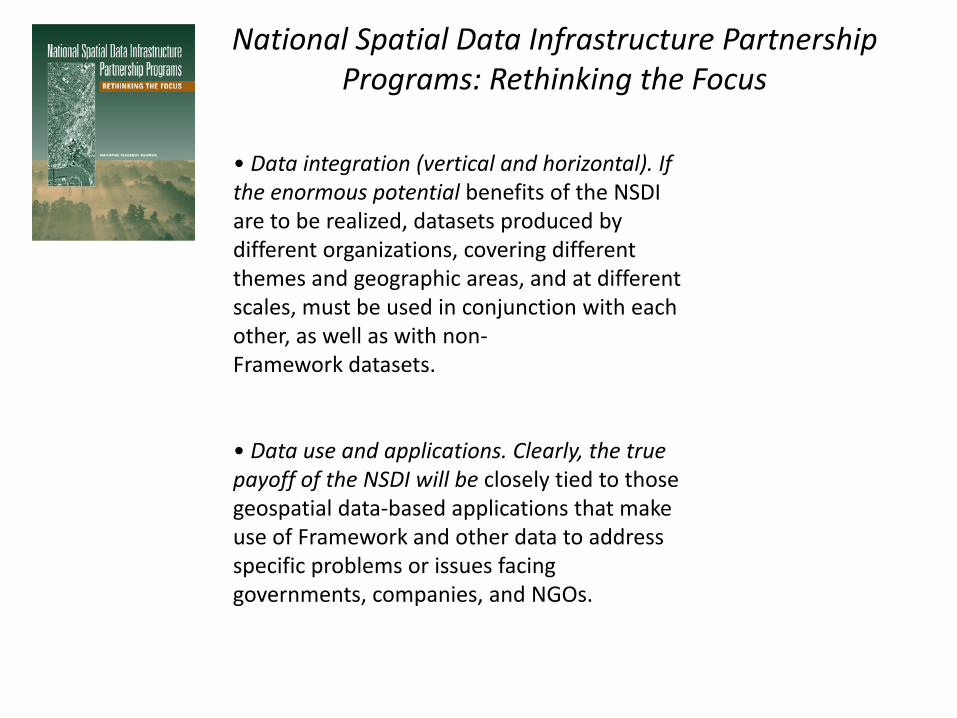
National Spatial Data Infrastructure Partnership Programs: Rethinking the Focus
• Data integration (vertical and horizontal). If the enormous potential benefits of the NSDI are to be realized, datasets produced by different organizations, covering different themes and geographic areas, and at differentscales, must be used in conjunction with each other, as well as with non‐Framework datasets.
• Data use and applications. Clearly, the true payoff of the NSDI will be closely tied to those geospatial data‐based applications that make use of Framework and other data to address specific problems or issues facing governments, companies, and NGOs.

ARGUMENTS FOR AN EXTENDED FRAMEWORK

National Spatial Data Infrastructure Partnership Programs: Rethinking the Focus
There are at least nine major steps necessary to realize this extendedFramework:1. Definition of the contents of the city, county, or local extended Framework.2. Definition of the contents of the state or tribal nation extended Framework.3. Definition of the extended Framework hardware architecture.4. Definition of coordination mechanisms.5. Assignments for layer responsibilities.6. Definition of quality standards (collection and maintenance) andprocedures for the development of the extended Framework at all levels.7. Data generation in agreement with the corresponding Framework.8. Data maintenance program.9. Budget allocation.

ROLES OF PRIVATE INDUSTRY AND NON‐PROFITORGANIZATIONS
There are at least two roles for private industry and nonprofit organizations in the creation of an extended Framework:1. Performing the actual data capture and database creation under contract to governmental units; and2. Involvement in consortia of private firms, nonprofit organizations, and governmental units in collecting and maintaining necessary data.

National Spatial Data Infrastructure Partnership Programs: Rethinking the
Focus
• Conclusions – “However, with respect to the other goals of the specific FGDC
partnership programs, we find little evidence that these programs have reduced redundancy in geospatial data creation and maintenance, reduced the costs of geospatial data creation and maintenance, or improved the accuracy of the geospatial data used by the broader community.”
– For all three goals, little evidence has been found to demonstrate conclusively that the concept of the NSDI and its furtherance through partnerships has had any dramatic impact on overcoming the significant institutional barriers that inhibit the development and maintenance of spatial data. Without such evidence, we fear that the momentum established as a result of the missionary efforts during these seven years will dissipate, and that the NSDI will fail to achieve its promise.

Next Steps
• Share current documents to bring committee up to date
• Determine a schedule and methodlogy
