colin bray, ce, osi, 'ordnance survey ireland: mapping our future'. 19-11-2014
TRANSCRIPT

19 November 2014
Mapping Our Future
RIA Lunchtime Lecture
Ordnance Survey Ireland: Mapping Our FutureLinking the physical world to
the digital world
Colin Bray, OSi Chief Executive& Chief Survey Officer
RIA Lunchtime Lecture, 19th November 2014

19 November 2014
Mapping Our Future
RIA Lunchtime Lecture
Introduction
• Ordnance Survey today
• Continuous innovation & change
• Next generation national mapping
• Summary

19 November 2014
Mapping Our Future
RIA Lunchtime Lecture
• The map-making of the Ordnance Survey: challenges on every front
• The Ordnance Survey Six-inch Mapping Project: political and cultural agendas
• Translations? The Ordnance Survey and Irish place-names
• George Petrie’s “Topographical Department” (1835-42)
• Glimpses of Ireland’s past: drawings in the Ordnance Survey Memoirs
• John O’Donovan’s work for Ordnance Survey
• From Rocque to the Ordnance Survey: mapping Dublin 1756 to 1847
• Dublin in 1847: city of the Ordnance Survey

19 November 2014
Mapping Our Future
RIA Lunchtime Lecture
Ordnance Survey today

19 November 2014
Mapping Our Future
RIA Lunchtime Lecture
• Established in 1824 (190 years)
• Established as a State Body in 2002 under the OSi Act 2001
• 228 staff (public servants)
• Head Office in Phoenix Park, Dublin with 6 Regional Offices
• Create & maintain the definitive spatial reference information for the State
• OSi, Valuation Office & Property Registration Authority to merge
OSi – The National Mapping Agency
19 November 2014
Mapping Our Future
RIA Lunchtime Lecture
To provide a national mapping service in the State… creating and maintaining the definitive national mapping and related geographic records
• to maintain and develop the underlying physical infrastructure which is needed to support mapping applications, including to maintain a national grid and the national geodetic and height frameworks and to link these to international systems,
• to create and maintain for the entire State mapping and related geographic databases which have national consistency of content, currency, style and manner including those areas which do not provide a commercial return on the activity,
• to provide mapping and related geographic information to the public and private sectors in support of social, economic, legislative, educational, security, business and administrative functions and requirements,
OSi Functions (1) – OSi Act 2001

19 November 2014
Mapping Our Future
RIA Lunchtime Lecture
• to encourage and promote the benefits of the use of the national mapping and related databases and the development of products, services and markets to meet national and user needs,
• to advise the Government, a Minister of the Government, a body established by or under statute and other public sector organisations on matters relating to the policy and practice of survey, mapping and geographic information and on the development of national spatial data infrastructures,
• to represent the State at international level on matters relating to mapping and geographic information,
• to provide the necessary technical support to the Chief Boundary Surveyor in the performance of his or her duties in delimiting statutory boundaries and the delineation of such boundaries on maps,
OSi Functions (2) – OSi Act 2001
19 November 2014
Mapping Our Future
RIA Lunchtime Lecture
• to depict place-names and ancient features in the national mapping and related records and databases including the Irish language equivalent of place-names as advised by An Coimisiún Logainmneacha and declared in place-names orders made under section 2 of the Place-Names (Irish Forms) Act, 1973,
• to protect the Government copyright on OSI records, databases, products and published material including copyright on OSI records, databases, products and published material made prior to the establishment day.
OSi Functions (3) – OSi Act 2001

19 November 2014
Mapping Our Future
RIA Lunchtime Lecture
OSi Products & Services
Small Scale Data
1:210,000 Holiday1:450,000 Ireland1:600,000 Ireland
Medium Scale Data
1:10-15,000 Digi-City1:10,000 Digi- Town1:50,000 Discovery
Large Scale Data
1:1,000, 1:2,500 and 1:5,000 PLACE Maps
National Imagery
1m per pixel ortho-photography
LiDAR Data
Digital Terrain ModelDigital Surface Model
Boundary Data
CountyED
TownlandsSmall Area
City & Town Imagery
25cm per pixel ortho-photography
Updated every 1, 3 and 5 years
Cities &Towns
Services
Online ShopPublic Viewer
Environmental ReportsWeb Services

19 November 2014
Mapping Our Future
RIA Lunchtime Lecture
Who we work with …
Central Government, Local Authorities, Utilities, Banks, Insurance, Transport, Emergency, Architects, Engineers, Planners, Surveyors, Solicitors etc.

19 November 2014
Mapping Our Future
RIA Lunchtime Lecture
Data Collection Expertise
• 60% of staff involved in production activities
• 12% field surveying staff
• 8% of staff in IT activities
• Two leased aircraft/pilot with OSi crews
• Fully digital workflows (ISO Certification for remote sensing flowlines)
• Photogrammetry
• Field • Comp
letion
• Graphic
• Completion
• Databasing
• Supply

19 November 2014
Mapping Our Future
RIA Lunchtime Lecture
Data Management Expertise
• Digital data from 1824 - 2014
• Manage over 1 Petabyte of data
• Official reference site for Oracle Spatial Technology
• Data centers in Phoenix Park, Regional Offices and Amazon Cloud
• Developed and maintain the INSPIRE technical infrastructure for Ireland

19 November 2014
Mapping Our Future
RIA Lunchtime Lecture
Continuous Innovation & Change

19 November 2014
Mapping Our Future
RIA Lunchtime Lecture
Mapping Series
1st Edition 6” (1824-1846) 1st Edition 25” (1887-1913)
New Mapping (1985-2005)

19 November 2014
Mapping Our Future
RIA Lunchtime Lecture
Reference Frameworks
• Principal Triangulation (1924-1832)
Lough Foyle Base Line (1827-28)

19 November 2014
Mapping Our Future
RIA Lunchtime Lecture
Reference Frameworks
• Principal Triangulation (1924-1832)
• Primary Triangulation of Ireland (1958-1969)

19 November 2014
Mapping Our Future
RIA Lunchtime Lecture
Reference Frameworks
• Principal Triangulation (1924-1832)
• Primary Triangulation of Ireland (1958-1969)
• IRENET95 - Passive GPS Network
MADR
WETT
KOSG
ONSA
ZIMM
HERS
IRENET
Fiducial (IGS)GB
Key to GPS StationsZ001
Z002Z003
Z004Z005
Z006
Z007Z008
Z009 Z010 Z011
Z097Z096Z095
Z099
Z012
D106
D108 D109
D112
D111D113
D115
D128
D101
D100Z009
D097 D098
D103
D110
D099
D104
D117
D118
D129
D119
D122
D123
D121
D124
D126
D125
D171D168D169
D166
D170
D093
D091 D092
D095D096
D089
D120
D159
D162
D164
D161
D084D087 D088
D131D157
D154D152 D153
D158
D074 D075
D079D080
D076
D081
D086
Z006
D082
D090D141
D173
D140
D142
Z007D148
D151D147
D150
D067
D066
D072
Z005D068
D073D070
D071
D135
D137
D062
D058
D063 D064D065
D048
D134D133
D055
D059 D060 D046
D030
D031
D044
D032
D047
D043D042
D041
D034
D052
D035
D040
D053
D054
D038
D013D028
D014
D027D026
D016
D017 D018
D023 D022
Z002
D021
D020
D037
D001
D002D003
D011
Z001
D004
D009
D005
D008
D006
D107
D114
D116
D105
D102
D127 D130Z010
D165
D172
Z011 D167
D094 D132
D160
D163
D083
Z008
D085D155
D156
D078
D077
D143
D149
D144D145D146
D069D136
D138D139
D061D050
Z004D051
D029
D045Z003
D049
D033D036
D039
D015
D025D024
D019
D056
D012 D010D007

19 November 2014
Mapping Our Future
RIA Lunchtime Lecture
Reference Frameworks
• Principal Triangulation (1924-1832)
• Primary Triangulation of Ireland (1958-1969)
• IRENET95 - Passive GPS Network
• Active GNSS Network (current)

19 November 2014
Mapping Our Future
RIA Lunchtime Lecture
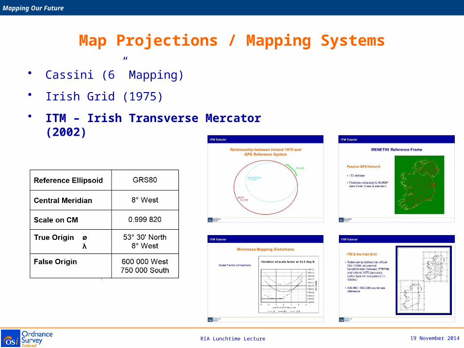
Map Projections / Mapping Systems
• Cassini (6” Mapping)

19 November 2014
Mapping Our Future
RIA Lunchtime Lecture
Map Projections / Mapping Systems
• Cassini (6” Mapping)
• Irish Grid (1975)
19 November 2014
Mapping Our Future
RIA Lunchtime Lecture
Map Projections / Mapping Systems
• Cassini (6” Mapping)
• Irish Grid (1975)
• ITM – Irish Transverse Mercator (2002)

19 November 2014
Mapping Our Future
RIA Lunchtime Lecture
Height Datum
• Poolbeg Lighthouse (1837)
Low water mark of the spring tide on the 8th April 1837
Initially fixed for County Dublin, adopted as national datum approximately 5 years later
Heights above this datum were given in (Imperial) feet
19 November 2014
Mapping Our Future
RIA Lunchtime Lecture
Height Datum
• Poolbeg Lighthouse (1837)
• Malin Head (1970)
Mean Sea Level of tide gauge from readings taken between Jan 1960 and Dec 1969
All heights since 1970 in International metres above this datum
Malin Head datum approximately 2.7m above Poolbeg Lighthouse datum

19 November 2014
Mapping Our Future
RIA Lunchtime Lecture
Height Datum
• Poolbeg Lighthouse (1837)
• Malin Head (1970)
• OSGM02
Land SurfaceGEOID
Ellipsoid Sea
Hh
p
verticalnormal
deviation of the verticalLand Surface
N
Ordnance Survey Geoid Model 2002

19 November 2014
Mapping Our Future
RIA Lunchtime Lecture
Surveying Technology
Photogrammetry (1965) Analogue (1965) Computerisation (mid 1970’s)
Flying Activities (1979) Analytical (1982) GPS (1989)

19 November 2014
Mapping Our Future
RIA Lunchtime Lecture
Surveying Technology
Field Computers (1998/2004)Digital (1992) Film Scanning (1992)
LiDAR (2004)Digital Sensor (2005)

19 November 2014
Mapping Our Future
RIA Lunchtime Lecture
Next Generational National Mapping

19 November 2014
Mapping Our Future
RIA Lunchtime Lecture
Real World Object Orientated data model
• Seamless & scale independent• Non-proprietary• Rigorously based on industry standards• Data Storage Model with attribution• OSi’s version of the real world, but extensible• Data consolidation project (single point of truth)
• 3 Key Phases
– Data modelling (2007 – 2010)
– Data re-engineering (2011 – 2013)
– Systems & Infrastructure (2013 – 2014)
19 November 2014
Mapping Our Future
RIA Lunchtime Lecture
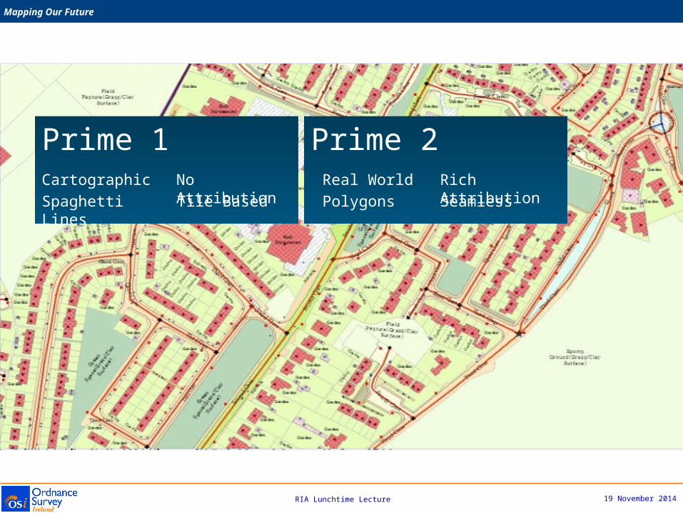
Prime 1 Prime 2CartographicSpaghetti Lines
No AttributionTile Based Seamless
Rich Attribution
Real WorldPolygons

19 November 2014
Mapping Our Future
RIA Lunchtime Lecture
Prime2 is one of the most significant developmentsin Ordnance Survey Ireland’s 190 years
From Cartographic Map Sheetsto Real-World Features
Lithographic Stone Copperplate Printing Multi Resolution Cartographic Tiles
From updating 14,000 Cartographic Map Sheet to maintaining 50m Real-World objects

19 November 2014
Mapping Our Future
RIA Lunchtime Lecture
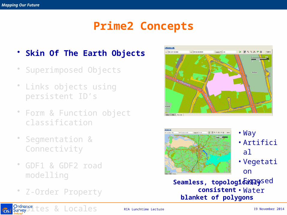
• Skin Of The Earth Objects
• Superimposed Objects
• Links objects using persistent ID’s
• Form & Function object classification
• Segmentation & Connectivity
• GDF1 & GDF2 road modelling
• Z-Order Property
• Sites & Locales
• 3D data storage (CityGML LOD2)
Prime2 Concepts
19 November 2014
Mapping Our Future
RIA Lunchtime Lecture
• Skin Of The Earth Objects
• Superimposed Objects
• Links objects using persistent ID’s
• Form & Function object classification
• Segmentation & Connectivity
• GDF1 & GDF2 road modelling
• Z-Order Property
• Sites & Locales
• 3D data storage (CityGML LOD2)
• Way• Artificial• Vegetation• Exposed• Water
Seamless, topologically consistentblanket of polygons
Prime2 Concepts

19 November 2014
Mapping Our Future
RIA Lunchtime Lecture
• Skin Of The Earth Objects
• Superimposed Objects
• Links objects using persistent ID’s
• Form & Function object classification
• Segmentation & Connectivity
• GDF1 & GDF2 road modelling
• Z-Order Property
• Sites & Locales
• 3D data storage (CityGML LOD2)
Prime2 Concepts

19 November 2014
Mapping Our Future
RIA Lunchtime Lecture
• Skin Of The Earth Objects
• Superimposed Objects
• Links objects using persistent ID’s
• Form & Function object classification
• Segmentation & Connectivity
• GDF1 & GDF2 road modelling
• Z-Order Property
• Sites & Locales
• 3D data storage (CityGML LOD2) GUID - Globally Unique IDentifier
Prime2 Concepts

19 November 2014
Mapping Our Future
RIA Lunchtime Lecture
• Skin Of The Earth Objects
• Superimposed Objects
• Links objects using persistent ID’s
• Form & Function object classification
• Segmentation & Connectivity
• GDF1 & GDF2 road modelling
• Z-Order Property
• Sites & Locales
• 3D data storage (CityGML LOD2)
FormPhysical form of an
object as it exists in the real world
i.e. Building, Pylon, Field, River, Lake
Function‘Use’ or ‘Purpose’ of
an object in the real world
i.e. Residential, Army Barracks, Electricity
Supply, Agricultural, Reservoir
Prime2 Concepts

19 November 2014
Mapping Our Future
RIA Lunchtime Lecture
• Skin Of The Earth Objects
• Superimposed Objects
• Links objects using persistent ID’s
• Form & Function object classification
• Segmentation & Connectivity
• GDF1 & GDF2 road modelling
• Z-Order Property
• Sites & Locales
• 3D data storage (CityGML LOD2) Full geometric network connectivity on Roads, Rail and Rivers
Prime2 Concepts

19 November 2014
Mapping Our Future
RIA Lunchtime Lecture
• Skin Of The Earth Objects
• Superimposed Objects
• Links objects using persistent ID’s
• Form & Function object classification
• Segmentation & Connectivity
• GDF1 & GDF2 road modelling
• Z-Order Property
• Sites & Locales
• 3D data storage (CityGML LOD2)
ZOrder = -1
Prime2 Concepts
19 November 2014
Mapping Our Future
RIA Lunchtime Lecture
• Skin Of The Earth Objects
• Superimposed Objects
• Links objects using persistent ID’s
• Form & Function object classification
• Segmentation & Connectivity
• GDF1 & GDF2 road modelling
• Z-Order Property
• Sites & Locales
• 3D data storage (CityGML LOD2)
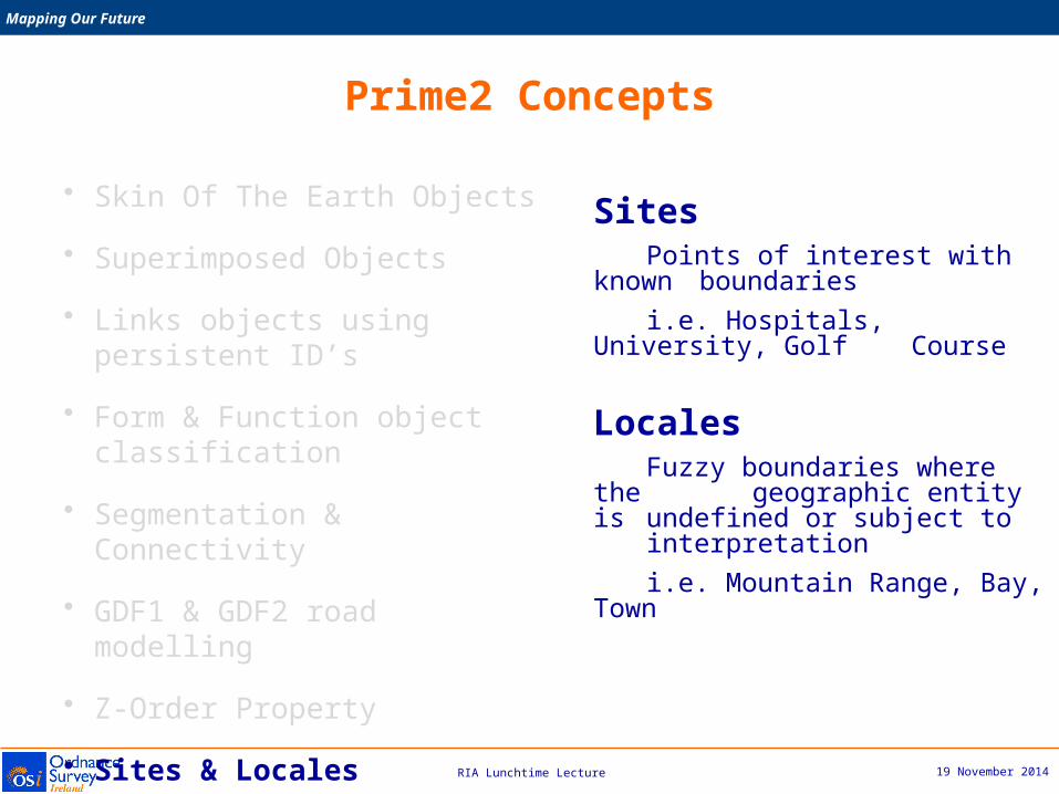
SitesPoints of interest with known boundariesi.e. Hospitals, University, Golf Course
LocalesFuzzy boundaries where the geographic entity is
undefined or subject to interpretation
i.e. Mountain Range, Bay, Town
Prime2 Concepts

19 November 2014
Mapping Our Future
RIA Lunchtime Lecture
• Skin Of The Earth Objects
• Superimposed Objects
• Links objects using persistent ID’s
• Form & Function object classification
• Segmentation & Connectivity
• GDF1 & GDF2 road modelling
• Z-Order Property
• Sites & Locals
• 3D data storage (CityGML LOD2)
Prime2 Concepts

19 November 2014
Mapping Our Future
RIA Lunchtime Lecture
Relationships between building and roads
19 November 2014
Mapping Our Future
RIA Lunchtime Lecture
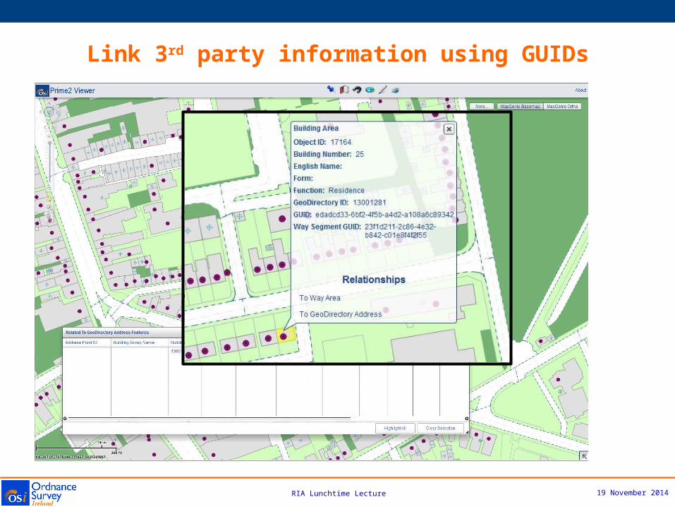
Link 3rd party information using GUIDs

19 November 2014
Mapping Our Future
RIA Lunchtime Lecture
Persisting Quality – Geospatial Management System (GMS)
Service-Oriented Architecture (SOA) based software platformusing the latest Oracle Technologies (BPEL and Workspace Manager)
Key benefits include• Quality control activities via a rules-based approach
• Production efficiencies
• Technical foundation for a future automated product generation flowline
• Provides for cost and resource savings
19 November 2014
Mapping Our Future
RIA Lunchtime Lecture
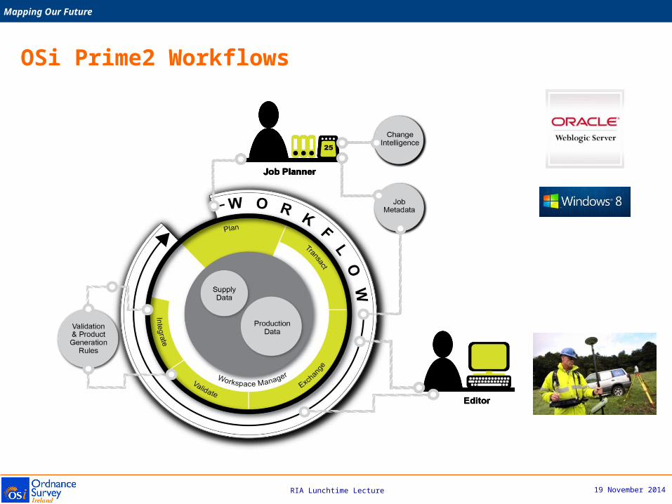
OSi Prime2 Workflows
19 November 2014
Mapping Our Future
RIA Lunchtime Lecture
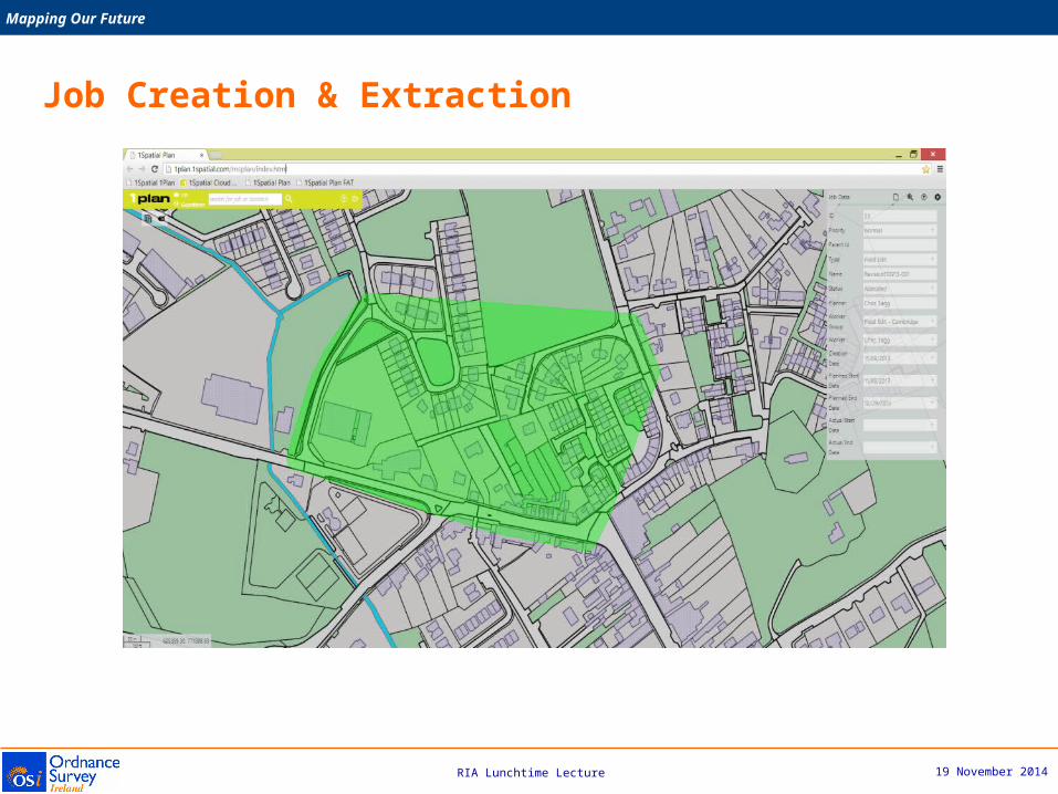
Job Creation & Extraction

19 November 2014
Mapping Our Future
RIA Lunchtime Lecture
Job Creation & Extraction

19 November 2014
Mapping Our Future
RIA Lunchtime Lecture
• Provides Ireland with a consistent authoritative spatial referencing system for the integration and management of national spatial information
• Prime2 is a foundation for a modern National Spatial Data Infrastructure
• Provides users with high quality high intelligence reference data in an easy to use industry standard data format
• The standards based intelligent data storage model enables the generation of products and services via data schemas designed for user requirements
• Provides solution developers and data integrators with a robust framework for integrating 3rd party data
• Enables OSi to develop enhanced Web Services (Web Feature Services)
OSi &
Industry
Customers
Products &
Services
– Benefits & Opportunities

19 November 2014
Mapping Our Future
RIA Lunchtime Lecture

19 November 2014
Mapping Our Future
RIA Lunchtime Lecture
Data Maintenance Enhanced Automation
Multi-Resolution Data Store
Continuous Innovation

19 November 2014
Mapping Our Future
RIA Lunchtime Lecture
Prime2
Height data
Other source(s)
DLM-Core
DLM-3 metre
DCM-Core
DLM-6 metre
DLM-15 metre
DCM 20
DCM 100
DCM 400
e.g. 1:50,000
GeoTIF Raster
e.g. Large Scale
GeoTIF Raster
e.g. Large Scale
e.g. Street Map
GeoTIF Raster
e.g. Street Map
e.g. Road Atlas
Delivery
Delivery
Delivery
Delivery
<= 1:5,000
1:6,000-1:20,000
1:25,000-1:100,000
1:200,000-1:1m
“Star” configuration
MRDS – product output from Prime2
19 November 2014
Mapping Our Future
RIA Lunchtime Lecture
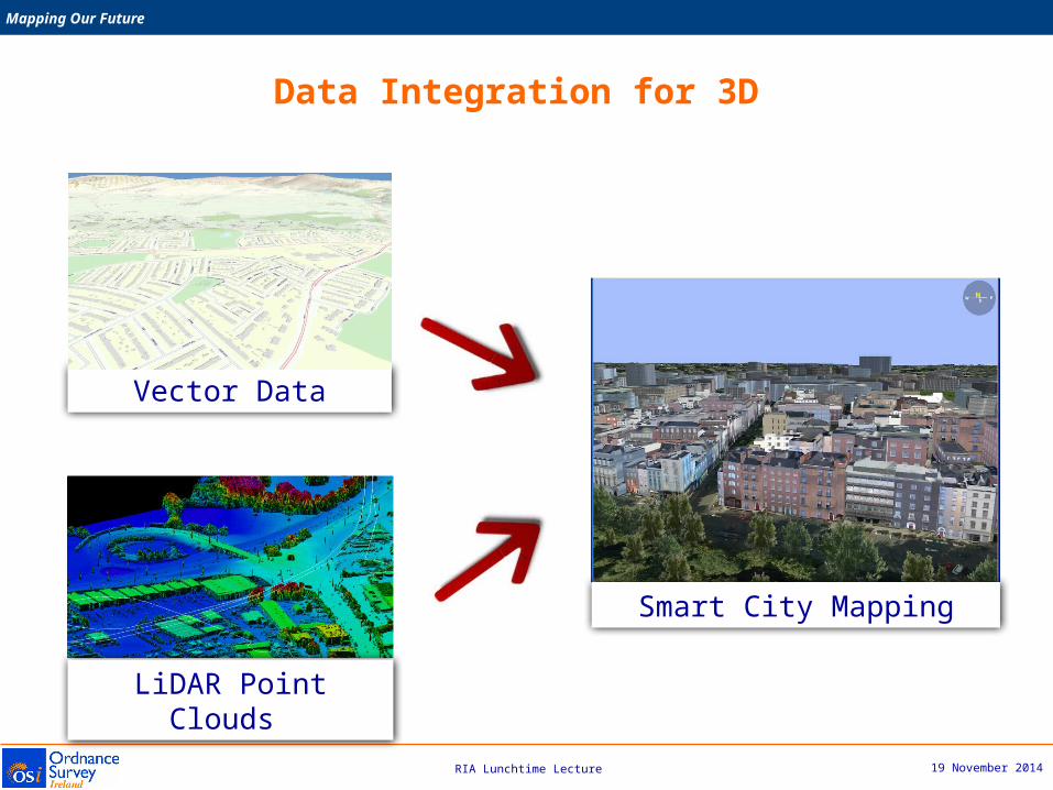
Vector Data
LiDAR Point Clouds
Smart City Mapping
Data Integration for 3D

19 November 2014
Mapping Our Future
RIA Lunchtime Lecture
Summary

19 November 2014
Mapping Our Future
RIA Lunchtime Lecture
Summary
Ordnance Survey Ireland
• Has a very proud history and a very bright future
• Continues its tradition of innovation in national mapping
• Focused on:
– providing users with the most up-to-date mapping services
– making its data easier to access, use and integrate
– quality and its authoritative function
– Adding value to our users work processes
– optimising operational efficiencies with best practise & technology
• Has created a world class national spatial data infrastructure (Prime2)
• Its real asset is its highly skilled and professional staff

19 November 2014
Mapping Our Future
RIA Lunchtime Lecture
• scientific accuracy
• thorough
• complete, comprehensive
• recorded (and the records managed)
• regulated
• authoritative
• up-to-date
• uniform …
Intentions or ambitions of the Ordnance Surveyof Ireland (from 1824-): [Ref. Dr Jacinta Prunty]

19 November 2014
Mapping Our Future
RIA Lunchtime Lecture
Thank You

19 November 2014
Mapping Our Future
RIA Lunchtime Lecture
Mission
To exploit land information for the economic & social development of Ireland
We will deliver on this mission by providing the authoritative:
• National property registration system• National mapping and surveying infrastructure• National property valuation service
This will enable us to lead, develop and maintain national spatial information infrastructures, supporting better land management and the creation of new businesses.
Tailte Éireann