cominco ltd. 42a89se0244 2. 2515 guibord w. m. little · cominco ltd. 42a89se0244 2. 2515 guibord...
TRANSCRIPT

COMINCO LTD. 42A89SE0244 2. 2515 GUIBORD
PROJECTS .UNIT EXPLORATION EASTERN DISTRICT
REPORT OF WORK
GIB PROPERTY
GUIBORD TWP., ONTARIO
PERIOD SEPTEMBER 1976 - AUGUST 1977
W. M. Little
1. LOCATION, ACCESS, HISTORY
The property is located in Guibord Township, Larder Lake Mining Division, Ontario, about 45 miles east of Timmins, 10 miles east of Matheson, and 3 miles east of the Ross gold mine.
Highway #101 crosses the northern edge of the property and a bush road along the eastern boundary provides additional access. Although much of the property is underlain by muskeg, most areas were quite dry in August - September 1976, and all parts of the property could be reached easily on foot or with tracked vehicles.
The property is part of a larger claim block held by Hollinger Mines Ltd. from 1964-1972. Their work (primarily gold exploration) consisted of ground E.M. and magnetometer surveys, and about 20 widely spaced drill holes. The present Gib Property was staked by Cominco for gold exploration possibilities in August and September 1976, and a 32 hole "overburden drill" program in September 1976 is the subject of the present report.
2. PROPERTY
The property is owned 100* by Cominco Ltd. , 120 Adelaide St. W. , Suite 1700, Toronto, Ontario, M5H 1T1.
Assessment credits are claimed for application against 113 claims, in Guibord Twp., Ont., with numbers as follows:
L 475766-785; 797-806; 824-833 inclusive.L 477203-219; 222-234; 237-250; 252-262 inclusive.L 477312-319; 322-325 328-329; 332-335 inclusive.
The claim locations are shown on the attached map*

- 2 -
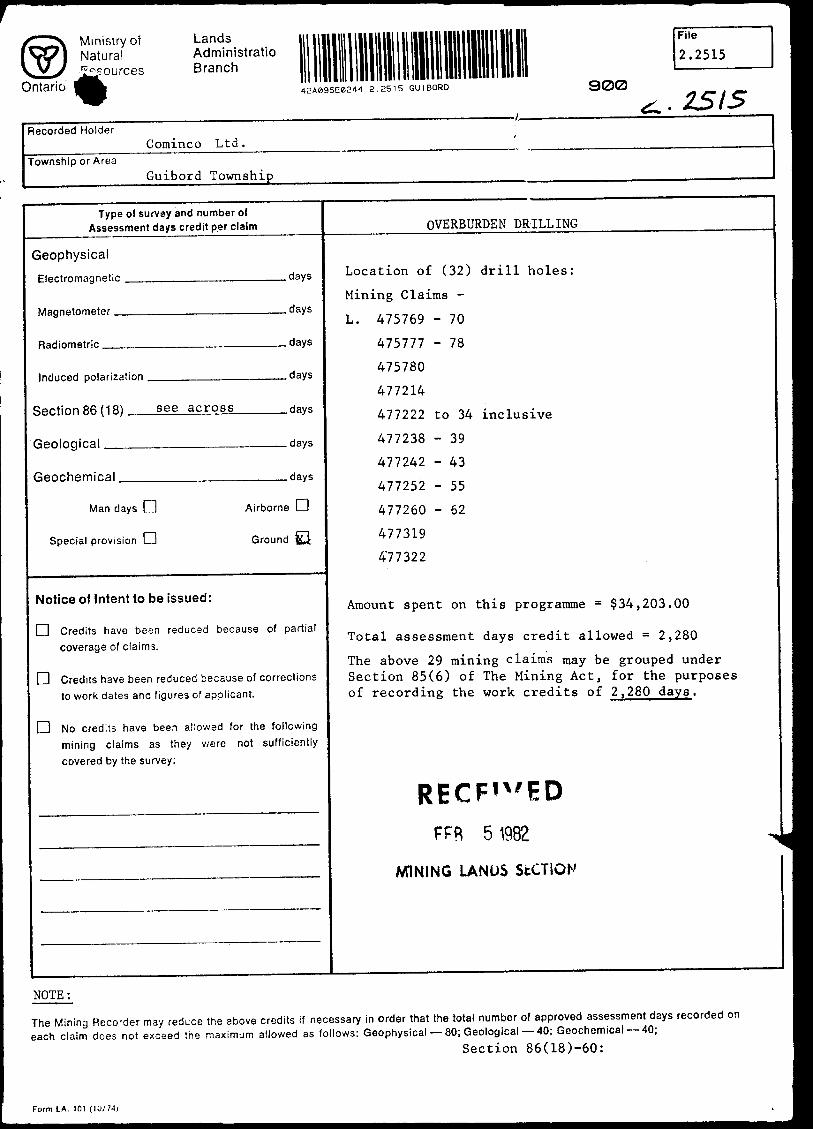
The overburden drilling involved 32 holes, on the following claims:
L 475770, 777, 780, 781L 477214, 222, 223, 224, 225, 226, 227, 228, 229, 230,
231, 232, 233, 234, 238, 239, 242, 243, 252,
255, 260, 262 L 477319, 322
The present submission does not apply to an additional 21 adjoining claims (L 476814-823, L477220-221, 235-236, 251, L477320-321, 326-327, 336, 379) in Guibord and Michaud Townships, which gave the property an original total of 134 claims.
3. WORK CARRIED OUT
The main work carried out was a program of 32 vertical "overburden drill" holes on a grid roughly 1000' x 2000". The holes were drilled to penetrate approximately 5' into bedrock, and had an average depth of 116'. The drilling was done under contract by Bradley Bros. Limited, P. O. Box 367, Noranda, P.Q., using track mounted "reverse circulation" equipment, giving a hole roughly 3V in diameter.
The cuttings were divided into plus and minus 14 mesh fractions, and 5-10 Ib. samples of both fractions were collected from (a) approximately the lower 10' of the overburden (2-5* sample intervals) and (b) the bedrock (1-2' intervals). Since the bedrock depth could not be accurately predicted, the overburden sampling was usually started well above the expected depth to ensure that the sampling covered the 10' basal section. Extra samples, from higher parts of the overburden, were subsequently disposed of.
The sampling was carried out by R. L. Lortie (geologist) and R. Campbell (sampler). For the overburden sampling, the exceptionally high drill penetration (up to 5'/minute) made it necessary to have two men to handle the sieving and bagging of samples, measure and note footages, and remove access materials. Additional duties of the geologist were to log the full length of the holes (mostly involving overburden variations), to decide when holes should be stopped (i.e. to distinguish bedrock from boulders), to change hole locations de pending on bedrock lithologies, and to make preliminary binocular microscope studies of the bedrock cuttings.
The program involved 4 days field time (August 24-27, 1976) by the writer and R. Lortie, to spot drill hole locations, and 18 days (September 7-24) by R. Lortie and R. Campbell, when the drilling was in progress.
Analytical procedures were as follows:
Samples were pulvarized and split at the Cominco Geochemical Laboratory, Toronto.

- 3 -
The original coarse (+14 mesh) fraction was used for all bedrock analyses. The ppb Au determinations were done by Bondar-Clegg and Company, Ottawa, using a fire assay - AA procedure. The major element analyses were carried out by XRF by the Cominco Research Laboratory, Vancouver, and the FeO, Co , H O+, MnO , As O and S determinations by wet chemical methods by the Cominco Toronto Laboratory.
The basal overburden samples (original-14 mesh fraction) were treated by the Cominco Vancouver Laboratory. Analyses were made on a -20 mesh "silt fraction" (cut before liquid separation) and a "heavy mineral fraction" from which magnetite was removed. All samples were pulvarized before analysis. The ppb Au analyses were by aqua regia extraction AA procedure, the Cu, Pb and Zn by acid extraction plus. AA, and the As by a colorometric method.
4. GEOLOGY
The geology shown on the attached map is based on the ODM mapping by Prest (1953) modified for the results of Hollinger's 1964-72 drilling and the present overburden drill program. For most of the property, however, the geology is still very poorly known - there are essentially no outcrops, and the widely scattered drill holes provide as many questions as answers.
The following discussion is restricted to new information provided by the present work.
Overburden
Descriptions of the overburden in individual holes are given in Table II.
From the exploration standpoint, the most obvious characteristic is its thickness - an average of 110', and over 90" thick in 28 of the 32 holes.
The bulk of the material, and possibly all of it, has been water transported, and probably represents part of the Munro Esker system. Two distinct layers are usually present. The upper part, averaging about 60' thick, consists of clean, fine sand, which sometimes grades laterally or upwards into sandy clay or silt. The lower subdivision, 50' thick on the average, is usually a fine (-1") well sorted gravel, although the basal sections sometimes contain coarser gravel "up to 3") and occasionally boulders of larger size.
Bedrock Types
Bedrock drill cuttings were studied under a binocular microscope by the writer and the results of whole-rock analyses are listed in Table III.
- 4 -
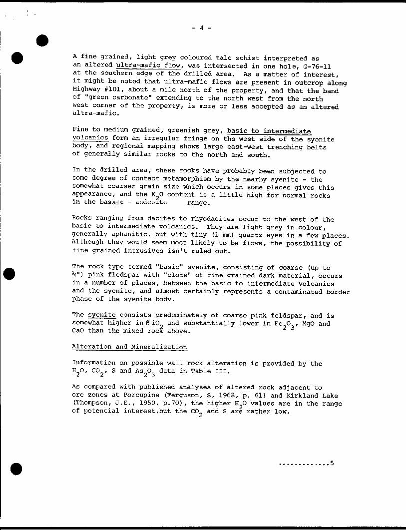
A fine grained, light grey coloured talc schist interpreted as an altered ultra-mafic flow, was intersected in one hole, G-76-11 at the southern edge of the drilled area. As a matter of interest, it might be noted that ultra-mafic flows are present in outcrop along Highway #101, about a mile north of the property, and that the band of "green carbonate" extending to the north west from the north west corner of the property, is more or less accepted as an altered ultra-mafic.
Fine to medium grained, greenish grey, basic to intermediate volcanics form an irregular fringe on the west side of the syenite body, and regional mapping shows large east-west trenching belts of generally similar rocks to the north and south.
In the drilled area, these rocks have probably been subjected to some degree of contact metamorphism by the nearby syenite - the somewhat coarser grain size which occurs in some places gives this appearance, and the K O content is a little high for normal rocks in the basalt - andesite range.
Rocks ranging from dacites to rhyodacites occur to the west of the basic to intermediate volcanics. They are light grey in colour, generally aphanitic, but with tiny (l mm) quartz eyes in a few places. Although they would seem most likely to be flows, the possibility of fine grained intrusives isn't ruled out.
The rock type termed "basic" syenite, consisting of coarse (up to V) pink fledspar with "clots" of fine grained dark material, occurs in a number of places, between the basic to intermediate volcanics and the syenite, and almost certainly represents a contaminated border phase of the syenite body.
The syenite consists predominately of coarse pink feldspar, and is somewhat higher in S io and substantially lower in Fe O , MgO and CaO than the mixed rock above.
Alteration and Mineralization
Information on possible wall rock alteration is provided by the HO, CO , S and As O data in Table III.
fi ft t* J
As compared with published analyses of altered rock adjacent to ore zones at Porcupine (Ferguson, S, 1968, p. 61) and Kirkland Lake (Thompson, J.E., 1950, p.70), the higher HO values are in the range of potential interest,but the CO and S are rather low.

- 5 -
Basic,Intermediate Volcanics Porphyry, Dacite
1
H20
.6-2
.1-3
.7
.5
co2
9.5-16.8
.1-6.0
S
.1-14.
.1- .
0
6
H 20
1.0-1. .9-2. .7-2.
9 35
3.4.
co2
8-4 1-8 2-1
.2
.2
.7
S
.2-1.5
.2 0- .5
Porcupine Kirkland Lake Gib
The Gib rocks do show some indication, however, of a relationship between alteration and gold values. In both the basic to inter mediate volcanics and the "basic" syenite, the holes with the highest CO content (#29 and #19 respectively) are the holes with anomalous Au, and the two anomalous dacite holes (#21 and 23) have the highest HO. Hole #21, with the highest bedrock Au values obtained in tne program, is the only one with anomalous As.
Bedrock Au values and Cu, Pb, Zn, As, Au results from the over burden samples are listed in Table IV. It might be noted that although the different trace ?u analytical procedures used for the bedrock and overburden samples give different lower levels of determination (-5 ppb for Bondar-Clegg bedrock analyses, and -25 ppb for Cominco Vancouver overburden results), test work by the writer has shown that the two laboratories give comparable results with samples in the "anomalous" range.
The following discussion is restricted to the trace Au results - the overburden base metal values show no obvious patterns in their distribution.
In the bedrock samples, anomalous Au values (+2S ppb) occur in only 4 of the 32 holes, and even in these 4 holes less than half the samples *Jave significant values. The highest result was 170 ppm, in hole #29, the equivalent of .0005 oz/T.
The overburden samples gave anomalous AM in the "heavy mineral" fraction in 10 holes, and in the "silt" fraction in 6 - only one hole, #21 showing anomalous results from both fractions. The "heavy mineral" anomalous values (up to 190 ppb) are in the same range as the bedrock figures, but a few values up to 1600 ppb were obtained from "silt". For both overburden fractions, the majority of the anomalous samples came from immediately above the bedrock - the exceptions average 3' above.
As is shown on the geological map, the holes with anomalous "heavy mineral" and "silt" samples occur in rough clusters.
The "heavy mineral" anomalies occur in three groups; (a) in holes #19, 29 and 30, in the north-east, in association with bedrock anomalies in holes #19 and 29; (b) in holes #21, 28 and 17, to the west, in association with bedrock values in holes #21 and 23, and (c) in holes #8, 10, 13, 15 and 16, to the south, without associated bedrock anomalies.
- 6 -
Anomalous "silt" values occur in two areas, more or less independently of the "heavy mineral" anomaly distribution. Two holes, #21 (with anomalous bedrock, "heavy mineral" and "silt" values) and #22 ("silt" values alone) occur on the west side of the drilled area, and a second group of four holes, #3, 4, 5 and 6 (without associated bedrock or "heavy mineral" values) occurs in the central part of the area.
5. WRITER'S QUALIFICATIONS
The writer is a registered Professional Engineer (Ont.) and holds B.A.Se (1949), M.A.Sc(1950) and Ph.D (1957) degrees in Economic Geology from the University of Toronto. He has been employed as a mine geologist and in mining exploration since 1954.
He is familiar with the work described in the above report, having initiated, planned and directly supervised the project, having spent four days on the property, and having personally compiled and evaluated the results.
Submitted by:W. M. LITTLE SENIOR GEOLOGIST
REFERENCES
Ferguson, S.A. (1968) Geology and Ore Deposits of Tisdale Township.O.D.M. Geol. Dept. 58.
Prest, V.K. (1953) Geology of Guibord Township. O.D.M. Vol. LX, Part IX. Thompson, J.E. et al (1950) Geology of the Main Ore Zone at Kirkland
Lake. O.D.M. Vol. LVIII, Part V.
ATTACHMENTS
TABLE I Cost BreakdownTABLE II Overburden Drill Holes, 1976TABLE III Bedrock GeochemistryTABLE IV Mineralization SummaryGeologist Map, l" = 1000'
DISTRIBUTION
Ministry of Natural Resources (Ont.) (2) File (D
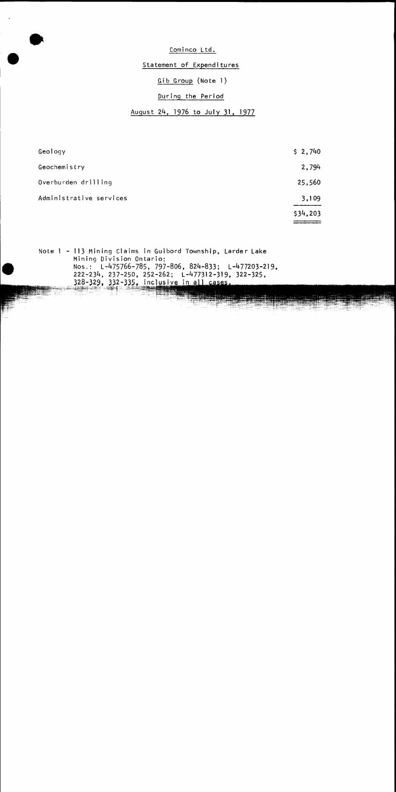
Cominco Ltd.
Statement of Expenditures
G i b Group (Note l)
During the Period
August 2k, 1 976 to July 31. 1977
Geology
Geochemi stry
Overburden drilling
Administrative services
$ 2,7^0
2,79^
25,560
3.109
$34,203
Note l - 113 Mining Claims in Guibord Township, Larder Lake Mining Division Ontario:Nos.: L-475766-785, 797-806, 824-833; L-477203-219, 222-234, 237-250, 252-262; L-477312-319, 322-325, 328-329, 232-335, j nel

Cominco Ltd.
Statement of Expenditures
Gib Group (Note 1)
During the Period
August 2k, 1 976 to July 31. 1977
Geology
Geochemi s try
Overburden drilling
Administrative services
$ 2,7^0
2,79^
25,560
3,109
$3I^203
Note l - 113 Mining Claims in Guibord Township, Larder Lake Mining Division Ontario:Nos.: L-^75766-785, 797-806, 824-833; L-477203-219, 222-23*1, 237-250, 252-262; L-477312-319, 322-325, 328-329, 332-335, inclusive in all cases.
R. CraigVancouver Office October 13, 1977
Certified Correct
R. L. WoodsSupervisor, Exploration g- Foreign Accounting
-'l r/
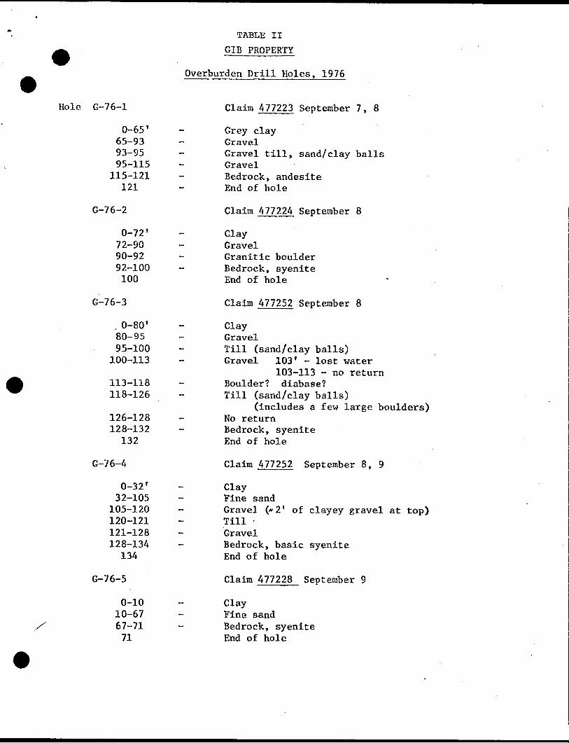
TABLE II
GIB PROPERTY
Overburden Drill Holes, 1976
Hole G-76-1 Claim 477223 September 7, 8
0-65' - Grey clay65-93 - Gravel93-95 - Gravel till, sand/clay balls95-115 - Gravel
115-121 - Bedrock, andesite121 - End of hole
G-76-2 Claim 477224 September 8
0-72' - Clay72-90 - Gravel90-92 - Granitic boulder92-100 - Bedrock, syenite100 End of hole
G-76-3 Claim 477252 September 8
. 0-80' - Clay80-95 - Gravel95-100 - Till (sand/clay balls)
100-113 - Gravel 103' - lost water 103-113 - no return
113-118 - Boulder? diabase?118-126 - Till (sand/clay balls)
(includes a few large boulders) 126-128 - No return 128-132 - Bedrock, syenite
132 End of hole
G-76-4 Claim 477252 September 8, 9
0-32 T - Clay32-105 - Fine sand
105-120 - Gravel (*2 f of clayey gravel at top)120-121 - Till -121-128 - Gravel128-134 - Bedrock, basic syenite
134 End of hole
G-76-5 Claim 477228 September 9
0-10 - Clay10-67 - Fine sand67-71 - Bedrock, syenite71 End of hole
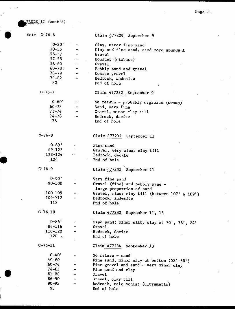
JL'ABLE II (cont'd)
Page 2.
Hole G-76-6
0-30'
30-55 55-5757-5858-60 60-7878-7979-82
82
G-76-7
0-60'
60-7373-7474-78
78
Claim 477229 September 9
Clay, minor fine sandClay and fine sand, sand more abundantGravelBoulder (diabase)GravelPebbly sand and gravelCoarse gravelBedrock, andesiteEnd of hole
Claim 477232 September 9
No return - probably organics (swamp) Sand, very fine Gravel, minor clay till Bedrock, dacite End of hole
G-76-8
0-69'
69-122 122-124
124
G-76-9
0-90'
90-100
100-109109-112
112
G-76-10
0=86'
86-116 116-120
120
G-76-11
0-40'
40-60 60-74 74-81 81-86 86-90 90-9393
Claim 477232 September 11
Fine sandGravel, very minor clay tillBedrock, daciteEnd of hole
Claim 477233 September 11
Very fine sandGravel (fine) and pebbly sand -large proportion of sand
Gravel, minor clay till (between 107' f* 109*) Bedrock, andesite End of hole
Claim 477232 September 11, 13
Fine sand; minor silty clay at 70', 76', 84' GravelBedrock, dacite End of hole
Claim 477234 September 13
No return - sandFine sand, minor clay at bottom (58'-60')Fine gravel and sand - very minor clayFine sand and clayGravelGravel, clay tillBedrock, talc schist (ultramafic)End of hole
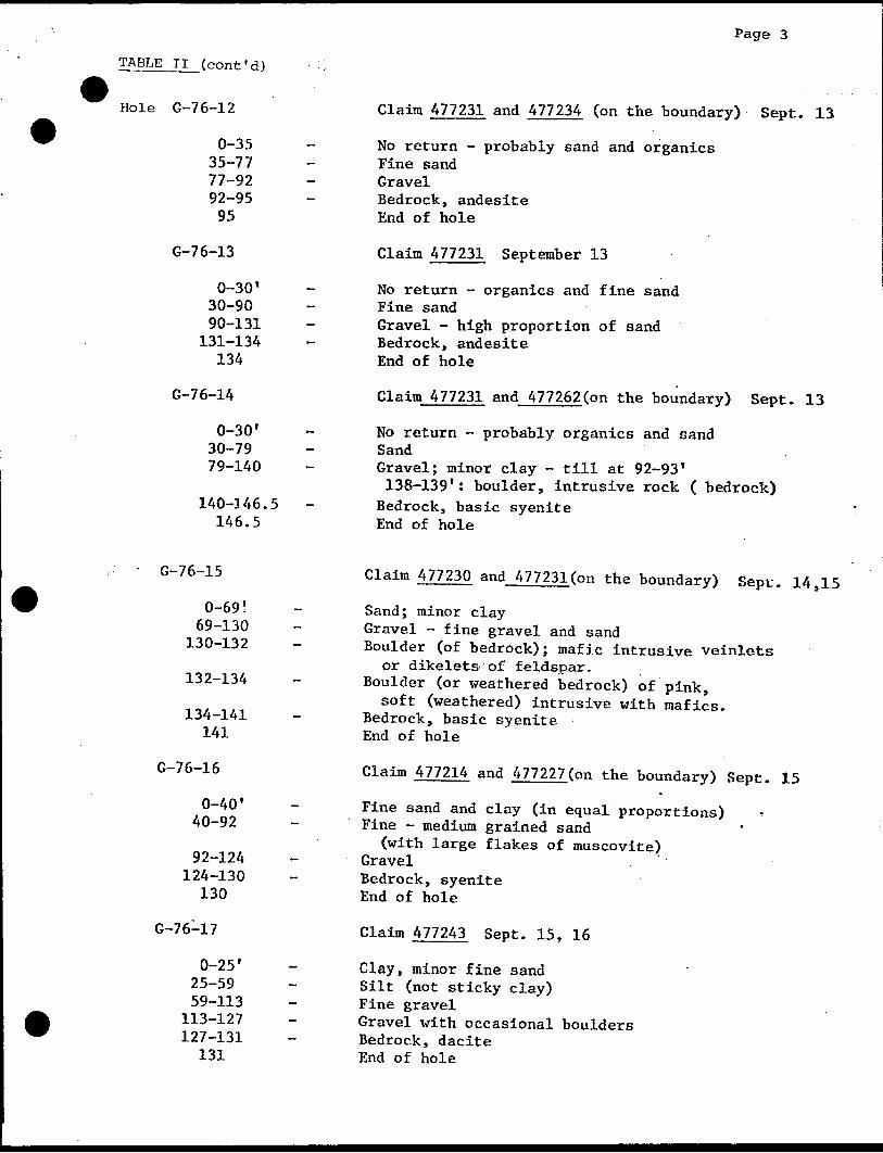
Page 3
TABLE II (cont'd) :
Hole G-76-12 Claim 477231 and 477234 (on the boundary) Sept. 13
0-35 - No return - probably sand and organics35-77 - Fine sand77-92 - Gravel92-95 - Bedrock, andesite95 End of hole
G-76-13 Claim 477231 September 13
0-30' - No return - organics and fine sand30-90 - Fine sand90-131 - Gravel - high proportion of sand
131-134 - Bedrock, andesite134 End of hole
G-76-14 Claim 477231 and 477262(on the boundary) Sept. 13
0-30' - No return - probably organics and sand30-79 - Sand79-140 - Gravel; minor clay - till at 92-93'
138-139': boulder, intrusive rock ( bedrock) 140-146.5 - Bedrock, basic syenite 146.5 End of hole
- G-76-15 Claim 477230 and 477231(on the boundary) Sept. 14,15
0-69! - Sand; minor clay69-130 - Gravel - fine gravel and sand
130-132 - Boulder (of bedrock); mafic intrusive veinlets or dikelets of feldspar.
132-134 - Boulder (or weathered bedrock) of pink, soft (weathered) intrusive with mafics.
134-141 - Bedrock, basic syenite 141 End of hole
G-76-16 Claim 477214 and 477227(on the boundary) Sept. 15
0-40' - Fine sand and clay (in equal proportions)40-92 - Fine - medium grained sand
(with large flakes of muscovite) 92-124 - Gravel
124-130 - Bedrock, syenite130 End of hole
G-76-17 Claim 477243 Sept. 15, 16
0-25' - Clay, minor fine sand25-59 - Silt (not sticky clay)59-113 - Fine gravel
113-127 - Gravel with occasional boulders127-131 - Bedrock, dacite
131 End of hole

Page 4
TABLE II (cont'd)
Hole G-76-18
0-66'
66-100.5 100.5-104
104
G-76-19
0-45 45-74 74-140
140-145 -, 145
G-76-20
0-24'
24-26 26-2828
G-76-21
0-25'25-9270-9292-114
114-123123
Claim 477225 September 16
Clay and fine sandMinor clay only (at 20-30')Gravel; minor till beds below 80' (80-90')Bedrock, basaltEnd of hole
Claim 477222 September 16
Silty clay and fine sand, in equal proportions. Fine sand; very minor clay Gravel; minor till Bedrock, basic syenite End of hole
Claim 477238 September 17
Fine sand and clay Gravel with boulders Bedrock, basalt End of hole
Note: Redrilled G-76-20 (15 T north) to confirmbedrock at 26*
- hole logged exactly as before.
Claim 475777 September 17
Clay and fine sandGravelTill (mainly)Coarse gravelBedrock, daciteEnd of hole
rt.-l e G-76-22
0-62'
62-78 78-92 92-95 95-113
113-128 128-131
131
G-76-23
0-52'
52-140 140-145
145
Claim 475780 and 475781 (on the boundary) Sept. 18
Fine sand, minor clayGravelClay till, small pebbles (no boulders)Gravel, high proportion sandTill with small bouldersCoarse gravel (boulders *2-3")Bedrock, daciteEnd of hole
Claim 477242 Sept. 18 S 20
Fine sand, subordinate clayGravel (102-104', large boulder, basic tuff?)Bedrock, daciteEnd of hole

TABLE-II ••(cent* A)-
Page 5
Hole G-76-24
0-53*53-7070-8080-9090-9494-102102-110110-115115-122122-128
128
G-76-25
0-62' 62-68 68-100
100-110 110-123 123-129 129-135
135
G-76-26
0-58'58-105
105-115115-130130-136136
Claim 477319 and 477322(boundary) Sept. 20
Organics ( 10'); clay and fine sandFine gravelGravel (mainly), minor till layersTill (mainly)ClayGravel, occasional clay bedClayGravelBoulder - green sandstone (graywacke)Bedrock, basaltEnd of hole
Claim 477260 Sept. 21
Silty clayFine sand and silt 'Gravel (fine)Coarse gravel (poor return)TillGravel - . .Bedrock, basic syeniteEnd of hole
Claim 477260 Sept. 21
Clay (silty) Fine gravel Bouldery gravel Till and gravel Bedrock, syenite End of hole
G-76-27 Claim 475770 Sept, 21
0-39'
39-51 51-72 72-80 80-89 89-92 92-96 96-99 99-103103
Clay, fine sandGravelTillCoarse gravelTillClay with sandSand, minor clayTill and gravelBedrock, basic syeniteEnd of hole

TABLE II,. (cont' d)
Page 6
Hole G-76-28 Claim 477239 Sept. 220-38'
38-59 59-90
90-94 94
G-76-29
0-36'
36-73 73-88 88-9292
G-76-30
0-40*
40-70 70-72 72-76 76-109
109-116116
G-76-31
0-72 72-118
118-120 -:- 3.2Q-14Q
140-145 145-153 153-160
160
G-76-32
0-38* 38-120
120-128 128
82')97')
118')
Clay and fine sandGravelTill and gravel (about equal proportions
alternating) Bedrock, dacite End of hole
Claim 477225 Sept. 22
Silty clay Fine silty sand GravelBedrock, basalt End of hole
Claim 477226 Sept. 23
Silty clay and fine sandFine sandGravelSandGravelBedrock, syeniteEnd of hole
Claim 477226 Sept. 23
Fine sand, minor clay near topGravelTillGravelBoulders, coarse gravelBouldersBedrock, syeniteEnd of hole '
Claim 477255 Sept. 23
Sand Gravel
thin till beds
Bedrock, basic syenite End of hole

TABLE IV MINERALIZATION SUMMARY
Hole No. Footage
G-76-1
Bedrock Samples ppb Au
95-100100-105105-108108-110110-111
G 76-285-9090-9292-9595-100
G-76-3122-124A122-124B124-126128-130131-132A131-132B
G-76-4120-125125-128128-130130-132132-133133-134
G-76-567-6868-6969-7070-71
G-76-673-7878-7979-8080-81
G-76-773-7474-7575-7676-7777-78
n.d.n.d.n.d.
n.d.L5
n.d.n.d.n.d.
n.d.L5L5L5
n.d.n.d.L5
L5n.d.
L5n.d.n.d.n.d.
Heavy Mineral Fraction Cu Pb Zn As ppb Au
44 L3 43 L2 L25 60 L3 42 "
Overburden SamplesSilt Fraction
19 L3 39 L2 L25 80 20 187 " "
39 L3 34 L2 L2530 3 45 "32 L3 51 " "
88 L3 39 L2 L25 42 L3 54 " "
170 25 187 L2 L25
63 L3 52 L2 L25 38 L3 45 " "
34 6 43 L2 L25
Cut Fb Zii As^ ppb Au
5 L3 13 L2 L257 L3 12 " "
5 L3 9 L2 L25 53 10 64 "
8 6 11 L2 L257 L3 11 " "
10 L3 15 " 66,4,70
14 L3 12 L2 200,4 10 L3 16 " L25
28 L3 72 L2 45,18,80
8 L3 13 L2 1600,6,24,50 10 L3 24 " L25
10 L3 30 L2 L25

3LE IV (cont'd)
Hole No.Footage
G-76-8118-120120-122122-123123-124
G-76-9100-105109-110110-111111-112
G-76-10108-112112-116116-118117-118118-119119-120
G-76-1185-9090-9191-9292-93
G-76-12104-108108-112112-113113-114114-115
G- 7 6-1 3124-129129-132132-133133-134
G-76-14136-138138-140140-142142-144144-145145-146.5
BedrockSamplesppb Au
L5L5
n.d.L5n.d.
n.d.n.d.n.d .n.d.
L5L5L5
L5n.d.n.d.
L5L5
L5n.d.L5L5
Overburden SamplesSamples Heavy Mineral Fraction Silt Fraction ppb Au Cu Pb Zn As ppb Au
70 L3 73 55 88,70 60 3 49 L2 L25
70 25 60 L2 L25
50 4 53 4117 10 37 3 100,90
200 20 56 L2 L25
27 5 37 L2 L25 32 L3 28 "
39 L3 42 L2 L25 200 48 54 " 40,26,40
25 L3 87 L2 L25 191 L3 91 " "
Cu Pb Zn As ppb Au
15 L3 27 L2 L25 19 L3 26 " "
12 L3 16 L2 L25
7 L3 13 L2 L25 17 L3 24 " "
25 L3 16 L2 L25
3 L3 8 L2 L25 5 L3 10 "
18 L3 26 L2 L25 15 L3 20 " "
13 L3 42 L2 L25 40 L3 61 " "

TABLE IV (cont'd)
Hole No. Footage
G-76-15
Bedrock Overburden SamplesSamples Heavy Mineral Fraction ppb Au Cu Pb Zn As ppb Au
130-132132-135135-137137-139139-140140-141
G-76-16
120-122122-124124-126126-128128-129129-130
G-76-17
118-124124-127127-128128-129129-130130-131
G-76-18
88- 9898-101101-102102-103103-104
G-76-19
128-134134-140140-141141-143143-145
G- 76-20
24- 2626- 2727- 28
1055
L5
L5L5n.d.n.d.
5L5L5L5
L5n.d.n.d.
50n.d.35
L5L5
68167
65135
5672
18103
2840
5 264 L2 L25 50 409 " 40,42
23 98 L2 L25 27 115 " 48,12
6 47 L2 L25 27 39 " 140,110
3 27 L2 L25 3 47
L3 26 L2 L25 L3 44 " 40,80
Silt FractionAu
41 L3 102 L2 L25 40 91 201
34 7 50 L2 L25 57 7 60
12 L3 19 L2 L25 10 3 21
6 L3 12 L2 L25 19 L3 22
7 L3 13 L2 L25 9 L3 15
38 L3 49 L2 L25

IBLE iv (cont'd)
Hole No. Footage
G-76-21104-110 110-116 116-118 118-120 120-123
G-76-22
115-120 120-128 128-129 129-130 130-131
G-76-23
152-157 157-160 160-161 161-162 162-163 163-165
G-76-24
110-115 115-122 122-124 124-127 127-128
G-76-25
120-125 125-129 129-131 131-133 133-135
G-76-26
120-125 125-130 130-133 133-135 135-136
G-76-27
90- 95A 90- 95B
100-102 102-103
Bedrock Overburden SamplesSamples Heavy Mineral Fraction Silt Fractionppb Au Cu Pb Zn As ppb Au Cu Pb Zn As ppb Au
193 6 49 L2 21 L3 30 L2 L25 188 241 66 " 108,52,;90 22 59 147 " 266,40
L5 95
100
30 3 61 L2 L25 16 4 22 L2 L25 39 3 63 " " 5 L3 27 " 760,30
L5 L5 5
76 3 61 L2 L25 23 4 40 L2 L25 144 685 92 " " 37 75 49 "
5 40 n.d. n.d.
47 L3 38 L2 L25 20 3 28 L2 L25 500 50 36 6 91 L3 60 " "
L5 L5 L5
70 L3 70 L2 L25 11 L3 26 L2 L25 73 L3 90 " " 6 L3 17
n.d. L5 n.d.
108 10 52 L2 L25 20 L3 27 52 L3 47 " " 5 L3 18
n.d. L5 L5
28 L3 39 L2 L25 4 L3 17 L2 L25 40 L3 52 " 28 L3 50 "
L5 10
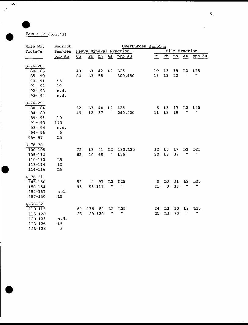
TABLE IV ( cont'd)
Hole No.Footage
G-76-2880- 8585- 9090- 9191- 9292- 9393- 94
G-76-29
80- 8484- 8989- 9191- 9393- 9494- 96
96- 97
G-76-30100-105105-110110-113113-114114-116
G-76-31
145-150150-154154-157157-160
G-76-32
110-115115-120120-123123-126126-128
Bedroc]Sample:ppb Au
L510n.d.n.d.
10170n.d.5
L5
L510L5
n.d.L5
n.d.L55
Overburden samples Samples Heavy Mineral Fraction ____Silt Fraction
Cu Pb^ Zii As^ ppb Au
49 L3 42 L2 L2580 L3 58 " 300,450
32 L3 44 L2 L2549 12 37 " 240,400
72 L3 41 L2 180,L25 82 10 69 " L25
5293
4 97 L2 L25 95 117
62 138 64 L2 L25 36 29 120 " "
Cu Pb^ Zn^ As± ppb Au
10 L3 19 L2 L25 13 L3 22
8 L3 17 L2 L25 11 L3 19
10 L3 17 L2 L25 20 L3 37
9 L3 31 L2 L25 21 3 33
24 L3 30 L2 L2525 L3 70

TABLE III
BEDROCK GEOCHEMISTRY
U.M. (flow?)Hole No.Footage
SiO
Al 023
FS203
FeO
MgO
CaO
Na20
V OK20
MnO
TiO
P205
H O+2
co2S
Ac: O *AS 2 3
A.U**
Total
* ppm
** ppb
G-76-11
127-130
41.97
5.29
5.98
5.16
22.28
9.27
.20
.06
.17
.34
.03
2.62
6.93
.06
L5
L5
100.36
76-1
105-111
56.05
13.81
3.45
8.31
4.84
7.92
2.55
1.45
.17
1.14
.10
1.04
.12
.05
L5
n.d.
101.00
76-679-81
54.10
14.78
2.27
4.59
4.64
7.52
5.03
1.96
.13
.67
.45
1.39
3.31
.20
L5
L5
101.04
Basic to Intermediate Volcanics76-9
109-112
53.14
14.52
3.25
7.60
5.32
8.52
2.44
1.75
.18
.95
.09
1.16
.26
.08
L5
L5
99.26
76-12112-115
58.89
12.76
.73
9.75
3.72
6.98
2.72
1.42
.18
1.17
.12
1.19
.47
.12
L5
L5
100.22
76-13132-134
57.07
12.62
2.77
2.72
5.19
6.43
5.45
2.51
.10
.46
.24
.28
3.79
.58
5
L5
100.21
76-18101-104
51.51
13.02
5.15
7.81
4.97
9.04
3.61
1.10
.21
1.27
.13
1.33
.05
.11
L5
L5
99.31
76-2026-28
52.15
14.50
6.06
3.30
7.47
8.30
3.30
1.35
.18
.65
.06
1.07
.80
.13
5
L5
99.32
76-24122-127
52.07
14.19
7.84
2.29
5.76
6.07
2.40
1.15
.14
.84
.06
3.49
4.28
.20
L5
L5
100.78
76-2989-97
48.36
13.14
5.23
2.29
6.84
9.32
3.85
2.62
.19
.75
.39
.39
5.98
.28
L5
37
99.63
76-7
74-78
63.55
15.33
2.05
2.72
3.03
4.88
5.92
1.30
.07
.57
.09
.83
.78
.48
5
L5
101.60
76-8
122-124
68.10
16.11
2.71
1.43
1.52
1.90
3.37
2.28
.06
.71
.08
1.58
.25
.01
5
L5
100.11
76-10116-120
64.76
16.01
1.66
2.72
2.21
2.20
4.49
2.85
.06
.48
.07
.71
.28
.21
L5
n.d.
98.71
Dacite76-17
160-165
69.73
14.01
1.16
3.15
2.16
2.40
3.26
1.66
.06
.54
.03
1.17
.36
.09
L5
L5
99.78
76-21116-123
63.26
16.67
3.01
2.44
2.90
1.45
2.02
3.05
.07
.61
.12
2.46
.18
.01
60
65
98.25
76-22128-131
70.70
12.52
2.34
1.86
2.36
3.64
3.42
1.75
.07
.43
.07
1.07
.58
.08
L5
L5
100.89
76-23160-163
62.04
17.48
1.69
4.23
2.60
2.04
2.91
2.73
.09
.73
.09
2.24
.53
.14
15
11
99.54
76-2890-94
66.06
15.78
1.56
3.01
2.97
2.84
3.26
2.83
.06
.55
.10
1.38
1.70
.28
35
L5
102.38

BEDROCK GEOCHEMISTRY (cont'd)
"Basic "SyeniteHole No. Footage
Si02
A1203
Fe 0
FeO
MgO
CaO
Na20
K20
MnO
TiO
P205
H2CH"
co2S
AS203*
Au**
Total
* ppm
** ppb
76-4128-134
55.01
18.36
4.07
1.43
1.94
5.05
3.42
7.34
.13
.77
.25
.91
1.67
.07
5
L5
100.42
76-14140-145
54.53
13.53
5.02
2.44
4.27
7.85
3.51
5.61
.15
.86
.61
.26
1.01
.13
5
L5
99.78
76-15135-141
55.06
17.14
3.29
3.01
2.07
4.16
5.16
5.78
.16
.90
.33
.34
1.93
.14
L5
5
99.47
76-19140-145
54.72
15.94
5.09
2.72
2.32
5.52
4.95
4.38
.17
.84
.34
.56
3.51
.39
5
28
101.45
76-25129-133
54.25
17.18
4.23
1.72
1.93
5.59
3.68
6.18
.15
.86
.30
.70
3.07
.07
5
L5
99.91
76-27100-103
52.81
14.82
3.51
3.44
4.58
7.51
2.85
5.64
.14
.85
.67
.77
2.52
.08
L5
5
100.19
76-32 76-2120-128
50.19
14.08
7.81
2.44
3.76
10.34
3.12
3.53
.26
1.40
.22
1.44
.27
.07
L
L5
92-100
65.98
14.82
1.81
1.58
1.31
3.46
3.41
4.92
.06
.59
.10
.36
1.73
.18
5
L5
98.93 100.31
76-3
128-132
68.36
13.72
1.03
1.72
1.26
4.05
3.66
4.14
.06
.37
.07
.63
.67
.10
5
n.d.
99.84
76-568-71
63.07
16.46
1.95
1.43
1.39
3.48
4.43
5.74
.09
.48
.14
.33
1.90
.16
L5
L5
101.05
Syenite76-16
124-130
63.56
18.28
1.75
.57
.65
2.44
5.59
5.38
.05
.32
.04
.34
1.93
.01
L5
L5
100.91
76-26130-136
58.59
16.29
3.00
3.30
3.30
3.22
1.73
7.54
.10
.83
.11
1.46
1.21
.04
L5
L5
100.72
76-30110-116
58.04
16.60
3.20
2.29
1.82
3.93
5.04
4.70
.13
.80
.25
.49
1.78
.11
L5
L5
99.18
76-31154-160
61.81
17.37
3.17
1.15
1.19
2.62
5.28
4.82
.07
.47
.13
.58
1.35
.06
L5
L5
100.07
Ministry oi Natural
LandsAdministratioBranch
File
2.2515
42A09SE0244 2.2515 GUIBORD 900
Recorded HolderCominco Ltd.
Township or Area
Guibord Township
Type of survey and number of Assessment days credit per claim OVERBURDEN DRILLING
Geophysical
Electromagnetic
Magnetometer
Radiometric
Induced polarization
Section 86 (18) see across
Geological ^^—^^^-^^
Geochemical
.days
.days
.days
.days
.days
.days
.days
Man days i l
Special provision l l
Airborne [J
Ground Si
Notice of Intent to be issued:
[ l Credits have been reduced because of partial
coverage of claims.
[~l Credits have been reduced because of corrections
to work dales and figures of applicant.
i l No credits have been allowed for the following
mining claims as they were not sufficiently
covered by the survey:
Location of (32) drill holes:
Mining Claims -
L. 475769 - 70
475777 - 78
475780
477214
477222 to 34 inclusive
477238 - 39
477242 - 43
477252 - 55
477260 - 62
477319
477322
Amount spent on this programme = $34,203.00
Total assessment days credit allowed s 2,280
The above 29 mining claims may be grouped under
Section 85(6) of The Mining Act, for the purposes
of recording the work credits of 2,280 days.
51982
MINING LANDS StCTICW
NOTE:
The Mining Recorder may reduce the above credits if necessary in order that the total number of approved assessment days recorded on
each claim does not exceed the maximum allowed as follows: Geophysical 80; Geological 40; Geochemical 40;
Section 86(18)-60:
Form LA. 101 (10/74)

IOin ro
o. OC/)
MUNRO TWP M. 376Noturol Cos Pipe Line
Holtyre Townsite
477252 '477226 i _
(VI Nto
CL
Q
O
12 48 0 27' 35"
COOK TWR M. 33942A09SE0244 2.2515 GUIBORD 200
NOTES
400' surface rights reservation a long the shores o! all lakes and rivers,
DATE OF ISSUE
SIP-81978
SURVEYS AND MAPPING.j jP^fj^ i ii
IP) or
LEGEND
PATENTED LAND
PATENTED FOR SURFACE RIGHTS ONLY
LEASE
LICENSE OF OCCUPATION
CROWN LAND SALES
LOCATED LAND
CANCELLED
MINING RIGHTS ONLY
SURFACE RIGHTS ONLY
HIGHWAY S ROUTE NO.
ROADS
TRAILS
RAILWAYS
POWER LINES
MARSH OR MUSKEG
MINES
used only with summer resofl locations or when space is limited
LO.
C.S.
Loc,
C.
M.R.O.
S.R.O.
GUIBORDDISTRICT OF
COCHRANE
LARDER LAKEMINING DIVISION
SCALE : 1 INCH 40 CHAINS (1/2 MILE)
DR.
DATE I40cf 7!PLAN NO. M. 352
ONTARIO
MINISTRY OH NATURAL RESOURCES^OiVv'EVo AINL- MAIVtNG iJKAi's

TtVA*
i 80*0
~ P- - .. s"^r ~~ - T——r~477J29 S 477332
f -js&in
Qutcropt Au showing
Syenite, basic sye/t/te-) fe/s/fe
Granite, granite fe/dspar porphyry
Cominco O. S. Or/// Ho/e,
Groups of O. B. 60/es
D/STR/CTf A STE K NO——l Pre- Comtnco G/a
MA THMSQAt A A f ABos/c ro/cw'cs
c ) a/ fared UAt.At r S -** A/9*