commerce corridor study - richmond regional … · market opportunities scenarios study process. 13...
TRANSCRIPT

COMMERCE CORRIDOR STUDY 1
COMMERCE CORRIDOR STUDY
Technical Advisory Committee / Policy Advisory Committee
Workshop on Defining the Future
8/11/2016
Photo: City of Richmond

2
COMMERCE CORRIDOR STUDY 2
Agenda
• Welcome and Introductions – Barbara Nelson, Director of Transportation RRTPO
• Workshop objectives – Paul Prideaux, P.E., Michael Baker International
• Key take-a-ways from August 4 Webinar on Case Studies
• Discussion on Market Opportunity Scenarios
• Multimodal Transportation Assets and Deficiencies
• Site Connectivity & Operations Assessment
• Group consensus on direction for corridor
• Next Steps / Wrap Up – Paul Prideaux / Barbara Nelson

3
COMMERCE CORRIDOR STUDY 3
Review of August 4 Case Study Webinar

4
COMMERCE CORRIDOR STUDY 4
Inland Logistics Hub Case Studies
5 Case Studies Presented in 8-4-16 Webinar:
• Virginia Inland Port – Front Royal, VA
• CenterPoint Intermodal – Joliet, IL
• Port of Albany, NY
• Port of Savannah - Savannah, GA
• Inland Port Greer – Greer, SC
August 4 Webinar on Case StudiesHighlights and Key Take-Aways

5
COMMERCE CORRIDOR STUDY 5
VIPFront Royal, VA
Ownership: Virginia Port Authority
Size: 161 acres
Rail: Norfolk Southern
Highway: I-66/I-81
Marine: None.
Designation: Foreign Trade Zone
Source: http://www.vtrans.org/resources/reports/Virginia_Inland_Port_Technical_Report_FINAL_042513.pdf
August 4 Webinar on Case StudiesHighlights and Key Take-Aways

6
COMMERCE CORRIDOR STUDY 6
CenterPointJoliet, IL
Ownership: CenterPoint Properties
Size: 6,500 acres
Rail: UP, BNSF
Highway: I-55/I-80
Marine: Il. Waterway (1 mile)
Designation: Foreign Trade Zone
Source: http://www.centerpoint-intermodal.com/interactive.html
August 4 Webinar on Case StudiesHighlights and Key Take-Aways

7
COMMERCE CORRIDOR STUDY 7
Port of Albany, NY
Ownership: Albany Port District Commission
Rail: CP, CSX, NS nearby;
Port of Albany RR
Highway: I-87, I-787, I- 90
Marine: Prior container on barge service offered by Columbia Coastal Transport, now discontinued
Source: http://www.marad.dot.gov/wp-content/uploads/pdf/MHI_Route_Designation_Description_Page.pdfhttps://flipflashpages.uniflip.com/2/95006/353682/pub/html5.html#page/6
August 4 Webinar on Case StudiesHighlights and Key Take-Aways

8
COMMERCE CORRIDOR STUDY 8
Port ofSavannah, GA
Ownership: Georgia Ports Authority
Rail: NS, CSX
Highway: I-16, I-95
Marine: Deep-sea port
Designation: Foreign Trade ZoneSources:(1)https://people.hofstra.edu/geotrans/eng/ch4en/appl4en/savannah_logistics_cluster.html; (2) http://www.gaports.com/siteselection/#/
Site marketing focused on 4 corridors, 3 that connect directly to Port of Savannah
August 4 Webinar on Case StudiesHighlights and Key Take-Aways

9
COMMERCE CORRIDOR STUDY 9
Inland Port Greer, SC
Ownership: SC Port Authority
Size: 40 acres (on 100 acre site)
Rail: Norfolk Southern
Highway: I-85
Marine: None.
Designation: Can be in FTZ 38 Source: http://www.scspa.com/documents/SC_Inland_Port_Flyer.pdf
August 4 Webinar on Case StudiesHighlights and Key Take-Aways

10
COMMERCE CORRIDOR STUDY 10
Summary
Front Royal Joliet Albany Savannah Greer Richmond
Class I rail NS UP, BNSF CP/CSX/NSnearPort RR
CSX, NS NS CSX; NS via switch
Interstate I-66, I-81 I-55, I-80 I-87, I-787, I- 90
I-16, I-95 I-85 I-95
Maritime None Illinois Waterway (incidental)
Prior: M-87 container on barge
Deep Draft Ocean Port
None M-64 Container on barge
Econ. Dev. Distribution centers
Distribution, logistics
Transportjobs only
Port: DCs, warehouses
Distribution Centers
Available land
Takeaway RR-TruckDiversion; A shipper focus (now)
Land and rail access
Lack of shipperfocus
Shipper-focused DC developmentkey to success
RR-truckdiversion to/from ocean port
Location advantage maritime-truck/rail
August 4 Webinar on Case StudiesHighlights and Key Take-Aways

11
COMMERCE CORRIDOR STUDY 11
Market Opportunity Scenario Analysis

12
COMMERCE CORRIDOR STUDY 12
• Three Corridor Growth Scenarios• Baseline - TREDIS freight data and forecasts for the
region
• Two Alternative Scenarios - Details based on today’s exploration of future opportunities
• Analyze Each Scenario’s Impacts on:(With detail for Richmond and Chesterfield County)
• Employment by Industry/Occupation
• Freight Production and Associated Trips
• Freight Mode Share
• Future Transportation Needs
Market Opportunities ScenariosStudy Process

13
COMMERCE CORRIDOR STUDY 13
Land Development
Scenario
Industry Employment
Freight Commodity
Volumes
Number of Trips and Mode
Demands on the transportation
network & deficiencies
E.g. parcel-level sf of development, by industry
National survey data: FAR and sf/worker in different sectors
TREDIS Industry-Commodity relationships: shipments/receipts
TREDIS Commodity-Mode/Vehicle relationships
Travel demand modelling
Market Opportunities ScenariosStudy Process, Inputs and Outputs

14
COMMERCE CORRIDOR STUDY 14
1. Today. Conceptual growth scenarios defined in terms of target markets, key development sites.
2. Subsequent data-driven assessment. Further analysis of regional market opportunities using current freight/industry data in TREDIS, including:• Forecast baseline industry & commodity trends
• Relative positioning of the region and the port
3. Identification of hypothetical site- and industry-specific growth scenarios, used to understand transportation network needs.
Market Opportunities ScenariosUnderstanding Market Opportunities

15
COMMERCE CORRIDOR STUDY 15
Defining the Economic Future of the Commerce Corridor
• What industries should we target for market opportunity scenarios?
• For the Commerce Corridor, what is its• Greatest economic strength
• Greatest economic weakness
• Greatest economic opportunity
• Envision the economic success of the corridor• How would it look in a newspaper headline?

16
COMMERCE CORRIDOR STUDY 16
Existing Transportation Assets & Deficiencies
17
COMMERCE CORRIDOR STUDY 17
Existing Transportation Assets & Deficiencies
• Transportation Data collected in the following areas:
• Highways
• Horizontal Geometrics – e.g. inadequate radii, short transitions
• Vertical Geometrics – e.g. bridge clearances
• Congestion hot-spots
• Pavement condition
• Bridge condition
• Heavy Truck Percentages
• Crash history
• Transit service in study area
• Rail network, crossings, and bridge clearances
• Port operations and constraints

18
COMMERCE CORRIDOR STUDY 18
Existing Transportation Assets & Deficiencies

19
COMMERCE CORRIDOR STUDY 19
Gravel/Dirt road
Loop ramps to and from northbound I-95 have tight radius with 20mph warning signs
Pavement in poor condition
Deficiencies in:- Roadway geometry- Pavement Condition- Structural condition
Existing Transportation Assets & DeficienciesHighway System
Gravel/Dirt roads under I-95
20
COMMERCE CORRIDOR STUDY 20
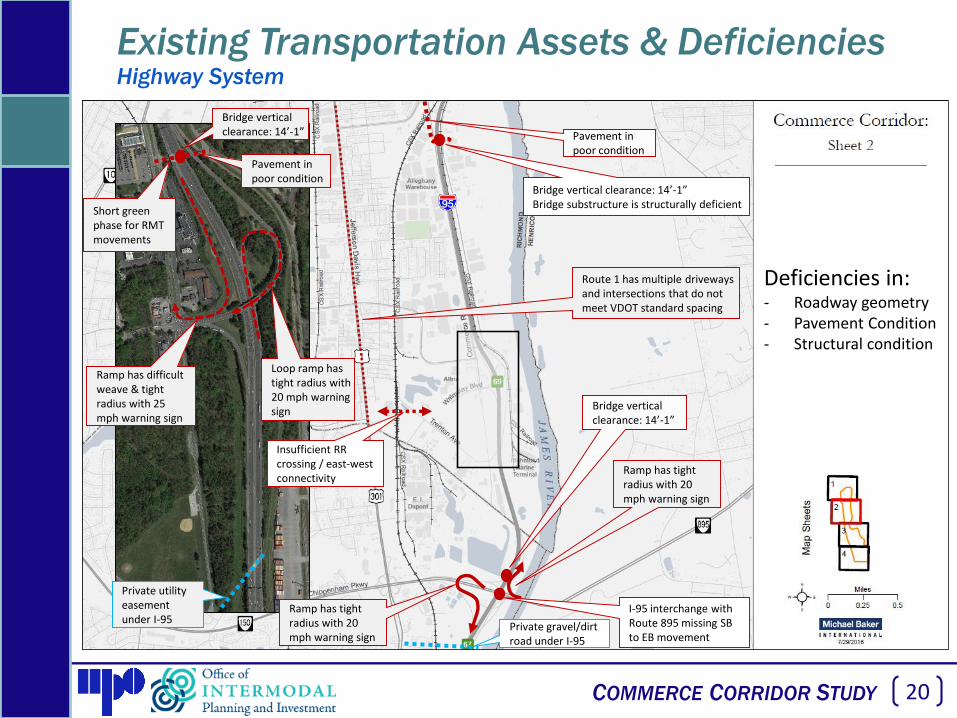
Pavement in poor condition
Bridge vertical clearance: 14’-1”Bridge substructure is structurally deficient
Bridge vertical clearance: 14’-1”
Ramp has difficult weave & tight radius with 25 mph warning sign
Loop ramp has tight radius with 20 mph warning sign
Private utility easement under I-95
Pavement in poor condition
I-95 interchange with Route 895 missing SB to EB movement
Insufficient RR crossing / east-west connectivity
Ramp has tight radius with 20 mph warning sign
Route 1 has multiple driveways and intersections that do not meet VDOT standard spacing
Bridge vertical clearance: 14’-1”
Ramp has tight radius with 20 mph warning sign
Private gravel/dirt road under I-95
Deficiencies in:- Roadway geometry- Pavement Condition- Structural condition
Existing Transportation Assets & DeficienciesHighway System
Short green phase for RMT movements

21
COMMERCE CORRIDOR STUDY 21
Private gravel/dirt road under I-95
Bridge vertical clearance: 13’-7”
Willis Rd interchange design is outdated. Signal spacing does not meet VDOT standards
Route 1 bridge over RR recently reconstructed
Dog-leg intersection with tight turning radii
Route 1 has multiple driveways and intersections that do not meet VDOT standard spacing
Bridge vertical clearance: 14’-4”Bridge deck is structurally deficient
Deficiencies in:- Roadway geometry- Pavement Condition- Structural condition
Existing Transportation Assets & DeficienciesHighway System

22
COMMERCE CORRIDOR STUDY 22
Sub-standard SB deceleration lane length
Ramps have tight radii with 30 mph warning & truck rollover signs
Sub-standard NB acceleration lane length
Sub-standard SB acceleration lane length
Ramps have tight radii with 25 mph warning signs
Deficiencies in:- Roadway geometry- Pavement Condition- Structural condition
Existing Transportation Assets & DeficienciesHighway System
Interchange includes two options for the southbound I-95 to westbound Rt. 10 movement

23
COMMERCE CORRIDOR STUDY 23
Existing Transportation Assets & DeficienciesHighway System
Deficiencies in:- Recurring congestion
Source:TomTom travel time data
Recurring congestion causes queue lengths that extend beyond the adjacent signalized intersection
The Purpose and Need Statement from the Willis Rd. IMR states safety and operations on the I-95 off-ramps as deficiencies that require modifications to the interchange
Daily peak hour congestion along surface streets at Bells Road interchange area
Daily peak hour congestion along surface streets in Route 10 interchange area
Closely spaced signalized intersections along Rt. 1 cause increased congestion during peak travel times
The Purpose and Need Statement from the Rt. 10 IMR states that the loop-ramp from southbound I-95 to eastbound Rt. 10 and the loop-ramp from eastbound Route 10 to northbound I-95 currently have safety and operational deficiencies that require modifications to the interchange

24
COMMERCE CORRIDOR STUDY 24
Hull St. and Maury St. have high crash rates
Royall Ave. has high crash rate
Deficiencies in:- Safety / crash rate
Existing Transportation Assets & DeficienciesHighway System

25
COMMERCE CORRIDOR STUDY 25
Ruffin Rd. has a high crash rate
Intersection of Bells Rd. & Commerce Road has high crash rate
Deficiencies in:- Safety / crash rate
Existing Transportation Assets & DeficienciesHighway System

26
COMMERCE CORRIDOR STUDY 26
Willis Road has high crash rate
Crash rates along I-95 on this sheet are similar to statewide average crash rates in the southbound direction. In the northbound direction, crash rates on I-95 are lower than the state average.
Deficiencies in:- Safety / crash rate
Existing Transportation Assets & DeficienciesHighway System

27
COMMERCE CORRIDOR STUDY 27
Crash rates along I-95 on this sheet are similar to statewide average crash rates in the southbound direction. In the northbound direction, crash rates on I-95 are lower than the state average.
Crash rate on Route 10 exceeds statewide average for principle arterial
Coxendale Road has high crash rate
Osborne Rd./Old Stage Rd. has a high crash rate Deficiencies in:
- Safety / crash rate
Existing Transportation Assets & DeficienciesHighway System

28
COMMERCE CORRIDOR STUDY 28
Richmond Marine Terminal Intermodal Transfer Improvements:• Re-pave north wharf area• Repair dilapidated rail crossings• Replace fenders along the wharf wall
I-95 and Maury Street Freight Interchange Improvements (Smart Scale):• Replace signalized intersection with a roundabout• Re-construct the I-95 ramps
US 1 / US 301 Street Freight Corridor Improvements (Smart Scale):• Reconstruct roadway to include dedicated turn lanes,
new sidewalks, and a bike lane• Improve access management• Installation of new traffic signals
Commerce Road Complete Street• Reconstruct roadway to include protected turn
lanes and segregated bike/ped facilities• Reconfiguration of entrances to improve access
management
Deepwater Terminal Road Extension• Extension of 0.7 miles to Goodes Street• Provides second point of access with 21’ clearance
under I-95 to accommodate oversize cargo
Existing Transportation Assets & DeficienciesVDOT Six Year Improvement Plan Projects

29
COMMERCE CORRIDOR STUDY 29
Existing Transportation Assets & DeficienciesRichmond Marine Terminal

30
COMMERCE CORRIDOR STUDY 30
Existing Transportation Assets & DeficienciesRichmond Marine Terminal

31
COMMERCE CORRIDOR STUDY 31
Existing Transportation Assets & DeficienciesRichmond Marine Terminal

32
COMMERCE CORRIDOR STUDY 32
Existing Transportation Assets & DeficienciesRichmond Marine Terminal

33
COMMERCE CORRIDOR STUDY 33
• Origins of large trucks during typical weekday (Monday – Thursday, April 2015 – March 2016) destined for RMT.
Existing Transportation Assets & DeficienciesRichmond Marine Terminal
Lower % Higher %Negligible

34
COMMERCE CORRIDOR STUDY 34
• Origins of large trucks during typical weekday (Monday – Thursday, April 2015 – March 2016) destined for RMT.
Existing Transportation Assets & DeficienciesRichmond Marine Terminal
Honeywell, DuPont, other
Pilot Truck Stop
Roxbury Industrial
Center
Route 10 industrial corridor
Abilene Motor Express, Alstom
Luck Stone, other
Philip Morris
Lower % Higher %Negligible

35
COMMERCE CORRIDOR STUDY 35
• Transportation-related challenges to growth at RMT• Gate capacity / operations
• Vertical height restrictions at key highway locations
• Bells Road Access Road (across from Altria)
• Commerce Road Access (across from Alleghany)
• Others as shown in previous slides
• Operations at Bells Road interchange with I-95
• A more diversified / balanced mix of RMT customers is an important part of the future success (e.g. more rail)
• There exist opportunities through future contracts with customers to have ‘on-site presence’. This includes the 14-acres of developable land at south end of site
Existing Transportation Assets & DeficienciesRichmond Marine Terminal

36
COMMERCE CORRIDOR STUDY 36
Defining the Transportation Future of the Commerce Corridor
• Discussion Questions
• Should our aim be to invest in ways that would diversify the modal options for freight movement in the corridor?
• Are some of the problems in the corridor more an issue of perception than reality?

37
COMMERCE CORRIDOR STUDY 37
Defining the Transportation Future of the Commerce Corridor
• For the Commerce Corridor, what is its• Greatest transportation strength
• Greatest transportation weakness
• Greatest transportation opportunity
• What transportation system improvements should we prioritize?• Consider the industries we prioritized earlier

38
COMMERCE CORRIDOR STUDY 38
In 2040 the Commerce Corridor will . . .
Defining the Future of the Commerce Corridor

39
COMMERCE CORRIDOR STUDY 39
Connectivity Assessment at Select Sites

40
COMMERCE CORRIDOR STUDY 40
To understand the connectivity and operations challenges of the surface street & interstate networks in close proximity to key economic
development sites for the various growth scenarios developed as part of the study
Site Connectivity & Operations AssessmentPurpose of Conducting Site Assessment Studies

41
COMMERCE CORRIDOR STUDY 41
1) Commerce Road / Ingram St area
2) Alleghany Warehouse site
3) DuPont property near Commerce Road / Trenton Ave
4) Altria parcels near Commerce Road / Walmsley Blvd
5) Tranlin property on Willis Road
6) Route 10 Industrial Corridor east of I-95
7) Route 1 / I-295 Industrial corridor in Hanover County
8) RIC / White Oak area
9) Meadowville Technology Park area
Site Connectivity & Operations AssessmentNine candidate Locations Identified

42
COMMERCE CORRIDOR STUDY 42
Site Connectivity & Operations AssessmentMap Key

43
COMMERCE CORRIDOR STUDY 43
Candidate Assessment Area #1
Commerce Rd / Ingram St
Site Connectivity & Operations AssessmentCandidate Locations – Sheet 1 of 4

44
COMMERCE CORRIDOR STUDY 44
AlleghanyWarehouse
Altria
Candidate Assessment Area #2
Alleghany Warehouse
Candidate Assessment Area #3
DuPont Property
Candidate Assessment Area #4
Altria Property
Site Connectivity & Operations AssessmentCandidate Locations – Sheet 2 of 4

45
COMMERCE CORRIDOR STUDY 45
TranlinPaper
Candidate Assessment Area #5
Tranlin Property
Site Connectivity & Operations AssessmentCandidate Locations – Sheet 3 of 4

46
COMMERCE CORRIDOR STUDY 46
Route 10Industrial Corridor
Candidate Assessment Area #6
Route 10 Industrial area
Site Connectivity & Operations AssessmentCandidate Locations – Sheet 4 of 4

47
COMMERCE CORRIDOR STUDY 47
Candidate Assessment Area #8
RIC / White Oak areaCandidate Assessment Area #7
Route 1 / I-295 area
Candidate Assessment Area #9
Meadowville area
Site Connectivity & Operations AssessmentCandidate Locations – Regional
48
COMMERCE CORRIDOR STUDY 48
Interactive Discussion on Site Selection
Factors to consider when selecting areas for detailed analysis:• Is the site or area developed, developing (e.g. Tranlin), future development /
redevelopment, or a mix?• Which type of site or area should take priority for site connectivity assessment?
• Does the site or area have sufficiently large, marketable sites to impact the future of the Commerce Corridor?
• Does the site or area currently bring/or have potential to bring customers to the doorstep of RMT?
• Is the site or area currently generating or attracting trips to, from, or within the Commerce Corridor?
• Does the site or area have documented transportation challenges to be mitigated?
Site Connectivity & Operations Assessment

49
COMMERCE CORRIDOR STUDY 49
Review summary of workshop discussion and seek consensus on
direction for corridor
Group Discussion on Workshop Take-Aways
50
COMMERCE CORRIDOR STUDY 50
Finalize identification of 4 sites for connectivity and operations
assessment
Workshop Wrap-up

51
COMMERCE CORRIDOR STUDY 51
Project Communication
Meeting coordination and information sharing through RRTPO staff.
Primary contact:
Chris Wichman
(804) 323-2033
Project website:
http://www.richmondregional.org/Commerce_Corridor/

52
COMMERCE CORRIDOR STUDY 52
Next Steps
• Post / Circulate materials from today’s Workshop
• Continue Stakeholder interviews
• Conduct Focus Group discussions
• Develop Market Opportunity Scenarios
• Perform Future Needs Assessment & Prioritization
• Hold next meetings with PAC & TAC in early Nov.

COMMERCE CORRIDOR STUDY 53
COMMERCE CORRIDOR STUDY
Photo: City of Richmond
Technical Advisory Committee / Policy Advisory Committee
Workshop on Defining the Future
8/11/2016

54
COMMERCE CORRIDOR STUDY 54
Extra slides beyond this point

55
COMMERCE CORRIDOR STUDY 55
Introduction to Commerce Corridor

56
COMMERCE CORRIDOR STUDY 56
PAC & TAC Membership
Stakeholder Technical Advisory Committee
Policy Advisory Committee
Chesterfield County Barb Smith Bill DuplerCity of Richmond Amy Inman Lee DowneyCTB Carlos Brown DRPT Michael Todd Pete BurrusOIPI/ Secretary’s Office Kelli Nash Ronique DayPOV Chris Gullickson or
Sarah McCoyJeff Florin
P3 Ali Lauzon Ali LauzonRRTPO Chris Wichman Barbara NelsonVDOT Central Office Chris Detmer Ben MannellVDOT Richmond District Ron Svejkovsky Mark RiblettVEDP John Loftus

57
COMMERCE CORRIDOR STUDY 57
Scope Overview
Task 1: Existing Conditions & Asset Inventory
Task 2: Existing Deficiency & Needs Identification
Task 3: Defining Future & Focus Groups
Task 4: Market Opportunity Scenario Analysis & Future Needs Assessment
Task 5: Needs Prioritization
Task 6: Solution Identification
58
COMMERCE CORRIDOR STUDY 58
Scope Overview, Cont’d
Task 7: Assessment of Solutions
Task 8: Identification of Short, Medium, & Long-Term Solutions
Task 9: Implementation Plan/Roadmap
Task 10: Project Coordination
Task 11: Project Management

59
COMMERCE CORRIDOR STUDY 59
PAC & TAC Responsibilities
• Policy Advisory Committee
• Provides high level policy input
• Steers direction of the study
• Reviews final deliverables
• Technical Advisory Committee
• Participates more directly in technical approaches
• Provides mode-specific expertise
• Reviews draft deliverables

60
COMMERCE CORRIDOR STUDY 60
Project Timeline
• Notice to Proceed – June 9, 2016
• 8-9 month schedule• Anticipated completion February 2017
• 5 PAC Meetings
• 5 TAC Meetings

COMMERCE CORRIDOR STUDY 61