committee(s): date(s): planning & transportation 26...
TRANSCRIPT

Committee(s): Planning & Transportation Committee Projects Sub-Committee
Date(s): 26 November 2013 5 December 2013
Subject: Department of Built Environment Projects Programme
Public
Report of: Director of the Department for the Built Environment
For Decision
Summary
This report sets out the current programme for all Department of the Built Environment Capital Projects. This builds on the report put to Committees in May this year that set out the Environmental Enhancement project programme, and adds in the transport, Highways and other projects being progressed by the department. The report provides updates on progress made and seeks approvals for project initiation for new projects at Gateway 2, which can be considered in the light of the full programme of projected work. A programme of the „major Projects expected to be carried out by the department over the next five years is included The report aims to provide an overview of all projects to assist Members in decision making. These projects originate in three ways. Firstly, and primarily, they are agreed and prioritised through Planning and Transportation Committee and the Court of Common Council as part of the process of agreeing and adopting Area Environmental Enhancement Strategies („Area Strategies‟). Secondly they may be approved by Members following the direct request of a developer/occupier to enhance an area around their building. These projects would be legally binding through either S106 or s278 agreements. Finally they may be specific environmental enhancement projects funded by Transport for London (TfL), or rarely through City funding. This report also sets out the funding sources for the projects, which are predominantly external to the City‟s own funds and the estimated delivery and spend on projects over the next three financial years. To provide a comprehensive overview of environmental enhancement projects this report has four appendices. The first sets out the current programme of all approved projects in Gateway order. It lists them under four categories; firstly those projects currently approved for construction, under construction, or completed and awaiting closedown (Gateway 5-7); secondly those where options for project delivery are being worked on prior to final approval (Gateway 3-4); thirdly those currently being promoted through this report for approval to commence outline option appraisal (Gateway 1-2) and finally those projects which are included in Approved Strategies or which relate to anticipated developments coming through the Town Planning process, but which are not yet being promoted to become live projects (Gateway 0). The second Appendix sets out a comprehensive schedule showing progress made in the delivery of all projects included in the currently approved Area

Strategies. This again is intended to assist Members in decision making, particularly in relation to the approval of the Gateway 2 projects being presented for approval that are set out in detail in Appendix 6. The second Appendix sets out the programme of construction for major projects that the Department expects to be implementing in the next five years. This will be a key consideration when assessing the traffic impact of implementing these schemes alongside redevelopments and utility works carried out by statutory undertakers. The intention is to regulate the timing of those schemes where there is more discretion in relation to completion dates to minimise the overall impact on congestion in the City. A future report is planned that will set out this full programme of works being carried out on the City streets over the next 5 years. It is recommended that Members:
Note the full programme of projects being undertaken by the Department of Built Environment as set out in Appendix 1.
Note the progress made in delivering Area Enhancement Strategies as set out in Appendix 4.
Approve projects at Gateway.2 for the projects set out in Appendix 6.
Note projected programme of major projects as set out in Appendix 2.

Background 1. This report sets out an overview of current projects, in order to enable Members to keep an
overview of the project programme and to control the implementation and co-ordination of projects. This includes those projects that have been completed, those currently being implemented and those that have been approved in principle by the Planning and Transportation Committee and Court of Common Council, and are envisaged will be delivered over the next few years, subject to funding.
2. The Department of Built Environment Project Programme relates primarily to projects that are
delivered through the implementation of Environmental Enhancement Area Strategies, Section 106 and Section 278 Agreements related to development applications, specific undertakings from City businesses and developers to facilitate the improvement of the immediate area around their building and/or TfL (Transport for London) funded Environmental Enhancement Projects. There are in addition a small number of street infrastructure projects, such as street lighting and toilet provision that arise from time to time.
3. In order to manage the programme of projects the City has been developing the use of a co-
ordinating software package, Project Vision. This software is compatible with the Prince 2 project management methodology used by the Department of Built Environment, for the effective management of its projects. Project Vision is aligned with the City‟s recently revised project governance procedures, and projects are monitored on that basis.
4. The progress of projects through the corporate system is determined through their approval at
defined „Gateways‟. These are:
Gateway Zero: Projects that are included in approved Environmental Enhancement Area Strategies, or are related to developments coming forward through the Town Planning process and have likely Planning or Highway agreement funding associated with them . Gateway 1: Approval the Chief Officers Corporate Project Board. Gateway 2: Approval by the Projects Sub-Committee as a valid project for outline options appraisal Gateway 3: Approval of key option(s) from outline options appraisal. Gateway 4: Approval for chosen final option to be designed in detail. Gateway 5: Approval of final budget and implementation of the project. Gateway 6: Progress and update reports Gateway 7: Outcome reports on completion of the project.
5. In order to oversee greater co-ordination of the funding and implementation of projects, this
committee report seeks to bring together the programme of projects currently approved and co-ordinated through Project Vision with those planned, and to set out the full programme of potential project work. These are set out in full in Appendix 1 to this report and for ease of analysis are grouped into the following categories:
Gateway 5-7: Projects approved for implementation (some of which have been substantially completed), but not including completed projects

Gateway 3-4: Approved projects at various stages of options appraisal, but not yet approved for implementation. Gateway 1-2: Projects that are being brought forward, for approval as valid projects seeking approval to evaluate options. Gateway Zeros: Projects in approved Environmental Enhancement Area Strategies and/or coming forward from developments, either with Planning Permission given, or at pre-application stage.
To provide an indication of possible total spend should all projects proceed to completion, Table 1 below shows a firmer projection of spend over the next 3 years and provides an indicative figure for future years. For all projects that have not been approved for implementation (i.e. not approved at Gateway 5) the projected spend figures represent a best estimate of expenditure that will become further refined as the project moves through the defined gateways as set out above. Table1 shows that the average projected annual spend on Approved DBE projects, from all sources over the next three financial years is currently £ 18.5 Million. This reflects the scale of change in the built environment of the City, and particularly relates to major developments in the North and East of the City. .
Table. 1
*the total for Gateway Zero projects includes projects that may never come forward and gain approval or that may gain
approval as a project in several years
6. Table 2 below shows the projected sources of funding for the programme. It can be seen that most of the funding for the Department of Built Environment Project Programme is provided externally, through planning agreements related to developments, either through Section106 of the Town and Country Planning Act 1990, or through Section 278 of the Highways Act 1980. These agreements are intended to offset the direct impact on the City of new developments, or to meet the specific needs or wishes of City businesses or developers entirely at their own cost.
Projected Year of Financial Spend in £000
Project Gateway Stages Previous Years FY 13-14 FY 14-15 FY 15-16 Future
Years
TOTAL
Approved for
implementation or in
progress
Gateway 5-7 19,787 10,618 8,690 2,711 950 42,756
Approved for Options
Appraisal. Gateway 3-4 1,305 4,353 12,422 12,751 31,362 62,193
Project approval
Gateway 1-2 60 220 2,202 1,637 16,043 20,162
Subtotal 21,152 15,191 23,314 17,099 48,355 125,111
Projects in approved
strategies and from likely
developments
Gateway Zeros* 0 244 1,617 5,112 39,233 46,206
TOTAL 21,152 15,435 24,931 22,211 87,588 171,317

Table.2
*the total for Gateway Zero projects includes projects that may never come forward and gain approval or that may gain approval as
a project in several years
7. Table.2 also shows a reduced reliance on the City of London‟s own funds for implementing environmental enhancement, transport and highways projects in the City. It also shows how successful the City has been at attracting Transport for London Major Projects funding. This means that the City‟s public realm is being renewed predominantly through the funding from developers and TfL. Not only does this benefit the City in terms of environmental quality, but the renewal of infrastructure also reduces the input of City funding for future maintenance. This external funding also ensures that the City moves forwards in terms of accessibility for those with mobility impairments, public space provision, climate change adaptation, play, cultural activities and welcome to City visitors.
8. Where Table 2 and Appendix 1 show direct City funding being utilised, it is either from the
Surplus on the On-Street Parking Account (Parking Surplus), or from Bridge House. In the case of Parking Surplus it is mostly related to older projects such as Queen Street and the Riverside Walkway, where expenditure has already been incurred in previous years. Currently, £1.5 Million of Parking Surplus is being used as part of the funding for projects around the Barbican, as part of the implementation of the Barbican Area Strategy, which is match funded with Section 106 funding from the Heron Development. Small elements of Parking Surplus and other CoL funding have also been approved as „seed corn‟ funding that help to move projects forward to attract funding from other sources, such as TfL, sponsorship or grant giving bodies. Bridge House funding of £1.62 Million is currently only used for the Staircase at London Bridge project, being implemented next financial year.
Projected Source of Funding in £000
Project Gateway Stages S.106/S.278/CIL TfL Parking
Surplus
Bridge
House/Other
CoL
TOTAL
Approved for
implementation or in
progress
Gateway 5-7 31,351 5,067 3,183 3,155 42,776
Approved for Evaluation
Gateway 3-4 48,815 12,269 1,109 0 62,193
Project approval
Gateway 1-2 10,117 10,045 0 0 20,162
Subtotal 90,283 27,381 4,292 3,155 125,111
Projects in approved
strategies and from likely
developments
Gateway Zeros* 37,695 5,592 33 2,886 46,206
TOTAL 127,978 32,973 4,325 6,041 171,317

Environmental Enhancement Area Strategies 9. In order to set out and to manage the City‟s priorities with regards to environmental
enhancement and major transport projects, Environmental Enhancement Area Strategies have been developed over recent years. These give officers clear direction in making funding applications to bodies like TfL and in negotiating Section 106 and Section 278 agreements with developers and businesses.
10. Environmental Enhancement Area Strategies were piloted with the approval of the Queen
Street Area Strategy in 2003. In order to progress Area Strategies in manageable chunks, with local input, the City has been divided into 16 different districts for the purposes of ensuring that over time the whole City will be covered by an approved strategy. There are currently 11 approved strategies:
Cheapside and Queen Street St. Pauls and Carter Lane Riverside Walkway Fleet Street Courts and Lanes Eastern City Cluster Aldgate and Tower Barbican Guildhall Bank Fenchurch Street & Monument Liverpool Street West Smithfield (Being Recommended for Approval)
A map showing the strategy areas and the strategy adoption stage they are in is attached as Appendix 3.
11. The strategies seek to ensure that the City‟s public realm (mostly public highway) keeps pace with the changing needs of the City community. The Planning and Transportation Committee is responsible for approving Area Strategies, which are then referred to the Court of Common Council for final agreement. Each Area Strategy approved includes a number of specific projects considered necessary to meet the needs of the particular area. The projects are proposed following public consultation with stakeholders. The projects are presented by the priority (High, Medium and Low) in which it is intended they will be implemented, subject to funding and developments coming forward. Progress made on implementing these strategies is set out fully in Appendix 4. It should be noted that occasionally low priority projects are implemented ahead of high and medium priority. This is due to developments adjacent to proposed projects, where the project becomes part of the planning obligation and the project becomes a high priority for the development, but remains a low priority for the strategy in general.
12. As well as project priority the strategies set out the estimated cost of each project, and a
funding plan to set out where funding will be sought. The vast majority of funding used to implement the strategies is external to the City‟s own funds, and is usually obtained through Section 106 agreements and S.278 agreements related to new developments, or through TfL funding obtained through the Mayor‟s Major Project Programme. In the past there has also been significant funding obtained from City businesses and developers unilateral undertakings. These are often delivering security and/or public realm enhancements seen as essential by developers for their specific project.

13. The Area Strategies do not make planning policy but help implement the Citywide spatial planning policies for sustainable growth set out in the City‟s adopted Core Strategy 2011 and the Draft Local Plan 2013. The Area Strategies provide a delivery plan for environmental enhancement in each district that also advances the objectives of the following City Corporation documents:
City‟s Road Danger Reduction Plan Open Spaces Strategy Biodiversity Action Plan Climate Change Adaption Strategy Noise Reduction Strategy Air Quality Enhancement Strategy
14. The Court of Common Council approved strategies are each intended to have an
implementation period of about 5 years. Within that time, experience has shown that all high priority, most medium priority and some lower priority projects will usually be implemented or commenced.
15. Some of the more significant projects delivered through the implementation of Area Strategies
over the years, have included:
Queen Street. The creation of a pedestrian priority quarter around Bow Lane and Watling Street Carter Lane & St. Pauls. The relocation of the St. Pauls Coach Park, pedestrianisation of Carter Lane and the creation of new gardens Riverside Walkway. Access and route enhancements and the creation of new links and spaces such as Grants Quay in the East and Paul‟s Walk in the West. Eastern Cluster. Ahead of the implementation of the public space enhancements an arts project to install world class sculptures on a rolling programme with financial backing from local businesses has had great success. Chancery Lane. A joint project with Camden and Westminster Councils for the widening and realignment of footways on Chancery Lane, and the creation of public spaces in side streets
16. The current work programme for Environmental Enhancement Area Strategies is largely
targeted at those areas with existing strategies, where the strategies have been in place for over 5 years, and where there is major change expected over the next five years. The following area strategies are currently being reviewed and renewed, and will be the subject of extensive public consultations as this process of review progresses:
Riverside Walkway Fleet Street Barbican Cheapside & Guildhall (combining the two strategies)
17. Area Strategies have been brought forward for consultation and adoption when the pressure or
need for change is thought to be of a scale that needs to be managed, through a phased implementation of several projects in one district. This needs to be matched with a realistic and achievable funding plan for the strategy that will implement all high, most medium and some lower priority projects within the intended five year life of the strategy. Some districts of the City have very little pressure from development, such as the Temple/ Whitefriars areas and, to date, it has not been necessary or affordable to bring strategies forward for the environmental enhancement of these areas.

Gateway 2 Approvals 18. To give an indication of those projects likely to be brought forward in coming years from all
sources, a schedule of „Project Zeros‟ is kept on Project Vision and regularly updated. The current schedule is set out in Appendix 1. There are some IT and lighting projects included in the schedule, however this schedule is predominantly made up of:
All projects that form part of an approved Environmental Enhancement or Transport Strategy.
Projects that are agreed through signed Section.106 Agreements
Projects that are agreed through signed Section.278 Agreements 19. As agreed by Members in May this year, projects will be brought forward from the current
Project Vision Schedule of Gateway Zeros, or where there is immediate need to initiate a project that has not previously been identified, but where there is need and funding available to implement the project. In considering projects brought forward for initiation Members will be able to assess the priorities being recommended by officers in the context of the whole potential work programme.
20. At this time it is recommended that the following 7 projects are brought forward for approval at
Gateway 2 ( Full details are include at Appendix 6):
LIVERPOOL STREET
MOORGATE AREA
LONDON WALL PLACE S278
MUSEUM OF LONDON GYRATORY
PLOUGH PLACE
PHILPOT LANE AND EASTCHEAP CROSSING
BANK JUNCTION IMPROVEMENTS
THE MAYOR OF LONDON - VISION FOR CYCLING IN LONDON
A map showing the location of these project (with the exception of the Mayor‟s Vision for Cycling that deals with the whole City) is attached as Appendix 5 to this report.
21. Two of the projects being recommended for implementation are related to the completion and
operation of Crossrail in 2018. Liverpool Street and Moorgate Area projects seek to direct the enhancement of the environment and local transport provision around the entrances at either end of the Crossrail platform that stretches between Liverpool Street and Moorgate. Both of these are High Priority projects in the Liverpool Street Area Strategy, approved by the Court of Common Council in September 2013. The projects seek to co-ordinate with the station re-instatement works to be carried out by Crossrail, to ensure that the wider street environment is improved and adjusted to deal with the increased number of people that Crossrail will move in and out of the City.
22. Three of the projects, Moorgate, London Wall Place S278 and the Museum of London Gyratory projects link together and wrap around the southern end of the Barbican Area. These projects need to be considered together, as they deal with issues of the movement of people and vehicular traffic in area where significant growth is expected in terms of the number of pedestrians and cyclists. This growth is related to Crossrail, cycling growth, and the Cultural Quarter strategy, which looks to reinforce its Cultural Hub made up of the arts and culture institutions in the Barbican area. As has been said, Moorgate Area project deals with the impact of Crossrail, the London Wall Place Section 278 relates to the narrowing of London Wall, required to accommodate the development at London Wall Place (St. Alphage House). This presents options for introducing footways for the full length of London Wall, improving Cycle provision in line with the Mayor for London‟s Cycling Vision, and improving north south

connections across London Wall for pedestrians. The Museum of London Gyratory Project connects with London Wall and seeks to make two way working streets from St.Martins le Grand and King Edward Street. The aim of the project is to reduce the road danger of the Gyratory, which has a poor collision record and to create ease of movement across the area for the increasing number of visitors that are in the St.Pauls/Museum area. The project has the potential to significantly enhance access to the Museum of London at Street Level. Close liaison with the Museum on their emerging plans for the future will be critical to maximising the benefits of this project.
23. Plough Place is a Section 106 and Section 278 funded project related to the redevelopment of
12-14 New Fetter Lane and 43 Fetter Lane. It involves the removal of vehicular traffic from Plough Place, a section of Highway land used to access surface level parking associated with the previous building on the development site. The project proposal was submitted with the planning application, and is an essential part of changing the environment around the building to make it acceptable in planning terms.
24. Philpot Lane/Eastcheap Crossing project is stipulated as necessary in the Section 278
agreement for the 20 Fenchurch Street development, in order to make the development acceptable in planning terms. The need to provide improved safe pedestrian access to this significant building was identified at the planning stage of the development. The project will be fully funded from the existing Section 278 agreement. As well as delivering the necessary function, the enhancements will also deliver on the objectives of the approved Fenchurch and Monument Area Enhancement strategy, seeking to improve both Philpot Lane and Eastcheap.
25. Bank Junction Improvements is the flagship project of the Bank Area Environmental
Enhancement Strategy approved by Members in July 2013. The project is focused on reducing the road danger currently causing Bank Junction to have one of the highest collision records of junctions in the City. These collisions are particularly problematic for the more vulnerable and majority walking and cycling users of the junction, where the existing layout is far from optimal. Initial work done for the strategy has identified several options for creating a safer environment and providing more time and more space for vulnerable users. With projected growth in the daytime population of the City, the project is seen as key in capturing the benefits of the upgrade of the Bank Underground Station that will deliver greater capacity for moving people in and out of the heart of the City. The scheme also has the aim of creating a significantly improved local environment at Bank, that will allow the Royal Exchange, the Bank of England and the Mansion House to release the potential for Bank as a new civic public space for the City.
26. The Mayor of London – Vision for London Cycling was launched in March 2013. The vision includes a wide variety of initiatives, all with the aim of improving provisions for cyclists. (A copy of the Vision is provided in to the gateway 2 Report attached. Transport for London (TfL), various local authorities, police forces, Royal Parks and other agencies have been working together with the view of delivering that strategic vision.
The four relevant themes pertinent to the City and other inner London authorities are:-
a. Monitoring & Strategies. This includes qualitative and quantitative monitoring, strategies and research.
b. Better and safer routes for cycling. This includes cycle superhighways, cross rail for bikes and quietways forming the Central London Cycle Grid and better junctions. Draft objectives, guiding principles and levels of service for the Central London Cycle Grid are provided in Appendix 3.
c. Safer cycling. Targeted small scale engineering solutions, education, training and publicity.
d. More people cycling. Culture change, inspiring new cyclists, cycle parking and rail integration.

The Mayor, through TfL will be providing funding (through bids) to boroughs and other agencies. The City has already secured £44,880 of early funding in order to engage with the development of the Central London Cycle Grid.
27. Appendix 6 contains the Gateway 2 reports for project initiation that are recommended for approval by Members. These reports have been agreed by the Chief Officers Corporate Project Board that oversees the initiation of projects across the City of London departments.
28. Legal Implications
Projects can require varying degrees of legal input under a potentially wide range of issues such as agreements with third party funders; identifying affected land ownerships and agreements with affected land owners; agreements with neighbouring authorities; statutory processes required to implement highways or traffic changes; procurement; issues arising from implementation such as claims arising from works carried out. This is provided by Comptroller and City Solicitor‟s staff as far as possible, but the feasibility of this will depend on the number and scope of active projects. Therefore the resource requirements of a project in terms of legal issues should be identified and taken into account in determining project programmes and/or cost.
Conclusion The programme for Department of the Built Environment projects is keeping pace with the rate of the rapid change of built environment in the city, and in the changing pattern and mode of movement in the City‟s streets. This is providing for the planned growth identified in the Local Plan. There is a projected growth in cycling and an increase in the daytime population, increase in night-time economy, visitor activity and significant improvements to transport links. All of this pressure requires strategy and management, with planned changes through the implementation of projects that align the City‟s infrastructure with the changing City. The Environmental Enhancement Area Strategy approach has proved to be an effective way of setting out this change, and will remain the main co-ordinating mechanism to ensure proper community consultation and joined up project delivery for enhancement projects. .

Appendices
Appendix 1 Programme of approved projects.
Appendix 2 Progress of approved Area Strategies
Appendix 3 Gateway 2 Short Form Reports
Appendix 4 Programme of Major Projects being progressed by DBE
Contact
Report Author Victor Callister
Email Address [email protected]
Telephone Number 0207 332 3468

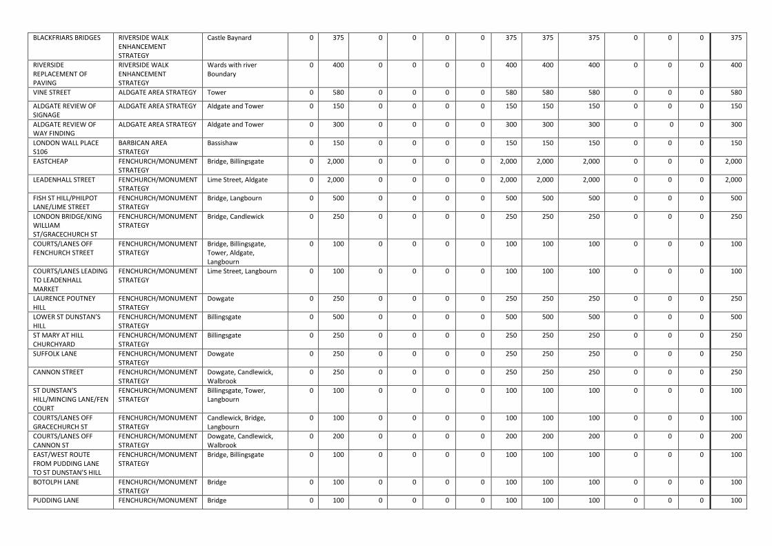
Appendix.1
Programme of
Approved Environmental Enhancement Projects.

Gateway 0 Projects Name Programme Wards Cost
App'd by CCC £000
Latest Est'd Cost £000
Exp. pre 01/04/13 £000
2013/14 £000
014/15 £000
2015/16 £000
Future Years
Forecast Total
S.106/S.278 CIL/ Other External
Transport for London
Parking Meter Reserve
Bridge House Estates /City fund
Total Funding
1 NEW STREET SQUARE ROADS Castle Baynard 0 947 0 10 50 0 887 947 947 0 0 0 947
COURTESY CROSSING STUDY
ROAD DANGER REDUCTION
City Wide 0 3,040 0 40 500 1,500 1,000 3,040 0 3,040 0 0 3,040
EASTERN CITY CLUSTER PHASE 3
EASTERN CITY CLUSTER Lime Street 0 800 0 50 200 300 250 800 800 0 0 0 800
EASTERN CITY CLUSTER PHASE 4
EASTERN CITY CLUSTER Lime Street 0 719 0 0 0 70 649 719 719 0 0 0 719
100 BISHOPSGATE S278 EASTERN CITY CLUSTER Bishopsgate 0 300 0 0 0 0 300 300 300 0 0 0 300
MITRE SQUARE S106 EASTERN CITY CLUSTER Aldgate 0 866 0 0 0 400 466 866 866 0 0 0 866
MONUMENT STREET FENCHURCH/MONUMENT STRATEGY
Bridge 0 136 0 0 136 0 0 136 136 0 0 0 136
MONUMENT JUNCTION FENCHURCH/MONUMENT STRATEGY
Candlewick 0 1,000 0 0 0 0 1,000 1,000 0 1,000 0 0 1,000
11-19 MONUMENT STREET
FENCHURCH/MONUMENT STRATEGY
Bridge 0 300 0 0 0 0 300 300 300 0 0 0 300
LOMBARD STREET BANK AREA STRATEGY Langbourn, 0 1,500 0 0 0 500 1,000 1,500 1,000 500 0 0 1,500
GREENING CHEAPSIDE CHEAPSIDE STRATEGY Cheap, Bassishaw 0 350 0 0 175 175 350 250 100 0 0 350
LONG LANE WEST SMITHFIELD STRATEGY
Farringdon Without, Aldersgate
0 500 0 0 0 0 500 500 250 250 0 0 500
BARTS HOSPITAL WEST SMITHFIELD STRATEGY
Farringdon Without 0 400 0 0 30 30 340 400 400 0 0 0 400
4 CANNON STREET CHEAPSIDE STRATEGY Bread Street, Vintry 0 3,215 0 0 0 0 3,215 3,215 3,215 0 0 0 3,215
BALTIC STREET WEST BARBICAN AREA STRATEGY
Cripplegate 0 350 0 0 0 0 350 350 350 0 0 0 350
FANN STREET BARBICAN AREA STRATEGY
Cripplegate/Aldergate 0 100 0 0 0 0 100 100 100 0 0 0 100
GOLDEN LANE BARBICAN AREA STRATEGY
Cripplegate 0 200 0 0 0 0 200 200 200 0 0 0 200
BARBER SURGEONS GARDENS
BARBICAN AREA STRATEGY
Cripplegate 0 150 0 0 0 0 150 150 150 0 0 0 150
BARBICAN CITY WALKWAYS
FENCHURCH/MONUMENT STRATEGY
Cripplegate, Aldersgate 0 100 0 0 0 0 100 100 100 0 0 0 100
ALDERSGATE STREET/ GOSWELL ROAD
BARBICAN AREA STRATEGY
Aldersgate 0 500 0 0 0 0 500 500 500 0 0 0 500
GUILDHALL PARKING AND SERVICING PLAN
GUILDHALL AREA STRATEGY
Bassishaw 0 20 0 0 0 20 20 20 0 0 0 20
GOLDEN LANE ESTATE CITY WALKWAY AREAS
BARBICAN AREA STRATEGY
Cripplegate 0 200 0 0 0 0 200 200 200 0 0 0 200
WHITE LION HILL RIVERSIDE WALK ENHANCEMENT STRATEGY
Castle Baynard 0 300 0 0 0 0 300 300 300 0 0 0 300
ST MAGNUS GARDEN RIVERSIDE WALK Bridge 0 150 0 0 0 0 150 150 150 0 0 0 150

ENHANCEMENT STRATEGY
RIVERSIDE RE-CLADDING OF WALLS
RIVERSIDE WALK ENHANCEMENT STRATEGY
Wards with river Boundary
0 275 0 0 0 0 275 275 275 0 0 0 275
RIVERSIDE LIGHTING STRATEGY
RIVERSIDE WALK ENHANCEMENT STRATEGY
Wards with river Boundary
0 400 0 0 0 0 400 400 400 0 0 0 400
BREAMS BUILDINGS CHANCERY LANE STRATEGY
Farringdon Without 0 150 0 0 0 0 150 150 150 0 0 0 150
CHANCERY LANE GATEWAYS
CHANCERY LANE STRATEGY
Farringdon Without 0 50 0 0 0 0 50 50 50 0 0 0 50
CHANCERY HOUSE GREEN SPACE
CHANCERY LANE STRATEGY
Farringdon Without 0 150 0 0 0 0 150 150 150 0 0 0 150
PLEYDELL STREET FLEET STREET AREA STRATEGY
Castle Baynard 0 100 0 0 0 0 100 100 100 0 0 0 100
BOUVERIE & WHITEFRIARS STREET
FLEET STREET AREA STRATEGY
Castle Baynard 0 200 0 0 0 0 200 200 200 0 0 0 200
HANGING SWORD ALLEY FLEET STREET AREA STRATEGY
Castle Baynard 0 150 0 0 0 0 150 150 150 0 0 0 150
SALISBURY SQUARE FLEET STREET AREA STRATEGY
Castle Baynard 0 100 0 0 0 0 100 100 100 0 0 0 100
BRIDE LANE AND COURT FLEET STREET AREA STRATEGY
Castle Baynard 0 150 0 0 0 0 150 150 150 0 0 0 150
LOMBARD LANE FLEET STREET AREA STRATEGY
Castle Baynard 0 40 0 0 0 0 40 40 40 0 0 0 40
TEMPLE LANE FLEET STREET AREA STRATEGY
Castle Baynard, Farringdon Without
0 60 0 0 0 0 60 60 60 0 0 0 60
BRIDEWELL PLACE FLEET STREET AREA STRATEGY
Castle Baynard 0 75 0 0 0 0 75 75 75 0 0 0 75
HUTTON STREET FLEET STREET AREA STRATEGY
Castle Baynard 0 60 0 0 0 0 60 60 60 0 0 0 60
DORSET RISE FLEET STREET AREA STRATEGY
Castle Baynard 0 60 0 0 0 0 60 60 60 0 0 0 60
MITRE COURT ALDGATE AREA STRATEGY Aldgate 0 100 0 0 0 0 100 100 100 0 0 0 100
ALDGATE BUS STATION IMPROVEMENTS
ALDGATE AREA STRATEGY Aldgate 0 1,000 0 0 0 0 1,000 1,000 1,000 0 0 0 1,000
VINE STREET AND CRESENT
ALDGATE AREA STRATEGY Tower 0 750 0 0 0 0 750 750 750 0 0 0 750
AMERICA SQUARE ALDGATE AREA STRATEGY Tower 0 650 0 0 0 0 650 650 650 0 0 0 650
LITTLE SOMERSET STREET
ALDGATE AREA STRATEGY Aldgate 0 750 0 0 0 0 750 750 750 0 0 0 750
HAYDON STREET ALDGATE AREA STRATEGY Tower 0 500 0 0 0 0 500 500 500 0 0 0 500
PORTSOKEN STREET ALDGATE AREA STRATEGY Tower 0 100 0 0 0 0 100 100 100 0 0 0 100
JEWRY STREET ALDGATE AREA STRATEGY Tower 0 400 0 0 0 0 400 400 400 0 0 0 400
ALDGATE RAISED TABLES ALDGATE AREA STRATEGY Aldgate and Tower 0 150 0 0 0 0 150 150 150 0 0 0 150
ST BRIDES CHURCHYARD FLEET STREET AREA STRATEGY
Castle Baynard 0 80 0 0 0 0 80 80 80 0 0 0 80
BLACKFRIARS BRIDGES RIVERSIDE WALK ENHANCEMENT STRATEGY
Castle Baynard 0 375 0 0 0 0 375 375 375 0 0 0 375
RIVERSIDE REPLACEMENT OF PAVING
RIVERSIDE WALK ENHANCEMENT STRATEGY
Wards with river Boundary
0 400 0 0 0 0 400 400 400 0 0 0 400
VINE STREET ALDGATE AREA STRATEGY Tower 0 580 0 0 0 0 580 580 580 0 0 0 580
ALDGATE REVIEW OF SIGNAGE
ALDGATE AREA STRATEGY Aldgate and Tower 0 150 0 0 0 0 150 150 150 0 0 0 150
ALDGATE REVIEW OF WAY FINDING
ALDGATE AREA STRATEGY Aldgate and Tower 0 300 0 0 0 0 300 300 300 0 0 0 300
LONDON WALL PLACE S106
BARBICAN AREA STRATEGY
Bassishaw 0 150 0 0 0 0 150 150 150 0 0 0 150
EASTCHEAP FENCHURCH/MONUMENT STRATEGY
Bridge, Billingsgate 0 2,000 0 0 0 0 2,000 2,000 2,000 0 0 0 2,000
LEADENHALL STREET FENCHURCH/MONUMENT STRATEGY
Lime Street, Aldgate 0 2,000 0 0 0 0 2,000 2,000 2,000 0 0 0 2,000
FISH ST HILL/PHILPOT LANE/LIME STREET
FENCHURCH/MONUMENT STRATEGY
Bridge, Langbourn 0 500 0 0 0 0 500 500 500 0 0 0 500
LONDON BRIDGE/KING WILLIAM ST/GRACECHURCH ST
FENCHURCH/MONUMENT STRATEGY
Bridge, Candlewick 0 250 0 0 0 0 250 250 250 0 0 0 250
COURTS/LANES OFF FENCHURCH STREET
FENCHURCH/MONUMENT STRATEGY
Bridge, Billingsgate, Tower, Aldgate, Langbourn
0 100 0 0 0 0 100 100 100 0 0 0 100
COURTS/LANES LEADING TO LEADENHALL MARKET
FENCHURCH/MONUMENT STRATEGY
Lime Street, Langbourn 0 100 0 0 0 0 100 100 100 0 0 0 100
LAURENCE POUTNEY HILL
FENCHURCH/MONUMENT STRATEGY
Dowgate 0 250 0 0 0 0 250 250 250 0 0 0 250
LOWER ST DUNSTAN’S HILL
FENCHURCH/MONUMENT STRATEGY
Billingsgate 0 500 0 0 0 0 500 500 500 0 0 0 500
ST MARY AT HILL CHURCHYARD
FENCHURCH/MONUMENT STRATEGY
Billingsgate 0 250 0 0 0 0 250 250 250 0 0 0 250
SUFFOLK LANE FENCHURCH/MONUMENT STRATEGY
Dowgate 0 250 0 0 0 0 250 250 250 0 0 0 250
CANNON STREET FENCHURCH/MONUMENT STRATEGY
Dowgate, Candlewick, Walbrook
0 250 0 0 0 0 250 250 250 0 0 0 250
ST DUNSTAN’S HILL/MINCING LANE/FEN COURT
FENCHURCH/MONUMENT STRATEGY
Billingsgate, Tower, Langbourn
0 100 0 0 0 0 100 100 100 0 0 0 100
COURTS/LANES OFF GRACECHURCH ST
FENCHURCH/MONUMENT STRATEGY
Candlewick, Bridge, Langbourn
0 100 0 0 0 0 100 100 100 0 0 0 100
COURTS/LANES OFF CANNON ST
FENCHURCH/MONUMENT STRATEGY
Dowgate, Candlewick, Walbrook
0 200 0 0 0 0 200 200 200 0 0 0 200
EAST/WEST ROUTE FROM PUDDING LANE TO ST DUNSTAN’S HILL
FENCHURCH/MONUMENT STRATEGY
Bridge, Billingsgate 0 100 0 0 0 0 100 100 100 0 0 0 100
BOTOLPH LANE FENCHURCH/MONUMENT STRATEGY
Bridge 0 100 0 0 0 0 100 100 100 0 0 0 100
PUDDING LANE FENCHURCH/MONUMENT Bridge 0 100 0 0 0 0 100 100 100 0 0 0 100

STRATEGY
ST DUNSTAN’S IN THE EAST CHURCHYARD
FENCHURCH/MONUMENT STRATEGY
Billingsgate 0 100 0 0 0 0 100 100 100 0 0 0 100
BAKERS HALL COURT FENCHURCH/MONUMENT STRATEGY
Tower 0 100 0 0 0 0 100 100 100 0 0 0 100
STAR ALLEY ST OLAVE CHURCHYARD
FENCHURCH/MONUMENT STRATEGY
Tower 0 100 0 0 0 0 100 100 100 0 0 0 100
ST MARY AT HILL FENCHURCH/MONUMENT STRATEGY
Billingsgate 0 100 0 0 0 0 100 100 100 0 0 0 100
BANK AREA ACCESS IMPROVEMENTS
BANK AREA STRATEGY Cordwainer, Walbrook, Cornhill, Langbourn, Cheap
0 750 0 0 0 0 750 750 500 250 0 0 750
BANK AREA TREE PLANTING
BANK AREA STRATEGY Cordwainer, Walbrook, Cornhill, Langbourn, Cheap
0 100 0 0 0 0 100 100 50 50 0 0 100
ROYAL EXCHANGE FORECOURT
BANK AREA STRATEGY Cornhill 0 750 0 0 0 0 750 750 500 250 0 0 750
ROYAL EXCHANGE REAR BANK AREA STRATEGY Cornhill 0 350 0 0 0 0 350 350 250 100 0 0 350
BANK AREA WAYFINDING
BANK AREA STRATEGY Cordwainer, Walbrook, Cornhill, Langbourn, Cheap
0 250 0 0 0 0 250 250 200 50 0 0 250
52 Lime St S278 & S106 FENCHURCH/MONUMENT STRATEGY
0 1,766 0 0 0 0 1,766 1,766 1,766 0 0 0 1,766
1 Angel Court S278 & S106
BANK AREA STRATEGY 0 301 0 0 0 0 301 301 301 0 0 0 301
60 St Mary Axe S278 & S106
EASTERN CITY CLUSTER 0 1,057 0 0 0 0 1,057 1,057 1,057 0 0 0 1,057
120 Fenchurch St S278 & S106
FENCHURCH/MONUMENT STRATEGY
0 748 0 0 0 0 748 748 748 0 0 0 748
Mitre Square S278 Only EASTERN CITY CLUSTER 0 329 0 0 0 100 229 329 329 0 0 0 329
Sugar Quay S278 & S106 RIVERSIDE WALK ENHANCEMENT STRATEGY
0 401 0 0 0 100 301 401 401 0 0 0 401
33 King William St S278 & S106
BANK AREA STRATEGY 0 360 0 0 0 0 360 360 360 0 0 0 360
River Plate House S278 & S106
ROADS 0 180 0 0 0 0 180 180 180 0 0 0 180
Tenter House S278 & S106
LIVERPOOL ST AREA STRATEGY
0 271 0 0 0 0 271 271 271 0 0 0 271
12-14 New Fetter Lane S278 & S106
CHANCERY LANE STRATEGY
0 512 0 0 0 0 512 512 512 0 0 0 512
Seal House S278 & S106 RIVERSIDE WALK ENHANCEMENT STRATEGY
0 357 0 0 0 0 357 357 357 0 0 0 357
25-32 Chancery Lane S278 & S106
CHANCERY LANE STRATEGY
0 149 0 0 0 0 149 149 149 0 0 0 149
30-32 Lombard St S278 & S106
BANK AREA STRATEGY 0 93 0 0 0 30 63 93 93 0 0 0 93
BEVIS MARKS S106 (POST EVN)
EASTERN CITY CLUSTER Aldgate 0 224 0 112 112 0 224 224 0 0 0 224

BASINGHALL ST S.106 PH 3
STREET SCENE ENHANCEMENTS
Bassishaw 0 84 0 0 0 84 84 84 0 0 0 84
Ocean House S278 & S106
ROADS 0 694 0 50 75 569 694 694 0 0 0 694
CARTER LANE QTR PHASE 3
STREET SCENE ENHANCEMENTS
Castle Baynard 0 766 0 0 0 383 383 766 731 2 33 0 766
25-27 Poultry S278 & S106
BANK AREA STRATEGY 0 570 30 70 470 570 570 0 0 0 570
REFURB STURGEON LIGHTING UNITS
OTHER ITEMS 0 386 0 12 374 0 0 386 0 0 0 386 386
BANK ALLEYS AND COURTS
BANK AREA STRATEGY Candlewick, Langbourn, Cornhill
0 750 0 0 200 200 350 750 750 0 0 0 750
122 LEADENHALL STREET PAVING S278
EASTERN CITY CLUSTER Lime Street 0 60 0 0 60 60 60 0 0 0 60
STREET LIGHTING STRATEGY
ROADS 0 2,500 0 0 350 675 1,475 2,500 0 0 0 2,500 2,500

Gateway 1-2 Projects Name Programme Wards Cost
App'd by CCC £000
Latest Est'd Cost £000
Exp. pre 01/04/13 £000
2013/14 £000
014/15 £000
2015/16 £000
Future Years
Forecast Total
S.106/S.278 CIL/ Other External
Transport for London
Parking Meter Reserve
Bridge House Estates /City fund
Total Funding
LIVERPOOL STREET LIVERPOOL ST AREA STRATEGY
Bishopsgate, Broad Street
1,000 1,000 0 30 30 40 900 1,000 500 500 0 0 1,000
LONDON WALL PLACE S278
ROADS Barbican 2,217 2,217 0 0 277 277 1,663 2,217 2,217 0 0 0 2,217
MUSEUM OF LONDON GYRATORY
ROADS Cheap 6,000 6,000 0 20 100 150 5,730 6,000 3,000 3,000 0 0 6,000
PLOUGH PLACE CHANCERY LANE STRATEGY
Castle Baynard, Farringdon Without
200 200 0 10 100 90 200 200 0 0 200
BANK JUNCTION IMPROVEMENTS
BANK AREA STRATEGY Cordwainer, Walbrook, Cornhill, Langbourn and Cheap
6000 6,000 60 75 485 530 4,850 5,940 3,000 3,000 0 0 6,000
THE MAYOR OF LONDON - VISION FOR CYCLING IN LONDON
CYCLE REVOLUTION ALL 3,045 3,045 0 45 500 500 2,000 3,045 0 3045 0 0 3,045
MOORGATE AREA LIVERPOOL ST AREA STRATEGY
Coleman Street 1,000 1,000 0 30 20 50 900 1,000 500 500 0 0 1,000

Gateway 3-4 Projects
Name Programme Wards Cost App'd by CCC £000
Latest Est'd Cost £000
Exp. pre 01/04/13 £000
2013/14 £000
014/15 £000
2015/16 £000
Future Years
Forecast Total
S.106/S.278 CIL/ Other External
Transport for London
Parking Meter Reserve
Bridge House Estates /City fund
Total Funding
ALDGATE GYRATORY S106-PUBLIC SQUARE
HIGHWAYS AND TRAFFIC Portsoken, Aldgate, Tower
15,536 15,536 0 1,536 6,979 4,235 2,786 15,536 8,484 7,052 0 0 15,536
PHILPOT LANE/EASTCHEAP CROSSING
FENCHURCH/MONUMENT STRATEGY
Bridge 700 700 0 10 690 0 0 700 700 0 0 0 700
HERON PLAZA SECURITY S.278
HIGHWAYS AND TRAFFIC Bishopsgate 2,000 2,000 0 0 0 500 1,500 2,000 2,000 0 0 0 2,000
CAR PARK BARRIER EQUIPMENT
GENERAL ALL 409 409 0 0 4 405 0 409 409 0 0 0 409
RWE QUEENHITHE MOSAIC
RIVERSIDE WALK ENHANCEMENT STRATEGY
Queenhithe 140 140 0 60 80 0 0 140 140 0 0 0 140
BANK BYPASS WALKING ROUTES S.106
BANK AREA STRATEGY Candlewick, Langbourn, Cornhill
500 500 0 35 200 265 0 500 250 250 0 0 500
Guildhall Gateway and Green spaces
GUILDHALL AREA STRATEGY
Bassishaw 40 100 15 30 55 0 0 85 20 0 80 0 100
LONDON WALL / WOOD STREET
HIGHWAYS AND TRAFFIC Bassishaw 107 97 45 52 0 0 0 52 97 0 0 0 97
L'HALL ST/ST MARY AXE JUNCTION IMPS
HIGHWAYS AND TRAFFIC Lime St/Aldgate 705 805 100 250 25 80 350 705 805 0 0 0 805
FENCHURCH ST S106 FENCHURCH/MONUMENT STRATEGY
Langbourn, Aldgate 100 4,000 0 100 200 2,000 1,700 4,000 4,000 0 0 4,000
FLEET BLDGS SECURITY S.278
FLEET STREET AREA STRATEGY
Farringdon Within 100 7,000 0 60 30 10 6,900 7,000 7,000 0 0 0 7,000
BLOOMBERG PLACE H'WY CHANGES S278
HIGHWAYS AND TRAFFIC Cordwainer, Walbrook, Vintry, Dowgate
250 4,044 44 123 87 2,040 1,750 4,000 4,044 0 0 0 4,044
ST PAUL'S EXTERNAL LIGHTING
OTHER ITEMS Castle Baynard 1,200 1,200 50 25 1,125 1,150 1,050 0 150 0 1,200
FLEET STREET MAJOR PROJECT
FLEET STREET AREA STRATEGY
Castle Baynard, Bread Street, Farringdon Within, Farringdon
6,482 6,482 110 0 366 1,250 4,756 6,372 2,882 3,600 0 0 6,482

Without
5 BROADGATE S278 LIVERPOOL ST AREA STRATEGY
Bishopsgate 191 191 73 118 0 0 0 118 191 0 0 0 191
LONDON WALL/WOOD ST/ JUNCTION
BARBICAN AREA STRATEGY
Bassishaw 300 300 0 0 0 0 300 300 148 152 0 0 300
EASTERN CITY CLUSTER PUBLIC ART PH4
EASTERN CITY CLUSTER Lime Street/Aldgate/Cornhill
218 218 20 50 148 198 218 0 218
Bartholomew Close WEST SMITHFIELD STRATEGY
Farringdon Within 7,500 7,500 0 0 0 100 7,400 7,500 7,500 0 0 0 7,500
GUILDHALL OUTREACH PLAN
GUILDHALL AREA STRATEGY
Bassishaw, Cheap 5 20 0 20 0 0 0 20 20 0 0 0 20
ALDGATE HIGHWAY & PUBLIC SQUARE
HIGHWAYS AND TRAFFIC Portsoken, Aldgate, Tower
1,503 1,503 591 912 0 0 0 912 604 899 0 0 1,503
MARK LANE S.106 FENCHURCH/MONUMENT STRATEGY
Tower, Billingsgate 508 508 43 8 100 300 57 465 508 0 0 0 508
BUCKLERSBURY HOUSE S106
STREET SCENE ENHANCEMENTS
Walbrook 71 71 37 5 29 0 0 34 71 0 0 0 71
M'SEX ST RAMPS S106 (PRE + POST EVN)
STREET SCENE ENHANCEMENTS
Portsoken 473 473 9 39 200 225 0 464 473 0 0 0 473
MIDDLESEX ST AREA ENHANCEMENT S106 (PRE + POST EVN)
STREET SCENE ENHANCEMENTS
Bishopsgate, Portsoken 900 900 64 50 500 286 0 836 900 0 0 0 900
30 OLD BAILEY S106 STREET SCENE ENHANCEMENTS
Castle Baynard, Bread Street, Farringdon Within
300 300 0 116 0 184 300 184 116 0 0 300
40-45 CHANCERY LANE S.106
STREET SCENE ENHANCEMENTS
Farringdon Without 175 175 0 37 138 0 0 175 175 0 0 0 175
RWE GLOBE VIEW WALKWAY
RIVERSIDE WALK ENHANCEMENT STRATEGY
Queenhithe 1,000 1,000 55 50 50 400 445 945 900 100 0 0 1,000
RWE FISHMONGERS WHARF
RIVERSIDE WALK ENHANCEMENT STRATEGY
Bridge 590 590 0 35 200 355 590 490 100 0 0 590
BARBICAN AREA STRATEGY - SILK ST
BARBICAN AREA STRATEGY
Cripplegate, Coleman Street
700 700 0 75 625 0 700 0 0 700 0 700
BEECH ST TUNNEL BARBICAN AREA STRATEGY
Cripplegate, Aldersgate 1,500 1,500 1 28 0 0 1,471 1,499 1,321 0 179 0 1,500

72 FORE ST S.106 BARBICAN AREA STRATEGY
Coleman St 1,007 1,007 9 60 0 300 638 998 1,007 0 0 0 1,007
ECC - ST HELEN'S SQUARE
EASTERN CITY CLUSTER Lime Street 2,224 2,224 39 585 1,600 0 0 2,185 2,224 0 0 0 2,224

Gateway 5-7 Projects Name Programme Wards Cost
App'd by CCC £000
Latest Est'd Cost £000
Exp. pre 01/04/13 £000
2013/14 £000
014/15 £000
2015/16 £000
Future Years
Forecast Total
S.106/S.278 CIL/ Other External
Transport for London
Parking Meter Reserve
Bridge House Estates /City fund
Total Funding
EASTERN CITY CLUSTER PHASE 1
EASTERN CITY CLUSTER Lime Street 1,658 2,131 192 500 1,000 439 0 1,939 2,131 0 0 0 2,131
EASTERN CITY CLUSTER PHASE 2
EASTERN CITY CLUSTER Lime Street 1,650 1,650 6 84 500 530 530 1,644 1,650 0 0 0 1,650
EASTERN CITY CLUSTER PUBLIC ART PH2
EASTERN CITY CLUSTER Lime Street/Aldgate 137 137 136 1 0 0 0 1 137 0 0 0 137
EASTERN CITY CLUSTER PUBLIC ART PH3
EASTERN CITY CLUSTER Lime Street/Aldgate/Cornhill 218 218 70 148 0 0 0 148 218 0 0 0 218
FENCHURCH PLACE S.278 FENCHURCH/MONUMENT STRATEGY
Tower 578 575 12 367 196 0 0 563 575 0 0 0 575
5 BROADGATE S106 LIVERPOOL ST AREA STRATEGY
Bishopsgate 68 1,896 17 650 1,229 0 0 1,879 1,896 0 0 0 1,896
JOHN CARPENTER ST S278 TEMPLE & WHITEFRIARS AREA STRATEGY
Castle Baynard 191 750 0 600 150 0 0 750 750 0 0 0 750
WINCHESTER HSE, OLD BROAD ST SEC.
ROADS 950 950 0 350 600 0 0 950 950 0 0 0 950
DRINKING FOUNTAINS (POST EVN)
STREET SCENE ENHANCEMENTS
City-wide 60 60 0 0 20 20 20 60 60 0 0 0 60
20 FENCHURCH ST S106 POST EVN
STREET SCENE ENHANCEMENTS
Bridge 543 543 0 50 200 293 0 543 543 0 0 0 543
GREEN CORRIDORS YEAR 3
STREET SCENE ENHANCEMENTS
City-wide 92 122 0 122 0 0 0 122 0 122 0 0 122
ROLLS BUILDING SECURITY SCHEME S278
OTHER ITEMS Castle Baynard 665 519 472 47 0 0 0 47 519 0 0 0 519
QUEEN STREET PILOT PROJECT
STREET SCENE ENHANCEMENTS
Cordwainer, Cheap, Vintry 1,903 1,903 1,877 7 19 0 0 26 30 675 1,198 0 1,903
MARINER HOUSE STREET SCENE S.106
STREET SCENE ENHANCEMENTS
Tower 551 551 344 52 155 0 0 207 551 0 0 0 551
ROLLS BUILDING STREET SCENE S106
STREET SCENE ENHANCEMENTS
Castle Baynard 308 308 248 34 26 0 0 60 308 0 0 0 308
ANGEL COURT STREET SCENE WORKS
STREET SCENE ENHANCEMENTS
Coleman Street, Broad Street 100 75 67 8 0 0 0 8 75 0 0 0 75
8-10 MOORGATE S.106 STREET SCENE ENHANCEMENTS
Coleman Street, Broad Street 286 286 18 11 220 37 0 268 286 0 0 0 286
24-26 MINORIES S278 STREET SCENE ENHANCEMENTS
Tower 86 86 0 52 28 6 0 86 86 0 0 0 86
107 CHEAPSIDE S.106 CHEAPSIDE STRATEGY Cheap 261 261 180 2 79 0 0 81 261 0 0 0 261
BOW CHURCHYARD S106 CHEAPSIDE STRATEGY Cordwainer 366 366 355 11 0 0 0 11 366 0 0 0 366
RWE MILLENNIUM BRIDGE AREA
RIVERSIDE WALK ENHANCEMENT STRATEGY
Queenhithe 1,201 1,201 53 68 832 248 0 1,148 1,071 0 130 0 1,201
IS/E-BUSINESS DEVELOPMENT
INFORMATION TECHNOLOGY
842 682 662 10 10 0 0 20 0 0 0 682 682
NEW ST SQ H'WAY IMPS HIGHWAYS AND TRAFFIC Castle Baynard 1,012 1,013 972 41 0 0 0 41 1,013 0 0 0 1,013

HIGHWAYS MANAGEMENT SYSTEM
INFORMATION TECHNOLOGY
345 275 95 88 92 0 0 180 0 0 0 275 275
WINCHESTER HSE, OLD BROAD ST SEC.
HIGHWAYS AND TRAFFIC Broad St/Cornhill 485 229 187 42 0 0 0 42 229 0 0 0 229
CANNON ST STATION SECURITY POST EVN
HIGHWAYS AND TRAFFIC Dowgate/Walbrook/Cordwainer 2,107 1,543 1,543 0 0 0 0 0 1,543 0 0 0 1,543
CANNON ST STATION HIGHWAY POST EVN
HIGHWAYS AND TRAFFIC Dowgate/Walbrook/Cordwainer 879 793 723 70 0 0 0 70 793 0 0 0 793
67 LOMBARD ST S278 BANK AREA STRATEGY Langbourn, 51 51 0 51 0 0 0 51 51 0 0 0 51
HOLBORN CIRCUS AREA ENHANCEMENT
HIGHWAYS AND TRAFFIC Farringdon Without, Castle Baynard
3,149 3,148 223 2,925 0 0 0 2,925 253 2,500 395 0 3,148
MILTON CT HIGHWAY WORKS S278
HIGHWAYS AND TRAFFIC Coleman St, Cripplegate 1,612 1,264 687 577 0 0 0 577 1,264 0 0 0 1,264
HERON PLAZA HIGHWAY WORKS S.278
HIGHWAYS AND TRAFFIC Bishopsgate 810 810 0 0 70 340 400 810 810 0 0 0 810
ST BOTOLPH'S CHURCH ACCESS
OTHER ITEMS Bishopsgate 104 103 0 103 0 0 0 103 103 0 0 0 103
ST SWITHINS LANE SECURITY S.278
BANK AREA STRATEGY Walbrook 198 143 129 13 1 0 0 14 143 0 0 0 143
20 FENCHURCH ST SECURITY S.278
FENCHURCH/MONUMENT STRATEGY
Bridge 787 787 14 773 0 0 0 773 787 0 0 0 787
LIMEBURNER LANE S.278 HIGHWAYS AND TRAFFIC Farringdon Within 80 80 55 25 0 0 0 25 80 0 0 0 80
BANK AREA STRATEGY (PRE EVN)S106
STREET SCENE ENHANCEMENTS
Langbourne, cornhill, walbrook, cordwainer,
140 140 134 6 0 0 0 6 140 0 0 0 140
SHOE LANE PHASE 2 STREET SCENE ENHANCEMENTS
Castle Baynard 718 718 652 0 66 0 66 359 0 359 0 718
SHOE LANE PH3, WINE OFFICE COURT
STREET SCENE ENHANCEMENTS
Castle Baynard 98 98 15 0 0 83 0 83 49 0 49 0 98
BASINGHALL ST S.106 PH 2 (PRE + POST EVN)
STREET SCENE ENHANCEMENTS
Bassishaw 463 446 433 13 0 0 0 13 446 0 0 0 446
THROGMORTON ST S106 STREET SCENE ENHANCEMENTS
Broad Street 368 368 48 270 50 0 0 320 368 0 0 0 368
BARTHOLOMEW LANE S.106
STREET SCENE ENHANCEMENTS
Walbrook 87 87 26 61 0 0 0 61 87 0 0 0 87
FENCHURCH/MONUMENT STRATEGY
STREET SCENE ENHANCEMENTS
Dowgate, Candlewick, Bridge, Billingsgate, Tower, Aldgate, Lime Street, Cornhill
129 112 110 2 0 0 0 2 112 0 0 0 112
CARTER LANE QUARTER PH 2A & 2B
STREET SCENE ENHANCEMENTS
Castle Baynard 698 563 560 3 0 0 0 3 0 261 302 0 563
ONE COLEMAN STREET S106
STREET SCENE ENHANCEMENTS
Colman Street 305 129 121 8 0 0 0 8 129 0 0 0 129
ST PAUL'S AREA ENHANCEMENT
STREET SCENE ENHANCEMENTS
Castle Baynard, Bread Street 2,004 2,004 1,546 24 200 234 0 458 569 1,435 0 0 2,004
ST SWITHINS LANE Street Scene
BANK AREA STRATEGY Walbrook 583 459 425 34 0 0 00 34 459 0 0 0 459
LIME ST AREA S106 STREET SCENE ENHANCEMENTS
Lime Street, Aldgate, Langbourne
282 282 18 27 64 173 0 264 282 0 0 0 282
201 B'GATE S.106 PH3 POST EVN
STREET SCENE ENHANCEMENTS
Bishopsgate 45 39 3 36 0 0 0 36 39 0 0 0 39
LIME ST CULLUM ST ENHANCEMENT WORKS
FENCHURCH/MONUMENT STRATEGY
Langbourn 659 659 10 270 379 0 0 649 659 0 0 0 659

S106
STONECUTTER ST DANGER REDUCTIONS278
STREET SCENE ENHANCEMENTS
Farringdon Within 87 44 42 2 0 0 0 2 44 0 0 0 44
ST ANDREWS HOLBORN - LANDSCAPE S106
HOLBORN STRATEGY Farringdon Without 499 499 85 414 0 0 0 414 499 0 0 0 499
PARKING & ENFORCEMENT PLAN PHASE3
HIGHWAYS AND TRAFFIC City-wide 419 423 317 106 0 0 0 106 0 0 423 0 423
CHEAPSIDE AREA S.106 STAGE 2
CHEAPSIDE STRATEGY Cheap, Bread St, Bassishaw, Cordwainer, Walbrook
2,003 1,793 1,792 1 0 0 0 1 1,793 0 0 0 1,793
CHEAPSIDE AREA S106 STAGE 4
CHEAPSIDE STRATEGY Cheap, Bread St, Bassishaw, Cordwainer, Walbrook
953 515 514 1 0 0 0 1 515 0 0 0 515
CHEAPSIDE STAGE 4A GRESHAM ST
CHEAPSIDE STRATEGY Cheap, Bread St, Bassishaw, Cordwainer, Walbrook
100 101 9 80 12 0 0 92 101 0 0 0 101
CHEAPSIDE STAGE 4A GRESHAM ST
CHEAPSIDE STRATEGY Cheap, Bread St, Bassishaw, Cordwainer, Walbrook
67 67 57 10 0 0 0 10 67 0 0 0 67
CHEAPSIDE AREA STRATEGY - OUTCOME
CHEAPSIDE STRATEGY Cheap, Bread St, Bassishaw, Cordwainer, Walbrook
40 41 25 0 6 10 0 16 41 0 0 0 41
Cheapside Area Stage 1 CHEAPSIDE STRATEGY Cheap, Bread St, Bassishaw, Cordwainer, Walbrook
1,033 873 873 0 0 0 0 0 873 0 0 0 873
Cheapside Area Stage 3 CHEAPSIDE STRATEGY Cheap, Bread St, Bassishaw, Cordwainer, Walbrook
1,403 1,014 1,014 0 0 0 0 0 1,014 0 0 0 1,014
Cheapside Area Sunken Garden
CHEAPSIDE STRATEGY Cheap, Bread St, Bassishaw, Cordwainer, Walbrook
117 113 113 0 0 0 0 0 113 0 0 0 113
CHEAPSIDE AREA STRATEGY REVIEW S106
CHEAPSIDE STRATEGY Cheap, Bread St, Bassishaw, Cordwainer, Walbrook
45 45 0 30 15 0 0 45 45 0 0 0 45
RWE STEELYARD PASSAGE PH2 S106
RIVERSIDE WALK ENHANCEMENT STRATEGY
Dowgate 226 206 178 28 0 0 0 28 206 0 0 0 206
RWE PAUL'S WALK WESTERN END
RIVERSIDE WALK ENHANCEMENT STRATEGY
Castle Baynard 406 406 173 233 0 0 0 233 406 0 0 0 406
RWE LONDON BRIDGE STAIRCASE
RIVERSIDE WALK ENHANCEMENT STRATEGY
Bridge 1,695 1,695 403 100 1,192 0 0 1,292 0 74 0 1,621 1,695
BARBICAN HIGHWALKS (BAS ST GILES)
BARBICAN AREA STRATEGY
Cripplegate 252 252 146 106 0 0 0 106 0 0 252 0 252
MOOR LANE BARBICAN AREA STRATEGY
Cripplegate 1,391 1,101 50 88 963 0 0 1,051 1,101 0 0 0 1,101
BARBICAN AREA STRATEGY
BARBICAN AREA STRATEGY
Cripplegate/Aldergate 95 95 0 95 0 0 0 95 20 0 75 0 95
BURY COURT S.278 HIGHWAYS AND TRAFFIC Aldgate 300 268 0 252 16 0 0 268 268 0 0 0 268
NEW LUDGATE S.278 HIGHWAYS AND TRAFFIC Farringdon Within 738 738 106 34 300 298 0 632 738 0 0 0 738
71 Queen Victoria Street S278 (Pre-Evaluation)
CHEAPSIDE STRATEGY Vintry 220 220 0 220 0 0 0 220 220 0 0 0 220
LIVERPOOL STREET AREA ENHANCEMENT
STREET SCENE ENHANCEMENTS
Bishopsgate, Portsoken, Coleman Street, Broad Street
57 57 57 0 0 0 0 0 57 0 0 0 57
PUBLIC CONVENIENCES CLEANSING SERVICES Various/All 422 445 395 50 0 0 0 50 0 0 0 445 445
EASTCHEAP TOILET BARRIERS
CLEANSING SERVICES Bridge/Candlewick 132 132 0 0 0 0 0 0 0 0 0 132 132

Appendix.2
Major Projects Construction Programme Table

R PROJECTS RUN ON INTO FUTURE YEARS
MAJOR PROJECT CONSTRUCTION PERIOD 2013 2014 2015 2016 2017 2018
Q1 Q2 Q3 Q4 Q1 Q2 Q3 Q4 Q1 Q2 Q3 Q4 Q1 Q2 Q3 Q4 Q1 Q2 Q3 Q4 Q1 Q2 Q3 Q4
MILTON CT HIGHWAY WORKS S278
HOLBORN CIRCUS AREA ENHANCEMENT
THROGMORTON ST S106
20 FENCHURCH ST SECURITY S.278
FENCHURCH PLACE S.278
JOHN CARPENTER STREET
MIDDLESEX STREET
ST ANDREWS HOLBORN - LANDSCAPE S106
MOOR LANE
LIME ST AREA S106
FORE STREET
20mph limit
SILK STREET
RWE MILLENNIUM BRIDGE AREA
ALDGATE HIGHWAY & PUBLIC SQUARE
VISION FOR CYCLING PROGRAMME
RWE LONDON BRIDGE STAIRCASE
5 BROADGATE S278
MARK LANE S.106
HERON PLAZA (SECURITY & H'WAY WORKS S278)
MIDDLESEX STREET RAMPS
ST PAUL'S EXTERNAL LIGHTING
BANK ALLEYS AND LANES WALKING ROUTES
RWE GLOBE VIEW WALKWAY S106
BEECH STREET
BLOOMBERG PLACE H'WY CHANGES S278
FLEET STREET (TfL MAJOR PROJECT)
L'HALL ST/ST MARY AXE JUNCTION
LONDON WALL PLACE S278
FENCHURCH STREET
LIVERPOOL STREET (Crossrail)
MOORGATE (Crossrail)
BANK JUNCTION IMPROVEMENTS R
FLEET BLDGS SECURITY S.278 R
MUSEUM OF LONDON GYRATORY R
Appendix 3
Area Enhancement Strategies Map


Appendix 4
Progress of project delivery through approved Environmental Enhancement
Area Strategies

Area Name: Cheapside
Date Adopted: 2008
Project Priority Estimated Cost
Progress
Bow Lane Re-paving and new planters
High 209,626 Complete
Foster Lane enhancements including raised pedestrian table, paving and footway widening
High 247,208 Complete
Milk Street Area enhancements including re-landscaping southern end, raised pedestrian table and paving
High 388,603 Complete
Wood Street enhancements including raised pedestrian tables, paving and footway widening
High 282,068 Complete
Bow Churchyard Re-landscaping
High 352,827 Complete
Gresham Street (Central) Enhancements including raised pedestrian table, trees, paving and footway widening
High 392,703 Complete
Gresham Street (East) Enhancements including footway widening and re-paving
High 74,087 Complete
Cheapside Stages 1-4 Comprehensive changes to junctions and main shopping street including footway widening, repaving, alterations to crossings, tree planting and landscaping
Medium 4,700,000 Complete
Cheapside Stage 4a Opening up and alterations to the junction of Grsham Street and St Martins Le Grand
Medium 72,000 Subject to approval. Gateway 4c/5 report is being prepared.
A range of projects, programmes and events to develop the culture and leisure product for a wider audience as part of the retail promotion strategy
Low n/a Mostly run by the Cheapside Initiative
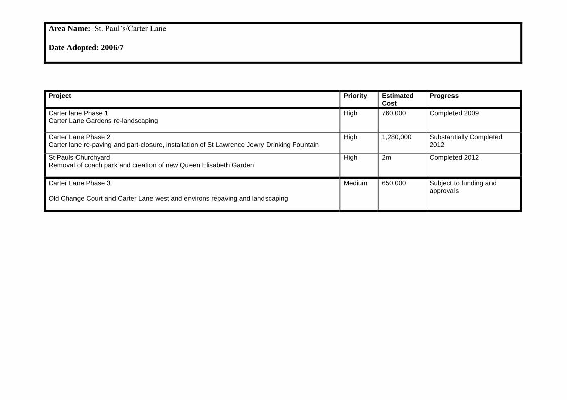
Area Name: St. Paul’s/Carter Lane
Date Adopted: 2006/7
Project Priority Estimated Cost
Progress
Carter lane Phase 1 Carter Lane Gardens re-landscaping
High 760,000 Completed 2009
Carter Lane Phase 2 Carter lane re-paving and part-closure, installation of St Lawrence Jewry Drinking Fountain
High 1,280,000 Substantially Completed 2012
St Pauls Churchyard Removal of coach park and creation of new Queen Elisabeth Garden
High 2m Completed 2012
Carter Lane Phase 3 Old Change Court and Carter Lane west and environs repaving and landscaping
Medium 650,000 Subject to funding and approvals

Area Name: Riverside Walkway
Date Adopted: 2005
Project Priority Estimated Cost
Progress
High Timber Street Access improvements and widened footways
High 82,000 Complete
Old Billingsgate Bollards Installation of bollards to prevent vehicles driving illegally over walkway
High 5,000 Complete
New staircase from London Bridge to the Riverside Walk High 1,700,000 Approved and funded. Construction to commence this spring
Improvements to Steelyard passage under Cannon Street Station High 143,000 Completed
Grants Quay Wharf Ramp and re-landscaping
High 906,000 Completed
Globe View walkway Opening up the walkway under Globe view with associated improvements
High £750,000 - £1.5m
Gateway 3 approved. Design being further developed.
Millennium Bridge Area Re-landscaping Pauls Walk and removal of HSBC gates
High 1.1m Gateway 3 / 4 report approved. Constructions designs being developed
Sugar Quay Ramp alterations
Medium 11,000 Complete
Blackfriars Bridges: creation of retail/commercial uses in spaces under the bridges. High
375,000 On-hold due to TfL ongoing maintenance issues
Pauls Walk East– re-landscaping
Medium 211,000 Complete
White Lion Hill
Medium 300,000 Subject to approvals and funding
Blackfriars ramp extension Medium 168,000 Complete
Blackfriars Hoarding Medium 100,000 Complete
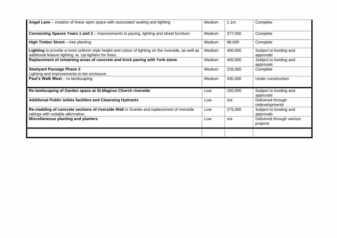
Angel Lane – creation of linear open space with associated seating and lighting Medium 1.1m Complete
Connecting Spaces Years 1 and 2 – Improvements to paving, lighting and street furniture Medium 377,000 Complete
High Timber Street – tree planting Medium 88,000 Complete
Lighting to provide a more uniform style height and colour of lighting on the riverside, as well as additional feature lighting. ie. Up-lighters for trees.
Medium 400,000 Subject to funding and approvals
Replacement of remaining areas of concrete and brick paving with York stone Medium 400,000 Subject to funding and approvals
Steelyard Passage Phase 2 Lighting and improvements to bin enclosure
Medium 226,000 Complete
Paul’s Walk West – re-landscaping Medium 430,000 Under construction
Re-landscaping of Garden space at St.Magnus Church riverside Low 150,000 Subject to funding and approvals
Additional Public toilets facilities and Cleansing Hydrants Low n/a Delivered through redevelopments
Re-cladding of concrete sections of riverside Wall in Granite and replacement of riverside railings with suitable alternative.
Low 275,000 Subject to funding and approvals
Miscellaneous planting and planters Low n/a Delivered through various projects

Area Name: Fleet Street Courts & Lanes
Date Adopted: 2004
Project Priority Estimated Cost
Progress
Johnson’s Court & Crane Court Repaving, new seating, water feature, planting
High £317,000 Completed
Fleet Street Courts & Lanes Gough Square and enhancement to court entrances
High £188,000 Completed
Red Lion Court Pedestrianised and improved lighting
High £88,000 Completed
Shoe Lane Phase 1 New paving, planting and security measures
High £1.02m Completed
Shoe Lane Phase 2 New paving, widened footways and public art
High £733,000 Substantially Completed
Wine Office Court Improved planting and lighting
Medium £109,600 Not yet completed due to redevelopment
St Bride’s Passage New seating, improved paving and lighting
Medium £106,231 Completed
Pleydell Street Pedestrianisation, new paving and lighting
Medium £100,000 Subject to funding and approvals
St Bride’s Churchyard Entry treatments, new planting and lighting
Medium £80,000 Subject to funding and approvals
Bouverie Street Footway widening, improved crossings, new trees
Medium £100,000 Subject to funding and approvals
Whitefriars Street Footway widening, improved crossings, new trees
Medium £100,000 Subject to funding and approvals
Hanging Sword Alley Enhanced public space, new planting, potential artwork
Medium £150,000 Subject to funding and approvals

Salisbury Square Pedestrianisation, footway widening, new planting and seating
Medium £100,000 Subject to funding and approvals
Bride Lane Pedestrianisation, new paving and lighting
Medium £100,000 Subject to funding and approvals
Bride Court New planting, lighting and signage
Medium £50,000 Subject to funding and approvals
Lombard Lane Reduce street clutter
Low £40,000 Subject to funding and approvals
Temple Lane New paving, reduced street clutter
Low £60,000 Subject to funding and approvals
Bridewell Place New paving, reduced street clutter
Low £75,000 Subject to funding and approvals
Hutton Street New paving
Low £60,000 Subject to funding and approvals
Dorset Rise Footway widening, new paving
Low £60,000 Subject to funding and approvals
Mitre Court Raised carriageway, new paving, lighting and signage
Low £100,000 Subject to funding and approvals

Area Name: Eastern City Cluster
Date Adopted: 2005 Date Revised: 2007
Project Priority Estimated Cost
Progress
ECC Phase 1 Landscaping and paving enhancements Pinnacle/ Undershaft area
High £1.9m Approved and funded. Works due to start this spring subject to finalising a legal agreement.
ECC Sculpture in the City Years 1-4 Area wide programme of temporary art installations
High £230,000 plus
significant in-kind
Years 1 and 2 complete, Years 3 and 4 planned
ECC Phase 2 Landscaping – Undershaft south
Medium £1,650,000 Options Appraisal
St Helens Square Landscaping
Medium 2.2m Designs being developed. Subject to planning permission
ECC Phase 3 St Mary Axe street improvements
Medium 780,000 Design subject to Helens Square design completion
ECC Phase 4 Leadenhall Street and Camomile Street, including new crossing
Medium 718,901 Options Appraisal and outline Design under development

Project Priority Estimated Cost
Progress
Aldgate Gyratory Remove gyratory and create a public space. Remove subways and improve mobility in the area.
High 7-12 m Gateway 3 approved. Gateway 4 planned for autumn 2013. Implementation expected 2014
Vine Street/Crescent/ Hammett Street Green space, biodiversity, SUDs, improved air quality, play space & opportunity for public are providing an improved walking route.
High 750,000 Subject to funding and approvals
Little Somerset Street Provide & enhance the walking environment along this link. Add street trees and other planting, widen footways and consider SUDs.
High 750,000 Subject to funding and approvals
Minories Widen footways, encourage the use of outdoor space, planting and consider the introduction of possible two-way traffic
High 1m Possible inclusion with Aldgate Gyratory removal project
Seething Lane table Slow traffic
High 200,000 Subject to funding and approvals
Aldgate Gyratory (Private) Trinity and bus station improvements
Medium 1m Private land
America Square Green space, biodiversity, SUDs, improved air quality, play space & opportunity for public are providing an improved walking route.
Medium 650,000 Subject to funding and approvals
Vine Street Lighting underbridge. Improve the experience under the bridge to enhance the pedestrian link connecting projects at America Square and the Crescent.
Medium 80,000 Subject to funding and approvals
Area Name: Aldgate & Tower
Date Adopted: 2012

Vine Street Provide and enhance the walking environment along this link. Add street trees and other planting and widen footways.
500,000 Subject to funding and approvals
Crutched Friars Implementation programmed. Includes widening the footways.
Medium 60,000 Completed 2012
Crutched Friars Lighting underbridge. Enhance the place function as well as the link.
Medium 20,000 Planned for 2013
Jewry Street Greening Widen footways, improve planting for biodiversity and improved air quality, consider SUDs, construct side road entry treatments to enhance the pedestrian experience and inset parking.
Medium 400,000 Subject to funding and approvals
All Over Strategy Area – Raised Tables on Main Walking Routes Provide a consistent enhancement to the Strategy Area – enhance the inclusive accessibility of the environment.
Medium 150,000 Subject to funding and approvals
All Over Strategy Area – Navigation Sign Review Make way-finding easier, reduce clutter and chose appropriate unobtrusive locations.
Medium 150,000 Subject to funding and approvals
All Over Strategy Area – Intuitive Way-Finding through Materials Linking pedestrian connections through the area by applying consistent palette of materials to the footway and carriageway.
Medium 300,000 Subject to funding and approvals
Minories Lighting underbridge – consider movement sensor lighting. Improve the experience under the bridge to improve the waiting environment at the bus stop and enhance the connection along Minories
Low 80,000 Subject to funding and approvals
Haydon Street Widen footways, provide green walls (third party walls) and enhance this popular pedestrian and cycle link
Low 500,000 Subject to funding and approvals
Portsoken Street Consider enhancing the street and listed building, which will attract people to the Portsoken play space. Review loading and servicing requirements
Low 100,000 Subject to funding and approvals
Seething Lane Gardens Dependent on development.
Low 100,000 Subject to funding and approvals

Area Name: Barbican
Date Adopted: 2008
Project Priority Cost Progress
Moor Lane Creation of linear open space and associated enhancements
High £1,550,000 Implementation Feb 2014
Milton Court Repaving
High 200,000 To be implemented by the developer (private street)
Silk Street Footway widening, tree planting and associated enhancements
High 400,000 Gateway 3/4 completed, Gateway 5 approval Jan/Feb 14 expecting implementation mid 2014
Beech St / Silk St Junction Improvements to junction to ease pedestrian movement
High 300,000 Gateway 3/4 completed, expecting implementation late 2013
Barbican Estate City Walkway Areas Various improvements to planters and seating
High 200,000 Seating Completed Spring 2013
St Giles Terrace Re-landscaping of terrace
High 200,000 Seating and planting Completed Spring 2013
Junction Wood St and London Wall Improvements to pedestrian crossing facilities and associated adjustments to footways
High 300,000 Options appraisal stage
Beech St Tunnel Lighting improvements, possible widening footways and possible crossing point
Medium 1,000,000 Project initiated. Gateway 3 report Scheduled for January 2014.
Baltic Street West Re-landscaping, tree planting and associated enhancements
Medium 350,000 Subject to funding and approvals
Fann Street De-cluttering, tree planting and associated enhancements
Medium 100,000 Subject to funding and approvals
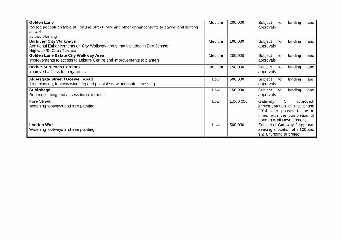
Golden Lane Raised pedestrian table at Fortune Street Park and other enhancements to paving and lighting as well as tree planting
Medium 200,000 Subject to funding and approvals
Barbican City Walkways Additional Enhancements on City Walkway areas, not included in Ben Johnson Highwalk/St.Giles Terrace
Medium 100,000 Subject to funding and approvals
Golden Lane Estate City Walkway Area Improvements to access to Leisure Centre and improvements to planters
Medium 200,000 Subject to funding and approvals
Barber Surgeons Gardens Improved access to thegardens
Medium 150,000 Subject to funding and approvals
Aldersgate Street / Goswell Road Tree planting, footway widening and possible new pedestrian crossing
Low 500,000 Subject to funding and approvals
St Alphage Re-landscaping and access improvements
Low 150,000 Subject to funding and approvals
Fore Street Widening footways and tree planting
Low 1,000,000 Gateway 3 approved, implementation of first phase 2014 later phases to be in timed with the completion of London Wall Development.
London Wall Widening footways and tree planting
Low 500,000 Subject of Gateway 2 approval seeking allocation of s.106 and s.278 funding to project.

Area Name: Guildhall
Date Adopted: 2011
Project Priority Cost Progress
Signifiers – Flags and Banners High 30,000 Complete 2012
Signifiers –Signage High 10,000 Complete 2012
Signifiers - Planters High 20,000 Complete 2012
Seasonal tables and chairs
High n/a Complete 2012
Coffee van trial High n/a Complete 2012
Enhancements to ‘gateway’ (pond) area High 325,000 Options appraisal underway. Gateway 3 planned for May 2013
Enhancements to surrounding green spaces High 115,000 Options appraisal underway. Gateway 3 planned for May 2013
New parking and servicing Plan High 15,000 To be considered as part of gateway improvements
Develop Outreach Plan for the Guildhall Area High 20,000 Subject to funding and approvals
Re-pave the Yard in robust materials Medium
1.6m Subject to funding and approvals

Establish temporary art or cultural exhibitions or displays in the Yard Medium
unknown Subject to funding and approvals
Establish programme of public events in the Yard Medium
unknown Subject to funding and approvals
Implement publicity and promotion plans for the Yard Medium
unknown Subject to funding and approvals
Establish café within the Yard Medium
unknown Subject to funding and approvals
Clean the façade of St Lawrence Jewry Low 470,000 Subject to funding and approvals
Lighting strategy Low 500,000- 1,000,000
Subject to funding and approvals
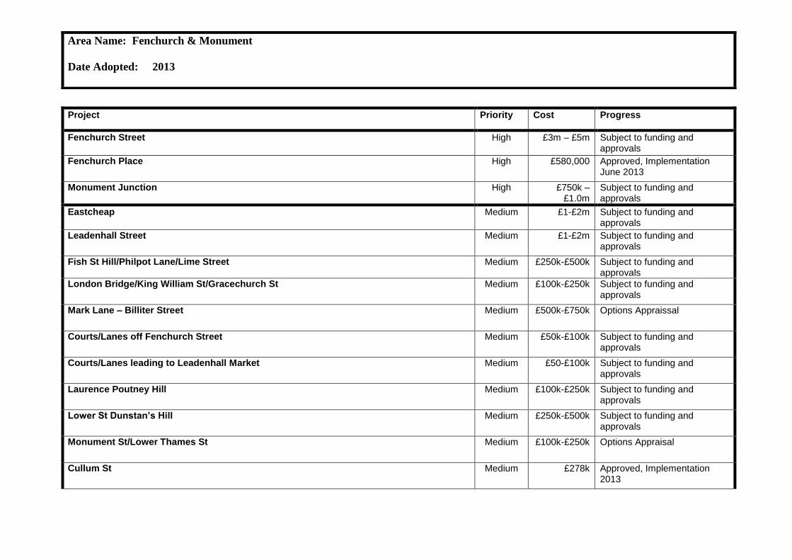
Area Name: Fenchurch & Monument
Date Adopted: 2013
Project Priority Cost Progress
Fenchurch Street High £3m – £5m Subject to funding and approvals
Fenchurch Place High £580,000 Approved, Implementation June 2013
Monument Junction High £750k – £1.0m
Subject to funding and approvals
Eastcheap Medium
£1-£2m Subject to funding and approvals
Leadenhall Street Medium
£1-£2m Subject to funding and approvals
Fish St Hill/Philpot Lane/Lime Street Medium
£250k-£500k Subject to funding and approvals
London Bridge/King William St/Gracechurch St Medium
£100k-£250k Subject to funding and approvals
Mark Lane – Billiter Street Medium £500k-£750k Options Appraissal
Courts/Lanes off Fenchurch Street Medium £50k-£100k Subject to funding and approvals
Courts/Lanes leading to Leadenhall Market Medium £50-£100k Subject to funding and approvals
Laurence Poutney Hill Medium £100k-£250k Subject to funding and approvals
Lower St Dunstan’s Hill Medium £250k-£500k Subject to funding and approvals
Monument St/Lower Thames St Medium £100k-£250k Options Appraisal
Cullum St Medium £278k Approved, Implementation 2013

St Mary at Hill Churchyard Medium £100k-£250k Subject to funding and approvals
Monument Street Medium £100k-£250k Subject to funding and approvals
Suffolk Lane Medium
£100k-£250k Subject to funding and approvals
Cannon Street Low £100k-£250k Subject to funding and approvals
Upper/Lower Thames St Low £100k-£250k Subject to funding and approvals
St Dunstan’s Hill/Mincing Lane/Fen Court Low £50k-£100k Subject to funding and approvals
Courts/Lanes off Gracechurch St Low £50k-£100k Subject to funding and approvals
Courts/Lanes off Cannon St Low £100k-£200k Subject to funding and approvals
East/west route from Pudding Lane to St Dunstan’s Hill Low £50k-£100k Subject to funding and approvals
Botolph Lane Low £50k-£100k Subject to funding and approvals
Pudding Lane Low £50k-£100k Subject to funding and approvals
St Dunstan’s in the East churchyard Low £50k-£100k Subject to funding and approvals
Bakers Hall Court Low £50k-£100k Subject to funding and approvals
Star Alley St Olave Churchyard Low £50k-£100k Subject to funding and approvals
St Mary at Hill Low £50k-£100k Subject to funding and approvals

Area Name: Chancery Lane
Date Adopted: 2009
Project Priority Estimated Cost
Progress
Chancery Lane Footway widening and resurfacing and other public realm improvements
High £800,000 Completed
Cursitor Street New pedestrian space, planting and seating
High £200,000 Completed
Breams Buildings New pedestrian space
Medium £150,000 Subject to funding and approvals
Southampton Buildings Landscaping and footway widening
Medium £200,000 Subject to funding and approvals
Gateways to Chancery Lane Widened footways, decluttering, improved lighting
Medium 50,000 Subject to funding and approvals
Chancery House Green Space Relandscaping of car park
Low 150,000 Subject to funding and approvals
Appendix 5
Location Map of Gateway 2 Projects for Initiation


Appendix.6
Gateway 2 Reports Projects for Initiation

Project Gateway 2.
Project:
Liverpool Street project
Public
Report of:
Director of the Built Environment
For Decision
Overview
2. Spending Committee Streets & Walkways Sub-Committee
2. Project Board Due to the complexity of the project with multiple stakeholders a Project Board is recommended for this project.
3. Area Strategy Authorising Committee and date of Authorisation The Liverpool Street Area Enhancement Strategy was approved by the Court of Common Council in September 2013.
4. Brief description of project The project will deliver environmental enhancements and functional highway changes in Liverpool Street that would support the increased pedestrian footfall due to the new Crossrail station entrance to be opened in 2018. The project will:
- Provide more space for pedestrians and spaces accessible to all, as well as a safer environment for all road users in the area;
- Provide a consistent and coherent civic space for the significant increase in the volume of people expected in the area as a result of the new Crossrail station entrance;
- Ensure consistency in the design and the materials used as per the Street Scene Manual, considering in particular integration across different ownership boundaries;
- Improve signage and wayfinding in the area to locate the rail, underground and Crossrail station entrances in conjunction with other wayfinding and signage around the Liverpool Street interchange.
The project will be fully funded from Transport for London, Crossrail, Community Infrastructure Levy and Section 106‟s in the area.
5. Do materials used comply with ‘material review’ approved use? Yes the materials will comply.
6. Success Criteria

- Enhanced public realm in Liverpool Street
- Improvement of access through the area
- Increased pedestrian capacity to address increasing pedestrian volumes linked to the new Crossrail station entrance
- Increased road safety, particularly for vulnerable road users
7. Key options to be considered The key options to be considered will be informed by the functional requirements of the new Crossrail entrance and the enhancement of the public realm, as well as transport network changes in the area. The key options are likely to include:
- Creation of a civic space for pedestrians in the length of Liverpool Street and enhancement of the public realm possibly incorporating, landscaping, street furniture and street lighting improvements;
- Consider a restriction on vehicle access in Liverpool Street, whilst exploring options to keep vehicular access for deliveries and a potential drop-off point at the eastern end of Liverpool Street;
- Review the location of the taxi rank on Liverpool Street, which is a cause of congestion and poor air quality. While ensuring overall taxi capacity is not reduced, consider removing the taxis from Liverpool Street and relocating them in the underused taxi rank located within the station as well as in smaller (micro) taxi ranks within the wider area;
- Improvements to Old Broad and Street Eldon Street to provide safe pedestrian crossing facilities and review the proposed location of loading bays, ensuring a strong east-west connection between Liverpool Street and Moorgate area.
- Consider upgrading alleyways to provide an improved connection to St Botolph-without-Bishopsgate Churchyard;
These options and their prioritisation will be developed at the options appraisal stage and will be in accordance with the Liverpool Street Area Enhancement Strategy.
8. Links to other existing strategies, programmes and/or projects The project will link with the recently adopted Liverpool Street Area Enhancement Strategy which sets out a framework for public realm improvements within the area to improve the function, appearance and safety of the area.
The project will link with the project developed by Crossrail for Liverpool Street.
The project will link with the City‟s Road Danger Reduction Plan and improve road safety in the Liverpool Street area. The area is within the Bishopsgate Conservation Area and provides the settings to a number of listed buildings which places a number of duties on the City.

9. Within which category does this project fit? Fully reimbursable.
Asset enhancement/ improvement (capital).
10. What is the priority of the project Advisable.
Financial Implications
11. Likely capital/supplementary revenue cost range £250k – £2m
12. Potential source (s) of funding
Fully funded through Crossrail, Transport for London, Community Infrastructure Levy and Section 106‟s in the area.
13. On-going revenue requirements and departmental local risk budget (s) affected It is anticipated that the project would be largely revenue neutral as Liverpool Street is already cleansed and maintained by the City. There would be revenue implications for the new proposed soft landscaping however this will be identified as the design develops and reported at the next Gateway.
14. Indicative Procurement Approach Given the varied nature of the works they are various options we could consider. Works could be undertaken by the City‟s term contractor, J.B Riney, who represents value for money as tested through the recently re-tendered term contract. The project could also be delivered in using Crossrail contractors to achieve economy to scale and minimize disruption on site. This will be investigated further and confirmed in future Gateway reports.
15. Major risks
Overall Project - Low Risk
Risk breakdown:
1. Full cost of works unknown.
As the design options are identified the likely cost of the scheme will be established. The scope of the project will be tailored to ensure delivery within the available funding.
2. Key stakeholders oppose proposed enhancement works.
Officers will provide detailed information and briefings to all stakeholders throughout the evaluation and design stages
3. Taxis against removal of the taxi ranks in Liverpool Street.
Liaison and briefings with taxis representatives and Members throughout the

valuation and design stages.
16. Anticipated stakeholders and consultees Anticipated external stakeholders:
- Crossrail - Local business owners/occupiers - British Land - Taxi representatives - Local residents - Transport for London - Network Rail - City Members - English Heritage
Anticipated internal stakeholders:
- City Transportation - Highways - City Surveyors - Open Spaces - Access Team and Planning Development - Finance
17. Sustainability Implications It is anticipated that all materials will be sustainably sourced where possible and be suitably durable for construction purposes. This will be confirmed once design options are identified.
18. Resources requirements to reach next Gateway
- Initial staff costs allocation - £25,000
- Professional fees allocation - £35,000
The staff allocation will allow for the management of the project (approximately 220 hours) with the input of the Assistant Director where required (approximately 35 hours) to progress the project to outline options appraisal, conduct initial consultation work including liaison with local stakeholders and to prepare necessary reports back to Members.
The professional fees allocation will be used for the appointment of consultants to undertake initial design works and transport reviews, as well as surveys in the project area.
Any unspent resource will be reported at the next gateway and allocated to future stages of the project.
To reach the next Gateway, the project will be externally funded through the existing 5 Broadgate Section 106 Agreement.
19. Standard or streamlined approval track Streamlined Approval Track based on the approval track matrix.

Appendix 1 : Liverpool Street Plan

Project Gateway 2.
Project:
Moorgate Area
Public
Report of:
Director of the Built Environment
For Decision
Overview
3. Spending Committee Streets & Walkways Sub-Committee
2. Project Board Due to the complexity of the project with multiple stakeholders a Project Board is recommended for this project.
3. Area Strategy Authorising Committee and date of Authorisation The Liverpool Street Area Enhancement Strategy was approved by the Court of Common Council in September 2013.
4. Brief description of project The project will deliver environmental enhancements and functional highway changes to Moorgate and Moorfields area that would support the increased pedestrian footfall due to the new Crossrail station entrance to be opened in 2018. Crossrail are currently submitting their plans for making good their site areas in 2014. The project will:
- Improve the public realm in the area and provide more space for pedestrians
to manage the significant increase in the volume of people expected as a result of the new Crossrail entrance;
- Address road safety issues in the area, particularly in providing an additional crossing in Moorgate aligning with the main east-west pedestrian route from the new Crossrail station;
- Explore opportunities to enhance existing public spaces and create new ones where possible;
- Enhance paving and surfaces in the area using materials that are consistent with the City of London‟s Street Scene Manual. Take account of future maintenance and cleansing requirements in the choice and layout of materials;
- Improve the retail environment.
The project will be fully funded from Crossrail, Transport for London, Community Infrastructure Levy and Section 106‟s in the area.
5. Do materials used comply with ‘material review’ approved use?

Yes the materials will comply.
6. Success Criteria - Enhanced public realm in the Moorgate and Moorfields area
- Improvement of access through the area
- Increased pedestrian capacity to address increasing pedestrian volumes
- Increased road safety, particularly for vulnerable road users
7. Key options to be considered The key options to be considered will be informed by the functional requirements of the transport network in the area and the enhancement of the public realm. The key options are likely to include:
- Widen footways considering ways to rationalise vehicle, cycle and bus traffic on Moorgate in order to create a safe environment for all road users and pedestrians;
- Consider limiting and managing vehicular access onto north Moorfields to allow for pedestrian priority along the length of the street;
- Enhancing the public realm along Moorgate possibly incorporating street trees that are appropriate to the conditions and context of the street;
- Enhancing the public space located at the corner of Moorgate and London Wall to accommodate the increased pedestrian flows created by the new Crossrail station exit on Moorfields while continuing to provide a popular and high quality civic amenity space;
- Consider the new desire lines created by the Crossrail station exit on Moorfields and Moorgate, and explore options to limit the traffic in a section of Moorfields to create a better and safer environment for pedestrians using the Crossrail entrance;
- Consider incentives to encourage shop fronts in the area and particularly in Moorgate and Moorfields. This part of Moorgate forms part of the Principal Shopping Centre and is a significant policy consideration.
- The area adjoins the Bank and Finsbury Circus Conservation Areas, and provides the settings of a number of heritage assets both listed and otherwise. This imposes particular duties on the City.
These options and their prioritisation will be developed at the options appraisal stage and will be in accordance with the Liverpool Street Area Enhancement Strategy and support the development of the Cultural Hub.
8. Links to other existing strategies, programmes and/or projects The project will link with the recently adopted Liverpool Street Area Enhancement Strategy which sets out a framework for public realm improvements to improve the function, appearance and safety of the area. The project will link with the Liverpool Street project that is also part of the Liverpool Street Area Enhancement Strategy.
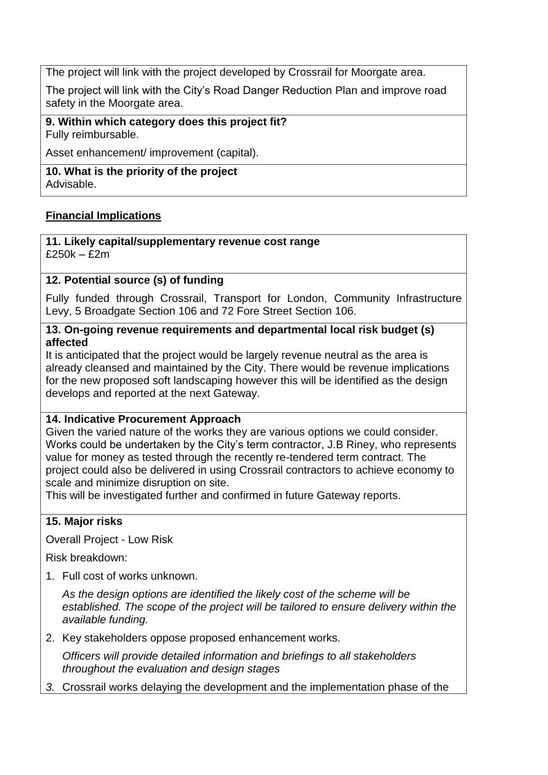
The project will link with the project developed by Crossrail for Moorgate area.
The project will link with the City‟s Road Danger Reduction Plan and improve road safety in the Moorgate area.
9. Within which category does this project fit? Fully reimbursable.
Asset enhancement/ improvement (capital).
10. What is the priority of the project Advisable.
Financial Implications
11. Likely capital/supplementary revenue cost range £250k – £2m
12. Potential source (s) of funding
Fully funded through Crossrail, Transport for London, Community Infrastructure Levy, 5 Broadgate Section 106 and 72 Fore Street Section 106.
13. On-going revenue requirements and departmental local risk budget (s) affected It is anticipated that the project would be largely revenue neutral as the area is already cleansed and maintained by the City. There would be revenue implications for the new proposed soft landscaping however this will be identified as the design develops and reported at the next Gateway.
14. Indicative Procurement Approach Given the varied nature of the works they are various options we could consider. Works could be undertaken by the City‟s term contractor, J.B Riney, who represents value for money as tested through the recently re-tendered term contract. The project could also be delivered in using Crossrail contractors to achieve economy to scale and minimize disruption on site. This will be investigated further and confirmed in future Gateway reports.
15. Major risks
Overall Project - Low Risk
Risk breakdown:
1. Full cost of works unknown.
As the design options are identified the likely cost of the scheme will be established. The scope of the project will be tailored to ensure delivery within the available funding.
2. Key stakeholders oppose proposed enhancement works.
Officers will provide detailed information and briefings to all stakeholders throughout the evaluation and design stages
3. Crossrail works delaying the development and the implementation phase of the

project
Regular liaison to be done with Crossrail to get accurate information regarding progress on the station works.
16. Anticipated stakeholders and consultees Anticipated external stakeholders:
- Crossrail - Local business owners/occupiers - Barbican residents - Developers of 5 Broadgate - Developers of 72 Fore Street - Local residents - Transport for London - City Members - English Heritage - Amenity Groups
Anticipated internal stakeholders: - City Transportation - Highways - City Surveyors - Open Spaces - Access Team and Development Division including archaeology - Finance - Barbican Estate Office - Barbican Centre
17. Sustainability Implications It is anticipated that all materials will be sustainably sourced where possible and be suitably durable for construction purposes. This will be confirmed once design options are identified.
18. Resources requirements to reach next Gateway
- Initial staff costs allocation - £20,000
- Professional fees allocation - £30,000
The staff allocation will allow for the management of the project (approximately 200 hours) with the input of the Assistant Director where required (approximately 30 hours) to progress the project to outline options appraisal, conduct initial consultation work including liaison with local stakeholders and to prepare necessary reports back to Members.
The professional fees allocation will be used for the appointment of consultants to undertake initial design works and transport reviews, as well as surveys in the project area.
Any unspent resource will be reported at the next gateway and allocated to future stages of the project.
To reach the next Gateway, the project is funded through the Environmental Enhancement Team Local Risk Budget.

19. Standard or streamlined approval track Streamlined Approval Track based on the approval track matrix.
Appendix 1 : Moorgate Area Plan
Project Gateway 2.
Project:
London Wall Place S278 Agreement – Highway Enabling Works
Public
Report of:
Director of the Built Environment
For Decision
Overview
4. Spending Committee Streets & Walkways Sub-Committee
2. Project Board A formal working group will be set up which will include the Developer, Environmental Enhancement, Open Spaces, Highways, Transportation and Transport for London (TfL).
3. Area Strategy Authorising Committee and date of Authorisation
On 27th June 2011 the Planning & Transportation Committee approved a planning application for the redevelopment of the St. Alphage House site. The new development, known as London Wall Place, will provide a mixture of office and retail space. The requirement to enter into a Section 278 agreement to undertake the necessary highway works to mitigate the impact of the development on the surrounding highway infrastructure is identified in the Section 106 agreement which was signed on the 26th August 2011.
The highway changes required to accommodate the development on London Wall, Fore Street, Wood Street and St. Alphage Gardens will reflect the aspirations of the Barbican Area Enhancement Strategy. The Barbican Area Enhancement Strategy is currently being reviewed.
4. Brief description of project
London Wall Place is a new development on the former St. Alphage House site on the land bounded by London Wall, Fore Street, Wood Street and St. Alphage Gardens. The project area plan in Appendix 1 shows the location. The development comprises two new buildings with the main entrances fronting onto London Wall. This is a fundamental change from the previous site where there was no active frontage along London Wall and pedestrians interacted with the site from both ground level and podium level. The new development focusses frontage activity at ground level on London Wall, which will significantly change the way in which pedestrians and other highway users access the site.
The new building entrances fronting onto London Wall require the widening of the northern footway on London Wall between Fore Street and Wood Street. In addition, the footway widening is required to accommodate the design of the buildings which cantilever out from the site above the London Wall footway. The impacts of this footway widening on the London Wall carriageway will be assessed to determine the effects this has on the functional requirements of London Wall as a City street, and

the implications this has for the wider City highway network.
The developer firmly expects the first building will be occupied in the second quarter of 2017. A pre-let tenant has been confirmed by the developer.
Members will be presented with options for changes to the highway layout at the options appraisal stage (gateway 3/4).
5. Do materials used comply with ‘material review’ approved use? Yes the materials will comply.
6. Success Criteria
Enable the widening of the northern footway on London Wall between Fore Street and Wood Street so that there is sufficient footway for access to the new building entrances and accommodate the building design
Upgrading the London Wall / Wood Street junction to mitigate the impact of the development on road safety and pedestrian facilities
Mitigate the impact of the development on the surrounding area by accommodating increased numbers of pedestrians
Integrate the development into the local highway network at street level linking the development and highway works with adjacent projects
Wider highway adjustments including widened footways, upgraded cycle facilities, street lighting and environmental enhancements to accommodate the development
Delivery of the highway enabling works to a timetable that is set by the provisional occupation date of the tenant.
7. Key options to be considered The key options to be considered will be informed by the functional requirements of the highway network and how the new development can be seamlessly integrated into the local streetscape. The key options may include:
- the widening of the northern footway on London Wall.
- widening of the footways on both sides of London Wall and reducing the carriageway width in both directions
- removal of the central reservation, if feasible, and the redesign of street lighting
- the relocation of a Barclays Cycle Hire Docking Station
- highway changes that deliver increased safety for cyclists
- restricted vehicular access on St. Alphage Gardens
These options and their prioritisation will be developed at the options appraisal stage and will meet the aspirations of the Barbican Area Enhancement Strategy.
8. Links to other existing strategies, programmes and/or projects The project will link with the Barbican Area Enhancement Strategy and be mindful of potential changes that may occur as a result of a review of the strategy.
There are a number of other projects immediately adjacent to the development including 72 Fore Street (Moorgate Exchange) and Moor Lane environmental
enhancement works.
9. Within which category does this project fit? 4: Fully reimbursable.
10. What is the priority of the project A: Essential.
Financial Implications
11. Likely capital/supplementary revenue cost range £1m – £5m
12. Potential source (s) of funding
Fully funded through a S278 Agreement with the developer (Brookfield).
13. On-going revenue requirements and departmental local risk budget (s) affected It is anticipated that the project would be revenue neutral as all of the highway works required will be funded by the developer through the S278 Agreement. There may be some revenue implications if additional planting or street lighting is required, however this will be identified as the design develops and reported.
14. Indicative Procurement Approach The works will be undertaken by the City‟s term contractor, J.B Riney, who have the required expertise to complete the anticipated works and represent value for money as tested through the recently re-tendered term contract. The use of J.B Riney will be confirmed in future Gateway reports. The use of external consultants will be secured through the City of London Procurement Services.
15. Major risks
Overall Project - Low Risk
Risk breakdown:
1. Full cost of works unknown.
As the design options are identified the likely cost of the scheme will be established. The scope of the project will be tailored to ensure delivery within the available Section 278 funding.
2. London Wall Car Park structure
As the evaluation and design of the project progresses, it is likely that the proximity of the London Wall Car Park Structure will present technical and financial challenges.
3. Highway Network Implications
The widening of the northern footway on London Wall means that the existing arrangement of two general traffic lanes and a cycle lane in the eastbound direction cannot be accommodated. If a view is taken that the cycle lane must be maintained then this implies reducing the eastbound carriageway to one traffic lane. This may have wider network implications.

4. Key stakeholders oppose proposed enhancement works.
Officers will provide detailed information and briefings to all stakeholders throughout the evaluation and design stages.
5. Ancient Scheduled Monument.
Parts of The London Wall (an ancient scheduled monument) are located within the area of works and immediately adjacent to and within the highway and car park structure.
16. Anticipated stakeholders and consultees
External Parties
Brookfield (the developer) Crossrail, the Museum of London, English Heritage, London Buses, Freight Association, TfL Streets and Traffic Signals, Barbican Residents Association, City Police, London Fire Brigade, London Ambulance Service and Living Streets.
Barbican Estate
Consultation with residents of the Barbican Estate will follow a four stage consultation framework which is currently being developed for consulting on schemes in and around the Barbican Estate.
Interested Internal parties:
Highways team (construction, drainage, street lighting), Access Team, Historic Environment, City Surveyors, Open Spaces, Cleansing, Ward Members, Legal and Finance.
Political
GLA, Relevant COL Committee Members, Lord Mayor and future Lord Mayor‟s.
Users:
Pedestrians, cyclists, Taxis/ Private Hire Vehicles, Buses/ coaches, freight delivery vehicles (including HGV‟s), Powered two wheelers/ Motorcyclists, Local Occupiers and Residents.
17. Sustainability Implications It is anticipated that all materials will be sustainably sourced and be suitably durable for construction purposes. This will be confirmed once design options are identified.
18. Resources requirements to reach next Gateway
- Initial staff costs allocation - £125,000
- Professional fees allocation - £50,000
The staff allocation will allow for the management of the project, with the input of the Assistant Director where required, to progress the project to outline options appraisal, conduct initial consultation work including liaison with local stakeholders and to prepare necessary reports back to Members. The estimate for the staff costs is based on the anticipated time it will take to reach the next gateway (3/4).
The professional fees allocation will be used for the appointment of consultants to undertake initial transport reviews including traffic modelling and surveys. The estimate for professional fees is based upon similar types of work that have

previously been procured by the City.
Any unspent resource will be reported at the next gateway and allocated to future stages of the project.
The project is fully externally funded by the developer through the required Section 278 Agreement.
19. Standard or streamlined approval track Streamlined Track will be used as this is a fully externally funded project.

Appendix 1 – Project Area


Project Gateway 2.
Project: Museum of London Gyratory – Highway Changes and Public Realm Improvements
Public
Report of:
Director of the Built Environment
For Decision
Overview
5. Spending Committee Streets and Walkways Sub-Committee
2. Project Board A Project Board is recommended given the likely scope and complexity of the project. It will need to consist of key stakeholders including representatives from St. Paul‟s and the Museum of London, City Police, Senior City Officers and Senior Transport for London (TfL) representatives.
3. Area Strategy Authorising Committee and date of Authorisation The Cheapside Area Strategy 2008, is currently being updated to reflect an amended boundary area that includes identified opportunities in the area between St. Paul‟s and the Museum of London. An initial scoping study was approved for inclusion in the 2013/14 LIP submission by the Planning and Transportation and Policy and Resources Committee in 2011.
4. Brief description of project The Museum of London gyratory is located to the north of St. Paul‟s Cathedral in the Farringdon Within and Cheap Wards of the City of London, EC2. The project area plan in Appendix 1 shows the location. Background The existing gyratory is a complex and highly trafficked one-way gyratory system formed of Newgate Street, Angel Street, King Edward Street, Montague Street, Aldersgate Street and St. Martin‟s Le Grand. The nature of the one-way system encourages higher traffic speeds which is intimidating for other road users. Of particular concern is the number of collisions around the gyratory involving vulnerable road users such as pedestrians and cyclists. Cyclists and pedestrians
make up 80% of all serious casualties and 51% of the slight casualties in the study area. At a number of locations pedestrian facilities are limited and around St. Paul's Underground station footways are too narrow for the volumes of pedestrians in the area. The nature of the gyratory affects the quality of the urban space. The legibility to a number of key trip and visitor destinations in the area, such as the Museum of London, is limited.

The removal of the gyratory between St. Paul‟s and the Museum of London will significantly improve conditions for pedestrians and cyclists and is an objective set out in the City‟s 2011 Local Implementation Plan (paragraph 3.45). Similar projects to remove gyratories in the City include the highway improvements at Mansion House which was completed in 2010, and the Aldgate project which is scheduled for completion in 2016. Project The introduction of two-way working for traffic is part of an area wide aspiration to remove the gyratory, reduce traffic speeds and create safer streets and public realm more suitable for the needs of business, residents and visitors. This includes a commitment to reduce road danger on City streets by directly addressing the causation factors resulting in collisions. A scheme focussing on achieving an appropriate balance for the movement of people by various travel modes is expected to identify new areas of opportunity for public realm improvements, such as widened footways and potentially new public spaces in the St. Paul's and Museum of London areas. This may create further opportunities to improve access to St. Paul‟s Underground Station.
5. Do materials used comply with ‘material review’ approved use? The materials to be used will comply with the material review
6. Success Criteria - Improved road safety, particularly for vulnerable road users - Improvement of access through the area - Improvement of legibility to key visitor destinations - Improved access to public transport nodes - Increased pedestrian capacity to address increasing pedestrian volumes - Enhanced public realm in the St. Paul‟s and Museum of London areas
7. Key options to be considered A scoping study to identify the highway changes required to achieve the desired improvements, most likely the removal of the gyratory and introduction of two way working for traffic, has identified a number of different options that meet the project objectives. In summary, the options may include:
the full or partial introduction of two way traffic on the streets in the area
widening of footways and reducing the width of the carriageway on Newgate Street and St. Martin‟s Le Grand
reducing the scale and complexity of the traffic signal controlled junctions at Newgate Street / Cheapside and Newgate Street / King Edward Street
a partial closure of the Museum of London roundabout to facilitate improved access for pedestrians to a new visitor entrance
to explore the potential for closing Newgate Street to vehicular traffic to release the potential for new public space
to explore the potential to close part of King Edward Street to vehicular traffic

to create a new public space The City has general powers to improve the highway under section 62 of the Highways Act 1960 and in carrying out its highway and traffic functions when considering key options, the City will have regard, inter alia, to its duty to assert and protect the rights of the public to the use and enjoyment of the highway (s 130 Highways Act 1980); its duty to secure the expeditious, convenient and safe movement of traffics (having regard to the effect on amenities) (s122 Road Traffic Regulation Act 1984); and its duty to secure the efficient use of the road network avoiding congestion and disruption (s 16 Traffic Management Act 2004).
8. Links to other existing strategies, programmes and/or projects This project is linked with the Cheapside Area Enhancement Strategy which is currently being updated to reflect progress made in delivering projects and focussing on the areas that have not yet been addressed. The location of the gyratory along the cultural spine between St. Paul‟s Cathedral and the Museum of London is identified in the revised strategy as requiring significant improvement. The project area interrelates with a number of projects in the Barbican area including the works associated with the London Wall Place development. Parallel programmes include:
The City‟s Road Danger Reduction programme
TfL‟s London Cycling Grid programme, where the route alignment is proposed to be along Gresham Street, St. Martin‟s Le Grand and Little Britain.
Identification of part of the gyratory on Newgate Street as requiring cycle safety improvements through the TfL Better Junctions programme.
9. Within which category does this project fit? 7. Asset Enhancement/improvement (capital)
10. What is the priority of the project B. Advisable
Financial Implications
11. Likely capital/supplementary revenue cost range £8m – £12m (an application for £10.35m has been submitted to the TfL Major Schemes programme)
12. Potential source (s) of funding The funding strategy for the highway and public realm improvements consist of a mixture of funding from:
Transport for London;
Section 106 agreements; and
Community Infrastructure Levy contributions. The Project has been submitted to TfL as a major scheme bid and is being
considered for funding from 2014/15 to 2020/21 financial years with the implementation phase following the completion of other City Major Schemes such Aldgate, Bank and Fleet Street.
13. On-going revenue requirements and departmental local risk budget (s) affected It is anticipated that this project would be largely revenue neutral, however any revenue implications that are identified during the project the will be reported.
14. Indicative Procurement Approach It is anticipated that all works will be undertaken by the City‟s term contractor, J.B Riney, who have the required expertise to complete the anticipated works and represent value for money as tested through the recently re-tendered term contract. The use of J.B Riney will be confirmed in future Gateway reports. The use of external consultants will be secured through the City of London Procurement Services.
15. Major risks Overall Project – Low Risk
1. Funding bid from TfL is unsuccessful. Confirmation of funding for 2014/15 will be announced in early December. The City has a successful history of delivering local and strategic transportation schemes that TfL have been supportive of and we are confident that TfL will support this scheme, if not in 2014/15 then in future years.
2. Project costs exceed the budget available. Mitigate by monitoring costs closely and seeking best value in all aspects of procurement to keep costs down. Works may be phased or prioritised to keep within budget or to allow time to find further reimbursable funding to fully complete the proposed solution.
3. Reconciling stakeholders public realm expectations with Traffic Management Act Responsibilities. As the Highway Authority, the City has responsibilities under the Traffic Management Act 2004 to maintain the integrity of the Strategic Road Network. This must be balanced with the expectations of stakeholders for public realm improvements.
16. Anticipated stakeholders and consultees
External Parties
The Museum of London, TfL, City Police, London Fire Brigade, London Ambulance Service, local occupiers and businesses, Barbican Residents Association and Living Streets.
Interested Internal parties:
Highways team (construction, drainage, street lighting), Access Team, City Surveyors, Conservation Design team, Open Spaces, Cleansing, Ward Members, Legal and Finance.
Barbican Estate
Consultation with residents of the Barbican Estate will follow a four stage consultation framework which is currently being developed for consulting on

schemes in and around the Barbican Estate.
Political
GLA, City Members, Lord Mayor and future Lord Mayor‟s.
Users:
Pedestrians, cyclists, Taxis/ Private Hire Vehicles, Buses/ coaches, freight delivery vehicles (including HGV‟s), Powered two wheelers/ Motorcyclists, Local Occupiers and Residents.
17. Sustainability Implications It is anticipated that all materials will be sustainably sourced and be suitably durable for construction purposes. This will be confirmed once design options are identified.
18. Resources requirements to reach next Gateway This is an estimate based on using information from previous projects of a similar nature. Greater clarity will be gained following the initial start- up phase of the project which will detail more precisely the tasks that need to be undertaken in order to reach Gateway 3. It is anticipated it will take approximately 18 months to reach Gateway 3. It is therefore estimated at this stage that a budget of £400k is needed to reach G3, estimated as:
staff costs - £200,000 (approximately 18 months of work)
fees - £200,000 (significant traffic modelling is the major component)
The staff allocation will allow for the management of the project, with the input of the Assistant Director where required, to progress the project to outline options appraisal, conduct initial consultation work including liaison with local stakeholders and to prepare necessary reports back to Members. The estimate for the staff costs is based on the anticipated time it will take to reach the next gateway (3).
The professional fees allocation will be used for the appointment of consultants to undertake initial transport reviews including traffic modelling and surveys. The estimate for professional fees is based upon similar types of work that have previously been procured by the City.
These costs are to be met through a combination of City s106 and TfL Major Schemes funding.
19. Standard or streamlined approval track Standard. This is a major scheme.

Appendix 1 – Project Area


Project Gateway 2
Project: Plough Place Public
Report of: Director of the Built Environment For Decision
Overview
6. Spending Committee Streets & Walkways Sub-Committee
2. Project Board A Project Board is not recommended given the scale and nature of this project. Regular design team meetings will be held with the project team and Senior Responsible Officer.
3. Area Strategy Authorising Committee and date of Authorisation The project area is contained within the boundary of the Chancery Lane Area Strategy which was approved by Court of Common Council in 2010; however no specific proposals were included for the project area.
4. Brief description of project As stipulated in the Section 106 agreement relating to the development site at 12-14 New Fetter Lane and 43 Fetter Lane, initial works will focus on enhancements to Plough Place, a small but important east-west route through the area for pedestrians. The existing site at 43 Fetter Lane contains a car park which is accessed via Fetter Lane and Plough Place. The redevelopment will remove this car park, thereby eliminating the requirement for access from Plough Place and presenting an opportunity to fully pedestrianise the street. The focus of this project will therefore be to investigate options for the enhancement of Plough Place (see Appendix 1 for a site plan). Plough Place is located within the area covered by the Chancery Lane Area Enhancement Strategy, although no specific proposals for this street were included. However, Chancery Lane is connected to Plough Place and New Fetter Lane via Cursitor Street, which has recently been improved and so options for the enhancement of Plough Place will take these works into consideration. The enhancement of Plough Place may involve the introduction of street trees, seating, improved lighting and public art, taking the proposed local frontages and uses into consideration. A Traffic Order will be required to formally remove vehicular access to the street, and options for the existing motor cycle parking on the street will be investigated as the project develops.
5. Do materials used comply with ‘material review’ approved use? Yes.
6. Success Criteria
Improved east-west links through the Chancery Lane area;
Accessibility improvements.

7. Key options to be considered The key options to be considered will be centred on the enhancement of the public realm as defined in the Section 106 agreement. The key options are likely to include:
- Part pedestrianisation of Plough Place;
- Full pedestrianisation of Plough Place.
Both options will consider the introduction of street trees, new seating, improved lighting and public art.
These options and their prioritisation will be developed at the options appraisal stage and will be in accordance with the Chancery Lane Area Enhancement Strategy.
8. Links to other existing strategies, programmes and/or projects The project will link with the existing Chancery Lane Area Enhancement Strategy. Although not included as a specific project within the strategy document, Chancery Lane is connected to Plough Place and New Fetter Lane via Cursitor Street, which has recently been improved and so options for the enhancement of Plough Place will take these works into consideration.
The project aim to deliver some of the main aims of the area strategy, namely to create new public space and improve pedestrian links through the area.
9. Within which category does this project fit? Fully reimbursable.
Asset enhancement/ improvement (capital).
10. What is the priority of the project Advisable.
Financial Implications
11. Likely capital/supplementary revenue cost range £150,000 - £200,000.
12. Potential source (s) of funding
Fully funded through the Section 106 agreement related to the development site at 12-14 New Fetter Lane and 43 Fetter Lane, the total contribution of which is £432,318 (for Local Community & Environmental Improvement Works). However, it should be noted that the initial 10% contribution (£43,232) has not yet been received from the developer, despite preparatory works for the development commencing (which is the trigger for such payments). Therefore the progression of the project is subject to this funding being received from the developer.
13. On-going revenue requirements and departmental local risk budget (s) affected It is anticipated that the project would be largely revenue neutral as the area is already cleansed and maintained by the City. There may be revenue implications if increased soft landscaping is proposed however this will be identified as the design

develops and reported at the next Gateway.
14. Indicative Procurement Approach It is anticipated that all works will be undertaken by the City‟s term contractor, JB Riney. The use of J.B Riney will be confirmed in future Gateway reports.
15. Major risks
Overall Project - Low Risk
Risk breakdown:
1. Full cost of works unknown
As the design options are identified the anticipated cost of the scheme will be refined. The scope of the project will be tailored to ensure delivery within the available Section 106 funding.
2. Presence of utilities requires additional works
Appropriate surveys, such as radar surveys and trial holes, will be carried out during the design stage to establish the presence of utilities and any required works.
3. The project is delayed due to uncertainty arising from the developer
The City will continue to liaise with the developer to understand the expected timescales, and no substantive design work will take place until such confirmation is received.
16. Anticipated stakeholders and consultees
Developer
Local business owners/occupiers
Local residents
City of London Police
City Transportation
Highways
City Surveyors
Open Spaces
Access Team
Chamberlain
Comptroller & City Solicitor
17. Sustainability Implications It is anticipated that all materials will be sustainably sourced where possible and be suitably durable for construction purposes. This will be confirmed as design options are refined.
18. Resources requirements to reach next Gateway
- Staff costs allocation - £23,000
- Professional fees allocation - £20,000
The staff allocation will allow for approximately 120 hours of time for the Project Officer, and approximately 20 hours of time for the Assistant Director where required; this will include work to progress the project to outline options appraisal, conduct initial consultation work including liaison with local stakeholders, and to prepare necessary reports back to Members.
The professional fees allocation will be used for the appointment of consultants to

undertake any initial transport reviews or surveys if so required.
Any unspent resource will be reported at the next gateway and allocated to future stages of the project.
These resources are fully externally funded through the Section 106 agreement relating to the development site at 12-14 New Fetter Lane and 43 Fetter Lane.
19. Standard or streamlined approval track Streamlined.
Appendix 1 – Map of the project area
Plough Place

Project Gateway 2.
Project:
Philpot Lane & Eastcheap Crossing
Public
Report of:
Director of the Built Environment
For Decision
Overview
7. Spending Committee Streets & Walkways Sub-Committee
2. Project Board A Project Board is not recommended given the scale and nature of this project. Regular design team meetings will be held with the project team and Senior Responsible Officer.
3. Area Strategy Authorising Committee and date of Authorisation The Fenchurch & Monument Area Enhancement Strategy was approved by the Court of Common Council in April 2013.
4. Brief description of project The project will deliver environmental enhancements and functional highway changes to the vicinity of the 20 Fenchurch Street development site primarily focussing on Philpot Lane and the Eastcheap Pedestrian Crossing (see Appendix 1) as stipulated in the Section 278 agreement for the 20 Fenchurch Street development and the project will be fully funded from this existing agreement. The project area is also located partially within the Eastcheap Conservation Area. The project will: - improve the quality of the public realm in the area to reflect the significant commercial investment in this part of the City; - address road safety issues in the area, particularly improving the crossing of Eastcheap to assist movement from Monument Underground Station toward the Fenchurch Street area; - address public realm and transport network capacity issues and provide for the significant increase in the volume of people expected in the area as a result of local development growth. - enhance the character and appearance of the Eastcheap Conservation Area, in line with the City‟s statutory requirements.
The project is envisaged to deliver at least two of the priorities of the Fenchurch & Monument Area Enhancement Strategy by reviewing and enhancing Philpot Lane and Eastcheap.
5. Do materials used comply with ‘material review’ approved use?

Yes the materials will comply.
6. Success Criteria - Enhanced public realm in the Philpot Lane/Eastcheap area - Improvement of access through the area - Increased pedestrian capacity to address increasing pedestrian volumes - Increased road safety, particularly for vulnerable road users
7. Key options to be considered The key options to be considered will be informed by the functional requirements of the transport network in the area and the enhancement of the public realm. The key options are likely to include:
- Partial pedestrianisation of Philpot Lane
- Limiting vehicle access through Philpot Lane
- Functional highway changes to improve pedestrian capacity of Philpot Lane
- Enhancement of the public realm to improve the quality and safety of the area
- Full revision of the pedestrian crossing facilities on Eastcheap to prioritise pedestrian access to/from the Fenchurch Street area and the Monument Underground Station/Monument Junction.
- Functional highway changes on Eastcheap to facilitate informal crossing
- Upgrade of existing pedestrian crossings on Eastcheap
These options and their prioritisation will be developed at the options appraisal stage and will be in accordance with the Fenchurch & Monument Area Enhancement Strategy.
8. Links to other existing strategies, programmes and/or projects The project will link with the recently adopted Fenchurch & Monument Area Enhancement Strategy which sets out a framework for public realm improvements within the Fenchurch Street/Leadenhall Street/Eastcheap area to improve the function, appearance and safety of the area. It is anticipated that the project will deliver two of the priority projects of the Area Enhancement Strategy to improve Philpot Lane and Eastcheap.
The project will link with the City‟s draft Road Danger Reduction Plan and improve road safety in the Fenchurch Street/Philpot Lane/Eastcheap area.
The project will also link with the environmental enhancement and security project that is currently being delivered by the City at the 20 Fenchurch Street development site.
There is an adopted Character Summary and Management Strategy SPD for Eastcheap Conservation Area (2013).
9. Within which category does this project fit?

Fully reimbursable.
Asset enhancement/ improvement (capital).
10. What is the priority of the project Advisable.
Financial Implications
11. Likely capital/supplementary revenue cost range £250k – £2m (anticipated value of project being £650k-£700k).
12. Potential source (s) of funding
Fully funded through the S278 Agreement (dated 20th May 2011) connected with the 20 Fenchurch Street development.
13. On-going revenue requirements and departmental local risk budget (s) affected It is anticipated that the project would be largely revenue neutral as the Philpot Lane/Eastcheap area is already cleansed and maintained by the City. There may be revenue implications if increased soft landscaping is proposed however this will be identified as the design develops and reported at the next Gateway.
14. Indicative Procurement Approach It is anticipated that all works will be undertaken by the City‟s term contractor, J.B Riney, who have the required expertise to complete the anticipated works and represent value for money as tested through the recently re-tendered term contract. The use of J.B Riney will be confirmed in future Gateway reports.
15. Major risks
Overall Project - Low Risk
Risk breakdown:
1. Full cost of works unknown.
As the design options are identified the likely cost of the scheme will be established. The scope of the project will be tailored to ensure delivery within the available Section 278 funding.
2. Key stakeholders oppose proposed enhancement works.
Officers will provide detailed information and briefings to all stakeholders throughout the evaluation and design stages
16. Anticipated stakeholders and consultees Anticipated external stakeholders: - Developers of 20 Fenchurch Street - Local business owners/occupiers

- Local residents - Transport for London
Anticipated internal stakeholders: - City of London Police - City Transportation - Highways - City Surveyors - Open Spaces - Access Team - Finance
17. Sustainability Implications It is anticipated that all materials will be sustainably sourced where possible and be suitably durable for construction purposes. This will be confirmed once design options are identified.
18. Resources requirements to reach next Gateway
- Initial staff costs allocation - £15,000
- Professional fees allocation - £10,000
The staff allocation will allow for the management of the project (approximately 100 hours) with the input of the Assistant Director where required (approximately 20 hours) to progress the project to outline options appraisal, conduct initial consultation work including liaison with local stakeholders and to prepare necessary reports back to Members.
The professional fees allocation will be used for the appointment of consultants to undertake any initial transport reviews or surveys if so required.
Any unspent resource will be reported at the next gateway and allocated to future stages of the project.
The project is fully externally funded through the existing 20 Fenchurch Street Section 278 Agreement.
19. Standard or streamlined approval track Streamlined Approval Track based on the approval track matrix.
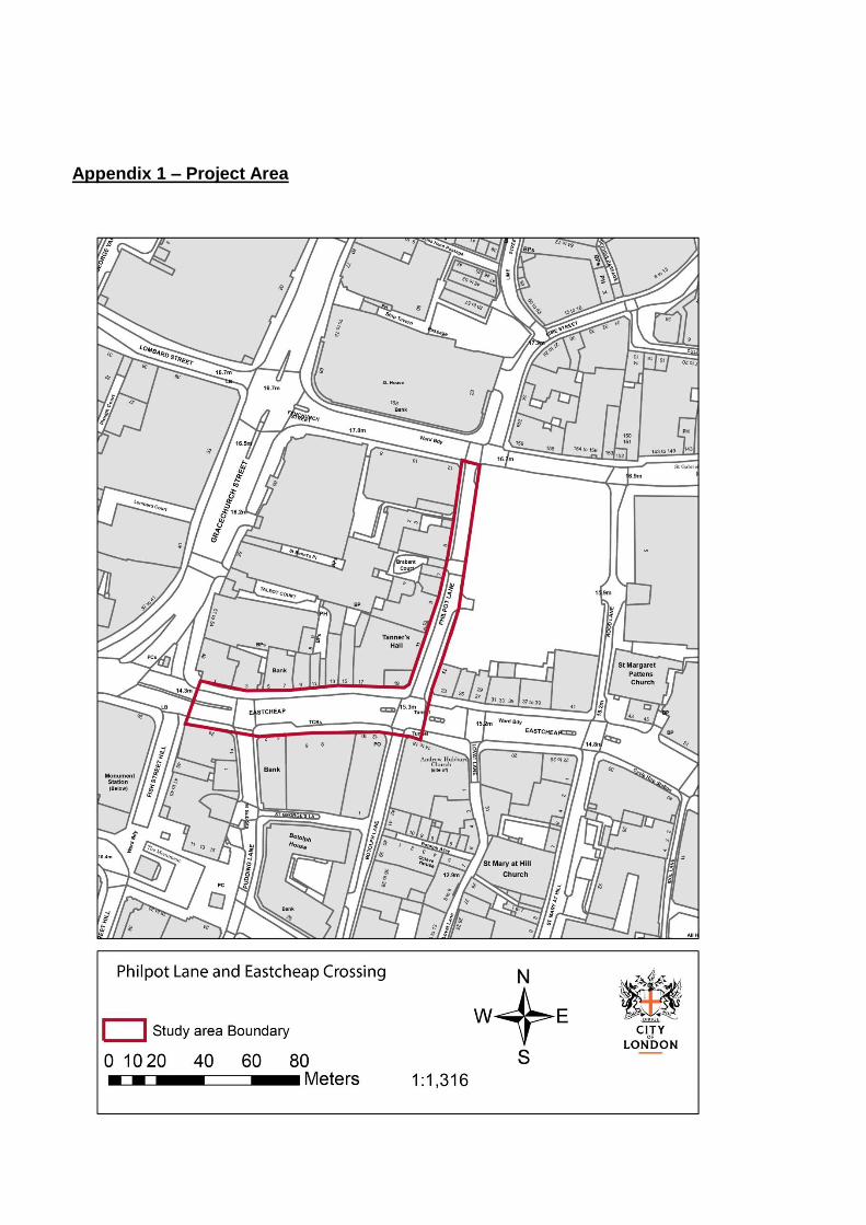
Appendix 1 – Project Area

Project Gateway 2.
Project: Bank Junction Improvements Public
Report of:
Director of the Built Environment
For Decision
Overview
8. Spending Committee Streets & Walkways Sub-Committee
2. Project Board A Project Board is recommended given the likely complexity of the project. It will need to consist of key local stakeholders, Senior COL Officers and Senior TfL representatives.
3. Area Strategy Authorising Committee and date of Authorisation Bank Area Enhancement Strategy Approved in: Planning and Transportation: 16 April 2013 Policy and Resources: 02 May 2013 Court of Common Council: 16 May 2013
4. Brief description of project
Currently the junction is polluted, congested, confusing and creates conflict/danger. The project aims to simplify the movement at the junction to create less conflict and improve safety for all users, in particular for the most vulnerable road user groups; pedestrians and cyclists. With the proposal to upgrade Bank station by Transport for London (TfL) through the congestion relief programme, and a general increase in employment and expected number of people visiting the City this situation is only going to get worse. There is also an expected increase in the numbers of people who will cycle to the City.
This project links closely with the other projects from the Bank Area Enhancement Strategy; to improve the lanes and alleys and encourage pedestrians to follow alternative routes and avoid the main junction if possible. However, those entering or exiting from the Underground station have little choice but to be around the junction. It also links closely with the new entrance at King William Street/Cannon Street as part of the London Underground congestion relief programme and with the development of the Bucklersbury site which will provide a new Waterloo and City Line entrance on Walbrook.
The project is likely to include a simplification of the junction to reduce the number of possible manoeuvres and the reallocation of space to assist with the anticipated pedestrian growth in the area, particularly from the underground station entrances. The solutions for the junction will not be looked at in isolation and a successful outcome for Bank junction has to be considered against the movement pattern for all traffic in the wider area. This will require extensive modelling of traffic flows in the area, and the zone of impact. This data will be needed to receive approval from TfL

to proceed with any changes to the network as Bank Junction is on the Strategic Road Network.
Along with dealing with the movement aspect of the area, the junction is also a significant place with iconic and historic buildings and is at the centre of the Bank Conservation Area. The project will need to ensure that the „place‟ function is also suitably catered for. This is a good example of how the City can incorporate the new Roads Task Force core aims and use the movement/place matrix to formalise the approach to creating a better space for everyone.
5. Do materials used comply with ‘material review’ approved use? Materials will comply with the material review
6. Success Criteria
It is proposed that the following are the measurable objectives of the project:
The delivery of a simplified junction which reduces the amount of conflict to improve safety. This can be measured by a reduction in total casualties at the junction (base 2009-11 total of 24 casualties and 2 Killed or seriously injured (KSI).(Road Danger Reduction Plan Tech doc). With specific interest in reducing
o pedestrian casualties at the junction (base 2009-11 with total of 6 casualties)
o cycling casualties at the junction (base 2009-11 total of 11 casualties)
Reduce PM10 (particulate matter pollutant) and NO2 (nitrogen dioxide)
levels at this location (Air Quality Strategy base 2011) by reducing the number of motorised vehicles using the area.
Lower pedestrian crowding levels at crossing points around the junction
Improved public perception of place
7. Key options to be considered
The Bank Area Enhancement Strategy set out that a radical solution would be required and that small scale improvements were not going to be good enough to make a real difference in this location.
The strategy suggested options to be considered should include (or a combination of) :
road closure(s),
raised carriageway,
timed closures; and
Introduction of areas of shared space.
It may be necessary to consider possible relocation or widening of London Underground exits from the „bull ring‟ section of the London Underground station as part of a solution to stop pedestrians being directed into the worst pinch points. It will also be necessary to consider widening footways to provide for the increase in

pedestrian numbers, particularly around waiting points such as crossings and Underground entry/exit points.
Bus route relocation and possible service reduction will also be examined with Transport for London as a way of reducing vehicular movement at the junction. This is likely to be mainly in an east west direction to closely link with the bus service review being undertaken to coincide with Crossrail‟s opening.
All of these options, and combinations of them, need to be scoped out to identify their likely success and impact.
Following the identification of the appropriate traffic/cycle/pedestrian solution it will be necessary to consider how this can be designed to fit with the character of the area and enhance the public realm and experience of the users.
8. Links to other existing strategies, programmes and/or projects Area Strategies This project is clearly supported in the Bank Area Enhancement Strategy and closely links with the surrounding area enhancement strategies of Liverpool Street, Cheapside, Eastern City Cluster and Fenchurch and Monument strategies because of its likely wide reaching traffic impact on the local area. Road Danger Reduction The project is also closely linked to helping achieve the objectives of the Road Danger Reduction Plan, one of which is to: “reduce the number of persons killed or seriously injured to a three year rolling average of 24.7 by 2020 and to reduce the total number of persons injured to a three year rolling average of 258 by 2020” Other The project will also assist with the:
Air Quality Strategy 2011 as Bank has one of the worst PM10 and N02 concentrations in the City;
Joint Health and Wellbeing Strategy;
London bus service review;
proposals around the Bloomberg development at Walbrook
Bank Station Capacity Upgrade; and
possible synergy with the developing of freight management plans.
9. Within which category does this project fit? Fully Reimbursable Asset Enhancement/improvement (capital)
10. What is the priority of the project Essential

Financial Implications
11. Likely capital/supplementary revenue cost range In the Bank Area Enhancement Strategy an indicative likely cost of £4-6 million was identified for improvements to the junction.
12. Potential source (s) of funding The indicative funding strategy for the junction improvements consist of a mixture of Transport for London, Section 106 and Community Infrastructure Levy contributions. Bank Junction has been submitted to TfL as a major scheme bid and is being considered for funding in the 2015/16 financial year following the completion of the Aldgate and Holborn Circus funding commitments.
13. On-going revenue requirements and departmental local risk budget (s) affected It is anticipated that this project would be largely revenue neutral, however any likely revenue implications identified as the project develops will be identified and reported.
14. Major risks 4. The best solution (in terms of achieving the objectives of the project)
is considered too radical. To mitigate, provide information regularly on progress of the project to decision makers and funders to keep them informed on the likely solutions.
5. Project exceeds the budget available. Mitigate by monitoring costs closely and seeking best value in all aspects of procurement to keep costs down. Works may be phased or prioritised to keep within budget or to allow time to find further reimbursable funding to fully complete the proposed solution.
6. Proposed work causes major disruption to the local road network. Officers will undertake thorough investigations to minimise disruption by working closely with utility suppliers to undertake collaborative works and link with other construction programmes to minimise the impact on the traffic flow and pedestrian activity.
7. Funding bid from TfL is unsuccessful. Indications from TfL are positive that this will not be the case and Bank is in the Major funding programme, however there is always a risk. Officers will continue to liaise with TfL and keep them updated on progress of the project to ensure that funding is not an issue. Confirmation of funding for 2014/15 should be announced in late November or early December.
15. Anticipated stakeholders and consultees
External Parties
London Underground/DLR, London Buses, Freight Association, TfL Streets and Signals, Mansion House, Bank of England, Royal Exchange, City Police , London Fire Brigade, London Ambulance Service and Living Streets.
Interested Internal parties:
Highways team (construction, drainage, lighting…), Access Team, Conservation Design team, Open Spaces (War Memorial), Cleansing, Ward Members, Legal and
Finance.

Political
GLA, Relevant COL Committee Members, Lord Mayor.
Users:
Pedestrians, cyclists, Taxis/ Private Hire Vehicles, Buses/ coaches, freight delivery vehicles (including HGV‟s), Powered two wheelers/ Motorcyclists, Local Occupiers and Residents.
16. Resources requirements to reach next Gateway This is an estimate based on using information from previous projects of a similar nature. Greater clarity will be gained following the initial start- up phase of the project which will detail more precisely the tasks that need to be undertaken in order to reach Gateway 3. It is anticipated it will take approximately 18 months to reach Gateway 3. It is therefore estimated at this stage that a budget of £532k is needed to reach G3, estimated by:
o Staff costs £260k (full time project manager, support assistant and technical input from relevant officers)
o Highway staff costs £8k (Engineer support) o External Fees 254k
Data collection/reporting (70k) Modelling (112k) Outline designs (72k)
o Revenue expenses for working parties, travel expenses, printing, room hire etc. 10k
The staff costs budget will cover a full time project manager to progress the programme of works, approximately 2000 hours, with the input of the Assistant Director where required, approximately 270 hours for 18 months. Also covered is the time for technical and project support to the project manager estimated to be about 1235 hours. (This estimate includes officer time already spent to reach this gateway report which is sought to be reimbursed.) The external fees are estimated high at this stage as there will be a need to undertake traffic modelling to assess early option ideas. Until the initial scoping has been undertaken the amount of data and the area for which we need to collect data for and model will be unknown. The model will need to include a wider area to assess the impacts on traffic when changing the junction. At this stage the estimates assume a wider impact and therefore higher levels of data collection and modelling assessment will be needed. If this is not the case then remaining funds can be rolled over into progressing to G4, if approved. Early indications, following liaison with London Underground, suggest that there will be an opportunity for data sharing between the Bank Station Capacity Upgrade project and this project. The full extent of this has not yet been established. It is proposed to utilise the following S106 contributions to reach G3 (up to £532k):

Cheapside Stage 4 underspend is pending a G7 outturn report. This is being worked on at present and is anticipated to be reported in the new year. Both 1 Lothbury and Mondial House are received payments and will be prioritised for expenditure first to allow time for the G7 report to be processed. TfL Major schemes funding has been bid for to be utilised for the 2014/15 financial year with a sum of 180k, however it has been indicated that it is unlikely to be approved with larger funding commitments for the Aldgate project expected. It is anticipated that TfL funding will be forthcoming in the 2015/16 financial year. This means that that the use of S106 funding will need to be utilised in the first instance until the TfL allocation is received. It is proposed that if TfL funding is made available for 2014/15 that the use of the proposed S106‟s be reduced/removed and utilised in the preparation of the G4 instead. Recommendation: Members are asked to approve that:
Delegated authority be given to the Director of the Built Environment and Head of Finance to adjust the budget between the elements listed in fees, staff costs, and between the two (as indicated above), once more robust estimates have been established. This is providing that the overall sum does not increase above the total threshold of £532k and does not change the overall scope of the project.
Development Contribution
(125 Old Broad Street, Mondial House, 1 Bartholomew Lane, 22-24 Bishopsgate) Cheapside stage 4 underspend
£450,000 (G7 needed to release funds)
1 Lothbury transport contribution £ 34,410
Mondial House transport contribution £ 48,368
TOTAL £532,778
17. Standard or streamlined approval track Standard Approval track.

Project Gateway 1/2.
Project: The Mayor of London – Vision for cycling in London
Public
Report of:
Director of the Built Environment
For Decision
Overview
9. Spending Committee
Streets & Walkways Sub-committee
2. Project Board
An external project board consisting of relevant boroughs (of which the City is represented) and organisations has already been established by the Mayor. This board oversees the delivery of the Central London Cycle Grid. A copy of the Terms of Reference is provided in Appendix 2. There is also another project board (of which the City is also represented) which focuses on the cycle superhighway and cross rail for bikes within the square mile.
An additional City of London project board could still be established if this is considered necessary however at this early stage, a Project Board is not recommended.
3. Area Strategy Authorising Committee and date of Authorisation
Not applicable
4. Brief description of project
In March 2013, The Mayor for London launched his vision for cycling in London. The vision includes engineering, non-engineering and legislative initiatives, all with the aim of improving provisions for cyclists. A copy of the Vision is provided in Appendix 1. Since then Transport for London (TfL), various Local Authorities, Police forces, Royal Parks and other agencies have been working together with the view of delivering that strategic vision.
The vision includes a programme of four themes plus an additional theme for outer London Boroughs. The four relevant themes pertinent to the City and other inner authorities are:-
a. Monitoring & Strategies. This includes qualitative and quantitative monitoring, strategies and research.
b. Better and safer routes for cycling. This includes cycle superhighways, cross rail for bikes and quietways forming the Central London Cycle Grid and better junctions. Draft objectives, guiding principles and levels of service for the Central London Cycle Grid are provided in Appendix 3.
c. Safer cycling. Targeted small scale engineering solutions, education, training and publicity.
d. More people cycling. Culture change, inspiring new cyclists, cycle

parking and rail integration.
The Mayor, through TfL will be providing funding (through bids) to boroughs and other agencies. The City has already secured £44,880 of early funding in order to engage with the development of the Central London Cycle Grid.
It is now important for the City to formally initiate this project to deliver the Mayor‟s cycling vision to ensure that cycling is strategically developed, co-ordinated and is right for the City of London.
5. Do materials used comply with ‘material review’ approved use?
Yes
6. Success Criteria
Contribute towards the Mayor‟s vision for cycling in London with the following key outcomes.
i. A “Tube” network for the bike
ii. Safer streets for the bike
iii. More people travelling by bike
iv. Better places for everyone
7. Key options to be considered
The project will:
e. Consider ppropriate measures and routes for the Central London Cycle Grid including wayfinding and other measures to get more people to cycle.
f. Work with TfL to deliver their projects which form part of the cycling vision, in particular cross rail for bikes, cycle superhighways and the better junctions programme to ensure that the best possible outcome is achieved for the City.
g. Capture opportunities for complementary measures including environmental enhancements, public art and other safer cycling projects.
h. Capture opportunities for monitoring, strategies, education, training and publicity.
8. Corporate and Strategic Implications
This project is part of a London-wide strategic vision for cycling launched by the Mayor of London. It will also support the City‟s Corporate Plan and goals around transport, environment, economy and City workers‟ and residents‟ quality of life including health and wellbeing.
This project also complements the City‟s Cycling Revolution Programme as approved in the Local Implementation Plan.
9. Within which category does this project fit?
Fully reimbursable
10. What is the priority of the project
Essential. There is a duty for the city to deliver the approved transport objectives as

detailed in the Local Implementation Plan.
Financial Implications
11. Likely capital/supplementary revenue cost range
£2m+
12. Potential source (s) of funding
Transport for London (probably 100%)
Section 106
Section 278
13. On-going revenue requirements and departmental local risk budget (s) affected
To be assessed at options appraisal stage but expected to be minimal, if any.
14. Major risks
i. Significant re-allocation of carriageway space for cyclists on TfL‟s roads which could have an impact on the City‟s highway – medium/high risk
j. Timescale. The Mayor has a desire to deliver as much as possible by 2016 which is considered to be a very tight timescale – high risk.
k. Objections, protests and challenges from the public and other organisations – medium/high risk
l. Conflicts with other developments and road works affecting delivery and disruption to the City‟s occupiers and road users – low risk
15. Anticipated stakeholders and consultees
Wide-ranging including internal departments, Members, emergency services, road user groups, other local and possibly national government authorities, city road users and occupiers.
16. Resources requirements to reach next Gateway
£44,880 of TfL funding has already been secured for officers to engage with the development of the Central London Cycle Grid and for this project to be taken to this stage. In order to reach the next stage, it has been estimated that a further £140,000 will be needed. This includes £70,000 for fees (traffic modelling and specialist consultancy work) and £70,000 for staff costs. It is however worth noting that there may be opportunities for fees tasks such as modelling to be carried out by TfL, but for the purpose of this estimation, it is prudent to include it. It is also worth noting that the scope of the project may also change as the project progresses especially as this project is at its infancy.
17. Standard or streamlined approval track
Streamlined track

The Mayor of London – Vision for cycling in London Appendix 1: The Mayor’s Vision for Cycling in London
Hyperlink: The Mayor's Vision for Cycling in London Address: http://www.london.gov.uk/sites/default/files

The Mayor of London – Vision for cycling in London Appendix 2:
Central London Cycle Grid Programme Board - Draft Terms of Reference
Central London Cycle Grid Programme Board
Draft Terms of Reference
Purpose:
• To provide ownership, strategic direction and control for delivery of the Grid.
• To ensure that the programme is highly visible and supported across all partner
organisations.
• To agree changes to the cost and timescale of the delivery of routes within the
agreed overall budget.
Scope:
• Oversee the delivery of an agreed network of continuous and linked cycle routes
across central London, substantially completed by 2016 and within the agreed
budget (to be determined).
• Identify appropriate means to drive forward and synthesise working level
discussions and direct the programme manager.
• Recommend the allocation of resources to routes and project teams, in
accordance with TfL‟s financial rules.
• Agree the delivery mechanisms for the Grid.
• Assess the benefits that the programme is going to achieve.
Objectives:
• Agree the geographical extent of the Grid.
• Act as a forum to resolve design principles and route alignment issues.
• Oversee the development and collective agreement of consistent and common,
yet also flexible design standards and level of service for the network, including
wayfinding, signage and identity.

• Approve the Grid route network, as developed by all local boroughs, TfL and other
delivery partners, with input where necessary from 1-2-1 discussions between TfL
and boroughs.
• Agree the delivery framework and phasing of routes for implementation.
• Coordinate and monitor progress in planning and delivery.
• Approve design principles, taking into account the local design standards and
context in which the routes are being planned to ensure consistency.
• Escalate through relevant TfL and borough governance structures for authority
and approval changes that are beyond the board‟s agreed scope, with
recommendations.
• Support the delivery teams in completing continuous routes across borough
boundaries.
• Identify and manage key interdependencies and synergies between routes and
also other parallel programmes.
• Manage and resolve issues and risks as identified, assessed and escalated by the
programme manager.
• Support the route projects through the local and TfL approvals processes.
• Ensure the coordination of stakeholder engagement and champion the Grid,
resolving key delivery challenges.
• Identify and realise benefits from the investment.
• Agree a monitoring framework for the Grid.
• Provide a clear framework for where future resources (e.g. route investment and
subsequent maintenance) should be focussed.
Inputs to the board:
• Route alignment proposals.
• Status reports on each route project, prepared by the Programme Manager.
• Status reports from Crossrail for the Bike and other interdependent programmes.
• Authority / approval / quality issue submissions e.g. route design principles.
• Presentations on specific issues.
• Programme management documentation (e.g. risk and issue registers /
programme plans, communications plan etc.)

Outputs of the board:
• Strategic alignment, route density and overall form of the Grid.
• Design standards and approved route design options.
• Agreed delivery programme and monitoring frameworks.
• Minutes and actions.
• Escalation of issues / risks / approvals as necessary.
• Approvals / endorsement / change authority to the Programme Manager.
• Change requests to TfL (e.g. concept, financial implications or timescales).
Decision-making
• The Chair will attempt to reach consensus on all issues.
• Decisions of the board may have to be referred to TfL‟s internal Cycle Programme
governance structure and are always subject to TfL‟s financial regulations and the
GLA Act.
• The Grid will need to be delivered in line with TfL and borough standing orders,
financial rules and relevant procedures.
• Board members will endeavour to ensure that they have received their own
internal approvals and are authorised to make decisions on their respective
borough‟s behalf.
Attendance:
– Mark Chetwynd – Kensington & Chelsea (Chair)
– Louise Bond – Camden (Vice Chair)
– Heads of Transport from the other five Central London boroughs
– Heads of Transport from Tower Hamlets & Hackney
– Representative of the Royal Parks
– Representative of Cross River Partnership
– Representative of Central London Forward
– Representative of the Canal and Rivers Trust
– Lilli Matson, Sarah Burr & Leon Thorne, TfL Surface Planning

– David Rowe & Dan Johnson, TfL Borough Projects & Programmes
– TfL attendees as necessary according to the agenda
– Andrew Gilligan, Mayor‟s Cycling Commissioner
Frequency & Timings:
• Every 4 weeks during planning stages and every 8 weeks during the construction
phase.
• Agenda and papers one week in advance.
Board governance structure:
Central London Cycling Grid Programme Board
Chair – Mark Chetwynd, Royal Borough of Kensington & Chelsea
Programme Sponsor (Design Phase) – Lilli Matson, Delivery Planning, TfL
Programme Sponsor (Delivery Phase) – David Rowe, Borough Projects & Programmes, TfL
Programme Manager
Design Meetings Delivery Meetings

The Mayor of London – Vision for cycling in London Appendix 3: Central London Cycle Grid – Draft Objectives, Guiding Principles and Levels of Service


