common carrier fixed point microwavejirwinconsulting.com/fcc - dn common carrier fixed point...
TRANSCRIPT

Del Norte County Common Carrier Fixed Point Microwave Page 1 Revised May 12, 2007
Del Norte County Common Carrier Fixed Point Microwave
Table of Contents
Master List ........................................................................................................................................2
License Details By Registrant .........................................................................................................4
ART Licensing Corp. .................................................................................................................. 4
WPND664 ............................................................................................................................... 4
WPNE944 ............................................................................................................................... 7
Charter Communications ............................................................................................................ 9
KTG39 .................................................................................................................................... 9
Curry County Communications ................................................................................................ 13
WMJ753 ................................................................................................................................ 13
WMJ754 ................................................................................................................................ 17
M.U.T. ....................................................................................................................................... 20
WLM387 ............................................................................................................................... 20
WLT380 ................................................................................................................................ 22
US Cellular -- California Rural Service Area 1, Inc. ................................................................ 24
WPJB980 .............................................................................................................................. 24
WPJB981 .............................................................................................................................. 27
WPNN778 ............................................................................................................................. 30
WPOL988 ............................................................................................................................. 34
WPOL989 ............................................................................................................................. 38
WPOM431 ............................................................................................................................ 41
WPYM516 ............................................................................................................................ 44
WQFA779 ............................................................................................................................. 47
Verizon ...................................................................................................................................... 50
KML48 .................................................................................................................................. 50
KML49 .................................................................................................................................. 55
KML50 .................................................................................................................................. 61
KPF73 ................................................................................................................................... 67
KZA84 .................................................................................................................................. 72
WAX78 ................................................................................................................................. 75
WPOS872 ............................................................................................................................. 77
WPTB833 ............................................................................................................................. 80
Note: This data retrieved from the FCC databases. This data important as it represents the
backbone of telephony for Del Norte, especially for Verizon.

Del Norte County Common Carrier Fixed Point Microwave Page 2 Revised May 12, 2007
Master List
Note: Presented here in the order retrieved from the FCC databases.
Call Sign Licensee Name FRN
Radio Service Status
Expiration Date
1 KML48 Verizon West Coast, Inc. 0001583228 CF Active 02/01/2011
2 KML49 Verizon West Coast, Inc. 0001583228 CF Active 02/01/2011
3 KML50 Verizon West Coast, Inc. 0001583228 CF Active 02/01/2011
4 KPF73 Verizon Northwest Inc. 0001583244 CF Active 02/01/2011
5 KTG39 PACIFIC MICROWAVE JOINT VENTURE 0004534145 CF Active 02/01/2011
6 KZA84 Verizon California Inc. 0001536424 CF Active 02/01/2011
7 WAX78 Verizon California Inc. 0001536424 CF Active 02/01/2011
8 WLL506 AB Cellular LA, LLC 0004521977 CF Canceled 02/01/2011
9 WLL563 TMC COMMUNICATIONS, INC. CF Expired 02/01/2001
10 WLL642 GTE MOBILNET OF CALIFORNIA LIMITED PARTNERSHIP
0003579380 CF Canceled 02/01/2011
11 WLL656 GTE MOBILNET OF SANTA BARBARA LIMITED PARTNERSHIP
0003577624 CF Canceled 02/01/2011
12 WLM387 M.U.T. Licensing, LLC 0004253712 CF Active 02/01/2011
13 WLM538 PACTEL CELLULAR CF Expired 02/01/2001
14 WLM579 BUSINESS INFORMATION TRANSMISSION
SYSTEMS
CF Expired 02/01/2001
15 WLT380 M.U.T. Licensing, LLC 0004253712 CF Active 02/01/2011
16 WLU670 Verestar, Inc. (Debtor-in-Possession) 0010068609 CF Canceled 02/01/2011
17 WMJ498 CELLULAR 2000 CF Canceled 02/01/2001
18 WMJ753 Curry County Communications 0005751946 CF Active 02/01/2011
19 WMJ754 Curry County Communications 0005751946 CF Active 02/01/2011
20 WPJB980 CALIFORNIA RURAL SERVICE AREA 1 INC 0002703700 CF Active 02/01/2011
21 WPJB981 CALIFORNIA RURAL SERVICE AREA 1 INC 0002703700 CF Active 02/01/2011
22 WPND664 ART Licensing Corp. 0003865888 CF Active 03/26/2007
23 WPNE944 ART Licensing Corp. 0003865888 CF Active 05/15/2007
24 WPNE950 ART Licensing Corp. 0003865888 CF Active 05/15/2007
25 WPNN778 CALIFORNIA RURAL SERVICE AREA #1, INC. 0002703700 CF Active 06/15/2008
26 WPOL988 California Rural Service Area #1 Inc. 0002703700 CF Active 01/27/2010
27 WPOL989 California Rural Service Area #1, Inc. 0002703700 CF Active 01/27/2010
28 WPOM431 California Rural Service Area #1, Inc. 0002703700 CF Active 02/18/2010
29 WPOM432 California Rural Service Area #1 Inc. 0002703700 CF Canceled 02/18/2010
30 WPOR602 CALIFORNIA RURAL SERVICE AREA 1 INC 0002703700 CF Canceled 12/10/2008

Del Norte County Common Carrier Fixed Point Microwave Page 3 Revised May 12, 2007
31 WPOS871 Cal-One Cellular L.P. 0001736453
CF Canceled 04/23/2009
32 WPOS872 Cal-One Cellular L P 0001736453
CF Active 04/23/2009
33 WPTB833 Cal-One Cellular L P 0001736453
CF Active 08/24/2011
34 WPTF797 Cal-One Cellular L P 000173645
3
CF Active 09/24/2011
35 WPYM516 CALIFORNIA RURAL SERVICE AREA #1, INC. 0002703700
CF Active 09/09/2013
36 WQFA779 CALIFORNIA RURAL SERVICE AREA #1, INC. 0002703700
CF Active 06/02/2016
Del Norte County Common Carrier Fixed Point Microwave Page 4 Revised May 12, 2007
License Details By Registrant
Note: Information presented here is organized by registrant.
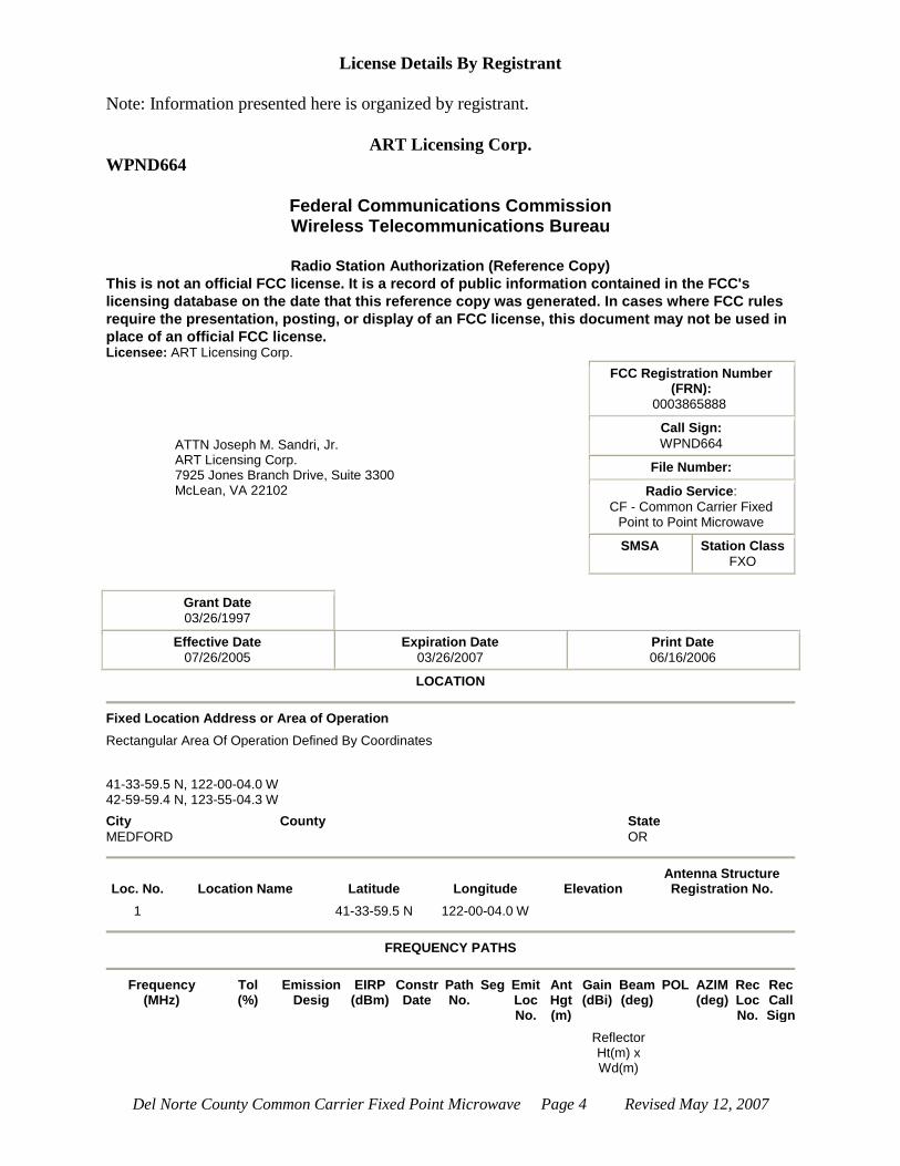
ART Licensing Corp.
WPND664
Federal Communications Commission Wireless Telecommunications Bureau
Radio Station Authorization (Reference Copy)
This is not an official FCC license. It is a record of public information contained in the FCC's
licensing database on the date that this reference copy was generated. In cases where FCC rules
require the presentation, posting, or display of an FCC license, this document may not be used in
place of an official FCC license. Licensee: ART Licensing Corp.
ATTN Joseph M. Sandri, Jr. ART Licensing Corp. 7925 Jones Branch Drive, Suite 3300 McLean, VA 22102
FCC Registration Number (FRN):
0003865888
Call Sign:
WPND664
File Number:
Radio Service:
CF - Common Carrier Fixed Point to Point Microwave
SMSA Station Class
FXO
Grant Date
03/26/1997
Effective Date
07/26/2005
Expiration Date
03/26/2007
Print Date
06/16/2006
LOCATION
Fixed Location Address or Area of Operation
Rectangular Area Of Operation Defined By Coordinates
41-33-59.5 N, 122-00-04.0 W 42-59-59.4 N, 123-55-04.3 W
City
MEDFORD
County State
OR
Loc. No. Location Name Latitude Longitude Elevation Antenna Structure Registration No.
1 41-33-59.5 N 122-00-04.0 W
FREQUENCY PATHS
Frequency
(MHz) Tol (%)
Emission Desig
EIRP (dBm)
Constr Date
Path No.
Seg Emit Loc No.
Ant Hgt (m)
Gain (dBi)
Beam (deg)
POL AZIM (deg)
Rec Loc No.
Rec Call Sign
Reflector Ht(m) x Wd(m)

Del Norte County Common Carrier Fixed Point Microwave Page 5 Revised May 12, 2007
039000.00000000-039050.00000000
0.03000 50M0W9W 85.0 1 1 1 6.1 38.0 2.2 S 999.0 1
039700.00000000-039750.00000000
0.03000 50M0W9W 85.0 1 1 1 6.1 38.0 2.2 S 999.0 1
Waivers/Conditions: THIS AUTHORIZATION IS CONDITIONED ON ANY RULE CHANGES RESULTING FROM
FUTURE RULEMAKING PROCEEDINGS AFFECTING THE FREQUENCIES AUTHORIZED HEREIN.
Conditions
Pursuant to Section 309(h) of the Communications Act of 1934, as amended, 47 U.S.C. Section 309(h), this license is subject to the following conditions: This license shall not vest in the licensee any right to operate the station nor any right in the use of the frequencies designated in the license beyond the term thereof nor in any other manner than authorized herein. Neither the license nor the right granted thereunder shall be assigned or otherwise transferred in violation of the Communications Act of 1934, as amended. See 47 U.S.C. Section 310(d). This license is subject in terms to the right of use or control conferred by Section 706 of the Communications Act of 1934, as amended. See 47 U.S.C. Section 706.
Locations Summary
Call Sign WPND664 Radio Service CF - Common Carrier Fixed Point to Point Microwave
1 Total Location
10 Locations per Summary Page
Mobile Transmit Location 1:
Operating within a rectangular area of operation: Latitude 41-33-59.5 N, Longitude 122-00-04.0 W Max Lat 42-59-59.4 N, Max Long 123-55-04.3 W
Special Conditions
None
Paths Summary
Call Sign WPND664 Radio Service CF - Common Carrier Fixed Point to Point Microwave
Transmitter Coordinates 41-33-59.5 N , 122-00-04.0 W
1 Total Path
Path 1 - Area
Rec. Call Sign
Path Frequencies
039000.00000000-039050.00000000 039700.00000000-039750.00000000

Del Norte County Common Carrier Fixed Point Microwave Page 6 Revised May 12, 2007
Del Norte County Common Carrier Fixed Point Microwave Page 7 Revised May 12, 2007
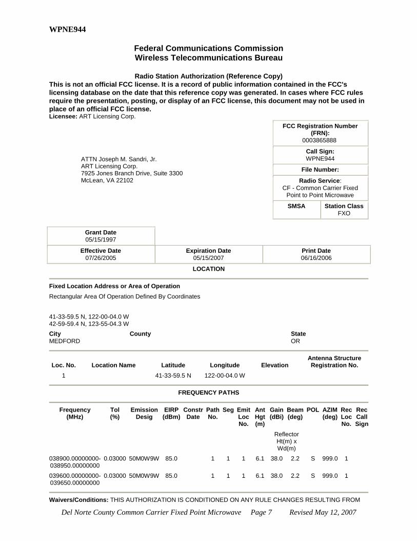
WPNE944
Federal Communications Commission Wireless Telecommunications Bureau
Radio Station Authorization (Reference Copy)
This is not an official FCC license. It is a record of public information contained in the FCC's
licensing database on the date that this reference copy was generated. In cases where FCC rules
require the presentation, posting, or display of an FCC license, this document may not be used in
place of an official FCC license. Licensee: ART Licensing Corp.
ATTN Joseph M. Sandri, Jr. ART Licensing Corp. 7925 Jones Branch Drive, Suite 3300 McLean, VA 22102
FCC Registration Number (FRN):
0003865888
Call Sign:
WPNE944
File Number:
Radio Service:
CF - Common Carrier Fixed Point to Point Microwave
SMSA Station Class
FXO
Grant Date
05/15/1997
Effective Date
07/26/2005
Expiration Date
05/15/2007
Print Date
06/16/2006
LOCATION
Fixed Location Address or Area of Operation
Rectangular Area Of Operation Defined By Coordinates
41-33-59.5 N, 122-00-04.0 W 42-59-59.4 N, 123-55-04.3 W
City
MEDFORD
County State
OR
Loc. No. Location Name Latitude Longitude Elevation Antenna Structure Registration No.
1 41-33-59.5 N 122-00-04.0 W
FREQUENCY PATHS
Frequency
(MHz) Tol (%)
Emission Desig
EIRP (dBm)
Constr Date
Path No.
Seg Emit Loc No.
Ant Hgt (m)
Gain (dBi)
Beam (deg)
POL AZIM (deg)
Rec Loc No.
Rec Call Sign
Reflector Ht(m) x Wd(m)
038900.00000000-038950.00000000
0.03000 50M0W9W 85.0 1 1 1 6.1 38.0 2.2 S 999.0 1
039600.00000000-039650.00000000
0.03000 50M0W9W 85.0 1 1 1 6.1 38.0 2.2 S 999.0 1
Waivers/Conditions: THIS AUTHORIZATION IS CONDITIONED ON ANY RULE CHANGES RESULTING FROM

Del Norte County Common Carrier Fixed Point Microwave Page 8 Revised May 12, 2007
FUTURE RULEMAKING PROCEEDINGS AFFECTING THE FREQUENCIES AUTHORIZED HEREIN.
Conditions
Pursuant to Section 309(h) of the Communications Act of 1934, as amended, 47 U.S.C. Section 309(h), this license is subject to the following conditions: This license shall not vest in the licensee any right to operate the station nor any right in the use of the frequencies designated in the license beyond the term thereof nor in any other manner than authorized herein. Neither the license nor the right granted thereunder shall be assigned or otherwise transferred in violation of the Communications Act of 1934, as amended. See 47 U.S.C. Section 310(d). This license is subject in terms to the right of use or control conferred by Section 706 of the Communications Act of 1934, as amended. See 47 U.S.C. Section 706.
Locations Summary
Call Sign WPNE944 Radio Service CF - Common Carrier Fixed
Point to Point Microwave
1 Total Location
10 Locations per Summary Page
Mobile Transmit Location 1:
Operating within a rectangular area of operation: Latitude 41-33-59.5 N, Longitude 122-00-04.0 W
Max Lat 42-59-59.4 N, Max Long 123-55-04.3 W
Special Conditions
None
Paths Summary
Call Sign WPNE944 Radio Service CF - Common Carrier Fixed Point to Point Microwave
Transmitter Coordinates 41-33-59.5 N , 122-00-04.0 W
1 Total Path
Path 1 - Area
Rec. Call Sign
Path Frequencies
038900.00000000-038950.00000000 039600.00000000-039650.00000000
Del Norte County Common Carrier Fixed Point Microwave Page 9 Revised May 12, 2007
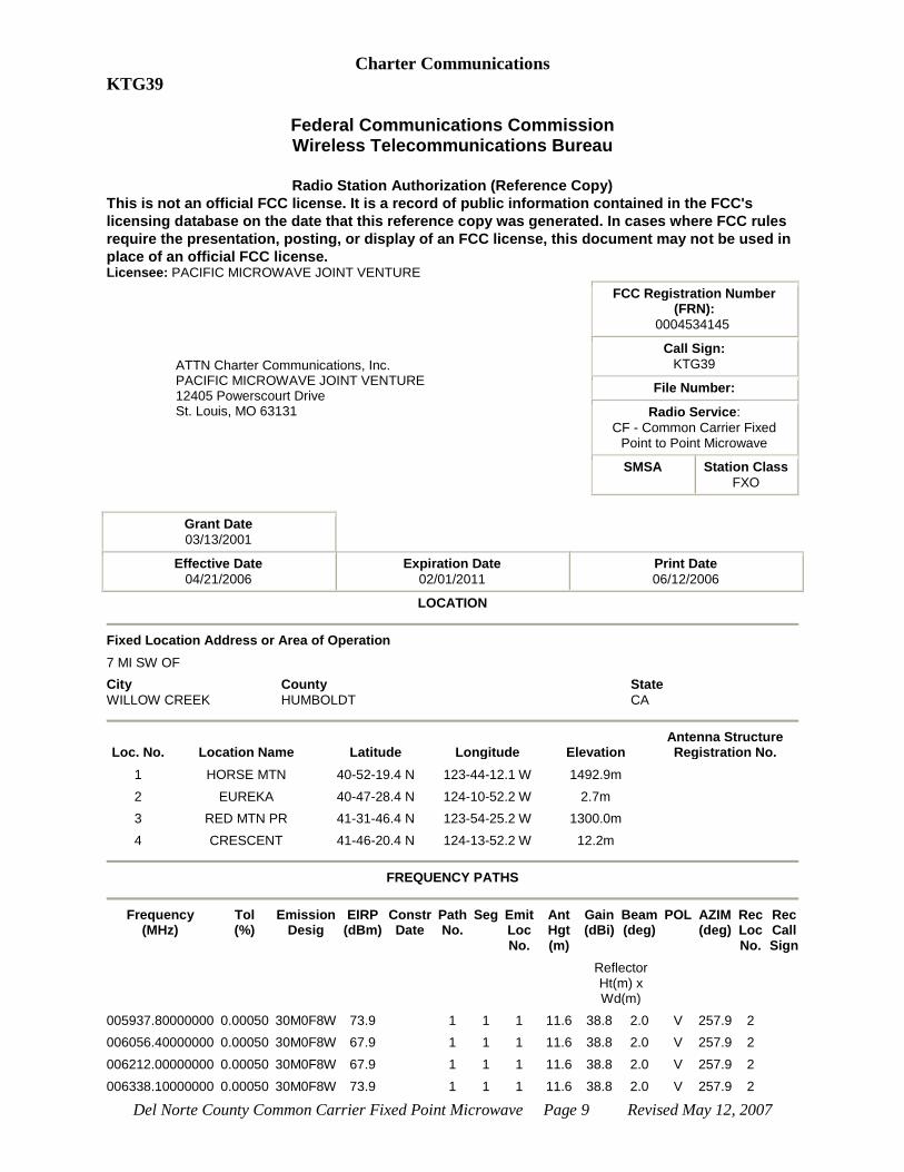
Charter Communications
KTG39
Federal Communications Commission Wireless Telecommunications Bureau
Radio Station Authorization (Reference Copy)
This is not an official FCC license. It is a record of public information contained in the FCC's
licensing database on the date that this reference copy was generated. In cases where FCC rules
require the presentation, posting, or display of an FCC license, this document may not be used in
place of an official FCC license. Licensee: PACIFIC MICROWAVE JOINT VENTURE
ATTN Charter Communications, Inc. PACIFIC MICROWAVE JOINT VENTURE 12405 Powerscourt Drive St. Louis, MO 63131
FCC Registration Number (FRN):
0004534145
Call Sign:
KTG39
File Number:
Radio Service:
CF - Common Carrier Fixed Point to Point Microwave
SMSA Station Class
FXO
Grant Date
03/13/2001
Effective Date
04/21/2006
Expiration Date
02/01/2011
Print Date
06/12/2006
LOCATION
Fixed Location Address or Area of Operation
7 MI SW OF
City
WILLOW CREEK
County
HUMBOLDT
State
CA
Loc. No. Location Name Latitude Longitude Elevation Antenna Structure Registration No.
1 HORSE MTN 40-52-19.4 N 123-44-12.1 W 1492.9m
2 EUREKA 40-47-28.4 N 124-10-52.2 W 2.7m
3 RED MTN PR 41-31-46.4 N 123-54-25.2 W 1300.0m
4 CRESCENT 41-46-20.4 N 124-13-52.2 W 12.2m
FREQUENCY PATHS
Frequency
(MHz) Tol (%)
Emission Desig
EIRP (dBm)
Constr Date
Path No.
Seg Emit Loc No.
Ant Hgt (m)
Gain (dBi)
Beam (deg)
POL AZIM (deg)
Rec Loc No.
Rec Call Sign
Reflector Ht(m) x Wd(m)
005937.80000000 0.00050 30M0F8W 73.9 1 1 1 11.6 38.8 2.0 V 257.9 2
006056.40000000 0.00050 30M0F8W 67.9 1 1 1 11.6 38.8 2.0 V 257.9 2
006212.00000000 0.00050 30M0F8W 67.9 1 1 1 11.6 38.8 2.0 V 257.9 2
006338.10000000 0.00050 30M0F8W 73.9 1 1 1 11.6 38.8 2.0 V 257.9 2

Del Norte County Common Carrier Fixed Point Microwave Page 10 Revised May 12, 2007
006056.38750000 0.00050 30M0F8W 74.6 2 1 1 10.7 41.5 1.4 H 348.9 3
2 3 11.3 41.5 H 315.0 4
006212.06500000 0.00050 30M0F8W 74.6 2 1 1 10.7 41.5 1.4 H 348.9 3
2 3 11.3 41.5 H 315.0 4
006308.42750000 0.00050 30M0F8W 76.6 2 1 1 10.7 41.5 1.4 H 348.9 3
2 3 11.3 41.5 H 315.0 4
Waivers/Conditions: None
Conditions
Pursuant to Section 309(h) of the Communications Act of 1934, as amended, 47 U.S.C. Section 309(h), this license is subject to the following conditions: This license shall not vest in the licensee any right to operate the station nor any right in the use of the frequencies designated in the license beyond the term thereof nor in any other manner than authorized herein. Neither the license nor the right granted thereunder shall be assigned or otherwise transferred in violation of the Communications Act of 1934, as amended. See 47 U.S.C. Section 310(d). This license is subject in terms to the right of use or control conferred by Section 706 of the Communications Act of 1934, as amended. See 47 U.S.C. Section 706.
Call Sign KTG39 Radio Service CF - Common Carrier Fixed
Point to Point Microwave
4 Total Locations
10 Locations per Summary Page
Fixed Transmit Location 1: HORSE MTN
Transmit Location
7 MI SW OF WILLOW CREEK, CA
HUMBOLDT County
Coordinates 40-52-19.4 N, 123-44-12.1
W
Site Elevation (AMSL)
1492.9m Height w/o Appurtenances
18.3m
ASR # N/A Height w/ Appurtenances
18.3m
Support Structure
Type
Special Conditions
None
Other Locations
Location 2 : EUREKA
Type Receive Location Coordinates 40-47-28.4 N, 124-10-52.2 W
Site Elevation
(AMSL)
2.7m Height w/o
Appurtenances
ASR # N/A Height w/ Appurtenances
Support Structure Type

Del Norte County Common Carrier Fixed Point Microwave Page 11 Revised May 12, 2007
Special Conditions
None
Location 3 : RED MTN PR
Type Passive Repeater Location Coordinates 41-31-46.4 N, 123-54-25.2 W
Site Elevation (AMSL)
1300.0m Height w/o Appurtenances
ASR # N/A Height w/ Appurtenances
13.1m
Support
Structure
Type
Special Conditions
None
Location 4 : CRESCENT
Type Receive Location Coordinates 41-46-20.4 N, 124-13-52.2 W
Site Elevation
(AMSL)
12.2m Height w/o Appurtenances
ASR # N/A Height w/ Appurtenances
Support Structure Type
Special Conditions
None
4 Total Locations
10 Locations per Summary Page
Call Sign KTG39 Radio Service CF - Common Carrier Fixed Point to Point Microwave
Transmitter HORSE MTN Coordinates 40-52-19.4 N , 123-44-12.1 W
2 Total Paths
Path 1 - Fixed Point-to-Point
Rec. Call Sign
Del Norte County Common Carrier Fixed Point Microwave Page 12 Revised May 12, 2007
Location Coordinates
EUREKA 40-47-28.4 N , 124-10-52.2 W
Path Frequencies
005937.80000000 006056.40000000 006212.00000000
006338.10000000
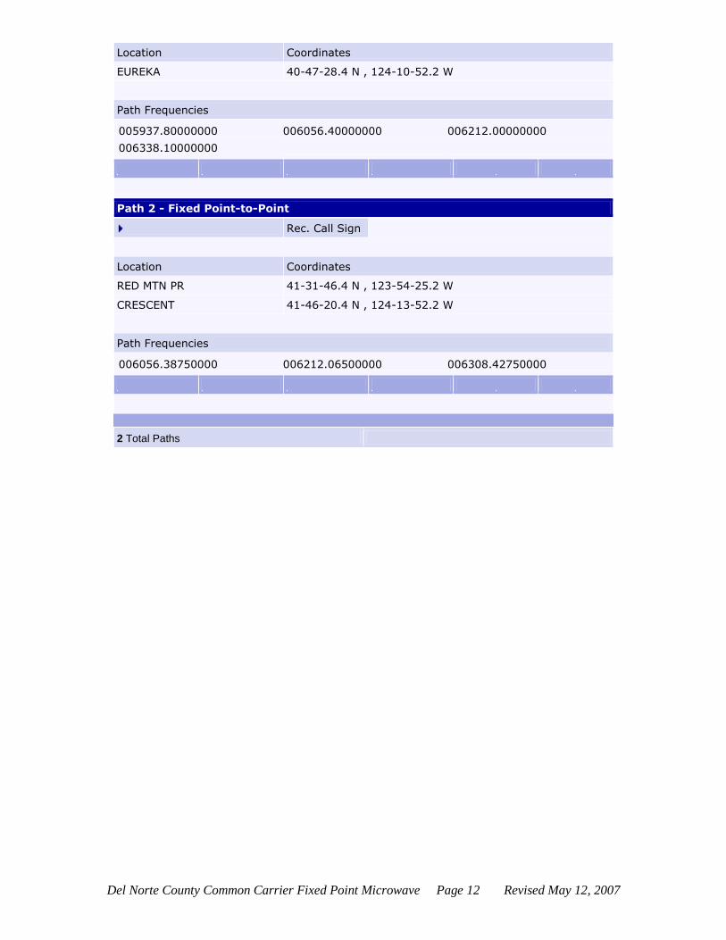
Path 2 - Fixed Point-to-Point
Rec. Call Sign
Location Coordinates
RED MTN PR 41-31-46.4 N , 123-54-25.2 W
CRESCENT 41-46-20.4 N , 124-13-52.2 W
Path Frequencies
006056.38750000 006212.06500000 006308.42750000
2 Total Paths

Del Norte County Common Carrier Fixed Point Microwave Page 13 Revised May 12, 2007
Curry County Communications
WMJ753
Federal Communications Commission Wireless Telecommunications Bureau
Radio Station Authorization (Reference Copy)
This is not an official FCC license. It is a record of public information contained in the FCC's
licensing database on the date that this reference copy was generated. In cases where FCC rules
require the presentation, posting, or display of an FCC license, this document may not be used in
place of an official FCC license. Licensee: Curry County Communications
ATTN Vern R. garvin Curry County Communications PO Box 1220 607 railroad street BROOKINGS, OR 97415
FCC Registration Number (FRN):
0005751946
Call Sign:
WMJ753
File Number:
Radio Service:
CF - Common Carrier Fixed Point to Point Microwave
SMSA Station Class
FXO
Grant Date
02/27/2001
Effective Date
02/19/2005
Expiration Date
02/01/2011
Print Date
06/15/2006
LOCATION
Fixed Location Address or Area of Operation
1.6 MILES E OF
City
BROOKINGS
County
CURRY
State
OR
Loc. No. Location Name Latitude Longitude Elevation Antenna Structure Registration No.
1 HARBOR HILL 42-03-01.3 N 124-15-15.3 W 335.3m
2 CRESENT CITY 41-45-17.4 N 124-12-17.2 W 3.0m
3 BROOKINGS 42-03-04.4 N 124-17-12.3 W 15.2m
FREQUENCY PATHS
Frequency
(MHz) Tol (%)
Emission Desig
EIRP (dBm)
Constr Date
Path No.
Seg Emit Loc No.
Ant Hgt (m)
Gain (dBi)
Beam (deg)
POL AZIM (deg)
Rec Loc No.
Rec Call Sign
Reflector Ht(m) x Wd(m)
002121.60000000 0.00100 1M60F8W 58.5 1 1 1 6.1 30.5 5.1 H 172.9 2 WMJ754
002128.00000000 0.00100 1M60F8W 54.7 2 1 1 6.1 26.7 7.9 V 272.0 3 WDU677
Waivers/Conditions: THIS AUTHORIZATION FOR ANY FACILITIES AUTHORIZED FOR FREQUENCY BETWEEN

Del Norte County Common Carrier Fixed Point Microwave Page 14 Revised May 12, 2007
1850 AND 2200 MHZ IS SUBJECT TO THE RULES, PROCEDURES, AND POLICIES IMPOSED BY THE COMMISSION IN ET DOCKET NO. 92-9, INCLUDING OPERATION OF A FACILITY AT 1850 TO 2200 MHZ ON A SECONDARY, NON-INTERFERENCE BASIS.
Conditions
Pursuant to Section 309(h) of the Communications Act of 1934, as amended, 47 U.S.C. Section 309(h), this license is subject to the following conditions: This license shall not vest in the licensee any right to operate the station nor any right in the use of the frequencies designated in the license beyond the term thereof nor in any other manner than authorized herein. Neither the license nor the right granted thereunder shall be assigned or otherwise transferred in violation of the Communications Act of 1934, as amended. See 47 U.S.C. Section 310(d). This license is subject in terms to the right of use or control conferred by Section 706 of the Communications Act of 1934, as amended. See 47 U.S.C. Section 706.
Locations Summary
Call Sign WMJ753 Radio Service CF - Common Carrier Fixed Point to Point Microwave
3 Total Locations
10 Locations per Summary Page
Fixed Transmit Location 1: HARBOR HILL
Transmit Location
1.6 MILES E OF BROOKINGS, OR CURRY County
Coordinates 42-03-01.3 N, 124-15-15.3
W
Site Elevation (AMSL)
335.3m Height w/o Appurtenances
ASR # N/A Height w/ Appurtenances
9.1m
Support Structure Type
Special Conditions
None
Other Locations
Location 2 : CRESENT CITY
Type Receive Location Coordinates 41-45-17.4 N, 124-12-17.2 W
Site Elevation (AMSL)
3.0m Height w/o Appurtenances
ASR # N/A Height w/ Appurtenances
Support Structure Type

Del Norte County Common Carrier Fixed Point Microwave Page 15 Revised May 12, 2007
Special Conditions
None
Location 3 : BROOKINGS
Type Receive Location Coordinates 42-03-04.4 N, 124-17-12.3 W
Site Elevation (AMSL)
15.2m Height w/o Appurtenances
ASR # N/A Height w/ Appurtenances
Support
Structure
Type
Special Conditions
None
Paths Summary
Call Sign WMJ753 Radio Service CF - Common Carrier Fixed Point to Point Microwave
Transmitter HARBOR HILL Coordinates 42-03-01.3 N , 124-15-15.3 W
2 Total Paths
Path 1 - Fixed Point-to-Point
Rec. Call Sign WMJ754
Location Coordinates
CRESENT CITY 41-45-17.4 N , 124-12-17.2 W
Path Frequencies
002121.60000000
Path 2 - Fixed Point-to-Point
Rec. Call Sign WDU677
Location Coordinates
BROOKINGS 42-03-04.4 N , 124-17-12.3 W
Path Frequencies

Del Norte County Common Carrier Fixed Point Microwave Page 16 Revised May 12, 2007
002128.00000000
2 Total Paths
Del Norte County Common Carrier Fixed Point Microwave Page 17 Revised May 12, 2007
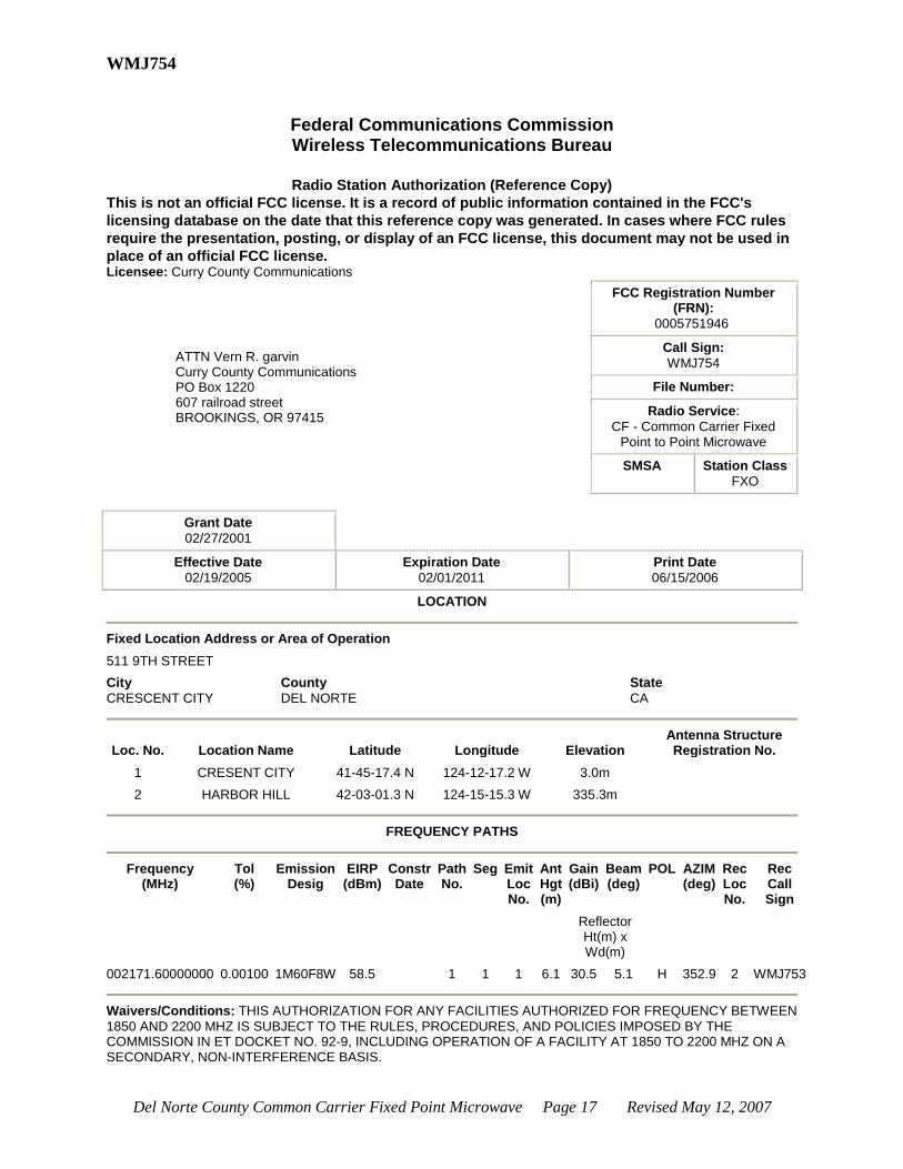
WMJ754
Federal Communications Commission Wireless Telecommunications Bureau
Radio Station Authorization (Reference Copy)
This is not an official FCC license. It is a record of public information contained in the FCC's
licensing database on the date that this reference copy was generated. In cases where FCC rules
require the presentation, posting, or display of an FCC license, this document may not be used in
place of an official FCC license. Licensee: Curry County Communications
ATTN Vern R. garvin Curry County Communications PO Box 1220 607 railroad street BROOKINGS, OR 97415
FCC Registration Number (FRN):
0005751946
Call Sign:
WMJ754
File Number:
Radio Service:
CF - Common Carrier Fixed Point to Point Microwave
SMSA Station Class
FXO
Grant Date
02/27/2001
Effective Date
02/19/2005
Expiration Date
02/01/2011
Print Date
06/15/2006
LOCATION
Fixed Location Address or Area of Operation
511 9TH STREET
City
CRESCENT CITY
County
DEL NORTE
State
CA
Loc. No. Location Name Latitude Longitude Elevation Antenna Structure Registration No.
1 CRESENT CITY 41-45-17.4 N 124-12-17.2 W 3.0m
2 HARBOR HILL 42-03-01.3 N 124-15-15.3 W 335.3m
FREQUENCY PATHS
Frequency
(MHz) Tol (%)
Emission Desig
EIRP (dBm)
Constr Date
Path No.
Seg Emit Loc No.
Ant Hgt (m)
Gain (dBi)
Beam (deg)
POL AZIM (deg)
Rec Loc No.
Rec Call Sign
Reflector Ht(m) x Wd(m)
002171.60000000 0.00100 1M60F8W 58.5 1 1 1 6.1 30.5 5.1 H 352.9 2 WMJ753
Waivers/Conditions: THIS AUTHORIZATION FOR ANY FACILITIES AUTHORIZED FOR FREQUENCY BETWEEN
1850 AND 2200 MHZ IS SUBJECT TO THE RULES, PROCEDURES, AND POLICIES IMPOSED BY THE COMMISSION IN ET DOCKET NO. 92-9, INCLUDING OPERATION OF A FACILITY AT 1850 TO 2200 MHZ ON A SECONDARY, NON-INTERFERENCE BASIS.
Del Norte County Common Carrier Fixed Point Microwave Page 18 Revised May 12, 2007
Conditions
Pursuant to Section 309(h) of the Communications Act of 1934, as amended, 47 U.S.C. Section 309(h), this license is subject to the following conditions: This license shall not vest in the licensee any right to operate the station nor any right in the use of the frequencies designated in the license beyond the term thereof nor in any other manner than authorized herein. Neither the license nor the right granted thereunder shall be assigned or otherwise transferred in violation of the Communications Act of 1934, as amended. See 47 U.S.C. Section 310(d). This license is subject in terms to the right of use or control conferred by Section 706 of the Communications Act of 1934, as amended. See 47 U.S.C. Section 706.
Locations Summary
Call Sign WMJ754 Radio Service CF - Common Carrier Fixed Point to Point Microwave
2 Total Locations
10 Locations per Summary Page
Fixed Transmit Location 1: CRESENT CITY
Transmit Location 511 9TH STREET
CRESCENT CITY, CA DEL NORTE County
Coordinates 41-45-17.4 N, 124-12-17.2 W
Site Elevation
(AMSL)
3.0m Height w/o
Appurtenances
ASR # N/A Height w/ Appurtenances
6.7m
Support Structure Type
Special Conditions
None
Other Locations
Location 2 : HARBOR HILL
Type Receive Location Coordinates 42-03-01.3 N, 124-15-15.3 W
Site Elevation (AMSL)
335.3m Height w/o Appurtenances
ASR # N/A Height w/ Appurtenances
Support Structure
Type
Special Conditions
None
Del Norte County Common Carrier Fixed Point Microwave Page 19 Revised May 12, 2007
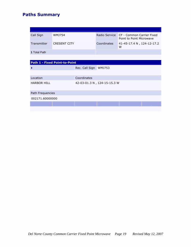
Paths Summary
Call Sign WMJ754 Radio Service CF - Common Carrier Fixed Point to Point Microwave
Transmitter CRESENT CITY Coordinates 41-45-17.4 N , 124-12-17.2 W
1 Total Path
Path 1 - Fixed Point-to-Point
Rec. Call Sign WMJ753
Location Coordinates
HARBOR HILL 42-03-01.3 N , 124-15-15.3 W
Path Frequencies
002171.60000000

Del Norte County Common Carrier Fixed Point Microwave Page 20 Revised May 12, 2007
M.U.T.
WLM387
Federal Communications Commission Wireless Telecommunications Bureau
Radio Station Authorization (Reference Copy)
This is not an official FCC license. It is a record of public information contained in the FCC's licensing
database on the date that this reference copy was generated. In cases where FCC rules require the
presentation, posting, or display of an FCC license, this document may not be used in place of an
official FCC license. Licensee: M.U.T. Licensing, LLC
M.U.T. Licensing, LLC 301 N. Fairfax Street, Suite 101 Alexandria, VA 22314
FCC Registration Number (FRN):
0004253712
Call Sign:
WLM387
File Number:
Radio Service:
CF - Common Carrier Fixed Point to Point Microwave
SMSA Station Class
FX5
Grant Date
02/21/2001
Effective Date
05/30/2001
Expiration Date
02/01/2011
Print Date
06/15/2006
LOCATION
Fixed Location Address or Area of Operation
Statewide
City County State
CA
Loc. No. Location Name Latitude Longitude Elevation Antenna Structure Registration No.
1 - - - -
FREQUENCY PATHS
Frequency
(MHz) Tol (%)
Emission Desig
EIRP (dBm)
Constr Date
Path No.
Seg Emit Loc No.
Ant Hgt (m)
Gain (dBi)
Beam (deg)
POL AZIM (deg)
Rec Loc No.
Rec Call Sign
Reflector Ht(m) x Wd(m)
002110.00000000-002130.00000000
1 1 1 6.1 S 1 WLM387
002160.00000000-002180.00000000
1 1 1 6.1 S 1 WLM387
003700.00000000-004200.00000000
1 1 1 6.1 S 1 WLM387
005925.00000000-006425.00000000
1 1 1 6.1 S 1 WLM387

Del Norte County Common Carrier Fixed Point Microwave Page 21 Revised May 12, 2007
010700.00000000-011700.00000000
1 1 1 6.1 S 1 WLM387
017700.00000000-019700.00000000
1 1 1 6.1 S 1 WLM387
021200.00000000-021800.00000000
1 1 1 6.1 S 1 WLM387
022400.00000000-023000.00000000
1 1 1 6.1 S 1 WLM387
Waivers/Conditions: None
Conditions
Pursuant to Section 309(h) of the Communications Act of 1934, as amended, 47 U.S.C. Section 309(h), this license is subject to the following conditions: This license shall not vest in the licensee any right to operate the station nor any right in the use of the frequencies designated in the license beyond the term thereof nor in any other manner than authorized herein. Neither the license nor the right granted thereunder shall be assigned or otherwise transferred in violation of the Communications Act of 1934, as amended. See 47 U.S.C. Section 310(d). This license is subject in terms to the right of use or control conferred by Section 706 of the Communications Act of 1934, as amended. See 47 U.S.C. Section 706.
Microwave Data
Oper Type Temporary Fixed/Mobile Station Class FX5 - Temporary Fixed

Del Norte County Common Carrier Fixed Point Microwave Page 22 Revised May 12, 2007
WLT380
Federal Communications Commission Wireless Telecommunications Bureau
Radio Station Authorization (Reference Copy)
This is not an official FCC license. It is a record of public information contained in the FCC's
licensing database on the date that this reference copy was generated. In cases where FCC rules
require the presentation, posting, or display of an FCC license, this document may not be used in
place of an official FCC license. Licensee: M.U.T. Licensing, LLC
M.U.T. Licensing, LLC 301 N. Fairfax Street, Suite 101 Alexandria, VA 22314
FCC Registration Number (FRN):
0004253712
Call Sign:
WLT380
File Number:
Radio Service:
CF - Common Carrier Fixed Point to Point Microwave
SMSA Station Class
FX5
Grant Date
02/21/2001
Effective Date
05/30/2001
Expiration Date
02/01/2011
Print Date
06/15/2006
LOCATION
Fixed Location Address or Area of Operation
Statewide
City County State
CA
Loc. No. Location Name Latitude Longitude Elevation Antenna Structure Registration No.
1 - - - -
FREQUENCY PATHS
Frequency
(MHz) Tol (%)
Emission Desig
EIRP (dBm)
Constr Date
Path No.
Seg Emit Loc No.
Ant Hgt (m)
Gain (dBi)
Beam (deg)
POL AZIM (deg)
Rec Loc No.
Rec Call Sign
Reflector Ht(m) x Wd(m)
002110.00000000-002130.00000000
1 1 1 6.1 S 1 WLT380
002160.00000000-002180.00000000
1 1 1 6.1 S 1 WLT380
003700.00000000-004200.00000000
1 1 1 6.1 S 1 WLT380
005925.00000000-006425.00000000
1 1 1 6.1 S 1 WLT380
010700.00000000- 1 1 1 6.1 S 1 WLT380

Del Norte County Common Carrier Fixed Point Microwave Page 23 Revised May 12, 2007
011700.00000000
017700.00000000-018820.00000000
1 1 1 6.1 S 1 WLT380
018920.00000000-019160.00000000
1 1 1 6.1 S 1 WLT380
019260.00000000-019700.00000000
1 1 1 6.1 S 1 WLT380
021200.00000000-022000.00000000
1 1 1 6.1 S 1 WLT380
022000.00000000-023600.00000000
1 1 1 6.1 S 1 WLT380
027500.00000000-029500.00000000
1 1 1 6.1 S 1 WLT380
Waivers/Conditions: None
Conditions
Pursuant to Section 309(h) of the Communications Act of 1934, as amended, 47 U.S.C. Section 309(h), this license is subject to the following conditions: This license shall not vest in the licensee any right to operate the station nor any right in the use of the frequencies designated in the license beyond the term thereof nor in any other manner than authorized herein. Neither the license nor the right granted thereunder shall be assigned or otherwise transferred in violation of the Communications Act of 1934, as amended. See 47 U.S.C. Section 310(d). This license is subject in terms to the right of use or control conferred by Section 706 of the Communications Act of 1934, as amended. See 47 U.S.C. Section 706.
Microwave Data
Oper Type Temporary Fixed/Mobile Station Class FX5 - Temporary Fixed

Del Norte County Common Carrier Fixed Point Microwave Page 24 Revised May 12, 2007
US Cellular -- California Rural Service Area 1, Inc.
WPJB980
Federal Communications Commission Wireless Telecommunications Bureau
Radio Station Authorization (Reference Copy)
This is not an official FCC license. It is a record of public information contained in the FCC's
licensing database on the date that this reference copy was generated. In cases where FCC rules
require the presentation, posting, or display of an FCC license, this document may not be used in
place of an official FCC license. Licensee: CALIFORNIA RURAL SERVICE AREA 1 INC
CALIFORNIA RURAL SERVICE AREA 1 INC 8410 WEST BRYN MAWR STE 700 CHICAGO, IL 60631
FCC Registration Number (FRN):
0002703700
Call Sign:
WPJB980
File Number:
Radio Service:
CF - Common Carrier Fixed Point to Point Microwave
SMSA Station Class
FXO
Grant Date
02/21/2001
Effective Date
02/21/2001
Expiration Date
02/01/2011
Print Date
06/15/2006
LOCATION
Fixed Location Address or Area of Operation
14 MI N OF
City
CRESCENT CITY
County
DEL NORTE
State
CA
Loc. No. Location Name Latitude Longitude Elevation Antenna Structure Registration No.
1 CRESCENT CITY 41-58-10.4 N 124-11-16.3 W 289.3m
2 CRESCENT CITY
AIRPRT 41-46-20.4 N 124-14-05.2 W 12.5m
FREQUENCY PATHS
Frequency
(MHz) Tol (%)
Emission Desig
EIRP (dBm)
Constr Date
Path No.
Seg Emit Loc No.
Ant Hgt (m)
Gain (dBi)
Beam (deg)
POL AZIM (deg)
Rec Loc No.
Rec Call Sign
Reflector Ht(m) x Wd(m)
002128.00000000 0.00100 3M50D7W 55.0 1 1 1 30.5 30.0 5.4 H 190.1 2 WPJB981
Waivers/Conditions: THIS AUTHORIZATION FOR ANY FACILITIES AUTHORIZED FOR FREQUENCY BETWEEN
1850 AND 2200 MHZ IS SUBJECT TO THE RULES, PROCEDURES, AND POLICIES IMPOSED BY THE
Del Norte County Common Carrier Fixed Point Microwave Page 25 Revised May 12, 2007
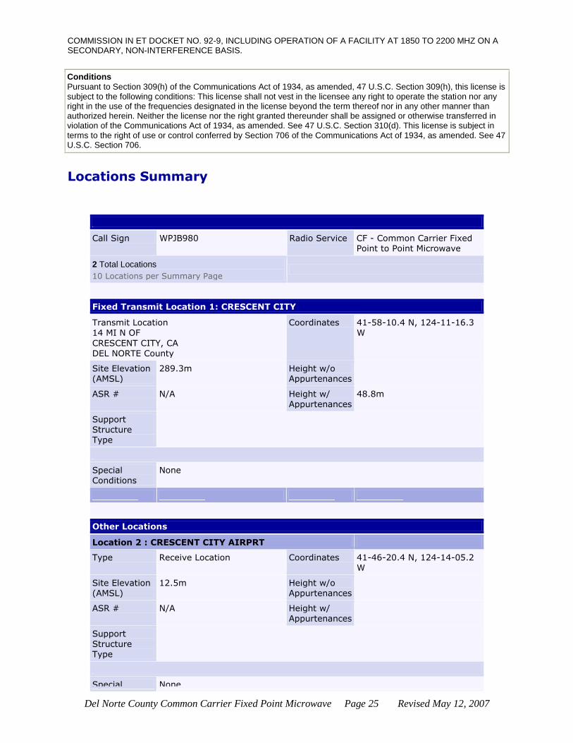
COMMISSION IN ET DOCKET NO. 92-9, INCLUDING OPERATION OF A FACILITY AT 1850 TO 2200 MHZ ON A SECONDARY, NON-INTERFERENCE BASIS.
Conditions
Pursuant to Section 309(h) of the Communications Act of 1934, as amended, 47 U.S.C. Section 309(h), this license is subject to the following conditions: This license shall not vest in the licensee any right to operate the station nor any right in the use of the frequencies designated in the license beyond the term thereof nor in any other manner than authorized herein. Neither the license nor the right granted thereunder shall be assigned or otherwise transferred in violation of the Communications Act of 1934, as amended. See 47 U.S.C. Section 310(d). This license is subject in terms to the right of use or control conferred by Section 706 of the Communications Act of 1934, as amended. See 47 U.S.C. Section 706.
Locations Summary
Call Sign WPJB980 Radio Service CF - Common Carrier Fixed Point to Point Microwave
2 Total Locations
10 Locations per Summary Page
Fixed Transmit Location 1: CRESCENT CITY
Transmit Location 14 MI N OF
CRESCENT CITY, CA DEL NORTE County
Coordinates 41-58-10.4 N, 124-11-16.3 W
Site Elevation (AMSL)
289.3m Height w/o Appurtenances
ASR # N/A Height w/ Appurtenances
48.8m
Support Structure Type
Special
Conditions
None
Other Locations
Location 2 : CRESCENT CITY AIRPRT
Type Receive Location Coordinates 41-46-20.4 N, 124-14-05.2 W
Site Elevation (AMSL)
12.5m Height w/o Appurtenances
ASR # N/A Height w/
Appurtenances
Support Structure Type
Special None

Del Norte County Common Carrier Fixed Point Microwave Page 26 Revised May 12, 2007
Conditions
Paths Summary
Call Sign WPJB980 Radio Service CF - Common Carrier Fixed Point to Point Microwave
Transmitter CRESCENT CITY Coordinates 41-58-10.4 N , 124-11-16.3 W
1 Total Path
Path 1 - Fixed Point-to-Point
Rec. Call Sign WPJB981
Location Coordinates
CRESCENT CITY AIRPRT 41-46-20.4 N , 124-14-05.2 W
Path Frequencies
002128.00000000
1 Total Path
Del Norte County Common Carrier Fixed Point Microwave Page 27 Revised May 12, 2007
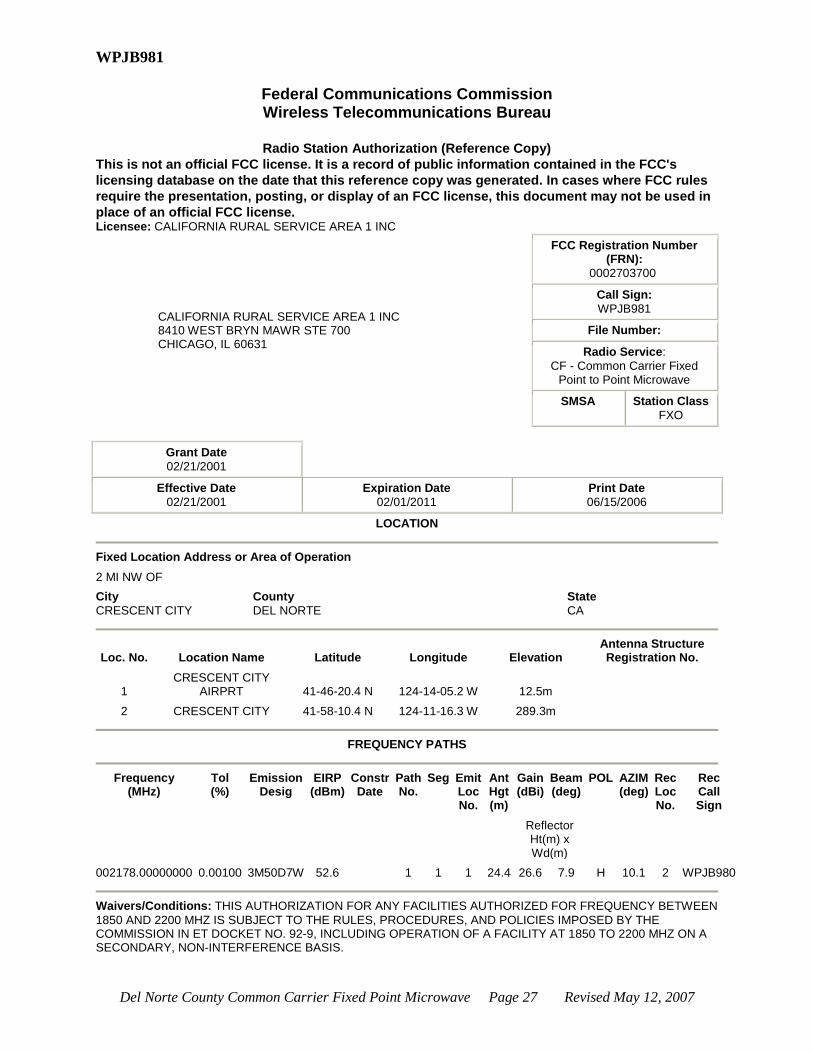
WPJB981
Federal Communications Commission Wireless Telecommunications Bureau
Radio Station Authorization (Reference Copy)
This is not an official FCC license. It is a record of public information contained in the FCC's
licensing database on the date that this reference copy was generated. In cases where FCC rules
require the presentation, posting, or display of an FCC license, this document may not be used in
place of an official FCC license. Licensee: CALIFORNIA RURAL SERVICE AREA 1 INC
CALIFORNIA RURAL SERVICE AREA 1 INC 8410 WEST BRYN MAWR STE 700 CHICAGO, IL 60631
FCC Registration Number (FRN):
0002703700
Call Sign:
WPJB981
File Number:
Radio Service:
CF - Common Carrier Fixed Point to Point Microwave
SMSA Station Class
FXO
Grant Date
02/21/2001
Effective Date
02/21/2001
Expiration Date
02/01/2011
Print Date
06/15/2006
LOCATION
Fixed Location Address or Area of Operation
2 MI NW OF
City
CRESCENT CITY
County
DEL NORTE
State
CA
Loc. No. Location Name Latitude Longitude Elevation Antenna Structure Registration No.
1 CRESCENT CITY
AIRPRT 41-46-20.4 N 124-14-05.2 W 12.5m
2 CRESCENT CITY 41-58-10.4 N 124-11-16.3 W 289.3m
FREQUENCY PATHS
Frequency
(MHz) Tol (%)
Emission Desig
EIRP (dBm)
Constr Date
Path No.
Seg Emit Loc No.
Ant Hgt (m)
Gain (dBi)
Beam (deg)
POL AZIM (deg)
Rec Loc No.
Rec Call Sign
Reflector Ht(m) x Wd(m)
002178.00000000 0.00100 3M50D7W 52.6 1 1 1 24.4 26.6 7.9 H 10.1 2 WPJB980
Waivers/Conditions: THIS AUTHORIZATION FOR ANY FACILITIES AUTHORIZED FOR FREQUENCY BETWEEN
1850 AND 2200 MHZ IS SUBJECT TO THE RULES, PROCEDURES, AND POLICIES IMPOSED BY THE COMMISSION IN ET DOCKET NO. 92-9, INCLUDING OPERATION OF A FACILITY AT 1850 TO 2200 MHZ ON A SECONDARY, NON-INTERFERENCE BASIS.
Del Norte County Common Carrier Fixed Point Microwave Page 28 Revised May 12, 2007
Conditions
Pursuant to Section 309(h) of the Communications Act of 1934, as amended, 47 U.S.C. Section 309(h), this license is subject to the following conditions: This license shall not vest in the licensee any right to operate the station nor any right in the use of the frequencies designated in the license beyond the term thereof nor in any other manner than authorized herein. Neither the license nor the right granted thereunder shall be assigned or otherwise transferred in violation of the Communications Act of 1934, as amended. See 47 U.S.C. Section 310(d). This license is subject in terms to the right of use or control conferred by Section 706 of the Communications Act of 1934, as amended. See 47 U.S.C. Section 706.
Locations Summary
Call Sign WPJB981 Radio Service CF - Common Carrier Fixed Point to Point Microwave
2 Total Locations
10 Locations per Summary Page
Fixed Transmit Location 1: CRESCENT CITY AIRPRT
Transmit Location 2 MI NW OF
CRESCENT CITY, CA DEL NORTE County
Coordinates 41-46-20.4 N, 124-14-05.2 W
Site Elevation
(AMSL)
12.5m Height w/o
Appurtenances
ASR # N/A Height w/ Appurtenances
38.1m
Support Structure Type
Special Conditions
None
Other Locations
Location 2 : CRESCENT CITY
Type Receive Location Coordinates 41-58-10.4 N, 124-11-16.3 W
Site Elevation (AMSL)
289.3m Height w/o Appurtenances
ASR # N/A Height w/ Appurtenances
Support Structure
Type
Special Conditions
None

Del Norte County Common Carrier Fixed Point Microwave Page 29 Revised May 12, 2007
Paths Summary
Call Sign WPJB981 Radio Service CF - Common Carrier Fixed Point to Point Microwave
Transmitter CRESCENT CITY AIRPRT Coordinates 41-46-20.4 N , 124-14-05.2 W
1 Total Path
Path 1 - Fixed Point-to-Point
Rec. Call Sign WPJB980
Location Coordinates
CRESCENT CITY 41-58-10.4 N , 124-11-16.3 W
Path Frequencies
002178.00000000
Del Norte County Common Carrier Fixed Point Microwave Page 30 Revised May 12, 2007
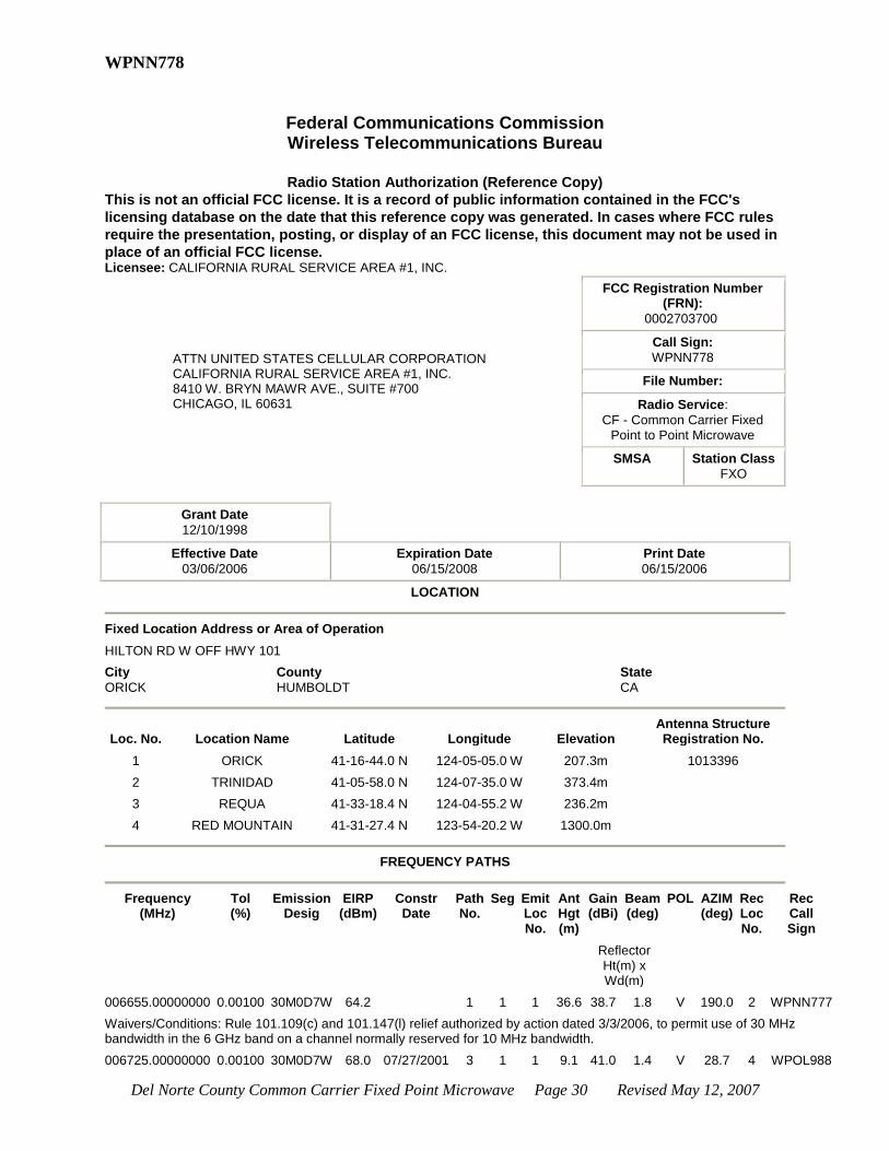
WPNN778
Federal Communications Commission Wireless Telecommunications Bureau
Radio Station Authorization (Reference Copy)
This is not an official FCC license. It is a record of public information contained in the FCC's
licensing database on the date that this reference copy was generated. In cases where FCC rules
require the presentation, posting, or display of an FCC license, this document may not be used in
place of an official FCC license. Licensee: CALIFORNIA RURAL SERVICE AREA #1, INC.
ATTN UNITED STATES CELLULAR CORPORATION CALIFORNIA RURAL SERVICE AREA #1, INC. 8410 W. BRYN MAWR AVE., SUITE #700 CHICAGO, IL 60631
FCC Registration Number (FRN):
0002703700
Call Sign:
WPNN778
File Number:
Radio Service:
CF - Common Carrier Fixed Point to Point Microwave
SMSA Station Class
FXO
Grant Date
12/10/1998
Effective Date
03/06/2006
Expiration Date
06/15/2008
Print Date
06/15/2006
LOCATION
Fixed Location Address or Area of Operation
HILTON RD W OFF HWY 101
City
ORICK
County
HUMBOLDT
State
CA
Loc. No. Location Name Latitude Longitude Elevation Antenna Structure Registration No.
1 ORICK 41-16-44.0 N 124-05-05.0 W 207.3m 1013396
2 TRINIDAD 41-05-58.0 N 124-07-35.0 W 373.4m
3 REQUA 41-33-18.4 N 124-04-55.2 W 236.2m
4 RED MOUNTAIN 41-31-27.4 N 123-54-20.2 W 1300.0m
FREQUENCY PATHS
Frequency
(MHz) Tol (%)
Emission Desig
EIRP (dBm)
Constr Date
Path No.
Seg Emit Loc No.
Ant Hgt (m)
Gain (dBi)
Beam (deg)
POL AZIM (deg)
Rec Loc No.
Rec Call Sign
Reflector Ht(m) x Wd(m)
006655.00000000 0.00100 30M0D7W 64.2 1 1 1 36.6 38.7 1.8 V 190.0 2 WPNN777
Waivers/Conditions: Rule 101.109(c) and 101.147(l) relief authorized by action dated 3/3/2006, to permit use of 30 MHz bandwidth in the 6 GHz band on a channel normally reserved for 10 MHz bandwidth.
006725.00000000 0.00100 30M0D7W 68.0 07/27/2001 3 1 1 9.1 41.0 1.4 V 28.7 4 WPOL988

Del Norte County Common Carrier Fixed Point Microwave Page 31 Revised May 12, 2007
Waivers/Conditions: Rule 101.109(c) and 101.147(l) relief authorized by action dated 3/3/2006, to permit use of 30 MHz bandwidth in the 6 GHz band on a channel normally reserved for 10 MHz bandwidth.
Waivers/Conditions: None
Conditions
Pursuant to Section 309(h) of the Communications Act of 1934, as amended, 47 U.S.C. Section 309(h), this license is subject to the following conditions: This license shall not vest in the licensee any right to operate the station nor any right in the use of the frequencies designated in the license beyond the term thereof nor in any other manner than authorized herein. Neither the license nor the right granted thereunder shall be assigned or otherwise transferred in violation of the Communications Act of 1934, as amended. See 47 U.S.C. Section 310(d). This license is subject in terms to the right of use or control conferred by Section 706 of the Communications Act of 1934, as amended. See 47 U.S.C. Section 706.
Call Sign WPNN778 Radio Service CF - Common Carrier Fixed Point to Point Microwave
4 Total Locations
10 Locations per Summary Page
Fixed Transmit Location 1: ORICK
Transmit Location HILTON RD W OFF HWY 101 ORICK, CA HUMBOLDT County
Coordinates 41-16-44.0 N, 124-05-05.0 W
Site Elevation (AMSL)
207.3m Height w/o Appurtenances
45.1m
ASR # 1013396 Height w/ Appurtenances
50.0m
Support Structure Type
TOWER - A free standing or guyed structure
Special Conditions
None
Other Locations
Location 2 : TRINIDAD
Type Receive Location Coordinates 41-05-58.0 N, 124-07-35.0 W
Site Elevation (AMSL)
373.4m Height w/o Appurtenances
ASR # N/A Height w/ Appurtenances
Support Structure
Type
Special
Conditions
None
Del Norte County Common Carrier Fixed Point Microwave Page 32 Revised May 12, 2007
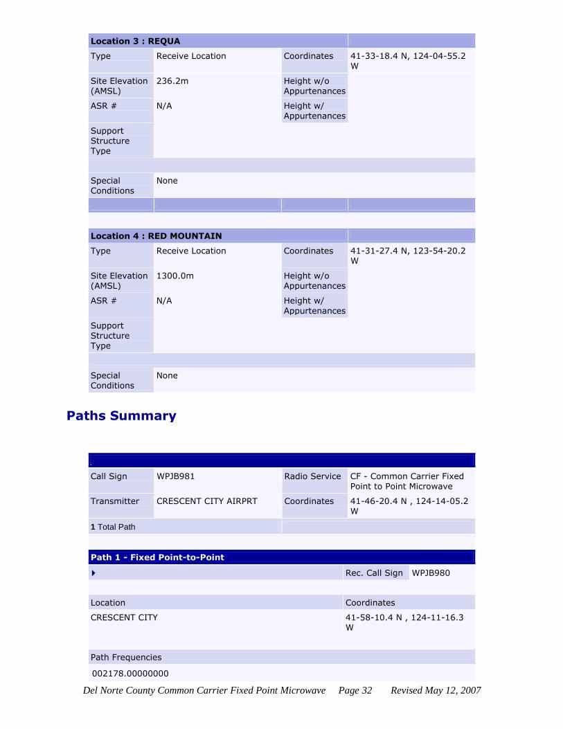
Location 3 : REQUA
Type Receive Location Coordinates 41-33-18.4 N, 124-04-55.2
W
Site Elevation (AMSL)
236.2m Height w/o Appurtenances
ASR # N/A Height w/ Appurtenances
Support Structure Type
Special Conditions
None
Location 4 : RED MOUNTAIN
Type Receive Location Coordinates 41-31-27.4 N, 123-54-20.2 W
Site Elevation (AMSL)
1300.0m Height w/o Appurtenances
ASR # N/A Height w/
Appurtenances
Support
Structure Type
Special Conditions
None
Paths Summary
Call Sign WPJB981 Radio Service CF - Common Carrier Fixed Point to Point Microwave
Transmitter CRESCENT CITY AIRPRT Coordinates 41-46-20.4 N , 124-14-05.2 W
1 Total Path
Path 1 - Fixed Point-to-Point
Rec. Call Sign WPJB980
Location Coordinates
CRESCENT CITY 41-58-10.4 N , 124-11-16.3 W
Path Frequencies
002178.00000000

Del Norte County Common Carrier Fixed Point Microwave Page 33 Revised May 12, 2007
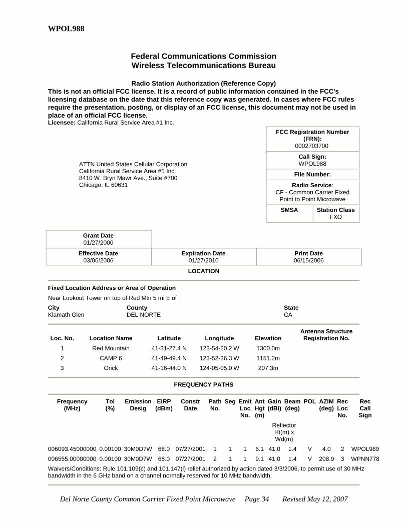
Del Norte County Common Carrier Fixed Point Microwave Page 34 Revised May 12, 2007
WPOL988
Federal Communications Commission Wireless Telecommunications Bureau
Radio Station Authorization (Reference Copy)
This is not an official FCC license. It is a record of public information contained in the FCC's
licensing database on the date that this reference copy was generated. In cases where FCC rules
require the presentation, posting, or display of an FCC license, this document may not be used in
place of an official FCC license. Licensee: California Rural Service Area #1 Inc.
ATTN United States Cellular Corporation California Rural Service Area #1 Inc. 8410 W. Bryn Mawr Ave., Suite #700 Chicago, IL 60631
FCC Registration Number (FRN):
0002703700
Call Sign:
WPOL988
File Number:
Radio Service:
CF - Common Carrier Fixed Point to Point Microwave
SMSA Station Class
FXO
Grant Date
01/27/2000
Effective Date
03/06/2006
Expiration Date
01/27/2010
Print Date
06/15/2006
LOCATION
Fixed Location Address or Area of Operation
Near Lookout Tower on top of Red Mtn 5 mi E of
City
Klamath Glen
County
DEL NORTE
State
CA
Loc. No. Location Name Latitude Longitude Elevation Antenna Structure Registration No.
1 Red Mountain 41-31-27.4 N 123-54-20.2 W 1300.0m
2 CAMP 6 41-49-49.4 N 123-52-36.3 W 1151.2m
3 Orick 41-16-44.0 N 124-05-05.0 W 207.3m
FREQUENCY PATHS
Frequency
(MHz) Tol (%)
Emission Desig
EIRP (dBm)
Constr Date
Path No.
Seg Emit Loc No.
Ant Hgt (m)
Gain (dBi)
Beam (deg)
POL AZIM (deg)
Rec Loc No.
Rec Call Sign
Reflector Ht(m) x Wd(m)
006093.45000000 0.00100 30M0D7W 68.0 07/27/2001 1 1 1 6.1 41.0 1.4 V 4.0 2 WPOL989
006555.00000000 0.00100 30M0D7W 68.0 07/27/2001 2 1 1 9.1 41.0 1.4 V 208.9 3 WPNN778
Waivers/Conditions: Rule 101.109(c) and 101.147(l) relief authorized by action dated 3/3/2006, to permit use of 30 MHz bandwidth in the 6 GHz band on a channel normally reserved for 10 MHz bandwidth.
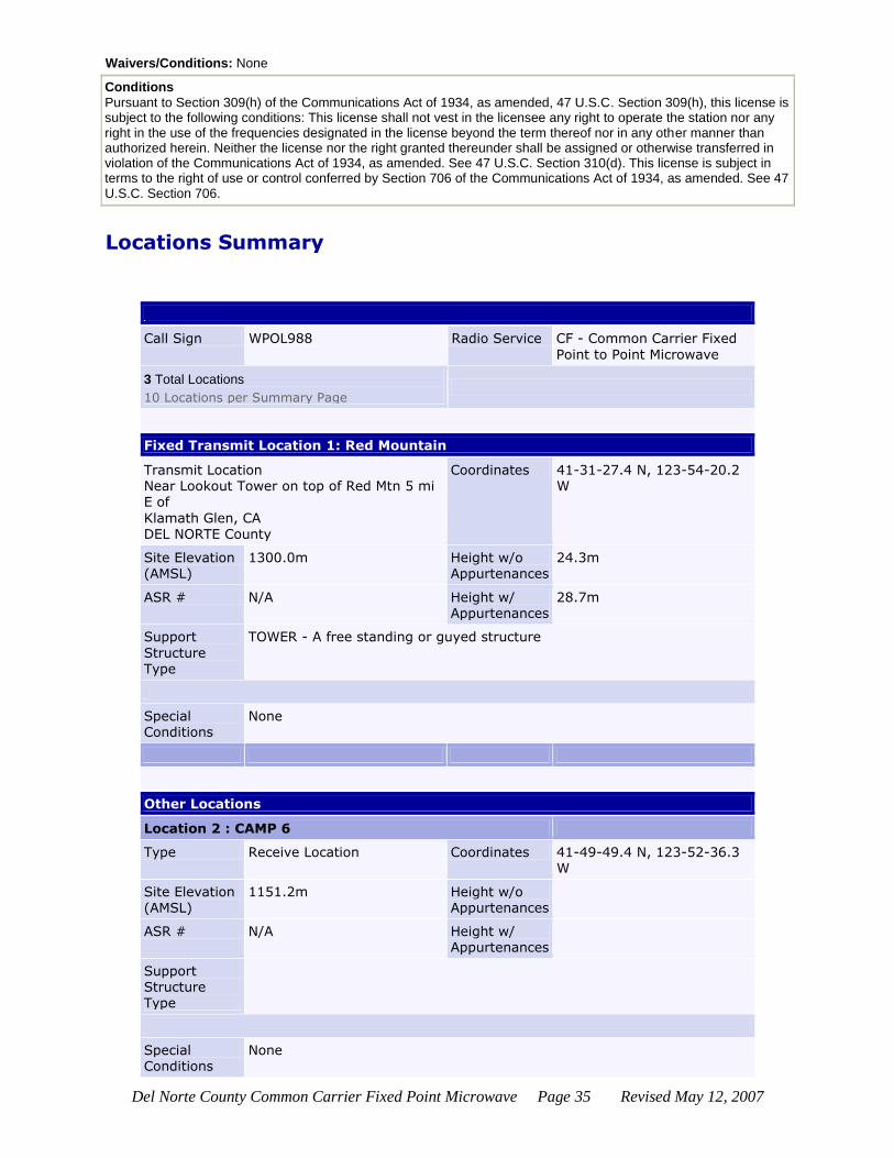
Del Norte County Common Carrier Fixed Point Microwave Page 35 Revised May 12, 2007
Waivers/Conditions: None
Conditions
Pursuant to Section 309(h) of the Communications Act of 1934, as amended, 47 U.S.C. Section 309(h), this license is subject to the following conditions: This license shall not vest in the licensee any right to operate the station nor any right in the use of the frequencies designated in the license beyond the term thereof nor in any other manner than authorized herein. Neither the license nor the right granted thereunder shall be assigned or otherwise transferred in violation of the Communications Act of 1934, as amended. See 47 U.S.C. Section 310(d). This license is subject in terms to the right of use or control conferred by Section 706 of the Communications Act of 1934, as amended. See 47 U.S.C. Section 706.
Locations Summary
Call Sign WPOL988 Radio Service CF - Common Carrier Fixed
Point to Point Microwave
3 Total Locations
10 Locations per Summary Page
Fixed Transmit Location 1: Red Mountain
Transmit Location Near Lookout Tower on top of Red Mtn 5 mi E of
Klamath Glen, CA
DEL NORTE County
Coordinates 41-31-27.4 N, 123-54-20.2 W
Site Elevation (AMSL)
1300.0m Height w/o Appurtenances
24.3m
ASR # N/A Height w/ Appurtenances
28.7m
Support
Structure Type
TOWER - A free standing or guyed structure
Special Conditions
None
Other Locations
Location 2 : CAMP 6
Type Receive Location Coordinates 41-49-49.4 N, 123-52-36.3 W
Site Elevation (AMSL)
1151.2m Height w/o Appurtenances
ASR # N/A Height w/ Appurtenances
Support Structure Type
Special Conditions
None

Del Norte County Common Carrier Fixed Point Microwave Page 36 Revised May 12, 2007
Location 3 : Orick
Type Receive Location Coordinates 41-16-44.0 N, 124-05-05.0 W
Site Elevation (AMSL)
207.3m Height w/o Appurtenances
ASR # N/A Height w/ Appurtenances
Support Structure Type
Special Conditions
None
Paths Summary
Call Sign WPOL988 Radio Service CF - Common Carrier Fixed Point to Point Microwave
Transmitter Red Mountain Coordinates 41-31-27.4 N , 123-54-20.2 W
2 Total Paths
Path 1 - Fixed Point-to-Point
Rec. Call Sign WPOL989
Location Coordinates
CAMP 6 41-49-49.4 N , 123-52-36.3 W
Path Frequencies
006093.45000000
Path 2 - Fixed Point-to-Point
Rec. Call Sign WPNN778
Location Coordinates
Orick 41-16-44.0 N , 124-05-05.0 W
Path Frequencies
006555.00000000

Del Norte County Common Carrier Fixed Point Microwave Page 37 Revised May 12, 2007
2 Total Paths

Del Norte County Common Carrier Fixed Point Microwave Page 38 Revised May 12, 2007
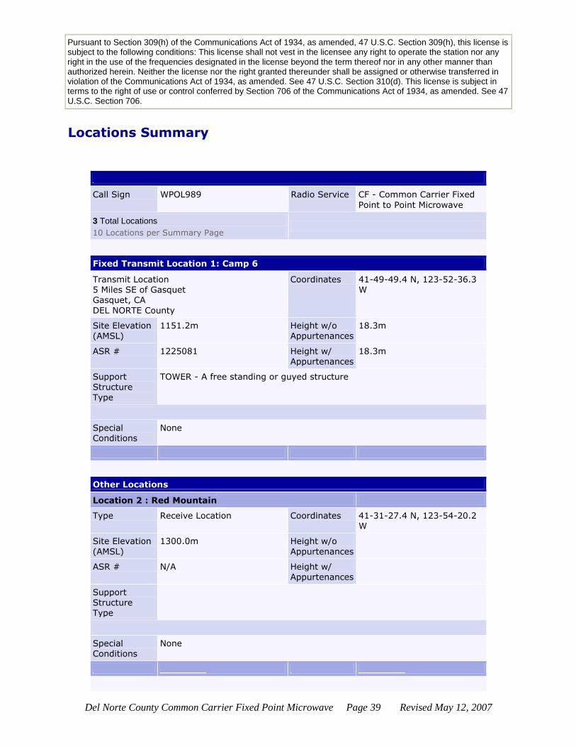
WPOL989
Federal Communications Commission Wireless Telecommunications Bureau
Radio Station Authorization (Reference Copy)
This is not an official FCC license. It is a record of public information contained in the FCC's
licensing database on the date that this reference copy was generated. In cases where FCC rules
require the presentation, posting, or display of an FCC license, this document may not be used in
place of an official FCC license. Licensee: California Rural Service Area #1, Inc.
ATTN United States Cellular Corporation California Rural Service Area #1, Inc. 8410 W. Bryn Mawr Ave., Suite #700 Chicago, IL 60631
FCC Registration Number (FRN):
0002703700
Call Sign:
WPOL989
File Number:
Radio Service:
CF - Common Carrier Fixed Point to Point Microwave
SMSA Station Class
FXO
Grant Date
01/27/2000
Effective Date
01/04/2006
Expiration Date
01/27/2010
Print Date
06/15/2006
LOCATION
Fixed Location Address or Area of Operation
5 Miles SE of Gasquet
City
Gasquet
County
DEL NORTE
State
CA
Loc. No. Location Name Latitude Longitude Elevation Antenna Structure Registration No.
1 Camp 6 41-49-49.4 N 123-52-36.3 W 1151.2m 1225081
2 Red Mountain 41-31-27.4 N 123-54-20.2 W 1300.0m
3 Crescent City DT 41-45-19.7 N 124-11-30.5 W 4.3m
FREQUENCY PATHS
Frequency
(MHz) Tol (%)
Emission Desig
EIRP (dBm)
Constr Date
Path No.
Seg Emit Loc No.
Ant Hgt (m)
Gain (dBi)
Beam (deg)
POL AZIM (deg)
Rec Loc No.
Rec Call Sign
Reflector Ht(m) x Wd(m)
006345.49000000 0.00100 30M0D7W 68.0 07/27/2001 1 1 1 10.7 41.0 1.4 V 184.1 2 WPOL988
006197.24000000 0.00100 30M0D7W 68.0 07/11/2003 2 1 1 18.3 41.0 1.4 H 252.5 3 WPOM431
Waivers/Conditions: None
Conditions
Del Norte County Common Carrier Fixed Point Microwave Page 39 Revised May 12, 2007
Pursuant to Section 309(h) of the Communications Act of 1934, as amended, 47 U.S.C. Section 309(h), this license is subject to the following conditions: This license shall not vest in the licensee any right to operate the station nor any right in the use of the frequencies designated in the license beyond the term thereof nor in any other manner than authorized herein. Neither the license nor the right granted thereunder shall be assigned or otherwise transferred in violation of the Communications Act of 1934, as amended. See 47 U.S.C. Section 310(d). This license is subject in terms to the right of use or control conferred by Section 706 of the Communications Act of 1934, as amended. See 47 U.S.C. Section 706.
Locations Summary
Call Sign WPOL989 Radio Service CF - Common Carrier Fixed
Point to Point Microwave
3 Total Locations
10 Locations per Summary Page
Fixed Transmit Location 1: Camp 6
Transmit Location 5 Miles SE of Gasquet Gasquet, CA
DEL NORTE County
Coordinates 41-49-49.4 N, 123-52-36.3 W
Site Elevation (AMSL)
1151.2m Height w/o Appurtenances
18.3m
ASR # 1225081 Height w/ Appurtenances
18.3m
Support Structure
Type
TOWER - A free standing or guyed structure
Special Conditions
None
Other Locations
Location 2 : Red Mountain
Type Receive Location Coordinates 41-31-27.4 N, 123-54-20.2 W
Site Elevation
(AMSL)
1300.0m Height w/o
Appurtenances
ASR # N/A Height w/ Appurtenances
Support Structure Type
Special Conditions
None

Del Norte County Common Carrier Fixed Point Microwave Page 40 Revised May 12, 2007
Location 3 : Crescent City DT
Type Receive Location Coordinates 41-45-19.7 N, 124-11-30.5
W
Site Elevation (AMSL)
4.3m Height w/o Appurtenances
ASR # N/A Height w/ Appurtenances
Support Structure Type
Special Conditions
None
Paths Summary
Call Sign WPOL989 Radio Service CF - Common Carrier Fixed
Point to Point Microwave
Transmitter Camp 6 Coordinates 41-49-49.4 N , 123-52-36.3 W
2 Total Paths
Path 1 - Fixed Point-to-Point
Rec. Call Sign WPOL988
Location Coordinates
Red Mountain 41-31-27.4 N , 123-54-20.2 W
Path Frequencies
006345.49000000
Path 2 - Fixed Point-to-Point
Rec. Call Sign WPOM431
Location Coordinates
Crescent City DT 41-45-19.7 N , 124-11-30.5 W
Path Frequencies
006197.24000000
Del Norte County Common Carrier Fixed Point Microwave Page 41 Revised May 12, 2007
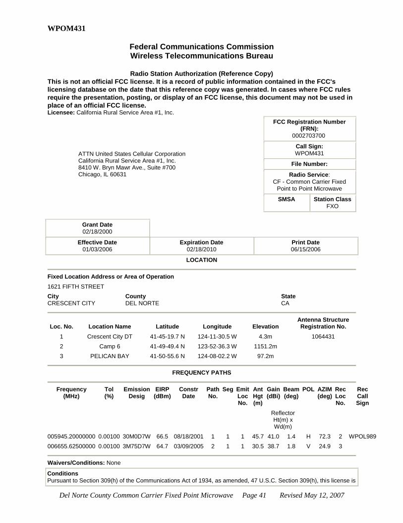
WPOM431
Federal Communications Commission Wireless Telecommunications Bureau
Radio Station Authorization (Reference Copy)
This is not an official FCC license. It is a record of public information contained in the FCC's
licensing database on the date that this reference copy was generated. In cases where FCC rules
require the presentation, posting, or display of an FCC license, this document may not be used in
place of an official FCC license. Licensee: California Rural Service Area #1, Inc.
ATTN United States Cellular Corporation California Rural Service Area #1, Inc. 8410 W. Bryn Mawr Ave., Suite #700 Chicago, IL 60631
FCC Registration Number (FRN):
0002703700
Call Sign:
WPOM431
File Number:
Radio Service:
CF - Common Carrier Fixed Point to Point Microwave
SMSA Station Class
FXO
Grant Date
02/18/2000
Effective Date
01/03/2006
Expiration Date
02/18/2010
Print Date
06/15/2006
LOCATION
Fixed Location Address or Area of Operation
1621 FIFTH STREET
City
CRESCENT CITY
County
DEL NORTE
State
CA
Loc. No. Location Name Latitude Longitude Elevation Antenna Structure Registration No.
1 Crescent City DT 41-45-19.7 N 124-11-30.5 W 4.3m 1064431
2 Camp 6 41-49-49.4 N 123-52-36.3 W 1151.2m
3 PELICAN BAY 41-50-55.6 N 124-08-02.2 W 97.2m
FREQUENCY PATHS
Frequency
(MHz) Tol (%)
Emission Desig
EIRP (dBm)
Constr Date
Path No.
Seg Emit Loc No.
Ant Hgt (m)
Gain (dBi)
Beam (deg)
POL AZIM (deg)
Rec Loc No.
Rec Call Sign
Reflector Ht(m) x Wd(m)
005945.20000000 0.00100 30M0D7W 66.5 08/18/2001 1 1 1 45.7 41.0 1.4 H 72.3 2 WPOL989
006655.62500000 0.00100 3M75D7W 64.7 03/09/2005 2 1 1 30.5 38.7 1.8 V 24.9 3
Waivers/Conditions: None
Conditions
Pursuant to Section 309(h) of the Communications Act of 1934, as amended, 47 U.S.C. Section 309(h), this license is

Del Norte County Common Carrier Fixed Point Microwave Page 42 Revised May 12, 2007
subject to the following conditions: This license shall not vest in the licensee any right to operate the station nor any right in the use of the frequencies designated in the license beyond the term thereof nor in any other manner than authorized herein. Neither the license nor the right granted thereunder shall be assigned or otherwise transferred in violation of the Communications Act of 1934, as amended. See 47 U.S.C. Section 310(d). This license is subject in terms to the right of use or control conferred by Section 706 of the Communications Act of 1934, as amended. See 47 U.S.C. Section 706.
Locations Summary
Call Sign WPOM431 Radio Service CF - Common Carrier Fixed Point to Point Microwave
3 Total Locations
10 Locations per Summary Page
Fixed Transmit Location 1: Crescent City DT
Transmit Location 1621 FIFTH STREET CRESCENT CITY, CA DEL NORTE County
Coordinates 41-45-19.7 N, 124-11-30.5 W
Site Elevation (AMSL)
4.3m Height w/o Appurtenances
45.7m
ASR # 1064431 Height w/
Appurtenances
50.3m
Support Structure Type
TOWER - A free standing or guyed structure
Special Conditions
None
Other Locations
Location 2 : Camp 6
Type Receive Location Coordinates 41-49-49.4 N, 123-52-36.3 W
Site Elevation (AMSL)
1151.2m Height w/o Appurtenances
ASR # N/A Height w/ Appurtenances
Support
Structure Type
Special Conditions
None
Location 3 : PELICAN BAY

Del Norte County Common Carrier Fixed Point Microwave Page 43 Revised May 12, 2007
Type Receive Location Coordinates 41-50-55.6 N, 124-08-02.2 W
Site Elevation (AMSL)
97.2m Height w/o Appurtenances
ASR # N/A Height w/ Appurtenances
Support Structure Type
Special Conditions
None
Paths Summary
Call Sign WPOM431 Radio Service CF - Common Carrier Fixed Point to Point Microwave
Transmitter Crescent City DT Coordinates 41-45-19.7 N , 124-11-30.5 W
2 Total Paths
Path 1 - Fixed Point-to-Point
Rec. Call Sign WPOL989
Location Coordinates
Camp 6 41-49-49.4 N , 123-52-36.3 W
Path Frequencies
005945.20000000
Path 2 - Fixed Point-to-Point
Rec. Call Sign
Location Coordinates
PELICAN BAY 41-50-55.6 N , 124-08-02.2
W
Path Frequencies
006655.62500000

Del Norte County Common Carrier Fixed Point Microwave Page 44 Revised May 12, 2007
WPYM516
Federal Communications Commission Wireless Telecommunications Bureau
Radio Station Authorization (Reference Copy)
This is not an official FCC license. It is a record of public information contained in the FCC's
licensing database on the date that this reference copy was generated. In cases where FCC rules
require the presentation, posting, or display of an FCC license, this document may not be used in
place of an official FCC license. Licensee: CALIFORNIA RURAL SERVICE AREA #1, INC.
ATTN UNITED STATES CELLULAR CORPORATION CALIFORNIA RURAL SERVICE AREA #1, INC. 8410 W. BRYN MAWR AVE., SUITE #700 CHICAGO, IL 60631
FCC Registration Number (FRN):
0002703700
Call Sign:
WPYM516
File Number:
Radio Service:
CF - Common Carrier Fixed Point to Point Microwave
SMSA Station Class
FXO
Grant Date
09/09/2003
Effective Date
09/09/2003
Expiration Date
09/09/2013
Print Date
06/15/2006
LOCATION
Fixed Location Address or Area of Operation
King's Road
City
Crescent City
County
DEL NORTE
State
CA
Loc. No. Location Name Latitude Longitude Elevation Antenna Structure Registration No.
1 PELICAN BAY 41-50-55.6 N 124-08-02.2 W 97.2m 1239750
2 CRESCENT CITY DT 41-45-19.7 N 124-11-30.5 W 4.3m
FREQUENCY PATHS
Frequency
(MHz) Tol (%)
Emission Desig
EIRP (dBm)
Constr Date
Path No.
Seg Emit Loc No.
Ant Hgt (m)
Gain (dBi)
Beam (deg)
POL AZIM (deg)
Rec Loc No.
Rec Call Sign
Reflector Ht(m) x Wd(m)
006815.62500000 0.00100 3M75D7W 64.2 03/09/2005 1 1 1 38.1 38.7 1.8 V 204.9 2 WPOM431
Waivers/Conditions: None
Conditions
Pursuant to Section 309(h) of the Communications Act of 1934, as amended, 47 U.S.C. Section 309(h), this license is subject to the following conditions: This license shall not vest in the licensee any right to operate the station nor any right in the use of the frequencies designated in the license beyond the term thereof nor in any other manner than authorized herein. Neither the license nor the right granted thereunder shall be assigned or otherwise transferred in

Del Norte County Common Carrier Fixed Point Microwave Page 45 Revised May 12, 2007
violation of the Communications Act of 1934, as amended. See 47 U.S.C. Section 310(d). This license is subject in terms to the right of use or control conferred by Section 706 of the Communications Act of 1934, as amended. See 47 U.S.C. Section 706.
Locations Summary
Call Sign WPYM516 Radio Service CF - Common Carrier Fixed Point to Point Microwave
2 Total Locations
10 Locations per Summary Page
Fixed Transmit Location 1: PELICAN BAY
Transmit Location King's Road Crescent City, CA
DEL NORTE County
Coordinates 41-50-55.6 N, 124-08-02.2 W
Site Elevation (AMSL)
97.2m Height w/o Appurtenances
54.9m
ASR # 1239750 Height w/ Appurtenances
59.4m
Support
Structure
Type
TOWER - A free standing or guyed structure
Special Conditions
None
Other Locations
Location 2 : CRESCENT CITY DT
Type Receive Location Coordinates 41-45-19.7 N, 124-11-30.5
W
Site Elevation
(AMSL)
4.3m Height w/o
Appurtenances
ASR # N/A Height w/ Appurtenances
Support Structure Type
Special Conditions
None
Paths Summary

Del Norte County Common Carrier Fixed Point Microwave Page 46 Revised May 12, 2007
Call Sign WPYM516 Radio Service CF - Common Carrier Fixed Point to Point Microwave
Transmitter PELICAN BAY Coordinates 41-50-55.6 N , 124-08-02.2 W
1 Total Path
Path 1 - Fixed Point-to-Point
Rec. Call Sign WPOM431
Location Coordinates
CRESCENT CITY DT 41-45-19.7 N , 124-11-30.5 W
Path Frequencies
006815.62500000

Del Norte County Common Carrier Fixed Point Microwave Page 47 Revised May 12, 2007
WQFA779
Federal Communications Commission Wireless Telecommunications Bureau
Radio Station Authorization (Reference Copy)
This is not an official FCC license. It is a record of public information contained in the FCC's
licensing database on the date that this reference copy was generated. In cases where FCC rules
require the presentation, posting, or display of an FCC license, this document may not be used in
place of an official FCC license. Licensee: CALIFORNIA RURAL SERVICE AREA #1, INC.
ATTN UNITED STATES CELLULAR CORPORATION CALIFORNIA RURAL SERVICE AREA #1, INC. 8410 WEST BRYN MAWR, STE 700 CHICAGO, IL 60631
FCC Registration Number (FRN):
0002703700
Call Sign:
WQFA779
File Number:
Radio Service:
CF - Common Carrier Fixed Point to Point Microwave
SMSA Station Class
FXO
Grant Date
06/02/2006
Effective Date
06/02/2006
Expiration Date
06/02/2016
Print Date
06/15/2006
LOCATION
Fixed Location Address or Area of Operation
252 King Street
City
Brookings
County
CURRY
State
OR
Loc. No. Location Name Latitude Longitude Elevation Antenna Structure Registration No.
1 BROOKINGS 42-03-00.3 N 124-17-04.4 W 35.4m 1207910
2 CRESCENT CITY 41-58-10.4 N 124-11-16.3 W 289.3m
FREQUENCY PATHS
Frequency
(MHz) Tol (%)
Emission Desig
EIRP (dBm)
Constr Date
Path No.
Seg Emit Loc No.
Ant Hgt (m)
Gain (dBi)
Beam (deg)
POL AZIM (deg)
Rec Loc No.
Rec Call Sign
Reflector Ht(m) x Wd(m)
011325.00000000 0.00100 30M0D7W 64.7 12/02/2007 1 1 1 24.4 46.2 0.8 V 138.1 2 WPJB980
Waivers/Conditions: None
Conditions
Pursuant to Section 309(h) of the Communications Act of 1934, as amended, 47 U.S.C. Section 309(h), this license is subject to the following conditions: This license shall not vest in the licensee any right to operate the station nor any right in the use of the frequencies designated in the license beyond the term thereof nor in any other manner than authorized herein. Neither the license nor the right granted thereunder shall be assigned or otherwise transferred in
Del Norte County Common Carrier Fixed Point Microwave Page 48 Revised May 12, 2007
violation of the Communications Act of 1934, as amended. See 47 U.S.C. Section 310(d). This license is subject in terms to the right of use or control conferred by Section 706 of the Communications Act of 1934, as amended. See 47 U.S.C. Section 706.
Locations Summary
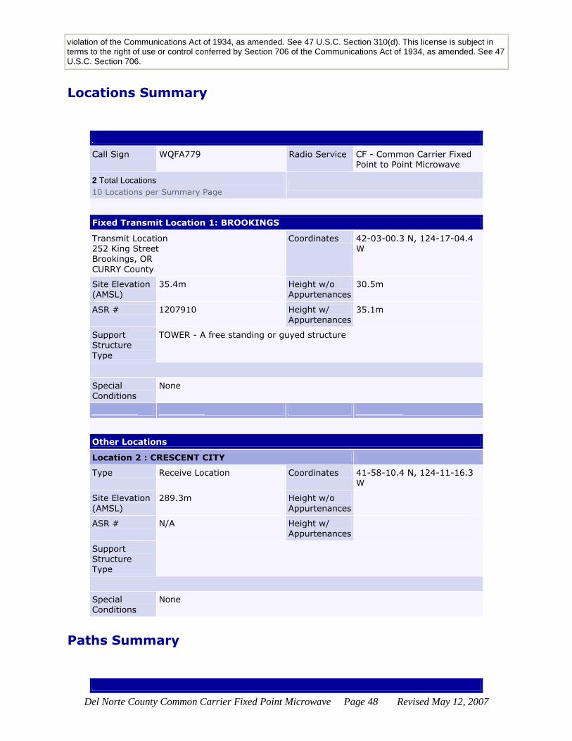
Call Sign WQFA779 Radio Service CF - Common Carrier Fixed Point to Point Microwave
2 Total Locations
10 Locations per Summary Page
Fixed Transmit Location 1: BROOKINGS
Transmit Location 252 King Street Brookings, OR
CURRY County
Coordinates 42-03-00.3 N, 124-17-04.4 W
Site Elevation (AMSL)
35.4m Height w/o Appurtenances
30.5m
ASR # 1207910 Height w/ Appurtenances
35.1m
Support
Structure
Type
TOWER - A free standing or guyed structure
Special Conditions
None
Other Locations
Location 2 : CRESCENT CITY
Type Receive Location Coordinates 41-58-10.4 N, 124-11-16.3
W
Site Elevation
(AMSL)
289.3m Height w/o
Appurtenances
ASR # N/A Height w/ Appurtenances
Support Structure Type
Special Conditions
None
Paths Summary

Del Norte County Common Carrier Fixed Point Microwave Page 49 Revised May 12, 2007
Call Sign WQFA779 Radio Service CF - Common Carrier Fixed Point to Point Microwave
Transmitter BROOKINGS Coordinates 42-03-00.3 N , 124-17-04.4 W
1 Total Path
Path 1 - Fixed Point-to-Point
Rec. Call Sign WPJB980
Location Coordinates
CRESCENT CITY 41-58-10.4 N , 124-11-16.3 W
Path Frequencies
011325.00000000

Del Norte County Common Carrier Fixed Point Microwave Page 50 Revised May 12, 2007
Verizon
KML48
Federal Communications Commission Wireless Telecommunications Bureau
Radio Station Authorization (Reference Copy)
This is not an official FCC license. It is a record of public information contained in the FCC's
licensing database on the date that this reference copy was generated. In cases where FCC rules
require the presentation, posting, or display of an FCC license, this document may not be used in
place of an official FCC license. Licensee: Verizon West Coast, Inc.
ATTN MC:HQE02N65 Verizon West Coast, Inc. PO Box 152092 IRVING, TX 75015-2092
FCC Registration Number (FRN):
0001583228
Call Sign:
KML48
File Number:
Radio Service:
CF - Common Carrier Fixed Point to Point Microwave
SMSA Station Class
FXO
Grant Date
01/03/2001
Effective Date
03/16/2005
Expiration Date
02/01/2011
Print Date
06/12/2006
LOCATION
Fixed Location Address or Area of Operation
356 H ST
City
CRESCENT CITY
County
DEL NORTE
State
CA
Loc. No. Location Name Latitude Longitude Elevation Antenna Structure Registration No.
1 CRESCENT CITY 41-45-08.4 N 124-11-54.2 W 4.6m
2 KLAMATH 41-33-31.4 N 124-05-12.2 W 243.8m
3 PRBT 42-07-35.3 N 124-13-38.3 W 632.2m
FREQUENCY PATHS
Frequency
(MHz) Tol (%)
Emission Desig
EIRP (dBm)
Constr Date
Path No.
Seg Emit Loc No.
Ant Hgt (m)
Gain (dBi)
Beam (deg)
POL AZIM (deg)
Rec Loc No.
Rec Call Sign
Reflector Ht(m) x Wd(m)
005974.85000000 0.00500 30M0F7W 72.1 1 1 1 14.0 41.3 1.5 V 156.6 2 KML49
006093.45000000 0.00500 30M0F7W 72.1 1 1 1 14.0 41.3 1.5 V 156.6 2 KML49
005982.26000000 0.02000 25M4F8W 72.1 2 1 1 16.8 41.3 1.5 H 356.7 3 KPF73
006100.86200000 0.02000 25M4F8W 72.1 2 1 1 16.8 41.3 1.5 H 356.7 3 KPF73

Del Norte County Common Carrier Fixed Point Microwave Page 51 Revised May 12, 2007
006123.10000000 0.00500 30M0D9W 77.3 3 1 1 14.0 41.3 1.5 H 156.6 2 KML49
006004.50000000 0.00500 30M0D9W 74.3 4 1 1 14.0 41.3 1.6 H 156.6 2 KML49
006545.62500000 0.00100 3M75D7W 71.0 10/24/2003 5 1 1 15.5 44.0 1.0 V 356.7 3 KPF73
006034.15000000 0.00100 30M0D7W 69.3 02/24/2006 6 1 1 10.6 41.3 1.4 V 156.5 2 KML49
Waivers/Conditions: None
Conditions
Pursuant to Section 309(h) of the Communications Act of 1934, as amended, 47 U.S.C. Section 309(h), this license is subject to the following conditions: This license shall not vest in the licensee any right to operate the station nor any right in the use of the frequencies designated in the license beyond the term thereof nor in any other manner than authorized herein. Neither the license nor the right granted thereunder shall be assigned or otherwise transferred in violation of the Communications Act of 1934, as amended. See 47 U.S.C. Section 310(d). This license is subject in terms to the right of use or control conferred by Section 706 of the Communications Act of 1934, as amended. See 47 U.S.C. Section 706.
Call Sign KML48 Radio Service CF - Common Carrier Fixed Point to Point Microwave
3 Total Locations
10 Locations per Summary Page
Fixed Transmit Location 1: CRESCENT CITY
Transmit Location 356 H ST CRESCENT CITY, CA
DEL NORTE County
Coordinates 41-45-08.4 N, 124-11-54.2 W
Site Elevation
(AMSL)
4.6m Height w/o
Appurtenances
ASR # N/A Height w/ Appurtenances
24.1m
Support Structure Type
Special Conditions
None
Other Locations
Location 2 : KLAMATH
Type Receive Location Coordinates 41-33-31.4 N, 124-05-12.2 W
Site Elevation (AMSL)
243.8m Height w/o Appurtenances
ASR # N/A Height w/
Appurtenances
Support Structure Type
Special
Conditions
None
Del Norte County Common Carrier Fixed Point Microwave Page 52 Revised May 12, 2007
Location 3 : PRBT
Type Receive Location Coordinates 42-07-35.3 N, 124-13-38.3 W
Site Elevation (AMSL)
632.2m Height w/o Appurtenances
ASR # N/A Height w/ Appurtenances
Support Structure Type
Special Conditions
None
3 Total Locations
10 Locations per Summary Page
Paths Summary
Call Sign KML48 Radio Service CF - Common Carrier Fixed Point to Point Microwave
Transmitter CRESCENT CITY Coordinates 41-45-08.4 N , 124-11-54.2 W
6 Total Paths
Path 1 - Fixed Point-to-Point
Rec. Call Sign KML49
Location Coordinates
KLAMATH 41-33-31.4 N , 124-05-12.2 W
Path Frequencies
005974.85000000 006093.45000000
Path 2 - Fixed Point-to-Point
Rec. Call Sign KPF73
Location Coordinates
PRBT 42-07-35.3 N , 124-13-38.3 W

Del Norte County Common Carrier Fixed Point Microwave Page 53 Revised May 12, 2007
Path Frequencies
005982.26000000 006100.86200000
Path 3 - Fixed Point-to-Point
Rec. Call Sign KML49
Location Coordinates
KLAMATH 41-33-31.4 N , 124-05-12.2 W
Path Frequencies
006123.10000000
Path 4 - Fixed Point-to-Point
Rec. Call Sign KML49
Location Coordinates
KLAMATH 41-33-31.4 N , 124-05-12.2 W
Path Frequencies
006004.50000000
Path 5 - Fixed Point-to-Point
Rec. Call Sign KPF73
Location Coordinates
PRBT 42-07-35.3 N , 124-13-38.3 W
Path Frequencies
006545.62500000
Path 6 - Fixed Point-to-Point
Rec. Call Sign KML49
Location Coordinates
KLAMATH 41-33-31.4 N , 124-05-12.2 W
Path Frequencies
Del Norte County Common Carrier Fixed Point Microwave Page 54 Revised May 12, 2007
006034.15000000
6 Total Paths

Del Norte County Common Carrier Fixed Point Microwave Page 55 Revised May 12, 2007
KML49
Federal Communications Commission Wireless Telecommunications Bureau
Radio Station Authorization (Reference Copy)
This is not an official FCC license. It is a record of public information contained in the FCC's
licensing database on the date that this reference copy was generated. In cases where FCC rules
require the presentation, posting, or display of an FCC license, this document may not be used in
place of an official FCC license. Licensee: Verizon West Coast, Inc.
ATTN MC:HQE02N65 Verizon West Coast, Inc. PO Box 152092 IRVING, TX 75015-2092
FCC Registration Number (FRN):
0001583228
Call Sign:
KML49
File Number:
Radio Service:
CF - Common Carrier Fixed Point to Point Microwave
SMSA Station Class
FXO
Grant Date
01/03/2001
Effective Date
03/16/2005
Expiration Date
02/01/2011
Print Date
06/12/2006
LOCATION
Fixed Location Address or Area of Operation
USAF SITE Z33
City
KLAMATH
County
DEL NORTE
State
CA
Loc. No. Location Name Latitude Longitude Elevation Antenna Structure Registration No.
1 KLAMATH 41-33-31.4 N 124-05-12.2 W 243.8m
2 ORICK 41-16-49.4 N 124-05-04.2 W 198.1m
3 CRESCENT CITY 41-45-08.4 N 124-11-54.2 W 4.6m
FREQUENCY PATHS
Frequency
(MHz) Tol (%)
Emission Desig
EIRP (dBm)
Constr Date
Path No.
Seg Emit Loc No.
Ant Hgt (m)
Gain (dBi)
Beam (deg)
POL AZIM (deg)
Rec Loc No.
Rec Call Sign
Reflector Ht(m) x Wd(m)
006226.89000000 0.00500 30M0D9W 77.3 1 1 1 13.4 41.3 1.5 H 179.7 2 KML50
006286.19000000 0.00500 30M0D9W 77.3 2 1 1 13.4 41.3 1.5 H 336.7 3 KML48
006256.54000000 0.00500 30M0F7W 72.1 3 1 1 13.4 41.3 1.5 V 179.7 2 KML50
006375.14000000 0.00500 30M0F7W 72.1 3 1 1 13.4 41.3 1.5 V 179.7 2 KML50
006345.49000000 0.00500 30M0F7W 72.1 4 1 1 13.4 41.3 1.5 V 336.7 3 KML48
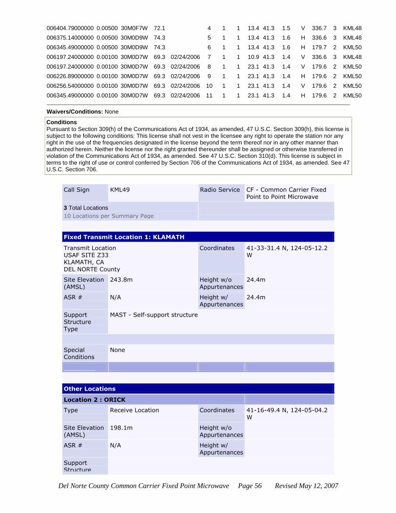
Del Norte County Common Carrier Fixed Point Microwave Page 56 Revised May 12, 2007
006404.79000000 0.00500 30M0F7W 72.1 4 1 1 13.4 41.3 1.5 V 336.7 3 KML48
006375.14000000 0.00500 30M0D9W 74.3 5 1 1 13.4 41.3 1.6 H 336.6 3 KML48
006345.49000000 0.00500 30M0D9W 74.3 6 1 1 13.4 41.3 1.6 H 179.7 2 KML50
006197.24000000 0.00100 30M0D7W 69.3 02/24/2006 7 1 1 10.9 41.3 1.4 V 336.6 3 KML48
006197.24000000 0.00100 30M0D7W 69.3 02/24/2006 8 1 1 23.1 41.3 1.4 V 179.6 2 KML50
006226.89000000 0.00100 30M0D7W 69.3 02/24/2006 9 1 1 23.1 41.3 1.4 H 179.6 2 KML50
006256.54000000 0.00100 30M0D7W 69.3 02/24/2006 10 1 1 23.1 41.3 1.4 V 179.6 2 KML50
006345.49000000 0.00100 30M0D7W 69.3 02/24/2006 11 1 1 23.1 41.3 1.4 H 179.6 2 KML50
Waivers/Conditions: None
Conditions
Pursuant to Section 309(h) of the Communications Act of 1934, as amended, 47 U.S.C. Section 309(h), this license is subject to the following conditions: This license shall not vest in the licensee any right to operate the station nor any right in the use of the frequencies designated in the license beyond the term thereof nor in any other manner than authorized herein. Neither the license nor the right granted thereunder shall be assigned or otherwise transferred in violation of the Communications Act of 1934, as amended. See 47 U.S.C. Section 310(d). This license is subject in terms to the right of use or control conferred by Section 706 of the Communications Act of 1934, as amended. See 47 U.S.C. Section 706.
Call Sign KML49 Radio Service CF - Common Carrier Fixed Point to Point Microwave
3 Total Locations
10 Locations per Summary Page
Fixed Transmit Location 1: KLAMATH
Transmit Location USAF SITE Z33 KLAMATH, CA DEL NORTE County
Coordinates 41-33-31.4 N, 124-05-12.2 W
Site Elevation
(AMSL)
243.8m Height w/o
Appurtenances
24.4m
ASR # N/A Height w/ Appurtenances
24.4m
Support Structure
Type
MAST - Self-support structure
Special Conditions
None
Other Locations
Location 2 : ORICK
Type Receive Location Coordinates 41-16-49.4 N, 124-05-04.2 W
Site Elevation (AMSL)
198.1m Height w/o Appurtenances
ASR # N/A Height w/ Appurtenances
Support Structure
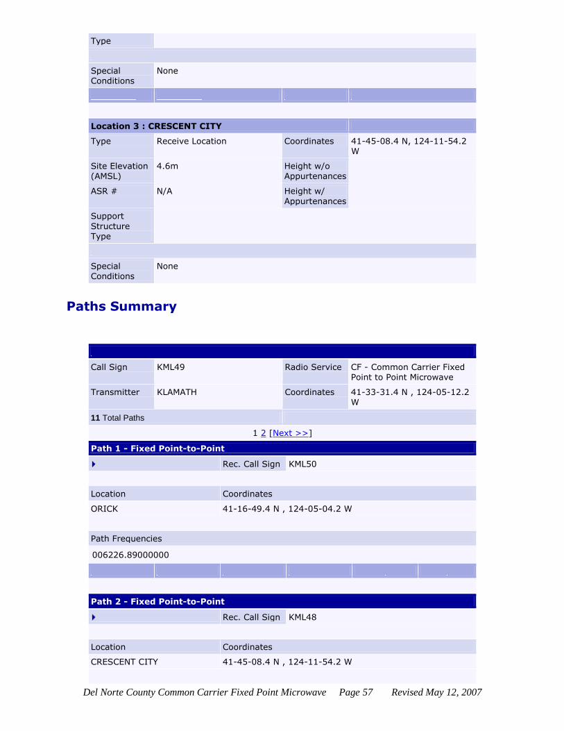
Del Norte County Common Carrier Fixed Point Microwave Page 57 Revised May 12, 2007
Type
Special Conditions
None
Location 3 : CRESCENT CITY
Type Receive Location Coordinates 41-45-08.4 N, 124-11-54.2 W
Site Elevation (AMSL)
4.6m Height w/o Appurtenances
ASR # N/A Height w/
Appurtenances
Support
Structure Type
Special Conditions
None
Paths Summary
Call Sign KML49 Radio Service CF - Common Carrier Fixed Point to Point Microwave
Transmitter KLAMATH Coordinates 41-33-31.4 N , 124-05-12.2 W
11 Total Paths
1 2 [Next >>]
Path 1 - Fixed Point-to-Point
Rec. Call Sign KML50
Location Coordinates
ORICK 41-16-49.4 N , 124-05-04.2 W
Path Frequencies
006226.89000000
Path 2 - Fixed Point-to-Point
Rec. Call Sign KML48
Location Coordinates
CRESCENT CITY 41-45-08.4 N , 124-11-54.2 W
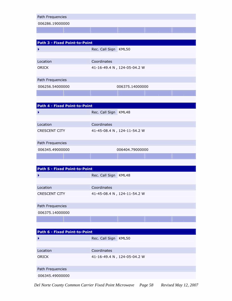
Del Norte County Common Carrier Fixed Point Microwave Page 58 Revised May 12, 2007
Path Frequencies
006286.19000000
Path 3 - Fixed Point-to-Point
Rec. Call Sign KML50
Location Coordinates
ORICK 41-16-49.4 N , 124-05-04.2 W
Path Frequencies
006256.54000000 006375.14000000
Path 4 - Fixed Point-to-Point
Rec. Call Sign KML48
Location Coordinates
CRESCENT CITY 41-45-08.4 N , 124-11-54.2 W
Path Frequencies
006345.49000000 006404.79000000
Path 5 - Fixed Point-to-Point
Rec. Call Sign KML48
Location Coordinates
CRESCENT CITY 41-45-08.4 N , 124-11-54.2 W
Path Frequencies
006375.14000000
Path 6 - Fixed Point-to-Point
Rec. Call Sign KML50
Location Coordinates
ORICK 41-16-49.4 N , 124-05-04.2 W
Path Frequencies
006345.49000000
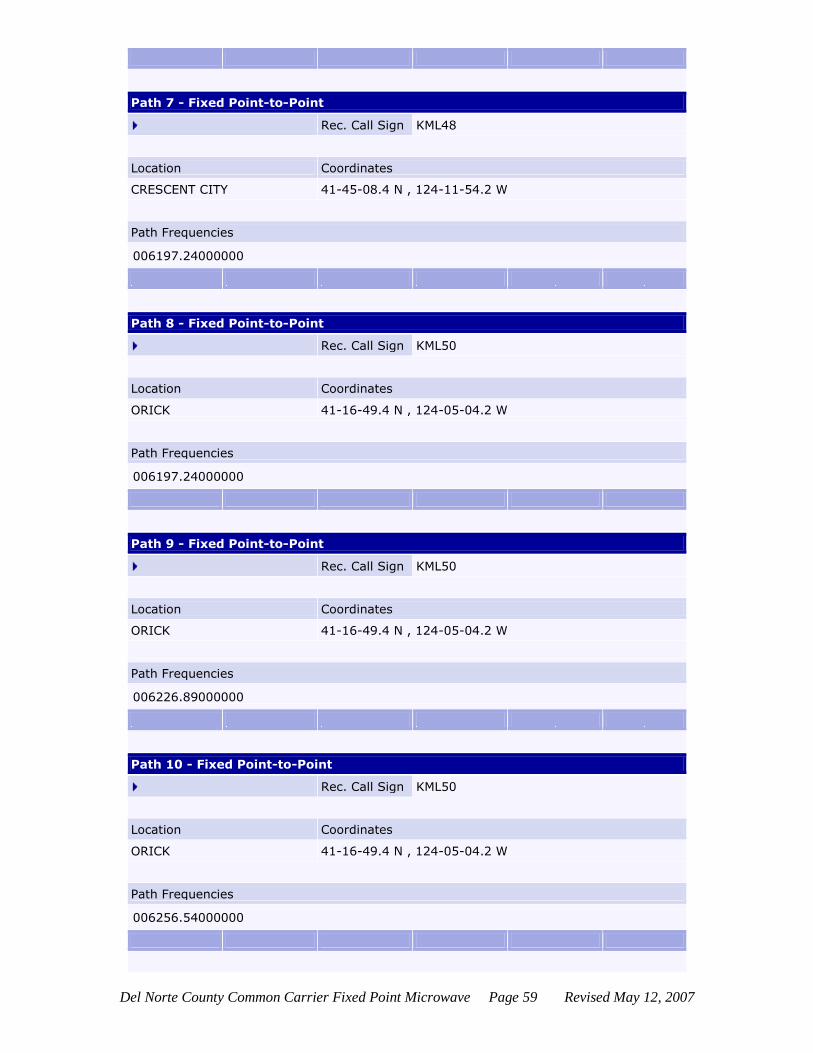
Del Norte County Common Carrier Fixed Point Microwave Page 59 Revised May 12, 2007
Path 7 - Fixed Point-to-Point
Rec. Call Sign KML48
Location Coordinates
CRESCENT CITY 41-45-08.4 N , 124-11-54.2 W
Path Frequencies
006197.24000000
Path 8 - Fixed Point-to-Point
Rec. Call Sign KML50
Location Coordinates
ORICK 41-16-49.4 N , 124-05-04.2 W
Path Frequencies
006197.24000000
Path 9 - Fixed Point-to-Point
Rec. Call Sign KML50
Location Coordinates
ORICK 41-16-49.4 N , 124-05-04.2 W
Path Frequencies
006226.89000000
Path 10 - Fixed Point-to-Point
Rec. Call Sign KML50
Location Coordinates
ORICK 41-16-49.4 N , 124-05-04.2 W
Path Frequencies
006256.54000000
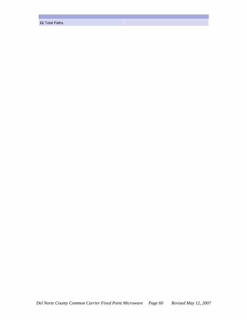
Del Norte County Common Carrier Fixed Point Microwave Page 60 Revised May 12, 2007
11 Total Paths

Del Norte County Common Carrier Fixed Point Microwave Page 61 Revised May 12, 2007
KML50
Federal Communications Commission Wireless Telecommunications Bureau
Radio Station Authorization (Reference Copy)
This is not an official FCC license. It is a record of public information contained in the FCC's
licensing database on the date that this reference copy was generated. In cases where FCC rules
require the presentation, posting, or display of an FCC license, this document may not be used in
place of an official FCC license. Licensee: Verizon West Coast, Inc.
ATTN MC:HQE02N65 Verizon West Coast, Inc. PO Box 152092 IRVING, TX 75015-2092
FCC Registration Number (FRN):
0001583228
Call Sign:
KML50
File Number:
Radio Service:
CF - Common Carrier Fixed Point to Point Microwave
SMSA Station Class
FXO
Grant Date
01/03/2001
Effective Date
03/16/2005
Expiration Date
02/01/2011
Print Date
06/12/2006
LOCATION
Fixed Location Address or Area of Operation
HILTONS RANCH
City
ORICK
County
HUMBOLDT
State
CA
Loc. No. Location Name Latitude Longitude Elevation Antenna Structure Registration No.
1 ORICK 41-16-49.4 N 124-05-04.2 W 198.1m
2 WALKERS HIL 41-05-57.4 N 124-07-36.2 W 368.8m
3 KLAMATH 41-33-31.4 N 124-05-12.2 W 243.8m
FREQUENCY PATHS
Frequency
(MHz) Tol (%)
Emission Desig
EIRP (dBm)
Constr Date
Path No.
Seg Emit Loc No.
Ant Hgt (m)
Gain (dBi)
Beam (deg)
POL AZIM (deg)
Rec Loc No.
Rec Call Sign
Reflector Ht(m) x Wd(m)
005945.20000000 0.00500 30M0F7W 72.1 1 1 1 11.3 41.3 1.5 V 190.0 2 WLC855
006063.80000000 0.00500 30M0F7W 72.1 1 1 1 11.3 41.3 1.5 V 190.0 2 WLC855
005945.20000000 0.00500 30M0D9W 79.2 2 1 1 11.3 43.2 1.2 H 359.7 3 KML49
006004.50000000 0.00500 30M0D9W 77.3 3 1 1 11.3 41.3 1.5 H 190.0 2 WLC855
006004.50000000 0.00500 30M0F7W 74.0 4 1 1 11.3 43.2 1.2 V 359.7 3 KML49

Del Norte County Common Carrier Fixed Point Microwave Page 62 Revised May 12, 2007
006123.10000000 0.00500 30M0F7W 74.0 4 1 1 11.3 43.2 1.2 V 359.7 3 KML49
006034.15000000 0.00500 30M0D9W 76.2 5 1 1 11.3 43.2 1.4 H 359.7 3 KML49
005945.20000000 0.00100 30M0D7W 69.3 02/24/2006 6 1 1 17.0 41.3 1.4 H 359.6 3 KML49
006004.50000000 0.00100 30M0D7W 69.3 02/24/2006 7 1 1 17.0 41.3 1.4 V 359.6 3 KML49
006034.15000000 0.00100 30M0D7W 69.3 02/24/2006 8 1 1 17.0 41.3 1.4 H 359.6 3 KML49
006157.75000000 0.00100 30M0D7W 69.3 02/24/2006 9 1 1 17.0 41.3 1.4 H 359.6 3 KML49
006093.45000000 0.00100 30M0D7W 69.3 02/24/2006 10 1 1 7.9 41.3 1.4 H 190.0 2 WLC855
Waivers/Conditions: None
Conditions
Pursuant to Section 309(h) of the Communications Act of 1934, as amended, 47 U.S.C. Section 309(h), this license is subject to the following conditions: This license shall not vest in the licensee any right to operate the station nor any right in the use of the frequencies designated in the license beyond the term thereof nor in any other manner than authorized herein. Neither the license nor the right granted thereunder shall be assigned or otherwise transferred in violation of the Communications Act of 1934, as amended. See 47 U.S.C. Section 310(d). This license is subject in terms to the right of use or control conferred by Section 706 of the Communications Act of 1934, as amended. See 47 U.S.C. Section 706.
Call Sign KML50 Radio Service CF - Common Carrier Fixed Point to Point Microwave
3 Total Locations
10 Locations per Summary Page
Fixed Transmit Location 1: ORICK
Transmit Location HILTONS RANCH ORICK, CA HUMBOLDT County
Coordinates 41-16-49.4 N, 124-05-04.2 W
Site Elevation (AMSL)
198.1m Height w/o Appurtenances
18.3m
ASR # N/A Height w/
Appurtenances
18.3m
Support Structure Type
MAST - Self-support structure
Special Conditions
None
Other Locations
Location 2 : WALKERS HIL
Type Receive Location Coordinates 41-05-57.4 N, 124-07-36.2 W
Site Elevation
(AMSL)
368.8m Height w/o
Appurtenances
ASR # N/A Height w/ Appurtenances
Support
Structure Type

Del Norte County Common Carrier Fixed Point Microwave Page 63 Revised May 12, 2007
Special
Conditions
None
Location 3 : KLAMATH
Type Receive Location Coordinates 41-33-31.4 N, 124-05-12.2 W
Site Elevation (AMSL)
243.8m Height w/o Appurtenances
ASR # N/A Height w/ Appurtenances
Support Structure Type
Special Conditions
None
3 Total Locations
10 Locations per Summary Page
Paths Summary
Call Sign KML50 Radio Service CF - Common Carrier Fixed Point to Point Microwave
Transmitter ORICK Coordinates 41-16-49.4 N , 124-05-04.2 W
10 Total Paths
Path 1 - Fixed Point-to-Point
Rec. Call Sign WLC855
Location Coordinates
WALKERS HIL 41-05-57.4 N , 124-07-36.2 W
Path Frequencies
005945.20000000 006063.80000000
Path 2 - Fixed Point-to-Point
Rec. Call Sign KML49
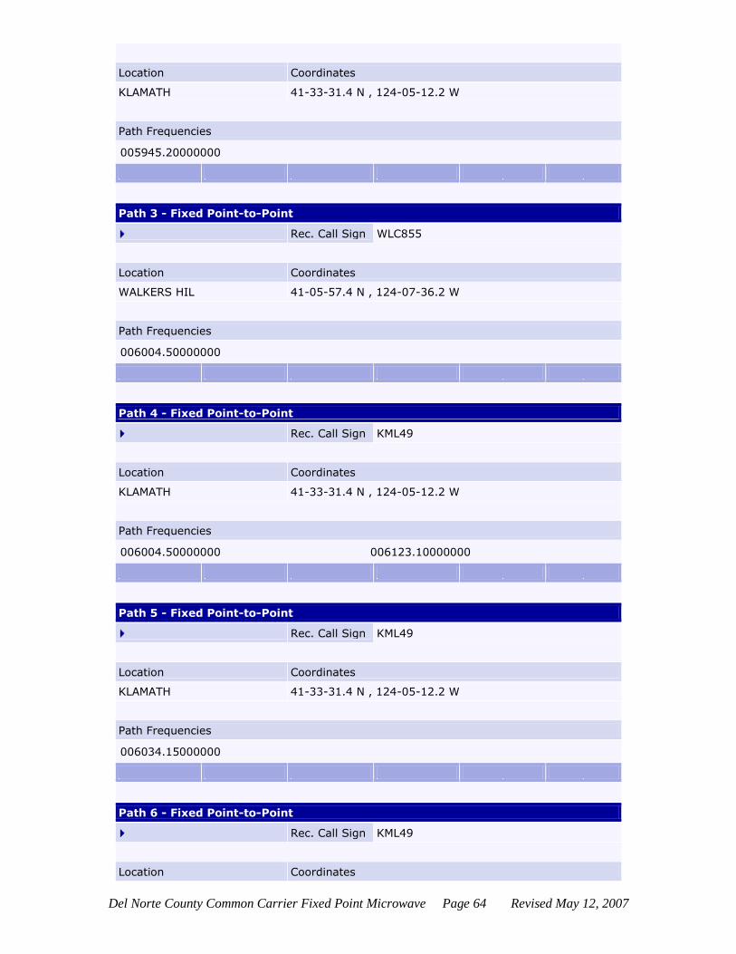
Del Norte County Common Carrier Fixed Point Microwave Page 64 Revised May 12, 2007
Location Coordinates
KLAMATH 41-33-31.4 N , 124-05-12.2 W
Path Frequencies
005945.20000000
Path 3 - Fixed Point-to-Point
Rec. Call Sign WLC855
Location Coordinates
WALKERS HIL 41-05-57.4 N , 124-07-36.2 W
Path Frequencies
006004.50000000
Path 4 - Fixed Point-to-Point
Rec. Call Sign KML49
Location Coordinates
KLAMATH 41-33-31.4 N , 124-05-12.2 W
Path Frequencies
006004.50000000 006123.10000000
Path 5 - Fixed Point-to-Point
Rec. Call Sign KML49
Location Coordinates
KLAMATH 41-33-31.4 N , 124-05-12.2 W
Path Frequencies
006034.15000000
Path 6 - Fixed Point-to-Point
Rec. Call Sign KML49
Location Coordinates

Del Norte County Common Carrier Fixed Point Microwave Page 65 Revised May 12, 2007
KLAMATH 41-33-31.4 N , 124-05-12.2 W
Path Frequencies
005945.20000000
Path 7 - Fixed Point-to-Point
Rec. Call Sign KML49
Location Coordinates
KLAMATH 41-33-31.4 N , 124-05-12.2 W
Path Frequencies
006004.50000000
Path 8 - Fixed Point-to-Point
Rec. Call Sign KML49
Location Coordinates
KLAMATH 41-33-31.4 N , 124-05-12.2 W
Path Frequencies
006034.15000000
Path 9 - Fixed Point-to-Point
Rec. Call Sign KML49
Location Coordinates
KLAMATH 41-33-31.4 N , 124-05-12.2 W
Path Frequencies
006157.75000000
Path 10 - Fixed Point-to-Point
Rec. Call Sign WLC855
Location Coordinates
WALKERS HIL 41-05-57.4 N , 124-07-36.2 W
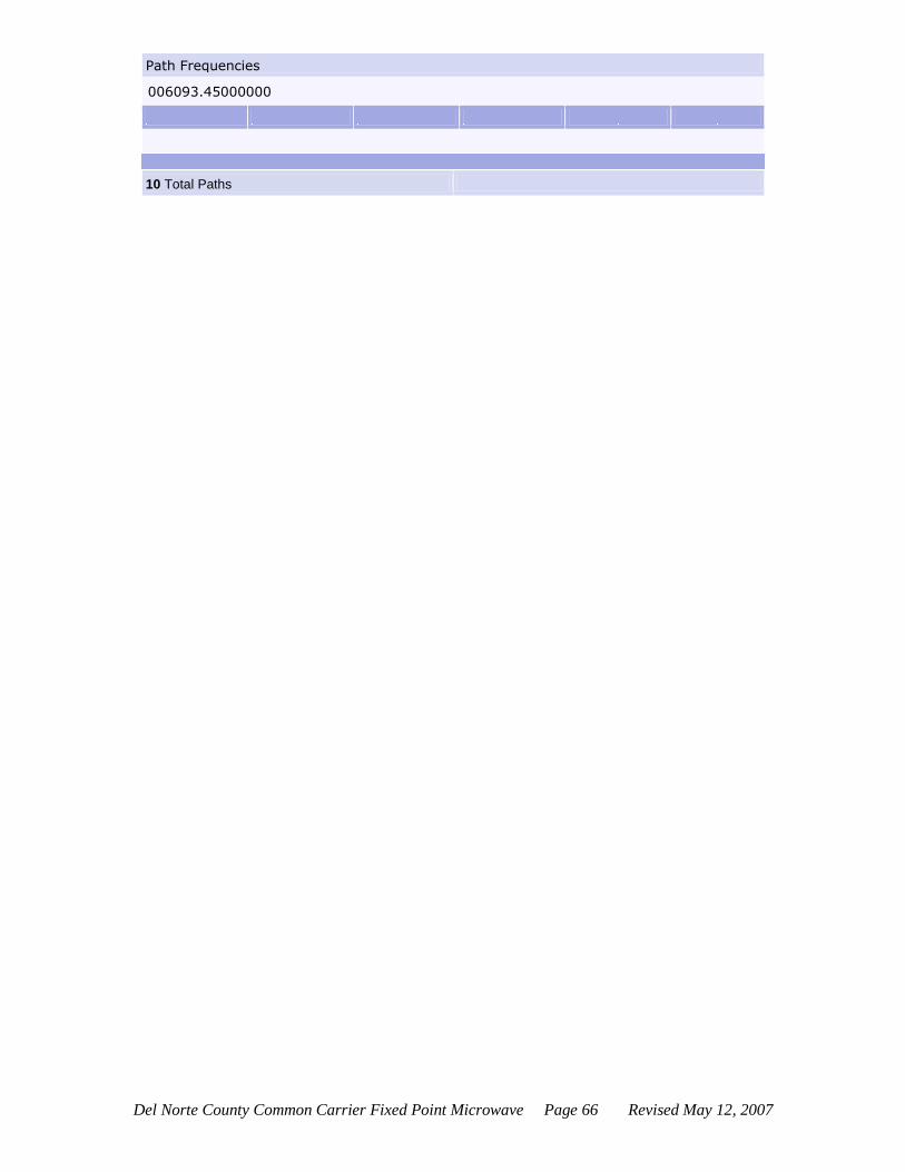
Del Norte County Common Carrier Fixed Point Microwave Page 66 Revised May 12, 2007
Path Frequencies
006093.45000000
10 Total Paths
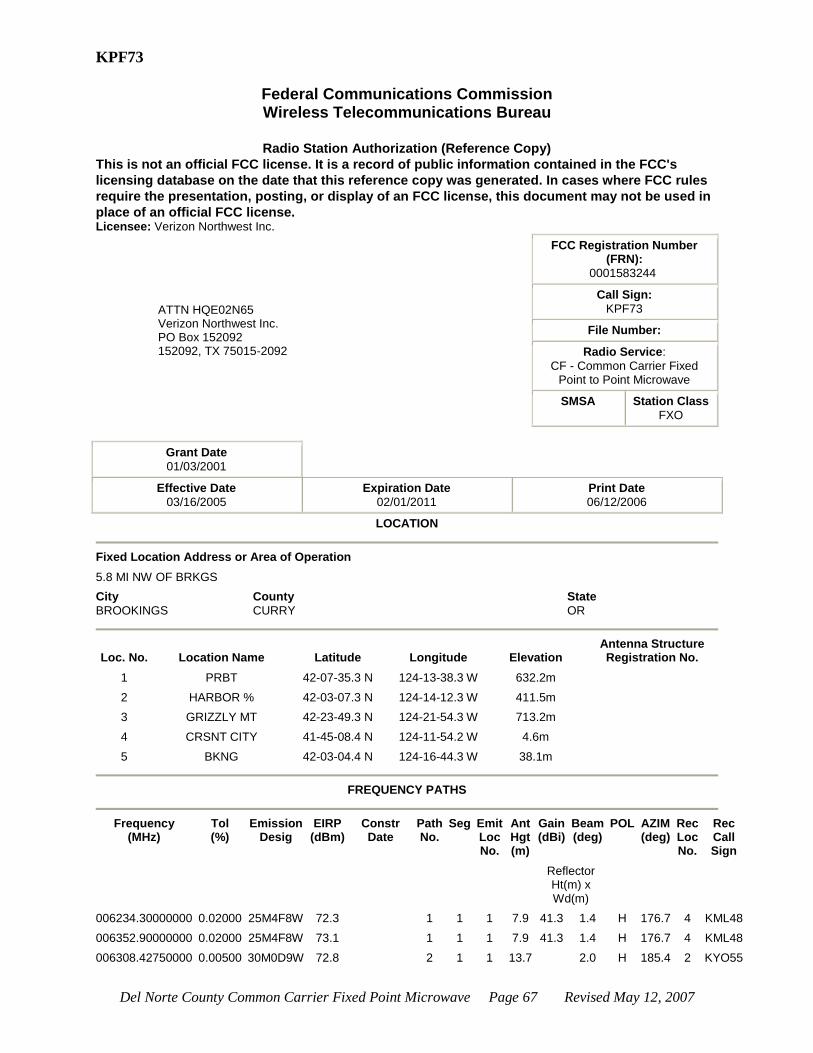
Del Norte County Common Carrier Fixed Point Microwave Page 67 Revised May 12, 2007
KPF73
Federal Communications Commission Wireless Telecommunications Bureau
Radio Station Authorization (Reference Copy)
This is not an official FCC license. It is a record of public information contained in the FCC's
licensing database on the date that this reference copy was generated. In cases where FCC rules
require the presentation, posting, or display of an FCC license, this document may not be used in
place of an official FCC license. Licensee: Verizon Northwest Inc.
ATTN HQE02N65 Verizon Northwest Inc. PO Box 152092 152092, TX 75015-2092
FCC Registration Number (FRN):
0001583244
Call Sign:
KPF73
File Number:
Radio Service:
CF - Common Carrier Fixed Point to Point Microwave
SMSA Station Class
FXO
Grant Date
01/03/2001
Effective Date
03/16/2005
Expiration Date
02/01/2011
Print Date
06/12/2006
LOCATION
Fixed Location Address or Area of Operation
5.8 MI NW OF BRKGS
City
BROOKINGS
County
CURRY
State
OR
Loc. No. Location Name Latitude Longitude Elevation Antenna Structure Registration No.
1 PRBT 42-07-35.3 N 124-13-38.3 W 632.2m
2 HARBOR % 42-03-07.3 N 124-14-12.3 W 411.5m
3 GRIZZLY MT 42-23-49.3 N 124-21-54.3 W 713.2m
4 CRSNT CITY 41-45-08.4 N 124-11-54.2 W 4.6m
5 BKNG 42-03-04.4 N 124-16-44.3 W 38.1m
FREQUENCY PATHS
Frequency
(MHz) Tol (%)
Emission Desig
EIRP (dBm)
Constr Date
Path No.
Seg Emit Loc No.
Ant Hgt (m)
Gain (dBi)
Beam (deg)
POL AZIM (deg)
Rec Loc No.
Rec Call Sign
Reflector Ht(m) x Wd(m)
006234.30000000 0.02000 25M4F8W 72.3 1 1 1 7.9 41.3 1.4 H 176.7 4 KML48
006352.90000000 0.02000 25M4F8W 73.1 1 1 1 7.9 41.3 1.4 H 176.7 4 KML48
006308.42750000 0.00500 30M0D9W 72.8 2 1 1 13.7 2.0 H 185.4 2 KYO55
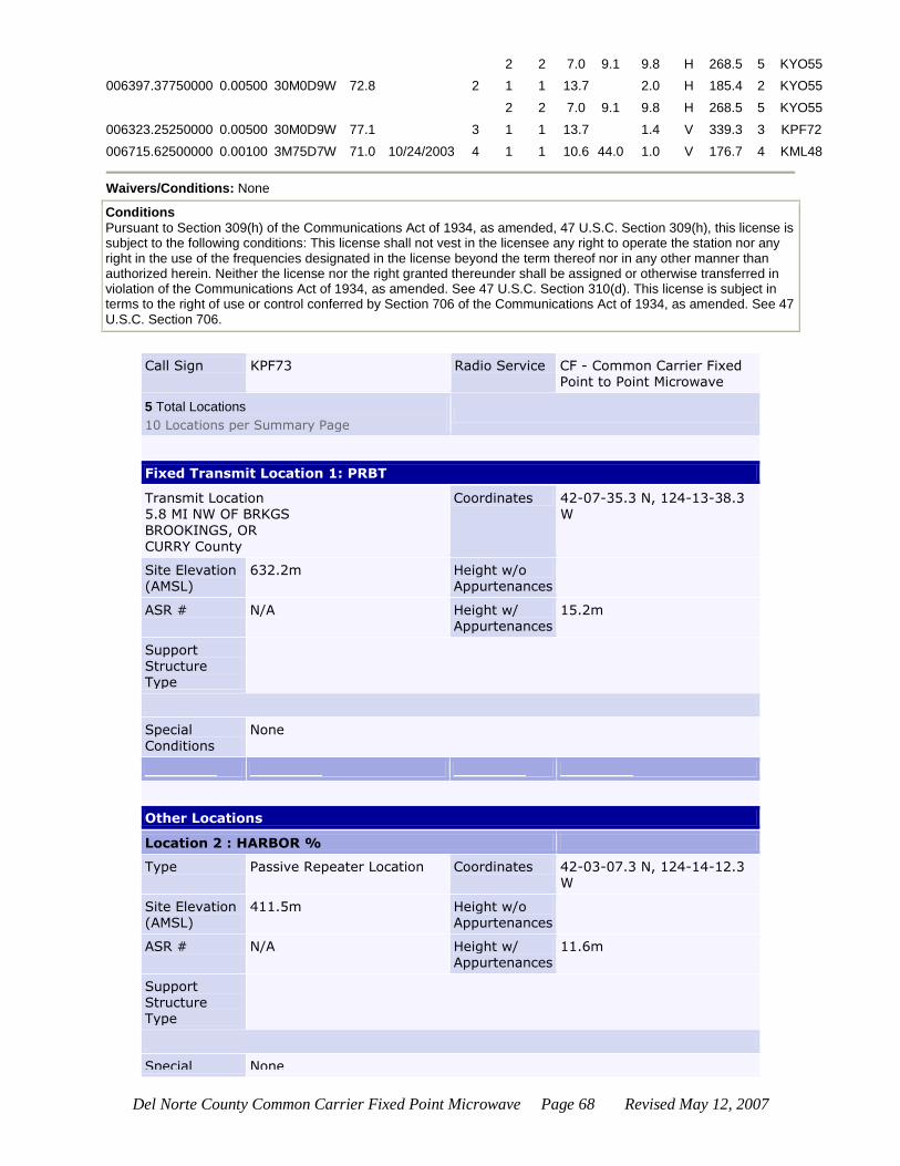
Del Norte County Common Carrier Fixed Point Microwave Page 68 Revised May 12, 2007
2 2 7.0 9.1 9.8 H 268.5 5 KYO55
006397.37750000 0.00500 30M0D9W 72.8 2 1 1 13.7 2.0 H 185.4 2 KYO55
2 2 7.0 9.1 9.8 H 268.5 5 KYO55
006323.25250000 0.00500 30M0D9W 77.1 3 1 1 13.7 1.4 V 339.3 3 KPF72
006715.62500000 0.00100 3M75D7W 71.0 10/24/2003 4 1 1 10.6 44.0 1.0 V 176.7 4 KML48
Waivers/Conditions: None
Conditions
Pursuant to Section 309(h) of the Communications Act of 1934, as amended, 47 U.S.C. Section 309(h), this license is subject to the following conditions: This license shall not vest in the licensee any right to operate the station nor any right in the use of the frequencies designated in the license beyond the term thereof nor in any other manner than authorized herein. Neither the license nor the right granted thereunder shall be assigned or otherwise transferred in violation of the Communications Act of 1934, as amended. See 47 U.S.C. Section 310(d). This license is subject in terms to the right of use or control conferred by Section 706 of the Communications Act of 1934, as amended. See 47 U.S.C. Section 706.
Call Sign KPF73 Radio Service CF - Common Carrier Fixed Point to Point Microwave
5 Total Locations
10 Locations per Summary Page
Fixed Transmit Location 1: PRBT
Transmit Location 5.8 MI NW OF BRKGS
BROOKINGS, OR
CURRY County
Coordinates 42-07-35.3 N, 124-13-38.3 W
Site Elevation (AMSL)
632.2m Height w/o Appurtenances
ASR # N/A Height w/ Appurtenances
15.2m
Support Structure Type
Special
Conditions
None
Other Locations
Location 2 : HARBOR %
Type Passive Repeater Location Coordinates 42-03-07.3 N, 124-14-12.3 W
Site Elevation (AMSL)
411.5m Height w/o Appurtenances
ASR # N/A Height w/
Appurtenances
11.6m
Support Structure Type
Special None

Del Norte County Common Carrier Fixed Point Microwave Page 69 Revised May 12, 2007
Conditions
Location 3 : GRIZZLY MT
Type Receive Location Coordinates 42-23-49.3 N, 124-21-54.3
W
Site Elevation (AMSL)
713.2m Height w/o Appurtenances
ASR # N/A Height w/ Appurtenances
Support Structure
Type
Special Conditions
None
Location 4 : CRSNT CITY
Type Receive Location Coordinates 41-45-08.4 N, 124-11-54.2 W
Site Elevation (AMSL)
4.6m Height w/o Appurtenances
ASR # N/A Height w/ Appurtenances
Support
Structure Type
Special Conditions
None
Location 5 : BKNG
Type Receive Location Coordinates 42-03-04.4 N, 124-16-44.3 W
Site Elevation (AMSL)
38.1m Height w/o Appurtenances
ASR # N/A Height w/ Appurtenances
Support Structure Type
Special Conditions
None
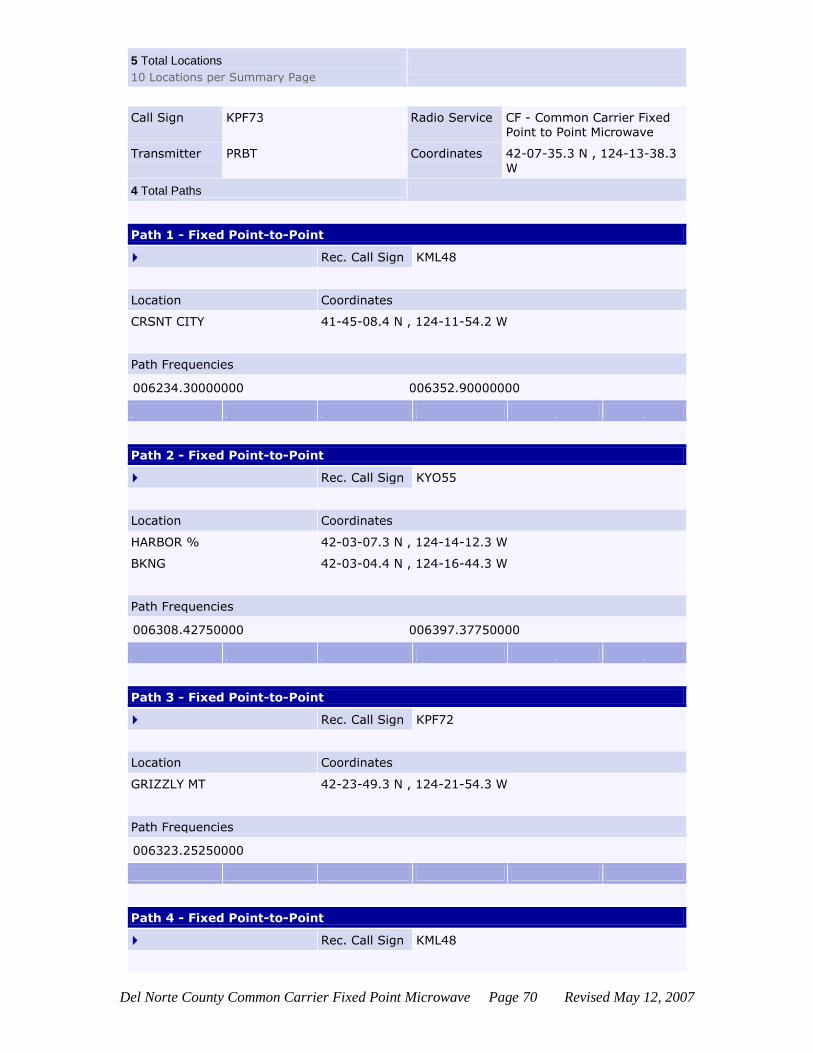
Del Norte County Common Carrier Fixed Point Microwave Page 70 Revised May 12, 2007
5 Total Locations
10 Locations per Summary Page
Call Sign KPF73 Radio Service CF - Common Carrier Fixed Point to Point Microwave
Transmitter PRBT Coordinates 42-07-35.3 N , 124-13-38.3
W
4 Total Paths
Path 1 - Fixed Point-to-Point
Rec. Call Sign KML48
Location Coordinates
CRSNT CITY 41-45-08.4 N , 124-11-54.2 W
Path Frequencies
006234.30000000 006352.90000000
Path 2 - Fixed Point-to-Point
Rec. Call Sign KYO55
Location Coordinates
HARBOR % 42-03-07.3 N , 124-14-12.3 W
BKNG 42-03-04.4 N , 124-16-44.3 W
Path Frequencies
006308.42750000 006397.37750000
Path 3 - Fixed Point-to-Point
Rec. Call Sign KPF72
Location Coordinates
GRIZZLY MT 42-23-49.3 N , 124-21-54.3 W
Path Frequencies
006323.25250000
Path 4 - Fixed Point-to-Point
Rec. Call Sign KML48

Del Norte County Common Carrier Fixed Point Microwave Page 71 Revised May 12, 2007
Location Coordinates
CRSNT CITY 41-45-08.4 N , 124-11-54.2 W
Path Frequencies
006715.62500000
4 Total Paths
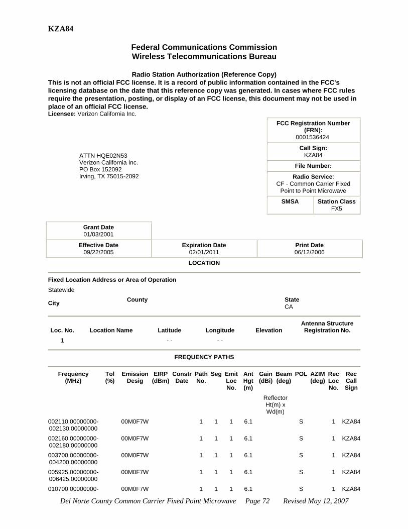
Del Norte County Common Carrier Fixed Point Microwave Page 72 Revised May 12, 2007
KZA84
Federal Communications Commission Wireless Telecommunications Bureau
Radio Station Authorization (Reference Copy)
This is not an official FCC license. It is a record of public information contained in the FCC's
licensing database on the date that this reference copy was generated. In cases where FCC rules
require the presentation, posting, or display of an FCC license, this document may not be used in
place of an official FCC license. Licensee: Verizon California Inc.
ATTN HQE02N53 Verizon California Inc. PO Box 152092 Irving, TX 75015-2092
FCC Registration Number (FRN):
0001536424
Call Sign:
KZA84
File Number:
Radio Service:
CF - Common Carrier Fixed Point to Point Microwave
SMSA Station Class
FX5
Grant Date
01/03/2001
Effective Date
09/22/2005
Expiration Date
02/01/2011
Print Date
06/12/2006
LOCATION
Fixed Location Address or Area of Operation
Statewide
City County State
CA
Loc. No. Location Name Latitude Longitude Elevation Antenna Structure Registration No.
1 - - - -
FREQUENCY PATHS
Frequency
(MHz) Tol (%)
Emission Desig
EIRP (dBm)
Constr Date
Path No.
Seg Emit Loc No.
Ant Hgt (m)
Gain (dBi)
Beam (deg)
POL AZIM (deg)
Rec Loc No.
Rec Call Sign
Reflector Ht(m) x Wd(m)
002110.00000000-002130.00000000
00M0F7W 1 1 1 6.1 S 1 KZA84
002160.00000000-002180.00000000
00M0F7W 1 1 1 6.1 S 1 KZA84
003700.00000000-004200.00000000
00M0F7W 1 1 1 6.1 S 1 KZA84
005925.00000000-006425.00000000
00M0F7W 1 1 1 6.1 S 1 KZA84
010700.00000000- 00M0F7W 1 1 1 6.1 S 1 KZA84

Del Norte County Common Carrier Fixed Point Microwave Page 73 Revised May 12, 2007
011700.00000000
017700.00000000-018820.00000000
00M0F7W 1 1 1 6.1 S 1 KZA84
018920.00000000-019160.00000000
00M0F7W 1 1 1 6.1 S 1 KZA84
019260.00000000-019700.00000000
00M0F7W 1 1 1 6.1 S 1 KZA84
021200.00000000-022000.00000000
00M0F7W 1 1 1 6.1 S 1 KZA84
022000.00000000-023600.00000000
00M0F7W 1 1 1 6.1 S 1 KZA84
Waivers/Conditions: OPERATIONS WITHIN 35 MILES OF THE CANADIAN BORDER ARE NOT AUTHORIZED.
Conditions
Pursuant to Section 309(h) of the Communications Act of 1934, as amended, 47 U.S.C. Section 309(h), this license is subject to the following conditions: This license shall not vest in the licensee any right to operate the station nor any right in the use of the frequencies designated in the license beyond the term thereof nor in any other manner than authorized herein. Neither the license nor the right granted thereunder shall be assigned or otherwise transferred in violation of the Communications Act of 1934, as amended. See 47 U.S.C. Section 310(d). This license is subject in terms to the right of use or control conferred by Section 706 of the Communications Act of 1934, as amended. See 47 U.S.C. Section 706.
Call Sign KZA84 Radio Service CF - Common Carrier Fixed Point to Point Microwave
1 Total Location
10 Locations per Summary Page
Mobile Transmit Location 1:
Operating Statewide: CA
Special Conditions
None
1 Total Location
10 Locations per Summary Page
Paths Summary
Call Sign KZA84 Radio Service CF - Common Carrier Fixed Point to Point Microwave
Transmitter Coordinates - - , - -
1 Total Path
Path 1 - Area
Rec. Call Sign KZA84
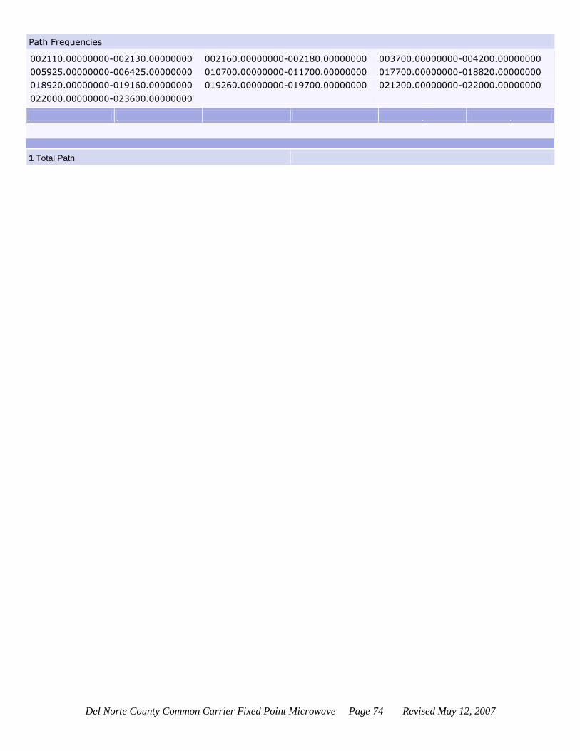
Del Norte County Common Carrier Fixed Point Microwave Page 74 Revised May 12, 2007
Path Frequencies
002110.00000000-002130.00000000 002160.00000000-002180.00000000 003700.00000000-004200.00000000
005925.00000000-006425.00000000 010700.00000000-011700.00000000 017700.00000000-018820.00000000
018920.00000000-019160.00000000 019260.00000000-019700.00000000 021200.00000000-022000.00000000
022000.00000000-023600.00000000
1 Total Path

Del Norte County Common Carrier Fixed Point Microwave Page 75 Revised May 12, 2007
WAX78
Federal Communications Commission Wireless Telecommunications Bureau
Radio Station Authorization (Reference Copy)
This is not an official FCC license. It is a record of public information contained in the FCC's
licensing database on the date that this reference copy was generated. In cases where FCC rules
require the presentation, posting, or display of an FCC license, this document may not be used in
place of an official FCC license. Licensee: Verizon California Inc.
ATTN HQE02N53 Verizon California Inc. PO Box 152092 Irving, TX 75015-2092
FCC Registration Number (FRN):
0001536424
Call Sign:
WAX78
File Number:
Radio Service:
CF - Common Carrier Fixed Point to Point Microwave
SMSA Station Class
FX5
Grant Date
03/09/2001
Effective Date
09/22/2005
Expiration Date
02/01/2011
Print Date
06/12/2006
LOCATION
Fixed Location Address or Area of Operation
Statewide
City County State
CA
Loc. No. Location Name Latitude Longitude Elevation Antenna Structure Registration No.
1 - - - -
FREQUENCY PATHS
Frequency
(MHz) Tol (%)
Emission Desig
EIRP (dBm)
Constr Date
Path No.
Seg Emit Loc No.
Ant Hgt (m)
Gain (dBi)
Beam (deg)
POL AZIM (deg)
Rec Loc No.
Rec Call Sign
Reflector Ht(m) x Wd(m)
010550.00000000-010630.00000000
1 1 1 6.1 S 1 WAX78
021200.00000000-023600.00000000
1 1 1 6.1 S 1 WAX78
027500.00000000-029500.00000000
1 1 1 6.1 S 1 WAX78
031000.00000000-031300.00000000
1 1 1 6.1 S 1 WAX78
038600.00000000- 1 1 1 6.1 S 1 WAX78

Del Norte County Common Carrier Fixed Point Microwave Page 76 Revised May 12, 2007
040000.00000000
Waivers/Conditions: This authorization is secondary to fixed point-to-point authorizations and to authorizations
which were awarded through a competitive bidding process. Each use of facilities under this authorization must be prior coordinated with existing users and applicants in accordance with 101.103(d) of the Commission's Rules. Pursuant to 101.31 no station under this authorization may remain at the same location for a period of more than 6 months. No right to the use of the frequency beyond 6 months is conveyed by operation under this authorization, unless an application for permanent authorization has been filed with the Commission.
Conditions
Pursuant to Section 309(h) of the Communications Act of 1934, as amended, 47 U.S.C. Section 309(h), this license is subject to the following conditions: This license shall not vest in the licensee any right to operate the station nor any right in the use of the frequencies designated in the license beyond the term thereof nor in any other manner than authorized herein. Neither the license nor the right granted thereunder shall be assigned or otherwise transferred in violation of the Communications Act of 1934, as amended. See 47 U.S.C. Section 310(d). This license is subject in terms to the right of use or control conferred by Section 706 of the Communications Act of 1934, as amended. See 47 U.S.C. Section 706.
Call Sign WAX78 Radio Service CF - Common Carrier Fixed Point to Point Microwave
1 Total Location
10 Locations per Summary Page
Mobile Transmit Location 1:
Operating Statewide: CA
Special
Conditions
None
1 Total Location
10 Locations per Summary Page
Call Sign WAX78 Radio Service CF - Common Carrier Fixed Point to Point Microwave
Transmitter Coordinates - - , - -
1 Total Path
Path 1 - Area
Rec. Call Sign WAX78
Path Frequencies
010550.00000000-010630.00000000 021200.00000000-023600.00000000 027500.00000000-029500.00000000
031000.00000000-031300.00000000 038600.00000000-040000.00000000
1 Total Path
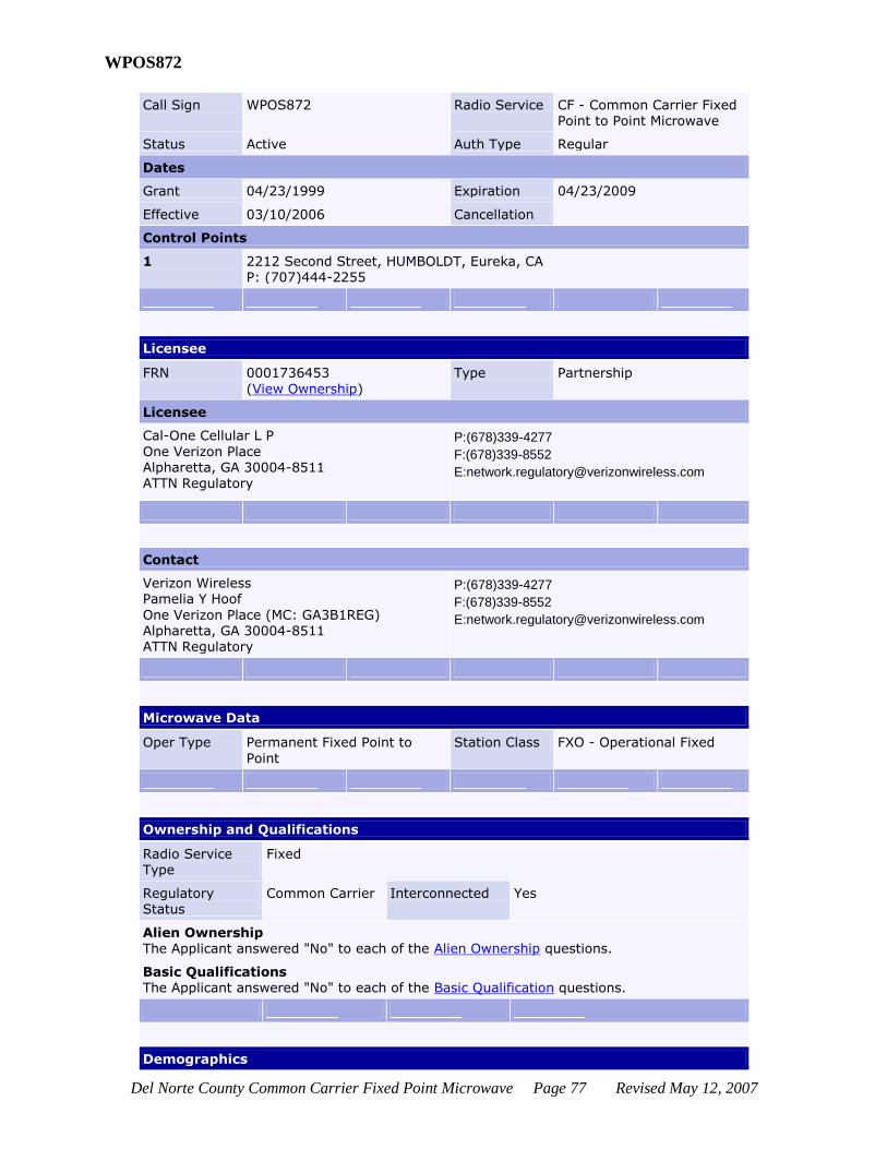
Del Norte County Common Carrier Fixed Point Microwave Page 77 Revised May 12, 2007
WPOS872
Call Sign WPOS872 Radio Service CF - Common Carrier Fixed Point to Point Microwave
Status Active Auth Type Regular
Dates
Grant 04/23/1999 Expiration 04/23/2009
Effective 03/10/2006 Cancellation
Control Points
1 2212 Second Street, HUMBOLDT, Eureka, CA P: (707)444-2255
Licensee
FRN 0001736453
(View Ownership)
Type Partnership
Licensee
Cal-One Cellular L P
One Verizon Place Alpharetta, GA 30004-8511 ATTN Regulatory
P:(678)339-4277
F:(678)339-8552
Contact
Verizon Wireless Pamelia Y Hoof
One Verizon Place (MC: GA3B1REG) Alpharetta, GA 30004-8511 ATTN Regulatory
P:(678)339-4277
F:(678)339-8552
Microwave Data
Oper Type Permanent Fixed Point to
Point
Station Class FXO - Operational Fixed
Ownership and Qualifications
Radio Service Type
Fixed
Regulatory Status
Common Carrier
Interconnected Yes
Alien Ownership
The Applicant answered "No" to each of the Alien Ownership questions.
Basic Qualifications The Applicant answered "No" to each of the Basic Qualification questions.
Demographics
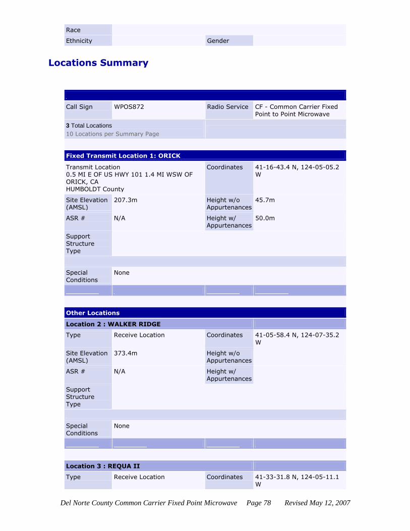
Del Norte County Common Carrier Fixed Point Microwave Page 78 Revised May 12, 2007
Race
Ethnicity Gender
Locations Summary
Call Sign WPOS872 Radio Service CF - Common Carrier Fixed Point to Point Microwave
3 Total Locations
10 Locations per Summary Page
Fixed Transmit Location 1: ORICK
Transmit Location 0.5 MI E OF US HWY 101 1.4 MI WSW OF ORICK, CA HUMBOLDT County
Coordinates 41-16-43.4 N, 124-05-05.2 W
Site Elevation (AMSL)
207.3m Height w/o Appurtenances
45.7m
ASR # N/A Height w/ Appurtenances
50.0m
Support
Structure Type
Special Conditions
None
Other Locations
Location 2 : WALKER RIDGE
Type Receive Location Coordinates 41-05-58.4 N, 124-07-35.2
W
Site Elevation (AMSL)
373.4m Height w/o Appurtenances
ASR # N/A Height w/ Appurtenances
Support Structure
Type
Special Conditions
None
Location 3 : REQUA II
Type Receive Location Coordinates 41-33-31.8 N, 124-05-11.1 W

Del Norte County Common Carrier Fixed Point Microwave Page 79 Revised May 12, 2007
Site Elevation (AMSL)
253.3m Height w/o Appurtenances
ASR # N/A Height w/ Appurtenances
Support Structure Type
Special Conditions
None
Paths Summary
Call Sign WPOS872 Radio Service CF - Common Carrier Fixed
Point to Point Microwave
Transmitter ORICK Coordinates 41-16-43.4 N , 124-05-05.2 W
2 Total Paths
Path 1 - Fixed Point-to-Point
Rec. Call Sign WPNN512
Location Coordinates
WALKER RIDGE 41-05-58.4 N , 124-07-35.2 W
Path Frequencies
006152.75000000
Path 2 - Fixed Point-to-Point
Rec. Call Sign
Location Coordinates
REQUA II 41-33-31.8 N , 124-05-11.1 W
Path Frequencies
006063.80000000
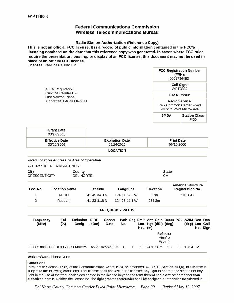
Del Norte County Common Carrier Fixed Point Microwave Page 80 Revised May 12, 2007
WPTB833
Federal Communications Commission Wireless Telecommunications Bureau
Radio Station Authorization (Reference Copy)
This is not an official FCC license. It is a record of public information contained in the FCC's
licensing database on the date that this reference copy was generated. In cases where FCC rules
require the presentation, posting, or display of an FCC license, this document may not be used in
place of an official FCC license. Licensee: Cal-One Cellular L P
ATTN Regulatory Cal-One Cellular L P One Verizon Place Alpharetta, GA 30004-8511
FCC Registration Number (FRN):
0001736453
Call Sign:
WPTB833
File Number:
Radio Service:
CF - Common Carrier Fixed Point to Point Microwave
SMSA Station Class
FXO
Grant Date
08/24/2001
Effective Date
03/10/2006
Expiration Date
08/24/2011
Print Date
06/15/2006
LOCATION
Fixed Location Address or Area of Operation
421 HWY 101 N FAIRGROUNDS
City
CRESCENT CITY
County
DEL NORTE
State
CA
Loc. No. Location Name Latitude Longitude Elevation Antenna Structure Registration No.
1 KPOD 41-45-34.0 N 124-11-32.0 W 2.7m 1013617
2 Requa II 41-33-31.8 N 124-05-11.1 W 253.3m
FREQUENCY PATHS
Frequency
(MHz) Tol (%)
Emission Desig
EIRP (dBm)
Constr Date
Path No.
Seg Emit Loc No.
Ant Hgt (m)
Gain (dBi)
Beam (deg)
POL AZIM (deg)
Rec Loc No.
Rec Call Sign
Reflector Ht(m) x Wd(m)
006063.80000000 0.00500 30M0D9W 65.2 02/24/2003 1 1 1 74.1 38.2 1.9 H 158.4 2
Waivers/Conditions: None
Conditions
Pursuant to Section 309(h) of the Communications Act of 1934, as amended, 47 U.S.C. Section 309(h), this license is subject to the following conditions: This license shall not vest in the licensee any right to operate the station nor any right in the use of the frequencies designated in the license beyond the term thereof nor in any other manner than authorized herein. Neither the license nor the right granted thereunder shall be assigned or otherwise transferred in

Del Norte County Common Carrier Fixed Point Microwave Page 81 Revised May 12, 2007
violation of the Communications Act of 1934, as amended. See 47 U.S.C. Section 310(d). This license is subject in terms to the right of use or control conferred by Section 706 of the Communications Act of 1934, as amended. See 47 U.S.C. Section 706.
Locations Summary
Call Sign WPTB833 Radio Service CF - Common Carrier Fixed Point to Point Microwave
2 Total Locations
10 Locations per Summary Page
Fixed Transmit Location 1: KPOD
Transmit Location 421 HWY 101 N FAIRGROUNDS CRESCENT CITY, CA
DEL NORTE County
Coordinates 41-45-34.0 N, 124-11-32.0 W
Site Elevation (AMSL)
2.7m Height w/o Appurtenances
93.5m
ASR # 1013617 Height w/ Appurtenances
94.5m
Support
Structure
Type
TOWER - A free standing or guyed structure
Special Conditions
None
Other Locations
Location 2 : Requa II
Type Receive Location Coordinates 41-33-31.8 N, 124-05-11.1
W
Site Elevation
(AMSL)
253.3m Height w/o
Appurtenances
ASR # N/A Height w/ Appurtenances
Support Structure Type
Special Conditions
None
Paths Summary
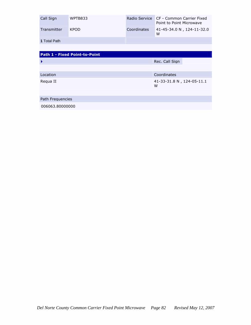
Del Norte County Common Carrier Fixed Point Microwave Page 82 Revised May 12, 2007
Call Sign WPTB833 Radio Service CF - Common Carrier Fixed Point to Point Microwave
Transmitter KPOD Coordinates 41-45-34.0 N , 124-11-32.0 W
1 Total Path
Path 1 - Fixed Point-to-Point
Rec. Call Sign
Location Coordinates
Requa II 41-33-31.8 N , 124-05-11.1 W
Path Frequencies
006063.80000000