common vehicle information model (cvim) · common vehicle information model (cvim) 30.03.2018 cvim...
TRANSCRIPT
This work has received funding from theEuropean Union’s Horizon 2020 researchand innovation programme under grantagreement No 644657
Common Vehicle Information ModelThe open and brand-independent vehicle big data model of the AutoMat project
Public Specification Version 1.2.0

Common Vehicle Information Model (CVIM) 30.03.2018
CVIM Version 1.2.0 Page 2 of 38
Imprint
AutoMat Project Inside today's vehicles ~4000 CAN-Bus signals/sec are processed in comparison to very few signals in smart phones and alike. This large amount of continuously gathered vehicle data represents major big data business potentials, not only for the automotive industry but in particular for cross-sectorial industries with interdis-ciplinary applications. The core intention of the AutoMat project is to innovate an open ecosystem for Vehicle Big Data, materializing in the form of a cross-border Vehicle Big Data Marketplace that leverages currently unused information gath-ered from connected vehicles. The interface to the marketplace is derived from a Common Vehicle Information Model (CVIM) that makes mined and anonymous vehicle data from various OEMs accessible to cross-sectorial service providers. With the huge amount of volatile data from vehicles, the AutoMat ecosystem heav-ily builds upon current trends in Big Data.
www.automat-project.eu
Project Coordinator VOLKSWAGEN AG Represented by: Adrian Zarcula VST/Zc car2enterprise & Fahrzeug-EKG e-mail: [email protected] phone: +49-(0)5361-9-31031
Project Consortium Volkswagen AG (VW, Coordinatorv), Germany Renault SAS (RSA), France Centro Ricerche Fiat SCPA (CRF), Italy Institut für angewandte Systemtechnik Bremen GmbH (ATB), Germany ERPC European Research Programme Consulting Gmbh (ERPC), Germany Technische Universität Dortmund (TUDO), Germany ATOS Spain SA (ATOS), Spain Institut Mines-Telecom (IMT), France Trialog (TRIALOG), France Here Global B.V (HERE), Netherlands, Meteologix AG (METEOLX), Switzerland
CVIM Contact Johannes Pillmann, TU Dortmund University, Communication Networks Institute, Otto-Hahn-Str. 6, 44227 Dortmund e-mail: [email protected] phone: +49 (0) 231 755 2328
Authors Adrian Zarcula (VW), Johannes Lauer (HERE),
Albert Zilverberg (ATB), Johannes Pillmann (TUDO)
Antonio Kung (TRIALOG), Jörg Kachelmann (METEOLX),
Carlos Armero (VW), Marco Zanzola (CRF),
Christian Wolff (ATB), Roberto Tola (CRF),
Daniel Calvo Alonso (ATOS), Roland Schrödner (METEOLX),
Guido Steusel (HERE), Thomas Raugust (VW),
Jean-Jacques Droux (RSA), Uwe Kirchhoff (ATB)
CVIM Edition Version 1.2.0 Release date 30.03.2018
This document is licensed to the public under the Creative Commons Attribution 4.0 license (CC BY 4.0), https://creativecommons.org/licenses/by/4.0/
This work has received funding from the European Union’s Horizon 2020 research and innovation pro-gramme under grant agreement No 644657
Common Vehicle Information Model (CVIM) 30.03.2018
CVIM Version 1.2.0 Page 3 of 38
Abbreviations
API Application Programming Inter-face
App Software Application
CVIM Common Vehicle Information Model
D Deliverable
DoW Description of Work
e.g. Exempli gratia = for example
EC European Commission
EU European Union
FP7 Framework Programme 7
GA Grant Agreement
HTTP Hyper Text Transfer Protocol
i.e. id est = that is to say
IANA Internet Assigned Numbers Au-thority
ICT Information and Communication Technology
IP Intellectual Property
IPR Intellectual Property Rights
ISO International Organization for Standardization
JSON Java Script Object Notation
KPI Key Performance Indicator
M Month
OEM Original Equipment Manufac-turer
REST Representational State Transfer
RFC Request For Comments
RTD Research and Technological Development
SME Small and Medium Sized Enter-prise
SSL Secure Sockets Layer
T Task
TLS Transport Layer Security
UML Unified Markup Language
UUID Universally Unique Identifier
VIN Vehicle Identification Number
WP Work Package
XML eXtensible Markup Language
Common Vehicle Information Model (CVIM) 30.03.2018
CVIM Version 1.2.0 Page 4 of 38
Table of Contents
1 Introduction ....................................................................................................................................... 6 1.1 The AutoMat Project ................................................................................................................. 6 1.2 CVIM Content and Purpose ...................................................................................................... 7
2 Terminology and Format of the CVIM Specification ..................................................................... 8 2.1 Terminology of Requirements .................................................................................................. 8 2.2 Specification Format ................................................................................................................. 8 2.3 JSON Schema Datatype Extension ......................................................................................... 8
3 The AutoMat Common Vehicle Information Model ..................................................................... 10 3.1 Architecture............................................................................................................................. 10 3.2 Concepts and Methods ........................................................................................................... 10
3.2.1 Measurement Channels ......................................................................................................... 11 3.2.2 OEM Certification ................................................................................................................... 17 3.2.3 Trip-ID ..................................................................................................................................... 17 3.2.4 Data Ownership Information ................................................................................................... 18 3.2.5 Harmonization......................................................................................................................... 19
3.3 Signal Layer Specification ...................................................................................................... 22 3.3.1 Signal Definition ...................................................................................................................... 22 3.3.2 Signal Examples ..................................................................................................................... 23
3.4 Measurement Layer Specification .......................................................................................... 24 3.4.1 Measurement Channel Definition ........................................................................................... 25 3.4.2 Measurement Channel Examples .......................................................................................... 27
3.5 Data Layer Specification ......................................................................................................... 28 3.5.1 Data Package Definition ......................................................................................................... 29 3.5.2 Data Package Examples ........................................................................................................ 35
Common Vehicle Information Model (CVIM) 30.03.2018
CVIM Version 1.2.0 Page 5 of 38
List of Figures
Figure 1 The AutoMat Ecosystem ................................................................................................................. 6 Figure 2: Layered High-level View of the Common Vehicle Information Model (CVIM) ............................. 10 Figure 3: Time Series Example ................................................................................................................... 11 Figure 4: Example Signal (left plot) and its histogram (right plot) ............................................................... 13 Figure 5: Example geo-based histogram of exterior temperature distribution ............................................ 15 Figure 6: Example of a pie-chart grid visualization of geo-based histograms ............................................ 15 Figure 7: Geo histogram data with a resolution of 2.45 km (zoom level 14) .............................................. 16 Figure 8 Geo histogram data with a resolution of 19.5 km (zoom level 11) ............................................... 16 Figure 9: Trip-id example for data packages from different measurement channels ................................. 17 Figure 10 Realised and achievable level of CVIM harmonization by AutoMat ........................................... 19 Figure 11 Common Vehicle Information Model Harmonization in the AutoMat Project ............................. 20 Figure 12: Signal UML Model ..................................................................................................................... 22 Figure 13: Measurement Channel UML Model ........................................................................................... 25 Figure 14: Data Package UML Model ......................................................................................................... 29 Figure 15 Engine Speed vs Coolant Temperature Multidimensional Histogram as Heatmap ................... 36
List of Tables
Table 1 Extension of JSON Schema Format Attributes ................................................................................ 9 Table 2: Volume of data inside vehicles ..................................................................................................... 11 Table 3: Example Signal Downsampling .................................................................................................... 12 Table 4: Multidimensional Histogram Example ........................................................................................... 14 Table 5: Example Histogram for different COUNT and TIME Aggregation Strategies ............................... 14 Table 6: Example Histogram for different MIN and MAX Aggregation Strategies ...................................... 14 Table 7 Zoom Levels for geo-histograms ................................................................................................... 15 Table 8: Signal properties definition ............................................................................................................ 22 Table 9: Measurement Channel Model property definition ......................................................................... 25 Table 10: Histogram Measurement Channel Bin Configuration property definition ................................... 27 Table 11: Data Package Model properties definition .................................................................................. 29 Table 12: Geo Bounding Box Object properties definition .......................................................................... 31 Table 13: OEM-Certification-Object property definition .............................................................................. 31 Table 14: Ownership-Information-Object property definition ...................................................................... 32 Table 15: Statistic Properties Object property definition ............................................................................. 33 Table 16: Statistic Properties Histogram Object property definition ........................................................... 33 Table 17: Time-Series-Data Object property definition ............................................................................... 34 Table 18: Geo-Tile Object property definition ............................................................................................. 34

Common Vehicle Information Model (CVIM) 30.03.2018
CVIM Version 1.2.0 Page 6 of 38
1 Introduction
1.1 The AutoMat Project
Inside today's vehicles ~4000 CAN-Bus signals/sec are processed in comparison to very few signals in smart phones and alike. This large amount of continuously gathered vehicle data represents major big data business potentials, not only for the automotive industry but in particular for cross-sectorial industries with interdisciplinary applications. With today's proprietary approaches focusing on bringing services into vehi-cles and the applied ignorance of customer privacy concerns, this major business potential is still locked because the automotive industry was not yet able to establish an open service ecosystem equivalent to the ones in the smart phone industry.
The core intention of the AutoMat project is to innovate an open ecosystem for Vehicle Big Data, material-izing in the form of a cross-border Vehicle Big Data Marketplace that leverages currently unused information gathered from connected vehicles. The interface to the marketplace is derived from a Common Vehicle Information Model that makes mined and anonymous vehicle data from various OEMs accessible to cross-sectorial service providers. With the huge amount of volatile data from vehicles, the AutoMat ecosystem heavily builds upon current trends in Big Data. Exemplary service scenarios, driven by service providers dedicated to generate concrete businesses from the AutoMat ecosystem, are developed in the context of meteorological data based hyper-local and extended innovative enterprise service domains.
By defining an open value chain, the proposed AutoMat ecosystem enables and stimulates parties from different sectors to focus on their core businesses and to excel collaboration with other partners. AutoMat therefore may serve as incubator for new business opportunities strengthening Europe's position as pro-vider of innovative cross-sectorial and cross-border Big Data services. The latter aspect is actively stimu-lated during the project by an Open Service Contest based upon the AutoMat Big Data ecosystem.
Figure 1 The AutoMat Ecosystem
Common Vehicle Information Model (CVIM) 30.03.2018
CVIM Version 1.2.0 Page 7 of 38
1.2 CVIM Content and Purpose
AutoMat targets the collection of vehicle data from various car manufacturers. Thereby a common under-standing of data and information is required. Within the scope of the project, the Common Vehicle Infor-mation Model (CVIM) was developed as open and highly scalable automotive big data format. The CVIM provides a brand-independent and transparent data model, which harmonizes proprietary data into generic datasets. However, the CVIM is not rigid, rather representing a living data structure, where in reference to the needs of the service provider community the amount of signals to be recorded as well as the type of measurement channels can be modified or extended.
This document comprises the specification of the CVIM and describes a key result of the AutoMat project. A machine-readable CVIM definition is publicly available at the AutoMat GitHub1 repository as part of the SDK.
1 https://github.com/automat-project/SDK

Common Vehicle Information Model (CVIM) 30.03.2018
CVIM Version 1.2.0 Page 8 of 38
2 Terminology and Format of the CVIM Specification
2.1 Terminology of Requirements
The key words "MUST", "MUST NOT", "REQUIRED", "SHALL", "SHALL NOT", "SHOULD", "SHOULD NOT", "RECOMMENDED", "MAY", and "OPTIONAL" in this document are to be interpreted as described in RFC 2119, 2.
2.2 Specification Format
The specification is provided in text form throughout the following sections and in a machine-readable for-mat as part of the SDK, which is publicly available at github3. This enables automated testing and validation of CVIM data and Cloud Storage Provider Interfaces. The CVIM specification and definition exploits the following formats and standards:
CVIM Relationship Modelling: Unified Modeling LanguageTM (UML), Version 2.5, 4
CVIM Model Definition: JSON Schema, Version 4, 5
CVIM Reference and Prototype Implementation: JavaScript Object Notation (JSON), 6
Cloud Storage Provider Interface Specification: OpenAPI, Version 2.0, 7
Cloud Storage Provider Prototype Implementation: Python, Version 3.6, 8
2.3 JSON Schema Datatype Extension
JSON Schema allows detailed and rich data model descriptions. Nevertheless, it supports the following seven primitive data types for JSON values:
Array – a JSON array
Boolean – Value may be true or false
Integer – Number without fraction or exponent part
Number – Any number, Number includes integer
Null – Null (empty) value
Object – JSON object
String – Text value To improve and validate contents of fields the JSON Schema Validation defines semantic validation using the format attribute. Table 1 further extends this format attribute to provide a more detailed description of data types within the CVIM definition and Cloud Storage Provider specification.
2 Internet Engineering Task Force (IETF), “Keywords for use in RFCs to Indicate Requirement Levels”,
https://www.ietf.org/rfc/rfc2119.txt 3 https://github.com/automat-project 4 Object Management Group, Unified Modelling Language (UML) Version 2.5,
http://www.omg.org/spec/UML/2.5/ 5 Internet Engineering Task Force (IETF), “JSON Schema: core definitions and terminology”, 30.01.2013,
http://tools.ietf.org/html/draft-zyp-json-schema-04 6 ECMA International, “The JSON Data Interchange Format”, Standard ECMA-404, 1st Edition, October
2013 7 OpenAPI Initiative, “OpenAPI Specification”, 29.01.2016, https://github.com/OAI/OpenAPI-Specifica-
tion/blob/394ffd3ff3e2fe0029a821170937a8154b04e0ba/versions/2.0.md 8 Python Software Foundation, „Python Release 3.6.0“, https://www.python.org/downloads/release/py-
thon-360/

Common Vehicle Information Model (CVIM) 30.03.2018
CVIM Version 1.2.0 Page 9 of 38
Table 1 Extension of JSON Schema Format Attributes
Value Type (JSON Schema)
“type”-attribute
Format
“format”-attribute
Description Example
integer int8 signed 8-bit integer -128
integer int16 signed 16-bit integer 32767
integer int32 signed 32-bit integer -2147483648
integer int64 signed 64-bit integer 1
integer uint8 unsigned 8-bit integer 255
integer uint16 unsigned 16-bit integer 65535
integer uint32 unsigned 32-bit integer 4294967295
integer uint64 unsigned 64-bit integer 0
number double single precision floating point value representing an 32-bit bi-nary format IEEE 754 value
-3.1415926, +Infinity
number double double precision floating point value representing an 64-bit bi-nary format IEEE 754 value
3.1415926, -Infinity
string date As defined by full-date in RFC3339
2016-04-07
string date-time As defined by date-time in RFC3339
2016-04-07T11:45:13.01Z
string uuid Universally unique identifier (UUID representing a 128-bit unique value in a hexadecimal representation
664f4826-9563-4a56-9d73-c8cf55572fd5
string email E-Mail address representation [email protected]
string version CVIM Version Format with Schema a.b.c:
- a: Major Version - b: Minor Release - c: Revision
1.2.0
Common Vehicle Information Model (CVIM) 30.03.2018
CVIM Version 1.2.0 Page 10 of 38
3 The AutoMat Common Vehicle Information Model
This section defines the AutoMat’s data model – the Common Vehicle Information Model (CVIM). Section 3.1 provides an overview of the CVIM architecture. Following, section 3.2 describes methods and concepts of CVIM data aggregation and modelling. The detailed description and definition of the CVIM follows in a bottom-up approach from the Signal layer (section 3.3) over the measurement layer (3.4) upwards to the data layer (3.5).
Unified Modeling LanguageTM (UML) is used for the high-level data modelling. The detailed data model is described in text form, while orientating at the “JSON Schema” 9 data modelling language.
In addition, the data model is implemented in the Software Development Kit, in the programming language agnostic and machine-readable format "JSON Schema" and is publicly available via the automat github repository10. The CVIM documentation in text form orientates at the JSON Schema definition and provides examples using JavaScript Object Notation (JSON).
3.1 Architecture
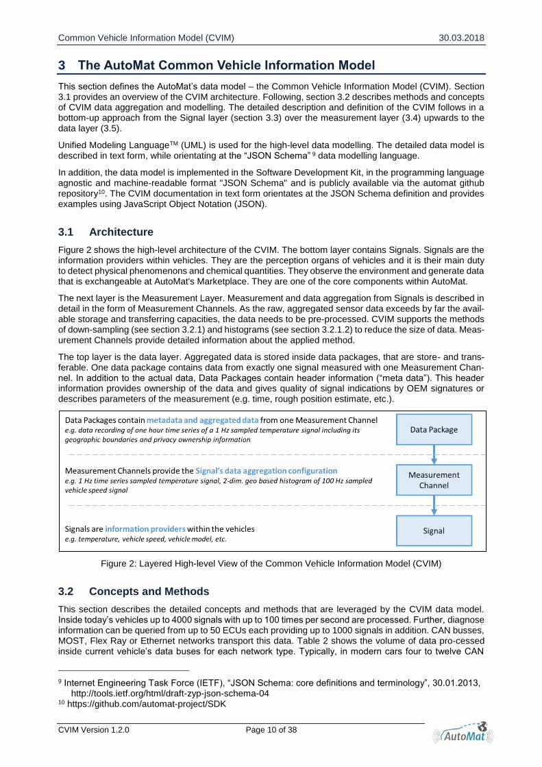
Figure 2 shows the high-level architecture of the CVIM. The bottom layer contains Signals. Signals are the information providers within vehicles. They are the perception organs of vehicles and it is their main duty to detect physical phenomenons and chemical quantities. They observe the environment and generate data that is exchangeable at AutoMat's Marketplace. They are one of the core components within AutoMat.
The next layer is the Measurement Layer. Measurement and data aggregation from Signals is described in detail in the form of Measurement Channels. As the raw, aggregated sensor data exceeds by far the avail-able storage and transferring capacities, the data needs to be pre-processed. CVIM supports the methods of down-sampling (see section 3.2.1) and histograms (see section 3.2.1.2) to reduce the size of data. Meas-urement Channels provide detailed information about the applied method.
The top layer is the data layer. Aggregated data is stored inside data packages, that are store- and trans-ferable. One data package contains data from exactly one signal measured with one Measurement Chan-nel. In addition to the actual data, Data Packages contain header information (“meta data”). This header information provides ownership of the data and gives quality of signal indications by OEM signatures or describes parameters of the measurement (e.g. time, rough position estimate, etc.).
Figure 2: Layered High-level View of the Common Vehicle Information Model (CVIM)
3.2 Concepts and Methods
This section describes the detailed concepts and methods that are leveraged by the CVIM data model. Inside today’s vehicles up to 4000 signals with up to 100 times per second are processed. Further, diagnose information can be queried from up to 50 ECUs each providing up to 1000 signals in addition. CAN busses, MOST, Flex Ray or Ethernet networks transport this data. Table 2 shows the volume of data pro-cessed inside current vehicle’s data buses for each network type. Typically, in modern cars four to twelve CAN
9 Internet Engineering Task Force (IETF), “JSON Schema: core definitions and terminology”, 30.01.2013,
http://tools.ietf.org/html/draft-zyp-json-schema-04 10 https://github.com/automat-project/SDK

Common Vehicle Information Model (CVIM) 30.03.2018
CVIM Version 1.2.0 Page 11 of 38
busses are used producing 12 GB of data per day. When data of a whole fleet of 1000 cars is mined the volume increases to 12 TB per day or 4.3 PB per year. In addition, the other network types provide even more bandwidth resulting in even larger data volume.
On the one hand, this large amount of continuously gathered vehicle data represents the major Big Data potential of the AutoMat project. On the other hand, as the project as a whole need to be scalable and data transfer capacity from vehicles to the backend is limited, a pre-processing of the data within the vehicles needs to be done. As some of the data is redundant or strongly correlated to other information, it may be dropped and the maximum data volume reduced. Inside vehicles, computing power is limited and complex data encodings are therefore not feasible.
The following sections describe the state of the art approaches implemented by the Common Vehicle In-formation Model (CVIM) for Vehicle Big Data pre-processing using subsampling of time series (section 3.2.1) and distribution based data acquisition (section 3.2.1.2).
Table 2: Volume of data inside vehicles11
Data Source Volume per Car
Volume per 1000 car fleet
Volume per 1000 car fleet
4-12 CAN buses (actual bandwidth) 12 GB / day 12 TB / day 4.3 PB / year
MOST Bus (theoretical bandwidth) 211 GB / day 211 TB /day 77 PB / year
Flex Ray network (theoretical bandwidth) 83 GB / day 83 TB / day 30 PB / year
Ethernet Network (theoretical bandwidth) 83 GB / day 83 TB / day 30 PB / year
3.2.1 Measurement Channels
The Common Vehicle Information Model (CVIM) supports a wide variety of signals. The following sections provide the detailed concepts of how physical signals and their sampled measurements are implemented and represented in the CVIM format.
3.2.1.1 Time Series
Time Series is a sequence of data recordings (sample) from a signal in a time order. Each data sample is assigned to a specific point in time. Figure 3 shows an example signal and its sampled Time Series.
Figure 3: Time Series Example
11 GB = Gigabyte = 109 Byte, TB = Terabyte = 1012 Byte, PB = Petabyte = 1015 Byte
Common Vehicle Information Model (CVIM) 30.03.2018
CVIM Version 1.2.0 Page 12 of 38
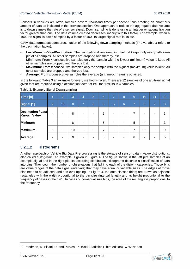
Sensors in vehicles are often sampled several thousand times per second thus creating an enormous amount of data as indicated in the previous section. One approach to reduce the aggregated data volume is to down sample the rate of a sensor signal. Down sampling is done using an integer or rational fraction factor greater than one. The data volume created decreases linearly with this factor. For example, when a 1000 Hz signal is down sampled by a factor of 100, its target signal rate is 10 Hz.
CVIM data format supports presentation of the following down sampling methods (The variable x refers to the decimation factor):
- Last-Known-Value/Decimation: The decimation down sampling method keeps only every x-th sam-ple of all samples. All other samples are dropped and thereby lost.
- Minimum: From x consecutive samples only the sample with the lowest (minimum) value is kept. All other samples are dropped and thereby lost.
- Maximum: From x consecutive samples only the sample with the highest (maximum) value is kept. All other samples are dropped and thereby lost.
- Average: From x consecutive samples the average (arithmetic mean) is obtained.
In the following Table 3 an example for every method is given. There are 12 samples of one arbitrary signal given that are reduced using a decimation factor of x=3 that results in 4 samples.
Table 3: Example Signal Downsampling
Time [s] 1 2 3 4 5 6 7 8 9 10 11 12
Signal [1] 9 10 8 7 6 5 5 6 7 3 9 3
Decimation / Last Known Value
- - 8 - - 5 - - 7 - - 3
Minimum - - 8 - - 5 - - 5 - - 3
Maximum - - 10 - - 7 - - 7 - - 9
Average - - 9 - - 6 - - 6 - - 5
3.2.1.2 Histograms
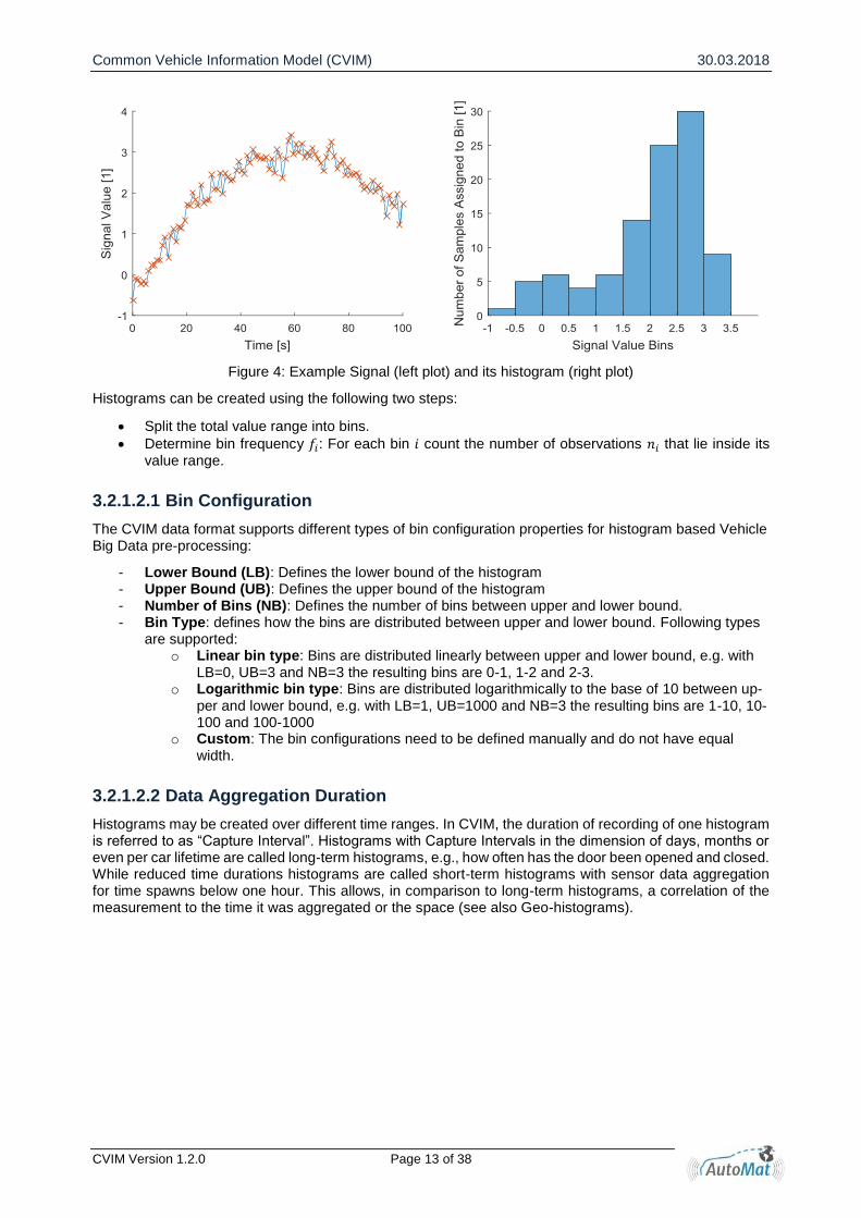
Another approach of Vehicle Big Data Pre-processing is the storage of sensor data in value distributions, also called histograms. An example is given in Figure 4. The figure shows in the left plot samples of an example signal and in the right plot its according distribution. Histograms describe a classification of data into bins. They count the number of observations that fall into each of the disjoint categories. Those bins are value ranges of the data signal (intervals) that may have equal or variable sizes. The edges of those bins need to be adjacent and non-overlapping. In Figure 4, the data classes (bins) are drawn as adjacent rectangles with the width proportional to the bin size (interval length) and its height proportional to the frequency of cases in the bin12. In cases of non-equal size bins, the area of the rectangle is proportional to the frequency.
12 Freedman, D. Pisani, R. and Purves, R. 1998. Statistics (Third edition). W.W.Norton
Common Vehicle Information Model (CVIM) 30.03.2018
CVIM Version 1.2.0 Page 13 of 38
Figure 4: Example Signal (left plot) and its histogram (right plot)
Histograms can be created using the following two steps:
Split the total value range into bins.
Determine bin frequency 𝑓𝑖: For each bin 𝑖 count the number of observations 𝑛𝑖 that lie inside its value range.
3.2.1.2.1 Bin Configuration
The CVIM data format supports different types of bin configuration properties for histogram based Vehicle Big Data pre-processing:
- Lower Bound (LB): Defines the lower bound of the histogram - Upper Bound (UB): Defines the upper bound of the histogram - Number of Bins (NB): Defines the number of bins between upper and lower bound. - Bin Type: defines how the bins are distributed between upper and lower bound. Following types
are supported: o Linear bin type: Bins are distributed linearly between upper and lower bound, e.g. with
LB=0, UB=3 and NB=3 the resulting bins are 0-1, 1-2 and 2-3. o Logarithmic bin type: Bins are distributed logarithmically to the base of 10 between up-
per and lower bound, e.g. with LB=1, UB=1000 and NB=3 the resulting bins are 1-10, 10-100 and 100-1000
o Custom: The bin configurations need to be defined manually and do not have equal width.
3.2.1.2.2 Data Aggregation Duration
Histograms may be created over different time ranges. In CVIM, the duration of recording of one histogram is referred to as “Capture Interval”. Histograms with Capture Intervals in the dimension of days, months or even per car lifetime are called long-term histograms, e.g., how often has the door been opened and closed. While reduced time durations histograms are called short-term histograms with sensor data aggregation for time spawns below one hour. This allows, in comparison to long-term histograms, a correlation of the measurement to the time it was aggregated or the space (see also Geo-histograms).

Common Vehicle Information Model (CVIM) 30.03.2018
CVIM Version 1.2.0 Page 14 of 38
3.2.1.2.3 Multidimensional Histograms
CVIM does support multidimensional histograms. Each dimension has its own Bin configuration and signal. A multidimensional histogram example is given in Table 4.
Table 4: Multidimensional Histogram Example
Time [s] 0 15 20 25 45 50 60 70 80 90
Signal A Value [1] 10 9 8 7 5 5 4 3 2 1
Signal B Value [1] 100 200 300 400 500 600 700 800 900 1000
Signal A Bin 1 – 5 Signal A Bin 6 – 10
Signal B Bin 1 – 333 0 3
Signal B Bin 334 – 666 2 1
Signal B Bin 667 – 1000 4 0
3.2.1.2.4 Aggregation Strategies
Next to the above-described classification on observations into bins, CVIM supports the following additional advanced aggregation strategies:
- COUNT: As described above, each bin stores the number of observations within its value range. - TIME: Similar to count, but instead of the number of observations each bin represents the time one
signal spent within the bin’s value range. - MINIMUM: The value of each bin represents the minimum value of that signal in the bin’s range. An
example is given in Table 6. - MAXIMUM: Same as “Minimum”, but maximum-function is used instead.
The following Table 5 gives example histograms for the COUNT and TIME, Table 6 gives an example for the MIN and MAX Aggregation Strategies.
Table 5: Example Histogram for different COUNT and TIME Aggregation Strategies
Time [s] 0 15 20 25 45 50 60 70 80 90
Signal Value [1] 10 9 8 7 5 5 4 3 2 1
COUNT Histogram TIME Histogram
Bin 1 – 5 4 45
Bin 6 - 10 6 45
Table 6: Example Histogram for different MIN and MAX Aggregation Strategies
Time [s] 0 10 20 30 40 50 60 70 80 90
Signal Value [1] 10 9 8 7 5 5 4 3 2 1
MIN Histogram MAX Histogram
Bin 1 - 5 1 5
Bin 6 - 10 7 10

Common Vehicle Information Model (CVIM) 30.03.2018
CVIM Version 1.2.0 Page 15 of 38
3.2.1.3 Geo-Histograms
The concept of geo-histograms enriches the histogram approach by a geospatial dimension, so that addi-tionally to the classic histogram information of how often a certain value was seen in a certain time period, the information of where a certain value was observed during the observation period.
Similar to the quantization of observed values into histogram bins, the geospatial dimension is also quan-tized into geo-bins, which represent a certain map tile based on the Mercator projection, i.e. a combination of a certain latitude range and a certain longitude range.
Coming from a one-dimensional histogram storing the value distribution the structure of gathered data gets two-dimensional: one dimension for the quantized bins of the signal values and one dimension for the quantized geo-position. As reference, the latitude and longitude of the middle point of each map tile is given, see example in Figure 5 below.
Figure 5: Example geo-based histogram of exterior temperature distribution
The visualization of such a value distribution can be imagined as a heat map (or a grid of pie charts) on top of a geographical map – see Figure 6 below:
Figure 6: Example of a pie-chart grid visualization of geo-based histograms
Based on the Mercator projection there are 24 possible zoom levels (0 to 23), which give the predefined zoom levels with their related resolution shown in Table 7 below.
Table 7 Zoom Levels for geo-histograms
Zoom level Length of the map (pixel)
Width of the map (pixel)
Resolution (m)
0 256 1 40 075 016.70
1 512 2 20 037 508.35
2 1 024 4 10 018 754.18
3 2 048 8 5 009 377.08
4 4 096 16 2 504 688.54
5 8 192 32 1 252 344.27
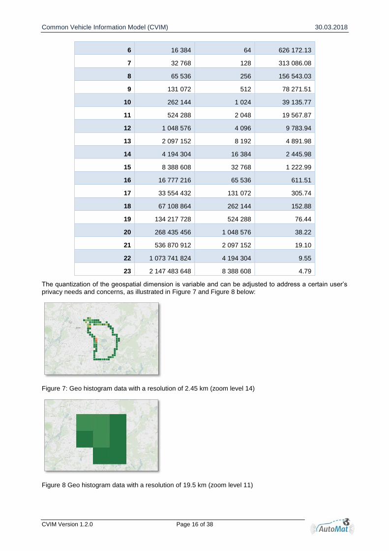
Common Vehicle Information Model (CVIM) 30.03.2018
CVIM Version 1.2.0 Page 16 of 38
6 16 384 64 626 172.13
7 32 768 128 313 086.08
8 65 536 256 156 543.03
9 131 072 512 78 271.51
10 262 144 1 024 39 135.77
11 524 288 2 048 19 567.87
12 1 048 576 4 096 9 783.94
13 2 097 152 8 192 4 891.98
14 4 194 304 16 384 2 445.98
15 8 388 608 32 768 1 222.99
16 16 777 216 65 536 611.51
17 33 554 432 131 072 305.74
18 67 108 864 262 144 152.88
19 134 217 728 524 288 76.44
20 268 435 456 1 048 576 38.22
21 536 870 912 2 097 152 19.10
22 1 073 741 824 4 194 304 9.55
23 2 147 483 648 8 388 608 4.79
The quantization of the geospatial dimension is variable and can be adjusted to address a certain user’s privacy needs and concerns, as illustrated in Figure 7 and Figure 8 below:
Figure 7: Geo histogram data with a resolution of 2.45 km (zoom level 14)
Figure 8 Geo histogram data with a resolution of 19.5 km (zoom level 11)

Common Vehicle Information Model (CVIM) 30.03.2018
CVIM Version 1.2.0 Page 17 of 38
3.2.2 OEM Certification
The OEM data origin certification is a CVIM feature to support the validation and verification of origin, in-tegrity and completeness of data. The intention is to protect the data inside the Data Package against manipulation.
Manipulation could be either the change or the removal of data within a data package. For use cases that rely on completeness and integrity of data it is necessary for the service provider to be able to detect data manipulation.
To protect data against any change inside the data package and to confirm the origin of data, two inde-pendent cryptographic signatures are used for the header and data of each data package. Both fields in-clude information about the start and end of the data inside a data package (i.e. the mileage). The OEM Backend publishes data packages along with the information about origin of data and digitally signs the package using its OEM Backend data publisher certificate. Thus, the data package contains OEM-certified data and origin information and any subsequent manipulation of the header or data of a data package can be easily detected.
A different kind of manipulation is the removal of complete data packages. To enable service providers to detect such cases of data removal, the OEM Backend assigns an ascending sequence number to the signed data packages. The manipulation of that sequence number is protected also by digital signature of OEM Backend. In this way, each service provider can easily detect whether the data is complete or whether certain data packages are missing.
3.2.3 Trip-ID
In order to allow easier combination of data packages the trip-id has been defined. Due to privacy concerns and especially when the user demands, the MP removes personal information from CVIM Data Packages such as vault-id during anonymization and hereby prevents Service Providers from combining two data packages. However, combining information (e.g. temperature reading of one sensor with the position of the vehicle) is mandatory for several services. For those cases, an optional trip-id is added in the CVIM Metadata. The trip-id is the same for all Data Packages that were recorded at the same time and that belong together. The trip-id is arbitrarily defined by the OEM. The MP must pseudomize the trip-id. A recommended process is to leverage a one-way hash function, which takes as input the vault-id, trip-id and the receiving service-provider’s offer ID. The OEMs should choose a random string for the trip-id. A minimum recom-mended – not necessarily required – trip-length is five minutes and the maximum is up to one day.
Figure 9 shows the example of the trip-id attributes. One vehicle records Data Packages on two different Measurement Channels A and B. All recorded Data Packages are indistinguishable after the MP removes brand-independent information in its pseudomization process. Therefore, when the data is generated, the OEM chooses a random trip-id. The four data packages on the left side of the picture form the trip “71910”. Whereas in channel A only one data package is generated, channel B produces three packages. The time-bounds of different channels do not need to overlap. In this example, after some time no more data is recorded. When data recording is resumed, a new trip-id is generated.
Figure 9: Trip-id example for data packages from different measurement channels

Common Vehicle Information Model (CVIM) 30.03.2018
CVIM Version 1.2.0 Page 18 of 38
3.2.4 Data Ownership Information
Data ownership is defined as follows:
The act of having legal rights and control over a single piece or set of data elements13.
Data ownership refers to both the possession of and responsibility for information. Ownership im-plies power as well as control14.
The following observations can be made:
There may be many stakeholders that might claim for ownership15:
Creator – The party that creates or generate data
Consumer – The party that uses the data owns the data
Compiler – The entity that selects and compiles information from different information sources
Enterprise - All data created within an enterprise
Funder - the party that commissions the data creation
Decoder - the party that decode the information
Packager - the party that collects information and adds value (e.g. through formatting)
Reader - the reader gains value through adding that information to an information repository
Subject - the subject of the data
Purchaser/Licenser - the party that buys or licenses data
Privacy legislation does not focus on data ownership. It focuses on data controllers and data pro-cessors. However, according to the previous points, data controllers and data processors are also some kind of owners…
Ownership management is often associated with copyright management, which has the advantage to provide a legal framework.
Copyright management can also be a tool for privacy management, but it is widely recognised that this is not sufficient. Paula Samuelson16 provides ample examples and provides a historical per-spective. She quotes D. Warren and L. Brandeis17 as follows: privacy harms are quite different in nature from market harms with which copyright is mainly concerned.
We conclude that information about data ownership info is one amongst various mechanisms that can be used to ensure proper management of data. There are several reasons why this could be useful:
For IPR issues rather than privacy issues
For transparency reasons as this would potentially provide consumers with information on the origin of data.
For accountability reasons, as this would explicitly shows the roles of data controllers and data processors:
There are many ways for storing such information:
Approach 1: At the individual data level. Note that this substantially increase the storage needs. For instance, each sample data is associated with information on which ECU produced it.
Approach 2: At the level of a collection of data (e.g. a file). For instance, a time series or a histogram file would be associated with an ownership field. Likewise, an aggregated file would also be asso-ciated with an ownership field
Approach 3: Separately, by describing an ownership tree model. For this to work, the implementa-tion should include mechanisms to guarantee the ownership model is the one actually used.
AutoMat uses approach 2. The following fields have been defined:
Copyright stakeholders: This field is optional. It is used when the type of data at stake involve intellectual property rights issues. For instance, the data could have been generated through a sensing system the use of which is subject to specific licensing conditions.
o List of owners
13 https://www.techopedia.com/definition/29059/data-ownership 14 http://www.niu.edu/rcrportal/datamanagement/dotopic.html 15 http://www.niu.edu/rcrportal/datamanagement/dotopic.html 16 Samuelson, Pamela, Protecting Privacy Through Copyright Law? (May 1, 2014). Visions of Privacy in the Modern
Age (Marc Rotenberg, ed., 2014) 17 Samuel D. Warren & Louis D. Brandeis, The Right to Privacy, 4 Harv. L. Rev. 193 (1890)
Common Vehicle Information Model (CVIM) 30.03.2018
CVIM Version 1.2.0 Page 19 of 38
Data stakeholders. This field is optional. It is used when the type of data at stake is personal data. It could involve stakeholders that might have had or will have control capability. For instance, it could include a reference to the data controller (e.g. OEM providing the collecting capability), a reference to a data processor (e.g. third party that is part of the data collecting and aggregation chain).
o Data controllers, list of data processors
Privacy veto rights: This field is optional. It is used when the type of data might be considered as personal data. In this case, the use of the data for business purpose might necessitate specific usage options. Here are example of information that might be provided by this field:
o Consent level: Need for consent concerning privacy level o Jurisdiction constraint: Consent for storage in European jurisdiction only18 o Storage constraint: Consent for personal data storage only19.
Data privacy level: This field is optional. It is needed when there is a need to make a distinction between different treatments of privacy. At this stage, there is no standardised approach for defin-ing data privacy level20. We suggest to define at this point three levels:
o Public. The data package is searchable and accessible to everyone o Shared. The data package is searchable. It is only accessible to a list of stakeholders o Private. The data package is not searchable. It is only visible and accessible to the user
3.2.5 Harmonization
Harmonization describes the process of aligning of different standards, formats and methods against each other. It is a common compromise between varied interpretations and a generally valid solution for all mem-bers21. Within AutoMat, harmonization is achievable on several layers. AutoMat itself is an open and com-mon ecosystem. The concept works independent of brand or service and allowing various OEMs and Ser-vice Providers to participate in the project. Even competing partners are able to join the project without interference. Harmonization of vehicle data is one key factor for success of the AutoMat project.
Figure 10 Realised and achievable level of CVIM harmonization by AutoMat
First Layer: Open and common ecosystem – achieved
18 To prevent from surveillance schemes imposed in jurisdictions where such schemes are allowed. 19 Many future big data will be based on personal data ecosystems 20 There are many proposals from existing websites (for instance http://mushpedia.com/wiki/Privacy_Levels,
http://read-the-docs.readthedocs.io/en/latest/privacy.html or http://www.screencast.com/help/tuto-rial.aspx?id=303). The cloud security alliance has started a privacy level agreement working group (https://cloudsecurityalliance.org/group/privacy-level-agreement/)
21 https://en.wikipedia.org/wiki/Standardization
Common Vehicle Information Model (CVIM) 30.03.2018
CVIM Version 1.2.0 Page 20 of 38
In general, we can state that AutoMat provides the first open and common ecosystem for vehicle data. The concept works independently of brand or service and allows various OEMs and Service Providers to par-ticipate in the AutoMat ecosystem. Even competing partners are able to join the AutoMat ecosystem without interference.
By specifying the Marketplace with open and standardized interfaces, AutoMat removes entry barriers for new Service Providers in a novel way. In this way, Service Providers can avoid negotiating with several OEMs and the costly implementation of several proprietary OEM backend interfaces. Centralizing the ve-hicle data input link to one single point, the Marketplace helps Service Providers to decrease total imple-mentation costs, speeds up developing new services and leads to new business potentials. Allowing sev-eral OEMs to offer vehicle data on the Marketplace results in a large amount of available data. Services can exploit this pile of data to scale steeply.
Second Layer: Open and common ecosystem – achieved
Harmonization of vehicle data is one key factor for success of the AutoMat project. One task of the project is to harmonize automotive data by specifying the Common Vehicle Information Model. The data model shall remove brand proprietaries and dependencies and create a common data format. Figure 11 shows the position of the CVIM between OEMs and Service Providers within the AutoMat project. On the left side OEMs transfer their proprietary data into the CVIM data format. Brand-dependent information is removed and aligned to fit the model. Service Providers, on the right side, can leverage this information. They receive generic datasets of various brands. Both sides are in a win-win situation and profit from the harmonization. OEMs benefit as they address a broader number of Service Providers. On the other hand, Service Providers receive data from more OEMs and they can avoid implementing proprietary data formats.
Figure 11 Common Vehicle Information Model Harmonization in the AutoMat Project
The CVIM format is designed to be unbiased and to treat all data in the same way. It defines Signals as information providers and Measurement Channels as the recording and measurement configuration of those Signals. Hereby, CVIM does not differentiate between the data origin within the car, the vehicle type or its manufacturer.
Third Layer: Open and common ecosystem – partly achieved
Intensive and fruitful discussions during project have shown that neither the participating OEMs nor the Service Providers can exactly define a common list of signals to be provided/needed, especially not regard-ing a common signal resolution. Taking into account the different background and interests on both AutoMat system sides (on the one hand, OEMs who have to keep cost low for data capturing, transfer, processing and provision, and on the other Service Providers who always would like to have the full range information available in a vehicle), a crucial project results is that, with so few OEM and especially Service Provider partners, it’s impossible to realise more than a starting point for signal list harmonisation. However, the defined common data format of the CVIM represents a stable and intact standard format that will be not affected by any harmonization/standardisation activities to achieve uniform datasets. In the end, the signal list standardisation is a question of vehicle data Supply and Demand, as well as of costs for data provision and willingness to pay. Hence, in the long run, the market will show which signal and resolution of signals will be provided and what kind of standardisation is requested by different market players. Generally, the CVIM will not be a rigid, rather representing a living data structure, where in reference to the needs of the Service Provider community the amount of signals to be recorded, as well as the type of measurement channels, can be modified or extended.
Anyway, in the scope of the AutoMat project, a first harmonisation to achieve a common, service independ-ent signal list was carried out, covering a defined set of different sensor signals to support identified and

Common Vehicle Information Model (CVIM) 30.03.2018
CVIM Version 1.2.0 Page 21 of 38
prioritised list of phenomena. However, this work is just reflecting the view of the restricted set of OEM and Service Provider partners and cannot claim to be a standard, but can be the trigger for standardisation work in future.
Measurement Channel Harmonization
Furthermore, to enable the harmonisation of the measured data into uniform datasets, the CVIM concept provides Measurement Channels, which can be divided into Standard Measurement Channels and Custom Measurement Channels. The Standard Measurement Channels would define a catalogue of predefined measurement configurations that are the common denominator between the OEM’s signals. The purpose of Standard Measurement Channels is to harmonize the measured signals to achieve the same type of data coming from every vehicle, allowing Service Providers to receive uniform data from a broad pool of vehicles and OEMs. On the other hand, Custom Measurement Channels define OEM/vehicle specific or individual measurement configurations that may be proprietary.
Common Vehicle Information Model (CVIM) 30.03.2018
CVIM Version 1.2.0 Page 22 of 38
3.3 Signal Layer Specification
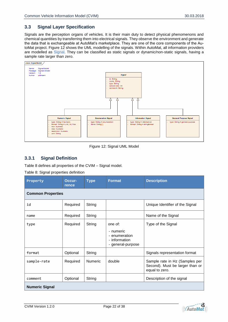
Signals are the perception organs of vehicles. It is their main duty to detect physical phenomenons and chemical quantities by transferring them into electrical signals. They observe the environment and generate the data that is exchangeable at AutoMat’s marketplace. They are one of the core components of the Au-toMat project. Figure 12 shows the UML modelling of the signals. Within AutoMat, all information providers are modelled as Signal. They can be classified as static signals or dynamic/non-static signals, having a sample rate larger than zero.
Figure 12: Signal UML Model
3.3.1 Signal Definition
Table 8 defines all properties of the CVIM – Signal model.
Table 8: Signal properties definition
Property Occur-rence
Type Format Description
Common Properties
id Required String Unique Identifier of the Signal
name Required String Name of the Signal
type Required String one of:
- numeric - enumeration - information - general-purpose
Type of the Signal
format Optional String Signals representation format
sample-rate Required Numeric double Sample rate in Hz (Samples per Second). Must be larger than or equal to zero.
comment Optional String Description of the signal
Numeric Signal
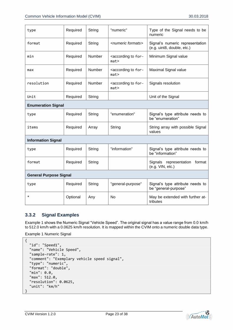
Common Vehicle Information Model (CVIM) 30.03.2018
CVIM Version 1.2.0 Page 23 of 38
type Required String "numeric" Type of the Signal needs to be numeric
format Required String <numeric formats> Signal’s numeric representation (e.g. uint8, double, etc.)
min Required Number <according to for-mat>
Minimum Signal value
max Required Number <according to for-mat>
Maximal Signal value
resolution Required Number <according to for-mat>
Signals resolution
Unit Required String Unit of the Signal
Enumeration Signal
type Required String "enumeration" Signal’s type attribute needs to be “enumeration”
items Required Array String String array with possible Signal values
Information Signal
type Required String "information" Signal’s type attribute needs to be “information”
format Required String Signals representation format (e.g. VIN, etc.)
General Purpose Signal
type Required String "general-purpose" Signal’s type attribute needs to be “general-purpose”
* Optional Any No May be extended with further at-tributes
3.3.2 Signal Examples
Example 1 shows the Numeric Signal “Vehicle Speed”. The original signal has a value range from 0.0 km/h to 512.0 km/h with a 0.0625 km/h resolution. It is mapped within the CVIM onto a numeric double data type.
Example 1 Numeric Signal
{ "id": "Speed1", "name": "Vehicle Speed", "sample-rate": 1, "comment": "Exemplary vehicle speed signal", "type": "numeric", "format": "double", "min": 0.0, "max": 512.0, "resolution": 0.0625, "unit": "km/h" }

Common Vehicle Information Model (CVIM) 30.03.2018
CVIM Version 1.2.0 Page 24 of 38
Example 2 shows the Enumeration Signal “Fuel Type”. Fuel type is required to be petrol, diesel or electricity. It does not change, since it is basic property of a vehicle and therefore has a sample-rate of zero.
Example 2 Enumeration Signal
{ "id": "FuelType1", "name": "Fuel type", "sample-rate": 0, "comment": "Fuel type", "type": "enumeration", "items": ["petrol", "diesel", "electricity"] }
Example 3 shows the text information Signal “Vehicle Identification Number”. Since it is static and does not change, its sample rate is zero.
Example 3 Information Signal
{ "id": "VIN1", "name": "Vehicle Identification Number", "sample-rate": 0, "type": "information", "format": "vin" }
3.4 Measurement Layer Specification
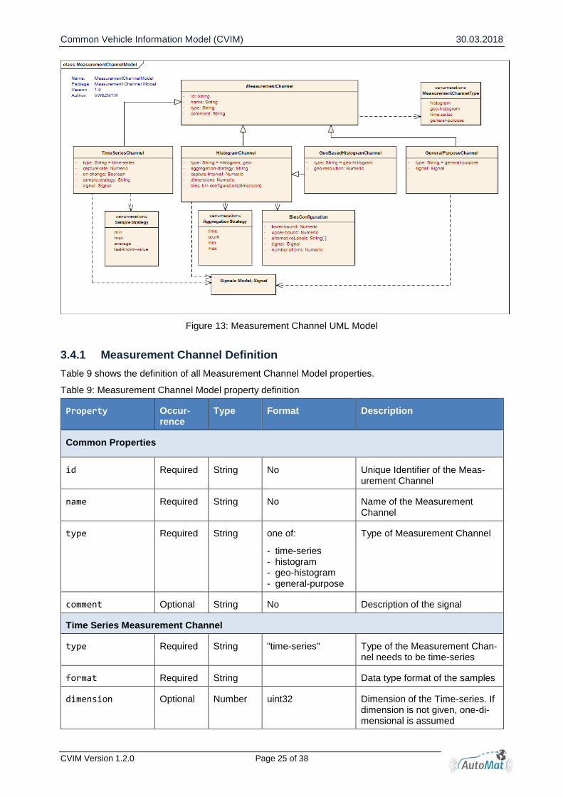
The measurement layer defines how sensor signals are captured and processed. Within CVIM configura-tion of sensor signal measurements are described as Measurement Channel. One Measurement Channel describes how samples from one (or more - in the case of multidimensional histograms) sensor signal are aggregated and measured. Figure 13 shows the Measurement Channel UML model. CVIM supports four different types of Measurement Channels as introduced in section 3.2.1
- Time Series Measurement Channels: Signal values are sampled and measured over time - Histogram Measurement Channels: Distribution of Signal values - Geo-Histogram Measurement Channels: Histograms with geographic resolution - General Purpose Channels: Any other data
Common Vehicle Information Model (CVIM) 30.03.2018
CVIM Version 1.2.0 Page 25 of 38
Figure 13: Measurement Channel UML Model
3.4.1 Measurement Channel Definition
Table 9 shows the definition of all Measurement Channel Model properties.
Table 9: Measurement Channel Model property definition
Property Occur-rence
Type Format Description
Common Properties
id Required String No Unique Identifier of the Meas-urement Channel
name Required String No Name of the Measurement Channel
type Required String one of:
- time-series - histogram - geo-histogram - general-purpose
Type of Measurement Channel
comment Optional String No Description of the signal
Time Series Measurement Channel
type Required String "time-series" Type of the Measurement Chan-nel needs to be time-series
format Required String Data type format of the samples
dimension Optional Number uint32 Dimension of the Time-series. If dimension is not given, one-di-mensional is assumed
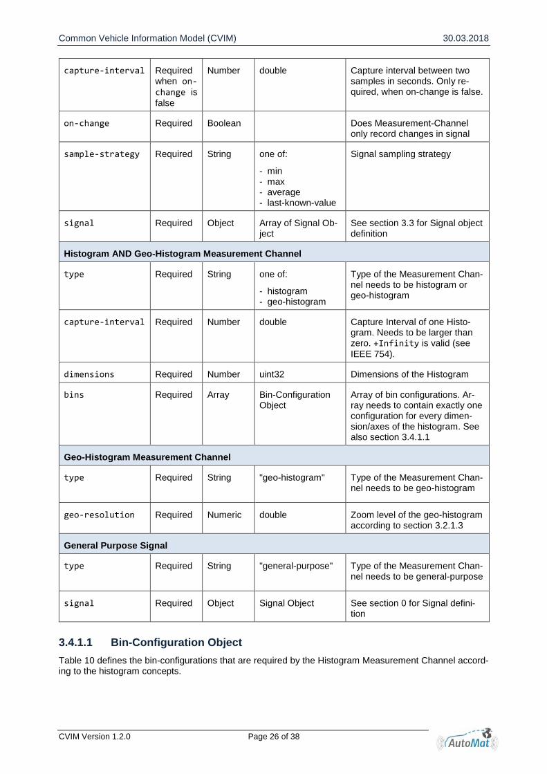
Common Vehicle Information Model (CVIM) 30.03.2018
CVIM Version 1.2.0 Page 26 of 38
capture-interval Required when on-change is
false
Number double Capture interval between two samples in seconds. Only re-quired, when on-change is false.
on-change Required Boolean Does Measurement-Channel only record changes in signal
sample-strategy Required String one of:
- min - max - average - last-known-value
Signal sampling strategy
signal Required Object Array of Signal Ob-ject
See section 3.3 for Signal object definition
Histogram AND Geo-Histogram Measurement Channel
type Required String one of:
- histogram - geo-histogram
Type of the Measurement Chan-nel needs to be histogram or geo-histogram
capture-interval Required Number double Capture Interval of one Histo-gram. Needs to be larger than zero. +Infinity is valid (see
IEEE 754).
dimensions Required Number uint32 Dimensions of the Histogram
bins Required Array Bin-Configuration Object
Array of bin configurations. Ar-ray needs to contain exactly one configuration for every dimen-sion/axes of the histogram. See also section 3.4.1.1
Geo-Histogram Measurement Channel
type Required String "geo-histogram"
Type of the Measurement Chan-nel needs to be geo-histogram
geo-resolution Required Numeric double Zoom level of the geo-histogram according to section 3.2.1.3
General Purpose Signal
type Required String "general-purpose"
Type of the Measurement Chan-nel needs to be general-purpose
signal Required Object Signal Object See section 0 for Signal defini-tion
3.4.1.1 Bin-Configuration Object
Table 10 defines the bin-configurations that are required by the Histogram Measurement Channel accord-ing to the histogram concepts.

Common Vehicle Information Model (CVIM) 30.03.2018
CVIM Version 1.2.0 Page 27 of 38
Table 10: Histogram Measurement Channel Bin Configuration property definition
Property Occur-rence
Type Format Description
Common Properties
type Required String one of:
- linear - logarithmic - custom
Type of the bin configuration
lower-bound Required Numeric Lower bound of the histogram
upper-bound Required Numeric Upper bound of the histogram
signal Required Object Signal Object See section 0 for Signal definition
number-of-bins Required Number uint32 Number of Bins
alternative-bin-labels
Optional Array String Array of strings with alternative bin labels: Size of array must match number-of-bins
Linear and Logarithmic
type Required String one of:
- linear - logarithmic
Type of the bin configuration needs to be linear or logarithmic
Custom
type Required String "custom" Type of the bin configuration needs to be custom
custom-bounds Required Array Numeric Array of bounds. Size of the array must match number-of-bins mi-nus one (upper and lower bound are already specified).
3.4.2 Measurement Channel Examples
Example 4 defines the Time Series Measurement Channel “Vehicle Speed”. The vehicle speed Signal (see also Example 1) is sampled every second by its last-known-value.
Example 4 Time Series Measurement Channel
{ "id": "SpeedChannel1", "name": "Vehicle Speed", "type": "time-series", "format": "double", "capture-interval": 1.0, "on-change": false, "sample-strategy": "last-known-value", "signal": { "id": "Speed1", "name": "Vehicle Speed", "sample-rate": 1,

Common Vehicle Information Model (CVIM) 30.03.2018
CVIM Version 1.2.0 Page 28 of 38
"comment": "Example vehicle speed signal", "type": "numeric", "format": "double", "min": 0.0, "max": 512.0, "resolution": 0.0625, "unit": "km/h" } }
Example 5 defines the Geo-Histogram Measurement Channel “Vehicle Speed Geo-Histogram”. The vehicle speed Signal (see also Example 1) is captured inside 50 bins over an interval from 0 km/h to 300 km/h. The geo-resolution is 2 km and the capture interval 300 s = 5 Min.
Example 5 Geo-Histogram Measurement Channel
{ "id": "SpeedChannel2", "name": "Vehicle Speed Geo-Histogram", "type": "geo-histogram", "capture-interval": 300.0, "dimension": 1, "aggregation-strategy": "time", “geo-resolution”: “2000” "bins": [{ "type": "linear", "lower-bound": 0.0, "upper-bound": 300.0, "number-of-bins": 50, "signal": { "id": "Speed1", "name": "Example vehicle speed signal", "sample-rate": 50, "type": "numeric", "format": "double", "min": 0.0, "max": 655.34, "resolution": 0.01, "unit": "km/h" } }] }
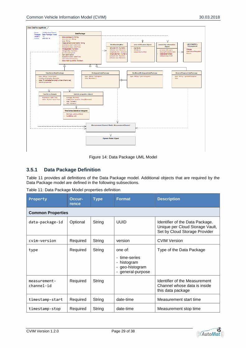
3.5 Data Layer Specification
Data Packages contain the actual data of Signal measurements. As Signals are the information providers and Measurement Channels define the process of data acquisition from those Signals, Data Packages provide a structure for storing the data. In addition, they provide meta / header information containing time of recording, data ownership information, etc. Data Packages contain data from exactly one Measurement Channel. This leads to four different types of Data Packages that are defined similar as the Measurement Channels:
- Time Series Data Package - Histogram Data Package - Geo-Histogram Data Package - General Purpose Data Package
The UML Model of the Data Package is shown in Figure 14.
Common Vehicle Information Model (CVIM) 30.03.2018
CVIM Version 1.2.0 Page 29 of 38
Figure 14: Data Package UML Model
3.5.1 Data Package Definition
Table 11 provides all definitions of the Data Package model. Additional objects that are required by the Data Package model are defined in the following subsections.
Table 11: Data Package Model properties definition
Property Occur-rence
Type Format Description
Common Properties
data-package-id Optional String UUID Identifier of the Data Package. Unique per Cloud Storage Vault, Set by Cloud Storage Provider
cvim-version Required String version CVIM Version
type Required String one of:
- time-series - histogram - geo-histogram - general-purpose
Type of the Data Package
measurement-channel-id
Required String Identifier of the Measurement Channel whose data is inside this data package
timestamp-start Required String date-time Measurement start time
timestamp-stop Required String date-time Measurement stop time
Common Vehicle Information Model (CVIM) 30.03.2018
CVIM Version 1.2.0 Page 30 of 38
mileage-start Optional Number double Mileage at the start of the meas-urement in kilometres (km)
mileage-stop Optional Number double Mileage at end of measurement in kilometres (km)
trip-id Optional String any Trip-ID of the User
vault-id Optional String UUID ID of the Cloud Storage Vault, where the data is stored in.
geo-bounding-box
Optional Object Geo-Bounding-Ob-ject
Geographic bounding box, see section 3.5.1.1
oem-certifica-tion
Optional Object OEM-Certification-Object
OEM Certification, see section 3.5.1.2
data-ownership-information
Optional Object Ownership-Infor-mation – Object
Data Ownership Information, see section 3.5.1.3
expiration-date Optional String date-time Data expiration date
data-masking-active
Optional Boolean Indicates status of data-masking (true = active)
Time Series Data Package
type Required String "time-series" Type of the Measurement Chan-nel needs to be time-series
number-of-sam-ples
Required Number uint32 Number of samples that are stored in data
statistic-prop-erties
Optional Object statistic-properties-object
Provides statistic properties about the data, see section 3.5.1.4
data Required Array time-series key-value-pair – object
Array of time-series-data Ob-jects. The size of the array must equal number of samples, see section 0
Histogram
type Required String histogram Type of the Measurement Chan-nel needs to be histogram
data Required (Multidi-men-sional) Ar-ray
Number Array containing the bin counts. Size of array must match the di-mension and bin configuration of the related Measurement Chan-nel. Number format depends on Histogram aggregation-strategy
Geo-Histogram Data package
type Required String geo-histogram Type of the Measurement Chan-nel needs to be geo-histogram
Common Vehicle Information Model (CVIM) 30.03.2018
CVIM Version 1.2.0 Page 31 of 38
data Required (Multidi-men-sional) Ar-ray
Number Array containing the bin counts. Size of array must match the di-mension and bin configuration of the related Measurement Chan-nel. Number format depends on Histogram aggregation-strategy.
The outer most dimension is the geo-dimension. It must match in its size the size of the geo-tiles array.
geo-tiles Required Array Geo-Tile Object Array of geo-tile objects. Only visited tiles are included.
General Purpose Data Package
type Required String "general-purpose"
Type of the Measurement Chan-nel needs to be general-purpose
data Required Any Datatype depends on Measure-ment Channel
3.5.1.1 Geo-Bounding-Box Object
Table 12 lists all properties of the geo-bounding-box object that is required by the Data Package definition. The geo-bounding-box defines an area where the data inside the Data Package has been measured.
Table 12: Geo Bounding Box Object properties definition
Property Occur-rence
Type Format Description
latitude-min Optional Number double Minimum Latitude
latitude-max Optional Number double Maximum Latitude
longitude-min Optional Number double Minimum Longitude
longitude-max Optional Number double Minimum Longitude
altitude-min Optional Number double Minimum Altitude
altitude-max Optional Number double Minimum Altitude
3.5.1.2 OEM-Certification Object
Table 13 lists all properties of the OEM-Certification object that is required by the Data Package definition.
Table 13: OEM-Certification-Object property definition
Property Occur-rence
Type Format Description
signature Optional String OEM Signature
checksum Optional String Checksum over data package
sequence-number Optional String Sequence number to ensure quality of data packages

Common Vehicle Information Model (CVIM) 30.03.2018
CVIM Version 1.2.0 Page 32 of 38
3.5.1.3 Ownership-Information Object
Table 14 lists all properties of the data ownership information object that is required by the Data Package definition.
Table 14: Ownership-Information-Object property definition
Property Occur-rence
Type Format Description
privacy-veto-rights
Optional Object Privacy-veto-right-object
Privacy Veto Rights (see be-low)
copyright-stakeholders
Optional Array Copyright-stake-holders object
Copyright Stakeholders Infor-mation (see below)
data-stakehold-ers
Optional Array Data-stakeholders object
Data Stakeholders Information (see below)
data-privacy-level
Optional String one of:
- public - shared - private
Describes level of privacy of the data
Privacy-veto-rights
consent-level Optional String one of:
- public - shared - private
Describes the level of consent provide by the user
Data format Optional String one of:
- time series - histogram
Describes collecting constraint for a measurement channel
jurisdiction Optional String one of:
- Europe - any
Describes jurisdiction constraint
storage-con-straint
Optional String one of:
- OEM storage - Personal storage
Describes storage constraint22
Copyright-Stakeholders
name Required String Stakeholder identi-fication
Identification of copyright stake-holder
status Required String one of:
- creator - other
Ownership status. See also sec-tion 3.2.4.
Data-Stakeholders
name Required String Stakeholder identi-fication
Identification of data stakeholder
22 AutoMat will only support OEM storage for the project.

Common Vehicle Information Model (CVIM) 30.03.2018
CVIM Version 1.2.0 Page 33 of 38
status Required String One of:
- data controller - data processor
Role status
3.5.1.4 Statistic-Properties Object
Table 15: Statistic Properties Object property definition
Property Occur-rence
Type Format Description
min Optional Number According to Signal Values
Minimum value
max Optional Number According to Signal Values
Maximum value
average Optional Number double Average
histogram Optional Object Statistic-Properties-Histogram-Object
Statistics Properties Histogram Object
Example 6 Statistic Properties Object Example
{ "histogram": { "data": [13.15, 124.75, 12.05, 0.0, 0.0, 0.0, 0.0], "measurement-channel-id": "172" }, "min": 0, "max": 2355, "average": 198.41 }
3.5.1.5 Statistic-Properties-Histogram-Object
Table 16: Statistic Properties Histogram Object property definition
Property Occur-rence
Type Format Description
data Manda-tory
Array Array of <According to measurement channel definition>
Minimum value
measurement-channel-id
Optional String Measurement-Channel-Id de-scribing the histogram in data.
3.5.1.6 Time-Series Key-Value-Pair Object
The time series data item is itself a two dimensional array. Its first item is a timestamp of the measurement, the second the actual measured value. Table 17 provides all properties of the object. Example 8 gives an example of one key-value-pair object. Here, a GPS Position in form of latitude (48.77) and longitude (9.17) were measured on 27.12.2017 at 11:20:01.001.

Common Vehicle Information Model (CVIM) 30.03.2018
CVIM Version 1.2.0 Page 34 of 38
Table 17: Time-Series-Data Object property definition
Property Occur-rence
Type Format Description
timestamp Required String date-time Timestamp of the measurement
value Required,
when di-mension == 1
Any <According to measurement channel definition>
Value of the measurement
value Required, when di-mension > 1
Array <According to measurement channel definition>
Values of the measurement
1st Array-Item: Signal 1 value, 2nd Array-Item: Signal 2 value, ...
Example 7 Time-Series Key-Value-Pair Object Example of 1D Time-Series
"timestamp": "2016-12-27T11:20:01.001Z", "value": [ 48.771682, 9.176587 ]
Example 8 Time-Series Key-Value-Pair Object Example of 2D Time-Series
"timestamp": "2016-12-27T11:20:01.001Z", "value": [ 48.771682, 9.176587 ]
3.5.1.7 Geo-Histogram Geo-Tile Object
The following Table 18 describes the geo-tile object properties, which are required by the Geo-Histogram data package definition. Below, Example 9 gives an example of a geo-tile object.
Table 18: Geo-Tile Object property definition
Property Occur-rence
Type Format Description
latitude Required Numeric Float Center latitude coordinate of the geo-tile
longitude Required Numeric Float Center longitude coordinate of the geo-tile
Example 9 Geo-Tile Object Example
{ "latitude": 52.422656, "longitude": 10.760192 }

Common Vehicle Information Model (CVIM) 30.03.2018
CVIM Version 1.2.0 Page 35 of 38
3.5.2 Data Package Examples
In the following subsection, different examples of Data Packages are shown.
Time Series Data Package
Example 10 shows a Time Series Data Package. The data was recorded over a period of ten seconds from the Measurement Channel that has been defined in Example 4. The vehicle drove around 50 km/h and created ten samples.
Example 10 Time Series Data Package
{ "data-package-id": "...", "cvim-version": "1.2.0", "type": "time-series", "measurement-channel-id": "9031", "timestamp-start": "2017-07-06T08:00:00.00Z", "timestamp-stop": "2017-07-06T08:00:09.00Z", "mileage-start": 100.00, "mileage-stop": 100.14, "geo-bounding-box": { "latitude-min": 51.497615, "latitude-max": 51.497688, "longitude-min": 7.451854, "longitude-max": 7.453866, } "data-masking-active": false "number-of-samples": 4, "statistic-properties": { "min": 48.0, "max": 52.0, "average": 50.0 } "data": [ {"timestamp": "2017-07-06T08:00:00.00Z", "value": 50.0}, {"timestamp": "2017-07-06T08:00:01.00Z", "value": 51.0}, {"timestamp": "2017-07-06T08:00:01.95Z", "value": 52.0}, {"timestamp": "2017-07-06T08:00:03.00Z", "value": 51.0} ] }
Common Vehicle Information Model (CVIM) 30.03.2018
CVIM Version 1.2.0 Page 36 of 38
Histogram Data Package
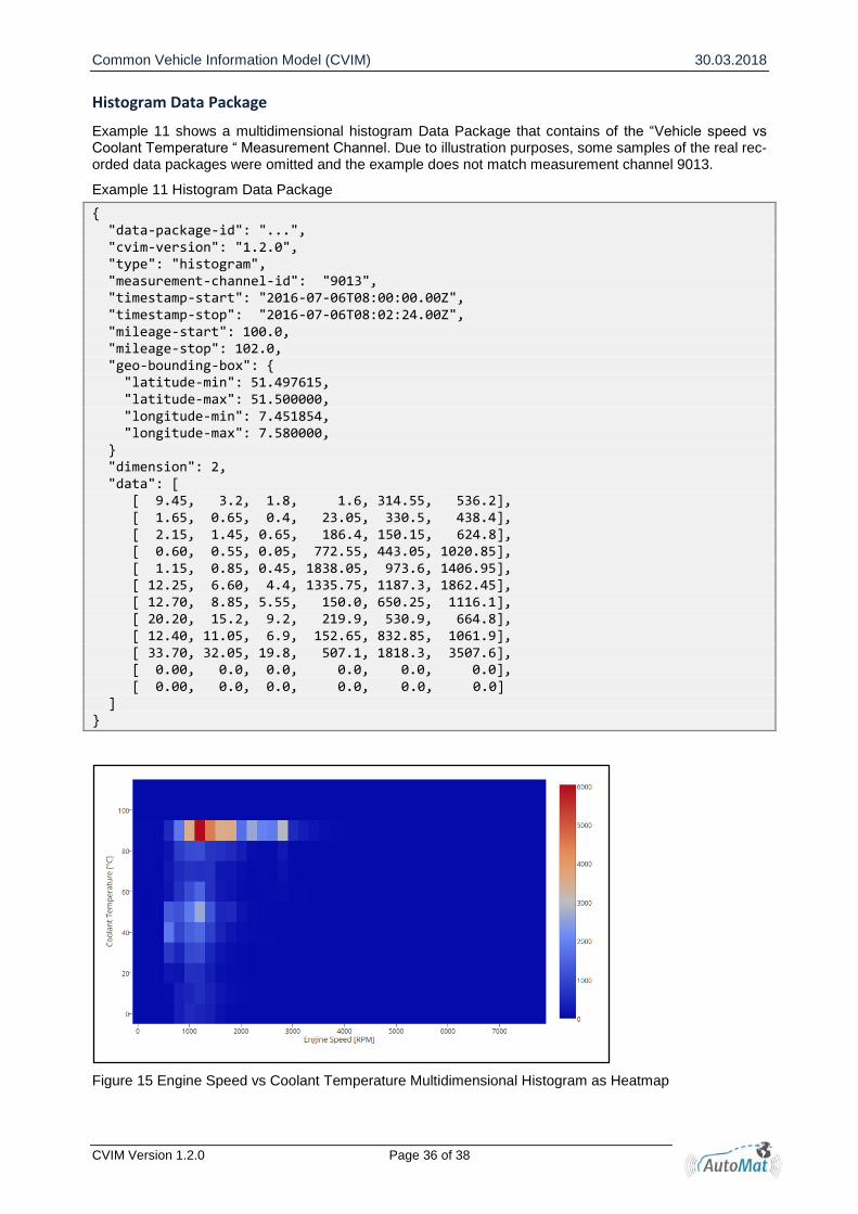
Example 11 shows a multidimensional histogram Data Package that contains of the “Vehicle speed vs Coolant Temperature “ Measurement Channel. Due to illustration purposes, some samples of the real rec-orded data packages were omitted and the example does not match measurement channel 9013.
Example 11 Histogram Data Package
{ "data-package-id": "...", "cvim-version": "1.2.0", "type": "histogram", "measurement-channel-id": "9013", "timestamp-start": "2016-07-06T08:00:00.00Z", "timestamp-stop": "2016-07-06T08:02:24.00Z", "mileage-start": 100.0, "mileage-stop": 102.0, "geo-bounding-box": { "latitude-min": 51.497615, "latitude-max": 51.500000, "longitude-min": 7.451854, "longitude-max": 7.580000, } "dimension": 2, "data": [ [ 9.45, 3.2, 1.8, 1.6, 314.55, 536.2], [ 1.65, 0.65, 0.4, 23.05, 330.5, 438.4], [ 2.15, 1.45, 0.65, 186.4, 150.15, 624.8], [ 0.60, 0.55, 0.05, 772.55, 443.05, 1020.85], [ 1.15, 0.85, 0.45, 1838.05, 973.6, 1406.95], [ 12.25, 6.60, 4.4, 1335.75, 1187.3, 1862.45], [ 12.70, 8.85, 5.55, 150.0, 650.25, 1116.1], [ 20.20, 15.2, 9.2, 219.9, 530.9, 664.8], [ 12.40, 11.05, 6.9, 152.65, 832.85, 1061.9], [ 33.70, 32.05, 19.8, 507.1, 1818.3, 3507.6], [ 0.00, 0.0, 0.0, 0.0, 0.0, 0.0], [ 0.00, 0.0, 0.0, 0.0, 0.0, 0.0] ] }
Figure 15 Engine Speed vs Coolant Temperature Multidimensional Histogram as Heatmap

Common Vehicle Information Model (CVIM) 30.03.2018
CVIM Version 1.2.0 Page 37 of 38
Geo-Histogram Data Package
Example 12 shows a geo-histogram Data Package. In comparison to the basic histogram, the geo-tiles attribute is added. Geo-tiles include the center coordinate of each visited geo tile. The data attribute is shifted by one additional dimension, which needs to match the number of visited geo-tiles.
Example 12 Geo-histogram Data Package
{ "cvim-version": "1.2.0", "measurement-channel-id": "255", "vault-id": "4afe345b-abef-4d4a-aad0-a2a35994b444", "timestamp-start": "2017-10-04T10:55:49Z", "timestamp-stop": "2017-10-05T04:02:11Z", "trip-id": "3176124", "geo-bounding-box": { "latitude-max": 52.434944, "latitude-min": 52.422656, "longitude-max": 10.797056, "longitude-min": 10.760192 }, "type": "geo-histogram", "geo-tiles": [ {"latitude": 52.422656, "longitude": 10.760192}, {"latitude": 52.422856, "longitude": 10.760592}, {"latitude": 52.432656, "longitude": 10.780192}, {"latitude": 52.434944, "longitude": 10.797056} ], "data": [ [ 9.45, 3.20, 1.80, 1.60, 314.55, 536.20], [ 1.65, 0.65, 0.40, 23.05, 330.50, 438.40], [ 2.15, 1.45, 0.65, 186.40, 150.15, 624.80], [ 0.60, 0.55, 0.05, 772.55, 443.05, 1020.85] ] }