commonwealth of the northern mariana islands joint...
TRANSCRIPT

CJMT EIS/OEIS Chapter 4, Environmental Consequences April 2015 Draft Programmatic Analysis
4-503
PROGRAMMATIC ANALYSIS OF FUTURE POTENTIAL PROJECT 4.18COMPONENTS
The proposed action presented in this EIS/OEIS includes until level and combined level RTA construction and operation as presented in Chapter 2, and analyzed in Chapter 4 for each resource. Two additional projects that are not included within the proposed action presented in this EIS/OEIS are anticipated to be implemented at a future and unknown date in support of the CJMT effort. The two projects are: (1) relocation of the existing International Broadcasting Bureau on Tinian and (2) construction and operation of a new dock and associated breakwater on Pagan. These two projects are presented and analyzed in the following section programmatically and in a broader context than the proposed action analyzed in this EIS/OEIS.
A programmatic approach is considered the most effective way to characterize these future potential projects. Programmatic environmental analyses of this type are conducted when a federal agency plans or contemplates a broad action or program, the specific details of which have not yet been defined. The intention is to comply with Council on Environmental Quality guidance that recommends integration of the environmental process with other planning efforts at the earliest possible time to ensure that planning and decisions reflect environmental value. A programmatic analysis at a conceptual level of detail provides early identification and analysis of potential impacts, methods to mitigate anticipated impacts, and a strategy to address issues at a tiered level if necessary.
The CJMT EIS/OEIS proposed action could require relocating the International Broadcasting Bureau facility on Tinian, currently located in the Military Lease Area. Based on a relocation study completed in 2014, other locations are being considered including on Tinian, in the CNMI or Guam. Specifically, Tinian Alternatives 2 or 3 could require relocating the International Broadcasting Bureau facility to accommodate a unit level RTA in the Military Lease Area. The new International Broadcasting Bureau facility must be completely and fully operational before relocation occurs.
Construction of a dock and associated breakwater on Pagan is also being considered. Proposed raining on Pagan could be enhanced by constructing and operating a new dock and associated breakwater on Pagan to facilitate movement of supplies, equipment and personnel.
If, in the future, there is a decision to move forward with either of these projects, then the appropriate level of project-specific environmental studies and consultations would be conducted. Additional NEPA analyses and agency consultations would be completed to address those changes as warranted. Subsequent NEPA documentation could tier from this EIS/OEIS and use the framework of the following programmatic analysis as a foundation to further address the potential impacts of those site-specific actions.
This section presents the programmatic environmental analyses of these two future potential project components. Section 4.18.1 is a programmatic analysis of potential environmental impacts of the International Broadcasting Bureau relocation, and Section 4.18.2 is a programmatic analysis of potential environmental impacts of a new Pagan dock and breakwater.

CJMT EIS/OEIS Chapter 4, Environmental Consequences April 2015 Draft Programmatic Analysis
4-504
International Broadcasting Bureau Programmatic Analysis 4.18.1The International Broadcasting Bureau on Tinian is one of two transmitter sites in the CNMI: one on Tinian and the other on Saipan. The Bureau’s mission is to promote freedom and democracy through communication of accurate, objective, and balanced news to audiences overseas. The International Broadcasting Bureau facility on Tinian provides high-power shortwave transmissions for the following organizations and target audiences:
Radio Free Asia: China, North and South Korea, all of Southeast Asia, and Tibet Voice of America: China, East Asia, Korea, and South Asia Australian and British Broadcasting Corporations: Indonesia
The CJMT EIS/OEIS proposed action would require relocating the International Broadcasting Bureau facility on Tinian, currently located in the Military Lease Area, to another location in the CNMI or Guam. Specifically, Tinian Alternatives 2 or 3 would require relocating the International Broadcasting Bureau facility to accommodate the establishment of a unit level RTA in the Military Lease Area.
A relocation study to identify potential sites was conducted in 2013-14. This section introduces the objectives of that study, presents a summary of the siting requirements applied to identify potential relocation sites, identifies and describes the viable relocation sites, and then broadly or programmatically evaluates the environmental consequences of the International Broadcasting Bureau facility relocation to the alternative sites. If there is a decision to move forward with relocating the International Broadcasting Bureau in the future, then more detailed and project-specific environmental studies, consultations, NEPA documentation, and public review will be undertaken.
4.18.1.1 Relocation Study The International Broadcasting Bureau-Voice of America Tinian Transmitter Station Relocation Study (Relocation Study) evaluated potential locations for siting the International Broadcasting Bureau. The scope of the Relocation Study limited the evaluation of potential locations to within the CNMI and Guam (DoN 2014a). Transmitter station operational requirements were based on those identified in the International Broadcasting Bureau-Voice of America Tinian Transmitter Station Requirements Study (DoN 2013) and then further refined as part of the Relocation Study.
According to the Relocation Study, relocation site considerations focused primarily on technical- and construction-related requirements. The following are the minimum requirements for a site to be suitable for transmitter establishment:
Be relatively flat, and depending on location be between 200 and 285 acres (81 and 114 hectares) in size (i.e., large enough to accommodate the antennae array, associated facilities comprising the transmitter station, and security fencing)
On property owned by the U.S. or by a host government that allows unrestricted rights to broadcast programming to meet the International Broadcasting Bureau’s mission
Be positioned so that antennas can transmit to the target audiences Be separated from adjoining land uses to afford worker safety within, and minimize radio
frequency interference outside of the transmitter site

CJMT EIS/OEIS Chapter 4, Environmental Consequences April 2015 Draft Programmatic Analysis
4-505
Have appropriate infrastructure such as roads, utilities (e.g., electricity, communication lines, potable water), and community support
Be able to accommodate, in existing airports and sea ports, the weight and size of equipment (construction and transmitters) needed for station establishment
Potential relocation sites needed to be in the CNMI or on Guam to be considered viable because the sites need to be within an area where the station can broadcast to its audiences. The only locations where the minimum requirements listed above were met were on Rota, Saipan, Tinian, and Guam. In total, 7 sites were first identified for potential Tinian transmitter station relocation: 3 on Rota, 2 on Saipan, 1 on Tinian, and 1 on Guam. Through further refinement and requirements application, four sites were determined as feasible relocation candidates for more in-depth evaluation. These four candidate sites included one location each on Rota, Saipan, Tinian, and Guam (DoN 2014a).
Potential Rota Site 4.18.1.1.1
The potential transmitter site on Rota is located on the south side of the island on a plateau that is centrally located between the east and west coast, northeast of Teneto Village on the CNMI public land (Figure 4.18-1). The site is relatively flat and has sufficient area to support the relocation of the transmitter station. There is adequate infrastructure to support communications needs; however, the on-island power supply and access roads would need upgrading. There is sufficient separation from adjacent land uses to ensure safety and avoid radio frequency exposure. While there is capacity at the airport to accommodate cargo, ocean shipment of materials and equipment would be limited due to the crane capacity and water depth in harbor. Housing may be in short supply to accommodate the approximately 25 transmitter personnel.
Potential Saipan Site 4.18.1.1.2
The potential transmitter site on Saipan is located on the north side of the island near the west coast (east of Chalan Pale Arnold Road, west of Marpi Road). The southernmost array would be on the south side of Ayuyu Drive on both the CNMI Government and private lands (Figure 4.18-2). The site has steep terrain but is of sufficient size to accommodate the antennae field, associated facilities, and security fencing. There is adequate infrastructure to deliver electricity, support communications needs, and provide road access. There is sufficient separation from adjacent land uses to ensure safety and avoid radio frequency exposure. The airport and port are adequate to receive construction material and transmitter equipment shipments and enough on-island housing to accommodate the transmitter personnel.
Potential Tinian Site 4.18.1.1.3
The potential transmitter site on Tinian is located on the extreme south end of the island on the Carolinas plateau, which is centrally located between the east and west coast of the island (Figure 4.18-3). The site is relatively flat and of sufficient size to accommodate the antennae field, associated facilities, and security fencing. There is adequate infrastructure to deliver electricity, support communications needs, and provide road access. There is sufficient separation from adjacent land uses to ensure safety and avoid radio frequency exposure. The airport and port are adequate to receive construction material and transmitter equipment shipments and enough on-island housing to accommodate the transmitter personnel.

Rota International Airport
Song Song Village
SasanhayaBay
Alaguan Bay
Wedding Cake Mountain
Teneto Village
Philippine Sea
Pacific Ocean
Figure 4.18-1Potential Rota Site N
LegendPotential Relocation Site - Fenced Area
0 1 20.5Miles
0 1 20.5Kilometers
4-506

Makpi Parkway
Saipan International Airport
Bird IslandAyuyu Drive
Lao Lao Bay
Susupe
Garapan
Philippine Sea
Pacific Ocean
Figure 4.18-2Potential Saipan Site N
LegendPotential Relocation Site - Fenced Area
0 1 20.5Miles
0 1 20.5Kilometers
Chalan
Pale A
rnold R
oad
Chala
n Pale
Arno
ld Ro
ad
Isla Drive
4-507

State
Stre
et
Grand Avenue
Masa
lok B
each
Roa
d
Broa
dway
42nd Street
8th Avenue86th Street
96th Street 96th Street
8th Av
enue
123rdStreetRive
rside D
rive 124th Street
Broa
dway
Figure 4.18-3Potential Tinian Site N
LegendMilitary Lease AreaPotential Relocation Site - Fenced Area
0 1 20.5Miles
0 1 20.5Kilometers
4-508

CJMT EIS/OEIS Chapter 4, Environmental Consequences April 2015 Draft Programmatic Analysis
4-509
Potential Guam Site 4.18.1.1.4
The potential transmitter site on Guam is located primarily on Government of Guam property with a small portion on private land, in the northwest portion of the island, south of Naval Computer and Telecommunications Station Finegayan and the former Federal Aviation Administration site, and west of South Finegayan Family Housing Area (Figure 4.18-4). The site is relatively flat and of sufficient size to accommodate the antennae field, associated facilities, and security fencing. There is adequate infrastructure to deliver electricity, support communications needs, and provide road access. There is sufficient separation from adjacent land uses to ensure safety and avoid radio frequency exposure. The airport and port are adequate to receive construction material and transmitter equipment shipments and enough on-island housing to accommodate the transmitter personnel. The potential site is notional and would be adjusted based on site-specific data (e.g., existing installation restoration sites).
4.18.1.2 Programmatic Analysis This summary of the programmatic environmental consequences provides a general analysis of the potential impacts of establishing a transmitter facility at any of the four site locations identified in the Relocation Study (DoN 2014a). The programmatic approach identifies potential environmental issues that inform the decision maker during the environmental review process. If in the future there is a decision to move forward with relocating the International Broadcasting Bureau, then, the appropriate level of environmental studies, consultations, and NEPA documentation and public review will be undertaken. Consultation with agencies may be required. Potential consultations include:
Endangered Species Act, Section 7: U.S. Fish and Wildlife Service and National Marine Fisheries Service
Magnuson-Stevens Fishery Conservation and Management Act: National Marine Fisheries Service
Marine Mammal Protection Act, National Marine Fisheries Service
National Historic Preservation Act, Section 106: Advisory Council on Historic Preservation, CNMI Historic Preservation Office, and Guam State Historic Preservation Office
Coastal Zone Management Act: CNMI Bureau of Environmental and Coastal Quality and Guam Bureau of Statistics and Plans
The programmatic analysis of potential impacts associated with the International Broadcasting Bureau relocation is presented generally for all sites below. Where possible, site-specific information is presented for each resource.

!"15!"1
!"9
!"3
!"5
!"2
!"15
Naval Computer and Telecommunications Station Finegayan
Andersen AirForce Base
Northwest Field
South Finegayan Family Housing Area
Andersen South
Barrigada
Naval Magazine
Naval Base Guam
Former Federal Aviation Administration Site
Guam International Airport
Philippine Sea
Pacific Ocean
Tumo n Bay
Ag an a Bay
Ap ra Harbo r
Ag at Bay
Co co s Lagoo n
Pag o Bay
LegendDoD PropertyPotential Relocation Site - Fenced Area
Figure 4.18-4Potential Guam Site N
0 2 41Miles
0 2 41Kilometers
4-510

CJMT EIS/OEIS Chapter 4, Environmental Consequences April 2015 Draft Programmatic Analysis
4-511
Geology and Soils 4.18.1.2.1
General 4.18.1.2.1.1
Given the known geology of the Mariana Islands, there is likely probability that sinkholes would be present at each of the sites. These geologic hazards would need to be identified and avoided or addressed during facility design and construction to avoid potential impacts. There also could be fault lines on the sites. For facilities, roadways, or other infrastructure where construction or other improvements that could not avoid fault lines, then engineering design would be require construction that would minimize any potential effects from earthquakes and associated fault ruptures. Buildings, facilities, and infrastructure would be designed, situated, and constructed in accordance with Unified Facility Criteria recommendations for seismic protection. The proposed International Broadcasting Bureau facility locations are each in a tsunami evacuation safe zone. A hazard communication and evacuation plan for site workers would be required as a construction safety best management practice.
Construction of the transmitter station would require site clearing, grubbing, and grading; excavating (cut); and filling. This could result in over 200 acres (81 hectares) of cleared land depending upon existing conditions at each site. Best management practices including soil and erosion controls would need to be followed during construction to minimize impacts on soils and other natural resources. There would be impacts associated with changes to topography including slope instability and alteration of surface drainage patterns that would need to be managed. These temporary effects could occur when excavation and fill would take place to form level surfaces for site development. There is a potential for increased erosion, compaction, and soil loss from physical disturbance caused by construction activities and changes to existing topography. Project design and construction would incorporate engineering controls as best management practices (see Appendix D, Best Management Practices) to minimize erosion as required by the CNMI Earthmoving and Erosion Control Regulations.
Site-specific information is described below.
Rota 4.18.1.2.1.2
The site is relatively flat, with a slight difference of about 40 feet (12 meters) in elevation across the site. This location has sufficient area for the transmitter station. The limestone formations may have sinkholes and below-ground voids, so further geotechnical investigation would be needed for this site. The majority of the soils are shallow, well-drained, and appear suitable for construction of the transmitter station. The site is above Sinapalu Village, which is designated as a tsunami evacuation safe zone. The site has no known fault zones or seismic features.
Saipan 4.18.1.2.1.3
There are relatively steep grades at this site, increasing from elevation 520 feet (158 meters) to 820 feet (250 meters) above MSL across the site. The site has a relatively constant rise across the proposed antenna field. The site continues to rise toward the north. These grades could be overcome through design and site grading. The limestone formations may have sinkholes and below-ground voids, so further geotechnical investigation would be needed for this site. The majority of the soil types are shallow, well-drained, and appear suitable for construction of the transmitter station. There are moderately steep soils and rock outcrops on a limestone plateau and side slopes. The site is above

CJMT EIS/OEIS Chapter 4, Environmental Consequences April 2015 Draft Programmatic Analysis
4-512
Capitol Hill, which is designated as a tsunami evacuation safe zone. The site has no known fault zones or seismic features.
Tinian 4.18.1.2.1.4
The site is relatively flat, with a change of about 40 feet (12 meters) across the site. It has sufficient area for the transmitter station. The limestone formations may have sinkholes and below-ground voids, so further geotechnical investigation would be needed for this site. The majority of the soil types are shallow, well-drained, and appear suitable for construction of the transmitter station. The site is above Tinian International Airport, which is designated as a tsunami evacuation safe zone. The site has no known fault zones or seismic features.
Guam 4.18.1.2.1.5
The site is basically flat, with a change of only about 20 feet (6 meters) across the site. It has sufficient area for the transmitter station. The limestone formations may have sinkholes and below-ground voids, so further geotechnical investigation would be needed for this site. The majority of the soil types are shallow, well-drained, and appear suitable for construction of the transmitter station. The site is high enough in elevation to be designated as a tsunami evacuation safe zone. Minor faults and fault zones exist north of the site. Presence of faults near sites would need to be addressed in facility design. In general, construction on fault lines would be avoided as much as practicable.
Water Resources 4.18.1.2.2
None of the sites contain intermittent or perennial surface water systems, although potential wetland areas are located at the Rota site. The Guam site overlies the northern Guam aquifer. No known groundwater aquifers are located immediately beneath the other sites.
Construction of the transmitter station would include clearing, grubbing, and grading; excavating (cut); and filling. These activities, all of which would increase the potential for erosion and sedimentation from exposed earth. During the construction phase and prior to any ground-disturbing activities, a Stormwater Pollution Prevention Plan (as required by the National Pollutant Discharge Elimination System permit program) would be submitted by construction contractors and approved by regulatory authorities. As required by the CNMI Bureau of Environmental and Coastal Quality, an erosion and sediment control plan would be developed based on a 25 year/24 hour duration storm event. Best management practices (e.g., silt fencing) and engineering controls (e.g., soil stabilization) would be implemented to minimize potential impacts to water resources during construction.
A comprehensive drainage and Low Impact Development study would be performed for the transmitter station site. Findings from the comprehensive drainage and Low Impact Development study would be used to inform and design the post-development stormwater management system.
Best management practices that would be implemented during construction to protect groundwater resources include vegetation buffers to protect sinkholes; limiting use of heavy equipment in areas that support groundwater recharge; proper abandonment of historic groundwater wells; and proper management of spills and leaks of hazardous materials and waste. Construction activities could result in the accidental release of pollutants (e.g., oil or chemicals) due to failure of a materials handling best

CJMT EIS/OEIS Chapter 4, Environmental Consequences April 2015 Draft Programmatic Analysis
4-513
management practice, which could affect groundwater quality through percolation. Any accidental release or spill of pollutants would be cleaned up immediately.
Air Quality 4.18.1.2.3
Operation of construction equipment and associated vehicles would result in short-term impacts to air quality at any of the potential sites. Operation of the facility once it is constructed would involve typical types of emissions sources such as vehicles, generators, and maintenance equipment. If average annual emissions during construction or annual operations are below the 250 tons (227 metric tons) per year threshold, construction would result in less than significant direct or indirect impacts to air quality. The transmitter station would not affect the operational capacity of existing utility systems. Therefore, no adverse air quality impacts from stationary sources (i.e., new or modified fixed or immobile facilities) would occur.
Noise 4.18.1.2.4
Earth-moving equipment (e.g., graders, excavators, dozers) and impact devices (e.g., pile drivers and jackhammers) are examples of heavy (large) equipment that would be used for construction. Smaller construction equipment includes generators, concrete saws, and compressors. Equipment and other construction activities typically generate noise levels ranging from 70 to 90 decibels at a distance of 50 feet (15 meters), see Appendix H, Noise Study (see Table 2.4-1) for specific equipment noise levels (U.S. Department of Transportation 2006).
From a noise perspective, construction activities are too distant to generate elevated noise levels that would be detectable in residential areas of Rota, Saipan, and Tinian. However, construction noise would potentially be audible at the military family housing area east of the Guam Site. In addition, construction noise would be audible to other sensitive land uses surrounding the various sites, such as World War II memorial sites (Rota and Tinian), a National Historic Landmark (Saipan), and a country club (Saipan). Operation of the facility would involve noise sources typical to an industrial facility. These would include vehicles and maintenance equipment. These activities would generate less noise than construction activities. Operational noise would not likely be audible at the sensitive land use locations mentioned above.
Airspace 4.18.1.2.5
The proposed sites are not adjacent to airports. The antenna heights would be the same as the existing International Broadcasting Bureau facilities, ranging between 150 feet (46 meters) and 400 feet (122 meters).Prior to constructing the new transmitter station, the Federal Aviation Administration would be contacted to ensure the tower height is compatible with aircraft safety restrictions.
Land and Submerged Land Use 4.18.1.2.6
It is possible that the U.S. military would need to prepare a Coastal Zone Management Federal Consistency Determination. Depending on the location, the determination would be submitted to the CNMI Bureau of Environmental and Coastal Quality or to the Guam Bureau.

CJMT EIS/OEIS Chapter 4, Environmental Consequences April 2015 Draft Programmatic Analysis
4-514
Rota 4.18.1.2.6.1
The site is on publicly owned land (by the CNMI government) within the Sabana Conservation Area. Nearby land uses include a small botanical garden, a World War II memorial, a communications tower, and a small firing range. The communication tower would be incompatible with the proposed transmitter station and would need to be relocated. Other land uses would not be affected. Therefore, this site is moderately compatible with existing land uses.
Saipan 4.18.1.2.6.2
The site is a combination of private and publicly owned land (the CNMI government). The land south of the site (adjacent to the two proposed southernmost antennas) is owned by the Marianas Country Club. The antennas could affect access to several holes on the golf course. In addition, private land to the west would need to be acquired due to the proximity of the radio frequency hazard zone.
The northern portion of the transmitter site would be located in the National Park Service’s Marpi National Historic Landmark. This is also the location of the Suicide Cliff Overlook. The central portion of the site is on a recently disestablished Far East Broadcasting Corporation Station site. This area is owned by the CNMI government and leased to a private party. Overall, this site would not be compatible with current land uses in the area as it is immediately adjacent to a country club and the Marpi National Historic Landmark.
Tinian 4.18.1.2.6.3
The site is on publicly owned land (by the CNMI government) south of the Kastiyu Wildlife Preserve and west of a World War II memorial located at the cliff edge. The antenna and facilities placement would not affect the memorial or other land uses nearby. This site is compatible with existing land uses.
Guam 4.18.1.2.6.4
The site is a combination of private and publicly owned land (Guam government). The site is situated on a plateau with a cliff to the west. The areas north and south of the site are vacant, and the area to the east is military family housing. The lands are owned by the Government of Guam but are in the process of being returned to the people of Guam through a judicial process. The portion of the site to the south is on private land that would need to be acquired. This site is moderately compatible with existing land uses.
Recreation 4.18.1.2.7
For each of the potential sites construction materials and equipment would come through the harbor and/or airport. Materials would be delivered to the construction sites via surface roadways. Introducing slow-moving construction vehicles to the roadways could affect the public’s access to recreational resources on island. The increased traffic and slow operation of construction vehicles could result in negative impacts to visitor access to, and their overall experience of, recreational resources on island. Operations would not affect recreation.
Terrestrial Biology 4.18.1.2.8
Construction would involve vegetation removal to clear areas within the project site. In addition, birds in the immediate vicinity of construction activities may be disturbed by noise and human activities. Nests

CJMT EIS/OEIS Chapter 4, Environmental Consequences April 2015 Draft Programmatic Analysis
4-515
may be susceptible to abandonment by adults and predation of eggs or young. This would temporarily displace birds, causing them to expend additional energy, some of which may be lost or have reduced breeding success. Direct mortality from construction equipment is unlikely because noise associated with pre-construction activities and human presence is likely to disperse wildlife prior to any equipment use, although vehicle traffic would increase the potential for wildlife collisions. The noise impacts would be short-term and minor. Impacts would be minimized by implementing resource management measures summarized in Section 4.9.2 and presented in detail in Appendix D, Best Management
Practices. Endangered Species Act, Section 7 consultation may be needed with U.S. Fish and Wildlife Service.
Rota 4.18.1.2.8.1
The site is within the Sabana Conservation Area and is within critical habitat designated under the Endangered Species Act for a federally endangered bird, the Rota bridled white-eye, and adjacent to critical habitat for the federally endangered Mariana crow. Construction would include the removal of native limestone forest. Construction of the new transmitter station site would directly affect critical habitat, and there could be indirect effects. Potential indirect operational effects to the bird species include the potential for birds to strike the antennae or fencing, as well as be subject to the electromagnetic radiation from the antennae.
Saipan 4.18.1.2.8.2
The project area supports three endangered bird species: nightingale reed-warbler, Micronesian megapode, and Mariana swiftlet. Construction of the proposed transmitter station site would directly impact reed-warbler and megapode habitat. In addition, potential indirect operational effects to the bird species include the potential for birds to strike the antennae or fencing, as well as be subject to the electromagnetic radiation from the antenna.
Tinian 4.18.1.2.8.3
There are no known wildlife species of concern at this site.
Guam 4.18.1.2.8.4
The site is in an area defined by the U.S. Fish and Wildlife Service as “recovery habitat” for the endangered Guam Micronesian kingfisher, Guam rail, Mariana crow, and Mariana fruit bat. Construction of the proposed transmitter station site would directly impact recovery habitat, and there could be indirect effects. Impacts to recovery habitat would be unavoidable but would be minimized to the maximum extent possible.
Marine Biology 4.18.1.2.9
There would be no marine biology impacts associated with the proposed relocation. All potential sites under consideration would be on land and would not have a marine component.
Cultural Resources 4.18.1.2.10
Construction could adversely impact historic properties in the project footprint. There are no historic resources at the Rota and Guam sites. The Saipan site is within the Marpi National Historic Landmark and Suicide Cliff Overlook. The Tinian site does not have historic resources but is adjacent to a World

CJMT EIS/OEIS Chapter 4, Environmental Consequences April 2015 Draft Programmatic Analysis
4-516
War II memorial. Cultural resource surveys would need to be conducted at each of the sites to confirm the presence or absence of archaeological resources. National Historic Preservation Act, Section 106 may be needed with Advisory Council on Historic Preservation, CNMI Historic Preservation Office, and/or Guam State Historic Preservation Office.
Visual Resources 4.18.1.2.11
Due to their height, all or most of the antennas would be visible from many key observation points surrounding each site. Due to topography at the Rota site, the antennas would not be visible from the northern, western, or southern areas outside the site. Due to topography in northern Saipan, the antennas would be visible along the western coastline. Suicide Cliff Overlook is north of the Saipan site, and views from this location would also be affected by the Saipan transmitter station facilities. The Tinian site is situated in the southeastern part of the island below a ridgeline, so views of the antennas would be limited primarily to that part of the island. The Guam site is relatively flat, so the antennas would be visible from most locations surrounding the site.
Transportation 4.18.1.2.12
Construction of the new International Broadcasting Bureau facilities would be limited to grading, excavation, construction of structures and antennae, and installation of automation equipment. Depending on how rapidly construction is completed, construction workers may be onsite for many months. Off-island workers would likely be used for to construct the facilities. They would reside on island throughout the construction phase. Throughout the construction period, intermittent impacts to traffic circulation may result from the movement of trucks containing construction and debris removal materials, as well as from construction workers commuting. This increase in traffic volumes on roadways could affect traffic circulation or roadway Level of Service. Construction truck movements may result in generally isolated impacts that could include, but would not be limited to, congestion, slower speeds in construction zones, temporary roadway closures, and short detours that may be caused by equipment movement, delivery of construction materials, removal of construction debris, and construction of roadway improvements.
Most of the construction activities would occur within the project footprint, and as such, very limited transportation and circulation impacts from construction are anticipated. Implementation of a traffic management plan and work zone traffic management would minimize construction impacts on vehicular travel and bicycle and pedestrian circulation, and access to destinations near the construction area.
Implementation of these best management practices (see Appendix D, Best Management Practices) would lessen potential construction effects to traffic circulation or roadway Level of Service for vehicles, public transit, pedestrians, or bicycles, increase the rate of traffic related accidents, or reduce transportation safety.
The antenna structures are potential hazards for aircraft. However, none of the sites is near an airfield or airport. Although construction materials may be shipped to the island, the number of vessel trips would likely be minimal.
Site-specific information is described below.

CJMT EIS/OEIS Chapter 4, Environmental Consequences April 2015 Draft Programmatic Analysis
4-517
Rota 4.18.1.2.12.1
Transportation of construction materials to Rota would be limited due to the crane capacity and water depth at the harbor. Thus, additional shipments would be needed for this site in relation to the other sites. Delivery of fuel oil would be via fuel tanker trucks from the east harbor. The road from Sinapalu to the Sabana Conservation Area would need improvement to provide access for construction and daily access for workers once the site is operational. A new road would be required to provide access to the operations support area. The access road from the west side of the island would need to be closed to prevent access to the plateau before the hazard area of the antenna field. The Rota International Airport can accommodate Boeing 757s with restricted landing and takeoff loads. Prior to constructing the new transmitter station, the Federal Aviation Administration would be contacted to ensure the tower height is compatible with aircraft safety restrictions. The Rota West Harbor has a narrow channel and cannot accommodate large vessels. It has boat slips and a couple of storage companies. There is no bulk fuel storage at this harbor, and the crane is rated to lift only 20-ton (18,144-kilogram) containers.
Saipan 4.18.1.2.12.2
A roadway (Ayuyu Drive) bisects the site, so the antenna arrays would be placed on either side of the road. This would require the road to be closed to the general public, thus affecting local vehicle traffic. Delivery of fuel oil would be via fuel tanker trucks from the Port of Saipan. Ayuyu Drive from Chalan Pale Arnold Road to Matansa Drive would require improvement to about 8,400 feet (2,560 meters) of road. This would be necessary to provide access for construction vehicles, as well as daily access for employees once the site is operational. Saipan International Airport can accommodate DC-10s and Boeing 747s. Prior to constructing the new transmitter station, the Federal Aviation Administration would be contacted to ensure the tower height is compatible with aircraft safety restrictions. The Port of Saipan has a deep channel, and it has two fuel storage facilities plus a bulk cement company.
Tinian 4.18.1.2.12.3
Delivery of fuel oil would be via fuel tanker trucks from Tinian Harbor. Fuel oil is delivered to the harbor fuel tanks one time per month. The current access road would require improvements, and a new road would be needed to access the administration area. The Tinian International Airport currently accommodates single-engine aircraft with a capacity of 36 passengers. Prior to constructing the new transmitter station, the Federal Aviation Administration would be contacted to ensure the tower height is compatible with aircraft safety restrictions. The main wharf at the Tinian Harbor is 2,000 feet (610 meters) long and has two piers on the southwest side, both of which are in a state of disrepair.
Guam 4.18.1.2.12.4
The site is close to existing roadways. Transportation of construction materials to Guam is not restricted by the harbor or airport size. Delivery of fuel oil would be via fuel tanker trucks from the Golf Pier in the harbor. The existing road from Route 3 and some of Royal Palm Drive would need improvement to support construction and operations of the facility. A new road would be required to the entrance of the site. The Guam International Airport can accommodate large aircraft. Prior to constructing the new transmitter station, the Federal Aviation Administration would be contacted to ensure the tower height is compatible with aircraft safety restrictions. Apra Harbor is a deepwater port that includes a container terminal, fuel oil piers, and laydown yards.
CJMT EIS/OEIS Chapter 4, Environmental Consequences April 2015 Draft Programmatic Analysis
4-518
Utilities 4.18.1.2.13
Site-specific information is described below.
Rota 4.18.1.2.13.1
The electrical power system on the island would require additional generating capacity as well as replacement of some overhead power lines to support operation of the transmitter station. An additional 6.0 megawatts of generating capacity would need to be added to the island power supply. Water supply via filtered rainwater is adequate for the proposed facility. Bottled water would be used for drinking water. Wastewater would be handled with an onsite package sewage treatment system with discharge to a leach field. Solid waste would be collected and disposed of by private contractors. However, there is not a permitted landfill on Rota. Commercial carriers for telephone, internet, and television are available on the island.
Saipan 4.18.1.2.13.2
The overhead power line feeder from Power Plant I and II may be insufficient to provide adequate power to the site. This feeder line would need to be replaced. In addition, the transmitter transmission lines to the two southernmost antennas would need to be routed over Ayuyu Drive. Water supply via filtered rainwater is adequate for the proposed facility. Bottled water would be used for drinking water. Wastewater would be handled with an onsite package sewage treatment system with discharge to a leach field. Solid waste would be collected and disposed of by private contractors. Commercial carriers for telephone, internet, and television are available on the island.
Tinian 4.18.1.2.13.3
The existing overhead power lines from the power plant are insufficient to provide adequate power. These lines would need to be replaced. Water supply via filtered rainwater is adequate for the proposed facility. Bottled water would be used for drinking water. Wastewater would be handled with an onsite package sewage treatment system with discharge to a leach field. Solid waste would be collected and disposed of by private contractors. However, there is not a permitted landfill on Tinian. Commercial carriers for telephone, internet, and television are available on the island.
Guam 4.18.1.2.13.4
The site is close to existing roadways and utility infrastructure. It has adequate on-island power, municipal potable water, and municipal sanitary sewer system. Solid waste and hazardous waste can be collected and disposed of by private contractors. Commercial carriers for telephone, internet, and television are available on the island.
Socioeconomics and Environmental Justice 4.18.1.2.14
At any of the potential locations, construction work associated with the relocation would generate economic benefits. If the International Broadcasting Bureau is relocated to Rota, then some temporary construction workforce housing would likely need to be constructed to support construction activities.
International Broadcasting Bureau operations should generate economic benefits. Sufficient public services and housing capacity exist on Guam, Saipan, and Tinian to avoid stresses related to the

CJMT EIS/OEIS Chapter 4, Environmental Consequences April 2015 Draft Programmatic Analysis
4-519
estimated 25 permanent employees. However, additional population related to these employees may put some strain on Rota public services.
Hazardous Materials and Waste 4.18.1.2.15
Candidate sites would be screened for the presence of contamination on land proposed for development or use following the potential relocation. Neither Rota nor Tinian has a permitted landfill that would handle hazardous waste. Any hazardous materials used during construction or operations would be handled according to applicable federal and local regulations. Any generated hazardous waste would be collected and transferred by private contractors to licensed operators for regulated disposal of hazardous waste.
Hazardous Materials 4.18.1.2.15.1
Construction activities would include vegetation removal, grading, excavation, and construction. Construction activities would cause a short-term increase in the use of hazardous materials that would end when the construction is finished. Most of the hazardous materials expected to be used are common to construction (e.g., diesel fuel, gasoline, and propane; hydraulic fluids, oils, and lubricants; welding gases; paints and solvents; adhesives; and batteries). The increased volume and use of hazardous materials during the construction period would present a potential for increased accidental spills and releases of hazardous materials, resulting in potential impacts to human health (direct impacts) and the environment (i.e., soils, surface water, groundwater, air, plants and animals [indirect impacts]). The hazardous materials would be handled, stored, and disposed according to applicable best management practices, standard operating procedures, and federal and CNMI or Guam regulations.
Hazardous materials would be brought to construction sites using existing or proposed public transportation routes. Transportation of all materials would be conducted in compliance with the U.S. Department of Transportation regulations and CFR Title 49. Following the best management practices and standard operating procedures and compliance with federal and CNMI/Guam regulations would reduce the likelihood and volume of accidental releases, allow for faster spill response times, and enable timely cleanup. Similar procedures would be implemented for operation of the proposed International Broadcasting Bureau facilities.
Toxic Substances 4.18.1.2.15.2
Construction and demolition of any buildings on these candidate sites may reveal asbestos-containing materials, lead-based paint, or polychlorinated biphenyls that were used in building materials or electrical equipment at the time of original construction. If any of these toxic substances are encountered, properly trained and licensed contractors would be used to ensure that all U.S. military, federal, and CNMI/Guam hazardous waste testing, handling, and disposal procedures and requirements are followed for their collection and disposal. Because the U.S. Environmental Protection Agency banned lead-based paint in 1978, and banned most uses of polychlorinated biphenyls in 1979, these toxic substances would not be used to construct the proposed new facilities; nor would asbestos-containing materials be used. Similar procedures would be implemented for operation of the proposed International Broadcasting Bureau facilities.

CJMT EIS/OEIS Chapter 4, Environmental Consequences April 2015 Draft Programmatic Analysis
4-520
Hazardous Waste 4.18.1.2.15.3
Construction activities would result in a short-term increase in the generation of hazardous waste that would end when construction is finished. Hazardous waste generated from construction activities includes pesticides, herbicides, solvents, adhesives, lubricants, corrosive liquids, batteries, and aerosols. Due to the projected increase in generation of hazardous waste, this potential relocation would have the potential to result in adverse impacts to human health and the environment (i.e., soils, surface water, groundwater, air, and biota). However, the hazardous waste would be handled and disposed per applicable best management practices and standard operating procedures (see Appendix D, Best
Management Practices). Construction contractors would be required to comply with all applicable requirements concerning handling, storage, and disposal of construction-related hazardous waste. All hazardous waste would be containerized and shipped off the island to the appropriate disposal facility site. Existing public transportation routes, including shipping by commercial carrier, would be utilized for the conveyance of hazardous waste to the disposal facility site. Transportation of all hazardous waste would be conducted in compliance with U.S. Department of Transportation regulations and CFR Title 49. Similar procedures would be implemented for operation of the proposed International Broadcasting Bureau facilities.
Contaminated Sites 4.18.1.2.15.4
The design of the proposed International Broadcasting Bureau facilities would either avoid the disturbance and dispersion of soil and groundwater at contaminated sites, or use of best management practices to minimize them. Construction would not increase the potential for impacts to contaminated sites.
If contaminated sites are present at the project locations, consideration and careful attention during project design phases would be given prior to construction to avoid these sites. If the proposed construction location cannot be designed to avoid these contaminated sites, then various best management practices and construction operational protocols would be followed to protect human health and the environment.
In addition, special design techniques and methodology would be required to ensure the long-term structural integrity of proposed construction projects. Best management practices that would be used include, but are not limited to, development of site-specific health and safety plans; the use of engineering controls (e.g., dust suppression) and administrative controls; and the use of personal protective equipment (see Appendix D, Best Management Practices) for a discussion of proposed best management practices.
For construction on these candidate sites, explosives safety documentation would be prepared that outlines specific measures that would be implemented to ensure the safety of workers and the public. This would reduce the potential hazards related to the exposure to unexploded ordnance. It would also be in accordance with Department of Defense Instruction 3200.16 Operational Range Clearance
(Department of Defense 2005), Department of Defense Instruction 4140.62 Material Potentially
Presenting and Explosive Hazard (Department of Defense 2014), Department of Defense Directive 6055.9, Department of Defense Ammunition and Explosive Safety Submission (DoN 2010) and Naval Ordnance and Safety and Security Activity Instruction 8020.15D (DoN 2011). Best management practices that would be implemented include having qualified operational range clearance or unexploded

CJMT EIS/OEIS Chapter 4, Environmental Consequences April 2015 Draft Programmatic Analysis
4-521
ordnance personnel perform surveys to identify and remove potential unexploded ordnance before the start of ground-disturbing activities. The identification and removal of the unexploded ordnance before the start of construction activities would minimize potential impacts. However, additional safety precautions could include operational range clearance or unexploded ordnance personnel supervision during earth moving and providing a safety awareness/hazardous assessment brief to construction contractors and equipment operators to train them to identify whether materials are unexploded ordnance that potentially present an explosive hazard. Any unexploded ordnance identified during construction would be disposed of in accordance with applicable regulations.
Public Health and Safety 4.18.1.2.16
Construction personnel would be required to maintain boundary signs, fences, and barricades to provide notice to the public of active construction zones. In addition, security personnel or construction safety flaggers could provide warnings to the public of ongoing construction activities along roadways and publicly visited areas (e.g., recreational areas). Because the public would be excluded from entering active construction areas, potential impacts to public health and safety would not result in any safety risk.
Each of the four sites are located away from ordnance facilities, and fencing would restrict access to the site by the general public. Therefore, hazards of electromagnetic radiation to ordnance and personnel would not create a safety risk. Diesel fuel could be used on the site without a safety risk.
Pagan Dock and Breakwater 4.18.2A planned 200-foot (61-meter) dock and associated 300-foot (91-meter) breakwater would be located on the west side of Pagan, at the southern end of Red Beach. The dock/breakwater would support loading/off-loading operations for a joint high speed vessel and landing craft. The dock and breakwater would accommodate landing craft logistical operations, and possibly a Littoral Combat Ship. Biosecurity inspections and wash downs of vehicles and equipment as needed would be conducted in these areas. A design has not been completed. However, it could consist of a 150-foot (56-meter) jetty extending from shore to a loading platform (dock) with its seaward face in water about 20 feet (6 meters) deep. The jetty width could be 20-35 feet (6-11 meters). The dock could be a concrete slab supported by a steel sheet pile structure. The proposed location for the dock and associated breakwater is shown in Figure 4.18-5.
Consultation with agencies may be required. Potential consultations include:
Endangered Species Act, Section 7: U.S. Fish and Wildlife Service and National Marine Fisheries Service
Marine Mammal Protection Act: National Marine Fisheries Service Magnuson-Stevens Fishery Conservation and Management Act: National Marine Fisheries
Service National Historic Preservation Act, Section 106: Advisory Council on Historic Preservation, and
CNMI Historic Preservation Office Coastal Zone Management Act: CNMI Bureau of Environmental and Coastal Quality Section 404 of the Clean Water Act: U.S. Army Corps of Engineers
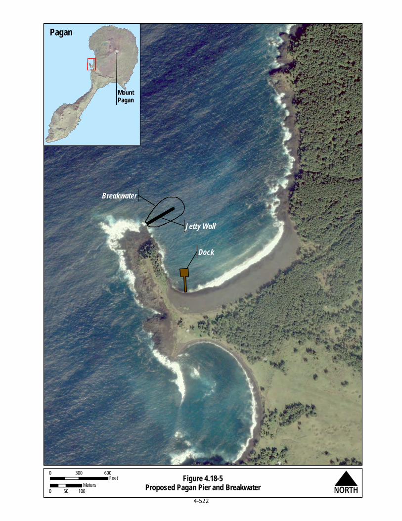
Figure 4.18-5Proposed Pagan Pier and Breakwater
Breakwater
Jetty Wall
Dock
N0 300 600
Feet
0 50 100Meters
MountPagan
Pagan
4-522

CJMT EIS/OEIS Chapter 4, Environmental Consequences April 2015 Draft Programmatic Analysis
4-523
A programmatic analysis of impacts is presented below. If, in the future, there is a decision to move forward with the proposed dock and breakwater, then the appropriate level of project-specific environmental studies, consultations, and NEPA documentation and public review will be undertaken.
4.18.2.1 Geology and Soils The proposed dock and its associated breakwater would be constructed according to appropriate Department of Defense and accepted seismic engineering standards to ensure stability and safety in the event of an earthquake. An earthquake/seismic hazard and volcanic hazard communication and evacuation plan for personnel involved in construction and training on Pagan would be implemented to minimize the potential for exposure to seismic hazards, including tsunamis. Construction would be limited to in-water areas at Red Beach and would have minimal effects to onshore geology and soils.
In-water construction would disturb marine sediments. Turbidity during construction would be monitored and minimized as much as possible. Operations at the dock would not affect topography, geologic units, or soils on Pagan. Using best management practices and standard operating procedures would lessen the potential for adverse impacts.
4.18.2.2 Water Resources In-water construction would have short-term and localized impacts to nearshore waters. Potential impacts include turbidity, sedimentation, decreased water clarity, and potential accidental discharge of pollutants. In-water construction of both the dock and breakwater at Red Beach would result in direct impacts to nearshore waters. Both the dock and breakwater would fill waters of the U.S. that is regulated by the federal government. Construction activities would also temporarily disturb sediment and increase turbidity and thus impact water quality, clarity, and dissolved oxygen levels. Best management practices, including isolating the in-water construction area and potential use of silt curtains, would be utilized to capture sediment and debris caused by in-water construction activities. In-water construction would require authorization under Section 404 and Section 401 of the Clean Water Act, Section 10 of the Rivers and Harbors Act, and the Coastal Zone Management Act.
Operations at the dock could potentially impact water quality. The accidental release of other pollutants associated with the use and maintenance of the dock could also impact nearshore water quality. However, accidental release of these pollutants would only occur as a result of a failure of a materials-handling best management practice, and any spills would be cleaned up immediately. Spill prevention plans and other best management practices would be implemented to minimize the impact of operations on nearshore water quality.
4.18.2.3 Air Quality Construction of the proposed dock and breakwater would create air emissions from construction equipment. The proposed dock and breakwater would facilitate more marine traffic. However, operation of the dock would not result in new types of emissions from stationary sources. No sensitive land uses are located close to the proposed dock and breakwater location, and frequent trade winds would disperse emissions.

CJMT EIS/OEIS Chapter 4, Environmental Consequences April 2015 Draft Programmatic Analysis
4-524
Existing volcanic gases would continue to be released from volcanic eruptions as part of natural geological processes. Sulfur dioxide, a criteria pollutant, is one of the most common gases released in volcanic eruptions and is hazardous to humans. Periodic sulfur dioxide releases due to volcanic eruptions could potentially have an adverse impact to air quality. However, volcanic eruptions are natural geological processes. Furthermore, construction and operation of the dock and breakwater would not have an impact to the frequency of such eruptions.
4.18.2.4 Noise The Pagan dock and breakwater would involve construction of relatively minor harbor facilities. Equipment and other construction activities typically generate noise levels ranging from 70 to 90 decibels at a distance of 50 feet (15 meters) (U.S. Department of Transportation 2006). Construction activities for the proposed dock and breakwater would not impact any residential properties or noise-sensitive receptors such as schools, houses of worship, and hospitals as no such features exist on Pagan Operations at the dock and breakwater would involve marine vessel activities, as well as ground-based equipment and vehicles. Noise would be similar to those conducted at Red Beach without these facilities.
Noise would be caused by construction equipment onshore and in nearshore waters of Red Beach. No blasting would be required. It has been found that noise levels traveling in the air, above water, from typical dredging in deeper water of harbors and rivers could be 87.3 decibels at 50 feet (15 meters), dropping to 61.2 decibels at 1,000 feet (305 meters), and to 55.2 decibels at 2,000 feet (610 meters) from the source (DoN 2010). The highest typical in-water noise levels for dredging operations in harbors and rivers are generally 150 to 162 decibels or 1 micro Pascal at 3 feet (1 meter) (Greene and Moore 1995). Proposed construction operations would occur within shallow waters, typically at or near low tide. Underwater noise levels would be, therefore, less than noise levels presented above for deep-water harbors and rivers. However, underwater noise from pile driving to construction the dock could affect marine mammals. It will be important to have future modeling done of underwater noise that simulates the distance and strength of underwater noise based on the number and type of piles as well duration of construction and presence of any marine mammals or sea turtles in the area. These studies would be done should the dock and its associated breakwater proposals move forward.
Noise impacts would not affect residential areas, schools, houses of worship, and hospitals (i.e., sensitive receptors). Operational noise would be consistent with noise proposed for Red Beach (see Section 4.5, Noise). This includes vessel activity, terrestrial vehicle activity, and human sources.
4.18.2.5 Airspace The proposed dock and breakwater would not affect the airspace or airfield, nor would it alter new or existing airspace that would impact civilian air traffic.
4.18.2.6 Land and Submerged Land Use Construction of the dock and breakwater harbor facilities would facilitate safe access to Pagan. There are currently no federal lands or privately owned lands on Pagan. The CNMI government owns all of Pagan. Under the CJMT EIS/OEIS proposed action, the federal government would seek to acquire a real estate interest for the entire island of Pagan (approximately 11,794 acres [4,773 hectares]) from the

CJMT EIS/OEIS Chapter 4, Environmental Consequences April 2015 Draft Programmatic Analysis
4-525
CNMI government. This would include the area needed to construct the dock and breakwater. Therefore, construction and operation of the dock and breakwater would not create any new changes to land ownership, submerged land ownership and management, or the CNMI Areas of Particular Concern. The Territorial Submerged Lands Act was amended to convey certain submerged lands to the CNMI government, which included submerged lands around Pagan. The submerged lands around Pagan are now owned by the CNMI government. The proposed dock and breakwater would not affect compatibility with plans and polices or with current land uses. This project would allow easier public access to Pagan when military training is not occurring.
Since 1981, Pagan has been largely closed to public access due to volcanic risk. Operation of the dock and breakwater would not change the amount of time that Pagan is available to the public during the training. The remainder of the year all but the High Hazard Impact Areas would be open to the public, should the volcano risk be reduced. While unauthorized (i.e., no use permits obtained from the CNMI government), individual visitors use the land for subsistence. Scientific studies do occasionally take place on Pagan. There is also some recreation use with occasional ecotourism visits to Pagan by groups and individuals. None of these activities would be affected by operation of the dock and breakwater.
There is no CNMI land use designation for Pagan, so it is therefore assumed to be conservation. The proposed use of submerged land by the U.S. military for the dock and breakwater would constitute a change in submerged land use from the present use (conservation). The dock and breakwater would introduce a new use and thus a change in the use of submerged lands, but not completely incompatible. However, this use would be consistent with activities proposed to occur there for proposed CJMT training. This includes transport and offloading of equipment and personnel at Red Beach.
The proposed dock and breakwater would affect coastal uses and resources that are subject to Coastal Zone Management Act federal consistency requirements. These facilities would be consistent to the maximum extent practicable with the enforceable policies of the CNMI Bureau of Environmental and Coastal Quality. The proposed action would be consistent to the maximum extent practicable with the Coastal Zone Management Act and the enforceable policies of the CNMI Bureau of Environmental and Coastal Quality.
The proposed dock and breakwater would not be located in the CNMI Areas of Particular Concern. Therefore, the proposed dock and breakwater would be inconsistent with the intended special (protective) management of the CNMI Areas of Particular Concern. The impact on the corals, beaches, and marine environment, and potential measures to lessen these impacts, are discussed in detail in Section 4.18.2.9, Marine Biology.
4.18.2.7 Recreation Pagan is officially uninhabited and does not contain any official recreational areas. Nevertheless, there have been discussions about developing Pagan as an eco-tourism destination and a staging area for visitors to the Marianas Trench National Marine Monument area. The proposed dock and breakwater would be permanent structures at Red Beach. Construction at this location would not limit the impact to the island’s potential recreational resources during the construction phase.
Operation of the proposed dock and breakwater would not result in additional closure of the northern portion of the island beyond what is proposed for the CJMT EIS/OEIS proposed action. Therefore, no

CJMT EIS/OEIS Chapter 4, Environmental Consequences April 2015 Draft Programmatic Analysis
4-526
additional restrictions of recreational activities would occur due to operation of the dock and breakwater.
Consequently, the proposed dock and breakwater would not alter the areas available for recreational use. The proposed harbor improvements could provide beneficial impacts to the island recreational areas by facilitating safe access to the island for visitor traffic.
4.18.2.8 Terrestrial Biology The construction of the dock and breakwater would occur in water and would not change the project footprint onshore. Additional vessel activities would occur at Red Beach, but overall noise levels would not substantially increase. The dock and breakwater would not cause additional foot traffic, vehicle traffic, or ordnance use at other places throughout the island. Therefore, vegetation communities, native wildlife, and special-status species would not be affected.
Vegetation Communities 4.18.2.8.1
Temporary disturbance would occur near the construction area for staging of construction vehicles, equipment and supplies. However, no vegetation communities or habitat would be permanently affected by construction activities. No native limestone forest would be affected by construction. Limestone forests on Pagan are important as they retain the functional ecological components of native forest. This habitat provides for the majority of Pagan’s native species, including candidate and listed special-status species, as well as maintaining water quality and reducing fire risk.
Native Wildlife 4.18.2.8.2
No long-term habitat loss would result from the construction of the proposed dock and breakwater. Damage of forested areas, particularly native limestone forest, by non-native mammals (i.e., feral goats and pigs) is a serious concern on Pagan. Construction of the proposed dock and breakwater would not affect the concentrations or locations of these animals on site or at other areas on the island. Therefore, the island vegetation community and its function would not be affected. In addition, implementation of best management practices would occur, as identified in Appendix D, Best Management Practices.
Since there would be no loss of forested habitats, there would not be resulting loss of nesting areas or other effects to native bird populations because suitable nesting habitat occurs throughout the island. Short-term construction noise may temporarily affect areas with suitable habitat for some, but birds could relocate to other suitable habitat and return when construction is completed. Nests in the immediate vicinity of construction activities also could be disturbed by noise and human activities and susceptible to abandonment and depredation. This would temporarily displace birds, some of which may be lost or have reduced breeding success. Construction noise impacts would be short-term and minor at Red Beach.
Increased traffic and human presence, as well as noise from construction, may temporarily displace wildlife species, causing them to expend additional energy. Direct mortality from construction equipment is unlikely since noise associated with pre-construction activities and human presence is likely to disperse wildlife prior to any equipment use.

CJMT EIS/OEIS Chapter 4, Environmental Consequences April 2015 Draft Programmatic Analysis
4-527
Special-status Species 4.18.2.8.3
Direct impacts to special-status species from proposed construction activities can include the removal of habitat, fragmentation of remaining habitat, and associated noise and human activities. Red Beach is not within the vicinity of federally listed species habitat on Pagan. Therefore, there would be no impacts to these species resulting from construction. The proposed dock footprint also would not affect foraging habitat. Therefore, no effects from construction would occur to the Mariana fruit bat.
The proposed dock and breakwater construction activities would not reduce the amount of habitat available to Migratory Bird Treaty Act-listed birds on Pagan. There would be no loss of forested habitats, and therefore no resulting loss of nesting, roosting, or foraging areas. Therefore, adverse effects on the migratory bird populations on Pagan would not occur. Short-term construction noise may temporarily impact suitable habitat for some birds in the vicinity of the construction area, but they would relocate to other suitable habitat, and could return to the area following construction. In addition to the impacts to habitat identified above, nests in the immediate vicinity of construction activities may be disturbed by noise and human activities and susceptible to abandonment and depredation. This would temporarily displace birds, some of which may be lost or have reduced breeding success. Therefore, implementation of dock and breakwater construction activities would not result in less than significant impacts to Migratory Bird Treaty Act-listed birds. In addition, the potential best management practices minimize the potential for impacts.
No sea turtles have been observed nesting on the beaches of Pagan. In addition, sightings of sea turtles on the beaches of Pagan are rare, with one green sea turtle observed resting on Red Beach (Kessler 2011). Pre-construction monitoring could occur to ensure there are no sea turtles resting on the beach or in their nests. The monitoring could include pre-construction surveys to delineate boundaries around nest sites as well as postponing construction activities when a nesting sea turtle is observed near the proposed dock location.
4.18.2.9 Marine Biology Actions that could potentially impact marine biology include in-water construction and associated increase in vessel traffic. The proposed dock and breakwater would affect marine biological resources near the new construction if habitats are disturbed or removed. There would be temporary impacts to mobile marine resources near construction due to increased noise levels. A Clean Water Act Section 404 permit would be required for construction and mitigation would be developed through consultation with regulatory agencies.
There would be impacts associated with the use of the new dock. The level of noise would not increase over that of the CJMT EIS/OEIS proposed action, but there would be more days per year that noise is generated on land that could result in impacts to marine mammals and sea turtles. There would be operational noise in the harbor associated with use of the new dock that could impact species in the area.
Consultation with agencies may be required. Potential consultations include:
Endangered Species Act, Section 7: U.S. Fish and Wildlife Service and National Marine Fisheries Service
CJMT EIS/OEIS Chapter 4, Environmental Consequences April 2015 Draft Programmatic Analysis
4-528
Magnuson-Stevens Fishery Conservation and Management Act: National Marine Fisheries Service
Marine Mammal Protection Act, National Marine Fisheries Service
Marine Habitats 4.18.2.9.1
Proposed in-water construction of the dock and breakwater could potentially impact marine habitats. This includes in-water construction activities as well as associated vessel traffic and land-based vehicle activities. The evaluation of potential impacts to marine habitats focuses on the ecological function of the physical substrate; impacts specific to marine biological organisms are described in the sections below. Construction activities at Red Beach could impact marine habitats by disturbing or altering the seafloor, water quality, or physical environment (e.g., underwater noise). Marine habitats may be exposed to direct and indirect physical disturbance. Construction activities could result in the loss of marine habitat anywhere from +3 feet (1 meter) mean-mean low water to -20 feet (6 meters) mean-mean low water.
The marine habitats (soft shore, hard bottom, and aquatic bed) currently found within the designated amphibious landing areas would be modified through direct, physical disturbance. Erosion or changes in sediment transport (extent to be determined following additional information via modelling or an engineering study) may result in long-term direct and indirect impacts to the abundance and distribution of marine organisms that utilize habitat impacted by such changes, particularly soft shore habitat and aquatic beds.
Physical alteration of hard bottom habitat could also impact ecological function at Red Beach. The removal of some coral and homogenization of the slope of the reef could result in changes to refuge availability, differences in wave energy propagation, the runoff profile of the beach, and filtration by marine organisms.
Alterations to a marine habitat’s exposure to wave action, sunlight (i.e., shading from the proposed dock), and tidal fluctuations may in turn affect the temperature, salinity, and pH of the water. Such changes could impact the distribution and composition of marine organisms (Cowardin et al. 1979).
Construction of the proposed dock and breakwater would result in direct temporary impacts to the water quality of nearshore waters, particularly to such parameters as turbidity, sediment deposition, and dissolved oxygen levels due to the physical process of constructing the proposed dock and breakwater. Construction of the proposed dock and breakwater could result in long-term and permanent, direct and indirect adverse impacts to marine habitat, since current habitat types and ecosystem function would be lost or degraded.) Impacts would be minimized to the maximum extent practicable through adherence to best management practices, such as limiting in-water work to low tidal conditions and installation of silt/turbidity curtains.
Marine Flora 4.18.2.9.2
Marine flora impacts at Red Beach could be minimized through design considerations and adherence to best management practices.

CJMT EIS/OEIS Chapter 4, Environmental Consequences April 2015 Draft Programmatic Analysis
4-529
Marine Invertebrates 4.18.2.9.3
Construction activities would impact corals by removing coral, filling coral reefs or by stirring up the seafloor, leading to increased turbidity that could reduce water quality. Impacts to corals would be expected to affect other invertebrates, and design considerations and adherence to best management practices to protect the corals are expected to protect other invertebrates as well.
Coral 4.18.2.9.4
Construction impacts would primarily result from removal of corals and other invertebrates. Red Beach has low topographic complexity, low coral cover, and high sand cover. The areas of the footprints for the dock and breakwater have moderate topographic complexity, low coral cover, and low sand cover. There is minimal coral cover in the dock footprint (ranging from 1-10%), but more coral cover and diversity in the breakwater footprint (ranging from 10-30%). The majority of the coral at Red Beach was observed at depths shallower than 12 feet (4 meters) at the headlands to the north and south of Red Beach, but not directly in front of the sandy beach. By contrast, the footprint areas have greater species richness than any of the other beaches surveyed in 2013 (DoN 2014b), and the corals occur at greater depth than along the actual beach. In the footprint areas, small coral colonies of all species present are abundant and large colonies are uncommon. Corals would be directly affected in locations where piles for the dock would be driven. One Endangered Species Act-listed coral species (Acropora globiceps) was observed at Red Beach (DoN 2014b). In the footprint of the breakwater, all corals within the footprint would be directly affected by the material placed for the base of the breakwater.
Fish 4.18.2.9.5
Construction activities may have temporary adverse effect on fish species. However, impacts would be short term and localized. Changes to the structure and complexity of the environment by the addition of a dock and breakwater could change the distribution of some fish species by aggregating individuals and increasing interaction among species.
Essential Fish Habitat 4.18.2.9.6
There is Essential Fish Habitat is the vicinity of the proposed dock and breakwater. Construction activities could impact Essential Fish Habitat by disturbing or altering the seafloor, water quality, or physical environment (e.g., underwater noise) at Red Beach, which is designated as Essential Fish Habitat.
Potential impacts to water quality characteristics of the marine environment during coastal and inland operational activities would be reduced but not avoided by implementing best management practices to control sedimentation, control stormwater runoff, eutrophication (i.e., enriched in dissolved nutrients), and fuel or chemical spills.
Construction would result in Essential Fish Habitat within the footprints of the proposed dock and breakwater at Red Beach being permanently unavailable. The location of the jetty would be permanently unavailable, but after completion, the area along the jetty and beneath the dock would add structural complexity to the environment and would be available for fish and invertebrates to use. The habitat types and ecosystem function within these areas would be chronically lost or degraded. Construction may adversely affect Essential Fish Habitat under the Magnuson-Stevens Fishery
CJMT EIS/OEIS Chapter 4, Environmental Consequences April 2015 Draft Programmatic Analysis
4-530
Conservation and Management Act. An Essential Fish Habitat Assessment would be prepared as part of future environmental studies of these proposed projects.
Sea Turtles 4.18.2.9.7
Sea turtle densities at Pagan during the 2-week survey conducted in August 2013 survey appear relatively uniform, with density calculations ranging between 49 sea turtles per square mile (19 sea turtles per square kilometer) on the northwestern coast to 101.3 sea turtles per square mile (39.1 sea turtles per square kilometer) on the western coast (DoN 2014c). However, few turtles were observed near Red Beach during the 2013 survey, and no sea turtles have been observed nesting on the beaches of Pagan. In addition, sightings of sea turtles on the beaches of Pagan are rare, with only one green sea turtle observed resting on Red Beach (Kessler 2011).
Construction activities could potentially impact sea turtles. Sea turtle hearing is less sensitive to impacts than marine mammals, although in the shallow waters of near the dock and breakwater locations they would likely be much closer to the noise source. The highest intensity in-water noise would be due to impulsive noise associated with pile driving. If construction or operational vessel noise exceeds 180 decibels in the area of a turtle, and they are unable to leave the area, adverse impacts to sea turtles could occur. Proposed construction could adversely affect sea turtles that may be exposed to sound levels capable of causing behavioral changes during construction. This could occur through a series of behavioral modification in the form of mild alert and startle responses, avoidance of the construction area, and alteration of swimming and diving patterns. It is not likely that turtles would be injured or killed by the construction noise source. In addition, their exposure would likely have no measurable impact on their ability to forage, shelter, reproduce, or avoid predators and other threats. Construction and operation could cause localized turbidity. However, construction best management practices would likely keep suspended sediments immediately adjacent to the construction activity. It would be unlikely that sea turtles would approach close enough to the construction to be exposed to project-related elevated turbidity.
Pre-construction monitoring could occur to ensure there are no sea turtles resting on the beach or in their nests. The monitoring could include pre-construction surveys to delineate boundaries around nest sites as well as postponing construction activities when a nesting sea turtle is observed near the proposed dock location. Construction could cause temporary habitat loss for sea turtles since turtles may be temporarily displaced for the duration of construction activities at Red Beach.
Section 7 consultation with National Marine Fisheries Service and the U.S. Fish and Wildlife Service under the Endangered Species Act may be required.
See Section 4.18.2.8, Terrestrial Biology, for impacts to sea turtle nesting.
Marine Mammals 4.18.2.9.8
Construction of the dock and breakwater may impact marine mammals acoustically as well as via an increase for the potential of marine mammal-vessel interaction. Once the breakwater has been constructed, it is not anticipated to impact marine mammals, as it will become a permanent structure. Operation of the dock structure will increase the potential for marine mammal-vessel interactions as vessels enter the embayment associated with Red Beach; however, the increase in the potential for

CJMT EIS/OEIS Chapter 4, Environmental Consequences April 2015 Draft Programmatic Analysis
4-531
marine mammal-vessel interaction is not anticipated to be significant, based on the low number of marine mammal sightings in the area.
Marine mammals have been both visually and acoustically detected in the CNMI (DoN 2007; Ligon et al. 2011; HDR 2012; Hill et al. 2012, 2013a, 2013b, 2014; Oleson 2013), as well as specifically off Pagan (DoN 2014d). The Marine Mammal Survey conducted in support of this EIS/OEIS identified five marine mammals in the nearshore waters of Pagan using both acoustic and visual methods. These included sperm whales, common bottlenose dolphins, spinner dolphins, Cuvier’s beaked whales, and Blainville’s beaked whales. All of these species are afforded protections under the Marine Mammal Protection Act and the sperm whale is also protected under provisions of the Endangered Species Act.
Under the Marine Mammal Protection Act, National Marine Fisheries Service has defined levels of harassment for marine mammals. The National Marine Fisheries Service uses generic sound exposure thresholds to determine when an activity in the ocean produces sound that might result in impacts to a marine mammal such that a take by harassment might occur (National Marine Fisheries Service 2005). Recent studies of pile driving used to construct offshore wind turbines have validated the distances over which underwater sound from pile driving may exceed National Marine Fisheries Service thresholds (Bailey et al. 2010), as well as behavioral responses of harbor porpoises (Phocoena phocoena) to intense sound from pile driving (Thompson et al. 2010; Brandt et al. 2011). Current National Marine Fisheries Service practice regarding exposure of marine mammals to high level sounds is that cetaceans and pinnipeds exposed to impulsive sounds of 180 and 190 decibel root mean squared or above, respectively, are considered to have been taken by Level A (injurious) harassment. Level A acoustic harassment under the Marine Mammal Protection Act constitutes harm under the Endangered Species Act, whereas Level B acoustic harassment under the Marine Mammal Protection Act is also harassment under the Endangered Species Act. Since pinniped species are not known to occur in the vicinity of the project, acoustic thresholds for cetacean species will be discussed in this section. Impact pile driving is considered an impulse (non-continuous) sound source, and vibratory pile driving is a continuous sound source, so the two types of hammers are treated differently for Level B take thresholds.
Pile driving and/or vibratory pile extraction would generate underwater noise that potentially could result in disturbance to marine mammals. Transmission loss underwater is the decrease in sound intensity due to sound spreading and chemistry and viscosity-based absorption as an acoustic pressure wave propagates out from a source. Parameters vary with frequency, temperature, sea conditions, current, source and receiver depth, water depth, water chemistry, and bottom composition and topography.
Pile driving during the construction period (for the new sheet pile bulkhead and mooring dolphins) would comprise the project’s greatest noise source of concern in the underwater environment. The frequency and intensity of the sound energy generated by pile driving is primarily a function of the type and size (diameter or length) of the piling or sheet pile, the driving mechanism (e.g., impact or vibratory hammer), and the type of substrate into which the pile is being driven. Several different types of piles would be used during construction, including steel sheet piles, and round mooring piles. In the absence of site-specific acoustic data, measured source levels from similar pile driving events were used to estimate pile driving source levels for this project (California Department of Transportation 2012). Because pinniped haul out locations have not been observed in the project area, airborne noise levels are not evaluated relative to National Marine Fisheries Service airborne threshold criteria.

CJMT EIS/OEIS Chapter 4, Environmental Consequences April 2015 Draft Programmatic Analysis
4-532
Table 4.18-1 provides the density estimates for those species that may potentially occur in the Project Area. No seasonal variation in marine mammal density was noted for these species. While the spinner dolphin, bottlenose dolphin, Cuvier’s beaked whale, Blainville’s beaked whale and sperm whale are the only species that have been either visually or acoustically detected during surveys around Pagan (DoN 2014d), any of the species presented in Table 4.18-1 may occur within the zone of influence associated with pile driving. For example, Hill et al (2014) found that satellite tagged marine mammals routinely moved great distances between islands or island groups. While none of the satellite tagged animals were shown to occur off Pagan, this does not preclude them from potentially occurring within the 120-decibel zone of influence.
Table 4.18-1. Density Estimates for Species Potentially Occurring in the Project Area
Common Name Scientific Name Density Estimate
(animals/km2)
Family Delphinidae Bottlenose dolphin Tursiops truncatus 0.001311 False killer whale Pseudorca crassidens 0.00111 Melon-headed whale Peponocephala electra 0.00428 Pantropical spotted dolphin Stenella attenuata 0.00226 Pygmy killer whale Feresa attenuata 0.00014 Rough-toothed dolphin Steno bredanensis 0.003551
Short-finned pilot whale Globicephala macrorhynchus 0.003621 Spinner dolphin Stenella longirostris 0.006991,2 Family Ziphiidae Cuvier’s beaked whale Ziphius cavirostris 0.00621 Family Hyperoodontidae Blainville’s beaked whale Mesoplodon densirostris 0.001171 Family Kogiidae Dwarf sperm whale Kogia sima 0.002911
Family Physeteridae Sperm whales Physeter macrocephalus 0.00123 Notes: 1Derived from density data from the Hawaii Range Complex.
2Based on density estimates for waters in a main Hawaiian Islands stratum (Barlow 2006). Sources: Barlow 2006; Fulling et al. 2011; DoN 2014d; Hill et al. 2014.
Results of visual surveys in 2013 indicate that spinner dolphins and bottlenose dolphins would be present around Pagan during project construction and would hear pile driving noise (DoN 2014d). Based on the density estimates in Table 4.18-2, deeper-water species that could occur in the greatest concentration in the area covered by the 120-decibel threshold are the melon-headed whale, short-finned pilot whale, and the rough-toothed dolphin. Based on information provided in Hill et al (2014), these species were detected in waters greater than 1,400 feet (430 meters) deep where the effects of the pile driving noise would likely be mitigated by environmental variables (e.g., bathymetry variation, temperature and salinity fluctuations). However, these species may also be sighted in the nearshore environment at depths of as little as 853 feet (260 meters). Of the species most likely found in the nearshore environment, the bottlenose and spinner dolphins would be the most likely species to be impacted by noise during construction. Hill et al (2014) found that median depths for was 289 feet (88

CJMT EIS/OEIS Chapter 4, Environmental Consequences April 2015 Draft Programmatic Analysis
4-533
meters) for the bottlenose dolphins and 155 feet (47 meters) for spinner dolphins. Regardless, because of their highly mobile nature, it is expected that individuals would avoid the area and the construction would not pose a substantial risk to individuals, populations or the species as a whole.
Construction of the breakwater to the north of the dock would have short-term impacts to marine mammals. Noise as a result of adding material to the breakwater for establishment and stabilization purposes is not anticipated to reach levels that would exceed regulatory thresholds. Construction-related vessels may also be in the area associated with the breakwater, but they are not anticipated to substantially increase the likelihood for marine mammal-vessel interactions. Sightings data in the vicinity of Red Beach, and known habitat characteristics, indicates that dolphin species would be the most likely species to be in the vicinity of the construction. However, based on their highly mobile nature, it is expected that individuals would avoid the area and the construction would not pose a substantial risk to individuals, populations or the species as a whole. Furthermore, impacts would be minimized through design considerations and adherence to best management practices.
Use of the dock structure by vessels is not anticipated to pose a substantial risk to marine mammals. However, if a strike were to occur, the collision could cause major wounds and may be fatal to marine mammals. In addition, sound from surface vessel traffic may cause behavioral responses of marine mammals. While an increase in the number of vessels in the area would increase the potential for marine mammal-vessel interactions, the potential for strike is not anticipated to pose a risk to the populations or the species as a whole. Individuals may change direction to avoid incoming/outgoing vessels, but this change in behavior is anticipated to be short-term and no long-term effects are anticipated.
Consultation with National Marine Fisheries Service under the Marine Mammal Protection Act may be required.
Special-status Species 4.18.2.9.9
The DoN recorded the presence of coral species proposed for listing under the Endangered Species Act on Pagan. None were identified at Red Beach (DoN 2014b). No Endangered Species Act-proposed coral species were identified at Red Beach.
4.18.2.10 Cultural Resources Historic properties could include Pre-Contact latte complexes, pre-World War II Japanese Administration sites, and World War II-era Japanese defensive sites. Construction of the proposed dock and breakwater would include in-water construction and some onshore ground disturbance. However, no historic properties are identified in the project footprint. Visual setting effects to historic properties would be less than significant because the proposed dock and breakwater would not be visible to most historic properties. Also, the proposed dock and breakwater would not affect areas identified as potential traditional cultural properties. Therefore, the proposed dock and breakwater would not alter or affect archaeological sites recommended eligible for listing in the National Register of Historic Places. There would be no direct impacts to historic properties.
In addition, potential impacts could be minimized by developing an agreement document through the Section 106 process with the CNMI Historic Preservation Office and other consulting parties. The agreement document would include the measures that will be taken to avoid, minimize, and/or mitigate

CJMT EIS/OEIS Chapter 4, Environmental Consequences April 2015 Draft Programmatic Analysis
4-534
the effects of the undertaking on historic properties. Such measures typically include data recovery excavations, documentation, public education, and additional investigations. See Appendix N, Cultural
Resources Technical Memo for a discussion of the consultation process.
4.18.2.11 Visual Resources Construction would be required at Red Beach, and would involve creation of a new dock extending out from shore and a breakwater farther offshore (see Figure 4.18-5). The construction would mostly involve in-water construction activities, associated vessel activities, and some onshore activities. Because of the overlap between the construction period and operation, visual impacts are presented in Operation Impacts.
Permanent changes to the visual environment at Red Beach would occur. The harbor improvements would change the visual landscape of the harbor. However, since Pagan is essentially uninhabited, no impact would occur.
4.18.2.12 Transportation The proposed dock and breakwater would not affect the air transportation facilities of Pagan.
Currently there are no roads, transit networks, pedestrian, bicycle facilities and no significant vehicular traffic patterns occur on Pagan. Only all-terrain vehicle pathways exist on Pagan and their use is limited. Construction of the proposed dock and breakwater would require heavy equipment, including, but not limited to: road graders, vibratory compactors, dump trucks, and backhoes. Construction would not increase the potential for impacts to traffic circulation or Level of Service for vehicles, public transit, pedestrians, bicycles, increase the rate of traffic related accidents, or reduce transportation safety.
There is currently no functional dock or appreciable marine vessel traffic to Pagan. Therefore, the proposed dock and breakwater would have a beneficial impact to marine transportation. Operation of a usable dock would facilitate transport of cargo through a more efficient method than transferring cargo directly to beaches via amphibious vehicles or rubber riding craft.
4.18.2.13 Utilities There is no current electrical power utility, potable water utility, wastewater infrastructure, or information technology/communications infrastructure on Pagan. The proposed dock and breakwater would have no effects to existing or proposed utilities infrastructure on Pagan.
No permanent wastewater infrastructure exists for Pagan. It is anticipated that wastewater generated due to construction and operation of the proposed dock and breakwater would be managed with field sanitation devices. Field sanitation devices would include toilets with collection bags or burn-out latrines and field urinals. With the potential use of burn-out latrines, the burning of human waste would create air quality impacts. It is anticipated that the ash produced by the burn-out latrines would be collected in containers and shipped to the U.S. military transfer station located on Tinian or another suitable location, such as Saipan. Construction workers would be housed in temporary facilities onshore or on a support vessel.

CJMT EIS/OEIS Chapter 4, Environmental Consequences April 2015 Draft Programmatic Analysis
4-535
A small stormwater management system at Red Beach would be proposed as part of the proposed projects. Construction activities would require a Stormwater Pollution Prevention Plan and appropriate use of erosion control procedures to protect ecology and water resources.
The primary solid waste impact would consist of green waste generated during construction. Green waste would be managed on site through composting and mulching operations. All waste generated during construction that cannot be processed and reused on Pagan would be shipped to an acceptable off-island location for proper handling and disposal or reuse.
4.18.2.14 Socioeconomics and Environmental Justice Construction of the proposed breakwater and dock would generate economic activity, which would be beneficial to the CNMI economy. Temporary construction worker housing would need to be built to support construction activities.
The dock and breakwater would improve access to Pagan Harbor. This would facilitate visitor engagement in cultural and recreational activities as well as potential economic activities (such as mining and ecotourism), leading to a beneficial impact.
4.18.2.15 Hazardous Materials and Waste The proposed dock and breakwater would increase use of hazardous materials and generation of hazardous waste during construction, but it would not increase the volume of hazardous materials and waste to be managed during operations.
Hazardous Materials 4.18.2.15.1
Construction for the proposed dock and breakwater at Red Beach would cause a short-term increase in the volume of construction-related hazardous materials that would cease at the completion of construction activity. Best management practices and standard operating procedures described for Tinian (see Appendix D, Best Management Practices) would be followed to minimize or prevent accidental releases of hazardous materials during construction on Pagan. The use, transport, storage, and handling of hazardous materials would be in accordance with applicable federal and CNMI regulations and U.S. military requirements. Similar procedures would be implemented for operation of the proposed dock.
Toxic Substances 4.18.2.15.2
No demolition would take place to construct either the new dock or its associated breakwater, so it is unlikely that toxic-substance building materials would be encountered. In the event that asbestos-containing materials, lead-containing paint, or polychlorinated biphenyls are discovered, these materials would be managed by properly trained and licensed personnel to ensure that applicable hazardous waste testing, handling, and disposal procedures and requirements are followed. No toxic-substance building materials would be used in construction. Similar procedures would be implemented for operation of the proposed dock.

CJMT EIS/OEIS Chapter 4, Environmental Consequences April 2015 Draft Programmatic Analysis
4-536
Hazardous Waste 4.18.2.15.3
Construction activities would result in a short-term increase in the generation of hazardous waste (e.g., pesticides, herbicides, solvents, adhesives, lubricants, corrosive liquids, batteries, and aerosols) that would end when construction is finished. The projected increase in hazardous waste would have the potential to result in adverse impacts to human health and the environment. All construction would be conducted in compliance with all applicable requirements concerning handling of hazardous waste. Best management practices and standard operating procedures (see Appendix D, Best Management
Practices) would be followed to reduce the likelihood and volume of accidental releases, allow for accelerated spill response times, and allow for the timely implementation of cleanup measures. The generation, transport, storage, and handling of hazardous waste would be in accordance with applicable federal and CNMI regulations and U.S. military requirements. All hazardous waste would be containerized and shipped off the island to the appropriate disposal facility site. Existing transportation routes, including shipping by commercial carrier, would be utilized for the conveyance of hazardous waste to a disposal facility site. Transportation of all hazardous waste would be conducted in compliance with U.S. Department of Transportation regulations and CFR Title 49. Similar procedures would be implemented for operation of the proposed dock.
Contaminated Sites 4.18.2.15.4
If the proposed dock and breakwater cannot be constructed without avoiding contaminated sites, then appropriate best management practices would be followed (see Appendix D, Best Management
Practices). To reduce potential hazards related to exposure to munitions and explosives of concern, appropriate U.S. military requirements and best management practices be followed and implemented (see Appendix D, Best Management Practices). Through the use of best management practices and the identification and removal of munitions and explosives of concern, impacts resulting from the disturbance and dispersion of contaminated soil and groundwater would be minimized.
4.18.2.16 Public Health and Safety The CNMI Homeland Security and Emergency Management Office would be notified of construction activities on Pagan. Because there is no permanent resident population on Pagan, construction of the proposed dock and breakwater would result in no direct or indirect impacts to public health and safety. The proposed dock and breakwater could potentially benefit public health and safety by providing a safer method to move people and cargo than the smaller vessels. The public would continue to be restricted from the island during training for health and safety reasons.