community based climate change adaptation and...
TRANSCRIPT
Community based climate change adaptation and disaster risk reduction action plan for the Ikalto community of Telavi
Municipality, Upper Alazani Watershed, Republic of Georgia
Integrated Natural Resources Management in the Republic of Georgia Program

Technical Summary Report
Community based climate change adaptation and disaster risk reduction action plan for the Ikalto community of Telavi
Municipality, Upper Alazani Watershed, Republic of Georgia
Funding for this publication was provided by the people of the United States of America through the U.S. Agency for International Development (USAID) under Agreement No.CA # AID-114-LA-10-00004, as a component of the Integrated Natural Resources Management for the Republic of Georgia Program. The views and opinions of authors expressed herein do not necessarily state or reflect those of the United States Agency for International Development of the United States Government or Florida International University. Copyright © Global Water for Sustainability Program – Florida International University
This publication may be reproduced in whole or in part and in any form for educational or non-profit purposes without special permission from the copyright holder, provided acknowledgement of the source is made. No use of the publication may be made for resale or for any commercial purposes whatsoever without the prior permission in writing from the Florida International University - Global Water for Sustainability Program. Any inquiries can be addressed to the same at the following address:
Global Water for Sustainability Program
Florida International University
Biscayne Bay Campus 3000 NE 151 St. ACI-267
North Miami, FL 33181 USA
Email: [email protected]
Website: www.globalwaters.net
For bibliographic purposes, this document should be cited as:
GLOWS-FIU. 2014. Community based climate change adaptation and disaster risk reduction action plan for the Ikalto community of Telavi Municipality, Upper Alazani Watershed, Republic of Georgia ISBN:
Contents
Preface .................................................................................................................................................... 2
1. Methodology ....................................................................................................................................... 3
2. General characteristics of the community .......................................................................................... 9
3. Units of analysis of the Ikalto Community ........................................................................................ 11
3.1 Agriculture and agricultural lands ............................................................................................... 12
3.2 Rivers flowing on the territory of the community ...................................................................... 12
3.3 Infrastructure .............................................................................................................................. 14
4. Problems / challenges faced by the Ikalto community ..................................................................... 17
5. Climate change and its consequences .............................................................................................. 23
6. Combined impacts in the Ikalto community ..................................................................................... 24
7. Adaptation and disaster risk reduction activities ............................................................................. 26
Preface
The present report has been developed within the framework of the program Integrated Natural Resources Management in Watersheds (INRMW) of Georgia, being implemented by the following partners:
• Florida International University (FIU) • UNESCO-IHE Institute for Water Education • CARE International • Winrock International • Caucasus Environmental NGO Network (CENN)
The geography of the program covers the following watersheds of Georgia: the Rioni River basin in West Georgia, and the Iori River and Alazani River basins in East Georgia. The following pilot watershed areas were selected for the implementation of the pilot program:
• Upper Rioni pilot watershed area – Municipalities of Oni and Ambrolauri • Lower Rioni pilot watershed area – Municipalities of Khobi and Senaki • Upper Alazani pilot watershed area – Municipalities of Akhmeta and Telavi • Lower Alazani Iori pilot watershed area – Municipality of Dedoplistskaro
The program considers the development of a community based climate change adaptation and disaster risk reduction plan for one community in each targeted municipality.
The present report contains the community based climate change adaptation and disaster risk reduction plan developed for the Ikalto community of Telavi municipality (Upper Alazani pilot watershed area).
© CENN – 2014 Page | 2
1. Methodology
Process
The process of developing the community based climate change adaptation and disaster risk reduction plan consisted of the following main stages:
• selection of a pilot community; • community mobilization and working meetings with community members with the purpose
of identification of urgent issues; • experts’ field visits to targeted communities;
o working meetings with local communities; o field examination of hazards identified during working meetings with community
members; o finalization of recommendations with community members;
• final report.
A brief overview of the methodology used at the key stages of the plan’s development is given below.
Selection of pilot communities
The INRMW program considered selection of one community in each targeted municipality where participatory community based climate change adaptation and disaster risk reduction plans would be developed (7 communities in total).
A web-based decision support tool1 developed by the Helsinki University of Technology was used to select targeted communities. This tool is often used for environmental research (e.g., EIAs, ESIAs).
The selection process comprised of the several stages:
• identification of selection criteria;
• data collection;
• integration of data into the web system;
• data processing (weighting, standardization, “criteria tree”);
• web analysis of results;
• validation of the results of the web-based decision;
• finalization of the results with implementing partners.
1 http://www.hipre.hut.fi/
© CENN – 2014 Page | 3
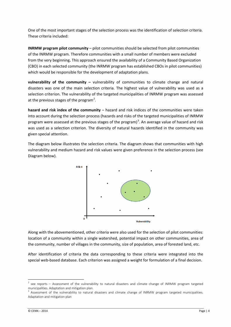
One of the most important stages of the selection process was the identification of selection criteria. These criteria included: INRMW program pilot community – pilot communities should be selected from pilot communities of the INRMW program. Therefore communities with a small number of members were excluded from the very beginning. This approach ensured the availability of a Community Based Organization (CBO) in each selected community (the INRMW program has established CBOs in pilot communities) which would be responsible for the development of adaptation plans.
vulnerability of the community – vulnerability of communities to climate change and natural disasters was one of the main selection criteria. The highest value of vulnerability was used as a selection criterion. The vulnerability of the targeted municipalities of INRMW program was assessed at the previous stages of the program2.
hazard and risk index of the community – hazard and risk indices of the communities were taken into account during the selection process (hazards and risks of the targeted municipalities of INRMW program were assessed at the previous stages of the program)3. An average value of hazard and risk was used as a selection criterion. The diversity of natural hazards identified in the community was given special attention.
The diagram below illustrates the selection criteria. The diagram shows that communities with high vulnerability and medium hazard and risk values were given preference in the selection process (see Diagram below).
Along with the abovementioned, other criteria were also used for the selection of pilot communities: location of a community within a single watershed, potential impact on other communities, area of the community, number of villages in the community, size of population, area of forested land, etc.
After identification of criteria the data corresponding to these criteria were integrated into the special web-based database. Each criterion was assigned a weight for formulation of a final decision.
2 see reports – Assessment of the vulnerability to natural disasters and climate change of INRMW program targeted municipalities. Adaptation and mitigation plan. 3 Assessment of the vulnerability to natural disasters and climate change of INRMW program targeted municipalities. Adaptation and mitigation plan
© CENN – 2014 Page | 4
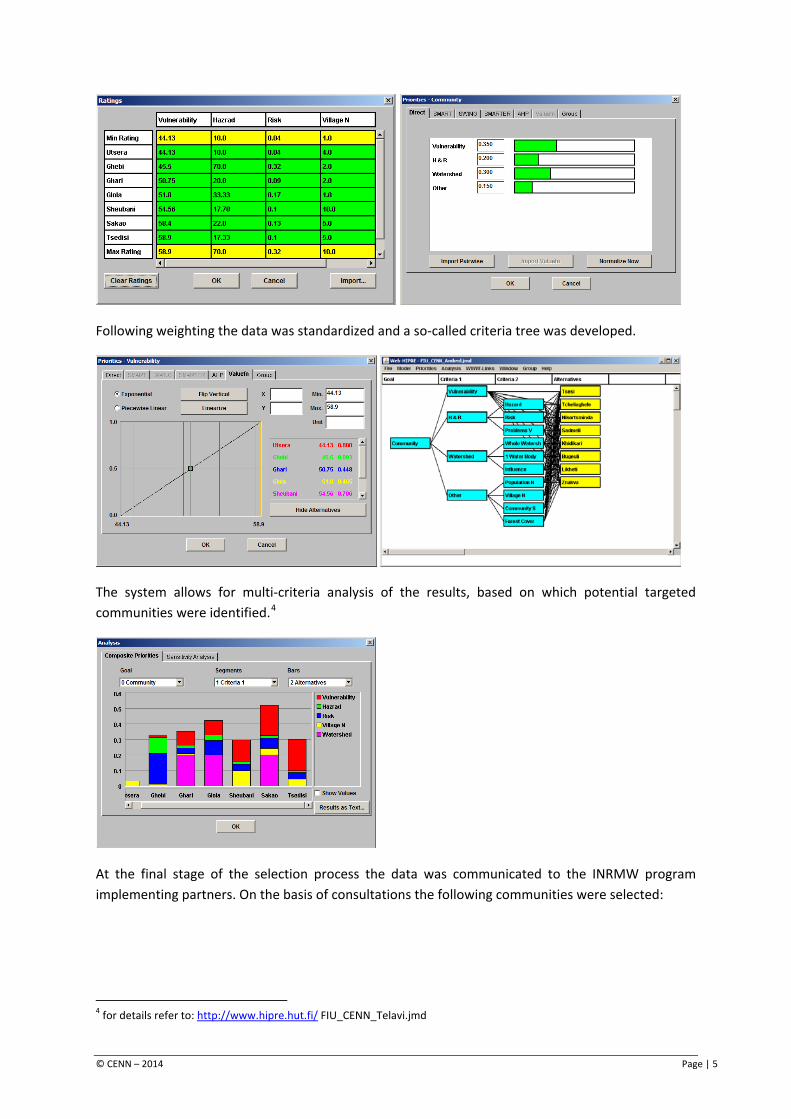
Following weighting the data was standardized and a so-called criteria tree was developed.
The system allows for multi-criteria analysis of the results, based on which potential targeted communities were identified.4
At the final stage of the selection process the data was communicated to the INRMW program implementing partners. On the basis of consultations the following communities were selected:
4 for details refer to: http://www.hipre.hut.fi/ FIU_CENN_Telavi.jmd
© CENN – 2014 Page | 5
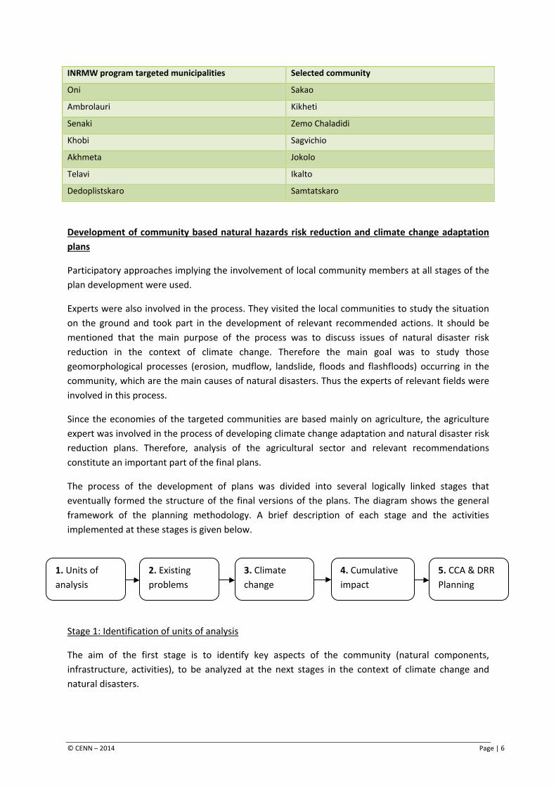
INRMW program targeted municipalities Selected community
Oni Sakao
Ambrolauri Kikheti
Senaki Zemo Chaladidi
Khobi Sagvichio
Akhmeta Jokolo
Telavi Ikalto
Dedoplistskaro Samtatskaro
Development of community based natural hazards risk reduction and climate change adaptation plans
Participatory approaches implying the involvement of local community members at all stages of the plan development were used.
Experts were also involved in the process. They visited the local communities to study the situation on the ground and took part in the development of relevant recommended actions. It should be mentioned that the main purpose of the process was to discuss issues of natural disaster risk reduction in the context of climate change. Therefore the main goal was to study those geomorphological processes (erosion, mudflow, landslide, floods and flashfloods) occurring in the community, which are the main causes of natural disasters. Thus the experts of relevant fields were involved in this process.
Since the economies of the targeted communities are based mainly on agriculture, the agriculture expert was involved in the process of developing climate change adaptation and natural disaster risk reduction plans. Therefore, analysis of the agricultural sector and relevant recommendations constitute an important part of the final plans.
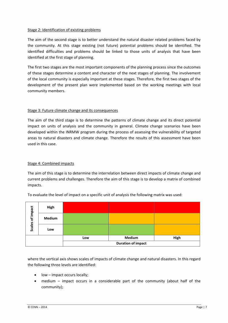
The process of the development of plans was divided into several logically linked stages that eventually formed the structure of the final versions of the plans. The diagram shows the general framework of the planning methodology. A brief description of each stage and the activities implemented at these stages is given below.
Stage 1: Identification of units of analysis
The aim of the first stage is to identify key aspects of the community (natural components, infrastructure, activities), to be analyzed at the next stages in the context of climate change and natural disasters.
1. Units of analysis
2. Existing problems
3. Climate change
4. Cumulative impact
5. CCA & DRR Planning
© CENN – 2014 Page | 6
Stage 2: Identification of existing problems
The aim of the second stage is to better understand the natural disaster related problems faced by the community. At this stage existing (not future) potential problems should be identified. The identified difficulties and problems should be linked to those units of analysis that have been identified at the first stage of planning.
The first two stages are the most important components of the planning process since the outcomes of these stages determine a content and character of the next stages of planning. The involvement of the local community is especially important at these stages. Therefore, the first two stages of the development of the present plan were implemented based on the working meetings with local community members.
Stage 3: Future climate change and its consequences
The aim of the third stage is to determine the patterns of climate change and its direct potential impact on units of analysis and the community in general. Climate change scenarios have been developed within the INRMW program during the process of assessing the vulnerability of targeted areas to natural disasters and climate change. Therefore the results of this assessment have been used in this case.
Stage 4: Combined impacts
The aim of this stage is to determine the interrelation between direct impacts of climate change and current problems and challenges. Therefore the aim of this stage is to develop a matrix of combined impacts.
To evaluate the level of impact on a specific unit of analysis the following matrix was used:
Scal
es o
f im
pact
High
Medium
Low
Low Medium High Duration of impact
where the vertical axis shows scales of impacts of climate change and natural disasters. In this regard the following three levels are identified:
• low – impact occurs locally; • medium – impact occurs in a considerable part of the community (about half of the
community);
© CENN – 2014 Page | 7
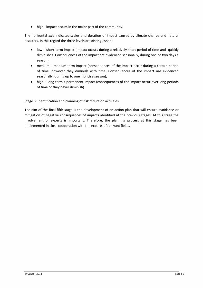
• high - impact occurs in the major part of the community.
The horizontal axis indicates scales and duration of impact caused by climate change and natural disasters. In this regard the three levels are distinguished:
• low – short-term impact (impact occurs during a relatively short period of time and quickly diminishes. Consequences of the impact are evidenced seasonally, during one or two days a season);
• medium – medium-term impact (consequences of the impact occur during a certain period of time, however they diminish with time. Consequences of the impact are evidenced seasonally, during up to one month a season);
• high – long-term / permanent impact (consequences of the impact occur over long periods of time or they never diminish).
Stage 5: Identification and planning of risk reduction activities
The aim of the final fifth stage is the development of an action plan that will ensure avoidance or mitigation of negative consequences of impacts identified at the previous stages. At this stage the involvement of experts is important. Therefore, the planning process at this stage has been implemented in close cooperation with the experts of relevant fields.
© CENN – 2014 Page | 8
2. General characteristics of the community
Location and natural environment
The Ikalto community in located in the western part of the Telavi municipality and borders the Akhmeta municipality. The territory of the community is situated on the north-eastern slopes of the Gombori range, on a depression of the Gombori range and at the head of the Alazani Valley, on a relief slightly inclined to the Alazani River. The elevation of the community is around 700 m above sea level. The community consists of one village – Ikalto. The village is located 7 km away from the municipal center. The total area of the community is 1,562 ha.
The main river of the community is the Chumatkhevi River – a right tributary of the Alazani River. The Ikalto community covers the source and upstream areas of this river. The Chumatkhevi River divides the territory of the community into two almost equal parts. The Berakhevi River flows west of Ikalto. The Turdoskhevi River is the eastern boundary of the community. There are also a few small springs and streams in the territory of the community. The Ikalto dry ravine, crossing the village, fills with water during rains, posing a threat of natural hazards to the community.
In terms of climate the Ikalto community and the Telavi municipality in general belong to a transitional zone between subtropical-continental and marine climates. The areas located at an altitude of up to 700-800 above sea level (the part of the Alazani valley within the boundaries of the municipality and adjacent foothill zone) is characterized by a humid climate with moderate warm winters and long hot summers. The major part of the Ikalto community is located within this zone. At elevations of 700-1,200 m above sea level the climate is moderately humid with moderate cold winters and relatively cool summers. Only a small part of the community is located within this zone.
The vegetation of the territory in the Ikalto community and the Telavi municipality is heavily modified. Large areas of foothills and low-hills are occupied by oak-hornbeam and other broadleaved forests. Oak-hornbeam and beech forests are found in the middle altitudes of the Gombori range. In the territory of the Ikalto community forests are found on the slopes of the Gombori range. These forests are heavily degraded. Almost the whole of the Alazani plane is used for agriculture, therefore commonly cultivated plants are widespread there. On the slopes the Gombori range the following representatives of fauna are found: brown bear, chamois, deer, hare, wolf, fox, jackal, water vole, brown rat, dormouse, and wild boar. Ornitofauna are represented by owl, eagle, woodpecker, crow, etc. Chub, khramulya, carp, loach, barbel, etc. are found in the rivers.
Population
The Ikalto community consists of 915 households. Population – 2,562.
Almost 80% of the population of the Ikalto community are able-bodied. About 8% are pensioners and 12% are youth.
Sex ratio information is not available in the community, however, during the meeting the community members mentioned that the number of women exceeds the number of men.
© CENN – 2014 Page | 9

The population is primarily employed at the local public school and kindergarten (about 35% of employed). The rest of the population is engaged in different services and at private local enterprises. It shall be noted that only 10% of the able-bodied population have salaried jobs. The main source of income for the other part of the community is private small-sized farms.
According to the statistical data, 40 households (about 5% of the local population) is below the poverty line. The migration rate is high. The local population often moves to the regional center – Telavi and Tbilisi in search of temporary jobs. External migration to Russia and western European counties – Spain, Italy, Greece, etc. is also observed. According to the locals, every family has at least one member working outside the community. The main source of income for the local population is money sent by migrants.
© CENN – 2014 Page | 10
3. Units of analysis of the Ikalto Community
The first stage in the methodology of planning the community based climate change adaptation and disaster risk reduction activities considered the identification of those units of analysis that are most vulnerable to hazardous natural processes and would be more severely affected in the future under the forecasted climate change scenarios. At the same time, these units have an important role in the life of the community and determine the level of adaptation of the community to the expected impacts of climate change.
In the process of identifying units of analysis for the Ikalto community, important issues associated with the risks of natural disasters and expected impacts of climate change were identified. The following sources of information were used to identify the units of analysis:
• DRR and Climate Change Reports for targeted watersheds including upper Alazani watershed area developed within the framework of the INRMW program. The Ikalto community is discussed in the context of the Telavi municipality.
• Meetings with the local population – the aim of these meetings was to study the views of the local community on problems, existing situation, expected impacts of natural disasters and climate change in the life of the community, as well as their perception of methods of future development for the community.
• The expert team working on community based adaptation plans was an important source of information. The team was involved in community meetings, as well as in collection of baseline information and identification and planning of relevant adaptation activities at the final stage of the process.
Based on these information sources and consultations with the local population and expert team, the following environmental components have been determined as units of analysis for the Ikalto community:
• agricultural lands – primarily vineyards, but also arable lands and perennials and pastures – as the main source of income and food safety of the community;
• rivers flowing in the territory of the community – as a source of irrigation water for the community and a cause of natural disasters occurring in the community;
• infrastructural facilities located on the territory of the community – including irrigation infrastructure, motor roads and bridges, houses, drainage canals, etc.
See below a description of each component and brief characteristics of their role and importance to the life of the community.
© CENN – 2014 Page | 11
3.1 Agriculture and agricultural lands
Crop growing
Crop growing is the main source of income for the Ikalto community. The total area of agricultural lands of the community is around 1,600 ha, including perennials, mainly vineyards – more than 300 ha, arable lands - 180 ha, household plots - 100 ha, and peach plantations – 20 ha. The community has mountain pastures that are mainly used for sheep grazing. As a result of the land privatization process, each household received 0.75 ha of agricultural lands.
Vine is the main agricultural plant. Its average productivity is 5-6 tons per ha. From grain crops, corn is characterized by a high productivity – 6-8 tons per ha, barley and wheat are also cultivated. However, the productivity of wheat is very low – 0.3-1.5 tons per ha. Vegetables are produced only for subsistence use. Large agricultural areas are occupied by peach plantations. According to the locals the productivity of peaches is 50 tons per ha.
Livestock breeding
At present 278 cows, 20 horses, 50 donkeys and 800 heads sheep are recorded in the Ikalto community. The community uses summer mountain pastures for sheep grazing, in snowy winters the sheep graze in vineyards. Other livestock use 300 ha of pastures in the territory of the community. Taking into account the quantity of livestock, the existing pasture is moderately loaded. However, it should be used in a rational way applying the principle of plot rotation to prevent overgrazing.
The community members are also engaged in beekeeping. At present there are 52 beehives in the community.
3.2 Rivers flowing on the territory of the community
The Alazani river and its general hydrological characteristics
The Alazani River – the second largest river in eastern Georgia has its source on the southern slopes of the Caucasus Range at an altitude of 825 m, at the conjunction of two rivers - Tsiplovaniskhevi and Samkuristskali, at the village of Khadori. The Alazani River joins Mingachevir reservoir at the southern edge of the Gare Kakheti highland. The length of the river is 351 km, the total drop is 745 m, and its average gradient is 0.0021. The area of the watershed comprises 11,800 km2.
1,803 tributaries of various types, with a total length of 6,851 km, flow into the Alazani River. The watershed of the river is asymmetric. 65.3% of the watershed of the Alazani river is located on the left side of the river. A 20 km long upstream section of the watershed, from the source up to city of Akhmeta, is located within the high and medium mountainous zones of the Caucasus Range. The
© CENN – 2014 Page | 12
remaining 330 km of the watershed stretches from the city of Akhmeta to the confluence, located on the Kakheti intermountain lowlands.
The watershed is bordered by the Caucasus Range in the north and north-east. The average height of the Caucasus Range at this section varies between 2,600-2,800 m above sea level. The western border of the watershed lies on the Kakheti Range and its extension – the Gombori Range. Their highest points vary from 1,682 m (Mount Manavis Tsivi on the Gombori Range) to 2,050 m (Mount Gareja on the Kakheti Range). The lower part of the watershed is bordered by the Gare Kakheti Plateau in the south-west. Its average altitude varies from 700 m to 1,084 m above sea level.
The upstream section of the Alazani River watershed, located within in high and medium mountainous zones of the Caucasus range, is dissected by deep gorges and eroded ravines. This part of the watershed is made up of sand-stones and clay shales, which are widespread on the left side of the watershed. On the right side of the watershed limestone and conglomerates are found. The downstream area of the watershed is made up of quaternary alluvial and alluvial–diluvial sediments. Soils and vegetation of the watershed are diverse. Loamy forest grey soils are found in the mountainous part of the watershed.
Alluvial non-carbonate forest soils are present downstream on the left side of the of the watershed, while alluvial carbonate soils are found on its right side. Medium and heavy loamy forest brown soils are widespread on the north-eastern slopes of the Tsiv-Gombori Range. Alpine meadows are found at altitudes from 2,000 m up to 2,200 m. Deciduous forests grow below 1,400 m. Lowlands are used mainly for agricultural purposes. Natural vegetation is formed of thin shrubbery and semi-desert vegetation. The head of the river gorge is box shaped. Its slopes merge with the slopes of adjacent mountains. The river gorge downstream of the city of Akhmeta is not clearly formed. The riverbed from the source up to the Chiaura bridge is meandering and branched. The river banks are steep and covered with pebbles. Downstream of the Chiaura bridge, the river flows in a single unbranched riverbed. The riverbanks are made up of argillaceous soils prone to erosion during floods and flashfloods. After joining the Matsimi River, the Alazani River becomes a freely meandering flow. As a result of washing from the meandering and riverbed straightening some forested floodplains appear on the territory of Azerbaijan. The width, depth and velocity of the flow vary from the river source to the convergence. The width of the flow varies from 10-12 m (at the village Birkiani) up to 60-80 m (downstream of the junction with the Argichay River). The depth varies from 1.0-1.5 m up to 4.5-5.8 m. The velocity varies from 1.5-2.5 m/sec to 0.8-1.2 m/sec. The riverbed is covered with pebbles at its source. Downstream of the Chiaura bridge the riverbed is sandy. The river is fed by snowmelt, rains and ground waters. The pattern of the flow is characterized by spring floods caused by Snowmelt, flashfloods caused by summer and autumn rains, and relatively low water levels in winter. The flow during the spring-summer flood period is 65-72% of the annual flow (35-40% during spring and 30-32% during summer). The autumn flow is 20-23% of the annual flow, although it often increases to summer levels. Winter is characterized by low waters. The winter flow is 8-18% of the annual flow.
Observations of the Alazani River runoff have been conducted by 11 hydrological posts since 1912. 4 hydrological posts were operational until 1991.
© CENN – 2014 Page | 13
The Alazani River is used for irrigation and energy generation purposes. There are 23 irrigation canals, including 3 main irrigation canals and one large pump station on the Alazani River and its tributaries.
Other canals are of local importance. Besides the main and local irrigation canals there are 5 irrigation water reservoirs within the Alazani River watershed. The Khadori hydro power station, with 24 megawatt installed capacity, has been constructed and recently opened at the source of the Aazani River – at the conjunction of the rivers Samkuristskali and Tsiplovaniskhevi. The Alazani hydro power plant, with 4,8 megawatt installed capacity, operates on the main canal of the Lower Alazani irrigation system.
The Chumatkhevi River and its hydrological characteristics
The watershed of the Chumatkhevi River is almost completely located in the territory of the Ikalto community. The river has its rise at an altitude of 1,028 m above sea level and flows into the Alazani River from the right side. The length of the river is 14.7 km, total drop – 627 m, average gradient – 0,027. The area of the watershed is 21.9 km2. The river discharge of 1% probability at its conjunction is 82 m3/sec. The river has developed a deep erosive gorge.
3.3 Infrastructure
Irrigation infrastructure
The condition of the irrigation system has a great importance to the agricultural context of the community.
In Soviet times (2nd half of the 20th century) the village was totally covered by a network of irrigation canals. The canals were supplied through pump stations taking water from the Alazani River and providing the whole territory of the community with irrigation water.
At present, the irrigation system is available only for a small portion of agricultural lands located near the Alazani irrigation canal, laid at the edge of the village. This canal is supplied with water from the Alazani River through gravity flow techniques, and afterwards is distributed to agricultural lands. Only the area located to the north of the canal, where irrigation through gravity flow is possible, is being irrigated. This area constitutes 1/3 of the total agricultural lands of the community. There is no irrigation system in the community. The majority of the community use potable water to irrigate their agricultural lands and household plots, which leads to drinking water shortages in dry seasons.
Limited access to irrigation water leads to a limited choice of crops and harvests.
© CENN – 2014 Page | 14
Road and social infrastructure
The Ikalto community is crossed by a 2 km long section of the main motor road to Telavi. The asphalted road is in a good condition. The total length of internal village roads is about 9 km. Some of them (road to the Ikalto monastery and local guesthouses) are asphalted. Other roads are not paved (about 5.5. km) and require rehabilitation. There are two motor bridges and one foot bridge (over the Ikaltoskhevi River) in the community. The foot bridge is in a critical condition and requires rehabilitation.
There are 715 residential houses in the community. These are mainly standard two-storied permanent structures built of stone and blocks.
The Ikalto community has a permanent electricity supply. The existing electricity transmission infrastructure (power transmission networks, poles) is outdated and often, especially in bad weather, leads to electricity cuts. Therefore the electricity infrastructure of the community requires rehabilitation.
In 2011 a gas pipeline was built in the community. At present the internal network is being constructed. The cost of construction for the internal gas network is 600-700 GEL, and has to be covered by each household. This amount is not affordable for a large part of the community and therefore they cannot use natural gas. At present, about 55% of the total population is provided with natural gas.
The village is completely covered with drainage canals, however most of these canals are damaged and require cleaning and rehabilitation. The improper condition of drainage canals is often a cause of damage to road infrastructure.
The community has no sewerage system and the population uses simple latrines. A large proportion of domestic wastewater flows into so-called canoes - surface drainage canals.
There are no dumpsites in the village and a municipal garbage truck removes garbage from the villages only once a week. Due to this part of the population throws garbage into the Alazani irrigation canal and adjacent ravines.
There are no infrastructure facilities posing a threat to the community.
Table 1 provides a summary of the information on the units of analysis for the Ikalto community, identified during working meetings with the local population and consultations with relevant experts.
Table 1. Units of analysis identified in the Ikalto community
Unit of analysis Description/Importance
Agricultural lands • Agriculture is the main source of income for the community. • Total area of agricultural lands is up to 1,600 ha. • Main agricultural plant – vine – occupies 300 ha.
© CENN – 2014 Page | 15

Unit of analysis Description/Importance
Hydrographical network
• Main rivers of the community are the rivers Alazani, Chumatkhevi and Ikaltoskhevi.
• The Alazani River is the main source of irrigation water for the community. • The rivers of the community are the main source of hazards occurring in the
community.
Infrastructure
• Irrigation canals are important for the development of agriculture. • Road and social infrastructure is important for the development of the
community and improvement of the living conditions of the population. • The condition of the infrastructure is an important factor determining the
vulnerability of the community.
© CENN – 2014 Page | 16
4. Problems / challenges faced by the Ikalto community
The present chapter contains a brief description of problems and challenges faced by the Ikalto community. A special emphasis is placed on those natural hazards that determine the risk profile and the potential/ability of the community to adapt to expected climate change. The interrelation of these problems with the units of analysis identified at the first stage of planning is also described.
Problems of agricultural sector in the Ikalto community
Sale of local agricultural products is one of the priority problems faced by the Ikalto community in the field of agriculture. There are no processing enterprises that are able to buy excess fruit and vegetables from local farmers. This hampers the development of fruit and vegetable growing, since the local farmers refrain from farming products that are hard to sell. They cultivate such crops only in small areas, which leads to ineffective use of land resources as part of the agricultural lands remain uncultivated. As a result of this, the incomes of local households depend only on harvests of one agricultural plant – vines. This increases their vulnerability to risks considerably and hampers the development of agriculture in the community.
Limited access to irrigation water leads to a limited choice of crops and harvests, and is also a significant problem.
Shortage of irrigation water, as well as inadequate agricultural machinery and a deficiency in quality seeds determine the low yields of crops, especially wheat (0.3-1.5 tons per ha).
River erosion
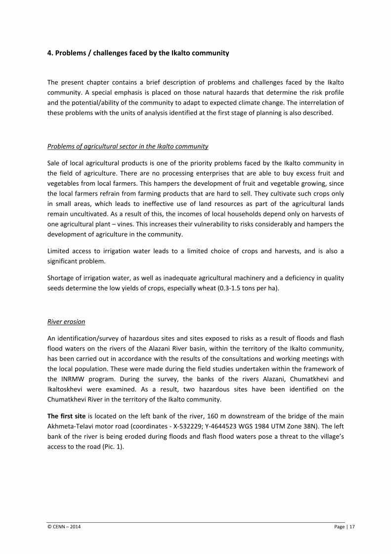
An identification/survey of hazardous sites and sites exposed to risks as a result of floods and flash flood waters on the rivers of the Alazani River basin, within the territory of the Ikalto community, has been carried out in accordance with the results of the consultations and working meetings with the local population. These were made during the field studies undertaken within the framework of the INRMW program. During the survey, the banks of the rivers Alazani, Chumatkhevi and Ikaltoskhevi were examined. As a result, two hazardous sites have been identified on the Chumatkhevi River in the territory of the Ikalto community.
The first site is located on the left bank of the river, 160 m downstream of the bridge of the main Akhmeta-Telavi motor road (coordinates - X-532229; Y-4644523 WGS 1984 UTM Zone 38N). The left bank of the river is being eroded during floods and flash flood waters pose a threat to the village’s access to the road (Pic. 1).
© CENN – 2014 Page | 17
Pic 1. The Ikalto community, hazardous left bank of the Chumatkhevi River.
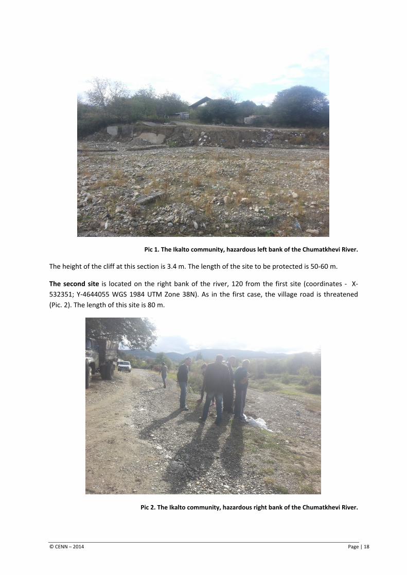
The height of the cliff at this section is 3.4 m. The length of the site to be protected is 50-60 m.
The second site is located on the right bank of the river, 120 from the first site (coordinates - X-532351; Y-4644055 WGS 1984 UTM Zone 38N). As in the first case, the village road is threatened (Pic. 2). The length of this site is 80 m.
Pic 2. The Ikalto community, hazardous right bank of the Chumatkhevi River.
© CENN – 2014 Page | 18
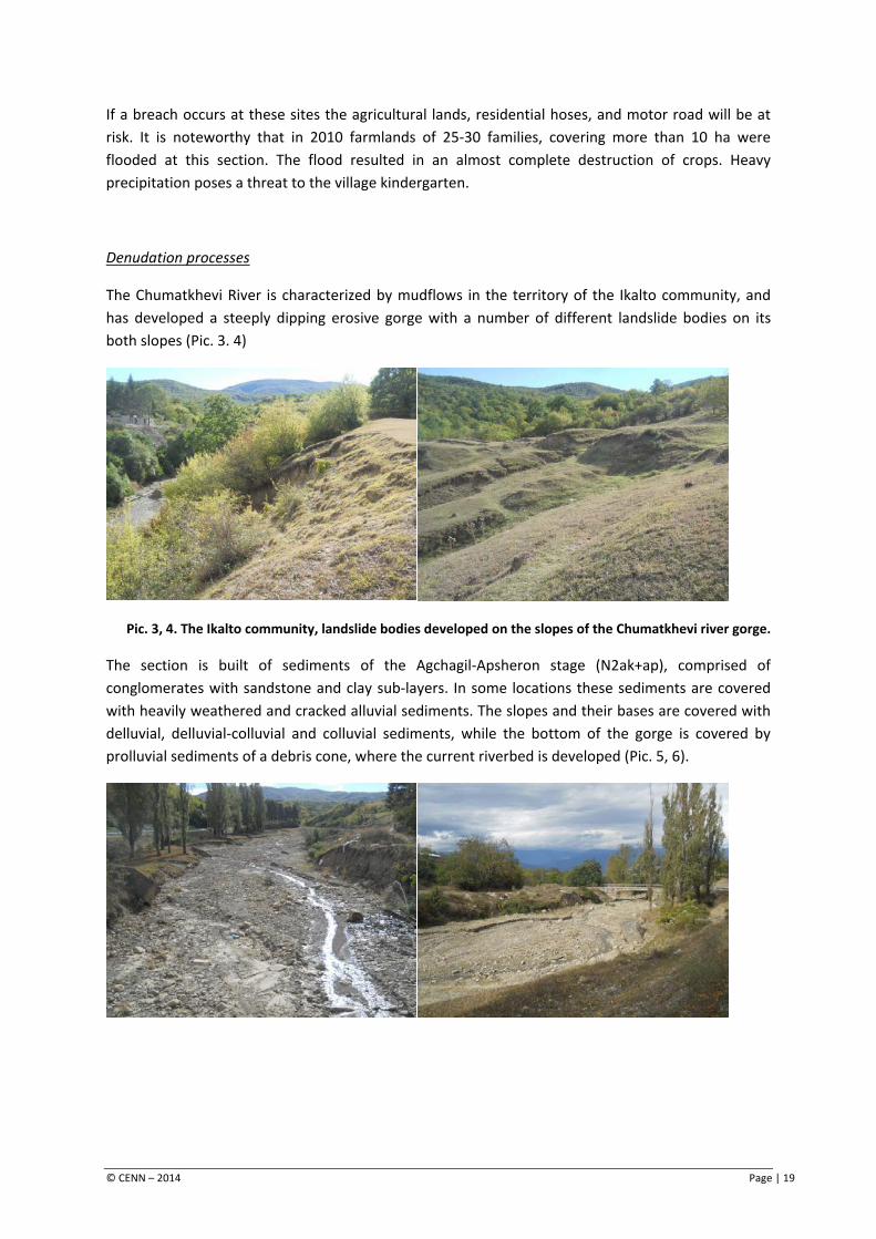
If a breach occurs at these sites the agricultural lands, residential hoses, and motor road will be at risk. It is noteworthy that in 2010 farmlands of 25-30 families, covering more than 10 ha were flooded at this section. The flood resulted in an almost complete destruction of crops. Heavy precipitation poses a threat to the village kindergarten.
Denudation processes
The Chumatkhevi River is characterized by mudflows in the territory of the Ikalto community, and has developed a steeply dipping erosive gorge with a number of different landslide bodies on its both slopes (Pic. 3. 4)
Pic. 3, 4. The Ikalto community, landslide bodies developed on the slopes of the Chumatkhevi river gorge.
The section is built of sediments of the Agchagil-Apsheron stage (N2ak+ap), comprised of conglomerates with sandstone and clay sub-layers. In some locations these sediments are covered with heavily weathered and cracked alluvial sediments. The slopes and their bases are covered with delluvial, delluvial-colluvial and colluvial sediments, while the bottom of the gorge is covered by prolluvial sediments of a debris cone, where the current riverbed is developed (Pic. 5, 6).
© CENN – 2014 Page | 19
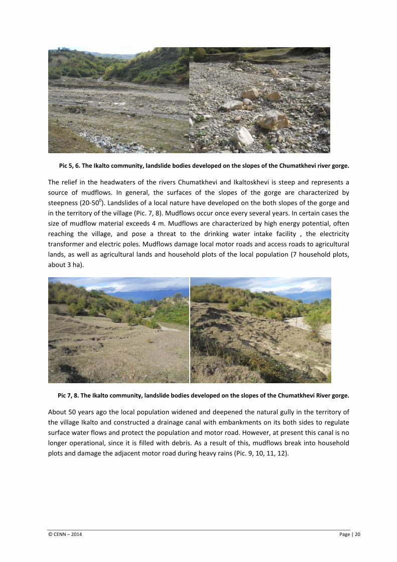
Pic 5, 6. The Ikalto community, landslide bodies developed on the slopes of the Chumatkhevi river gorge.
The relief in the headwaters of the rivers Chumatkhevi and Ikaltoskhevi is steep and represents a source of mudflows. In general, the surfaces of the slopes of the gorge are characterized by steepness (20-500). Landslides of a local nature have developed on the both slopes of the gorge and in the territory of the village (Pic. 7, 8). Mudflows occur once every several years. In certain cases the size of mudflow material exceeds 4 m. Mudflows are characterized by high energy potential, often reaching the village, and pose a threat to the drinking water intake facility , the electricity transformer and electric poles. Mudflows damage local motor roads and access roads to agricultural lands, as well as agricultural lands and household plots of the local population (7 household plots, about 3 ha).
Pic 7, 8. The Ikalto community, landslide bodies developed on the slopes of the Chumatkhevi River gorge.
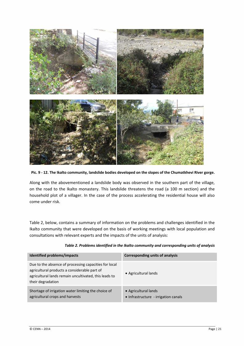
About 50 years ago the local population widened and deepened the natural gully in the territory of the village Ikalto and constructed a drainage canal with embankments on its both sides to regulate surface water flows and protect the population and motor road. However, at present this canal is no longer operational, since it is filled with debris. As a result of this, mudflows break into household plots and damage the adjacent motor road during heavy rains (Pic. 9, 10, 11, 12).
© CENN – 2014 Page | 20
Pic. 9 - 12. The Ikalto community, landslide bodies developed on the slopes of the Chumatkhevi River gorge.
Along with the abovementioned a landslide body was observed in the southern part of the village, on the road to the Ikalto monastery. This landslide threatens the road (a 100 m section) and the household plot of a villager. In the case of the process accelerating the residential house will also come under risk.
Table 2, below, contains a summary of information on the problems and challenges identified in the Ikalto community that were developed on the basis of working meetings with local population and consultations with relevant experts and the impacts of the units of analysis:
Table 2. Problems identified in the Ikalto community and corresponding units of analysis
Identified problems/impacts Corresponding units of analysis
Due to the absence of processing capacities for local agricultural products a considerable part of agricultural lands remain uncultivated, this leads to their degradation
• Agricultural lands
Shortage of irrigation water limiting the choice of agricultural crops and harvests
• Agricultural lands • Infrastructure - irrigation canals
© CENN – 2014 Page | 21
Identified problems/impacts Corresponding units of analysis
Floods and flash flood waters occurring as a result of river bank erosion damages the community
• Agricultural lands • Infrastructure – residential houses, motor roads
Mudflow processes contribute to the reduction of harvests, water and electricity supply systems of the community are under the threat
• Agricultural lands • Infrastructure – drinking water intake facility,
electricity transmission infrastructure
Landslide processes threaten agricultural lands, which may lead to the reduction of agricultural incomes. The road network of the village is also under threat.
• Agricultural lands • Infrastructure – motor road
© CENN – 2014 Page | 22
5. Climate change and its consequences
After the identification of challenges that exist in the community, climate change trends were identified to determine the potential direct impacts of climate change in terms of emerging challenges and the aggravation of existing problems in the community. Climate change trends have been identified on the basis of local knowledge/experience as well as using the results of the climate change studies carried out at the previous stages of the program5. Table 3 contains climate change trends along with descriptions of potential direct impacts and indications of those units of analysis that might be potentially affected by the mentioned changes.
Table 3. Climate change and potential direct impacts
Climate change trends Direct impacts Corresponding units of analysis
Expected increase of all parameters of air temperature (mean annual, seasonal, etc.)
• Change of the agricultural calendar. • Decrease in river discharge and
groundwater yields.
• Agricultural lands • Hydrographic network
Increase of draught risks • Soil degradation and acceleration of the
desertification process • Change of agro-technical terms
• Agricultural lands
Increase in precipitation. Change in the seasonal distribution of precipitation
• Increase in the risk of acceleration of landslide processes
• Expected increase in the occurrences and scales of floods and the consequent increased risk of flooding and acceleration of erosion of riverside areas
• High risk of mudflows, floods and flash waters will be maintained
• The areas prone to mudflows, floods, flash waters and landslides will face increased risks
• Agricultural lands • Hydrographic network –
engineering and service structures, utilities, residential houses
For more details on the impacts of climate change in the Telavi municipality please refer to the report - Assessment of the Vulnerability to Natural Disasters and Climate Change for Upper Alazani Pilot Watershed Area & Plan of Mitigation and Adaptation Measures.
5 see INRMW program, report - Assessment of the Vulnerability to Natural Disasters and Climate Change for Upper Alazani Pilot Watershed Area & Plan of Mitigation and Adaptation Measures.
© CENN – 2014 Page | 23
6. Combined impacts in the Ikalto community
At this stage the potential combined impacts of the challenges faced by the community and the consequences of climate change on the units of analysis have been assessed on the basis of experts’ work and participatory working meetings with the local population.
Impacts on agriculture
Increased demand for irrigation water in the Ikalto community is expected under forecasted climate change scenarios. Although these scenarios predict an increase in mean annual precipitation, it should be also taken into account that an increase in temperature by 2-2.50C, including an increase in mean maximal temperature in summer are expected, this will lead to increased demand for water for agricultural crops.
As has been stated in previous chapters agricultural incomes depend on mainly on a few crops. Potential changes in the agro-technical terms (due to changes in precipitation and temperature patterns) under different climate change scenarios, as well as the increased demand for irrigation water, will further restrict the choice of agricultural crops. Therefore the incomes from agriculture will depend on one crop (or at best a few crops). In conditions of increased occurrences of extreme weather events this will considerably affect the incomes of farmers. Therefore, the vulnerability of the Ikalto community will be increased due to climate change.
Along with the abovementioned, the qualitative degradation of existing agricultural lands is expected (due to increased droughts and changes in precipitation patterns). This will affect both the qualitative and quantitative characteristics of agricultural products and lead to increased agricultural costs.
Based on the abovementioned, it can be concluded that climate change will have a substantial impact on agriculture in the Ikalto community.
Negative natural phenomena
The analysis of the existing situation shows that the Ikalto community is being affected by negative natural phenomena such as river erosion, leading to flooding in the territory of the community during floods and flash floods. Mudflows in the ravines of the community are common. The utilities of the community are being damaged by landslides. The scales of natural processes observed in the community is described in detail in Chapter 4.
According to climate change scenarios, acceleration of landslide processes is expected due to increased precipitation. Increased occurrence and intensity of floods is also expected. The current high risk of developing mudflows and flash floods will be maintained. Therefore, this will presumably lead to increased damage from natural phenomena in the Ikalto community. The areas currently being threatened by these hazards will be most affected.
© CENN – 2014 Page | 24
Considering the present scale of these impacts in the Ikalto community, climate change will have a medium impact on the development of hazardous natural processes.
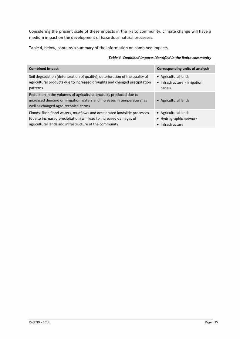
Table 4, below, contains a summary of the information on combined impacts.
Table 4. Combined impacts identified in the Ikalto community
Combined impact Corresponding units of analysis
Soil degradation (deterioration of quality), deterioration of the quality of agricultural products due to increased droughts and changed precipitation patterns
• Agricultural lands • Infrastructure - irrigation
canals
Reduction in the volumes of agricultural products produced due to increased demand on irrigation waters and increases in temperature, as well as changed agro-technical terms
• Agricultural lands
Floods, flash flood waters, mudflows and accelerated landslide processes (due to increased precipitation) will lead to increased damages of agricultural lands and infrastructure of the community.
• Agricultural lands • Hydrographic network • Infrastructure
© CENN – 2014 Page | 25
7. Adaptation and disaster risk reduction activities
The final stage of the selected methodology for planning climate change adaptation and natural disaster risk reduction activities considers the development of an action plan to ensure the prevention or mitigation of the negative impacts identified at the previous stages of planning. The following set of activities for each impact, identified for the Ikalto community, have been selected in close cooperation with experts of the relevant fields.
Agriculture
1. Vine is the main agricultural plant in the Ikalto community. From grain crops, the most profitable is corn. The development of vegetable and fruit growing depends entirely on solving the problems associated with sales of local agricultural products. The volumes and stability of yields for the majority of crops depend on the proper operation and availability of irrigation systems for agricultural lands.
As was indicated at the pervious stages of planning, an increases demand for water for agricultural crops is expected against the background of climate change in the community. Therefore, it is very important to implement activities that ensure retention and increase of moisture content in soils:
a) Soil productivity, specifically the content of organic matter in soils, should increased. Organic matter in soils is able to retain about 10 times as much water as its dehydrated weight; therefore, the content of soil determines its ability to retain moisture. This can be achieved through the application of organic fertilizers. Taking into account the current level of soil fertility application of 25-30 tons of composted manure, compost manure or compost per 1 ha. The amount of fertilizers can be increased depending on the needs of crops if applied to soils poor in organic matter.
The content of organic matter in soils can be increased through the sowing of green manure (so-called green fertilizers). For this purpose legumes (e.g. vetch, grass pea) are mainly used. Green manure can be used for both perennials (vine, fruits), and annual crops. For the preparation of land plots for autumn cereals (wheat, barley) green manure can be sowed in spring and ploughed into the soils during their flowering period, while in case of spring crops (corn, the majority of vegetables and vine crops) they can be sowed in autumn (September-October) and ploughed into the soils prior to sowing the main crops.
b) Mulching is an important activity for ensuring that moisture in soils is retained. Mulching is effective for vines and other perennials. Mulching materials have to be made of locally available hay or crop remains. HayHay used for mulching should not contain the seeds of weeds, therefore grass should be mowed during the flowering season. Mulching for perennials should be done in spring, before rains; for vegetables it should be done after transplanting or when sprouts reach a desirable height.
Along with dead mulch, so-called live mulch can be used between the rows of perennials. For this cover plants have to be sown. Cover plants are comprised of legumes or a combination of legumes and grain grasses. Cover plants retain moisture in soils as well as revitalizing and improving their
© CENN – 2014 Page | 26
structure. The presence of legumes (vetch, grass pea, clover, etc.) in cover plants ensures the accumulation of biological nitrogen in soils and thus improves consumption of nitrogen by the main crops.
The use of cover plants on arable lands is important in the case of spring crops, when soils are free from vegetation during the autumn-winter and early spring periods. During this period cover plants can protects soils form erosion, retain moisture in soils, restrict the development of weeds, accumulate biological nitrogen and provide significant amounts of green mass that can be used as green fertilizers, forage and preparation of mulch and nourishing hay.
In the case of the Ikalto community, the combination of mulch prepared from hay and crops remains is recommended under vine and fruit plantations. Specifically, mulch can be applied within the zone surrounding by the roots of plants, while cover plants can be sown between the rows. This measure will ensure retention of moisture in soils for a long period of time during droughts. Cover plants will not compete for water with main crops, moreover, they will provide additional nitrogen, prevent the development of soil crusts and mitigate the need for ploughing, reduce rain water losses and ensure accumulation of water in soils.
2. To increase the productivity of cattle improvements in the local breeding stock are required. Currently, the average yield per dairy cow is around 8-10 l a day, which can be considered as a mean index in the conditions of Georgia; however, it is low compared to the potential of exiting breeds of dairy and dairy-beef cattle. The village Ikalto has sufficient pastures and arable lands to increase the production of milk and meat and make cattle breeding more profitable, if breeding stock is improved.
3. Maintenance of local breeds of sheep and improvement of forage reserves is important for the development of sheep breeding in the Ikalto community. Special attention should be given to the proper management of pastures. For this purpose a plot rotation practice should be introduced to keep the productivity of pastures at the current level and enable their improvement, which in turn will give local farmers the possibility to increase the number of sheep.
4. Like in other regions of Georgia the development of pig breeding in the Ikalto community has been restricted since the outbreak of African Pig Plague. At present, pig breeding has no commercial importance. To maintain and further develop the pig breeding practice regular implementation of preventive measures against diseases and strict observation of sanitary and hygienic rules is required.
5. The development of bee keeping in the Ikalto community will contribute to the growth of incomes of local farmers if it is exploited to its full potential, implying production of other valuable products along with honey. The role of bees in the growth of the pollination index for agricultural crops, leading to increased yields, should also be considered. To support the development of bee keeping and the growth of productivity nectariferous plants should be included in seed rotation, cover plants and pastures (sainfoin, alfalfa, clover, etc.).
© CENN – 2014 Page | 27
Hazardous natural processes
River erosion
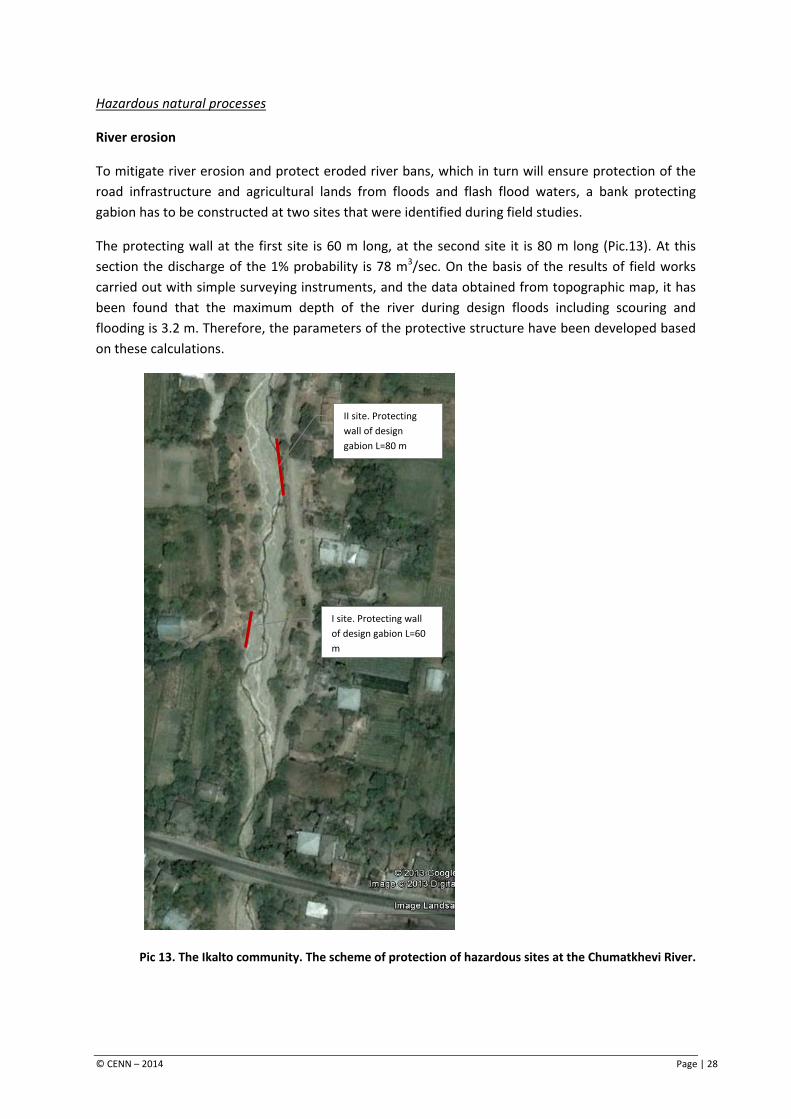
To mitigate river erosion and protect eroded river bans, which in turn will ensure protection of the road infrastructure and agricultural lands from floods and flash flood waters, a bank protecting gabion has to be constructed at two sites that were identified during field studies.
The protecting wall at the first site is 60 m long, at the second site it is 80 m long (Pic.13). At this section the discharge of the 1% probability is 78 m3/sec. On the basis of the results of field works carried out with simple surveying instruments, and the data obtained from topographic map, it has been found that the maximum depth of the river during design floods including scouring and flooding is 3.2 m. Therefore, the parameters of the protective structure have been developed based on these calculations.
Pic 13. The Ikalto community. The scheme of protection of hazardous sites at the Chumatkhevi River.
I site. Protecting wall of design gabion L=60 m
II site. Protecting wall of design gabion L=80 m
© CENN – 2014 Page | 28
The estimated volume of the wall of the designed gabion at site I, indicated in the picture, is 360 m3. The estimated cost of bank protection-rehabilitation activities at this section (coordinates - X-532229; Y-4644523 WGS 1984 UTM Zone 38N) is 60,000 GEL.
The estimated volume of the wall of the designed gabion at site, II indicated in the picture. is 490 m3. In this case (coordinates - X-532351; Y-4644055 WGS 1984 UTM Zone 38N) the estimated cost of bank protection-rehabilitation activities is about 80,000 GEL.
Mudflow processes
Two sites were identified in the territory of the Ikalto community in the context of mudflows where the relevant risk reduction activities have been planned:
Site I – The implementation of the following measures on the Chumatkhevi River is important for the reduction of risk development of destructive mudflow processes:
• permanent monitoring of the Chumatkhevi River and introduction of early warning system. Informing the population on mudflow hazards on a regular basis.
• periodical cleaning of the riverbed, characterized by frequent mudflows, from sediments to prevent the development of large scale mudflows.
• implementation of phytomelioration activities on the slopes of the river around mudflow origin sites, which will also ensure stabilization of local landslide bodies to a certain degree.
Site II – as has been already mentioned, a drainage canal has been constructed within the natural gully to regulate surface flows. This canal is currently filled with different types of debris and therefore is not operating. As a result of this, mudflow mass enters household plots and damages the adjacent motor road. To avoid such negative events this canal should be fully cleaned/rehabilitated. In the future the canal, especially up to the point 700-800 m upstream from the road to the church (coordinates X-532182; Y-4643330 WGS 1984 UTM Zone 38N) should be cleaned periodically.
Table 5, below, contains a summary of information on climate change and natural disaster risk reduction activities to be implemented in the Ikalto community.
© CENN – 2014 Page | 29
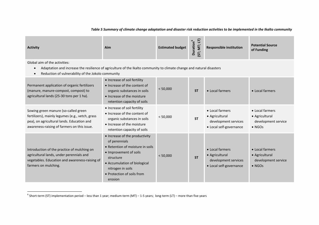
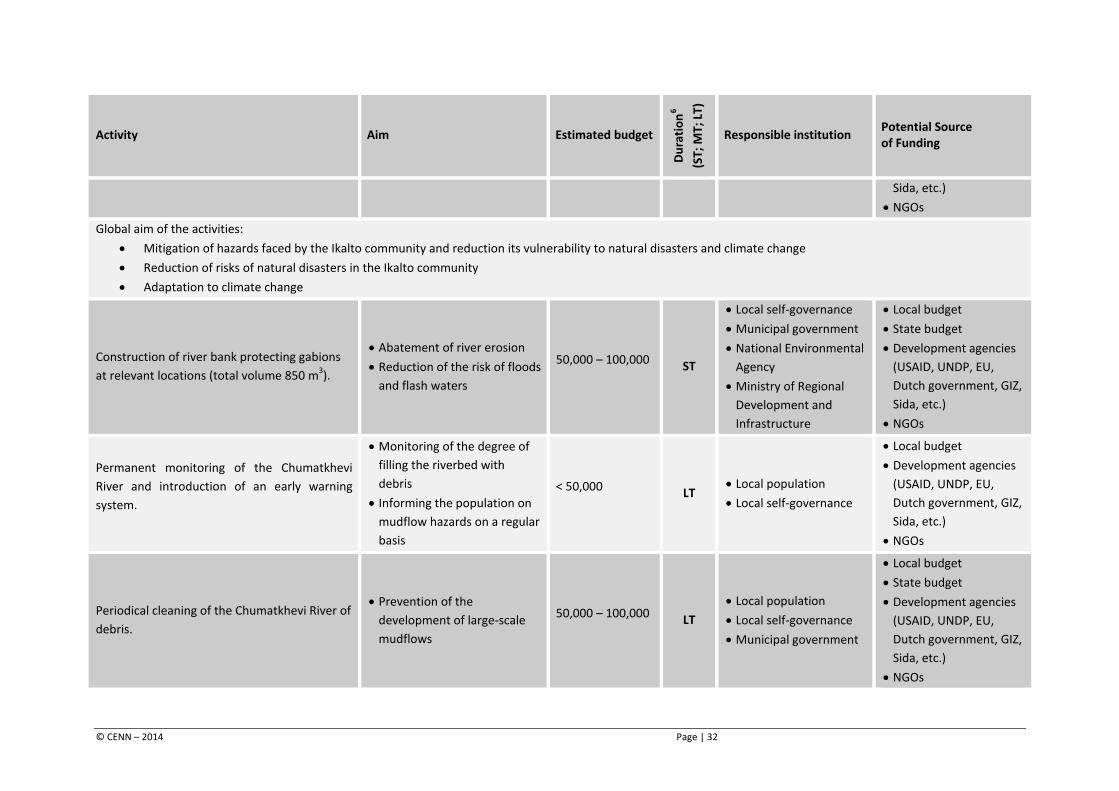
Table 5 Summary of climate change adaptation and disaster risk reduction activities to be implemented in the Ikalto community
Activity Aim Estimated budget
Dura
tion6
(ST;
MT;
LT)
Responsible institution Potential Source of Funding
Global aim of the activities: • Adaptation and increase the resilience of agriculture of the Ikalto community to climate change and natural disasters • Reduction of vulnerability of the Jokolo community
Permanent application of organic fertilizers (manure, manure-compost, compost) to agricultural lands (25-30 tons per 1 ha).
• Increase of soil fertility • Increase of the content of
organic substances in soils • Increase of the moisture
retention capacity of soils
< 50,000 ST • Local farmers • Local farmers
Sowing green manure (so-called green fertilizers), mainly legumes (e.g., vetch, grass pea), on agricultural lands. Education and awareness-raising of farmers on this issue.
• Increase of soil fertility • Increase of the content of
organic substances in soils • Increase of the moisture
retention capacity of soils
< 50,000 ST
• Local farmers • Agricultural
development services • Local self-governance
• Local farmers • Agricultural
development service • NGOs
Introduction of the practice of mulching on agricultural lands, under perennials and vegetables. Education and awareness-raising of farmers on mulching.
• Increase of the productivity of perennials
• Retention of moisture in soils • Improvement of soils
structure • Accumulation of biological
nitrogen in soils • Protection of soils from
erosion
< 50,000 ST
• Local farmers • Agricultural
development services • Local self-governance
• Local farmers • Agricultural
development service • NGOs
6 Short-term (ST) implementation period – less than 1 year; medium-term (MT) – 1-5 years; long-term (LT) – more than five years
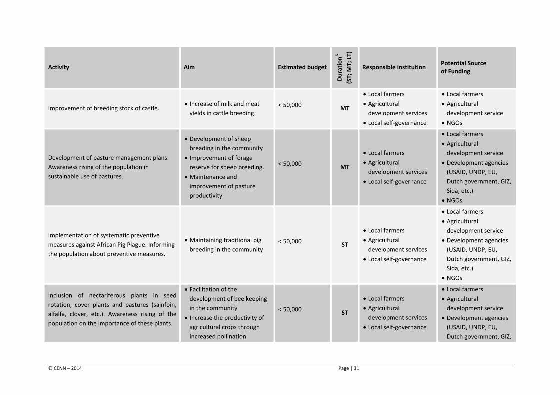
Activity Aim Estimated budget
Dura
tion6
(ST;
MT;
LT)
Responsible institution Potential Source of Funding
Improvement of breeding stock of castle. • Increase of milk and meat
yields in cattle breeding < 50,000 MT
• Local farmers • Agricultural
development services • Local self-governance
• Local farmers • Agricultural
development service • NGOs
Development of pasture management plans. Awareness rising of the population in sustainable use of pastures.
• Development of sheep breading in the community
• Improvement of forage reserve for sheep breeding.
• Maintenance and improvement of pasture productivity
< 50,000 MT
• Local farmers • Agricultural
development services • Local self-governance
• Local farmers • Agricultural
development service • Development agencies
(USAID, UNDP, EU, Dutch government, GIZ, Sida, etc.)
• NGOs
Implementation of systematic preventive measures against African Pig Plague. Informing the population about preventive measures.
• Maintaining traditional pig breeding in the community
< 50,000 ST
• Local farmers • Agricultural
development services • Local self-governance
• Local farmers • Agricultural
development service • Development agencies
(USAID, UNDP, EU, Dutch government, GIZ, Sida, etc.)
• NGOs
Inclusion of nectariferous plants in seed rotation, cover plants and pastures (sainfoin, alfalfa, clover, etc.). Awareness rising of the population on the importance of these plants.
• Facilitation of the development of bee keeping in the community
• Increase the productivity of agricultural crops through increased pollination
< 50,000 ST
• Local farmers • Agricultural
development services • Local self-governance
• Local farmers • Agricultural
development service • Development agencies
(USAID, UNDP, EU, Dutch government, GIZ,
© CENN – 2014 Page | 31
Activity Aim Estimated budget
Dura
tion6
(ST;
MT;
LT)
Responsible institution Potential Source of Funding
Sida, etc.) • NGOs
Global aim of the activities: • Mitigation of hazards faced by the Ikalto community and reduction its vulnerability to natural disasters and climate change • Reduction of risks of natural disasters in the Ikalto community • Adaptation to climate change
Construction of river bank protecting gabions at relevant locations (total volume 850 m3).
• Abatement of river erosion • Reduction of the risk of floods
and flash waters
50,000 – 100,000 ST
• Local self-governance • Municipal government • National Environmental
Agency • Ministry of Regional
Development and Infrastructure
• Local budget • State budget • Development agencies
(USAID, UNDP, EU, Dutch government, GIZ, Sida, etc.)
• NGOs
Permanent monitoring of the Chumatkhevi River and introduction of an early warning system.
• Monitoring of the degree of filling the riverbed with debris
• Informing the population on mudflow hazards on a regular basis
< 50,000 LT • Local population • Local self-governance
• Local budget • Development agencies
(USAID, UNDP, EU, Dutch government, GIZ, Sida, etc.)
• NGOs
Periodical cleaning of the Chumatkhevi River of debris.
• Prevention of the development of large-scale mudflows
50,000 – 100,000 LT • Local population • Local self-governance • Municipal government
• Local budget • State budget • Development agencies
(USAID, UNDP, EU, Dutch government, GIZ, Sida, etc.)
• NGOs
© CENN – 2014 Page | 32
Activity Aim Estimated budget
Dura
tion6
(ST;
MT;
LT)
Responsible institution Potential Source of Funding
Implementation of phytomelioration activities on the slopes of the ravine around mudflow origin sites.
• Prevention of the development of large-scale mudflows
• Stabilization of the slopes of the ravine
• Stabilization of local landslide bodies
< 50,000 MT • Local population • Local self-governance
• Local budget • Development agencies
(USAID, UNDP, EU, Dutch government, GIZ, Sida, etc.)
• NGOs
Full cleaning of the drainage canal in the village Ikalto. Regular cleaning of the canal.
• protection of household plots from mudflow masses
• Protection of the road network of the community from damage
< 50,000 ST • Local population • Local self-governance
• Local budget • Development agencies
(USAID, UNDP, EU, Dutch government, GIZ, Sida, etc.)
• NGOs
© CENN – 2014 Page | 33


Global Water for Sustainability Program
Florida International University
Biscayne Bay Campus
3000 NE 151St. ACI-267
North Miami, FL 33181 USA
Phone: (+1-305) 919-4112
Fax: (+1-305) 919-4117
www.globalwaters.net