community planning & economic development standing...
TRANSCRIPT
Community Planning & Economic Development Standing Committee November 14, 2013
TO: Chair and Members of Community Planning & Economic Development Standing Committee
Original Signed by: SUBMITTED BY:
Jane Fraser. Director, Planning & Infrastructure
DATE: November 4, 2013
SUBJECT: Mainland Halifax North – Bedford Corridor Transportation and Wastewater Servicing Strategy
ORIGIN
At the Feb. 28, 2012, meeting, Regional Council adopted the recommendation of staff and this Committee:
1. That a servicing strategy be initiated for the Bedford - Mainland Halifax North Corridor to estimate transportation and wastewater services upgrades needed to service future growth with associated costs and suggested means of finance; and
2. Further public consultation on all development proposals referenced in this report1, which require plan amendments, be deferred until the servicing study has been completed.
LEGISLATIVE AUTHORITY
Under Part VIII, Section 229, a municipal planning strategy may include: � statements of policy regarding studies to be carried out prior to undertaking specified
developments or developments in specified areas; � the protection, use and development of lands within the Municipality; and � municipal investment for public and private development and the coordination of public
programs relating to the economic, social and physical development of the Municipality.
In accordance with Section 219, Council is required to adopt, by policy, a public participation program concerning the preparation of planning documents.
(Recommendation on next page)
1 The staff report presented at the February 9, 2012 meeting of the Community Planning & Economic Development Standing Committee.

Mainland Halifax North – Bedford Corridor Servicing Strategy CP&ED Standing Committee - 2 - November 14, 2013
RECOMMENDATION
It is recommended that the Committee recommend to Regional Council:
1. That the Bedford-Halifax Mainland North Corridor Traffic Study Report (MRC, October 2013) be accepted by Council and that the findings of the study related to the capacity of the transportation network, to accommodate the low and high population scenarios, be accepted in principle as a means to proceed with development applications;
2. That an amendment to the Halifax Municipal Planning Strategy be initiated to allow for consideration of a mixed use development on a 63 acre property, adjacent to Mount St. Vincent University (“the Motherhouse lands”) and that a public meeting be scheduled to present the proposal and solicit comments; and
3. That public consultations and deliberations on all development proposals, which were held in abeyance pending completion of the wastewater and transportation studies, be resumed.
BACKGROUND
At the February 9, 2012, meeting of this Committee, a staff report was presented in support of the recommendation to initiate transportation and wastewater servicing strategies. The recommendation was made in response to four development proposals to allow for increased densities; these were at Mill Cove, Birch Cove, Paper Mill Lake, the former radio transmitter site (Rockingham South) and the Sister of Charity “Motherhouse” property. The staff report, presented as Attachment A, includes a summary description and status of various development proposals received and justification for the recommendations.
Staff also recommended that further public consultations on any proposal requiring a plan amendment be deferred until the studies were completed.
Deliberations and Consultations:Since the recommendations were adopted by Council, the following activities regarding the development proposals have taken place: � At the March 18, 2013, meeting of Halifax and West Community Council, a stage I
development agreement was approved to allow for the Rockingham South mixed use development on the east side of Dunbrack Street. The development includes a mix of approximately 48 single unit, 98 townhouse units, 828 apartment units, and commercial floor space over 55 acres;
� Southwest Properties has held three meetings with area residents to consult about its development plans for the Motherhouse lands and has submitted its most recently revised plans for review by staff;
� Waterfront Development Corporation Ltd. has held three open house sessions to give area residents an opportunity for input into the development plans for the Bedford Waterfront at Mill Cove; and

Mainland Halifax North – Bedford Corridor Servicing Strategy CP&ED Standing Committee - 3 - November 14, 2013
� Crombie Property Holdings Ltd. and Sobey Leased Properties Ltd., have been working with Provincial and HRM staff to transfer a water lot in Moirs Pond to public ownership. Under a proposed plan for the Mill Cove area on the Bedford waterfront, this pond would become part of a municipal park.
Submissions received from proponents of these developments are presented as Attachment B.
The Transportation Study:Under the requests for proposals, the following study tasks were established:
� Review the development proposals at the five sites shown on Attachment A, along with any relevant studies related to trip generation and impact;
� Determine the trip generation characteristics of each site under two scenarios. One scenario would entail the development as proposed by the land owners and the other would be at lower suburban densities recently approved by the Municipality (the figures to be used will be supplied by HRM staff);
� For each development scenario, describe the transit measures required in accordance with the following generalized transit service characteristics: (1) a low service level which minimizes the introduction of new transit services; (2) a medium service level which introduces new routes and possibly transit facilities; and (3) a high service level which includes new high-capacity services (rail/ferry), higher-service bus transit (express buses on partially dedicated corridors), and increased conventional transit service, will make up these scenarios. The Proponent is to consult with HRM transit services in developing the transit proposals;
� Determine modal split expectations for each development/transit service level scenario and describe how the potential development sites can best contribute to the success of these scenarios, by virtue of their transit-oriented design or their geographic location;
� Describe active transportation measures which could influence trip characteristics with particular emphasis on enhancing transit ridership;
� Employ trip demand modeling to determine demands on both the roadway and transit networks. Traffic counts will be required. Consultations are to be held with HRM Regional Transportation in determining the study, boundaries, traffic count locations, modeling requirements (see Section 3.2) and modeling assumptions to be made;
� Review the Highway 102-Bayers Road Corridor Study and the need for additional roadway capacity identified in that assessment;
� Design, at a functional level, any additional roadway capacity projects needed to manage increasing demands; and
� Provide a high-level estimate of life-cycle costs for each element of roadway infrastructure or transit service needed to service each scenario for the purpose of scenario comparison. It should be recognized that some cost determination has been conducted in previous studies and these may be applied, provided they are reviewed and adjusted or updated as needed.

Mainland Halifax North – Bedford Corridor Servicing Strategy CP&ED Standing Committee - 4 - November 14, 2013
MRC was selected as the consultant for the study. The Bedford – Halifax Mainland North Traffic Study Report (October 2013) can be found under Planning Updates at http://www.halifax.ca/planhrm/
DISCUSSION
The key findings are summarized in Sections 7.5 and 8.4 of the study which are presented as Attachment C.
The Transportation Network and Public Transit:Modelling of the transportation network was done for current (2011) and future (2031) conditions. The 2031 model included the following vehicle capacity additions to the road network identified in the 2006 Regional Plan and other development-related road requirements:
� Widen Bayers Road – Highway 102 to Windsor Street � Burnside Drive Extension – Akerley Blvd to Damascus Road (provincial responsibility) � Highway 113 – Highway 102 to Highway 103 (provincial responsibility)� Margeson Drive Extension – Highway 101 to Lucasville Road � Regency Park Drive Extension – Thomas Raddall Drive to Washmill Lake Drive
Additional road network projects will be needed to add lanes for transit, high-occupancy vehicles and bicycles, to encourage shift in demand from single-occupant vehicles. Although the report evaluates specific additional improvements to the road and transit networks that are not identified by the Regional Plan, these are not to be considered recommendations but simply a demonstration of the ability to handle increased demand.
The modelling examined the impact of increasing transit service in a medium scenario (dedicated transit lanes and express transit service) and a high scenario (medium scenario plus rail or ferry) as well as status quo transit service. The table below summarizes how those transit service levels are expected to affect transit modal split (the percentage of people who choose transit to make their trip to work). Not unexpectedly, this data shows that more trips will be attracted to transit as the level of transit service increases but these increases are moderate in comparison to overall growth in new trip generation.
TRANSIT MODAL SPLIT TO PENINSULA HALIFAX (2031)Fairview Residents Bedford Residents
Status Quo 22% 18% Medium Transit Service 26% 22-23% High Transit Service 26-27% 24-29%
Notes: 1. These numbers reflect the High Population Scenario. Values for the Low Scenario are slightly less.
2. Ranges reflect alternative elements within the transit scenarios.

Mainland Halifax North – Bedford Corridor Servicing Strategy CP&ED Standing Committee - 5 - November 14, 2013
The study also reached the following conclusions regarding the transportation network and transit services:
� The higher population scenario would, in the broad regional context, not have significantly more impact on the road network performance than the low scenario;
� The resulting levels of service are within acceptable ranges without need to increase the road network capacity beyond the projects listed above;
� A higher level of transit service (medium or high) is important in reducing vehicle demand so that key intersections in the study area continue to operate capably. This capability is reliant on the road network projects indicated; however, even the scenario of high transit use cannot reverse that; and
� A ferry service between Mill Cove and Downtown Halifax does not appear to be viable due to the lack of contiguity of the Cove with neighbouring areas. Commuter rail appears to have the potential to complement transit and feeder buses in the longer term, as long as density also increases along the corridor.
The key to accommodating the transportation demands from this level of development is the implementation of the road network components identified and provision of an increased level of transit service delivery. The critical element of the road network requirement is the addition of traffic lanes to Bayers Road, as identified in the Highway 102/Bayers Road corridor study.
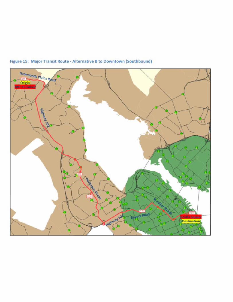
The increased level of transit service proposed by the study consists of two alternative urban express transit routes, supported by on-street transit priority measures. The alternative routes are illustrated on pages 41 and 43 of the study, which are reproduced as Attachment D. These proposals will require further assessment and co-ordination with ongoing strategic transit service planning.
Density and Clustering: The study offered the following comments regarding the impact of higher density and clustering on travel patterns:
� higher density developments, particularly when conceived as mixed use walkable projects, have the potential to support a more cost-effective transit system in the long run. From a transit perspective, they can be used to encourage less dependency on cars and more reliance on transit;
� The number of potential destinations within a specific area or neighbourhood, tends to increase with population and employment density, reducing travel distances and the need for car travel;
� Increased density tends to increase the number of transportation options available due to economies of scale; and
� Increased density tends to reduce traffic speeds, increase traffic congestion and reduce parking supply, making driving relatively less attractive relative to other transportation modes.
These findings are consistent with principles and opportunities identified by the Regional Plan to:� Support development patterns that promote a vigorous regional economy;
Mainland Halifax North – Bedford Corridor Servicing Strategy CP&ED Standing Committee - 6 - November 14, 2013
� Manage development to make the most effective use of land, energy, infrastructure, public services, facilities, and consider healthy lifestyles;
� Develop integrated transportation systems that improve transit use and reduce costs through improved use of the existing transportation network and integration of settlement pattern and transportation planning;
� Promote walkable, mixed use communities where people can be more active; � Reduce servicing costs by encouraging the right density in proposed developments and
reducing the dispersion and distance between communities; and � Reduce greenhouse gas emissions and leave more land in a natural state as less land is
needed for development.
The Regional Plan targets 50% of household growth to the suburbs. These development proposals are all within the suburbs and would increase the density of development within the urban service area boundary established under the Regional Subdivision By-Law. For these reasons, staff recommends that the study be accepted and that deliberations proceed on the development proposals that have been deferred pending completion of the study.
Cost Estimates and Financing:High level cost estimates for the various options are presented in Section 7.5 of the study which has been reproduced on page 13 of this report. Currently, these projects would be financed through the capital budget with possible assistance from senior levels of government, if available.
Staff has recently proposed a development charge to pay for regional transportation and transit related facilities, which could be used to pay for any of these projects in whole or in part2. At the October 29, 2013, meeting, Regional Council referred this matter back to the Committee of the Whole for further deliberation.
Wastewater Servicing: As directed by the N.S. Utility & Review Board, the Integrated Resource Plan (October 2012, Genivar, Halcrow & XCG Consultants Ltd.) was undertaken by Halifax Water in order to define its overall program and resource needs for the next thirty years (2013 - 2043). The IRP, utilizing the output of Halifax Water’s recently completed Regional Wastewater Functional Plan,responds to the combined requirements of regional growth, present and expected regulatory compliance and asset renewal. HRM’s planning department provided a range of growth projections for use by the IRP project team.
The IRP outlined required upgrades to regional infrastructure to facilitate the growth projections. In conjunction with the infrastructure plan, Halifax Water is developing an implementation plan that includes an appropriate funding mechanism and reasonable timeline to provide the infrastructure. An application has been made to the N.S Utility & Review Board, and a hearing has been scheduled for December of this year, for enhancements to the Regional Development Charges (RDCs) to provide the required long term funding.
2 A copy of the staff report can be found at http://www.halifax.ca/council/agendasc/131029rcAgenda.htmlunder item 11.4.2.

Mainland Halifax North – Bedford Corridor Servicing Strategy CP&ED Standing Committee - 7 - November 14, 2013
Subject to the approval of the funding increase, and establishment of a practical timeline to deliver the implementation plan, Halifax Water should be able to service the proposed developments.
Under an ideal timeline, Halifax Water would complete the above mentioned regional infrastructure upgrade implementation plan in advance of any major development activity within this broad planning area. However, in light of current development requests in the “Transmitter Lands”, the “Motherhouse Lands” and other smaller sites in this area, we have modeled our existing system and determined that the wastewater system has dry weather capacity for the approximate 5,000 person additional capacity that may be projected from these developments. Thus, they could be accommodated within our existing regional infrastructure, should HRM choose to proceed with the planning process for these developments. Please note there may be localized system upgrades required by each respective applicant in gaining access to the regional infrastructure.
At the same time it is important to note, that while this existing regional system within the Halifax area has current dry weather capacity, it does suffer from excessive wet weather flows like many of the other wastewater systems within our region. As such, during certain rain events there are combined sewer overflows (CSOs) and sanitary sewer overflows at various points along this system. Currently, Nova Scotia Environment (NSE) requires Halifax Water to report CSOs related to the Halifax Harbour Solutions system to NSE. The new regulations (or future regulations) may require the elimination or reduction of overflows, and may further restrict development activities that could increase overflow events, or allow development to occur with an appropriate management plan in place to deal with the reduction of overflows over time. The timing of these regulations, the impact on Halifax Water wastewater infrastructure requirements and the details of subsequent management plans, are not certain at this time. However, the long term vision of the IRP has developed infrastructure requirements in consideration of these anticipated regulatory requirements.
Next Steps:If the staff recommendations are adopted by Regional Council, the following actions would be required for the development proposals: � A public information meeting would be scheduled to present the development proposal for
the Motherhouse lands and solicit public opinion. If no significant problems arise, negotiations would be completed and the planning documents needed to accommodate the proposal would be brought back to Halifax and West Community Council for recommendation to Regional Council. If approval is to be considered, a public hearing would then be scheduled.
Normally, staff would recommend a more thorough public participation program than that being recommended for this project. However, in this instance, acknowledgement is being given to the three public consultations already undertaken by Southwest Properties.
� The staff and committee recommendations regarding the Paper Mill Lake and Bedford Waterfront development proposals would be tabled with North West Community Council

Mainland Halifax North – Bedford Corridor Servicing Strategy CP&ED Standing Committee - 8 - November 14, 2013
for deliberation. The Community Council would then recommend to Regional Council whether to hold a public hearing to consider approval of the plan amendments that have been drafted for the Paper Mill Lake lands, and whether to instruct staff to proceed to draft plan amendments to implement the consultant’s study recommendations for the Bedford Waterfront. A supplementary staff report will be prepared for the Community Council to address the requests by property owners within the Bedford Waterfront study area (see Attachment B).
� A staff and steering committee report regarding the Birch Cove study area would be tabled with Halifax and West Community Council. The Community Council would be requested to recommend to Regional Council whether to instruct staff to draft plan amendments to implement the consultant’s study recommendations.
The supportive road infrastructure and transit service will be built into upcoming functional and operational plans and the Project Budget process, all of which are subject to future approval by Regional Council. Staff accepts that a transit service level similar in concept to the medium transit scenario, is appropriate for areas such as this that have the potential to generate high transit demand and is necessary to moderate increased demand on the roadway network. The supportive road network capacity is identified in the current Road Network Functional Plan and some elements appear in the five-year Project Budget.
FINANCIAL IMPLICATIONS
There are no budgetary immediate implications associated with the recommendations of this report. Future infrastructure and service investments discussed in this report will be dealt with through the normal Project Budget process.
COMMUNITY ENGAGEMENT
A public meeting was held for the Paper Mill Lake plan amendment request and a series of three public meetings were held for each of the Bedford Waterfront and Birch Cove Waterfront design studies. Further information regarding the Paper Mill Lake proposal, meeting minutes and public comments received, can be made available upon request. Further information regarding the Bedford Waterfront and Birch Cove Waterfront design studies can be found at: http://www.halifax.ca/VisionHRM/BedfordWaterfront/index.html and http://www.halifax.ca/regionalplanning/WesternShoreBedfordBasin.html
Mainland Halifax North – Bedford Corridor Servicing Strategy CP&ED Standing Committee - 9 - November 14, 2013
ENVIRONMENTAL IMPLICATIONS
These projects offer opportunities to increase the density of development within the urban service area boundary, which could potentially further opportunities identified by the Regional Plan to manage development, to make the more effective use of energy and reduce greenhouse gas emissions and leave more land in a natural state, as less land is needed for development.
ALTERNATIVES
This committee could recommend that Regional Council:
1. Adopt the staff recommendations to accept the Bedford-Halifax Mainland North Corridor Traffic Study Report (MRC, October 2013) for consideration in planning future transportation improvements; initiate a plan amendment process for the Motherhouse lands; and continue consultation processes and deliberations for the other development proposals that were deferred.
2. Defer further consideration of all of these development proposals until the Regional Plan review has been completed. This option would be appropriate if the Committee is of the opinion that Council should first deliberate on the broader regional direction regarding preferred growth patterns.
Numerous submissions have been received recommending that HRM should increase the target currently established for the Regional Centre from 25% to as much as 50% of new housing starts. If this option is preferred, approval of these projects, or similar projects which increase development potential outside the regional centre, would make this objective more difficult to achieve. The more likely policy approach would be to discourage further development outside the Regional Centre while creating incentives for more development within the Centre.
Staff would not recommend this option as projects such as these, which intensify development within the established urban service boundaries, can further principles and opportunities identified by the Regional Plan.
3. Defer further consideration of these proposals until the Utility & Review Board has concluded hearings and rendered a decision regarding the application by Halifax Water for growth related development charges for water and wastewater services. The decision from the NSUARB may impact Halifax Water’s ability to fund growth related projects at current projected timelines.
Staff does not support this option as there is no evident advantage as growth will have to be accommodated in any event. More importantly, HRM should take the lead in deciding where growth should be supported.

Mainland Halifax North – Bedford Corridor Servicing Strategy CP&ED Standing Committee - 10 - November 14, 2013
ATTACHMENTS
Attachment A: Staff Report Re: Mainland Halifax North – Bedford Corridor Transportation Study, dated January 12, 2012.
Attachment B: Submissions received from development proponents
Attachment C: Summary of Study Findings
Attachment D: Alternative Transit Priority Routes
______________________________________________________________________________
A copy of this report can be obtained online at http://www.halifax.ca/commcoun/cc.html then choose the appropriate Community Council and meeting date, or by contacting the Office of the Municipal Clerk at 490-4210, or Fax 490-4208.
Report Prepared by: Paul Morgan, Planner, Planning & Infrastructure, 490-4482; David McCusker, Regional Transportation Manager, Planning & Infrastructure, 490-6696; and Kenda MacKenzie, Manager Engineering Approvals, Halifax Water, 490-5029
Original Signed by: ______________________________________ Report Approved by: Eddie Robar, Director, Metro Transit, 490-6720
Original Signed by ______________________________________ Report Approved by: Austin French, Manager, Planning Services, Planning & Infrastructure, 490-6717 ______________________________________ Report Approved by: Jamie Hannam, Director, Engineering and Information Services, Halifax Water, 490-1584
Original Signed by: Financial Approval by: ______________________________________ Greg Keefe, A/ Director of Finance/CFO, 490-6308 _______________________________________________________________________________________________________
Original Signed by:

Attachment A
Original Signed by:


Original Signed by:
Original Signed by:
Original Signed by:
Original Signed by:


Attachment B
Original Signed by
The Cable Wharf Phone: (902) 422-6591 1751 Lower Water Street Fax: (902) 422-7582 Halifax Nova Scotia Email: [email protected] B3J 1S5 Web: www.my-waterfront.ca
November 1, 2013
Austin French Manager, HRM Planning Services P.O. Box 1749 Halifax, NS B3J 3A5
Re: Bedford Waterfront
Dear Austin,
Waterfront Development acknowledges and supports the Regional Plan’s identification of the Bedford waterfront as an important regional growth centre. As you know, we have been engaging the community for some time to collaboratively determine a development scenario that meets both the intent of the Regional Plan and the aspirations of the local community.
With the infrastructure analysis now complete, we look forward to engaging the community anew. The purpose of the next round of engagement will be to finalize a plan that is socially, environmentally and financially sustainable, and of which all HRM residents can be proud.
Thanks very much for HRM’s ongoing partnership in this project, and for the opportunity to provide comment.
Andy Fillmore, LPP, MCIP, AICP VP Planning & Development Waterfront Development
Original Signed by

November 4, 2013 Paul Morgan, Regional Planner Halifax Regional Municipality Eastern Region Office 40 Alderney Drive Dartmouth, Nova Scotia B2Y 2N5 Re: Lot AEA1 – PID # 40598765 Bedford, NS Dear Mr. Morgan, The owner of the subject property has retained our company to engage the Halifax Regional Municipality with a planning application to establish the appropriate use and built form. It is his intention to develop the site for a mixed use building with underground parking, commercial at grade, and residential units above. In assessing the site our team researched the following:
� Regional Plan; � Bedford Municipal Planning Strategy; � Bedford Waterfront Visioning Plan; � Bedford Land Use Bylaw; � The physical characteristics of the site – previously a water lot;
1
� The site relationship with the Bedford Highway, adjacent uses, and the Bedford Basin.
The client is anxious to proceed with the public process, and is hoping to be under construction in the winter of 2014/ spring of 2015. Based on our research, and our successful public engagement for 2 nearby projects at 864 Bedford Highway and 644 Bedford Highway, we believe that the contemplated development plan for the subject site under the proposed Bedford Visioning Plan does not take into consideration the site specific characteristics and challenges, and consequently does not provide the parameters for a sustainable building that is in line with the expectation for development along the Bedford waterfront. This however can be realised through a site specific process that captures the essence of the site through the control measures of a Development Agreement. Thank you for your consideration. We look forward to collaborate with Staff, HRM Council, and the public on this exciting project. Regards, Cesar Saleh, P.Eng. VP Planning and Design W.M. Fares Group
2
Original Signed by

Mainland Halifax North – Bedford Corridor Servicing Strategy CP&ED Standing Committee - 11 - November 14, 2013
Attachment C: Summary of Study Findings
7.5 What does all this mean? The� modelling� process� determined� that� for� the� afternoon� peak� hour,� the� High� Population� Growth�Scenario�resulted�in�954�more�person�trip�“in”�productions�and�1452�more�person�trip�“in”�attractions�than� the� Low� Population� Growth� Scenario,� for� the� five� development� areas� combined.� Beyond� these�basic�figures,�a�number�of�specific�conclusions�can�be�drawn�from�the�findings.�
Traffic�impacts�
� The� volume�to�capacity� ratio� (v/c)� on� roadways� represents� a� similar� condition� for� both� Low�Population� Growth� and� High� Population� for� the� 2031� Base� Case,� The� high� and� low� population�Growth� scenarios� result� in� very� limited� difference� in� v/c� at� the� network� level� since� the� total�populations�in�both�scenarios�are�similar.��
� In� addition,� the� implementation� of� transit� improvements� would� benefit� auto� users;� the� average�delay�could�be�reduced�by�up�to�3.9%�depending�upon�the�transit�improvements.�
� Under� both� Low� and�High� population� scenarios,� total� vehicle�trip� (auto),� total� vehicle�kilometers,�total� vehicle�hours,� and� total� delay� in� the� network�would� be� reduced�with� the�medium� and� high�transit� service� level� scenarios;� accordingly,� total� person�trip�in�transit� usage� would� be� increased�with�the�proposed�transit�modes.�
Transit�Share�and�Ridership�
� The� medium� service� levels� scenario� with� the� major� transit� route� is� expected� to� improve� transit�ridership�by�320�to�475�during�the�afternoon�peak�hour�compared�to�Base�Case�(‘Status�Quo’).�
� Under�a�low�population�growth�scenario�transit�improvements�could�increase�transit�share�from�the�Peninsula�to�Fairview�Clayton�Park�by�approximately�4.0�to�5.1%�and�from�the�Peninsula�to�Bedford�by�approximately�3.0%�to�9.5%.��
� Under�a�high�population�growth�scenario�transit�improvements�could�increase�transit�share�from�the�Peninsula� to� Fairview� Clayton� Park� by� approximately� 3.9%� to� 4.7%� and� from� the� Peninsula� to�Bedford�by�approximately�3.6%�to�10.6%.��
� Ridership�on�the�major�transit�route�may�be�increased�by�providing�additional�stops�and/or�feeder�routes.��
� Commuter� Rail� is� expected� to� add� about� 300� additional� riders� during� peak� hour� or� 0.20� to� 0.25�percent�total�transit�share�compared�to�the�medium�transit�scenario.��
Transit�Trips�
� For�the�low�population�growth�scenario,�the�medium�transit�service�levels�would�increase�the�total�transit�trips�by�2.4�to�2.9%�and�the�high�transit� improvement�scenario�could�provide�a�3.5�to�6.9%�
Mainland Halifax North – Bedford Corridor Servicing Strategy CP&ED Standing Committee - 12 - November 14, 2013
increase�in�total�transit�ridership.�The�high�service�level�scenario�with�commuter�rail�+�major�transit�route�would�provide�the�highest�transit�ridership.�
� For�the�high�population�growth�scenario,�the�medium�transit�improvements�would�increase�the�total�transit�trips�by�2.63�to�3.44%�and�the�high�transit�service�scenario�could�provide�about�3.80�to�6.12%�increase�in�total�transit�ridership.��
So�what�does�this�all�mean?�In�Section�2,�for�the�five�development�proposals,�it�was�found�that�the�higher�population�scenario�would,�in�the�broad�regional�context,�not�have�any�significantly�more�impact�on�the�road�network�than�the�low�scenario,�other�than�some�additional�delay�on�Bedford�highway�between�Hammonds�Plains�Road�and�Southgate�Drive�in�the�southbound�direction�(PM�peak�hour).�This�is�not�surprising�given�the�relatively�minor�impact�on�the�overall�regional�population�and�dwelling�increases�expected�over�the�next�twenty�years.��
Similarly,�this�section�presented�the�results�of�an�analysis�of�transit�performance�under�high�and�low�population�growth�scenarios.�Similar�to�the�base�case�analysis�presented�in�Section�2,�while�there�are�nearly�900�more�person�trips�projected�in�the�AM�and�PM�periods�for�the�high�growth�scenario,�the�higher�population�growth�would�not�have�any�significantly�greater�impact�on�the�road�network�than�the�lower�growth�scenario.�Both�show�modest�reductions�in�total�auto�trips,�total�vehicle�kilometers,�total�vehicle�hours,�and�total�delay�in�the�network,�as�well�and�an�increase�in�transit�use�as�a�result�of�transit�improvements�(both�medium�and�high�scenarios).���
Notably�however,�an�improvement�in�transit�usage�is�slightly�better�in�the�high�transit�scenario�than�the�medium�transit�scenario,�but�at�significantly�higher�cost.�For�the�high�population�growth�scenario,�the�medium�transit�improvements�would�increase�the�total�transit�trips�by�3%�while�the�high�transit�improvement�scenario�would�provide�a�marginally�better�3.5�to�4.0%�increase.�
Cost�implications�
Following�are�high�order�infrastructure�cost�estimates�for�each�option�discussed�in�this�report.��

Mainland Halifax North – Bedford Corridor Servicing Strategy CP&ED Standing Committee - 13 - November 14, 2013
�Table�1:�Infrastructure�Cost�Estimates�
Scenario� Start�Up�Capital�Costs
Notes
Major�Transit�Route���Alt�A��(Bedford�Highway/Seton/Lacewood/Dunbrack)�
$�14,694,000 2013�estimates�
Major�Transit�Route���Alt�B�(Dunbrack)�
$6,600,000
Ferry� $�35,850,000 2010�estimates�per:�An�Operational�and�Life�Cycle�
Cost�Analysis�of�Transit�Service�Alternatives�in�the�Bedford�Halifax�Corridor
Commuter�Rail� $�25,850,000Transit–BRT�
(vehicles�only)�$�9,050,000
This�amount�would�be�added�to�all�of�the�costs�above,�based�on�the�scenarios�
described.Note:��Because�of�the�available�capacity�on�Dunbrack,�it�is�be�possible�to�use�it�as�is�for�the�foreseeable�future.�There�may�be�a�desire�over�time�to�add�transit�priority�measures;�in�such�case,�additional�costs�would�be�relatively�minor.��
8.4 Conclusion: What it all means
This report has analyzed the transportation implications of five development proposals in the Mainland North area of Halifax and Bedford. The probable impact on traffic congestion was explored, and various ways to mitigate that impact through transit, ferry and rail were also examined. The following conclusions and strategic directions are suggested by our findings:
8.4.1 Not significantly worse
The analysis revealed that the slightly higher level of development currently proposed for the five sites is not likely to have a significantly worse impact on the transportation network than more conventional densities proposed by the Regional Planning Advisory Committee. That being said, on a general note, higher density developments, particularly when conceived as mixed use walkable projects, have the potential to support a more cost-effective transit system in the long run. In other words, compact projects such as these should be encouraged. From a transit perspective, they can be used to encourage less dependency on cars and more reliance on transit.
8.4.2 Higher-order transit can deliver more riders
The analysis also revealed that a higher order of transit that builds on Metro Transit policies for the area, including a new transit terminal in Lacewood, has significant potential to improve transit usage and dependency. This could be achieved at a reasonable cost by using a four-lane Dunbrack Street as a central transit spine from which a feeder transit system could be added.
Mainland Halifax North – Bedford Corridor Servicing Strategy CP&ED Standing Committee - 14 - November 14, 2013
8.4.3 Build on the planned Peninsula Transit Corridor
Future study should consider the long term potential of the Dunbrack Street route, when connected to the proposed Bayers Road/Highway102 Peninsula transit corridor, to eventually permit a high-order transit corridor through the Mainland North area.
8.4.4 Adopt transit oriented development as a near term strategic goal
By affirming the long term intent for such a corridor, HRM and its citizens could begin to plan now for a highly connected transit oriented district that encompasses the entire Mainland North area.
8.4.5 Make a choice between rail and ferry
As demonstrated in our 2010 report, a ferry terminal at Mill Cove is constrained by a number of factors:
� The catchment area is limited by its lack of contiguity with neighbouring areas. While this could be partially mitigated by the large Mill Cove development as discussed in this report, it does not address the larger catchment area problem.
� Without a large investment in on-site parking, the ferry would require an off-site parking lot and shuttle service that imposes a time penalty on users; other modes (especially bus transit) are available and can be readily expanded at lower cost.
As a result of these constraints, which we conclude are insurmountable in the face of more cost-effective options, we recommend that a Mill Cove-Downtown ferry option as currently envisioned should be abandoned.
8.4.6 Plan for commuter rail as a long term strategy
As an opportunity for further significant growth in transit ridership and modal split, the High Transit Service Level with commuter rail appears to have potential to complement conventional transit and feeder bus routes in the longer term, as long as density also increases along the corridor. More study and planning should begin that includes a commuter rail-based transportation system as part of a long term vision for Halifax Regional Municipality and beyond.