community wildfire hazard risk assessment · pdf filefirewise communities/usa® page 1...
TRANSCRIPT

Firewise Communities/USA® Page 1 Firewise Communities Program® www.firewise.org
Community Wildfire Hazard Risk Assessment Chiwawa River Pines Lake Wenatchee, WA
Prepared by: Patrick Haggerty and Amanda Lavesque, Forestry and Firewise
Coordinators Cascadia Conservation District
And Mick Lamar, Fire Chief
Lake Wenatchee Fire and Rescue
September 2016
Firewise Communities/USA® Page 2 Firewise Communities Program® www.firewise.org
1) Introduction The Firewise Communities/USA program is designed to provide an effective management approach for preserving wildland living aesthetics. The program can be tailored for adoption by any community and/or neighborhood association that is committed to ensuring its citizens maximum protection from wildland fire. The following community assessment is intended as a resource to be used by the Chiwawa River Pines residents for creating a wildfire safety action plan. The plan developed from the information in this assessment should be implemented in a collaborative manner, and updated and modified as needed. This Assessment was prepared by a team representing Firewise Communities/USE that included Patrick Haggerty and Amanda Lavesque, Cascadia Conservation District (CCD), Fire Chief Mick Lamar and fire Safety and Prevention Coordinator Bill Moffat, Lake Wenatchee Fire and Rescue (LWFR) The assessment has been reviewed by Chuck Wytko, Washington Department of Natural Resources (DNR). 2) Definition of the Home Ignition Zone Chiwawa River Pines is located in a wildfire environment. Wildfires will happen--exclusion is not a choice. The variables in a fire scenario are when the fire will occur, and where. This assessment addresses the wildfire-related characteristics of Chiwawa River Pines. It examines the area’s exposure to wildfire as it relates to ignition potential. The assessment does not focus on specific homes, but examines the community as a whole. A house burns because of its interrelationship with everything in its surrounding home ignition zone----the house and its immediate surroundings. To avoid a home ignition, a homeowner must eliminate the wildfire’s potential relationship with his/her house. This can be accomplished by interrupting the natural path a fire takes. Changing a fire’s path by clearing a home ignition zone is an easy-to-accomplish task that can result in avoiding home loss. To accomplish this, flammable items such as dead vegetation must be removed from the area immediately around the structure to prevent flames from contacting it. Also, reducing the volume of live vegetation will affect the intensity of the wildfire as it enters the home ignition zone. Included in this assessment are observations made while visiting Chiwawa River Pines. The assessment addresses the ease with which home ignitions can occur under severe wildfire conditions and how these ignitions might be avoided within the home ignition zones of affected residents. The Chiwawa River Pines residents can reduce their risk of destruction during a wildfire by taking actions within their home ignition zones. This zone principally determines the potential for home ignitions during a wildland fire; it includes a house and its immediate surroundings within 100 to 150 feet. The result of the assessment is that wildfire behavior will be dominated by the residential characteristics of this area. The good news is that by addressing community

Firewise Communities/USA® Page 3 Firewise Communities Program® www.firewise.org
vulnerabilities, residents will be able to substantially reduce their exposure to loss. Relatively small investments of time and effort will reap great rewards in wildfire safety. 3) DESCRIPTION OF [SIZE AND NATURE OF] THE SEVERE CASE WILDLAND FIRE CHARACTERISTICS THAT COULD THREATEN THE AREA
Fire intensity and spread rate depend on the fuel type and condition (live/dead), the weather conditions prior and during ignition, and the topography. Generally the following relationships hold between the fire behavior and the fuel, weather and topography.
▪ Fine fuels ignite more easily and spread faster with higher intensities than coarser fuels. For a given fuel, the more there is and the more continuous it is, the faster the fire spreads and the higher the intensities. Fine fuels take a shorter time to burn out than coarser fuels.
▪ The weather conditions affect the moisture content of the dead and live vegetative fuels. Dead fine fuel moisture content is highly dependent on the relative humidity and the degree of sun exposure. The lower the relative humidity and the greater the sun exposure, the lower will be the fuel moisture content. Lower fuel moistures produce higher spread rates and fire intensities.
▪ Wind speed significantly influences the rate of fire spread and fire intensity. The higher the wind speed, the greater the spread rate and intensity.
▪ Topography influences fire behavior principally by the steepness of the slope. However, the configuration of the terrain such as narrow draws, saddles and so forth can influence fire spread and intensity. In general, the steeper the slope, the higher the uphill fire spread and intensity.
Chiwawa River Pines is a beautiful community that sits nestled between the Wenatchee and Chiwawa Rivers. While these rivers serve as significant firebreak, the community sits adjacent to vast tracts of USFS public property, under current management for multiple ecological and economic objectives. While the USFS has been actively managing lands adjacent to Chiwawa River Pines, less management has occurred in the upper watershed. With the exclusion of fire for over 100 years the largest risk of severe wildfire for this community if fires spreading down the Chiwawa Valley, or cresting the ridge from the Entiat Drainage. Under severe fire behavior conditions either of these situations would put the community at high risk due to continuous, dense fuel sources throughout the community. 4) SITE DESCRIPTION Chiwawa River Pines sits just 3 miles east of Lake Wenatchee and 19 miles east side of the Cascade Mountain Range Crest in Chelan County. Hardly foothills, the Lake is surrounded by Nason Ridge and Dirty Face Mountain both of which rise steeply from the lake from an elevation of ~1880 ft to ~6000 ft. Lake Wenatchee is located in the Upper Wenatchee watershed and is the headwaters of the Wenatchee River. The Lake is fed primarily by four tributaries including the Chiwawa River, White River, Little Wenatchee

Firewise Communities/USA® Page 4 Firewise Communities Program® www.firewise.org
River, and Nason Creek. All but Nason Creek have seen little development and are watersheds dominated by US Forest Service ownership with some checker-boarded private ownership, majority of which owned by Weyerhaeuser. Chiwawa River Pines sits between the Wenatchee River on the west and Chiwawa River on the East, and is nestled into a peninsula formed by the confluence of the two rivers. The forest land surrounding Chiwawa River Pines is comprised of Ponderosa pine, Douglas fir, grand fir, cedar and hemlock, with larch and alpine fir in the high elevations. Most stands within the community are overstocked, increasing the risk of catastrophic fires from the heavy layers of ladder fuels in the form of low hanging limbs and fuels on the ground. While adding somewhat to the overall aesthetics and privacy these stands provide, they also are the main component in moving a ground fire to the canopy. This neighborhood has been identified by WA DNR ranked a HIGH community at risk to wildfire based on data from the current National Fire Protection Association (NFPA 299) risk assessment due to various physical characteristics of landscape, including fuel loading, the need for more defensible space, topography and the proximity of home to wildlands. The Chiwawa River Pines Firewise Community includes 399 parcels, the majority of which are 0.5-1.0 acres with 10-15 private properties 10-31 acres. The community is comprise of two neighborhoods with the dividing line being Hwy 22. The northern neighborhood sits elevated above the Chiwawa River on a 10-30% slope and consists of roughly half of the parcels in the community. The other half of the parcels sit on the south side of the highway, on flat flood plain created by the confluence of the Chiwawa and Wenatchee Rivers.
Figure 1. WA DNR Communities at Risk Map showing Chiwawa River Pines Firewise Community as at HIGH risk.

Firewise Communities/USA® Page 5 Firewise Communities Program® www.firewise.org
Figure2. Chiwawa River Pines Firewise Community Boundary. 5) ASSESSMENT PROCESS – Staff from Lake Wenatchee Fire and Rescue and Cascadia Conservation District collaborated on this assessment. LWFR conducted an initial field visit to assess infrastructure, access, water availability and various other concerns. Cascadia followed up to assess forest health, stand density, and other wildfire risks. 6) IMPORTANT CONSIDERATIONS The Firewise Communities/USA program seeks to create a sustainable balance that will allow communities to live safely while maintaining environmental harmony in a WUI setting. Homeowners already balance their decisions about fire protection measures against their desire for certain flammable components on their properties. It is important for them to understand the implications of the choices they are making. These choices directly relate to the ignitability of their home ignition zones during a wildfire. Fire History

Firewise Communities/USA® Page 6 Firewise Communities Program® www.firewise.org
Figure 3. Chelan County Fire History 1901-2014. USFS 2014. As evidenced by the USFS Fire History map for Chelan County, the Lake Wenatchee area is no stranger to wildfire. Since 1970, over 600 fires have been started naturally or by human ignition in the Lake Wenatchee Fire and Rescue District. Historical fire intervals for this dry forest range for 7-20 years which helped evolve an ecosystem highly dependent on fire for maintaining natural species composition, stand density, and disease resistance. Successful wildfire suppression efforts throughout the 20th century have led to a forest condition distant from its natural state where average number of trees per acre (TPA) is often in the range of 400-800 stems as opposed to 60-100 TPA historically. Fire in this area was historically low to moderate severity with pockets of high intensity fire creating a mosaic landscape critical for forest health and wildlife habitat. The lack of low and mixed severity fires in the region has left the forests in the Lake Wenatchee area overstocked with tall brush ready to act as ladder fuels when fire does arrive. Additionally, forest stands are typically comprised of even age trees (~110 years old) and the canopies of the trees overlap significantly setting the stage for uncharacteristic, landscape-wide high severity wildfire behavior to take place in the future.

Firewise Communities/USA® Page 7 Firewise Communities Program® www.firewise.org
Figure 4. DNR Fire Risk Assessment overlayed with data from the DNR annual Insect and Disease Survey. Lake Wenatchee Community Wildfire Protection Plan 2007. Fuels Fire intensity and the rate a fire spreads depend on the type of fuel and the amount ready to burn at any given time of the year. Different fuel types burn at different rates. Live fuels; trees, brush and grasses burn slower than if they are dead. The weather conditions affect the moisture of live and dead vegetation. Lower relative humidity and higher temperatures will reduce the fuel moisture content, and produce higher fire spread rates and intensities. Wind speed significantly increases the rate of fire spread and fire intensity. The higher the wind speed the greater fire will spread. Fine fuels such as grasses ignite more easily and spread faster than other types of fuels. They also burn out faster. There are no high intensity ember showers associated with grass fires. Shrubs and brush also burn fast, and depending on the amount of dead fuel present can create embers and result in spotting into the community. When large trees, especially conifers, are present with grass and shrubs, there is a possibility for fire to travel from the fuels on the ground and into the treetops, especially on steep slopes with high wind speeds. Crown fires are a big concern since this type of fire produces vast quantities of fire embers. During a large fire, ember trapped in gutters, eves, and under decks are major causes of home ignitions.

Firewise Communities/USA® Page 8 Firewise Communities Program® www.firewise.org
Nightly Rentals Weekend renters from out of the area lighting campfires or using charcoal grills contrary to local restrictions is a common summer problem. A continuing problem occurs with weekend renters from out of the area lighting campfires or using fireworks during wildfire season, contrary to published restrictions. It is incumbent on property owners to make renters aware of wildfire potential, and the need to follow campfire bans and fireworks restrictions that they may be unaware of. Remind Chiwawa River Pines landlords to be responsible when renting to persons unfamiliar with the fire danger. Recreation Lake Wenatchee has is well known as a recreational hub for both local and out-of-town people coming to camp, use off-road recreational vehicles, hike, bike, boat, fish and snowmobile. This is an important consideration in that education around wildfire safety needs to be directed towards both full-time residents, and weekend travelers who may have limited understanding of wildfire ecology and safety. Opportunities for outreach may include large billboard-type signs on HWY 207, increased burn-ban signage, targeted signage at well know dispersed camp sites, individual home risk assessments, and workshops for landowners on how to reduce fire risk around their homes. Many of the Chiwawa River Pines secondary landowners utilize their properties primarily in for winter recreation. This creates an additional challenge as there may be a disconnect between the management of their property and the threat this creates for the rest of the community throughout wildfire season. Consider Firewise door hangers and outreach during popular winter weekends such as President’s Day and Martin Luther King Day. Publicly Owned Land Over 80% of Chelan County is publicly owned, with the majority of that ownership being with the United States Forest Service. The Lake Wenatchee/Plain Firewise Board has partnered with Cascadia and USFS to assess priority treatment areas on USFS lands adjacent to communities and ranked these priorities based off need for safe access, home protection, and ongoing work on adjacent private lands driven by Firewise Communities. Chiwawa River Pines was not listed in the top 3 suggested priorities to USFS, but does have several public parcels adjacent to the community that the residents should continue to provide support to USFS for eventual treatment. As individual and community fuels reduction projects are developed in the Chiwawa River Pines area public ownership will always be an important consideration, and efforts should be made to plan cross-boundary treatments whenever possible. Chiwawa River Pines is unique in that much of the adjacent USFS lands have been treated for hazardous fuels under the Fishpole Enviromental Assessment for landscape restoration. Much of this area was commercially logged, and has either already been treated with prescribed fire or is scheduled for maintenance with prescribed fire over the next several years. In 2016, ~80 of USFS lands were underburned to reduce hazardous fuels and restore the landscapes. The use of prescribed fire to maintain these fuels is a direct benefit to the Firewise Community, and support
Firewise Communities/USA® Page 9 Firewise Communities Program® www.firewise.org
for the USFS to continue this practice will continue to reduce the wildfire risk of Chiwawa River Pines. 7) OBSERVATIONS AND RECOMMENDATIONS- Water Supply Availability of an adequate supply of water is always a major consideration at any fire. Water is our most abundant and least expensive firefighting agent. Chiwawa River Pines has fire hydrants throughout the community. It would be helpful to firefighting operations to have all hydrants color coded per National Fire Protection Association (NFPA) standards to indicate hydrant capacity. Per NFPA 291, hydrant tops should be painted as follows: • Blue - 1,500 gallons per minute, or more • Green - 1,000 to 1,499 gallons per minute • Orange - 500 to 999 gallons per minute • Red - below 500 gallons per minute Additionally, numbering the hydrants and mapping their locations, including GPS coordinates, could save considerable time during an emergency. Chiwawa River Pines also has several riverfront locations that could be used to draft water using pumps. Restricting the parking of vehicles that might impede immediate access to the river at the community access points would be helpful. Trucks and pumps must have close access to the water source to enable pump operations. This could be accomplished through singe or a barrier. Chiwawa River Pines has its own water district, which may have infrastructure and equipment available during an emergency or for use during preparedness activities. signage or a barrier. Individual Homeowner Tree Thinning, Limbing and Defensible Space Wildfires are influenced by three factors - topography (the lay of the land), wind velocity, and fuel. Of the three, we can only influence fuel, by attempting to reduce fire ignition potential. Nothing, not even Firewise, can prevent a raging fire in the tree tops from destroying a community, but we can prevent blowing embers from a nearby fire from starting new fires. As Chiwawa River Pines experiences frequent winds, these fuel reduction efforts are critical. Individual homeowners are the ones who will be charged with preparing their homes using Firewise techniques to keep wildfire out of the North Shore. If everyone does their part, the community will be better prepared to keep everyone's home safe. Residents will receive information and training to accomplish "Firewising." Tasks include creating defensible space, limbing up trees approximately 10-16 feet to prevent a fire on the ground from getting into trees, and thinning underbrush. Additionally, homeowners should be strongly encouraged to prevent the accumulation of combustible

Firewise Communities/USA® Page 10 Firewise Communities Program® www.firewise.org
materials in and around their homes. Eliminating dead leaves and needles from yards, roofs, gutters and decks helps immensely, as does moving firewood away from the house. Using non-combustible landscaping and eliminating beauty bark is very helpful. Efforts should be made to avoid allowing trimmed tree branches, dried leaves and needles to lie in piles during the fire season. A community chipping event is planned for spring, and LWFR will offer home risk assessments to individual landowners.
Figure 5. Graphic depiction of the three zones of defensible space recommended for all homes in the Chiwawa River Pines area whenever feasible. Many of the Chiwawa River Pines landowners participated in Cascadia’s mobile chipping program this year, and several have partnered with DNR on contracts for fuels reduction projects on their property. Continued participation in these programs is highly encouraged, and new opportunities for debris removal, home hardening, and Firewise education should be pursued.

Firewise Communities/USA® Page 11 Firewise Communities Program® www.firewise.org
Reflective Address Signs Encourage All Chiwawa River Pines residents to order and install reflective address signs for their homes. This allows firefighters to quickly locate specific locations in the event of an emergency. Community Wildfire Protection Plan (CWPP) In 2007, Cascadia worked collaboratively with LWFR, WADNR, US Forest Service and concerned citizens of Chelan County to produce a CWPP for the Lake Wenatchee Fire District. The plan was signed by WADNR State Forester, Fire Chief, County Commissioner, and several landowners in July 2007which was approved by the WA DNR State Forester. This plan identifies Chiwawa River Pines as a community at high risk to wildfire, and provides suggestions for mitigating risks to life and property by implanting best management practices on private and public land. Insect and Disease
Figure 6. WA DNR cumulative insect and disease survey. According to the WA DNR Forest Health Program, “Thinning dense tree stands is the best way to protect your forest from severe insect or wildfire damage.” In the Chiwawa River Pines area the annual aerial survey to monitor number of new dead trees per acre shows that the area falls into the low category with 0-5 new dead trees per acer which indicates no major outbreaks of insect or disease in the area. Common insects and disease that may be present in this area are dwarf mistletoe, pine beetles, spruce bud work and root rot.
Firewise Communities/USA® Page 12 Firewise Communities Program® www.firewise.org
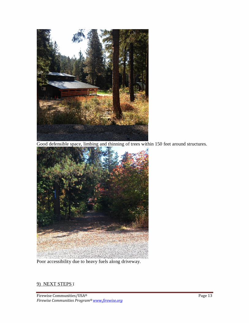
Insect and disease should be an important consideration when planning any fuels reduction treatments and storm damage clean-up in this area. Piling slash >3” in diameter should be avoided from January-June (particularly Ponderosa Pine slash) to avoid creating habitat for IPS beetles. This is an important consideration when making piles for spring community chipping events, and creating IPS Beetle habitat can be avoided my minimizing the length of time the piles are sitting waiting for chipper arrival. When using a loop-and-scatter method of slash disposal, slash should be “pancaked” by cutting it into 2-4 foot pieces that lie as close to the ground as possible. Ground contact will provide additional moisture and insect interaction that will speed up decomposition and naturally incorporate fuels into the soil profile. Fish Hatchery US Fish and Wildlife Service operates a fish hatchery on the south end of the floodplain where Chiwawa River Pines sits. This may be a source for water as they have large ponds and pumping infrastructure. Secondary Egress Although there are several access routes in and out of these neighborhoods, the route out is often not intuitive. During the field work for this assessment we found it often difficult to find the fastest egress route from far corners of the neighborhood. Both neighborhoods should consider installing Wildfire Evacuation Route signage that could ease evacuation, especially for weekend renters who are unfamiliar with the area. These signs would also raise Firewise awareness. 8) SUCCESSFUL FIREWISE MODIFICATIONS – When adequately prepared, a house can likely withstand a wildfire without the intervention of the fire service. Further, a house and its surrounding community can be both Firewise and compatible with the area’s ecosystem. The Firewise Communities/USA program is designed to enable communities to achieve a high level of protection against WUI fire loss even as a sustainable ecosystem balance is maintained. A homeowner/community must focus attention on the home ignition zone and eliminate the fire’s potential relationship with the house. This can be accomplished by disconnecting the house from high and/or low-intensity fire that could occur around it. The following photographs were taken in the Chiwawa River Pines area and are examples of good and bad Firewise practices:
Firewise Communities/USA® Page 13 Firewise Communities Program® www.firewise.org
Good defensible space, limbing and thinning of trees within 150 feet around structures.
Poor accessibility due to heavy fuels along driveway. 9) NEXT STEPS –

Firewise Communities/USA® Page 14 Firewise Communities Program® www.firewise.org
After reviewing the contents of this assessment and its recommendations, the Chiwawa River Pines Firewise Board in cooperation with LWFR will determine whether or not it wishes to continue seeking Firewise Communities/USA recognition. The Firewise Communities/USA representative will contact the Firewise Board representative by 11/1/2016 to receive its decision. If the site assessment and recommendations are accepted and recognition will be sought, Chiwawa River Pines Firewise Board will create agreed-upon, area-specific solutions to the Firewise recommendations and create an action plan in cooperation with LWFR. Assuming the assessment area seeks to achieve national Firewise Communities/USA recognition status, it will integrate the following standards into its plan of action:
� Sponsor a local Firewise board, task force, committee, commission or department that maintains the Firewise Community program and status.
� Enlist a WUI specialist to complete an assessment and create a plan from which it identifies agreed-upon, achievable local solutions.
� Invest a minimum of $2.00 annually per capita in its Firewise Communities/USA program. (Work done by municipal employees or volunteers, using municipal or other equipment, can be included, as can state/federal grants dedicated to that purpose.)
� Observe a Firewise Communities/USA Day each spring that is dedicated to a local Firewise project.
� Submit an annual report to Firewise Communities/USA. This report documents continuing participation in the program.
Chiwawa River Pines residents are reminded to be conscious of keeping high-intensity fire more than 100 feet from their homes. It is important for them to avoid fire contact with their structures. This includes firebrands. The assessment team recommends the establishment of a ‘fire free zone’, allowing no fire to burn within ten feet of a house by removing fuels located there. It is a bad idea for fire to touch a house during a wildfire. Remember that, while wildfire cannot be eliminated from a property, it can be reduced in intensity. Weather is, of course, of great concern during wildfire season. At such time as fire weather is severe, homeowners should remember not to leave flammable items outside. This includes rattan doormats, flammable patio furniture, firewood stacked next to the house, or other flammables. Homeowners are reminded that street signs, addresses, road widths and fire hydrants do not keep a house from igniting. Proper attention to their home ignition zones does.