comprehensive station plan embarcadero - bart.gov station plan 1 ... 6.4 prototype station capacity...
TRANSCRIPT

Comprehensive Station PlanEmbarcadero
June 2004


EmbarcaderoComprehensive Station Plan
1
June 2004
Section Page WHAT IS A COMPREHENSIVE STATION PLAN? 5
1.0 EXECUTIVE SUMMARY 6
2.0 INTRODUCTION 10
2.1 A Vision for the Embarcadero Station 10
2.2 BART’s Goals 11
2.3 Station Planning at BART 13
2.4 The Planning Process 14
3.0 THE EMBARCADERO STATION TODAY 15
3.1 History and Existing Conditions 15
3.2 Who Uses Embarcadero Station? 18
3.3 How Do Riders Get to BART? 21
3.4 Environmental Justice Access Planning in Chinatown 22
4.0 STATION AREA DEVELOPMENT 24
4.1 San Francisco Redevelopment Agency 24
4.2 San Francisco Planning Department Area Plans 26
4.3 Other Area Plans and Redevelopment Plans 28
5.0 STATION ACCESS 29
5.1 On Foot 29
5.2 By Bicycle 31
5.3 By Transit 32
5.4 By Auto or Taxi 37
6.0 STATION CAPACITY 41
6.1 Vertical Circulation 43
6.2 Platform Area Requirements 44
6.3 AFC Equipment 45
6.4 Prototype Station Capacity Requirements 46
6.5 Station Improvement Plan Development 46
6.6 Specific Comments on the Embarcadero Station 48
7.0 IMPLEMENTATION 52
7.1 Access Plan Recommendations 54
Table of Contents
EmbarcaderoComprehensive Station Plan
2
June 2004
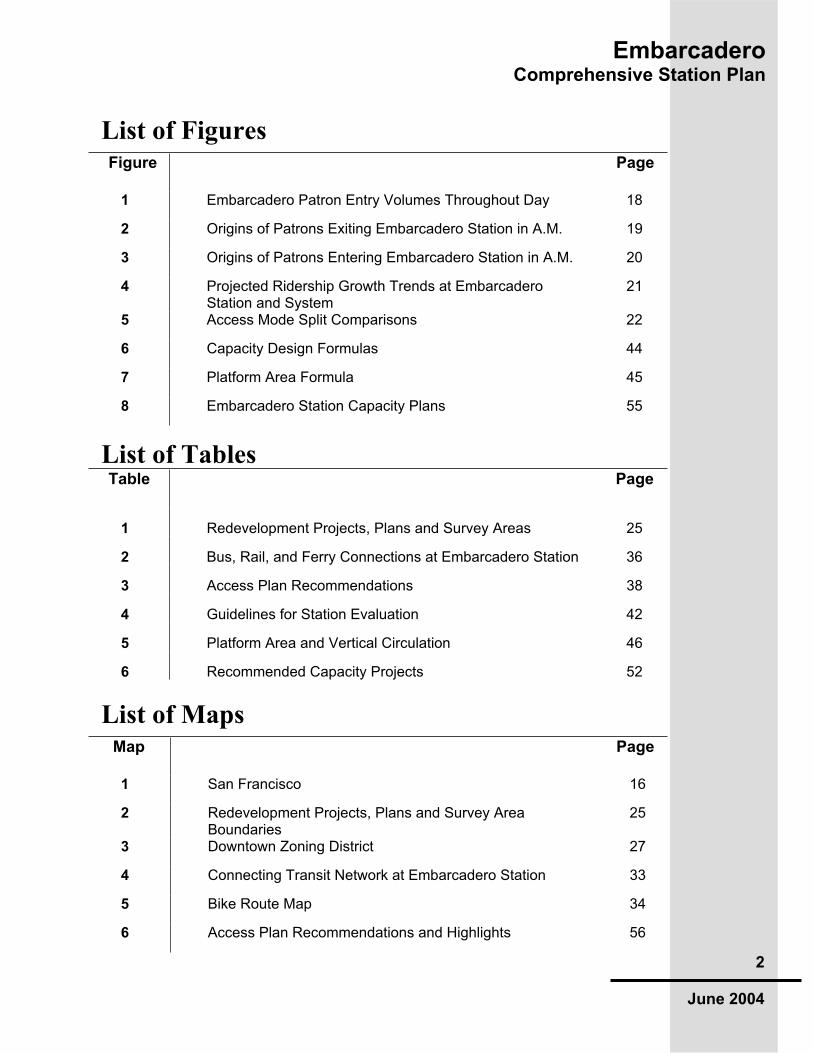
List of Figures Figure Page
1 Embarcadero Patron Entry Volumes Throughout Day 18
2 Origins of Patrons Exiting Embarcadero Station in A.M. 19
3 Origins of Patrons Entering Embarcadero Station in A.M. 20
4 Projected Ridership Growth Trends at EmbarcaderoStation and System
21
5 Access Mode Split Comparisons 22
6 Capacity Design Formulas 44
7 Platform Area Formula 45
8 Embarcadero Station Capacity Plans 55
List of Tables Table Page
1 Redevelopment Projects, Plans and Survey Areas 25
2 Bus, Rail, and Ferry Connections at Embarcadero Station 36
3 Access Plan Recommendations 38
4 Guidelines for Station Evaluation 42
5 Platform Area and Vertical Circulation 46
6 Recommended Capacity Projects 52
List of Maps Map Page
1 San Francisco 16
2 Redevelopment Projects, Plans and Survey Area Boundaries
25
3 Downtown Zoning District 27
4 Connecting Transit Network at Embarcadero Station 33
5 Bike Route Map 34
6 Access Plan Recommendations and Highlights 56

EmbarcaderoComprehensive Station Plan
3
June 2004
We intend to include all those who supported the Planning Department in creating this report; we apologize if we missed anyone’s name.
uthorPeter Albert, BART Planning Department
art Staff
ustomer Access
Carter Mau, Laura Timothy, Jim Evans
overnment & Community Relations
David Tucker, Molly Burke
rants
Gregg Marrama, Todd Morgan, Priya Mathur
aintenance and Engineering
Roger Avery, Ersten Imaoka, T.K. Chu
perations
Paul Oversier, Tian Feng, Jeff Garcia
perations Liasons
Randy Franklin, Duane Condit
lanning
Marianne Payne, Ellen Smith, John Nemeth, Charlotte Barham, Anthony Foster, Taryn Seawright
olice
Gary Gee, Steven Langner, Mark Howard
eal Estate
Jeff Ordway, Bruno Peguese, Yvette McCoy, John Rennels
olling Stock & Shops
Bill McCoy
ystem Capacity
Bill Theile, Sam Lau
ystem Safety
Len Hardy, Mark Chan
ransit System Development
Gary LaBonte, Dick Wenzel, Jim Gravesande, Larry Kozimor, Chris Quinn, Walt Sonnichsen, Scott Van Dussen
Acknowledgments

EmbarcaderoComprehensive Station Plan
4
June 2004
ransportation
Pam Kessinger, Craig Anderson
ART Advisory Groups BART Bicycle Task Force BART Accessibility Task Force
xternal Stakeholders Embarcadero BART patrons SF Planning Department SF Department of Parking and Traffic Muni (and Muni Accessibility CAC) Transbay Terminal Authority Transbay Terminal CAC SF Redevelopment Agency Water Transit Authority Golden Gate Transit AC Transit Caltrain/SamTrans/JPB SF County Transportation Authority Port of San Francisco Neighborhood Associations SF Redevelopment CAC’s Chinatown Community Development Center SBC Park / San Francisco Giants

EmbarcaderoComprehensive Station Plan
5
June 2004
ART stations are both transit hubs and valued community resources.
Recognizing this, the BART Board of Directors in 2001 directed the Planning Department to undertake a thorough and integrated analysis of planning issues at every station. Called Comprehensive Station Plans, these documents are guided by BART’s Strategic Plan, with recommendations reflecting the Strategic Plan’s focus areas. Each Comprehensive Station Plan brings together the work of many BART staff, agency partners and members of the public.
Each Comprehensive Station Plan examines how effectively a station meets the present and future needs of its passengers and surrounding community. The Comprehensive Station Plan does this by examining three key station elements:
Station Area Development--how the station works in its surrounding neighborhood
Station Access--how passengers get to the station
Station Capacity and Functionality--how the physical and operating components of the station function
BART staff use Comprehensive Station Plans to evaluate the scope and timing of a proposed station project or initiative, to seek grant funds, and to communicate with the public and other agencies. Partners and potential partners use the plans to evaluate the most effective way to work toward common goals.
A Comprehensive Station Plan can be updated or expanded as needed. As planning documents, they are living and flexible works, meant to be revised by section or overall as new information or direction becomes available. A Comprehensive Station Plan allows for revisions while it retains the station’s collectively defined vision.
We invite your perusal, use, and comments.
What Is a Comprehensive Station Plan?

EmbarcaderoComprehensive Station Plan
6
June 2004
he Embarcadero BART Station is by many indications a model of transit
planning success: robust ridership of about 30,000 weekday patrons – one in ten BART riders gets on or off here -- excellent connections to a huge number of other transit networks (Muni Metro shares use of the station) and proximity to nearby destinations in an area of downtown San Francisco that continues to improve and beautify. However, the strains of the demands on the station and the aging transit system it serves are real, and the volumes of riders using the Embarcadero Station have already tested its capacity limits at times. With more development and transit connections in the near future, planning for a better functioning and more welcoming station must get underway.
The Embarcadero Station Comprehensive Plan assesses the station’s current and future needs in an integrated way so that decisions made today do not preclude tomorrow’s possibilities. The plan examines three major station elements to achieve this: Station Area Development, Station Access, and Station Capacity. Key findings from the Plan are summarized below.
Station Area Development
he area surrounding the Embarcadero BART Station is as urban and high-
density as any outside Manhattan. BART has long been the centerpiece for transportation access: the station itself was financed by the San Francisco Redevelopment Agency in the early 1970’s to fulfill the transit-oriented vision of the Golden Gateway and Embarcadero Center project. While numerous other nearby plans sponsored by the Redevelopment Agency have been built out, more are underway – notably the Rincon Hill and Transbay Areas – which raise the bar of mixed-use by projecting a substantial increase in residential developments in this primarily office-dominated district.
Farther away from the station, other major developments, such as Mission Bay, the SBC Ballpark, and South Beach, rely heavily on BART service at the Embarcadero because the transit links to these areas, mostly by Muni, depend on BART for access to the region. More than any other station, the Embarcadero is BART’s gateway to San Francisco form the East Bay.
BART does not own developable land at the Embarcadero Station, but it plans for the need for greater access and increased ridership volumes spurred by development and the economy by targeting access and capacity improvements that anticipate and respond to proposed land use changes:
Strengthen connections to regional activity hubs nearby, such as the Transbay Terminal and the Ferry Building, as well as recreational
1.0 Executive Summary

EmbarcaderoComprehensive Station Plan
7
June 2004
destinations that make better use of the rich train service outside the commuter “rush” period,
Continue partnerships with key city agencies, such as the Redevelopment Agency, the Port of San Francisco, and the San Francisco Planning Department to promote use of BART, and
Participate in the community processes employed by each agency to ensure that the Station and its needs figure prominently in local land use planning decisions.
Station Access
o other BART station has direct links to so rich and varied a network of
transit services as the Embarcadero: Muni light rail, streetcar, cable car and bus, the regional AC and SamTrans bus lines, a proposed extension of Caltrain, and a planned expansion of ferry service all pivot around the Embarcadero BART station. The percent of BART riders who use other transit services to get to this station is among the highest in the system, as is the number of people who walk to the station.
Nevertheless, station access improvements were studied in the development of an Access Plan for this station, and several key recommendations are intended to facilitate further transit, bike and walking connections to the station. Many of these improvements require implementation by others agencies, such as Muni or San Francisco DPW :
Provide for a direct link between the BART station concourse and the future train concourse in the Transbay Terminal,
Focus on wayfinding and sidewalk improvements to bleak areas near the station, particularly where the former Embarcadero Freeway’s overhead ramps blighted the landscape,
Provide for direct connections between the BART and Muni Metro platforms that no longer necessitate use of the top-floor concourse,
Expand the use of the new Bike Station by promotion, marketing, signage and construction of a bike “channel” to make use of the stairways from the street easier,
Expand the successful Real Time information programs that give patrons accurate and reliable updates on the arrival of connecting buses, light rail and other transit vehicles,
Promote the use of taxis through better signage and other means of improving patron orientation, and
Provide signs and other information services in other languages, especially Chinese, as well as enhanced transit connections to meet the unique needs of nearby communities such as Chinatown.
EmbarcaderoComprehensive Station Plan
8
June 2004
Station Capacity and Functionality
he Embarcadero Station has been identified as having the greatest needs for
capacity expansion of all BART stations. The platform is too narrow, vertical circulation demands outweigh what is provided, and more faregates and vending machines are needed to improve station circulation and convenience. The capacity concerns are made even greater when the high volumes of riders who arrive at Embarcadero from the East Bay are considered: any forced evacuation of one or more westbound trains would place even greater demands on the station’s platforms and internal circulation.
The basis for station capacity analysis is the projected ridership of 2025, and considers the needs of emergency egress and ingress as well as daily operating needs. The Station Capacity section of this Plan includes the following recommendations for the Embarcadero Station:
Expand the usable portions of station paid area by removing benches and installing platform doors and screens,
Replace one set of escalators at each of the two paid areas with a set of stair-escalators to increase vertical circulation,
Widen the stairs at each end of the platform to a full 66-inch width
Design each end stairway so that their landings meet the Muni Metro level and are fitted with special faregates that allow direct connections between the BART and Muni Metro platforms,
Add a new stairway from the street level (on the public sidewalk) to the station concourse, and
Add fare gates and ticket vending machine equipment
The conceptual cost to implement the capacity elements of this proposed plan is approximately $27 million.
EmbarcaderoComprehensive Station Plan
9
June 2004
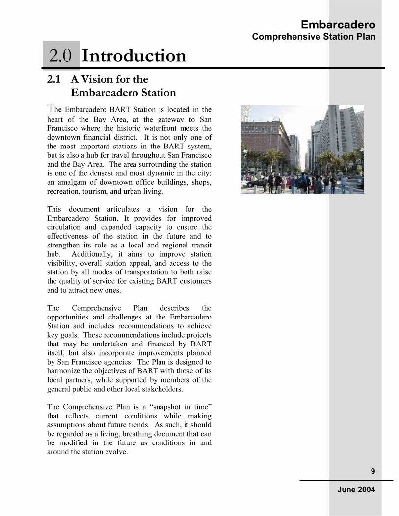
2.1 A Vision for the Embarcadero Station
he Embarcadero BART Station is located in the
heart of the Bay Area, at the gateway to San Francisco where the historic waterfront meets the downtown financial district. It is not only one of the most important stations in the BART system, but is also a hub for travel throughout San Francisco and the Bay Area. The area surrounding the station is one of the densest and most dynamic in the city: an amalgam of downtown office buildings, shops, recreation, tourism, and urban living.
This document articulates a vision for the Embarcadero Station. It provides for improved circulation and expanded capacity to ensure the effectiveness of the station in the future and to strengthen its role as a local and regional transit hub. Additionally, it aims to improve station visibility, overall station appeal, and access to the station by all modes of transportation to both raise the quality of service for existing BART customers and to attract new ones.
The Comprehensive Plan describes the opportunities and challenges at the Embarcadero Station and includes recommendations to achieve key goals. These recommendations include projects that may be undertaken and financed by BART itself, but also incorporate improvements planned by San Francisco agencies. The Plan is designed to harmonize the objectives of BART with those of its local partners, while supported by members of the general public and other local stakeholders.
The Comprehensive Plan is a “snapshot in time” that reflects current conditions while making assumptions about future trends. As such, it should be regarded as a living, breathing document that can be modified in the future as conditions in and around the station evolve.
2.0 Introduction

EmbarcaderoComprehensive Station Plan
10
June 2004
2.2 BART’s Goals ART’s Strategic Plan, adopted in 1999,
established policy goals for the organization, divided into the following seven broad categories:
Improving the BART Customer Experience
Building Local Partnerships For Support
Optimizing BART capacity by managing Transit Travel Demand
Planning Land Use and Quality of Life improvements at BART stations
Proving a quality work environment for the People of BART
Shoring up the System’s Physical Infrastructure
Managing the Financial Health of BART
Some of these goals are especially applicable to the Embarcadero Comprehensive Plan. The need to address the BART’s physical infrastructure is reflected in a variety of capacity and circulation enhancements. The goal of improving the BART Customer Experience can be seen in the Plan’s capacity and station access improvements, as well as improved station visibility, information and signage. Lastly, the importance of Building Local Partnerships is reflected in BART’s planning process, which engages local customers, residents and other stakeholders and incorporates local San Francisco plans and goals.
2.2.1 Local Goals The City of San Francisco has a variety of transportation and development goals for the general area served by the Embarcadero BART station. While the number of specific goals articulated by various city agencies is numerous, certain major themes stand out.
Activation of the Waterfront—The city’s waterfront, revitalized following the removal of the Embarcadero freeway, is likely to be further activated in the near future through a variety of city-driven efforts. The Port of San Francisco has

EmbarcaderoComprehensive Station Plan
11
June 2004
recently restored the historic Ferry Building, and has plans for a cruise ship terminal at Piers 30 and 32. Muni has plan for a new hotel on its property at Embarcadero & Stuart. Meanwhile, the SF Redevelopment Agency is developing both Rincon Hill and Mission Bay, which connect to the Embarcadero BART Station via Muni rail along the Waterfront. Muni also has plans for a new rail line, the “E”, to run along the Embarcadero from Caltrain at 4th and King to Fisherman’s Wharf.
A New Transbay Terminal—Led by Transbay Terminal Authority, the City has plans to replace the old Transbay Bus Terminal. The new terminal will be accompanied by significant mixed use development, and will include more space for buses and the ability to accommodate a downtown extension of Caltrain from the 4th and King Station and possible future high-speed rail. In addition, the City has proposed a potential underground pedestrian connection linking the new Terminal to the Montgomery or Embarcadero BART Stations. The new Terminal reflects a larger multi-agency goal, encouraged by MTC, to improve the seamlessness of the city’s and the region’s transit systems.
New Downtown Neighborhoods—The SF Planning Department’s Downtown Neighborhood Initiative is intended to create mixed use urban neighborhoods that could add up to 40,000 units of housing in and around the downtown Central Business District. The recently completed Rincon Hill Plan, which encourages residential development, is one outcome from this initiative. Redevelopment also has plans to create a mixed-use urban neighborhood in the underutilized area near the Transbay Terminal. Finally, the rise of near-downtown neighborhoods can be seen in the emerging mixed-use Mission Bay development, which will ultimately include up to 6,000 new units of housing.

EmbarcaderoComprehensive Station Plan
12
June 2004
Market Street Improvements—The San Francisco Transportation Authority recently led a study of Market Street with the goals of improving pedestrian safety, bicycle routes and transit mobility. Specific proposals devised for Market St. include: auto restrictions on some blocks, additional bus-only lanes, dedicated bicycle lanes, and new pedestrian-friendly technology.
Voter-Supported Transit Enhancements—Over the last year, San Francisco voters approved a 30-yr extension of a ½ cent sales tax (Prop K) and a one-dollar increase in the tolls for all Bay Area bridges except the Golden Gate (RM-2). Included for future funding in both initiatives are access and capacity improvements for BART customers using the Embarcadero Station, such as the cross-platform BART-Muni connection (but not certain projects already discussed, such as the underground connection to the Transbay Terminal). This represents the larger, significant voter-approved goals of investment in specific transit improvements.
2.3 Station Planning at BART ART’s Comprehensive Station Plans were born
out of a desire to unify planning for physical station changes, station access improvements, and station area property development. This approach is intended to improve decision-making by combining the expertise of many different departments at BART and by integrating with the Plans of local jurisdictions. Comprehensive Station Plans are not detailed enough to serve as technical engineering studies but are specific enough to harmonize the implementation of station improvements and to serve as a support for future grant funding.
The Comprehensive Plan for the Embarcadero Station is being completed simultaneously with plans for 16th Street, Richmond, El Cerrito del Norte, Walnut Creek and Bay Fair stations. These stations were selected due to the need for

EmbarcaderoComprehensive Station Plan
13
June 2004
comprehensive frameworks to address pressing capacity, station access or development issues. This round of Plans follows the first round of prototype Comprehensive Plans for Pleasant Hill, Union City and Balboa Park, completed in 2002.
This Plan benefits from having a high degree of station planning already completed by BART: an Access Plan, enhanced with internal and external stakeholder meetings held in 2002, an “Environmental Justice” access-to-BART study also drawing on external stakeholder input (specific to Chinatown rather than any one BART station but relevant to Embarcadero), a review of the extensive land use planning already completed and underway led by city agencies, and a station capacity study completed in 2003 with extensive internal BART review. This Planning Process is discussed in greater length below.
2.4 The Planning Process omprehensive Station Plans address three key
components: station capacity, station access, and station area development. In December 2002, BART completed a Station Access Plan for the Embarcadero Station in collaboration with local partners. The Access Plan addressed the station’s role in helping achieve a systemwide multi-modal set of targets that emphasize non-automobile access to BART stations. That plan has been updated with input from BART staff and city agencies, and folded into this larger Comprehensive Plan. This Plan also includes recommendations from a 2003-2004 Caltrans-funded outreach program in Chinatown, led by BART and a local community group, that focused on improving access to (and the appeal of) BART stations.
In 2003, BART created a long-term capacity plan for the Embarcadero Station to ensure its ability to handle growing ridership volumes in the future. The plan that emerged is meant to be a prototype for other downtown subway stations in analyzing current capacity and circulation constraints and
Key Stakeholders
Internal BART Departments PlanningCustomer Access Transit System Development OperationsReal Estate Police System Capacity System Safety TransportationGovernment & Community
Relations
BART Advisory Groups BART Bicycle Task Force BART Accessibility Task Force
External Stakeholders Embarcadero BART patrons SF Planning Department SF Department of Parking and Traffic
Muni (and Muni Accessibility CAC)Transbay Terminal Authority Transbay Terminal CAC SF Redevelopment Agency Water Transit Authority Golden Gate Transit AC Transit Caltrain/SamTrans/JPB SF County Transportation AuthorityPort of San Francisco Neighborhood Associations SF Redevelopment CAC’s Chinatown Community Development Center SBC Park / San Francisco Giants

EmbarcaderoComprehensive Station Plan
14
June 2004
offering recommendations that allow for future expansion. This effort is also incorporated into this Plan.
Finally, the station area development plan borrows heavily from local San Francisco plans of city agencies focused on the downtown area, as BART itself owns little property at the street level.

EmbarcaderoComprehensive Station Plan
15
June 2004
3.1 History and Existing Conditions
he Embarcadero Station was not a part of the
original BART system. It opened in 1976 as BART’s first “in-fill” station as part of the Golden Gate Redevelopment Area in the rapidly changing area northeast of the Montgomery BART station. Driving that change was the Golden Gateway Redevelopment Project, situated north of Market Street and east of Battery Street. The project resulted in the construction of the Embarcadero Center, which included 3.5 million square feet of office space as well as retail, housing, public plazas and open space.
In conjunction with this development, the San Francisco Redevelopment Agency also financed the shell of the Embarcadero station, an underground facility that also houses the Muni Metro. After its opening, the station quickly became one of the most heavily used in the BART system, alternating at times with Montgomery Station for title to highest ridership volume.
The station neighborhood changed dramatically again after 1989 when the double-decker Embarcadero freeway, damaged by the Loma Prieta earthquake, was torn down. With the freeway gone, the Embarcadero BART station was suddenly much better linked with the waterfront and the historic Ferry Building. The removal of the freeway created opportunities for transit expansion, new development, and aesthetic improvements in its wake.
The area surrounding the station is highly varied, but is mostly characterized by multi-story office towers, usually with ground level retail, and the highest employment densities in the region. Given the primacy of office uses, there are relatively few residential areas within a half-mile radius, although
3.0 The Embarcadero Station Today

EmbarcaderoComprehensive Station Plan
16
June 2004
the many units planned for the few vacant sites freed up by freeway demolition and other land use changes are of very high density (60 units/acre or more).
Within a mile of the station, however, are some of the highest density residential neighborhoods in the Bay Area. These include Chinatown, North Beach and Telegraph Hill, with densities of over 60,000 people per square mile. These areas, along with neighborhoods to the west, such as Pacific Heights, Russian Hill and the Marina, are the origin points for most of the a.m. boardings at the Embarcadero Station. The growing neighborhoods south of Market Street, such as South Beach, are another important source of riders.
Map 1: San Francisco

EmbarcaderoComprehensive Station Plan
17
June 2004
Most of the growth and change in the station area is occurring south of Market Street. With the ongoing development of additional office space in this area, San Francisco’s “downtown” will likely continue to spread southward. Two recently completed projects reflect the trend. The 32 story Hines-Calpers tower at Mission between 1st and 2nd and the nearby Foundry Square project at 1st and Howard together add nearly 1 million new sq. ft. of office space south of Market. Plans for the already entitled 30 story office tower at 555 Mission as well as long term plans for office development tied to the new Transbay Terminal would reinforce the trend further.
Farther from the station, recent residential developments, such as Avalon Towers on Beale Street, have also expanded the 24-hour population of the SOMA neighborhood. To the south, the emerging Mission Bay development with its UCSF biotech campus is creating an entirely new near-downtown neighborhood. This area is well served by the Embarcadero BART Station via a light rail link along the Embarcadero and, in the future, 3rd Street. Finally, redevelopment in the Transbay Terminal vicinity, as envisioned in the Transbay 20/20 Plan, could also result in the development of more active mixed-use neighborhoods south of Market.
In addition to office and residential growth, entertainment and retail uses are also expanding in the station area, mostly along the waterfront. The Ferry building at the foot of Market Street was recently renovated by the Port of San Francisco to include ground level shops and weekend markets, making it a popular attraction. The Port also has plans for a cruise ship terminal at Piers 30 and 32. Muni has plans to lease a bus layover area at Mission & Steuart Streets for construction of a 200-room hotel, which could further activate the waterfront in the Embarcadero Station area.

EmbarcaderoComprehensive Station Plan
18
June 2004
3.2 Who Uses Embarcadero Station?
mbarcadero is often the busiest station in the
BART system (30,506 weekday exits in the last quarter of fiscal year 2004), alternately sharing the lead with Montgomery Station. As with other downtown San Francisco stations, the vast majority of customers at Embarcadero are commuters who exit the stations in the morning, and re-enter the station in the evening to return home. The use pattern at Embarcadero is thus sharply peaked, with the height of the morning peak period occurring between 7:00 and 9:30 AM, and the evening peak occurring between 5:00 and 7:30 PM. During this time, it is not uncommon for 4,000 people to pass through the faregates into the station every 30 minutes. This translates to 2.2 persons per second. During the midday, station ridership drops by about 90% to only a few hundred riders every 30 minutes.
Patrons arriving at Embarcadero in the morning hail from all over BART’s service area. About 28% come from the segment of stations between San Francisco’s Mission District and the northern San Mateo County. Another sizable portion (23%) originate in central Contra Costa County from Pittsburg to Orinda, with more coming from
0
500
1,000
1,500
2,000
2,500
3,000
3,500
4,000
3:004:30
6:007:30
9:0010:30
12:00
13:30
15:00
16:30
18:00
19:30
21:00
22:30
0:001:30
Time
Pa
tro
ns
/ 3
0 m
in Embarcadero
System
Figure 1: Embarcadero Patron Entry Volumes Throughout Day

EmbarcaderoComprehensive Station Plan
19
June 2004
Pleasant Hill than any other single station in the BART system.
The number of people using Embarcadero as a home origin station to travel elsewhere in the system is actually much lower than the system average. In fact, Embarcadero ranks 36th out of 43 stations for entries between 6 a.m. and 10 a.m. Given the available capacity of BART trains leaving the city in the morning, this capacity available for the reverse commute represents an opportunity for ridership growth.
Nearly half (48%) of patrons who enter Embarcadero Station before 10 a.m. are headed for Oakland or Berkeley. Meanwhile, a sizable 21% are simply headed for somewhere else in downtown San Francisco, suggesting that these riders work in the city and that Embarcadero is an interim stop in their trip – not their true home origin. For example, those arriving by ferry may walk to Embarcadero and then ride to Montgomery.
Fig. 2: Origins of Patrons Exiting Embarcadero Station in AMFigure 2: Origins of Patrons Exiting Embarcadero Station in A.M.

EmbarcaderoComprehensive Station Plan
20
June 2004
Riders who use Embarcadero as their home station are generally similar demographically to BART riders systemwide. Some distinctions, however, are worth noting. At Embarcadero, there are fewer ethnic minorities than at many other BART stations, with 74% identifying themselves as “white” compared to 59% systemwide. And, while 52% of the residents within a one-mile radius are Asian, only 13% of the a.m. riders at Embarcadero are Asian. This discrepancy is partly due to the relatively large population of Chinatown, and the fact that many of its residents use the Powell Station, rather than Embarcadero.
Embarcadero Station also has one of the highest percentages of riders using the station for something other than work, school, or shopping. These patrons may include tourists, visitors or business travelers. Possibly as a result of the high number of these non-frequent patrons, the number of those who use the station as their entry point every day (58%) is much lower than the system average (72%).
Fig. 3: Origins of Patrons Entering Embarcadero Station in A.M.Figure 3: Origins of Patrons Entering Embarcadero Station in A.M.

EmbarcaderoComprehensive Station Plan
21
June 2004
Figure 4 Projected Ridership Growth Trends at Embarcadero Station and System
05,000
10,00015,00020,00025,00030,00035,00040,00045,00050,000
1990
1993
1996
1999
2002
2005
2008
2011
Avera
ge W
eekd
ay E
xit
s
(Em
ba
rca
de
ro)
0
50,000
100,000
150,000
200,000
250,000
300,000
350,000
400,000
450,000
Avera
ge W
eekd
ay E
xit
s (
Syste
m-
Wid
e)
Embarcadero Ridership
System-wide Ridership
Ridership at Embarcadero is expected to grow, but at generally the same rate as growth in the system as a whole. However, if the impacts from future development in the station area exceed expectations, ridership may increase more dramatically. In the future, the VTA-led extension of BART to San Jose could generate new ridership
at the station as well.
3.3 How Do Riders Get to BART?
ew patrons drive alone to Embarcadero Station
compared with other BART stations. There are, however, a significant number of drop-offs as well as some who park on local city streets. At 55%, the share of riders arriving by transit is the second highest in the BART system.
Figure 4: Projected Ridership Growth Trends at Embarcadero Station and System

EmbarcaderoComprehensive Station Plan
22
June 2004
Walk
23%
Bike
2%
Transit
21%Dropoff/carpool
/taxi
Drive alone and
park
38%
Figure 5: Access Mode Split Comparisons Access to Embarcadero Station Splits Systemwide Station Access Mode
Bike
8%Auto
16%
Transit
56%
Walk
20%
This is a reflection of both the multiplicity of transit options in the immediate vicinity and the relative absence and high cost of parking.
Bike access is also relatively high at Embarcadero due in part to rules that allow bikes in the station during the a.m. peak for reverse commutes. Pedestrian access from home to the station in the a.m. is actually lower than that of an average BART station, despite the urban setting and pedestrian-oriented street network. This is not surprising, however, given the lack of residences within a walkable distance of the station.
3.4 Environmental Justice Access Planning in Chinatown
ART was awarded a grant from Caltrans in 2003
to study access issues and concerns that make using BART less convenient for residents, workers and visitors in San Francisco’s Chinatown. This study drew from community meetings and focus groups facilitated by the Chinatown Community Development Center (CCDC) and city and county agencies such as Muni, the Planning Department, the Department of Parking and Traffic, the
Figure 5: Access Mode Split Comparisons.

EmbarcaderoComprehensive Station Plan
23
June 2004
Transportation Authority and the Board of Supervisors.
The recommendations that came out of this study highlight that BART would be more heavily used and valued by the Chinatown community if some of the perceived barriers to using BART were overcome. These include such changes as hiring more Chinese-speaking station agents, installing Chinese language directional and information signs, reducing overcrowding on Muni buses linking Chinatown to BART, improving bus and BART real time information and making this more readily available, and improving lighting, aesthetics and perceived safety on key pedestrian corridors to BART.

EmbarcaderoComprehensive Station Plan
24
June 2004
ince the Embarcadero BART station is located
entirely below the public-right-of-way (the roadbed and sidewalks of Market Street), BART does not have the kinds of “joint-development” opportunities here it does on BART property around stations with parking lots or other land areas.
However, the Embarcadero Station is surrounded by areas that have specific land use and height designations by either the San Francisco Redevelopment Agency or the San Francisco Planning Department. These designations anticipate high-density, mixed use development that is heavily dependent on transit access. These areas all have well-developed “plans” to guide future growth adopted by respective agencies:
4.1 San Francisco Redevelopment Agency
he San Francisco Redevelopment Agency has
identified the following Redevelopment Projects, Plans and Survey Areas that are within ½ mile of the Embarcadero Station. These include the Golden Gateway (which included the BART station itself in 1976), Rincon Point and Yerba Buena Redevelopment Areas, and the Transbay Terminal Redevelopment Survey Area (Survey Areas require plan adoption to become Redevelopment Areas). Within a longer walk or short Muni ride from these areas are the South Of Market and Mission Bay Redevelopment Areas. Each Area Plan includes housing, commercial and open space and other amenities that represent residents, employees and visitors likely to use the Embarcadero BART Station.
Map 1 following shows the boundaries of these areas as they are intercepted by a half-mile radius circle from the station.
4.0 Station Area Development

EmbarcaderoComprehensive Station Plan
25
June 2004
RedevelopmentArea
#units
Office sf Other features
Golden Gateway 1,500 3.7 m BART Station, retail, hotel, theater,
parks
Rincon-S. Beach 2,800 1.8 m Ballpark, waterfront amenities, parks,
hotel
Yerba Buena 2,500 330K exhibition Museums, hotels, exhibition space,
entertainment, parks
Transbay Terminal 3,400 Several new
towers Rail/bus terminal, parks, neighborhood services
South of Market 1,000 Small, back
office Focus on affordable housing, SRO’s,
new school
Mission Bay 6,000 6m UCSF campus, parks, school
CCTCKey to Areas Names: Golden Gateway (GG) Areas near the Embarcadero Station: Rincon Point/South Beach (RB-SB) South of Market (SOM) Yerba Buena Center (YBC) Mission Bay North (MB(N)) Transbay Terminal (TB) Stockton/Sacramento (SS – not an Area) Chinatown Community Trade Center (CCTC – not an Area)
Map 2: Redevelopment Projects, Plans and Survey Area Boundaries
Table 1: Redevelopment Projects, Plans and Survey Areas

EmbarcaderoComprehensive Station Plan
26
June 2004
4.2 San Francisco Planning Department Area Plans
everal “Area Plans” are identified by the San
Francisco General Plan within a half-mile radius from the Embarcadero Station. These area plans have unique zoning and height regulations that control land use, density, design and parking requirements. Map 2 below shows these areas.
The General Plan’s Downtown Plan covers the entire area surrounding all the BART Stations along Market Street. Remarkable features of this plan are the city’s highest height districts (550 - 600 ft), high density office, housing and mixed-use districts, and very low parking requirements (none for office or hotel, 1 space for every four housing units). The zoning designations are variations of the high-density office and retail “C-3” districts. These controls strongly support the designation of Downtown San Francisco as a “Transit-First” area with public transit and walking being the primary means of circulation.
Area Plans that are included in or adjacent to the Downtown Plan are the Northeast Waterfront Plan, the Chinatown Area Plan, the Rincon Hill Plan and the South of Market Plan. These Area Plans use zoning, parking policy and height to shape the urban form and character of each area, and include policies that call for amenities (schools, parks, community services) that are deemed as needed in each community.
The General Plan’s Area Plans are consistent with the Redevelopment Areas where they overlap – the primary distinctions being that the General Plan defines an area’s building height, land use and density, and a Redevelopment Plan establishes an area subject to tax revenue management and programmatic clearance of a specific land uses.
Other areas of the General Plan that apply to this Comprehensive Plan include the following Elements: Transportation, Residence, Commerce and Industry, Recreation and Open Space,

EmbarcaderoComprehensive Station Plan
27
June 2004
Community Facilities, Community Safety, Air Quality, Arts, Environmental Protection and Urban Design. These Elements complement the land use provisions of the Area Plans by identifying strategies and programs to enhance infrastructure, support desired development, meet local land use targets and make linkages between different concerns (i.e., between Transportation and Commerce and Industry).
BART’s role in providing high-capacity, affordable public transportation, regional mobility and connections to other systems while producing negligible air quality emissions is in direct support of these Elements. In addition, BART’s program of regular maintenance and strengthening its infrastructure reflects its importance as a safe community asset for the City’s long-term benefit.
Map 3: Downtown Zoning District

EmbarcaderoComprehensive Station Plan
28
June 2004
4.3 Other Area Plans and Redevelopment Plans
mbarcadero Station is a gateway to San
Francisco. Many major regional attractions and destinations are located along the Embarcadero, just inland or near Mission Bay and at Fisherman’s Wharf. Such destinations as Pier 39, SBC Park, the Caltrain Terminal, Chinatown, Mission Bay and the Cruise Terminal are all farther than a half-mile from the Embarcadero Station, but they are only a quick Muni ride away. As the first BART stop in San Francisco coming from the East Bay, Embarcadero Station serves as the natural gateway for transit riders.
Because the destinations are in such transit-intensive areas, the transit ridership they generate has a direct effect on BART, even if BART is not close by. For example, BART daily ridership often peaks when the Giants are playing at home, and no BART station is as affected by the ridership spike as Embarcadero, the closest station to the park.
In much the same manner, the Embarcadero Station is also the Transit Gateway to such places as Sausalito, Tiburon, Angel Island, Larkspur and other ferry destinations because of its proximity to the Ferry Building. The popularity of these places and their continued strength in drawing visitors and residents suggests land values and development pressures will continue to rise. This growth translates to increased dependence on the Embarcadero BART station.
Tourists, day-trippers, commuters and local residents who want to use the ferries are actively encouraged to ride transit to the Ferry Building, which does not offer commuter parking. BART, with its excellent regional access, is the quickest and easiest way for many to reach the Ferry Building, and Embarcadero Station is again the closest station.

EmbarcaderoComprehensive Station Plan
29
June 2004
he Embarcadero Station has a number of access
strengths when compared to other stations in the BART system. There are, however, some deficiencies as well. A detailed description of the opportunities for access improvement by mode follows below.
5.1 On Foot he Embarcadero Station has the benefit of being
located in a very walkable urban environment. The surrounding street pattern is a modified grid, and sidewalks and signalized crossings on these streets are omnipresent. In addition there are no nearby impassable barriers for pedestrians such as freeways, waterways, or major arterials. The San Francisco County Transportation Authority has given most of this area a “high” rating for a variety of pedestrian environment criteria.
The best walking environment is on Market Street with its wide brick-paved sidewalks, large street trees, retail store frontage, decorative street lamps and general vitality. This high quality pedestrian environment continues along the Embarcadero, which has experienced a pedestrian renaissance with the removal of the Embarcadero freeway.
If there is a weak spot in the pedestrian network, however, it’s in the vicinity of the Transbay Terminal, roughly bounded by Mission, Harrison, 1st and Main. Sidewalks in this area are generally narrower than others in the vicinity and there is a dearth of landscaping, store frontages or other amenities. Pedestrians must be wary of cars entering and exiting the numerous surface parking lots which also create an empty and vacant feeling.
The unfriendly nature of this area’s pedestrian environment was recognized by the S.F. Redevelopment Agency’s Transbay 20/20 plan which mentions the area’s general lack of greenery
5.0 Station Access

EmbarcaderoComprehensive Station Plan
30
June 2004
and the presence of a large amount of vacant and underutilized land.
While a respectable share of the a.m. entries at Embarcadero is from pedestrians, this mode of access is limited by the lack of residential densities within a half-mile radius. New residential development close to the station would boost ridership, and also the number who access the station on foot. In essence, the station area could become both an a.m. origin and destination with a broader mixture of uses, rather strictly a destination dominated by office uses.
A deficiency that affects all modes of access is the poor visibility of BART station entrances along Market Street. Signs are tiny and faded and include only BART’s logo and not the name of the station. In the words of a 2001 Booz, Allen & Hamilton signage study for BART, “station identification on the street level is often difficult to locate and identify.” The study also notes that “BART takes a very understated approach to its identity”, and that “a strong identity system can help to create a sense of place.”
In addition to a lack of station identity on the street, there is an absence of wayfinding signs in the area to help patrons find the station. This is particularly relevant at the Embarcadero Station, which has a very high number of tourists, business travelers and occasional riders. Chinese language wayfinding signage and informational brochures would help BART patrons traveling to and from Chinatown.
Key strategies for increasing the number of patrons accessing BART on foot include:
Encouraging the development of dense residential uses in the immediate station vicinity, perhaps through existing redevelopment efforts.
Improving the visibility of the station entrances though bolder exterior signage and canopies.
Installing BART wayfinding signs to guide patrons to the station.

EmbarcaderoComprehensive Station Plan
31
June 2004
Providing Chinese-language wayfinding and other BART informational “tools” (such as service brochures)
Improving the quality of the pedestrian environment in the Transbay Terminal area, with better sidewalks, trees, fewer curb cuts, and the development of streetscape frontages.
5.2 By Bicycle o accommodate cyclists and to encourage even
greater access by bike, BART constructed a Bike Station on the Concourse level of the Embarcadero Station with capacity for 150 bicycles. The station is an artfully designed perforated metal cage that will be attended on weekdays from 6am to 9pm at a minimum. The station was opened in 2003, but is not yet well-used. BART Access staff are planning a system of wayfinding signage to promote the use of the Bike Station for people who may not yet know of this service.
The new Bike Station represents a major access improvement that must be promoted and publicized to maximize its effectiveness. This will be done partly through a contract with the Bike Station operator that includes marketing, as well as through the use of BART’s own internal marketing resources. Staff will also continue to seek additional funds to help advertise the facility.
As use of the Bike Station increases, supporting bicycle amenities will become increasingly important at the Embarcadero Station. Signage at one or more station entrances that indicate the presence of bike parking inside would create street-level visibility for the Bike Station. Also, stair channels from one or more entrances to the Concourse level and from the Concourse level to the Platform level would make vertical bike circulation considerably easier. Encouraging bike patrons to use the stairs will also help to prevent them from crowding the elevators used mainly by disabled riders. Finally, security cameras should be

EmbarcaderoComprehensive Station Plan
32
June 2004
installed to monitor the stored bikes and discourage theft.
While the Embarcadero along the waterfront offers wide sidewalks for cyclists and Folsom Street has striped bike lanes, there are few other corridors for cyclists. Although Market, 2nd, Sansome and Battery Streets are all official bike routes, they do not offer any special striping or widths. Currently, the city is preparing to stripe a lane on Howard from 5th to Main. Improvements such as these to the downtown bike network are a key ingredient in boosting bike access to BART. To further enhance this network, a system of BART wayfinding signs would help direct cyclists to the Embarcadero Station.
Key strategies for increasing bike access to the station include:
Publicizing and creating awareness of the new Bike Station through marketing, and exterior and interior signage.
Maximizing the effectiveness of the newly constructed Bike Station by adding related amenities such as security cameras and stair channels.
Encouraging the expansion and improvement of the City’s downtown bicycle network.
Installing a series of BART wayfinding signs to guide cyclists to the station.
5.3 By Transit primary asset at Embarcadero is the sheer
abundance of transit connections. There are approximately 22 different Muni bus routes that connect directly with the station. In addition, Embarcadero is the terminus of five Muni light rail lines, one of which was extended in 1998 along the Embarcadero to 4th Street to serve the SBC ballpark and the Caltrain depot. The Station is adjacent to the terminus for the California Street cable car line, and rests below Market Street’s historic F streetcar
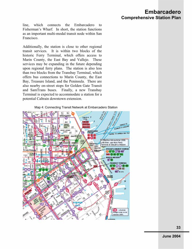
EmbarcaderoComprehensive Station Plan
33
June 2004
line, which connects the Embarcadero to Fisherman’s Wharf. In short, the station functions as an important multi-modal transit node within San Francisco.
Additionally, the station is close to other regional transit services. It is within two blocks of the historic Ferry Terminal, which offers access to Marin County, the East Bay and Vallejo. These services may be expanding in the future depending upon regional ferry plans. The station is also less than two blocks from the Transbay Terminal, which offers bus connections to Marin County, the East Bay, Treasure Island, and the Peninsula. There are also nearby on-street stops for Golden Gate Transit and SamTrans buses. Finally, a new Transbay Terminal is expected to accommodate a station for a potential Caltrain downtown extension.
Map 4: Connecting Transit Network at Embarcadero Station

EmbarcaderoComprehensive Station Plan
34
June 2004
Despite the abundance of transit, however, the connections between the Embarcadero BART station and other transit services are not always seamless. While the Transbay Terminal is only 1 ½ blocks from the BART station, it is far enough to make transfers an inconvenience, particularly to those with disabilities or unfamiliarity with San Francisco transit systems. Even the transfer between BART and Muni within the station is often frustrating to riders. With no direct connection from one platform to the other, riders must go from the BART platform level, all the way up to the Concourse, through two faregates and then back down to the Muni level (or vice-versa). This is particularly problematic during Giants games at SBC Park, when many non-frequent riders must make this complex transfer.
Another barrier to seamless transit connections is the absence of real-time information. This could be added through Muni’s “Next Bus” automatic vehicle location program. Schedule information about connecting Muni service could be displayed at the street level or within the station.
Lastly, new or increased Muni service in key corridors that serve the station, as described in its Short Range Transit Plan and Vision Plan, could make transit access to Embarcadero more effective.
Key strategies for increasing station access by transit include:
Creating an underground link from the Embarcadero BART station to the planned new Transbay Terminal/Caltrain Downtown Station
Creating a direct BART to Muni connection within the station
Adding real-time schedule information in the station for BART trains and all connecting Muni service
Adding more service to existing feeder bus routes (38X,31X & 1X).
Map 5: Bike Route Map
EmbarcaderoComprehensive Station Plan
35
June 2004
Creating new Muni services, such as an E light rail line along the Embarcadero or the expansion of the F Market to Fort Mason
Incorporating information about transfer locations (to ferries, regional bus connections and Caltrain) on wayfinding signs

EmbarcaderoComprehensive Station Plan
36
June 2004
Bus/Light Rail/Cable Car/Ferry Service within 3 blocks of Embarcadero Station Operator Type Line Operator Type Line
Muni bus 1 Golden Gate bus 2 Muni bus 2 Golden Gate bus 4 Muni bus 3 Golden Gate bus 8 Muni bus 4 Golden Gate bus 10 Muni bus 5 Golden Gate bus 18 Muni bus 6 Golden Gate bus 24 Muni bus 9 Golden Gate bus 26/27 Muni bus 10 Golden Gate bus 38 Muni bus 12 Golden Gate bus 44 Muni bus 14 Golden Gate bus 54 Muni bus (limited) 14L Golden Gate bus 56 Muni bus 21 Golden Gate bus 58 Muni bus 31 Golden Gate bus 60 Muni bus 38 Golden Gate bus 72 Muni bus (limited) 38L Golden Gate bus 73 Muni bus 71 Golden Gate bus 74 Muni bus (limited) 71L Golden Gate bus 76 Muni bus (express) 1 AX,BX Golden Gate bus 70/80 Muni bus (express) 30 X Golden Gate bus 93 Muni bus (express) 31 AX/BX SamTrans bus DX Muni bus (express) 38 AX/BX SamTrans bus FX Muni bus (express) 80 X SamTrans bus KX Muni streetcar F SamTrans bus MX Muni light rail J SamTrans bus NX Muni light rail K SamTrans bus PX Muni light rail L SamTrans bus RX Muni light rail M SamTrans bus 292 Muni light rail N SamTrans bus 391 Muni cable car California SamTrans bus 397
Golden Gate ferry Larkspur Golden Gate ferry Sausalito (Others) ferry Harbor Bay (Others) ferry Tiburon (Others) ferry Vallejo (Others) ferry Oakland/
Alameda
Table 2: Bus, Rail, and Ferry Connections at Embarcadero Station

EmbarcaderoComprehensive Station Plan
37
June 2004
5.4 By Auto or Taxi here are no BART parking spaces at Embarcadero
and BART has no plans to construct any. A parking facility near the station would not only be extremely costly but would also be inconsistent with the city’s General Plan.
Currently, a significant number of riders are dropped off at the station and the capacity for this type of access is high. It could aid patrons, however, if there was a designated drop-off area very near the station. This might be especially beneficial to Muni-provided paratransit services. A new drop-off area could be modeled on the exiting spot on Beale St. between Market and Mission, but would have to be carefully designed to avoid creating traffic conflicts or impeding Muni operations.
The Embarcadero Station is fortunate to have a taxi stand nearby on Drumm Street, next to the Hyatt Hotel. While the stand is only a short walk from station exits, patrons unfamiliar with the area may not know it exists. More information about the taxi stand, perhaps integrated into station area maps or local wayfinding signage, could be helpful to BART riders.
Key strategies for autos, drop-off and taxis include: Designating a drop-off area at the street level. Installing wayfinding signs in the area to guide vehicles to the station. Installing wayfinding signs inside the station or in the immediate station area to guide BART riders to the taxi stand.

Em
ba
rca
de
roC
om
pre
he
ns
ive
Sta
tio
n P
lan
38
Ju
ne 2
004
Mode
Recom
mendation M
ap R
efe
rence N
um
ber
and D
escription
S/M
/LT
erm
*Lead
Fundin
g
Tie
r and
Sourc
e**
Walk
W1: S
OM
A S
treets
cape: Im
pro
ve t
he p
edestr
ian r
ealm
in the
vic
inity o
f th
e T
ransbay T
erm
inal and F
ols
om
Str
eet corr
idor
in
accord
ance w
ith S
an F
rancis
co's
Tra
nsbay 2
0/2
0 P
lan.
LC
ity o
f S
an
Fra
ncis
co
Tie
r 3: S
an F
rancis
co,
Develo
pers
Impro
ve
men
t to
Pedestr
ian
Environm
en
t W
2: P
edestr
ian W
ayfindin
g: In
sta
ll a s
eries o
f sig
ns to a
ssis
t pedestr
ians in
locating the s
tation. C
onsid
er
inte
gra
ting B
AR
T into
S
an F
rancis
co's
new
dow
nto
wn w
ayfindin
g s
ignage s
yste
m. T
his
should
inclu
de s
ignage to m
ajo
r are
a d
estinations, such a
s S
BC
P
ark
, th
e F
err
y B
uild
ing a
nd the C
hin
ato
wn fre
e s
huttle
in
Em
barc
adero
Cente
r (w
ith b
i-lin
gual s
igns).
SB
AR
TC
ity o
f S
an
Fra
ncis
co
Tie
r 2: B
AR
T, S
an
Fra
ncis
co
BIK
EB
1: S
ecurity
Cam
era
s: In
sta
ll security
cam
era
s a
t th
e B
ike S
tation.
SB
AR
TP
AR
TIA
LLY
FU
ND
ED
T
ier
1: B
AR
T
B2: B
ike L
ockers
/Racks:
Insta
ll 8-1
0 n
ew
perf
ora
ted lockers
or
racks lockers
betw
een p
aid
and n
on-p
aid
are
a n
ear
sta
tion a
gent to
ensure
availa
ble
bik
e p
ark
ing o
uts
ide o
f B
ike S
tation h
ours
.
SB
AR
TT
ier
2: B
AR
T
B3: S
tair C
hannels
: In
sta
ll bik
e s
tair c
hannels
at th
ree e
ntr
ances.
Insta
ll one s
tair c
hannel f
rom
Conco
urs
e to P
latform
level.
MB
AR
TT
ier
2: B
AR
T
Bik
e F
acili
ties/
Am
enitie
s
B4: B
ike S
tation: P
ublic
ize/p
rom
ote
the B
ike S
tation
SB
AR
TT
ier
1: B
AR
T +
oth
er
B5: E
xte
rior
Sig
ns: Locate
bic
ycle
park
ing s
igns a
t sta
tion
entr
ances to d
irect cyclis
ts to the n
ew
Bik
e S
tation
S
BA
RT
City o
f S
FT
ier
2: B
AR
T
Info
rmation
B6: F
ree B
rochure
: D
evelo
p a
Bik
e &
BA
RT
syste
mw
ide b
rochure
th
at ill
ustr
ate
s the r
egio
nal bik
e n
etw
ork
to a
ll B
AR
T s
tations.
MB
AR
TT
ier
3: B
AR
T
Key A
ccess
Route
sB
7: H
ow
ard
Str
eet: C
reate
a s
trip
ed b
ike lane o
n H
ow
ard
Str
eet
from
5th
to F
rem
ont.
SC
ity o
f S
an
Fra
ncis
co
FU
ND
ED
T
ier
1: S
an F
rancis
co
TF
CA
Ta
ble
3: A
ccess P
lan
Recom
me
nda
tio
ns

Em
ba
rca
de
roC
om
pre
he
ns
ive
Sta
tio
n P
lan
39
Ju
ne 2
004
Mode
Recom
men
dation M
ap R
efe
rence N
um
ber
and
Description
S/M
/LT
erm
*Lead
Fundin
g
Tie
r and
Sourc
e**
BIK
E
Key A
ccess R
oute
s
B8: W
ayfindin
g: In
sta
ll a s
eries o
f sig
ns d
ow
nto
wn to g
uid
e
cyclis
ts o
n k
ey b
ike r
oute
s to the E
mbarc
adero
Sta
tion. C
ould
be a
sta
nd-a
lone p
roje
ct or
part
of m
ulti-m
odal w
ayfindin
g s
yste
m.
SB
AR
TC
ity o
f S
an
Fra
ncis
co
Tie
r 2: B
AR
T, C
ity o
f S
F
TR
AN
SIT
Lin
k to T
ransbay
Term
inal
T1: P
edestr
ian T
unnel: Insta
ll underg
round tunnel and m
ovin
g
sid
ew
alk
lin
kin
g B
AR
T to the low
er
level of T
ransbay T
erm
inal.
LB
AR
TC
ity o
f S
an
Fra
ncis
co
Tie
r 3: T
BD
Direct B
AR
T -
Muni
Connection
T2: S
eam
less T
ransfe
r: R
etr
ofit sta
ircase a
rea a
t N
E e
nd o
f sta
tion
allo
win
g d
irect access fro
m B
AR
T p
latform
to M
uni pla
tform
, and
insta
ll fa
regate
s o
n the M
uni le
vel
MB
AR
T M
uni
Tie
r 3: B
AR
T, M
uni
T3: F
eeder
Serv
ice: A
dd s
erv
ice to the F
-Mark
et str
eetc
ar,
1
Calif
orn
ia e
xpre
ss, 38 G
eary
expre
ss a
nd 3
1 B
alb
oa e
xpre
ss.
MM
uni
Tie
r 3: M
uni
T4: N
ew
Serv
ice: C
reate
a n
ew
"E
" str
eetc
ar
line a
long the
Em
barc
adero
. E
xte
nd to F
-Mark
et str
eetc
ar
to F
ort
Mason
Com
ple
te the C
entr
al S
ubw
ay a
nd G
eary
corr
idor
LR
T p
roje
cts
.
MM
uni
Tie
r 3: M
uni
Muni S
erv
ice
T5: P
rioritized B
us Info
rmation: P
rioritize k
ey B
AR
T feeder
lines in
NextB
us e
xpansio
n, in
clu
de m
onitors
at bus s
tops. Inclu
de
bili
ngual s
ignage for
the 1
Calif
orn
ia s
erv
ing C
hin
ato
wn.
MM
uni
PA
RT
LY
FU
ND
ED
T
ier
1: M
uni
T6: R
eal T
ime Info
rmation: Insta
ll re
al-tim
e d
ispla
ys o
f B
AR
T tra
in
schedule
info
rmation o
n M
uni pla
tform
level. Insta
ll M
uni nextb
us
info
rmation o
n B
AR
T p
latform
level or
concours
e/s
treet le
vels
MB
AR
TM
uni
Tie
r 2: M
uni, B
AR
T
Info
rmation
T7: Inte
rior
Sig
nage:
Insta
ll cle
ar
sig
nage d
irecting B
AR
T p
atr
ons
to o
ther
transit s
yste
ms s
uch a
s M
uni M
etr
o a
nd b
uses, F
err
y
Build
ing, T
ransbay T
erm
inal post curr
ent B
AR
T m
aps a
nd fare
info
.
SB
AR
TM
uni
Tie
r 2: B
AR
T
Shuttle
Serv
ice
T8: C
hin
ato
wn S
huttle
: E
ncoura
ge C
hin
ato
wn C
DC
to r
e-r
oute
C
hin
ato
wn p
ark
-n-r
ide s
huttle
thre
e b
locks s
outh
to inclu
de s
top a
t B
AR
T, contingent on B
AR
T a
ssessm
ent of m
ark
et fo
r th
is s
erv
ice.
Make a
ll C
hin
ato
wn S
huttle
sig
ns b
ilingual.
SB
AR
TC
hin
ato
wn
CD
C
Tie
r 2: C
hin
ato
wn
CD
C

Em
ba
rca
de
roC
om
pre
he
ns
ive
Sta
tio
n P
lan
40
Ju
ne 2
004
Mode
Recom
men
dation M
ap R
efe
rence N
um
ber
and
Description
S/M
/LT
erm
*Lead
Fundin
g
Tie
r and
Sourc
e**
AU
TO
Auto
Wayfindin
g
V1: W
ayfindin
g S
igns: Insta
ll w
ayfindin
g s
igns to g
uid
e
moto
rists
to the s
tation. T
his
could
be a
sta
nd-a
lone p
roje
ct or
part
of a g
enera
l, m
ulti-m
odal w
ayfindin
g s
yste
m.
SB
AR
TC
ity o
f S
an
Fra
ncis
co
Tie
r 2: B
AR
T, C
ity o
f S
an F
rancis
co
Taxi S
tand W
ayfindin
g
V2: W
ayfindin
g to T
axis
: Insta
ll w
ayfindin
g s
igns insid
e the s
tation
or
in the im
media
te s
tation a
rea to g
uid
e B
AR
T r
iders
to the n
earb
y
taxi sta
nd.
SB
AR
TC
ity o
f S
an
Fra
ncis
co
Tie
r 2: B
AR
T, C
ity o
f S
an F
rancis
co
Dro
p-o
ff A
rea
V3: D
rop-o
ff: C
onsid
er
desig
nating a
dro
p-o
ff a
rea a
t th
e s
treet
level fo
r m
oto
rists
and taxis
, as long a
s it does n
ot im
pede M
uni
opera
tions
SB
AR
TC
ity o
f S
an
Fra
ncis
co
Tie
r 3: B
AR
T, C
ity o
f S
an F
rancis
co
ALL M
OD
ES
E
ntr
ance A
menity
A1: D
ecora
tive C
anopie
s -
Insta
ll art
istically
inspired
canopie
s a
t one o
r m
ore
sta
tion e
ntr
ances
MB
AR
TC
ity o
f S
an
Fra
ncis
co
Tie
r 3: B
AR
T, C
ity o
f S
an F
rancis
co, M
uni
Exte
rior
Sig
nage
A2: S
tation Identification -
Insta
ll pro
min
ent and d
istinctive s
ignage
at th
e e
ntr
ance to the s
tation w
ith s
tation n
am
e, "
Em
barc
ad
ero
".
C
ould
be c
olu
mnar
or
inte
gra
ted w
ith c
anopie
s
MB
AR
TT
ier
3: B
AR
T, C
ity o
f S
an F
rancis
co, M
uni
Info
rmation
A3: N
ew
Maps -
U
pdate
the s
tation a
rea m
aps insid
e the S
tation.
SB
AR
TC
ity o
f S
an
Fra
ncis
co
Tie
r 2: B
AR
T

EmbarcaderoComprehensive Station Plan
41
June 2004
6.0
s the second most intensely-used BART station
(after Montgomery Station), the Embarcadero Station is subject to crush loads of commuters as well as customers using the station to attend large-scale special events on any day of the week. These loads put demands on the vertical circulation systems (escalators, stairs, elevators), the faregates and the adjacent areas of the concourse where queues may form. The platform area is subject to loads that test capacity, especially because it is slightly narrower than those in other San Francisco BART subway stations. Furthermore, trains arriving at Embarcadero Station from the East Bay are the most heavily-loaded in the system, and any situation that requires emptying a westbound train at Embarcadero will present the most demanding platform capacity conditions.
As an exercise in long-range planning, based on anticipated ridership of 500,000 daily riders in the year 2025, the vertical circulation, faregate and platform conditions were all studied to identify key capacity-expanding projects that are feasible, cost-effective and realistic. While it may be prohibitively expensive to make very extensive station modifications, given the difficulty in expanding platforms and circulation systems in a three-level subway “box” with two operating rail systems, the demands that growing ridership will impose can be reasonably relieved by certain capacity projects in a number of ways:
At the entrance, there must be sufficient Automatic Fare Collection (AFC) gates to process both arriving and departing passengers without causing excessive queuing. Queues for departing passengers cannot be so long as to interfere with escalators, creating hazards for other passengers.
The paid area must be large enough to allow for efficient movement of patrons towards stairs, escalators and elevators, and those vertical circulation elements must have

EmbarcaderoComprehensive Station Plan
42
June 2004
enough capacity to handle crowds of boarding and alighting passengers.
The platform must be wide enough so that patrons can disperse themselves along its 700 foot length, and not so crowded that patron safety is compromised.
The station must also be adequate not only for normal operations, but for delay or emergency conditions when platforms may be forced to hold more patrons, and when stairs and escalators must be adequate to evacuate the station quickly.
To evaluate station impacts, three critical station features are evaluated which can be tied to fire and life safety codes, and to accepted BART and industry standards: platform width, vertical circulation, and AFC equipment. The standards that govern these three station elements are presented in Table 1.
Element Guideline Source
VerticalCirculation:Platform to Concourse
Must exit trainload and occupant load from platforms within 4 minutes.Based on 12-minute delay (or two headways) plus one delayed peak direction off-loading train and one normally loaded off-peak train also off loading.
NFPA 130 (2000)
VerticalCirculation:Concourse to Street(subwaystations)
Must exit trainload and occupant load from platforms to public street within 6 minutes.
NFPA 130 (2000)
Platforms: Delay operation(12 minutes delay)
5 sq ft/passenger. Based on a 12-minute delay (or two headways) plus off loading one delayed peak direction train. Off-peak direction operates normally.
Industry and BARTPractice
AFC Equipment No more than 60-second delay at fare gate with one gate per array out of service in peak direction. Based on total entries and exits. No queue long enough to interfere with stair and escalator operations.
BARTstandard
Table 4: Guidelines for Station Evaluation

EmbarcaderoComprehensive Station Plan
43
June 2004
Applying these station guidelines to each of the core system stations allows for a relatively straightforward calculation of the adequacy of BART stations under future conditions. All guidelines are applied to the peak 15 minutes of the peak hour (“peak of the peak”) in the peak direction, as is consistent with BART practice.
To translate the station evaluation guidelines into additional capacity requirements, a design population must first be calculated for each of the three capacity features: vertical circulation, platform area, and AFC equipment. The design populations are then translated into gross and net additional capacity requirements.
6.1 Vertical Circulation he design population for vertical circulation is a
count of the patrons who must be cleared from a crowded platform and evacuated via stairs and escalators to the station concourse. The design population is the sum of the total patrons on the platform (boarding load) and on the trains coming into the station that must be off-loaded (train load). The hourly patronage provided by the VTA 2025 patronage estimates (with the Silicon Valley Rapid Transit, or SVRT, Project) is translated into “peak of the peak” to capture the period of most intense demand at the station. A surge factor consistent with BART experience (1.2 for downtown stations and 1.4 for suburban stations) is used to approximate the peak period. A delay factor is also applied to the patronage to calculate the number of patrons who will accumulate on the platform when the peak direction train is delayed by 12 minutes or 2 missed headways (whichever is greater). By applying these factors, the design population can be determined for each station (Fig. 6).

EmbarcaderoComprehensive Station Plan
44
June 2004
Required Capacity (pax/min) = Design Population (pax) 4 minutes
Existing Capacity (pax/min) =
Total Stair Width (in) X capacity rate (pax/in/min) + Total Escalator Width X capacity rate (pax/in/min)
Additional Width Required (inches) =
Required Capacity – Existing Capacity (pax/min) stair capacity rate (pax/in/min)
Figure 6: Capacity Design Formulas
Once a design population is established, the next step is to calculate the necessary vertical circulation capacity to evacuate that population. Dividing the total design population by the 4 minute (NPFA 130 (2000) safe exiting requirement yields a required rate per minute to clear the platform. Stairs and escalators have accepted industry averages for capacity that is expressed as passengers per inch of stair width per minute. Therefore the evacuation capacity of existing vertical elements can be calculated, and a net additional need for vertical circulation (expressed as inches of stair width) can be determined.
For subway stations, a further test of the vertical circulation system is required. To make sure that patrons can exit to a place of safety (outside the station) within 6 minutes, the vertical capacity from the concourse to the street must be equivalent to the vertical capacity from the platform to the concourse.
6.2 Platform Area Requirements
he Platform area requirement is calculated based
on the same delayed operation scenario used for the vertical circulation, which assumes that there are two missed headways or a delay of 12 minutes (whichever is greater) and assumes that the incoming peak direction train must be off-loaded

EmbarcaderoComprehensive Station Plan
45
June 2004
onto the platform. The off-peak direction train is assumed to be operating normally and is not off loaded at the station, therefore the design population for platform requirements is slightly lower than that for vertical circulation, for which both directions are off loaded. This scenario assumes that all patrons must be accommodated on the platform with a minimum platform space of 5 square feet per person, in conformance with BART and industry practice.
The area required for passengers is a simple calculation of the design population times 5 square feet per person. The square footage of the footprint of new required vertical circulation is added in to reach a total required area. Subtracting the current platform area derives the net additional area required (Fig. 7).
6.3 AFC Equipment he AFC gate requirement is calculated in
accordance with the methodology set out in the BART Extension Program: Automatic Fare Collection Equipment Final Report (April 1991). The required number of AFC gates is calculated considering the peak passenger loads (boarding and alighting), the passenger flow rate from the platform vertical circulation elements, the expected queue length and the maximum delay permitted at the gates.
The design demand for fare gates is based on the maximum board load during the peak five minutes, and the maximum alighting load during the peak 15 minutes.
Figure 7: Platform Area Formula
Passenger Area Required = Design Population x 5 sq. ft./person
Total Area Required = Passenger Area + footprint of new stairs/escalators Additional Area Required = Total Area Required - Current Available area

EmbarcaderoComprehensive Station Plan
46
June 2004
The required number of AFC exit aisles is determined to clear the design population in one minute in accordance with BART standard practice. A secondary check is also undertaken to ensure that sufficient area is available to accommodate the resulting queue length.
The requirement for AFC gates is initially calculated as aisles of travel. It’s important to note that actual AFC equipment for design and costing purposes is counted as pieces of gate equipment, not the circulation space between it, meaning that to serve five aisles six AFC gates must be installed.
6.4 Prototype Station Capacity Requirements
pplying these standards to Embarcadero Station
results in that station’s capacity requirements (Table 2). This information was field tested as the study team completed a comprehensive evaluation of the station. This preliminary analysis does not consider the constructability or feasibility of developing a capital project to actually meet these requirements, but simply calculates the need for circulation elements and platform width.
AdditionalStair Width(inches)
AdditionalPlatformWidth Required (feet) - (sq in)
AFC Units
530 16.6 - 11,650 18 Source: Arup 1
Platform area square footage required/700 ft. avg. length of platform. The figure is presented in this format to better visualize the additional platform requirement.
6.5 Station Improvement Plan Development
ustomized capital improvement plans were
developed for the Embarcadero Station. Each of the
Table 5: Platform Area and Vertical Circulation

EmbarcaderoComprehensive Station Plan
47
June 2004
capital improvement plans were designed to meet the capacity requirements calculated using the station metrics, as well as reflecting specific station use patterns, as determined by interviewing station agents, BART police, and planning, and operations staff. In all cases, engineering staff was included to ensure that capital improvements recommended in the plans were constructible and reasonable.
Two design workshops were conducted with both BART and VTA staff to review the development of reasonable improvements. In some cases, station improvements were recommended that were not solely demanded by capacity needs, but would be useful for improving station flow or station operations. While these non-capacity oriented projects are costed in this study, they are not included in the calculation of cost allocation between VTA and BART, as non-capacity projects are not considered VTA responsibility.
Where possible, capacity needs were designed to be met with capital improvements to stations. It should be noted that in some cases, no reasonable capital project could be developed that would fully satisfy capacity requirements. In all cases, the team limited recommendations to those that could be implemented while maintaining service through the station. In subway stations in particular, no improvement was recommended that would require “expanding the box” of the station. For example, at Embarcadero station, the calculations in Table 2 suggest that 16.6 feet of additional platform width would be required to meet the station criteria. No practical capital project could be identified that would increase the platform width by that amount within the confines of the current station box. Ultimately, in the case of Embarcadero, it will require both physical improvements and operational changes at that station to meet the demand projected for 2025.
The following sections show the plans developed for this station, with a description of the improvements recommended and their associated costs. An important criterion for all of the plans developed in the station planning process was the
EmbarcaderoComprehensive Station Plan
48
June 2004
requirement that the station be kept open and that service be uninterrupted during construction. Vertical circulation between the concourse and platform must be maintained at least at its present capacity at all times, and fare collection functions must also be continuously maintained. New or temporary restrooms and staff facilities must be provided prior to removal of existing facilities. All improvements will also meet current ADA accessibility requirements.
6.6 Specific Comments on the Embarcadero Station
mbarcadero is the single busiest station in the
entire BART network. As the first downtown station approached from the East Bay, it is the exit point for many commuters during the a.m. peak. It also has the narrowest platform of any downtown station. Typical of downtown subway stations, all entrances to the station are via stair/escalator pairs between street and concourse. A concourse mezzanine level one story below street-level includes two BART paid areas at either end with a total of 26 AFC gates, as well as a Muni paid area in the center. The mezzanine also includes a bike station, concessions, phones, and restrooms (currently closed to the public as a security precaution). From each paid area, two escalators and one set of stairs descend two full stories, through the Muni station level, to the BART platform.
6.6.1 Improvement Plans The station metrics computation indicated the need for a total of 530 additional inches of vertical circulation width (equivalent to eight standard stairways), and 16.6 additional linear feet (11,650 square feet) of platform width.
Given the constraints at Embarcadero Station, the recommended improvements at the station fail to address the computed requirements. Even with all feasible capacity enhancements, Embarcadero will require an additional 336 inches of vertical capacity,

EmbarcaderoComprehensive Station Plan
49
June 2004
and over 9,000 square feet of platform area. The only way to fully satisfy the capacity requirements at Embarcadero is through a combination of capital projects and operational measures. The location of Embarcadero Station in downtown San Francisco, and the frequency of trains going through the station, as well as the proximity of Embarcadero to the adjacent Montgomery Station, creates opportunities for operational solutions that do not exist at most other stations. These measures could include “skip stop operation” during delay or normal conditions, or closing the station during certain conditions. Alternative techniques may also be developed. Specific operational changes will be developed by BART’s Operations staff as capacity deficits arise.
While it is not possible to meet all capacity requirements for the 2025 design population through capital projects alone, there are a number of feasible improvements that will bring the station considerably closer to the required capacity. These are summarized below:
6.6.2 Vertical Circulation
One additional stairway can be added to each paid area by replacing a single escalator with an escalator/stair pair.
Vertical circulation can also be enhanced by replacing the existing narrow stairway at each end of the platform with a full 66 inch stair. This will require removal of a beam at the Muni level to create enough room to construct the stairway.
More variation in speeds between the trains and faregates can be achieved to reduce bunching by striping and signing the escalators to make it clear that escalators users should stand on the right and be allowed to walk on the left. This change – making an “unwritten” rule already in casual practice more widely known - would mostly likely be seen as a convenience and courtesy enhancement that reduce the conflicts between escalators users who block the way of people who are in a hurry.

EmbarcaderoComprehensive Station Plan
50
June 2004
Creating a direct Muni/BART connection from the end stairs at the Muni level will also enhance vertical circulation. To some degree this will diminish demand on transferring passengers, who currently must go up to the mezzanine level and then back down to transfer between systems. This would require new AFC ticket programming in the gates to simultaneously allow both entry and exit between the two systems, as well as some monitoring to dissuade fare evasion.
A new stairway will be added from the concourse to the street, further expanding exiting capacity at Embarcadero from platform level through to the street. This additional stair will require relocation of existing staff and patron restrooms.
6.6.3 Platforms
Large round seating areas, kiosks, and all other non-essential platform furniture will be removed to maximize available platform area.
Furniture will be replaced with more linear seating that provides the same amenity in less area.
Platform doors will be installed on both edges of the platform to provide additional area. Platform doors increase net area by making the 2-foot platform edge area usable space; the net gain is 1.5 lineal feet after accounting for the structure of the door system. The platform doors line up with the train doors and open when a train arrives.
6.6.4 AFC Equipment
Eighteen new AFC gates will be added to existing arrays to accommodate demand and channel BART patrons more effectively so that dangerous queues will not develop around stair and escalator landings.
Four add fare machines are also added.

EmbarcaderoComprehensive Station Plan
51
June 2004
6.6.5 Other Improvements
Embarcadero Station is the only downtown station San Francisco bicyclists can enter to go towards the East Bay during the a.m. commute. To better accommodate bicyclists, the plan proposes to install a bike channel in the new station entrance stair to street level. This is not primarily a capacity enhancement, but is rather a project to increase ease of use of the BART system for cyclists.
6.6.7 Projected Capacity Improvement Costs: $27,020,000
Section 7 (Implementation) details the costs of each of the capacity improvements. They are also shown on the plans in Figure 8.
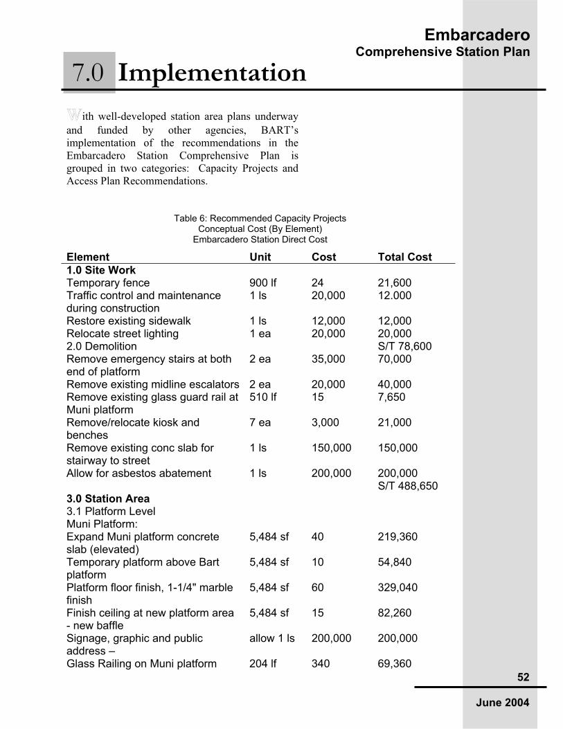
EmbarcaderoComprehensive Station Plan
52
June 2004
ith well-developed station area plans underway
and funded by other agencies, BART’s implementation of the recommendations in the Embarcadero Station Comprehensive Plan is grouped in two categories: Capacity Projects and Access Plan Recommendations.
Element Unit Cost Total Cost
1.0 Site Work Temporary fence 900 lf 24 21,600 Traffic control and maintenance during construction
1 ls 20,000 12.000
Restore existing sidewalk 1 ls 12,000 12,000 Relocate street lighting 1 ea 20,000 20,000 2.0 Demolition S/T 78,600 Remove emergency stairs at both end of platform
2 ea 35,000 70,000
Remove existing midline escalators 2 ea 20,000 40,000 Remove existing glass guard rail at Muni platform
510 lf 15 7,650
Remove/relocate kiosk and benches
7 ea 3,000 21,000
Remove existing conc slab for stairway to street
1 ls 150,000 150,000
Allow for asbestos abatement 1 ls 200,000 200,000 S/T 488,650 3.0 Station Area 3.1 Platform Level Muni Platform: Expand Muni platform concrete slab (elevated)
5,484 sf 40 219,360
Temporary platform above Bart platform
5,484 sf 10 54,840
Platform floor finish, 1-1/4" marble finish
5,484 sf 60 329,040
Finish ceiling at new platform area - new baffle
5,484 sf 15 82,260
Signage, graphic and public address –
allow 1 ls 200,000 200,000
Glass Railing on Muni platform 204 lf 340 69,360
7.0 Implementation
Table 6: Recommended Capacity Projects Conceptual Cost (By Element)
Embarcadero Station Direct Cost

EmbarcaderoComprehensive Station Plan
53
June 2004
Element Unit Cost Total Cost
Install new lighting 5,484 sf 7 38,388 Additional power distribution incl'd cable
1 ls 30,000 30,000
Install new fire sprinkler 5,484 sf 4 21,936 BART Platform: Allow for trainscreen and platform doors
1 ls 4,000,000
S/T 5,045,184 4.0 Vertical Circulation 4.1 Street to Concourse and Platform
New emergency stairs at both end of platform
2 ea 440,000 880,000
Remove/replace struct. beams at new stairs –
allow 2 ea 700,000 1,400,000
New stairs parallel to escalators, concourse to platform
2 ea 370,000 740,000
New stair from concourse to Market Street
1 ea 350,000 350,000
Allow for structure modification w/bike channel
1 ls 250,000 250,000
New escalators, 36' rise, concourse to platform
2 ea 350,000 700,000
Escalator and stairway side wall and soffit finish
2,940 sf 85 249,900
Escalator pits - widening of existing pits
2 ea 15,000 30,000
Power connection for new escalators
2 ea 5,000 10,000
Local fire sprinkler system under escalators and stairs
5 ea 6,000 30,000
S/T 4,639,900 5.0 Fare Collection Barrier rail and service gates at new fare gate arrays
6 ea 6,000 36,000
Modification of existing glass rail for new arrays
4 ea 3,000 12,000
Modification of existing enclosures for AFC –
allow 1 ls 50,000 50,000
F & I for AFC Equipment TVM - ea 68,750 - AFM 4 ea 62,500 250,000 FG Machine - Exit 3 ea 20,000 60,000 FG Machine - Entry 3 ea 21,250 63,750 FG Machine - Reverse 9 ea 30,750 276,750 FG Machine - Handicap 3 ea 53,500 160,500
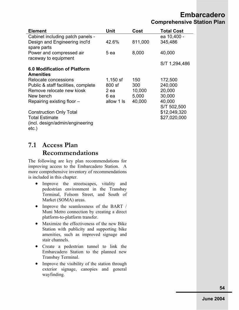
EmbarcaderoComprehensive Station Plan
54
June 2004
Element Unit Cost Total Cost
Cabinet including patch panels - ea 10,400 - Design and Engineering incl'd spare parts
42.6% 811,000 345,486
Power and compressed air raceway to equipment
5 ea 8,000 40,000
S/T 1,294,486 6.0 Modification of Platform Amenities
Relocate concessions 1,150 sf 150 172,500 Public & staff facilities, complete 800 sf 300 240,000 Remove relocate new kiosk 2 ea 10,000 20,000 New bench 6 ea 5,000 30,000 Repairing existing floor – allow 1 ls 40,000 40,000 S/T 502,500 Construction Only Total $12,049,320 Total Estimate(incl. design/admin/engineering etc.)
$27,020,000
7.1 Access Plan Recommendations
The following are key plan recommendations for improving access to the Embarcadero Station. A more comprehensive inventory of recommendations is included in this chapter.
Improve the streetscapes, vitality and pedestrian environment in the Transbay Terminal, Folsom Street, and South of Market (SOMA) areas.
Improve the seamlessness of the BART / Muni Metro connection by creating a direct platform-to-platform transfer.
Maximize the effectiveness of the new Bike Station with publicity and supporting bike amenities, such as improved signage and stair channels.
Create a pedestrian tunnel to link the Embarcadero Station to the planned new Transbay Terminal.
Improve the visibility of the station through exterior signage, canopies and general wayfinding.

Em
ba
rca
de
roC
om
pre
he
ns
ive
Sta
tio
n P
lan
55
Ju
ne 2
004
Fig
ure
8: E
mbarc
adero
Sta
tion C
apacity P
lans
Str
eet Level and C
oncours
e P
lans (
Top)
and M
UN
I and B
AR
T P
lans (
Bottom
)
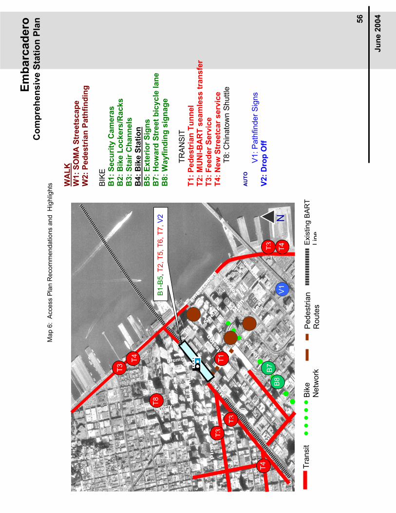
Em
ba
rca
de
roC
om
pre
he
ns
ive
Sta
tio
n P
lan
56
Ju
ne 2
004
WA
LK
W1
: S
OM
A S
tre
ets
ca
pe
W
2:
Ped
estr
ian
Path
fin
din
g
BIK
EB
1:
Secu
rity
Cam
era
s
B2:
Bik
e L
ockers
/Racks
B3:
Sta
ir C
han
nels
B
4:
Bik
e S
tati
on
B5
: E
xte
rio
r S
ign
s
B7:
Ho
ward
Str
eet
bic
ycle
lan
e
B8
: W
ayfi
nd
ing
sig
na
ge
TR
AN
SIT
T1:
Ped
estr
ian
Tu
nn
el
T2:
MU
NI-
BA
RT
seam
less t
ran
sfe
r T
3:
Feed
er
Serv
ice
T4:
New
Str
eetc
ar
serv
ice
T8:
Chin
ato
wn S
huttle
AU
TO
V1:
Path
finder
Sig
ns
V2
: D
rop
Off
T3
T4
V1
T4
B7
B8
T3
T4
T3
T3
T8
T1
B1-B
5,T
2, T
5, T
6, T
7,V
2
Exis
ting B
AR
T
Lin
eB
ike
Netw
ork
Tra
nsit
Pedestr
ian
Route
s
N
Ma
p 6
: A
ccess P
lan
Recom
me
nda
tio
ns a
nd
H
igh
lights