computer vision in the temples of karnak : past, present … · computer vision in the temples of...
TRANSCRIPT

COMPUTER VISION IN THE TEMPLES OF KARNAK : PAST, PRESENT & FUTURE
V. Tournadre a, Ch. Labarta b, *, P. Megard c, A. Garric d, E. Saubestre b, B. Durand b
a Iconem, Paris, France – [email protected] CNRS, USR 3172 - CFEETK - LabEx Archimede - [email protected], [email protected],
[email protected] CNRS, USR 3172 - CFEETK – MAEDI [email protected]
d CNRS, USR 3172 – CFEETK [email protected]
Commission WG V/1, WG V/2, WG II/8, WG VI/2 & CIPA
KEY WORDS: archaeology, cultural heritage, digitization, 3D modeling, photogrammetry, Egypt
ABSTRACT:
CFEETK, the French-Egyptian Center for the Study of the Temples of Karnak, is celebrating this year the 50 th anniversary of itsfoundation. As a multicultural and transdisciplinary research center, it has always been a playground for testing emergingtechnologies applied to various fields. The raise of automatic computer vision algorithms is an interesting topic, as it allows non-experts to provide high value results. This article presents the evolution in measurement experiments in the past 50 years, and itdescribes how cameras are used today. Ultimately, it aims to set the trends of the upcoming projects and it discusses how imageprocessing could contribute further to the study and the conservation of the cultural heritage.
1. INTRODUCTION
Mainly dedicated to the god Amun-Ra, Karnak had stubbornlyremained the heart of the religious and political power formore than two millennia. It is among the best preserved sitesof Egypt. Since the end of the 19 th century, FrenchEgyptologists have been studying the group of monumentswithin the main precinct, which expands over an area of 2.6km2. These include the temple dedicated to Amun-Ra andseveral other structures attached to the cultic center. The sitewas built by the greatest kings of Egypt, among which areSenusret I, Thutmose III and Ramesses II, and it presents a richcollection of monuments whose diversity is a unique witness ofthe religious, political and technical changes. Karnak continuesto be an object of research that is periodically enriched byarchaeological discoveries. The latter are partially madepossible thanks to technologies in constant evolution. As of today, more and more bridges are built between the so-called “hard and soft sciences”. This article aims to presenthow collaborations between the Egyptologists andphotogrammetry specialists help the ongoing work ofexcavation and restoration, and to contribute to a betterunderstanding of the hieroglyphic inscriptions studied in theProjet Karnak 1.
2. PAST
2.1 Early experiments
The 3D modelling of the environment has been a wide subjectof interest in the 20 th century. The evolution of measurementtechniques has been an opportunity to create copies of ourcultural heritage, which is still today a challenge for thepreservation of endangered sites.In 1967, a few years after its participation in the conservationof the antique Nubia heritage, including the famous AbuSimbel temple, IGN - the French mapping agency – producedthe first thorough map of the Karnak temples at a 1:500 scalefrom an aerial stereophotogrammetric acquisition.
It is interesting to note that the process of acquisition and therestitution involved teachers as well as students (Yoyotte,1966). Still used today as the base of the topographic canvasand refined years after years (Azim et al., 1998), this mapproves how pedagogical programs can have an impact half acentury later.Starting in the mid 1980’s,(Vergnieux & Gondran, 1997;Vergnieux, 1999) led a study using modern computer aideddesign technologies focusing on 12 000 blocks from the reignof Akhenaten, who is known as the heretical pharaoh.
2.2 Twenty-first century
The technological revolution induced by the introduction ofcomputers has impacted photogrammetric processes with theemergence of digital photogrammetry. In the early 21st century,the computer vision approaches brought a lot of automation inthe processes, renewing the interest for 3D reconstructionsfrom images.At the beginning of 2000’s, digital photogrammetry has startedto be employed, in combination with terrestrial laser scans intwo digitization projects. This period constituted anintermediate technological phase before its currentindependent use, low-cost and overall easier method. The firstone aimed at studying the 134 columns standing 13 to 20meters high in the great Hypostyle Hall (Chandelier et al.,2009). A French-Canadian mission produced 3D models of thecolumns and derived unrolled orthophotographs. Anothercampaign is still undergoing and interdependent with theAmerican-Canadian epigraphic mission conducted by J. Revezand P. Brand (Meyer, 2004; Meyer et al., 2005; Brand et al.,2013).The second important project of this decade took place in thetemple dedicated to the goddess Opet and the god Osiris. Ledby E. Laroze, it aimed at producing a 3D model of the templethanks to the use of both LiDAR and digital photogrammetry(Chazaly & Laroze, 2005). Among other uses, it was valuableto produce orthophotographs and cross sections scaled at 1:50.Between 2011 and 2014, the Center, always open to innovativetechnical approaches, hosted several survey by the University
* Corresponding author
The International Archives of the Photogrammetry, Remote Sensing and Spatial Information Sciences, Volume XLII-5/W1, 2017 GEOMATICS & RESTORATION – Conservation of Cultural Heritage in the Digital Era, 22–24 May 2017, Florence, Italy
This contribution has been peer-reviewed. doi:10.5194/isprs-archives-XLII-5-W1-357-2017 357
of Oxford, which involved the use of ReflectanceTransformation Imaging (RTI). (Frood & Howley, 2014) usedthis technique for the study of ancient graffiti located invarious areas of the temple. This computational photographicmethod is particularly apt to get clear images of shallowengravings and so to gain a better understanding of these non-royal inscriptions.
3. PRESENT
3.1 Applications
After 50 years of progressive evolution and field testing, digitalphotogrammetry is now a relatively mature technology. It hasimpacted – at various degrees – each profession gathered in theCenter, from that of the land surveyor, to that of the stonemason, including the photographers, the archaeologists or theEgyptologists.
3.1.1 On the archaeological excavations: Since 2008,excavations are being carried on in the precinct of Ptah, in thenorthern area of Karnak. The main goal of the work is to setthe evolution of the enclosure walls, the better preservedperiod being the Ptolemaic one. To gather topographicinformations of this brick-built Ptolemaic surrounding wall, thefirst archaeologists to work in the area were using a totalstation in order to create a minimalist pointcloud (a fewhundred points). Each of these dots were then printed on paperand connected. The paper being then scanned and used as thebasis to draw the final map on Illustrator or AutoCAD. Thismethod soon appeared to be very long and not very efficient todeal with the large mud bricks structure in the investigatedarea. Having a very limited working schedule on theexcavation, a solution had to be found to improve the survey.Meanwhile, photogrammetry has developed enough to studysuch structures efficiently.A few years later, it has become essential for archaeologistsand to speed up the process of field documentation. Incomparison with the traditional method to maps of theexcavated area, the image based approach appears to be muchmore effective in terms of time requirements, accuracy andcompleteness of the survey (introducing the possibility toproduce new types of documents later on). Concretely, withinthe framework of the excavation of the temple of Ptah, a surveythat previously required a full day of work on the field can nowbe achieved within an hour.The photogrammetric acquisition follows the recommendationsof (Chandelier, 2011). A few Ground Control Points (GCP) aresurveyed on the edges of the area of interest (with a relativeaccuracy of a few millimeters). A 4 meters pole and a remotecontrol are used to get the most favourable viewpoints, and theshots are treated with Agisoft Photoscan. The ortho-imagescomputed are likely the most important products for thisspecific mission, as they can be imported in a CAD software todraw the excavation map. Multiscale works can also berealised easily through this technique, as for example drawingsof individual bricks that can be inserted directly in thegeoreferenced CAD file. By following this process severaltypes of documents can be produced: 3D models (possibility tocreate videos), ortho-images, excavation maps, etc.The production of the archaeological documents has benefitedfrom that technology, and so has their exploitation. Therealization of a 3D model in a sector constitutes a digital copyof an incomparable precision/resolution, while remaining avery simple tool that can be used by non-experts of 3Dmodeling. For every point in a 3D model, one can measure itsheight from the ground, or compute its distance from anotherpoint. This exploitation of the 3D imaging also allows to savetime during the field work, as some of the measurements can
be postponed to the post-excavation work. This type ofdocument was difficult to produce until some years ago. Today,the export of these 3D models is made under PLY format, andthey can be consulted with free and open-source software(CloudCompare, 2017).When in 2015, a “favissa” was discovered next to the templeof Ptah (Charloux et al., forthcoming; Charloux & Thiers,2017), digital photogrammetry was already employed as acommon tool by CFEETK’s land surveyor. The experienceaccumulated in the previous years opened new possibilities;thanks to the expertise of K. Guadagnini, it was first time ananimated video could be reconstructed from severalphotogrammetric acquisitions. Apart from its scientific value,the video proved an innovative and powerful tool to share thestep-by-step discovery to the public.Another application of the 3D model is the realization ofstratigraphical cross sections, from the accumulation of severalcopies of ortho-images. In any location of the site, it is possibleto define an axis of a few centimeters wide and obtain thevarious stages of the excavation for such axis. If this onefollowed the stratigraphy and if every stratum was ortho-rectified, a cross section can be derived from the variouslayers. The results of this technique are convincing as theydeliver the same level of accuracy that can be obtainedthroughout the excavation on the field, which requires theinstallation of a permanent axis chosen in advance. Thisexploitation of the 3D imaging avoids the time-consumingrealization of cross section along the excavation as well as itoffers a large freedom concerning the choice of its location.
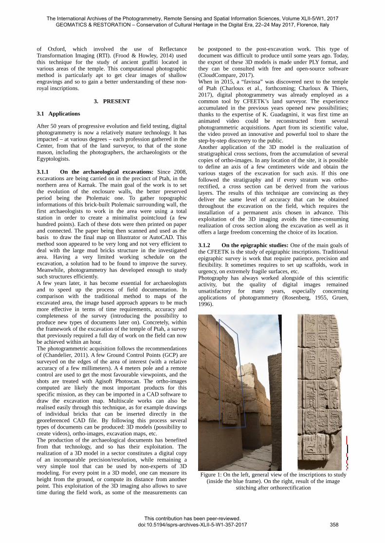
3.1.2 On the epigraphic studies: One of the main goals ofthe CFEETK is the study of epigraphic inscriptions. Traditionalepigraphic survey is work that require patience, precision andflexibility. It sometimes requires to set up scaffolds, work inurgency, on extremely fragile surfaces, etc.Photography has always worked alongside of this scientificactivity, but the quality of digital images remainedunsatisfactory for many years, especially concerningapplications of photogrammetry (Rosenberg, 1955, Gruen,1996).
Figure 1: On the left, general view of the inscriptions to study(inside the blue frame). On the right, result of the image
stitching after orthorectification
The International Archives of the Photogrammetry, Remote Sensing and Spatial Information Sciences, Volume XLII-5/W1, 2017 GEOMATICS & RESTORATION – Conservation of Cultural Heritage in the Digital Era, 22–24 May 2017, Florence, Italy
This contribution has been peer-reviewed. doi:10.5194/isprs-archives-XLII-5-W1-357-2017
358

With the recent full frame cameras and their very large sensorsize and resolution (Nikon D810 with 36.15 megapixels as anexample), the equipment is faster and more efficient to providegood quality images to the scientists. Furthermore, theproduction of orthophotographs became a new way of imagemaking, as many close-range pictures can be compiled into asingle one, in which the optical distortions and the perspectivedefaults can be estimated and corrected.Traditional tracing techniques, that imply transparent plasticsheets fixed directly onto the stone surface, have been used fordecades to produce facsimile. The technique has proveneffective to copy hieroglyphic inscriptions, but it raises a fewproblems. The most striking drawback of this technique is thatit requires to stay on the field during the whole study. A firstdrawing is usually made on the plastic sheet, which is thenphotographed and digitized in a vector software. The drawingis then printed on paper, and verified on the field against theoriginal. An image-based approach in which anorthophotograph is the base for the vector drawing presentsresponses to these issues.Some of the most immediate advantages are the possibility toproduce images of very large structures, walls and blocks, withno distortion and with a result nearly as good as a traditionalepigraphic drawing. In addition, when the set-back distance isso short that the photographer cannot shoot a whole scenewithin a single frame, he can apply a photogrammetricacquisition protocol and produce a photomontage with higherquality and better precision than the photomerge tool onphotoshop software.As an example, it is possible to make a photograph of an 4,5meters high mast-grooves with only a 2 meters gap to take thephotos (Figure 1).The process that the CFEETK employs to createorthophotographs is the same than in archaeology but it doesn’trequire GCP, as the visual results are satisfying as they are forthe epigraphic study. To solve the orthograph’s orientationunknowns without GCP, a couple of points can be indicated onthe horizontal or vertical lines that are often present on theEgyptian scenes.This kind of process requires a high computing power so theycan respect the studies deadlines. The VIIIth pylon has been thefirst massive monument in Karnak subject to aphotogrammetric acquisition for its epigraphic study. 3500pictures have been shot to cover one face of the structure(which would then require 14000 images for the wholemonument). As a result of recent material investments, thechunk could calculated within a day (produced by K.Guadagnini & P. Soubias), while it took almost 3 days witholder material. Moreover, the final ortho-image can be veryheavy as a very fine resolution is mandatory for thehieroglyphic study: about 18GB in that case. Such highresolution documents can be hard to open on a standardworking station, to work with or to upload.CFEETK's photographic department has been usingphotogrammetry as a tool to overcome difficulties on the fieldand nowaydays the photographers’s work in the center is madeof 20% of field work (single shot images, mainly for objects)and 80 % of office work (image treatment with AdobePhotoshop and Agisoft Photoscan, e.g. walls and monuments).At the end of the process, these images are used as highdefinition reference image in the Projet Karnak which aims atlabelling the temples as a whole. The computing power issurely the biggest challenge that one will have to overcome.
3.1.3 On the objects and statuary study: Theexcavations led in various parts of Karnak Temples have dugup hundreds of objects in the last years (statuettes, ceramic,millstones,…). Their study is sometimes complex as theirfragility can necessitate to limit their access. Traditionally
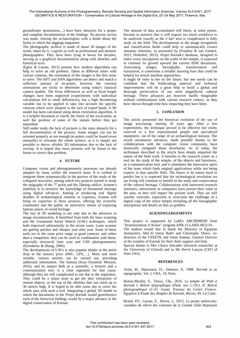
recorded in the archive through photographies, the lack ofreliable 3D informations can be restrictive, for example whenthe elements are considered in a reconstruction hypothesis.In addition to the traditional photographic archive, aphotogrammetric acquisition is realised on the best pieces. As a360° acquisition is generally possible, the use of GCP is notnecessary as such acquisition geometry does not lead -in theauthors experiences- to problematic drift errors. A calibrationcard is used to resolve the unknown scale factor, which hasproven to be cost-effective as well as efficient for the usagesconsidered. A short video presenting the object can then beproduced, this is a powerful means to share discoveries thatcould otherwise remain hidden for years. Ortho-images canalso be realized to have different views of the object.As for the field documentation, the creation of a cross sectionon an object from its 3D model is an interesting application.The tools included in Agisoft Photoscan are helpful to segmentan object and to export an ortho-image of the remaining half(Figure 2). This application facilitates the drawing ofvoluminous objects such as millstones, whose heavy weight arenot a problem any more as it is not necessary to manipulatethese. Meanwhile, the archaeologist is released from a tediousactivity, he only intervenes in the realization of thevectorization in the post-excavation.
3.1.4 In the anastylosis works: For more than a century,dozens of monuments have been rebuilt in Karnak Temple bystudying thousands of stones, coming from fallen structures orexcavations, participating thus in the conservation and theenhancement of this unique site.A new reconstruction project has recently started: thereassembly of 250 blocks onto the Cachette Courtyard walls,built by Thutmose III and especially decorated by Ramesses IIand Tutankhamun. Partially rebuilt following the study of (F.Le Saout, 1982), this anastylosis is based on a research doneby (G. Dembitz, to be published) who produced, fromepigraphic survey and old photographs, some views of thereassembled stones. These studies were done to document themeaning of the decorated scenes and the hieroglyphic texts.Even if these documents are scaled, they aren't accurate enoughto take measurements on and be used on the field in thereconstruction process, as they only indicate the relativepositions of the decorated faces.
Figure 2: Study of a millstone: 1- Textured 3D model; 2- Ortho-image (top view); 3- 3D model segmented; 4- Cross section
drawn from the segmented 3D model
The International Archives of the Photogrammetry, Remote Sensing and Spatial Information Sciences, Volume XLII-5/W1, 2017 GEOMATICS & RESTORATION – Conservation of Cultural Heritage in the Digital Era, 22–24 May 2017, Florence, Italy
This contribution has been peer-reviewed. doi:10.5194/isprs-archives-XLII-5-W1-357-2017
359

One of the main difficulties of anastylosis, especially when themonument is incomplete, is the first laid courses cannot bereadjusted during the laying of the next ones, and these notonly have to connect with the part already assembled but also,in the end, with those of the existing building. Note that eachstone weights about 2.5 tons. The reassembly of all the blocks to their original position onthe structures still in place requires a millimetric accuracy.Each one needs to be carefully surveyed with thesespecifications to know the dimensions and the precisearchitectural characteristics as to the course heights, blocklengths, and distance between the decorative elements andjoints.As explained above, traditional survey techniques are long andtedious (in this case, it would require scaffolding, plumb level,drawing board, etc.), while an image-based approach is anopportunity to accelerate this process.Therefore, orthophotographs on both sides of each wall havebeen made with a resolution adapted to the direct needs of thereconstruction work: sufficient enough to record all necessaryinformation, allowing the reading of hieroglyphs, the
measurement of decor elements and joint positions, withoutbeing overly cumbersome.Unlike the epigraphic use-case, the visual information derivedfrom the image reconstruction are not as important as theirgeometric quality. On a 60m long and 8m high wall, about ahundred images were taken from 3m (Nikon D90). Toguarantee this geometric quality, 6 to 10 GCP are set on thewall, associated with close-up pictures indicating theirpositions (defined on easily identifiable elements such as theend of a line of decoration, the tip of a particular crack, etc.). A3D model is created, allowing to compute orthophotographs onthe vertical side. Inserted into a CAD software, the next step isto integrate all the blocks into the complete orthophotograph ofthe wall. Two solutions are possible:- Using historical images if the quality is good enough,although this may not be the best solution.- Making orthophotographs of each block (limited to 5/6 shots)In both cases, the distance between two details on eachdecorated face are measured, and thus all blocks can easily beimported and scaled in the CAD file. (Figure 3)Therefore, it is no longer necessary to make measurementseither on the wall or on the blocks as the measurements are all
Figure 4: Assembly test scaled on the 12m high wall top part with orthophotographs of recently discovered blocks (CachetteCourtyard North Wall, ongoing reconstruction hypothesis).
Figure 3: Tutankhamun scenes on east side of the Cachette Courtyard East Wall. Old photographs and ortho-images of all theblocks to be rebuilt have been scaled and accurately preassembled on CAD software (ongoing reconstruction hypothesis).
The International Archives of the Photogrammetry, Remote Sensing and Spatial Information Sciences, Volume XLII-5/W1, 2017 GEOMATICS & RESTORATION – Conservation of Cultural Heritage in the Digital Era, 22–24 May 2017, Florence, Italy
This contribution has been peer-reviewed. doi:10.5194/isprs-archives-XLII-5-W1-357-2017
360

easily accessible in the ortho-image CAD file: widths of thedifferent scenes, height of the text lines, distance between aline and a joint, etc. all within millimetric accuracy.With this kind of information, the reconstruction work caneasily be done "virtually" and then on the field. For the NorthWall top part (Figure 4), which is 12m high and difficult tosurvey, the position of 16 recently discovered blocks has beenconfirmed by using this photogrammetric process without evenmoving them, which is rather practical because some stonesweigh more than 4 tons.Computer vision applications are also possible in otherreconstruction projects: on the Thutmose III bark shrineanastylosis (achieved in September 2016), a huge brokenmonolithic ceiling slab had to be moved and reinstalled on thechapel's top. After 3D modeling each of the fragments, CloudCompare was used to know accurately (to cubic centimeter)their volumes, which would have been hard with traditionalapproaches as the objects shape were not rectilinear. Knowingthe density of the calcite, the slab mass was estimated at76.2 tons. Having to lift it manually onto the 4.5m high chapel(with hydraulic jacks and temporary walls), it was very usefulto first know its mass precisely. In addition, by daily shots, atime lapse video has been realized of the complete liftingoperation to highlight the anastylosis and his its presentation tothe public (https://youtu.be/8D2Fl8A3rIY).
3.2 Recent experiments
The multidisciplinary team has now been experimenting 3Dreconstruction from images for years. Then a new look can begiven on problems that were though unsolvable – or really hardto overcome. Three recent and original applications are beingexplored.
3.2.1 On the use of small cameras: It is very common tofind re-employed epigraphic blocks in the foundations of anedifice. The sanctuary of Ermant-Hermonthis, on the west sideof Luxor, is a good example of this practice. Many blocks fromthe 18th Dynasty have been used to build the foundations of thetemple from the Ptolemaic and Roman period. Although the epigraphed faces are usually hidden, a block fromthe reign of Hatshepsut (middle of 15th century BC) isaccessible through a small gap (Figure 5). Unfortunately, it istoo narrow to get a complete photography cover of the hiddeninscriptions, and even more for the epigraphist to produce afacsimile from a plastic sheet. This re-employed block studied by S. Biston-Moulin (to bepublished) is a subject of interest, as only few traces remainfrom the queen's reign. About 15 cm at the most narrow spots,the gap is still wide enough to slide a camera and take images.Too small for a DSLR, a Coolpix compact camera was used.A mirror was reflecting the light from the sun towards theengraved face, providing a diffuse lighting on the wholesurface. The camera was then moved horizontally andvertically from a few centimeters for each poses, literally
scanning the block within half an hour. In total, 397 imageswere taken on the 60 by 70 cm face. Although it is very well known that zoom lenses with unstablemechanical parts do not offer the best geometric stability of thecalibration (Remondino & Fraser, 2006), the automatic postproduction work was completed within a few hours, providingan overview of the entire block (Figure 6). The resultsachieved both in terms of time requirement and visual qualityare satisfactory. Another way to get these results would havebeen to move the massive stone, which is for obvious reasonsmore complicated. Although, if the general view of the block isacceptable for the epigraphic study, its quality is way beyondthe one produced in proper conditions, which is probably dueto the lack of good lighting source and to the low-cost camerathat was used (16MP CMOS sensor, with a mediocre opticalZoom-NIKKOR glass lens 28-140mm that made achromaticaberrations and the compressed jpg files as the only option onthis camera).It is still interesting to note that the first photographicacquisition resulted in an incomplete orthophotograph. Thelack of a sufficient overlapping pictures produced a couple ofholes, which have been completed through additional shots.
3.2.2 On the use of depth maps: To improve the fullunderstanding of the Karnak Temple, the epigraphic study ofthe numerous engraved inscriptions is essential. The site issprinkled with historical or religious inscription on varioussubstrates : architectural elements, furniture, statues, etc. Theirconservation state are sometimes really good, while others arehighly deteriorated, in which case it is complicated to read oreven distinguish the signs carved on the stones. It is especiallytrue when their surface have eroded or when the inscriptionshave been hammered. When working from pictures, the textureof the stone, the shootings conditions or even the location ofthe block can have a negative effect on the study. The methodpresented here has produced convincing results mainly onmagmatic rocks, which are granular and heterogeneous such asthe granitic stones from Aswan. As presented by (Capriotti Vitozzi & Angelini, 2013), therecent evolutions in image reconstruction can be tweaked toprovide additional information from photographs. The idea isto take advantage of the depth information through aphotogrammetric process to get another view of the carvingsmade on an object. Generally deeper than the breaks, a properacquisition and 3d reconstruction make these appear moreclearly than with a trained eye on the field, as the stone texture-here invisible- does not mislead the reading. Three examplescan illustrate the results achievable through the technique.
Figure 6: Screenshot of the textured model and camera poses.The lower right part has been completed through an additional
acquisition
Figure 5: General view of a block difficult to access
The International Archives of the Photogrammetry, Remote Sensing and Spatial Information Sciences, Volume XLII-5/W1, 2017 GEOMATICS & RESTORATION – Conservation of Cultural Heritage in the Digital Era, 22–24 May 2017, Florence, Italy
This contribution has been peer-reviewed. doi:10.5194/isprs-archives-XLII-5-W1-357-2017
361

The first application case is a granite piece of furniture fromthe 13th dynasty (first half of the 18 th century BC), on which adedication banner spreads around the four faces (Labarta,2017). The banner is in a very bad conservation state, as thestone has been eroding year after year along subparallel faces.The carvings are not deep enough, or too much degraded on 2faces, but inscriptions clearly pop out from the depth mapscomputed on the two other sides (Figure 7). The method provesto be effective as some of the signs had not been mentioned inthe first (and unique) hieroglyphic transcription of the furniturein 1950's.The second example relies on the study of a royal stele made ofgranodiorite. Its inscriptions have been voluntarily hammered(Figure 8), as it happened for various reasons along the historyof Egypt. G. Legrain, a prominent Egyptologist that led Karnakreconstruction in the early 20th century, found the stele andwrote about it : “The name carved in the cartouches seem to beNekhao (?). A historical twenty lines text was carved above thescene, but its deplorable state of conservation prevents fromreading it. It seems to be dating from the year 6” (Legrain,1929) 2. Currently under study, the date of the year 6 has beenconfirmed on the first depth maps but it also appears that theproposed main dating must be analyzed again. It is hoped thatthe technique will help to confirm the king mentioned as wellas the nature of the text that could be linked to a drawing of asacred bull in the offering scene from the stele’s upper part.The third and final example illustrates how the technique canbe used for architectural reconstruction purposes. During thestudy of the epigraphic inscriptions on the central bark shrineof Philip Arrhidaeus (323-317 BC) (Thiers & Tillier,forthcoming), two blocks have been identified as part of the
monument's ceiling. The depth maps revealed some very thinand flattened inscriptions, as well as continuous drawingselements (Figure 9).
3.2.3 On the use of historical images: The "Cour de laCachette" holds its name from the discovery by G. Legrain ofmore than 800 statues and 17000 bronze statuettes between1903 and 1907. The profusion of elements to unearth combinedto the conditions of the excavation (up to 15 meters deep,
Figure 7: Depth maps application on temple furniture: the case of the support of Sekhemre-Seouadjtaouy (XIIIth dynasty) in the“Middle Kingdom court”.
Figure 8: Depth maps application on hammered royal stele in granodiorite from the First Court.
Figure 9: Depth maps application on architectural blocks: thecase of ceiling fragments from the Central Bark Shrine in
granite.
The International Archives of the Photogrammetry, Remote Sensing and Spatial Information Sciences, Volume XLII-5/W1, 2017 GEOMATICS & RESTORATION – Conservation of Cultural Heritage in the Digital Era, 22–24 May 2017, Florence, Italy
This contribution has been peer-reviewed. doi:10.5194/isprs-archives-XLII-5-W1-357-2017
362
groundwater penetration,...) have been obstacles for a properand complete documentation of the findings. No precise surveywas made, leaving the archaeologists with a doubt about thelimits in which the diggings happened.The photographic archive is made of about 50 images of thescene, taken by G. Legrain as well as professional and amateurphotographers. They have been lying in boxes for decades,serving as a graphical documentation along with sketches andhistorical texts.(Egels & Laroze, 2015) present how modern algorithms canhelp to solve an old problem. Taken at different times withvarious cameras, the orientation of the images is the first issueto solve. The SIFT and ANN algorithms can detect and match asufficient amount of tie-points, however the externalorientations are tricky to determine using today's classicalcamera models. The focus differences as well as focal lengthchanges have been neglected (experiments with individualcalculations led to small differences), but a high decenteringvariable has to be applied to take into account the specificcameras which were adapted to the lack of tripod heads. A 3Dmodel has been calculated using dense correlation algorithm. Itis a helpful document to clarify the limits of the excavation, aswell the position of some of the statues before they gotunearthed.Still under study, the lack of pictures is the main obstacle for afull documentation of the process. Some images can not beoriented properly as not enough tie-points could be found (evenmanually) to orientate the whole archive, or it is simply notpossible to derive reliable 3D information due to the lack ofoverlap. It is hoped that more pictures will be found in thefuture to correct that problem.
4. FUTURE
Computer vision and photogrammetric processes are alreadyadopted by many within the research team. It is wished tointegrate these systematically in the process of the study of thecollapsed structures, among which two projects started to studythe epigraphy of the 7th pylon and the Taharqa edifice. Iconem’sambition is to preserve the knowledge of threatened heritageusing digital advances. Aiming at producing real digitaldoubles of archaeological remains or expanses, Iconem willbring its expertise in these projects, offering the scientificcommunity and the public an innovative means of exploringfamous places of world heritage.The rise of 3D modeling is not only due to the advances inimage reconstruction. It benefited from both the laser scanningand the Unnamned Aerial Vehicle (UAV) techniques, whichboth improved substantially in the recent years. Laser scannerare getting quicker and cheaper year after year. Some of thesetools are in the same price range as good cameras, and ratherthan a competitor, they can be used in combination with these,especially terrestrial laser scan and UAV photogrammetry(Eisenbeiss & Zhang, 2006). The developments of UAVs is also popular thanks to the quickdrop in the sensors price (IMU, GPS,…). More and morereliable, various sensors can be carried out, providingadditional information. The famous (Scan Pyramids Mission,2016), and its impact both as a scientific, a historic and acommunication tool, is a clear argument for that cause,although they are still complicated to use due to the regulation.They could be a major asset to get the best viewpoints ofremote objects, as the top of the obelisks that can reach up to30 meters high. It is hoped to be able some day to cover thewhole area with such a tool. Integrating a global 3D model inwhich the documents in the Projet Karnak would georeferenceeach of the historical findings would be a major advance in thedigital conservation of Karnak.
The amount of data accumulated will likely, at some points,become so massive that it will require too much workforce tobe analysed, exactly as the 2 km² area is complicated to fullystudy on the field. The developments in the image recognitionand classification fields could help to automatically extractsemantic elements, as presented by (Franken & van Gemert,2013, Nederhof, 2015). Projet Karnak’s database, designed toindex every inscriptions on the walls of the temple, is expectedto continue its growth upward the current 8500 documents.Associating images, hieroglyphs, transliteration andtranslation, it constitutes a reliable learning base that could behelpful for neural machine approaches.It might be risky to bet on the future, but one surely can beconfident that the forthcoming material and technicalimprovements will be a great help to build a global andthorough preservation of our most magnificent culturalheritage. These advances are however hardly imaginablewithout collaborations with various research centers, as theyhave shown through time how impacting they have been.
5. CONLUSION
The article presented the historical evolution of the use ofimage processing, starting 50 years ago. After a fewexperiments, the technique proved to be effective but costly,reserved to a few experimented people and specializedequipment, out of the range of an archaeological mission. Therecent automation advances, made possible thanks to thecollaborations with the computer vision community, havedrastically mitigated these drawbacks. As of today, thetechniques described in the article have deeply impacted thenature of the field work. It benefits to the research center as atool for the study of the temple, of the objects and furnitures,as a communication tool, and it stimulates the innovative spiritof the team which finds original applications while not beingexperts in that specific field. The future is by nature hard topredict but it is expected that the technological revolution weare living will continue to benefit to the study and conservationof the cultural heritage. Collaborations with interested researchinstitutes, universities or companies have proven their value inthe past, as they still impact the present work. They are stillwarmly welcome, especially to overcome the challenge of adigital copy of the entire temple including all the hieroglyphicinscriptions and details as thin as graffitis.
ACKNOWLEDGEMENTS
This project is supported by LabEx ARCHIMEDE from"Investissement d’Avenir" program ANR-11-LABX-0032-01. The authors would like to thank the Ministry of EgyptianAntiquities, Abd Al Sattar Badri and Christophe Thiers, co-directors of the CFEETK and Amin Ammar, General Directorof the temples of Karnak for their daily support and help.Special thanks to Mrs Chiara Salvador (doctoral researcher atthe University of Oxford) and to Mr Hervé Lançon (CEO ofSites SAS).
REFERENCES
Azim, M., Bjarnason, Fr., Deleuze, P., 1998. Karnak et satopographie, Vol. I, CRA, 19, Paris.
Biston-Moulin, S., Thiers, Chr., 2016. Le temple de Ptah àKarnak I. Relevé épigraphique (Ptah, nos 1-191), II. Relevéphotographique (J.-Fr. Gout), Travaux du Centre Franco-Égyptien d’Étude des Temples de Karnak, BiGen, 49, Le Caire.
Brand, P.F., Laroze, E., Revez, J., 2013. Le projet américano-canadien de relevé des colonnes de la Grande Salle Hypostyle
The International Archives of the Photogrammetry, Remote Sensing and Spatial Information Sciences, Volume XLII-5/W1, 2017 GEOMATICS & RESTORATION – Conservation of Cultural Heritage in the Digital Era, 22–24 May 2017, Florence, Italy
This contribution has been peer-reviewed. doi:10.5194/isprs-archives-XLII-5-W1-357-2017
363
de Karnak : objectifs globaux et méthodologie, JSSEA, 38,pp. 17-34.
Capriotti Vittozzi, G., Angelini, A., 2013. Una ricerca traantichi disastri ambientali tecnologie avanzate in R. Pirelli(éd.), Ricerche Italiane e Scavi in Egitto, 6, Cairo, pp. 81-96.
Charloux, G., Thiers, Chr., 2017. The early temple of Ptah atKarnak. Egyptian Archaeology, (50), pp. 11-15.
Charloux, G., Thiers, Chr., Abd al-Aziz, M., Ali al-Abady, M ;,Bout, St., Bourse, C., Laroye, J., Guadagnini, K., Nasseh, A.The Afterlife of Egyptian Statues: New Evidence From a Cacheof Cultic Objects in the Temple of Ptah at Karnak, Antiquity(forthcoming).
Chandelier, L., Chazaly, B., Egels, Y., Laroze, E., 2009.Numérisation 3D et déroulé photographique des 134 colonnesde la Grande Salle Hypostyle de Karnak, Revue XYZ, 120,pp. 33-39.
Chandelier, L., 2011. La prise de vue photogrammétrique. http://cours-fad-public.ensg.eu/mod/resource/view.php?id=495&redirect=1
Chazaly, B., Laroze, E., 2005. Le relevé par scannage 3D dutemple d’Opet à Karnak, Egypte, Revue XYZ, 102, pp. 21-26.
CloudCompare (version 2.9) [GPL software], 2017. Retrievedfrom http://www.cloudcompare.org/
Egels, Y., Laroze E., 2016, November. From photographicarchives to 3D data: experience of the “Cour de la Cachette” atKarnak, CIPA Newsletter 10, pp. 1-2http://cipa.icomos.org/portfolio-item/newsletter_10/.
Eisenbeiss, H., Zhang, L., 2006. Comparison of DSMsgenerated from mini UAV imagery and terrestrial laser scannerin a cultural heritage application. International Archives ofPhotogrammetry, Remote Sensing and Spatial InformationSciences, 36(5), pp. 90-96.
Franken, M., van Gemert, J. C., 2013. Automatic Egyptianhieroglyph recognition by retrieving images as texts. InProceedings of the 21st ACM international conference onMultimedia, pp. 765-768.
Frood, E., Howley, K., 2014. Application of ReflectanceTransformation Imaging (RTI) in the Study of Temple Graffiti.In Pischikiva, E., Budka, J., Griffin, K. (ed.), Thebes in theFirst Millenium B.C., Cambridge, pp. 625-638.
Labarta, Ch., 2017. Un support au nom de SobekhotepSékhemrê-Séouadjtaouy – Karnak varia, Karnak, 16(forthcoming).
Laroze, E., Chazaly, B., 2009. Relevés des colonnes de lagrande salle hypostyle de Karnak, CRAIBL, 153(2), pp. 669-686.
Legrain, G., 1929. Les temples de Karnak. Fragment dudernier ouvrage de Georges Legrain, Directeur des Travaux duService des Antiquités de l’Égypte, Bruxelles, p. 140.
Le Saout, F., 1982. Reconstitution des murs de la Cour de laCachette. Karnak, 7, pp. 213-58.
Meyer, E., Grussenmeyer, P., Tidafi, T., Parisel, C. and Revez,J., 2004. Photogrammetry for the epigraphic survey in the greathypostyle hall of Karnak temple: a new approach. In
Proceedings of the XXth Congress of the ISPRS, Istanbul,Turkey, pp. 12-23.
Meyer E., 2005. La photogrammétrie pour le relevéépigraphique des colonnes de la Salle Hypostyle du temple deKarnak, Revue XYZ, 102, pp. 29-34.
Nederhof, M. J., 2015. ORC of handwritten transcriptions ofAncient Egyptian hieroglyphic text. Altertumswissenschaftenin a Digital Age: Egyptology, Papyrology and beyond, Leipzig.
Remondino, F., Fraser, C., 2006. Digital camera calibrationmethods: considerations and comparisons. InternationalArchives of Photogrammetry, Remote Sensing and SpatialInformation Sciences, 36(5), pp. 266-272.
Rosenberg, P., 1955. Information theory and electronicphotogrammetry. Photogrammetric engineering, 21(4), pp.543-555.
Scan Pyramids Mission, 2016. Press release, Cairo, Egypt.http://www.hip.institute/press/HIP_INSTITUTE_CP9_EN.pdf.Last access : Apr. 1th 2017.
Thiers, Chr., Tillier, A., Le reposoir de barque de PhilippeArrhidée. Relevé épigraphique, Le Caire (forthcoming).
Vergnieux, R., Gondran, M., 1997. Aménophis IV et les pierresdu soleil. Akhénaton retrouvé. Arthaud, Paris.
Vergnieux, R., 1999. Recherches sur les monuments thébainsd’Amenhotep IV à l’aide d’outils informatiques. Méthodes etrésultats, CSEG, 4, Genève.
Yoyotte, J., 1966. Religion de l'Égypte. École Pratique desHautes Études: Ve section - sciences religieuses, 79 (75),pp. 267-282.
APPENDIX
1 Based on a comprehensive inventory of documents andinscriptions from Karnak collated in the field, this project isavailable in http://sith.huma-num.fr/karnak
2 Original french text from G. Legrain on the study of the royalstele : “Le nom gravé dans les cartouches paraît être celui deNekhao (?). Un texte historique d’une vingtaine de lignes étaitgravé au-dessous du tableau, mais son état déplorable enempêche le déchiffrement. La date paraît être l’an VI.”
3 The Macedonian king Philip Arrhidaeus dedicates (repeatedlyin the wall inscriptions) his construction to Thutmose III, kingof the 18th dynasty and builder of the previous shrine whichwas erected in the same place and performed the same function(Biston-Moulin & Thiers, 2017). Furthermore, this assignmentproposal is based on a typological study of starry decoration,also carried out using depth maps.
The International Archives of the Photogrammetry, Remote Sensing and Spatial Information Sciences, Volume XLII-5/W1, 2017 GEOMATICS & RESTORATION – Conservation of Cultural Heritage in the Digital Era, 22–24 May 2017, Florence, Italy
This contribution has been peer-reviewed. doi:10.5194/isprs-archives-XLII-5-W1-357-2017 364