con edison - maspeth substationnewtowncreek.info/docs2/2 remedial investigation/remedial...con...
TRANSCRIPT

Con Edison – Maspeth Substation Draft Upland Site Summary
Draft Upland Site Summary Report May 2012 Newtown Creek RI/FS 1 120782-01.01
CON EDISON – MASPETH SUBSTATION (DAR SITE ID #4)
Address: 57 – 77 Rust Street, Flushing, New York 11378 Tax Lot Parcel(s): Queens Block 2676, Lot 1 Latitude: 40.721245 Longitude: -73.912333 Regulatory Programs/ Numbers/Codes: NYSDEC VCP Code V00326, USEPA ID No. NYR000089441 (active) and NYD987011830 (inactive), NYSDEC Spill No. 9614406, 0004153, 0007625, 0304106, 0300684, and 0503800 Analytical Data Status: Electronic Data Available Hardcopies only No Data Available
1 SUMMARY OF CONSTITUENTS OF POTENTIAL CONCERN (COPCs) TRANSPORT PATHWAYS TO THE CREEK
The current understanding of the transport mechanisms of COPCs from the uplands portions of the Con Edison – Maspeth Substation site (site) to Newtown Creek is summarized in this section and Table 1 and supported in following sections. Overland Transport: The site is located approximately 0.43 mile from Newtown Creek and associated waterways. This is not a complete historical or current pathway. Bank Erosion: The site is not adjacent to Newtown Creek or associated waterways. This is not a complete historical or current pathway. Groundwater: The site is located approximately 0.43 miles from Newtown Creek and associated waterways. Groundwater at the site flows to the west toward Maspeth Creek and has been shown to contain COPCs. This pathway is historically and currently complete.

Con Edison – Maspeth Substation
Draft Upland Site Summary Report May 2012 Newtown Creek RI/FS 2 120782-01.01
Overwater Activities: This site is not adjacent to Newtown Creek or associated waterways and has no overwater activities. This is not a complete historical or current pathway. Stormwater/Wastewater Systems: This site is within the Newtown Creek Water Pollution Control Plant (WPCP) sewershed. Stormwater and wastewater discharges from the site flow into separate municipal sewer systems. Wastewater is conveyed to the WPCP for treatment prior to discharge. The site lies within the drainage area of stormwater Outfall NC-077, which discharges at the head of Maspeth Creek (NYCDEP 2007). It is possible that overland sheet runoff may have transported eroded surface soils and COPCs from historical transformer discharges, spills, and leaks from the site to Maspeth Creek via the storm drain system. There is insufficient evidence to make a historical or current pathway determination for direct discharge of stormwater and wastewater. The sewer/combined sewer overflow (CSO) pathway is potentially currently complete; however, there is insufficient evidence to make a historical sewer/CSO pathway determination. Air Releases: Information regarding site air discharges was not identified in files available for review. There is insufficient evidence to make a historical or current pathway determination.
2 PROJECT STATUS
Based on the presence of polychlorinated biphenyl (PCBs) in the former transformer yard, the site is listed on the New York State Environmental Site Remediation Database as a “Class A” VCP site (i.e., a non-registry site in any remedial program where work is underway and not yet complete). A summary of remedial activities at the site is provided in the following table:

Con Edison – Maspeth Substation
Draft Upland Site Summary Report May 2012 Newtown Creek RI/FS 3 120782-01.01
Activity Date(s)/Comments
Phase 1 Environmental Site Assessment
Site Characterization Borings and Wells: 1996, 1999, 2000/2001 Soil Samples: 1996-2001
Ground Penetrating Radar Survey: 1999 Groundwater Samples and Pumping Tests: 2002 Qualitative Human Health Exposure Assessment
(QHHEA): 2003 Pressure Pulse Technology test: 2004
Remedial Investigation (RI) RI completed October 1997; Supplemental RI completed May 2002
Remedy Selection
Remedial Design/Remedial Action Implementation
Con Edison Site Remediation Activities: 1996 Passive Recovery: 1999-2002
Product-Only Recovery: 2001-2002 Vacuum Enhanced Fluid Recovery (VEFR): 2002-2003
Coastal Environmental Group (Coastal) Remedial Activities: 2005-2007
Use Restrictions (Environmental Easements or Institutional Controls)
Construction Completion
Site Closeout/No Further Action Determination
Notes: Coastal – Coastal Environmental Group Con Edison – Consolidated Edison QHHEA – qualitative human health exposure assessment RI – Remedial Investigation VEFR – vacuum enhanced fluid recovery
• NYSDEC Site Code VCP Site Number V00326 • NYSDEC Site Manager(s): Bryan Wong (718) 482-4905
3 SITE OWNERSHIP HISTORY
Respondent Member: Yes No

Con Edison – Maspeth Substation
Draft Upland Site Summary Report May 2012 Newtown Creek RI/FS 4 120782-01.01
Owner Years Occupant Type of Operation
Consolidated Edison Company of New York
1922 – 1996 Same Electrical substation
LDC Realty Holdings, LLC 1996 – 1997 Unknown Unknown
R.A.W. Realty & Equipment Company
1997 – 1999 Unknown Tire-recapping
Michael Berenshtyn & Andrew Wygodzki c/o M & A Linens
1999 – present M&A Linens Textile storage
4 PROPERTY DESCRIPTION
The property occupies approximately 0.5-acre located at 57 – 77 Rust Street in the Maspeth section of the borough and county of Queens in the city of Flushing, New York (see Figure 1). The property formerly contained a Con Edison electrical substation, which housed transformers and other PCB-containing equipment. Structures on the property include a one-story brick building on the south end of the property and an adjacent parking lot to the north. The parking lot is the location of the former transformer yard. The perimeter of the property is fenced. Topography at the property slopes toward Maspeth Creek, located approximately 0.6-mile to the west. According to GIS data provided by New York City, the site lies within the drainage area of stormwater Outfall NC-077, which is located at the head of Maspeth Creek. The property is physically separated from Maspeth Creek by anthropogenic infrastructure including buildings and roads. The property is bordered by two-story residential homes on the north, by 58th Street on the east, by Rust Street on the west, and by 58th Avenue on the south. The area is zoned M1-1D (NYCDCP 2011a). M1 districts are designated for manufacturing areas with a significant number of residential buildings (NYCDCP 2011b). Figure 1 includes an aerial photograph of the site showing the existing building and adjacent parking lot. Attachment 1 depicts the site layout in 1996.

Con Edison – Maspeth Substation
Draft Upland Site Summary Report May 2012 Newtown Creek RI/FS 5 120782-01.01
5 CURRENT SITE USE
The site is currently owned by M&A Linens and has been used for textile storage since 1999. The intended future use for the property is to construct a new brick warehouse and a gravel parking lot area (Stantec 2011).
6 SITE USE HISTORY
Built in 1922, the site contained two tanks close to 58th Street and 57th Drive, three transformers in the middle of the property, and an operating room, battery room, and coal room along Rust Street (Sanborn 1936). The site was operated as an active electrical substation between 1925 and 1985 by Con Edison and its predecessor, the New York and Queens Electric Light & Power Company (Stantec 2011). The site was inactive between 1985 and 1996 (Stantec 2011). Con Edison sold the site in 1996 (Con Edison 1996a).
7 CURRENT AND HISTORICAL AREAS OF CONCERN AND COPCS
The current understanding of the historical and current potential upland areas of concern at the site are summarized in Table 1. The following sections provide brief discussion of the potential sources and COPCs at the site requiring additional discussion.
7.1 Uplands
Historic areas of concern include the existing brick building that formerly housed electrical equipment and battery and control rooms of the former electric substation, as well as the adjacent transformer storage yard. Spare electrical equipment was likely staged on the large western-most concrete slab shown in Attachment 1. The former substation’s step-down transformers were located on concrete pads in the central portion of the storage yard as shown in Attachment 1. Additionally, an above-ground storage tank (AST) for discarded oil located on the eastern-most pad is briefly mentioned in the 1999 Interim Report prepared for the site (Jacques Whitford Engineering Group 1999; see Attachment 1). No analytical results for the contents of the AST were available in any of the documents reviewed. The ground surface between the concrete transformer pads was unpaved and covered with a foot of crushed bluestone rock (Jacques Whitford Engineering Group 1999).

Con Edison – Maspeth Substation
Draft Upland Site Summary Report May 2012 Newtown Creek RI/FS 6 120782-01.01
Records indicate the site is an active Resource Conservation and Recovery Act (RCRA) large quantity generator (LQG; USEPA 2012). Historically, it has been listed as small quantity and large quantity generator between the years 2000 and 2008 (EDR 2010). Available hazardous waste manifest documentation indicates that in 2001, 2005, and 2006 the facility shipped miscellaneous PCB wastes (B007) and in 2001 and 2003 shipped petroleum oil with PCBs (B002). No other information related to waste generation was located. Historical sources of COPCs at the property include discharges, leaks, and spills of dielectric oil, including PCBs, originating from the equipment and other unknown sources on-site (Jacques Whitford Engineering Group 2004; Stantec 2011). Sampling for potential soil and groundwater contamination at the site was conducted between 1989 and 2010 by Con Edison Environmental Affairs and the Jacques Whitford Engineering Group, Inc., P.C. (Jacques Whitford Engineering Group; later known as Stantec Consulting Services, Inc. [Stantec]). Results of these investigations indicated that PCBs were the primary COPC at the site. Other COPCs discovered at the site include volatile organic compounds (VOCs) such as 1,4-dichlorobenzene, and semivolatile organic compounds (SVOCs) such as benzo(a)anthracene, benzo(a)pyrene, chrysene, dibenzo(a,h)anthracene, and metals.
7.2 Overwater Activities
This site is not adjacent to Newtown Creek or associated waterways and has no overwater activities.
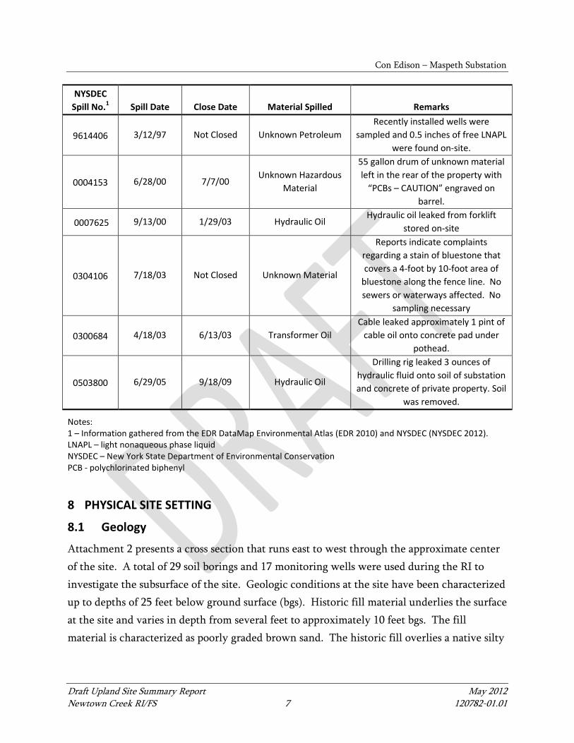
7.3 Spills
Historical undocumented spills at the site are the primary sources of PCB contamination at the site (see Section 7.1). Recently documented spills that have occurred at the site are summarized in the following table:
Con Edison – Maspeth Substation
Draft Upland Site Summary Report May 2012 Newtown Creek RI/FS 7 120782-01.01
NYSDEC Spill No.1 Spill Date Close Date Material Spilled Remarks
9614406 3/12/97 Not Closed Unknown Petroleum Recently installed wells were
sampled and 0.5 inches of free LNAPL were found on-site.
0004153 6/28/00 7/7/00 Unknown Hazardous
Material
55 gallon drum of unknown material left in the rear of the property with
“PCBs – CAUTION” engraved on barrel.
0007625 9/13/00 1/29/03 Hydraulic Oil Hydraulic oil leaked from forklift
stored on-site
0304106 7/18/03 Not Closed Unknown Material
Reports indicate complaints regarding a stain of bluestone that covers a 4-foot by 10-foot area of
bluestone along the fence line. No sewers or waterways affected. No
sampling necessary
0300684 4/18/03 6/13/03 Transformer Oil Cable leaked approximately 1 pint of
cable oil onto concrete pad under pothead.
0503800 6/29/05 9/18/09 Hydraulic Oil
Drilling rig leaked 3 ounces of hydraulic fluid onto soil of substation and concrete of private property. Soil
was removed.
Notes: 1 – Information gathered from the EDR DataMap Environmental Atlas (EDR 2010) and NYSDEC (NYSDEC 2012). LNAPL – light nonaqueous phase liquid NYSDEC – New York State Department of Environmental Conservation PCB - polychlorinated biphenyl
8 PHYSICAL SITE SETTING
8.1 Geology
Attachment 2 presents a cross section that runs east to west through the approximate center of the site. A total of 29 soil borings and 17 monitoring wells were used during the RI to investigate the subsurface of the site. Geologic conditions at the site have been characterized up to depths of 25 feet below ground surface (bgs). Historic fill material underlies the surface at the site and varies in depth from several feet to approximately 10 feet bgs. The fill material is characterized as poorly graded brown sand. The historic fill overlies a native silty

Con Edison – Maspeth Substation
Draft Upland Site Summary Report May 2012 Newtown Creek RI/FS 8 120782-01.01
sand that contains cobbles and boulders, the origin of which is interpreted to be ablation till deposited during the last period of glacial retreat (Stantec 2011).
8.2 Hydrogeology
Attachment 2 also depicts the approximate depths of the underlying groundwater at each of the monitoring wells. This shallow groundwater zone is dominated by native silty sand. Periodic measurements of groundwater levels indicate that depth to the water table fluctuates between 12 and 18 feet bgs. However, groundwater levels measured at 58th Street depths fluctuate between 10 and 14 feet bgs (see Attachment 3). Groundwater flow in the shallow saturated zone is to the west. Pump tests conducted in 2002 demonstrated that the transmissivity of the aquifer material underlying the site ranges from 100 to 500 gallons per day (gpd)/foot (Stantec 2011).
9 NATURE AND EXTENT (CURRENT UNDERSTANDING OF ENVIRONMENTAL CONDITIONS)
Investigations conducted at the site since 1989 revealed the presence of petroleum (transformer oil) contaminated with PCBs in both soil and groundwater. Light nonaqueous phase liquid (LNAPL) containing PCBs was detected in several groundwater monitoring wells at approximately 15 to 17 feet below grade.
9.1 Soil
Soil Investigations Yes No Bank Samples Yes No Not Applicable Soil-Vapor Investigations Yes No Surface and subsurface soil samples collected during an Environmental Assessment (EA) in 1989 and 1990 revealed total PCB concentrations up to 3,540 mg/kg in surface soil and 6,041 mg/kg in subsurface soil (Con Edison 1996b). Additionally, wipe and concrete chip samples from the transformer vaults revealed extensive PCB contamination. In 1996, the NYSDEC Technical and Administrative Guidance Memorandum (TAGM) Recommended Soil Cleanup Objectives (RSCOs) for PCBs for the site were 1 parts per million (ppm) at the surface (0-2 feet bgs) and 10 ppm at depths greater than 2 feet bgs. Based on the EA, Con Edison
Con Edison – Maspeth Substation
Draft Upland Site Summary Report May 2012 Newtown Creek RI/FS 9 120782-01.01
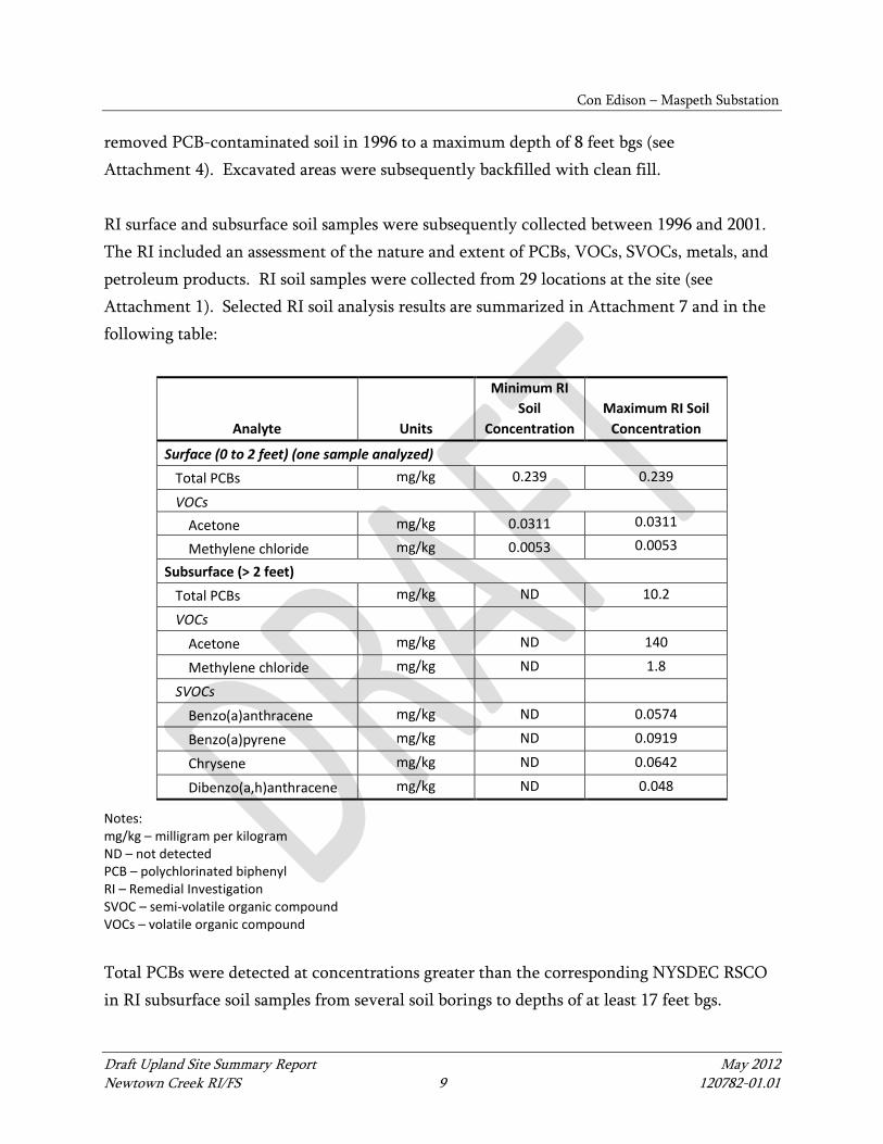
removed PCB-contaminated soil in 1996 to a maximum depth of 8 feet bgs (see Attachment 4). Excavated areas were subsequently backfilled with clean fill. RI surface and subsurface soil samples were subsequently collected between 1996 and 2001. The RI included an assessment of the nature and extent of PCBs, VOCs, SVOCs, metals, and petroleum products. RI soil samples were collected from 29 locations at the site (see Attachment 1). Selected RI soil analysis results are summarized in Attachment 7 and in the following table:
Analyte Units
Minimum RI Soil
Concentration Maximum RI Soil
Concentration Surface (0 to 2 feet) (one sample analyzed)
Total PCBs mg/kg 0.239 0.239
VOCs Acetone mg/kg 0.0311 0.0311
Methylene chloride mg/kg 0.0053 0.0053
Subsurface (> 2 feet) Total PCBs mg/kg ND 10.2 VOCs
Acetone mg/kg ND 140
Methylene chloride mg/kg ND 1.8
SVOCs
Benzo(a)anthracene mg/kg ND 0.0574
Benzo(a)pyrene mg/kg ND 0.0919
Chrysene mg/kg ND 0.0642
Dibenzo(a,h)anthracene mg/kg ND 0.048
Notes: mg/kg – milligram per kilogram ND – not detected PCB – polychlorinated biphenyl RI – Remedial Investigation SVOC – semi-volatile organic compound VOCs – volatile organic compound Total PCBs were detected at concentrations greater than the corresponding NYSDEC RSCO in RI subsurface soil samples from several soil borings to depths of at least 17 feet bgs.

Con Edison – Maspeth Substation
Draft Upland Site Summary Report May 2012 Newtown Creek RI/FS 10 120782-01.01
VOCs, acetone, and methylene chloride were detected in RI subsurface soil samples at concentrations above their respective TAGM RSCO. SVOCs, benzo(a)anthracene, benzo(a)pyrene, chrysene, and dibenzo(a,h)anthracene were detected at concentrations above their respective TAGM RSCO. Metals at the site detected at concentrations above their respective TAGM RSCO include arsenic, beryllium, cadmium, calcium, chromium, iron, magnesium, manganese, and zinc.
9.2 Groundwater
Groundwater Investigations Yes No NAPL Presence (Historical and Current) Yes No Dissolved COPC Plumes Yes No Visual Seep Sample Data Yes No Not Applicable
9.2.1 Groundwater Investigations
Several groundwater investigations have been performed at the site. Groundwater in the vicinity of the site is not used as drinking water supply or for human consumption (Stantec 2011). The closest receptor, Maspeth Creek, is greater than 3,200 feet (0.6 mile) west of the site. Groundwater from the site most likely discharges to Newtown Creek or one of its tributaries, including Maspeth Creek.
9.2.2 Light Nonaqueous Phase Liquid
The presence of PCB-containing LNAPL on the water table underlying the site was confirmed and delineated during the RI activities (Stantec 2011). Although LNAPL was not observed in soil samples collected at the site, quantities of LNAPL were detected at four of the monitoring wells during remedial investigations (see Attachment 5). Based on testing of the LNAPL, it likely originated from specific dielectric fluids commonly used by Con Edison and identified as “Suntrans” dielectric fluid and Sun #4 Cable Oil (see Attachment 6; Stantec 2011). The maximum PCB concentration detected in LNAPL was 328 ppm, consisting entirely of Aroclor 1260. LNAPL had been measured in monitoring wells between 1996 and 2002, located primarily within the Site’s boundaries, ranging in thickness from a sheen (MW-201/201A and MW-203/203A) to over three feet (MW-103A, MW-201/201A,

Con Edison – Maspeth Substation
Draft Upland Site Summary Report May 2012 Newtown Creek RI/FS 11 120782-01.01
and MW-203). The seasonal fluctuation of the water table further suggested the product had likely created a smear zone at depths of about 12 to 18 feet bgs (Stantec 2011). Various interim remedial measures were performed to remove LNAPL from the groundwater at the site (Jacques Whitford Engineering Group 2004). Passive recovery was attempted between 1999 and 2002; approximately 25 gallons of product were removed from existing monitoring wells using a combination of oil absorbent wicks, LNAPL skimmers, and hand bailing during weekly monitoring events. In 2001 and 2002 a product-only recovery system was set up in three wells. Approximately 37 gallons of product were removed over the 15 months the system was in place. The last groundwater interim remedial measure attempted was a vacuum-enhanced fluid recovery system operated in four wells from late 2002 to early 2003. Approximately 180 to 300 gallons of product/water were removed over the four months the vacuum enhanced fluid recovery system was in place.
9.2.3 Dissolved Contaminant Plume
Aroclor 1260 was the only PCB detected in groundwater during the RI at concentrations above the NYSDEC Technical and Operational Guidance Series (TOGS) Groundwater Standard of 0.1 micrograms per liter (µg/L). The VOC COPC, 1,4-dichlorobenzene was the only VOC compound detected at concentrations above its respective TOGS Groundwater Standard on site. Two other VOC COPCs, benzene and chloroform, were detected at three off-site monitoring well locations (MW-303, MW-304, and MW-306). No SVOCs were detected at concentrations above the respective TOGS Groundwater Standards. Metals at the site detected at concentration above their respective TOGS Groundwater Standard include aluminum, iron, manganese, and sodium. Aluminum, iron, and manganese, which exceeded their respective TOGS Groundwater Standards, were also documented at off-site monitoring wells. Selected groundwater sampling results are summarized in Attachment 8 and in the following table:

Con Edison – Maspeth Substation
Draft Upland Site Summary Report May 2012 Newtown Creek RI/FS 12 120782-01.01
Analyte Units
Minimum RI Groundwater Concentration
Maximum RI Groundwater Concentration
PCBs Aroclor 1260 µg/L <0.05 1.5
VOCs Benzene µg/L ND 1.80
Chloroform µg/L ND 7.80
1,4-dichlorobenzene µg/L ND 12.7
Metals Aluminum µg/L ND 13900 Iron µg/L ND 28600 Manganese µg/L ND 5450 Sodium µg/L ND 374000
Notes: µg/L – microgram per liter (ppb) ND – not detected PCB – polychlorinated biphenyl ppb – parts per billion RI – Remedial Investigation VOC – volatile organic compound A Groundwater Management Plan (GMP) was developed and executed between July 2008 and April 2010 following successful completion of the on-site soil excavation remedial activities, including the backfill operations (see Section 10). Post-excavation monitoring wells were drilled and constructed on-site and off-site and together with existing wells, were sampled quarterly for two years. During the February 2010 gauging event, LNAPL was detected in MW-602 at a thickness of 0.02 feet (approximately one-quarter inch). The product was analyzed for PCB content and the sample contained 18,600 µg/kg (parts per billion [ppb]) of PCB Aroclor 1260. PCBs in off-site groundwater were reported at levels above the TOGS PCB standard/guidance value of 0.09 µg/L (or ppb) during both the December 2009 and February 2010 groundwater sampling events at concentrations up to 8.03 µg/L (Stantec 2011).
9.2.4 Groundwater Summary
Groundwater investigations have been conducted at the site since 1989 and have included groundwater monitoring of up to 17 monitoring wells (Stantec 2011). The general

Con Edison – Maspeth Substation
Draft Upland Site Summary Report May 2012 Newtown Creek RI/FS 13 120782-01.01
groundwater flow direction in the vicinity of the site is to the west. Groundwater from the site most likely discharges to Newtown Creek. Dissolved groundwater COPCs detected at elevated concentrations or at concentrations exceeding NYSDEC TOGS Groundwater Standards include PCBs, 1,4-dichlorobenzene, and several metals. An area of PCB-containing LNAPL was formerly present at the site; however, the area of LNAPL was excavated and subsequent groundwater monitoring over a 2-year period has intermittently detected LNAPL (up to 0.4 foot thick) in some on-site and off-site wells.
9.3 Surface Water
Surface Water Investigation Yes No SPDES Permit (Current or Past) Yes No Industrial Wastewater Discharge Permit (Current or Past) Yes No Stormwater Data Yes No Catch Basin Solids Data Yes No Wastewater Data Yes No
9.3.1 Stormwater and Wastewater Systems This site is within the Newtown Creek WPCP sewershed. Stormwater and wastewater discharges from the site flow into separate municipal sewer systems. Wastewater is conveyed to the WPCP for treatment prior to discharge. The site lies within the drainage area of stormwater Outfall NC-077, which discharges at the head of Maspeth Creek (NYCDEP 2007). It is possible that overland sheet runoff may have transported eroded surface soils and COPCs from historical transformer discharges, spills, and leaks from the site to Maspeth Creek via the storm drain system. There are no current discharge permits for the site.
9.4 Sediment
Creek Sediment Data Yes No Not Applicable No sediment investigation information was found in reviewed documents.

Con Edison – Maspeth Substation
Draft Upland Site Summary Report May 2012 Newtown Creek RI/FS 14 120782-01.01
9.5 Air
Air Permit Yes No Air Data Yes No Information related to air emissions was not found in reviewed documents.
10 REMEDIATION HISTORY (INTERIM REMEDIAL MEASURES AND OTHER CLEANUPS)
Investigation and cleanup activities conducted at the site have been driven by PCBs and not VOCs, SVOCs, or metals (Stantec 2011). Analytical data collected at the site indicated that the main COPC was PCBs at varying concentrations in soil as well as LNAPL containing PCBs (at depth) on the groundwater surface. Several cleanup efforts and monitoring programs have occurred at the site since 1996.
10.1 Initial Cleanup Actions
In 1996, site remediation activities were conducted by Con Edison during which PCB-contaminated soils that contained greater than 2 ppm PCBs in surficial soil (<2 feet bgs) and 10 ppm PCBs in subsurface soil (>2 feet bgs) were excavated to depths ranging from 1 to 10 feet bgs and disposed off-site (Jacques Whitford Engineering Group 1999; see Attachment 4). Excavated areas were subsequently backfilled with clean fill.
10.2 Groundwater Interim Remedial Measures
Various Interim Remedial Measures (IRMs) were performed to remove LNAPL from the groundwater at the site (Jacques Whitford Engineering Group 2004). As discussed in Section 9.2.2, passive recovery was attempted between 1999 and 2002; approximately 25 gallons of product were removed from existing monitoring wells using a combination of oil absorbent wicks, LNAPL skimmers, and hand bailing during weekly monitoring events. In 2001 and 2002 a product-only recovery system was set up in three wells. Approximately 37 gallons of product were removed over the 15 months the system was in place. The last groundwater interim remedial measure attempted was a vacuum enhanced fluid recovery system operated in four wells from late 2002 to early 2003. Approximately 180-300 gallons of product/water

Con Edison – Maspeth Substation
Draft Upland Site Summary Report May 2012 Newtown Creek RI/FS 15 120782-01.01
were removed over the four months the vacuum enhanced fluid recovery system was in place. The data collected from monitoring wells at the site during the IRMs suggested that, although relatively large volumes of product and water were removed from the wells, the separate phase product thickness in the wells remained relatively constant. Recovery efforts, using passive and active recovery, VEFR, and skimming methods had limited success. Therefore, the remaining volume of free-phase product on the water table was proposed to be removed through excavation efforts (Stantec 2011).
10.3 2006 Remedial Action
NYSDEC approved Con Edison’s remedial action work plan in 2005 (Stantec 2011). In general the plan addressed the remaining on-site issues through excavation of the on-site soils (surface and subsurface soils) exceeding 1 ppm PCBs and removing the free-phase product through soil excavation below the water table and associated dewatering efforts. A high density polyethylene (HDPE) liner barrier for free-phase product (potentially existing beneath the sidewalk adjacent to 58th Street) was installed along the eastern and northern soil excavation sidewalls from 6 feet bgs to approximately 18 feet bgs in 2006. In addition to removing soil and free-phase product, the 2006 remedial action also included removal of the PCB contaminated transformer vaults and other concrete structures in the former substation yard. Quantities of materials removed during the 2006 remedial action are summarized in the following table:
Material/Waste Stream1 Total Quantity Removed (tons) Disposal Location
Concrete 719 Rason Asphalt, North Lawrence,
New York Construction and Demolition
(C&D) Debris 343
Rason Asphalt, North Lawrence, New York
Non-Hazardous Soils – Main Excavation
8526 Casie Protank, Vineland, New
Jersey
Hazardous Soils – Main Excavation
2450 CWM Chemical Services, Model
City, New York
Hazardous Soils – Over-Drill Excavation
975 CWM Chemical Services, Model
City, New York
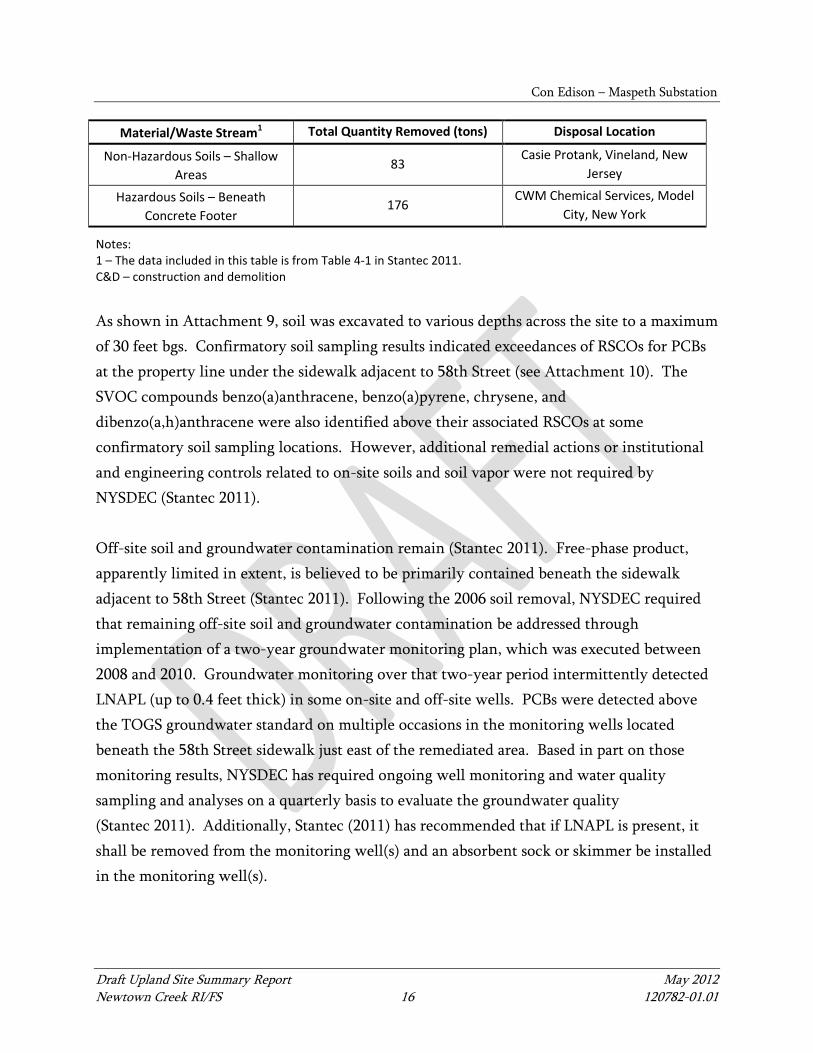
Con Edison – Maspeth Substation
Draft Upland Site Summary Report May 2012 Newtown Creek RI/FS 16 120782-01.01
Material/Waste Stream1 Total Quantity Removed (tons) Disposal Location
Non-Hazardous Soils – Shallow Areas
83 Casie Protank, Vineland, New
Jersey
Hazardous Soils – Beneath Concrete Footer
176 CWM Chemical Services, Model
City, New York
Notes: 1 – The data included in this table is from Table 4-1 in Stantec 2011. C&D – construction and demolition As shown in Attachment 9, soil was excavated to various depths across the site to a maximum of 30 feet bgs. Confirmatory soil sampling results indicated exceedances of RSCOs for PCBs at the property line under the sidewalk adjacent to 58th Street (see Attachment 10). The SVOC compounds benzo(a)anthracene, benzo(a)pyrene, chrysene, and dibenzo(a,h)anthracene were also identified above their associated RSCOs at some confirmatory soil sampling locations. However, additional remedial actions or institutional and engineering controls related to on-site soils and soil vapor were not required by NYSDEC (Stantec 2011). Off-site soil and groundwater contamination remain (Stantec 2011). Free-phase product, apparently limited in extent, is believed to be primarily contained beneath the sidewalk adjacent to 58th Street (Stantec 2011). Following the 2006 soil removal, NYSDEC required that remaining off-site soil and groundwater contamination be addressed through implementation of a two-year groundwater monitoring plan, which was executed between 2008 and 2010. Groundwater monitoring over that two-year period intermittently detected LNAPL (up to 0.4 feet thick) in some on-site and off-site wells. PCBs were detected above the TOGS groundwater standard on multiple occasions in the monitoring wells located beneath the 58th Street sidewalk just east of the remediated area. Based in part on those monitoring results, NYSDEC has required ongoing well monitoring and water quality sampling and analyses on a quarterly basis to evaluate the groundwater quality (Stantec 2011). Additionally, Stantec (2011) has recommended that if LNAPL is present, it shall be removed from the monitoring well(s) and an absorbent sock or skimmer be installed in the monitoring well(s).
Con Edison – Maspeth Substation
Draft Upland Site Summary Report May 2012 Newtown Creek RI/FS 17 120782-01.01
Other cleanup actions that have occurred at the site include abatement of asbestos-containing material (ACM) and PCB and oil cleanup in the substation building. Technical specifications for these cleanup activities are included in a March 1996 environmental assessment (Con Edison 1996b).
11 BIBLIOGRAPHY/INFORMATION SOURCES
Con Edison (Consolidated Edison Company of New York, Inc.), 1996a. Deed between Consolidated Edison and LDC Realty Holdings. June 17, 1996.
Con Edison, 1996b. Environmental Assessment and Remediation at Maspeth Substation. Prepared by Con Edison Environmental Affairs. March, 1996.
EDR (Environmental Data Resources Inc.), 2010. EDR DataMapTM Environmental AtlasTM. Prepared for Newtown Creek, Queens, New York. November 4, 2010.
Jacques Whitford Engineering Group (Jacques Whitford Engineering Group, Inc., P.C.), 1999. Interim Report for the Former Consolidated Edison Company of New York, Inc. Maspeth Substation, Queens, NY. New York, New York; June 1999.
Jacques Whitford Engineering Group, 2004. Remedial Action Work Plan for the Consolidated Edison Company of New York, Inc. Former Maspeth Substation, Maspeth, New York. Prepared for Consolidated Edison Company of New York, Inc. November 2004.
NYCDCP (New York City Department of City Planning), 2011a. Article IV: Manufacturing District Regulations. Updated: September 21, 2011. Accessed November 28, 2011. Available from: http://www.nyc.gov/html/dcp/html/zone/zonetext.shtml
NYCDCP, 2011b. Zoning and Land Use mapping tool. Updated: November 28, 2011. Accessed November 28, 2011. Available from: http://www.nyc.gov/html/dcp/
NYCDEP (New York City Department of Environmental Protection), 2007. Landside Modeling Report, Sewershed Characteristics and Model Calibration. City-Wide Long Term CSO Control Planning Project. Newtown Creek WPCP Service Area. Draft. New York City Department of Environmental Protection, Bureau of Engineering Design and Construction. July 2007.
Con Edison – Maspeth Substation
Draft Upland Site Summary Report May 2012 Newtown Creek RI/FS 18 120782-01.01
NYSDEC (New York State Department Environmental Conservation), 2012. Environmental Site Remediation Database. Accessed January 10, 2012. Available from: http://www.dec.ny.gov/cfmx/extapps/derexternal/haz/details.cfm and http://www.dec.ny.gov/cfmx/extapps/derexternal/haz/details.cfm?pageid=3
Sanborn (Sanborn Map Company), 1936. Insurance Maps of the Borough of Queens, City of New York. Volume 3. Original 1914, revised 1936.
Stantec (Stantec Consulting Services, Inc.), 2011. Former Maspeth Substation, Queens, New York: Final Engineering Report. Prepared for Consolidated Edison Company of New York, Inc. April 2011.
12 ATTACHMENTS
Figures Figure 1 Site Vicinity Map: Con Edison – Maspeth Substation
Tables Table 1 Potential Areas of Concern and Transport Pathways Assessment

Con Edison – Maspeth Substation
Draft Upland Site Summary Report May 2012 Newtown Creek RI/FS 19 120782-01.01
Supplemental Attachments Attachment 1 Figure 3: Former Site Plan (Stantec 2011) Attachment 2 Figure 4: Geologic Cross Section A – A’ (Stantec 2011) Attachment 3 Figure 5: Groundwater Flow Map (Stantec 2011) Attachment 4 Figure 2: Site Plan (Stantec 2011) Attachment 5 Figure 6: Free Product Isopach Map (Stantec 2011) Attachment 6 Table 1-10: RI Free-Product Laboratory Analysis (Stantec 2011) Attachment 7 Figure 7: Spider Map of Total PCBs in Soil Exceeding SCGs (Before
Rem. Action) (Stantec 2011) Attachment 8 Figure 10: Spider Map of Total PCBs in Groundwater Exceeding SCGs
(Before Rem. Action) (Stantec 2011) Attachment 9 Figure 13A: Excavation Areas (Stantec 2011) Attachment 10 Figure 22: Residual Soil Contamination Remaining On-site
(Stantec 2011)

Con Edison – Maspeth Substation
Draft Upland Site Summary Report May 2012 Newtown Creek RI/FS 20 120782-01.01
Table 1 Potential Areas of Concern and Transport Pathways Assessment – Con Edison – Maspeth Substation
Potential Areas of Concern
Media Impacted COPCs Potential Complete Pathway
Description of Areas of Concern Su
rfac
e So
il
Subs
urfa
ce S
oil
Gro
undw
ater
Catc
h Ba
sin
Solid
s
Cree
k Se
dim
ent
TPH VOCs
SVO
Cs
PAHs
Phth
alat
es
Phen
olic
s
Met
als
PCBs
Herb
icid
es a
nd
Pest
icid
es
Diox
ins/
Fura
ns
Ove
rland
Tra
nspo
rt
Gro
undw
ater
Dire
ct D
isch
arge
–
Ove
rwat
er
Dire
ct D
isch
arge
–
Stor
m/W
aste
wat
er
Disc
harg
e to
Se
wer
/CSO
Bank
Ero
sion
Air R
elea
ses
Gas
olin
e-Ra
nge
Dies
el –
Ran
ge
Heav
ier –
Ran
ge
Petr
oleu
m R
elat
ed
(e.g
., BT
EX)
VOCs
Chlo
rinat
ed V
OCs
Discharges, spills and leaks – Former Transformer Yard
√ √ √ ? -- ? ? √ √ √ √ √ √ ? ? √ √ ? ? -- ? -- ? ? -- ?
Former Substation building √ √ √ ? -- ? ? ? √ ? ? ? ? ? ? √ √ ? ? -- ? -- ? ? -- ?
AST for discarded oil ? ? ? ? -- ? ? ? ? ? ? ? ? ? ? ? ? ? ? -- ? -- ? ? -- --
Notes: √ – COPCs are/were present in areas of concern having a current or historical pathway that is determined to be complete or potentially complete. ? – There is not enough information to determine if COPC is/was present in area of concern or if pathway is complete. -- – Current or historical pathway has been investigated and shown to be not present or incomplete. AST – aboveground storage tank BTEX – benzene, toluene, ethylbenzene, and xylene COPC – constituent of potential concern CSO –combined sewer outfall PAH – polycyclic aromatic hydrocarbon PCB – polychlorinated biphenyl SVOC – semi-volatile organic compound TPH – total petroleum hydrocarbon VOC – volatile organic compound
R U S T S T
5 8 S T
5 9 D R
5 6 T E R
5 6 D R
5 7 P L
F LU S
H I NG
A V
M A S P E T H A V
M A S P E T H A V
5 8 D R
MAU
RIC E
AV
5 6 S T
5 8 P L
5 8 S T
5 9 S T
5 6 R D
49 L A
R U S T S T
PA G E P L
5 7 D R
5 7 R D
5 8 R D
5 7 S T
5 8 A V
G R A N D A V
5 9 A V
40
20
50
30
45
40
55
25
35
50
45
40
15
25
35
20
30
FormerFormerW.L.K.W.L.K.Corp.Corp.
S&L MetalS&L MetalProductsProducts
Corp.Corp.
S&L MetalS&L MetalProductsProducts
Corp.Corp.
STARSTARCorrugatedCorrugated
Box Co.Box Co.
Con EdisonCon Edison- Maspeth- MaspethSubstationSubstation
!. USEPA Sample Locations (Surface and Subsurface)Shoreline (NYC Dept. of Information Technology, 2006)USGS Nat'l Elev. Dataset 5-foot ContoursSelected Site Property BoundaryNeighboring Site Property Boundary
Outfall Class!( Direct Discharge!( General!( Highway Drain!( Major Stormwater Outfall!( SPDES!( Storm Drain
Q:\Jo
bs\11
0782
-01_N
ewTo
wnCr
eek\M
aps\R
I_Rem
edial
Inves
tigati
on\H
istori
c_Da
ta_Re
searc
h\Site
Featu
res M
apbo
ok.m
xd c
kiblin
ger 5
/23/20
12 4:
21:32
PM
NEWTOWNNEWTOWNCREEKCREEK
EASTEASTRIVERRIVER
HUDSONHUDSONRIVERRIVER
0 100 200 300 400Feet
Site Vicinty MapDraft Upland Site Summary: Con Edison - Maspeth Substation
Newtown Creek RI/FS
Figure 1
NOTES:1. Outfall Labeling: BB: Bowery Bay; NC(B/Q): Newtown Creek, Brooklyn/Queens; ST: Stormwater.2. Outfall locations are preliminary, compiled, estimated data based on New York City Department ofEnvironmental Protection (NYCDEP) maps and tabulated data and other resources. Many outfall locationswere taken from the New York City Shoreline Survey Program: Newtown Creek Water Pollution Control PlantDrainage Area, NYCDEP, March 31, 2003. Other locations were taken from an excerpt from a similar reportfrom 2008 (the complete report was not included in files available for review). Finally, some outfall locationswere inherited from previous Anchor QEA and Newtown Creek Project work. Latitudinal and longitudinal dataprovided in the 2003 and 2008 NYCDEP reports were rounded to the nearest second. This resulted inpotential outfall location discrepancies of up to approximately 200 feet. All outfall locations are currentlyunder field verification.3. Aerial Photos: New York State Division of Homeland Security and Emergency Services, 2010.4. Site Boundaries are based on New York City parcels data.5. Coarse topographic contours are derived from U.S. Geological Survey 10-meter data.
[
DRAFT

SUPPLEMENTAL ATTACHMENTS

Attachment 1

Attachment 2

Attachment 3

Attachment 4
Attachment 5

Attachment 6

Attachment 7

Attachment 8

Attachment 9
Attachment 10