conjugate strike-slip faulting along the bangong-nujiang ...mtaylor/conjugatefaults.pdf · the...
TRANSCRIPT

Conjugate strike-slip faulting along the Bangong-Nujiang suture
zone accommodates coeval east-west extension and north-south
shortening in the interior of the Tibetan Plateau
Michael Taylor,1 An Yin,1 Frederick J. Ryerson,2 Paul Kapp,1,3 and Lin Ding4
Received 25 January 2002; revised 13 January 2003; accepted 5 March 2003; published 28 August 2003.
[1] Geologic investigations of how the Tibetanplateau is currently deforming have focusedprimarily on its boundary faults. Consequently, howthe interior of the plateau deforms remains poorlyunderstood. To fill this gap in knowledge, weconducted field mapping, analysis of remote sensingand digital topographic data, and reinterpretation ofexisting geologic maps in central Tibet. This studyreveals a 200–300 km wide and 1500–1800 km longeast trending zone of conjugate strike-slip faults acrosscentral Tibet. The central Tibet conjugate fault zone iscomprised of northeast striking left-slip faults north ofthe Bangong-Nujiang suture and northwest strikingright-slip faults south of the suture zone. These strike-slip faults are kinematically linked with north trendingTibetan rifts located north and south of the conjugatefault systems. Without exception, all conjugate faultsintersect or merge toward one another along theBangong-Nujiang suture zone. Motion on these faultsaccommodates coeval east-west extension and north-south contraction. To determine the fault kinematicsand the magnitude of fault slip, we investigated threeconjugate fault sets in the central Tibet fault zone.These include from east to west, the Dong Co, BueCo, and Aishi Co conjugate fault systems, which areadjacent to the Bangong-Nujiang suture zone andseparated by a distance of 400 and 70 km,respectively. The average magnitude of fault motionon individual strike-slip faults is �12 km asdetermined by offsets of Tertiary thrusts andPaleozoic-Mesozoic lithologic units. The conjugatefault configuration requires �12 km of north-southcontraction across the 200–300 km fault zone since itsinitiation. Because the conjugate strike-slip faults are
kinematically linked with the north trending Tibetanrifts which initiated between 14 and 8 Ma, ourestimated magnitude of north-south contractionimplies a contraction rate of �1–2 mm/yr acrosscentral Tibet. The relatively closely spaced (<150 km)basins may result from a series of conjugate strike-slipfault systems in the interior of Tibet. These structureslikely formed by eastward spreading of the Tibetancrust via distributed eastward extrusion of small(<150 km wide) wedge-shaped crustal blocks thatleave a space at their trailing end. INDEX TERMS: 8107
Tectonophysics: Continental neotectonics; 8109 Tectonophysics:
Continental tectonics—extensional (0905); 8005 Structural
Geology: Folds and folding; 9320 Information Related to
Geographic Region: Asia; 8010 Structural Geology: Fractures
and faults; KEYWORDS: conjugate strike-slip faults, Tibet,
neotectonics, extrusion tectonics. Citation: Taylor, M., A. Yin,
F. J. Ryerson, P. Kapp, and L. Ding, Conjugate strike-slip faulting
along the Bangong-Nujiang suture zone accommodates coeval
east-west extension and north-south shortening in the interior of
the Tibetan Plateau, Tectonics, 22(4), 1044, doi:10.1029/
2002TC001361, 2003.
1. Introduction
[2] The classic debate about the Indo-Asian collisioncenters on how >1500 km of northward penetration of Indiahas been accommodated by intracontinental deformation inAsia. The lateral extrusion hypothesis emphasizes the roleof large-scale strike-slip faults in transporting relativelyundeformed continental blocks eastward away from theIndo-Asian convergent front [Peltzer and Tapponnier,1988]. In contrast, the crustal thickening model suggeststhat indentation of India into Asia has been accommodatedby distributed north-south shortening [Dewey and Burke,1973]. The first hypothesis requires that the strike-slip faultsbe discrete and cut through the entire lithosphere withhundreds of kilometers of slip [Peltzer and Tapponnier,1988; Avouac and Tapponnier, 1993]. Discrete deformationin extrusion tectonics also implies that major strike-slipfaults in Asia move at rates of several cm/yr. The secondhypothesis requires contractional structures such as thrustsand folds to be distributed throughout the collision zonewith individual faults having much smaller magnitude ofoffsets (�100s of kilometers) and moving at rates of lessthan a few mm/yr [Dewey et al., 1988; England and Molnar,1998].
TECTONICS, VOL. 22, NO. 4, 1044, doi:10.1029/2002TC001361, 2003
1Department of Earth and Space Sciences, University of California andInstitute of Geophysics and Planetary Physics, Los Angeles, California,USA.
2Institute of Geophysics and Planetary Physics, Lawrence LivermoreNational Laboratory, Livermore, California, USA.
3Now at Department of Geosciences, University of Arizona, Tucson,Arizona, USA.
4Institute of Geology and Geophysics, Chinese Academy of Sciences,Beijing, People’s Republic of China.
Copyright 2003 by the American Geophysical Union.0278-7407/03/2002TC001361$12.00
18 - 1
[3] In light of recent results of geologic and geophysicalinvestigations in Tibet, these end-member views mayrequire a level of refinement. Meyer et al. [1998], Owensand Zandt [1997], and Cattin and Avouac [2000] point outthat discrete continental subduction may have been thedominant mode of deformation in accommodating theIndo-Asian collision along the northern and southern edgesof the Tibetan plateau. This implies that extrusion tectonicsmay have played a lesser role in accommodating the overallconvergence between India and Asia. This is consistent withthe results of recent geologic and geodetic studies on majorstrike-slip faults in the Indo-Asian collision zone. Forexample, studies along the southern and central segmentof the active right-slip Karakoram fault suggest that its totaldisplacement is between 60 and 150 km, respectively[Searle, 1996; Searle et al., 1998, 1999; Murphy et al.,2000]. These estimates are much less than the �1000 km ofright-slip motion predicted by the extrusion model [Peltzerand Tapponnier, 1988]. Using Quaternary slip rates alongmajor strike-slip faults to test the extrusion hypothesis hasyielded ambiguous results. At a timescale of a few years,GPS studies suggest that the Altyn Tagh fault moves at arate of �10 mm/yr or less [Bendick et al., 2000; Shen et al.,2001]. However, long-term slip rates along the Altyn Taghfault could be as high as �30 mm/yr [e.g., Meriaux et al.,1999]. In addition, a recent study of the long-term slip ratealong the Karakoram fault suggests that it may be as low as�3 mm/yr, based on dating offset geomorphic landformsusing cosmogenic 10Be [Brown et al., 2002]. Why slip ratesalong the Altyn Tagh and Karakoram faults vary with timeremains poorly understood.
[4] Smaller magnitudes of displacement and slower sliprates along major strike-slip faults in Asia imply that east-ward motion of Tibet may be less important than north-southshortening [England and Molnar, 1998]. However, thisinterpretation may be oversimplified, because eastwardmovement of Tibet could be accommodated by a greaternumber of strike-slip faults distributed over a large area ofTibet [Rothery and Drury, 1984; Molnar and Lyon-Caen,1989; Yin, 2000]. If correct, then an alternative to the end-member models of discrete lateral extrusion and distributedcrustal thickening arises. That is, eastward motion of Tibetcould be accommodated by a large number of strike-slipfaults distributed across central Tibet [Kong and Bird, 1996;Yin, 2000]. This interpretation implies that the left-slip AltynTagh and right-slip Karakorum faults may be only one ofmany conjugate fault systems that assist in the eastwardspreading of the Tibetan crust (Foldout 1 and Figure 1).A key to testing this possibility is to establish thegeometry and kinematics of active faults in the interiorof the Tibetan plateau related to the Indo-Asian collision.Armijo et al. [1986, 1989] viewed the Qiangtang terraneas a rigid block moving eastward relative to the Lhasaterrane via a series of en-echelon right-slip faults (theKarakorum-Jiali fault zone) directly south of the Ban-gong- Nujiang suture zon. This inter-pretation has been questioned by both geophysical andgeologic observations. First, active deformation is occur-ring in the Qiangtang terrane as expressed by numerous
fault-bounded blocks with each having complex kine-matics [Molnar and Lyon-Caen, 1989]. Second, fieldstudies by Yin et al. [1999a] and Blisniuk et al. [2001]suggest that the Qiangtang terrane has experienced mea-surable east-west extension. In addition, a sparse GPSnetwork that spans Tibet near 95�E longitude suggeststhat a measurable amount of coeval north-south contrac-tion and east-west extension is presently occurring [Wanget al., 2001].
[5] To address the question of how Tibet is deforminginternally, we conducted geologic investigations of active-to-recently active faults using field mapping, analysis ofdigital topography (GTOPO30), and interpretation of Land-sat-7 and CORONA satellite images. Our results allow us todevelop a coherent kinematic model that emphasizes therole of conjugate strike-slip faults in accommodating coevalnorth-south contraction and east-west extension in centralTibet.
2. Regional Geology
[6] The Lhasa and Qiangtang terranes were accreted ontothe southern margin of Eurasia beginning in the north,during the Late Triassic-Early Jurassic and the Late Juras-sic-Early Cretaceous [Dewey et al., 1988; Yin and Harrison,2000]. From north to south, the boundaries of these terranesare marked by the Jinsha, Bangong-Nujiang, and Indus-Yalu suture zones and have been reactivated by both strike-slip and contractional deformation during the CenozoicIndo-Asian collision [Armijo et al., 1986, 1989; Meyer etal., 1998].
[7] A salient topographic feature of the Lhasa terrane isthe north trending rift systems, which dissect the otherwiselow-relief surface. Whether the rifts are an expression ofupper crustal deformation or involve the mantle lithospherehas been debated [Masek et al., 1994; Yin, 2000]. It has alsobeen considered that Tibetan rifts are the result of gravita-tional collapse [Molnar and Tapponnier, 1978; Tapponnieret al., 1981] or caused by a convective event in the mantle[England and Houseman, 1989]. Except the Yadong-Gulurift that extends into the Himalaya, all rifts in the Lhasaterrane terminate before they reach the Indus-Yalu andBangong-Nujiang suture zones [Armijo et al., 1986]. Thisobservation implies that the sutures on both sides of theLhasa terrane may act as transfer structures converting east-west extensional strain to the Qiangtang terrane in the northand southward into the Himalayan range [Yin, 2000]. Theinitiation of the Yadong-Gulu rift is constrained to be 8 ±1 Ma along the Nyainquentanghla Shan [Harrison et al.,1995], with an upper age bound of �12 Ma along itssouthernmost segment [Edwards and Harrison, 1997; Wuet al., 1998]. Minor east-west stretching of the Lhasa crustat an earlier stage is inferred from a north trending dikeswarm near Xigaze and was dated at 18–13 Ma [Yin et al.,1994; Williams et al., 2001]. The Thakkola graben in thecentral Himalaya south of the Lhasa terrane initiatedbetween 11–14 Ma based on ages of the oldest synriftsediments [Garizone et al., 2000] and north trending exten-sional fractures [Coleman and Hodges, 1995].
18 - 2 TAYLOR ET AL.: CONJUGATE STRIKE-SLIP FAULTING WITHIN TIBET

Foldout1.
Reg
ional
tect
onic
map
of
the
Tib
etan
pla
teau
modif
ied
afte
rArm
ijoet
al.
[1986,
1989],Meyer
etal.
[1998],
Arrowsm
ithandStrecker
[1999],Yin
etal.
[1999b],
and
our
ow
nobse
rvat
ions.
Inac
tive
stru
cture
s(e
.g.,
the
Gan
des
eth
rust
)in
centr
alT
ibet
hav
ebee
nom
itte
dfo
rcl
arity.
An
east
-wes
ttr
endin
gbel
tof
conju
gat
est
rike-
slip
faults
ispre
sent
along
the
Ban
gong-N
ujian
gsu
ture
zone
ince
ntr
alT
ibet
.See
textfo
rdes
crip
tion
ofth
efa
ult
geo
met
ryan
ddis
trib
ution
of
sutu
res.
Red
star
sin
dic
ate
the
loca
tions
of
the
8N
ovem
ber
1997,
M7.6
left
-slip
Man
yi
eart
hquak
e(l
eft)
,an
dth
e14
Novem
ber
2001,
M7.9
left
-slip
Kokoxilli
eart
hquak
e(r
ight)
.L
abel
sA
,B
,an
dC
indic
ate
the
inte
rsec
tions
of
the
Dong
Co,
Bue
Co,
and
Ais
hi
Co
conju
gat
est
rike-
slip
fault
syst
ems.
See
enla
rged
ver
sion
of
this
figure
inth
eH
TM
L.
TAYLOR ET AL.: CONJUGATE STRIKE-SLIP FAULTING WITHIN TIBET 18 - 3

Figure
1.
Colo
rsh
aded
relief
map
with
aco
mpre
ssed
pal
ette
of
centr
alT
ibet
show
ing
abro
adea
st-w
est
tren
din
gdep
ress
ion
(in
dar
kblu
e)al
ong
the
Ban
gong-N
ujian
gsu
ture
zone.
Note
that
the
dep
ress
ion
ism
arked
by
ase
ries
of
dis
continuous
bas
ins.
Str
ike-
slip
faults
are
repre
sente
dby
nar
row
and
linea
rto
pogra
phic
stru
cture
str
endin
gnort
hea
stan
dnort
hw
est,
nort
han
dso
uth
of
the
centr
aldep
ress
ion.
Thes
elinea
rfe
ature
sar
eth
ele
ft-s
lip
faults
inth
eQ
iangta
ng
terr
ane
and
right-
slip
faults
inth
eL
has
ate
rran
e.N
ote
that
right-
slip
faults
inth
eL
has
ate
rran
ebound
the
nort
her
nm
argin
of
sever
alnort
htr
endin
gri
fts,
wher
eas
left
-slip
faults
inth
eQ
iangta
ng
terr
ane
are
connec
ted
with
topogra
phic
ally
less
pro
nounce
dnort
htr
endin
gri
fts.
The
poor
topogra
phic
def
initio
nof
rift
sin
Qia
ngta
ng
may
resu
ltfr
om
the
inte
rnal
lydra
ined
bas
infi
llin
g[Yin
etal.,
1999b],
or
bec
ause
of
hori
zonta
lm
otion
asso
ciat
edw
ith
stri
ke-
slip
faultin
g.
See
colo
rver
sion
of
this
figure
atbac
kof
this
issu
e.
18 - 4 TAYLOR ET AL.: CONJUGATE STRIKE-SLIP FAULTING WITHIN TIBET

[8] Active faulting within the Qiangtang terrane has beenrecognized previously through fault plane solutions andanalysis of satellite imagery [Molnar and Lyon-Caen,1989; Molnar and Tapponnier, 1978; Rothery and Drury,1984]. These studies revealed that active-to-recently activefaults in the Qiangtang vary in strike and fault kinematics.The latter ranges from strike-slip to normal faulting. Aminimum initiation age of normal faulting was obtainedby Blisniuk et al. [2001], who used the 40Ar/39Ar method todate syn-kinematically grown muscovite from the Shuanghunormal fault zone. Their results suggest that the onset ofeast-west extension may have occurred at or prior to�13.5 Ma [Blisniuk et al., 2001]. Similar to rifts in theLhasa terrane, rifts and their associated faults in the Qiang-tang terrane do not appear to extend across the Bangong-Nujiang suture zone, suggesting that it has been acting as atransfer zone linking extensional structures in the Lhasa andQiangtang terranes [Yin, 2000]. It is the question of how theextensional structures are geometrically and kinematicallyrelated across the Bangong-Nujiang suture zone that hasmotivated this study as presented in detail below.
3. Conjugate Faults Along the Bangong-
Nujiang Suture Zone
[9] From field observations, topography, and satelliteimages, faults that appear to be active and located directlynorth of the Bangong-Nujiang suture zone are exclusivelynortheast striking while those directly south of the suture arenorthwest striking [Rothery and Drury, 1984; Armijo et al.,1986]. These faults merge toward one another along thesuture (Foldout 1 and Figure 1). Because north trending riftsin Lhasa and Qiangtang accommodate nearly east-westextension [Mercier et al., 1987; Yin et al., 1999a], aninference is that northeast striking faults are left-slip,whereas the northwest striking faults are right-slip. Thiswould imply that these structures are conjugate fault setsthat accommodate coeval east-west extension and north-south contraction. In the following, we show that conjugatestrike-slip fault systems are common structures in centralTibet, which all together accommodate a portion of Indo-Asian convergence.
3.1. Dong Co Conjugate System
[10] The east facing Dong Co conjugate fault system iscomprised of the northeast striking Yibug Caka fault zoneto the north and the northwest striking Gyaring Co fault tothe south (Foldout 1 and Figure 1). We have mapped thebedrock geology of the conjugate fault system on 1:100,000scale topographic maps. In the vicinity of active-to-recentlyactive faults, we mapped the Quaternary stratigraphy onCORONA satellite photographs. Quaternary units weredelineated based on their relative surface heights androughness, degree of surface vegetation and incision, andsurface albedo observed in satellite images and in the field.3.1.1. Left-Slip Yibug Caka Fault Zone
[11] The �340 km long Yibug Caka fault zone is S-shapedin map view, with the northern and southern segments
striking �N70�E and the central segment striking N30-40�E (Foldout 1 and Figures 1 and 2). The northern andsouthern fault segments are dominantly left-slip, whereasthe central fault segment is dominantly normal-slip (Fig-ures 2b–2d). Associated with along-strike variation offault strike and kinematics is a change in topographicrelief. Local relief is �500 m along the strike-slip seg-ments of the fault zone, but increases to >1000 m alongthe normal-fault segment (Figure 2a).
[12] The Riganpei Co fault defines the southern Yibug-Caka fault zone and strikes N70�E. Locally, it exhibitssub-horizontal fault striations (Figure 2). The fault offsetsleft-laterally a north dipping thrust at its northeast end for�7 km (Figure 2a). The thrust juxtaposes Permian lime-stones over folded Tertiary strata. The Riganpei Co faultlocally offsets alluvial fans and paleo-shorelines, asobserved near Riganpei Co (Figure 6). The Riganpei Cofault becomes buried, or tips out at its southern end at theZhaxi Co and Dong Co basins (Figure 2a). Althoughnortheast striking fault scarps are locally observed nearZhaxi Co, these faults disappear to the south. The northernend of the Riganpei Co fault links with an extensionalsystem in the central Yibug-Caka fault zone.
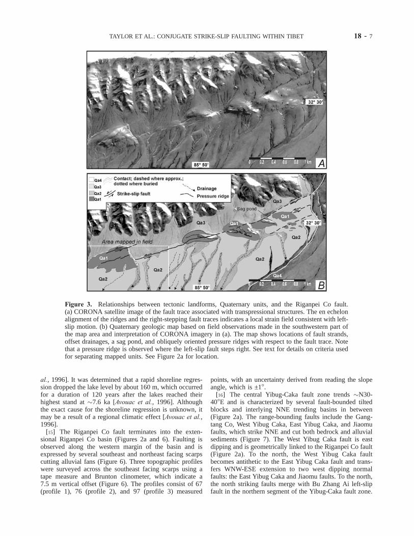
[13] Locally, pressure ridges, sag ponds, and offsetalluvial fans are observed along the Riganpei Co fault(Figure 3). Field observations allow us to identify fourchronostratigraphic units (Qa1–Qa4 from oldest to young-est, Figure 3). The right stepping, en echelon alignment ofthe fault traces and ridges is consistent with left-slipmotion. South flowing streams are also offset left laterally(Figure 4). Field measurements of the offset gullies andbeheaded channels range from 30–100 m. The variationsin horizontal displacement presumably reflects the relativeages of the offset geomorphic features with the leastincised and smoothest (i.e., youngest) and relatively loweralluvial surfaces displaying the smallest offsets. Locally,shutter ridges are present along the active trace of theRiganpei Co fault with an average trend of N70�E. Shutterridges are typically several hundred meters in length andtens of meters in height. They are asymmetric in cross-section, where the north sides of the shutter ridges aresteep and coincident with the sub-vertical fault surface(Figure 4).
[14] In the vicinity of Riganpei Co, regressive shorelinesare observed with overlying younger alluvial sediments. Inturn, the alluvial sediments are cut by several anastomosingstrands of the Riganpei Co fault (Figure 5). Left-lateraloffset of the alluvial fans is observed on their eastern marginwhere a north facing fault scarp indicates left-lateral anddip-slip displacements of 25 ± 5 m and 2 ± 0.5 m,respectively, as determined in the field with a tape measureand Brunton clinometer (Figure 5). A left-lateral offset of achannel is also 25 ± 5 m at this site (Figure 5a). Most lakesand closed basins in Tibet are surrounded by regressiveshorelines. An example from west central Tibet is LongmuCo, where the shorelines were leveled from 75–250 mabove the present lake level [Avouac et al., 1996]. Amodified Penman formula was used to calculate a syntheticcurve of the shoreline regression at Longmu Co [Avouac et
TAYLOR ET AL.: CONJUGATE STRIKE-SLIP FAULTING WITHIN TIBET 18 - 5
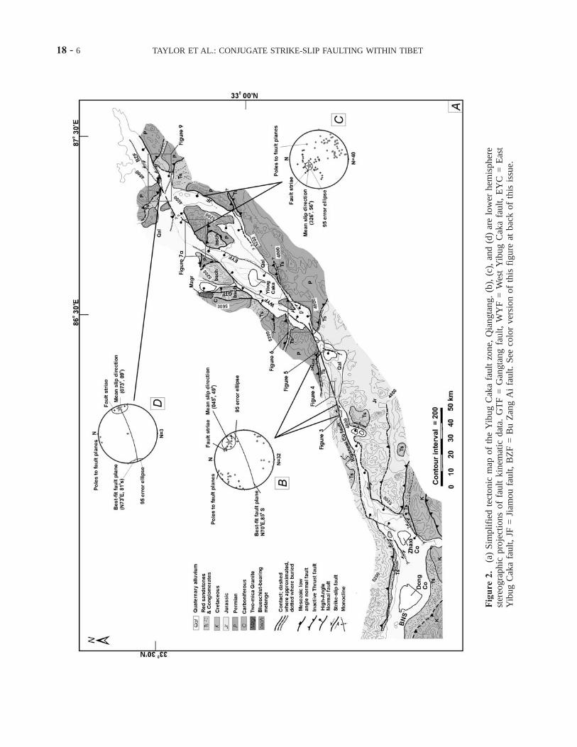
Figure
2.
(a)
Sim
plifi
edte
ctonic
map
of
the
Yib
ug
Cak
afa
ult
zone,
Qia
ngta
ng.
(b),
(c),
and
(d)
are
low
erhem
ispher
est
ereo
gra
phic
pro
ject
ions
of
fault
kin
emat
icdat
a.G
TF
=G
angta
ng
fault,
WY
F=
Wes
tY
ibug
Cak
afa
ult,
EY
C=
Eas
tY
ibug
Cak
afa
ult,
JF=
Jiam
ou
fault,
BZ
F=
Bu
Zan
gA
ifa
ult.
See
colo
rver
sion
of
this
figure
atbac
kof
this
issu
e.
18 - 6 TAYLOR ET AL.: CONJUGATE STRIKE-SLIP FAULTING WITHIN TIBET
al., 1996]. It was determined that a rapid shoreline regres-sion dropped the lake level by about 160 m, which occurredfor a duration of 120 years after the lakes reached theirhighest stand at �7.6 ka [Avouac et al., 1996]. Althoughthe exact cause for the shoreline regression is unknown, itmay be a result of a regional climatic effect [Avouac et al.,1996].
[15] The Riganpei Co fault terminates into the exten-sional Riganpei Co basin (Figures 2a and 6). Faulting isobserved along the western margin of the basin and isexpressed by several southeast and northeast facing scarpscutting alluvial fans (Figure 6). Three topographic profileswere surveyed across the southeast facing scarps using atape measure and Brunton clinometer, which indicate a7.5 m vertical offset (Figure 6). The profiles consist of 67(profile 1), 76 (profile 2), and 97 (profile 3) measured
points, with an uncertainty derived from reading the slopeangle, which is ±1�.
[16] The central Yibug-Caka fault zone trends �N30-40�E and is characterized by several fault-bounded tiltedblocks and interlying NNE trending basins in between(Figure 2a). The range-bounding faults include the Gang-tang Co, West Yibug Caka, East Yibug Caka, and Jiaomufaults, which strike NNE and cut both bedrock and alluvialsediments (Figure 7). The West Yibug Caka fault is eastdipping and is geometrically linked to the Riganpei Co fault(Figure 2a). To the north, the West Yibug Caka faultbecomes antithetic to the East Yibug Caka fault and trans-fers WNW-ESE extension to two west dipping normalfaults: the East Yibug Caka and Jiaomu faults. To the north,the north striking faults merge with Bu Zhang Ai left-slipfault in the northern segment of the Yibug-Caka fault zone.
Figure 3. Relationships between tectonic landforms, Quaternary units, and the Riganpei Co fault.(a) CORONA satellite image of the fault trace associated with transpressional structures. The en echelonalignment of the ridges and the right-stepping fault traces indicates a local strain field consistent with left-slip motion. (b) Quaternary geologic map based on field observations made in the southwestern part ofthe map area and interpretation of CORONA imagery in (a). The map shows locations of fault strands,offset drainages, a sag pond, and obliquely oriented pressure ridges with respect to the fault trace. Notethat a pressure ridge is observed where the left-slip fault steps right. See text for details on criteria usedfor separating mapped units. See Figure 2a for location.
TAYLOR ET AL.: CONJUGATE STRIKE-SLIP FAULTING WITHIN TIBET 18 - 7

[17] The NNE striking faults in the central fault zoneare normal-slip as indicated by dip-slip fault striations(Figure 2c), toolmarks, mullions, and Riedel shears(Figure 8a). The striation data were collected only fromthe range-bounding faults, as minor faults located awayfrom the main fault zone may be unrelated to the YibugCaka fault. The best fit mean slip direction for westdipping faults is 326�, 56� (Figure 2c).
[18] The central block in the northern half of the centralYibug Caka fault zone exposes blueschist-bearing melange.Its exhumation is associated with motion along the earlyJurassic Rongma detachment fault, which is related to aregional early Mesozoic extensional event that occurredthroughout the central Qiangtang [Kapp et al., 2003; Kapp,2001]. The Rongma detachment fault is regionally extensiveand forms a key marker horizon for restoring the magnitudeof extension across the active normal faults in the centralYibug Caka fault zone. Although the uncertainties are large,a minimum of 2 km of east-west extension is accommodatedby the NNE striking faults that are distributed across thecentral Yibug Caka fault zone [see Kapp et al., 2003].
[19] The Bu Zang Ai fault segment of the Yibug Cakafault zone strikes N73�E and is dominantly left-slip.
Locally, sub horizontal striations and tool marks areobserved on fault surfaces and indicate a mean slip directionoriented 073�, 09� (Figure 2d). We estimate the magnitudeof left slip along this fault segment to be �14 km based onthe left-separation of a north dipping Tertiary thrust. Thethrust juxtaposing Paleozoic limestones over Tertiary redbeds is truncated by two strands of the strike-slip systemthat strike �N55�E (Figures 2a and 9). The thrust isoroclinally folded as it approaches the fault zone from amoderate dip of 47� in the east, and becomes subvertical inthe west (Figure 9). We suggest that synkinematic transformmotion related to thrusting in the Quaternary is unlikely, asno thrust fault scarps are observed, and locally Quaternarysediments unconformably overlie the thrust contact.
[20] Although we only visited the southernmost part ofthe northern rift segment, the morphologically definedYibug Caka rift extends for at least another 50 km to thenorth (Figure 2a). From topography and existing activetectonic maps of the region [Liao, 1990], it appears thatthe Yibug Caka rift transfers displacement to a series ofnorth trending rifts in the north. These rifts in turn, appear toterminate into a series of ENE striking left-slip faults thatwe consider as the westernmost extension of the seismically
Figure 4. (a) CORONA satellite imagery of neotectonic features along a potentially active fault zone.Landforms include offsets of drainages, shutter ridges, and sag ponds that are consistent with left-slipmotion. (b) Line drawing of the major geologic features observed in the field and shown in (a). SeeFigure 2a for location.
18 - 8 TAYLOR ET AL.: CONJUGATE STRIKE-SLIP FAULTING WITHIN TIBET

active left-slip Kunlun fault system [Kidd and Molnar,1988; Yin, 2000; Van der Woerd et al., 2000, 2002]. Thisinference is consistent with the left-slip focal mechanisms ofthe M 7.6 and M 7.9 Manyi and Kokoxilli earthquakes,which occurred along the inferred left-slip faults (Foldout 1and Figure 1) [Peltzer et al., 1998; Lasserre et al., 2002].3.1.2. Right-Slip Gyaring Co Fault
[21] From regional mapping, topographic maps, andLandsat images, the left-slip Riganpei Co fault in thesouthern Yibug Caka fault zone merges to the south withthe right-slip Gyaring Co fault in the northern Lhasa terrane(Foldout 1 and Figure 1). This relationship suggests that thetwo faults may form a conjugate strike-slip set, whichwould require a comparable magnitude of displacementacross the two faults. Right-slip faults directly south ofthe Bangong-Nujiang suture, namely the Karakorum-Jialifault zone [Armijo et al., 1986, 1989], are kinematicallyrelated to north trending rifts further to the south [Mercier etal., 1987; Burchfiel et al., 1991; Ratschbacher et al., 1994;Harrison et al., 1995; Cogan et al., 1998]. Four of thesestrike-slip faults, the Karakorum fault, the Gyaring Co fault,
the Jiali fault, and the Beng Co fault were studied by Armijoet al. [1989]. However, that study emphasized the neo-tectonic activity of these structures and provides no con-straints on the magnitude of fault slip. Thus, our study, withan emphasis on determining piercing points across the right-slip faults in the northern Lhasa terrane compliments thework of Armijo et al. [1989]. The results of our investiga-tion on the Gyaring Co fault are described below.
[22] The Gyaring Co fault is expressed as a linear valley�250 km long that strikes �N70�W. Its northern endmerges with the southern end of the Yibug Caka fault zonealong the Bangong-Nujiang suture, whereas its southern endis kinematically linked with the north trending Pum-Qu-Xainza rift (Foldout 1 and Figure 1). Our fieldwork con-centrated on the northern fault segment where the faultoffsets Mesozoic and Early Tertiary east trending contrac-tional structures and strata (Figure 10a). The fault is sub-vertical and well exposed along the northwest shore ofGoman Co. Striations in the fault zone are dominantlyhorizontal and the fault zone gouge can reach tens of metersin thickness. Locally, the trace of the fault cuts alluvial
Figure 5. (a) Field photo looking WSW along a fault scarp that cuts alluvial fans along the northernsegment of the Riganpei Co fault. The fault scarp is north facing and offsets a drainage for �30 m leftlaterally. (b) CORONA imagery of the fault trace. (c) Line drawing of geologic relationships based onfield mapping and interpretation of (b). Note that younger alluvial deposits, which are cut by the faultstrands, depositionally overlie the regressive shorelines as shown by the green arrows. See Figure 2a forlocation.
TAYLOR ET AL.: CONJUGATE STRIKE-SLIP FAULTING WITHIN TIBET 18 - 9

sediments and is associated with sag ponds, pressure ridges,offset alluvial fans and terrace risers, all consistent withright-slip motion.
[23] The magnitude of slip on the Gyaring Co fault isconstrained by restoring a piercing point defined by theintersection line between a Tertiary unconformity (definedby Tertiary strata deposited on top of Mesozoic strata) andthe Goman-Caibu Co thrust system, both of which are cutby the strike-slip fault (Figures 10 and 11). The Goman-Caibu Co thrust system juxtaposes Early Cretaceous lime-stones over younger Cretaceous volcanic rocks, and Tertiarysandstones and conglomerates, all offset by the Gyaring Cofault. The age assignment of stratigraphic units observed inthe study area is adopted from Liu [1988]. Because theGoman-Caibu Co thrust system cuts Tertiary strata, theoffset of this structure by the Gyaring Co fault can beattributed to its Late Cenozoic motion. A best fit plane tothe Goman-Caibu Co thrust is oriented N75�E, 24�NW(Figure 10d). Measurements of the footwall stratigraphicbedding and the underlying unconformity indicate a best fitplane oriented N81�E, 14�NW (Figure 10c). The trend andplunge of the intersection line between the two best fitplanes is 257�, 01� (Figure 10b). The offset calculation ofthis intersection line uses a best fit orientation of theGyaring Co fault. Fault zone fabrics are well exposed along
the north shore of Goman Co. Measurements of faultsurfaces indicate a best fit fault plane oriented N70�W,89�NE (Figure 10d). We project the intersection linebetween the Goman-Caibu Co thrust systems and theTertiary unconformity into the plane of the Gyaring Cofault. The intersection line pierces the Gyaring Co fault inthe west and east sides at the 4710-m and the 4610-mstructure contours, respectively. A calculated net slip is12.5 ± 4 km oriented 110�, 5�. A minor normal componentof �100 m is calculated from the total slip vector. Theuncertainty in the slip calculation is introduced due touncertainties in the location of the intersection line, whichresult from errors associated with the fault orientation andthe attitude of the Tertiary unconformity.
[24] A similar magnitude of right separation along theGyaring Co fault may be inferred to the northwest, based onthe �12 km of right separation of a north dipping thrustjuxtaposing Mesozoic carbonates over Mesozoic volcanicrocks (Figure 10). The initiation age of the Gyaring Co faultis unknown.
3.2. Bue Co Conjugate System
[25] The Bue Co conjugate fault system is located�400 km west of the Dong Co conjugate system andconsists of two fault segments that conjoin at Bue Co
Figure 6. (a) CORONA imagery of the Riganpei Co basin at the northern end of the Riganpei Co fault.(b) Line drawing of key geologic relationships as observed in the field and interpreted from (a). Bothnormal and strike-slip faults cut Quaternary alluvial deposits in the transtensional structure. (c) Faultscarp profiles surveyed with tape measure and Brunton clinometer. See (b) for location of scarp profilesand Figure 2a for location.
18 - 10 TAYLOR ET AL.: CONJUGATE STRIKE-SLIP FAULTING WITHIN TIBET

Figure 7. (a) CORONA imagery showing western margin of a range front bounded by a west dippingnormal fault. Northwest trending, white arrow indicates location of normal fault in Figure 7b. Southeasttrending, white arrow at the range front indicates location of Figure 8a; symbol on alluvial fan indicatesviewing location and viewing direction for Figure 8b. (b) A west dipping normal fault offsetting thecontact between Quaternary fan deposits above and the Paleozoic strata below, view is to the north. See(a) for location.
Figure 8. (a) Downdip fault striations, toolmarks and reidel shears on surface of a west dipping normalfault, view to the east. Location of this outcrop is indicated in Figure 7a by southeast trending whitearrow. (b) West dipping normal fault, view to the ESE. See Figure 7a for location.
TAYLOR ET AL.: CONJUGATE STRIKE-SLIP FAULTING WITHIN TIBET 18 - 11

(Figure 11). The Bue Co fault strikes N70�E and forms thenorthern branch of the strike-slip conjugate system and theLamu Co fault strikes N55�W and forms the southernbranch. The Bue Co fault forms a broad valley up to10 km wide and �80 km long. Along strike to the northeast,the fault merges with two northeast dipping faults thatbound the elongate basins (Figure 12). The main Bue Cofault displays an apparent left-oblique normal-slip compo-nent (Figure 14). This interpretation is based on the pres-ence of a �25 km long and �7 km wide crescent-shapedbasin that is bounded on its east side by the southern BueCo fault. We interpret this basin geometry to result fromleft-slip motion along a releasing bend (Figure 12). Theactive nature of the fault is suggested by its trace cuttingseveral alluvial fans (Figure 13a). The magnitude of left-lateral motion along the Bue Co fault is �12 km, asestimated from left separation of a Permian limestone unit[Cheng and Xu, 1987] observed in Landsat-7 imagery(Figure 13).
[26] The Lamu Co fault strikes �N55�W and consists oftwo segments (Figure 13). The overlapping area of the tworight stepping fault segments resembles a pull-apart basin.If correct, this implies that the Lamu Co fault is right-slip.The northern fault segment strikes N50�W and is �45 kmlong. Fault scarps and triangular facets are visible inLandsat images, suggesting that this structure may be active(Figure 13a). Jurassic volcanic strata [Cheng and Xu, 1987]at location A-A0 are truncated by the fault and display�11 km of right separation (Figure 14). The southern faultsegment of the Lamu Co fault is also visible on Landsat-7images (Figure 13a). It is curvilinear in map view, is >95 kmlong, and truncates east-west striking Jurassic strata.
[27] Distinct Jurassic volcanic rocks appear as a dark redlithologic unit in the center of Figure 13a. This unit
coincides with a south-directed thrust fault that was mappedon the western side of the Lamu Co fault [Cheng and Xu,1987]. This contact is truncated by the Lamu Co fault atlocation B in Figure 13b. A red lithologic unit with similarcharacteristics and geometry is observed on the eastern sideof the Lamu Co fault as recognized from the Landsat-7image (B0 on Figure 13b). Because the two units appearsimilar, we suggest that they were once the same unit thathas been cut by the Lamu Co fault. This implies 17 ± 5 kmof right separation along the Lamu Co fault.
[28] The triangular block bounded by the conjugate BueCo and Lamu Co faults appears to be undergoing east-westextension. This inference is suggested by the presence ofthree north trending range fronts with triangular facetsbounding their western margins (Figure 13a). Althoughthe data are sparse, we interpret this range front morphologyto represent active-to-recently active faulting (Figure 13a).Based on the locations of the adjacent basins with respect tothe north-south strike of the range-bounding features, weinfer these to represent west dipping extensional structures.A basin is located at the tip of the wedge-shaped blockbounded by the Bue Co and Lamu Co faults. This basinappears be transtensional [Harland, 1971] in origin becauseof the eastward extrusion of the small wedge-shaped blockthat leaves a space at its trailing end. A prediction of thismodel is that the kinematics of range-bounding faults wouldhave a dominant component of oblique strike-slip motion.
3.3. Aishui Co Conjugate System
[29] The Aishui Co conjugate fault system is located�70 km west of the Bue Co conjugate fault system. Thisfault system consists of the left-slip Xianqie Co fault in thenorth and the right-slip Awong Co fault in the south.Investigation of this conjugate fault system is based on
Figure 9. Geologic map of the Bu Zhang Ai fault zone. Strike-slip faults cut a north dipping thrustalong the northern rift segment of the Yibug Caka rift. See Figure 2a for location.
18 - 12 TAYLOR ET AL.: CONJUGATE STRIKE-SLIP FAULTING WITHIN TIBET

Figure
10.
(a)
Sim
plifi
edgeo
logic
map
of
the
nort
hw
estse
gm
entof
the
Gyar
ing
Co
fault
loca
ted
inth
eL
has
ate
rran
e.See
Fold
out1
for
loca
tion.(b
),(c
),(d
):L
ow
erhem
ispher
e,eq
ual
-are
ast
ereo
net
ssh
ow
ing
ori
enta
tion
dat
aof
the
Gom
an-C
aibu
Co
thru
stfa
ults,
Ter
tiar
yunco
nfo
rmity,
and
the
Gyar
ing
Co
fault
use
din
the
slip
estim
ate
of
the
Gyar
ing
Co
fault.G
MC
T=
Gom
anC
oth
rust
,C
CT
=C
aibu
Co
thru
st.
See
colo
rver
sion
of
this
figure
atbac
kof
this
issu
e.
TAYLOR ET AL.: CONJUGATE STRIKE-SLIP FAULTING WITHIN TIBET 18 - 13

digital topography, satellite images, and reinterpretation ofexisting geologic maps [Liu, 1988; Cheng and Xu, 1987].3.3.1. Left-Slip Xianqie Co Fault System
[30] The Xianqie Co fault is comprised of two principalfault segments that strike N65�E and are defined by thepresence of three lakes (Figure 12). The southern segmentof the Xianqie Co fault system begins at the QuaternaryAishui Co basin in the south and links with the northernfault segment at Xianqie Co. The northern fault segmentcontinues from Xianqie Co in the south and appears toterminate at Lumajangdong Co in the north (Figure 12).The Aishui Co basin may be associated with an easttrending contractional structure whereas the Xianqie Cobasin may be related to the N25�W striking Jieze Cakafault. The latter displays normal slip as suggested bytriangular facets observed in CORONA satellite imagery(Figure 14a). The Jieze Caka fault continues further to thewest and changes strike to �N70�W (Figure 12). Thenorthern segment of the Xianqie Co fault zone continuesto the northeast and links with an apparent west dippingtranstensional fault. This range-bounding fault strikes�N10�E and appears to control the location of the Luma-jangdong Co basin (Figure 12).
[31] Left-slip kinematics along the Xianqie Co fault isindicated by CORONA satellite photographs that show aprominent south facing curvilinear fault scarp and associ-ated left-slip displacement of a terrace riser (Figures 14c and14d). Three different ages of terrace surfaces can be inferredbased on the surface texture and albedo observed in theCORONA images (Figure 14d). They range from T3 for theephemeral to active drainage, to T1 for the oldest terracesurface. The T1-T2 terrace riser displays a left-lateral offsetof �100 m on the eastern side of the south-flowing stream(Figure 14c). The western terrace riser displays no apparent
offset, which we attribute to erosion by the active streamchannel and which is consistent with left-slip motion.3.3.2. Awong Co Fault System
[32] Located south of the Bangong-Nujiang suture zoneis the Awong Co fault, which we interpret to be the strike-slip conjugate to the Xianqie Co left-slip fault (Figure 12).The range-bounding Awong Co fault strikes northwest andis curvilinear in map view. The northern segment of theAwong Co fault strikes �N65�W and is sub parallel tothe Bangong-Nujiang suture zone. However, to the south,the Awong Co fault becomes more oblique to the suturezone and strikes �N45�W. Spatially corresponding to thechange in fault strike are releasing bends as indicated by thelocation of Awong Co and Nier Co. This fault geometrysuggests right-slip motion along the Awong Co fault. Anorth dipping thrust is shown in the map of Cheng and Xu[1987] juxtaposing Jurassic flysch over Cretaceous strata,which is truncated by the Awong Co fault (Figures 13aand 13b). We infer horizontal separation along the appa-rently active structure, however this inference does notpreclude vertical motion. The magnitude of right lateralmotion along the southern segment of the Awong Co faultis unknown.
4. Discussion
4.1. Kinematics of Active Deformation in Central Tibet
[33] The geologic observations presented above suggestthat conjugate strike-slip faults are significant structuresalong the Bangong-Nujiang suture zone in central Tibet.Observations of strike-slip and normal faults near theBangong-Nujiang suture zone are consistent with recentlyobtained fault-plane solutions of earthquakes in the region[Langin et al., 2001]. The presence of conjugate strike-slipfaults along an elongate belt across central Tibet raises thequestion of their role, both in accommodating convergencebetween India and Asia in general, and specifically, theirrelationship to north trending rifts located north and south ofthe strike-slip systems. In the Qiangtang terrane, the left-slipfaults are linked with NNE striking normal faults, asdemonstrated along the Yibug Caka, Bue Co, and AishiCo conjugate fault systems. In the Lhasa terrane, it has beenlong recognized that right-slip faults near the Bangong-Nujiang suture zone are kinematically linked with northtrending rifts [Armijo et al., 1986, 1989] (Foldout 1 andFigure 1). Thus rifts in the Qiangtang and Lhasa terranes arekinematically linked by a series of conjugate sets of strike-slip faults in between. This mode of transferring extension isdifferent from that along mid-ocean ridges where transformfaults oriented perpendicular to normal faults is the rule.The difference may be explained by contrasting strainfields. Along the mid-ocean ridges, ridge-parallel compres-sion is probably negligible. However, in Tibet rift-parallel(i.e., north-south) compression is significant as induced bythe Indo-Asian collision.
[34] The presence of conjugate strike-slip faults in centralTibet is a refinement of the simple eastward extrusion modelof a rigid Qiangtang [Armijo et al., 1989]. Our observationsincorporate the left-slip faults of the Qiangtang, where the
Figure 11. A simple block diagram illustrating the offsetrelationships of the Goman-Caibu Co thrust systems along asimplified trace of the Gyaring Co fault.
18 - 14 TAYLOR ET AL.: CONJUGATE STRIKE-SLIP FAULTING WITHIN TIBET

conjugate strike-slip fault geometry together with the Tibe-tan rifts facilitates coeval north-south contraction and east-west extension. Because east-west extensional strain isdistributed over central Tibet and is accommodated by theeastward extrusion of a series of small wedges bounded byconjugate strike-slip faults, the overall mode of east-westextension may be expressed as eastward ‘‘spreading’’ of theTibetan plateau (Figure 15). Because the magnitude ofstrike-slip displacement is similar to a first-order for theactive northeast and northwest striking strike-slip faults incentral Tibet, we interpret this kinematic pattern to besuggestive of a constrictional strain, as originally postulatedfor Tibet by Mercier et al. [1987].
[35] Figure 15a is a schematic kinematic model for theactive tectonics of central Tibet. The left-slip Kunlunfault in the north and the right-slip Karakorum-Jiali fault
zone in the south assist eastward spreading of Tibetancrust. To the east, crustal material turns toward thesoutheast and is bounded by the Ganzi-Xianshuihe-Xiao-jiang fault system in the north and the Jiali-Red Riverfault system in the south. This kinematic pattern isconsistent with the model of Ratschbacher et al. [1996]and recent GPS results from eastern Tibet [Royden et al.,1997; Chen et al., 2000].
[36] If fault-bounded blocks are rigid, conjugate strike-slip faulting along the Bangong-Nujiang suture zone wouldresult in a gap at the trailing edge of the eastward movingwedge (Figure 16). The space may be closed by movementalong east striking thrust faults (i.e., a trailing zipper), or byvertical-axis rotation of the surrounding rock mass and thestrike-slip faults that bound the wedge-shaped block. Thrustearthquakes and folding in the late Cenozoic basins along
Figure 12. A simplified fault map showing the geometry of the Bue Co and Aishui Co conjugate strike-slip fault systems. See Foldout 1 for location.
TAYLOR ET AL.: CONJUGATE STRIKE-SLIP FAULTING WITHIN TIBET 18 - 15

the Bangong-Nujiang suture zone would be expected withnorth-south contraction of the central Tibetan crust. How-ever, this prediction is inconsistent with the absence ofthrust earthquake mechanisms in central Tibet [Molnar andLyon-Caen, 1989; Langin et al., 2001] and the lack of easttrending folds in the late Cenozoic strata along the Ban-gong-Nujiang suture zone based on our own field observa-tions. Thus, we favor the geometry and kinematic patternshown in Figure 16. This would explain the presence ofnumerous Quaternary basins such as the Siling Co, Lum-pola, and Dong Co basins along the Bangong-Nujiang
suture zone (Foldout 1 and Figures 1 and 15). Perhaps thelow elevation of the Bangong-Nujiang suture zone isinduced by the extrusion of small crustal wedges boundedby conjugate strike-slip faults. Oblique-slip kinematics ispredicted for the basin-bounding faults in this model.
[37] It has been postulated that major Cenozoic strike-slipsystems in central Tibet reactivate older suture zones[Allegre et al., 1984]. However, from field mapping, wefound no evidence that the conjugate strike-slip faults in thecentral Tibet fault zone have been reactivated from olderstructures such as Mesozoic sutures and Tertiary thrusts.
Figure 13a. Landsat-7 image was processed with an RGB color combination using channels 7-4-1.Note the prominent northeast and northwest striking faults. See Figure 12 for location and text for adiscussion. See color version of this figure at back of this issue.
18 - 16 TAYLOR ET AL.: CONJUGATE STRIKE-SLIP FAULTING WITHIN TIBET

Instead they consistently truncate and offset these olderstructures. If the strike-slip faults formed by the Coulombfracture mechanism, their intersection angle across the eastfacing fault-bounded wedge should be about 120�, assum-ing a typical internal friction angle of 30�. However, theobserved intersection angle between conjugate strike-slipfaults is only �70�–90�. This implies that left-slip faultsand fault-bounded blocks in the Qiangtang terrane may haverotated 15�–25� clockwise, whereas right-slip faults andfault-bounded blocks in the Lhasa terrane may have rotated15�–25� counterclockwise. However, the magnitude offault slip along the strike-slip faults is only �12 km, which
would be inconsistent with a predicted fault rotation of15�–25�. Thus, we prefer a mechanism that includes a fault-bend fold mechanism on map view that would not require alarge magnitude of fault rotation (Figure 16) [Peltzer andTapponnier, 1988]. This prediction may be tested by futurepaleomagnetic studies.
4.2. North-South Contraction and East-WestStretching of Central Tibet
[38] If we use 12 km as the average magnitude of strike-slip displacement along individual faults, a total of 12 km of
Figure 13b. Simple line drawing of geologic relationships shown in Figure 13a. A–A0 and B–B0 showa right separation of a distinct lithologic units. See text for a discussion.
TAYLOR ET AL.: CONJUGATE STRIKE-SLIP FAULTING WITHIN TIBET 18 - 17

Figure
14.
(a)
CO
RO
NA
imag
eof
the
Xia
nqie
Co
fault.
Note
the
conjo
inin
gfa
ult
segm
ents
com
pri
sed
of
the
nort
hea
stst
rikin
gX
ianqie
Co
left
-slip
fault
and
anort
hw
est
stri
kin
gnorm
alfa
ult
that
def
ines
the
range
front.
See
Fig
ure
12
for
loca
tion.
(b)
Lin
edra
win
gof
key
geo
logic
rela
tionsh
ips
inte
rpre
ted
from
the
imag
esh
ow
nin
(a).
(c)
CO
RO
NA
imag
ery
show
ing
left
-slip
dis
pla
cem
ent
of
ate
rrac
eri
ser
along
the
Xia
nqie
Co
fault.
(d)
Inte
rpre
tive
line
dra
win
gsh
ow
ing
key
geo
logic
rela
tionsh
ips
in(c
).See
(a)
for
loca
tion.
18 - 18 TAYLOR ET AL.: CONJUGATE STRIKE-SLIP FAULTING WITHIN TIBET

north-south contraction should have been absorbed bymotion on the conjugate left- and right-slip faults acrossthe Bangong-Nujiang suture zone between 31�240N and33�300N along the longitude of 86�E. Using the onset ageof Tibetan rifts as a proxy for the initiation age of thekinematically linked conjugate strike-slip systems in centralTibet, which is between 14 and 8 Ma [Blisniuk et al., 2001;Harrison et al., 1995], the corresponding rates of north-
south contraction across the strike-slip fault zone are �1–2 mm/yr. This rate of contraction accounts for �4% of theIndo-Asian convergence rate if one assumes a total con-vergence rate of 37–47 mm/yr [Demets et al., 1990;Gordon et al., 1999; Shen et al., 2000]. However, eventhe upper bound of our long-term rate is significantly lowerthan that determined by a GPS survey across the same rangeof latitude where our estimate was carried out. Although the
Figure 15. Schematic kinematic model of the active tectonics in central Tibet. (a) Conjugate strike-slipfaults accommodate coeval east-west extension and north-south contraction in the interior of Tibet.Closely spaced (<150 km) conjugate strike-slip faults assist distributed eastward extrusion of smallwedge-shaped blocks. (b) Alternatively, if rigid behavior of the Qiangtang terrane is correct, then asimilar magnitude of slip along the Karakoram fault and the strike-slip faults that comprise the KJFZ isrequired.
Figure 16. A potential interaction of conjugate strike-slip faults and related basin development at theirintersection. The gap generated by the extruding wedge is closed by rotation of its surrounding rockmass, accompanied with minimal vertical axis rotations of strike-slip faults, and by rotation of itssurrounding rock mass via the fault-bend fold mechanism, leaving a triangular basin at the tail end of theextruding wedge. Note distributed stretching of the extruding wedge.
TAYLOR ET AL.: CONJUGATE STRIKE-SLIP FAULTING WITHIN TIBET 18 - 19

uncerta inties are large, the north-south contraction rate is5 ± 3 mm/yr as determined by the GPS survey of Wang etal. [2001]. This implies that the interior of Tibet may haveaccomm odated an insignificant amount of north-sou th con-traction on a timescale of millions of years t han thatdetermined by GPS studies on a timescale of several years.
[ 39] In comparison to the Karakoram fault , individualconjug ate strike -slip fault systems in central Tibet displayless finite strain by at least a factor of 5 ( i.e., 12 km versus65 km) [ Murphy et al., 2000]. The Altyn Tagh fault exhibitsthe largest displaceme nt with �500 km of left-slip motion[ Peltzer et al. , 1988; Yin and Harrison , 2000; Yi n e t a l . ,2002] . How ever, the summation of eastward motion alongthe strike slip faults in central Tibet may be signific ant(Figure 15a). Specifically, inte grating the east-west compo-nent of individual fault s in this study accounts for �33 kmof east-west stretching, which is m ore significant t hanno rth -s outh co ntr acti on by app rox ima te ly a f acto r of 3.We su gg es t t ha t t hi s i s l i k el y a mi ni m um es t i m at e , a snorthea st and northwest striking strike-slip fault s are presentto the east and west of the study area presented in this paper.Thus, the magnitude of east-west stretching may be as highas �60 km if one includes slip along the Beng Co and Jialistrike -slip faults in east central Tibet, and the Longmu Cofault to the west (Foldo ut 1 and Figure 1). If our correlationis correct, it implies that the cumulative magnitude of east-west stretchi ng across central Tibet could be of sim ilarmagnitude to the Karakoram fault. In turn, the Qiangtangterrane could not behave as a rigid block because, if thiswer e the case, the magnitude of horizontal motion alongindividual faults (i.e., the Karakoram , Gyaring Co, BengCo, and Jiali faults) [ Armij o et. al., 1989] would each be�65 km (Figure 15b). When summed together, the totalamoun t of eastward motion along the Karakora m fault andthe central Tibet conjugate fault zone is at least �125 km.
[ 40] At a timescale of a few years, geodetic studies suggestthat the slip-rate along the Altyn Tagh fault is �10 mm/yr orless [ Bendick et al., 2000; Shen et al., 2001], and the long-term behavior of this structure suggests that it may slip at�9 mm/yr, which would be consiste nt with ste ady sta tebehavi or [ Yi n e t a l . , 2002]. A recent study of the interm edi-ate-t erm behavior of the Karakoram fault suggests a rela-tive ly low slip rate along this structure at �3 mm/yr [Brown etal. , 2002]. In central Tibet a recent InSAR investigationsuggests the southern segment of the Yibug Caka fault zone(i.e., the Riganpei Co fault) may be moving at a short-termrate that may be as high as �5 mm/yr [Taylor et al., 2002].
5. Conclusions
[41] This study reveals a 200–300 km wide and 1500 kmlong east trending zone of conjugate strike-slip faults acrosscentralTibet.ThecentralTibet conjugate fault zoneconsists ofnortheast striking left-slip faults north of the Bangong-Nujiang suture and northwest striking right-slip faults southof the suture. The conjugate faults merge toward the Bangong-Nujiang suture zone and accommodate coeval east-westextension and north-south contraction. Three conjugate faultsets in centralTibetwere investigated.TheDongCoconjugatesystem adjacent to the central Bangong-Nujiang suture zoneconsists of the northeast striking left-slip Yibug Caka faultnorth of the suture and the northwest striking right-slipGyaring Co fault south of the suture. The Bue Co and theAishui Co conjugate systems are located along the westernBangong-Nujiang suture �400 km west of the Dong Coconjugate system. The Bue Co fault system consists of thenortheast striking left-slip Bue Co fault in the north andthe northwest striking right-slip Lamu Co fault in the south.The Aishui Co fault system consists of the northeast strikingleft-slip Xianqie Co fault in the north and the northweststriking right-slip Awong Co fault in the south. We use anaverage magnitude of horizontal fault motion of �12 km, asdetermined by offsets and separations of Tertiary thrusts andPaleozoic-Mesozoic lithologic units. This conjugate faultconfiguration requires a minim um of �12 km of north-southcontraction and >31 km of eastward extrusion to have beenaccommodated across the 200–300 km wide central Tibetconjugate fault zone. Because the conjugate strike-slip faultsare kinematically linked with north trending Tibetan rifts thatinitiated between 14 and 8 Ma, our estimated magnitude ofcontraction implies a north-sou th contraction rate of � 1–2 mm/yr and >2–4 mm/yr of east-west extension acrosscentral Tibet. The presence of a series of conjugate faultsystems in the interior ofTibet suggests that the centralTibetancrust has been spreading eastward via distributed eastwardextrusion of small (<150 km wide) wedge-shaped blocks.
[42] Acknowledgments. The National Science Foundation (EAR-98-05340), Geological Society of America, UC cooperative research program,Lawrence Livermore National Laboratory, and National Project forResearch of the Tibetan Plateau (G1998040801) provided financial support.We thank Gary Axen, Stephanie Briggs, Eric Cowgill, Mark Harrison,Brian Horton, Carrie Menold, Mike Murphy, Gilles Peltzer, Alex Robinson,Paul Tapponnier, Alex Webb, and Jerome Van der Woerd, for thoughtfuldiscussions of the Himalayan-Tibetan orogen. We thank Yong Zhou, JessicaD’Andrea, and Shundong He for their invaluable field assistance. Criticalreviews by Kelin Whipple, Jean-Phillipe Avouac, and an anonymousreviewer helped clarify and improve the original manuscript.
References
Allegre, C. J., et al., Structure and evolution of the Hima-layan-Tibet orogenic belt,Nature,307, 17 –22, 1984.
Armijo, R., P. Tapponnier, J. L. Mercier, and T. L. Han,Quaternary extension in southern Tibet: Field ob-servations and tectonic implications, J. Geophys.Res., 91, 13,803 –13,872, 1986.
Armijo, R., P. Tapponnier, and H. Tonglin, Late Cen-ozoic right-lateral strike-slip faulting in southernTibet, J. Geophys. Res., 94, 2787 –2838, 1989.
Arrowsmith, J. R., and M. R. Strecker, Seismotectonicrange-front segmentation and mountain-belt growthin the Pamir-Alai region, Kyrgystan (India-Eurasia
collision zone), Geol. Soc. Am. Bull., 111, 1665 –1683, 1999.
Avouac, J. P., and P. Tapponnier, Kinematic model ofactive deformation in central Asia, Geophys. Res.Lett., 20, 895 –898, 1993.
Avouac, J. P., J. F. Dobremez, and L. Bourjot, Paleocli-matic interpretation of a topographic profile acrossmiddle Holocene regressive shorelines of LongmuCo (western Tibet), Paleogeogr. Paleoclimatol. Pa-leoecol., 120, 93 – 104, 1996.
Bendick, R., R. Bilham, J. Freymueller, K. Larson, andYin Guanghua, Geodetic evidence for a low slip
rate in the Altyn Tagh fault system, Nature, 404,69 –72, 2000.
Blisniuk, P., B. Hacker, J. Glodny, L. Ratschbacher,S. Bi, Z. Wu, M. McWilliams, and A. Calvert,Normal faulting in central Tibet since at least13.5 Myr ago, Nature, 412, 628 – 632, 2001.
Brown, E. T., R. Bendick, D. L. Bourles, V. Gaur,P. Molnar, G. M. Raisbeck, and F. Yiou, Slip ratesof the Karakorum fault, Ladakh, India, determinedusing cosmic ray exposure dating of debris flowsand moraines, J. Geophys. Res., 107(B9), 2192,doi:10.1029/2000JB000100, 2002.
18 - 20 TAYLOR ET AL.: CONJUGATE STRIKE-SLIP FAULTING WITHIN TIBET
Burchfiel, B. C., Z. Chen, L. H. Royden, Y. Liu, andC. Deng, Extensional development of the Gabovalley, southern Tibet, Tectonophysics, 194,187 –193, 1991.
Cattin, R., and J. Avouac, Modeling mountain buildingand the seismic cycle in the Himalaya of Nepal,J. Geophys. Res., 105, 13,389 – 13,407, 2000.
Chen, Z., B. C. Burchfiel, Y. Liu, R. King, L. H.Royden, W. Tang, E. Wang, J. Zhao, and X. Zhang,Global positioning system measurements fromeastern Tibet and their implications for India/Eur-asia intercontinental deformation, J. Geophys. Res.,105, 16,215– 16,227, 2000.
Cheng, J., and G. Xu, Geologic map of the Ritu regionwith report (in Chinese), 598 pp., Tibetan Bur. ofGeol. and Miner Resour., Chengdu, People’s Re-public of China, 1987.
Cogan, M. J., et al., Shallow structures of the Yadong-Gulu Rift, southern Tibet, from refraction analysisof Project INDEPTH common midpoint data, Tec-tonics, 17, 46 –61, 1998.
Coleman, M. E., and K. V. Hodges, Evidence for Tibe-tan plateau uplift before 14 m.y. ago from a newminimum age for east-west extension, Nature, 374,49 – 52, 1995.
Demets, C., R. G. Gordon, D. F. Argus, and S. Stein,Current plate motions, Geophys. J. Int., 101, 425 –478, 1990.
Dewey, J. F., and K. Burke, Tibetan, Variscan and Pre-cambrian basement reactivation: Products of conti-nental collision, J. Geology, 81, 683 – 692, 1973.
Dewey, J. F., R. M. Shackleton, C. Chengfa, and S. Yiyin,The tectonic evolution of the Tibetan Plateau, Philos.Trans. R. Soc. London, Ser. A, 327, 379 – 413, 1988.
Edwards, M. A., and T. M. Harrison, When did the roofcollapse? Late Miocene north-south extension inthe High Himalaya revealed by Th-Pb monazitedating of the Khula Kangri granite, Geology, 25,543 –546, 1997.
England, P., and G. Houseman, Extension during con-tinental convergence, with application to the Tibetanplateau, J. Geophys. Res., 94, 17,561– 17,579, 1989.
England, P., and P. Molnar, The field of crustal velocityin Asia calculated from Quaternary rates of slip onfaults, Geophys, J. Int., 130, 551 – 582, 1998.
Garizone, C. N., D. L. Dettman, J. Quade, P. DeCelles,and R. F. Butler, High times on the Tibetan plateau:Paleoelevation of the Thakkola graben, Nepal,Geology, 28, 339 – 342, 2000.
Gordon, R. G., D. F. Argus, and M. B. Heflin, Revisedestimate of the angular velocity of India relative toEurasia, Eos Trans. AGU, 80(46), F273, Fall Meet.Suppl., 1999.
Harland, W. B., Tectonic Transpression in CaledonianSpitzbergen, Geol. Mag., 108, 27 –42, 1971.
Harrison, T. M., P. Copeland, W. S. F. Kidd, and O. M.Lovera, Activation of the Nyainqen-tanghla shearzone: Implications for uplift of the southern TibetanPlateau, Tectonics, 14, 658 – 676, 1995.
Kapp, P. A., Tectonic evolution of the Qiangtang ter-rane and the Bangong-Nujiang suture zone, centralTibet, 398 pp., Ph.D thesis, Univ. of Calif., LosAngeles, 2001.
Kapp, P., A. Yin, C. E. Manning, T. M. Harrison, M. H.Taylor, and Lin Ding, Tectonic evolution of theearly Mesozoic blueschist-bearing Qiangtang meta-morphic belt, central Tibet, Tectonics , 22 ,doi:10.1029/2002TC001383, in press, 2003.
Kidd, W. S. F., and P. Molnar, Quaternary and activefaulting observed on the 1985 Academia Sinica-Royal Society Geotraverse of Tibet, Philos. Trans.R. Soc. London, Ser. A, 327, 337 –363, 1988.
Kong, X., and P. Bird, Neotectonics of Asia: Thin-shell,finite-element models with faults, in The Tectonics ofAsia, edited by A. Yin and T. M. Harrison, pp. 18 –35, Cambridge Univ. Press, New York, 1996.
Langin, W. R., L. Brown, and E. Sandvol, Seismicity ofCentral Tibet from Project INDEPTH III seismicrecordings, Eos Trans. AGU, 82(47), Fall Meet.Suppl., Abstract S31D-06, 2001.
Lasserre, C., G. Peltzer, J. Van der Woerd, andY. Klinger, Coseismic deformation from the
Mw = 7.8 Kokoxilli, Tibet earthquake, From ERSInSAR data, Eos Trans. AGU, 83(47), Fall Meet.Suppl., Abstract G61B-0987, 2002.
Liao, K., (Ed.), Atlas of the Qinghai-Xizang Plateau, 237pp., Inst. of Geogr., Sci. Publ. House, Beijing, 1990.
Liu, Z., Geologic map of the Qinghai-Xizang Plateau,Geol. Publ. House, Beijing, 1988.
Masek, J. G., B. L. Isacks, and E. J. Fielding, Rift flankuplift in Tibet: Evidence for a viscous lower crust,Tectonics, 13, 659 –667, 1994.
Mercier, J. L., R. Armijo, P. Tapponnier, E. Carey-Gailhardis, and T. L. Han, Change from Tertiarycompression to Quaternary extension in southernTibet during the India-Asia collision, Tectonics, 6,275 – 304, 1987.
Meriaux, A.-S., P. Tapponnier, F. J. Ryerson, J. vander Woerd, C. Lasserre, X. Xu, R. Finkel, andM. Caffee, Large-scale strain patterns, great earth-quake breaks, and late Pleistocene slip-rate alongthe Altyn Tagh Fault (China), J. Conf. Abstr. EUG,4(1), 55, 1999.
Meyer, B. P., P. Tapponnier, L. Bourjot, F. Metivier,Y. Gaudemer, and G. Peltzer, Crustal thickening inthe Gansu-Qinghai, lithospheric mantle-subductionand oblique, strike-slip controlled growth of theTibetan plateau, Geophys. Int., 135, 1 –47, 1998.
Molnar, P., and H. Lyon-Caen, Fault plane solutions ofearthquakes and active tectonics of the Tibetan Pla-teau and its margins, Geophys. J. Int., 99, 123 – 153,1989.
Molnar, P., and P. Tapponnier, Active tectonics of Tibet,J. Geophys. Res., 83, 5361 – 5373, 1978.
Murphy, M., A. Yin, T. M. Harrison, Ding Lin, andGuo Jinghui, Southward propagation of the Kara-koram fault system, southwest Tibet: Timing andmagnitude of slip, Geology, 28, 451 –454, 2000.
Owens, T. J., and G. Zandt, Implications and crustalproperty variations for models of Tibetan plateauevolution, Nature, 387, 37 –43, 1997.
Peltzer, G., and P. Tapponnier, Formation and evolutionof strike-slip faults, rifts, and basins during theIndia-Asia collision: An experimental approach,J. Geophys. Res., 93, 15,085 –15,117, 1988.
Peltzer, G., F. Crampe, and G. King, Evidence ofnonlinear elasticity of the crust from the Mw 7.6Manyi (Tibet) Earthquake, Science, 286, 272 –276, 1998.
Ratschbacher, L., W. Frisch, G. Liu, and C. C. Chen,Distributed deformation in southern and westernTibet during and after the India-Asian collision,J. Geophys. Res., 99, 19,917 –19,945, 1994.
Ratschbacher, L., W. Frisch, Changsheng Chen, andGuitang Pan, Cenozoic deformation, rotation, andstress patterns in eastern Tibet and western Sichuan,China, in The Tectonics of Asia, edited by A. Yinand T. M. Harrison, pp. 227 –249, Cambridge Univ.Press, New York, 1996.
Rothery, D. A., and S. A. Drury, The neotectonics ofthe Tibetan plateau, Tectonics, 3, 19 –26, 1984.
Royden, L. H., B. Burchfiel, R. King, E. Wang,Z. Chen, F. Shen, and Y. Liu, Surface deformationand lower crustal flow in eastern Tibet, Science,276(5313), 788 – 790, 1997.
Searle, M. T., Geological evidence against large-scalepre-Holocene offsets along the Karakoram Fault:Implications for the limited extrusion of the Tibe-tan, Tectonics, 15, 171 –186, 1996.
Searle, M. P., R. F. Weinberg, and W. J. Dunlap, Trans-pressional tectonics along the Karakoram faultzone, northern Ladakh: Constraints on Tibetan ex-trusion, in Continental Transpressional and Trans-
tensional Tectonics, edited by R. E. Holdsworth,R. Strachan, and J. F. Dewey, Geol. Soc. Spec.Publ., 135, 307 – 326, 1998.
Searle, M. P., M. Asif Khan, J. E. Fraser, S. J. Gough,and M. Qasim Jan, The tectonic evolution of theKohistan-Karakoram collision belt along the Kara-koram Highway transect, North Pakistan, Tectonics,18, 929 – 949, 1999.
Shen, Z., C. Zhao, A. Yin, Y. Li, D. Jackson, P. Fang,and D. Dong, Contemporary crustal deformation ineast Asia constrained by Global Positioning System
measurements, J. Geophys. Res., 105, 5721 –5734,2000.
Shen, Zheng-Khang, M. Wang, Y. Li, D. Jackson,A. Yin, D. Dong, and P. Fang, Crustal deformationalong the Altyn Tagh fault system, western China,from GPS, J. Geophys. Res., 106, 30,607 –30,621,2001.
Tapponnier, P., J. L. Mercier, R. Armijo, T. Han, andT. J. Zhao, Field evidence for active normal faultingin Tibet, Nature, 294, 410 – 414, 1981.
Taylor, M., G. Peltzer, A. Yin, F. J. Ryerson, R. Finkel,and D. Lin, Active deformation in Central Tibet:Quantitative results from InSAR and geologic ob-servations, Eos Trans. AGU, 83(47), Fall Meet.Suppl., Abstract T51B-1153, 2002.
Van der Woerd, J., F. J. Ryerson, P. Tapponnier, A.-S.Meriaux, Y. Gaudemer, B. Meyer, R. Finkel,M. Caffee, Zhao Gouguang, and Xu Zhiqin, Uni-form slip-rate along the Kunlun fault: Implicationsfor seismic behavior and large-scale tectonics,Geophys. Res. Lett., 27, 2353 –2356, 2000.
Van der Woerd, J., P. Tapponnier, F. J. Ryerson, A.-S.Meriaux, B. Meyer, Y. Gaudemer, R. C. Finkel,M. W. Caffee, and X. Zhiqin, Uniform post-glacialslip-rate along the central 600 km of the Kunlunfault (Tibet), from 26Al, 10Be, and 14C dating ofriser offsets, and climatic origin of the regionalmorphology, Geophys. J. Int., 148, 356 –388, 2002.
Wang, Q., et al., Present-day crustal deformation inChina constrained by global positioning systemmeasurements, Science, 294, 574 –577, 2001.
Williams, H., S. Turner, S. Kelley, and N. Harris, Ageand composition of dikes in southern Tibet: Newconstraints on the timing of east-west extension andits relationship to post-collisional volcanism, Geol-ogy, 29, 339 –342, 2001.
Wu, C., K. D. Nelson, G. Wortman, S. Samson, Y. Yue,J. Li, W. S. F. Kidd, and M. A. Edwards, Yadongcross structure and South Tibetan detachment in theeast central Himalaya (89�–90�E), Tectonics, 17,28 –45, 1998.
Yin, A., Mode of Cenozoic east-west extension in Tibetsuggests a common origin of rifts in Asia during theIndo-Asian collision, J. Geophys. Res., 105,21,745 – 21,759, 2000.
Yin, A., and T. M. Harrison, Cenozoic evolution of theHimalayan-Tibetan orogen, Annu. Rev. Earth, Pla-net Sci., 28, 211 –280, 2000.
Yin, A., T. M. Harrison, F. J. Ryerson, W. J. Chen, W. S. F.Kidd, and P. Copeland, Tertiary structural evolutionof the Gangdese thrust system in southeastern Tibet,J. Geophys. Res., 99, 18,175 –18,201, 1994.
Yin, A., P. A. Kapp, M. A. Murphy, T. M. Harrison,M. Grove, L. Ding, X. Deng, and C. Wu, Significantlate Neogene east-west extension in northern Tibet,Geology, 27, 787 – 790, 1999a.
Yin, A., T. M. Harrison, M. A. Murphy, M. Grove,S. Nie, F. J. Ryerson, X. F. Wang, and Z. L. Chen,Tertiary deformation history of southeastern andsouthwestern Tibet during the Indo-Asian colli-sion, GSA Bull., 111(11), 1644 –1664, 1999b.
Yin, A., et al., A Tectonic history of the Altyn Taghfault system in northern Tibet inferred from Ceno-zoic sedimentation, GSA Bull., 114(10), 1257 –1295, 2002.
���������L. Ding, Institute of Geology and Geophysics,
Chinese Academy of Sciences, Beijing 100029, Peo-ple’s Republic of China.
P. Kapp, Department of Geosciences, University ofArizona, Gould-Simpson Building, Tucson, AZ 85721,USA.
F. J. Ryerson, Institute of Geophysics and PlanetaryPhysics, Lawrence Livermore National Laboratory,Livermore, CA 94550, USA.
M. Taylor and A. Yin, Department of Earth andSpace Sciences, University of California, 3651 GeologyBuilding, Los Angeles, CA 90095-156702, USA.([email protected])
TAYLOR ET AL.: CONJUGATE STRIKE-SLIP FAULTING WITHIN TIBET 18 - 21
Figure
1.
Colo
rsh
aded
relief
map
with
aco
mpre
ssed
pal
ette
of
centr
alT
ibet
show
ing
abro
adea
st-w
est
tren
din
gdep
ress
ion
(in
dar
kblu
e)al
ong
the
Ban
gong-N
ujian
gsu
ture
zone.
Note
that
the
dep
ress
ion
ism
arked
by
ase
ries
of
dis
continuous
bas
ins.
Str
ike-
slip
faults
are
repre
sente
dby
nar
row
and
linea
rto
pogra
phic
stru
cture
str
endin
gnort
hea
stan
dnort
hw
est,
nort
han
dso
uth
of
the
centr
aldep
ress
ion.
Thes
elinea
rfe
ature
sar
eth
ele
ft-s
lip
faults
inth
eQ
iangta
ng
terr
ane
and
right-
slip
faults
inth
eL
has
ate
rran
e.N
ote
that
right-
slip
faults
inth
eL
has
ate
rran
ebound
the
nort
her
nm
argin
of
sever
alnort
htr
endin
gri
fts,
wher
eas
left
-slip
faults
inth
eQ
iangta
ng
terr
ane
are
connec
ted
with
topogra
phic
ally
less
pro
nounce
dnort
htr
endin
gri
fts.
The
poor
topogra
phic
def
initio
nof
rift
sin
Qia
ngta
ng
may
resu
ltfr
om
the
inte
rnal
lydra
ined
bas
infi
llin
g[Yin
etal.,
1999b],
or
bec
ause
of
hori
zonta
lm
otion
asso
ciat
edw
ith
stri
ke-
slip
faultin
g.
TAYLOR ET AL.: CONJUGATE STRIKE-SLIP FAULTING WITHIN TIBET
18 - 4
Figure
2.
(a)
Sim
plifi
edte
ctonic
map
of
the
Yib
ug
Cak
afa
ult
zone,
Qia
ngta
ng.
(b),
(c),
and
(d)
are
low
erhem
ispher
est
ereo
gra
phic
pro
ject
ions
offa
ult
kin
emat
icdat
a.G
TF
=G
angta
ng
fault,W
YF
=W
estY
ibug
Cak
afa
ult,E
YC
=E
astY
ibug
Cak
afa
ult,
JF=
Jiam
ou
fault,
BZ
F=
Bu
Zan
gA
ifa
ult.
TAYLOR ET AL.: CONJUGATE STRIKE-SLIP FAULTING WITHIN TIBET
18 - 6

Figure
10.
(a)
Sim
plifi
edgeo
logic
map
of
the
nort
hw
estse
gm
entof
the
Gyar
ing
Co
fault
loca
ted
inth
eL
has
ate
rran
e.See
Fold
out1
for
loca
tion.(b
),(c
),(d
):L
ow
erhem
ispher
e,eq
ual
-are
ast
ereo
net
ssh
ow
ing
ori
enta
tion
dat
aof
the
Gom
an-C
aibu
Co
thru
stfa
ults,
Ter
tiar
yunco
nfo
rmity,
and
the
Gyar
ing
Co
fault
use
din
the
slip
estim
ate
of
the
Gyar
ing
Co
fault.G
MC
T=
Gom
anC
oth
rust
,C
CT
=C
aibu
Co
thru
st.
TAYLOR ET AL.: CONJUGATE STRIKE-SLIP FAULTING WITHIN TIBET
18 - 13

Figure 13a. Landsat-7 image was processed with an RGB color combination using channels 7-4-1.Note the prominent northeast and northwest striking faults. See Figure 12 for location and text for adiscussion.
TAYLOR ET AL.: CONJUGATE STRIKE-SLIP FAULTING WITHIN TIBET
18 - 16