connecticut avenue transportation study - compendium avenue... · connecticut avenue transportation...
TRANSCRIPT

Prepared by:DMJM+HARRIS, Inc.
for:District Department of Transportation
District of Columbia
August 2003
Connecticut AvenueTransportation Study
Final Report

Connecticut Ave. Transportation Study August 2003 i
TABLE OF CONTENTS
EXECUTIVE SUMMARY ........................................................................................ ES-1
I. INTRODUCTION........................................................................................................ 1
II. EXISTING CONDITIONS ......................................................................................... 3 EXISTING TRANSPORTATION FEATURES........................................................................... 3
Major Roadways in the Study Area ............................................................................ 3 Public Transportation................................................................................................. 8
TRAFFIC VOLUMES ........................................................................................................ 10 SPEED AND TRAVEL TIMES ............................................................................................ 19 ORIGIN-DESTINATION PATTERNS IN THE STUDY AREA.................................................. 25
Data Collection for Origin-Destination Survey........................................................ 25 Data Processing for Origin-Destination Survey....................................................... 25 Trip Matrices and Findings of Origin-Destination Surveys ..................................... 27
SAFETY .......................................................................................................................... 34 QUEUES AT CRITICAL INTERSECTIONS........................................................................... 36 PARKING INVENTORY .................................................................................................... 38 EXISTING LEVELS OF SERVICE ....................................................................................... 40
III. FUTURE CONDITIONS......................................................................................... 44 BACKGROUND GROWTH ................................................................................................ 44
Background Traffic Volumes .................................................................................... 44 Levels of Service with Background Traffic ............................................................... 44
DEVELOPMENT TRAFFIC ................................................................................................ 49 Trip Generation for Other Area Developments ........................................................ 49 Trip Distributions and Assignments for Area Developments ................................... 50
TOTAL TRIP ASSIGNMENTS............................................................................................ 54 Site Impacts............................................................................................................... 54 Future Levels of Service with Development Traffic.................................................. 57
IV. ISSUES AND RECOMMENDED IMPROVEMENTS........................................ 60
V. SUMMARY OF FINDINGS AND RECOMMENDATIONS................................ 88 TRANSPORTATION ISSUES .............................................................................................. 88 TRANSPORTATION IMPROVEMENT RECOMMENDATIONS................................................ 88

Connecticut Ave. Transportation Study August 2003 ii
LIST OF FIGURES FIGURE 1. Study Area .................................................................................................................. 2 2. Existing (2002) Peak Period Lane Configurations ..................................................... 4 3. Generalized Land Use Map ........................................................................................ 6 4. Public Transit .............................................................................................................. 9 5. Location of Turning Movement Counts ................................................................... 11 6. 2002 Existing Weekday Peak Hour Volumes........................................................... 13 7. 2002 Existing Weekday Evening (6:30 – 7:30 PM) Volumes.................................. 14 8. 2002 Existing Saturday Peak Hour Volumes............................................................ 15 9. 2002 Existing Weekday Peak Hour Pedestrian Volumes ......................................... 16 10. 2002 Existing Weekday Evening (6:30 – 7:30 PM) Pedestrian Volumes ................ 17 11. 2002 Existing Saturday Peak Hour Pedestrian Volumes.......................................... 18 12. AM Peak Period Travel Times ................................................................................. 23 13. PM Peak Period Travel Times .................................................................................. 24 14. License Plate Survey Locations for Origin-Destination Study................................. 26 15. AM License Plate Distribution ................................................................................. 30 16. PM License Plate Distribution .................................................................................. 33 17. Observed Queues at Studied Intersections................................................................ 37 18. Daytime Parking Restrictions ................................................................................... 39 19. Existing AM and PM Peak Hour Levels of Service (LOS) ...................................... 41 20. Existing Evening and Saturday Peak Hour Levels of Service (LOS)....................... 43 21. 2012 Weekday Peak Hour Background Volumes .................................................... 45 22. 2012 Weekday Evening (6:30-7:30 PM) and Saturday Peak Hour Background
Volumes .................................................................................................................... 46 23. AM and PM Peak Hour Levels of Service (LOS) with Background Traffic............ 47 24. Evening and Saturday Peak Hour Levels of Service (LOS) with Background
Traffic ....................................................................................................................... 48 25. 2012 Weekday Peak Hour Site Traffic Volumes...................................................... 52 26. 2012 Weekday Evening (6:30-7:30 PM) and Saturday Peak Hour Site Traffic
Volumes .................................................................................................................... 53 27. 2012 Total Weekday Peak Hour Traffic Volumes ................................................... 55 28. 2012 Total Weekday Evening (6:30-7:30 PM) and Saturday Peak Hour Traffic
Volumes .................................................................................................................... 56 29. AM and PM Peak Hour Levels of Service (LOS) with Total Traffic....................... 58 30. Existing Evening and Saturday Peak Hour Levels of Service (LOS) with Total
Traffic ....................................................................................................................... 59 31. Existing Transportation Issue Locations................................................................... 61 32. Truck Restrictions..................................................................................................... 76 33. Recommended Improvements to Connecticut Avenue and Tilden Street ................ 77 34. Van Ness Alley Counts - AM Peak Period............................................................... 80 35. Van Ness Alley Counts - PM Peak Period................................................................ 81 36. Alley Improvements.................................................................................................. 82 37. Detailed Van Ness Alley Improvements................................................................... 83 38. Recommended Improvements to Connecticut Avenue and Windom Place ............. 84 39. Recommended Improvements to 36th and Yuma Streets......................................... 87 40. Transportation Issues and Recommendations........................................................... 89

Connecticut Ave. Transportation Study August 2003 iii
LIST OF TABLES TABLE 1. Average Travel Speeds Between Selected Locations............................................... 22 2. Total Origin-Destination Trips During the AM Peak Hours (6:45 AM –
9:15 AM)................................................................................................................... 28 3. Total Origin-Destination Trips During the AM Peak Hours (6:45 AM –
9:15 AM) as Percentage of Exit Volumes ................................................................ 29 4. Total Origin-Destination Trips During the PM Peak Hours (3:00 PM –
5:30 PM) ................................................................................................................... 31 5. Total Origin-Destination Trips During the PM Peak Hours (3:00 PM –
5:30 PM) as Percentage of Exit Volumes ................................................................. 32 6. Summary of Accident Data....................................................................................... 35 7. Summary of AM and PM Peak Hour Trip Generation for Area Developments ...... 50 8. Summary of Evening and Saturday Peak Hour Trip Generation for Area
Developments ........................................................................................................... 51 9. Impact of Site Traffic on Area Intersections............................................................. 57 10. Transportation Issues and Improvements ................................................................. 62 10A. Connecticut Avenue and Van Ness Street ................................................................ 78 10B. 36th Street between Reno Road and Yuma Street .................................................... 85 11. LOS Comparison Table with Optimized Signal Timings and Recommended
Improvements ........................................................................................................... 91
LIST OF CHARTS
CHART 1. Weekday Hourly Distribution of Vehicular Trips – Connecticut Avenue
North of Veazey Terrace........................................................................................... 20 2. Saturday Hourly Distribution of Vehicular Trips – Connecticut Avenue
North of Veazey Terrace........................................................................................... 21
LIST OF APPENDICES
APPENDIX A. Scope of Work B. Traffic Count Data C. Recorded Speeds for Studied Segments in the Study Area D. Accident Data E. Parking Inventory Data F. Description of Level of Service for Signalized and Unsignalized Intersections G. Unadjusted Origin-Destination Matrices from the Origin-Destination Study H. Trip Generation - Area Developments I. Optimized Signal Timings J. Connecticut Avenue Reversible Lane Study K. Citizens' Comments L. Preliminary Planning Cost Estimate
Connecticut Ave. Transportation Study August 2003 ES-1
EXECUTIVE SUMMARY
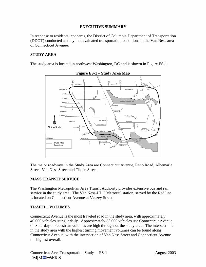
In response to residents’ concerns, the District of Columbia Department of Transportation (DDOT) conducted a study that evaluated transportation conditions in the Van Ness area of Connecticut Avenue. STUDY AREA The study area is located in northwest Washington, DC and is shown in Figure ES-1.
Figure ES-1 – Study Area Map
LEGEND:
Study AreaBoundary
Soapstone Valley Park
Melvin C. Hazen Park
Melvin C. Hazen Park
Albemarle StAlbemarle St
Appleton St Appleton St Allendale Pl
Yuma St
Alton Pl
36th
St
30th
St
32nd
St
Warren St
Van Ness St
International Pl
International Dr
Upton St
Van Ness St
Rodman St
International Ct
35th
St
Sedgwick St
35th S
t 29th S
t
Reno R
d
Ren
o R
d
Lenmore Ln
Linnean Ave
Tilden Pl
Windom Pl
Veazey Ter
LinneanAve
Audobon Ter
Idah
o A
ve
Springland Ln
37th
St
29th
St
28th
Pl
Tilden StTilden St
Rowland Pl
Rodman St
Connecticut A
ve
Connecticut A
ve
Upton St
Quebec Pl
Veazey St
Windom Pl
The major roadways in the Study Area are Connecticut Avenue, Reno Road, Albemarle Street, Van Ness Street and Tilden Street. MASS TRANSIT SERVICE The Washington Metropolitan Area Transit Authority provides extensive bus and rail service in the study area. The Van Ness-UDC Metrorail station, served by the Red line, is located on Connecticut Avenue at Veazey Street. TRAFFIC VOLUMES Connecticut Avenue is the most traveled road in the study area, with approximately 40,000 vehicles using it daily. Approximately 35,000 vehicles use Connecticut Avenue on Saturdays. Pedestrian volumes are high throughout the study area. The intersections in the study area with the highest turning movement volumes can be found along Connecticut Avenue, with the intersection of Van Ness Street and Connecticut Avenue the highest overall.
N Not to Scale

Connecticut Ave. Transportation Study August 2003 ES-2
Traffic levels on Connecticut Avenue during the AM peak hour are higher than the traffic during the PM peak hour. During the weekday AM peak period, traffic between 8:00 AM to 9:00 AM is consistently higher than during other hours of the peak period. Weekday peak traffic conditions during the PM peak period are maintained over a period of several hours. The peak period for Saturdays is between 12:00 PM and 6:00 PM with volumes relatively constant throughout this entire peak period. Between the hours of 7:00 AM and 7:00 PM, the classification data indicates that Connecticut Avenue volume is approximately two percent heavy vehicles. On Van Ness Street west of Connecticut Avenue, approximately six percent of average weekday traffic is comprised of heavy vehicles. SAFETY The Study Team found that the reversible lane operation is a safety issue. Many drivers were observed driving against traffic on the reversible lane. The intersection of Connecticut Avenue and Tilden Street is the location with the largest number of accidents in the study area. SPEEDS Average peak hour speeds on the studied corridors are well below posted speed limits, due to heavy traffic volumes and numerous traffic signals, particularly on Connecticut Avenue. However, there are individual sections on most studied roadways where average peak hour speeds are well above the posted limits. ORIGIN-DESTINATION SURVEY The Study Team conducted and origin-destination survey to assess the patterns of vehicles traversing the study area. The most significant findings of the origin-destination survey are the following:
• Approximately half of the vehicles destined for the study area enter via Connecticut Avenue at Albemarle Street during the AM peak hours.
• The majority of vehicles traveling south through the study area during the AM peak hours are from Maryland.
• During the PM peak hours, approximately one-third of the vehicles exiting the study area begin their trips within the study area.
PARKING Parking availability is adequate throughout most of the study area. During the times when parking is not allowed on Connecticut Avenue (7:00 – 9:30 AM and 4:00 – 6:30 PM), parking utilization on the streets adjacent to Connecticut Avenue is high.

Connecticut Ave. Transportation Study August 2003 ES-3
TRAFFIC OPERATIONS During the AM and PM peak hours, most intersections on Connecticut Avenue operate at level of service (LOS) D or better. This indicates that traffic volumes are approaching the capacity of these intersections, but they are still performing acceptably. The intersection of Connecticut and Van Ness Street operates at LOS F during the PM peak hour, and Connecticut and Tilden Street operates at LOS E during the PM peak hour. During weekday evenings (6:30 – 7:30) two intersections on Connecticut Avenue operate at LOS E. The reduced level of service is due to the parking that is permitted in the curb lanes of Connecticut Avenue beginning at 6:30 PM. On Saturdays, the intersections on Connecticut Avenue operate at LOS D or better. However, there are significant delays due to the friction resulting from vehicles parking and exiting and entering the commercial establishments along Connecticut Avenue. FUTURE CONDITIONS In order to assess future conditions, the Study Team collected information on new or proposed developments in the study area. The primary source of information on these developments was the District of Columbia Office of Planning. The Study Team identified five new or proposed developments within the study area: 3883 Connecticut Avenue, a newly opened residential development; a proposed expansion of the Edmund Burke School at 2955 Upton Street; a proposed expansion of the Sheridan School at 4400 36th Street; and proposed Chinese and Moroccan Embassies in the International Chancery Center off Van Ness Street. The Study Team found that projected traffic associated with these developments is expected to have a negligible impact on traffic operations within the study area, but current high traffic volumes throughout the area, combined with the expected 1.0 percent per year increase in regional traffic will create a demand for mitigation measures to improve traffic operations. TRANSPORTATION ISSUES The Study Team, with the assistance of area residents, conducted an extensive field evaluation of the transportation infrastructure in the study area. The Study Team identified area-wide transportation issues as well as issues on and around Connecticut Avenue, Tilden Street, Van Ness Street, Reno Road, Yuma Street, 36th Street and Alton Place. These issues are concerned with, but not limited to, vehicular operations, transit service, pedestrian safety and school operations. Detailed descriptions of the transportation issues are presented in the study. In addition, short- and long-term recommendations were made for improvements to these issues. Figure ES-2 summarizes transportation issues and recommended improvements within the study area. Appendix L provides a prioritization scheme and cost estimates for the recommended improvements. The District Department of Transportation will conduct a final evaluation and will begin implementation of the recommended improvements after the conclusion of the study.
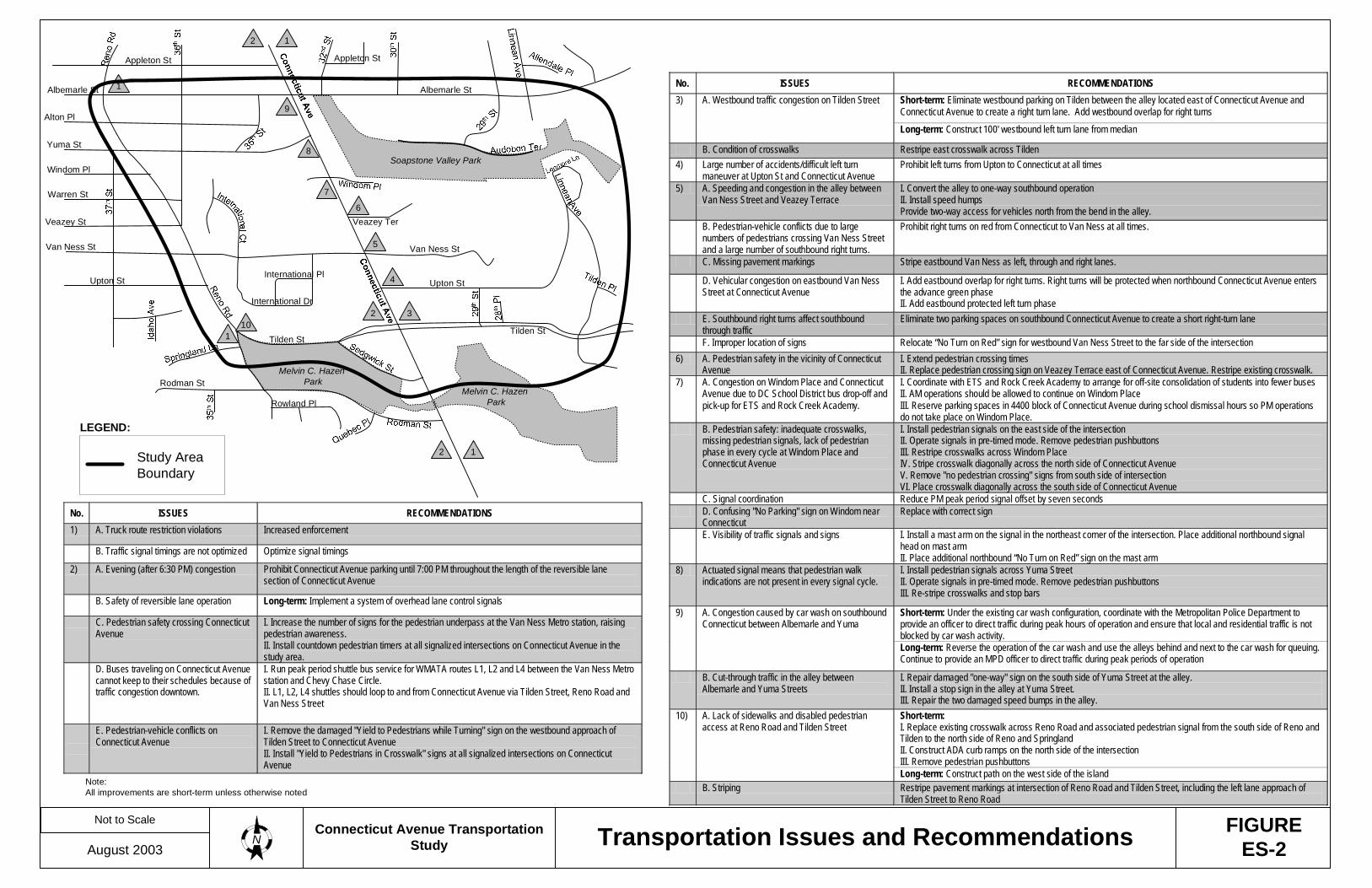
No. ISSUES RECOMMENDATIONS 1) A. Truck route restriction violations Increased enforcement
B. Traffic signal timings are not optimized Optimize signal timings
2) A. Evening (after 6:30 PM) congestion Prohibit Connecticut Avenue parking until 7:00 PM throughout the length of the reversible lane section of Connecticut Avenue
B. Safety of reversible lane operation Long-term: Implement a system of overhead lane control signals
C. Pedestrian safety crossing Connecticut Avenue
I. Increase the number of signs for the pedestrian underpass at the Van Ness Metro station, raising pedestrian awareness. II. Install countdown pedestrian timers at all signalized intersections on Connecticut Avenue in the study area.
D. Buses traveling on Connecticut Avenue cannot keep to their schedules because of traffic congestion downtown.
I. Run peak period shuttle bus service for WMATA routes L1, L2 and L4 between the Van Ness Metro station and Chevy Chase Circle. II. L1, L2, L4 shuttles should loop to and from Connecticut Avenue via Tilden Street, Reno Road and Van Ness Street
E. Pedestrian-vehicle conflicts on Connecticut Avenue
I. Remove the damaged "Yield to Pedestrians while Turning" sign on the westbound approach of Tilden Street to Connecticut Avenue II. Install "Yield to Pedestrians in Crosswalk" signs at all signalized intersections on Connecticut Avenue
No. ISSUES RECOMMENDATIONS Short-term: Eliminate westbound parking on Tilden between the alley located east of Connecticut Avenue and Connecticut Avenue to create a right turn lane. Add westbound overlap for right turns
3) A. Westbound traffic congestion on Tilden Street
Long-term: Construct 100' westbound left turn lane from median
B. Condition of crosswalks Restripe east crosswalk across Tilden 4) Large number of accidents/difficult left turn
maneuver at Upton St and Connecticut Avenue Prohibit left turns from Upton to Connecticut at all times
5) A. Speeding and congestion in the alley between Van Ness Street and Veazey Terrace
I. Convert the alley to one-way southbound operation II. Install speed humps Provide two-way access for vehicles north from the bend in the alley.
B. Pedestrian-vehicle conflicts due to large numbers of pedestrians crossing Van Ness Street and a large number of southbound right turns.
Prohibit right turns on red from Connecticut to Van Ness at all times.
C. Missing pavement markings Stripe eastbound Van Ness as left, through and right lanes.
D. Vehicular congestion on eastbound Van Ness Street at Connecticut Avenue
I. Add eastbound overlap for right turns. Right turns will be protected when northbound Connecticut Avenue enters the advance green phase II. Add eastbound protected left turn phase
E. Southbound right turns affect southbound through traffic
Eliminate two parking spaces on southbound Connecticut Avenue to create a short right-turn lane
F. Improper location of signs Relocate “No Turn on Red” sign for westbound Van Ness Street to the far side of the intersection 6) A. Pedestrian safety in the vicinity of Connecticut
Avenue I. Extend pedestrian crossing times II. Replace pedestrian crossing sign on Veazey Terrace east of Connecticut Avenue. Restripe existing crosswalk.
7) A. Congestion on Windom Place and Connecticut Avenue due to DC School District bus drop-off and pick-up for ETS and Rock Creek Academy.
I. Coordinate with ETS and Rock Creek Academy to arrange for off-site consolidation of students into fewer buses II. AM operations should be allowed to continue on Windom Place III. Reserve parking spaces in 4400 block of Connecticut Avenue during school dismissal hours so PM operations do not take place on Windom Place.
B. Pedestrian safety: inadequate crosswalks, missing pedestrian signals, lack of pedestrian phase in every cycle at Windom Place and Connecticut Avenue
I. Install pedestrian signals on the east side of the intersection II. Operate signals in pre-timed mode. Remove pedestrian pushbuttons III. Restripe crosswalks across Windom Place IV. Stripe crosswalk diagonally across the north side of Connecticut Avenue V. Remove "no pedestrian crossing" signs from south side of intersection VI. Place crosswalk diagonally across the south side of Connecticut Avenue
C. Signal coordination Reduce PM peak period signal offset by seven seconds D. Confusing "No Parking" sign on Windom near
Connecticut Replace with correct sign
E. Visibility of traffic signals and signs I. Install a mast arm on the signal in the northeast corner of the intersection. Place additional northbound signal head on mast arm II. Place additional northbound “No Turn on Red” sign on the mast arm
8) Actuated signal means that pedestrian walk indications are not present in every signal cycle.
I. Install pedestrian signals across Yuma Street II. Operate signals in pre-timed mode. Remove pedestrian pushbuttons III. Re-stripe crosswalks and stop bars
Under the existing car wash configuration, coordinate with the Metropolitan Police Department to provide an officer to direct traffic peak hours of operation and ensure that local and residential traffic is not blocked by car wash activity. 9) A. Congestion caused by car wash on southbound
Connecticut between Albemarle and Yuma Reverse the operation of the car wash and use the alleys behind and next to the car wash for queuing. Continue to provide an MPD officer to direct traffic during peak periods of operation (long-term)
Short-term: Under the existing car wash configuration, coordinate with the Metropolitan Police Department to provide an officer to direct traffic during peak hours of operation and ensure that local and residential traffic is not blocked by car wash activity.
9)
A. Congestion caused by car wash on southbound Connecticut between Albemarle and Yuma
Long-term: Reverse the operation of the car wash and use the alleys behind and next to the car wash for queuing. Continue to provide an MPD officer to direct traffic during peak periods of operation
B. Cut-through traffic in the alley between Albemarle and Yuma Streets
I. Repair damaged "one-way" sign on the south side of Yuma Street at the alley. II. Install a stop sign in the alley at Yuma Street. III. Repair the two damaged speed bumps in the alley. Short-term: I. Replace existing crosswalk across Reno Road and associated pedestrian signal from the south side of Reno and Tilden to the north side of Reno and Springland II. Construct ADA curb ramps on the north side of the intersection III. Remove pedestrian pushbuttons
10) A. Lack of sidewalks and disabled pedestrian access at Reno Road and Tilden Street
Long-term: Construct path on the west side of the island B. Striping Restripe pavement markings at intersection of Reno Road and Tilden Street, including the left lane approach of
Tilden Street to Reno Road
Soapstone Valley Park
Melvin C. Hazen Park
Melvin C. Hazen Park
Albemarle StAlbemarle St
Appleton St Appleton St
Yuma St
Alton Pl
Warren St
Van Ness St
International Pl
International Dr
Upton St
Van Ness St
Rodman St
Veazey Ter
Tilden StTilden St
Rowland Pl
Upton St
Veazey St
Windom Pl
4
5
6
7
8
2
10
2
2 3
9
1
1
1
1
Not to Scale
August 2003Connecticut Avenue Transportation
Study Transportation Issues and Recommendations FIGUREES-2N
LEGEND:
Study AreaBoundary
Note:All improvements are short-term unless otherwise noted

No. ISSUES RECOMMENDATIONS 11) A. Traffic operations and pavement striping on
Reno Road Maintain the existing cross-section of Reno Road
12) A. Lack of parking. High traffic speeds on Reno Road
I. Install additional speed limit signs II. Increase speed enforcement
B. Lack of sidewalk on the west side of Reno Road.
Long-term: Construct sidewalk on west side of Reno Road between Tilden Street and Upton Street
13) Pedestrian safety crossing Reno Road and lack of disabled pedestrian access
I. Place crosswalk across Reno Road II. Construct ADA curb ramps at each end of the crosswalk
14) A. Riders boarding and alighting buses at this location have to cross a landscaped sidewalk buffer.
Construct concrete pedestrian bus pad at bus stop in southeast corner of the intersection.
B. Signage Replace damaged "No Trucks" sign in northeast corner of the intersection. Short-term: I. Construct two traffic chokers on the east side of the 4300 block of 36th Street II. Remove the rumble strips on 36th Street in front of Sheridan School III. Coordinate with Sheridan School for morning drop-off to take place on the west side of 36th Street IV. Construct a choker on 36th Street at Reno Road
15) A. Speeding and cut-through traffic on northbound 36th Street between Reno Road and Yuma Street
Long-term: Remove the proposed choker (see short-term recommendation) on 36th Street at Reno Road and close 36th Street between Reno Road and Warren Street
B. Frequent parking violations Increase residential parking enforcement on 36th Street between Reno and Yuma 16) No sidewalk on portions of the south side of Yuma
Street Construct sidewalk on south side of Yuma Street between the UDC driveway west of Connecticut Avenue and 35th Street
17) A. Disabled pedestrian access Construct ADA curb ramps at the crosswalk on the east side of 35th Street
B. Pedestrian and vehicle safety Install all-way stop signs
18) A. Pedestrian access and safety at 36th Street I. Construct ADA curb ramps at the crosswalk on the south side of Yuma Street II. Reconstruct ADA curb ramps on the north side of Yuma Street III. Construct a raised crosswalk across Yuma Street on the west side of the intersection with 36th Street
B. Cut-through and speeding traffic Install traffic chokers on each side of Yuma Street 100 feet west of the intersection with 36th Street
19) A. Lack of crosswalks and lack of disabled pedestrian access
I. Place crosswalks across Sedgwick Street and the east side of Tilden Street II. Construct ADA curb ramp on Tilden Street in the northeast corner of the intersection
B. Signage Replace damaged/misaligned "No Left Turn" sign on eastbound Tilden at Intelsat driveway
20) A. The planter/barrier in front of the Israeli Embassy creates a vehicular safety hazard.
I. Place pavement marking taper tangent from curve on the south side of Van Ness to the corner of the planter/barrier in front of the Israeli Embassy. Add gore markings between the taper and the curb. Continue pavement marking from east side of planter to International Drive II. Install a crash attenuator on the west side of the planter that fits the architectural characteristics of the embassy III. Place yellow pavement taper extending west from the western end of the median on Van Ness Street in front of the Israeli embassy
B. Lack of pavement markings for left turn bays Stripe left turn lanes on both approaches of Van Ness Street at International Drive and International Court C. Crosswalks are in poor condition or are missing I. Restripe all existing crosswalks
II. Stripe crosswalk across the south side of International Drive at Van Ness Street
Soapstone Valley Park
Melvin C. Hazen Park
Melvin C. Hazen Park
Albemarle StAlbemarle St
Appleton St Appleton St
Yuma St
Alton Pl
Warren St
Van Ness St
International Pl
International Dr
Upton St
Van Ness St
Rodman St
Veazey Ter
Tilden StTilden St
Rowland Pl
Upton St
Veazey St
Windom Pl
11
13
1420 20
1816
11
15
12
12
12
1617
19
2021 22 22
Not to Scale
August 2003Connecticut Avenue Transportation
StudyN
LEGEND:
Study AreaBoundary
Short-term: I. Replace the existing mirror in the median of Van Ness Street with a larger mirror showing oncoming traffic in greater detail II. Eliminate the two parking spaces on the north side of Van Ness Street closest to the UDC exit driveway III. Install "Hidden Driveway" signs on eastbound and westbound Van Ness Street 150 feet before the exit driveway
21) Unsafe exit maneuvers from the UDC driveway.
Long-term: Consolidate driveway entrance and exit movements to the current entrance driveway opposite International Drive. Signalize the intersection if warrants are met. The current exit driveway would remain operational as an emergency or overflow driveway
22) Difficult emergency vehicle access on Van Ness east of Connecticut due to congestion
I. Greater enforcement of parking regulations II. Install "No Double Parking" signs III. Request that Bank of America place a sign on their building encouraging customers to use the parking garage on Veazey Terrace
23) A. Pedestrian Safety Construct a raised crosswalk across Alton Place on the west side of the intersection with 36th Street
B. Cut-through and speeding traffic I. Remove the rumble strips located on Alton Place between Reno Road and 36th Street and install traffic chokers on each side of Alton Place 100 feet west of the intersection with 36th Street II. Remove the rumble strips located on Alton Place between 35th and 36th Streets and install a speed hump in the same location.
Note:All improvements are short-term unless otherwise noted
23 23
Transportation Issues and Recommendations FIGUREES-2

Connecticut Ave. Transportation Study August 2003 1
I. INTRODUCTION In response to residents’ concerns, the District of Columbia Department of Transportation (DDOT) conducted a study that evaluated transportation conditions in the Van Ness area of Connecticut Avenue in the District. The consulting firm DMJM+HARRIS, Inc. (Consultant) conducted the study with assistance from DDOT staff. In this report the team of Consultant and DDOT staff is referred to as the “Study Team.” As detailed in the Scope of Work presented in Appendix A, the main goals of the study were to assess existing traffic conditions in the study area and make recommendations to improve mobility, traffic safety and compliance with speeding regulations, as well as pedestrian and bicycle safety. The study area, shown in Figure 1, focuses on Connecticut Avenue and is bounded by the following corridors:
• Albemarle Street to the north • Tilden Street to the south • Reno Road to the west • Linnean Avenue to the east
The study was conducted with assistance from area residents. The Study Team held three meetings with area residents to discuss transportation issues and potential improvement options. Area residents provided additional input via e-mail and regular correspondence. Input from residents was helpful in the identification of key transportation issues noted in this report and in the development of mitigation measures with respect to transportation improvements. The Washington DC Office of Planning provided additional information to the Study Team. This report summarizes the assessment of existing and future transportation conditions, identifies transportation issues, presents an evaluation of proposed improvements, and describes the improvements that are recommended for implementation in the study area. The existing conditions section of this report includes a description of the major roadways in the study area; information on traffic volumes at critical intersections; travel speeds throughout the study area, origin-destination patterns; accidents, queues, and level of service at critical intersections. It also describes the conditions of existing pedestrian facilities and public transportation. The future transportation conditions section of this report includes an assessment of proposed development, future year travel forecasts and levels of service for the year 2012. The following section describes the identified transportation issues and presents recommended improvements for traffic, pedestrian and public transit operation. The last section of the report presents a summary of findings and recommendations.

Scale: 1" = 785'
August 2003Connecticut AvenueTransportation Study Study Area
LEGEND:
Study AreaBoundary
Soapstone Valley Park
Melvin C. Hazen Park
Melvin C. Hazen Park
Albemarle StAlbemarle St
Appleton St Appleton St
Yuma St
Alton Pl
Warren St
Van Ness St
International Pl
International Dr
Upton St
Van Ness St
Rodman St
Veazey Ter
Tilden StTilden St
Rowland Pl
Upton St
N
Veazey St
Windom Pl
FIGURE1

Connecticut Ave. Transportation Study August 2003 3
II. EXISTING CONDITIONS EXISTING TRANSPORTATION FEATURES The Study Team conducted an extensive data collection effort to gain an understanding of existing conditions in the study area. In addition to collecting data for the quantitative assessment of existing conditions, the Study Team conducted field evaluations throughout the study area during peak and off-peak hours to further assist in the assessment of existing conditions. This section of the report summarizes the data collected for the study and addresses issues and deficiencies in the transportation infrastructure. MAJOR ROADWAYS IN THE STUDY AREA The study area is located in Northwest Washington, DC and is shown in Figure 1. The following are the major roadways in the study area:
• Connecticut Avenue • Reno Road • Tilden Street • Albemarle Street • Van Ness Street
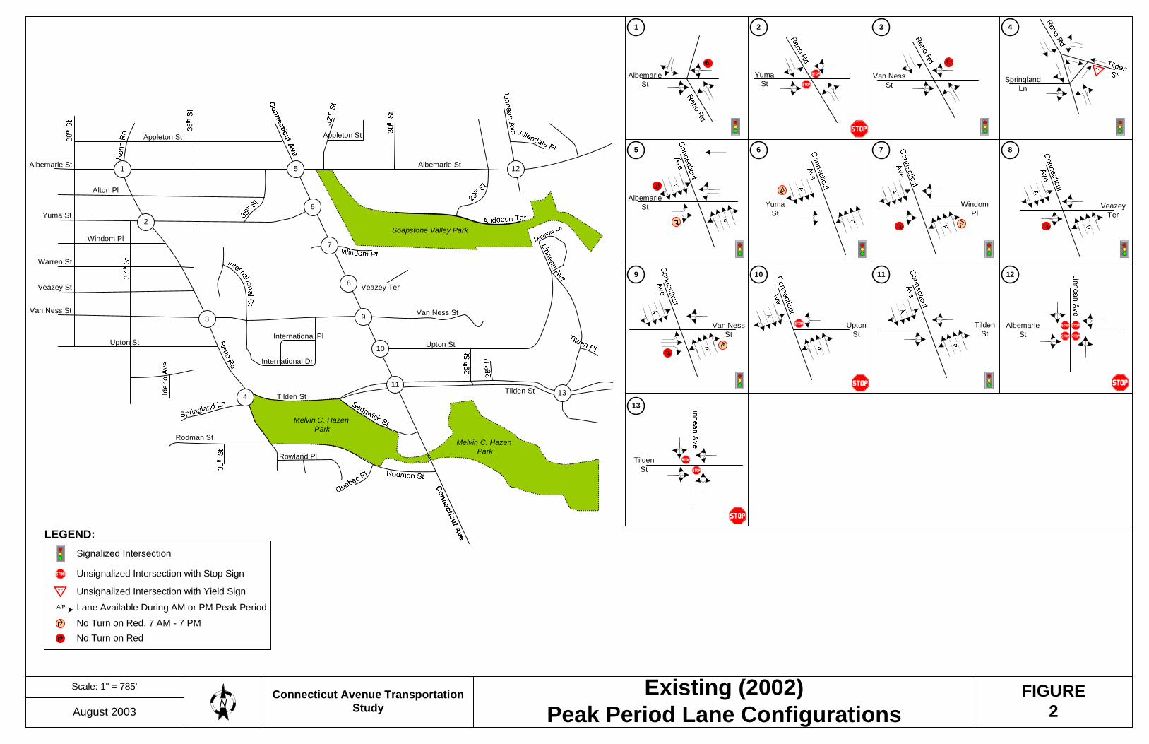
While some of the studied roadways continue beyond the above terminals, their associated characteristics will only be described within these limits. Connecticut Avenue Connecticut Avenue1 is a two way major arterial2 running north-south through the study area. There is a total of six lanes on Connecticut Avenue with a reversible lane in operation during the AM and PM peak periods. As shown in Figure 2, Connecticut Avenue operates with four southbound and two northbound lanes during weekdays from 7:00-9:30 AM and four northbound and two southbound lanes during weekdays from 4:00-6:30 PM. No parking is allowed on Connecticut Avenue during AM and PM reversible lane operation. During off peak hours and weekends, Connecticut Avenue operates as two-lanes in each direction with parking allowed on both sides of the road. There are parking meters on both sides of Connecticut Avenue from Albemarle to Van Ness Street and on the west side of Connecticut from Van Ness to Tilden Street. The posted speed limit is 30 mph. There is no median on Connecticut Avenue.
1 All streets in the study area are located in the northwest quadrant of the District. Therefore, throughout this report where the NW designation is omitted, it should be understood that the street is located in the northwest quadrant of the District. 2 All roadway classifications were taken from the District of Columbia Functional Classification Map, January 1, 2002.
Scale: 1" = 785'
August 2003Connecticut Avenue Transportation
StudyExisting (2002)
Peak Period Lane ConfigurationsFIGURE
2N
1 2 3 4
5 6 7 8
9 10 11 12
13
LEGEND:Signalized Intersection
Unsignalized Intersection with Stop SignYIELD Unsignalized Intersection with Yield SignA/P Lane Available During AM or PM Peak Period
Soapstone Valley Park
Melvin C. Hazen Park
Melvin C. Hazen Park
Albemarle StAlbemarle St
Appleton St Appleton St
Yuma St
Alton Pl
Warren St
Van Ness St
International Pl
International Dr
Upton St
Van Ness St
Rodman St
Veazey Ter
Tilden StTilden St
Rowland Pl
Upton St
Veazey St
Windom Pl
11
1
2
3
4
6
7
8
9
10
13
125
SpringlandLn
Van NessSt
YumaSt
AlbemarleSt
AlbemarleSt Windom
PlVeazey
Ter
Van NessSt
UptonSt
TildenSt
AlbemarleSt
TildenSt
YumaSt
No Turn on Red, 7 AM - 7 PMNo Turn on Red
Connecticut Ave. Transportation Study August 2003 5
The intersections of Connecticut Avenue with Albemarle Street, Yuma Street, Windom Place, Veazey Terrace, Van Ness Street, and Tilden Street are signalized intersections, while the intersection of Upton Street is un-signalized intersection with stop control on the minor street. Sidewalks are generally in good condition, with widths greater than six feet and curb cuts present at all crosswalk locations. As shown in Figure 3, land usage along Connecticut Avenue varies widely based on location. From Albemarle Street to Van Ness Street is moderate density commercial area with local public facilities at the corner of Van Ness Street. The Van Ness Metro station is located on the west side of Connecticut Avenue at Van Ness Street. East of Connecticut are high-density residential areas. Reno Road Reno Road is a two-way minor arterial running north-south through the study area between Tilden and Albemarle Streets. Reno road is generally one lane in each direction with a center lane for left turns. From Van Ness to Tilden Street, there are two lanes in each direction (Figure 2). No parking is allowed on either side of Reno Road within the study area. The intersections of Reno Road with Tilden, Van Ness and Albemarle Streets are signalized intersections while the intersection of Reno road with Yuma Street is stop-controlled on the minor street. The posted speed limit on Reno Road is 25 mph. The west side of Reno Road has six-foot sidewalks from Albemarle Street to Upton Street while the east side has six-foot intermittent sidewalks from Yuma to Warren Streets, and from Veazey to Tilden Street. Sidewalks are generally in good condition. Land usage along Reno Road is primarily low-density residential along the west side of Reno Road and the east side from Albemarle Street to Veazey Street. The east side of Reno Road, from Veazey to Tilden Street is foreign embassy property. Tilden Street Tilden Street is a two-way, two-lane minor arterial running east-west through the study area between Linnean Avenue and Reno Road. There is one lane in each direction. All-day parking is permitted on both sides of the street between Reno Road and 28th Place. Parking is not allowed on the north side of Tilden Street from Linnean Avenue to 28th Place. Tilden Street has a landscaped center median from Linnean Avenue to Sedgwick Street. The intersection of Tilden Street with Linnean Avenue is stop-controlled on the minor street, while the intersections of Tilden Street with Connecticut Avenue and Tilden Street with Reno Road are signalized. The posted speed limit is 25 mph. Both sides of the road have sidewalks, which are generally six feet in width.

Moderate density residential
High density residential
FIGURE3Generalized Land Use MapConnecticut Avenue
Transportation StudyNot to Scale
August 2003
Source:District of Columbia Office of Planning801 North Capitol Street N.E., Suite 4000, Washington, D.C. 20002February 2001
Low density residential
Institutional
Legend:
Parks, recreation and open space
Local public facilities
Federal
Moderate density commercial
Connecticut Ave. Transportation Study August 2003 7
As shown on Figure 3, land usage along Tilden Street varies widely based on location. From Linnean Avenue to the east side of Connecticut Avenue is low-density residential usage, with a high-density residential area near the Connecticut Avenue intersection. The north side of Tilden Street from Connecticut Avenue to Reno Road includes several embassies and the south side includes parks or open space. Albemarle Street Albemarle Street is a two-way collector running east-west between Linnean Avenue and Reno Road in the study area. The posted speed limit is 25 mph. Albemarle Street generally operates with one lane in each direction with the exception of two lanes in each direction at the Connecticut Avenue intersection (Figure 2). From Linnean Avenue to 35th Street no parking is allowed on the south side of Albemarle Street. However, all day parking is allowed on the north side of Albemarle Street from 35th Street to Linnean Avenue, and both sides of the road from 35th Street to Reno Road. Signalized intersections along this portion of Albemarle Street include Connecticut Avenue and Reno Road. The intersection with Linnean Avenue is all-way stop controlled. Sidewalks are six feet wide on average and generally in good condition. Land usage along Albemarle Street is primarily low-density residential, with high-density residential and moderate density commercial at the intersection of Albemarle Street and Connecticut Avenue. Van Ness Street Van Ness Street is a two-way road running east-west from Reno Road to the east of Connecticut Avenue. West of Connecticut Avenue, Van Ness Street is classified as a collector. It is a local road to the east of Connecticut Avenue. The posted speed limit is 25 mph. Van Ness Street operates with one lane in each direction from the east side of Connecticut Avenue with parking allowed on both sides of the road. To the west, from Connecticut Avenue to Reno Road, Van Ness Street operates with one lane in the westbound direction and two lanes in the eastbound direction. Metered parking is located on the north side of Van Ness Street between Connecticut Avenue and International Court. Signalized intersections along Van Ness Street are Connecticut Avenue and Reno Road. Sidewalks on both sides of the road between Reno Road and Connecticut Avenue are generally eight feet wide, while sidewalks east of Connecticut Avenue are generally six feet wide. Sidewalks are generally in good condition with curb cuts visible in all crosswalk locations. Land usage along Van Ness Street varies widely based on location. On the east side of Connecticut Avenue, Van Ness Street is institutional with high-density residential and moderate-density commercial area near Connecticut Avenue. On the west side of Connecticut Avenue, land usage is predominantly public and federal facilities, with the UDC-Van Ness campus at the corner of Van Ness Street and Connecticut Avenue.

Connecticut Ave. Transportation Study August 2003 8
PUBLIC TRANSPORTATION The Washington Metropolitan Area Transit Authority (WMATA) provides extensive bus and rail service in the study area. As shown in Figure 4, four routes (L1, L2, L4, and D32) provide north-south service to the study area, operating primarily along Connecticut Avenue. In addition, route H2 provides service from the Van Ness-UDC metro station to the south on Connecticut Avenue. Route H3 serves the west side of the study area along Veazey Street, Van Ness Street and Reno Road. Route N8 operates from the Metro station to the west along Veazey and Van Ness Streets. The Van Ness-UDC station of the Metro Red Line is located on Connecticut Avenue at Veazey Street. Access to the station is provided on both sides of Connecticut Avenue. Bus routes operating in the study area are as follows1: WMATA Route L1, L2, L4 – Connecticut Avenue Line Routes L1, L2, L4 operate on Connecticut Avenue and are the major bus routes for traveling north-south through the study area. During weekdays, L2 provides service throughout the day with southbound service operating from 5:05 AM until 1:35 AM. Northbound service operates from 5:39 AM until 2:08 AM. Southbound L1 operates only during the morning rush hour from 6:58 AM until 8:37 AM, and southbound L4 starts its operation after the end of morning peak hour from 9:15 AM until 8:14 PM. Northbound L1 operates only during afternoon peak hours from 4:12 PM till 6:05 PM, and northbound L4 operates from 8:31 AM until 8:43 PM. In the study area, southbound headways range from 6 minutes to 35 minutes, with AM peak period headways varying from 6 to 9 minutes, and PM peak period headways ranging from 8 to 12 minutes. Northbound headways range from 5 to 38 minutes, with AM peak period headways varying from 7 to 15 minutes, and PM peak period headways ranging from 5 to 10 minutes. On Saturdays and Sundays only route L2 operates. It runs between morning and midnight with varying headways between 12 and 40 minutes. The most prevalent headway is 20 minutes. WMATA Route N8 – Van Ness-Wesley Heights Loop Route N8 operates as a loop from the Van Ness –UDC campus to Wesley Heights. The outbound route serves Veazey Street from Reno Road to Wisconsin Avenue, while the inbound route operates on Van Ness Street. The loop provides service from 5:57 AM until 12:08 AM during weekdays with headways range from 18 minutes to 50 minutes. AM and PM peak headways are constant, operating 18 minutes apart. 1 Routes and headways based on WMATA schedules published between 12/30/01 and 9/29/02.

LEGEND:
Metro Station
Terminal for bus routes listedin the accompanying box
Bus shelter
Soapstone Valley Park
Melvin C. Hazen Park
Melvin C. Hazen Park
Albemarle StAlbemarle St
Appleton St Appleton St
Yuma St
Alton Pl
Warren St
Van Ness St
International Pl
International Dr
Upton St
Van Ness St
Rodman St
Veazey Ter
Tilden StTilden St
Rowland Pl
Upton St
Veazey St
Windom Pl
H3 H2
D32
L1
L2
L4
Van Ness -UDC
Van Ness -UDC
Van Ness-UDC StationH2 N8
Mt. Pleasant / Deal Jr. HS In Out --- --- --- ---Brookland-CUA Metro / Van Ness-UDC Metro • • • • • • •Brookland-CUA Metro / Tenleytown-AU Metro In Out --- --- --- --- •Chevy Chase Circle / Potomac Park In Out --- --- --- ---Chevy Chase Circle / McPherson Square Metro • • • • • • •Chevy Chase Circle / Dupont Circle Metro --- In • • --- --- •Van Ness-UDC Metro / Wesley Heights • • • • • • • Via Tenleytown-AU Metro & Yuma Street
D32H2H3L1L2L4N8
RemarksRoute Terminals
Connecticut Avenue Transportation StudyNot to Scale
August 2003 Public TransitNFIGURE
4
In =
Out =
Service Guide Key:
Inbound
Outbound
Both Directions
Not AvailableWheelchair Lift-Equipped Service
--- =
=
=
Out Public School Open Only

Connecticut Ave. Transportation Study August 2003 10
Route N8 also runs on Saturday from 5:50 AM until 12:22 AM and on Sunday from 6:20 AM until 11:00 PM. Headways are approximately 45 minutes to 50 minutes apart for Saturday and Sunday operation. WMATA Routes H2, H3 – Crosstown Line Route H2 runs on Connecticut Avenue in the study area with outbound headways during AM peak period ranging from 21 to 31 minutes, while PM peak period headways range from 24 to 33 minutes. Inbound headways range from 23 minutes to 31 minutes during the AM peak period and 27 minutes to 31 minutes during PM peak hours. Weekend service is offered on this route. Route H3 runs on Reno Road, Veazey Street and Van Ness Street on the west side of the study area, with westbound service available only in morning peak hours, and eastbound service available in morning and afternoon peak hours. Headways during the westbound AM peak period range from 22 to 27 minutes. Eastbound headways range from 50 minutes to 54 minutes during AM peak period and 21 minutes to 31 minutes during PM peak period. Weekend service is not offered on this route. WMATA Route D32 – Deal Junior High School Line Route D32 operates only when District public schools are in session. It runs northbound on Connecticut Avenue twice daily at 8:03AM and 8:08AM. In the afternoon, it operates along Wisconsin Avenue outside the study area.
TRAFFIC VOLUMES In order to evaluate existing traffic conditions throughout the study area, the Study Team collected turning movement counts at the thirteen intersections listed below during peak and off-peak periods. Additionally, the Study Team collected daily traffic counts at key locations throughout the study area. Figure 5 shows the intersections where the Study Team collected turning movement count data.
1. Reno Road and Albemarle Street 2. Reno Road and Yuma Street 3. Reno Road and Van Ness Street 4. Reno Road and Tilden Street and Springland Lane 5. Connecticut Avenue and Albemarle Street 6. Connecticut Avenue and Yuma Street 7. Connecticut Avenue and Windom Place 8. Connecticut Avenue and Veazey Terrace 9. Connecticut Avenue and Van Ness Street 10. Connecticut Avenue and Upton Street 11. Connecticut Avenue and Tilden Street 12. Linnean Avenue and Albemarle Street 13. Linnean Avenue and Tilden Street

Scale: 1" = 785'
August 2003Connecticut AvenueTransportation Study Location of Turning Movement Counts FIGURE
5
Soapstone Valley Park
Melvin C. Hazen Park
Melvin C. Hazen Park
Albemarle StAlbemarle St
Appleton St Appleton St
Yuma St
Alton Pl
Warren St
Van Ness St
International Pl
International Dr
Upton St
Van Ness St
Rodman St
Veazey Ter
Tilden StTilden St
Rowland Pl
Upton St
N
Veazey St
Windom Pl
11
1
2
3
4
5
7
8
9
10
12
6
13

Connecticut Ave. Transportation Study August 2003 12
The intersections on Connecticut Avenue were counted on four typical weekdays (Tuesday, Wednesday or Thursday), from 8:00 AM -10:00 AM and 4:30 PM - 8:00 PM. Additionally, these intersections were counted on four Saturdays between the times of 12:00-4:00 PM. Counts were taken during the months of November and December 2002 and January 2003. No traffic was counted during holiday weeks or while District public schools and universities were not in session. Since all the counts were taken during fall months, when traffic volumes are typically standard as all the schools and business are open, no seasonal adjustment factor was applied to the raw volumes. As all the intersections in Connecticut Avenue were counted four times, the turning movement traffic counts on Connecticut Avenue were averaged and treated as raw volumes. Because of the averaging process, there were minor discrepancies in the overall balance of traffic volumes throughout the study area network. In order to improve the modeling of existing traffic conditions, the Study Team applied standard traffic engineering techniques to adjust the turning movement counts at intersections where minor unjustified imbalances were found. Figure 6 represents the existing 2002 balanced AM and PM weekday peak hour turning movement counts at all 13 intersections. Figures 7 and 8 provide information on additional traffic data collected on Connecticut Avenue. These are weekday evening (6:30- 7:30 PM) peak hour and Saturday midday peak hour turning movement counts, respectively. Accompanying pedestrian counts are presented in Figures 9, 10 and 11 for weekdays, evenings and Saturdays, respectively. Appendix B presents raw vehicular and pedestrian volumes for all counts at the above thirteen intersections. As shown in the turning movement count figures, the intersections in the study area with the highest turning movement volumes can be found along Connecticut Avenue, with the intersection of Van Ness Street and Connecticut Avenue the highest overall. Intersections along the periphery of the study area along Reno Road and Linnean Avenue have lower traffic volumes. The pedestrian volume figures show that, as expected, high pedestrian volumes are found along Connecticut Avenue. The highest number of pedestrians for weekdays and Saturdays can be found at Windom Place and Connecticut Avenue, the intersection closest to the Metro station.
The Study Team collected automated Average Daily Traffic (ADT) counts over a two-week period throughout November 2002 at the following four locations:
• Connecticut Avenue between Albemarle Street and Yuma Street • Connecticut Avenue between Veazey Terrace and Windom Place • Connecticut Avenue between Tilden Street and Upton Street • Van Ness Street west of Connecticut Avenue

Scale: 1" = 785'
August 2003
Connecticut AvenueTransportation Study 2002 Existing Weekday Peak Hour Volumes
Soapstone Valley Park
Melvin C. Hazen Park
Melvin C. Hazen Park
Albemarle StAlbemarle St
Appleton St Appleton St
Yuma St
Alton Pl
Warren St
Van Ness St
International Pl
International Dr
Upton St
Van Ness St
Rodman St
Veazey Ter
Tilden StTilden St
Rowland Pl
Upton St
N
Veazey St
Windom Pl
11
1
2
3
4
5
7
8
9
10
12
13
1
6
16 (25)213 (260)141 (62)
15 (23)260 (180)88 (74)
3 4
5 6 7 8
9 10
13
41 (12)361 (366)
22 (2)
27 (7)559 (401)
3 (0)
11 12
39 (119)15 (27)1 (0)
3 (2)15 (13)0 (0)
2
22 (20)78 (56)46 (28)
49 (17)59 (59)25 (23)
21 (33)333 (170)71 (86)
57 (106)208 (251)24 (45)
4 (5)1 (1)3 (3)
376 (342)0 (0)
59 (70)
13 (16)4 (9)19 (7)
38 (91)3 (1)
49 (57)
15 (77)12 (1)56 (73)
7 (136)4 (3)
29 (67)
26 (36)1 (0)
88 (69)
3 (20)1 (0)2 (16)
54 (90)78 (156)75 (41)
13 (16)184 (61)251 (52)
199 (400)48 (81)
144 (258)
41 (53)57 (44)66 (49)
79 (83)6 (7)
24 (50)248 (279)32 (35)
208 (192)308 (206)84 (51)
Albemarle St Yuma St Windom Pl Veazey Ter
Van Ness St Upton St Tilden St
Tilden St
Albemarle St
Albemarle St Yuma St Van Ness St Springland Ln Tilden St
FIGURE6
37,300
39,800
39,700
10,700
LEGEND:
385 AM Peak Hour Volume
(456) PM Peak Hour Volume
10,000 Average Daily Volume

Scale: 1" = 785'
August 2003
Connecticut AvenueTransportation Study
2002 Existing Weekday Evening(6:30-7:30 PM) Volumes on Connecticut Avenue
Soapstone Valley Park
Melvin C. Hazen Park
Melvin C. Hazen Park
Albemarle StAlbemarle St
Appleton St Appleton St
Yuma St
Alton Pl
Warren St
Van Ness St
International Pl
International Dr
Upton St
Van Ness St
Rodman St
Veazey Ter
Tilden StTilden St
Rowland Pl
Upton St
N
Veazey St
Windom Pl
11
5
7
8
9
10
6
5 6 7 8
9 10 11
LEGEND:
EVENING (6:30-7:30 PM) VOLUME
1039
52044
47348
713
53
450
81
808
768140
134250
23749178
464348
546
3116427
15816953
Albemarle St Yuma St Windom Pl Veazey Ter
Van Ness St Upton St Tilden St
FIGURE7
385

Scale: 1" = 785'
August 2003
Connecticut AvenueTransportation Study
2002 Existing Saturday Peak Hour Volumes onConnecticut Avenue
Soapstone Valley Park
Melvin C. Hazen Park
Melvin C. Hazen Park
Albemarle StAlbemarle St
Appleton St Appleton St
Yuma St
Alton Pl
Warren St
Van Ness St
International Pl
International Dr
Upton St
Van Ness St
Rodman St
Veazey Ter
Tilden StTilden St
Rowland Pl
Upton St
N
Veazey St
Windom Pl
11
5
7
8
9
10
6
5 6 7 8
9 10 11
75
10
71044
24347
723
52
500
85
000
6870126
197362
13146131
404042
4711
1813421
15316257
Albemarle St Yuma St Windom Pl Veazey Ter
Van Ness St Upton St Tilden St
FIGURE8
34,900
33,400
6,100
LEGEND:
Saturday Peak Hour Volume
33,700
10,000 Average Daily Volume (Saturday)
385

Scale: 1" = 785'
August 2003
Connecticut AvenueTransportation Study
2002 Existing Weekday Peak Hour PedestrianVolumes
Soapstone Valley Park
Melvin C. Hazen Park
Melvin C. Hazen Park
Albemarle StAlbemarle St
Appleton St Appleton St
Yuma St
Alton Pl
Warren St
Van Ness St
International Pl
International Dr
Upton St
Van Ness St
Rodman St
Veazey Ter
Tilden StTilden St
Rowland Pl
Upton St
N
Veazey St
Windom Pl
11
1
2
3
4
5
7
8
9
10
12
13
1
6
3 4
5 6 7 8
9 10
13
11 12
2
LEGEND:
Upton St
YumaSt Van Ness
StTilden
St
AlbemarleSt
YumaSt
WindomPl
TildenSt
VeazeyTer
Van NessSt
AlbemarleSt
8(14)
6(12)
AlbemarleSt
2(0)
1(0)
TildenSt
0(0)
0(2)
8(14)
No. of Pedestrians in AM Peak HourNo. of Pedestrians in PM Peak Hour
FIGURE9

Scale: 1" = 785'
August 2003
Connecticut AvenueTransportation Study
2002 Existing Weekday Evening (6:30-7:30 PM)Pedestrian Volumes on Connecticut Avenue
Soapstone Valley Park
Melvin C. Hazen Park
Melvin C. Hazen Park
Albemarle StAlbemarle St
Appleton St Appleton St
Yuma St
Alton Pl
Warren St
Van Ness St
International Pl
International Dr
Upton St
Van Ness St
Rodman St
Veazey Ter
Tilden StTilden St
Rowland Pl
Upton St
N
Veazey St
Windom Pl
11
5
7
8
9
10
6
LEGEND:42 No. of Pedestrians in Hour
5 6 7 8
9 10 11
Upton St
AlbemarleSt
YumaSt
WindomPl
TildenSt
VeazeyTer
Van NessSt
FIGURE10

Scale: 1" = 785'
August 2003
Connecticut AvenueTransportation Study
2002 Existing Saturday Peak Hour PedestrianVolumes on Connecticut Avenue
Soapstone Valley Park
Melvin C. Hazen Park
Melvin C. Hazen Park
Albemarle StAlbemarle St
Appleton St Appleton St
Yuma St
Alton Pl
Warren St
Van Ness St
International Pl
International Dr
Upton St
Van Ness St
Rodman St
Veazey Ter
Tilden StTilden St
Rowland Pl
Upton St
N
Veazey St
Windom Pl
11
5
7
8
9
10
6
LEGEND:42 No. of Pedestrians in Peak Hour
5 6 7 8
9 10 11
Upton St
AlbemarleSt
YumaSt
WindomPl
TildenSt
VeazeyTer
Van NessSt
FIGURE11

Connecticut Ave. Transportation Study August 2003 19
Connecticut Avenue carries approximately 40,000 vehicles per day during a typical weekday1 and 35,000 vehicles on Saturdays. The daily traffic on Van Ness Street on a weekday is 11,000 vehicles. Saturday daily volumes are slightly less than weekday volumes but significantly higher than Sunday daily volumes. Charts 1 and 2 show average daily traffic volumes, for weekdays and Saturdays respectively, at one of the four locations where average daily traffic volumes were recorded. Charts for the remaining three locations are presented in Appendix B. As shown in Chart 1, traffic levels on Connecticut Avenue during the AM peak hour are higher than the traffic during the PM peak hour. During the weekday AM peak period, traffic between 8:00 AM to 9:00 AM is consistently higher than during other hours of the peak period. Weekday peak traffic conditions during the PM peak period are maintained over a period of several hours. As indicated in Chart 2, the peak period for Saturdays is between 12:00 PM and 6:00 PM with volumes relatively constant throughout this entire peak period. Automated vehicle classification counts taken over a two-week periods on Van Ness Street west of Connecticut Avenue indicate that approximately six percent of average weekday traffic is comprised of heavy vehicles (buses, semi-trucks, etc.). Weekend percentages of heavy vehicles are in the range of three to four percent. Between the hours of 7:00 AM and 7:00 PM, the classification data indicates that Connecticut Avenue volume is approximately two percent heavy vehicles. SPEED AND TRAVEL TIMES In order to gain an understanding of driving patterns and to gather information needed in the development of the traffic model for the study area, the Study Team collected information on speed and travel times on key corridors in the study area. The Study Team collected the data on travel times and delay on January 16, 2003. Study Team data collectors drove the Connecticut Avenue, Tilden Street, Reno Road, Albemarle Street and Van Ness Street corridors several times in each direction during both the AM and PM peak hours, and recorded the elapsed travel times at predetermined travel points and the distance between the selected travel points. For the travel time runs, the data collectors were instructed to drive at the same speed as most of the vehicles traversing the study area. Thus, in some sections of the critical corridors, the data collectors traveled at speeds above the speed limit. The Study Team calculated average speed for each roadway segment as well as an overall average speed for the corridor using the data collected on travel times and distances 1 Total 24-hour traffic volume in both directions.

Chart 1Weekday Hourly Distribution of Vehicular Trips -
Connecticut Avenue North of Veazey Terrace
0
500
1000
1500
2000
2500
3000
0:00 2:00 4:00 6:00 8:00 10:00 12:00 14:00 16:00 18:00 20:00 22:00
Time
Num
ber o
f Veh
icle
s
Northbound
Southbound

Chart 2Saturday Hourly Distribution of Vehicular Trips -
Connecticut Avenue North of Veazey Terrace
0
200
400
600
800
1000
1200
1400
0:00 2:00 4:00 6:00 8:00 10:00 12:00 14:00 16:00 18:00 20:00 22:00
Time
Num
ber o
f Veh
icle
s
Northbound
Southbound
Connecticut Ave. Transportation Study August 2003 22
between time points. Figures 12 and 13 present overall travel times and speeds for the key corridors for AM and PM peak hours, respectively. Due to signal coordination, the Connecticut Avenue corridor (from Sedgwick street to Albemarle street) has higher southbound speeds in the morning, and higher northbound speed in the afternoon peak hour. Eastbound Tilden Street speed is consistently higher in AM and PM peak hour than the westbound direction. Speeds on Albemarle Street are generally consistent regardless of time period, with the exception of westbound Albemarle Street from 36th street to Reno Road, which has a considerably slower segment speed. However, eastbound Albemarle Street has higher average speed than westbound Albemarle Street for the AM and PM peak hour. Average speeds on northbound Reno Road are approximately twice the speed of southbound Reno Road for the AM and PM hour. Van Ness Street speeds are consistent regardless of peak hours; however, eastbound speeds are higher than westbound speeds. For individual segments, speeds in the segment of Van Ness Street between International Drive and Reno Road are noticeably slower than all other segments. These travel times include signal delay, and therefore due to traffic signals along most of the corridors, as well as moderate to heavy peak period traffic volumes, overall average speeds are considerably slower than the speed limits of the roadways. However, there are individual sections on all of the corridors (except westbound Albemarle Street and Southbound Reno Road) where average speeds met or exceeded the speed limit, as can be seen in Table 1. In particular, traffic traveling on Connecticut Avenue northbound between Upton and Tilden Streets; eastbound Albemarle Street between Connecticut Avenue and 30th Street; Tilden Street eastbound between 29th Street and Linnean Avenue; Reno Road northbound between Yuma Street and Albemarle Street; and Van Ness Street eastbound between International Court and International Drive exceeded the speed limit by a noticeable amount.
Table 1
Average Travel Speeds Between Selected Locations
Roadway and Direction Segment
Speed Limit (mph)
AM Peak
(mph)
PM Peak
(mph) Connecticut Avenue northbound Tilden Street – Upton Street 30 32.2 36.1 Connecticut Avenue southbound Upton Street – Tilden Street 30 32.2 11.0 Albemarle Street eastbound Connecticut Avenue – 30th Street 25 31.8 29.5 Albemarle Street westbound 30th Street – Connecticut Avenue 25 17.2 20.3 Tilden Street eastbound 29th Street – Linnean Avenue 25 33.5 30.2 Tilden Street westbound Linnean Avenue – 29th Street 25 26.2 22.9 Reno Road northbound Yuma Street – Albemarle Street 25 38.8 34.9 Reno Road southbound Albemarle Street – Yuma Street 25 15.4 30.1 Van Ness Street eastbound International Court – International Drive 25 38.0 37.2 Van Ness Street westbound International Drive – International Court 25 37.2 27.1
Appendix C presents a list of recorded speeds for all analyzed segments within the Study Area.

Scale: 1" = 785'
August 2003Connecticut AvenueTransportation Study AM Peak Period Travel Times and Speeds FIGURE
12
Soapstone Valley Park
Melvin C. Hazen Park
Melvin C. Hazen Park
Albemarle StAlbemarle St
Appleton St Appleton St
Yuma St
Alton Pl
Warren St
Van Ness St
International Pl
International Dr
Upton St
Van Ness St
Rodman St
Veazey Ter
Tilden StTilden St
Rowland Pl
Upton St
N
Veazey St
Windom Pl
Distance: 0.7 milesEB: 1:55, 21.9 mphWB: 2:55, 14.4 mphSpeed Limit: 25 MPH
Legend:
Travel RouteDistance: [Total Distance][Direction]: [Average Time], [Average Speed]
Note: Each travel route is representedby a different color. The associateddistances, times and speeds areshown with matching-colored text.
Distance: 0.45 milesEB: 1:37, 16.7 mphWB: 2:52, 9.4 mphSpeed Limit: 25 MPH
Distance: 0.85 milesEB: 2:56, 17.4 mphWB: 3:41, 13.9 mphSpeed Limit: 25 MPH
Distance: 0.7 milesNB: 2:21, 17.9 mphSB: 2:12, 19.1 mphSpeed Limit: 30 MPH
Distance: 0.55 milesNB: 1:50, 18.0 mphSB: 3:30, 9.4 mphSpeed Limit: 25 MPH

Scale: 1" = 785'
August 2003Connecticut AvenueTransportation Study PM Peak Period Travel Times and Speeds FIGURE
13
Soapstone Valley Park
Melvin C. Hazen Park
Melvin C. Hazen Park
Albemarle StAlbemarle St
Appleton St Appleton St
Yuma St
Alton Pl
Warren St
Van Ness St
International Pl
International Dr
Upton St
Van Ness St
Rodman St
Veazey Ter
Tilden StTilden St
Rowland Pl
Upton St
N
Veazey St
Windom Pl
Distance: 0.7 milesEB: 1:46, 23.8 mphWB: 2:46, 15.2 mphSpeed Limit: 25 MPH
Legend:
Travel RouteDistance: [Total Distance][Direction]: [Average Time], [Average Speed]
Note: Each travel route is representedby a different color. The associateddistances, times and speeds areshown with matching-colored text.
Distance: 0.45 milesEB: 1:57, 13.8 mphWB: 3:50, 7.1 mphSpeed Limit: 25 MPH
Distance: 0.85 milesEB: 2:40, 19.1 mphWB: 3:28, 14.7 mphSpeed Limit: 25 MPH
Distance: 0.7 milesNB: 2:11, 19.2 mphSB: 3:10, 13.3 mphSpeed Limit: 30 MPH
Distance: 0.55 milesNB: 1:14, 26.8 mphSB: 2:26, 13.6 mphSpeed Limit: 25 MPH

Connecticut Ave. Transportation Study August 2003 25
ORIGIN-DESTINATION PATTERNS IN THE STUDY AREA In order to gain an understanding of existing traffic patterns in the study area, the Study Team conducted a comprehensive assessment of origins and destinations for vehicles entering and exiting the study area during the AM and PM peak period. The origin-destination survey helped identify the travel patterns of all vehicles entering the study area during the peak hours. DATA COLLECTION FOR ORIGIN-DESTINATION SURVEY The data collection effort for the origin-destination survey encompassed the following tasks: 1. Recording of license plates at all major entry and exit points of vehicles entering and
exiting the study area: survey personnel (surveyors) recorded license plate data, state and number, onto tape recorders at the locations shown in Figure 14 on November 14, 2002.
2. Recording of missed vehicles: if a surveyor could not get the license plate of a vehicle, he/she was instructed to note the vehicle as a “missed” to have control totals that could be used for the expansion of the survey data.
3. Transcription of license plate records: surveyors entered the state and license plate data for each location onto a computerized database.
DATA PROCESSING FOR ORIGIN-DESTINATION SURVEY Study Team staff used the license plate database to match entering and exiting vehicles. The Study Team made the following assumptions in the database matching process: 1. Based on field observations, 35 percent of unmatched volumes at entry and exit
points were assumed to have entered or exited the study area via streets where license plate data was not collected.
2. Based on the high number of residential units in the study area, during the AM peak period, remaining unmatched exiting vehicles with DC license plates were assumed to originate their trips in the study area. During the PM peak period, remaining unmatched entering vehicles with DC license plates were assumed to terminate their trips in the study area.
3. Missed vehicles have the same travel patterns as vehicles for which origin origin-destination matches were found.
In the first step of the license plate matching process, the Study Team developed a “raw” origin-destination trip matrix based on existing license plates that matched entering license plates. This raw origin-destination matrix excluded unmatched vehicles and missed vehicles. In the second step, the Study Team used the assumptions listed above to determine a “total” origin-destination trip matrix for all vehicles entering and exiting the study area.

Scale: 1" = 785'
August 2003Connecticut AvenueTransportation Study
License Plate Survey Locations forOrigin-Destination Study
LEGEND:
License Plate Survey Location -inbound and outbound duringAM and PM peak periods
Soapstone Valley Park
Melvin C. Hazen Park
Melvin C. Hazen Park
Albemarle StAlbemarle St
Appleton St Appleton St
Yuma St
Alton Pl
Warren St
Van Ness St
International Pl
International Dr
Upton St
Van Ness St
Rodman St
Veazey Ter
Tilden StTilden St
Rowland Pl
Upton St
N
Veazey St
Windom Pl
FIGURE14

Connecticut Ave. Transportation Study August 2003 27
TRIP MATRICES AND FINDINGS OF ORIGIN-DESTINATION SURVEYS Tables 2 and 3 present the results of the vehicle matching for the study area during the AM peak period (6:45AM – 9:15AM). The matrix of origins and destinations shown in Table 2 are the totals for all vehicles and include adjustments to account for unmatched and missed vehicles1. The main findings of the origin-destination survey results for the AM peak period are:
• Approximately 17 percent of the vehicles exiting the study area originate their
trips within the study area. • As shown in Figure 15, a majority of southbound vehicles entering the study area
had Maryland license plates. • Likewise, a majority of southbound vehicles exiting the study area had Maryland
license plates. • The location where Virginia vehicles represented the highest percentage of
entering vehicles was eastbound Van Ness Street at Reno Road. • 47 percent of vehicles destined for the study area enter the study area via
southbound Connecticut Avenue at Albemarle Street • The exit locations with the highest percentage of trips that started within the study
area are eastbound Tilden Street at Linnean Avenue and westbound Albemarle Street at Reno road, each with 37 percent of their overall exiting traffic originating within the study area.
• The most used roadway in the study area is Connecticut Avenue. • The majority of trips entering the study area via westbound Tilden Street at
Linnean Avenue exit the study area at one of the exit locations along Reno Road; very few of these trips exit on Connecticut Avenue.
• With the exceptions of traffic entering the study area on eastbound Van Ness Street or westbound Tilden Street, a majority of vehicles tended to exit the study area on the same road on which they entered.
Tables 4 and 5 present the results of the vehicle matching for the study area during the PM peak period (3:00 PM – 5:30 PM). The matrix of origins and destinations shown in Table 4 includes the adjustments to account for unmatched and missed vehicles1. The main findings of the origin-destination survey results for the PM peak period are:
• Approximately 33 percent of the total number of vehicles exiting the study area originate their trips within the study area.
• Twenty percent of all trips bound for the study area entered on northbound Connecticut Avenue at Sedgwick Street, the highest percentage of any entry point. Northbound Reno Road at Tilden Street was the second-most used, with nineteen percent.
• As shown in Figure 16, more vehicles from Maryland entered the study area at northbound and southbound Connecticut Avenue than from any other individual state.
1 The unadjusted “raw” origin-destination matrices are included in Appendix G.

LOCATION
Reno Rd Northbound at Albemarle St
Albemarle St Westbound at Reno
Rd
Van Ness St Westbound at Reno
Rd
Reno Rd Southbound at
Tilden St
Connecticut Ave Southbound at Sedgwick St
Tilden St Eastbound at Linnean Ave
Albemarle St Eastbound at Linnean Ave
Connecticut Ave Northbound at Albemarle St Internals
Reno Rd Southbound at Albemarle St 0 0 4 250 16 21 0 7 183Albemarle St
Eastbound at Reno Rd 11 0 8 88 28 15 6 27 147
Van Ness St Eastbound at Reno
Rd 6 4 0 118 132 72 5 50 302
Reno Rd Northbound at Tilden St 371 47 24 0 56 16 12 32 359
Connecticut Ave Northbound at Sedgwick St 27 44 73 33 0 33 6 474 531
Tilden St Westbound at Linnean Ave 99 92 67 192 105 0 0 59 487Albemarle St Westbound at Linnean Ave 0 8 0 13 0 2 0 0 18
Connecticut Ave Southhbound at
Albemarle St 45 98 130 145 1906 104 4 0 1806
Internals 204 169 89 368 411 158 11 222 N/A
Note: 1. The volumes shown on the table are for a two and half an hour period.2. The trips shown on this table include adjustments to the raw matching data to account for license plates that were not adequately documented inthe data collection process and license plates that were not adequately matched in the database matching process.3. N/A = not available
Table 2Total Origin-Destination Trips During the AM Peak Hours (6:45 AM - 9:15 AM)
DESTINATIONS
OR
IGIN
S

LOCATION
Reno Rd Northbound at Albemarle St
Albemarle St Westbound at Reno
Rd
Van Ness St Westbound at Reno
Rd
Reno Rd Southbound at
Tilden St
Connecticut Ave Southbound at Sedgwick St
Tilden St Eastbound at Linnean Ave
Albemarle St Eastbound at Linnean Ave
Connecticut Ave Northbound at Albemarle St Internals
Reno Rd Southbound at Albemarle St 0% 0% 1% 21% 1% 5% 0% 1% 5%Albemarle St
Eastbound at Reno Rd 1% 0% 2% 7% 1% 4% 13% 3% 4%
Van Ness St Eastbound at Reno
Rd 1% 1% 0% 10% 5% 17% 11% 6% 8%
Reno Rd Northbound at Tilden St 49% 10% 6% 0% 2% 4% 28% 4% 9%
Connecticut Ave Northbound at Sedgwick St 4% 9% 19% 3% 0% 8% 13% 54% 14%
Tilden St Westbound at Linnean Ave 13% 20% 17% 16% 4% 0% 0% 7% 13%Albemarle St Westbound at Linnean Ave 0% 2% 0% 1% 0% 1% 0% 0% 0%
Connecticut Ave Southhbound at
Albemarle St 6% 21% 33% 12% 72% 25% 10% 0% 47%
Internals 27% 37% 23% 31% 15% 37% 25% 26% N/A
TOTAL VOLUME 762 462 395 1206 2654 421 44 871 3834
Note: 1. The volumes shown on the table are for a two and half an hour period.2. N/A = not available
OR
IGIN
STable 3
Total Origin-Destination Trips During the AM Peak Hours (6:45 AM - 9:15 AM)As Pecentage of Exit Volumes
DESTINATIONS

Scale: 1" = 785'
August 2003Connecticut AvenueTransportation Study AM License Plate Distribution
Soapstone Valley Park
Melvin C. Hazen Park
Melvin C. Hazen Park
Albemarle StAlbemarle St
Appleton St Appleton St
Yuma St
Alton Pl
Warren St
Van Ness St
International Pl
International Dr
Upton St
Van Ness St
Rodman St
Veazey Ter
Tilden StTilden St
Rowland Pl
Upton St
N
Veazey St
Windom Pl
FIGURE15
DCMDVAOT
50.1%34.8%
9.7%5.3%
INDCMDVAOT
55.2%27.4%
7.1%10.2%
OUT
DCMDVAOT
28.7%26.2%30.9%14.1%
INDCMDVAOT
43.2%46.0%
3.9%6.4%
OUT
DCMDVAOT
41.1%40.4%13.6%5.0%
INDCMDVAOT
31.9%57.6%4.1%6.5%
OUT
DCMDVAOT
53.3%33.8%4.7%8.1%
INDCMDVAOT
53.8%31.6%7.5%7.1%
OUT
DCMDVAOT
70.7%12.2%4.9%
12.2%
INDCMDVAOT
52.4%31.0%4.8%
11.9%
OUT
DCMDVAOT
26.7%63.2%
3.2%7.0%
INDCMDVAOT
44.2%36.7%10.0%
9.0%
OUT
DCMDVAOT
62.5%22.2%9.9%5.4%
INDCMDVAOT
43.6%46.0%3.9%6.4%
OUT
DCMDVAOT
39.9%48.2%5.3%6.6%
INDCMDVAOT
63.3%23.5%6.5%6.7%
OUT
Note: Values represent the percentageof the total volume at either entryor exit direction
LEGEND:
Study Area Boundary
Traffic entering the studyarea at that location
IN
Traffic exiting the studyarea at the location
OUT
LOCATION
Reno Rd Northbound at Albemarle St
Albemarle St Westbound at
Reno Rd
Van Ness St Westbound at
Reno Rd
Reno Rd Southbound at
Tilden St
Connecticut Ave Southbound at Sedgwick St
Tilden St Eastbound at Linnean Ave
Albemarle St Eastbound at Linnean Ave
Connecticut Ave Northbound at Albemarle St Internals
Reno Rd Southbound at Albemarle St 0 6 2 218 12 43 0 6 172Albemarle St
Eastbound at Reno Rd 9 0 4 53 9 38 0 43 200
Van Ness St Eastbound at Reno
Rd 15 7 0 43 28 46 0 52 113
Reno Rd Northbound at Tilden St 354 69 22 0 18 0 0 23 305
Connecticut Ave Northbound at Sedgwick St 44 44 26 21 0 52 11 908 333
Tilden St Westbound at Linnean Ave 30 22 37 28 33 0 0 39 224Albemarle St Westbound at Linnean Ave 0 0 0 0 0 0 0 1 27
Connecticut Ave Southhbound at
Albemarle St 22 31 28 45 504 76 0 0 270
Internals 430 201 194 536 589 310 17 1075 N/A
Note: 1. The volumes shown on the table are for a two and half an hour period.2. The trips shown on this table include adjustments to the raw matching data to account for license plates that were not adequately documented inthe data collection process and license plates that were not adequately matched in the database matching process.3. N/A = not available
Table 4Total Origin-Destination Trips During the PM Peak Hours (3:00 PM - 5:30 PM)
DESTINATIONS
OR
IGIN
S

LOCATION
Reno Rd Northbound at Albemarle St
Albemarle St Westbound at
Reno Rd
Van Ness St Westbound at
Reno Rd
Reno Rd Southbound at
Tilden St
Connecticut Ave Southbound at Sedgwick St
Tilden St Eastbound at Linnean Ave
Albemarle St Eastbound at Linnean Ave
Connecticut Ave Northbound at Albemarle St Internals
Reno Rd Southbound at Albemarle St 0% 2% 1% 23% 1% 8% 0% 0% 10%Albemarle St
Eastbound at Reno Rd 1% 0% 1% 6% 1% 7% 0% 2% 12%
Van Ness St Eastbound at Reno
Rd 2% 2% 0% 5% 2% 8% 0% 2% 7%
Reno Rd Northbound at Tilden St 39% 18% 7% 0% 2% 0% 0% 1% 19%
Connecticut Ave Northbound at Sedgwick St 5% 12% 8% 2% 0% 9% 40% 42% 20%
Tilden St Westbound at Linnean Ave 3% 6% 12% 3% 3% 0% 0% 2% 14%Albemarle St Westbound at Linnean Ave 0% 0% 0% 0% 0% 0% 0% 0% 2%
Connecticut Ave Southhbound at
Albemarle St 2% 8% 9% 5% 42% 13% 0% 0% 16%
Internals 48% 53% 62% 57% 49% 55% 60% 50% N/A
TOTAL VOLUME 903 380 313 944 1193 564 28 2146 1645
Note: 1. The volumes shown on the table are for a two and half an hour period.2. N/A = not available
OR
IGIN
STable 5
Total Origin-Destination Trips During the PM Peak Hours (3:00 PM - 5:30 PM)As Pecentage of Exit Volumes
DESTINATIONS
Scale: 1" = 785'
August 2003Connecticut AvenueTransportation Study PM License Plate Distribution
Soapstone Valley Park
Melvin C. Hazen Park
Melvin C. Hazen Park
Albemarle StAlbemarle St
Appleton St Appleton St
Yuma St
Alton Pl
Warren St
Van Ness St
International Pl
International Dr
Upton St
Van Ness St
Rodman St
Veazey Ter
Tilden StTilden St
Rowland Pl
Upton St
N
Veazey St
Windom Pl
FIGURE16
DCMDVAOT
58.7%27.9%
5.1%8.3%
INDCMDVAOT
49.1%31.4%
8.4%11.1%
OUT
DCMDVAOT
43.6%30.7%
9.7%15.9%
INDCMDVAOT
33.5%22.6%26.4%17.5%
OUT
DCMDVAOT
27.2%58.8%7.1%6.8%
INDCMDVAOT
36.5%34.9%16.4%12.3%
OUT
DCMDVAOT
55.9%25.0%9.9%9.3%
INDCMDVAOT
53.2%33.3%8.7%4.8%
OUT
DCMDVAOT
51.2%26.8%6.1%
15.9%
INDCMDVAOT
19.0%40.5%19.0%21.4%
OUT
DCMDVAOT
34.0%42.6%11.3%12.1%
INDCMDVAOT
23.2%62.2%
7.1%7.4%
OUT
DCMDVAOT
44.8%43.7%5.3%6.2%
INDCMDVAOT
53.0%28.7%9.6%8.6%
OUT
DCMDVAOT
54.2%32.6%7.5%5.6%
INDCMDVAOT
40.0%45.9%5.6%8.5%
OUT
Note: Values represent the percentageof the total volume at either entryor exit direction
LEGEND:
Study Area Boundary
Traffic entering the studyarea at that location
IN
Traffic exiting the studyarea at the location
OUT

Connecticut Ave. Transportation Study August 2003 34
• Likewise, Maryland vehicles represented a majority of northbound traffic exiting the study area.
• All other entry and exit points had a higher percentage of DC vehicles than any other state.
• More than one half of the exiting traffic at each individual location originated within the study area.
• The most used roadway in the study area is Connecticut Avenue. • Forty-two percent of all vehicles exiting the study area on northbound
Connecticut Avenue entered the study area on Connecticut Avenue. Additionally, 42 percent of vehicles exiting the study area on southbound Connecticut Avenue entered the study area on Connecticut Avenue.
• Thirteen percent of traffic exiting the study area on eastbound Tilden Street at Linnean Avenue entered the study area on southbound Connecticut Avenue. This is unexpected compared to the AM pattern, where a relatively small percentage of traffic exiting on Tilden Street entered on Connecticut Avenue.
SAFETY In order to assess safety conditions in the study area, the Study Team obtained accident data from DDOT for all principal and minor arterials, collectors and local roads inside the study area, for the years from 1999 through 2001. Based on the information summarized in Table 6, there was a total of 165 reported accidents in the study area involving 69 injuries. More than 90% of the reported accidents and injuries occurred on Connecticut Avenue. There were three head on collisions in the study area, all of which occurred on Connecticut Avenue. The high number of accidents on Connecticut Avenue can be attributed in part to the reversible lane operation, high volume of traffic and the relatively high speed at which vehicles travel on this roadway. As the information in Table 6 indicates, the intersection of Connecticut Avenue and Tilden Street experienced the highest number of accidents in the study area, with 30 during the three analyzed years. Rear end, left-turn and side-swiped were the most common types of accident at this intersection. A head-on collision was reported on this intersection. The high number of accidents at this intersection indicates that enhancements to signing and signalization at this location may be needed to improve the safety of traffic operations. Twenty-four accidents were reported at the intersection of Connecticut and Yuma, with 10 sideswiped and seven rear end accidents. Twenty-two accidents were reported at Connecticut and Van Ness, with sideswipes as the most common type. Twenty-one accidents were reported at both Connecticut and Windom Place and Connecticut and Upton Street. Sideswipe was the most common type of accident at Windom Place whereas left-turn was the most common at Upton Street. One head-on collision was also reported at Windom Place. Numbers of accidents on the remainder of Connecticut Avenue include Albemarle Street with 16 accidents, Sedgwick Street with 12 accidents, and Veazey Terrace with six accidents. As

Connecticut Ave. Transportation Study August 2003 35
Table 6 Summary of Accident Data
1999 2000 2001 1999 2000 2001 1999 2000 2001 1999 2000 2001Connecticut Avenue 3 (1) 6 (0) 7 (4) 33 0 0 33 17 14 33 83 86 Head On - 1and Left Turn - 1Ablemarle Street Other - 3
Parked - 2Pedestrian - 1Rear End - 6Side Swiped - 2
Connecticut Avenue 6 (4) 11 (5) 7 (3) 17 18 29 33 36 57 50 46 14 Left Turn - 4and Rear End - 7Yuma Street Right Angle - 2
Side Swiped - 10Connecticut Avenue 5 (3) 9 (2) 7 (3) 20 33 43 20 11 29 60 56 28 Fixed Object - 1and Left Turn - 1Windom Place Non-Collision - 1
Other - 4Pedestrian - 2Rear End - 5Side Swiped - 7
Connecticut Avenue 3 (1) N/A 3 (2) 0 N/A 0 33 N/A 0 67 N/A 100 Fixed Object - 1and Other - 2Veazey Terrace Rear End - 2
Side Swiped - 1Connecticut Avenue 2 (1) 9 (5) 11 (5) 50 22 18 0 33 9 50 45 73 Left Turn - 2and Other - 3Van Ness Street Parked - 2
Pedestrian - 1Rear End - 2Right Angle - 3Side Swiped - 9
Connecticut Avenue 8 (3) 7 (2) 6 (2) 12 0 33 38 29 17 50 71 50 Fixed Object - 2and Head On - 1Upton Street Left Turn - 6
Other - 2Parked - 4Right Angle - 5Side Swiped - 3
Connecticut Avenue 7 (7) 11 (5) 12 (3) 29 18 17 0 0 58 71 82 25 Fixed Object - 1and Head On - 1Tilden Street Left Turn - 8
Other - 1Parked - 2Rear End - 9Right Angle - 3Side Swiped - 5
Connecticut Avenue 4 (0) 2 (2) 6 (4) 25 0 0 25 50 33 50 50 67 Fixed Object - 1and Left Turn - 2Sedgwick Street Other - 1
Parked - 2Rear End - 3Right Angle - 1Side Swiped - 2
Reno Road and Albemarle Street 1 (0) N/A 1 (0) 0 N/A 0 0 N/A 0 100 N/A 100 Right Angle - 2Reno Road and Yuma Street N/A 1 (1) N/A N/A 0 N/A N/A 0 N/A N/A 100 N/A Right Angle - 1Reno Road N/A N/A 3 (0) N/A N/A 0 N/A N/A 0 N/A N/A 100 Left Turn - 1and Rear End - 1Van Ness Street Right Angle - 1Reno Road and Tilden Street 2 (0) 1 (1) 1 (0) 0 0 0 0 100 100 100 0 0 Fixed Object - 2
Side Swiped - 2Linnean Avenue and Albemarle Street N/A N/A N/A N/A N/A N/A N/A N/A N/A N/A N/A N/ALinnean Avenue and Tilden Street 1 (0) N/A 2 (0) 0 N/A 0 0 N/A 0 100 N/A 100 Fixed Object - 2
Rear End - 1
Off-PeakPercentage
N/A: Not Available
Total Number ofAccidents (Injuries) Percentage
AM Peak Hour PM Peak HourPercentage
Complete DCDPW Accident Summary Reports can be found in Appendix D
Intersection Accident Type(s) (1999-2001)

Connecticut Ave. Transportation Study August 2003 36
the table indicates a large proportion of the accidents on Connecticut Avenue intersections occurred during AM and PM peak periods. During these hours, the reversible lane operations are in effect at these locations. The high number of side-swiped accidents during the peak hours may be attributable to the reversible lane operation of Connecticut Avenue. Fewer than four accidents were reported at any intersection on Reno Road and Linnean Avenue for the years 1999 to 2001. Pedestrian accidents occurred at the intersections of Connecticut Avenue and Albemarle Street, Connecticut Avenue and Windom Place and Connecticut Avenue and Van Ness Street. Based on pedestrian observation and counts, a relatively high number of pedestrian use these intersections. While no pedestrian accidents were reported at the other critical intersections in the study area, pedestrian safety issues were observed at some intersections. These issues are described in the next section of this report. Detailed accident data is presented in Appendix D. QUEUES AT CRITICAL INTERSECTIONS The Study Team collected information on existing queues – the number of vehicles lined up at an intersection during the red phase of a traffic signal – at critical intersections in the study area. This information was needed to adequately develop a computerized simulation model of existing traffic conditions. The Study Team observed AM and PM peak hour queues for each of the approaches of all the critical intersections inside the study area. The Study Team calculated the maximum queues for all of the approaches. Figure 17 summarizes the observed maximum queues for all the critical intersections. Based on the observation, southbound Connecticut Avenue generally forms longer queues than northbound Connecticut Avenue during the AM peak hour. Also AM period queues are higher than the PM peak period queues on Connecticut Avenue due to more highly concentrated AM peak period traffic. The longest queues were observed on southbound Reno Road at Van Ness Street during AM peak hour. Westbound Van Ness Street at Reno Road had the longest observed queues during the PM peak hour. The study team observed significantly long queues at Northbound Reno Road at Tilden Street during AM peak hour. Another location with long queues is westbound Tilden Street at Connecticut Avenue. The Study Team used the queuing information to develop the existing conditions traffic model. The queues of the traffic simulations were compared with the observed queues. Where the Study Team found significant discrepancies between modeled conditions and observed conditions, the input data used to set up the model was thoroughly examined to eliminate the possibility of errors in the development of the model. After errors were ruled out, discrepancies were reconciled by making adjustments to the traffic model parameters to make the model replicate more accurately observed traffic conditions.

Scale: 1" = 785'
August 2003Connecticut AvenueTransportation Study
Observed Queues at StudiedIntersections
FIGURE17
Soapstone Valley Park
Melvin C. Hazen Park
Melvin C. Hazen Park
Albemarle StAlbemarle St
Appleton St Appleton St
Yuma St
Alton Pl
Warren St
Van Ness St
International Pl
International Dr
Upton St
Van Ness St
Rodman St
Veazey Ter
Tilden StTilden St
Rowland Pl
Upton St
N
Veazey St
Windom Pl
1SB
1NB
XWB
XEB
1SB
1NB
0WB
0EB
1SB
0NB
1WB
2EB
1SB
0NB
1WB
1EB
2SB
7NB
3WB
8EB
10SB
10NB
11WB
11EB
0SB
1NB
1WB
2EB
0SB
0NB
3WB
3EB
13SB
4NB
3WB
6EB
8SB
8NB
5WB
4EB
16SB
14NB
6WB
12SB
29NB
5WB
11SB
8NB
25WB
13EB
41SB
20NB
8WB
11EB
6SB
3NB
4EB
16SB
5NB
3EB
6SB
2NB
11WB
9EB
10SB
8NB
4WB
2EB
11SB
10NB
6WB
2EB
15SB
8NB
2WB
4EB
12SB
8NB
4WB
10EB
10SB
11NB
3WB
7EB
2SB
0NB
3WB
0SB
5NB
5WB
9SB
4NB
19WB
7EB
5SB
5NB
25WB
11EB
1
2
3
4
5
11
7
8
9
10
12
6
13
Note: N/A = not applicable
Legend:Studied Intersection
2
3
AM Peak Maximum Queue (no. of vehicles)
PM Peak Maximum Queue (no. of vehicles)
1
NB
SB
Northbound
Southbound
EB
WB
Eastbound
Westbound

Connecticut Ave. Transportation Study August 2003 38
PARKING INVENTORY The study team performed a detailed parking inventory for the entire study area. As shown in Figure 18, parking restrictions vary along the corridors based on surrounding land. For example, no parking is allowed at metered parking locations on Connecticut Avenue between 7:00 AM and 9:30 AM and from 4:00 PM until 6:30 PM. These hours coincide with reversible lane operation on Connecticut Avenue. No parking is allowed on Reno Road throughout the study area. Non-metered parking locations throughout the study area are signed as three-hour residential parking from 7:00 AM – 8:30 PM, Zone 3 excepted. The study team recorded parking utilization on all study area roadways for four different time periods on a typical weekday during January 2003. The four periods are AM peak period from 8:30 AM-9:30 AM, AM off peak period from 10:00 AM-12 noon, PM off peak period from 2:00 PM–3:30 PM, and PM peak period from 4:00PM-5:30 PM. As metered parking on Connecticut Avenue is not allowed during AM and PM peak periods, no parking utilization inventory was performed on Connecticut Avenue during peak periods. Detailed information of parking utilization on different periods for the study area is available on Appendix E. There are 50 parking meters on southbound Connecticut Avenue from Albemarle Street to Tilden Street, and 17 parking meters on northbound Connecticut Avenue from Van Ness Street to Albemarle Street. There are no parking meters on northbound Connecticut Avenue from Sedgwick Street to Van Ness Street; however, parking is available during off peak hours. In addition to Connecticut Avenue, metered parking is found on Van Ness Street from Connecticut Avenue to International Drive, 36th Street from Reno Road to Yuma Street, Yuma Street from 35th Street to Connecticut Avenue, and Windom Place in the vicinity of Connecticut Avenue. Parking is limited to two hours at these meters. Parking utilization is very high on southbound Connecticut Avenue from Albemarle Street to Sedgwick Street during AM and PM off peak periods except for the ten parking meters from Upton Street to Tilden Street where the utilization rate is very low. Parking utilization on northbound Connecticut Avenue from Sedgwick Street to Albemarle Street is moderate to very high during AM and PM off peak hours. In addition to on-street parking, there are privately owned, off-street parking facilities on Connecticut Avenue between Albemarle Street and Van Ness Street. Parking utilization was very high during the survey periods on westbound Albemarle Street from 30th Street to 36th Street and eastbound Albemarle Street from 36th Street to 35th Street. However, parking utilization is low on Albemarle Street east of 30th Street and west of 36th Street. All the metered parking on Yuma Street was at or near capacity during the survey periods due to its proximity to Connecticut Avenue. Eastbound Yuma Street parking between 35th Street and the beginning of metered parking is at full capacity throughout the day, however, parking utilization is moderate to very low west of 35th Street. Parking utilization is very low to moderate on 36th Street during the entire survey period. In addition, most of the parking meters on northbound 36th Street were not used

Scale: 1" = 785'
August 2003Connecticut AvenueTransportation Study Daytime Parking Restrictions FIGURE
18N
LEGEND
All day parking
Off-peak (9:30 AM - 4 PM) Parking
Parking allowed during AM/PMpeak hours
Metered Parking
A/P
Note:1. AM peak hours are from 7:00 to 9:30 AM2. PM peak hours are from 4:00 to 6:30 PM
No Parking during Day
Study Area Boundary
Soapstone Valley Park
Melvin C. Hazen Park
Melvin C. Hazen Park
Appleton St Appleton St
Warren St
Van Ness St
International Pl
International Dr
Upton St
Van Ness St
Rodman St
Tilden St
Rowland Pl
Veazey St
Windom Pl
Upton St
Windom Pl
Albemarle St
Yuma St
Alton Pl
Albemarle St
Tilden St

Connecticut Ave. Transportation Study August 2003 40
throughout the day. Parking utilization rates were very high on both sides of Van Ness Street east of Connecticut Avenue. All 43 metered parking spaces on westbound Van Ness Street from Connecticut Avenue to International Drive were occupied during the survey periods. Parking spaces were full on both sides of Upton Street from Connecticut Avenue to 29th Street throughout the entire day. Parking utilization was moderate to very high on both sides of Tilden Street from 29th Street to Reno Road. In general, parking utilization is very high on and near Connecticut Avenue, where the greatest parking-generating land uses are located. The parking utilization rate reduces from moderate to low as one travels further away from Connecticut Avenue. While on-street parking utilization is very high on and near Connecticut Avenue, there does not appear to be any need to supplement the existing parking available in the immediate area. During peak parking demand periods, parking spaces on side streets – where parking utilization is moderate to low – are used as a supplement to the available parking resources on and near Connecticut Avenue. EXISTING LEVELS OF SERVICE The Consultant used SYNCHRO, a traffic modeling/analysis program, to evaluate existing traffic conditions in the study area. For the evaluation, the Consultant entered existing traffic volumes, lane configurations, pedestrian volumes and signal timings into SYNCHRO to develop a base case, existing conditions model. SimTraffic, SYNCHRO’s associated traffic simulation software, was used to assist in the development of a model that accurately replicates existing conditions. The Consultant used the SimTraffic software results to calculate levels of service (LOS) and the delay per vehicle for the thirteen intersections in the study area. All of the intersections except Reno Road at Yuma street, Connecticut Avenue at Upton Street, Albemarle Avenue at Linnean Avenue, and Tilden Street at Linnean Avenue are signalized intersections. The LOS evaluation uses a six-letter grade scale (A to F) to rank the overall traffic handling ability of an intersection or a network based on delay/vehicle. LOS A indicates excellent traffic operations with minimal delays. LOS F represents failing conditions with long delays. Levels of service E and F are generally considered undesirable. Appendix F provides a description of the different levels of service and their associated delays for both signalized and unsignalized intersections. The Consultant analyzed Connecticut Avenue traffic for AM and PM peak hour, while reversible lane operation is in effect on Connecticut Avenue. In addition, traffic was also analyzed for weekday evening peak (6:30 – 7:30 PM) and the Saturday midday peak hour, when Connecticut Avenue operates with two lanes in each direction with parking allowed on both sides of the road. As seen in Figure 19, during the AM peak hour all the intersections on Connecticut Avenue operate at LOS C or better except the intersection of Connecticut Avenue and Tilden Street, which operates at LOS D with long westbound queues. LOS D indicates

Scale: 1" = 785'
August 2003Connecticut AvenueTransportation Study
Existing AM and PM Peak Hour Levelsof Service (LOS)
FIGURE19
Soapstone Valley Park
Melvin C. Hazen Park
Melvin C. Hazen Park
Albemarle StAlbemarle St
Appleton St Appleton St
Yuma St
Alton Pl
Warren St
Van Ness St
International Pl
International Dr
Upton St
Van Ness St
Rodman St
Veazey Ter
Tilden StTilden St
Rowland Pl
Upton St
N
Veazey St
Windom Pl
11
1
2
3
4
5
7
8
9
10
12
6
13
C (A)
B (A)
B (D)
B (D)
C (F)
B (D)
D (E)
F (A)
A (A)
D (C)
D (F)
D (D)
F (C)
Legend:5 Turning Movement
Count Location
AM (PM) Level of ServiceX (X)

Connecticut Ave. Transportation Study August 2003 42
that the existing traffic volumes are approaching the capacity at the intersection and traffic delays are approaching undesirable levels. In addition, all the peripheral signalized intersections in the study area operate at LOS D except Reno Road and Tilden Street, which operates at LOS F. During the PM peak hour all intersections on Connecticut Avenue operate at LOS D or better except the intersections with Tilden Street and Van Ness Street, which operate at LOS E and F, respectively. Van Ness Street has long queues for eastbound left turns, whereas Tilden Street has long westbound queues. In addition, all peripheral signalized intersections along Reno Road in the study area operate at LOS D or better. The intersections on Connecticut Avenue were also analyzed during weekday evening (6:30 PM – 7:30 PM) and Saturday peak hours, as shown in Figure 20. The intersections of Connecticut Avenue with Veazey Terrace and Van Ness Street are operating at LOS E during the evening peak hour with long queues in all directions. All other intersections on Connecticut Avenue operate at LOS D or better during the same time period. Since parking is allowed on both sides of Connecticut Avenue during evening hours and weekends, the reduction in the number of available traffic lanes and the friction between parking and through vehicles reduces the capacity of the roadway and affects traffic operations. The Saturday peak hour analysis indicates that all intersections on Connecticut Avenue operate at LOS D or better. In some cases spill back traffic was observed in both directions of Connecticut Avenue between Albemarle Street and Van Ness Street during evening and Saturday peak hours. The Consultant used the existing levels of service to identify locations where future improvements - such as signalization, changes in signal timing/phasing and additional lanes – could be implemented. These issues are described in Section IV of this report.

Scale: 1" = 785'
August 2003Connecticut AvenueTransportation Study
Existing Evening and Saturday PeakHour Levels of Service (LOS)
FIGURE20
Soapstone Valley Park
Melvin C. Hazen Park
Melvin C. Hazen Park
Albemarle StAlbemarle St
Appleton St Appleton St
Yuma St
Alton Pl
Warren St
Van Ness St
International Pl
International Dr
Upton St
Van Ness St
Rodman St
Veazey Ter
Tilden StTilden St
Rowland Pl
Upton St
N
Veazey St
Windom Pl
11
5
7
8
9
10
6
C (D)
C (D)
D (D)
E (C)
E (D)
A (B)
C (C)
Legend:5 Turning Movement
Count LocationEvening (Saturday) Levelof ServiceX (X)

Connecticut Ave. Transportation Study August 2003 44
III. FUTURE CONDITIONS The Study Team evaluated future conditions taking into consideration growth in background traffic and traffic generated by new and proposed developments in the study area. The background traffic and new development traffic was added to existing traffic counts to determine future traffic volumes. BACKGROUND GROWTH The calculated growth rate used for background traffic was 1.0 percent per year. This rate accounts for regional growth as well as significant development growth in the area adjacent to the study area. BACKGROUND TRAFFIC VOLUMES All balanced traffic volumes were grown by 1.0 percent per year to determine background traffic volumes for the year 2012, the chosen future analysis year for the Connecticut Avenue Transportation Study. Figures 21 and 22 show 2012 background levels of traffic for AM and PM peak hours and for weekday evenings (6:30-7:30 PM) and Saturdays, respectively. LEVELS OF SERVICE WITH BACKGROUND TRAFFIC Using the Synchro traffic analysis software, the Study Team evaluated traffic conditions at the thirteen intersections within the study area for 2012 conditions with background traffic. SimTraffic, Synchro’s associated traffic simulation software, was used to assist in the development of a model depicting expected future traffic conditions with background traffic. The Study Team used the SimTraffic results to calculate LOS and the delay per vehicle for the intersections in the study area for the AM and PM peak hours. Additionally, the seven studied intersections along Connecticut Avenue were also analyzed for the evening (6:30-7:30 PM) and Saturday midday peak hours. It can be seen in Figures 23 and 24 that as expected, levels of service will degrade in 2012 with the projected growth in background traffic. Most intersections degrade by one letter grade, although there are some locations where no degradation is expected and other locations where LOS degrades by two letter grades. Few intersections are expected to operate at LOS F during the AM or PM peak hours. These intersections are Reno Road and Van Ness Street (AM), Reno Road and Tilden Street (AM), Connecticut Avenue and Van Ness Street (PM) and Connecticut Avenue and Tilden Street (PM). Reno and Tilden (AM) and Connecticut and Van Ness (PM) are currently operating at LOS F under existing conditions.

Scale: 1" = 785'
August 2003
Connecticut AvenueTransportation Study 2012 Weekday Peak Hour Background Volumes
Soapstone Valley Park
Melvin C. Hazen Park
Melvin C. Hazen Park
Albemarle StAlbemarle St
Appleton St Appleton St
Yuma St
Alton Pl
Warren St
Van Ness St
International Pl
International Dr
Upton St
Van Ness St
Rodman St
Veazey Ter
Tilden StTilden St
Rowland Pl
Upton St
N
Veazey St
Windom Pl
11
1
2
3
4
5
7
8
9
10
12
13
1
6
18 (28)235 (287)156 (68)
17 (25)287 (199)97 (82)
3 4
5 6 7 8
9 10
13
45 (13)399 (404)
24 (2)
30 (8)617 (443)
3 (0)
11 12
43 (131)17 (30)1 (0)
3 (2)17 (14)0 (0)
2
24 (22)86 (62)51 (31)
54 (19)65 (65)28 (25)
23 (36)368 (188)78 (95)
63 (117)230 (277)27 (50)
4 (6)1 (1)3 (3)
415 (378)0 (0)
65 (77)
14 (18)4 (10)21 (8)
42 (101)3 (1)
54 (63)
17 (85)13 (1)62 (81)
8 (150)4 (3)
32 (74)
29 (40)1 (0)
97 (76)
3 (22)1 (0)2 (18)
60 (99)86 (172)83 (45)
14 (18)203 (67)277 (57)
220 (442)53 (89)
159 (285)
45 (59)63 (49)73 (54)
87 (92)7 (8)
27 (55)274 (308)35 (39)
230 (212)340 (228)93 (56)
Albemarle St Yuma St Windom Pl Veazey Ter
Van Ness St Upton St Tilden St
Tilden St
Albemarle St
Albemarle St Yuma St Van Ness St Springland Ln Tilden St
FIGURE21
LEGEND:
385 AM Peak Hour Volume
(456) PM Peak Hour Volume

Scale: 1" = 785'
August 2003
Connecticut AvenueTransportation Study
2012 Weekday Evening (6:30-7:30 PM) andSaturday Peak Hour Background Volumes
Soapstone Valley Park
Melvin C. Hazen Park
Melvin C. Hazen Park
Albemarle StAlbemarle St
Appleton St Appleton St
Yuma St
Alton Pl
Warren St
Van Ness St
International Pl
International Dr
Upton St
Van Ness St
Rodman St
Veazey Ter
Tilden StTilden St
Rowland Pl
Upton St
N
Veazey St
Windom Pl
11
5
7
8
9
10
6
5 6 7 8
9 10 11
LEGEND:Evening (6:30-7:30 PM) or SaturdayPeak Hour Volume
113
10
57049
52353
783
59
500
90
909
848945
144655
26254197
514753
607
3418130
17518759
Albemarle St Yuma St Windom Pl Veazey Ter
Van Ness St Upton St Tilden St
FIGURE22
385
EVENING TRAFFIC VOLUMES
5 6 7 8
9 10 11
86
11
78049
27352
803
57
550
94
000
7577139
218169
14551145
444447
5212
2014823
16917963
Albemarle St Yuma St Windom Pl Veazey Ter
Van Ness St Upton St Tilden St
SATURDAY PEAK HOUR TRAFFIC VOLUMES

Scale: 1" = 785'
August 2003Connecticut AvenueTransportation Study
AM and PM Peak Hour Levels ofService (LOS) with Background Traffic
FIGURE23
Soapstone Valley Park
Melvin C. Hazen Park
Melvin C. Hazen Park
Albemarle StAlbemarle St
Appleton St Appleton St
Yuma St
Alton Pl
Warren St
Van Ness St
International Pl
International Dr
Upton St
Van Ness St
Rodman St
Veazey Ter
Tilden StTilden St
Rowland Pl
Upton St
N
Veazey St
Windom Pl
11
1
2
3
4
5
7
8
9
10
12
6
13
C (A)
B (A)
B (D)
B (D)
C (F)
A (A)
D (E)B (A)
A (A)D (C)
A (A)
D (D)
F (C)
E (D)
A (A)
F (E)
F (D)
E (B)
B (A)
C (E)
C (D)
D (F)
A (A)
E (F)C (A)
A (A)
LEGEND:
5 Turning Movement CountLocation
X (X)
X (X)
AM (PM) Level of Service withExisting (2002) Traffic
2012 AM (PM) Level of Servicewith Background Traffic

Scale: 1" = 785'
August 2003Connecticut AvenueTransportation Study
Evening and SaturdayPeak Hour Levels of Service (LOS)
with Background Traffic
FIGURE24
Soapstone Valley Park
Melvin C. Hazen Park
Melvin C. Hazen Park
Albemarle StAlbemarle St
Appleton St Appleton St
Yuma St
Alton Pl
Warren St
Van Ness St
International Pl
International Dr
Upton St
Van Ness St
Rodman St
Veazey Ter
Tilden StTilden St
Rowland Pl
Upton St
N
Veazey St
Windom Pl
11
5
7
8
9
10
6
C (D)
C (D)
D (D)
E (C)
E (D)
A (A)
C (C)
D (E)
E (E)
F (E)
E (D)
F (E)
C (C)
E (E)
LEGEND:
5 Turning Movement CountLocation
X (X)
X (X)
Evening (Saturday) Level of Servicewith Existing Traffic
2012 Evening (Saturday) Level ofService with Background Traffic

Connecticut Ave. Transportation Study August 2003 49
At the intersections of Reno Road and Tilden Street (AM) and Connecticut Avenue and Van Ness Street (PM), the increase in background growth, while causing the intersections to remain at LOS F, is expected to increase overall per-vehicle delay at these intersections by approximately 38 percent and 26 percent, respectively. During the evening peak hour, all studied intersections on Connecticut Avenue will drop at least one letter grade, with the following intersections expected to operate at LOS F: Connecticut Avenue with Van Ness Street and Tilden Street. No intersections are expected to operate at LOS F during the Saturday peak hour, although all will degrade by at least one letter. DEVELOPMENT TRAFFIC With the assistance of area residents and the District of Columbia Office of Planning, the National Capital Planning Commission and the U.S. Department of State, the Study Team identified five new or proposed developments within the study area. These developments are as follows:
1. Sheridan School – Located at 4400 36th Street (between Yuma Street and Alton Place). This private school currently has 215 students in grades kindergarten through eight. The school is seeking to increase its enrollment to 226 students, although no submission has yet been made to the Board of Zoning Adjustment of the District of Columbia (BZA).
2. Edmund Burke School – Located at 2955 Upton Street (between Connecticut Avenue and 29th Street). This private school currently has 295 students in grades six through twelve. An application submitted on April 15, 2003 to the BZA seeks to increase enrollment of the school to 320 students (from a current total of 295) and to increase faculty to 70 (from a current total of 55).
3. 3883 Connecticut Avenue – Nine-story, 166-unit residential development located on the east side of Connecticut Avenue between Sedgwick and Tilden Streets. As of the time of this study, 3883 Connecticut Avenue has been completed and is currently leasing.
4. Chinese Embassy – Located in the International Chancery Center (ICC) near Van Ness Street. The Chinese embassy is expected to employ 309 people.
5. Moroccan Embassy – Located in the ICC. This embassy is expected to employ 77 people.
TRIP GENERATION FOR OTHER AREA DEVELOPMENTS Table 7 summarizes AM and PM peak hour traffic volume forecasts for area developments, as well as daily traffic. Table 8 summarizes evening (6:30-7:30 PM) and Saturday peak hour. Since the two schools are not expected to generate any evening peak hour or Saturday trips, only those trips generated by 3883 Connecticut Avenue and the embassies are shown in Table 8. Trip generation rates for area developments were calculated based on available land use information and applying trip generation rates from the Institute of Transportation Engineers (ITE) Trip Generation Manual, 6th Edition.

Connecticut Ave. Transportation Study August 2003 50
Additionally, the numbers of trips were adjusted to account for transit usage based on information found in Development Related Ridership Survey II, published by WMATA. For the Sheridan and Edmund Burke Schools, trips were generated based on the proposed increase in student enrollment – 11 students for Sheridan and 25 students for Burke.
Table 7
Summary of AM and PM Peak Hour Trip Generation for Area Developments1 AM Peak Hour Trips PM Peak Hour Trips
No. Development IN OUT TOTAL IN OUT TOTAL Daily Trips(two-way)
1 Sheridan School Transit Reduction = 0% Net Trips
6 (0) 6
4 (0) 4
10 (0) 10
3 (0) 3
4 (0) 4
7 (0) 7
N/A2
2 Edmund Burke School Transit Reduction = 19% Net Trips (See Note 2)
14 (3) 11
9 (2) 7
23 (5) 18
7 (1) 6
9 (2) 7
16 (3) 13
N/A2
3 3883 Connecticut Ave. Transit Reduction = 44% Net Trips
15 (7) 8
62 (27) 35
77 (34) 43
45 (20) 25
27 (12) 15
72 (32) 40
650 (286) 364
4 Chinese Embassy Transit Reduction = 50% Net Trips
150 (75) 75
20 (10) 10
170 (85) 85
29 (14) 15
144 (72) 72
173 (86) 87
1176 (588) 588
5 Moroccan Embassy Transit Reduction = 45% Net Trips
45 (20) 25
6 (3) 3
51 (23) 28
15 (7) 8
73 (33) 40
88 (40) 48
364 (164) 200
Total Area Development Traffic 125 59 184 57 138 195
1,152
Notes:
1. The Table "Trip Generation For Area Development," included in Appendix H, presents more details on the square footage and number of units used in the calculations. It also presents detailed information on the ITE Trip Generation rates used in the calculations. 2. ITE provides no daily trip generation info for “Private School (K-12)” land use.
TRIP DISTRIBUTIONS AND ASSIGNMENTS FOR AREA DEVELOPMENTS Trips for the area developments were distributed throughout the study area based on existing traffic patterns. Trip distribution for the Edmund Burke School was based on patterns described the “Edmund Burke School Transportation Management Plan Washington, D.C.”1 (TMP) The Study Team conducted an evaluation of the Burke TMP and concluded that the traffic distributions used in the TMP accurately reflect the traffic conditions that can be expected if their submission is accepted by the BZA and their proposed changes are implemented.
1 Wells & Associates, LLC, April 14, 2003

Connecticut Ave. Transportation Study August 2003 51
Table 8 Summary of Evening and Saturday Peak Hour Trip Generation for Area
Developments1
Evening (6:30 – 7:30
PM) Peak Hour Trips Saturday
Peak Hour Trips
No. Development IN OUT TOTAL IN OUT TOTAL
Saturday Daily Trips(two-way)
3
3883 Connecticut Ave. Transit Reduction = 44% Sub-Total Evening Reduction = 27%2 Net Trips
45 (20) 25 (7) 18
27 (12) 15 (4) 11
72 (32) 40
(11) 29
26 (11) 15
(N/A) 15
35 (15) 20
(N/A) 20
61 (26) 35
(N/A) 35
852 (375) 477
(N/A) 477
4
Chinese Embassy Transit Reduction = 50% Sub-Total Evening Reduction = 30%3 Net Trips
29 (14) 15 (5) 10
144 (72) 72
(22) 50
173 (87) 87
(27) 60
13 (6) 7
(N/A) 7
13 (6) 7
(N/A) 7
26 (12) 14
(N/A) 14
168 (84) 84
(N/A) 84
5
Moroccan Embassy Transit Reduction = 45% Sub-Total Evening Reduction = 30%3 Net Trips
15 (7) 8
(2) 6
73 (33) 40
(12) 28
88 (40) 48
(14) 34
3 (1) 2
(N/A) 2
3 (1) 2
(N/A) 2
6 (2) 4
(N/A) 4
62 (28) 34
(N/A) 34
Total Area Development Traffic 34 89 123 24 29 53 595
Notes:
1. The Table "Trip Generation For Area Development," included in Appendix H, presents more details on the square footage and number of units used in the calculations. It also presents detailed information on the ITE Trip Generation rates used in the calculations. 2. 6:30 – 7:30 PM volume at the intersection of Connecticut Avenue and Tilden Street is 73 percent of the peak hour volume. Evening trips were calculated by taking 73 percent of the peak hour trip generation numbers for 3883 Connecticut Avenue. 3. 6:30 – 7:30 PM volume at the intersection of Connecticut Avenue and Van Ness Street is 70 percent of the peak hour volume. Evening trips were calculated by taking 70 percent of the peak hour trip generation numbers for the Chinese and Moroccan Embassies.
The Study Team assigned the trips to the network based on the distributions described above. Estimated 2012 trip assignments are summarized in Figures 25 and 26. The intersection of Reno Road and Van Ness Street is expected to see the greatest increase in the number of vehicles of any study area intersection, with an additional 95 vehicles during the AM peak hour and 102 vehicles during the PM peak hour. The remaining studied intersections are expected to increase by anywhere from five to 86 vehicles during the AM peak hour and six to 64 vehicles during the PM peak hour. As Figure 25 shows, there are individual movements at several intersections where traffic volumes actually decrease. This reduction in traffic is due to the proposed Burke TMP, which would result in changes to the traffic patterns used by students and faculty. In most cases, a reduction in volume for one movement at an intersection is offset by an increase

Scale: 1" = 785'
August 2003
Connecticut AvenueTransportation Study 2012 Weekday Peak Hour Site Traffic Volumes
Soapstone Valley Park
Melvin C. Hazen Park
Melvin C. Hazen Park
Albemarle StAlbemarle St
Appleton St Appleton St
Yuma St
Alton Pl
Warren St
Van Ness St
International Pl
International Dr
Upton St
Van Ness St
Rodman St
Veazey Ter
Tilden StTilden St
Rowland Pl
Upton St
N
Veazey St
Windom Pl
11
1
2
3
4
5
7
8
9
10
12
13
1
6
0 (0)0 (1)6 (1)
1 (1)1 (0)1 (1)
3 4
5 6 7 8
9 10
13
0 (0)2 (12)0 (0)
0 (0)11 (10)0 (0)
11 12
1 (3)0 (0)0 (0)
0 (0)0 (0)0 (0)
2
0 (0)0 (1)0 (0)
0 (0)1 (0)0 (0)
0 (0)10 (1)1 (0)
6 (43)14 (13)3 (22)
0 (0)0 (0)0 (0)
21 (6)0 (0)0 (0)
0 (0)0 (0)0 (0)
0 (0)0 (0)0 (0)
0 (0)0 (0)0 (0)
0 (0)0 (0)0 (0)
0 (0)0 (0)0 (1)
0 (0)0 (0)0 (0)
1 (1)0 (0)2 (2)
0 (0)0 (0)2 (1)
12 (26)0 (-1)6 (16)
1 (-3)1 (0)2 (0)
10 (-4)-6 (-5)
26 (14)-8 (10)0 (0)
15 (8)5 (2)-6 (6)
Albemarle St Yuma St Windom Pl Veazey Ter
Van Ness St Upton St Tilden St
Tilden St
Albemarle St
Albemarle St Yuma St Van Ness St Springland Ln Tilden St
FIGURE25
LEGEND:
385 AM Peak Hour Volume
(456) PM Peak Hour Volume

Scale: 1" = 785'
August 2003
Connecticut AvenueTransportation Study
2012 Weekday Evening (6:30-7:30 PM) andSaturday Peak Hour Site Traffic Volumes
Soapstone Valley Park
Melvin C. Hazen Park
Melvin C. Hazen Park
Albemarle StAlbemarle St
Appleton St Appleton St
Yuma St
Alton Pl
Warren St
Van Ness St
International Pl
International Dr
Upton St
Van Ness St
Rodman St
Veazey Ter
Tilden StTilden St
Rowland Pl
Upton St
N
Veazey St
Windom Pl
11
5
7
8
9
10
6
5 6 7 8
9 10 11
LEGEND:EVENING (6:30-7:30 PM) ORSATURDAY VOLUME
000
000
000
000
000
000
000
100
180
11
000
00
080
020
Albemarle St Yuma St Windom Pl Veazey Ter
Van Ness St Upton St Tilden St
FIGURE26
385
5 6 7 8
9 10 11
000
000
000
000
000
000
001
000
202
000
00
010
010
Albemarle St Yuma St Windom Pl Veazey Ter
Van Ness St Upton St Tilden St
WEEKDAY EVENING TRAFFIC VOLUMES
SATURDAY PEAK HOUR TRAFFIC VOLUMES

Connecticut Ave. Transportation Study August 2003 54
elsewhere and is reflected in the overall increase in Burke Traffic (18 trips in the AM peak and 13 trips in the PM peak, as noted above). Evening peak hour trips on Connecticut Avenue are expected to increase by anywhere from 21 to 46 trips per intersection, while the increase in Saturday peak hour trips will range from approximately 15 to 20. TOTAL TRIP ASSIGNMENTS In order to forecast the total number of vehicular trips that are expected to travel through the study area during the forecast year of 2012, the Study Team added the following layers of traffic volumes:
1. Existing traffic 2. Growth in background traffic 3. Trips generated by developments within the study area
Figures 27 and 28 respectively show total volumes for the study area for the AM and PM peak hours, and for the evening and Saturday peak hours. SITE IMPACTS The Study Team evaluated the impacts of development traffic on the study area intersections. Site impacts indicate what proportion of the forecast total traffic at a particular intersection is generated by new site traffic. The Study Team calculated site impacts by dividing the additional development-generated traffic by the total forecast traffic at each intersection. Site impacts of less than five percent are low and generally reflect negligible effects on traffic operations and delays. Site impacts between five and 15 percent are moderate and minor effects on traffic operations and delays are expected at intersections with site impacts at these levels. Site impacts of more than 15 percent are significant and generally result in significant degradation of traffic operations and increased delays. The intersections most affected by the site traffic are those located in the immediate vicinity of the development sites. Site impacts generally decrease with increased distance to the site that generates the trips. Table 9 shows that the intersections of Reno Road with Yuma and Van Ness Streets will be impacted the most by site traffic. The impact is expected to be negligible, though, with only four percent of their overall volume caused by site traffic. Most other intersections will see site impacts of one or two percent during the AM and PM peak hours, while all studied intersections are expected to see site impacts of one percent during the evening and Saturday peak hours.

Scale: 1" = 785'
August 2003
Connecticut AvenueTransportation Study 2012 Total Weekday Peak Hour Traffic Volumes
Soapstone Valley Park
Melvin C. Hazen Park
Melvin C. Hazen Park
Albemarle StAlbemarle St
Appleton St Appleton St
Yuma St
Alton Pl
Warren St
Van Ness St
International Pl
International Dr
Upton St
Van Ness St
Rodman St
Veazey Ter
Tilden StTilden St
Rowland Pl
Upton St
N
Veazey St
Windom Pl
11
1
2
3
4
5
7
8
9
10
12
13
1
6
18 (28)235 (288)161 (70)
17 (26)288 (199)98 (82)
3 4
5 6 7 8
9 10
13
45 (13)401 (416)
24 (2)
30 (8)629 (453)
3 (0)
11 12
44 (134)17 (30)1 (0)
3 (2)17 (15)0 (0)
2
24 (22)86 (62)51 (31)
54 (19)66 (65)28 (25)
23 (36)378 (189)79 (95)
69 (160)244 (290)29 (72)
4 (6)1 (1)3 (3)
436 (384)0 (0)
65 (77)
14 (18)4 (10)21 (8)
42 (101)3 (1)
54 (63)
17 (85)13 (1)62 (81)
8 (150)4 (3)
32 (74)
29 (40)9 (0)
97 (77)
3 (22)1 (0)2 (18)
61 (101)86 (172)85 (47)
14 (18)203 (67)280 (59)
232 (468)53 (88)
165 (301)
46 (56)64 (49)75 (54)
97 (88)1 (3)
53 (69)266 (318)35 (39)
245 (220)345 (229)87 (62)
Albemarle St Yuma St Windom Pl Veazey Ter
Van Ness St Upton St Tilden St
Tilden St
Albemarle St
Albemarle St Yuma St Van Ness St Springland Ln Tilden St
FIGURE27
LEGEND:
385 AM Peak Hour Volume
(456) PM Peak Hour Volume

Scale: 1" = 785'
August 2003
Connecticut AvenueTransportation Study
2012 Total Weekday Evening (6:30-7:30 PM) andSaturday Peak Hour Traffic Volumes
Soapstone Valley Park
Melvin C. Hazen Park
Melvin C. Hazen Park
Albemarle StAlbemarle St
Appleton St Appleton St
Yuma St
Alton Pl
Warren St
Van Ness St
International Pl
International Dr
Upton St
Van Ness St
Rodman St
Veazey Ter
Tilden StTilden St
Rowland Pl
Upton St
N
Veazey St
Windom Pl
11
5
7
8
9
10
6
5 6 7 8
9 10 11
LEGEND:EVENING (6:30-7:30 PM) ORSATURDAY VOLUME
113
10
57049
52353
783
59
500
90
909
848945
144656
28054208
514753
607
3418930
17518859
Albemarle St Yuma St Windom Pl Veazey Ter
Van Ness St Upton St Tilden St
FIGURE28
385
5 6 7 8
9 10 11
86
11
78049
27352
573
80
550
94
000
7577140
218169
14651146
444447
5212
2014923
16918063
Albemarle St Yuma St Windom Pl Veazey Ter
Van Ness St Upton St Tilden St
WEEKDAY EVENING TRAFFIC VOLUMES
SATURDAY PEAK HOUR TRAFFIC VOLUMES

Connecticut Ave. Transportation Study August 2003 57
Table 9 Impact of Site Traffic on Area Intersections
Intersection
2012 AM Peak
Hour Site Impact
2012 AM Peak
Hour Site Impact
2012 Evening Peak
Hour Site Impact
2012 Saturday Peak
Hour Site Impact
1. Reno Road & Albemarle St. 1% 3% N/A N/A 2. Reno Road & Yuma St. 2% 4% N/A N/A 3. Reno Road & Van Ness St. 3% 4% N/A N/A 4. Reno Road & Tilden St. 2% 2% N/A N/A 5. Connecticut Ave. & Albemarle St. 2% 1% 1% 1% 6. Connecticut Ave. & Yuma St. 2% 1% 1% 1% 7. Connecticut Ave. & Windom Place 2% 1% 1% 1% 8. Connecticut Ave. & Veazey Terrace 2% 1% 1% 1% 9. Connecticut Ave. and Van Ness St. 2% 1% 1% 1% 10.Connecticut Ave. & Upton St. 2% 1% 1% 1% 11.Connecticut Ave. & Tilden St. 1% 1% 1% 1% 12.Linnean Ave. & Albemarle St. 2% 2% N/A N/A 13.Linnean Ave. & Tilden St. 1% 2% N/A N/A
N/A – intersections were not analyzed during evening or Saturday peak hours FUTURE LEVELS OF SERVICE WITH DEVELOPMENT TRAFFIC Using the Synchro traffic analysis software, the Study Team evaluated traffic conditions at the thirteen intersections within the study area for 2012 conditions with background and development traffic. SimTraffic, Synchro’s associated traffic simulation software, was used to assist in the development of a model depicting expected future traffic conditions with background and development traffic. The Study Team used the SimTraffic results to calculate LOS and the delay per vehicle for the intersections in the study area for the AM and PM peak hours. Additionally, the seven studied intersections along Connecticut Avenue were also analyzed for the evening (6:30-7:30 PM) and Saturday midday peak hours. It can be seen in Figures 29 and 30 that development traffic has a relatively minor effect on the LOS of the studied intersections. During the AM or PM peak hours, five intersections experience degradation in LOS. With the exception of the intersection of Reno Road and Tilden Street, which degrades from LOS D to LOS F during the PM peak hour, the remaining affected intersections are only expected to drop by one letter grade. No degradation in LOS is expected in either the evening or Saturday peak hours.

Scale: 1" = 785'
August 2003Connecticut AvenueTransportation Study
AM and PM Peak Hour Levels ofService (LOS) with Total Traffic
FIGURE29
Soapstone Valley Park
Melvin C. Hazen Park
Melvin C. Hazen Park
Albemarle StAlbemarle St
Appleton St Appleton St
Yuma St
Alton Pl
Warren St
Van Ness St
International Pl
International Dr
Upton St
Van Ness St
Rodman St
Veazey Ter
Tilden StTilden St
Rowland Pl
Upton St
N
Veazey St
Windom Pl
11
1
2
3
4
5
7
8
9
10
12
6
13
C (A)
B (A)
B (D)
B (D)C (F)
A (A)
D (E)
B (A)
A (A)D (C)
A (A)
D (D)
F (C)
LEGEND:
5 Turning Movement CountLocation
X (X)
E (D)
A (A)
F (E)
F (D)
E (B)
B (A)
C (E)
C (D)D (F)
A (A)
E (F)
C (A)
A (A)
X (X)
AM (PM) Level of Service withExisting (2002) Traffic
2012 AM (PM) Level of Servicewith Background Traffic
F (D)
A (A)
F(F)
F (F)
E (B)
C (A)
C (F)
D (D)D (F)
A (A)
E (F)
A (A)
C (A)
X (X) 2012 AM (PM) Level of Servicewith Total Traffic

Scale: 1" = 785'
August 2003Connecticut AvenueTransportation Study
Existing Evening and SaturdayPeak Hour Levels of Service (LOS)
with Total Traffic
FIGURE30
Soapstone Valley Park
Melvin C. Hazen Park
Melvin C. Hazen Park
Albemarle StAlbemarle St
Appleton St Appleton St
Yuma St
Alton Pl
Warren St
Van Ness St
International Pl
International Dr
Upton St
Van Ness St
Rodman St
Veazey Ter
Tilden StTilden St
Rowland Pl
Upton St
N
Veazey St
Windom Pl
11
5
7
8
9
10
6
C (D)
C (D)
D (D)
E (C)E (D)
A (A)
C (C)
LEGEND:
5 Turning Movement CountLocation
X (X)
D (E)
E (E)
F (E)
E (D)F (E)
C (C)
E (E)
X (X)
Evening (Saturday) Level of Servicewith Existing Traffic
2012 Evening (Saturday) Level ofService with Background Traffic
D (E)
D (E)
F (E)
E (D)F (E)
B (C)
E (E)
X (X) 2012 Evening (Saturday) Level ofService with Total Traffic

Connecticut Ave. Transportation Study August 2003 60
IV. ISSUES AND RECOMMENDED IMPROVEMENTS Through field work, assessment of existing conditions data and meetings with area residents, the Study Team compiled a comprehensive list of transportation issues and suggested improvements for the entire study area. These issues represent the most pressing concerns and needs for improving safety and transportation operations in the Study Area. This section of the reports presents each identified transportation issue, listed by roadway, and then by intersection. They are presented as follows:
• Issue – states the concern, problem or need for improvement. • Preliminary Suggestion(s) – various solutions that could potentially address the
issue. This section includes a description of all the short-term and long-term improvements considered in the evaluation. Based on the evaluation of alternatives, some of the preliminary suggestions were not recommended for implementation.
• Discussion – analysis and evaluation parameters. • Recommendations – improvements to be implemented.
Locations where issues were identified are shown in Figure 31. Table 10 presents a discussion of existing transportation issues and recommended improvements throughout the study area.

Scale: 1" = 785'
August 2003Connecticut AvenueTransportation Study Transportation Issue Locations FIGURE
31
LEGEND:
Soapstone Valley Park
Melvin C. Hazen Park
Melvin C. Hazen Park
Albemarle StAlbemarle St
Appleton St Appleton St
Yuma St
Alton Pl
Warren St
Van Ness St
International Pl
International Dr
Upton St
Van Ness St
Rodman St
Veazey Ter
Tilden StTilden St
Rowland Pl
Upton St
N
Veazey St
Windom Pl
4
5
6
7
8
2
10
11
13
1420 20
1816
11
2
2 3
9
15
2Issue locationcorresponding to Table 10
12
12
12
1617
19
2021 22 22
1
1
1
1
23 23

Table 10 –Transportation Issues and Improvements
Connecticut Ave. Transportation Study August 2003 62
Location Issue Recommendations Discussion Area-Wide 1) A. Truck route restriction
violations Preliminary Suggestion(s): Increased enforcement Final Recommendation(s): Short-term: Implement the preliminary suggestion listed above.
Current truck restrictions are presented in Figure 32
B. Traffic signal timings are not optimized
Preliminary Suggestion(s): Optimize signal timings Final Recommendation(s): Short-term: implement the preliminary suggestion listed above.
Appendix I provides signal timing recommendations, as well as detailed pedestrian timings, for all signals to optimize traffic operations.
Connecticut Avenue
2) General A. Evening (after 6:30 PM) congestion
Preliminary Suggestion(s): Prohibit Connecticut Avenue parking until 7:00 PM throughout the length of the reversible lane section of Connecticut Avenue. Final Recommendation(s): Short-term: implement the preliminary suggestion listed above.
Traffic levels are consistently high until 7:00 PM.
B. Safety of reversible lane operation
Preliminary Suggestion(s): I. Implement a system of overhead lane control signals. II. Upgrade existing signing. III. Convert Connecticut Avenue operation to three lanes in each direction. Construct a center left turn lane, if possible. Final Recommendation(s): Long-term: Implement preliminary suggestion I above.
Appendix J presents a detailed evaluation of reversible lane operations.
C. Pedestrian safety crossing Connecticut Avenue
Preliminary Suggestion(s): I. Increase the number of signs for the pedestrian underpass at the Van Ness Metro station, raising pedestrian awareness. II. Install countdown pedestrian timers at all signalized intersections on Connecticut Avenue in the study area. Final Recommendation(s): Short-term: Implement the preliminary suggestions listed above.
Additional signage will reduce the number of pedestrian-vehicle conflicts at signalized intersections on Connecticut Avenue. Countdown timers will provide pedestrians with the amount of walk/flashing don’t walk time available to cross the intersection.

Table 10 (cont.) –Transportation Issues and Improvements
Connecticut Ave. Transportation Study August 2003 63
Location Issue Recommendations Discussion D. Buses traveling on
Connecticut Avenue cannot keep to their schedules because of traffic downtown.
Preliminary Suggestion(s): I. Run peak period shuttle bus service for WMATA routes L1, L2 and L4 between the Van Ness Metro station and Chevy Chase Circle.II. L1, L2, L4 shuttles should loop to and from Connecticut Avenue via Tilden Street, Reno Road and Van Ness Street. Final Recommendation(s): Short-term: Implement the preliminary suggestions listed above.
Current bus headways and downtown traffic congestion create extensive delays on these routes. These delays hinder ability to maintain schedules. No additional stops are recommended
E. Pedestrian-vehicle conflicts on Connecticut Avenue
Preliminary Suggestion(s): I. Remove the damaged "Yield to Pedestrians while Turning" sign on the westbound approach of Tilden Street to Connecticut Avenue. II. Install "Yield to Pedestrians while Turning" signs at all signalized intersections on Connecticut Avenue. Final Recommendation(s): Short-term: implement the preliminary suggestions listed above.
These signs will increase pedestrian safety.
3) Connecticut Avenue and Tilden Street
A. Westbound traffic congestion
Preliminary Suggestion(s): I. Eliminate westbound parking on Tilden between the alley located east of Connecticut Avenue and Connecticut Avenue to create a right turn lane. Add westbound overlap for right turns. II. Construct 100' westbound left turn lane from median. Final Recommendation(s): Short-term: Implement preliminary suggestion I above. Long-term: Implement preliminary suggestion II above.
An eastbound overlap means that a green arrow will be provide for eastbound right turning vehicles. The green arrow will be displayed when northbound left/through/right Connecticut Avenue has a green indication. Pedestrian operations will not be affected. See Figure 33
B. Difficult northbound left turns
Preliminary Suggestion(s): I. Provide northbound protected left-turn phase. Final Recommendation(s): Do not implement the preliminary suggestion listed above.
Northbound left turn volumes are not high enough to necessitate a protected phase.

Table 10 (cont.) –Transportation Issues and Improvements
Connecticut Ave. Transportation Study August 2003 64
Location Issue Recommendations Discussion C. Condition of crosswalks Preliminary Suggestion(s):
I. Restripe east crosswalk across Tilden Final Recommendation(s): Short-Term: Implement the preliminary suggestion listed above.
4) Connecticut Avenue and Upton Street
Large number of accidents/difficult left turn maneuver
Preliminary Suggestion(s): I. Prohibit left turns from Upton to Connecticut at all times. Final Recommendation(s): Short-Term: Implement the preliminary suggestion listed above.
Left turns accounted for the highest percentage of accidents at this intersection between 1999 and 2001. Due to the low number of left turns, their prohibition is expected to have a negligible effect on traffic operations but a marked effect on safety.
5) Connecticut Avenue and Van Ness Street
A. Speeding and congestion in the alley between Van Ness Street and Veazey Terrace
Preliminary Suggestion(s): I. Convert the alley to one-way southbound operation II. Convert alley to one-way southbound operation - convert the alley between Van Ness and Upton Streets to northbound operation. III. Convert alley to one-way northbound operation. Do not change the operation of the alley between Van Ness and Upton Streets. IV. Install speed humps Final Recommendation(s): Short-term: Implement preliminary suggestions I and IV listed above. Provide two-way access for vehicles north from the bend in the alley. See Figures 36 and 37.
See Table 10A for discussion of this issue.
B. Pedestrian-vehicle conflicts due to large numbers of pedestrians crossing Van Ness Street and a large number of southbound right turns.
Preliminary Suggestion(s): I. Prohibit right turns on red from Connecticut to Van Ness at all times. II. Extend pedestrian times Final Recommendation(s): Short-term: implement preliminary suggestion I above.
Prohibiting right turns on red will improve pedestrian safety. Existing pedestrian times are adequate.
C. Missing pavement markings
Preliminary Suggestion(s): Stripe eastbound Van Ness as left, through and right lanes. Final Recommendation(s): Short-term: Implement the preliminary suggestion listed above.

Table 10 (cont.) –Transportation Issues and Improvements
Connecticut Ave. Transportation Study August 2003 65
Location Issue Recommendations Discussion D. Vehicular congestion
on eastbound Van Ness Street at Connecticut Avenue
Preliminary Suggestion(s): I. Add eastbound overlap for right turns. Right turns will be protected when northbound Connecticut Avenue enters the advance green phase. II. Add eastbound protected left turn phase. Final Recommendation(s): Short-term: Implement the preliminary suggestions listed above.
An eastbound overlap means that a green arrow will be provided for eastbound right turning vehicles. The green arrow will be displayed when northbound left/through/right Connecticut Avenue has a green indication. Pedestrian operations will not be affected.
E. Southbound right turns affect southbound through traffic
Preliminary Suggestion(s): Eliminate two parking spaces on southbound Connecticut Avenue to create a short right-turn lane. Final Recommendation(s): Short-term: Implement the preliminary suggestion listed above.
This lane would only be active during non-peak periods and would serve to remove right turning traffic, which is often held up by crossing pedestrians, from the through lane. During peak periods, this curb lane is used as a travel lane.
F. Difficulty making southbound left turns
Preliminary Suggestion(s): Create protected left turn phase for southbound Connecticut Avenue at Van Ness Street. Final Recommendation(s): Do not implement the preliminary suggestion listed above.
Southbound left turn volumes are not high enough to justify the installation of a protected left turn phase at this location. The implementation of a protected left turn phase would result in significant deterioration of traffic operation within the study area.
G. Improper location of signs
Preliminary Suggestion(s): Relocate “No Turn on Red” sign for westbound Van Ness Street traffic to the far side of the intersection. Final Recommendation(s): Short-term: implement the preliminary suggestion listed above.
Due to its location on the near side of the intersection, visibility and effectiveness of this sign is reduced.
6) Connecticut Avenue and Veazey Terrace
A. Pedestrian safety in the vicinity of Connecticut Avenue
Preliminary Suggestion(s): I. Extend pedestrian crossing times II. Replace pedestrian crossing sign on Veazey Terrace east of Connecticut Avenue. Restripe existing crosswalk. Final Recommendation(s): Short-term: implement the preliminary suggestions listed above.
Existing pedestrian times are adequate. Replacing the pedestrian crossing sign and crosswalk will enhance pedestrian safety.

Table 10 (cont.) –Transportation Issues and Improvements
Connecticut Ave. Transportation Study August 2003 66
Location Issue Recommendations Discussion 7) Connecticut Avenue and
Windom Place A. Congestion on Windom Place and Connecticut Avenue due to DC School District bus drop-off and pick-up for ETS and Rock Creek Academy.
Preliminary Suggestion(s): I. Coordinate with ETS and Rock Creek Academy to arrange for off-site consolidation of students into fewer buses. II. AM operations should be allowed to continue on Windom Place. III. Reserve parking spaces in 4400 block of Connecticut Avenue during school dismissal hours so PM operations do not take place on Windom Place. Final Recommendation(s): Short-term: Implement the preliminary suggestions listed above.
Remote student drop-off/pick-up will reduce pedestrian-vehicle conflicts on Windom place as well as reduce congestion on Windom Place and ct Avenue. Shoemaker Street is a suggested location for this activity. Coordination with the National Park Service would be necessary in order to use their parking lot located off Shoemaker Street. Another possible location is 36th Street between Reno Road and Warren Street.
B. Pedestrian safety: inadequate crosswalks, missing pedestrian signals, lack of pedestrian phase in every cycle
Preliminary Suggestion(s): I. Operate signal in max recall mode from 7:00 AM to 7:00 PM to ensure a pedestrian phase in every cycle. II. Install pedestrian pushbutton sign at button in northwest corner of intersection. III. Install pedestrian signals on the east side of the intersection. IV. Operate signals in pre-timed mode. Remove pedestrian pushbuttons. V. Restripe crosswalks across Windom Place. VI. Stripe crosswalk diagonally across the north side of Connecticut Avenue VII. Remove "no pedestrian crossing" signs from south side of intersection. VIII. Place crosswalk diagonally across the south side of Connecticut Avenue. Final Recommendation(s): Short-term: Implement preliminary suggestions III through VIII listed above.
Operating the signals in pre-timed mode means that pedestrian crossing indications will appear during every cycle, eliminating the need for pedestrian pushbuttons and ensuring a consistent amount of walk time on every cycle, thereby increasing safety. The combined walk/flashing don't walk time should be at least 26 seconds in order to cross Connecticut Avenue. See Figure 38

Table 10 (cont.) –Transportation Issues and Improvements
Connecticut Ave. Transportation Study August 2003 67
Location Issue Recommendations Discussion C. Signal coordination Preliminary Suggestion(s):
Reduce PM peak period signal offset by seven seconds. Final Recommendation(s): Short-term: Implement the preliminary suggestion listed above.
Signal coordination and traffic flow between Veazey Terrace and Windom Place will be improved.
D. Confusing "No Parking" sign on the north side of Windom east of Connecticut
Preliminary Suggestion(s): Replace with correct sign Final Recommendation(s): Short-term: Implement the preliminary suggestion listed above.
The arrow on this sign is facing in the wrong direction
E. Visibility of traffic signals and signs
Preliminary Suggestion(s): I. Install a mast arm on the signal in the northeast corner of the intersection. Place additional northbound signal head on mast arm. II. Place additional northbound “No Turn on Red” sign on the mast arm. Final Recommendation(s): Short-term: Implement the preliminary suggestions listed above.
Currently there is only one northbound traffic signal on the north side of this intersection, and it is partially obscured by the tree located on Windom Place. The signals on the near side are not sufficient for safe operation of the intersection.
8) Connecticut Avenue and Yuma Street
Actuated signal means that pedestrian walk indications are not present in every signal cycle.
Preliminary Suggestion(s): I. Operate signal in max recall mode from 7:00 AM to 7:00 PM to ensure a pedestrian phase in every cycle. II. Move newspaper boxes away from pedestrian pushbutton in southwest corner of intersection. III. Install pedestrian signals across Yuma Street. IV. Operate signals in pre-timed mode. Remove pedestrian pushbuttons. V. Re-stripe crosswalks and stop bars. Final Recommendation(s): Short-term: Implement preliminary suggestions III, IV and V listed above.
Operating the signals in pre-timed mode means that pedestrian crossing indications will appear during every cycle, eliminating the need for pedestrian pushbuttons and ensuring a consistent amount of walk time on every cycle, thereby increasing safety.

Table 10 (cont.) –Transportation Issues and Improvements
Connecticut Ave. Transportation Study August 2003 68
Location Issue Recommendations Discussion 9) Connecticut Avenue and
Albemarle Street A. Congestion caused by car wash on southbound Connecticut between Albemarle and Yuma
Preliminary Suggestion(s): I. Under the existing car wash configuration, coordinate with the Metropolitan Police Department to provide an officer to direct traffic during peak hours of operation and ensure that local and residential traffic is not blocked by car wash activity. II. Reverse the operation of the car wash and use the alleys behind and next to the car wash for queuing. III. Coordinate with the car wash owners to implement a new system where customers drop their cars off in the back of the carwash. Attendants would drive cars through the alley, turn right on Albemarle, right on Connecticut and finally right into the car wash. IV. Same as II, but use the alley behind the car wash in both directions, from Albemarle and Yuma Streets. Final Recommendation(s): Short-term: Implement preliminary suggestion I listed above. Long-term: Implement preliminary suggestion II listed above. Continue to provide an MPD officer to direct traffic during peak periods of operation.
The MPD officer would ensure that local and residential traffic is not blocked by car wash activity. Suggestion II would ensure that all queuing took place on the driveway between the car wash and Burger King and in the alley behind the car wash. Coordination with car wash owners will be needed to assess the feasibility of implementing this modification.
B. Cut-through traffic in the alley between Albemarle and Yuma Streets
Preliminary Suggestion(s): I. Repair damaged "one-way" sign on the south side of Yuma Street at the alley. II. Install a stop sign in the alley at Yuma Street. III. Repair the two damaged speed bumps in the alley. Final Recommendation(s): Short-Term: Implement the preliminary suggestions listed above.

Table 10 (cont.) –Transportation Issues and Improvements
Connecticut Ave. Transportation Study August 2003 69
Location Issue Recommendations Discussion Reno Road
10) Reno Road and Tilden Street/Springland Lane
A. Lack of sidewalks and disabled pedestrian access
Preliminary Suggestion(s): I. Replace existing crosswalk across Reno Road and associated pedestrian signal from the south side of Reno and Tilden to the north side of Reno and Springland. II. Construct ADA curb ramps on the north side of the intersection. III. Remove pedestrian pushbuttons. IV. Construct path on the west side of the island. Final Recommendation(s): Short-Term: Implement preliminary suggestions I through III listed above. Long-term: Implement preliminary suggestion IV listed above.
The pushbutton is not necessary. Pedestrian indications are provided on every cycle. Neighborhood residential groups are planning to landscape the island and provide a meandering gravel sidewalk. All new pedestrian facilities should be ADA-compliant.
B. Striping Preliminary Suggestion(s): Restripe pavement markings at intersection of Reno Road and Tilden Street, including the left lane approach of Tilden Street to Reno Road. Final Recommendation(s): Short-term: implement the preliminary suggestion listed above.
Current markings are confusing.
11) Reno Road between Tilden Street and Van Ness Street
Traffic operations and pavement striping
Preliminary Suggestion(s): Restripe pavement markings to make this section of Reno Road consistent with other sections of Reno (three lane cross-section with continuous center turning lane.) Final Recommendation(s): Do not implement the preliminary suggestion listed above.
This section of Reno Road contains its highest traffic volumes, with numerous turning movements at its intersections with Tilden and Van Ness Streets. Providing two lanes in each direction facilitates the high traffic and turning movement volumes.

Table 10 (cont.) –Transportation Issues and Improvements
Connecticut Ave. Transportation Study August 2003 70
Location Issue Recommendations Discussion 12) Reno Road between Van
Ness Street and Albemarle Street
A. Lack of parking. High traffic speeds.
Preliminary Suggestion(s): I. Remove continuous center lane and provide left turn lanes at intersections. II. Provide residential parking. III. Install additional speed limit signs. IV. Increased speed enforcement Final Recommendation(s): Short-Term: Implement preliminary suggestions III and IV listed above.
Portions of Reno Road north of Chevy Chase Parkway are one lane in each direction with one parking lane. Traffic volumes in the study area are substantially higher and necessitate the additional lane.High northbound speeds on Reno Road support the need for increased speed limit signage and enforcement.
B. Lack of sidewalk on the west side of Reno Road.
Preliminary Suggestion(s): Construct sidewalk on west side of Reno Road between Tilden Street and Upton Street. Final Recommendation(s): Long-term: Implement the preliminary suggestion listed above.
Sidewalk construction at this location would be difficult, but feasible.
13) Reno Road and Upton Street
Pedestrian safety crossing Reno Road and lack of disabled pedestrian access
Preliminary Suggestion(s): I. Place crosswalk across Reno Road. II. Construct ADA curb ramps at each end of the crosswalk. Final Recommendation(s): Short-Term: Implement the preliminary suggestion listed above.
Curb ramps are necessary to comply with ADA regulations.
14) Reno Road and Van Ness Street
A. Riders boarding and alighting buses at this location have to cross a landscaped sidewalk buffer.
Preliminary Suggestion(s): Construct concrete pedestrian bus pad at bus stop in southeast corner of the intersection. Final Recommendation(s): Short-Term: Implement the preliminary suggestion listed above.
A concrete pedestrian bus pad will improve conditions at this bus stop.
B. Signage Preliminary Suggestion(s): Replace damaged "No Trucks" sign in northeast corner of the intersection. Final Recommendation(s): Short-Term: Implement the preliminary suggestion listed above.

Table 10 (cont.) –Transportation Issues and Improvements
Connecticut Ave. Transportation Study August 2003 71
Location Issue Recommendations Discussion C. Difficult left turns on all
approaches Preliminary Suggestion(s): I. Construct left turn lanes on Van Ness Street. II. Change signal timing to create protected left turn phases. Final Recommendation(s): Do not implement either of the preliminary suggestions listed above.
While constructing left turns on Van Ness Street would improve traffic operations, the considerable parking impact and difficulty of constructing the additional lane within the existing Right-of-Way outweigh the benefits. Implementing a protected left turn phase for Reno Road traffic would have a negative impact on overall traffic operations at this intersection
15) Reno Road and 36th Street
A. Speeding and cut-through traffic on northbound 36th Street between Reno Road and Yuma Street
Preliminary Suggestion(s): I. Make 36th Street one-way southbound between Yuma Street and Reno Road. II. Close 36th Street between Reno Road and Warren Street. III. Construct two traffic chokers on the east side of the 4300 block of 36th Street. IV. Remove the rumble strips on 36th Street in front of Sheridan School. V. Coordinate with Sheridan School for morning drop-off to take place on the west side of 36th Street. VI. Install a stop-sign on 36th Street at Warren Street. VII. Construct a choker on 36th Street at Reno Final Recommendation(s): Short-Term: Implement preliminary suggestions III - V and VII listed above. Long-term: Remove the proposed choker (see short-term recommendation) on 36th Street at Reno Road and implement preliminary suggestion II above.
Closing 36th Street will force traffic destined for the neighborhood between Reno Road and Connecticut Avenue (as well as cut-through traffic) to enter the neighborhood via one of the streets north of 36th Street. This will result in substantially lower speeds in the neighborhood and increase safety. See Table 10B and Figure 39 for further discussion of this issue.
B. Frequent parking violations
Preliminary Suggestion(s): Increase residential parking enforcement on 36th Street between Reno and Yuma. Final Recommendation(s): Short-term: Implement the preliminary suggestions listed above.
Increased parking enforcement will reduce the number of parking violations.

Table 10 (cont.) –Transportation Issues and Improvements
Connecticut Ave. Transportation Study August 2003 72
Location Issue Recommendations Discussion Yuma Street
16) General No sidewalk on portions of the south side of Yuma Street
Preliminary Suggestion(s): Construct sidewalk on south side of Yuma Street between the UDC driveway west of Connecticut Avenue and 35th Street. Final Recommendation(s): Short-term: Implement the preliminary suggestion listed above.
The design for an upgrade of Yuma Street is currently being completed by DDOT. Construction is expected to begin August 2003. New sidewalk will most likely be part of the roadway upgrades.
17) Yuma and 35th Streets A. Disabled pedestrian access
Preliminary Suggestion(s): Construct ADA curb ramps at the crosswalk on the east side of 35th Street. Final Recommendation(s): Implement the preliminary suggestions listed above.
Curb ramps are necessary to comply with ADA regulations.
B. Pedestrian and vehicle safety
Preliminary Suggestion(s): Install all-way stop signs. Final Recommendation(s): Implement the preliminary suggestion listed above.
Preliminary analysis indicates that all-way stop warrants are met at this intersection.
18) Yuma Street between Reno Road and 36th Street
A. Pedestrian access and safety at 36th Street
Preliminary Suggestion(s): I. Construct ADA curb ramps at the crosswalk on the south side of Yuma Street. II. Reconstruct ADA curb ramps on the north side of Yuma Street. III. Construct a raised crosswalk across Yuma Street on the west side of the intersection with 36th Street Final Recommendation(s): Short-term: Implement the preliminary suggestions listed above.
Curb ramps are necessary to comply with ADA regulations. Suggestion III is in conjunction with recommendations made for 36th Street. See Table 10B for further discussion. See Table 10B and Figure 39 for further discussion of this issue and the location of recommended traffic calming measures.
B. Cut-through and speeding traffic
Preliminary Suggestion(s): Install traffic chokers on each side of Yuma Street 100 feet west of the intersection with 36th Street. Final Recommendation(s): Implement the preliminary suggestion listed above.
This recommendation is in conjunction with recommendations made for 36th Street. See Table 10B for further discussion of 36th Street improvements. See Table 10B and Figure 39 for further discussion of this issue and the location of recommended traffic calming measures.
Table 10 (cont.) –Transportation Issues and Improvements
Connecticut Ave. Transportation Study August 2003 73
Location Issue Recommendations Discussion Tilden Street
19) Tilden Street and Sedgwick Street
A. Lack of crosswalks and lack of disabled pedestrian access
Preliminary Suggestion(s): I. Place crosswalks across Sedgwick Street and the east side of Tilden Street. II. Construct ADA curb ramp on Tilden Street in the northeast corner of the intersection. Final Recommendation(s): Short-term: Implement the preliminary suggestions listed above.
Two parking spaces west of the Intelsat driveway on Tilden Street will need to be eliminated in order to implement suggestion II.
B. Signage Preliminary Suggestion(s): Replace damaged/misaligned "No Left Turn" sign on eastbound Tilden at Intelsat driveway Final Recommendation(s): Short-term: Implement the preliminary suggestions listed above.
Van Ness Street
20) Van Ness Street between Reno Road and Connecticut Avenue
A. The planter/barrier in front of the Israeli Embassy creates a vehicular safety hazard.
Preliminary Suggestion(s): I. Place pavement marking taper tangent from curve on the south side of Van Ness to the corner of the planter/barrier in front of the Israeli Embassy. Add gore markings between the taper and the curb. Continue pavement marking from east side of planter to International Drive. II. Install a crash attenuator on the west side of the planter that fits the architectural characteristics of the embassy. III. Place yellow pavement taper extending west from the western end of the median on Van Ness Street in front of the Israeli embassy. Final Recommendation(s): Short-term: implement the preliminary suggestions listed above.
Implementation of these measures will improve safety and will most likely need to be coordinated with the Israeli Embassy and/or State Department.
Table 10 (cont.) –Transportation Issues and Improvements
Connecticut Ave. Transportation Study August 2003 74
Location Issue Recommendations Discussion B. Lack of pavement
markings for left turn bays Preliminary Suggestion(s): Stripe left turn lanes on both approaches of Van Ness Street at International Drive and International Court. Final Recommendation(s): Short-Term: implement the preliminary suggestion listed above.
Marked left turn lanes will improve vehicular safety and traffic operations
C. Crosswalks are in poor condition or are missing
Preliminary Suggestion(s): I. Restripe all existing crosswalks. II. Stripe crosswalk across the south side of International Drive at Van Ness Street. Final Recommendation(s): Short-term: implement the preliminary suggestions listed above.
Crosswalks will improve pedestrian safety
21) Van Ness Street and the UDC exit driveway
Unsafe exit maneuvers from the UDC driveway.
Preliminary Suggestion(s): I. Replace the existing mirror in the median of Van Ness Street with a larger mirror showing oncoming traffic in greater detail. II. Eliminate the two parking spaces on the north side of Van Ness Street closest to the UDC exit driveway. III. Install "Hidden Driveway" signs on eastbound and westbound Van Ness Street 150 feet before the exit driveway. IV. Consolidate driveway entrance and exit movements to the current entrance driveway opposite International Drive. Signalize the intersection if warrants are met. The current exit driveway would remain operational as an emergency or overflow driveway. Final Recommendation(s): Short-term: implement preliminary suggestions I - III listed above. Long-term: implement preliminary suggestion IV listed above.
Suggestions I - III will improve driver visibility and safety at the exit driveway. The long-term suggestion of consolidating driveway operations and signalizing the intersection with Van Ness Street will further improve operations and safety.

Table 10 (cont.) –Transportation Issues and Improvements
Connecticut Ave. Transportation Study August 2003 75
Location Issue Recommendations Discussion 22) Van Ness Street east of
Connecticut Avenue Difficult emergency vehicle access on Van Ness east of Connecticut due to congestion
Preliminary Suggestion(s): I. Greater enforcement of parking regulations II. Install "No Double Parking" signs. III. Request that Bank of America place a sign on their building encouraging customers to use the parking garage on Veazey Terrace. Final Recommendation(s): Short-term: implement the preliminary suggestions listed above.
Bank of America customers often park illegally on Van Ness between Connecticut and the alley.
Alton Place 23) Alton Place between
Reno Road and 35th Street
A. Pedestrian safety Preliminary Suggestion(s): Construct a raised crosswalk across Alton Place on the west side of the intersection with 36th Street Final Recommendation(s): Short-term: Implement the preliminary suggestion listed above.
This recommendation is in conjunction with recommendations made for 36th Street. See Table 10B for further discussion of 36th Street improvements. The recommended improvements to Alton Place should be implemented in a similar fashion to those recommended for Yuma Street.
B. Cut-through and speeding traffic
Preliminary Suggestion(s): I. Remove the rumble strips located on Alton Place between Reno Road and 36th Street and install traffic chokers on each side of Alton Place 100 feet west of the intersection with 36th Street. II. Remove the rumble strips located on Alton Place between 35th and 36th Streets and install a speed hump in the same location. Final Recommendation(s): Implement the preliminary suggestions listed above.
Rumble strips are an ineffective means of traffic calming. This recommendation is in conjunction with recommendations made for 36th Street. See Table 10B for further discussion of 36th Street improvements. The recommended improvements to Alton Place should be implemented in a similar fashion to those recommended for Yuma Street.

Scale: 1" = 785'
August 2003Connecticut AvenueTransportation Study Truck Restrictions
LEGEND:
No Trucks Permitted
Soapstone Valley Park
Melvin C. Hazen Park
Melvin C. Hazen Park
Albemarle StAlbemarle St
Appleton St Appleton St
Yuma St
Alton Pl
Warren St
Van Ness St
International Pl
International Dr
Upton St
Van Ness St
Rodman St
Veazey Ter
Tilden StTilden St
Rowland Pl
Upton St
N
Veazey St
Windom Pl
FIGURE32

NConnecticut AvenueTransportation Study
Recommended Improvements toConnecticut Avenue and Tilden Street
FIGURE33
Scale: 1" = 50'
August 2003
Prohibit parking in this section

Table 10A – Connecticut Avenue and Van Ness Street
Connecticut Ave. Transportation Study August 2003 78
Issue: Speeding and congestion in the alley between Van Ness Street and Veazey Terrace Preliminary Suggestion(s): I. Convert the alley to one-way southbound operation II. Convert alley to one-way southbound operation - convert the alley between Van Ness and Upton Streets to northbound operation. III. Convert alley to one-way northbound operation. Do not change the operation of the alley between Van Ness and Upton Streets. IV. Install speed humps Discussion: Residents of Van Ness Street and Veazey Terrace raised this issue through email correspondence and discussion at public meetings. The alley east of Connecticut Avenue, between Van Ness Street and Veazey Terrace, is used as a cut-through route for traffic wishing to avoid congestion on Connecticut Avenue, in addition to serving local businesses and residences. Residents have commented that the alley is too narrow for two-way traffic, which is often traveling too fast for conditions. They say that the alley is too often used as a cut-through route to bypass Connecticut Avenue congestion, and the additional alley traffic creates congestion on Van Ness Street and has possibly played a factor in traffic accidents on Van Ness Street. The Study Team observed traffic operations in the alley over the course of numerous field visits, examining its geometry and taking note of traffic patterns and activity. Study Team staff conduced traffic counts in the alley on April 23, 2003 between the hours of 8 – 9 AM and 5 – 6 PM, as shown in Figures 34 and 35. It can be seen that during the morning peak, a total of 61 vehicles used the alley – 20 traveling northbound and 41 traveling southbound. Of the 41 traveling southbound, the largest number of vehicles – 20 – turned left onto Van Ness Street to access the apartment buildings to the east or Howard Law School. Nine vehicles crossed Van Ness to continue in the alley towards Upton Street, and seven vehicles were ultimately destined for southbound Connecticut Avenue. During the PM peak, 89 vehicles used the alley – 55 traveling south, and 34 traveling north. Of the 55, 15 turned left on Van Ness towards the apartments or Howard Law School, 18 continued in the alley towards Upton, and 8 went to southbound Connecticut. The majority of northbound alley traffic during both peaks came from Connecticut Avenue, indicating that the alley is being used for northbound cut-through traffic as well. Study Team staff did not observe undue congestion due to southbound traffic in the alley. However, vehicles attempting to turn left into the alley (northbound) often had to wait for queued Van Ness traffic approaching Connecticut Avenue to clear, creating additional queuing extending towards Connecticut Avenue. The alley is narrow for current levels of two-way traffic. The Study Team explored the impacts of different alley configurations while evaluating the issue. If the alley were to operate as one-way northbound, traffic could still use it to bypass the block of Connecticut Avenue between Van Ness Street and Veazey Terrace, as the majority of northbound alley traffic is currently doing. A northbound configuration would require trucks accessing the loading dock in the alley to turn left at Van Ness Street, increasing traffic and congestion at this intersection. Currently, trucks can use the protected left

Table 10A (cont.) – Connecticut Avenue and Van Ness Street
Connecticut Ave. Transportation Study August 2003 79
turn phase at Veazey Terrace, which is ideal for large, slow-moving vehicles. A northbound configuration would allow the Bank of America drive-through window to operate unchanged. Converting the alley to one-way southbound operation would eliminate northbound cut-through traffic, but would still provide an alternative to Connecticut Avenue for southbound vehicles, letting them travel through to Upton or even Tilden Streets by way of the alley system. To prevent this, the alley between Van Ness and Upton could be turned around to operate as one-way northbound, but this would increase overall congestion at Connecticut and Van Ness and is not recommended. The Study Team feels that converting the alley between Van Ness and Veazey to one-way southbound operation, while leaving the alley between Van Ness and Upton as it currently operates, is the best solution. With southbound operation, vehicles destined for the alley, such as the trucks discussed above, have the advantage of a protected left turn phase on Connecticut Avenue, something that cannot be provided at Van Ness without severely affecting traffic operation and LOS throughout the entire Connecticut Avenue corridor. Additionally, vehicles that have final destinations on Van Ness Street can continue to make left turns from Connecticut at this protected signal. Again, the Study Team observed more problems with northbound traffic accessing the alley from Van Ness than with southbound traffic accessing Van Ness from the alley. The one drawback to this recommendation is the Bank of America drive-through window will need to be reconfigured for southbound operation. It is expected that alley speeds will increase with one-way operation, regardless of direction. In order to counter the increased speed and make the alley less desirable to cut-through traffic, two speed humps should be installed between Van Ness Street and the bend in the alley south of the loading dock driveway, as shown in Figures 36 and 37. A speed hump should also be installed in the alley south of Van Ness Street. Because these speed humps will also serve as an inconvenience to truck traffic using the loading dock, and because of the narrow width and parking on Van Ness Street, the Study Team recommends that the alley be made two-way from the bend in the alley north to Veazey Terrace. The alley should be signed appropriately, so that passenger vehicles do not travel northbound in the one-way southbound section of the alley and to encourage truck drivers departing the loading dock to exit the alley via Veazey Terrace. Final Recommendation(s): Short-Term: Implement preliminary suggestions I and IV listed above. Provide two-way access for vehicles north from the bend in the alley. See Figures 36 and 37

Count performed 4/23/038:00 - 9:00 AM
*seven vehicles observedillegally traveling north in alleybetween Upton and Van Ness.These vehicles are not includedin the above totals.
Van Ness St
Veazey Ter
Upton St
Van Ness St
12
5
20
9
201
4
7
7
41
1213
NFIGURE
34Van Ness Alley Counts - AM Peak PeriodConnecticut AvenueTransportation Study
Not to Scale
August 2003

Count performed 4/23/035:00 - 6:00 PM
*six vehicles observed illegallytraveling north in alley betweenUpton and Van Ness. Thesevehicles are not included in theabove totals.
**seven southbound vehiclesqueued in the alley betweenVan Ness and Veazey at 5:40PM.
Van Ness St
Veazey Ter
Upton St
Van Ness St
NFIGURE
35Van Ness Alley Counts - PM Peak PeriodConnecticut AvenueTransportation Study
Not to Scale
August 2003
25
20
15
18
347
7
8
8
55
26

Van Ness St
Veazey Ter
Upton St
Van Ness St
Loading Dock
Speed Hump
Speed Hump
Provide two-way access for all vehiclesin the northern section of the alley
C
C
NFIGURE
XXVan Ness Alley ImprovementsConnecticut AvenueTransportation Study
Not to Scale
May, 2003N
FIGURE36Alley ImprovementsConnecticut Avenue
Transportation StudyNot to Scale
August 2003
See Figure 37 fordetailedimprovements to thealley betweenVeazey Terrace andVan Ness Street.
A
B
C
A A
B C

NFIGURE
XXVan Ness Alley ImprovementsConnecticut AvenueTransportation Study
Not to Scale
May, 2003N
FIGURE37Detailed Van Ness Alley ImprovementsConnecticut Avenue
Transportation StudyScale: 1" = 40'
August 2003
16'
Drivable alley width = 10'
Driveway. Gate is chained
Approximate size andlocation of parking area.
Veazey Terrace
Van Ness Street
A
B
C
A A
B
C
ONEWAY
Speed Hump
PavementMarkings
Note: Pavement Markings andspeed humps not to scale.Location approximate
LEGEND

NConnecticut AvenueTransportation Study
Recommended Improvements toConnecticut Avenue and Windom Place
FIGURE38
Scale: 1" = 50'
August 2003
Proposed CrosswalkExisting Crosswalk
Relocate Crosswalk
Proposed Crosswalk
Restripe Crosswalk
Relocate Stop bar

Table 10B – 36th Street between Reno Road and Yuma Street
Connecticut Ave. Transportation Study August 2003 85
Issue: Speeding and cut-through traffic on northbound 36th Street between Reno Road and Yuma Street Preliminary Suggestion(s): I. Make 36th Street one-way southbound between Yuma Street and Reno Road. II. Close 36th Street between Reno Road and Warren Street. III. Construct two traffic chokers on the east side of the 4300 block of 36th Street. IV. Remove the rumble strips on 36th Street in front of Sheridan School. V. Coordinate with Sheridan School for morning drop-off to take place on the west side of 36th Street. VI. Install a stop-sign on 36th Street at Warren Street. VII. Construct a choker on 36th Street at Reno Road. Discussion: Residents of the 4300 block of 36th Street (between Warren and Yuma Streets) raised this issue through email correspondence and discussion at public meetings. 36th Street is used as a cut-through route for traffic wishing to avoid congestion on Reno Road and Connecticut Avenue. The Study Team observed traffic operations on 36th Street in numerous field visits. It was observed that a high percentage of vehicles traveling northbound on 36th Street turn right onto Yuma Street to access Connecticut Avenue, confirming residents’ claims that 36th Street is being used as a cut-through route. Additionally, residents reported high speeds on 36th Street and a failure to obey traffic control devices, specifically the stop sign at Yuma Street. Residents noted that speeds are high on 36th Street (posted speed limit 25 mph), a problem compounded by the residential nature of the street and the presence of the Sheridan School at 4400 36th Street. Finally, residents have complained about non-residential use of the residential parking in front of their homes on the west side of 36th Street. There is metered parking on the east side of 36th Street which is rarely used. Study Team staff conduced a speed study on 36th Street between Reno Road and Warren Street on April 23, 2003. The speed of vehicles traveling north on 36th Street were measured for one hour during the AM peak period and one hour during the PM peak period. The 85th percentile speed (a standard engineering practice used for measuring how closely motorists are following posted speed limits) was found to be 27 mph during the AM peak period and 31 mph during the PM peak period. A total of 45 out of 174 recorded vehicles were found to be traveling at or above 30 mph, with the highest speed recorded at 39 mph. These speeds are inconsistent with the residential nature and classification of 36th Street. The Study Team also obtained three-year accident records for the intersections of 36th Street with Reno Road, Warren Street and Yuma Street. There were no reported accidents at 36th and Reno or Warren between 1999 and 2001. There was one accident (head-on collision) at 36th and Yuma between 2000 and 2002. The goals behind any improvements to 36th Street are to increase safety, reduce vehicle speeds and reduce cut-through traffic. The long-term solution is to close 36th Street between Reno Road and Warren Street, increasing the size of the existing green space bounded by the above three roadways. This will force cut-through traffic wishing to use 36th Street to reduce its speed and turn on either Warren or Yuma Streets, or possibly onto Alton Place. Traffic will increase on Yuma Street but will remain at an acceptable level, because the increased inconvenience will cause many drivers to no longer use

Table 10B (cont.) – 36th Street between Reno Road and Yuma Street
Connecticut Ave. Transportation Study August 2003 86
these residential streets as a cut-through route. Drivers who continue to cut through the neighborhood will be able to use Warren Street, because 36th Street would remain open to two-way traffic as another means of reducing speed. In the short-term, prior to closing this block of 36th Street, a choker should be constructed across 36th Street at Reno Road, changing the angle of entry to 36th street and forcing drivers to slow down to negotiate the turn, as shown in Figure 38. With this reduced speed, the Study Team does not feel that a stop sign is necessary at 36th and Warren Streets. Another means of reducing speed will be to install two traffic chokers on the east side of the 4300 block of 36th Street. Two metered spaces will be lost, but based on current parking rates, this will not create a neighborhood parking problem. Enforcement of residential parking on the west side of 36th Street should be increased. Two improvements are suggested in the vicinity of the Sheridan School. The rumble strips surrounding the school should be removed. Rumble strips do not slow traffic, and vehicles crossing them create a level of noise that is inappropriate for a residential neighborhood. Lastly, school drop-off should take place on the west side of 36th Street. The benefits of this will be two-fold: students will no longer need to cross the street when they are dropped off, and northbound 36th Street traffic will be reduced. Due to the possibility of increased traffic on Yuma Street and Alton Place, additional traffic calming measures, including traffic chokers and raised crosswalks, have been recommended for these streets. See Location 18 of Table 10 for Yuma Street and Location 23 of Table 10 for Alton Place. Final Recommendation(s): Short-Term: Implement preliminary suggestions III - V and VII listed above. Increase parking enforcement. Long-term: Remove the proposed choker (see short-term recommendation) on 36th Street at Reno Road and implement preliminary suggestion II above.

Not to Scale
August 2003Connecticut AvenueTransportation Study
Recommended Improvements to 36th
and Yuma StreetsNFIGURE
39
TrafficChoker
Warren St
TrafficChokers
Warren St
TrafficChokers
Close 36th
Street betweenReno Road andWarren Street
Short-term Improvements Long-term Improvements
Sheridan School Sheridan School
LEGEND:Metered Parking
Yuma St
100'
Traffic Chokers Raised Crosswalk Yuma St
100'
Traffic Chokers Raised Crosswalk

Connecticut Ave. Transportation Study August 2003 88
V. SUMMARY OF FINDINGS AND RECOMMENDATIONS The Study Team conducted an extensive evaluation of transportation conditions in the Study Area. The main goals of this study were to examine existing and future transportation conditions and determine short-term and long-term improvements to reduce traffic congestion, especially during peak morning and evening travel hours; improve traffic and pedestrian safety; protect surrounding residential streets from traffic impacts; enhance transit service; and improve pedestrian transportation facilities in the study area. The study was conducted with assistance from area residents1. The Study Team held three meetings with area residents to discuss existing transportation issues and present findings. The area residents provided additional input via e-mail, regular correspondence and meetings with DDOT and Consultant representatives. Input from residents was helpful in the identification of key transportation issues and the identification of future levels of development in the study area. TRANSPORTATION ISSUES The Study Team identified a wide variety of existing and forecast transportation issues. Transit issues included the problem of buses running along Connecticut Avenue not being able to remain on schedule due to downstream traffic congestion. Pedestrian issues included lack of sidewalks at critical locations, poor condition or missing ADA access ramps, and lack of pedestrian signals. Parking issues included a lack of parking enforcement. Traffic operations issues included congestion along major roadways and at critical intersections, speeding, cut-through traffic, lack of turn lanes at selected intersections and non-optimized signal timings. TRANSPORTATION IMPROVEMENT RECOMMENDATIONS The Study Team, with the assistance of area residents, developed an extensive list of preliminary suggestions that could be implemented to address the identified transportation issues. The Study Team evaluated the suggested improvements and developed an extensive list of short-term and long-term recommendations to address the identified transportation issues. These recommendations are shown in Figure 40. Planning level cost estimates for the implementation of each the recommended improvements are provided in Appendix L. The implementation of these improvements would enhance transportation operations and improve safety in the study area. An improvement that would enhance traffic operations significantly is the optimization of signal timings throughout the study area. As shown in Table 11, with the exception of Tilden Street, existing Connecticut Avenue AM peak period signal timings are adequate, with little change in LOS or delay expected with the implementation of recommended improvements. At locations where delay is increased, such as Connecticut and Windom, the increased delay is usually the result of 1 Appendix K summarizes citizens’ comments received at public meetings.

No. ISSUES RECOMMENDATIONS 1) A. Truck route restriction violations Increased enforcement
B. Traffic signal timings are not optimized Optimize signal timings
2) A. Evening (after 6:30 PM) congestion Prohibit Connecticut Avenue parking until 7:00 PM throughout the length of the reversible lane section of Connecticut Avenue
B. Safety of reversible lane operation Long-term: Implement a system of overhead lane control signals
C. Pedestrian safety crossing Connecticut Avenue
I. Increase the number of signs for the pedestrian underpass at the Van Ness Metro station, raising pedestrian awareness. II. Install countdown pedestrian timers at all signalized intersections on Connecticut Avenue in the study area.
D. Buses traveling on Connecticut Avenue cannot keep to their schedules because of traffic congestion downtown.
I. Run peak period shuttle bus service for WMATA routes L1, L2 and L4 between the Van Ness Metro station and Chevy Chase Circle. II. L1, L2, L4 shuttles should loop to and from Connecticut Avenue via Tilden Street, Reno Road and Van Ness Street
E. Pedestrian-vehicle conflicts on Connecticut Avenue
I. Remove the damaged "Yield to Pedestrians while Turning" sign on the westbound approach of Tilden Street to Connecticut Avenue II. Install "Yield to Pedestrians in Crosswalk" signs at all signalized intersections on Connecticut Avenue
No. ISSUES RECOMMENDATIONS Short-term: Eliminate westbound parking on Tilden between the alley located east of Connecticut Avenue and Connecticut Avenue to create a right turn lane. Add westbound overlap for right turns
3) A. Westbound traffic congestion on Tilden Street
Long-term: Construct 100' westbound left turn lane from median
B. Condition of crosswalks Restripe east crosswalk across Tilden 4) Large number of accidents/difficult left turn
maneuver at Upton St and Connecticut Avenue Prohibit left turns from Upton to Connecticut at all times
5) A. Speeding and congestion in the alley between Van Ness Street and Veazey Terrace
I. Convert the alley to one-way southbound operation II. Install speed humps Provide two-way access for vehicles north from the bend in the alley.
B. Pedestrian-vehicle conflicts due to large numbers of pedestrians crossing Van Ness Street and a large number of southbound right turns.
Prohibit right turns on red from Connecticut to Van Ness at all times.
C. Missing pavement markings Stripe eastbound Van Ness as left, through and right lanes.
D. Vehicular congestion on eastbound Van Ness Street at Connecticut Avenue
I. Add eastbound overlap for right turns. Right turns will be protected when northbound Connecticut Avenue enters the advance green phase II. Add eastbound protected left turn phase
E. Southbound right turns affect southbound through traffic
Eliminate two parking spaces on southbound Connecticut Avenue to create a short right-turn lane
F. Improper location of signs Relocate “No Turn on Red” sign for westbound Van Ness Street to the far side of the intersection 6) A. Pedestrian safety in the vicinity of Connecticut
Avenue I. Extend pedestrian crossing times II. Replace pedestrian crossing sign on Veazey Terrace east of Connecticut Avenue. Restripe existing crosswalk.
7) A. Congestion on Windom Place and Connecticut Avenue due to DC School District bus drop-off and pick-up for ETS and Rock Creek Academy.
I. Coordinate with ETS and Rock Creek Academy to arrange for off-site consolidation of students into fewer buses II. AM operations should be allowed to continue on Windom Place III. Reserve parking spaces in 4400 block of Connecticut Avenue during school dismissal hours so PM operations do not take place on Windom Place.
B. Pedestrian safety: inadequate crosswalks, missing pedestrian signals, lack of pedestrian phase in every cycle at Windom Place and Connecticut Avenue
I. Install pedestrian signals on the east side of the intersection II. Operate signals in pre-timed mode. Remove pedestrian pushbuttons III. Restripe crosswalks across Windom Place IV. Stripe crosswalk diagonally across the north side of Connecticut Avenue V. Remove "no pedestrian crossing" signs from south side of intersection VI. Place crosswalk diagonally across the south side of Connecticut Avenue
C. Signal coordination Reduce PM peak period signal offset by seven seconds D. Confusing "No Parking" sign on Windom near
Connecticut Replace with correct sign
E. Visibility of traffic signals and signs I. Install a mast arm on the signal in the northeast corner of the intersection. Place additional northbound signal head on mast arm II. Place additional northbound “No Turn on Red” sign on the mast arm
8) Actuated signal means that pedestrian walk indications are not present in every signal cycle.
I. Install pedestrian signals across Yuma Street II. Operate signals in pre-timed mode. Remove pedestrian pushbuttons III. Re-stripe crosswalks and stop bars
Under the existing car wash configuration, coordinate with the Metropolitan Police Department to provide an officer to direct traffic peak hours of operation and ensure that local and residential traffic is not blocked by car wash activity. 9) A. Congestion caused by car wash on southbound
Connecticut between Albemarle and Yuma Reverse the operation of the car wash and use the alleys behind and next to the car wash for queuing. Continue to provide an MPD officer to direct traffic during peak periods of operation (long-term)
Short-term: Under the existing car wash configuration, coordinate with the Metropolitan Police Department to provide an officer to direct traffic during peak hours of operation and ensure that local and residential traffic is not blocked by car wash activity.
9)
A. Congestion caused by car wash on southbound Connecticut between Albemarle and Yuma
Long-term: Reverse the operation of the car wash and use the alleys behind and next to the car wash for queuing. Continue to provide an MPD officer to direct traffic during peak periods of operation
B. Cut-through traffic in the alley between Albemarle and Yuma Streets
I. Repair damaged "one-way" sign on the south side of Yuma Street at the alley. II. Install a stop sign in the alley at Yuma Street. III. Repair the two damaged speed bumps in the alley. Short-term: I. Replace existing crosswalk across Reno Road and associated pedestrian signal from the south side of Reno and Tilden to the north side of Reno and Springland II. Construct ADA curb ramps on the north side of the intersection III. Remove pedestrian pushbuttons
10) A. Lack of sidewalks and disabled pedestrian access at Reno Road and Tilden Street
Long-term: Construct path on the west side of the island B. Striping Restripe pavement markings at intersection of Reno Road and Tilden Street, including the left lane approach of
Tilden Street to Reno Road
Soapstone Valley Park
Melvin C. Hazen Park
Melvin C. Hazen Park
Albemarle StAlbemarle St
Appleton St Appleton St
Yuma St
Alton Pl
Warren St
Van Ness St
International Pl
International Dr
Upton St
Van Ness St
Rodman St
Veazey Ter
Tilden StTilden St
Rowland Pl
Upton St
Veazey St
Windom Pl
4
5
6
7
8
2
10
2
2 3
9
1
1
1
1
Not to Scale
August 2003Connecticut Avenue Transportation
Study Transportation Issues and Recommendations FIGURE40N
LEGEND:
Study AreaBoundary
Note:All improvements are short-term unless otherwise noted

No. ISSUES RECOMMENDATIONS 11) A. Traffic operations and pavement striping on
Reno Road Maintain the existing cross-section of Reno Road
12) A. Lack of parking. High traffic speeds on Reno Road
I. Install additional speed limit signs II. Increase speed enforcement
B. Lack of sidewalk on the west side of Reno Road.
Long-term: Construct sidewalk on west side of Reno Road between Tilden Street and Upton Street
13) Pedestrian safety crossing Reno Road and lack of disabled pedestrian access
I. Place crosswalk across Reno Road II. Construct ADA curb ramps at each end of the crosswalk
14) A. Riders boarding and alighting buses at this location have to cross a landscaped sidewalk buffer.
Construct concrete pedestrian bus pad at bus stop in southeast corner of the intersection.
B. Signage Replace damaged "No Trucks" sign in northeast corner of the intersection. Short-term: I. Construct two traffic chokers on the east side of the 4300 block of 36th Street II. Remove the rumble strips on 36th Street in front of Sheridan School III. Coordinate with Sheridan School for morning drop-off to take place on the west side of 36th Street IV. Construct a choker on 36th Street at Reno Road
15) A. Speeding and cut-through traffic on northbound 36th Street between Reno Road and Yuma Street
Long-term: Remove the proposed choker (see short-term recommendation) on 36th Street at Reno Road and close 36th Street between Reno Road and Warren Street
B. Frequent parking violations Increase residential parking enforcement on 36th Street between Reno and Yuma 16) No sidewalk on portions of the south side of Yuma
Street Construct sidewalk on south side of Yuma Street between the UDC driveway west of Connecticut Avenue and 35th Street
17) A. Disabled pedestrian access Construct ADA curb ramps at the crosswalk on the east side of 35th Street
B. Pedestrian and vehicle safety Install all-way stop signs
18) A. Pedestrian access and safety at 36th Street I. Construct ADA curb ramps at the crosswalk on the south side of Yuma Street II. Reconstruct ADA curb ramps on the north side of Yuma Street III. Construct a raised crosswalk across Yuma Street on the west side of the intersection with 36th Street
B. Cut-through and speeding traffic Install traffic chokers on each side of Yuma Street 100 feet west of the intersection with 36th Street
19) A. Lack of crosswalks and lack of disabled pedestrian access
I. Place crosswalks across Sedgwick Street and the east side of Tilden Street II. Construct ADA curb ramp on Tilden Street in the northeast corner of the intersection
B. Signage Replace damaged/misaligned "No Left Turn" sign on eastbound Tilden at Intelsat driveway
20) A. The planter/barrier in front of the Israeli Embassy creates a vehicular safety hazard.
I. Place pavement marking taper tangent from curve on the south side of Van Ness to the corner of the planter/barrier in front of the Israeli Embassy. Add gore markings between the taper and the curb. Continue pavement marking from east side of planter to International Drive II. Install a crash attenuator on the west side of the planter that fits the architectural characteristics of the embassy III. Place yellow pavement taper extending west from the western end of the median on Van Ness Street in front of the Israeli embassy
B. Lack of pavement markings for left turn bays Stripe left turn lanes on both approaches of Van Ness Street at International Drive and International Court C. Crosswalks are in poor condition or are missing I. Restripe all existing crosswalks
II. Stripe crosswalk across the south side of International Drive at Van Ness Street
Soapstone Valley Park
Melvin C. Hazen Park
Melvin C. Hazen Park
Albemarle StAlbemarle St
Appleton St Appleton St
Yuma St
Alton Pl
Warren St
Van Ness St
International Pl
International Dr
Upton St
Van Ness St
Rodman St
Veazey Ter
Tilden StTilden St
Rowland Pl
Upton St
Veazey St
Windom Pl
11
13
1420 20
1816
11
15
12
12
12
1617
19
2021 22 22
Not to Scale
August 2003Connecticut Avenue Transportation
StudyN
LEGEND:
Study AreaBoundary
Short-term: I. Replace the existing mirror in the median of Van Ness Street with a larger mirror showing oncoming traffic in greater detail II. Eliminate the two parking spaces on the north side of Van Ness Street closest to the UDC exit driveway III. Install "Hidden Driveway" signs on eastbound and westbound Van Ness Street 150 feet before the exit driveway
21) Unsafe exit maneuvers from the UDC driveway.
Long-term: Consolidate driveway entrance and exit movements to the current entrance driveway opposite International Drive. Signalize the intersection if warrants are met. The current exit driveway would remain operational as an emergency or overflow driveway
22) Difficult emergency vehicle access on Van Ness east of Connecticut due to congestion
I. Greater enforcement of parking regulations II. Install "No Double Parking" signs III. Request that Bank of America place a sign on their building encouraging customers to use the parking garage on Veazey Terrace
23) A. Pedestrian Safety Construct a raised crosswalk across Alton Place on the west side of the intersection with 36th Street
B. Cut-through and speeding traffic I. Remove the rumble strips located on Alton Place between Reno Road and 36th Street and install traffic chokers on each side of Alton Place 100 feet west of the intersection with 36th Street II. Remove the rumble strips located on Alton Place between 35th and 36th Streets and install a speed hump in the same location.
Note:All improvements are short-term unless otherwise noted
23 23
Transportation Issues and Recommendations FIGURE40

Table 11– LOS Comparison Table with Optimized Signal Timings and Recommended Improvements
Connecticut Ave. Transportation Study August 2003 91
AM Peak Hour AM Peak Hour AM Peak
Hour AM Peak Hour PM Peak Hour PM Peak Hour PM Peak Hour PM Peak Hour
2002 2002 with
Improvements 2012 2012 with Improvements 2002 2002 with
Improvements 2012 2012 with Improvements
Intersection Delay (s) LOS Delay (s) LOS Delay (s) LOS Delay (s) LOS Delay (s) LOS Delay (s) LOS Delay (s) LOS Delay (s) LOS 1. Reno Road & Albemarle St 35.7 D 47.4 D 90.2 F 54.5 D 32.3 C 22.2 C 42.7 D 26.9 C 2. Reno Road & Yuma St 30.2 D 34.6 D 9.8 A 7.5 A 53.6 F 24.5 C 4.6 A 4.8 A 3. Reno Road & Van Ness St 47.5 D 30.2 C 149.0 F 146.6 F 43.7 D 26.4 C 105.6 F 64.6 E 4. Reno Road & Tilden St 148.5 F 13.3 B 244.7 F 20.7 C 29.6 C 17.9 B 112.5 F 39.0 D 5. Connecticut Ave & Albemarle St 29.3 C 30.2 C 70.7 E 77.3 E 10.0 A 12.6 B 10.9 B 26.1 C 6. Connecticut Ave & Yuma St 10.4 B 12.0 B 24.0 C 32.8 C 6.1 A 6.9 A 9.3 A 28.4 C 7. Connecticut Ave & Windom Pl 16.2 B 21.2 C 33.2 C 39.5 D 38.6 D 35.4 D 91.4 F 94.5 F 8. Connecticut Ave & Veazey Terr 14.0 B 21.8 C 36.6 D 36.6 D 46.9 D 30.6 C 38.4 D 43.8 D 9. Connecticut Ave and Van Ness St 33.4 C 42.7 D 48.9 D 52.4 D 130.2 F 123.2 F 179.5 F 160.1 F 10. Connecticut Ave & Upton St 10.2 B 10.4 B 4.2 A 8.7 A 26.7 D 10.7 B 9.9 A 6.1 A 11. Connecticut Ave & Tilden St 49.9 D 19.9 B 74.9 E 39.9 D 78.8 E 24.8 C 116.6 F 26.8 C 12. Albemarle Ave & Linnean Ave 4.1 A 4.0 A 4.6 A 4.3 A 7.0 A 6.7 A 5.5 A 6.0 A 13. Tilden St & Linnean Ave 65.0 F 9.6 A 33.8 C 5.1 A 9.4 A 6.1 A 5.1 A 2.9 A Change in Delay (s)1 Change in Delay (s)1
Intersection 2002 2012 2002 2012 1. Reno Road & Albemarle St 11.8 (35.7) (10.2) (15.8) 2. Reno Road & Yuma St 4.4 (2.3) (29.1) 0.2 3. Reno Road & Van Ness St (17.3) (2.3) (17.3) (40.9) 4. Reno Road & Tilden St (135.2) (224.0) (11.7) (73.5) 5. Connecticut Ave & Albemarle St 1.0 6.6 2.7 15.2 6. Connecticut Ave & Yuma St 1.6 8.7 0.8 19.1 7. Connecticut Ave & Windom Pl 5.0 6.2 (3.3) 3.1 8. Connecticut Ave & Veazey Terr 7.8 0.1 (16.3) 5.3 9. Connecticut Ave and Van Ness St 9.3 3.5 (7.0) (19.4) 10. Connecticut Ave & Upton St 0.2 4.5 (16.0) (3.9) 11. Connecticut Ave & Tilden St (30.0) (35.0) (54.0) (89.7) 12. Albemarle Ave & Linnean Ave (0.1) (0.3) (0.3) 0.6 13. Tilden St & Linnean Ave (55.4) (28.7) (3.3) (2.2)
1Change in Delay calculated by subtracting unimproved delay from delay with improvements

Table 11 (cont.) – LOS Comparison Table with Optimized Signal Timings and Recommended Improvements
Connecticut Ave. Transportation Study August 2003 92
Evening Peak Hour
Evening Peak Hour
Evening Peak Hour
Evening Peak Hour Saturday Peak
Hour Saturday Peak
Hour Saturday Peak
Hour Saturday Peak
Hour
2002 2002 with
Improvements 2012 2012 with Improvements 2002 2002 with
Improvements 2012 2012 with Improvements
Intersection Delay (s) LOS Delay (s) LOS Delay (s) LOS Delay (s) LOS Delay (s) LOS Delay (s) LOS Delay (s) LOS Delay (s) LOS 5. Connecticut Ave & Albemarle St 22.0 C 12.9 B 39.1 D 17.2 B 36.5 D 22.9 C 60.2 E 30.8 C 6. Connecticut Ave & Yuma St 32.9 C 9.1 A 51.0 D 16.4 B 47.1 D 13.0 B 65.8 E 28.3 C 7. Connecticut Ave & Windom Pl 44.0 D 18.6 B 108.2 F 54.1 D 49.4 D 24.2 C 68.2 E 36.7 D 8. Connecticut Ave & Veazey Terr 57.3 E 20.1 C 68.2 E 49.8 D 29.6 C 15.7 B 45.3 D 21.1 C 9. Connecticut Ave and Van Ness St 57.2 E 39.1 D 96.3 F 59.9 E 42.6 D 39.7 D 56.2 E 50.0 D 10. Connecticut Ave & Upton St 13.1 B 3.8 A 18.0 B 13.2 B 11.0 B 10.7 B 34.2 C 47.0 D 11. Connecticut Ave & Tilden St 23.9 C 28.8 C 79.0 E 62.1 E 25.1 C 24.8 C 66.1 E 55.6 E
Change in Delay (s)1 Change in Delay (s)1
Intersection 2002 2012 2002 2012 5. Connecticut Ave & Albemarle St (9.1) (21.9) (13.6) (19.5) 6. Connecticut Ave & Yuma St (23.8) (34.6) (34.1) (30.8) 7. Connecticut Ave & Windom Pl (25.3) (54.1) (25.2) (22.4) 8. Connecticut Ave & Veazey Terr (37.1) (18.4) (13.9) (21.1) 9. Connecticut Ave and Van Ness St (18.1) (36.4) (2.9) (6.1) 10. Connecticut Ave & Upton St (1.1) (4.8) (0.3) 11.3 11. Connecticut Ave & Tilden St 4.9 (16.9) (0.3) (11.9)
1Change in Delay calculated by subtracting unimproved delay from delay with improvements
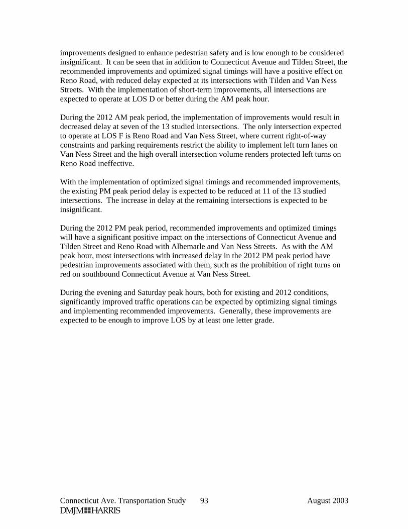
Connecticut Ave. Transportation Study August 2003 93
improvements designed to enhance pedestrian safety and is low enough to be considered insignificant. It can be seen that in addition to Connecticut Avenue and Tilden Street, the recommended improvements and optimized signal timings will have a positive effect on Reno Road, with reduced delay expected at its intersections with Tilden and Van Ness Streets. With the implementation of short-term improvements, all intersections are expected to operate at LOS D or better during the AM peak hour. During the 2012 AM peak period, the implementation of improvements would result in decreased delay at seven of the 13 studied intersections. The only intersection expected to operate at LOS F is Reno Road and Van Ness Street, where current right-of-way constraints and parking requirements restrict the ability to implement left turn lanes on Van Ness Street and the high overall intersection volume renders protected left turns on Reno Road ineffective. With the implementation of optimized signal timings and recommended improvements, the existing PM peak period delay is expected to be reduced at 11 of the 13 studied intersections. The increase in delay at the remaining intersections is expected to be insignificant. During the 2012 PM peak period, recommended improvements and optimized timings will have a significant positive impact on the intersections of Connecticut Avenue and Tilden Street and Reno Road with Albemarle and Van Ness Streets. As with the AM peak hour, most intersections with increased delay in the 2012 PM peak period have pedestrian improvements associated with them, such as the prohibition of right turns on red on southbound Connecticut Avenue at Van Ness Street. During the evening and Saturday peak hours, both for existing and 2012 conditions, significantly improved traffic operations can be expected by optimizing signal timings and implementing recommended improvements. Generally, these improvements are expected to be enough to improve LOS by at least one letter grade.