conservation and management plan for three fish species in utah
TRANSCRIPT

CONSERVATION AND MANAGEMENT PLAN FOR THREE FISH SPECIES IN UTAH
Addressing needs for Roundtail Chub (Gila robusta),
Bluehead Sucker (Catostomus discobolus), and Flannelmouth Sucker (Catostomus latipinnis)
Utah Department of Natural Resources Division of Wildlife Resources
1594 West North Temple, Suite 2110 P.O. Box 146301
Salt Lake City, Utah 84114-6301 An Equal Opportunity Employer
James F. Karpowitz Director
Publication Number 06-17 September 2006

Page 2
Table of Contents
Acknowledgements______________________________________________________ 4 Executive Summary _____________________________________________________ 5
PART 1: INTRODUCTION ___________________________________________________ 7 Purpose _______________________________________________________________ 7 Justification and Need____________________________________________________ 7 Certainty of Implementation: Staffing, Authority, and Funding __________________ 10 Certainty of Effectiveness________________________________________________ 13
PART 2: BACKGROUND____________________________________________________ 17 Geographic, Hydrologic, and Biological Setting ______________________________ 17 Species Overview ______________________________________________________ 21
ROUNDTAIL CHUB _______________________________________________________ 22 Roundtail Chub Status Review ______________________________________________ 23
General ______________________________________________________________ 23 Northeastern Region ____________________________________________________ 24 Southeastern Region ____________________________________________________ 24 Southern Region _______________________________________________________ 24
BLUEHEAD SUCKER ______________________________________________________ 29 Bluehead Sucker Status Review _____________________________________________ 29
General ______________________________________________________________ 29 Northeastern Region ____________________________________________________ 30 Southeastern Region ____________________________________________________ 30 Southern Region _______________________________________________________ 30 Northern Region _______________________________________________________ 31
FLANNELMOUTH SUCKER ________________________________________________ 37 Flannelmouth Sucker Status Review _________________________________________ 37
General ______________________________________________________________ 37 Northeastern Region ____________________________________________________ 38 Southeastern Region ____________________________________________________ 38 Southern Region _______________________________________________________ 38
PART 3: CONSERVATION APPROACH ______________________________________ 43 Geographic Management Units ___________________________________________ 43 Goal development ______________________________________________________ 44 Prioritization __________________________________________________________ 45 Annual Priorities Document ______________________________________________ 49 Criteria for Evaluation __________________________________________________ 50 Literature Cited ________________________________________________________ 53

Page 3
APPENDIX A - Conservation Goals, Objectives and Actions contained in the Range- wide Conservation Agreement for Roundtail Chub, Bluehead Sucker and Flannelmouth Sucker __________________________________________________ 64
Goal_________________________________________________________________ 64 Objectives ____________________________________________________________ 64 Conservation actions____________________________________________________ 64
APPENDIX B – Commitment Pages____________________________________________ 68 APPENDIX C – UTM coordinates for three species conservation stream reaches ______ 78APPENDIX D - Definitions ___________________________________________________ 82
List of Figures
Figure 1-1 Conservation components required for three species conservation. _____________ 16 Figure 2-1 Major streams in the state of Utah. ______________________________________ 18 Figure 2-2 Point to point and surface water diversions wthin 10 feet of streams and rivers in three species management units.___________________________________________ 19 Figure 2-3 Adult roundtail chub (Gila robusta) _____________________________________21 Figure 2-4 Adult flannelmouth sucker (Catostomus latipinnis) __________________________21 Figure 2-5 Adult bluehead sucker (Catostomus discobolus) ____________________________21 Figure 2-6 Occurrences of roundtail chub in Utah. __________________________________ 29 Figure 2-7 Occurrence of bluehead sucker in Utah. __________________________________ 36 Figure 2-8 Distribution of flannelmouth sucker in Utah. ______________________________ 42 Figure 3-1 State of Utah Hydrologic Unit Codes, Division of Wildlife Resources Regional Boundaries, and Three Species Management Units. ___________________________ 44 Figure 3-2 Prioritization process for identifying high priority projects in annual work plans. _ 47
List of Tables
Table 2-1. Distribution, status, and threats of roundtail chub in Northeastern Region. ______ 25Table 2-2. Distribution, status, and threats of roundtail chub in Southeastern Region. _______ 26 Table 2-3. Distribution, status, and threats of roundtail chub in Southern Region. __________ 27 Table 2-4. Distribution, status, and threats of bluehead sucker in Northeastern Region.______ 32 Table 2-5. Distribution, status, and threats of bluehead sucker in Southeastern Region.______ 33 Table 2-6. Distribution, status, and threats of bluehead sucker in Southern Region._________ 34 Table 2-7. Distribution, status, and threats of bluehead sucker in Northern Region._________ 35 Table 2-8. Distribution, status, and threats of flannelmouth sucker in Northeastern Region. __ 39 Table 2-9. Distribution, status, and threats of flannelmouth sucker in Southeastern Region. __ 40 Table 2-10. Distribution, status, and threats of flannelmouth sucker in Southern Region. ____ 41 Table 3-1 Knowledge assessment. _______________________________________________ 46 Table 3-2 Risk assessment._____________________________________________________ 48 Table 3-3 Opportunity assessment._______________________________________________ 49

Page 4
Acknowledgements This plan was prepared by the Utah Division of Wildlife Resources (UDWR) Native Aquatic Species Program staff in Salt Lake City: M. E. Andersen, T. N. Hedrick, T. C. Hogrefe, P. A. Miller, D. W. Speas, J. E. Thron, J. E. Wiglama, and K. Wilson. UDWR Aquatic Section Chief R. D. Radant initiated and supported the effort as did Radant’s successor, W. Donaldson. The Utah Department of Natural Resources’ Endangered Species Mitigation Fund and the U.S. Fish and Wildlife Service’s State Wildlife Grant program provided the bulk of funding to support the development of this plan.
Page 5
Executive Summary This plan is an effort to prevent the listing of three fish species (roundtail chub, bluehead sucker, and flannelmouth sucker) through proactive conservation of their populations and habitat throughout the state of Utah. Each of these species has experienced population declines in recent years due to habitat loss through water development, the introduction of nonnative species as both predators and competitors, and indirect effects brought about by these impacts. This observed decline in population numbers suggests these three species are in a situation that warrants their conservation. Because these species are not sportfish or listed species, they have historically received limited attention by wildlife management agencies. Preventing the listing of these species through proactive conservation is expected to benefit the Utah Division of Wildlife Resources (UDWR), other natural resource managers, and the communities surrounding three species habitats. This is a cooperative effort between a number of land and water resource agencies around the state. Each cooperator has a specific management authority that not only allows their participation in this effort, but also makes them essential to this process. Funding has been provided for development of this plan and the collection of baseline information through the State’s Endangered Species Mitigation Fund and the U.S. Fish and Wildlife Service’s State Wildlife Grants. This funding has been essential in completing tasks to this point and will be pursued in future years as we implement identified conservation actions. The current environment of these species is quite different from that of 100 years ago when all three species were considered common to all of their historical localities in the Colorado River Basin (Bezzerides and Bestgen 2002). Water development and diversion began with the Reclamation Act of 1902 and has progressed such that some systems in the state are highly artificial and others are at least highly impacted by varying types of surface water diversions. Especially in drought years, these diversions contribute to seasonal de-watering of entire stretches of stream after run-off flows have subsided. In addition to very different flow regimes, the community assemblage is quite different today than it was 150 years ago, after which time wildlife agencies began to stock nonnative fish species for human consumption and a source of angler recreation. In fact, only 14 species are considered native and over 60 species have been introduced (intentionally or accidentally) in the upper basin (Minckley 1991, Martinez et al. 1994, Valdez and Carothers 1998). These native fishes evolved to be specifically adapted to a very demanding and harsh environment. The human development of this environment reduced the variability of flows in the upper basin, which coupled with the introduction of competitors and previously unknown predators into the system, was detrimental to native species. Bezzerides and Bestgen (2002), the only range-wide status review for all three species suggests that impacts have been more severe for roundtail chub and bluehead sucker. In order to adequately address these impacts, UDWR has developed an approach that requires the identification of the exhaustive list of potential projects and annual prioritization of these projects based on the amount of information known in each hydrologic unit of interest, the risks posed to the three species within the hydrologic unit, and the opportunities present in each hydrologic unit. Initially, many of these prioritization steps will lead us to continue to fill in information gaps and implement actions to prevent losses of known populations. In time, when

Page 6
populations have stabilized, we will move from preventative steps to more proactive steps: establishing new populations and ensuring the persistence of each population. Criteria for success are identified as the number of populations per management unit and number of individuals per population. At this time, we have identified the number of populations required for persistence; however, the number of individuals per population needed for viability will be determined as we complete baseline surveys and subsequent analyses. If we find that this measure is too difficult to gather or too variable to effectively evaluate success, we will use a measure of population trends (i.e., increased relative abundance) to evaluate success of the project.

Page 7
PART 1: INTRODUCTION Purpose This Conservation and Management Plan (Plan) describes a strategy for identifying and implementing conservation measures for roundtail chub (Gila robusta), bluehead sucker (Catostomus discobolus), and flannelmouth sucker (Catostomus latipinnis) (henceforth referred to as the three species) and their habitats in Utah. Wildlife officials representing the states of Arizona, Nevada, Utah, New Mexico, Colorado, and Wyoming signed the Range-wide Conservation Agreement (Agreement) for the Three Species in April of 2004. Federal agencies, such as the Bureau of Land Management and National Park Service, signed the Agreement in 2005. The Agreement was meant to be a generalized schematic of conservation goals and objectives designed to expedite implementation of conservation measures for the species throughout their ranges. Subsequent to the development of the Agreement, the Utah Division of Wildlife Resources (UDWR) developed a Range-wide Conservation Strategy (Strategy) for the three species. The Strategy provides general guidance to each of the cooperators as they develop their state plans, as required by the Agreement. Range-wide objectives called for in the Agreement and reiterated in the Strategy are included in Appendix A. Justification and Need Potential for listing The three species are predominantly found in mainstem rivers and their major tributaries in the Colorado River Basin, though bluehead sucker are also found in parts of the Bonneville and Snake basins. Available data indicate that all three species have suffered significant reductions in distribution (ca. 50-55%) due to river regulation, water development, effects of invasive fish species (including hybridization with exotic fish), and regulatory neglect (Bezzerides and Bestgen 2002). All three species are now considered sensitive species in Utah (State of Utah Rule R657-481), are similarly classified or proposed for similar classification in neighboring states, and are included in the U.S. Bureau of Land Management’s (BLM) sensitive species list in Colorado, Utah, and Wyoming. The U.S. Fish and Wildlife Service (Service) Region 2 (representing Arizona, New Mexico, Oklahoma, and Texas) reports that the three species may be petitioned for listing under the federal Endangered Species Act (Act) in the foreseeable future and that they have already received a petition for listing the lower basin2 roundtail chub as a distinct population segment3. The Service responded with a “warranted, but precluded” finding that would have put the lower basin roundtail chub on the candidate4 list; however, they were asked to provide further support for the finding by the national Service office. In response, the Service, Region 2, issued a 90-day finding and is currently expected to make a ruling soon on whether or not to list the lower basin roundtail chub. Thus, the federal status on the roundtail
1 See http://www.rules.utah.gov/publicat/code/r657/r657-048.htm. State of Utah Rule R657-48. 2 The upper and lower Colorado River Basins are divided at Lee’s Ferry, Arizona, with everything upstream of Lee’s Ferry in the upper basin and everything downstream of Lee’s Ferry as the upper basin. 3 A distinct population segment is a designation below the species taxonomic level that refers to a portion of the species that is discrete with respect to the rest of the populations in the species and that is biologically or ecologically significant. 4 Candidate species are plants and animals for which the Service has sufficient information on their biological status and threats to propose them as endangered or threatened under the Endangered Species Act, but for which development of a listing regulation is precluded by other higher priority listing activities.

Page 8
chub remains uncertain at this time; however, listing, at least in the lower basin, would be a likely scenario without emphasis on conservation of roundtail chub populations. Water quantity The threats to these species are amplified by their preferred localities and habitats within the state. One or more of the three species are frequently found in mid-elevation high desert streams in Utah (i.e., the San Rafael, Price, Muddy, Duchesne and White rivers), which are characterized by approximate elevations of 4000 to 5000 feet and tend to have hot summers, cold winters, and less than 10 inches of rainfall annually. In addition, the alteration of riparian habitat over the last 200 years has allowed the invasion of the non-native tamarisk, which takes up more water than native cottonwood and willow species. The Utah State Water Plan identifies current allocations, future projected allocations based on growth and decline of certain uses, and issues and recommendations. An excerpt from the West Colorado River Basin Water plan exemplifies the problems associated with many basins in the state:
The West Colorado River Basin, like many other areas of the state, has a problem in overall supply and uses with regards to water rights. Much of the basin is over-appropriated and, as a result, late season shortages exist in many of the agricultural areas…. The San Rafael is the most over-appropriated drainage in the basin (Utah Division of Water Resources 2001).
Instream flow acquisition for the three species and other native fish in mid-elevation, high desert streams is almost nonexistent and usually dependent upon occurrence of endangered or sport fish, such as the flow recommendations for the Duchesne River intended to enhance instream habitat for Colorado pikeminnow and razorback sucker (Modde and Keleher 2003). In Utah, flow volumes in major tributary systems such as the Duchesne and Price rivers have been depleted by 47 – 52% over the past 100 years (Brunson and Christopherson 2003; Cavalli 1999) and may be developed further as long as the waterbody is able to meet its beneficial uses. Water quality The Utah Division of Water Quality assigns multiple beneficial uses to each of the state’s waterbodies and monitors them regularly to determine whether or not water quality is adequate for each of the beneficial uses. Though many of these streams are currently designated for some form of recreational use, they are also designated for agricultural use and normally do not support much sportfishing or recreational activities. Agricultural uses can often result in heavy depletions in many locations, and therefore highly degraded water quality. An increase in interest from recreation groups may help to change public opinion regarding water use issues and curtail these heavy depletions through broadening the actual beneficial uses of these streams. In addition to mid-elevation, high desert streams, bluehead sucker are found in higher elevation streams in the Bonneville Basin and Strawberry River Basin of northern Utah. Water temperatures are generally colder there than in three species streams of the Colorado River Basin. However, the Bonneville Basin, including the Bear, Ogden, and Weber rivers, is highly urbanized and highly developed with multiple dam and diversion structures (see Background section for more information). Water development projects, such as dams, have the potential to

Page 9
drop downstream water temperatures even further throughout the year, meaning that temperatures are cold on a regular basis, not only seasonally as was historically the case. Lack of information Compounding the preceding obstacles to the conservation of the three species is a near absence of historical abundance and distribution information regarding the three species. Not only were remote localities rarely sampled by wildlife agencies, information from these remote locations from members of the public are not reliable even as anecdotal information due to the historical tendency of laypersons to refer to all chubs in the Colorado River Basin (bonytail, humpback chub, roundtail chub) as “bonetails,” creating questions regarding the validity and accuracy of historical, non-agency records (Quartarone 1995). The limited historical information on these species makes determination of proper management and conservation tools difficult, especially in heavily impacted drainages. The three species are not classified as sport fish in most settings and managers have historically not collected information on these species; hence, information on them is comparatively fragmented and rare. Increasing risks from threats such as water development, nonnative fishes, and disease, combined with increasing public and professional scrutiny, have raised the levels of concern and actions for the three species concurrent with increasing potential for them to be listed. Information regarding the distribution, status, and abundance of the three species in Utah is just recently being organized (beginning in 2002) as a result of the three species project; however, prior to the initiation of the Agreement, species information in Utah was oftentimes outdated. Both mainstem and tributary habitats are likely important for these species depending on their life stage. A number of researchers have noted the home range of flannelmouth sucker tends to include both mainstem and tributary habitats (Beyers et al. 2001, Chart and Bergersen 1992, Douglas and Marsh 1998, Holden 1973, Holden and Crist 1981, Vanicek 1967), though the relationship is not clear. Snyder and Muth (1990) suggest that flannelmouth sucker will sometimes migrate depending on habitat availability and homing behaviors. In the Grand Canyon, only limited spawning habitat is present and flannelmouth sucker will travel great distances to get to these spawning locations (Weiss et al. 1998); in addition, some suggest that tributaries are important for spawning in the Grand Canyon (Douglas and Douglas 2000, Douglas and Marsh 1998, Maddux et al. 1987). It is also thought that roundtail chub and bluehead sucker likely use a combination or mainstem and tributary habitats in certain locations, though this information has not been described for any specific population of the three species in Utah. Relation to other conservation programs Distribution of the three species among both mainstem and tributary habitats is extensive and use of tributary systems for spawning, rearing, and/or adult habitat is well documented for the three species (Bestgen and Propst 1989, Carlson and Platania 1984, Cavalli 1999, Martinez et al. 1994, Miller and Rees 2000, Valdez and Ryel 1995, Wick et al. 1991). Because endangered fish recovery program activities are conducted within mainstem habitats and certain tributaries, it is expected that they will afford some amount of incidental protection or conservation measures for the three species. At this time, the Upper Colorado River Endangered Fishes Recovery

Page 10
Implementation Program (Program), the Virgin River Recovery Program (VRRP) and the San Juan Basin Recovery Implementation Program (SJRIP) provide funding for nonnative removal from mainstem habitats. The Program has funded mark-recapture efforts for flannelmouth and bluehead sucker and development of flow recommendations for tributaries to the Green River such as the Duchesne and Price rivers. The VRRP provides protection for flannelmouth sucker throughout the Virgin River system; however, this extensive protection is unusual and partially a result of the ranges of the endangered species targeted by this program. Instream flow acquisition and the idea of experimental flows to benefit endangered fishes is usually a provision of recovery programs; however, emphasis on provision of minimum flows in mainchannel and larger tributary environments for the benefit of endangered fish could lead to greater use of tributary waters in the future to make up for reductions in mainstem diversions, thus potentially jeopardizing persistence of the three species. Additional endangered species recovery programs throughout the range of the three species are implementing activities that will likely indirectly benefit the three species; please reference the state plans of Arizona, Colorado, Nevada, New Mexico, and Wyoming for this information. Benefits of the three species project Conservation of the three species will likely require habitat protection, water acquisition, and management of nonnative fish communities. Together, these conservation actions will also benefit the general public as a whole as conservation is directed towards maintenance of functionally healthy riparian ecosystems and prevention of listing under the Endangered Species Act. Fischer et al. (2000) cite multiple beneficial ecosystem functions resulting from healthy, functional riparian areas, including improved water quality, erosion control, and reduced flood peaks (O’Laughlin and Belt 1995), all of which have been shown to provide substantial benefits to human populations. Additionally, keeping regulatory authority in the hands of state, county, and local governments through the prevention of federal listing will ensure that conservation efforts can proceed more fluidly without economic hardship or conflict that may accompany regulatory protection of species. Voluntary cooperation between stakeholders and managers is thought to be more likely to occur in this atmosphere than in the more restrictive scenario engendered by listing. Certainty of Implementation: Staffing, Authority, and Funding Pursuant to the federal Policy for Evaluation of Conservation Efforts (PECE) guidelines, UDWR acknowledges the need to demonstrate a degree of certainty that this Plan will be implemented and will be effective in preventing the need for listing the three species. Staffing Personnel from the UDWR Native Aquatics Program will implement aspects of this Plan. Within the UDWR, three full time employees are tasked with various types of administrative three species tasks such as procuring funding, planning conservation activities in coordination with regional offices, completing conservation documents and proposals with input from regional offices, and performing other administrative duties necessary to implement the Plan. Regional and UDWR field offices are located in St. George, Moab, Ogden, Price, and Vernal. These offices include at least one and as many as three full time employees charged with developing

Page 11
work plans for implementing this Plan. Funds are regularly made available for seasonal help to complete fieldwork. Authority Some cooperative opportunities with other agencies that hold management responsibilities for the land and water immediately surrounding these species’ habitats have been established; others are being pursued at this time. These core managers are currently meeting at least twice a year, once to discuss range-wide priorities and once to discuss statewide priorities. These agencies are committed to providing consistent representation to this “Three Species Conservation Team” (Team) and to working towards conservation of these three species and have the authority to do so as outlined in Appendix B. In the future, as more specific conservation and management actions are identified and planned, additional stakeholder groups will be invited to participate. A list of cooperating agencies and their roles in participating in this Plan is presented below.
• National Park Service, including Canyonlands, Capitol Reef, Dinosaur, and Zion national parks and Glen Canyon National Recreation Area. Plan review and comment; data sharing; goals development; potential funding for specific actions.
• Navajo Nation. Plan review and comment; data sharing; goals development; potential
funding for specific actions. • The Nature Conservancy. Plan review and comment; data sharing; goals
development; potential funding for specific actions. • U.S. Bureau of Land Management, Utah State Office. Grand Staircase-Escalante
National Monument. Plan review and comment; data sharing; goals development, especially in managed habitats; potential funding for specific projects.
• U.S. Bureau of Reclamation, Upper Colorado River Office. Plan review and
comment; data sharing; goals development; potential funding for specific actions; potential management coordination, especially with regard to dam operation.
• U.S. Fish and Wildlife Service, Utah Field Office. Plan review and comment; data
sharing; goals development; potential funding for specific actions. • U.S. Forest Service, Ashley, Manti-La Sal, and Wasatch-Cache National Forests. Plan
review and comment; data sharing; goals development; potential funding for specific actions.
• UDWR, Aquatics and Habitat sections. Plan review and comment; data sharing; data
management; goals development; database development and updating; management coordination and implementation.
• Ute Tribe. Plan review and comment; data sharing; goals development; potential
funding for specific actions.

Page 12
Additional Signatories In the future, additional signatories may be added to this Plan. Any edits proposed by potential conservation partners that will allow them to sign this Plan and participate in conservation actions will be carefully considered and may be incorporated with the consensus of the existing signatories. This Plan may be amended at any time to include additional signatories. An entity requesting inclusion as a signatory shall submit its request to the Team in the form of a document defining its proposed responsibilities pursuant to this Plan. Cooperator Roles Though UDWR personnel will assume primary responsibility for implementation, the cooperating agencies will be welcome to provide review, suggestions, and funding; participate in fieldwork and research; and otherwise participate in coordination meetings to be held at least twice yearly: in November to discuss range-wide priorities and again before the following field season to develop annual Statewide priorities and report on prior year activities. Ideally, this second meeting would occur at a time when biologists can report on information collected the previous year and also at a time when the Team will still have plenty of time to identify priority projects for the upcoming field season for submittal to various grant programs. The UDWR has the responsibility and authority to develop a conservation and management plan consistent with the goal and objectives of the Range-wide Agreement and to establish and maintain an adequate and active program for the conservation of the three species. The UDWR has specific statutory responsibilities, particularly with respect to the management and conservation of the three species; their habitat; and the management, development, and allocation of water resources (Title 23-13-35 of the Utah Code provides that all wildlife within the State of Utah is the property of the State). This Plan is subject to and is intended to be consistent with all applicable Federal and State laws and interstate compacts. Implementation Plans In certain instances, agencies or entities may wish to participate without becoming official signatories to this Plan. In these cases, it will be possible for an agency or entity to participate in the development and execution of an implementation plan for specific hydrologic units or streams. In this way, an entity such as a water conservancy district that may be a significant component for project success, can participate in an official capacity at a more specific level, where they will have the greatest interest to participate. Funding The UDWR will apply for funding to support this plan during the years 2005 through 2010 from federal State Wildlife Grants (SWG) with matching funds from the Utah Department of Natural Resources’ Endangered Species Mitigation Fund (ESMF). The U.S. Bureau of Reclamation (Reclamation), and the Bureau of Land Management (BLM) have granted additional funding during the state fiscal years 2004, 2005, and 2006 and the federal fiscal year 2004 and 2005. Funding for future years will be sought from these and other appropriate sources through the request for proposals grant process of various grant programs.
5 See http://www.le.state.ut.us/~code/TITLE23/TITLE23.htm. Utah State Code Title 23-12-3.

Page 13
Certainty of Effectiveness The UDWR acknowledges and supports the principle that documented progress toward stable and increased distribution, abundance, and recruitment of populations of the three species constitutes the primary index of effectiveness of this conservation program. Conservation efforts implemented will be appropriate for the known threats to each population as identified through population and habitat surveys, many of which are already underway and included in the following chapters. Objectives and Conservation Actions: A step-by-step process to address threats The list of all potential conservation efforts is included in a separate document entitled, “Objectives and conservation actions for the three species: Annual priorities for the State of Utah conservation and management plan for the roundtail chub, bluehead sucker, and flannelmouth sucker” (Annual Priorities), which the Team will use as guidance through the life of the Agreement. The Annual Priorities document identifies the objectives and the conservation needs for the three species by 8-digit Hydrologic Unit Code (HUC). The Team will review the project list and go through a prioritization process (discussed in detail later in this text) internally each year before submittal of funding proposals. Team members will then meet to discuss the top projects on the list and approve those that will be included in each Team member’s annual workplans. The number of top priority projects for each year will be dependent upon the amount of expected funding for the upcoming year and the cost of each of the top priority projects. Each participating region in the UDWR is expected to participate in at least one, if not multiple projects to address threats to the species each year. Other Team members will incorporate three species projects as identified through the prioritization process. Three species cooperators will revisit the Annual Priorities document at the end of each calendar year to determine whether any projects need to be removed from or added to the list.
Required components Regular surveying of populations is identified as a conservation action under the Range-wide Agreement. In addition to serving the conventional purposes of identifying baseline conditions and assessing impacts of management actions, this method of evaluation of conservation actions is also necessary to fulfill the PECE criteria regarding effectiveness of a conservation program; thus, it is necessary to 1) provide evidence of population stability; 2) provide information to direct future management (adaptive management), another PECE criteria; and 3) assess cost effectiveness of actions. Other conservation actions identified in the Agreement and reiterated in the Strategy include development of a database to track all monitoring information; research on and identification of life history, habitat requirements, and conservation needs; genetic and morphological characterization of populations; range expansion; population enhancement; habitat enhancement; nonnative control; and outreach (see Figure 1-1). Each of these activities is an essential component in the overall conservation of each of these species. Certain components may not be necessary for each species or in each management unit; however, no one component will be disregarded for a species unless agreed upon through consensus of the Team members.
Page 14
Timeline • 2005 – 2009: Identify and fill information gaps. If the status of a population, drainage, or
stream or the number of populations in a given management unit is unknown, we will conduct baseline surveys. In addition, we will identify the population size or number of occupied stream miles needed in each management unit to maintain persistence. We will also evaluate and determine population boundaries for each species and incorporate genetic information into delineation of management units. Each of these details will aid the Team as they assess progress during the fifth and tenth years of the Agreement (2009 and 2014).
• 2005 - indefinite: Prevent losses of known populations. If we determine through baseline
surveys that numbers and sizes of populations per management unit are sufficient and stable, we will prevent the loss of these populations through protection of the current situation if threats are currently minimal, or identification and reduction of threats in systems where threats are more immediate. Reduction of threats will be through conservation actions deemed appropriate for the type and severity of threats in the management unit, as identified through baseline surveys.
• 2006: Formulate management objectives for drainages where information is sufficient to
do so and begin management. The three species cooperators have begun formulating specific conservation and management actions for each species in each drainage. This list, which can be found in the Annual Priorities document, will be finalized by December 2006 for incorporation into the prioritization process at the 2007 annual meeting. This list will be updated and referred to each year for identification of three species projects that year. Each management unit will have a separate timeline for implementation of conservation activities within the unit. The document will be reviewed and updated as new information is gathered.
• 2008 - 2012: Establish and enhance additional populations, where appropriate and as
needed (no net loss). If sufficient population numbers do not exist to meet objectives for a given management unit, we will establish new populations and expand existing populations in those areas as needed. If a population is lost in one area of the management unit and we are unable to minimize threats in that same location at that time, the Team can choose to restore the species to another location within the management unit to fulfill the success criteria.
• 2008 - indefinite: Create self-sustaining populations. Efforts that prevent the loss of or
establish new populations will continue through implementation of activities that ensure the persistence of these populations. The goal of all conservation activities is to create and/or maintain three species populations such that all existing populations are self-sustaining and not in need of augmentation. Where required, this includes maintenance or re-establishment of connectivity necessary to maintain metapopulations as called for under Objective 3 of the Agreement (“establish and/or maintain sufficient connectivity between populations so that viable metapopulations are established and/or maintained”).

Page 15
• Ongoing: Pursue ways to reduce threats that emphasize voluntary participation of
stakeholders. We will work with local communities to build an atmosphere of trust in order to work towards common goals that will also benefit the three species. Working to elicit voluntary participation of local governments and stakeholders to improve habitat for the three species should provide the most effective, long-term assurance that threats facing that population are reduced or eliminated.
Evaluating success The Team will evaluate success of the project at the five-year and ten-year marks (2009 and 2014). Determination of success will be dependent upon whether or not the appropriate number of populations have been established and stabilized in each 4-digit HUC, not based upon whether or not all potential projects have been completed. In fact, cooperators do not intend to complete each of the projects listed in the Annual Priorities to be able to consider the effort a success.

Page 16
GeneticIntegrity
BaselineConditions
NonnativeControl
RangeExpansion
HabitatEnhancement Monitoring
Three SpeciesConservation
Assess populations(define historical andcurrent distribution)
Identifyhabitatfragmentation
Determinerequirements forviable populations
Restorehydrologicconnections
Monitor populationtrends
Evaluate populationsand habitat
Maintain database
Determine lifehistory requirements Enhance and restore habitat
(BMPs, riparian fencing, bankstabilization)
Protect habitat(regulations, landuse changes, conservationeasements)
Detect hybridization
Determinerelatednessof populations
Developreintroductionand transplantprotocols
Eradicatenonnatives
Control spreadof nonnatives
Determinenegativeinteractions
Establish new populationsvia translocations
Develop translocation methods
Develop propagation techniques
Figure 1-1 Conservation components required for three species conservation

Page 17
PART 2: BACKGROUND
Geographic, Hydrologic, and Biological Setting Utah’s major streams and rivers are identified in Figure 2-1. One or more of the three species are found in the Green River and its tributaries such as the Duchesne in the Utah Division of Wildlife Resources (UDWR) Northeastern Region; the Price, San Rafael, Escalante, Dolores, and San Juan rivers and Muddy Creek in the UDWR Southeastern Region; the Escalante, Fremont, and Virgin rivers in the UDWR Southern Region; and the Weber, Ogden, and Bear rivers in the UDWR Northern Region. Each of the three species is also found in the mainstem Colorado River, though roundtail chub is currently considered rare in most mainstem locations. Only flannelmouth sucker are found in the Virgin River Basin, which is located within the Lower Colorado River Basin. Only bluehead sucker are found in the Bonneville Basin. Occurrences in these locations are historical only except for the Weber River where they are considered quite rare. Geographic, hydrologic, and biological characteristics of these basins are briefly described in the following sections as well as in the Range-wide Conservation Agreement and Strategy. Altered hydrologic systems Historically, flows, temperatures, and sediment loads of these systems varied widely on both intra- and inter-annual time scales in relation to wet and dry climatic regimes. These variable characteristics remain today only in the remote locations such as the Escalante and Paria rivers that lack water development structures such as power, storage, and diversion dams. Today, water development in high desert tributary streams in Utah is extensive (Cavalli 1999; Walker and Hudson 2004) (see Figure 2-2) and has likely lead to severe habitat fragmentation, disruption of native fish metapopulation dynamics, and has led to population declines due to extreme habitat degradation. While negative effects of dams on mainstem native fish communities are well documented (Berry 1988, Berry and Pimentel 1985, Childs and Clarkson 1996, Clarkson and Childs 2000, Collier et al. 1996, Haines et al. 1998, Kaeding and Osmundson 1988, Robinson et al. 1998a, Robinson et al. 1998b), lack of water in high desert tributary drainages resulting from water development for municipal, agricultural, and industrial purposes is perhaps the most severe threat to persistence of three species populations in Utah (Cavalli 1999, Walker and Hudson 2004). A large number of studies have linked habitat fragmentation or the fragmented distribution of species to declines in population size and/or increases in extinction risk (Cox et al. 2004, Davies et al. 2000, Fagan et al. 2005, Jager et al. 2001, Knapp et al. 2003, Morita and Yamamoto 2002, Robinson et al. 1995). Currently, the presence of diversions and dams limits fish movement either by creating an obstruction to passage between reaches or by dewatering tributary reaches entirely. Impacts of disrupted movement on the three species, particularly flannelmouth sucker and roundtail chub, include inability to escape the harsh environmental conditions brought on by dewatering itself (loss of water, high temperatures, low oxygen; Walker and Hudson 2004) and blocked seasonal movements to habitats important to various life stages of the species (Chart 1987, McKinney et al. 1999). Like many states in the west, all surface flows are diverted at some point, and in the state of Utah, these surface water diversions are plentiful. Figure 2-2 shows all point-to-point and surface water diversions within 10 feet of streams or springs within the range of the three species. This map does not display the entire extent of diversions within the state. The Utah Division of Water Rights’ GIS data show over 12,000 total point-to-point and surface diversions within the Weber

Page 18
Figure 2-1 Major streams in the state of Utah.

Page 19
Figure 2-2 Point to point and surface water diversions within 10 feet of streams and rivers in three species management units. The upper Colorado and lower Colorado designations on this map are USGS Hydrologic Unit Cataloguing designations and are not the same as the upper and lower Colorado Basin political divisions mentioned earlier in the document. Different colored circles represent diversion points in different management units.
Page 20
Basin, nearly 12,000 within the Bear River drainage, and over 21,000 within the entire Green River Basin in Utah. These are the most extreme basins in terms of number of diversions and most three species drainages have only 1000 to 5000 diversions (Utah Division of Water Rights6). It is important to note that not all of these diversions are substantial; however, even the smallest diversions can impact native fish through entrainment and fragmentation, and when taken together, the cumulative impacts can potentially be severe. Most streams in the Colorado River Basin provide irrigation water for hundreds of thousands of acres of crops and only small amounts of water for municipal and industrial uses. Moving north, however, into the Bonneville Basin and the Bear and Weber River systems, which support limited bluehead sucker populations, the situation is quite different. Hydrology of the Bonneville Basin streams is largely regulated by mainstem impoundments intended for water allocation purposes and flood control. The Bear River has three power dams, 13 storage/diversion dams, and over 50 diversions of various sizes and various uses from its headwaters, north into Wyoming and Idaho, and south to its endpoint at the Great Salt Lake in Utah. The Weber River does not have as many diversions; however, it is heavily regulated by water development projects, large interbasin transfers, and three storage reservoirs. Though more water from this basin is used for agricultural than municipal uses, the population of this basin is significantly higher than those found in the less populated Colorado River Basin streams. Timing of these diversions can also be problematic. In Utah, surface flow is generally at its lowest in July and August, which is often when diversions are most needed. Timing issues such as these, can contribute to the de-watering of streams, such as happened in 2004 in Muddy Creek (Walker and Birdsey 2005). The de-watering of this stream section likely “prevented downstream escapement of resident fish and it is unlikely that these fish survived the …dewatering” (Walker and Birdsey 2005). In order to prevent this scenario, Walker and Birdsey (2005) suggest coordinating water use in drainages where de-watering has recently been documented to reduce the potential for isolating upstream stretches. Nonnative predators and competitors The Colorado River has a predominant endemic fish population (42 of 49 species; of the total 49, only 14 were found in the upper basin) that is very specifically adapted to a harsh and highly variable environment (Hoetker and Gobalet 1999, Minckley et al. 1986, Smith 1981). Speciation and diversification in the Colorado River Basin was very limited in comparison with the eastern United States where hundreds of species of fishes can be found in each state (Starnes and Etnier 1986). Because speciation was so limited, these fishes never had to adapt to large numbers of predators and competitors. Thus, they have had a great deal of difficulty adjusting to the purposeful (i.e., for sportfishing purposes) and accidental (e.g., baitfish and biological control) introduction of at least 72 nonnative species of fishes throughout the basin (Behnke 1980, Minckley et al. 1986, Ono et al. 1983). These introductions have negatively impacted the native fishes of the Colorado River Basin (Carlson and Muth 1989, Lentsch et al. 1996, Martinez et al. 1994, Minckley 1991, Tyus and Saunders 1996, Valdez and Carothers 1998) through predation (Douglas and Marsh 1998, Nesler 1995, Ruppert et al. 1993, Tyus and Nikirk 1990), competition and trophic interactions (Lamarra 1999, Osmundson 1999), introduction of nonnative pathogens (Bezzerides and Bestgen 2002, Heckmann et al. 1993,Robinson et al. 1998b,) and hybridization (Douglas and Douglas 2000, Holden and Stalnaker 1974). Some researchers have suggested that
6 http://www.waterrights.utah.gov/gisinfo/. Utah Division of Water Rights GIS website.

Page 21 natives cannot survive in the presence of any nonnatives and thus recommend management options to this effect (Clarkson et al. 2005).
Species Overview The three fish species are all in the order Cypriniformes. Roundtail chub (Figure 2-3) are in the family Cyprinidae, the minnows. Flannelmouth sucker (Figure 2-4) and bluehead sucker (Figure 2-5) are in the family Catostomidae, the suckers. Common characteristics of endemic, large-river fish including the three fish species, are: 1) fusiform bodies, 2) humped or keeled dorsal surfaces (only present in the endangered Colorado River species, not the three species), 3) leathery skins with embedded scales, and 4) large, often falcate, fins. Such morphological features, combined with relatively long life spans, are thought to be
adaptations to the harsh, unpredictable physical environment of the Colorado River Basin (Bezzerides and Bestgen 2002, Minckley 1991, Scoppettone 1988, Stearns 1993). All three species reach relatively large sizes (ca. 300 – 500 mm), are relatively long-lived, and are thought to require only sporadic recruitment to maintain population stability. Of the three fish species, flannelmouth sucker can
demonstrate long-range movement (ca. hundreds of stream miles) throughout the course of their lives, which is not generally observed for the other two species (Bezzerides and Bestgen 2002). The two catostomids are primarily benthic feeders (Banks 1964; Childs et al. 1998; Grabowski and Hiebert 1989; Greger and Deacon 1988; Minckley 1973; Muth and Snyder 1995), whereas adult roundtail chub are frequently omnivorous and can be piscivorous and insectivorous as large juveniles and adults (Bestgen 1985; Karp and Tyus 1990; Koster 1957; McDonald and Dotson 1960; Neve 1976; Schreiber and Minckley 1981; Rinne 1992; Tyus and Minckley 1988; Vanicek and Kramer 1969). Additional life history characteristics, distribution and abundance have been described in numerous texts and publications for roundtail chub (Bestgen and Propst 1989, Brouder et al. 2000, Voeltz 2002), flannelmouth sucker (Chart 1987, Douglas and Marsh 1998, McKinney et al. 1999), and bluehead sucker (e.g., Bestgen 2000, Cavalli 1999, Holden and Minckley 1980, McAda 1977, McAda and Wydoski 1983). Bluehead sucker are also discussed in Brunson and Christopherson (2001), Jackson (2001), Mueller et al. (1998), and Valdez (1990).
Figure 2-3 Adult roundtail chub (Gila robusta)
Figure 2-4 Adult flannelmouth sucker (Catostomus latipinnis)
Figure 2-5 Adult bluehead sucker (Catostomus discobolus)

Page 22 Flannelmouth and bluehead sucker have most often been recorded in large rivers, though tributary occurrences are often observed for both species (McAda et al. 1977; Fridell et al. 2004; Morvilius and Fridell 2005; Walker and Hudson 2004; Walker and Birdsey 2005). It is currently thought that they also use tributary streams for one or more life history stages (Maddux and Kepner 1988, Weiss et al. 1998). In the past, roundtail chub were observed in mainstem habitats. Today, they are much more prevalent in larger tributaries, but not necessarily in the mainstem habitats (Voeltz 2002). Historical literature suggests that these three fishes were common to all of their historical localities within the Colorado River Basin up until the 1960s (Jordan and Evermann 1902, Minckley 1973, Sigler and Miller 1963). There had been no range-wide distribution or status assessments for any of these three species preceding the review of Bezzerides and Bestgen (2002); however, Voeltz (2002) offers a comprehensive status survey of roundtail chub in the lower basin.
ROUNDTAIL CHUB Roundtail chub utilize slow moving, deep pools for cover and feeding. These fish are found in the mainstem of major rivers in addition to smaller tributary streams. They use a variety of substrate types (silt, sand, gravel, and rocks) and prefer murky water to clear (Brouder et al. 2000, Sigler and Sigler 1996). Roundtail chub partition habitat use by life stage [adult, juvenile, young-of-year (YOY)]. Juveniles and YOY are found in quiet water near shore or backwaters with low velocity and frequent pools rather than runs and riffles. Juveniles avoid depths greater than 100 cm and YOY avoid depths greater than 50 cm. Juveniles use instream boulders for cover, while YOY are found in interstices between and under boulders or the slack-water area behind boulders (Brouder et al. 2000). Adults generally do not frequent vegetation and avoid shallow water cover types (overhanging and shoreline vegetation) (Brouder et al. 2000, Sigler and Sigler 1996). Adults are found in eddies and pools adjacent to strong current and use instream boulders as cover (Brouder et al. 2000, Sigler and Sigler 1996). Adults occupy depths greater than 20 cm and select for velocities less than 20 cm/s. Adults commonly move 100 m or less over the course of a year, often in search of pool habitats (Brouder et al. 2000). Roundtail chub mature at five years of age and/or 254 mm to 305 mm in length. Spawning begins in June to early July when water temperatures reach 18.3°C. Eggs from one female may be fertilized by three to five males over gravel in water up to 9.1 m. A 305 mm female can produce 10,000 eggs, 0.7 mm in diameter. The eggs are pasty white and adhesive, sticking to rocks and other substrate or falling into crevices (Sigler and Sigler 1996). Roundtail chub are omnivorous, opportunistic feeders. Documented food items include aquatic and terrestrial insects, fish, snails, crustaceans, algae, and occasionally lizards (Bestgen 2000, Osmundson 1999, Sigler and Sigler 1996). Potential hybridization among Gila species in the Colorado River Basin has caused management agencies to carefully consider their conservation actions. In Utah, hybridization between

Page 23 humpback chub (Gila cypha) and bonytail (G. elegans) in Desolation and Gray Canyons of the Green River has been postulated by many observers (Douglas et al. 1998, Kaeding et al. 1990, Valdez and Clemmer 1982). Whether biologists and agencies recognize two species, two species and a hybrid form, three species, or some other combination has implications for how the fish are managed. Because roundtail chub are congeners with humpback chub and bonytail, the potential for hybridization between the species exists, though it has not been as well documented as humpback chub/bonytail hybrids. Valdez and Clemmer (1982) have suggested that hybridization is a result of dramatic environmental changes, while Dowling and DeMarais (1993) suggest that hybridization among these species has occurred continually over geologic time, providing additional genetic variability. Barriers to hybridization among some Gila species may illustrate that it is a paraphyletic genus (Coburn and Cavender 1992 and references therein). Roundtail chub in the Gila River drainage of New Mexico and Arizona was recently divided into three species, G. robusta, G. intermedia, and G. nigra through genetic analysis (Minckley and DeMarais 1990). Additional investigation of these relationships and resulting offspring is needed and may affect future conservation and management actions for roundtail chub and other Gila species. The Virgin chub (G. seminuda) found in the Virgin River has been historically treated as a subspecies of roundtail chub (Maddux et al. 1995) and is thought to have originated through hybridization between the bonytail and the Colorado roundtail chub (Maddux et al. 1995, Sigler and Sigler 1996 and references therein). In 1993, taxonomic revisions were accepted, and the Virgin chub was asserted species status as G. seminuda (Maddux et al. 1995). It is currently listed as endangered under the federal Endangered Species Act. Roundtail chub presently exist in the United States only in the Gila River Basin, the Little Colorado River Basin, the Bill Williams River Basin, and the Upper Colorado River Basin, including the Green River Basin. Lee et al. (1980) also recorded occurrences in northern Mexico, which was anecdotally confirmed by personal communications in 2001 with S. Contreras-Balderas (Bioconservacíon A.C., Monterrey, Nuevo Leon) and A. Varela-Romero (Universidad de Sonora, Hermasillo). In Utah, roundtail chub occur in the Green and Colorado rivers and major tributaries of the two. Historically, roundtail chub were found in all of the state’s major drainages, though abundance information was not recorded (see Figure 2-6) (UDWR 2001). Roundtail Chub Status Review General Historical literature suggests that roundtail chub were common to all parts of the Colorado River Basin up to the 1960’s (Jordan and Evermann 1902, Minckley 1973, Sigler and Miller 1963). They are believed to have occurred in most faster flowing rivers and streams below 2,300 meters elevation (Bezzerides and Bestgen 2002). While they continue to occupy a number of rivers and streams in the upper basin, declines in numbers and relative abundance have been observed in many of these locations (Bezzerides and Bestgen 2002, Brunson and Christopherson 2003, Platania 1990).

Page 24
Northeastern Region
Roundtail chub abundance in the mainstem Green River and associated tributaries has declined since the installation of multiple water development projects beginning in 1902 (Bezzerides and Bestgen 2002). In addition to water development, the introduction of nonnative predators and competitors over the same time period has proven to be detrimental to the roundtail chub (Bezzerides and Bestgen 2002) as have the presence of oil exploration projects within the drainage. Roundtail chub were described as abundant in the Duchesne River as late as 1975 (Holden and Stalnaker 1975) and common in 1982 (Tyus et al. 1982), but have since declined in numbers (Brunson and Christopherson 2003). In the White River, oil exploration projects and the presence of non-natives are the largest problems. Roundtail chub were considered abundant in the White River in 1975 (Holden and Stalnaker 1975), but only relatively common in 1981 (11% of catch; Lanigan and Berry 1981) and 1982 (8-10% of catch; Miller et al. 1982). Flaming Gorge Dam is thought to have impacted roundtail chub at three sites: Willow Creek, Little Hole, and Brown’s Park. Roundtail chub were found at these locations in 1962, but not in 1964, 1965, 1966, or 2004 (UDWR 2005). Detailed information regarding the historical and current status of roundtail chub and associated threats from UDWR data is found in Table 2-1. Southeastern Region Though accounts of roundtail chub in this region are somewhat rare, recent information suggests that roundtail chub were present, but never abundant in mainstem habitats such as the lower Green, San Juan, and Colorado rivers; present in the Price, San Rafael, and upper Dirty Devil rivers (Tyus et al. 1982, Holden and Stalnaker 1975, Bezzerides and Bestgen 2002); and abundant in the Dolores River (Bezzerides and Bestgen 2002). Cavalli (1999) suggests that roundtail chub may have been extirpated from the Price River due to low flows in 1977 and 1993, a localized rotenone detoxification problem in 1977, and/or pollution-caused fish kills that have occurred in the past 20 years. Current surveys in the Price River seem to support this hypothesis. Although roundtail chub were observed in the San Rafael River during 2005, they were rare. This rarity and the absence of roundtail chub during 2004 surveys may be indicative of a decline in abundance within the drainage (Walker and Hudson 2004). Cavalli (1999) suggests that roundtail chub are slow to re-populate unoccupied habitats; therefore, roundtail chub may not move back into de-watered habitats until many years after habitat is suitable again. Detailed information regarding the historical and current status of roundtail chub and associated threats is found in Table 2-2. Southern Region Roundtail chub were thought to be historically present in the Escalante and Fremont rivers (Bezzerides and Bestgen 2002) and continue to be observed in the Escalante River (Fridell et al. 2004; Morvilius and Fridell 2005). Recent accounts in the Escalante River suggest that nonnatives pose a limited threat and that de-watering, pollution, and disease also likely pose threats to their presence in parts of the Escalante (Mueller et al. 1998). Detailed information regarding the historical and current status of roundtail chub and associated threats is found in Table 2-3.

Page 25
Table 2-1. Distribution, status, and threats of roundtail chub in Northeastern Region. UTM coordinates are available in Appendix C. Abundance class can be abundant (>50 individuals/100m), moderate or present (10-50 individuals/100m), rare (<10 individuals/100m), not present, or unknown. Historical information taken from the Utah Division of Wildlife Resources Natural Heritage Database.(UDWR 2001)
Drainage Stream Name Reach HUC
Current Abundance
Class Last
SurveyedLast
Observed Historically
present Population
reproducing? Threats Green River Green River Split Mountain to Sand Wash 14060001 Rare 2004 2004 Y N Nonnative presence
Island Park to Split Mountain 14060001 Moderate 2004 2004 Y N Nonnative presence
Green River North Slope Cart Creek Mouth to 1/10 mile upstream 14040106 Not Present 2002 U Y N
Dams, Lack of habitat, Nonnative presence
Carter Creek Mouth to 1/10 mile upstream 14040106 Not Present 2002 U Y N Dams, Lack of habitat, Nonnative presence
Ashley Creek Ashley Creek NOT DEFINED TO DATE 14060002 Not Present 1986 1975 Y N Diversion
Duchesne River
Duchesne River Mouth to Myton 14060003 Moderate 2004 2004 Y Y Diversion, Nonnative presence
1.5 miles upriver from Bridgeland bridge 14060003 Not Present 2004 U Y N Diversion, Nonnative presence Bridgeland bridge 14060003 Not Present 2004 U Y N Diversion, Nonnative presence South of Lake Boreham 14060003 Not Present 2004 U Y N Diversion, Nonnative presence Uinta River 14060003 Not Present 2005 1975 Y N Diversion, Nonnative presence
Lake Fork River ~2 miles south of Upalco 14060003 Not Present 2005 U Y N Diversion, Nonnative presence
Strawberry River Confluence with Starvation Reservoir 14060004 Not Present 2004 U Y N Diversion, Nonnative presence
First bridge above Starvation Reservoir 14060004 Not Present 2004 U Y N Diversion, Nonnative presence Second bridge above Starvation Reservoir 14060004 Not Present 2004 U Y N Diversion, Nonnative presence Third bridge above Starvation Reservoir 14060004 Not Present 2004 U Y N Diversion, Nonnative presence UDWR WMA property 14060004 Not Present 2004 U Y N Diversion, Nonnative presence Red Creek Confluence upstream 14060004 Not Present 2004 U Y N Diversion, Nonnative presence
Avintaquin Creek Vanderhoof property above tribal land 14060004 Not Present 2001 U Y U Nonnative presence
Currant Creek Currant Creek lodge 14060004 Not Present 2002 U Y N Diversion, Nonnative presence Bill Probst property 14060004 Not Present 2002 U Y N Diversion, Nonnative presence Confluence with Red Creek upstream 14060004 Not Present 2002 U Y N Diversion, Nonnative presence Red Creek Confluence with Strawberry upstream 14060004 Not Present 2002 U Y N Diversion, Nonnative presence
Rock Creek ~1 mile upstream of confluence with Duchesne 14060004 Not Present 2005 U U N Diversion, Nonnative presence
White River White River Cowboy Canyon to Bonanza Bridge 14050007 Rare 2004 2004 Y Y Diversion, Nonnative presence
Willow Creek NOT DEFINED TO DATE 14050007 Unknown 2004 U Y U Lack of habitat, Nonnative presence
Bitter Creek NOT DEFINED TO DATE 14050007 Unknown 1999 1981 Y N Lack of habitat, Nonnative presence

Page 26
Table 2-2. Distribution, status, and threats of roundtail chub in Southeastern Region. Abundance class can be abundant (>50 individuals/100m), moderate or present (10-50 individuals/100m), rare (<10 individuals/100m), not present, or unknown. Historical information taken from the Utah Division of Wildlife Resources Natural Heritage Database (UDWR 2001).
Drainage Stream Name Reach HUC
Current Abundance
Class Last
surveyedLast
observed Historically
present Population
reproducing? Threats
Green River Green River Mouth to Tusher diversion 14060005 Rare 2003 U Y N Hybridization, lack of habitat, nonnative presence
Tusher diversion to Sand Wash 14060005/14060008 Moderate 2005 2005 Y Y Hybridization, nonnative Presence
Price River Price River below Farnham reach 1 14060007 Not present 2004 U Y N Lack of habitat, nonnative presence below Farnham reach 2 14060007 Not present 2004 U Y N Lack of habitat, nonnative presence below Farnham reach 3 14060007 Not present 2004 U Y N Lack of habitat, nonnative presence
below Farnham reach 4 14060007 Not present 2004 U Y N Diversion, lack of habitat, nonnative presence Farnham dam to Milner's diversion 14060007 Not present 2004 U Y N Diversion, lack of habitat, nonnative presence
Milner's diversion to golf course diversion 14060007 Not present 2004 U Y N Diversion, lack of habitat, nonnative presence
Golf course diversion to Willow Creek confluence 14060007 Not present 2004 U Y N Diversion, lack of habitat, nonnative presence
San Rafael River San Rafael Mouth to Hatt Ranch diversion 14060009 Not present 2003 U Y N Diversion, water quality, lack of habitat, nonnative presence
Hatt Ranch diversion to swinging bridge above canyon 14060009 Unknown 2003 U Y U Diversion, damming, nonnative presence
Swinging bridge to confluence of Huntington and Ferron Creeks 14060009 Rare 2005 2005 Y U Diversion, nonnative presence
Cottonwood Mouth to diversion at Hwy 57 14060009 Not present 2003 U Y N Diversion, nonnative presence
Hwy 57 diversion to Joe’s Valley Reservoir Dam 14060009 Not present 2003 U Y N Diversion, nonnative presence
Huntington Mouth to Chevron pumping station (end of habitat) 14060009 Not present 2003 U Y N Diversion, nonnative presence
Ferron Mouth to swinging bridge barrier east of Hwy 10 14060009 Not present 2003 U Y N Diversion, nonnative presence Colorado River Colorado River Glen Canyon Dam to Below Cataract Canyon 14070001 Not present 2004 U Y N Dams, Lack of habitat, nonnative presence Cataract Canyon 14070001 Rare 2004 2004 Y N Hybridization, nonnative presence
Cataract Canyon to below Westwater Canyon 14030005/14070001 Rare 2004 2004 Y N Hybridization, Lack of habitat, nonnative presence
Westwater Canyon through State line 14030001/14010005 Abundant 2004 2004 Y Y Hybridization, nonnative presence
San Juan River San Juan River Colorado River confluence to Clay Hills 14080205 Not present 2004 U Y N Lack of habitat, nonnative presence Clay Hills to Sand Island 14080205 Not present 2004 U Y N Lack of habitat, nonnative presence Sand Island to state line 14080201 Not present 2004 U Y N Lack of habitat, nonnative presence Dirty Devil River Dirty Devil River Mouth to confluence with Fremont 14070004 Not present Y N Unknown Muddy Creek Muddy Creek Mouth to Salt Wash Confluence 14070002 Not present 2004 U U N Diversion, nonnative presence Salt Wash Confluence to Ivie Creek Confluence 14070002 Not present 2004 U U N Diversion, nonnative presence
Ivie Creek Confluence to diversion at USFS boundary 14070002 Not present 2004 U U N Diversion, nonnative presence
Ivie Creek Mouth to confluence with Quitchupah Creek 14070002 Not present 2004 U U N Diversion
Confluence with Quitchupah Creek to Confluence with Oak Spring Creek 14070002 Not present 2004 U U N
Quitchupah Creek Mouth to Browning Mine 14070002 Not present 2004 U U N Diversion, water quality
Dolores River Dolores River Mouth to state line 14030004 Unknown 2005 U Y U Hybridization, lack of habitat, nonnative presence

Page 27
Table 2-3. Distribution, status, and threats of roundtail chub in Southern Region. Abundance class can be abundant (>50 individuals/100m), moderate or present (10-50 individuals/100m), rare (<10 individuals/100m), not present, or unknown. Historical information taken from the Utah Division of Wildlife Resources Natural Heritage Database (UDWR 2001).
Drainage Stream Name Reach HUC
Current Abundance
Class Last
surveyed Last
observed Historically
present Population
reproducing? Threats Fremont River
Fremont River
BLM land just east of Capital Reef National Park 14070003 Not present 2005 U N N Unknown
Fremont River Capital Reef National Park 14070003 Not present 2005 1977 Y N Habitat fragmentation
Fremont River
Capital Reef N.P. boundary upstream to Fish Creek confluence 14070003 Not present 1992 U N N Non-natives
Escalante River
Escalante River
Lake Powell upstream to Glen Canyon NRA boundary 14070005 Rare 1998 1998 Y Y
Potential non-native influence from Lake Powell
Escalante River
Glen Canyon NRA boundary upstream to ~9 mile downstream of Calf Creek 14070005 Unknown U U Y Y
Potential non-native influence from Lake Powell
Escalante River
From ~9 miles downstream to ~8 miles upstream of Calf Creek 14070005 Rare 2004 2003 Y Y
Potential non-native influence from Lake Powell
Escalante River
From ~8 miles upstream of Calf Creek to Escalante town 14070005 Not present 2004 U U N
Entire reach dewatered except for ~1.5 mile stretch near the Escalante town

Page 28
Figure 2-6 Occurrences of roundtail chub within USGS Hydrologic Units in Utah. Data courtesy of the Utah Natural Heritage Program (UDWR 2001) Considered historical if present before 1985.

Page 29
BLUEHEAD SUCKER Bluehead sucker are found in a variety of habitats. Adults prefer large, cool streams (20°C) with rocky substrates (Bestgen 2000, Sigler and Sigler 1996), but are also found in warm, small creeks with maximum water temperatures of 28°C. They are thought to not do well in impoundments (Bezzerides and Bestgen 2002, Sigler and Sigler 1996). Bluehead sucker are opportunistic omnivores, consuming algae, detritus, plant debris, and occasionally aquatic invertebrates (Bestgen 2000, Osmundson 1999, Sigler and Sigler 1996). This species feeds in riffles or deep rocky pools (McAda 1977, Sigler and Sigler 1996). Bluehead sucker mature at two years of age and/or at 127 to 179 mm in length. Spawning occurs in shallow areas when water temperatures reach 15.6°C. Time of spawning varies by elevation, i.e., spring and early summer at low elevations and warm water temperatures, and mid- to late summer at higher elevations and cooler temperatures (Sigler and Sigler 1996). Fecundity is related to length, body weight (Holden 1973), and water temperature (McAda 1977). A 38 to 44 cm female may produce over 20,000 eggs (Andreason 1973). Eggs hatch in seven days at water temperatures of 18 to 21°C (Holden 1973). During spawning, bluehead sucker will compress to the bottom of the stream when disturbed and may be captured by hand (Sigler and Sigler 1996). Douglas and Douglas (2000) report that both indigenous bluehead and flannelmouth sucker currently hybridize with invasive white sucker (Catostomus commersoni) in the Little Yampa Canyon region of the Yampa River, Colorado; white sucker also occur in the Green, Duchesne, and Fremont rivers in Utah. Douglas and Douglas (2000) also found two hybrids between flannelmouth and bluehead sucker, which is rare elsewhere in the Colorado River Basin. Douglas and Douglas (2000) suggest backcrossing of fertile indigenous and invasive sucker hybrids as a mechanism perpetuating introgressed genes into the population. They also speculate that the species boundary between flannelmouth and bluehead suckers could be compromised as a result. Hybridization between bluehead sucker and Rio Grande sucker (C. plebius) is thought to have produced the Zuni bluehead sucker (C.d. yarrowi), a unique subspecies found mainly in Rio Nutria, NM. Bluehead Sucker Status Review General Bluehead sucker historically occurred in the Colorado River Basin, the Bonneville Basin in Utah, and the Snake River Basin in Idaho, Nevada, and Utah (Lee et al. 1980) (see Figure 2-7). In Utah, bluehead sucker in the San Juan River have been particularly well studied (Ryden 2001). Although bluehead sucker are considered common in the mainstem Green, San Rafael, Price, Duchesne, White, and San Juan rivers and abundant in the mainstem Colorado, Dolores, and Yampa rivers, they presently occupy only approximately 45% of their historical range in the Upper Colorado River basin (Bezzerides and Bestgen 2002). Recent declines of bluehead sucker have occurred in the White River (Utah and Colorado) below Taylor Draw Dam and in the upper Green River (Bezzerides and Bestgen 2002, Holden and Stalnaker 1975) and in lower portions of many tributaries to the Escalante River (Fridell et al. 2004; Morvilius and Fridell 2005).

Page 30
Northeastern Region Bluehead sucker are thought to be extirpated from a short stretch of the Green River below Flaming Gorge Dam, but common in the mainstem Green, Duchesne, and White rivers (Bezzerides and Bestgen 2002, Brunson and Christopherson 2001), including major tributaries such as the Strawberry River. Like the roundtail chub, the threats to the bluehead sucker in these basins are similar: water diversions, non-natives, and oil exploration projects that affect water quality. Non-natives in the basin include brown trout, northern pike, smallmouth bass, white sucker, green sunfish, red shiner, and walleye. Many higher elevation streams in the drainage that are suitable for bluehead sucker are also blue ribbon trout waters and thus are intended for sportfishing. Recent information shows a possible decline in numbers in the Duchesne River; however, more years of continuing surveys will help verify whether this is a true trend. Detailed information regarding the historical and current status of bluehead sucker and associated threats is found in Table 2-4. Southeastern Region Bezzerides and Bestgen (2002) described bluehead sucker as abundant in the Colorado and Dolores rivers and common in the Price, San Juan, and Dirty Devil rivers, though Valdez (1990) noted that bluehead sucker were rare in the mainstem Colorado River from Lake Powell to Moab, UT in the late 1980’s. Surveys for endangered fishes in the San Juan River suggest that bluehead sucker are still relatively common there, though population information has not been quantified. Surveys suggest that bluehead sucker were historically abundant in the San Rafael River drainage, but are now only rarely found in the drainage (C. Walker, Regional Biologist, Utah Division of Wildlife Resources, 2005, personal communication). De-watering of stream segments as a result of residential and commercial water development is exacerbated by drought. Extensive diversion of instream flow can cause increases in water temperatures and declines in water quality throughout the entire stream length as overall water levels decline. In addition to water quality, de-watering large stretches of rivers will segment migratory routes and provide direct benefit to riparian invasive species such as tamarisk, which further degrade the stream. Bluehead sucker in the Muddy Creek drainage show characteristics of both bluehead and mountain sucker (C. Walker, Regional Biologist, Utah Division of Wildlife Resources, 2005, personal communication) indicating that introgression may be occurring as numbers decline. Detailed information regarding the historical and current status of bluehead sucker and associated threats is found in Table 2-5. Southern Region Bluehead sucker were documented by McAda et al. (1977) in the Escalante River and thought to be historically present in the Fremont River (Bezzerides and Bestgen 2002). They are still considered common in portions of these streams, though Fridell et al. (2004) and Morvilius and Fridell (2005) observed declines in many of the Escalante River tributaries (see Table 2-6). Mueller et al. (1998) did not observe the species in his surveys in the lower Escalante River; however, recent surveys by the UDWR in 2003 and 2004 revealed populations of all three

Page 31
species and very few non-natives in upper portions of this watershed (Fridell et al. 2004; Morvilius and Fridell 2005). Threats are thought to be relatively limited in this portion of the state as very few non-natives were found relative to native species; however, the movement upstream from Lake Powell by non-natives is highly likely and will continue to be monitored throughout the life of the state plan. Detailed information regarding the historical and current status of bluehead sucker and associated threats is found in Table 2-6. Northern Region Historically, bluehead sucker were found in the Bonneville Basin of Utah in the Weber, Ogden, and Bear River drainages (Andreasen 1973). Recent surveys by the UDWR Northern Regional Office indicate that their numbers have been reduced and that they are currently not present or are rare in these drainages (see Table 2-7). The presence of urbanization, nonnative fish species, and major water developments are likely the biggest threats to the native species in these drainages. Survey efforts in the Bonneville Basin are ongoing. Future surveys could increase the current known distribution of bluehead sucker in this region. Detailed information regarding the historical and current status of bluehead sucker and associated threats is found in Table 2-7.

Page 32
Table 2-4. Distribution, status, and threats of bluehead sucker in Northeastern Region. Abundance class can be abundant (>50 individuals/100m), moderate or present (10-50 individuals/100m), rare (<10 individuals/100m), not present, or unknown. Historical information taken from the Utah Division of Wildlife Resources Natural Heritage Database.
Drainage Stream Name Reach HUC
Current Abundance
Class Last
Surveyed Last
ObservedHistorically
present Population Recruiting? Threats
Green River Green River Split Mountain to Sand Wash 14060001 Abundant 2004 2004 Y Y Nonnative presence Island Park to Split Mountain 14060001 Abundant 2004 2004 Y Y Nonnative presence
Green River North Slope Cart Creek Mouth to 1/10 mile upstream 14040106 Not Present 2002 1959 Y N
Dams, Lack of habitat, Nonnative presence
Dams, Lack of habitat, Nonnative presence Carter Creek Mouth to 1/10 mile upstream 14040106 Not Present 2002 1959 Y N
Ashley Creek Ashley Creek NOT DEFINED TO DATE 14060002 Not Present 1986 U Y N Diversion
Duchesne River Duchesne River Mouth to Myton 14060003 Moderate 2004 2004 Y Y Diversion, Nonnative presence 1.5 miles upriver from Bridgeland bridge 14060003 Not Present 2004 U Y N Diversion, Nonnative presence Bridgeland bridge 14060003 Not Present 2004 U Y N Diversion, Nonnative presence South of Lake Boreham 14060003 Rare 2004 2004 Y N Diversion, Nonnative presence Uinta River NOT DEFINED TO DATE 14060003 Unknown 1979 1969 Y U Diversion, Nonnative presence Lake Fork River ~2 miles south of Upalco 14060003 Unknown 2005 U Y N Diversion, Nonnative presence
Strawberry River Confluence with Starvation Reservoir 14060004 Abundant 2004 2004 Y Y Diversion, Nonnative presence First bridge above Starvation Reservoir 14060004 Abundant 2004 2004 Y Y Diversion, Nonnative presence Second bridge above Starvation Reservoir 14060004 Abundant 2004 2004 Y Y Diversion, Nonnative presence Third bridge above Starvation Reservoir 14060004 Abundant 2004 2004 Y Y Diversion, Nonnative presence
UDWR WMA property 14060004 Moderate 2004 2004 Y Y Diversion, Nonnative presence
Red Creek Confluence upstream 14060004 Moderate 2004 2004 Y Y Diversion, Nonnative presence Avintiquin Creek Vanderhoof property above tribal land 14060004 Not Present 2001 U Y N Nonnative presence Currant Creek Currant Creek lodge 14060004 Not Present 2002 1982? Y N Diversion, Nonnative presence Bill Probst property 14060004 Not Present 2002 1982? Y N Diversion, Nonnative presence Confluence with Red Creek upstream 14060004 Not Present 2002 2002 Y Y Diversion, Nonnative presence Red Creek Confluence with Strawberry upstream 14060004 Abundant 2002 2002 Y Y Diversion, Nonnative presence
Rock Creek ~1 mile upstream of confluence with Duchesne 14060004 Not Present 2005 U U N Diversion, Nonnative presence
White River White River Cowboy Canyon to Bonanza Bridge 14050007 Abundant 2001 2001 Y Y Diversion, Nonnative presence
Willow Creek Willow Creek NOT DEFINED TO DATE 14050007 Unknown 2004 U Y U
Lack of habitat, Nonnative presence
Bitter Creek NOT DEFINED TO DATE 14050007 Unknown 1999 U Y U Lack of habitat, Nonnative presence

Page 33
Table 2-5. Distribution, status, and threats of bluehead sucker in Southeastern Region. Abundance class can be abundant (>50 individuals/100m), moderate or present (10-50 individuals/100m), rare (<10 individuals/100m), not present, or unknown. Historical information taken from the Utah Division of Wildlife Resources Natural Heritage Database.
Basin Stream Name Reach HUC
Current Status
Last surveyed
Last observed
Historically present
Population reproducing? Threats
Green River Green River Mouth to Tusher diversion 14060005 Moderate 2003 2003 Y Y
Hybridization, lack of habitat, nonnative presence
Tusher diversion to Sand Wash 14060005/14060008 Moderate 2003 2003 Y Y Hybridization, nonnative Presence
Price River Price River Below Farnham reach 1 14060007 Abundant 2004 2004 Y Y Lack of habitat, nonnative presence Below Farnham reach 2 14060007 Abundant 2004 2004 Y Y Lack of habitat, nonnative presence Below Farnham reach 3 14060007 Abundant 2004 2004 Y Y Lack of habitat, nonnative presence
Diversion, lack of habitat, nonnative presence Below Farnham reach 4 14060007 Abundant 2004 2004 Y Y
Farnham dam to Milner’s diversion 14060007 Moderate 2004 2004 Y Y Dams, diversion Milner’s diversion to golf course diversion 14060007 Moderate 2004 2004 Y Y Dams, diversion Golf course diversion to Willow Creek confluence 14060007 Unknown U U Y U Dams San Rafael River San Rafael Mouth to Hatt Ranch diversion 14060009 Not Present 2003 U Y N
Diversion, water quality, lack of habitat, nonnative presence
Hatt Ranch diversion to swinging bridge above canyon 14060009 Rare 2005 U Y N Diversion, damming, nonnative presence
Swinging bridge to confluence of Huntington and Ferron Creeks 14060009 Rare 2005 U Y N Diversion, nonnative presence
Cottonwood Mouth to diversion at Hwy 57 14060009 Abundant 2003 2003 Y Y Diversion, nonnative presence Huntington Mouth to Chevron pumping station (end of habitat) 14060009 Rare 2003 2003 Y Y Diversion, nonnative presence Ferron Mouth to swinging bridge barrier east of Hwy 10 14060009 Moderate 2003 2003 Y Y Diversion, nonnative presence Colorado River
Colorado River Glen Canyon Dam to Below Cataract Canyon 14070001 Unknown 2004 U Y U Dams, lack of habitat, nonnative presence
Cataract Canyon 14070001 Rare 2004 2004 Y Y Hybridization, nonnative presence
Cataract Canyon to below Westwater Canyon 14030005/14070001 Moderate 2004 2004 Y Y Hybridization, nonnative presence
Westwater Canyon through State line 14030001/14010005 Moderate 2004 2004 Y Y Hybridization, nonnative presence
San Juan River
San Juan River Colorado River confluence to Clay Hills 14080205 Unknown U U Y U Dams, lack of habitat, nonnative presence
Hybridization, lack of habitat, nonnative presence Clay Hills to Sand Island 14080205 Moderate 2005 2005 Y Y Hybridization, lack of habitat, nonnative presence Sand Island to state line 14080201 Moderate 2005 2005 Y Y
Dirty Devil River
Dirty Devil River Mouth to confluence with Fremont 14070004 Unknown U U Y U Unknown
Muddy Creek
Muddy Creek Mouth to Salt Wash Confluence 14070002 Not Present 2004 U Y N Diversion, nonnative presence
Salt Wash Confluence to Ivie Creek Confluence 14070002 Not Present 2004 U Y N Diversion, nonnative presence
Ivie Creek Confluence to diversion at USFS boundary 14070002 Not Present 2004 U Y N Diversion, nonnative presence
Ivie Creek Mouth to confluence with Quitchupah Creek 14070002 Rare 2004 2004 Y Y Diversion
Quitchupah Creek Mouth to Browning Mine 14070002 Rare 2005 2005 Y U Diversion, water quality
Browning Mine to Convulsion Canyon diversion 14070002 Not Present 2004 U Y N Diversion, water quality, lack of habitat Dolores River
Dolores River Mouth to state line 14030004 Unknown 2005 U Y U
Hybridization, Lack of habitat, nonnative presence

Page 34
Table 2-6. Distribution, status, and threats of bluehead sucker in Southern Region. Abundance class can be abundant (>50 individuals/100m), moderate or present (10-50 individuals/100m), rare (<10 individuals/100m), not present, or unknown. Historical information taken from the Utah Division of Wildlife Resources Natural Heritage Database.
Drainage Stream Name Reach HUC
Current Abundance
Class Last
surveyed Last
observed Historically
present Population
reproducing? Threats
Paria River Paria River Upstream from UT/AZ border to SR-9 bridge crossing 14070007 Unknown 1977 U Y N De-watering
Paria River Upstream from SR-9 bridge crossing 14070007 Unknown 1977 U U N De-watering Fremont River
Fremont River
BLM land just east of Capital Reef National Park 14070003 Present 2005 2005 Y Y
Barrier, hybridization with white sucker
Fremont River Capital Reef National Park 14070003 Present 2005 2005 Y Y Fragmentation due to diversions
Fremont River
Capital Reef N.P. boundary upstream to Fish Creek confluence 14070003 Present 1992 1992 Y U Non-natives
Escalante River
Escalante River
Lake Powell upstream to Glen Canyon NRA boundary 14070005 Present 1998 1998 Y U
Potential non-native influence from Lake Powell
Escalante River
Glen Canyon NRA boundary upstream to ~9 mile downstream of Calf Creek 14070005 Unknown U U Y U
Potential non-native influence from Lake Powell
Escalante River
From ~9 miles downstream to ~8 miles upstream of Calf Creek 14070005 Moderate 2004 2004 Y Y
Potential non-native influence from Lake Powell Entire reach dewatered except for ~1.5 mile stretch near the Escalante town
Escalante River
From ~8 miles upstream of Calf Creek to Escalante town 14070005 Rare 2004 2004 Y Y
Pine Creek dewatered except for ~1 km stretch upstream from its confluence with Escalante River Pine Creek
Upstream from its confluence with Escalante River 14070005 Moderate 2004 2004 Y Y
Mamie Creek
1 mile reach located 1 mile upstream of confluence with Escalante River 14070005 Moderate 2004 2004 Y Y Limited threats
Sand Creek
From confluence with Escalante River upstream ~1 mile 14070005 Not Present 2004 1997 Y N Limited threats
Calf Creek Confluence with Escalante River upstream to Upper Calf Creek Falls 14070005 Not Present 2004 1997 Y N Limited threats; non-natives
Deer Creek Upstream of confluence with Boulder Creek 14070005 Not Present 2004 U Y N Non-natives

Page 35
Table 2-7. Distribution, status, and threats of bluehead sucker in Northern Region. Abundance class can be abundant (>50 individuals/100m), moderate or present (10-50 individuals/100m), rare (<10 individuals/100m), not present, or unknown. Historical information taken from the Utah Division of Wildlife Resources Natural Heritage Database.
Drainage Stream Name Reach* HUC
Current Abundance
Class Last
surveyed Last
observed Historically
present Population
reproducing? Threats Great Salt Lake Weber Below Ogden River Confluence 16020102 Not present 2004 U Y N Dams, diversion, nonnative presence Fort Bueneventura 16020102 Not present 2004 U Y N Dams, diversion, nonnative presence Slaterville/Weber Canal 16020102 Not present 2000 U Y N Dams, diversion, nonnative presence Uintah Bridge 16020102 Not present 2000 U Y N Dams, diversion, nonnative presence Parson Property 16020102 Not present 2004 U Y N Dams, diversion, nonnative presence 31st Street Bridge in Ogden 16020102 Not present 2003 U Y N Dams, diversion, nonnative presence Plunge pool below Utah Power Dam 16020102 Rare 2003 2003 Y U Dams, diversion, nonnative presence Mouth of Canyon 16020102 Rare 2003 2003 Y U Dams, diversion, nonnative presence Stoddard/Lost Creek 16020102 Not present 2003 U Y N Dams, diversion, nonnative presence Henefer Echo 16020101 Not present 2003 U Y N Dams, diversion, nonnative presence Henefer 16020101 Not present 1967 U Y U Dams, diversion, nonnative presence Coalville 16020101 Rare 2003 2003 Y U Dams, diversion, nonnative presence
Between Echo and Rockport Reservoirs, above Coalville 16020101 Rare 2003 2003 Y U Dams, diversion, nonnative presence
Between Echo and Rockport Reservoirs 16020101 Rare 2003 2003 Y U Dams, diversion, nonnative presence South of Hoytsville 16020101 Rare 2003 2003 Y U Dams, diversion, nonnative presence Hoytsville 16020101 Rare 2003 2003 Y U Dams, diversion, nonnative presence Below Wanship 16020101 Rare 2003 2003 Y U Dams, diversion, nonnative presence Echo Reservoir to Wanship Reservoir 16020101 Rare 1996 1996 Y U Dams, diversion, nonnative presence
Above Echo Reservoir upstream to Coalville bridge 16020101 Rare 2004 2004 Y U Dams, diversion, nonnative presence
Bear Not recorded 16010101 Not present 2003 U U N Dams, diversion, nonnative presence
Foothills of Crawford Mountains, private property 16010101 Not present 2003 U U N Dams, diversion, nonnative presence
Bear River Ranger Station 16010101 Not present 2003 U U N Dams, diversion, nonnative presence Below Two Bear Ranch 16010101 Not present 2003 U U N Dams, diversion, nonnative presence Not recorded 16010101 Not present 2003 U U N Dams, diversion, nonnative presence Utah/Wyoming border 16010101 Not present 2003 U U N Dams, diversion, nonnative presence Corrine 16010204 Not present 2004 1934 Y N Dams, diversion, nonnative presence Tremonton 16010204 Not present 2004 1934 Y N Dams, diversion, nonnative presence Bear River 16010204 Rare 1994 1994 Y N Dams, diversion, nonnative presence Bear River, Honeyville 16010204 Not present 2004 1934 Y N Dams, diversion, nonnative presence Malad River, Honeyville 16010204 Not present 2004 1934 Y N Dams, diversion, nonnative presence Ogden Dinosaur Park 16020102 Not present 2003 U Y N Dams, diversion, nonnative presence Lincoln Ave. upstream to Washington Blvd. 16020102 Not present 2004 U Y N Dams, diversion, nonnative presence Lorrin Farr Park 16020102 Not present 2003 U Y N Dams, diversion, nonnative presence Downstream of the Oaks Restaurant 16020102 Not present 2003 U Y N Dams, diversion, nonnative presence Lower Canyon 16020102 Not present 2003 U Y N Dams, diversion, nonnative presence Mill Creek Mill Creek Trailer Park in Ogden 16020102 Not present 2004 U Y N Lack of habitat, diversion
Dams, diversion, nonnative presence S Fork Ogden So. Branch, at Jefferson Hunt Campground 16020102 Not present 2004 U Y N
Pineview Reservoir 16020102 Not present U U Y U Dams, diversion, nonnative presence

Page 36
Figure 2-7 Occurrence of bluehead sucker in Utah. Data courtesy of the Utah Natural Heritage Program (UDWR 2001). USGS Hydrologic Units (1974). Considered historical if present before 1985.

Page 37
FLANNELMOUTH SUCKER Flannelmouth sucker reside in mainstem and tributary streams. Elements of flannelmouth sucker habitat include 0.9 to 6.1 m deep murky pools with little to no vegetation and deep runs and riffles (Bezzerides and Bestgen 2002, McAda 1977, Sigler and Sigler 1996). Preferred substrates consist of gravel, rock, sand, or mud (McAda 1977, Sigler and Sigler 1996). Flannelmouth sucker partition habitat use by life stage, with young fish occupying quiet, shallow riffles and near-shore eddies, and adults occupying deep riffles and runs. Flannelmouth sucker do not prosper in impoundments (Bezzerides and Bestgen 2002, McAda 1977, Sigler and Sigler 1996), though one introduction during the 1970’s in Lake Havasu in the lower Colorado River Basin continues to persist (Mueller and Wydoski 2003). Flannelmouth sucker are opportunistic, benthic omnivores consuming algae, detritus, plant debris, and aquatic invertebrates (Bezzerides and Bestgen 2002, McAda 1977, Osmundson 1999, Sigler and Sigler 1996). Food consumed depends on availability, age class, and time of season (McAda 1977, Sigler and Sigler 1996). Flannelmouth sucker mature at four or five years of age; males mature earliest (McAda 1977, Sigler and Sigler 1996). Females ripen at water temperatures of 10°C, whereas males ripen earlier in the spring (6.1 to 6.7°C) and remain fertile for a longer period of time (McAda 1977, Sigler and Sigler 1996). Seasonal migrations are made in the spring to suitable spawning habitat (Sigler and Sigler 1996, Suttkus and Clemmer 1979). McKinney et al. (1999) (see also Chart 1987, Chart and Bergersen 1987) documented long-range movements (ca. 98-231 km) among adult and sub-adult fish, although the roles these movements (and obstructions to such, i.e., dams) play in the life history of the fish are unclear. Many researchers suspect that flannelmouth sucker return to natal tributaries for the purpose of spawning (Snyder and Muth 1990; Weiss et al. 1998). Populations spawn for two to five weeks over gravel substrates. A female will produce 9,000 to 23,000 adhesive, demersal eggs. After fertilization, the eggs sink to the bottom of the stream and attach to substrate or drift between crevices (Sigler and Sigler 1996). Flannelmouth Sucker Status Review General Historical literature suggests that flannelmouth sucker were common to all parts of the Colorado River Basin up to the 1960’s (Jordan and Evermann 1902, Minckley 1973, Sigler and Miller 1963). They have been greatly reduced in the lower Colorado River Basin, but are still widespread in the upper basin (Bezzerides and Bestgen 2002). They are thought to remain in at least 50% of their historical range above Glen Canyon Dam (Bezzerides and Bestgen 2002). There are extant populations in the mainstem Colorado and in tributaries in the Grand Canyon reach and in the Virgin River in Utah, Arizona, and Nevada (see Figure 2-8). Of the historical flannelmouth sucker sites in Utah, the species has only been extirpated from sites near Flaming Gorge Dam (Vanicek et al. 1970). Flannelmouth sucker continue to be documented at all other sites. Hybridization with nonnative white sucker is thought to be an increasing threat. White sucker are commonly seen in the Green River and have been seen occasionally in smaller tributaries of the Green and Colorado rivers. As the range of the white sucker increases, it is thought that the range of the flannelmouth sucker will decrease, as hybridization between the two species is prevalent (Anderson and Stewart 2000, Bestgen and Crist 2000, Holden and Crist 1981, Holden and Stalnaker 1975).

Page 38
Northeastern Region Flannelmouth sucker are considered to be abundant in the White and Yampa rivers, present in the Duchesne River, and common in the mainstem Green River (Bezzerides and Bestgen 2002). The range of the flannelmouth sucker in the northeastern region is most similar to that of the bluehead sucker. Flannelmouth sucker are still found in many areas in the Duchesne River, Strawberry River above Starvation Reservoir (though not as far upstream as bluehead sucker), and the White River. Threats posed to the flannelmouth sucker are similar to those of the other two species: diversions, non-native species, and oil exploration and its impacts to water quality. Flannelmouth sucker may be better able to located adequate habitat though as they can be highly migratory (Bezzerides and Bestgen 2002) and therefore may be better at dealing with these threats than the other two species. Detailed information regarding the historical and current status of flannelmouth sucker and associated threats is found in Table 2-8. Southeastern Region Bezzerides and Bestgen (2002) noted flannelmouth sucker as abundant in the San Rafael, San Juan, and Price rivers and common in the Colorado, Dirty Devil, and Dolores rivers and Muddy Creek. Flannelmouth sucker are also occasionally observed in Lake Powell and is the only native fish species regularly observed there (Q. Bradwisch, Wahweap hatchery manager, Utah Division of Wildlife Resources, 2005, personal communication). Recent surveys suggest that they still do well in these drainages, though distribution is reduced from historical accounts. This is especially true in the Muddy Creek drainage and portions of the Price and San Rafael river drainages. Similar to the Northeastern Region, flannelmouth sucker appear to be better at adapting to threats imposed by non-native species. And though they appear to be able to adapt better to de-watering, habitat for this species and the opportunity for metapopulation dynamics is greatly reduced by de-watered stream sections and larger diversions. Possibly the greatest threat to the flannelmouth sucker at this point is the ability to hybridize with the white sucker, which has the potential to reduce the genetic integrity of the species and the ability for managers to adequately conserve the species. Detailed information regarding the historical and current status of flannelmouth sucker and associated threats is found in Table 2-9. Southern Region Flannelmouth sucker are present in the Escalante, Fremont, Paria, and Virgin rivers (Bezzerides and Bestgen 2002), though their current status in the Paria River is unknown. Their status is variable throughout the Virgin River system, but is protected by actions implemented by the Virgin River Recovery Implementation Program, including management of diversions to benefit native species. Threats are limited in many of the drainages in the southern region, including the Virgin River, which is more developed than the other drainages in the region. Detailed information regarding the historical and current status of flannelmouth sucker and associated threats is found in Table 2-10.

Page 39 Table 2-8. Distribution, status, and threats of flannelmouth sucker in Northeastern Region. Abundance class can be abundant (>50 individuals/100m), moderate or present (10-50 individuals/100m), rare (<10 individuals/100m), not present, or unknown. Historical information taken from the Utah Division of Wildlife Resources Natural Heritage Database.
Drainage Stream Name Reach HUC
Current Abundance
Class Last
SurveyedLast
Observed Historically
present Population Recruiting? Threats
Green River Green River Split Mountain to Sand Wash 14060001 Abundant 2004 2004 Y Y Hybridization, Nonnative presence Island Park to Split Mountain 14060001 Abundant 2004 2004 Y Y Hybridization, Nonnative presence Green River North Slope Cart Creek Mouth to 1/10 mile upstream 14040106 Not Present 2002 1959 Y N
Dams, Lack of habitat, Nonnative presence
Carter Creek Mouth to 1/10 mile upstream 14040106 Not Present 2002 U Y N Dams, Lack of habitat, Nonnative presence
Ashley Creek Ashley Creek NOT DEFINED TO DATE 14060002 Not Present 1986 1966 Y N Diversion Duchesne River Duchesne River Mouth to Myton 14060003 Abundant 2004 2004 Y Y Diversion, Nonnative presence
1.5 miles upriver from Bridgeland bridge 14060003 Not Present 2004 U Y N Diversion, Nonnative presence
Bridgeland bridge 14060003 Not Present 2004 U Y N Diversion, Nonnative presence South of Lake Boreham 14060003 Moderate 2004 2004 Y Y Diversion, Nonnative presence Uinta River NOT DEFINED TO DATE 14060003 Unknown 1979 1975 Y U Diversion, Nonnative presence Lake Fork River ~2 miles south of Upalco 14060003 Unknown 2005 2005 Y Y Diversion, Nonnative presence
Strawberry River Confluence with Starvation Reservoir 14060004 Abundant 2004 2004 Y Y Diversion, Nonnative presence
First bridge above Starvation Reservoir 14060004 Abundant 2004 2004 Y Y
Diversion, Hybridization, Nonnative presence
Second bridge above Starvation Reservoir 14060004 Abundant 2004 2004 Y Y Diversion, Nonnative presence
Third bridge above Starvation Reservoir 14060004 Abundant 2004 2004 Y Y
Diversion, Hybridization, Nonnative presence
UDWR WMA property 14060004 Not Present 2004 U Y N Diversion, Nonnative presence
Red Creek Confluence upstream 14060004 Not Present 2004 U Y N Diversion, Nonnative presence
Avantiquin Creek Vanderhoof property above tribal land 14060004 Moderate 2001 2001 Y U Nonnative presence
Current Creek Current Creek lodge 14060004 Not Present 2002 U Y N Diversion, Nonnative presence Bill Probst property 14060004 Not Present 2002 U Y N Diversion, Nonnative presence
Confluence with Red Creek upstream 14060004 Abundant 2002 2002 Y Y Diversion, Nonnative presence
Red Creek Confluence with Strawberry upstream 14060004 Abundant 2002 2002 Y Y Diversion, Nonnative presence
Rock Creek ~1 mile upstream of confluence with Duchesne 14060004 Not Present 2005 U U N Diversion, Nonnative presence
White River White River Cowboy Canyon to Bonanza Bridge 14050007 Abundant 2001 2001 Y Y Diversion, Nonnative presence
Willow Creek Willow Creek NOT DEFINED TO DATE 14050007 Unknown 2004 U Y U Lack of habitat, Nonnative presence
Bitter Creek NOT DEFINED TO DATE 14050007 Unknown 1999 U Y U
Lack of habitat, Nonnative presence

Page 40
Table 2-9. Distribution, status, and threats of flannelmouth sucker in Southeastern Region. Abundance class can be abundant (>50 individuals/100m), moderate or present (10-50 individuals/100m), rare (<10 individuals/100m), not present, or unknown. Historical information taken from the Utah Division of Wildlife Resources Natural Heritage Database.
Basin Stream Name Reach HUC
Current Status
Last surveyed
Last observed
Historically present
Population reproducing? Threats
Green River Green River Mouth to Tusher diversion 14060005 Abundant 2003 2003 Y Y Hybridization, nonnative presence
Tusher diversion to Sand Wash 14060005/14060008 Abundant 2003 2003 Y Y Hybridization, nonnative Presence
Price River Price River below Farnham reach 1 14060007 Abundant 2004 2004 Y Y Lack of habitat, nonnative presence below Farnham reach 2 14060007 Abundant 2004 2004 Y Y Lack of habitat, nonnative presence below Farnham reach 3 14060007 Abundant 2004 2004 Y Y Lack of habitat, nonnative presence
below Farnham reach 4 14060007 Abundant 2004 2004 Y Diversion, lack of habitat, nonnative presence
San Rafael River San Rafael Mouth to Hatt Ranch diversion 14060009 Rare 2003 2003 Y Y
Diversion, water quality, lack of habitat, nonnative presence
Hatt Ranch diversion to swinging bridge above canyon 14060009 Rare 2005 2005 Y U
Diversion, damming, nonnative presence
Swinging bridge to confluence of Huntington and Ferron Creeks 14060009 Rare 2005 2005 Y Y Diversion, nonnative presence
Cottonwood Mouth to diversion at Hwy 57 14060009 Moderate 2003 2003 Y Y Diversion, nonnative presence Hwy 57 diversion to Joes Valley Reservoir Dam 14060009 Not present 2003 U Y N Dams, water quality, lack of habitat Huntington Mouth to Chevron pumping station (end of habitat) 14060009 Not present 2003 U Y N Diversion, nonnative presence Ferron Mouth to swinging bridge barrier east of Hwy 10 14060009 Moderate 2003 2003 Y Y Diversion, nonnative presence Colorado River
Colorado River Glen Canyon Dam to Below Cataract Canyon 14070001 Unknown 2004 U Y U
Dams, lack of habitat, nonnative presence
Cataract Canyon 14070001 Abundant 2004 2004 Y Y Hybridization, nonnative presence
Cataract Canyon to below Westwater Canyon 14030005/14070001 Abundant 2004 2004 Y Y Hybridization, nonnative presence
Westwater Canyon through State line 14030001/14010005 Abundant 2004 2004 Y Y Hybridization, nonnative presence
San Juan River
San Juan River Colorado River confluence to Clay Hills 14080205 Unknown U U Y U
Dams, lack of habitat, nonnative presence
Clay Hills to Sand Island 14080205 Abundant 2005 2005 Y Y Hybridization, nonnative presence Sand Island to state line 14080201 Abundant 2005 2005 Y Y Hybridization, nonnative presence Dirty Devil River
Dirty Devil River Mouth to confluence with Fremont 14070004 Unknown U U Y U Unknown
Muddy Creek
Muddy Creek Mouth to Salt Wash Confluence 14070002 Rare 2004 2004 Y Y
Diversion (de-watering), nonnative presence
Salt Wash Confluence to Ivie Creek Confluence 14070002 Rare 2004 2004 Y Y Diversion, nonnative presence
Ivie Creek Confluence to diversion at USFS boundary 14070002 Rare 2004 2004 Y Y
Diversion (de-watering), nonnative presence
Ivie Creek Mouth to confluence with Quitchupah Creek 14070002 Moderate 2004 2004 Y Y Diversion, salinity control
Quitchupah Creek Mouth to Browning Mine 14070002 Not present 2004 U Y N Diversion, water quality
Browning Mine to Convulsion Canyon diversion 14070002 Not present 2004 U Y N Diversion, water quality, lack of habitat
Dolores River
Dolores River Mouth to state line 14030004 Unknown 2005 U Y U
Hybridization, lack of habitat, nonnative presence

Page 41
Table 2-10. Distribution, status, and threats of flannelmouth sucker in Southern Region. Abundance class can be abundant (>50 individuals/100m), moderate or present (10-50 individuals/100m), rare (<10 individuals/100m), not present, or unknown. Historical information taken from the Utah Division of Wildlife
Resources Natural Heritage Database.
Drainage Stream Name Reach HCU
Current Abundance
Class Last
surveyed Last
observed Historically
present Population
reproducing? Threats
Virgin River Virgin River Arizona state line upstream to Webb Hill Barrier 15030008 Rare 2004 2004 Y N
Non-reproducing due to non-native presence (red shiner)
Virgin River Webb Hill Barrier upstream to Johnson Diversion 15030008 Rare 2005 2005 Y N
Non-reproducing due to non-native presence (red shiner)
Virgin River Johnson Diversion upstream to Washington Fields Diversion 15030008 Moderate 2005 2005 Y Y
Non-reproducing due to non-native presence (red shiner)
Virgin River Washington Fields Diversion upstream to Pah Tempe 15030008 Moderate 2005 2005 Y Y
Limited flows, temperature, water quality, sediment management
Virgin River Pah Tempe upstream to the Quail Creek Diversion 15030008 Rare 2005 2003 Y N
Non-reproducing due to limited flow (Quail Creek Diversion)
Virgin River Quail Creek Diversion upstream to the North/East Forks 15030008 Abundant 2005 2005 Y Y
Currently stable; potential threats include floodplain and water development
East Fork Virgin River Confluence upstream to Labyrinth Falls 15030008 Abundant 2004 2004 Y Y
Currently stable (Zion National Park); potential threats include no long-term easement in place for Trees Ranch
North Fork Virgin River
Confluence upstream to its confluence with Deep Creek 15030008 Abundant 2005 2005 Y Y Currently stable (Zion National Park)
North Creek Confluence with Virgin River upstream to Zion Park boundary 15030008 Rare 2004 2001 Y N
Diversion/dewatering, temperature, water quality
Santa Clara River
Confluence with Virgin River upstream to Gunlock Reservoir 15030008 Not Present 2005 2002 Y N
Diversion/dewatering below Gunlock Reservoir, water quality, non-natives
Santa Clara River
Gunlock Reservoir upstream to Moody Wash/Magotsu Creek 15030008
Not Present/Rare 2005 2002 Y N
Diversion/dewatering, temperature, water quality, non-natives
Escalante River
Escalante River
Lake Powell upstream to the Glen Canyon Rec Area boundary 14070005 Moderate 1998 1998 Y Y
Limited threats; potential non-native influence from Lake Powell
Escalante River
Glen Canyon Rec Area boundary upstream ~9 mile downstream of Calf Creek 14070005 Unknown U U Y U
Limited threats; potential non-native influence from Lake Powell
Escalante River
From ~9 miles downstream to ~8 miles upstream of Calf Creek 14070005 Abundant 2004 2004 Y Y
Limited threats; potential non-native influence from Lake Powell
Escalante River
From ~8 miles upstream of Calf Creek to Escalante town 14070005 Not Present 2004 U U N
Entire reach dewatered except for ~1.5 mile stretch near the Escalante town
Sand Creek From its confluence with Escalante River upstream ~1 mile 14070005 Rare 2004 2004 Y Y Limited threats
Boulder Creek Upstream of confluence with Escalante River 14070005 Rare 2004 2004 Y N
Dewatering (until recent TNC purchase?); non-natives in lower Boulder Creek
Paria River Paria River Upstream from Utah/Arizona border to SR-9 bridge crossing 14070007 Unknown 1977 U Y N Dewatering
Paria River Upstream from SR-9 bridge crossing 14070007 Unknown 1977 U U N Dewatering Fremont River Fremont River
BLM land just east of Capital Reef National Park 14070003 Present 2005 2005 Y Y Barrier, hybridization with white sucker
Fremont River Capital Reef National Park 14070003 Present 2005 2005 Y Y Fragmentation of populations due to diversions
Fremont River Capital Reef N.P. boundary upstream to Fish Creek confluence 14070003 Present 1992 1992 Y Non-natives

Page 42
Figure 2-8 Distribution of flannelmouth sucker in Utah. Data courtesy of the Utah Natural Heritage Program (UDWR 2001). USGS Hydrologic Units (1974). Considered historical if present before 1985.

Page 43
PART 3: CONSERVATION APPROACH Management Units For the purposes of three species management, Utah state waters will be grouped into management units based upon U.S. Geological Survey (USGS) four-digit Hydrologic Cataloging Unit numbers as opposed to the Utah Division of Wildlife Resources (UDWR) regional dividing system that is based on political divisions and not watershed divisions (see Figure 3-1), as management units organized by hydrologic units are more appropriate for describing populations and metapopulations of the three species. The USGS Hydrologic Unit Code (HUC) system identifies river basins with a series of hierarchical numbers. Smaller watersheds receive longer codes. For example, the entire upper Colorado River Basin is HUC 14. The San Rafael River is in the four-digit HUC code 1406 and its tributaries of Ferron, Huntington, and Cottonwood creeks are located within the eight-digit HUC code 14060009 (see Figure 3-1). Using the USGS method, roundtail chub is found within portions of HUC codes 1403 (the Colorado River above the confluence with the Green River), 1404 (the upper Green River), 1406 (the middle Green River and its tributaries such as the Price, San Rafael, and Duchesne rivers), 1407 (the lower Colorado River at Lake Powell and its tributaries of the Escalante and Dirty Devil rivers), and 1408 (the San Juan River and its tributaries). Flannelmouth sucker are found in each of these HUCs in addition to 1501 (the Virgin River system), part of the lower Colorado River Basin. The bluehead sucker is also found within the aforementioned 14 codes, but not within 1501. They are, however, found in HUCs 1601 (the Bear River) and 1602 (the Weber River) in the Bonneville Basin. The database maintained by the Utah Natural Heritage Program includes occurrences of bluehead sucker in the Virgin River system, but this is inconsistent with other published authors (e.g., Holden and Minckley 1980; Morvilius and Fridell 2004). The closely related desert sucker (Catostomus clarki) does occur in the Virgin River drainage. For the purposes of this management plan, flannelmouth sucker in the lower Virgin River (HUC 1501) are considered lower basin populations. Bluehead sucker located in the Snake and Bonneville drainages (HUCs 1704, 1602, and 1601, respectively) are considered separate from one another and from Colorado Basin bluehead sucker populations, though genetic distinctness has yet to be proven. The remaining management units are located within the upper Colorado River Basin; however, for purposes of managing these populations, San Juan River populations will be considered distinct from populations outside of the 1408 HUC; populations within HUC 1407 will be considered distinct from those found in 1406 and others further north, and so on. White River populations are currently considered distinct (HUC 1405); however, they may be added to another population segment at a later date. In fact, each of the populations in these geographically divided management units may be found to be closely related to or even identical to a population in another management unit through genetic analyses. Potentially, however, the inverse may also occur: each stream segment analyzed through genetic work may be a localized and distinct population. If or when this occurs, the Team will discuss whether to continue with the current management units or to create new ones based on the updated information.

Page 44
Figure 3-1 State of Utah Hydrologic Unit Codes, Division of Wildlife Resources Regional Boundaries, and Three Species Management Units.
Goal development Development of goals for three species conservation poses several unique challenges arising from incomplete knowledge of each species’ historical and current distribution, abundance, and life history information, in addition to their diverse population demographics and geographic occurrences. Thus, an accurate assessment of appropriate population metrics has proven to be a difficult task. To simplify most of these matters, we recognized several principles in developing conservation objectives. First, this conservation plan, including the Annual Priorities document incorporating all potential conservation actions, has been developed for each species individually with status reviews, threat assessments, and conservation objectives that are specific to each 8-digit HUC, which is a smaller area than the 4-digit HUC or management unit. The idea behind this is that

Page 45
though we will manage the species based on the larger management units, we will implement activities on a smaller scale. Next, assessment metrics and criteria with which to evaluate the overall effort were chosen based on the number of populations and the size of those populations within each HUC (note: this provision is supportive of elements of Objective 2 in the Range-wide Agreement, which requires partners to “establish measurable criteria to evaluate the number of populations necessary to maintain the three species throughout their respective ranges” and “establish measurable criteria to evaluate the number of individuals necessary within each population to maintain the three species throughout their respective ranges”). To afford additional flexibility, numbers of populations deemed necessary to reach conservation objectives within a given 4-digit HUC may be distributed among drainages within the management unit such that the probability of achieving success within that management unit is optimized. Finally, it is recognized that the number of individuals per population will likely be dependent upon the size and characteristics of each stream. If enumeration of effective population size is too arbitrary or difficult for a stream or stream segment, the Three Species Conservation Team can discuss the applicability of other measures of population status such as relative abundance as a substitute for numbers of individuals. Prioritization Three species cooperators will prioritize conservation actions on an annual basis for inclusion in annual work plans. Determination of Utah’s management prioritization for the three species on a drainage-by-drainage basis will require careful consideration of 1) the extent of knowledge regarding the status and distribution of the species within each management unit, 2) the degree of risks to the biology, life history, and stability of the species within that management unit (takes into consideration population viability, metapopulation dynamics, and genetic diversity, among others), and 3) the opportunity to adequately provide for the needs of the species within that management unit, including whether funding exists, whether landowners and communities are supportive, etc. (see Figure 3-2). This prioritization can be done for individual projects, 8-digit HUCs, or the 4-digit HUC management units, depending on the needs of the cooperators, though it will most likely be used for 8-digit HUCs as most projects have been identified on that scale. If done initially at the 4-digit HUC or management unit scale, leaving a final result other than a list of high priority projects (i.e. a list of high priority management units), the prioritization will be performed again at the next level to clearly identify the highest priority projects. The initial prioritization step will require the cooperators to consider how much is known for the population (or 8-digit HUC) in question (Table 3-1). Upon completion of the knowledge assessment, managers will have a score assigned to the HUC between zero and five. Scores of 0, 1, and 2 will direct the manager to complete baseline surveys or research within the management unit to gain more knowledge of the system. Scores of 3, 4, and 5 will direct the manager to move to the risk assessment portion of the priority analysis. If a management unit overall scores a 0, 1, or 2, but contains smaller streams that would score a 3, 4, or 5, those particular HUCs can be removed from the overall management unit and moved into the risk assessment portion of the prioritization. The Team acknowledges that implementation of conservation actions is a high priority and will emphasize implementation over baseline surveys and monitoring, where feasible and practicable.

Page 46
Table 3-1 Knowledge assessment. The knowledge assessment for prioritization of conservation actions considers what is known for a species in each 8-digit HUC with a potential project identified.
The next step, risk assessment, is composed of six considerations with a total possible score of 14 and a minimum score of 0 (Table 3-2). In this system, highest priority is given to 8-digit HUCs with the greatest risk to persistence of three species, with declining and limited numbers of three species populations, with less native diversity, and a higher degree of hybridization with non-natives. Lower scores indicate lower risk and only the eight-digit HUCs in the management units with the highest risk assessment score will move on to the opportunity assessment. If prioritization is performed at the 4-digit HUC level and a smaller area within the HUC is known to have a higher risk assessment score than the total of the unit, that smaller stream can be broken out separately for opportunity assessment.
Knowledge Assessment
Fraction of 8-digit HUC (stream length) recently* surveyed > 50% = 1 < 50% = 0
Presence of threats Known = 1 Unknown = 0
Degree of threats Known = 1 Unknown = 0
Relative abundance or other appropriate measure of population status Known = 1 Unknown = 0
Is population part of a metapopulation? Known = 1 Unknown = 0
Total possible score range 5 0 *For purposes of this document, recent is ten years or less.
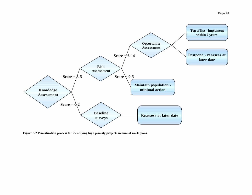
Page 47
Score = 3-5
Score = 0-2
KnowledgeAssessment
RiskAssessment
Baselinesurveys
OpportunityAssessment
Reassess at later date
Score = 0-5
Score = 6-14
Maintain population -minimal action
Top of list - implementwithin 2 years
Postpone - reassess atlater date
Figure 3-2 Prioritization process for identifying high priority projects in annual work plans.

Page 48 Table 3-2 Risk assessment. The knowledge assessment for prioritization of conservation actions considers the severity of threats in each 8-digit HUC with a potential project identified. (connectivity and population status derived from Mobrand et al. 2005).
Risk Assessment
Degree of threats (can include habitat destruction, de-watering)
Threats not present = 0
Threats present, but limited impact to the species = 1
Threats present; impacts are present and severe on a seasonal basis = 2
Threats present; impact to the species is continuous = 3
Threats present; impact to the species is continuous and severe = 4
Possible total = 4 Connectivity a) number of observed spawning locations
≥5 = 0
<5 = 1 b) total number of populations within the management unit
>3 = 0
≤3 = 1 c) barriers to migration present?
No = 0
Yes = 1 Possible total = 3 Reproduction Multiple age classes present = 0
Only adults present = 1
Possible total = 1 Population status a) if relative abundance estimate established: Increased since last estimate = 0 Remained stable since last estimate = 1 Decreased since last estimate = 2 OR c) if only presence/absence is known: Abundant = 0 Moderately abundant = 1
Rare/absent = 2
Possible total = 2
Native diversity
Historical native assemblage in tact = 0
Historical native assemblage disrupted = 1
Possible total = 1
Hybridization Genetically pure populations = 0 Genetically mixed populations - one generation = 1 Genetically mixed populations - multiple generations = 2 Genetically pure, but threatened by white sucker (or other non-native) = 3 Possible total = 3
Overall possible total = 14

Page 49 The final step in the prioritization process entails assessing the opportunities available to the Team as they identify projects for the upcoming field season (see Table 3-3). During this next assessment, cooperators must assess the level of opportunity present for each potential conservation action. Opportunities may include funding, interest among members of the public, land ownership surrounding the project area, and the severity and addressability of threats in each project area. The highest priority projects identified through both the risk and opportunity assessment will be the highest priority projects for implementation by the Team. Table 3-3 Opportunity assessment. The opportunity assessment for prioritization of conservation actions considers the presence of opportunities for implementation of projects in each 8-digit HUC.
Opportunity Assessment Ownership/management All surrounding lands privately owned = 0 Majority of surrounding lands privately owned = 1 Majority of surrounding lands publicly owned and managed by cooperator = 2 All surrounding lands publicly owned and managed by a cooperator = 3 Possible total = 3
Local opinion Public not amenable to proposed conservation action = 0 Partial public support for action = 1 Public support for proposed conservation action = 2 Possible total = 2 Funding Potential funding not identified = 0 Potential funding source identified, funding not secured = 1 Potential funding source identified, funding likely to be secured = 2
Potential funding source identified, funding secured = 3
Possible total = 3
Reversibility of threats
Threats present and not likely to be minimized without extreme effort = 0
Threats present and may potentially be minimized with adequate effort = 1
Threats, regardless of how severe, can be minimized = 2
Possible total = 2
Overall possible total = 10
All conservation actions will be reviewed thoroughly before implementation to ensure compatibility with the overall conservation strategy. Where feasible, these conservation actions will be tied to other priority actions implemented through other plans (i.e. watershed planning activities, the State’s Comprehensive Wildlife Conservation Strategy, etc.). Annual Priorities Document Rather than including an exhaustive list of conservation actions in this document, we have chosen to include specific conservation actions in a separate Annual Priorities document. Our intention in separating these documents is to maintain greater flexibility to add and remove potential projects as new information is acquired. New information, obtained from baseline surveys and assessments of conservation actions will be used to update the list of conservation

Page 50 actions annually. This annual process may include the addition or removal of projects from the overall project list or even an alteration of projects remaining on the list. We expect that by prioritizing projects, we will perform the most efficient projects (i.e., those that we expect to give us the greatest result for the most reasonable amount of effort) first. Success will not be measured by completion of every project on the list, but by meeting the success criteria identified in the Plan (see below). The aforementioned Annual Priorities document is also designed to serve as a timeline of necessary actions for each management unit. This timeline will guide cooperators in identification of projects to prioritize each year. Although management units are currently based on 4-digit HUCs, it should be noted that as more genetic information is gathered management unit delineations may be altered to better suit this new genetic information. Criteria for Evaluation The Team will evaluate success of individual conservation actions annually for three years following implementation of each action. After this initial three-year period, actions will be evaluated every third year through the life of the Agreement. Project success will be comprehensively evaluated during the fifth year of the Agreement (2009) and then again at the end of the Agreement (2014). The specific criteria for evaluation of success must be measurable according to the Agreement. Specifically, the number of populations within each management unit and the number of individuals within each population (or relative abundance if more practical) required to maintain persistence must be identified and met in order to achieve success in this effort. Initially, each stream (mainstem or tributary) will be considered a separate population, thus allowing us to talk about the necessary number of populations per 4-digit HUC or management unit. Only where the upper and lower portions of a stream are divided by a major structure (i.e. a fish barrier) will a stream segment be considered two populations, and only then with consensus among the Team members. If individuals within a population are shown to occupy mainstem habitats throughout adulthood, but annually or semi-annually use tributaries for spawning purposes, the mainstem and tributary unit will be considered one population. Where connectivity is maintained between two or more populations, these will be considered a metapopulation. What is currently considered a population may change as more genetic and habitat use information is gathered; if this occurs, the Three Species Conservation Team will practice adaptive management to reassess population delineations based on this new information. In the event that population delineations change, this document will not be re-written or require new signatures. Rather, new population delineations will be identified in the Annual Priorities document intended for regular revision. Current knowledge of each management unit suggests that the required number of populations in each unit is as follows: HUC 1403 – Three populations of each species. Each species is expected to occur in the mainstem Colorado River and the Dolores River. One other population must be found and protected or established in this unit. HUC 1404 – One population of each species. The upper Green River below Flaming Gorge Dam is a blue ribbon trout fishery and too cold for reproduction of three species populations to be successful. Carter and Cart creeks, tributaries to the Green River in this HUC, are not amenable
Page 51 to three species populations at this time; however, three species cooperators will work to reduce threats in one of these tributaries or another one based on updated information. HUC 1405 – One population of each species. Flannelmouth and bluehead sucker are considered abundant in the White River, though roundtail chub is considered rare. Maintenance of these populations will be considered success in this drainage. HUC 1406 – Twelve populations each of bluehead and flannelmouth sucker, seven populations of roundtail chub. Bluehead sucker are known to currently be present in the Green, Duchesne, Strawberry, and Price rivers and in Ashley, Cottonwood, Huntington, Ferron, and Red creeks. They are either not present or status is unknown in the following: Uinta, Lake Fork, and San Rafael rivers and Avintaquin and Currant creeks. Flannelmouth sucker distribution is similar except that they are moderately abundant in Avintaquin Creek, rare in the San Rafael, and not present in Huntington Creek. Distribution of the roundtail chub within this unit is more restricted. They are rare or moderately abundant in the Green, San Rafael, and Duchesne rivers and not present (or status unknown) in the remaining streams recently surveyed. HUC 1407 – Nine populations of bluehead sucker, six populations of flannelmouth sucker, and three populations of roundtail chub. Bluehead sucker are present in Ivie, Quitchupah, Pine, and Mamie creeks and the Fremont, Escalante, and Colorado (above Lake Powell) rivers. They were not found during Muddy Creek surveys during 2005 and their status is unknown in the Dirty Devil River. Flannelmouth sucker are present in the Colorado River above Lake Powell, the Escalante and Fremont rivers, and in Ivie and Sand creeks. They are considered not present or status unknown in the Dirty Devil River and Muddy and Quitchupah creeks. Roundtail chub are present, but rare in the Colorado River mainstem above Lake Powell and the Escalante River. They have not been observed in recent surveys in the Dirty Devil River or the Muddy Creek drainage. HUC 1408 - Two populations of bluehead and flannelmouth sucker, one population of roundtail chub. Knowledge of status in this unit is relatively limited. Bluehead and flannelmouth sucker are both regularly observed in the mainstem San Juan. In the San Juan River drainage, roundtail chub currently only occupy upstream tributaries in Colorado. No fish were observed in Montezuma Creek in 2005. Other tributaries in the San Juan drainage were de-watered or have not been surveyed by the UDWR; therefore, status is unknown in most of these locations at this time. HUC 1501 – Three populations of flannelmouth sucker. Flannelmouth sucker are currently found in all historical localities in the Virgin River system: Virgin River mainstem, East Fork Virgin River, and North Fork Virgin River. HUC 1601 – One population of bluehead sucker. Bluehead sucker are considered not present in surveyed localities in the Bear River system. HUC 1602 – Three populations of bluehead sucker. Bluehead sucker are considered historically present in the Ogden River, the South Fork of the Ogden, and the Weber River and Mill Creek. Bluehead have only been found recently in a small portion of the Weber River and are thus considered quite rare in this system.

Page 52 Progress toward achieving the overall goal will be used to evaluate effectiveness – have we established or maintained the designated number of populations in each management unit? If one population is lost, the Team can choose to re-establish this population using a nearest neighbor population, any genetically appropriate population, or a highly robust and healthy population either in the same location or in a different stream within the unit or state. We are currently considering the need for a hatchery or grow-out facilities only for bluehead sucker in the Bonneville Basin; however, three species cooperators may eventually decide these options are a necessity for all three species. In any event, hatchery fish will also be adequate to restore a population as long as appropriate hatchery management plans have been developed. We will consider our efforts successful if the designated number of populations are reached and persist through the life of the Agreement. In addition to the number of populations in a management unit we must also identify the adequate population size within each unit to help determine if we are successful. For each species, the Team will attempt to determine the number of individuals required per population to maintain the population in perpetuity. Because we have limited life history and historical information on these species, we must leave this criterion for later refinement. We will use historical and newly collected data to further refine population criteria. These values will be assigned by year five of the Agreement (2009). If we find that it is too difficult or expensive to effectively evaluate the number of individuals per population statewide, we will instead use population trends or relative abundance over the course of the Agreement to determine whether we are successful in meeting this criteria. Because it will likely be difficult to maintain up-to-date information on all streams statewide, we will not require recent information on all streams at the end of the Agreement. Instead we will evaluate the observed situation from 2009 – 2014 (the last five years of the Agreement), compile that with the information obtained through baseline surveys in 2003 through 2009, and use all of this information to make a determination.
Page 53
Literature Cited Anderson, R.M. and G. Stewart. 2000. Riverine fish flow investigations. Federal Aid Project F-
289-R3. Colorado Division of Wildlife, Fort Collins, CO. 96 pp. Andreasen, J.K. 1973. Reproductive life history of Catostomus ardens and Catostomus
discobolus in the Weber River, Utah. M. S. Thesis, Department of Zoology, Brigham Young University.
Banks, J.L. 1964. Fish species distribution in Dinosaur National Monument during 1961 and
1962. Master’s thesis, Colorado State University, Ft. Collins, Colorado. 99p. Behnke, R.J. 1980. The impacts of habitat alterations on the endangered and threatened fishes of
the Upper Colorado River Basin. Pages 204-216, In: Energy Development in the Southwest, Volume 2. W. O. Spofford Jr., A. L. Parker, and Allen V. Kneese, editors. Resources for the Future, Inc. Baltimore, Maryland.
Berry, C.R., Jr. 1988. Effects of cold shock on Colorado squawfish larvae. The Southwestern
Naturalist 33:193-197. Berry, C.R., Jr. and R. Pimentel. 1985. Swimming performance of three rare Colorado River
fishes. Transactions of the American Fisheries Society 114:397-402. Bestgen, K.R. 2000. Personal communication with Director of Colorado State University’s
Larval Fish Lab, Fort Collins, Colorado. Bestgen, K.R. 1985. Distribution, biology, and status f the roundtail chub, Gila robusta, in the
Gila River Basin, New Mexico. M.S. Thesis, Colorado State University, Ft. Collins, Colorado. 104p.
Bestgen, K.R., and D.L. Propst. 1989. Distribution, status, and notes on the ecology of Gila
robusta (Cyprinidae) in the Gila River drainage, New Mexico. The Southwestern Naturalist 34(3): 402-412.
Bestgen, K.R. and L.W. Crist. 2000. Response of the Green River fish community to
construction and re-regulation of Flaming Gorge Dam, 1962-1996. Final Report to Colorado River Recovery Implementation Program, Project Number 40, Larval Fish Laboratory Contribution 109.

Page 54
Beyers, D.W., C. Sodergren, J.M. Bundy, and K.R. Bestgen. 2001. Habitat use of bluehead sucker, flannelmouth sucker, and roundtail chub in the Colorado River. Contribution 121, Larval Fish Laboratory, Department of Fishery and Wildlife Biology, Colorado State University, Fort Collins, Colorado. 32 p.
Bezzerides, N. and K.R. Bestgen. 2002. Status review of roundtail chub Gila robusta,
flannelmouth sucker Catostomus latipinnis and bluehead sucker Catostomus discobolus in the Colorado River Basin. U.S. Department of the Interior, Bureau of Reclamation, Salt Lake City, Utah.
Brouder, M.J., D.D. Rogers, and L.D. Avenetti. 2000. Life history and ecology of the roundtail
chub (Gil robusta) from two streams in the Verde River Basin. Technical Guidance Bulletin No. 3 – July 2000. Arizona Game and Fish Department, Research Branch, Federal Aid in Sportfish Restoration Project F-14-R, Phoenix.
Brunson, R. and K. Christopherson. 2001. Development of a northern pike control program in
the Middle Green River. Annual Report to Upper Colorado River Recovery Implementation Program. Utah Division of Wildlife Resources, Vernal.
Brunson, R. E., and K. D. Christopherson. 2003. Early life-stage and fish community
investigations in the lower Duchesne River, 1997 - 1999. Final Report to the Upper Colorado River Basin Recovery Implementation Program, Denver, Colorado. Project #84-4, Utah Division of Wildlife Resources, Salt Lake City, UT.
Carlson, C.A., and R.T. Muth. 1989. Colorado River: Lifeline of the American Southwest. Pages
220-239 In: Proceedings of the International Large Rivers Symposium. D.P. Dodge, editor. Special Publication 106. Canadian Fisheries Aquatic Sciences, Ottawa, Ontario, Canada.
Carlson, C.A. and S.P. Platania. 1984. An ichthyofaunal survey over a seven-month period of
Plateau Creek; a Colorado River tributary. Report prepared for the Colorado State Department to Highways. 128pp.
Cavalli, P.A. 1999. Fish community investigations in the Lower Price River, 1996-1997. Final
Report to the Recovery Implementation Program for the Endangered Fish Species in the Upper Colorado River Basin. Project No. 78. Utah Division of Wildlife Resources, Salt Lake City, Utah.
Chart, T.E. 1987. The initial effect of impoundment on the fish community of the White River,
Colorado. Master’s thesis, Colorado State University, Ft. Collins, Colorado. 112p. Chart, T. E. and E. Bergersen 1987. Abstract - Impact of Taylor Draw Dam and Kenney
Reservoir on the Fishes of the White River. Fort Collins, CO, Colorado Cooperative Fish and Wildlife Research Unit.

Page 55
Chart, T.E. and E.P. Bergersen. 1992. Impact of mainstream impoundment on the distribution and movements of the resident flannelmouth sucker (Catostomidae: Catostomus latipinnis) population in the White River, Colorado. The Southwestern Naturalist 37(1): 9-15.
Childs, M.R. and R.W. Clarkson. 1996. Temperature effects on swimming performance of larval
and juvenile Colorado squawfish: implications for survival and species recovery. Transactions of the American Fisheries Society 125:940-947.
Childs, M.R., R.W. Clarkson, and A.T. Robinson. 1998. Resource use by larval and early
juvenile native fishes in the Little Colorado River, Grand Canyon, Arizona. Transactions of the American Fisheries Society 1267: 620-629.
Clarkson, R.W. and M.R. Childs. 2000. Temperature effects of hypolimnial-release dams on
early life stages of Colorado River Basin big-river fishes. Copeia 2000(2): 402-412. Clarkson, R.W., P.C. Marsh, S.E. Stefferud, and J.A. Stefferud. 2005. Conflicts between native
fish and nonnative sportfish management in the southwestern United States. Fisheries 30(9): 20-27.
Coburn, M.M. and T.M. Cavender. 1992. Interrelationships of North American Cyprinid Fishes.
Pages 328 – 373 in R.L. Mayden (ed.). Systematics, Historical Ecology, and North American Freshwater Fishes. Stanford University Press, Stanford, California.
Collier, M., R. H. Webb, and J. C. Schmidt, 1996. Dams and Rivers: A Primer on the
Downstream Effects of Dams. U. S. Geological Survey Circular 1126. Cox, M. P., C. R. Dickman, and J. Hunter. 2004. Effects of rainforest fragmentation on non-
flying mammals of the Eastern Dorrigo Plateau, Australia. Biological Conservation 115:175–189.
Davies, K. F., C. R. Margules, and K. F. Lawrence. 2000. Which traits of species predict
population declines in experimental forest fragments? Ecology 81:1450–1461. Douglas, M.R. and M.E. Douglas. 2000. Late season reproduction by big-river catostomidae in
Grand Canyon. Copeia 2000(1): 238-244. Douglas, M.E., and P.C. Marsh. 1998. Population and survival estimates of Catostomus
latipinnis in Northern Grand Canyon, with distribution and abundance of hybrids with Xyrauchen texanus. Copeia 1998(4): 915-925.
Douglas, M.E., R.R. Miller, and W.L. Minckley. 1998. Multivariate discrimination of Colorado
Plateau Gila species: the art of seeing well revisited. Transactions of the American Fisheries Society 127:163-173.

Page 56
Dowling, T.E. and B.D. DeMarais. 1993. Evolutionary significance of introgressive
hybridization in cyprinid fishes. Nature 362: 444-446. Fagan W.F., C. Aumann, C.M. Kennedy, and P.J. Unmack. 2005. Rarity, fragmentation, and the
scale dependence of extinction risk in desert fishes. Ecology 86(1): 34-41. Fischer, R.A., C.O. Martin, and J. C. Fischenich. 2000. Improving riparian buffer strips and
corridors for water quality and wildlife. International conference on riparian ecology and management in multi-land use watersheds. American Water Resources Association.
Fridell, R.A., M.K. Morvilius, and K.K. Wheeler. 2004. Inventory and distribution of fish in the
Escalante River and tributaries, Grand Staircase-Escalante National Monument, Utah. 2003. Utah Division of Wildlife Resources Publication 04-02. Salt Lake City, UT.
Grabowski, S.J. and S.D. Hiebert. 1989. Some aspects of trophic interactions in selected
backwaters and the main channel of the Green River, Utah. Final report of U.S. Bureau of Reclamation, Research and Laboratory Service Division, Applied Science Branch, Environmental Sciences Section, Denver, CO, for U.S. Bureau of Reclamation, Upper Colorado Regional Office, Salt Lake City, UT. 131p.
Greger, P.D. and J.E. Deacon. 1988. Food partitioning among fishes of the Virgin River, Copeia
1988(2): 314-323. Haines, G.B., B.W. Beyers, and T. Modde. 1998. Estimation of winter survival, movement and
dispersal of young Colorado squawfish in the Green River, Utah. Recovery Program Project 36. Contribution 96 of the Larval Fish Laboratory, Department of Fishery and Wildlife Biology, Colorado State University, Fort Collins, Colorado.
Heckmann, R.A., P.D. Greger, and R.C. Furtek. 1993. The Asian fish tapeworm,
(Bothriocephalus acheilognathi) in fishes from Nevada. Journal of the Helminthological Society of Washington 60(2): 127-128.
Hoetker, G.M. and K.W. Gobalet. 1999. Fossil razorback sucker (Pisces: Catostomidae,
Xyrauchen texanus) from southeastern California. Copeia 1999: 755–759. Holden, P.B. 1973. Distribution, Abundance and Life History of the Fishes of the Upper
Colorado River Basin. A dissertation submitted in partial fulfillment of the requirements for the degree of Doctor of Philosophy in Wildlife Science (Ecology). Utah State University, Logan, Utah.
Holden P.B., and C.B. Stalnaker. 1974. Distribution of fishes in the Dolores and Yampa River
systems of the upper Colorado River basin. The Southwestern Naturalist 19(4): 403-412. Holden, P.B., and C.B. Stalnaker. 1975. Distribution and abundance of mainstem fishes of the
Middle and Upper Colorado River Basins, 1967-1973. Transactions of the American Fisheries Society 104(2): 217-231.

Page 57
Holden, P.B., and W.L. Minckley. 1980. Catostomus discobolus Cope, bluehead sucker. Page
377 In: Atlas of North American Freshwater Fishes. D. S. Lee, C. R. Gilbert, C. H. Hocutt, R. E. Jenkins, D. E. McAllister, and J R. Stauffer Jr., editors, 1981. North Carolina State Museum of Natural History.
Holden, P.B. and L.W. Crist. 1981. Documentation of changes in the macroinvertebrate and fish
populations in the Green River due to inlet modification of Flaming Gorge Dam. Contract No. 0-007-40-S1357 for Water and Power Resources Service. Bio/West, Inc., Logan, Utah.
Jackson, J.A. 2001. Evaluation of Stocked Larval Colorado Pikeminnow into the San Juan River:
2000. Annual report to the San Juan River Basin Recovery Implementation Program. Utah Division of Wildlife Resources, Salt Lake City.
Jager, H. I., J. A. Chandler, K. B. Lepla, and W. Van Winkle. 2001. A theoretical study of river
fragmentation by dams and its effects on white sturgeon populations. Environmental Biology of Fishes 60: 347–361.
Jordan, D.S. and B.W. Evermann. 1902. American food and game fishes. Dover Publications,
Inc., New York. Kaeding, L.R. and D.B. Osmundson. 1988. Interaction of slow growth and early-life mortality:
an hypothesis on the decline of the Colorado squawfish in the upstream regions of its historic range. Environmental Biology of Fishes 22(4): 287-298.
Kaeding, L.R., B.D. Burdick, P.A. Schrader, and C.W. McAda. 1990. Temporal and spatial
relations between the spawning of humpback chub and roundtail chub in the upper Colorado River. Transactions of the American Fisheries Society 119: 135-144.
Karp, C.A. and H.M. Tyus. 1990. Humpback chub (Gila cypha) in the Yampa and Green Rivers,
Dinosaur National Monument, with observations on roundtail chub (Gila robusta) and other sympatric fishes. Great Basin Naturalist 50(3): 257-264.
Knapp, R. A., K. R. Matthews, H. K. Preisler, and R. Jellison. 2003. Developing probabilistic
models to predict amphibian site occupancy in a patchy landscape. Ecological Applications 13: 1069–1082.
Koster, W.J. 1957. Guide to the fishes of New Mexico. University of New Mexico Press,
Albuquerque, New Mexico. 116p. Lamarra, V.A. 1999. Longitudinal variation in the trophic structure of the upper Colorado River.
Final Report for Recovery Implementation Program, Project No. 48. Ecosystems Research Institute, Inc., Logan, Utah.

Page 58
Lanigan, S.H., and C.R. Berry, Jr. 1981. Distribution of fishes in the White River, Utah. The Southwestern Naturalist 26(4): 389-393.
Lee, D.S., C.R. Gilbert, C.H. Hocutt, R.E. Jenkins, D.E. McAllister, and J.R. Stauffer Jr. 1980.
Atlas of North American Freshwater Fishes. North Carolina Biological Survey Publication #1980-12. North Carolina State Museum of Natural History, Raleigh.
Lentsch, L.D., R.T. Muth, P.D. Thompson, B.G. Hoskins, and T.A. Crowl. 1996. Options for
selective control of nonnative fishes in the Upper Colorado River Basin. Publication Number 96-14. Utah Division of Wildlife Resources Colorado River Fishery Project, Salt Lake City.
Maddux, H.R., D.M. Kubly, J.C. deVos Jr., W.R. Persons, R.H. Staedicke, and R.L. Wright.
1987. Evaluation of varied flow regimes on aquatic resources of Glen and Grand Canyons. Glen Canyon Environmental Studies, Bureau of Reclamation, Upper Colorado Region, Salt Lake City, Utah. 291 p.
Maddux, H.R. and W.G. Kepner. 1988. Spawning of bluehead sucker in Kanab Creek, Arizona
(Pisces: Catostomidae). Southwestern Naturalist 33: 364-365. Maddux, H.R., J.A. Mizzi, S.J. Werdon, L.A. Fitzpatrick. 1995. Overview of the proposed
critical habitat for the endangered and threatened fishes of the Virgin River Basin. Department of the Interior, U.S. Fish and Wildlife Service, Salt Lake City, Utah.
Martinez, P.J., T.E. Chart, M.A. Trammell, J.G. Wullschleger, and E.P. Bergersen. 1994. Fish
species composition before and after construction of a main stem reservoir on the White River, Colorado. Environmental Biology of Fishes 40: 227-239.
McAda, C.W. 1977. Aspects of the life history of three Castostomids native to the Upper
Colorado River Basin. Master’s thesis, Utah State University, Logan, Utah. 104 p. McAda, C., C. Philips, C.R. Berry Jr., and R.S. Wydoski. 1977. Survey of threatened and
endangered fish in southeastern Utah streams. Report to Utah Division of Wildlife Resources. Contract No. 77-8236. Utah Cooperative Fishery Research Unit, Utah State University, Logan, Utah 84322.
McAda, C.W. and R.S. Wydoski. 1983. Maturity and fecundity of the bluehead sucker,
Catostomus discobolus (Catostomidae), in the Upper Colorado River Basin, 1975-76. The Southwestern Naturalist 28(1): 120-123.
McDonald, D.B. and P.A. Dotson. 1960. Fishery investigations of the Glen Canyon and Flaming
Gorge impoundment areas. Utah Department of Fish and Game Information Bulletin 60-3, I-70.
McKinney, T., W.R. Persons, and R.S. Rogers. 1999. Ecology of flannelmouth sucker in the
Lee’s Ferry tailwater, Colorado River, Arizona. Great Basin Naturalist 59: 259-265.

Page 59
Miller, W.H., D. Archer, H.M. Tyus, and R.M. McNatt. 1982. White River Fishes Study, Final
Report. Colorado River Fishery project, U.S. Fish and Wildlife Service, Salt Lake City, Utah, 58p.
Miller, W.J. and D.E. Rees. 2000. Final report: ichthyological surveys of tributaries of the San
Juan River, New Mexico. Miller Ecological Consultants, Inc. Fort Collins, Colorado. 28p.
Minckley, W.L. 1973. Fishes of Arizona. Arizona Game and Fish Department, Sims Printing
Company, Inc., Phoenix, Arizona. Minckley, W.L. 1991. Native fishes of the Grand Canyon: an obituary? Pages 124-177, In:
Colorado River Ecology and Dam Management, Proceedings of a Symposium May 24-25, 1990, Santa Fe, New Mexico. National Academy Press, Washington, D.C.
Minckley, W.L., D.A. Henderson, and C.E. Bond. 1986. Geography of western North American
freshwater fishes: description and relationships to intracontinental tectonism. Pages 519-613, In: The Zoogeography of North American Freshwater Fishes. C. H. Hocutt and E. O. Wiley, editors. John Wiley and Sons, New York.
Minckley, W.L., and B.D. DeMarais. 1990. Taxonomy of chubs (Teleostei, Cyprinidae, Genus
Gila) in the American Southwest, with comments on conservation. Copeia 2000 (1): 251-256.
Modde, T. and C. Keleher. 2003. Flow recommendations for the Duchesne River with a synopsis
of information regarding endangered fishes. U.S. Fish and Wildlife Service Project No. 84-1 submitted for the Upper Colorado River Basin Endangered Fishes Recovery Implementation Program.
Mobrand, L.E., J. Barr, L. Blankenship, D.E. Campton, T.T.P. Evelyn, Tom .A. Flagg, C.V.W.
Mahnken, L.W. Seeb, P.R. Seidel, and W.W. Smoker. 2005. Hatchery reform in Washington State: Principles and emerging issues. Fisheries 30(6): 11-23.
Morita, K., and S. Yamamoto. 2002. Effects of habitat fragmentation by damming on the
persistence of stream-dwelling charr populations. Conservation Biology 16: 1318–1323. Morvilius, M.K. and R.A. Fridell. 2004. Virgin Spinedace (Lepidomeda molispinis mollispinis)
Population Monitoring Summary 1994 - 2003. Utah Division of Wildlife Resources Publication.
Morvilius, M.K. and R.A. Fridell. 2005. Inventory and distribution of fish in the Escalante River
and tributaries, Grand Staircase-Escalate National Monument, Utah. 2003-2004. Utah Division of Wildlife Resources Publication 05-15. Salt Lake City, UT.

Page 60
Mueller, G., L. Boobar, R. Wydoski, K. Comella, and Q. Bradwisch. 1998. Aquatic survey of the Lower Escalante River, Glen Canyon National Recreation Area, Utah June 22-26, 1998. Preliminary report of the National Park Service and Utah Division of Wildlife Resources.
Mueller, G.A. and R. Wydoski. 2003. Reintroduction of the flannelmouth sucker in the lower
Colorado River. North American Journal of Fisheries Management 24(1): 41–46. Muth, R.T. and D.E. Snyder. 1995. Diets of young Colorado squawfish and other small fish in
backwaters of the Green River, Colorado and Utah. The Great Basin Naturalist 55(2): 95-104.
Nesler, T. P. 1995. Interactions between endangered fishes and introduced gamefishes in the
Yampa River, Colorado, 1987-1991. Final Report, September 1995, Colorado Division of Wildlife, Colorado River Recovery Implementation Program Project No. 91-29, Federal Aid Project SE-3, Ft. Collins, Colorado.
Neve, L.L. 1976. The life history of the roundtail chub, Gila robusta grahami, at Fossil Creek,
Arizona. Master’s thesis, Northern Arizona University, Flagstaff, 46p. O’Laughlin, J., and G. H. Belt, 1995. Functional approaches to riparian buffer strip design.
Journal of Forestry 93: 29-32. Ono, R.D., J.D. Williams, and A. Wagner. 1983. Vanishing fishes of North America. Stone Wall
Press, Inc. Washington, D.C. Osmundson, D.B. 1999. Longitudinal variation in fish community structure and water
temperature in the Upper Colorado River: implications for Colorado pikeminnow habitat suitability. Final Report for Recovery Implementation Program, Project No. 48. U.S. Fish and Wildlife Service, Grand Junction, Colorado.
Platania, S.P. 1990. Biological summary of the 1987 to 1989 New Mexico-Utah ichthyofaunal
study of the San Juan River. Department of Biology, Museum of Southwestern Biology, University of New Mexico, Albuquerque, NM. 143p.
Quartarone, F. 1995. Historical accounts of upper Colorado River Basin endangered fish. Final
Report for Recovery Implementation Program. U.S. Fish and Wildlife Service. Rinne, J.N. 1992. Physical habitat utilization of fish in a Sonoran desert stream, Arizona,
southwestern United States. Ecology of Freshwater Fish 1:35-41. Robinson, A.T., R.W. Clarkson, and R.T. Forrest. 1998a. Dispersal of larval fish in a regulated
river tributary. Transactions of the American Fisheries Society 127: 772-786. Robinson, A.T., P. P. Hines, J.A. Sorenson, and S.D. Bryan. 1998b. Parasites and fish health in a
desert stream and management implications for two endangered fishes. North American Journal of Fisheries Management 18: 599-608.

Page 61
Robinson, S. K., F. R. Thompson, T. M. Donovan, D. R. Whitehead, and J. Faaborg. 1995.
Regional nesting success of migratory birds. Science 267: 1987–1990. Ruppert, J.B., R.T. Muth, and T.P. Nesler. 1993. Predation on fish larvae by adult red shiner,
Yampa and Green Rivers, Colorado. The Southwestern Naturalist 38(4): 397-399. Ryden, D.W. 2001. Long term results of sub-adult and adult large-bodied fishes in the San Juan
River in 2000. U.S. Fish and Wildlife Services, Colorado River Fishery Project, Grand Junction, Colorado.
Schreiber, D.C. and W.L. Minckley. 1981. Feeding interrelations of native fishes in a Sonoran
Desert stream. Great Basin Naturalist 41(43): 409-426. Scoppettone, G.G. 1988. Growth and longevity of the cui-ui and longevity of other catostomids
and cyprinids in western North America. Transactions of the American Fisheries Society 117: 301-307.
Sigler, W.F. and R.R. Miller. 1963. Fishes of Utah. Utah State Department of Fish and Game,
Salt Lake City, Utah. Sigler, W.F. and J.W. Sigler. 1996. Fishes of Utah: A Natural History. University of Utah Press,
Salt Lake City. Smith, G.R. 1981. Late cenozoic freshwater fishes of North America. Annual Review of
Ecological Systematics 12: 163-193. Snyder, D.E. and R.T. Muth. 1990. Descriptions and identification of razorback, flannelmouth,
white, Utah, bluehead, and mountain sucker larvae and early juveniles. Technical Publication No. 28, Colorado Division of Wildlife. 152 p.
Stearns, S.C. 1993. The evolution of life histories. Oxford University Press, New York. Starnes, W.C., and D.A. Etnier. 1986. Drainage evolution and fish biogeography of the
Tennessee and Cumberland rivers drainage realm. Pages 325-361 in C.H. Hocutt and E.O. Wiley, eds. The Zoogeography of North American Freshwater Fishes. John Wiley and Sons, New York.
Suttkus, R.D. and G.H. Clemmer. 1979. Fishes of the Colorado River in Grand Canyon National
Park. National Park Service Transactions and Proceedings Series 5:599-604. Tyus, H.M. and W.L. Minckley. 1988. Migrating Mormon crickets, Anabrus simplex
(Orthoptera: Tettigoniidae), as food for stream fishes. Great Basin Naturalist 48: 25-30. Tyus, H.M. and N. Nikirk. 1990. Growth, diet, and status of channel catfish (Ictalurus punctatus)
in the Green and Yampa rivers, Colorado and Utah. Southwestern Naturalist 35: 188-198.

Page 62
Tyus, H.M. and J. Saunders. 1996. Nonnative fishes in the Upper Colorado River Basin and a
strategic plan for their control. U.S. Fish and Wildlife Service, Center for Limnology, University of Colorado at Boulder.
Tyus, H.M., B.D. Burdick, R.A. Valdez, C.M. Haynes, T.A. Lytle, and C.R. Berry. 1982. Fishes
of the Upper Colorado River Basin: distribution, abundance, and status. Pages 12-70 In: Fishes of the Upper Colorado River System: Present and Future. Proceedings of a Symposium Presented at the Annual Meeting of the American Fisheries Society in Albuquerque, New Mexico, September 18, 1981. William H. Miller, Harold M. Tyus, and Clarence A. Carlson, editors. Western Division, American Fisheries Society, Bethesda, Maryland.
Utah Division of Water Resources. 2001. Utah’s water resources: Planning for the future. Utah
State Water Plan, Salt Lake City, UT. UDWR (Utah Division of Wildlife Resources). 2001. Data collected by the Utah Natural
Heritage Program, Salt Lake City. UDWR (Utah Division of Wildlife Resources). 2005. ESMF Report Fiscal Year 2005.
Unpublished report, Salt Lake City, UT. Valdez, R.A. and G.C. Clemmer. 1982. Life history and prospects for recovery of the humpback
chub and bonytail chub. Pages 109-119 in W.H. Miller, H.M. Tyus, and C.A. Carlson (eds.). Fishes of the upper Colorado River system: present and future. Western Division, American Fisheries Society, Bethesda, Maryland.
Valdez, R.A. 1990. The endangered fish of Cataract Canyon. Final Report of BIO/WEST, Inc.,
to U.S. Bureau of Reclamation, Salt Lake City, Utah. Valdez, R.A. and R.J. Ryel. 1995. Life history and ecology of the humpback chub (Gila cypha)
in the Colorado River, Grand Canyon, Arizona. Final Report to Bureau of Reclamation, Salt Lake City, Utah. Contract No. 0-CS-40-09110. Bio/West Report No. TR-250-08.
Valdez, R.A. and S.W. Carothers. 1998. The aquatic ecosystem of the Colorado River in Grand
Canyon: Grand Canyon Data Integration Project Synthesis Report. D. A. House, editor. Prepared for the U.S.D.I. Bureau of Reclamation, Salt Lake City, Utah, by SWCA, Inc., Environmental Consultants, Flagstaff, Arizona.
Vanicek, C.D. 1967. Ecological studies of native Green River fishes below Flaming Gorge Dam,
1964-1966. Doctoral Dissertation. Utah State University, Logan. Vanicek, C.D. and R.H. Kramer. 1969. Life history of the Colorado Squawfish, Ptychocheilus
lucius, and the Colorado chub, Gila robusta, in the Green River in Dinosaur National Monument, 1964-1966. Transactions of the American Fisheries Society 98(2): 193-208.

Page 63
Vanicek, C.D., R.H. Kramer, and the late D.R. Franklin. 1970. Distribution of Green River fishes in Utah and Colorado following closure of Flaming Gorge Dam. The Southwestern Naturalist, 14(3): 297-315.
Voeltz, J.B. 2002. Roundtail chub Gila robusta status survey of the lower Colorado River basin.
Nongame and Endangered Wildlife Program Technical Report 186. Arizona Game and Fish Department, Phoenix.
Walker, C.A. and P. Birdsey. 2005. Surveys to determine the current distribution of roundtail
chub, flannelmouth sucker, and bluehead sucker in the Muddy Creek drainage, during 2004. Unpublished report. Utah Division of Wildlife Resources, Salt Lake City, UT.
Walker, C. A. and M. Hudson. 2004. Surveys to determine the current distribution of roundtail
chub, flannelmouth sucker, and bluehead sucker in the San Rafael drainage, during 2003. Unpublished report. Utah Division of Wildlife Resources, Salt Lake City, UT.
Weiss, S.J., E.O. Otis, and O.E. Maughan. 1998. Spawning ecology of flannelmouth sucker,
Catostomus latipinnis (Catostomidae), in two small tributaries of the lower Colorado River. Environmental Biology of Fishes 52: 419-433.
Wick, E.J., J.A. Hawkins, and T.P. Nesler. 1991. Occurrence of two endangered fishes in the
Little Snake River, Colorado. The Southwestern Naturalist 36(2): 251-254.

Page 64
APPENDIX A Conservation Goals, Objectives and Actions contained in the Range-wide Conservation
Agreement for Roundtail Chub, Bluehead Sucker and Flannelmouth Sucker
Goal The goal of this Agreement is to ensure the persistence of roundtail chub, bluehead sucker, and flannelmouth sucker populations throughout their ranges.
Objectives The individual state signatories to this document will develop conservation and management plans for any or all of the three species that occur naturally within their states. Any future signatories may also choose to develop individual conservation and management plans or to integrate their efforts with existing plans. The individual signatories agree to develop information and conduct actions to support the following objectives:
Establish and/or maintain roundtail chub, flannelmouth sucker, and bluehead sucker
populations sufficient to ensure persistence of each species within their ranges. 1) Establish measureable criteria to evaluate the number of populations required to
maintain the three species throughout their respective ranges. 2) Establish measureable criteria to evaluate the number of individuals required
within each population to maintain the three species throughout their respective ranges.
Establish and/or maintain sufficient connectivity between populations so that viable
metapopulations are established and/or maintained. As feasible, identify, significantly reduce, and/or eliminate threats to the persistence of
roundtail chub, bluehead sucker, and flannelmouth sucker that: 1) may warrant or maintain their listing as a sensitive species by state and federal agencies, and 2) may warrant their listing as a threatened or endangered species under the ESA.
Conservation actions The signatories will review and document existing and ongoing programmatic actions that benefit the three species. As signatories develop their individual management plans for

Page 65
conservation of the three species, each signatory may include but is not limited or obligated to incorporate the following conservation actions: 1) Conduct status assessment of roundtail chub, bluehead sucker, and flannelmouth sucker.
Identify concurrent programs that benefit the three fish species. Monitor and summarize their activities and progress.
Establish current information regarding species distribution, status, and habitat conditions as the baseline from which to measure change.
Identify threats to population persistence. Locate populations of the subject species to determine status of each.
2) Establish and maintain a database of past, present, and future information on roundtail chub, bluehead sucker, and flannelmouth sucker.
Establish format and maintain compatible databases. Signatories have identified the need to maintain a range-wide database as the primary means to conduct a range-wide assessment.
Establish and maintain bibliography of subject species.
3) Determine roundtail chub, bluehead sucker, and flannelmouth sucker population demographics, life history, habitat requirements, and conservation needs.
Determine current population sizes of subject species and/or utilize auxiliary catch and effort data to identify trends in relative abundance.
Identify subject species habitat requirements and current habitat conditions through surveys and studies of hydrological, biological, and watershed features.
Determine if existing flow recommendations and regimes are adequate for all life stages of the subject species. Develop appropriate flow recommendations for areas where existing flow regimes are inadequate.
Where additional data is needed to determine appropriate management actions, conduct appropriate, focused research and apply results.
4) Genetically and morphologically characterize populations of roundtail chub, bluehead sucker, and flannelmouth sucker.
Determine if known information is adequate to answer management questions
related to conservation genetics and assess need for additional genetic characterization of subject species.
Apply new information to management strategies. Review the literature available on hybridization and adequacy of existing data
to characterize the degrees of threats to conservation of the three species posed by hybridization.

Page 66
Develop genetic management plans for all three species that outline maintenance of species at the population level and discuss application to reestablishment efforts.
5) Increase roundtail chub, bluehead sucker, and flannelmouth sucker populations to accelerate progress toward attaining population objectives for respective species.
Assure regulatory protection for three species is adequate within the signatory
states. 6) Enhance and maintain habitat for roundtail chub, bluehead sucker, and flannelmouth sucker.
Enhance and/or restore connectedness and opportunities for migration of the subject species to disjunct populations where possible.
Restore altered channel and habitat features to conditions suitable for the three species.
Provide flows needed for all life stages of the subject species. Maintain and evaluate fish habitat improvements throughout the range. Install regulatory mechanisms for the long-term protection of habitat (e.g.,
conservation easements, water rights, etc.). 7) Control (as feasible and where possible) threats posed by nonnative species that compete with, prey upon, or hybridize with roundtail chub, bluehead sucker, and flannelmouth sucker.
Determine where detrimental actions occur between the subject species and
sympatric nonnative species. Control detrimental nonnative fish where necessary and feasible. Evaluate effectiveness of nonnative control efforts. Develop multi-state nonnative stocking procedure agreements that protect all
three species and potential reestablishment sites.
8) Expand roundtail chub, bluehead sucker, and flannelmouth sucker population distributions through transplant, augmentation (i.e., use of artificially propagated stock) or reintroduction activities as warranted using a genetically based augmentation/ reestablishment plan.
9) Establish and implement qualitative and quantitative long-term population and habitat
monitoring programs for roundtail chub, bluehead sucker, and flannelmouth sucker.
Develop and implement monitoring plans for the subject species. Evaluate conditions of populations using baseline data. Develop and implement habitat monitoring plans for the subject species. Evaluate habitat conditions using baseline data.

Page 67
10) Implement an outreach program (e.g., development of partnerships, information and education activities) regarding conservation and management of roundtail chub, bluehead sucker, and flannelmouth sucker.

Page 68
APPENDIX B Commitment Pages
This appendix contains copies of the signed agreements of all of the agencies and other partners, who have made commitments to participate in the implementation of this Conservation Plan. Agreements will be added, deleted, and edited as appropriate and when needed.
Page 69

Page 70

Page 71

Page 72

Page 73

Page 74
Page 75

Page 76

Page 77

Page 78
APPENDIX C – UTM coordinates for three species conservation stream reaches GMU Drainage Stream Name Reach HUC Begin UTM X Begin UTM Y End UTM X End UTM Y Species Found
SERO Green River Green River Mouth to Tusher diversion 14060005 597587 4227223 574405 4325925 RT, BH, FLM
Tusher diversion to Sand Wash 14060005/14060008 574405 4325925 594184 4409730 RT, BH, FLM
Price River Price River below Farnham reach 1 14060007 577262 4336834 560504 4344768 BH, FLM below Farnham reach 2 14060007 560504 4344768 548643 4353893 BH, FLM below Farnham reach 3 14060007 548643 4353893 532071 4366507 BH, FLM below Farnham reach 4 14060007 532071 4366507 527176 4374299 BH, FLM Farnham dam to Milner’s diversion 14060007 527176 4374299 524853 4376012 BH Milner’s diversion to golf course diversion 14060007 524853 4376012 512105 4388063 BH Golf course diversion to Willow Creek confluence 14060007 512105 4388063 511564 4397306
San Rafael River San Rafael Mouth to Hatt Ranch diversion 14060009 577698 4292020 555100 4303655 FLM
Hatt Ranch diversion to swinging bridge above canyon 14060009 555100 4303655 528947 4325588 BH, FLM Swinging bridge to confluence of Huntington and Ferron Creeks 14060009 528947 4325588 507580 4333111 RT, FLM Cottonwood Mouth to diversion at Hwy 57 14060009 507709 4333486 491964 4344101 BH, FLM Hwy 57 diversion to Joe’s Valley Reservoir Dam 14060009 Huntington Mouth to Chevron pumping station (end of habitat) 14060009 507580 4333111 528632 4365878 BH Ferron Mouth to swinging bridge barrier east of Hwy 10 14060009 507580 4333111 491931 4325170 BH, FLM
Colorado River Colorado River Glen Canyon Dam to Below Cataract Canyon 14070001 456965 4087826 555621 4193757
Cataract Canyon 14070001 555621 4193757 593580 4223541 RT, BH, FLM
Cataract Canyon to below Westwater Canyon 14030005/14070001 593580 4223541 655925 4313542 RT, BH, FLM
Westwater Canyon through State line 14030001/14010005 655925 4313542 672830 4334344 RT, BH, FLM
San Juan River San Juan River Colorado River confluence to Clay Hills 14080205 508786 4114448 553265 4127330
Clay Hills to Sand Island 14080205 553265 4127330 623215 4124572 BH, FLM Sand Island to state line 14080201 623215 4124572 677494 4096525 BH, FLM
Dirty Devil River
Dirty Devil River Mouth to confluence with Fremont 14070004 553899 4195749 526683 4250149
Muddy Creek Muddy Creek Mouth to Salt Wash confluence 14070002 FLM Salt Wash confluence to Ivie Creek confluence 14070002 FLM Ivie Creek confluence to diversion at USFS boundary 14070002 FLM Ivie Creek Mouth to confluence with Quitchupah Creek 14070002 BH, FLM
Confluence with Quitchupah Creek to confluence with Oak Spring Creek 14070002
Quitchupah Creek Mouth to Browning Mine 14070002 BH

Page 79
GMU Drainage Stream Name Reach HUC Begin UTM X Begin UTM Y End UTM X End UTM Y Species Found
Dolores River Dolores River Mouth to state line 14030004 649316 4298068 673942 4284144SRO Virgin River Virgin River Arizona state line upstream to Webb Hill Barrier 15030008 259255 4098150 270280 4105459 FLM Virgin River Webb Hill Barrier upstream to Johnson Diversion 15030008 270280 4105459 275303 4108632 FLM Virgin River Johnson Diversion upstream to Washington Fields Diversion 15030008 275303 4108632 283418 4110360 FLM Virgin River Washington Fields Diversion upstream to Pah Tempe 15030008 283418 4110360 298790 4118039 FLM Virgin River Pah Tempe upstream to the Quail Creek Diversion 15030008 298790 4118039 302339 4119051 FLM Virgin River Quail Creek Diversion upstream to the North/East Forks 15030008 302339 4119051 321040 4114474 FLM
East Fork Virgin River Confluence upstream to Labyrinth Falls 15030008 321040 4114474 334136 4116544 FLM
North Fork Virgin River Confluence upstream to its confluence with Deep Creek 15030008 321040 4114474 331483 4148988 FLM
North Creek Confluence with Virgin River upstream to Zion Park boundary 15030008 306557 4119054 314225 4126390 FLM
Santa Clara River Confluence with Virgin River upstream to Gunlock Reservoir 15030008 270572 4105842 253420 4125928
Santa Clara River Gunlock Reservoir upstream to Moody Wash/Magotsu Creek 15030008 254124 4128517 257937 4133029 FLM
Escalante River Escalante River Lake Powell upstream to the Glen Canyon Rec Area boundary 14070005 503701 4139215 477772 4172368 RT, BH, FLM
Escalante River Glen Canyon Rec Area boundary upstream to ~9 mile below Calf Creek 14070005 477772 4172368 471343 4178397
Escalante River From ~9 miles downstream to ~8 miles upstream of Calf Creek 14070005 471343 4178397 454842 4181304 RT, BH, FLM Escalante River From ~8 miles upstream of Calf Creek to Escalante town 14070005 454842 4181304 449404 4181004 BH Pine Creek Confluence with Escalante River upstream ~1.0 km 14070005 449422 4181094 448844 4181478 BH Mamie Creek Confluence with Escalante River upstream ~1 mile 14070005 455541 4181450 455037 4183106 BH Sand Creek Confluence with Escalante River upstream ~1 mile 14070005 459730 4180765 459577 4181716 FLM Sand Creek 1 mile to ~3 miles upstream of its confluence with Escalante River 14070005 459577 4181716 459216 4183971 Calf Creek Confluence with Escalante River upstream to Upper Calf Creek Falls 14070005 463221 4180847 459723 4190308 Boulder Creek Upstream of confluence with Escalante River 14070005 469196 4178754 463637 4189585 FLM Deer Creek Upstream of confluence with Boulder Creek 14070005 467791 4186754 468782 4189555 Paria River Paria River Upstream from Utah/Arizona border to SR-9 bridge crossing 14070007 423055 4095164 410700 4195500 Paria River Upstream from SR-9 bridge crossing 14070007 410700 4195500 Fremont River Fremont River BLM land just east of Capital Reef National Park 14070003 491602 42336456 489545 4237255 BH, FLM Fremont River Capital Reef National Park 14070003 489067 4237266 473669 4234698 BH, FLM Fremont River Capital Reef N.P. boundary upstream to Fish Creek confluence 14070003 473669 4234698 467647 4235465 BH, FLMNERO Green River Green River Split Mountain to Sand Wash 14060001 648415 4478065 597767 4413415 RT, BH, FLM Island Park to Split Mountain 14060001 657702 4486681 655598 4485159 RT, BH, FLM
Green River North Slope Cart Creek Mouth to 1/10 mile upstream 14040106 631916 4528638

Page 80
GMU Drainage Stream Name Reach HUC Begin UTM X Begin UTM Y End UTM X End UTM Y Species Found
Carter Creek Mouth to 1/10 mile upstream 14040106 618672 4526682
Duchesne River Duchesne River Mouth to Myton 14060003 611570 4439059 578325 4445822 RT, BH, FLM
1.5 miles upriver from Bridgeland bridge 14060003 563733 4445854 563890 4445800
Bridgeland bridge 14060003 565370 4445850 565312 4445678
South of Lake Boreham 14060003 571291 4446926 571429 4447018 BH, FLM
Uinta River NOT DEFINED TO DATE 14060003
Lake Fork River ~2 miles south of Upalco 14060003 566434 4456403 566523 4456322 FLM
Strawberry River Confluence with Starvation Reservoir 14060004 539599 4445988 540978 4445707 BH, FLM
First bridge above Starvaiton Reservoir 14060004 538751 4445054 538620 4445089 BH, FLM
Second bridge above Starvaiton Reservoir 14060004 533191 4443206 533052 4443348 BH, FLM
Third bridge above Starvation Reservoir 14060004 537250 4441810 BH, FLM
UDWR WMA property 14060004 521078 4441682 521225 4441738 BH
Red Creek Confluence upstream 14060004 522462 4441701 522385 4441581 BH
Avintiquin Creek Vanderhoof property above tribal land 14060004 520785 4433558 FLM
Currant Creek Currant Creek lodge 14060004 508343 4449653 508258 4449547
Bill Probst property 14060004 511106 4449182 511018 4449267
Confluence with Red Creek upstream 14060004 519016 4447935 518959 4447860 FLM
Red Creek Confluence with Strawberry upstream 14060004 522462 4441700 511018 4449267 BH, FLM
Rock Creek ~1 mile upstream of confluence with Duchesne River 14060004 543267 4460830
White River White River Cowboy Canyon to Bonanza Bridge 14050007 662718 4428499 655604 4425084 RT, BH, FLM
Willow Creek NOT DEFINED TO DATE 14050007
Bitter Creek NOT DEFINED TO DATE 14050007
NRO Weber River Weber River Below Ogden River Confluence 16020102 413217 4566418 413565 4566049
Fort Bueneventura 16020102 417218 4563286 416987 4562863
Slaterville/Weber Canal 16020102 417513 4556431 NR NR
Uintah Bridge 16020102 419506 4555370 NR NR
Parson Property 16020102 418800 4566418 NR NR
31st Street Bridge in Ogden 16020102 417100 4561860 416949 4560793
Plunge pool below Utah Power Dam 16020102 428539 4554324 NR NR BH
Mouth of Canyon 16020102 427832 4554270 NR NR BH
Stoddard Divide 16020102 NR NR NR NR
Ranch land 16020102 437564 4548741 NR NR
Red Barn 16020102 436858 4551015 436568 4551013
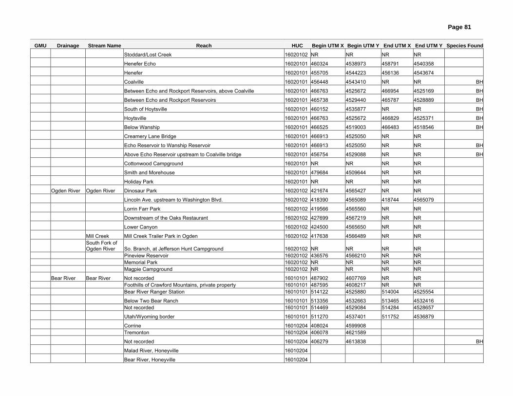
Page 81
GMU Drainage Stream Name Reach HUC Begin UTM X Begin UTM Y End UTM X End UTM Y Species Found
Stoddard/Lost Creek 16020102 NR NR NR NR
Henefer Echo 16020101 460324 4538973 458791 4540358
Henefer 16020101 455705 4544223 456136 4543674
Coalville 16020101 456448 4543410 NR NR BH
Between Echo and Rockport Reservoirs, above Coalville 16020101 466763 4525672 466954 4525169 BH
Between Echo and Rockport Reservoirs 16020101 465738 4529440 465787 4528889 BH
South of Hoytsville 16020101 460152 4535877 NR NR BH
Hoytsville 16020101 466763 4525672 466829 4525371 BH
Below Wanship 16020101 466525 4519003 466483 4518546 BH
Creamery Lane Bridge 16020101 466913 4525050 NR NR
Echo Reservoir to Wanship Reservoir 16020101 466913 4525050 NR NR BH
Above Echo Reservoir upstream to Coalville bridge 16020101 456754 4529088 NR NR BH
Cottonwood Campground 16020101 NR NR NR NR
Smith and Morehouse 16020101 479684 4509644 NR NR
Holiday Park 16020101 NR NR NR NR
Ogden River Ogden River Dinosaur Park 16020102 421674 4565427 NR NR
Lincoln Ave. upstream to Washington Blvd. 16020102 418390 4565089 418744 4565079
Lorrin Farr Park 16020102 419566 4565560 NR NR
Downstream of the Oaks Restaurant 16020102 427699 4567219 NR NR
Lower Canyon 16020102 424500 4565650 NR NR
Mill Creek Mill Creek Trailer Park in Ogden 16020102 417638 4566489 NR NR
South Fork of Ogden River So. Branch, at Jefferson Hunt Campground 16020102 NR NR NR NR
Pineview Reservoir 16020102 436576 4566210 NR NR Memorial Park 16020102 NR NR NR NR Magpie Campground 16020102 NR NR NR NR
Bear River Bear River Not recorded 16010101 487902 4607769 NR NR Foothills of Crawford Mountains, private property 16010101 487595 4608217 NR NR Bear River Ranger Station 16010101 514122 4525880 514004 4525554
Below Two Bear Ranch 16010101 513356 4532663 513465 4532416 Not recorded 16010101 514469 4529084 514284 4528657
Utah/Wyoming border 16010101 511270 4537401 511752 4536879
Corrine 16010204 408024 4599908 Tremonton 16010204 406078 4621589
Not recorded 16010204 406279 4613838 BH
Malad River, Honeyville 16010204
Bear River, Honeyville 16010204

Page 82
APPENDIX D Definitions
Endemic – Native to or confined to a certain region. Management Unit – A distinct area within Utah defined by the USGS 4-digit Hydrologic Unit Cataloguing system. All roundtail chub, flannelmouth sucker, and bluehead sucker in a management unit will be considered one population for purposes of this Plan. As more information is gathered, this management unit delineation may change. Historical Range – The area that a species is known or perceived to have inhabited prior to 1985. This plan utilizes historic ranges for the three species found in Bezzerides and Bestgen (2002) and only slightly modified with further information. HUC Hydrologic Unit Code – A hierarchical unique identifier for each hydrologic basin within the United States. Hybrid – The offspring of genetically dissimilar parents or stock; the offspring produced by breeding fish of different varieties, species, or races. Varying degrees of hybridization occur among populations, hence some hybridized populations, if produced among native species, may offer genetic and ecological value to three species conservation efforts. Metapopulation – A collection of localized populations that are geographically distinct yet are genetically interconnected through natural movement of individuals among populations. Nonnative – A species that historically did not occur or did not originate in a specific area or habitat, but was introduced via human intervention. Paraphyletic – Composed of some but not all members descending from a common ancestor. Persistence – Continuance of an effect after the cause is removed. The continued self-sufficiency of a population after conservation measures have ceased. Population – Individuals occurring in a geographically discrete system or members of a genetically distinct group. Self-sustaining population – A population that exists in sufficient numbers in a natural ecosystem to maintain its levels through time without active management. For purposes of this document, a population where multiple year classes have been observed, including young-of-year.