conservation practices for the reclamation of … practices for the reclamation of surface mines in...
TRANSCRIPT
Conservation Practices for the Reclamation of
Surface Mines in Arkansas
By
James F. Stephens, P.G. Robert S. Rogers, P.G.
and Phillip K. Fields, P.G.
March 30, 2001
Arkansas Department of Environmental Quality
Surface Mining and Reclamation Division 8001 National Drive
Little Rock, Arkansas 72209

Disclaimer: The thoughts and ideas expressed in this publication are intended to further research and development in this field. The Conservation Practices presented are not to be considered to be the only viable options. New technology is constantly providing new approaches to the problems associated with the prevention of non-point source pollution at surface mining operations. The State of Arkansas and the Department of Environmental Quality make no express or implied warranty concerning the thoughts and ideas expressed herein, should they fail to work as planned if utilized. Further the State of Arkansas and the Department of Environmental Quality make no warranty that the thoughts and ideas expressed herein are adequate for the reader’s purposes in general or for the reader’s compliance with local, state, or federal laws and regulations concerning surface mining operations. Any use of trade, product, or firm names is for descriptive purposes only and does not imply endorsement by the government of Arkansas.
Arkansas Department of Environmental Quality Richard A. Weiss - Interim Director Surface Mining and Reclamation Division James F. Stephens, P.G. - Chief
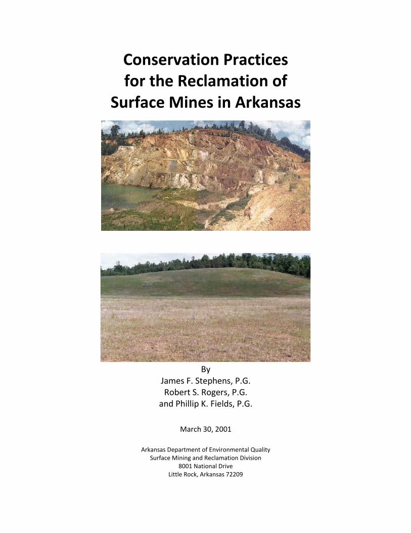
Front Cover: Cover photographs are U.S. Vanadium’s Christy Mine located in Hot Spring County, Arkansas taken before and after final reclamation. In 1998 this site won the first place award for outstanding non-coal reclamation from the Interstate Mining Compact Commission in a nation-wide competition among member states.
The authors would like to express their thanks to all of the employees of the ADEQ Surface Mining and Reclamation Division who provided assistance during the completion of this project. Without cooperation of the entire Division, this project would not have been possible. The authors would also like to extend appreciation to Floyd G. Durham. Mr. Durham was the Chief of the Surface Mining and Reclamation Division from 1978 to 2000. The idea and most of the work to put this handbook together was under his supervision and guidance.
This report is available from: Surface Mining and Reclamation Division Arkansas Department of Environmental Quality P.O. Box 8913 Little Rock, Arkansas 72219-8913

i
TABLE OF CONTENTS
CHAPTER 1: INTRODUCTION ............................................................................................................................ 1-1
SECTION 1.01 INTRODUCTION ................................................................................................................................. 1-1
CHAPTER 2: PERMITTING REQUIREMENTS ...................................................................................................... 2-1
SECTION 2.01 INTRODUCTION ................................................................................................................................. 2-1 SECTION 2.02 COAL MINING .................................................................................................................................. 2-1 SECTION 2.03 NON-COAL MINING........................................................................................................................... 2-2 SECTION 2.04 QUARRY OPERATIONS ........................................................................................................................ 2-3 SECTION 2.05 AIR PERMITS .................................................................................................................................... 2-3 SECTION 2.06 WATER PERMITS ............................................................................................................................... 2-5 SECTION 2.07 SAFETY ............................................................................................................................................ 2-6
CHAPTER 3: ADMINISTRATIVE CONSERVATION PRACTICES ............................................................................. 3-1
SECTION 3.01 INTRODUCTION .................................................................................................................................. 3-1 SECTION 3.02 PRELIMINARY ENVIRONMENTAL ASSESSMENT ......................................................................................... 3-1 SECTION 3.03 MAPS ............................................................................................................................................. 3-1 SECTION 3.04 MINING PLANS ................................................................................................................................. 3-5 SECTION 3.05 RECLAMATION PLANS ......................................................................................................................... 3-6 SECTION 3.06 BONDING......................................................................................................................................... 3-6
CHAPTER 4: EROSION CONTROL CONSERVATION PRACTICES .......................................................................... 4-1
SECTION 4.01 INTRODUCTION ................................................................................................................................. 4-1 SECTION 4.02 SILT FENCES ..................................................................................................................................... 4-1 SECTION 4.03 HAY BALES ....................................................................................................................................... 4-2 SECTION 4.04 GRADING ......................................................................................................................................... 4-4 SECTION 4.05 VEGETATION .................................................................................................................................... 4-4 SECTION 4.06 DIVERSION DITCHES AND BERMS ........................................................................................................... 4-5 SECTION 4.07 SEDIMENT PONDS ............................................................................................................................. 4-7 SECTION 4.08 RIPRAP ............................................................................................................................................ 4-8 SECTION 4.09 MULCHING ...................................................................................................................................... 4-9 SECTION 4.10 CHEMICAL SOIL BINDERS .................................................................................................................. 4-12 SECTION 4.11 CHECK DAMS.................................................................................................................................. 4-12
CHAPTER 5: RECLAMATION CONSERVATION PRACTICES ................................................................................. 5-1
SECTION 5.01 INTRODUCTION .................................................................................................................................. 5-1 SECTION 5.02 PRESERVATION OF TOPSOIL ................................................................................................................. 5-1 SECTION 5.03 TOPSOIL REPLACEMENT ...................................................................................................................... 5-2 SECTION 5.04 SOIL ANALYSIS .................................................................................................................................. 5-2 SECTION 5.05 COVERING ACID FORMING MATERIALS .................................................................................................. 5-3 SECTION 5.06 OVERBURDEN STORAGE ...................................................................................................................... 5-3 SECTION 5.07 EXCESSIVE REFUSE / SPOIL DISPOSAL .................................................................................................... 5-3 SECTION 5.08 CONTEMPORANEOUS RECLAMATION ..................................................................................................... 5-4 SECTION 5.09 BENCHING ....................................................................................................................................... 5-4
CHAPTER 6: OTHER MINING RELATED CONSERVATION PRACTICES ................................................................. 6-1
SECTION 6.01 INTRODUCTION ................................................................................................................................. 6-1 SECTION 6.02 DUST CONTROL ................................................................................................................................ 6-1 SECTION 6.03 ACID MINE DRAINAGE TREATMENT ...................................................................................................... 6-1 SECTION 6.04 GEOTEXTILES .................................................................................................................................... 6-4 SECTION 6.05 DROP STRUCTURES ............................................................................................................................ 6-5
ii
CHAPTER 7: CONCLUSION................................................................................................................................ 7-1
SECTION 7.01 CONCLUSION .................................................................................................................................... 7-1
APPENDIX A: SELECTED REFERENCES ............................................................................................................A-1
APPENDIX B: COMPANIES OFFERING ENVIRONMENTAL SERVICES FOR MINING OPERATIONS ..................... B-1
1. PERMIT APPLICATIONS ............................................................................................................................................ B-1 2. EROSION CONTROL ................................................................................................................................................. B-1 3. SEEDING AND VEGETATION ...................................................................................................................................... B-2 4. GENERAL CONTRACTORS (EARTH MOVING) ................................................................................................................. B-2 5. ENVIRONMENTAL TESTING ....................................................................................................................................... B-3
APPENDIX C: STATE - FEDERAL AGENCY & OTHER ORGANIZATIONS LISTING ................................................ C-1
1. STATE AGENCIES .................................................................................................................................................... C-1 2. FEDERAL AGENCIES ................................................................................................................................................. C-2 3. ORGANIZATIONS .................................................................................................................................................... C-2
APPENDIX D: CONVERSION FACTORS AND FORMULAS ................................................................................ D-1
1. HANDY CONVERSION TABLE ..................................................................................................................................... D-1 2. MAP SCALES ......................................................................................................................................................... D-3 3. RAPID CONVERSION TABLES ..................................................................................................................................... D-4 4. FORMULAS ........................................................................................................................................................... D-5
APPENDIX E: DEFINITIONS ............................................................................................................................ E-1
A. COMMON DEFINITIONS ........................................................................................................................................... E-1 B. COAL MINING DEFINITIONS ..................................................................................................................................... E-5 C. NON-COAL MINING ............................................................................................................................................. E-12 D. QUARRY MINING ................................................................................................................................................. E-14

iii
LIST OF FIGURES
FIGURE 2-1: FRONT OF BACKHOE....................................................................................................................................... 2-6 FIGURE 2-2: REAR OF BACKHOE ........................................................................................................................................ 2-7 FIGURE 3-1: PORTION OF A TOPOGRAPHIC MAP .................................................................................................................. 3-2 FIGURE 3-2: SITE MAP EXAMPLE ....................................................................................................................................... 3-3 FIGURE 3-3: RECLAMATION MAP EXAMPLE ......................................................................................................................... 3-4 FIGURE 3-4: TOPOGRAPHIC MAP SCALE INFORMATION .......................................................................................................... 3-5 FIGURE 4-1: SILT FENCE CONSTRUCTION ............................................................................................................................. 4-2 FIGURE 4-2: INEFFECTIVE SILT FENCE ................................................................................................................................. 4-2 FIGURE 4-3: PROPER HAY BALE INSTALLATION ..................................................................................................................... 4-3 FIGURE 4-4: HAY BALE EROSION CONTROL STRUCTURES ......................................................................................................... 4-3 FIGURE 4-5: IMPROPER INSTALLATION OF HAY BALES AS EROSION CONTROL STRUCTURE ............................................................... 4-4 FIGURE 4-6: VEE-SHAPED DIVERSION DITCH ........................................................................................................................ 4-6 FIGURE 4-7: PARABOLIC DIVERSION DITCH.......................................................................................................................... 4-6 FIGURE 4-8: TRAPEZOIDAL DIVERSION DITCH ...................................................................................................................... 4-7 FIGURE 4-9: SEDIMENT POND .......................................................................................................................................... 4-8 FIGURE 4-10: RIPRAP BERM ............................................................................................................................................. 4-9 FIGURE 4-11: MULCHING EXAMPLE ................................................................................................................................. 4-10 FIGURE 4-12: HYDRO-SEEDING ....................................................................................................................................... 4-11 FIGURE 4-13: EROSION CONTROL MATS............................................................................................................................ 4-12 FIGURE 4-14: ROCK CHECK DAM .................................................................................................................................... 4-13 FIGURE 4-15: LOG CHECK DAM ...................................................................................................................................... 4-13 FIGURE 5-1: TOPSOIL STORAGE (FROM OSM WEBSITE PHOTO GALLERY) ................................................................................... 5-1 FIGURE 5-2: TOPSOIL REPLACEMENT (FROM OSM WEBSITE PHOTO GALLERY) ............................................................................ 5-2 FIGURE 5-3: IDEALIZED CONTEMPORANEOUS RECLAMATION SEQUENCE ................................................................................... 5-4 FIGURE 5-4: BENCHING EXAMPLE ...................................................................................................................................... 5-5 FIGURE 6-1: CONSTRUCTED WETLAND ............................................................................................................................... 6-3 FIGURE 6-2: GEOTEXTILE CHANNEL LINING .......................................................................................................................... 6-4 FIGURE 6-3: GEOTEXTILE USED FOR STREAM BANK STABILIZATION ............................................................................................ 6-5 FIGURE 6-4: DROP STRUCTURE ......................................................................................................................................... 6-6

1-1
Chapter 1: INTRODUCTION
Section 1.01 Introduction
This handbook on conservation practices has been designed and produced to be a reference guide for anyone who wants to or is conducting surface mining operations in Arkansas. There are several major categories of surface mining based on the type of material being mined and the laws that regulate that specific mining activity.
The different categories of surface mining are:
Coal Mining
Non-Coal Mining (Open-cut Mining)
Quarry Operations
There are many of the different conservation practices that can be used in all three of the different categories of surface mining. Mine operators are encouraged to review all of the conservation practices to determine which practices may be applicable to the specific conditions of their mine site.
The term conservation practices (CP’s) has been generally used to describe a typically mechanical means of minimizing or eliminating non-point source water quality problems associated with various industries including surface mining operations. Once a CP has been selected and installed, it becomes a Best Management Practice (BMP) for that particular site.
The CP’s presented here have been selected to provide guidance for the operator of a surface mine. These CP’s can be used to integrate non-point source pollution prevention starting with the initial planning through to the final reclamation of the site once mining has been completed. The techniques and guidance provided in this manual should not be construed as law or regulation, but as highly effective and economical reclamation practices known to the Surface Mining and Reclamation Division at the present time.
This handbook was compiled and written by staff members of the Surface Mining and Reclamation Division to provide information to landowners, land use planners, and mine operators. The Division recommends that mine operators use this handbook as a resource in developing an environmentally and financially sound mine. This handbook should not be considered to be the final answer to all problems associated with preventing non-point source pollution at a mine site, but as a broad overview of CP’s that can assist the mine operator in selecting those CP’s that once installed will provide the BMP’s that help the operator in obtaining compliance with state and federal reclamation laws and regulations.
It is possible that no single CP will be the “magic bullet” that will control non-point source pollution at any given site. Multiple CP’s may be necessary to provide the operator with the necessary tools to obtain compliance. New technology is constantly being developed and mine
1-2
operators are urged to explore all avenues available when deciding upon what will be necessary for their particular site.
The reclamation of mine sites is a complex undertaking that usually calls for multi-disciplinary cooperation. Trained professionals such as agronomists, biologists, engineers, geologists, hydro-geologists and soil scientists can be helpful in developing a comprehensive reclamation plan for a mine site.
Implementation of CP’s as BMP’s is in everyone’s best interest. For mine operators correct BMP’s can result in more efficient and profitable mining operations. For society in general working BMP’s can result in cleaner, more usable reclaimed land. Effective final reclamation at a mine site can reduce water pollution, reduce the loss of topsoil, provide fish and wildlife habitat, and allow timber production, agriculture, and other uses that benefit all citizens in the state.
This project was partially funded by a grant from the U. S. Environmental Protection Agency (EPA) pursuant to Section 319(h) of the Clean Water Act. Remaining funding came from the operating budget of the Arkansas Department of Environment Quality as provided by the Arkansas General Assembly.

2-1
Chapter 2: PERMITTING REQUIREMENTS
Section 2.01 Introduction
This chapter will provide a brief overview on the different permitting requirements of the three surface mining programs in the State of Arkansas. Information on two other related environmental laws that affect mining operations, the Clean Air Act and the Clean Water Act, will also be presented in this chapter. Also included in this chapter are other state and federal programs that regulate the mining industry.
Section 2.02 Coal Mining
The primary goal for the issuance of a permit for coal mining is to insure that all surface coal mining and reclamation operations are conducted in a manner that meets all of the requirements of the state regulatory program. No person shall engage in surface coal mining and reclamation operations without obtaining a permit issued by the Department. All persons conducting surface coal mining and reclamation activities under a permit shall comply with the terms and conditions of said permit and all requirements of the Act and regulations.
A. There are five main requirements for the submission of a coal mining permit application. These are:
(1) General requirements that include: (a) Format and Content Requirements; (b) Permit Fees; (c) Verification of application.
(2) Requirements for legal, financial, compliance and related information; (3) Requirements for information on environmental resources; (4) Requirements for the operation and reclamation plans; and (5) Additional requirements for surface coal mining operations that are involved with
special categories of mining. These special categories are: (a) Experimental practices mining; (b) Mountaintop removal mining; (c) Steep slope mining; (d) Variances from approximate original contour restoration requirements of
steep slope mining; (e) Prime farmlands; (f) Variances for delay in contemporaneous reclamation; (g) Augering; (h) Coal processing plants or support facilities not located within the permit
area; (i) In situ processing activities;

2-2
(j) Lands eligible for re-mining.
B. Further details on each of the above requirements can be found in Regulation No. 20, the Arkansas Surface Coal Mining and Reclamation Code.
Section 2.03 Non-Coal Mining
The non-coal mining permitting program is divided into two areas. The first area deals with a surface mining operation that removes non-coal materials and the second area deals with removal of material from a stream channel. This differentiation in permitting requirements is due to the differences in the actual mining methods to remove the material and the reclamation requirements needed for the two areas. There are different forms for each of the two permit applications. Application packets containing forms and additional information can be obtained from the Surface Mining and Reclamation Division at (501) 682-0807.
A. Open-Cut Mining
(1) The general requirements for the submission of a permit application are: (a) Two signed and notarized permit application forms; (b) Permit application fee; (c) Proof of right to mine; (d) Mining Plan; (e) Reclamation Plan; (f) Maps:
(i) 7.5 min. topographic quadrangle vicinity map; (ii) Site map; and (iii) Reclamation map;
(g) Bond determination; (h) Bond instrument; and (i) Disclosure statement.
(2) Further details on each of these items may be found in Regulation No. 15, the Arkansas Open-Cut Mining and Land Reclamation Code.
B. In-Stream Mining
(1) The general requirements for the submission of an in-stream mining permit application are:
(a) Signed and notarized permit application form; (b) Permit application fee; (c) Proof of the right to mine; (d) Maps:
(i) 7.5 minute quadrangle map(s) with all areas to be permitted marked; (ii) Site map for each site; and (iii) Reclamation map as required;
(e) Bond instrument;

2-3
(f) Disclosure statement; and (g) Proof of notification of adjacent landowners of filing an application with the
Department.
(2) Further details on each of these items may be found in Regulation No. 15, the Arkansas Open-Cut Mining and Land Reclamation Code.
Section 2.04 Quarry Operations
The quarry operation and reclamation law does not allow for a permit to be issued, instead once the required information (Notification of Intent to Quarry) is sent to the Department, the quarry operation may begin. The Department has ninety (90) days to review the submitted materials and either ask for additional information or issue an “unconditional authorization to quarry”. The law does not allow any regulations to be promulgated and all information necessary for permitting is contained in the law. The law has been codified into the Arkansas Code Annotated (A.C.A.). The specific legal citation is A.C.A. 15-57-401 to 15-57-414.
A. The Notification of Intent (NOI) to Quarry is required to contain the following: (1) NOI form; (2) $250.00 fee (due with NOI to Quarry); (3) NOI Information sheet; (4) Right to Quarry; (5) Location Map; (6) Five (5) year Quarry Operation Map; (7) Reclamation Map (due with Notice of Exhausted Quarry); (8) NOI to Reclaim Quarry form; (9) Estimate of reclamation costs; (10) Bond Instrument; and (11) Proof of publication of Public Notice.
B. The forms listed above may be obtained from the Surface Mining and Reclamation Division at (501) 682-0807.
Section 2.05 Air Permits
Sources of emissions for rock crushers, screens, conveyors, haul roads, stock piles, engines, and fugitive dust emissions may be required to be permitted by the Department’s Air Division. A rock crushing facility is primarily of concern because of particulate matter (PM) emissions and/or particulate matter less than 10 microns in size (PM10). Any facility with emissions in excess of 10 tons per year PM or 15 tons per year of PM10 needs to obtain an ADEQ Minor Source Air Permit. In addition, a permit is required if the facility emits 40 tons per year of CO, 25 tons per year of NOx, VOC, or SO2. Any rock crushers with emissions in excess of 100 tons per year should apply for a Title V Air Permit. The majority of all applications for rock crushers will be minor source applications.

2-4
To complete an application the operator must have the following things in the application:
(1) General Facility Information Form; (2) Organizational Status of Owner/Operator Form; (3) USGS Maps of the Facility; (4) Legal Descriptions; (5) Plot Plans; (6) Process Flow Diagrams; (7) Process Description; (8) Identification of Emission Points; (9) Emission Rate Tables; (10) Emission Rate Calculations; (11) Equipment Specifications; (12) Environmental Disclosure; and (13) Certification of Application Form.
This information is explained thoroughly in the ADEQ Minor Source Permit Application Package. This information must be submitted for all sources at the facility.
The Air Division requires the permittee to submit emission calculations on all crushers, screens, conveyors, haul roads, stock piles, engines, and all other fugitive emissions. Record keeping conditions for most rock crushers involves keeping monthly records of throughput of fractured stone. This allows the permittee a method of demonstrating compliance with the emission limits set forth in the permit. Other conditions in most rock crushers permits involve the use of water sprays on all screens and all crushers at the facility, as well as, watering all haul roads when dust and debris are being emitted in excess amounts. Both of these conditions decrease dust emissions and do not allow the permittee to unnecessarily cause air contaminants and other pollutants to become airborne.
The federal regulation for rock crushers is New Source Performance Standards (NSPS) Subpart OOO - Standards of Performance for Non-metallic Mineral Processing Plants. To be Subject to these regulations any fixed rock crusher must have a capacity greater than 25 tons per hour and the processing equipment (screen, conveyors, and crushers) must have been constructed after August 31, 1983. Also any portable rock crusher must have a capacity greater than 150 tons per hour and the processing equipment (screen, conveyors, and crushers) must have been constructed after August 31, 1983. If a facility is subject to the NSPS requirements as defined in this paragraph, a permit must be obtained from the Department regardless of the amount of emissions previously mentioned. This regulation has a more stringent requirement on opacity. Requirements for these federal regulations usually require an initial opacity reading using EPA Method 9 for each crusher, conveyor, and screen. If the crusher contains stacks by which the emissions exit, the permittee must also perform a particulate test using EPA Method 5 or 17. Most rock crushers are not required to meet particulate requirements because they usually do not have emissions via a stack. Information on emissions from these facilities can be found in

2-5
EPA’s document “Compilation of Air Pollutant Emission Factors, AP-42, Fifth Edition, Volume I: Stationary Point and Area Sources”.
Section 2.06 Water Permits
The State of Arkansas has been delegated the authority by the Environmental Protection Agency (EPA) to implement a state permitting program in lieu of the federal National Pollutant Discharge Elimination System (NPDES). In order for Arkansas to have received this authorization, the state regulations have to be as stringent as the federal NPDES program. The permitting requirements for mining operations falls under two categories, a NPDES permit or a stormwater permit. Each of these major categories will be discussed separately.
A. NPDES Permits
NPDES permits regulate wastewater discharges by limiting the quantities of pollutants to be discharged and imposing monitoring requirements and other conditions. The limits and/or requirements in the permit help insure compliance with Arkansas Water Quality Standards and Federal Regulations, all of which are written to protect public health and the aquatic environment. There are two types of NPDES permits. These are the Individual NPDES Permit and the General NPDES Permit.
(1) The Individual NPDES Permit is unique to each facility. The limits and requirements in an individual permit are based on the facility’s operation, type and amount of discharge, and receiving stream, among other factors. If a project does not qualify for a general NPDES permit, an individual NPDES permit must be obtained. Mining operations that use a water process such as a wash plant for cleaning the materials must apply for an Individual NPDES permit.
(2) The General NPDES Permit is applicable to categories or types of facilities which have very similar or, in many cases, identical effluent limits and requirements. Coal Mining operations are eligible for an Arkansas General NPDES Permit (ARG040000).
B. Stormwater Permits
The requirements for stormwater control in Arkansas come from two different general permits, the Industrial Permit (ARR10A000) and the Construction Permit (ARR00A000). Under the terms of the Federal Clean Water Act and amendments as found in 40 CFR 122.26, operators of a wide range of construction and industrial activities must obtain NPDES permits for point source discharge of stormwater. Conditions in the permit typically require the creation of stormwater prevention plans designed to control and reduce pollutants in stormwater from these sites. Mining operations in Arkansas have two options in complying with these regulations. They can apply for the Individual NPDES Permit as detailed above or the Industrial stormwater permit.
2-6
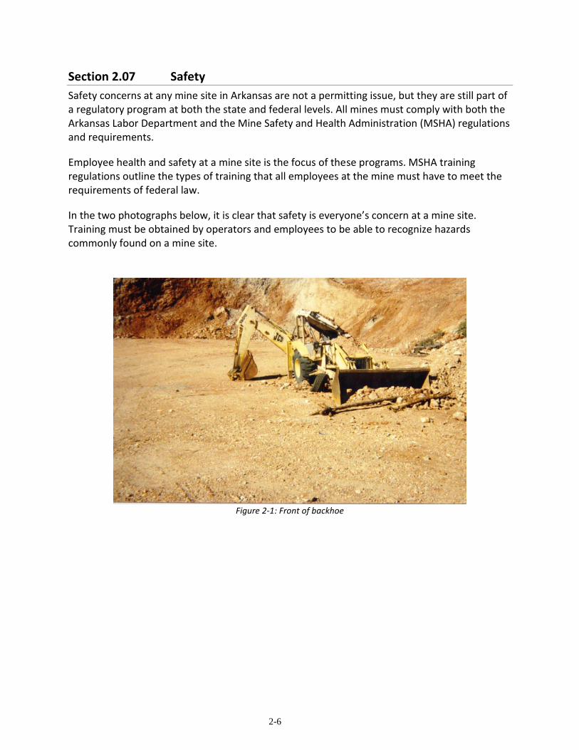
Section 2.07 Safety
Safety concerns at any mine site in Arkansas are not a permitting issue, but they are still part of a regulatory program at both the state and federal levels. All mines must comply with both the Arkansas Labor Department and the Mine Safety and Health Administration (MSHA) regulations and requirements.
Employee health and safety at a mine site is the focus of these programs. MSHA training regulations outline the types of training that all employees at the mine must have to meet the requirements of federal law.
In the two photographs below, it is clear that safety is everyone’s concern at a mine site. Training must be obtained by operators and employees to be able to recognize hazards commonly found on a mine site.
Figure 2-1: Front of backhoe

2-7
Figure 2-2: Rear of backhoe
The damage to the backhoe shown in Figure 2-1 and Figure 2-2 is the result of an employee operating near an unstable high-wall. Benching and lower active high-walls could have prevented this accident. No serious injuries occurred.

3-1
Chapter 3: ADMINISTRATIVE CONSERVATION
PRACTICES
Section 3.01 Introduction
The Administrative Conservation Practices listed in this chapter are those practices that have been identified as generally providing the operator with tools to be used in the initial planning phase of a mining operation. Using these practices at the start of operational planning will allow the operator to effectively plan the overall pollution prevention at the new mine site. Planning for the minimization of pollution at the front end will help the operator in obtaining all necessary permits before the operation begins and provide a more cost effective mining and reclamation plan.
Section 3.02 Preliminary Environmental Assessment
The Preliminary Environmental Assessment is a conservation practice that under certain conditions can aid the operator in identifying specific pollution sources at a specific mine site. The Preliminary Environmental Assessment normally consists of a detailed records search of the site in question examining previous land use information. Information on what activities have occurred at the site in the past such as other industrial uses can provide the operator with information on what kinds of pollution generating materials may be located on site. Sites that clearly have had no previous industrial activity may not need this practice in the mine planning phase.
Section 3.03 Maps
All of the mining permits listed in Chapter Two have detailed mapping requirements that must be submitted with permit applications. Preparing accurate maps of the mine site and its surroundings is a key step in developing a surface mining operation. Maps allow geographic data to be summarized in a compact form. Their primary purpose is to describe geographic features and the spatial relations of these features. Maps benefit the operator by clearly defining the area in which mining is permitted, and they assist in long-range planning for both efficient use of the mineral resource and for the timely reclamation of the site as mining progresses.
A. Types of Maps
There are several types of mine site maps that are required by the different surface mining permit programs. To meet regulatory requirements, maps must provide sufficient detail to characterize the mine site. Types of maps that may be required for permit applications are:

3-2
(1) A 7.5 Minute Topographic Map showing the location of the mine site. The original full-size map is required. Figure 3-1 below depicts a portion of a topographic map with the mine site location clearly marked and labeled.
Figure 3-1: Portion of a Topographic Map
(2) A Site Map showing details of the site to include the following features:
(a) The permit area is to be outlined and labeled; (b) The location and identification of all affected and unaffected areas. All areas
that will not be affected should be marked and labeled. Areas to be affected such as haul roads, offices, maintenance shelter(s), loading and process facilities, ponds, scales, spoil storage area(s), topsoil storage area(s), and the excavation area must be clearly marked;
(c) Flow patterns in the event that decant ponds or canals are used; (d) The precautions taken to avoid affecting any nearby waterway; (e) Identification of any diversion ditches used to channel water from sensitive
areas, including the flow patterns; and (f) The mining plan.

3-3
For sand and gravel mining sites that are ten (10) acres or larger in size that are regulated under the Arkansas Open-Cut Land Reclamation Act, a registered engineer or land surveyor is required to prepare the site map. These maps require elevation data of the pre-mining topography for the production of cross-sections of the original land surface. Additional cross-sections are to be made that will depict the ground’s surface after reclamation has been completed. An example of a Site Map is shown in Figure 3-2.
Figure 3-2: Site Map example
(3) A Reclamation Map that depicts the following information: (a) The permit area outlined and labeled;
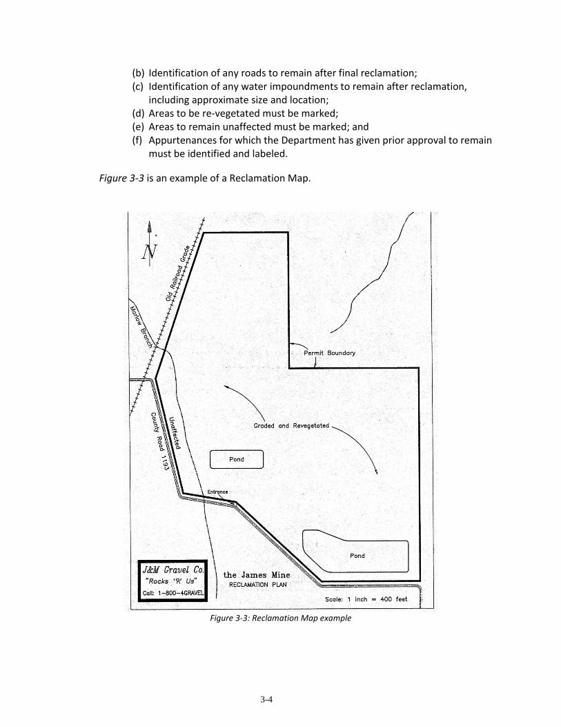
3-4
(b) Identification of any roads to remain after final reclamation; (c) Identification of any water impoundments to remain after reclamation,
including approximate size and location; (d) Areas to be re-vegetated must be marked; (e) Areas to remain unaffected must be marked; and (f) Appurtenances for which the Department has given prior approval to remain
must be identified and labeled.
Figure 3-3 is an example of a Reclamation Map.
Figure 3-3: Reclamation Map example
3-5
B. Map Sizes and Scales
(1) There are different requirements for the size of maps for each of the mining permitting programs. Usually the larger the map, the more information that can be displayed and clearly understood. The mine operator should submit maps to the Department that are large enough to clearly show all of the information required by the particular regulatory program.
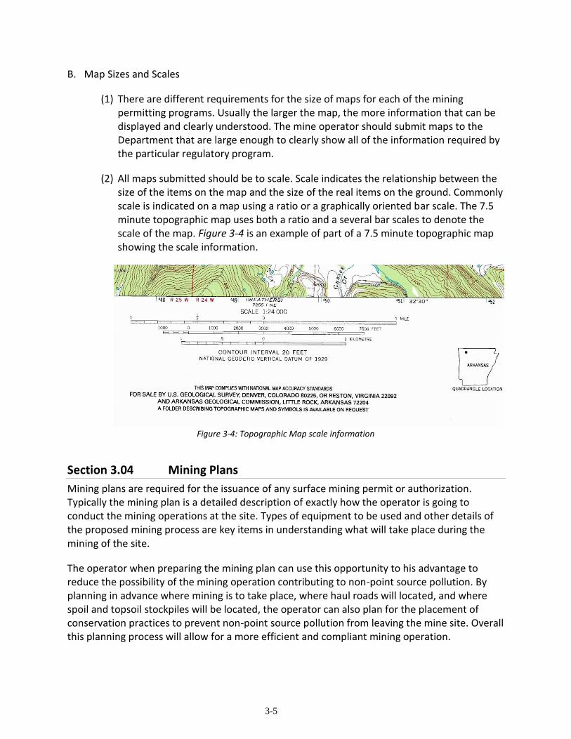
(2) All maps submitted should be to scale. Scale indicates the relationship between the size of the items on the map and the size of the real items on the ground. Commonly scale is indicated on a map using a ratio or a graphically oriented bar scale. The 7.5 minute topographic map uses both a ratio and a several bar scales to denote the scale of the map. Figure 3-4 is an example of part of a 7.5 minute topographic map showing the scale information.
Figure 3-4: Topographic Map scale information
Section 3.04 Mining Plans
Mining plans are required for the issuance of any surface mining permit or authorization. Typically the mining plan is a detailed description of exactly how the operator is going to conduct the mining operations at the site. Types of equipment to be used and other details of the proposed mining process are key items in understanding what will take place during the mining of the site.
The operator when preparing the mining plan can use this opportunity to his advantage to reduce the possibility of the mining operation contributing to non-point source pollution. By planning in advance where mining is to take place, where haul roads will located, and where spoil and topsoil stockpiles will be located, the operator can also plan for the placement of conservation practices to prevent non-point source pollution from leaving the mine site. Overall this planning process will allow for a more efficient and compliant mining operation.

3-6
Section 3.05 Reclamation Plans
Detailed reclamation plans are also very important to both the regulators and the operator. The proposed post mining use for the land also has an influence on what type of conservation practices will be useful in preventing non-point source pollution once reclamation is complete.
For example, the post mining land use may be designated to be a tree farm. However, just planting trees after the site has been graded may not be the best idea. Soil erosion could take place before the seedlings have a chance to become fully established. Silt washing from the bare ground around the trees becomes non-point source pollution. A much better approach would be to plan for an initial temporary vegetative cover to become established before the trees are planted. The temporary cover would prevent erosion until the trees themselves are established and providing additional erosion protection.
Section 3.06 Bonding
The requirements for a reclamation bond to be posted are valid for all types of surface mining. When an operator is determining the bond amount that will be required, it is another opportunity to plan for the reduction of non-point source pollution. If an operator chooses to bond using smaller mining increments at any one time, the possibility of non-point source pollution from the site will be reduced because fewer acres of land will be disturbed at any given time.
Other methods of planning for the reduction of bonding requirements also tend to lend themselves to the reduction of non-point source pollution leaving mine sites. Contemporaneous reclamation allows for reduced bond requirements by again reducing the amount of disturbed land that could be a source for non-point source pollution.

4-1
Chapter 4: EROSION CONTROL CONSERVATION
PRACTICES
Section 4.01 Introduction
The greatest source of non-point source pollution at surface mine operations can be attributed to silt leaving the mine site due to erosion. There are several factors that contribute to erosion. These are:
(1) Amount of annual rainfall; (2) Soil and rock types; (3) Steepness of slopes; and (4) Lack of vegetation.
Erosion control is very important at any mine site. Topsoil should be preserved and protected to provide the best possible growth medium for vegetation. Correct use of erosion control practices can insure that slopes are graded only once without rills and gullies appearing due to erosion. These practices contribute to successful reclamation with the least amount of time and money being used in the process.
This chapter will describe different conservation practices that will help the mine operator control erosion therefore eliminating or reducing the amount of silt that leaves the site. All active mining operations must have a storm water permit issued from the NPDES program as described in Section 2.6 of this handbook. The conservation practices listed below will help the mine operator comply with the requirements of the storm water permit.
Section 4.02 Silt Fences
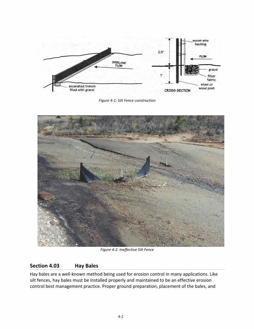
Silt fences are appropriate to be used below affected areas where sheet and rill erosion may be encountered. The silt fence is constructed using a filter fabric that allows water to flow through, but provides a barrier to silt particles. The silt fence is constructed perpendicular to the water’s flow direction and is held upright by stakes or posts (See Figure 4-1). The key installation requirement for a silt fence is that the fabric must extend below the ground’s surface and be anchored. Silt fences must be maintained to insure that they are effective. Figure 4-2 shows what can happen to an improperly installed and maintained silt fence.
4-2
Figure 4-1: Silt Fence construction
Figure 4-2: Ineffective Silt Fence
Section 4.03 Hay Bales
Hay bales are a well-known method being used for erosion control in many applications. Like silt fences, hay bales must be installed properly and maintained to be an effective erosion control best management practice. Proper ground preparation, placement of the bales, and
4-3
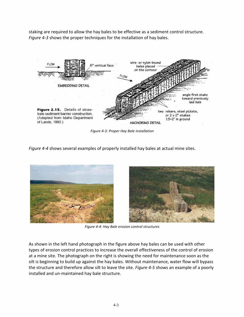
staking are required to allow the hay bales to be effective as a sediment control structure. Figure 4-3 shows the proper techniques for the installation of hay bales.
Figure 4-3: Proper Hay Bale installation
Figure 4-4 shows several examples of properly installed hay bales at actual mine sites.
Figure 4-4: Hay Bale erosion control structures
As shown in the left hand photograph in the figure above hay bales can be used with other types of erosion control practices to increase the overall effectiveness of the control of erosion at a mine site. The photograph on the right is showing the need for maintenance soon as the silt is beginning to build up against the hay bales. Without maintenance, water flow will bypass the structure and therefore allow silt to leave the site. Figure 4-5 shows an example of a poorly installed and un-maintained hay bale structure.

4-4
Figure 4-5: Improper installation of hay bales as erosion control structure
Section 4.04 Grading
The proper grading of spoil materials, either when stockpiled or when used for reclamation, can be an effective method of reducing the erosion of the spoil material. By grading slopes on the spoil stockpiles or the final slopes of the reclaimed high-walls, the operator reduces the velocity and ability to erode of the water flowing down the slopes during a storm event.
At non-coal mining sites, the law requires slopes to be no steeper than three (3) feet horizontal for one (1) foot vertical. Commonly we use a ratio (3 to 1 or 3:1) when talking about this type of slope. This is still a fairly steep slope and some of the non-coal mine operators have been using gentler slopes of 5 to 1 to further reduce the chances for erosion before a protective vegetation cover can be established.
Section 4.05 Vegetation
After grading is accomplished developing a vegetation cover is an important step in preventing non-point source pollution at a surface mining operation. The initial vegetative cover could be temporary or the operator could plant the species required for the final cover. Various species are usually required to get a successful self -sustaining vegetation cover. Mixtures of grasses, legumes, shrubs and trees can be necessary to obtain a useful final cover.

4-5
Vegetation is important because it: • reduces erosion, • reduces storm water runoff, • provides habitat and forage for animals, • reduces reclamation liability, and • increases the value of the property by returning it to a beneficial use.
There are several steps to follow in order to obtain successful vegetation of a surface mining operation as follows:
• Plan before you start, • Strip and store the topsoil and overburden separately using a temporary
vegetative cover on both, • Strip a small area at a time, • Move soil materials under dry conditions, • Reclaim the mine in segments, • Shape slopes for the planned final use, • Replace overburden and topsoil in the proper sequence, • Get advice from experts, and • Be patient.
The last step listed above needs the full attention of any mine operator. Additional soil amendments and seeding may be necessary to meet the regulatory program’s minimum vegetation standards. We have also seen occasions where a mine operator did not keep the land owner informed on the steps to get a release from reclamation liability. The land owner saw a brand new pasture wanted to immediately put livestock on the site. The livestock effectively ate all of the vegetation before it became permanently established. The mine operator had to go back and completely re-vegetate the site.
Section 4.06 Diversion Ditches and Berms
Diversion ditches and berms are storm water control structures whose location should be determined during the initial mine planning phase. These structures can be used to deflect storm water from entering onto the mine site from adjacent properties. Under the conditions of the NPDES permitting procedures, any storm water entering or falling on the mine site is the mine operator’s responsibility. Therefore it makes sense to plan to reduce the storm water liability at the very start of a mining operation. Diversion ditches that are installed on slopes should be placed perpendicular to the direction of the slope. As a general rule of thumb, diversion ditches can be installed every ten (10) vertical feet of slope. Another method of determining spacing between diversion ditches is to measure the distance from the top of the slope to the point on the slope where rills and gullies begin to develop.

4-6
The bottom of the ditch should be constructed to provide a slope of between 0.75 and 1 percent in the direction that the flow of water is to take. It is recommended that such structures be grass or riprap lined to provide natural filtration. Figure 4-6, Figure 4-7, and Figure 4-8 show several types of design for a diversion ditch.
Figure 4-6: Vee-shaped Diversion Ditch
Figure 4-7: Parabolic Diversion Ditch

4-7
Figure 4-8: Trapezoidal Diversion Ditch
Section 4.07 Sediment Ponds
Sediment ponds are used to collect storm water runoff from affected areas within the mine site. Permits issued under NPDES regulations usually contain requirements for one or more sediment ponds to be used before storm water may be discharged. The ponds can be of any size and normally are constructed using earthen embankments. Sand and Gravel operations typically incorporate their storm water runoff control in the ponds used for gravel washing and prefer to retain all of the water collected.
As the name infers these ponds are used to collect the storm water and allow the suspended sediment to settle out. Sediment ponds must be maintained. Inspections of the embankments should be conducted at routine intervals to determine if the structure has retained its integrity Failure could be caused by improper construction or animals burrowing into the structure. Commonly, the silt is excavated from the ponds at regular intervals, and it can then be used as fill during reclamation at other parts of the mine site.
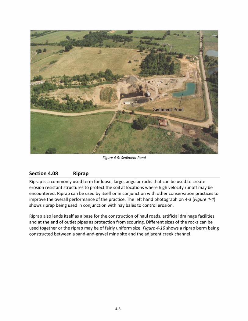
The Coal Mining law and regulations require that these ponds be designed by a professional engineer. Figure 4-9 shows a sediment pond at a coal mining site. The other mining regulatory programs recommend that the ponds be constructed using sound engineering practices.
4-8
Figure 4-9: Sediment Pond
Section 4.08 Riprap
Riprap is a commonly used term for loose, large, angular rocks that can be used to create erosion resistant structures to protect the soil at locations where high velocity runoff may be encountered. Riprap can be used by itself or in conjunction with other conservation practices to improve the overall performance of the practice. The left hand photograph on 4-3 (Figure 4-4) shows riprap being used in conjunction with hay bales to control erosion.
Riprap also lends itself as a base for the construction of haul roads, artificial drainage facilities and at the end of outlet pipes as protection from scouring. Different sizes of the rocks can be used together or the riprap may be of fairly uniform size. Figure 4-10 shows a riprap berm being constructed between a sand-and-gravel mine site and the adjacent creek channel.

4-9
Figure 4-10: Riprap berm
Section 4.09 Mulching
Mulching is the application of organic or other materials to the soil surface to prevent erosion and to retain moisture for seed germination. Mulching is highly recommended during all efforts for re-vegetation of reclaimed mined land. Mulches may be applied by blowers, hydro-mulching equipment or by hand. Figure 4-11 shows a site that has been properly mulched.

4-10
Figure 4-11: Mulching example
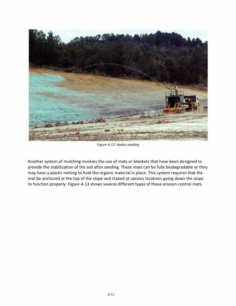
There are several common organic materials that have proven to be useful as mulches. These are hay or straw, wood chips, and wood fibers. Blower or hand application of mulch requires the seeds and fertilizer to be put down first. Hydro-mulch systems typically use a form of wood fibers plus a fertilizer along with the seeds for a one time application. Figure 4-12 shows a hydro-mulch system in operation at a gypsum mine in Arkansas. The same gypsum mine also had success using round hay bales unrolled in a crisscross pattern. They have found that even on gently sloping ground, the spaces in the mulch do not present any problems and excellent results are seen.
4-11
Figure 4-12: Hydro-seeding
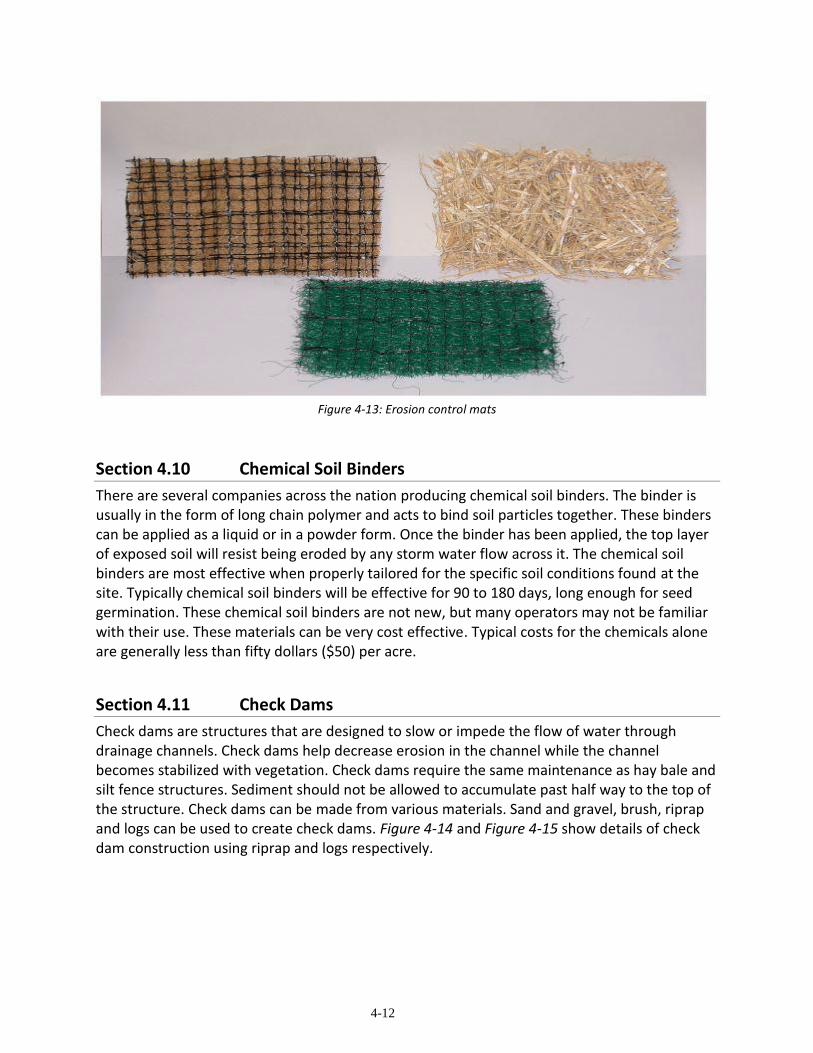
Another system of mulching involves the use of mats or blankets that have been designed to provide the stabilization of the soil after seeding. These mats can be fully biodegradable or they may have a plastic netting to hold the organic material in place. This system requires that the mat be anchored at the top of the slope and staked at various locations going down the slope to function properly. Figure 4-13 shows several different types of these erosion control mats.
4-12
Figure 4-13: Erosion control mats
Section 4.10 Chemical Soil Binders
There are several companies across the nation producing chemical soil binders. The binder is usually in the form of long chain polymer and acts to bind soil particles together. These binders can be applied as a liquid or in a powder form. Once the binder has been applied, the top layer of exposed soil will resist being eroded by any storm water flow across it. The chemical soil binders are most effective when properly tailored for the specific soil conditions found at the site. Typically chemical soil binders will be effective for 90 to 180 days, long enough for seed germination. These chemical soil binders are not new, but many operators may not be familiar with their use. These materials can be very cost effective. Typical costs for the chemicals alone are generally less than fifty dollars ($50) per acre.
Section 4.11 Check Dams
Check dams are structures that are designed to slow or impede the flow of water through drainage channels. Check dams help decrease erosion in the channel while the channel becomes stabilized with vegetation. Check dams require the same maintenance as hay bale and silt fence structures. Sediment should not be allowed to accumulate past half way to the top of the structure. Check dams can be made from various materials. Sand and gravel, brush, riprap and logs can be used to create check dams. Figure 4-14 and Figure 4-15 show details of check dam construction using riprap and logs respectively.

4-13
Figure 4-14: Rock Check Dam
Figure 4-15: Log Check Dam

5-1
Chapter 5: RECLAMATION CONSERVATION
PRACTICES
Section 5.01 Introduction
The Conservation Practices that will be covered in this chapter are useful in allowing the mine operator a head start on completing the final reclamation at a site. Surface mining operations can realize many benefits from the application of these practices. If the operator plans to use any or all of these conservation practices, the cost of reclamation will be minimized and therefore the profitability of the project will increase at the same time that the environment continues to be protected.
Section 5.02 Preservation of Topsoil
All of Arkansas’ surface mining laws all call for the preservation of topsoil when it is possible. Preferably topsoil should be stripped as a separate layer and stored for future use during reclamation. During storage the topsoil should be protected from unnecessary compaction and from erosion from both wind and water. Once the topsoil soil is stockpiled, a temporary vegetative cover should be developed on the stockpile. Figure 5-1 shows a topsoil stockpile with its vegetative cover in place.
Figure 5-1: Topsoil storage (from OSM website photo gallery)

5-2
Section 5.03 Topsoil Replacement
The replacement of topsoil is dependent on the final use proposed for the reclaimed site. Areas that are to be restored for agricultural purposes will need a thicker layer of topsoil to insure that post-mining production is equal to or greater than pre-mining production. Other land use designations may require varied thicknesses of topsoil to meet the requirements of successful re-vegetation and reclamation. Figure 5-2 shows topsoil being replaced on graded spoil at a coal mine.
Figure 5-2: Topsoil replacement (from OSM website photo gallery)
Section 5.04 Soil Analysis
Once the topsoil has been replaced, a soil analysis should be prepared to determine the correct soil amendments that are necessary. These amendments include the nutrients and fertilizers necessary for proper vegetative growth. These tests are provided by local conservation districts or state operated universities at low cost, or perhaps no cost, to the operator.
5-3
Section 5.05 Covering Acid Forming Materials
This conservation practice, while only applying to some surface mining operations is very important in reducing the potential of releasing damaging acid mine drainage (AMD). AMD is caused by the exposure of acid forming materials, such as iron pyrite (FeS2 ), to conditions where oxygen and water are present. The chemical reaction of these compounds produces a strong acid. For example, iron pyrite produces sulfuric acid (H2SO4).
To minimize the production of AMD, the operator must be able to identify the acid producing materials present and plan to separate the spoil that contains these materials for immediate disposal. The common method of disposal is to place these materials in a location that allows for the covering of the material with a cap that prevents the chemical reaction to take place.
Seams of acid forming minerals or geologic formations that will remain in the final high-wall must also be dealt with as soon as possible. A method commonly used for this situation is to have the seam exposure covered by water in a permanent impoundment. This method, however, does allow for the creation of a limited amount of AMD while the acid forming material is leached from of the high-wall until the chemical reaction stabilizes. This will require some form of active treatment of the impoundment, such as the addition of a buffering agent (commonly lime) until stabilization occurs in the high-wall.
Section 5.06 Overburden Storage
Overburden storage requirements are mandatory for the same pollution prevention reasons that proper storage of topsoil is necessary. Erosion of overburden stockpiles contributes heavy sediment loads to storm water runoff. Temporary vegetative cover again works to prevent erosion on these types of stockpiles.
Section 5.07 Excessive Refuse / Spoil Disposal
Occasionally a mine operator must plan for the disposal of excess volumes of spoil that will not be used as mine backfill or in other reclamation efforts at the mine site. There may be a commercial market for this material to be used as fill at other locations depending on local construction needs. Usually the mine operator may not always have this option available to him and must therefore plan to construct permanent disposal areas within the permitted site.
In the coal industry this has been accomplished in using what is called “head of hollow” fills. A natural topographic hollow near the site being mined is used to dispose of the excess material. Recently this practice has come under legal action in some states as requiring additional permits such as a Section 404 permit from the U.S. Army Corps of Engineers. Failure to quickly stabilize the fills has allowed erosion to contribute large amounts of sediment to the natural drainage paths in the hollows. Other conservation practices will be necessary in conjunction with any type of permanent fill to insure that off-site impacts are minimized in these cases.

5-4
Section 5.08 Contemporaneous Reclamation
Contemporaneous reclamation has slightly different meanings for the Coal Mining program and in the Non-Coal Mining program. The bottom line is that contemporaneous reclamation means that the operator will be performing reclamation concurrently with active mining is occurring at the mine site. This conservation practice does is limits the amount of affected area being exposed to the factors that could cause non-point source pollution. This practice may also be a financial incentive for the operator in several ways. Moving spoil straight to the reclamation site reduces the costs of handling the material. Bonding amounts for the site can be maintained at a lower level because fewer acres will require reclamation by the state in the event of bond forfeiture. Figure 5-3 shows a stylized sequence for contemporaneous reclamation.
Figure 5-3: Idealized Contemporaneous Reclamation sequence
Section 5.09 Benching
Benching is a conservation practice that not only allows for reclamation that reduces non-point source pollution, but it also increases the overall safety at the mine site. Benching works only where consolidated material is present as some of the overburden, the material to be extracted, or in both. MSHA regulations require that the operator to be able to scale the high-wall to insure that no loose materials can fall on the mine employees. The height of benching and width can be variable. We would highly recommend that topsoil be placed on flat portions of benches to facilitate vegetative growth, however, quarry operations are not required by law to do this. Figure 5-4 shows an example of benching at a quarry in Arkansas.

5-5
Figure 5-4: Benching example

6-1
Chapter 6: OTHER MINING RELATED
CONSERVATION PRACTICES
Section 6.01 Introduction
This chapter contains information on additional conservation practices that may be needed at a mine site but that do not easily fit into the categories of the practices mentioned in previous chapters. These practices include dust control, treatment of acid mine drainage, use of geotextiles, and drop structures. Some of these practices can be combined with others previously mentioned in this handbook for greater success in preventing non-point source pollution at a surface mine site.
Section 6.02 Dust Control
Dust is the dry finely pulverized particles of matter that may become airborne at a mine site and may possibly be a nuisance and a health hazard. While dust control is not specifically required for reclamation, some mining operations such as quarries will have air permits that contain references and rules to control fugitive dust emissions. Dust at a mine site can be generated by several different methods. The largest contributor to fugitive dust is equipment and truck traffic on haul roads. Blasting can also generate large amounts of dust under certain conditions, such as improper stemming and using excessive amounts of explosives.
Water is the most common method of dust control at many mine sites. Water trucks are used to spread water on haul roads. Crushers can be outfitted with spray bars at locations where dust emissions are generated. Some quarry operations use spray bars to clean trucks and moisten the truck’s load prior to the truck leaving the site. There are also chemical compounds that have been developed to bind the dust particles on roadways. If chemicals are used, a mine operator must be careful to use only approved suppressants to insure that storm water runoff from the areas treated will not contain dangerous chemicals that may leave the site.
Another strategy for dust control involves the use of barriers or screens. These could be berms, fences, or vegetation screens such as tall shrubs or trees.
Section 6.03 Acid Mine Drainage Treatment
Acid Mine Drainage (AMD) is a problem commonly encountered in coal mining; however, it can be problem for any type of surface mining where pyrite (iron sulfide) is found. AMD is formed when pyrite weathers in the presence of water and oxygen to form sulfuric acid. Section 5.05 in this handbook has already touched on this subject in relation to preventing AMD by quickly covering and properly disposing of acid forming materials. This section will describe some of the methods of treating AMD once it forms and becomes a problem at a mine site.
6-2
A. Active Treatment
Active AMD treatment was popular in the years before the 1980's. It consisted of applying chemicals to precipitate metals and neutralize the acidity found in AMD. Direct chemical treatment systems require constant attention to insure that the correct amounts of chemicals are being used. This method also often created large amounts of sludge containing high metals concentrations which presented additional problems concerning disposal of the sludge. The maintenance and operating costs of active treatment systems were therefore very high.
B. Passive Treatment
Since the 1980's, there has been a great deal of research into passive treatment systems for AMD problems. The passive systems are designed for long term, usually 20 to 40 years, treatment of AMD. There are four basic passive technologies that have been developed. These are constructed wetlands (aerobic and anaerobic), anoxic limestone drains (ALD), successive alkalinity producing systems (SAPS), and limestone ponds. These technologies can be combined to increase the overall effectiveness of the treatment.
(1) Constructed wetlands
Constructed wetlands rely on several mechanisms to treat AMD. Initially the function of the constructed wetland is to cause precipitation of metal hydroxides and metal sulfides. Organic reactions facilitate additional metal ion removal. Living plants, such as cattails, help consolidate the organic substrate and also directly incorporate metal ions in their tissues.
(a) Aerobic wetlands This type of constructed wetlands is highly dependent on the chemistry of the water entering the system. Aerobic wetlands perform effectively when the total input of water contains a net alkalinity. The purpose of the wetland is to collect water and provide time for the metals to precipitate.
(b) Anaerobic wetlands This type of wetland can be used when the water entering the system has a net acidity. The wetland must be constructed to provide the alkalinity to cause metal precipitation. Commonly limestone is placed below or mixed into the organic substrate. In the low oxygen conditions of the anaerobic wetland, bacteria remove additional metal ions. Figure 6-1 shows one pond of a series of ponds used in constructed wetlands. This site used chicken litter as the organic substrate.

6-3
Figure 6-1: Constructed Wetland
(2) Anoxic Limestone Drains (ALD)
ALD’s are constructed as closed systems that provide limestone filled conduits for AMD to pass through. The limestone dissolves to provide the alkalinity to precipitate the metals once the water comes in contact with oxygen outside of the ALD. Under the anoxic conditions, the limestone does not become coated with metal precipitate which greatly increases the effective life of this type of AMD treatment.
(3) Successive Alkalinity Producing Systems (SAPS)
These systems combine an ALD with a constructed wetland as a single treatment unit. Two or more of these treatment units are used in series to make up the SAPS. The wetland must have an organic substrate to function properly in combination with the ALD.
(4) Limestone ponds
Limestone ponds can be used where AMD occurs as an up-welling of water vertically rather that laterally as in the case of the use of an ALD. This vertical up-welling of AMD can occur along fracture zones or constructed conduits such as abandoned air shafts. A pond is constructed over the AMD seep to which a layer of limestone is added to the

6-4
bottom of the pond. The pond is sized and designed to retain water inflow for 12 to 24 hours. This allows the limestone to be covered with water to maintain low oxygen conditions to maximize the dissolving of the limestone by the AMD.
Section 6.04 Geotextiles
Geotextiles can be defined as a permeable textile used for geotechnical engineering purposes when dealing with soil stability, rock stability, and erosion control. A common usage is for this material is silt fences (See Section 4.02). Geotextiles can offer reasonable costs combined with predictable long term performance during soil stabilization and erosion control. Geotextiles can be used to reinforce, filter and direct planar water flow over the soil surface. Figure 6-2 shows the use of a geotextile as a channel lining material. Figure 6-3 shows a geotextile being used to help stabilize a stream bank until vegetation can grow.
Figure 6-2: Geotextile channel lining

6-5
Figure 6-3: Geotextile used for stream bank stabilization
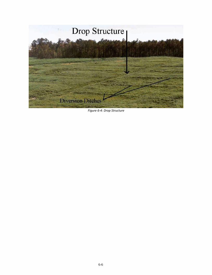
Section 6.05 Drop Structures
The primary function of a drop structure is to provide a transportation conduit for water to be moved vertically down a slope without causing erosion. There are many ways to create a drop structure. A spillway on a dam or a simple vertical rock lined ditch is both a type of drop structure. Drop structures are commonly combined with diversion ditches to manage water flow across a slope. Figure 6-4 shows a system of diversion ditches flowing into a drop structure that allows the water to flow out at the base of the slope.
6-6
Figure 6-4: Drop Structure

7-1
Chapter 7: CONCLUSION
Section 7.01 Conclusion
The authors hope that this handbook will provide help to the mine operator during all phases of the mining process from start to finish. The proper execution of these conservation practices as best management practices will provide the operator with the best chance to maximize potential profit of the operation at the same time insuring that non-point source pollution is reduced.
Another positive note for the operator is that by using these practices properly when required should keep the operator in compliance with environmental regulations. Compliance is a benefit for the operator, the Department, the state and the environment. This should be the goal of everyone involved with surface mining operations, such as the operator, mine employees, and the state regulatory authority employees.
We hope that this handbook will continue to be improved in the future. We understand that new conservation practices will be developed and that the mining industry must be provided with new information when it becomes available. If an operator develops a new practice or modifies a practice to fit certain conditions, we would hope that the operator will be willing to share this information for the benefit of all of the state’s surface mining industry.
Any comments for improvement of this handbook will be greatly appreciated. Comments should be sent to the Surface Mining and Reclamation Division at the address listed on the inside of the handbook’s cover.

A-1
Appendix A: SELECTED REFERENCES
Banks, Paul T.; Nickel, Robert E.; and Donald Blome. 1981.Reclamation and Pollution Control: Planning Guide for Small Sand and Gravel Mines. Report prepared by Hittman Associates, Inc. Sponsored by the U.S. Department of the Interior, Bureau of Mines, in cooperation with the Interstate Mining Compact Commission. Contract J0199052. Lexington, Kentucky.
Barksdale, R.D., editor, 1991, The aggregate handbook: National Stone Association [Washington, D. C.], 1v.
Beyer, L. E. ; Nickel, R.E.; and J. A. Diaper. 1979. Surface Mining and the Natural Environment. The Interstate Mining Compact Commission. Lexington, Kentucky.
Brady, N. C., 1974, The nature and properties of soils; 8th ed.: Macmillan, 639 p.
Cairns, J.; Dickson, K. L.; and E. E. Herricks. 1977. Recovery and Restoration of Damaged Ecosystems. University Press of Virginia. Charlottesville, Virginia.
Coppin, N.J.; Bradshaw, A. D., 1982, Quarry reclamation-The establishment of vegetation in quarries and open pit non-metal mines: Mining Journal Books [on behalf of the Mineral Industry Research Organization] [London], 112 p.
Davis, Stanley N.; and Roger J.M. DeWiest. 1966. Hydrology. John Wiley and Sons, Inc. New York, New York.
Down, C. and J. Stocks. 1978. Environmental Impact of Mining. Applied Science Publishers, Ltd. London, England.
Follett, R. H.; Murphy, L. S.; Donahue, R. L., 1981, Fertilizers and soil amendments: Prentice-Hall, 557 p.
Green, J. E.; Van Egmond, T.D.; Wylie, Carolyn; Jones, Ian; Knapik, Len; Paterson, L.R., 1992, A user guide to pit and quarry reclamation in Alberta: Alberta Land Conservation and Reclamation Council Reclamation Research Technical Advisory Committee, 137 p.
Greystone. 1998. In-stream Aggregate Extraction and Reclamation Guidance Document. Report prepared for the Colorado Department of Natural Resources, Division of Minerials and Geology. Contract C188188, Denver Colorado.
Idaho Department of Lands, 1992, Best management practices for mining in Idaho: Idaho Department of Lands, 1 v.
Law, D.L.,1984, Mined-land rehabilitation: Van Nostrand Reinhold, 184 p.
A-2
May, Jack T. 1977. Highlights of a Decade of Research and Reclamation on Kaolin Clay Strip Mining Spoil. Report No. 37 (June). Georgia Forest Research Council. University of Georgia. Athens, Georgia.
Michalski, M. F. P.; Gregory, D. R.; Usher, A. J., 1987, Rehabilitation of pits and quarries for fish and wildlife: Ontario Ministry of Natural Resources, Aggregate Resources Division, 59 p.
Munshower, F. F., 1994, Practical handbook of disturbed land revegetation: Lewis Publishers, 265p.
Norman, David K.; Wampler, Peter J.; Throop, Allen H.; Schnitzer, E. Frank; and Roloff, Jaretta M. 1996. Best Management Practices for Reclaiming Surface Mines in Washington and Oregon. Joint report prepared by the Washington State Division of Geology and Earth Resources and the Oregon State Department of Geology and Mineral Industries. Open File Reports, 96-2 and O-96-2. Olympia, Washington and Portland, Oregon.
Norman, D.K.; Lingley, W.S., Jr., 1992, Reclamation of sand and gravel mines: Washington Geology, v. 20, no. 3, p. 20-31.
North Carolina Department of Transportation, Division of Highways. 1980. Guidelines For Control of Erosion and Sediment During Construction. (July). Raleigh, North Carolina.
Rafaill, Barbara L. and Willis G. Vogel. 1978. A Guide for Vegetating Surface-Mined Lands for
Wildlife in Kentucky and West Virginia. FWS 14-16-0009-77-923. (July). U.S. Fish and Wildlife Service. U.S. Department of the Interior. Berea, Kentucky.
Schaller, E.W. and P. Sutton. (Eds.). 1978. Reclamation of Drastically Disturbed Lands. American Society of Agronomy, Crop Science Society of America and Soil Science Society of America. Madison, Wisconsin.
Schwab, Glen O.; Frevert, R. K.; Edminster, T. W.; and K. K. Barnes. 1966. Soil and Water Conservation Engineering. 2nd Ed. The Ferguson Foundation. Agricultural Engineering Series.
Soil and Water Conservation Committee of Georgia. Manual for Erosion and Sediment Control for Georgia. Athens, Georgia.
State Soil and Water Conservation Committee of Georgia. 1979. On -Site Erosion Control, Management Practices for Construction Activities. Athens, Georgia.
Thorne, Vincent, 1991, Reclaiming Feldspar Quarry: Atlas Blasting News, v. 17, no. 1, p.11.
Thronson, Robert E. 1971. Control of Erosion and SedimentDeposition from Construction of Highways and Land Development. U.S. Environmental Protection Agency, Office of Water Planning and Standards. Washington, D.C.
A-3
U.S. Bureau of Land Management, 1992, Solid minerals reclamation handbook-Noncoal leasable minerals, locatable minerals, salable minerals: U.S. Bureau of Land Management BLM Manual Handbook H-3042-1, 1 v.
U.S.D.A. Soil Conservation Service. 1975. Engineering Field Manualfor Conservation Practices. 2nd Printing. National Technical Information Service, U.S. Department of Commerce. Springfield, Virginia.
U.S.D.A. Soil Conservation Service, 1992, Engineering field handbook: Chapter 18-Soil bioengineering for upland slope protection and erosion reduction: U.S. Soil Conversion Service, 53 p.
U. S. Environmental Protection Agency, Office of Water Planning and Standards. 1973. Processes, Procedures, and Methods to Control Pollution From Mining Activities. EPA-430/9-73-011. (October). Washington, D.C.
U.S. Environmental Protection Agency, Office of Water Planning and Standards. 1976. Erosion and Sediment Control, surface Mining in the Eastern U.S. EPA-625/3-76-006. (October). Washington, D.C.
U.S. Environmental Protection Agency, Office of Water Planning and Standards. 1977. Water Quality Management Guidelines for Mine-Related Pollution Sources. EPA-440/3-77-027. (December). Washington, D.C.
U.S. Forest Service, U.S. Department of Agriculture and the Interstate Mining Compact Commission. 1980. Trees for Reclamation. (October 27-29). Lexington, Kentucky.
Virginia Soil and Water Conservation Commission. 1980. Virginia Erosion and Sediment Control Handbook. 2nd Ed. (June). Richmond, Virginia.
Vogel, Willis G. 1981. A Guide for Revegetating Coal Mine Soils in the Eastern U.S. Report NE-68. U.S. Department of Agriculture. Forest Service. Southern Region. Atlanta, Georgia.
West Virginia Department of Natural Resources, Division of Reclamation and U.S.D.A. Soil Conservation Service. 1975. Drainage Handbook for Surface Mining. Revised Ed. Charleston, West Virginia.

B-1
Appendix B: COMPANIES OFFERING ENVIRONMENTAL SERVICES FOR MINING OPERATIONS
Disclaimer The companies and/or individuals listed below are for information purposes only as having experience with mining related environmental issues. This listing does not imply any kind of endorsement by the Department or any other part of the government of Arkansas.
1. Permit Applications
NTB, Inc.- 3000 Kavanaugh Blvd, Ste 209A Little Rock, AR 72205 (501) 664-6380
Brixey, Baker & Associates, Inc.- P.O. Box 6180 Ft. Smith, AR 72903 (501) 646-6394 [FAX (501) 646-6721] Garver & Garver-Engineers- 1010 Battery St., P.O. Box C-50 Little Rock, AR 72203-0050
(501)376-3633 Genesis Environmental Consulting Inc.- 11400 Baseline Road, Little Rock, AR 72209
(501) 455-2199 Atoka, Inc.- 426 Winona, Hot Springs, AR 71901 (501) 623-1121 [FAX(501)623-2769] Environmental Enterprise Group, Inc.- 1305 E. Main St., Russellville, AR 72801 (501) 968-6767 FTN- No. 3 Innwood Circle Suite 220 Little Rock, AR 72211 (501) 225-7779 [FAX (501) 225-6738] GBMc & Associates - 219 Brown Lane Bryant, AR 72022 (501) 847-7077 [FAX (501) 847-7943] PMI- 3512 S. Shackleford Road, Little Rock, AR 72205 (501) 221-7122
2. Erosion Control
American Excelsior Company - 313 Phillips Rd. North Little Rock, AR 72117 (501) 945-4661 North American Green - Regional Office 14649 Highway 41 North Evansville, IN 47711
(800) 772-2040 www.nagreen.com
Landfill Service Corporation - 2183 Pennsylvania Ave Apalachin, NY 13732 (607) 625-3050 [FAX (607) 625-2689]

B-2
Applied Polymer Systems - 4015 Holcomb Bridge Rd. Suite 350-931 Norcross, GA 30092 (678) 461-9352.
3. Seeding and Vegetation
Arkansas HydroSeed - P.O. Box 557 Bryant, AR 72089 (501) 315-7333
(800) 573-7333 www.arkansashydroseed.com
Paul King Farms - Charleston, AR (501)965-2448
Axioo Construction, Inc.- P.O. Box 21 Mulberry, AR (501) 997-1144
Evergreen Landscaping, Inc. Hwy 7& 154 Centerville, AR 72829 (501) 576-2794
4. General Contractors (Earth moving)
R &E Excavating Co.- Inc.; Route 5 Box 559 Fort Smith, AR 72901 (501) 648-1260 Precision Grading & Excavation - 1823 Hwy 351 Paragould, AR 72450 (870) 240-8601 Blake Construction, Inc.- Route 1 Box 218 Arkoma, OK 74901 (919) 626-3983 Axioo Construction, Inc.- P.O. Box 21 Mulberry, AR 72947 (501) 997-1144 BryaCo, Inc. - 123 Robert Corder Rd., Griffithville, AR 72060 (501) 323-4339 Hammons Enterprises - 1805 Cherokee Ridge Circle, Mansfield, AR 73944 (501) 928-4418 Russell & Sons -3075 Eastman Road Longview, TX 75602 (903) 758-5578 Phelps Construction Co.- P.O. Box 61, Midland, AR 72945 (501) 651-3320 Evergreen Landscaping, Inc. - Hwy 7 & 154 Centerville, AR 72829 (501) 576-2794 Thomas Construction, Inc. - Route 5 Box 1228 Fort Scott, KS 66701 (316) 547-2475 Bennett’s Dozer Service - Route 1, Box 225, Havana, AR (501) 453-2285 Carter Construction & Ready Mix - P.O. Box 80 Subiaco, AR 72865 (501) 934-4211 G & G Dozer Service - P.O. Box 2522 Greenwood, AR
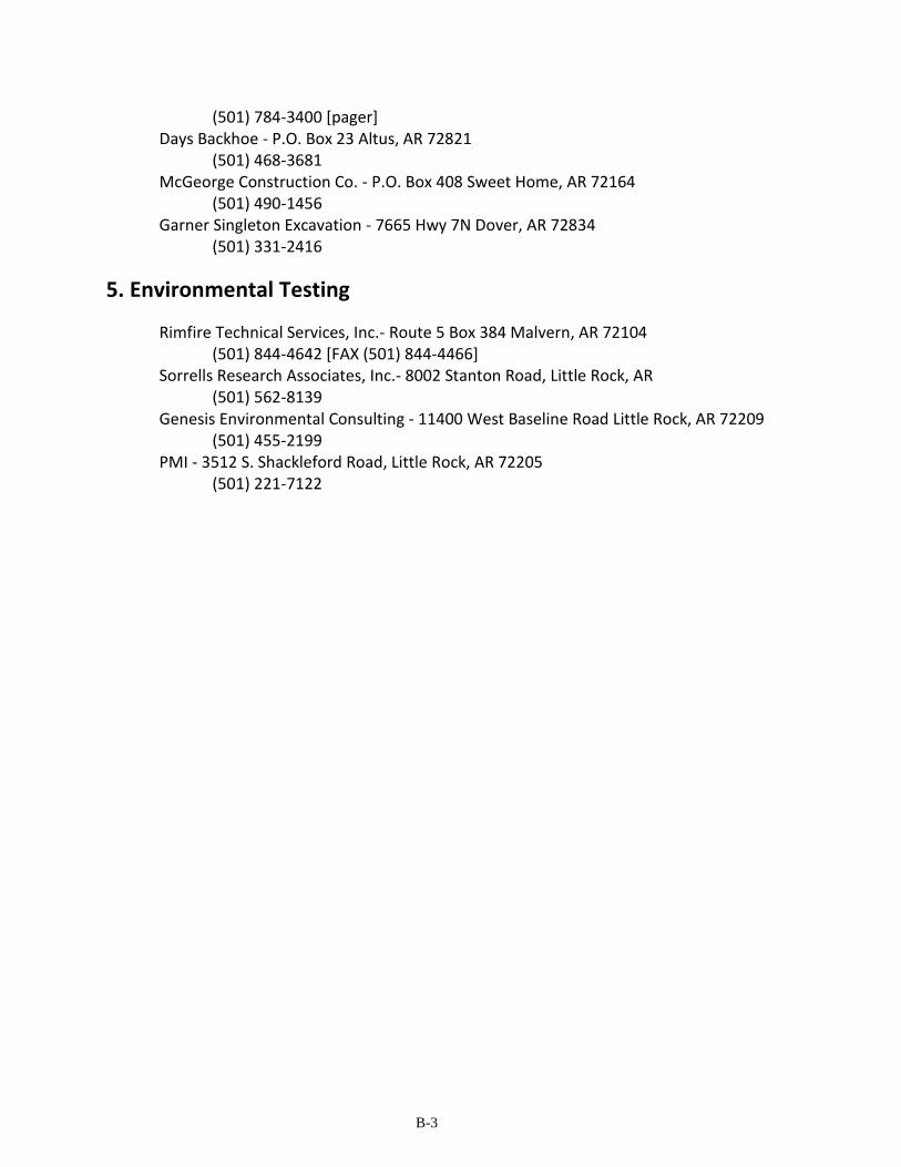
B-3
(501) 784-3400 [pager] Days Backhoe - P.O. Box 23 Altus, AR 72821 (501) 468-3681 McGeorge Construction Co. - P.O. Box 408 Sweet Home, AR 72164 (501) 490-1456 Garner Singleton Excavation - 7665 Hwy 7N Dover, AR 72834 (501) 331-2416
5. Environmental Testing
Rimfire Technical Services, Inc.- Route 5 Box 384 Malvern, AR 72104 (501) 844-4642 [FAX (501) 844-4466]
Sorrells Research Associates, Inc.- 8002 Stanton Road, Little Rock, AR (501) 562-8139
Genesis Environmental Consulting - 11400 West Baseline Road Little Rock, AR 72209 (501) 455-2199
PMI - 3512 S. Shackleford Road, Little Rock, AR 72205 (501) 221-7122
C-1
Appendix C: STATE - FEDERAL AGENCY & OTHER ORGANIZATIONS LISTING
1. State Agencies• Arkansas Department of Environmental Quality (501) 682-0744
(www.adeq.state.ar.us) P.O. Box 8913 Little Rock, Arkansas 72119-8913 Air Division (501) 682-0730 Surface Mining and Reclamation Division (501) 682-0807 Water Division (501) 682-0656
• Arkansas Soil and Water Conservation Commission (501) 682-1611 101 East Capitol Avenue, Suite 350 Little Rock, Arkansas 72201
• Arkansas Department of Labor (501) 682-4500 (www.state.ar.us/labor) 10421 West Markham Little Rock, Arkansas 72205
• Arkansas Geological Commission (501) 296-1877 3815 West Roosevelt Road Little Rock, Arkansas 72204
• Arkansas Cooperative Extension Service (501) 671-2080 (www.uaex..edu/natural/natural.html)
CES - Natural Resources P.O. Box 391 Little Rock, Arkansas 72203
• Arkansas Forestry Commission (501) 296-1940 3821 West Roosevelt Road Little Rock, Arkansas 72204
C-2
2. Federal Agencies • U. S. Department of Agriculture Natural Resources Conservation Service (501) 301-3100 (www.ar.nrcs.usda.gov) Room 3416 Federal Building 700 West Capitol Avenue Little Rock, Arkansas 72201 • U. S. Army Corps of Engineers
Little Rock District (501) 324-5551 Federal Building (6th and 7th Floors) 700 West Capitol Avenue Little Rock, Arkansas 72201
Memphis District (901) 544-3348 B-202 Clifford Davis Federal Building 167 North Main Street Memphis, Tennessee 38103-1854
Vicksburg District 1400 Walnut Street Vicksburg, Mississippi 39180 • U. S. Department of Interior Office of Surface mining Reclamation and Enforcement (www.osmre.gov) Tulsa Field Office (918) 581-6430 5100 East Skelly Drive, Suite 470 Tulsa, Oklahoma 74135-6548
3. Organizations • Interstate Mining Compact Commission (703) 709-8654 (www.imcc.isa.us) 445-A Carlisle Drive Herndon, Virginia 20170-4819 • National Association of State Land Reclamationists (www.siu.edu/~coalctr/naslr.htm) Coal Research Center Southern Illinois University Carbondale, Illinois 62901 • International Erosion Control Association (970) 879-3010 (www.ieca.org) P.O. Box 774904 Steamboat Springs, Colorado 80477-4904

D-1
Appendix D: CONVERSION FACTORS AND FORMULAS
1. Handy Conversion Table
To Convert Multiply by To Obtain
Acres 43560 square feet
Acres 4047 square meters
Acre-foot 43560 cubic feet
Acre-foot 3.259 X10⁵ gallons
Bushels 1.2445 cubic feet
Centimeters .03281 feet
Centimeters .3937 inches
Cubic Feet .8036 bushels
Cubic Feet 7.481 U. S. gallons
Cubic Feet 62.38 Pounds of water
Cubic Feet 28.32 Liters
Cubic Feet .02832 cubic meters
Cubic Inches 4.329 X 10⁻³ U. S. gallons
Cubic Inches .0361 pounds of water
Cubic Inches .01639 liters
Cubic meters 35.31 Cubic feet
fathoms 6 feet
feet 30.48 centimeters
feet .16667 fathoms
feet 3.048 X 10⁻⁴ kilometers
Gallons per minute 1440 gallons per day
Gallon (U.S.) 3.785 X 10⁻³ cubic meters
Gallon (U.S.) .1337 cubic feet
Gallon (U.S.) .8327 Imperial gallons
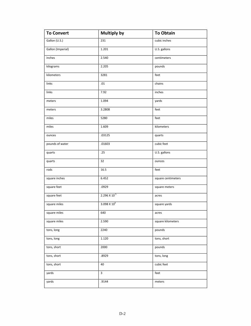
D-2
To Convert Multiply by To Obtain
Gallon (U.S.) 231 cubic inches
Gallon (Imperial) 1.201 U.S. gallons
inches 2.540 centimeters
kilograms 2.205 pounds
kilometers 3281 feet
links .01 chains
links 7.92 inches
meters 1.094 yards
meters 3.2808 feet
miles 5280 feet
miles 1.609 kilometers
ounces .03125 quarts
pounds of water .01603 cubic feet
quarts .25 U.S. gallons
quarts 32 ounces
rods 16.5 feet
square inches 6.452 square centimeters
square feet .0929 square meters
square feet 2.296 X 10⁻⁵ acres
square miles 3.098 X 10⁶ square yards
square miles 640 acres
square miles 2.590 square kilometers
tons, long 2240 pounds
tons, long 1.120 tons, short
tons, short 2000 pounds
tons, short .8929 tons, long
tons, short 40 cubic feet
yards 3 feet
yards .9144 meters
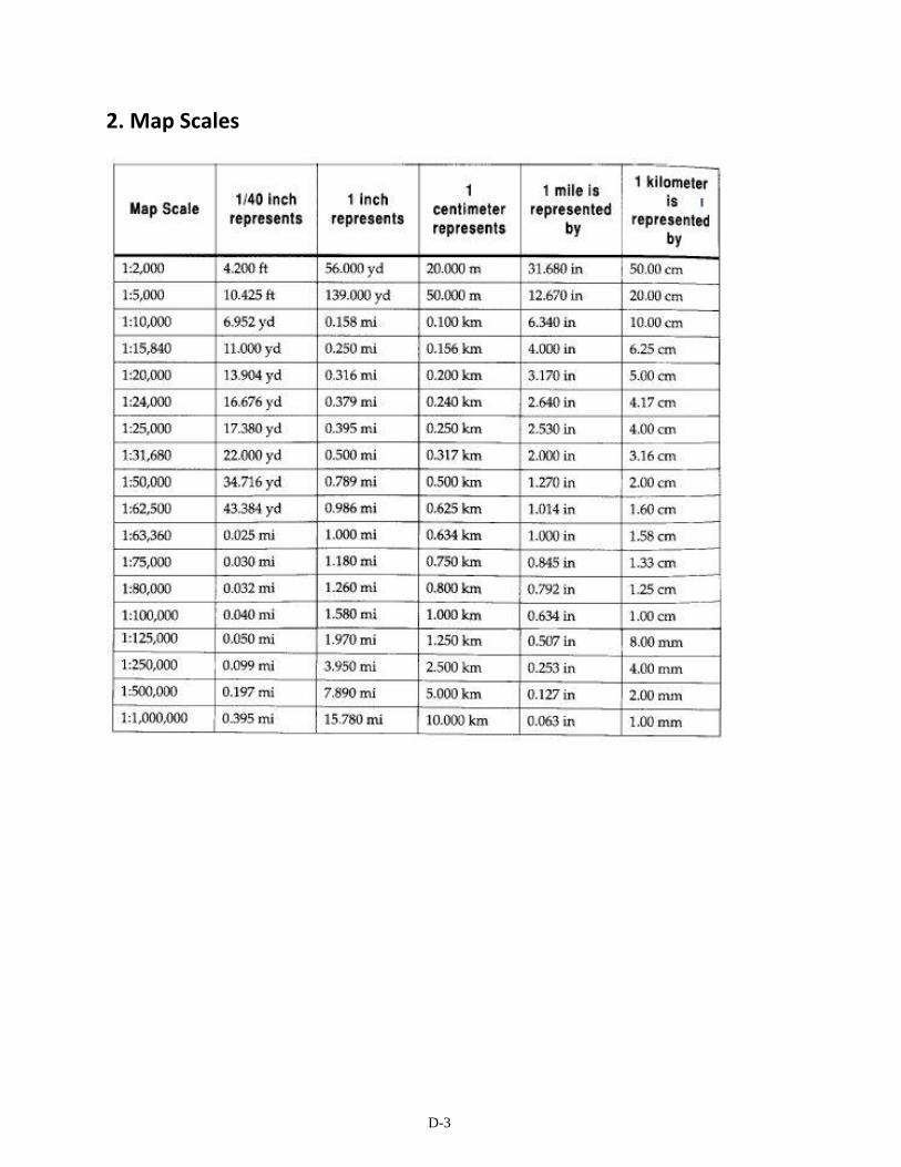
D-3
2. Map Scales

D-4
3. Rapid Conversion Tables
Lengths mm cm in ft yd m rd ch km mi
millimeters 1 10 25.4 304.8 914.4 1000 5029.2 20116.8 1000000 1609347
centimeters 0.1 1 2.54 30.48 91.44 100 502.9 2011.68 100000 160935
inches 0.03937 0.3937 1 12 36 39.37 198 792 39370 63360
feet 0.00328 0.0328 0.08333 1 3 3.2808 16.5 66 3280.8 5280
yards 0.00109 0.01093 0.0278 0.3333 1 1.0936 5.5 22 1093.6 1760
meters 0.001 0.01 0.02540 0.30480 0.91440 1 5.0292 20.116 1000 1609.3
rods 1.99x10⁻⁴ 0.00199 0.00505 0.0606 0.18181 0.1988 1 4 198.83 320
chains 4.97x10⁻⁵ 4.97x10⁻⁴ 0.00126 0.01515 0.04545 0.04971 0.25 1 49.708 80
kilometers 1x10⁻⁶ 1x10⁻⁵ 2.54x10⁻⁵ 3.05x10⁻⁴ 9.15x10⁻⁴ 0.001 0.00503 0.02012 1 1.6093
miles 6.21x10⁻⁷ 6.21x10⁻⁶ 1.58x10⁻⁵ 1.89x10⁻⁴ 5.68x10⁻⁴ 6.21x10⁻⁴ 0.00312 0.0125 .62137 1
Areas cm
2 in
2 ft
2 yd
2 m
2 rod
2 chain
2 acre kilometer
2 mi
2
cm2 1 6.452 929 8361 10000 252.91 4046528 40465284 1x10¹⁰ 2.59x10¹⁰
in2 0.155 1 144 1296 1550 39204 627264 6272640 155x107 4014489600
ft2 1.076x10⁻³ 0.0069 1 9 10.76 272.25 4356 43560 10763900 27878400
yd2 1.196x10⁻⁴ 7.716x10⁻⁴ 0.1111 1 1.196 30.25 484 4840 1195900 3097600
m2 1x10⁻⁴ 6.452x10⁻⁴ 0.0929 0.8361 1 25.29 404.7 4047 1x10⁶ 2589998
rod2 3.953x10⁻⁶ 2.551x10⁻⁵ 3.673x10⁻³ 0.0331 0.0395 1 16 160 39537 102400
chain2 2.471x10⁻⁷ 1.594x10⁻⁶ 2.296x10⁻⁴ 0.0021 0.0025 0.0625 1 10 2471 6400
acre 2.471x10⁻⁸ 1.594x10⁻⁷ 2.296x10⁻⁵ 2.066x10⁻⁴ 2.471x10⁻⁴ 0.0062 0.1 1 247.1 640
kilometer2 1x10⁻¹⁰ 6.452x10⁻¹⁰ 9.29x10⁻⁸ 8.361x10⁻⁷ 1x10⁻⁶ 2.529x10⁻⁵ 1.047x10⁻⁴ 4.047x10⁻³ 1 2.59
mi2 3.861x10⁻¹¹ 2.491x10⁻¹⁰ 3.587x10⁻⁸ 3.228x10⁻⁷ 3.861x10⁻⁷ 9.766x10⁻⁶ 1.563x10⁻⁴ 1.563x10⁻³ 0.3861 1

D-5
Volumes cm
3 in
3 liters Gal. ft
3 yd
3 m
3 acre ft
cubic cm 1 16.39 1000 3785.4 28317 764560 1x10⁶ 1.233x10
9
cubic in 0.06102 1 61.0234 231 1728 46656 61023 75271680
liters 0.001 0.016387 1 3.7854 28.317 764.56 1000 1233490
Gallons 2.642x10⁻⁴
0.004329 0.26417 1 7.4805 201.974 264.17 325851
cubic ft 3.531x10⁻⁵
5.787x10⁻⁴
0.03531 0.13368 1 27 35.3145 43560
cubic yds 1.308x10⁻⁶
2.143x10⁻⁵
0.001308 0.00495 0.03704 1 1.30794 1613.33
cubic m 1x10⁻⁶
1.639x10⁻⁵
0.001 0.003785 0.02832 0.76456 1 1233.49
acre ft 8.107x10⁻¹⁰
1.328x10⁻⁸
8.107x10⁻⁷
3.069x10⁻⁶
2.296x10⁻⁵
6.199x10⁻⁴
8.107x10⁻⁴
1
4. Formulas
Temperature Conversions Temperature Centigrade = 5/9 (Temp. °F. - 32) Temperature Fahrenheit = 9/5 (Temp. °C.) + 32 Absolute Temperature C = Temp. °C + 273 Absolute Temperature F = Temp. °F + 460

E-1
Appendix E: DEFINITIONS In this appendix, we will provide some of the basic definitions from each of the applicable mining laws and regulations that will be necessary to understand the purpose of the various Conservation Practices that will appear in the chapters to follow. The definitions will be presented first by a section of common definitions that apply to all types of surface mining and each specific category of mining will present its own specific definitions. In some cases a definition can appear in more than one section due to the difference in the way the definition was written and interpreted as it applies to a specific category of surface mining.
A. Common Definitions
Acid drainage means water with a pH of less than 6.0 and in which total acidity exceeds total alkalinity, discharged from an active, inactive or abandoned surface mine and reclamation operation or from an area affected by surface mining and reclamation operations.
Acid-forming materials means earth materials that contain sulfide minerals or other materials which, if exposed to air, water, or weathering processes, form acids that may create acid drainage.
Aquifer means a zone, stratum, or group of strata that can store and transmit water in sufficient quantities for a specific use.
Bond means a surety bond, collateral bond or self-bond or a combination thereof, by which a surface mine operator assures faithful performance of all the requirements of the law, regulation and the reclamation plan.
Compaction means increasing the density of a material by reducing the voids between the particles and is generally accomplished by controlled placement and mechanical effort such as from repeated application of wheel, track, or roller loads from heavy equipment.
Commission means the Arkansas Pollution Control and Ecology Commission, or such commission or other entity as may lawfully succeed to the powers and duties of the Commission.
Department means the Arkansas Department of Environmental Quality or such department or other entity which may lawfully succeed to the powers and duties of the Department.
Director means the executive head and active administrator of the Department. Diversion means a channel, embankment, or other manmade structure constructed to divert water from one area to another.
E-2
Diversion means a channel, embankment, or other manmade structure constructed to divert water from one area to another.
Drinking, domestic or residential water supply means water received from a well or spring and any appurtenant delivery system that provides water for direct human consumption or household use. Wells and springs that serve only agricultural, commercial or industrial enterprises are not included except to the extent the water supply is for direct human consumption or human sanitation, or domestic use.
Ephemeral stream means a stream which flows only in direct response to precipitation in the immediate watershed or in response to the melting of a cover of snow and ice, and which has a channel bottom that is always above the local water table.. Fugitive dust means that particulate matter not emitted from a duct or stack which becomes airborne due to the forces of wind or surface mining and reclamation operations or both. During surface mining and reclamation operations it may include emissions from haul roads; wind erosion of exposed surfaces, storage piles, and spoil piles; reclamation operations; and other activities in which material is either removed, stored, transported, or redistributed.
Groundwater means subsurface water that fills available openings in rock or soil materials to the extent that they are considered water saturated.
Half-shrub means a perennial plant with a woody base whose annually produced stems die back each year.
Hydrologic balance means the relationship between the quality and quantity of water inflow to, water outflow from, and water storage in a hydrologic unit such as a drainage basin, aquifer, soil zone, lake, or reservoir. It encompasses the dynamic relationships among precipitation, runoff, evaporation, and changes in ground and surface water storage.
Imminent danger to the health and safety of the public means the existence of any condition or practice, or any violation in a surface mining and reclamation operation, which could reasonably be expected to cause substantial physical harm to persons outside the mining area before the condition, practice, or violation can be abated. A reasonable expectation of death or serious injury before abatement exists if a rational person, subjected to the same condition or practice giving rise to the peril, would avoid exposure to the danger during the time necessary for abatement.
Impounding structure means a dam, embankment or other structure used to impound water, slurry, or other liquid or semi-liquid material.
Impoundment means a closed basin, naturally formed or artificially built, which is dammed or excavated for the retention of water, sediment, or waste.

E-3
Intermittent stream means — A. A stream or reach of a stream that drains a watershed of at least one square mile, or B. A stream or reach of a stream that is below the local water table for a least some part of
the year, and obtains its flow from both surface runoff and ground water discharge.
Mulch means vegetation residues or other suitable materials that aid in soil stabilization and soil moisture conservation, thus providing micro-climatic conditions suitable for germination and growth.
Noxious plants means species that have been included on official State lists of noxious plants for Arkansas.
Perennial stream means a stream or part of a stream that flows continuously during all of the calendar year as a result of ground-water discharge or surface runoff. The term does not include intermittent stream or ephemeral stream.
Permanent diversion means a diversion remaining after surface mining and reclamation operations are completed which has been approved for retention by the Director and other appropriate State and Federal agencies.
Permanent impoundment means an impoundment which is approved by the Department and, if required, by other State and Federal agencies for retention as part of the post mining land use.
Sedimentation pond means a primary sediment control structure designed, constructed and maintained and including, but not limited to a barrier, dam, or excavated depression which slows down water runoff to allow sediment to settle out. A sedimentation pond shall not include secondary sedimentation control structures, such as straw dikes, rip rap, check dams, mulches, dugouts and other measures that reduce overland flow velocity, reduce runoff volume or trap sediment, to the extent that such secondary sedimentation structures drain to a sedimentation pond.
Siltation structure means a sedimentation pond, a series of sedimentation ponds, or other treatment facility.
Slope means average inclination of a surface, measured from the horizontal, generally expressed as the ratio of a unit of vertical distance to a given number of units of horizontal distance (e.g.,1v:5h).
Soil Horizons means contrasting layers of soil parallel or nearly parallel to the land surface. Soil horizons are differentiated on the basis of field characteristics and laboratory data. The three major soil horizons are:
A. A horizon. The uppermost mineral layer often called the surface soil. It is the part of the soil in which organic matter is most abundant, and leaching of soluble or suspended particles is typically the greatest.

E-4
B. B horizon. The layer that typically is immediately beneath the A horizon and often called the subsoil. This middle layer commonly contains more clay, iron, or aluminum than the A or C horizons.
C. C horizon. The deepest layer of soil profile. It consists of loose material or weathered rock that is relatively unaffected by biologic activity.
Soil Survey means a field and other investigation, resulting in a map showing the geographic distribution of different kinds of soils and an accompanying report that describes, classifies, and interprets such soils for use.
Spoil means overburden that has been removed during surface mining operations.
Stabilize means to control movement of soil, spoil piles, or areas of disturbed earth by modifying the geometry of the mass, or by otherwise modifying physical or chemical properties, such as by providing a protective surface coating.
Suspended solids or non-filterable residue, expressed as milligrams per liter, means organic or inorganic materials carried or held in suspension in water which are retained by a standard glass fiber filter in the procedure outlined by the Environmental Protection Agency's regulations for waste water and analyses (40 CFR 136).
Temporary diversion means a diversion of a stream or overland flow which is used during surface mining and reclamation operations and not approved to remain after reclamation as part of the approved post-mining land use.
Temporary impoundment means an impoundment used during surface mining and reclamation operations, but not approved to remain as part of the approved post-mining land use.
Topsoil means the A soil horizon layer of the three major soil horizons.
Toxic-forming materials means earth materials or wastes which, if acted upon by air, water, weathering, or microbiological processes, are likely to produce chemical or physical conditions in soils or water that are detrimental to biota or uses of water.
Toxic mine drainage means water that is discharged from active or abandoned mines or other areas affected by coal exploration or surface coal mining and reclamation operations, which contains a substance that through chemical action or physical effects is likely to kill, injure, or impair biota commonly present in the area that might be exposed to it.
Water table means the upper surface of a zone of saturation, where the body of groundwater is not confined by an overlying impermeable zone.

E-5
B. Coal Mining Definitions
Act 134 means the Arkansas Surface Coal Mining and Reclamation Act (Arkansas Code Annotated 15-58-101 et seq.).
Adjacent area means land located outside the affected area or permit area, depending on the context in which adjacent area is used, where air, surface or ground water, fish, wildlife, vegetation or other resources protected by the Act may be adversely impacted by surface coal mining and reclamation operations.
Affected area means, with respect to surface mining activities, any land or water upon or in which those activities are conducted or located.
Agricultural use means the use of any tract of land for the production of animal or vegetable life. The uses include, but are not limited to, the pasturing, grazing, and watering of livestock, and the cropping, cultivation, and harvesting of plants.
Applicant means any person seeking a permit from the Director to conduct surface coal mining and reclamation operations pursuant to the State program.
Approximate original contour means that surface configuration achieved by backfilling and grading of the mined areas so that there claimed area, including any terracing or access roads, closely resembles the general surface configuration of the land prior to mining and blends into and complements the drainage pattern of the surrounding terrain, with all high-walls, spoil piles and coal refuse piles eliminated. Permanent water impoundments may be permitted where the Director has determined that they comply with the regulations.
Auger mining means a method of mining coal at a cliff or high-wall by drilling holes into an exposed coal seam from the high-wall and transporting the coal along an auger bit to the surface.
Best technology currently available means equipment, devices, systems, methods, or techniques which will (a) prevent, to the extent possible, additional contributions of suspended solids to stream flow or runoff outside the permit area, but in no event result in contributions of suspended solids in excess of requirements set by applicable State or Federal laws; and (b) minimize, to the extent possible, disturbances and adverse impacts on fish, wildlife and related environmental values, and achieve enhancement of those resources where practicable. The term includes equipment, devices, systems, methods, or techniques which are currently available anywhere as determined by the Director, even if they are not in routine use. The term includes, but is not limited to, construction practices, siting requirements, vegetative selection and planting requirements, animal stocking requirements, scheduling of activities and design of sedimentation ponds in accordance with the regulations. Within the constraints of the State program, the Director shall have the discretion to determine the best technology currently available on a case-by-case basis, as authorized by the Act and the regulations.

E-6
Coal exploration means the field gathering of:
A. Surface or subsurface geologic, physical, or chemical data by mapping, trenching, drilling, geophysical, or other techniques necessary to determine the quality and quantity of overburden and coal of an area; or
B. The gathering of environmental data to establish the conditions of an area before beginning surface coal mining and reclamation operations under the requirements of the regulations.
Coal mine waste means coal processing waste and underground development waste.
Coal processing plant means a collection of facilities where run-of-the-mine coal is subjected to chemical or physical processing or the cleaning, concentrating, or other processing or preparation. The processing plant may consist of, but need not be limited to, the following facilities: loading facilities, storage and stockpile facilities, sheds, shops and other buildings; water treatment and water storage facilities; settling basins and impoundments; coal processing and other waste disposal areas; roads, railroads and other transport facilities.
Coal processing waste means earth materials which are separated and wasted from the product coal during cleaning, concentrating, or other processing or preparation of coal.
Combustible material means organic material that is capable of burning, either by fire or through oxidation, accompanied by the evolution of heat and a significant temperature rise.
Cropland means land used for the production of adapted crops for harvest, alone or in a rotation with grasses and legumes, and includes row crops, small grain crops, hay crops, nursery crops, orchard crops, and other similar specialty crops.
Cumulative impact area means the area, including the permit area, within which impacts resulting from the proposed operation may interact with the impacts of all anticipated mining on the surface- and ground-water systems. Anticipated mining shall include, at a minimum, the entire projected lives through bond releases of:
A. The proposed operation,
B. All existing operations,
C. Any operation for which a permit application has been submitted to the Department, and
D. All operations required to meet diligent development requirements for leased Federal coal for which there is actual mine development information available.
Disturbed area means an area where vegetation, topsoil, or overburden is removed or upon which topsoil, spoil, coal processing waste, underground development waste, or non-coal waste

E-7
is placed by surface coal mining operations. Those areas are classified as disturbed until reclamation is complete and the performance bond or other assurance of performance required by the regulations.
Downslope means the land surface between the projected out-crop of the lowest coal bed being mined along each high-wall and a valley floor.
Embankment means an artificial deposit of material that is raised above the natural surface of the land and used to contain, divert, or store water, support roads or railways, or for other similar purposes.
Excess spoil means spoil material disposed of in a location other than the mined-out area, provided that spoil material used to achieve the approximate original contour or to blend the mined-out area with the surrounding terrain in non-slope areas shall not be considered excess spoil.
Existing structure means a structure or facility used in connection with or to facilitate surface coal mining and reclamation operations for which construction begins prior to the approval of the State program.
Head-of-hollow fill means a fill structure consisting of any material, other than coal processing waste and organic material, placed in the uppermost reaches of a hollow where side slopes of the existing hollow measured at the steepest point are greater than 20 degrees or the average slope of the profile of the hollow from the toe of the fill to the top of the fill is greater than 10 degrees. In fills with less than 250,000 cubic yards of material, associated with contour mining, the top surface of the fill will be at the elevation of the coal seam. In all other head-of-hollow fills, the top surface of the fill, when completed, is at approximately the same elevation as the adjacent ridge line, and no significant area of natural drainage occurs above the fill draining into the fill area.
High-wall means the face of exposed overburden and coal in an open cut of a surface coal mining activity or for entry to underground mining activities.
Historically used for cropland means (1) lands that have been used for cropland for any 5 years or more out of the 10 years immediately preceding the acquisition, including purchase, lease or option, of the land for the purpose of conducting or allowing through resale, lease or option the conduct of surface coal mining and reclamation operations; (2) lands that the Director determines, on the basis of additional cropland history of the surrounding lands and the lands under consideration, that the permit area is clearly cropland but falls outside the specific 5-years-in-10 criterion, in which case the regulations for prime farmland may be applied to include more years of cropland history only to increase the prime farmland acreage to be preserved; or (3) lands that would likely have been used as cropland for any 5 out of the last 10 years, immediately preceding such acquisition but for the same fact of ownership or control of the land unrelated to the productivity of the land.

E-8
Hydrologic regime means the entire state of water movement in a given area. It is a function of the climate and includes the phenomena by which water first occurs as atmospheric water vapor, passes into a liquid or solid form, falls as precipitation, moves along or into the ground surface, and returns to the atmosphere as vapor by means of evaporation and transpiration.
In situ processes means activities conducted on the surface or underground in connection with in-place distillation, retorting, leaching, or other chemical or physical processing of coal. The term includes, but is not limited to, in situ gasification, in situ leaching, slurry mining, solution mining, borehole mining, and fluid recovery mining.
Land use means specific uses or management-related activities, rather than the vegetation or cover of the land. Land uses may be identified in combination when joint or seasonal uses occur. Changes of land use or uses from one of the following categories to another shall be considered as a change to an alternative land use which is subject to approval by the Director.
A. Cropland means land used for the production of adapted crops for harvest, alone or in a rotation with grasses and legumes, and includes row crops, small grain crops, hay crops, nursery crops, orchard crops, and other similar specialty crops. Land used for facilities in support of cropland farming operations which is adjacent to or an integral part of these operations is also included for purposes of these land use categories.
B. Pasture land or land occasionally cut for hay. Land used primarily for the long-term production of adapted, domesticated forage plants to be grazed by livestock or occasionally cut and cured for livestock feed. Land used for facilities in support of pastureland or land occasionally cut for hay which is adjacent to or an integral part of these operations is also included.
C. Grazing land. Includes both grasslands and forest lands where the indigenous vegetation is actively managed for grazing, browsing, or occasional hay production. Land used for facilities in support of ranching operations which are adjacent to or an integral part of these operations is also included.
D. Forestry. Land used or managed for the long-term production of wood, wood fiber, or wood derived products. Land used for facilities in support of forest harvest and management operations which are adjacent to or an integral part of these operations is also included.
E. Residential. Includes single-and multiple-family housing, mobile home parks, and other residential lodgings. Land used for facilities in support of residential operations which is adjacent to or an integral part of these operations is also included. Support facilities include, but are not limited to, vehicle parking and open space that directly relates to the residential use.
E-9
F. Industrial/Commercial. Land used for —
1. Extraction or transformation of materials for fabrication of products, wholesaling of products or for long-term storage of products. This includes all heavy and light manufacturing facilities such as lumber and wood processing, chemical manufacturing, petroleum refining, and fabricated metal products manufacture. Land used for facilities in support of these operations which is adjacent to or an integral part of that operation is also included. Support facilities include, but are not limited to, all rail, road, and other transportation facilities;
2. Retail or trade of goods or services, including hotels, motels, stores, restaurants, and other commercial establishments. Land used for facilities in support of commercial operations which is adjacent to or an integral part of these operations is also included. Support facilities include, but are not limited to, parking, storage or shipping facilities.
G. Recreation. Land used for public or private leisure-time use, including developed recreation facilities such as parks, camps, and amusement areas, as well as areas for less intensive uses such as hiking, canoeing, and other undeveloped recreational uses.
H. Fish and wildlife habitat. Land dedicated wholly or partially to the production, protection or management of species of fish or wildlife.
Developed water resources. Includes land used for storing water for beneficial uses such as stock ponds, irrigation, fire protection, flood control, and water supply.
Undeveloped land or no current use or land management. Land that is undeveloped or, if previously developed, land that has been allowed to return naturally to an undeveloped state or has been allowed to return to forest through natural succession.
Material damage, in the context of the coal mining regulations, means:
A. Any functional impairment of surface lands, features, structures, or facilities;
B. Any physical change that has a significant adverse impact on the affected lands' capability to support any current or reasonable foreseeable uses or causes significant loss in production or income; or
C. C. Any significant change in the condition, appearance or utility of any structure or facility from its pre-subsidence condition.
Operator means any person engaged in coal mining that removes or intends to remove more than 250 tons of coal from the earth or from coal refuse piles by mining within 12 consecutive calendar months in any one location.

E-10
Outslope means the face of the spoil or embankment sloping downward from the highest elevation to the toe.
Overburden means material of any nature, consolidated or unconsolidated, that overlies a coal deposit, excluding topsoil.
Permit area means the area of land and water within the boundaries of the permit which are designated on the permit application maps, as approved by the Director. This area shall include, at a minimum, all areas which are or will be affected by the surface coal mining and reclamation operations during the term of the permit.
Permittee means a person holding or required by the Act or the regulations to hold a permit to conduct surface coal mining and reclamation operations issued by the Director pursuant to this program or pursuant to a cooperative agreement where one has been executed.
Precipitation event means a quantity of water resulting from drizzle, rain, snow, sleet, or hail in a limited period of time. It may be expressed in terms of recurrence interval. As used in Regulation No. 20, precipitation event also includes that quantity of water emanating from snow cover as snow-melt in a limited period of time.
Previously mined area means land affected by surface coal mining operations prior to August 3, 1977, that has not been reclaimed to the standards of 30 CFR Chapter VII and the regulations.
Prime farmland means those lands which are defined by the Secretary of Agriculture in 7 CFR 657 (Federal Register Vol. 4 No. 21) and which have historically been used for cropland as that phrase is defined above.
Rangeland means land on which the natural potential (climax) plant-cover is principally native grasses, forbs, and shrubs valuable for forage. This land includes natural grasslands and savannahs, such as prairies, and juniper savannahs, such as brush lands. Except for brush control, management is primarily achieved by regulating the intensity of grazing and season of use.
Recharge capacity means the ability of the soils and underlying materials to allow precipitation and runoff to infiltrate and reach the zone of saturation.
Reclamation means those actions taken to restore mined land as required by the regulations to a post-mining land use approved by the Director.
Recurrence interval means the interval of time in which a precipitation event is expected to occur once, on the average. For example, the 10-year 24-hour precipitation event would be that 24-hour precipitation event expected to occur on the average once in 10 years.
Reference area means a land unit maintained under appropriate management for the purpose of measuring vegetation ground cover, productivity and plant species diversity that are
E-11
produced naturally or by crop production methods approved by the Director. Reference areas must be representative of geology, soil, slope, and vegetation in the permit area.
Refuse pile means a surface deposit of coal mine waste that does not impound water, slurry, or other liquid or semi-liquid material.
Renewable resource lands means aquifers and areas for the recharge of aquifers and other underground waters, areas for agricultural or silvicultural production of food and fiber, and grazing lands.
Replacement of water supply means, with respect to protected water supplies contaminated, diminished, or interrupted by coal mining operations, provision of water supply on both a temporary and permanent basis equivalent to pre-mining quantity and quality. Replacement includes provision of an equivalent water delivery system and payment of operation and maintenance costs in excess of customary and reasonable delivery costs for pre-mining water supplies.
A. Upon agreement by the permittee and the water supply owner, the obligation to pay such operation and maintenance costs may be satisfied by a one-time payment in an amount which covers the present worth of the increased annual operation and maintenance costs for a period agreed to by the permittee and the water supply owner.
B. If the affected water supply was not needed for the land use in existence at the time of loss, contamination, or diminution, and if the supply is not needed to achieve the post-mining land use, replacement requirements may be satisfied by demonstrating that a suitable alternative water source is available and could feasibly be developed. If the latter approach is selected, written concurrence must be obtained from the water supply owner.
Road means a surface right-of-way for purposes of travel by land vehicles used in coal exploration or surface coal mining and reclamation operations. A road consists of the entire area within the right-of-way, including the roadbed, shoulders, parking and side area, approaches, structures, ditches, surface, and such contiguous appendages as are necessary for the total structure. The terms includes access and haul roads constructed, used, reconstructed, improved, or maintained for use in coal exploration or surface coal mining and reclamation operations, including use by coal hauling vehicles leading to transfer, processing, or storage areas. The term does not include pioneer or construction roadways used for part of the road construction procedure and promptly replaced by a primary or ancillary road located in the identical right-of-way as the pioneer or construction roadway. The term also excludes any roadway within the immediate mining pit area.
State Program means a program established by the Department and approved by the Secretary of the Interior pursuant to Public Law 95-87, Section 503 to regulate surface mining and reclamation operations on lands within the State. If a cooperative agreement under 30 CFR 745

E-12
has been executed, the State program may apply to Federal lands, in accordance with the terms of the agreement.
Steep slope means any slope of more than 20 degrees or such lesser slope as may be designated by the Director after consideration of soil, climate, and other characteristics of a region or State.
Substantially disturb means, for purposes of coal exploration, to significantly impact land or water resources by blasting; by removal of vegetation, topsoil, or overburden; by construction of roads or other access routes; by placement of excavated earth or waste material on the natural land surface or by other such activities; or to remove more than 250 tons of coal.
Surface coal mining activities means those surface coal mining and reclamation operations incident to the extraction of coal from the earth by removing the materials over a coal seam, before recovering the coal, by auger coal mining, or by recovery of coal from a deposit that is not in its original geologic location.
Valley fill means a fill structure consisting of any material other than coal waste and organic material that is placed in a valley where side slopes of the existing valley measured by the steepest point are greater than 20 degrees or the average slope of the profile of the valley from the toe of the fill to the top of the fill is greater than 10 degrees.
C. Non-Coal Mining
Act 827 means the Arkansas Open-Cut Land Reclamation Act (Arkansas Code Annotated 15-57-301 et seq.).
Affected land means the area of land where open-cut mining has been or is taking place or upon which spoil has been deposited, or both, or any other surface disturbance including haul roads, processing and loading facilities, or appurtenances related to the mining operations on or after July 1, 1977; until the land is reclaimed according to the operator's approved plan of reclamation.
Commercial purposes means the sale of material from an open-cut mine as either a cash transaction, part of a contractual agreement involving payment for materials provided, or use in another process to create a product with value.
Contemporaneous Reclamation means a mining method for a sand and gravel operation where the mining and reclamation of the mine site has been planned such that the reclamation of the mined areas takes place at intervals or stages as prescribed by the Department and defined in the permit. This mining method reduces the amount of land affected by mining at any given point in time and reduces reclamation costs through efficient management of resources.
Final cut means the last pit created in an open-cut mined area.
E-13
High-wall means that side of the pit adjacent to unmined land.
Material means any commodity mined from a stream channel or if moved by open-cut mining.
Open-cut mining means the surface extraction of clay, bauxite, sand, gravel or other materials for commercial purposes.
Operator means any person engaged in or controlling an open-cut mining or stream channel mining operation.
Ordinary High Water Mark means that line delimiting the bed from the bank and is found by ascertaining where the presence and actions of water are so usual and long, continuing in ordinary years, as to mark upon the soil of the bed a character distinct from that of the banks, with respect to vegetation and the nature of the soil.
Peak means a projecting point of spoil created in the open-cut mining process.
Permit term means the period of time beginning with the date upon which a permit is granted for open-cut mining of lands under the provisions of the Act and ending on the date requested by the operator and specified by the department, though not to exceed five (5) years.
Person means any individual, partnership, firm, company, public or private corporation, cooperative, association, joint-stock company, trust, estate, political subdivision or any agency, board, department or bureau of the state or any other legal entity whatever which is recognized by law as the subject of rights and duties.
Pit means a tract of land where open-cut mining is taking place.
Reclamation for productive use means conditioning areas affected by open-cut mining to make them suitable for any uses or purposes consistent with those enumerated in the declaration of policy.
Ridge means a lengthened elevation of spoil created in the open-cut mining process.
Right-of-way means the portion of land over or under which certain facilities, including, but not limited to roadways, pipelines or power lines, are built.
Spoil means all waste material and debris connected with open-cut mining and with the mechanical removal, cleaning and preparation of materials at the mine site.
Stream bed, or stream channel means that area that lies between the lines delimiting the bed from the bank on each side of a creek, branch, or river. Material removed from a stream bed or stream channel will not be considered as "borrow", and therefore such mining activities will be required to comply with the permitting requirements on Regulation No. 15. Due to the naturally high turbidity and flow rate of certain streams, the provisions of Regulation No. 15 do not apply to the following streams: Arkansas, Mississippi, Ouachita (State line to Remmel Dam),

E-14
Red, Little River (not including Lake Millwood), White, North Fork of White (Norfork Dam to White), Black and St. Francis (mouth to 36E parallel).
D. Quarry Mining
Act 1166 means the Arkansas Quarry Operation, Reclamation and Safe Closure Act (Arkansas Code Annotated 15-57- 401 et seq.).
Active means a quarry wall where extraction is occurring or is planned to occur.
Affected Land means the area of land to the nearest acre, where the quarrying of stone, industrial activity and the stockpiling of topsoil and spoil occur.
Citation means a written warning of a violation that may be accompanied by a fine when given two (2) times for the same violation.
Default means an operation that has uncorrected violations of the requirements of this act which allows the Department to forfeit the bond to have the site reclaimed as per the reclamation plan.
Exhausted Quarry means a quarry where the stone is depleted.
Fee means the notification or annual operating payment made by the Operator to the Department. The amount cannot be changed except by legislative action. This fee will be payable on or before July 1, for all operating quarries in the current calendar year.
Final Floor means the bottom surface created in a quarry.
Final Wall means the last wall created in a quarry.
Fine means a penalty for non-compliance which may accompany a second citation, except as provided in other sections of this act for specific violations. Fines are not retroactive, and the amounts cannot be changed except by legislative action.
Inactive Status means the period of time a quarry is inactive or temporarily shut down.
Notification of Intent is the operator's proper notification to the Department of the operator's intent to open a quarry, to temporarily close a quarry, to reactivate a quarry, and to shut down an exhausted quarry.
Notification in Process means that a Notice of Intent is on file and incomplete.
Operator means any person engaged in or controlling a quarrying operation.
Quarry means an excavation or pit from which stone is removed.

E-15
The Quarry Rim means the top surface of the quarry behind the wall from which has been removed the topsoil and spoil.
Reclamation Plan is a plan presented to the Department by an Operator detailing the reclamation and re-vegetation of lands affected by quarrying both contemporaneously and after the quarry is exhausted, and required by the act.
Spoil means the unconsolidated boulders, soil and other naturally occurring materials which lie above a deposit of quarriable stone, which must be excavated from above a deposit so that extraction can begin.
Start Up means the date an Operator begins site preparation for quarrying.