contents · may 2011 dungog local flood plan page i ... amendment list ... pmp probable maximum...
TRANSCRIPT


May 2011 Dungog Local Flood Plan Page i
CONTENTS
CONTENTS ........................................................................................................................................................ I
LIST OF TABLES ...............................................................................................................................................III
LIST OF FIGURES ..............................................................................................................................................III
DISTRIBUTION LIST ........................................................................................................................................ IV
AMENDMENT LIST .......................................................................................................................................... V
LIST OF ABBREVIATIONS ................................................................................................................................ VI
GLOSSARY .................................................................................................................................................... VIII
PART 1 - INTRODUCTION ................................................................................................................................. 1
1.1 Purpose ............................................................................................................................................ 1
1.2 Authority .......................................................................................................................................... 1
1.3 Area Covered by the Plan ................................................................................................................. 1
1.4 Description of Flooding and its Effects ............................................................................................. 1
1.5 Responsibilities ................................................................................................................................ 1
PART 2 - PREPAREDNESS ................................................................................................................................ 13
2.1 Maintenance of this Plan ............................................................................................................... 13
2.2 Floodplain Risk Management ......................................................................................................... 13
2.3 Development of Flood Intelligence ................................................................................................ 13
2.4 Development of Warning Systems ................................................................................................. 13
2.5 Public Education ............................................................................................................................. 14
2.6 Training .......................................................................................................................................... 14
2.7 Resources ....................................................................................................................................... 14
PART 3 - RESPONSE ........................................................................................................................................ 15
3.1 Control arrangements .................................................................................................................... 15
3.2 Operational Management .............................................................................................................. 15
3.3 Start of Response Operations ........................................................................................................ 16
3.4 Response Strategies ....................................................................................................................... 16
3.5 Operations Centres ........................................................................................................................ 17
3.6 Liaison ............................................................................................................................................ 18
3.7 All Clear .......................................................................................................................................... 18
3.8 Collating Situational Information ................................................................................................... 18
3.9 Provision of flood information and warnings ................................................................................. 20
3.10 Aircraft Management ..................................................................................................................... 23
3.11 Assistance for Animals ................................................................................................................... 24
3.12 Communication Systems ................................................................................................................ 25
3.13 Road and Traffic Control. ............................................................................................................... 25
3.14 Stranded Travellers ........................................................................................................................ 26
3.15 Managing Property Protection Operations .................................................................................... 26
3.16 Managing Flood Rescue Operations .............................................................................................. 26
3.17 Managing Evacuation Operations .................................................................................................. 26
3.18 Evacuations .................................................................................................................................... 31
3.19 Managing Resupply Operations ..................................................................................................... 32

May 2011 Dungog Local Flood Plan Page ii
PART 4 - RECOVERY........................................................................................................................................ 34
4.1 Recovery Coordination at the Local level ....................................................................................... 34
4.2 Recovery Coordination at the District and State level ................................................................... 34
4.3 Arrangements for Debriefs / After Action Reviews ........................................................................ 35
ANNEX A - THE FLOOD THREAT .................................................................................................................... A-1
A1. Overview ...................................................................................................................................... A-1
A2. The paterson river system ............................................................................................................ A-2
A3. the williams river system ............................................................................................................. A-2
A4. Storage Dams ............................................................................................................................... A-3
A5. Weather Systems and rainfall patterns ........................................................................................ A-5
A6. Flood History ................................................................................................................................ A-8
A7. Flood Recurrence Frequency ..................................................................................................... A-10
A8. Flow Characteristics and Times .................................................................................................. A-11
A9. Extreme Flooding ....................................................................................................................... A-12
ANNEX B - EFFECTS ON THE COMMUNITY .................................................................................................... B-1
B1. Community Profile ........................................................................................................................ B-1
B2. General .......................................................................................................................................... B-1
B3. Flooding in rural areas................................................................................................................... B-2
B4. Effects of Flooding on Towns and Villages .................................................................................... B-2
Dungog ....................................................................................................................................................... B-2
Clarence Town ............................................................................................................................................ B-3
B5. Road Closures ................................................................................................................................ B-5
ANNEX C - GAUGES MONITORED BY THE DUNGOG SES LOCAL HEADQUARTERS ......................................... C-1
ANNEX D - DISSEMINATION OPTIONS FOR SES FLOOD INFORMATION AND WARNING PRODUCTS ............. D-1
ANNEX E - TEMPLATE EVACUATION WARNING, EVACUATION ORDER AND ALL CLEAR ................................. E-1
ANNEX F - EVACUATION ARRANGEMENTS FOR THE DUNGOG SHIRE ............................................................ F-1
F1. Background ................................................................................................................................... F-1
F2. Arrangements ............................................................................................................................... F-1
F3. Decision to Evacuate ..................................................................................................................... F-2
F4. Phase 1 - Warning ......................................................................................................................... F-3
F5. Phase 2 – Withdrawal ................................................................................................................... F-4
F6. Phase 3 – Shelter ........................................................................................................................... F-5
F7. Phase 4 – Return ........................................................................................................................... F-6
ANNEX G - DETAILS OF THE DAM FAILURE WARNING SYSTEM FOR CHICHESTER DAM ................................ G-7
G1. Introduction ................................................................................................................................. G-7
G2. Effects of dam failure flooding ..................................................................................................... G-7
G3. Flood travel times ........................................................................................................................ G-8
G4. Residents at risk from dam failure flooding ................................................................................. G-8
G5. purpose of the early warning system ........................................................................................... G-8
G6. the warning system – operation and procedures ........................................................................ G-8
G7. evacuation arrangements ............................................................................................................ G-9
G8. evacuation procedure summary .................................................................................................. G-9
May 2011 Dungog Local Flood Plan Page iii
ANNEX H - ARRANGEMENTS FOR THE EVACUATION OF CARAVAN PARKS AND THE RELOCATION OF
CARAVANS ................................................................................................................................................... H-1
H1. General ......................................................................................................................................... H-1
H2. Advising Procedures ..................................................................................................................... H-1
H3. Evacuation of Occupants and Relocation of Vans ........................................................................ H-2
H4. Return of Occupants and Vans ..................................................................................................... H-3
ANNEX I - RESUPPLY FLOWCHART................................................................................................................. I-1
ANNEX J - DAM FAILURE ALERT NOTIFICATION ARRANGEMENTS FLOWCHART ............................................ J-1
ANNEX K - MAPS .......................................................................................................................................... K-1
MAP 1 - Hunter River Basin ............................................................................................................................. K-1
MAP 2 - Dungog Shire Council Area ................................................................................................................ K-2
MAP 3 - Dungog .............................................................................................................................................. K-3
MAP 4 - Clarence Town ................................................................................................................................... K-4
MAP 5 - Paterson............................................................................................................................................. K-5
LIST OF TABLES
Table 1: Chichester Dam Statistics ...................................................................................................................... A-4
Table 2: Lostock Dam Statistics .......................................................................................................................... A-5
Table 3: Return Frequency of Historical Floods at the Gostwyck Bridge Gauge (210902) ............................... A-10
Table 4: Annual Exceedence Probabilities at Dungog (2008 Williams River Flood Study, BMT WBM) ........... A-11
Table 5: Indicative Peak Flow Travel Times in the Dungog Shire ...................................................................... A-12
Table 6: Census of Housing and Population data (2006) ..................................................................................... B-1
Table 7: Road closure in the Dungog Shire Council area ..................................................................................... B-5
Table C-1: Gauges monitored by the Dungog SES Local Headquarters ............................................................... C-1
Table G-1: Notification, warning and evacuation arrangements for a potential failure of Chichester Dam .... G-13
LIST OF FIGURES
Figure 1: Floods above the minor flood classification Level (4.90 metres) recorded on the Dungog Gauge
(210903) since 1950 to 2008 by month .............................................................................................. A-7
Figure 2: Floods above the minor flood classification level (6.10 metres) recorded on the Mill Dam Falls gauge
(210010) since 1928 to 2008 by month .............................................................................................. A-8
Figure 3: Floods above the minor flood classification level (9.10 metres) recorded on the Gostwyck Bridge
gauge (210902) since 1928 by month ................................................................................................. A-8
Figure 4: Floods above the major flood classification level (8.50 metres) recorded at the Dungog gauge
(210903) .............................................................................................................................................. A-9
Figure 5: Floods above the major flood classification level (9.10 metres) recorded at the Mill Dam Falls Gauge
(210010) Williams River ...................................................................................................................... A-9
Figure 6: Floods above the major flood classification level (12.20 metres) recorded at the Gostwyck Bridge
Gauge (210902) Paterson River ........................................................................................................ A-10
Figure 7: Resupply Flowchart. Please note that the flowchart outlines the resupply process but does not
encompass all potential situations and/or outcomes. ......................................................................... I-1

May 2011 Dungog Local Flood Plan Page iv
DISTRIBUTION LIST
Recipient Number of copies
NSW SES State Headquarters 1
Hunter SES Region Headquarters 2
Dungog SES Local Controller 1
Dungog SES Unit 2
Dungog Local Emergency Operations Controller 1
NSW Police Force, Port Stephens Local Area Command 1
NSW Police Force, Central Hunter Local Area Command 1
NSW Police Force, Dungog, Clarence Town, Gresford and Paterson Station 1 each
Dungog Local Emergency Management Committee Members 4
Dungog Local Emergency Management Officer 1
Dungog Local Emergency Operations Centre 1
Dungog Shire Council Mayor 1
Dungog Shire Council General Manager 1
Dungog Shire Council Technical Services Department 1
Fire and Rescue NSW, Dungog 1
Rural Fire Service, Lower Hunter Zone 1
Essential Energy, Port Macquarie 1
Telstra, Maitland 1
Ambulance Service of NSW, Dungog and Hamilton 1 each
Department of Family and Community Services, Maitland 1
Department of Education and Communities, Newcastle 1
Department of Primary Industries, Hunter & Central Coast (Newcastle) 1
Dungog Hospital, Dungog 1
Catholic Schools Education Office, Newcastle 1
Hunter Water Corporation, Chichester Dam and Newcastle 2
Hunter - Central Rivers Catchment Management Authority, Tocal. 1
State Water, Lostock Dam 1
Forests NSW, Wauchope 1
National Parks & Wildlife Service, Gloucester 1
Council Libraries 1
Caravan Parks 1 each
Evacuation Centres 1 each
Schools 1 each
Spare 5

May 2011 Dungog Local Flood Plan Page v
AMENDMENT LIST
Suggestions for amendments to this plan should be forwarded to:
The Local Controller
Dungog State Emergency Service
Clarence Town Road
DUNGOG NSW 2420
Amendments promulgated in the amendments list below have been entered in this plan.
Amendment Number
Description Date Amendment entered by
Date

May 2011 Dungog Local Flood Plan Page vi
LIST OF ABBREVIATIONS
The following abbreviations have been used in this plan:
AEP Annual Exceedance Probability
AHD Australian Height Datum
AIIMS Australasian Inter-service Incident Management System
ARI Average Recurrence Interval (Years)
ALERT Automated Local Evaluation in Real Time
AWRC Australian Water Resources Council
Bureau Australian Government Bureau of Meteorology
DCF Dam Crest Flood
DSC Dams Safety Committee
DISPLAN Disaster Plan
DSEP Dam Safety Emergency Plan
DVR Disaster Victim Registration
FACS Depart of Family and Community Services
GIS Geographic Information System
GRN Government Radio Network
IAP Incident Action Plan
IFF Imminent Failure Flood
LEMO Local Emergency Management Officer
LEOCON Local Emergency Management Controller
NOW NSW Office of Water
OEH Office of Environment and Water
PMF Probable Maximum Flood
PMR Private Mobile Radio
PMP Probable Maximum Precipitation

May 2011 Dungog Local Flood Plan Page vii
RTA Roads and Traffic Authority
SEOCON State Emergency Operations Controller
SERCON State Emergency Recovery Controller
SES NSW State Emergency Service
SEWS Standard Emergency Warning Signal
VRA Volunteer Rescue Association
WICEN Wireless Institute Civil Emergency Network

May 2011 Dungog Local Flood Plan Page viii
GLOSSARY
Annual Exceedance Probability (AEP). The chance of a flood of a given or larger size
occurring in any one year, usually expressed as a percentage. For example, if a
peak flood level (height) has an AEP of 5%, there is a 5% chance (that is, a one-in-20
chance) of such a level or higher occurring in any one year (see also Average
Recurrence Interval).
Assistance Animal. A guide dog, a hearing assistance dog or any other animal trained to
assist a person to alleviate the effect of a disability (Refer to Section 9 of the
Disability Discrimination Act 1992).
Australian Height Datum (AHD). A common national surface level datum approximately
corresponding to mean sea level.
Average Recurrence Interval (ARI). The long-term average number of years between the
occurrence of a flood as big as, or larger than, the selected event. For example,
floods reaching a height as great as, or greater than, the 20 year ARI flood event
will occur on average once every 20 years.
Catchment (river basin). The land area draining through the main stream, as well as
tributary streams, to a particular site. It always relates to an area above a specific
location.
Coastal Erosion. The loss of land along the shoreline predominantly by the offshore
movement of sand during storms.
Dambreak Study. A Dambreak Study is undertaken to determine the likely downstream
inundation areas in case of a dam failure. Modelling is undertaken for a range of
dam breach possibilities and design floods. The dambreak study includes
information such as the extent of flooding, flood travel times and flood water
velocities. The study can assist dam owners, regulators, and emergency agencies in
the preparations of evacuation plans, dam break and other flood warning systems,
and hazard classification of affected areas.
Dam Failure. The uncontrolled release of a water storage. The failure may consist of the
collapse of the dam or some part of it, or excessive seepage or discharges. The
most likely causes of dam failure are:
Flood Induced Dam Failure: Dam failure caused by flood, either due to
overtopping erosion or by subsequent structural failure.
Sunny Day Dam Failure: Dam Failure as a result of factors other than flood ie
other than flood flow into the reservoir. Causes of "Sunny Day" dam failure
can include internal erosion, landslide, piping, earthquake or sabotage.

May 2011 Dungog Local Flood Plan Page ix
Dam Safety Emergency Plan (DSEP). A DSEP outlines the required actions of owners and
their personnel at dams in response to a range of possible emergency situations.
The NSW Dam Safety Committee requires a quality controlled DSEP, with
associated dambreak warning procedures to be prepared for prescribed dams
where persons may be at risk downstream, if the dam failed.
Design flood (or flood standard). A flood of specified magnitude that is adopted for
planning purposes. Selections should be based on an understanding of flood
behaviour and the associated flood risk, and take account of social, economic and
environmental considerations. There may be several design floods for an individual
area.
DisPlan (Disaster Plan). The object of a Displan is to ensure the coordinated response by all
agencies having responsibilities and functions in emergencies.
Emergency Alert. A national telephony alerting based system available for use by
emergency service agencies to send SMS and voice messages to landlines and/or
mobile telephones (by billing address) in times of emergency.
Essential services. Those services, often provided by local government authorities, that are
considered essential to the life of organised communities. Such services include
power, lighting, water, gas, sewerage and sanitation clearance.
Evacuation. The temporary movement (relocation) of people from a dangerous or
potentially dangerous place to a safe location, and their eventual return. It is a
safety strategy which uses distance to separate people from the danger created by
the hazard.
Evacuation Order. Notification to the community, authorised by the SES, when the intent of
an Incident Controller is to instruct a community to immediately evacuate in
response to an imminent threat.
Evacuation Warning. Notification to the community, authorised by the SES, when the
intent of an Incident Controller is to warn a community of the need to prepare for a
possible evacuation
Flash flooding. Flooding which is sudden and often unexpected because it is caused by
sudden local or nearby heavy rainfall. It is sometimes defined as flooding which
occurs within six hours of the rain that causes it.
Flood. Relatively high water level which overtops the natural or artificial banks in any part
of a stream, river, estuary, lake or dam, and/or local overland flooding associated
with drainage before entering a watercourse, and/or coastal inundation resulting
from super-elevated sea levels and/or waves overtopping coastline defences,
including Tsunami.
May 2011 Dungog Local Flood Plan Page x
Flood classifications. Locally defined flood levels used in flood warnings to give an
indication of the severity of flooding (minor, moderate or major) expected. These
levels are used by the State Emergency Service and the Australian Government
Bureau of Meteorology in flood bulletins and flood warnings.
Flood intelligence. The product of collecting, collating, analysing and interpreting flood-
related data to produce meaningful information (intelligence) to allow for the
timely preparation, planning and warning for and response to a flood.
Flood fringe. The remaining area of flood prone land after floodway and flood storage have
been defined
Flood liable land (also referred to as flood prone land). Land susceptible to flooding by the
Probable Maximum Flood. (PMF) event. This term also describes the maximum
extent of a floodplain which is an area of a river valley, adjacent to the river
channel, which is subject to inundation in floods up to this event.
Flood of record. Maximum observed historical flood.
Floodplain Management Plan. A plan developed in accordance with the principles and
guidelines in the New South Wales Floodplain Development Manual. Such a plan
usually includes both written and diagrammatic information describing how
particular areas of flood prone land can be used and managed to achieve defined
objectives.
Flood Plan. A response strategy plan that deals specifically with flooding and is a sub-plan
of a Disaster Plan. Flood plans describe agreed roles, responsibilities, functions,
strategies and management arrangements for the conduct of flood operations and
for preparing for them. A flood plan contains information and arrangements for all
floods whereas an IAP is for a specific flood/event.
Flood Rescue: the rescue or retrieval of persons trapped by floodwaters.
Flood storage areas. Those parts of the floodplain that are important for the temporary
storage of floodwaters during the passage of a flood. The extent and behaviour of
flood storage areas may change with flood severity, and loss of flood storage can
increase the severity of flood impacts by reducing natural flood attenuation.
Floodway. An area where a significant volume of water flows during floods. Such areas are
often aligned with obvious naturally-defined channels and are areas that, if partially
blocked, would cause a significant redistribution of flood flow which may in turn
adversely affect other areas. They are often, but not necessarily, the areas of
deeper flow or the areas where higher velocities occur.

May 2011 Dungog Local Flood Plan Page xi
Flood Watch. A Flood Watch is a notification of the potential for a flood to occur as a result
of a developing weather situation and consists of short generalised statements
about the developing weather including forecast rainfall totals, description of
catchment conditions and indicates streams at risk. The Bureau will also attempt to
estimate the magnitude of likely flooding in terms of the adopted flood
classifications. Flood Watches are normally issued 24 to 36 hours in advance of
likely flooding. Flood watches are issued on a catchment wide basis.
Flood Warning. A Flood Warning is a gauge specific forecast of actual or imminent flooding.
Flood Warnings specify the river valley, the locations expected to be flooded, the
likely severity of flooding and when it will occur.
Functional Area. means a category of services involved in the preparations for an
emergency, including the following:
Agriculture and Animal Services;
Communication Services;
Energy and Utility Services;
Engineering Services;
Environmental Services;
Health Services;
Public Information Services;
Transport Services; and
Welfare Services.
Geographic Information System (GIS). A computerised database for the capture, storage,
analysis and display of locationally defined information. Commonly, a GIS portrays
a portion of the earth’s surface in the form of a map on which this information is
overlaid.
Inundation. See definition for Flood.
Indirect Effect. Indirect effects are generally a consequence of infrastructure damage or
interruption of services and can affect communities distant from the actual flood
footprint i.e. floodplain. Indirect effects can also refer to indirect losses due to
disruption of economic activity, both in areas which are inundated or isolated.
Indirect effects are one of the three primary sources of risk in the context of
flooding (the other two are inundation and isolation).

May 2011 Dungog Local Flood Plan Page xii
Isolation. Properties and/or communities where flooding cuts access to essential services or
means of supply. Isolation is one of the three primary sources of risk in the context
of flooding (the other two are inundation and indirect effects).
Local overland flooding. Inundation by local runoff rather than overbank discharge from a
stream, river, estuary, lake or dam.
Major flooding. Flooding which causes inundation of extensive rural areas, with properties,
villages and towns isolated and/or appreciable urban areas flooded.
Minor flooding. Flooding which causes inconvenience such as closing of minor roads and
the submergence of low-level bridges. The lower limit of this class of flooding, on
the reference gauge, is the initial flood level at which landholders and/or
townspeople begin to be affected in a significant manner that necessitates the
issuing of a public flood warning by the Australian Government Bureau of
Meteorology.
Moderate flooding. Flooding which inundates low-lying areas, requiring removal of stock
and/or evacuation of some houses. Main traffic routes may be covered.
Incident Action Plan (IAP). An action plan for managing a specific flood event. Information
from the Local Flood Plan is used to develop the IAP.
Peak height. The highest level reached, at a nominated gauging station, during a particular
flood event.
Prescribed Dam. "Prescribed" dams are those listed in Schedule 1 of the Dams Safety Act
1978. The NSW Dam Safety Committee will prescribe those dams with the potential
for a failure which could have a significant adverse effect on community interests.
Probable Maximum Flood (PMF). The largest flood that could conceivably be expected to
occur at a particular location, usually estimated from probable maximum
precipitation. The PMF defines the maximum extent of flood prone land, that is,
the floodplain. It is difficult to define a meaningful Annual Exceedance Probability
for the PMF, but it is commonly assumed to be of the order of 104 to 107 (once in
10,000 to 10,000,000 years).
Runoff. The amount of rainfall which ends up as streamflow, also known as ‘rainfall excess’
since it is the amount remaining after accounting for other processes such as
evaporation and infiltration.
Standing Operating Procedure (SOP).
Stage height. A level reached, at a nominated gauging station, during the development of a
particular flood event.

May 2011 Dungog Local Flood Plan Page xiii
Stream gauging station. A place on a river or stream at which the stage height is routinely
measured, either daily or continuously, and where the discharge is measured from
time to time so as to develop a relationship between stage and discharge or rating
curve.
May 2011 Dungog Local Flood Plan Page 1
PART 1 - INTRODUCTION
1.1 PURPOSE
1.1.1 This plan covers preparedness measures, the conduct of response operations and the coordination of immediate recovery measures from flooding within the Dungog Local Government Area (LGA). It covers operations for all levels of flooding within the Council area.
1.2 AUTHORITY
1.2.1 This plan is issued under the authority of the State Emergency and Rescue Management Act 1989 and the State Emergency Service Act 1989. It has been accepted by the Hunter SES Region Controller and the Dungog Local Emergency Management Committee (LEMC).
1.3 AREA COVERED BY THE PLAN
1.3.1 The area covered by the plan is the Dungog Shire Council Local Government Area which includes:
The town of Dungog;
The villages of Gresford, Paterson, Vacy, Martins Creek, Clarence Town and Hilldale; and
Large areas of rural and forested land.
1.3.2 The Dungog Local Government Area is shown in Map 2.
1.3.3 The Council area is in the Hunter SES Region and for emergency management purposes is part of the Hunter Central Coast Emergency Management District.
1.4 DESCRIPTION OF FLOODING AND ITS EFFECTS
1.4.1 The nature of flooding in the Dungog Shire Council area is described in Annex A.
1.4.2 The effects of flooding on the community are detailed in Annex B.
1.5 RESPONSIBILITIES
1.5.1 The general responsibilities of emergency service organisations and supporting services (functional areas) are listed in the Lower Hunter Emergency Management Coordinating Committee Local Disaster Plan (DISPLAN), covering Cessnock, Dungog, Maitland and Port Stephens Local Government Areas. Some specific responsibilities are expanded upon in the following paragraphs. The extent of their implementation will depend on the severity of the flooding.

May 2011 Dungog Local Flood Plan Page 2
1.5.2 Dungog SES Local Controller. The Dungog SES Local Controller is responsible for dealing with floods as detailed in the State Flood Plan, and will:
Preparedness
a. Maintain a Local Headquarters at Clarence Town Road, Dungog in accordance with the SES Controllers’ Handbook and the SES Operations Manual.
b. Ensure that SES members are trained to undertake operations in accordance with current policy as laid down in the SES Controllers’ Handbook and the SES Operations Manual.
c. Coordinate the development and operation of a flood warning service for the community.
d. Participate in floodplain risk management initiatives organised by the Dungog Shire Council.
e. Coordinate a public education program.
f. Identify and monitor people and/or communities at risk of flooding.
g. Ensure that the currency of this plan is maintained.
Response
h. The Dungog SES Local Controller will appoint an appropriate Incident Controller to undertake response roles.
i. Control flood and storm response operations. This includes:
Directing the activities of the SES units operating within the Council area.
Coordinating the activities of supporting agencies and organisations and ensuring that liaison is established with them.
Contribute to preparation of Region IAP
j. Provide an information service in relation to:
Flood heights and flood behaviour.
Road conditions and closures.
Advice on methods of limiting property damage.
Confirmation of evacuation warnings and evacuation orders
k. Direct the conduct of flood rescue operations.
l. Direct the evacuation of people and/or communities.
m. Provide immediate welfare support for evacuated people.
n. Coordinate the provision of emergency food and medical supplies to isolated people and/or communities.
o. Coordinate operations to protect property, for example by:

May 2011 Dungog Local Flood Plan Page 3
Arranging resources for sandbagging operations.
Lifting or moving household furniture.
Lifting or moving commercial stock and equipment.
p. Arrange for support (for example, accommodation and meals) for emergency service organisation members and volunteers assisting them.
q. If SES resources are available, assist with emergency fodder supply operations conducted by Agriculture and Animal Services.
r. If SES resources are available, assist the NSW Police Force, RTA and Council with road closure and traffic control operations.
s. Exercise financial delegations relating to the use of emergency orders as laid down in the SES Controllers’ Handbook.
t. Coordinate the collection of flood information for development of intelligence.
u. Submit Situation Reports to the Hunter SES Region Headquarters and agencies assisting within the council area. These will contain information on:
Road conditions and closures.
Current flood behaviour.
Current operational activities.
Likely future flood behaviour.
Likely future operational activities.
Probable resource needs.
v. Keep the Local Emergency Operations Controller advised of the flood situation and the operational response.
w. Issue the ‘All Clear’ when flood operations have been completed.
Recovery
x. Ensure that appropriate After Action Reviews are held after floods.
y. Provide appropriate representation to the Recovery Committee for the duration of the response phase of an event and as agreed during the recovery phase.
1.5.3 Dungog SES Unit Members:
a. Carry out flood response tasks. These may include:
The management of the Dungog SES Local Headquarters Operations Centre.
Assist in the collection of flood information for the development of intelligence.
Flood rescue.

May 2011 Dungog Local Flood Plan Page 4
Evacuation.
Providing immediate welfare for evacuated people.
Delivery of warnings and information.
Resupply.
Sandbagging.
Lifting and/or moving household furniture and commercial stock.
Assisting with road closure and traffic control operations.
Assisting with emergency fodder supply operations.
b. Assist with preparedness activities.
c. Undertake training in flood operations.
1.5.4 Agricultural and Animal Services Functional Area
a. When requested by SES;
b. Activate the Agriculture and Animal Services Supporting Plan as required and coordinate the provision of required services which may include:
Supply and delivery of emergency fodder
Coordinate the management of livestock and farm animals
Advice on dealing with dead and injured farm animals
Financial, welfare and damage assessment assistance to flood affected farm people
Operation of animal shelter compound facilities for the domestic pets and companion animals of evacuees
1.5.5 Australian Government Bureau of Meteorology (Bureau):
a. Provide Flood Watches for the Paterson and Williams Rivers catchment areas.
b. Provide Flood Warnings, incorporating height-time predictions, for the Dungog (210903), Mill Dam Falls (Glen Martin) (210010) and Gostwyck Bridge (210902) gauges.
c. Provide severe weather warnings when flash flooding is likely to occur.
1.5.6 Caravan Park Proprietors - Ferndale Park (Chichester), Frank Robinson Memorial Park (Cooreei Bridge, Dungog), and the Williams River Holiday Park (Clarence Town):
a. Prepare a Flood Management Plan for the Caravan Park.
b. Ensure that owners and occupiers of caravans are aware that the caravan park is flood liable and what they must do to facilitate evacuation and van relocation when flooding occurs.
c. Ensure that occupiers are informed of flood warnings and flood watches.

May 2011 Dungog Local Flood Plan Page 5
d. Coordinate the evacuation of people and the relocation of moveable vans when floods are rising and their return when flood waters have subsided.
e. Inform the SES of the progress of evacuation and/or van relocation operations and of any need for assistance in the conduct of these tasks.
1.5.7 Child Care Centres and Preschools:
a. Child care centres listed in Annex B are to be contacted by the SES in the event of possible flooding or isolation:
b. When notified, the child care centres should:
Liaise with the SES and arrange for the early release of children whose travel arrangements are likely to be disrupted by flooding and/or road closures.
Assist with coordinating the evacuation of preschools and child care centres.
1.5.8 Citizens’ Radio Emergency Service Teams (CREST) / Wireless Institute Civil Emergency Network (WICEN):
a. Provide communications assistance.
1.5.9 Communication Services Functional Area:
a. When requested by SES;
Coordinate the restoration of telephone facilities damaged by flooding;
Coordinate additional telecommunications support for the SES Headquarters as required; and
Assist the SES to identify infrastructure at risk of flooding for incorporation into planning and intelligence
1.5.10 Dungog Local Emergency Operations Controller:
a. Monitor flood operations.
b. Coordinate support to the Dungog SES Local Controller if requested to do so.
1.5.11 Dungog Local Emergency Management Officer:
a. Provide executive support to the Local Emergency Operations Controller in accordance with the Lower Hunter Emergency Management Coordinating Committee Local Disaster Plan (DISPLAN).
b. At the request of the Dungog SES Local Controller, advise appropriate agencies and officers of the activation of this plan.
1.5.12 Dungog Shire Council:
Preparedness
a. Establish and maintain a floodplain risk management committee and ensure that key agencies are represented on the committee.

May 2011 Dungog Local Flood Plan Page 6
b. Provide flood studies and floodplain management studies to the SES.
c. Maintain a plant and equipment resource list for the Council area.
d. Contribute to the development and implementation of a public education program.
Response
e. At the request of the Dungog Local SES Controller, deploy personnel and resources for flood related activities.
f. Close and reopen Council roads and advise the Dungog SES Local Controller and the Police.
g. Provide information on the status of roads through Council’s website (http://www.dungog.nsw.gov.au) and/or telephone services.
h. Provide filled sandbags to urban and village areas in which flooding is expected.
i. Assist with the removal of caravans from caravan parks.
j. Provide back-up radio communications.
k. In the event of evacuations, assist with making facilities available for the domestic pets and companion animals of evacuees.
Recovery
l. Provide for the management of health hazards associated with flooding. This includes removing debris and waste.
m. Ensure premises are fit and safe for reoccupation and assess any need for demolition.
n. Arrange for storage of evacuees' furniture as required.
1.5.13 Energy and Utility Services Functional Area:
a. When requested by SES;
Implement the Energy and Utilities Services Functional Area Supporting Plan;
Where required, coordinate energy and utility services emergency management planning, preparation, response and recovery, including the restoration of services following a flood event;
Coordinate advice to the SES of any need to disconnect electricity, gas, water or wastewater services;
Assist the SES to identify infrastructure at risk of flooding for incorporation into planning and intelligence;
Identify interdependencies between flooding and utility services due to secondary impacts of flooding and advise the SES;
Assist the SES with advisory notices relating to hazards from utility services during flooding; and

May 2011 Dungog Local Flood Plan Page 7
Coordinate with utilities on restoration of services, including advisory notices relating to estimated time for restoration and mandatory safety checks prior to reconnection. Advise the SES and the relevant recovery committee and coordinator of the timetable for restoration.
b. Local Providers (electricity, water and wastewater) are Essential Energy and Hunter Water Corporation.
c. Essential Energy:
Provide advice to the Dungog SES Local Controller of any need to disconnect power supplies or of any timetable for reconnection.
Clear or make safe any hazard caused by power lines or electrical reticulation equipment.
Assess the necessity for and implement the disconnection of customers’ electrical installations where these may present a hazard.
Advise the public with regard to electrical hazards during flooding and to the availability or otherwise of the electricity supply.
Inspect, test and reconnect customers’ electrical installations as conditions allow.
Assist the SES to identify infrastructure at risk of flooding for incorporation into planning and intelligence.
d. Hunter Water Corporation
Provide advice to the Dungog SES Local Controller of any need to disconnect water supplies or of any timetable for reconnection.
Clear or make safe any hazard caused by wastewater pipes or wastewater facilities.
Assess the necessity for and implement the disconnection of customers’ water supplies or wastewater pipes where these may present a hazard.
Advise the public with regard to water and wastewater hazards during flooding and to the availability or otherwise of the water supply and wastewater facilities.
Inspect, test and reconnect customers’ water and wastewater installations as conditions allow.
Assist the SES to identify infrastructure at risk of flooding for incorporation into planning and intelligence.
Maintain and operate the Dam Failure Warning System for Chichester Dam.
Contribute to the development and implementation of a public education program on floods affected by dam failure within the Council area.
May 2011 Dungog Local Flood Plan Page 8
Consult with SES on the determination of dam failure alert levels and notification arrangements when developing a Dam Safety Emergency Plan.
Maintain a Dam Safety Emergency Plan and provide copies to the SES.
Advise the SES of actual and prospective outflows from Chichester Dam.
Provide river and rainfall information from their Supervisory Control and Data Acquisition (SCADA) system for the Chichester, Wangat and Williams River systems and catchment areas.
Provide information on the consequences of dam failure to the SES for incorporation into planning and flood intelligence.
Close and evacuate at risk recreational areas in Hunter Water Corporation’s managed areas.
1.5.14 Engineering Services Functional Area:
a. When requested by SES;
Provide engineering advice regarding the integrity of damaged structures;
Assist the SES with damage assessment;
Acquire and/or provide specialist technical engineering expertise; and
Coordinate the restoration of critical public facilities.
1.5.15 Environmental Services Functional Area:
a. When requested by SES;
Implement the Environmental Services Functional Area (Enviroplan) Supporting Plan if required; and
Activate the Hazmat/CBR Emergency Sub Plan if required.
1.5.16 Fire and Rescue NSW, Dungog:
a. Assist the SES with the delivery of evacuation warnings and evacuation orders.
b. Assist the SES with the conduct of evacuations.
c. Provide equipment for pumping flood water out of buildings and from low-lying areas.
d. Assist with cleanup operations, including the hosing out of flood affected properties.
1.5.17 Health Services Functional Area:
a. When requested by SES;
Activate Healthplan if required;

May 2011 Dungog Local Flood Plan Page 9
Ensure that appropriate business continuity plans are developed for essential health infrastructure and are activated during floods;
Provide medical support to the SES;
Establish health surveillance in affected areas;
Assess potential public health risks that either acutely endanger the health of human populations or are thought to have longer term consequences;
Provide environmental health advice;
Provide public health warnings and advice to affected communities;
Assist the SES with the warning and evacuation of hospitals.
b. The Ambulance Service of NSW will:
Assist with the evacuation of at risk communities (in particular elderly and/or infirm people)
Deploy ambulance resources to areas likely to become isolated, in consultation with the Dungog SES Local Controller.
Assist the SES with flood rescue operations
1.5.18 NSW Office of Water
a. Collect and maintain flood data including data relating to flood heights, velocities and discharges;
b. Provide the Bureau of Meteorology and SES real-time or near real-time access to river height gauges and height data for the development of official flood warnings;
c. Provide flow rating charts for river height gauges; and
d. Manage (with technical support from OEH) the approval process under the Water Act 1912 and Water Management Act 2000 for flood control works (earthworks, embankments and levees which can affect the distribution of floodwaters) including:
Assessment and approval of flood control works (including flood mitigation works) in rural areas designated under the Acts.
Use of floodplain management plans prepared by OEH in rural areas designated under the Acts to assess flood control work approvals.
Giving the SES access to relevant studies regarding flooding and studies supporting floodplain management plans prepared by OEH including flood studies, floodplain risk management studies and flood behaviour investigations.
May 2011 Dungog Local Flood Plan Page 10
1.5.19 NSW Police Force, Central Hunter and Port Stephens Local Area Commands (LAC):
a. Assist the SES with the delivery of evacuation warnings and evacuation orders.
b. Assist the SES with the conduct of evacuation operations.
c. Conduct road and traffic control operations in conjunction with Council.
d. Coordinate the registration of all evacuees.
e. Secure evacuated areas.
1.5.20 NSW Rural Fire Service (RFS), Lower Hunter Zone:
a. Provide personnel and high-clearance vehicles for flood related activities.
b. Assist the SES with the delivery of evacuation warnings and evacuation orders.
c. Assist the SES with the conduct of evacuations.
d. Provide equipment for pumping flood water out of buildings and from low-lying areas.
e. Assist with the removal of caravans.
f. Provide back-up radio communications.
g. Assist with cleanup operations, including the hosing of flood affected properties.
1.5.21 Office of Environment and Heritage:
a. Provide specialist policy, engineering and scientific advice to councils and the SES on flood related matters including assistance with:
The identification of flood problems
The preparation of Floodplain Risk Management Plans and associated studies
The implementation of floodplain risk management plans. This involves floodplain management projects which include flood mitigation works, flood warning, strategic land use planning and upgrade of evacuation routes
The exercising of Flood Sub Plans
b. Provide specialist advice on flood related matters as follows:
Provide the SES with access to relevant studies regarding flooding, including Flood Studies and Floodplain Risk Management Studies
Coordinate the collection of post event flood data, in consultation with the SES.
Provide advice to the SES in relation to the operation of the Hunter Valley Flood Mitigation Scheme
May 2011 Dungog Local Flood Plan Page 11
Provide data to the Bureau of Meteorology and SES real-time or near real-time access to river height gauges and height data for the development of official flood warnings (through a contract with MHL as described in the Response section of this plan).
c. Forest NSW
Close and evacuate at risk camping grounds in Forest NSW managed areas.
d. NSW National Parks and Wildlife Service
Close and evacuate at risk camping grounds in National Parks managed areas.
1.5.22 Public Information Services Functional Area:
a. When requested by SES;
Assist the SES in the establishment and operation of a Joint Media Information Centre
1.5.23 School Administration Offices including Catholic Education Office (Newcastle West), Department of Education & Training (Adamstown) and Private Schools:
a. Liaise with the SES and arrange for the early release of students whose travel arrangements are likely to be disrupted by flooding and/or road closures (or where required, for students to be moved to a suitable location until normal school closing time).
b. Pass information to school bus drivers/companies and/or other school principals on expected or actual impacts of flooding.
c. Assist with coordinating the evacuation of schools listed in Annex B when flooding or isolation is expected to occur.
d. Provide space in schools for evacuation centres where necessary.
1.5.24 State Water, Lostock Dam
a. Maintain and operate a Dam Failure Warning System for Lostock Dam.
b. Contribute to the development and implementation of a public education program on flooding within the Council area
c. Consult with SES on the determination of dam failure alert levels and notification arrangements when developing a Dam Safety Emergency Plan.
d. Maintain a Dam Safety Emergency Plan and provide copies to the SES.
e. Provide information on the consequences of dam failure to the SES for incorporation into planning and flood intelligence.
f. Advise the SES and downstream property owners of actual and prospective outflows from the dams.
g. Close and evacuate at risk camping grounds/recreational areas in State Water’s managed areas.

May 2011 Dungog Local Flood Plan Page 12
1.5.25 Transport Services Functional Area:
a. When requested by SES;
Assist with the coordination of transport for evacuation purposes.
Assist with the resupply of isolated communities and/or properties
b. Rail Corporation NSW, Central Train Control Broadmeadow will :
Close and reopen railway lines affected by flood waters and advise the SES;
Arrange trains for evacuations, commuting and/or resupply purposes.
1.5.26 Welfare Services Functional Area:
a. When requested by SES;
b. Establish and manage evacuation centres; and
c. Administer the Personal Hardship and Distress component of the NSW Disaster Relief Scheme established to provide financial assistance to people affected by emergencies.

May 2011 Dungog Local Flood Plan Page 13
PART 2 - PREPAREDNESS
2.1 MAINTENANCE OF THIS PLAN
2.1.1 The Dungog SES Local Controller will maintain the currency of this plan by:
a. Ensuring that all agencies, organisations and officers mentioned in it are aware of their roles and responsibilities.
b. Conducting exercises to test arrangements.
c. Reviewing the contents of the plan:
d. After each flood operation.
e. When significant changes in land-use or community characteristics occur.
f. When new information from flood studies become available.
g. When flood control or mitigation works are implemented or altered.
h. When there are changes that alter agreed plan arrangements.
2.1.2 In any event, the plan is to be reviewed no less frequently than every five years.
2.2 FLOODPLAIN RISK MANAGEMENT
2.2.1 The Dungog SES Local Controller will ensure that the SES:
a. Participates in floodplain risk management committee activities when this committee is formed.
b. Informs the Hunter SES Region Headquarters of involvement in floodplain risk management activities.
2.3 DEVELOPMENT OF FLOOD INTELLIGENCE
2.3.1 Flood intelligence describes flood behaviour and its effects on the community.
2.3.2 The SES maintains a centralised flood intelligence system.
2.4 DEVELOPMENT OF WARNING SYSTEMS
2.4.1 The SES may establish a total flood warning system for areas affected by flooding. This requires:
a. An identification of the potential clients of flood warning information at different levels of flooding (ie: who would be affected in floods of differing severities).
b. Available information about the estimated impacts of flooding at different heights.

May 2011 Dungog Local Flood Plan Page 14
c. Identification of required actions and the amounts of time needed to carry them out.
d. Appropriate means of disseminating warnings to different clients and at different flood levels.
2.5 PUBLIC EDUCATION
2.5.1 The Dungog SES Local Controller, with the assistance of the Dungog Shire Council, the Hunter Water Corporation, the Hunter SES Region Headquarters and SES State Headquarters, is responsible for ensuring that the residents of the Council area are aware of the flood threat in their vicinity and how to protect themselves from it.
2.5.2 Specific strategies to be employed include:
a. Dissemination of flood-related brochures and booklets in flood liable areas.
b. Talks and displays orientated to community organisations and schools.
c. Publicity given to this plan and to flood-orientated SES activities through local media outlets, including articles in local newspapers about the flood threat and appropriate responses.
2.6 TRAINING
2.6.1 Throughout this document there are references to functions that must be carried out by the members of the Dungog SES. The Dungog SES Local Controller is responsible for ensuring that the members are:
a. Familiar with the contents of this plan.
b. Trained in the skills necessary to carry out the tasks allocated to the SES.
2.7 RESOURCES
2.7.1 The Dungog SES Local Controller is responsible for maintaining the condition and state of readiness of SES equipment and the Dungog SES Local Headquarters.

May 2011 Dungog Local Flood Plan Page 15
PART 3 - RESPONSE
CONTROL
3.1 CONTROL ARRANGEMENTS
3.1.1 The SES is the legislated combat agency for floods and is responsible for the control of flood operations. This includes the coordination of other agencies and organisations for flood management tasks.
3.1.2 The Local DISPLAN will operate to provide support as requested by the SES Local Controller.
3.2 OPERATIONAL MANAGEMENT
3.2.1 SES utilises the Australasian Inter-service Incident Management System (AIIMS), which is based on three principles:
a. functional management;
b. management by objectives; and
c. span of control.
3.2.2 AIIMS provides for different incident levels based on the complexity of management.
3.2.3 The Local Government Area may be divided into sectors and divisions to manage the flood event (divisions are usually a group of sectors).
3.2.4 Sectors and divisions may be based on floodplain classifications, geographical, physical or functional boundaries. A town, city or suburb may be one sector or spilt into several sectors and divisions.
3.2.5 Flood waters may isolate some small rural communities in the Dungog Shire. Each of these isolated areas may form an individual ‘sector’ for the management of flood operations.
3.2.6 Depending on the severity of flooding, these sectors may include the towns and villages of:
a. Dungog
b. Paterson
c. Martins Creek
d. Clarence Town
3.2.7 In smaller flood events, all of the local government area will be under the control of the Dungog SES Incident Controller.
3.2.8 In more significant flood events, sector controllers and division controllers may be appointed to manage operations in the respective sectors or divisions.

May 2011 Dungog Local Flood Plan Page 16
3.2.9 Forward control centres for each of these sectors may be established at the relevant Rural Fire Service (RFS) Brigade Headquarters.
3.3 START OF RESPONSE OPERATIONS
3.3.1 This plan is always active to ensure that preparedness actions detailed in this plan are completed.
3.3.2 Response operation will begin:
a. On receipt of a Bureau of Meteorology Preliminary Flood Warning, Flood Warning, Flood Watch, Severe Thunderstorm Warning or a Severe Weather Warning for flash flooding.
b. On receipt of a dam failure alert.
c. When other evidence leads to an expectation of flooding within the Council area.
3.3.3 Contact with the Bureau of Meteorology to discuss the development of flood warnings will normally be through the Hunter SES Region Headquarters.
3.3.4 The following persons and organisations will be advised of the start of response operations regardless of the location and severity of the flooding anticipated:
a. Dungog Local Emergency Operations Controller (for transmission to the NSW Police Force Local Area Command Headquarters).
b. Dungog SES Local Controller
c. Dungog SES Unit
d. Hunter SES Region Headquarters.
e. Dungog Local Emergency Management Officer (for transmission to appropriate Council officers and departments).
f. Dungog Shire Council Mayor.
3.3.5 Other agencies listed in this plan will be advised by the LEMO on the request of the Dungog SES Local Controller and as appropriate to the location and nature of the threat.
3.4 RESPONSE STRATEGIES
3.4.1 The main response strategies for SES flood operations include:
a. Information Provision and Warning
Provision of warnings, information and advice to communities.
Inform the community regarding the potential impacts of a flood and what actions to undertake in preparation for flooding.
Provide timely and accurate information to the community.
b. Property protection

May 2011 Dungog Local Flood Plan Page 17
Protect the property of residents and businesses at risk of flood damage.
Assistance with property protection by way of sandbagging and the lifting or transporting of furniture, personal effects, commercial stock and caravans;
Assistance with the protection of essential infrastructure;
c. Evacuation
The temporary movement (relocation) of people from a dangerous or potentially dangerous place to a safe location, and their eventual return. It is a safety strategy which uses distance to separate people from the danger created by the hazard.
d. Rescue
The rescue or retrieval of persons trapped by floodwaters.
e. Resupply
Minimise disruption upon the community by resupplying towns and villages which have become isolated as a consequence of flooding.
Ensure supplies are maintained to property owners by coordinating the resupply of properties which have become isolated as a consequence of flooding.
3.4.2 The Dungog SES Incident Controller will select the appropriate response strategy to deal with the expected impact of the flood in each sector. The impact may vary from sector to sector, so a number of different strategies may be selected and implemented across the whole operational area.
3.4.3 Supporting strategies include:
a. Protect the community from incidents involving fire and hazardous materials.
b. Maintain the welfare of communities and individuals affected by the impact of a flood.
c. Minimise disruption to the community by ensuring supply of essential energy and utility services.
d. Ensure coordinated health services are available to and accessible by the flood affected communities.
e. Maintain the welfare of animals affected by the impact of a flood.
3.5 OPERATIONS CENTRES
3.5.1 The Dungog SES maintains an Operations Centre at Clarence Town Road, Dungog (32’ 24.750 S, 151’ 44.961E).
3.5.2 The Dungog Local Emergency Operations Centre (LEOC) is located at the Dungog Shire Depot, Common Road Dungog.

May 2011 Dungog Local Flood Plan Page 18
3.6 LIAISON
3.6.1 At the request of the Dungog SES Local Controller, each agency with responsibilities identified in this plan will provide liaison (including a liaison officer where necessary) to the Dungog SES Local Headquarters Operations Centre.
3.6.2 Liaison officers are to:
a. have the authority to deploy the resources of their parent organisations at the request of the Dungog SES Local Controller,
b. advise the Dungog SES Local Controller on resource availability for their service; and
c. be able to provide communications to their own organisations.
3.7 ALL CLEAR
3.7.1 When the immediate danger to life and property has passed the SES Region Incident Controller or the Dungog SES Incident Controller will issue an 'all clear' message signifying that response operations have been completed. The message will be distributed through the same media outlets as earlier evacuation messages. The relevant Controller will also advise details of recovery coordination arrangements, arrangements made for clean up operations prior to evacuees being allowed to return to their homes, and stand-down instructions for agencies not required for recovery operations.
3.7.2 A template guide to the content of an all clear message is contained in Annex E – Template Evacuation Warning, Evacuation Order and All Clear.
PLANNING
3.8 COLLATING SITUATIONAL INFORMATION
Strategy
3.8.1 The SES maintains and records situational awareness of current impacts and response activities.
Actions
3.8.2 The Dungog SES Local Headquarters collates information on the current situation in the Dungog Shire Council LGA and incorporates in Situation Reports.
3.8.3 The Hunter SES Region Headquarters collates Region-wide information for inclusion in Region SES Situation Reports.
3.8.4 Sources of situational information during times of flooding are:
a. Agency Situation Reports. Agencies and functional areas provide regular situation reports (SITREPs) to the SES.

May 2011 Dungog Local Flood Plan Page 19
b. Active Reconnaissance. The Dungog SES Incident Controller is responsible for coordinating the reconnaissance of impact areas, recording and communicating observations. Reconnaissance can be performed on the ground and using remote sensing (more commonly aerial). The SES monitors areas known to be at risk from flooding in the Dungog Shire. In addition, numerous roads may be closed by flood waters. These roads are listed in Annex B of this plan.
c. The Bureau of Meteorology’s Flood Warning Centre provides river height and rainfall information, data can is available on the website http://www.bom.gov.au/hydro/flood/nsw/
d. The Department of Services, Technology and Administration’s, Manly Hydraulics Laboratory automated river watch system funded by the Department of Environment, Climate Change and Water. This system provides river height and rainfall readings for a number of gauges as indicated in Annex C. Recent data from this system is available on the Manly Hydraulic Laboratory website: http://www.mhl.nsw.gov.au. A history of area floods is also available upon request via the website.
e. NSW Office of Water. This office advises flow rates and rates of rise for the Paterson and Williams Rivers. Daily river reports containing information on gauge heights and river flows are available from the website: http://waterinfo.nsw.gov.au/
f. Chichester Dam Storage Monitoring System. The Supervisory Control and Data Acquisition (SCADA) system provides information on water levels at Chichester Dam.
g. Hunter SES Region Headquarters. The Region Headquarters provides information on flooding and its consequences, including those in nearby council areas (this information is documented in Bulletins and Situation Reports).
3.8.5 During flood operations sources of information on roads closed by flooding include:
a. Dungog Shire Council website (http://www.dungog.nsw.gov.au) and/or telephone service
b. Central Hunter and Port Stephens Police Local Area Commands
c. Roads and Maritime Services website (http://www.rta.nsw.gov.au ) and/or telephone service.
d. Hunter SES Region Headquarters
e. Dungog SES Local Headquarters.
3.8.6 Situational information relating to consequences of flooding should be used to verify and validate SES Flood Intelligence records.

May 2011 Dungog Local Flood Plan Page 20
3.9 PROVISION OF FLOOD INFORMATION AND WARNINGS
Strategy
3.9.1 The Dungog SES Local Headquarters provides advice to the Hunter SES Region Headquarters on current and expected impacts of flooding in the Dungog Shire Council LGA.
3.9.2 The Hunter SES Region Headquarters issues SES Flood Bulletins, SES Livestock and Equipment Warnings, Evacuation Warnings and Evacuation Orders to media outlets and agencies on behalf of all SES units in the Region.
Actions
3.9.3 The Dungog SES Incident Controller will ensure that the Hunter SES Region Incident Controller is regularly briefed on the progress of operations.
3.9.4 Dungog SES Local Headquarters operations staff will be briefed regularly so that they can provide information in response to inquiries received in person or by other means such as phone or fax.
3.9.5 The Dungog SES Local Headquarters will operate a “phone-in” information service for the community in relation to:
a. river heights,
b. flood behaviour,
c. road conditions,
d. closures of local and main roads and advice,
e. advice on safety matters and means of protecting property.
3.9.6 Bureau of Meteorology Severe Thunderstorm Warning. These are issued direct to the media by the Bureau when severe thunderstorms are expected to produce dangerous or damaging conditions, including flash flooding. Severe thunderstorms are usually smaller in scale than events covered by Flood Watches and Severe Weather Warnings.
3.9.7 Bureau of Meteorology Severe Weather Warnings for Flash Flooding. These are issued direct to the media by the Bureau and provide a warning of the possibility for flash flooding as a result of intense rainfall. These warnings are issued when severe weather is expected to affect land based communities with 6 to 24 hours. Severe Weather Warnings may also include other conditions such as Damaging Winds.
3.9.8 Bureau of Meteorology Flood Watches. Flood Watches are issued by the Bureau to advise people of the potential for flooding in a catchment area based on predicted or actual rainfall. Flood Watches will be included in SES Flood Bulletins issued by the Hunter SES Region Headquarters.
3.9.9 Bureau of Meteorology Flood Warnings. The Hunter SES Region Headquarters will send a copy of the Bureau Flood Warnings to the Dungog SES Unit. On receipt the Dungog SES Incident Controller will provide the

May 2011 Dungog Local Flood Plan Page 21
Hunter SES Region Headquarters with information on the estimated impacts of flooding at the predicted heights for inclusion in SES Region Flood Bulletins.
3.9.10 SES Livestock and Equipment Warnings. Following heavy rain or when there are indications of significant creek or river rises (even to levels below Minor Flood heights), the Dungog SES Incident Controller will advise the Hunter SES Region Headquarters which will issue SES Livestock and Equipment Warnings.
3.9.11 SES Local Flood Advices. The Dungog SES Incident Controller may issue Local Flood Advices for locations not covered by the Bureau Flood Warnings. They may be provided verbally in response to phone inquiries but will normally be incorporated into SES Region Flood Bulletins. They will be distributed to agencies listed in Annex D.
3.9.12 SES Flood Bulletins. The Hunter SES Region Headquarters will regularly issue SES Flood Bulletins which describe information on the estimated impacts of flooding at the predicted heights (using information from Bureau Flood Warnings and SES Local Flood Advices) to SES units, media outlets and agencies on behalf of all SES units in the Region.
3.9.13 SES Evacuation Warnings and Evacuation Orders. These are usually issued to the media by the SES Region Incident Controller on behalf of the Dungog SES Incident Controller. A template guide to the content of evacuation warning and evacuation order messages is at Annex E.
3.9.14 Dam Failure Alerts. Dam failure alerts are issued to SES by the dam owner, in accordance with arrangements in the Dam Safety Emergency Plan (DSEP), the system involves the Dam Owner notifying SES State Headquarters Communications Centre, who in turn distribute the warning to the SES Region Headquarters and SES Unit Headquarters.
3.9.15 A flow chart illustrating the notification arrangements for potential dam failure is shown in Annex J.
3.9.16 Dam failure alert levels are set in consultation with the SES and are used to trigger appropriate response actions. The conditions that define each of the alert levels are listed in the relevant DSEP. Responses escalate as the alert level migrates from white to amber to red. Table 3-1 briefly outlines example defining conditions and appropriate SES responses associated with each alert.

May 2011 Dungog Local Flood Plan Page 22
Table 3-1: Outline of dam failure alerts, defining conditions and SES responses
Alert
Level
Defining Condition SES Response SES Warning Product
White May be a structural
anomaly.
May be increased
monitoring in
response to a heavy
rainfall event
Notification of
support agencies
Monitoring areas at
risk downstream
Check operational
readiness
This is a preliminary
alert to assists the
SES in its preparation.
This is not normally a
public alert.
Amber Failure possible if
storage level
continues to rise or
structural anomaly
not fixed
Warn downstream
population at risk to
prepare to evacuate
SES Evacuation
Warning
Red Failure imminent or
occurred
Evacuation of
downstream
populations
SES Evacuation Order
3.9.17 The SES will disseminate dam failure warnings. Refer to Evacuation Arrangements for Dungog Shire Council Area in Annex F – Evacuation Arrangements for the Dungog Shire.
3.9.18 Special arrangements apply in the case of severe flooding that may have the potential to cause the failure of Chichester Dam. Details of these arrangements are described in Annex H of this plan. The warning system consists of:
a. A water level sensor at Chichester Dam to measure the depth of water above the spillway crest. When particular, pre-set levels are reached there are three modes of notification. An automatic alarm sounds at the dam, an alarm is triggered on the SCADA system to Hunter Water Corporation Dispatch Centre and a message is paged to the residence of the dam caretaker on duty (via modem).
b. Arrangements for notifying Hunter Water Corporation and the SES as floods are rising. These arrangements apply in relatively minor flood events as well as in the more severe ones.
c. Arrangements for advising people who would need to evacuate from properties downstream of the dam if dam failure became possible. These arrangements apply only to the more severe floods.
May 2011 Dungog Local Flood Plan Page 23
d. Further information on warning and notification procedures for potential failure of Chichester Dam are contained in Annex H of this plan.
3.9.19 Standard Emergency Warning Signal (SEWS). This signal may be played over radio and television stations to alert communities to Evacuation Warnings, Evacuation Orders, Special Warnings or Dam-Failure Warnings. Approval to use the signal is associated with who approves the warning/order message.
3.9.20 The Public Information and Inquiry Centre (operated by the NSW Police Force) will answer calls from the public regarding registered evacuees.
3.9.21 The Disaster Welfare Assistance line is a central support and contact point for disaster affected people inquiring about welfare services advice and assistance.
3.9.22 The RMS Traffic Information Line will provide advice to callers on the status of roads. The RTA website (http://www.rms.nsw.gov.au) also lists road closure information.
3.9.23 Dungog Shire Council website (http://www.dungog.nsw.gov.au) and /or telephone service will provide information on the status of roads.
3.9.24 Collation and dissemination of road information is actioned as follows:
a. As part of Situation Reports, the Dungog SES Incident Controller provides road status reports for main roads in the Council area to the Hunter SES Region Headquarters.
b. The Hunter SES Region Headquarters distributes information on main roads to SES units, media outlets and agencies as part of SES Flood Bulletins.
OPERATIONS
3.10 AIRCRAFT MANAGEMENT
3.10.1 Aircraft can be used for a variety of purposes during flood operations including evacuation, rescue, resupply, reconnaissance and emergency travel.
3.10.2 Air support operations will be conducted under the control of the SES Region Headquarters, which may allocate aircraft to units if applicable.
3.10.3 Helicopter Landing Points. Suitable landing points are located at:
Area Helicopter Landing Point Coordinates
Bandon Grove School of Arts Hall
Chichester Dam Road
32’ 17.670 S
151’ 42.818 E
Chichester Dam Above Dam Office 32’ 14.547 S
151’ 41.198 E

May 2011 Dungog Local Flood Plan Page 24
Area Helicopter Landing Point Coordinates
Chichester Dam
Area
Ferndale Park Camping Area
Chichester Dam Road via Dungog
32’ 14.501 S
151’ 41.806 E
Clarence Town Reg Ford Oval
Durham Street, Clarence Town
32’ 35.120 S
151’ 46.580 E
Dungog Dungog Hospital
Hospital Road Dungog
32’ 24.070 S
151’ 44.747 E
Dungog Rural Fire Service Shed
Lord Street, Dungog
32’ 24.167 S
151’ 45.272 E
Dungog Bennett Park
Abelard Street, Dungog
32’ 24.251 S
151’ 45.179 E
Dungog Dungog Showground
Corner of Abelard and Chapman
Streets, Dungog
32’ 24.440 S
151’ 45.022 E
Gresford Gresford Sporting Complex
Park Street (Gresford Road)
Gresford
32’ 26.055 S
151’ 33.246 E
Lostock Lostock Dam Heliport
Paterson River Road, Lostock
32’ 19.847 S
151’ 27.565 E
Paterson Paterson Sportsground (next to
golf course) Webber Creek Road,
Paterson
32’ 36.216 S
151’ 36.616 E
Vacy Vacy Sports Oval
Gresford Road, Vacy
32’ 32.470 S
151’ 34.637 E
3.11 ASSISTANCE FOR ANIMALS
3.11.1 Matters relating to the welfare of livestock, companion animals and wildlife are to be referred to Agriculture and Animal Services.

May 2011 Dungog Local Flood Plan Page 25
3.11.2 Requests for emergency supply and/or delivery of fodder to stranded livestock, or for livestock rescue, are to be referred to Agriculture and Animal Services.
3.11.3 Requests for animal rescue should be referred to the SES.
3.12 COMMUNICATION SYSTEMS
3.12.1 The primary means of communications between fixed locations is by telephone, email and facsimile.
3.12.2 The primary means of communication to and between deployed SES resources is by the Government Radio Network (GRN) and /or SES PMR.
3.12.3 All liaison officers will provide their own communications link back to their parent agencies.
3.12.4 All other organisations will provide communications as necessary to their deployed field teams
3.12.5 Back-up communications are provided as follows:
a. UHF Citizens Band Radio.
b. Dungog Shire Council radio network.
c. Dungog Rural Fire Service (RFS) radio network.
3.13 ROAD AND TRAFFIC CONTROL.
3.13.1 A number of roads within the Council area are affected by flooding. Details are provided in Annex B.
3.13.2 The Council closes and re-opens its own roads.
3.13.3 The NSW Police Force has the authority to close and re-open roads but will normally only do so (if the council have not already acted) if public safety requires such action.
3.13.4 When resources permit, the SES assists Council or the Police by erecting road closure signs and barriers.
3.13.5 In flood events, the Dungog SES Incident Controller may direct the imposition of traffic control measures. The entry into flood affected areas will be controlled in accordance with the provisions of the State Emergency Service Act, 1989 (Part 5, Sections 19, 20, 21 and 22) and the State Emergency Rescue Management Act, 1989 (Part 4, Sections 60KA, 60L and 61).
3.13.6 Police or Council officers closing or re-opening roads or bridges affected by flooding are to advise the Dungog SES Local Headquarters, which will then provide a road information service to local emergency services, the public and the Hunter SES Region Headquarters. All such information will also be passed to the Police, RTA and the Council.

May 2011 Dungog Local Flood Plan Page 26
3.14 STRANDED TRAVELLERS
3.14.1 Flood waters can strand travellers within the Dungog LGA. Travellers seeking assistance will be referred to the Department of Family and Community Services for the arrangement of temporary accommodation.
3.15 MANAGING PROPERTY PROTECTION OPERATIONS
Strategy
3.15.1 Protect the property of residents and businesses at risk of flood damage.
Actions
3.15.2 The SES is the responsible agency for the coordination of operations to protect property.
3.15.3 Property may be protected from floods by:
3.15.4 Lifting or moving of household furniture
3.15.5 Lifting or moving commercial stock and equipment
3.15.6 Sandbagging to minimise entry of water into buildings
3.15.7 The Dungog SES Local Headquarters maintains a small stock of sandbags, and back-up supplies are available through the Hunter SES Region Headquarters. A motorised sandbag-filling machine is on site at the SES Local Headquarters. Other machines may be available through the Hunter SES Region Headquarters. Alternatively, local concrete trucks may be used.
3.16 MANAGING FLOOD RESCUE OPERATIONS
Strategy
3.16.1 Rescue of people from floods.
Actions
3.16.2 The Dungog SES Incident Controller controls flood rescue in the Dungog Shire Council LGA.
3.16.3 Flood rescues, may be carried out by accredited units in accordance with appropriate standards.
3.16.4 Additional flood boats and crews can be requested through the Hunter SES Region Headquarters
3.17 MANAGING EVACUATION OPERATIONS
Strategy
3.17.1 When there is a risk to public safety, evacuation is the primary strategy. Circumstances may include:

May 2011 Dungog Local Flood Plan Page 27
a. Evacuation of people when their homes or businesses are likely to flood.
b. Evacuation of people who are unsuited to living in isolated circumstances, due to flood water closing access.
c. Evacuation of people where essential energy and utility services have failed or where buildings have been made uninhabitable
Actions
3.17.2 The evacuation operation will have the following stages:
a. Decision to evacuate
b. Mobilisation (mobilisation may begin prior to the decision to evacuate)
c. Evacuation Warning/Order Delivery
d. Withdrawal
e. Shelter
f. Return
3.17.3 During floods, evacuations will be controlled by the SES. Small-scale evacuations will be controlled by the Dungog SES Incident Controller. Should the scale of evacuation operations be beyond the capabilities of local resources, control may be escalated to the Hunter SES Region Incident Controller.
Decision to evacuate
3.17.4 In most cases the decision to evacuate rests with the Dungog SES Incident Controller who exercises his/her authority in accordance with Section 22(1) of The State Emergency Service Act 1989. However, the decision to evacuate will usually be made after consultation with the Hunter SES Region Incident Controller and the Local Emergency Operations Controller.
3.17.5 In events that require large scale evacuations, the decision to evacuate may be escalated to the Region or the State Incident Controller.
3.17.6 Some people will make their own decision to evacuate earlier and move to alternate accommodation, using their own transport. This is referred to as self-motivated evacuation.
Mobilisation
3.17.7 The Dungog SES Incident Controller will mobilise the following to provide personnel for doorknock teams for designated Sectors/locations:
a. Dungog SES Unit members,
b. RFS Lower Hunter Zone
c. Local Police Force officers
3.17.8 The Hunter SES Region Incident Controller will mobilise any additional personnel required to assist with doorknock teams using:

May 2011 Dungog Local Flood Plan Page 28
a. SES members from the Hunter SES Region and surrounding SES Regions
b. FRNSW personnel arranged via the FRNSW Liaison Officer located at Hunter SES Region Headquarters
c. RFS personnel arranged via the RFS Liaison Officer located at Hunter SES Region Headquarters
3.17.9 The Dungog SES Incident Controller will request the Dungog LEMO to provide Council personnel to assist with traffic coordination within the sectors as required.
3.17.10 If required, the Hunter SES Region Incident Controller will mobilise the required number of buses for sectors via the Transport Services Functional Area Coordination Centre.
Delivery of Evacuation Warnings and Evacuation Orders
3.17.11 The SES will advise the community of the requirements to evacuate. The SES will issue an Evacuation Warning when the intent of an SES Incident Controller is to warn the community of the need to prepare for a possible evacuation. The SES will issue an Evacuation Order when the intent of the SES Incident Controller is to instruct a community to immediately evacuate in response to an imminent threat. A template guide to the content of evacuation warning and evacuation order messages is provided at Annex E.
3.17.12 The Dungog SES Incident Controller will distribute Evacuation Warnings/Orders to:
a. Sector Command Centres (where established)
b. Dungog Local Emergency Operations Centre
c. Dungog Shire Council
d. Central Hunter and Port Stephens Police Local Area Commands
e. Other local agencies and specified individuals
3.17.13 The Hunter SES Region Incident Controller will distribute Evacuation Warnings/Orders to:
a. The SES State Operations Centre
b. The Dungog SES Incident Controller
c. Media outlets and agencies as identified in Annex D.
3.17.14 Evacuation Warnings and Orders may be delivered through:
a. Radio and television stations (see Annex D)
b. Doorknocking by emergency service personnel
c. Public address systems (fixed or mobile)
d. Telephony-based systems (including Emergency Alert)
3.17.15 The Standard Emergency Warning Signal (SEWS) may be used to precede all Evacuation Orders broadcast on radio and television stations.

May 2011 Dungog Local Flood Plan Page 29
3.17.16 Sector Command Centres, where established, will distribute Evacuation Orders via Emergency Service personnel in doorknock teams to areas under threat of inundation.
3.17.17 Doorknock teams will work at the direction of:
a. The Sector Commander if a Sector Command Centre is established.
b. The relevant Division Commander where a Sector Command Centre has not been established.
3.17.18 Field teams conducting doorknocks will record and report back the following information to their Sector Commander:
a. Addresses and locations of houses doorknocked and/or evacuated.
b. The number of occupants.
c. Details of support required (such as transport, medical evacuation, assistance to secure house and/or property and raise or move belongings).
d. Details of residents who refuse to comply with the Evacuation Order.
3.17.19 Refusal to evacuate. Field teams cannot afford to waste time dealing with people who are reluctant or refuse to comply with any Evacuation Order. These cases are to be referred to the NSW Police Liaison Officer who will arrange for Police to ensure their evacuation.
Withdrawal
3.17.20 In each Sector, evacuations will generally be carried out in stages starting from the lowest areas, low flood islands and low trapped perimeters; and progressively from higher areas.
3.17.21 The most desirable method of evacuation is via road using private transport. This may be supplemented by buses for car-less people. However, other means of evacuation may also be used if available and as necessary (eg by foot, rail, air).
3.17.22 Evacuees who require accommodation or welfare assistance will be directed to designated evacuation centres. Evacuees who have their own accommodation arrangements will not be directed to Evacuation Centres. It is not possible to determine in advance how many will fall into this category.
3.17.23 Evacuees will:
a. Move along the suburban/regional road network to allocated Evacuation Centres.
3.17.24 Health Services. The Health Services Functional Area will coordinate the evacuation of hospitals, health centres and aged care facilities (including nursing homes).
3.17.25 Schools. School administration offices (Department of Education and Training, Catholic Education Office and Private Schools) will coordinate the evacuation of schools if not already closed.

May 2011 Dungog Local Flood Plan Page 30
3.17.26 Caravan parks. The caravan parks known to be flood liable are listed in Annex G, along with arrangements relating to the evacuation of residents and the removal of caravans.
3.17.27 Assistance Animals, Pets and Companion Animals of Evacuees: Assistance animals (guide dogs, hearing assistance animals, etc) will remain in the care of their owners throughout the evacuation. This includes transport and access into evacuation centres etc. Due to safety restrictions, it may not be possible to allow companion animals to accompany their owners when being transported via aircraft or flood rescue boats. Agriculture and Animal Services will make separate arrangements for the evacuation and care of companion animals.
3.17.28 Transport and storage: Transport and storage of furniture from flood threatened properties will be arranged as time and resources permit.
3.17.29 Security: The NSW Police Force will provide security for evacuated areas.
3.17.30 The Dungog SES Incident Controller is to provide the following reports to the SES Hunter SES Region Headquarters:
a. Advice of commencement of the evacuation of each Sector;
b. Half-hourly progress reports (by Sectors) during evacuations;
c. Advice of completion of the evacuation of each Sector.
Shelter
3.17.31 Evacuation centres / assembly areas. The usual purpose of evacuation centres is to meet the immediate needs of disaster affected people following evacuation from an emergency situation, not to provide them with accommodation. Evacuees will be advised to go to or be taken to the nearest accessible evacuation centre or temporary assembly area, which may initially be established at the direction of the SES Dungog Incident Controller, but managed as soon as possible by Welfare Services.
3.17.32 The following locations are suitable for use as flood evacuation centres:
a. Clarence Town School of Arts, 48 Grey Street Clarence Town
b. Dungog High School Multi Purpose Centre, Eloiza Street Dungog
c. Dungog Hospital Day Care Centre, Hospital Road Dungog
d. Doug Walters Pavilion, 60 Mackay Street Dungog.
e. Dungog Showground, Abelard Street Dungog
f. Gresford School of Arts, 42 Park Street East Gresford
g. Gresford Showground, Park Street Gresford
h. St Anne's Church Hall, Church Street Gresford
i. Martins Creek School of Arts, 58 Grace Avenue Martins Creek
j. Paterson School of Arts, 8 Duke Street Paterson

May 2011 Dungog Local Flood Plan Page 31
k. Paterson Public School, Webbers Creek Road Paterson
l. Vacy Public School, Gresford Road Vacy
m. Vacy School of Arts, 779 Gresford Road Vacy
3.17.33 Registration: The NSW Police Force will ensure that all evacuees are registered on arrival at the designated evacuation centres.
3.17.34 Animal shelter compounds: Animal shelter compounds will be set up for the domestic pets and companion animals of evacuees if required. Facilities will be managed by Agriculture and Animal Services.
Return
3.17.35 Once it is considered safe to do so, the Dungog SES Incident Controller will authorise the return of evacuees to their normal or alternative place of residence. This decision will be made in consultation with the following:
a. Health Service Functional Area Coordinator (public health),
b. Engineering Services Functional Area Co-coordinator (electrical safety of buildings, structural integrity of levees/dams),
c. Transport Services Functional Areas Coordinator (status of railway lines),
d. Dungog Shire Council (public health, status of local roads).
e. SES Region Incident Controller
3.17.36 The return will be controlled by the Dungog SES Incident Controller and may be conducted, at their request, by the Recovery Coordinator.
3.18 EVACUATIONS
3.18.1 In most minor floods within the Dungog Shire Council area, no evacuations are necessary. Major floods may create a need for small numbers of evacuations from rural areas and from low-lying areas in the towns of Dungog, Paterson and Clarence Town. Evacuations may also be required from the villages and townships of Vacy, Gresford and Martins Creek if these areas are isolated by flood waters.
3.18.2 A failure of Chichester Dam would lead to the evacuation of about 100 dwellings in Dungog and approximately 24 dwellings in rural areas upstream of the town. Details of the warning and evacuation procedures for potential failure of Chichester Dam are shown in Annex H of this plan.
3.18.3 All three caravan parks located in the Dungog Shire may be inundated during flooding (Ferndale Caravan Park at Chichester via Dungog, Frank Robinson Memorial Park at Dungog and the Williams River Holiday Park in Clarence Town). Arrangements for the evacuation of residents and the removal of caravans are shown at Annex G of this flood plan.
3.18.4 Evacuations in the Dungog Shire will be controlled by the Dungog SES Local Controller.
May 2011 Dungog Local Flood Plan Page 32
3.18.5 The evacuation arrangements for the Dungog Shire are detailed in Annex F of this plan.
3.19 MANAGING RESUPPLY OPERATIONS
3.19.1 The SES is responsible for the coordination of the resupply of isolated communities and properties.
3.19.2 If isolation is expected to occur, residents should be encouraged to consider their needs and suitability for an unknown period of isolation.
3.19.3 If properties/communities are going to remain in locations expected to become isolated, households/retailers should be encouraged to stock up on essential supplies.
3.19.4 Where practicable, once supplies are delivered to the SES designated loading point, the Dungog SES Incident Controller will arrange for the delivery of essential foodstuffs, fuels or urgent medical supplies required by an isolated property or community.
3.19.5 All reasonable effort will be made to deliver supplies, however where necessary the SES will prioritise the delivery of items.
Resupply of Isolated Towns and Villages
Strategy
3.19.6 Minimise disruption upon the community by resupplying towns and villages which have become isolated as a consequence of flooding.
Actions
3.19.7 The SES is responsible for the coordination of the resupply of isolated communities.
3.19.8 If flood predictions indicate that areas are likely to become isolated, the Dungog SES Incident Controller should advise retailers that they should stock up.
3.19.9 When isolation occurs, retailers will be expected to place orders with suppliers where they have a line of credit and to instruct those suppliers to package their goods and deliver them to loading points designated by the SES.
3.19.10 The SES is prepared to deliver mail to isolated communities but may not be able to do so according to normal Australia Post timetables.
3.19.11 The SES will assist hospitals with resupply of linen and other consumables where able.
Resupply of Isolated Properties
Strategy
3.19.12 Ensure supplies are maintained to properties by coordinating the resupply of properties which have become isolated as a consequence of flooding.

May 2011 Dungog Local Flood Plan Page 33
Actions
3.19.13 The resupply of isolated properties is a common requirement during floods and coordination can be difficult because requests can emanate from a variety of sources. Isolated properties may call their suppliers direct, place their orders through their own social networks or contact the SES.
3.19.14 The principles to be applied when planning for the resupply of isolated properties are:
a. The SES will coordinate resupply and establish a schedule.
b. Some isolated households will not have the ability to purchase essential grocery items due to financial hardship. If an isolated household seeks resupply from the SES and claims to be, or is considered to be, in dire circumstances, he/she is to be referred to Welfare Services for assessment of eligibility. Where financial eligibility criteria are met, Welfare Services will assist with the purchase of essential grocery items. Welfare Services will deliver the essential grocery items to the SES designated loading point for transport.
c. Local suppliers will liaise with the SES regarding delivery of resupply items to the designated loading point.
d. Local suppliers are responsible for packaging resupply items for delivery.
3.19.15 A flowchart illlustrating the Resupply Process of shown in Annex I. Please note that the flowchart outlines the resupply process but does not encompass all potential situations/outcomes.

May 2011 Dungog Local Flood Plan Page 34
PART 4 - RECOVERY
4.1 RECOVERY COORDINATION AT THE LOCAL LEVEL
4.1.1 The Dungog SES Local Controller will ensure that planning for long-term recovery operations begins at the earliest opportunity, initially through briefing the Local Emergency Management Committee (LEMC). As soon as possible the LEMC will meet to discuss recovery implications including the need for a Local Recovery Committee. The LEMC will consider any impact assessment in determining the need for recovery arrangements. This is conveyed in the first instance to the State Emergency Operations Controller (SEOCON) for confirmation with the State Emergency Recovery Controller (SERCON).
4.1.2 Once the need for recovery has been identified, the SERCON, in consultation with the SEOCON, may recommend the appointment of a Local Recovery Coordinator and nominate an appropriate candidate to the Minister for Emergency Services.
4.1.3 The SERCON may send a representative to the LEMC and subsequent recovery meetings to provide expert recovery advice and guidance.
4.1.4 The Dungog SES Local Controller and Local Emergency Operations Controller (LEOCON) attend recovery meetings to provide an overview of the emergency response operation.
4.1.5 The Hunter SES Region Incident Controller, the District Emergency Management Officer (DEMO) and appropriate District Functional Area Coordinators will be invited to the initial local meeting and to subsequent meetings as required.
4.1.6 The recovery committee will:
a. develop and maintain a Recovery Action Plan with an agreed exit strategy
b. monitor and coordinate the activities of agencies with responsibility for the delivery of services during recovery
c. ensure that relevant stakeholders, especially the communities affected, are involved in the development and implementation of recovery objectives and strategies and are informed of progress made
d. provide the SERCON with an end of recovery report
e. ensure the recovery is in line with the National Principles of Disaster Recovery and the NSW tenets
4.2 RECOVERY COORDINATION AT THE DISTRICT AND STATE LEVEL
4.2.1 In the event that an emergency affects several local areas, a District Emergency Management Committee (DEMC) will meet to discuss recovery implications including the need for a District Recovery Committee. This is conveyed in the first instance to the SEOCON for confirmation with the SERCON.

May 2011 Dungog Local Flood Plan Page 35
4.2.2 In the event of an emergency which affects multiple districts, or is of state or national consequence, or where complex, long term recovery and reconstruction is required, it may be necessary to establish a State Recovery Committee and the appointment of a State Recovery Coordinator..
4.3 ARRANGEMENTS FOR DEBRIEFS / AFTER ACTION REVIEWS
4.3.1 As soon as possible after flooding has abated, the Dungog SES Local Controller will advise participating organisations of details of response operation after action review arrangements.
4.3.2 The Dungog SES Local Controller will ensure that adequate arrangements are in place to record details of the after action review and each item requiring further action is delegated to an organisation or individual to implement.
4.3.3 Follow-up to ensure the satisfactory completion of these actions will be undertaken by the Dungog Local Emergency Management Committee.
May 2011 Dungog Local Flood Plan Page A-1
ANNEX A - THE FLOOD THREAT
LANDFORMS AND RIVER SYSTEMS
A1. OVERVIEW
1. The Hunter Valley is one of the prominent geographical features of eastern
New South Wales extending from the coast into the highlands of the Great
Dividing Range. The Dungog Shire is located in the Lower Hunter Valley and
includes the following (see Map 2 for further detail):
a) The Paterson River system (excluding some tributary headwaters)
including the Allyn River. The Allyn River is the main tributary of the
Paterson River.
b) The Williams River system: From its headwaters to a point about five
kilometres downstream of the village of Clarence Town. The main
tributaries of the Williams River are the Chichester and Wangat Rivers
which are also within the Council area.
c) NOTE: The Wangat River is also known as the Little River.
d) Lostock Dam situated on the Paterson River upstream of Gresford.
e) Chichester Dam located at the confluence of the Chichester and Wangat
(Little) Rivers, upstream of the town of Dungog.
2. Floods in the Dungog Shire Council area can occur on the Paterson and
Williams Rivers and their tributaries (Map 2). The headwaters of these systems
are in the rugged, forested country of the Barrington Plateau at altitudes
ranging to above 1,500 metres. In their upper sections, both rivers are incised
with narrow, steep-walled valleys, which gradually widening downstream. The
catchments of the Paterson and Williams Rivers are separated by the low hills
of the Williams and Wallarobba Ranges.
3. Both the Paterson and Williams Rivers flow in a generally north-south direction
to join the Hunter River downstream of the Council area, the Paterson River
near Morpeth and the Williams at Raymond Terrace. The channels which the
Hunter, Williams and Paterson Rivers have cut in the previously submerged
valley floors are not large enough to accommodate the high flow rate occurring
periodically as a result of heavy rains on the catchments. As a consequence,
these flows frequently spill over the banks, flooding large areas of the river
flats.

May 2011 Dungog Local Flood Plan Page A-2
4. Whilst the Paterson, Allyn, Williams and Chichester Rivers drain an area
comprising little more than one-tenth of the entire Hunter Basin, they
contribute almost half of its annual flow.
A2. THE PATERSON RIVER SYSTEM
1. The Paterson River is located within the Lower Hunter Valley in a long narrow
catchment covering approximately 1,000 square kilometres. The headwaters
of the Paterson River and its main tributary, the Allyn River, rise in the Mt.
Royal and Allyn Ranges at high elevations. The two rivers flow parallel to each
other in a generally southerly direction through steep-walled narrow valleys.
These valleys gradually widen and become less steep in the vicinity of East
Gresford where the two streams are separated by only a few kilometres. The
steeper areas are characterised by forests, with pastures in the remainder of
the catchment.
2. The Paterson River then flows through a major storage reservoir, Lostock Dam,
before joining the Allyn River at Vacy, approximately 18 kilometres
downstream of East Gresford. The Paterson River maintains its southerly
course through the town of Paterson and joins the Hunter River near Morpeth
in the Maitland City Council area.
3. Other tributaries of the Paterson River are the Boonabilla and Webbers Creeks.
Shell Brook, Masseys and Lewingbrook Creeks are significant tributaries of the
Allyn River.
4. Most of the floodplain development is in the vicinity of and downstream from
the village of Vacy, with much low-lying land near the village of Paterson.
Major floodplains start to develop downstream of Paterson township in the
Maitland City and Port Stephens Shire Council areas.
A3. THE WILLIAMS RIVER SYSTEM
1. The upper reaches of the Williams River catchment are formed by two
branches of similar size (approximately 20,000 hectares each).
2. The headwaters of the first branch, the Upper Williams River, are on the slopes
of Careys Peak, Mt McKenzie and Mt Nelson in the Barrington Tops and
Chichester State Forests to the east of the Allyn River Headwaters. The Upper
Williams River flows through the predominantly cleared, hilly and rolling
Tillegra Valley in a generally south east direction. This floodplain gradually
widens and become less rugged as the river progresses.
3. The other arm formed by the confluence of the Chichester and Wangat (Little)
Rivers, is located in the rugged heavily vegetated areas. These two streams
merge and feed into a storage lake created by Chichester Dam, below which

May 2011 Dungog Local Flood Plan Page A-3
the outflow waters join the Williams River at Bandon Grove, approximately 21
kilometres upstream of the town of Dungog. Downstream of this confluence,
the Williams River flows in a southerly direction to Fosterton where the valley
narrows slightly before taking an increasingly meandering path which reaches
three kilometres in width through broad, swampy lowlands near Clarence
Town.
4. Upstream of Dungog, the Williams River is joined by several other streams
including Carowiry and Main Creeks from the north and Myall Creek from the
west. South of Dungog, the river is joined by the Wallarobba Creek from the
west and Black Camp Creek from the east. Sugarloaf, Thalaba and Verges
Creeks are also tributaries of the Williams River.
5. Myall Creek, which joins the Williams River upstream of the town of Dungog,
has a major influence on flooding within the town. Not only can Myall Creek
flood independently of the Williams River, but this flooding can be made worse
when the Williams River is in flood because discharge from the creek is
restricted.
6. The flats and hills adjacent to the Williams River and its tributaries have largely
been cleared and are dominated by open grassy country and open woodlands.
The entire Williams River system drains a catchment area of 131,000 hectares,
most of it within the Dungog Shire Council area. The catchment is
approximately 100km long and 40km wide.
7. The Williams River joins the Hunter River at Raymond Terrace in the Port
Stephens Council area.
A4. STORAGE DAMS
1. Dam locations are shown on Map 2, Dungog LGA Map.
Chichester Dam
2. Chichester Dam is owned by the Hunter Water Corporation and is a major
water supply dam for communities in the lower Hunter area. It is a concrete
dam located at the confluence of the Chichester and Wangat (Little) Rivers, just
upstream of the town of Dungog. The outflow from the dam flows into the
Williams River at Bandon Grove. It is estimated that the Chichester Dam can
safely pass 4,500 cubic metres per second, equivalent to 94% of the likely flow
during a PMF event.
3. A water level sensor at the dam measures water above the spillway crest. If
particular pre-set levels at the spillway are reached, this triggers the
transmission of alarms from the dam site to the Hunter Water Corporation
(HWC) for actioning.

May 2011 Dungog Local Flood Plan Page A-4
Table 1: Chichester Dam Statistics
Catchment area 197 square kilometres
Available
Capacity 21,500 megalitres
Surface area of
dam 180 hectares
Maximum water
depth 37 metres
Average daily
supply 90 megalitres
Spillway Is un-gated and situated in the centre of the dam wall
Spillway length 112 metres
Thickness crest 3.7 metres
Thickness bass 27.4 metres
Full Supply Level
RL(reduced
level)
156.2 metres ASL (above sea level)
Construction
The wall is 254m long and 43m high, and is a ‘cyclopean’ system of
interlocking concrete blocks and large boulders, each approximately 230
cubic metres. The wall is anchored to the bedrock below the wall by 93
stressed tendons. The dam was completed in 1926 and has undergone a
number of upgrades and modifications in 1965, 1985, 1995 and 2003.
Lostock Dam
4. Lostock Dam is owned by State Water and provides water for town supplies,
irrigation and environmental flows. The dam is situated on the Paterson River
and commands approximately 25% of the catchment upstream of Vacy. By
itself, this dam is unlikely to provide sufficient flood storage to have any
noticeable impacts on downstream flood behaviour because:

May 2011 Dungog Local Flood Plan Page A-5
5. Flows from the large upstream catchment of the Allyn River would remain
uncontrolled as the dam is located upstream of the confluence of the Paterson
and Allyn Rivers.
6. The volume of storage required to effectively mitigate the 1% AEP flood is
approximately six times the storage capacity of Lostock Dam.
Table 2: Lostock Dam Statistics
Catchment area 277 square kilometres
Available
Capacity 20,220 megalitres
Surface area of
dam 220 hectares
Maximum water
depth 30 metres
Spillway capacity 255,996 megalitres per day
Full Supply
Level 155 metres ASL (above sea level)
Construction
The dam crest is 701m long and 38m high. It has a rockfill embankment
with a clay core and un-gated, concrete lined, flip bucket spillway. It was
completed in 1971.
A5. WEATHER SYSTEMS AND RAINFALL PATTERNS
1. Average annual rainfall exceeds 1,000 mm over most of the catchment areas of
the Paterson and Williams Rivers. The headwaters receive about 1,500mm per
annum whilst Dungog receives the lowest rainfalls in the area (about 994mm
on average. The comparatively low rainfalls received at Dungog can be
attributed to the absence of the influences of the coast and highlands which
affect rainfalls in the lower and upper catchments respectively.
2. Rainfall is fairly evenly distributed across the seasons, although the July-
October period is generally drier than others. Heavier falls are usually recorded
in the period between December and April (in part due to increased
thunderstorm activity) and over 50 percent of the annual average rainfall is
received during these months. High rainfall totals are also received in the
Chichester catchment from January to March as a result of much higher
summer rainfall in this part of the upper catchment.
May 2011 Dungog Local Flood Plan Page A-6
3. Heavy rainfall may occur however, at any time of year and some very heavy
one-day and three-day falls have been recorded. For example, Clarence Town
received 525mm in a three-day period in January, 1971.
4. Long periods of drought are also experienced, and the Williams River has been
known not to flow for as long as seven months at Glen Martin, downstream of
Dungog.
5. Numerous flood-producing mechanisms can be responsible for flooding in the
Dungog Shire Council area. These are:
a) East coast low-pressure systems. When these depressions are deep and
stationary, a cool, moist, south-easterly airstream produces heavy rain
over the catchments of the Paterson and Williams Rivers. This mechanism
is especially prevalent in the autumn and winter months, particularly
between March and July, though such systems can occur at other times.
Recent examples which have caused minor to major flooding within the
Council area were in June 2007 and April 2008.
b) Ex-tropical cyclonic systems. These systems originate in the Coral Sea and
move southwards along the Queensland and NSW coasts. Occasionally,
such systems move far enough south to bring heavy rain to the Dungog
Shire resulting in major flooding in the Williams and Paterson rivers. Ex-
tropical cyclonic systems occur in the summer and early autumn months,
particularly in February and March. Ex-tropical cyclone Nancy, in February
1990, is a recent example. This weather system resulted in major flooding
in the Dungog Shire causing numerous road closures, extensive inundation
of rural land and inundation of properties in the town of Dungog.
c) Monsoonal depressions forming over tropical Australia and moving in a
south-easterly direction, depositing heavy rain as they do so and
intensifying as they approach the coast. On rare occasions, such
depressions may penetrate as far south and east as the Dungog Shire.
These systems occur in the summer and early autumn months. The
catastrophic flood in the Hunter River catchment in February, 1955 was
caused by such a weather system resulting in major flooding on the
Paterson River at the Gostwyck Bridge gauge and moderate flooding on
the Williams River at the Mill Dam Falls gauge.
d) High-intensity, short-duration convective thunderstorms. These bring
intense rain for very short periods over limited areas, causing flash
flooding on minor creeks and the surcharging of artificial drainage systems
in built-up areas. These systems don’t last long enough or cover
sufficiently large areas to cause significant rises on the Paterson and

May 2011 Dungog Local Flood Plan Page A-7
Williams Rivers. Thunderstorm activity is largely confined to the late
spring, summer and early autumn months.
Seasonal Flood Patterns
6. Most floods in the Dungog Shire Council area have occurred in the January to
July period. Approximately 80% of the floods above minor recorded on the
Paterson and Williams Rivers have occurred in the first seven months of the
year as illustrated in Figures 1 to 3 below.
Figure 1: Floods above the minor flood classification Level (4.90 metres) recorded on the Dungog Gauge (210903) since 1950 to 2008 by month
8
4
15
2
11
9
1
2 2 2
1
0
2
4
6
8
10
12
14
16
Jan Feb Mar Apr May Jun Jul Aug Sep Oct Nov Dec
Pe
ak
s A
bo
ve
Min
or
Month
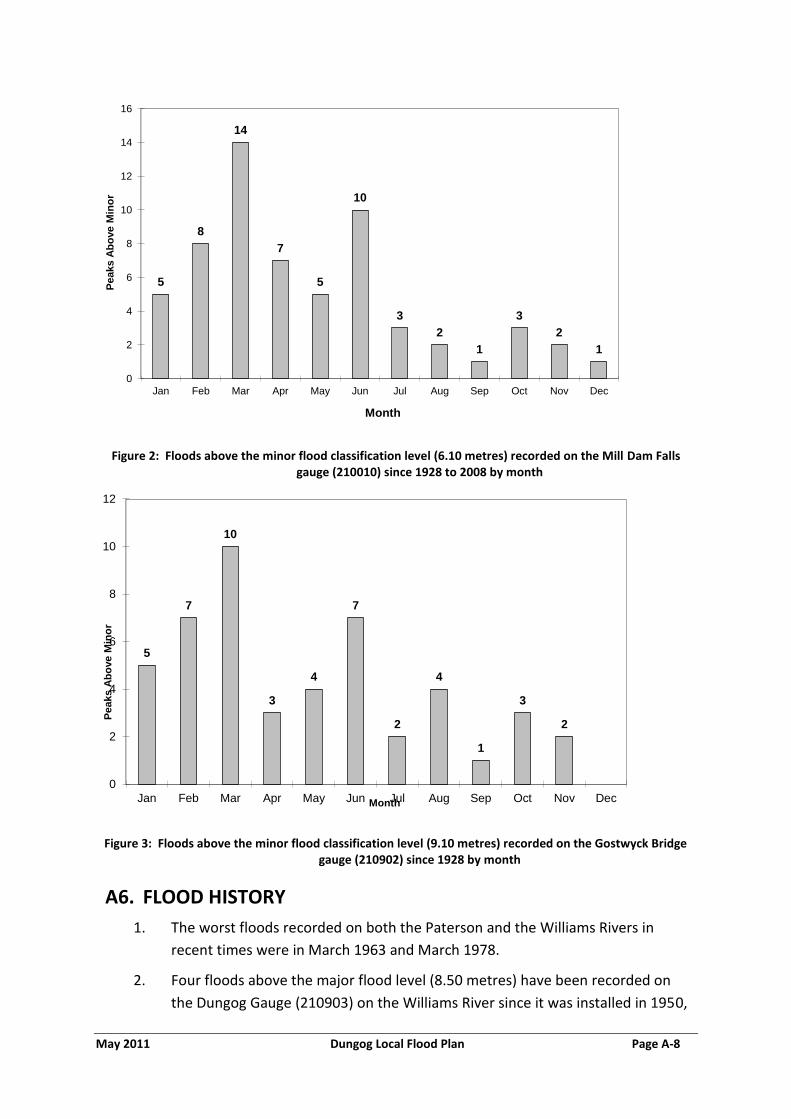
May 2011 Dungog Local Flood Plan Page A-8
Figure 2: Floods above the minor flood classification level (6.10 metres) recorded on the Mill Dam Falls gauge (210010) since 1928 to 2008 by month
Figure 3: Floods above the minor flood classification level (9.10 metres) recorded on the Gostwyck Bridge gauge (210902) since 1928 by month
A6. FLOOD HISTORY
1. The worst floods recorded on both the Paterson and the Williams Rivers in
recent times were in March 1963 and March 1978.
2. Four floods above the major flood level (8.50 metres) have been recorded on
the Dungog Gauge (210903) on the Williams River since it was installed in 1950,
5
8
14
7
5
10
3
2
1
3
2
1
0
2
4
6
8
10
12
14
16
Jan Feb Mar Apr May Jun Jul Aug Sep Oct Nov Dec
Peaks A
bo
ve M
ino
r
Month
5
7
10
3
4
7
2
4
1
3
2
0
2
4
6
8
10
12
Jan Feb Mar Apr May Jun Jul Aug Sep Oct Nov Dec
Peaks A
bo
ve M
ino
r
Month

May 2011 Dungog Local Flood Plan Page A-9
as shown in Figure 4 below. The most recent major flood occurred in February
1990 and reached a peak of 9.10 metres on the Dungog gauge.
Figure 4: Floods above the major flood classification level (8.50 metres) recorded at the Dungog gauge (210903)
3. The worst flood in recent times on the Williams River at Mill Dam Falls (Glen
Martin) occurred in March 1963 which reached 11.58 metres on the gauge. It
is likely that the flood of 1893 was even higher.
4. Fourteen major floods have been recorded at the Mill Dam Falls gauge since
1927, with the most recent being in June 2007 (9.15 metres).
5. The February 1955 flood on the Williams River was comparatively small (8.84
metres), with less than half the flow that was recorded at Mill Dam Falls in
1963.
Figure 5: Floods above the major flood classification level (9.10 metres) recorded at the Mill Dam Falls Gauge (210010) Williams River
8.69
8.51
8.94
9.10
8.20
8.30
8.40
8.50
8.60
8.70
8.80
8.90
9.00
9.10
9.20
19-Mar-63 24-Jan-72 19-Mar-78 4-Feb-90
Heig
ht
(m)
Date

May 2011 Dungog Local Flood Plan Page A-10
Figure 6: Floods above the major flood classification level (12.20 metres) recorded at the Gostwyck Bridge Gauge (210902) Paterson River
6. Twenty seven major floods have been recorded on the Gostwyck Bridge gauge
on the Paterson River since it’s installation in 1928. The most recent of these
occurred in April 2008 and reached a peak height of 12.80 metres. Much
higher floods were recorded in March 1963 (14.50 metres), October 1985
(15.02 metres) and February 1990 (14.72 metres). The largest flood recorded
on the Paterson River, was the March 1978 flood which peaked at 15.24
metres. This flood resulted from high rainfall over the Paterson River
catchment and the duration of flooding in this event was relatively short. The
1978 flood on the Paterson River is thought to have had an Annual Exceedence
Probability (AEP) of 1%.
A7. FLOOD RECURRENCE FREQUENCY
1. The return frequency of floods in the Paterson area is shown in the Table
below:
Table 3: Return Frequency of Historical Floods at the Gostwyck Bridge Gauge (210902)
Year Height ( metres) Average
Recurrence
Interval (years)
Annual
Exceedence
Probability (%)
March 1978 15.24 1 in 100 1%
March 1963 14.50 1 in 75 1.5%
February 1990 14.72 1 in 33 3%

May 2011 Dungog Local Flood Plan Page A-11
Year Height ( metres) Average
Recurrence
Interval (years)
Annual
Exceedence
Probability (%)
February 1955 12.98 Not known Not known
2. Design flood heights at Dungog on the Williams River are shown in the Table
below:
Table 4: Annual Exceedence Probabilities at Dungog (2008 Williams River Flood Study, BMT WBM)
Level (mAHD) Gauge Staff
Height (m)
DNR Gauge
Level (m)
Annual
Exceedence
Probability
49.91 8.81 8.69 20%
50.35 9.25 9.13 10%
50.87 9.77 9.65 5%
51.35 10.25 10.13 2%
51.88 10.78 10.66 1%
52.40 11.30 11.18 0.5%
56.63 15.53 15.41 PMF
A8. FLOW CHARACTERISTICS AND TIMES
1. In general, floods within the Council areas are relatively fast to rise (generally
less than twelve hours from the onset of rainfall) and fall, though inundation
lasting a few days could occur in the low-lying areas in the south of the Council
area in the more serious events. Warning times are short, especially in the
upper areas of the Paterson and Williams river catchments.
2. Indicative peak travel times for floods are given in Table 2 below. It should be
noted that flow times vary significantly from event to event and are usually
shorter in the more severe floods as flow velocities and volumes will be higher.

May 2011 Dungog Local Flood Plan Page A-12
Table 5: Indicative Peak Flow Travel Times in the Dungog Shire
River From To Distance (km) Flow Time
(hrs)
Paterson River Gresford Paterson 29 3
Williams River Dungog Clarence Town 35 3½
3. The construction in 1967 of Seaham Weir (downstream of the Council area)
substantially increased the magnitude, frequency and duration of minor
flooding on the nearby upstream farm properties on the Williams River.
Although floodgates constructed in 1978 have reduced the length of flooding
and resulted in no increases of large floods, minor flooding is still substantially
above pre-weir conditions.
A9. EXTREME FLOODING
1. The worst floods ever recorded in the Dungog Shire Council area since
European settlement should not be regarded as the most severe which can
occur there. Floods worse than have been seen by present residents are
possible. Such floods will be rare, but they may reach considerably greater
heights than have previously been experienced. In addition, they are likely to
be both faster to rise and more dangerous in terms of depth and velocity than
previous events.
2. At the Gostwyck Bridge gauge on the Paterson River for example, the
difference between the 1% AEP flood level (15.24 metres) and the extreme
flood level is 7.5 metres (i.e.: three building storeys). Extreme flooding could
lead to extensive building damage (including complete destruction) and closure
of evacuation routes from isolated communities and individual houses.
3. There is a remote possibility, in an extreme flood on the Chichester and
Wangat (Little) Rivers, that Chichester Dam could fail leading to unprecedented
flooding in the Dungog Shire. Further information on the potential effects of
dam failure flooding on the downstream community is included in Annex B.
Details of the dam failure warning and evacuation procedures for Chichester
Dam are contained in Annex H of this plan.

May 2011 Dungog Local Flood Plan Page B-1
ANNEX B - EFFECTS ON THE COMMUNITY
B1. COMMUNITY PROFILE
Census Description LGA Clarence Town Dungog Gresford East &
Gresford West
Paterson
Total Persons
8061 793 2101 289 345
Total Dwellings
2920 288 860 111 128
Total persons aged 65 years and over
1256 87 505 59 43
Total persons aged below 15 years
1701 191 380 55 72
Total persons with a need for assistance (profound / severe disability)
413 30 193 15 20
Total persons of indigenous origin
175 24 62 5 5
Total persons using Internet
1600 139 347 59 71
Single parent families 273 40 94 18 10
Persons living alone 664 56 284 29 34
Total persons who do not speak English well
3 0 3 0 0
Total persons who lived at a different address 5 years ago
2195 227 542 57 87
Households without vehicles
145 7 91 6 7
Total persons residing in caravans, cabins or houseboats
39 3 0 0 0
Mean household size 3 3 2 2 3
Table 6: Census of Housing and Population data (2006)
B2. GENERAL
1. Flooding can affect urban, village and rural properties in the Dungog
Shire through inundation and isolation as well as closing numerous
roads.

May 2011 Dungog Local Flood Plan Page B-2
B3. FLOODING IN RURAL AREAS
1. Farmlands are especially prone to inundation, with stock and pumps
needing to be relocated in advance of flooding and fences and irrigation
pipes periodically being damaged. It is likely that the expansion of
hobby farming and rural residential development is increasing the
number of people exposed to the flood risk in the rural parts of the
Council area.
2. Evacuations have not been required from rural areas in recent times,
and resupply has also not been necessary though both are possible in
major floods. Some rural dwellings in the Council area may also be
isolated for short periods.
B4. EFFECTS OF FLOODING ON TOWNS AND VILLAGES
DUNGOG
1. Dungog (2006 Census urban area population 2,101): Flooding within the
town of Dungog can result from the Williams River or Myall Creek (a
tributary of the Williams River that joins the main river in town) or a
combination of both. Flooding is usually made worse when both
streams are in flood, as discharge from the creek into the river backs up.
Inundation generally occurs on the northern and eastern edges of the
town. The area around the Frank Robinson Memorial Park adjacent to
the Cooreei Bridge (MR 101) begins to experience inundation at
approximately 6.1 metres on the Dungog gauge (see Annex G,
Arrangements for the Evacuation of Caravan Parks and the Relocation of
Caravans).
2. Major flooding may necessitate evacuation from a small number of
dwellings and businesses in low-lying areas in Hooke, Dowling, Brown
and Windeyer Streets. Substantial flooding from Myall Creek can cause
inundation of three of the lower units in the Alison Court Retirement
Village and one house in Brown Street. The Fosterton Road (Dungog to
Fosterton) may close at approximately 8.0 metres on the Dungog gauge,
isolating up to 32 residential properties for up to 24 hours. This road
can also close in a number of locations because of localised flooding.
3. Historically Dungog could have become isolated at approximately 9.0
metres on the Dungog gauge, when floodwaters closed Clarence Town
Road at the Union Creek Bridge Wirragulla. The Union Creek Bridge was
replaced in 2010 and the new bridge is higher than its predecessor. The
height at which the new bridge will close is not known.

May 2011 Dungog Local Flood Plan Page B-3
CLARENCE TOWN
4. Clarence Town (2006 Census urban area population 793): Some
evacuations are known to have been necessary from Clarence Town in
past floods. Inundation occurs from the southern edge of the village,
mostly from backwater flooding but almost the entire village is on high
ground which is free from flooding. The lower levels of the Williams
River Holiday Park, which is adjacent to the William the IV Bridge, are
inundated even before the minor flood level is reached (6.1 metres on
the Mill Dam Falls gauge). The campers and temporary caravans on
these lower levels will need to be moved to higher ground within the
park before this height is reached. Permanent caravan sites are located
on high ground within the park and will not be affected.
5. Paterson (2006 Census urban area population 345): Paterson is the
largest of the flood affected settlements on the Paterson River within
the Dungog Shire. It is a substantial rural village with an extensive
urban zoned area located on a bend of the Paterson River on the
western banks, about 23 kilometres upstream of the confluence of the
Paterson and Hunter Rivers. The village can be completely isolated by
road in flood events when the river reaches 11.7 metres on the
Gostwyck gauge (210902). During major floods, some evacuations from
Paterson may be necessary.
6. Flooding may also affect various rural residences in the vicinity of
Paterson and there is significant potential for destruction of crops,
pasture and infrastructure by inundation. Water will begin to overtop
the North Coast Railway line (Sydney to Brisbane) at approximately 13.0
metres on the Gostwyck gauge (10.3 metres on the Paterson Gauge),
resulting in the possible closure of the line.
7. Martins Creek: This village is located just north of Paterson. Some of
the larger rural residential areas include those located immediately to
the south of Martins Creek and to the north-west of the town of
Paterson. There are also areas developed for small hobby farms, with
the largest areas being located immediately to the west and north of
Martins Creek, adjacent to the Paterson River. These areas may also be
isolated by floods on the Paterson River. Properties in Glenburn and
Keppies Roads can become isolated by ungauged creek rises along
Martins Creek Road.

May 2011 Dungog Local Flood Plan Page B-4
Schools and childcare centres
8. The following schools and childcare centres are to be contacted by the
SES in the event of possible flooding:
Clarence Town Public, Queen Street Clarence Town
Clarence Town Pre-School, Prince Street
Dungog Primary, Chapman Street Dungog
Dungog High, Eloiza Street Dungog
Dungog Pre-School, Chapman Street
Tilly’s Play and Development Centre, Moore Street, Dungog
St Joseph’s Primary, Brown Street Dungog
Glen William Public, Clarence Town Road Glen William
Gresford Public, Durham Road Gresford
Martins Creek Public, Cook Street Martins Creek
Paterson Public, Webbers Creek Road Paterson
Paterson Pre-School, Webbers Creek Road
Vacy Public, Gresford Road Vacy
Potential Effects of Dam Failure Flooding on the Community
9. There is a remote chance, in an extreme flood on the Chichester and
Wangat (Little) Rivers that Chichester Dam could fail. If such an event
were to occur the following areas within the Dungog Shire may be at
risk from extreme flooding and substantial evacuations would be
required:
a) The Ferndale Caravan Park, located just below the dam.
b) 23 dwellings located in rural areas between the dam and Dungog.
c) Frank Robinson Memorial Park (Cooreei Bridge, Dungog),
d) Up to 100 homes in the town of Dungog itself, mainly in the
northern and eastern sections of town.
e) A small number of farm houses downstream of Dungog.
f) The school and a small number of homes in Clarence Town
10. Such a flood would have severe effects all the way down the Williams
River to its confluence with the Hunter River.

May 2011 Dungog Local Flood Plan Page B-5
11. Annex H of this plan contains details of the warning and evacuation
procedures for residents at risk from dam failure flooding in the Dungog
Shire.
B5. ROAD CLOSURES
1. A number of roads within the Council area can be closed by flooding,
though usually only for periods of several hours. Major floods on the
Lower Hunter River, however, could isolate the Council area from
Maitland for a number of days due to road closures in the Maitland City
Council. If roads and bridges are damaged by flood water, the period of
isolation may be even longer.
2. The roads known to be subject to closure are shown in the Table below.
Table 7: Road closure in the Dungog Shire Council area
ROAD CLOSES AT COMMENTS/ IMPLICATIONS
Fosterton Road (from Dungog to Fosterton)
Newell Crossing at Fosterton (over the Williams River)
This is a loop road and access will still be available to properties until the moderate flood level of 8.0 metres on the Dungog gauge is reached and access to Dungog is lost. This will result in 32 residential properties being isolated for up to 24 hours.
Main Creek Road (from Dungog to Main Creek)
Carowiry Creek at The Cedars (Cox’s Bridge)
Up to 30 rural properties may be isolated in the Main Creek area.
Alison Road (from Dungog to Alison, off MR 101)
Near the Frank Robinson Memorial Caravan Park, adjacent to the Cooreei Bridge, Dungog
Closes between 8.5 and 9.0m on Dungog gauge (may close earlier due to local creek flooding).
Alison Road (from Dungog to Alison, off MR 101)
At the Thalaba Bridge, Alison
No isolation of Alison as there are alternate routes available.
MR 101 (from Dungog to Stroud)
At the Frank Robinson Memorial Caravan Park adjacent to the Cooreei Bridge, Dungog
May close at 7.6m on Dungog gauge.
MR 101 – Tocal Road (from Dungog to Maitland)
John Tucker Park (Swamp Hollow) at the dip below Albert Street, Paterson.
Closes at approximately 11.5 metres on Gostwyck Bridge gauge (8.6 metres on the Paterson gauge). A detour is available via Sloane Street. This detour will remain viable until the road closes at Clements Bridge.

May 2011 Dungog Local Flood Plan Page B-6
ROAD CLOSES AT COMMENTS/ IMPLICATIONS
MR 101 - Tocal Road (from Dungog to Maitland)
Between 1 and 3 kilometres south of Paterson, just before Clements Bridge
Closes at approximately 11.8 metres on Gostwyck Bridge gauge (9.0 metres on the Paterson gauge). Alternative may be available via Paterson Road, depending on local flooding.
MR 301 (from Clarence Town to Wirragulla)
Union Creek Bridge, over the Union Creek (a tributary of the Williams River)
Historically closes at approximately 9.0 metres on Dungog gauge, however a new and higher bridge installed in 2010. The height at which this will now close is unknown. Can also close from a flood on Union Creek. This closure will isolate Dungog.
Clarence Town Road At the intersection of Woerdens Road
Flooding occurs from the ungauged Stoney Creek and results in the closure of the road from Dungog to Clarence Town.
Pine Brush Road (from Glen William to Glen Martin)
Banfield Bridge, Glen Martin (over the Williams River)
No alternatives available.
Glen William Road (from Dungog to Glen William)
Glen William Closes at 3.0 metres on the Mill Dam Falls gauge.
Seaham Road Seaham This is the normal road access between Clarence Town and Maitland/Raymond Terrace. It closes at 8.6 metres on the Mill Dam Falls gauge. An alternative route may be available via Limeburners Creek Road.
Glen Martin Road Boatfall Bridge (2km from intersection with Limeburner Creek Road)
May close at heights above approximately 9.0 metres on the Mill Dam Falls gauge.
MR 7764: Bingleburra Road (from Dungog to Gresford)
0.5km from the T-intersection of the Allyn River Road.
Closes intermittently. Detour may be available via MR 101 and Gresford Road via Vacy.
Paterson Road (from Woodville to Paterson)
Dunns Creek and Iona Closes at approximately 11.70 metres on the Gostwyck Bridge gauge. When this road closes, Paterson is isolated.
Woodville – Seaham Road
Taylors Bridge (Woodville)
Closes at approximately 11.70 metres on the Gostwyck Bridge gauge.
NOTE: The list of road closures in this table is not comprehensive and many
other minor roads and private roads in the upland areas are subject to closure
at low causeways and as a result of land slips, even during minor flooding.
There is also a possibility that additional roads that have remained flood free
in past events will be closed during major floods.

May 2011 Dungog Local Flood Plan Page C-1
ANNEX C - GAUGES MONITORED BY THE DUNGOG SES LOCAL HEADQUARTERS
Gauge Name Type AWRC No. Stream Flood classification Reading Arrangements Min Mod Maj
Lostock Dam Manual 210102
Paterson River Dam Caretaker
Lostock Dam D/S Telemeter 210021 Paterson River DWE
Upper Allyn Manual 210072 Allyn River DWE
Halton Telemeter 210022 Allyn River DWE
*‡Gostwyck
Bridge
Telemeter 210902 Paterson River 9.1 10.7 12.2 Bureau
Gostwyck (Vacy) Telemeter 210079 Paterson River DWE
‡Paterson Telemeter 210406 Paterson River 6.1 7.6 9.1 MHL
Tilligra Manual 210011 Williams River DWE
Chichester Dam
(Ferndale Site 1)
Manual 210007 Chichester River DWE
*‡Dungog
(Mill Race)
Telemeter 210903 Williams River 4.9 7.6 8.5 Bureau
*‡Mill Dam Falls
(Glen Martin)
Telemeter 210010 Williams River 6.1 7.6 9.1 DWE
Clarence Town Manual 210417 Williams River MHL
Table C-1: Gauges monitored by the Dungog SES Local Headquarters
Notes: The Bureau of Meteorology provides flood warnings for the gauges marked with an
asterisk (*). SES Local Flood Advices are provided for the gauges marked with a single cross
(†). The SES holds a Flood Intelligence Card for the gauges marked with a double cross (‡).

May 2011 Dungog Local Flood Plan Page D-1
ANNEX D - DISSEMINATION OPTIONS FOR SES FLOOD INFORMATION AND WARNING PRODUCTS
The Hunter SES Region Headquarters distributes SES Flood Bulletins, SES Evacuation
Warnings and SES Evacuation Orders to the following regional media outlets and agencies:
Television Stations:
Station Location
NBN 3 Newcastle
Prime Newcastle
Southern Cross Ten Coffs Harbour
Radio Stations:
Station Location Frequency Modulation
ABC Newcastle West 1233 AM
2HD Sandgate 1143 AM
NEW FM Sandgate 105.3 FM
KO FM Charlestown 102.9 FM
NX FM Charlestown 106.9 FM
2NUR-FM Callaghan 103.7 FM
Newspapers:
Name Location
Newcastle Herald Newcastle
Maitland Mercury Maitland
Other Agencies:
All other agencies listed with responsibilities under this plan.

May 2011 Dungog Local Flood Plan Page E-1
ANNEX E - TEMPLATE EVACUATION WARNING, EVACUATION ORDER AND ALL CLEAR

May 2011 Dungog Local Flood Plan Page E-2
Flood Evacuation Warning
Hunter SES Region Headquarters Telephone: (02) 4931 3222
72 Turton Street METFORD NSW 2323 Issued [day] [date] at [time (am,pm)]
Fax: (02) 4931 3200
Email: [email protected]
Radio stations are asked to immediately broadcast this message and repeat it.
Use of the Standard Emergency Warning Signal (SEWS) with this message is authorized.
Flood Evacuation Warning for [Enter location/s]
Authorised By: [ (name and operational position title) ]
As a result of the flood level predicted by the Bureau of Meteorology for [ location ] at [date/time] the State Emergency Service recommends that residents within the nominated areas should prepare to evacuate within the next [number] hours.
Residents should monitor the situation and be prepared to evacuate when instructed to do so. A
Flood Evacuation Order will be issued by the SES if evacuation is required.
You can choose to go to friends or relatives. Alternatively, evacuation centres will be established
at [ location/s ] where you can obtain temporary accommodation and other help.
To prepare for possible evacuation you should:
Raise belongings by placing them on tables, beds and benches. Put electrical items on top. You may be able to place light weight items in the roof space.
Collect together medicines, personal and financial documents, mementos and photos
If possible, check to see if your neighbours need help
Make arrangements for care of pets or other animals, or take your pets with you when you evacuate
Take three days’ supply of clothing and medicines
Find out where to turn off the electricity and gas
Continue to listen to a local radio station for updates
Don’t walk ride or drive through floodwaters – this is the main cause of death and injury during floods
For emergency assistance telephone the SES on 132 500
Web site: www.ses.nsw.gov.au
End SES Flood Evacuation Warning
[Enter next update and currency details]
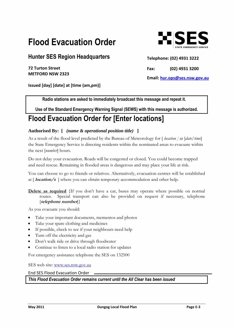
May 2011 Dungog Local Flood Plan Page E-3
Flood Evacuation Order
Hunter SES Region Headquarters Telephone: (02) 4931 3222
72 Turton Street METFORD NSW 2323 Issued [day] [date] at [time (am,pm)]
Fax: (02) 4931 3200
Email: [email protected]
Radio stations are asked to immediately broadcast this message and repeat it.
Use of the Standard Emergency Warning Signal (SEWS) with this message is authorized.
Flood Evacuation Order for [Enter locations]
Authorised By: [ (name & operational position title) ]
As a result of the flood level predicted by the Bureau of Meteorology for [ location ] at [date/time]
the State Emergency Service is directing residents within the nominated areas to evacuate within
the next [number] hours.
Do not delay your evacuation. Roads will be congested or closed. You could become trapped
and need rescue. Remaining in flooded areas is dangerous and may place your life at risk.
You can choose to go to friends or relatives. Alternatively, evacuation centres will be established
at [ location/s ] where you can obtain temporary accommodation and other help.
Delete as required {If you don’t have a car, buses may operate where possible on normal routes. Special transport can also be provided on request if necessary, telephone [telephone number]}
As you evacuate you should:
Take your important documents, mementos and photos
Take your spare clothing and medicines
If possible, check to see if your neighbours need help
Turn off the electricity and gas
Don’t walk ride or drive through floodwater
Continue to listen to a local radio station for updates
For emergency assistance telephone the SES on 132500
SES web site: www.ses.nsw.gov.au
End SES Flood Evacuation Order
This Flood Evacuation Order remains current until the All Clear has been issued

May 2011 Dungog Local Flood Plan Page E-4
Dam Failure Evacuation Warning
Hunter SES Region Headquarters Telephone: (02) 4931 3222
72 Turton Street METFORD NSW 2323 Issued [day] [date] at [time (am,pm)]
Fax: (02) 4931 3200
Email: [email protected]
Radio stations are asked to immediately broadcast this message and repeat it.
Use of the Standard Emergency Warning Signal (SEWS) with this message is authorised
Dam Failure Evacuation Warning for [Enter location/s]
Authorised by: [ name & operational position title ]
The dam failure warning system for Chichester Dam has issued an Amber Alert. The dam is not
expected to fail at this level but if the water keeps rising, a Red Alert could be triggered and
major flooding of the following areas is possible [location/s].
Residents should monitor the situation closely and be prepared to evacuate immediately when
instructed to do so. A specific Dam Failure Evacuation Order will be issued by the SES if
necessary.
If flooding does occur in your area, remaining within your home or business will be dangerous
and your life may be placed at risk.
Evacuation centres will be established at [location/s] where you can obtain temporary
accommodation and other help. You can also choose to go to friends or relatives.
To prepare for possible evacuation you should:
Raise belongings by placing them on tables, beds and benches. Put electrical items on top. You may be able to place light weight items in the roof space.
Collect together medicines, personal and financial documents, mementos and photos
If possible, check to see if your neighbours need help
Make arrangements for care of pets or other animals, or take your pets with you when you evacuate
Take three days’ supply of clothing and medicines
Find out where to turn off the electricity and gas
Continue to listen to a local radio station for updates
Don’t walk, ride or drive through floodwaters – this is the main cause of death and injury during
flooding.
For emergency assistance telephone the SES on 132 500
SES web site: www.ses.nsw.gov.au

May 2011 Dungog Local Flood Plan Page E-5
End Dam Failure Evacuation Warning
[Enter update and currency details]

May 2011 Dungog Local Flood Plan Page E-6
Dam Failure Evacuation Order for [Enter locations]
Authorised By: [ name & operational position title ]
The dam failure warning system for Chichester Dam has issued a Red Alert, for areas downstream of the dam. This alert means dam failure is imminent. Failure of the dam will result in extremely dangerous flooding of the following areas [locations].
The State Emergency Service directs residents within these areas to evacuate within the next [number] hours. Do not delay your evacuation. Roads may be congested or closed. You could become trapped and need to be rescued. Remaining in flooded areas is dangerous and may place your life at risk.
Evacuation centres will be established at [location/s ] where you can obtain temporary
accommodation and other help. You can also choose to go to friends or relatives. If you don’t go to an evacuation centre please telephone [telephone number] to report your safety.
Delete as required {If you don’t have a car, buses may operate where possible on normal routes. Special transport can also be provided on request if necessary, telephone [telephone number]}
As you evacuate you should:
Take your important documents, mementos and photos
Take your spare clothing and medicines
If possible, check to see if your neighbours need help
Turn off the electricity and gas
Do not walk, ride or drive through floodwater
Continue to listen to a local radio station for updates
End Dam Failure Evacuation Order
Dam Failure Evacuation Order
Hunter SES Region Headquarters Telephone: (02) 4931 3222
72 Turton Street
Metford NSW 2323
Issued [day] [date] at [time in civilian format (am,pm)]
Fax: (02) 4931 3200
Email: [email protected]
This Dam Failure Evacuation Order remains current until the All Clear has been issued
Radio stations are asked to immediately broadcast this message and repeat it.
Use of the Standard Emergency Warning Signal (SEWS) with this message is authorised
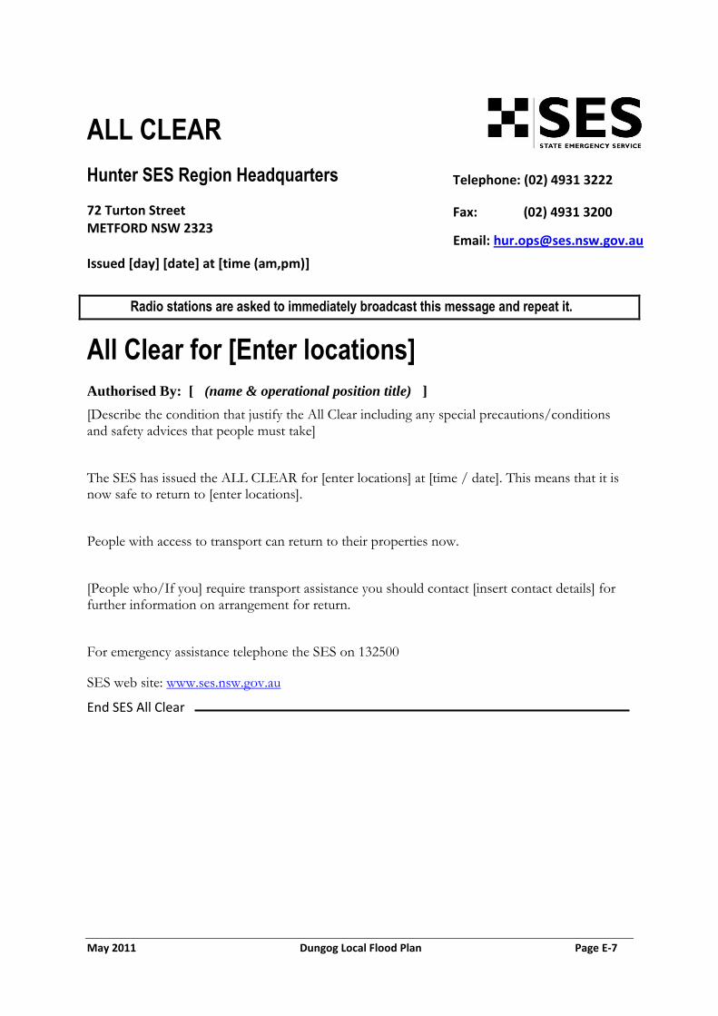
May 2011 Dungog Local Flood Plan Page E-7
ALL CLEAR
Hunter SES Region Headquarters Telephone: (02) 4931 3222
72 Turton Street METFORD NSW 2323 Issued [day] [date] at [time (am,pm)]
Fax: (02) 4931 3200
Email: [email protected]
Radio stations are asked to immediately broadcast this message and repeat it.
All Clear for [Enter locations]
Authorised By: [ (name & operational position title) ]
[Describe the condition that justify the All Clear including any special precautions/conditions and safety advices that people must take]
The SES has issued the ALL CLEAR for [enter locations] at [time / date]. This means that it is now safe to return to [enter locations].
People with access to transport can return to their properties now.
[People who/If you] require transport assistance you should contact [insert contact details] for further information on arrangement for return.
For emergency assistance telephone the SES on 132500
SES web site: www.ses.nsw.gov.au
End SES All Clear

May 2011 Dungog Local Flood Plan Page F-1
ANNEX F - EVACUATION ARRANGEMENTS FOR THE DUNGOG SHIRE
F1. BACKGROUND
1. Major floods may create a need for small numbers of evacuations from rural
areas and from low-lying properties in the townships of Dungog, Paterson and
Clarence Town.
2. A failure of Chichester Dam would lead to the evacuation of about 100 dwellings
in Dungog and approximately 24 dwellings in rural areas upstream of the town as
well as the Ferndale Park and Frank Robinson’s Memorial Park.
3. Further details of the effects of flooding on the community are shown in Annex B
of this plan.
4. Details of the warning and evacuation procedures for potential failure of
Chichester Dam are included in Annex H of this plan.
F2. ARRANGEMENTS
1. Control. During floods, evacuations will be controlled by the NSW SES. Small-
scale evacuations will be controlled by the Dungog SES Local Controller. Should
the evacuations operations escalate beyond the capabilities of local resources,
control may be handed over to the Hunter SES Region Controller.
2. Conduct. Evacuations will be controlled by the SES and conducted in four
phases:
a) Phase 1 - Warning.
b) Phase 2 – Withdrawal.
c) Phase 3 – Shelter.
d) Phase 4 – Return.
3. Tasks
a) Dungog SES Unit Members
Coordinate door knocking operations.
With the assistance of the Transport Services Coordinator, coordinate the transport for evacuees without their own transport.
b) NSW Police Force
Control traffic flow from the evacuated areas.
At the request of the Dungog SES Local Controller, assist with the door knocking of specific households where residents refuse to leave.
May 2011 Dungog Local Flood Plan Page F-2
Coordinate the registration of evacuees.
Provide security to evacuated areas.
c) NSW Rural Fire Service
Assist with door knocking.
Provide communications in isolated communities.
d) Fire and Rescue NSW
Assist with door knocking.
e) Dungog Shire Council
Assist with traffic control.
Provide vehicles for the evacuation of residents and transport of property.
f) Community Services
Establish evacuation centres.
F3. DECISION TO EVACUATE
1. The decision to evacuate. The responsibility for issuing any general evacuation
order during flooding rests with the Dungog SES Local Controller who exercises
his/her authority in accordance with Section 22(1) of The State Emergency
Service Act 1989. However, the decision to evacuate will usually be made after
consultation with the Local Emergency Operations Controller and the Hunter
SES Region Controller
2. When evacuation should occur. As far as possible, evacuation will be carried
out before inundation occurs.
3. Self-motivated evacuation. Some people will make their own decision to
evacuate earlier and move to alternative accommodation using their own
transport. These evacuees will be advised, via the media, to inform the Police
or SES of their evacuation and their temporary address.
4. Evacuation Triggers. Evacuations in the Dungog Shire may be required under
the following circumstances:
a) Caravan Parks and Camping Areas. Evacuation of caravan parks and
camping grounds in the Dungog Shire may be required even in minor
flooding.
If a peak of 6.1 metres is predicted for the Dungog gauge, visitors to the Frank Robinson Memorial Park in Dungog must move their vans and belongings to higher ground before this height is reached as the park will be inundated.

May 2011 Dungog Local Flood Plan Page F-3
If a peak of 5.5 metres (below minor) is predicted for the Mill Dam Falls gauge, campers and caravans in low-lying areas in the Williams River Holiday Park will need to move to higher ground within the park.
b) Dungog. When heavy rainfall over the Dungog Township and Myall Creek
catchment area causes local flooding. Under these circumstances,
approximately nine houses, two businesses and four aged care units in
Hooke, Dowling and Brown Streets Dungog may require evacuation.
Flooding in these areas may be made worse by high flows on the Williams
River which restrict the discharge of Myall Creek. Evacuations from these
areas during Williams River flooding may be required when peaks of
approximately 7.0 metres or greater are predicted on the Dungog gauge.
c) Evacuations may be required from low-lying residences on the Fosterton
Road (Dungog to Fosterton Road) if a peak of 8.0 metres or greater is
predicted at the Dungog gauge. This road closes at various locations
between 2.0 and 8.0 metres on the Dungog gauge, isolating approximately
32 properties. No isolations result from the first road closure at 2.0
metres, however access will progressively become restricted as this road
closes at further locations up to a height of 8.0 metres on the gauge.
Evacuations must be complete before road access to the properties at risk
is lost and it is likely that this evacuation will be carried out in stages
depending upon the predicted gauge height and the location of the
properties in relation to low points on the road.
d) Dam Failure Alerts for Chichester Dam. In the event of potential failure of
Chichester Dam, evacuation of the Ferndale Park, Frank Robinson
Memorial Park and a number of streets in the town of Dungog and in the
village of Clarence Town would be required. Further evacuations would be
necessary from rural properties along the Williams River between the dam
and the confluence of the Williams River with the Hunter River.
e) Failure of Essential Services. Evacuation of towns and villages and rural
properties may be required if essential services including power,
wastewater and water fail or are likely to fail during flooding. Under these
circumstances, living conditions can become uncomfortable and unsafe,
even if flood waters have not inundated or isolated the town or property.
F4. PHASE 1 - WARNING
1. Evacuation Warnings and Evacuation Orders. On the receipt of flood warnings
predicting peak heights of 7.0 metres and above at the Dungog gauge; the
Dungog SES Local Controller will consult as necessary to determine the level of
the threat and the need to consider evacuations. As soon as possible after the
decision to evacuate is made, the Dungog SES Local Controller will issue

May 2011 Dungog Local Flood Plan Page F-4
evacuation warnings to the ‘at risk’ residents, indicating what people should do
before evacuating and when actually doing so.
2. Content of Evacuation Warnings and Evacuation Orders. A template guide to
the content of evacuation warning and evacuation order messages is at Annex
E. These are disseminated via:
The radio and TV stations listed in Annex D.
Door-knocks by emergency service personnel.
Public address systems from emergency service vehicles.
Telephone (including the Emergency Alert System).
SES Flood Bulletins
F5. PHASE 2 – WITHDRAWAL
1. Introduction. Withdrawal involves the actual removal of the
community/individuals from dangerous or potentially dangerous areas to safer
areas.
2. Movement. Evacuees are to be encouraged to move using their own transport
where possible. The Dungog SES Local Controller will arrange transport for
those people without their own vehicles.
3. Special Needs Groups. A large proportion of Dungog’s aged population resides
in Dowling and Brown Streets. Alison Court Retirement Village is situated in
Brown Street, Dungog.
4. Animals. Assistance animals (guide dogs, hearing assistance animals, etc) will
remain in the care of their owners throughout the evacuation. This includes
transport and access into evacuation centres etc. Due to safety restrictions, it
may not be possible to allow companion animals to accompany their owners
when being transported via aircraft or flood rescue boats. Industry and
Investment NSW will make separate arrangements for the evacuation and care
of companion animals.
5. Doorknocking. Field teams conducting doorknocks will record and report the
following information back to the Operations Centre:
Addresses and locations of houses doorknocked and/or evacuated.
The number of occupants.
Details of support required (such as transport, medical evacuation, assistance to secure house and/or property and raise or move belongings).
Details of residents who refuse to comply with the evacuation order.

May 2011 Dungog Local Flood Plan Page F-5
6. Refusal to evacuate. Field teams should not waste time dealing with people
who are reluctant or refuse to comply with any evacuation order. These cases
should be referred to the LEOCON who will arrange for the NSW Police Force to
ensure their evacuation
7. Security. The NSW Police Force will provide security for evacuated areas.
8. Transport and storage. Transport and storage of furniture from flood
threatened properties will be arranged as time and resources permit.
F6. PHASE 3 – SHELTER
1. Evacuation centres. The usual purpose of evacuation centres is to meet the
immediate needs of victims, not to provide them with accommodation.
Evacuees will be advised to go to or be taken to the nearest accessible
evacuation centre, which may initially be established at the direction of the
Dungog Local Controller but managed as soon as possible by Community
Services. Any or all of the sites listed in table 5 below may be used as
evacuation centres:
Table F-1: Evacuation Centres within the Dungog Shire
Town/Village
Evacuation Centre Address Notes
Clarence Town Clarence Town School of Arts
48 Grey Street Clarence Town
Dungog Multi Purpose Centre, Dungog High School
Eloiza Street Dungog
Dungog Dungog Hospital/ Day Care Centre
Hospital Road Dungog
Includes facilities for elderly evacuees
Dungog Doug Walters Pavilion
60 Mackay Street Dungog
Dungog Dungog Showground
Abelard Street, Dungog
Camping & caravans only.
Gresford Gresford School of Arts
42 Park Street East Gresford
RSL Club and pre-school adjoining.
Gresford St Anne’s Church Hall
Church Street Gresford
Gresford Gresford Showground
Park Street Gresford
Camping & caravans only.
Martins Creek Martins Creek School of Arts
58 Grace Avenue Martins Creek
Paterson Paterson Public School
Webbers Creek Road Paterson
Paterson Paterson School of Arts Hall
Duke Street Paterson
Vacy Vacy Public School Gresford Road Vacy
Vacy Vacy School of Arts 779 Gresford Road Vacy

May 2011 Dungog Local Flood Plan Page F-6
2. Action on arrival. On arrival, evacuees will be:
registered;
medically checked, if necessary; and
provided with their immediate welfare needs.
3. Registration. The NSW Police Force will ensure that all evacuees are registered
on arrival at the designated evacuation centres.
4. Animal shelter compounds. Animal shelter compounds will be set up for the
domestic pets and companion animals of evacuees. These facilities will be
operated by Dungog Shire Council.
F7. PHASE 4 – RETURN
1. Once it is considered safe to do so, the Dungog SES Local Controller will
authorise the return of evacuees to their normal or alternative place of
residence. This decision will be made in consultation with appropriate officers
in regard to matters such as the electrical safety of buildings.
2. The return will be controlled by the Dungog SES Local Controller and may be
conducted, at his/her request, by Community Services.

May 2011 Dungog Local Flood Plan Page G-7
ANNEX G - DETAILS OF THE DAM FAILURE WARNING SYSTEM FOR CHICHESTER DAM
This Annex describes the downstream consequences and specific notification and warning
arrangements for the failure of Chichester Dam and should be read in conjunction with the
response arrangements detailed in this plan.
G1. INTRODUCTION
1. The Chichester Dam is located just upstream of Dusodie at the confluence of
the Chichester and Wangat (Little) Rivers. It has been calculated that the
Chichester Dam can safely pass flows up to 4,500 cubic metres per second
which represents more than 94% of the likely flow in a Probable Maximum
Flood (PMF) event at the dam site. Such a flow is more than four times that
which has ever been recorded at the dam which was built in 1925. However, in
an extreme flood on the Chichester and Wangat Rivers, the Chichester Dam
could fail.
2. The dam is relatively small (21,500 megalitres) and in the worst case it is
possible that within four hours of the onset of rain it could fill and overtop the
dam to the point of causing failure.
3. It must be stressed that following the remedial work which has been carried
out at the dam (post-tensioning, raising of the wall, sealing the left abutment
and construction of flood aprons), the chance of dam failure is extremely small.
Such a flood has an Annual Exceedence Probability (AEP) of 0.01% or one
chance in 10,000 every year.
4. This annex describes the warning system for the dam and the evacuation
arrangements which have been devised to accompany its operation.
G2. EFFECTS OF DAM FAILURE FLOODING
1. If dam failure were to occur, the flooding throughout the course of the
Williams River within the Dungog Shire would be of unprecedented severity.
Flood flows would be of much higher velocity than have been recorded in past
events on the river and the flooding would reach much higher levels, more
rapidly than has ever been experienced in the past. It is also likely that flood
waters would remain in the lower-lying rural areas from Dungog to below
Clarence Town for longer periods than would be the case in episodes of non-
dam failure flooding.
2. It has been estimated that flood levels will increase between five and eight
metres above existing flood conditions at Dungog. In the town of Dungog,
inundation would occur from low velocity backwater flooding which would

May 2011 Dungog Local Flood Plan Page G-8
generally be of short duration but water levels would rise more rapidly than in
any previous floods in the area.
G3. FLOOD TRAVEL TIMES
1. If such an extreme event were to occur, the flood wave resulting from failure
would reach Dusodie after 10 minutes, Bandon Grove after 30 minutes and
Dungog after one hour.
G4. RESIDENTS AT RISK FROM DAM FAILURE FLOODING
1. Should failure of Chichester Dam occur, the Ferndale Caravan Park, located just
below the dam, 24 dwellings located in rural areas between the dam and
Dungog and about 100 dwellings in Dungog itself would be at risk of flooding.
Streets in the northern and eastern sections of the town of Dungog (Dowling,
Hooke, Brown, Mackay, Abelard, Lord, Windeyer, Myles and Gladstone Streets
and Fosterton Road) could be affected. In addition, a few farmhouses further
downstream could be at risk of inundation.
2. At Clarence Town, the school and nearby residential areas at the lower end of
King Street (between Sheriff and Marshall Streets) could also experience
inundation in a dam failure flood.
3. Such a flood would have severe effects all the way down the Williams River to
its confluence with the Hunter River. Apart from causing substantial
evacuations, the flood waters would remain in the lower-lying rural areas from
Dungog to below Clarence Town for longer periods than would be the case in
flooding without dam failure.
G5. PURPOSE OF THE EARLY WARNING SYSTEM
1. The Dam Failure Warning System for properties downstream of Chichester
Dam is designed to provide early warning of very severe floods which could
cause the dam to fail. The system involves a water level sensor at the dam
which measures water above the spillway crest. If particular pre-set levels at
the spillway are reached, this triggers the transmission of alarms from the dam
site to the Hunter Water Corporation (HWC) for actioning.
G6. THE WARNING SYSTEM – OPERATION AND PROCEDURES
1. The warning system consists of:
a) A water level sensor at Chichester Dam to measure the depth of water
above the spillway crest.
b) At pre-set water levels at the dam, an automatic audible alarm sounds at
the dam, an alarm is triggered on the SCADA system to HWC’s Dispatch
May 2011 Dungog Local Flood Plan Page G-9
Centre and a message is paged to the residence of the dam caretaker on
duty (via modem).
c) Arrangements by which HWC advises Dungog SES Local Headquarters as
floods are rising. These arrangements apply in relatively minor flood
events as well as in the more severe ones
d) Arrangements for advising people who would need to evacuate if dam
failure becomes possible.
G7. EVACUATION ARRANGEMENTS
1. People advised to evacuate will be asked to move to pre-designated locations
as follows:
a) Residents of Ferndale Park camping ground below Chichester Dam
evacuate to Chichester Dam Office above the dam.
b) Residents of 23 dwellings between Chichester Dam and Dungog evacuate
to either the Chichester Dam Office above the dam or to high ground
around their properties.
c) Residents of approximately 100 dwellings in and downstream of Dungog
evacuate to an evacuation centre in Dungog or Clarence Town (see list
included in Annex F of this plan).
G8. EVACUATION PROCEDURE SUMMARY
1. A summary of procedures for notification, warning and evacuation is provided
in the table on the following page.
Note that:
2. Actions indicated as occurring at particular water levels may be brought
forward if the development of a flood event warrants it.
3. The `minimum time until failure' is an estimate of the worst case dam failure
flood.

May 2011 Dungog Local Flood Plan Page G-10
ALERT LEVEL
DEFINING CONDITION
ARRANGEMENTS AND ACTIONS
HUNTER WATER CORPORATION (HWC)
DUNGOG SES LOCAL UNIT.
HUNTER SES REGION HEADQUARTERS (RHQ)
COMMUNITY SERVICES
PEOPLE AT RISK
GREEN
Water level at RL 156.2m (spillway crest)
N/A N/A N/A N/A N/A
“WHITE” Emergency Services notification level and initial warning. Requires notification to downstream landholders. NOTE: This is a routine condition and implies no threat to the dam.
Water level at RL 157.0m (0.8m above spillway crest). Flow = 180 cubic metres per second.
Dam Maintenance Employee advises the Dungog SES Local Unit of the water level.
Monitors water levels at the dam.
Emergency Response Coordinator confirms water level with SES SHQ Communications Centre.
Informed of WHITE alert by HWC.
Issues Evacuation Warning to Ferndale Park Camping Ground and eight properties between dam and Bandon Grove by telephone
Advises Hunter RHQ, the Dungog Shire LEOCON and other emergency services of the situation at the dam.
Informed of WHITE alert by Dungog SES Local Unit.
Informed of WHITE alert by SHQ.
Ensures appropriate warnings and advices are broadcast over local radio stations.
Ensures Ferndale Park Camping Ground and eight properties between dam and Bandon Grove notified of WHITE alert.
N/A At risk people at Ferndale Park Camping Ground prepare to evacuate. At risk people at the other eight properties between dam and Bandon Grove to monitor the situation and prepare to evacuate.

May 2011 Dungog Local Flood Plan Page G-11
ALERT LEVEL
DEFINING CONDITION
ARRANGEMENTS AND ACTIONS
HUNTER WATER CORPORATION (HWC)
DUNGOG SES LOCAL UNIT.
HUNTER SES REGION HEADQUARTERS (RHQ)
COMMUNITY SERVICES
PEOPLE AT RISK
“ORANGE” Evacuation Level for Ferndale Park Camping Ground and eight properties between dam and Bandon Grove Evacuation Warning Level for areas between Bandon Grove and Dungog and low-lying areas within Dungog.
Water level at RL 157.7m (1.5m above spillway crest). Flow = 450 cubic metres per second.
Dam Maintenance Employee advises the Dungog SES Local Unit of the water level at this time and rate of rise at the dam every 30 minutes from this point in time
Emergency Response Coordinator confirms water level with SES SHQ Communications Centre.
Informed of ORANGE alert by HWC.
Issues Evacuation Order for Ferndale Park Camping Ground and eight properties between dam and Bandon Grove.
Issues Evacuation Warnings for 15 at-risk properties between Bandon Grove and Dungog and other low-lying areas within Dungog.
Advises Hunter RHQ, the Dungog Shire LEOCON and other emergency services of the situation at the dam.
Confirms evacuation of Ferndale Park Camping Ground and eight properties between dam and Bandon Grove.
Assemble and brief door-knocking teams for Dungog.
Monitor properties in low-lying areas of the town of Dungog.
Informed of ORANGE alert by Dungog SES Local Unit.
Informed of ORANGE alert by SHQ.
Ensures appropriate warnings and advices are broadcast over local radio stations.
Ensures Ferndale Park Camping Ground and eight properties between dam and Bandon Grove evacuated
Ensures Evacuation Warnings issued to properties between Bandon Grove and Dungog.
Make evacuation centres ready at Dungog and Clarence Town.
Receive evacuees and provide welfare and support as necessary.
Immediately evacuate Ferndale Park Camping Ground and eight properties between dam and Bandon Grove to the appropriate evacuation points.
All at risk properties between Bandon Grove and Dungog and low lying areas within Dungog are to prepare to evacuate.

May 2011 Dungog Local Flood Plan Page G-12
ALERT LEVEL
DEFINING CONDITION
ARRANGEMENTS AND ACTIONS
HUNTER WATER CORPORATION (HWC)
DUNGOG SES LOCAL UNIT.
HUNTER SES REGION HEADQUARTERS (RHQ)
COMMUNITY SERVICES
PEOPLE AT RISK
“RED” Evacuation level for Dungog and areas above. Evacuation Warning Level for areas downstream of Dungog.
Water level at RL 158.7m (2.5m above spillway). Flow = 975 cubic metres per second
Dam Maintenance Employee advises the Dungog SES Local Unit of the water level at this time and rate of rise at the dam every 30 minutes
Emergency Response Coordinator confirms water level with SES SHQ Communications Centre.
Informed of RED alert by HWC.
Advise Hunter Region RHQ, the Dungog Shire LEOCON and other emergency services of the situation at the dam.
Issues Evacuation Order for the 15 at-risk properties between Bandon Grove and Dungog and other low-lying areas within Dungog.
Issues Evacuation Warning for low lying residents downstream of Dungog.
Assemble and brief door-knocking teams for areas requiring evacuation.
Informed of RED alert by Dungog SES Local Unit.
Informed of RED alert by SHQ
Ensures evacuation order, warnings and advices are broadcast over local radio stations.
Ensures 15 properties between Bandon Grove and Dungog and other low-lying areas within Dungog have been evacuated.
Receive evacuees and provide welfare and support as necessary.
Immediately evacuate all at risk properties between Bandon Grove and Dungog and other low-lying areas within Dungog and move to the nearest evacuation centres.
Residents in low-lying areas downstream of Dungog should prepare to evacuate.

May 2011 Dungog Local Flood Plan Page G-13
ALERT LEVEL
DEFINING CONDITION
ARRANGEMENTS AND ACTIONS
HUNTER WATER CORPORATION (HWC)
DUNGOG SES LOCAL UNIT.
HUNTER SES REGION HEADQUARTERS (RHQ)
COMMUNITY SERVICES
PEOPLE AT RISK
DAM FAILURE Evacuation level for areas downstream of Dungog.
Water level at RL 160.9m (4.7m above spillway). Flow = 3200 cubic metres per second.
Advise Dungog SES Local Unit of the failure of the dam.
Emergency Response Coordinator confirms failure of dam with SES SHQ Communications Centre.
Advised of dam failure by HWC.
Advise Hunter Region RHQ, Dungog Shire LEOCON and other emergency services of failure of Chichester dam.
Issues Evacuation Order for low lying residents downstream of Dungog.
Informed of dam failure by Dungog SES Local Unit.
Informed of dam failure by SHQ.
Ensures evacuation order, warnings and advice are broadcast over local radio stations.
Receive evacuees and provide welfare and support as necessary.
Evacuate to the nearest evacuation centre and await further instructions.
ALL CLEAR Danger assessed as being over.
This can occur at any time after the spillway crest level at the dam is reached.
Advise Dungog SES Local Unit when failure of the dam is no longer a possibility.
Emergency Response Coordinator confirms All Clear with SES SHQ Communications Centre.
Dungog SES Local Controller Issues ‘All Clear’ by telephone, doorknock or at evacuation centres as necessary.
Assist residents to return home if possible.
Ensure ‘All Clear’ is broadcast over local radio stations.
Manage any long-term human recovery matters.
Stay at home, return home or await further advice
Table G-1: Notification, warning and evacuation arrangements for a potential failure of Chichester Dam

May 2011 Dungog Local Flood Plan Page H-1
ANNEX H - ARRANGEMENTS FOR THE EVACUATION OF CARAVAN PARKS AND THE RELOCATION OF CARAVANS
H1. GENERAL
1. The following caravan parks and camping grounds are flood liable:
a) Ferndale Park Chichester Road, via Dungog.
The park has 30 powered caravan sites and there is normally a minimum of 12 caravans left on site. The maximum number of people in both caravans and tents during peak season would be 300.
The park is situated on the banks of the Chichester River and is just below Chichester Dam. Sections of the park could be subject to inundation when the dam is at White Alert. This may involve relocations to higher ground within the park.
A failure of Chichester Dam would completely inundate the park and evacuations would be necessary.
b) Frank Robinson’s Memorial Park, Dowling Street, Dungog.
This park has eight powered sites and 20 tent sites.
At gauge heights of 6.1 metres and higher on the Dungog gauge, the whole park will be inundated by water from the Williams River and visitors must be warned to evacuate the park prior to this height being reached.
c) Williams River Holiday Park, Clarence Town.
The park can hold up to 300 people in tents and caravans.
The permanent van sites within the park are not flood liable.
The temporary caravan and camping areas may be inundated. If a peak of 5.5m (below Minor) is predicted on the Mill Dam Falls gauge, temporary caravans and campers in low lying areas will need to move to higher ground within the park.
Information and advice should be provided to the manager/owner by telephone, by the Dungog SES Local Controller.
H2. ADVISING PROCEDURES
1. Caravan Park and camping ground managers will ensure that the owners and
occupiers of caravans and campers are:
a) Made aware that the caravan park/camping ground is flood liable by:
May 2011 Dungog Local Flood Plan Page H-2
b) Handing a printed notice to occupiers taking up residence. The notice will
indicate that the caravan park/camping ground is liable to flooding and
outline the evacuation and van relocation arrangements.
c) Displaying this notice prominently in each caravan where this is relevant.
2. Made aware that if they are expecting to be absent from their caravans for
extended periods, they must:
a) Provide the manager with a key to the van enclosed in a sealed envelope.
If staying at the Frank Robinson Memorial Park, a key to the van, enclosed
in a sealed envelope is to be left with the Dungog Visitors Information
Centre.
b) Provide a contact address and telephone number.
c) Inform the manager if a vehicle will be required to relocate the van during
flood time.
d) Leave any mobile van in a condition allowing it to be towed in an
emergency (i.e.: tyres inflated, jacks wound up, personal effects secured
and annexes and lines for water, sewer, electricity and gas readily
detachable).
3. Informed when a flood is rising. At this time, occupiers and campers will be
advised to:
a) Ensure that they have spare batteries for their radios.
b) Listen to a local radio station for updated flood information.
c) Prepare for evacuation and relocation.
4. The Dungog SES Local Controller will ensure that the managers of caravan parks
and camping grounds are advised of flood warnings and the details of any
evacuation order.
H3. EVACUATION OF OCCUPANTS AND RELOCATION OF VANS
1. Caravan park managers should consider installing flood depth indicators and
road alignment markers within their caravan parks.
2. When an evacuation order is given occupiers of non-movable vans should:
a) Secure their vans by tying them down to prevent flotation.
b) Isolate power to their vans.
c) Collect personal papers, medicines, a change of clothing, toiletries and
bedclothes.
d) Lift the other contents of their vans as high as possible within the van.

May 2011 Dungog Local Flood Plan Page H-3
e) Move to the designated evacuation centre if they have their own
transport, or move to the caravan office to await transport.
3. Where possible, vans that can be moved will be relocated by their owners.
Park managers will arrange for the relocation of mobile vans whose owners do
not have a vehicle. Council and SES personnel may assist if time and resources
permit and may be able to provide additional vehicles. Vans are to be moved
to the following locations:
a) Caravans from Ferndale Park can either relocate to Chichester Dam or the
Dungog Showground, corner of Abelard and Chapman Streets, Dungog.
b) Caravans from the Frank Robinson’s Memorial Park can be relocated to the
Dungog Showground, corner of Abelard and Chapman Streets, Dungog.
c) Caravans from the Williams River Holiday Park will be relocated to higher
ground within the park.
4. Campers should pack their tents and belongings and move to higher ground or
evacuate the park altogether.
5. Caravan Park and camping ground managers will:
a) Ensure that their caravan park/camping ground is capable of being
evacuated within one (1) hour.
b) Advise the Dungog SES Local Controller of:
The number of people requiring transport.
Details of any medical evacuations required.
Whether additional assistance is required to effect the evacuation.
c) Check that no people remain in non-removable caravans that are likely to
be inundated.
d) Inform the Dungog SES Local Controller when the evacuation of the
caravan park/camping ground has been completed.
e) Provide the Dungog SES Local Controller with a register of people that
have been evacuated.
H4. RETURN OF OCCUPANTS AND VANS
1. The Dungog SES Local Controller, using Council resources as necessary, will
advise when it is safe for the caravan parks/camping grounds to be re-
occupied.
2. Caravans will be towed back to the caravan parks by van owners or by vehicles
and drivers arranged by the park managers. Again, Council and SES personnel
will assist if available.

May 2011 Dungog Local Flood Plan Page I-1
ANNEX I - RESUPPLY FLOWCHART
Figure 7: Resupply Flowchart. Please note that the flowchart outlines the resupply process but does not encompass all potential situations and/or outcomes.

May 2011 Dungog Local Flood Plan Page J-1
ANNEX J - DAM FAILURE ALERT NOTIFICATION ARRANGEMENTS FLOWCHART

May 2011 Dungog Local Flood Plan Page K-1
ANNEX K - MAPS
MAP 1 - HUNTER RIVER BASIN

May 2011 Dungog Local Flood Plan Page K-2
MAP 2 - DUNGOG SHIRE COUNCIL AREA
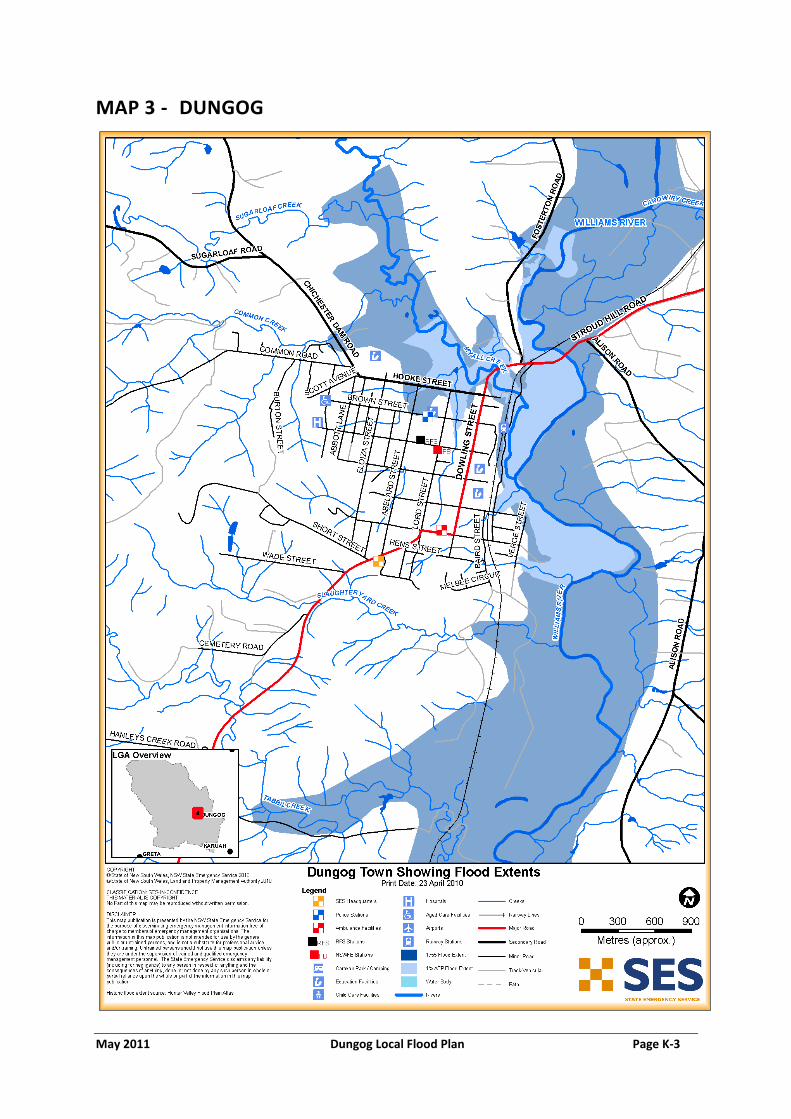
May 2011 Dungog Local Flood Plan Page K-3
MAP 3 - DUNGOG

May 2011 Dungog Local Flood Plan Page K-4
MAP 4 - CLARENCE TOWN

May 2011 Dungog Local Flood Plan Page K-5
MAP 5 - PATERSON