contribution to the speleology of sterkfontein cave
TRANSCRIPT
43
CONTRIBUTION TO THE SPELEOLOGY OFSTERKFONTEIN CAVE, GAUTENG PROVINCE,
SOUTH AFRICA
J.E.J.MARTINI1, P.E.WIPPLINGER2, H.F.G.MOEN2 and A.KEYSER3
ABSTRACTThe authors present more data about the speleological aspect of the Sterkfontein Cave, famousfor its bone breccia which yielded abundant hominid remains. They also briefly review theprevious voluminous studies by numerous authors, which are mainly dealing with the paleon-tology, stratigraphy and sedimentology of the breccia. The present investigations were orient-ed to hitherto poorly investigated aspects such as detail mapping of the cave, its country rockstratigraphy and recording the underground extension of the basal part of the breccia body.The cave consists of a complex network of phreatic channels, developed along joints inNeoarchaean cherty dolostone over a restricted surface of 250x250m. The combined length ofall passages within this area amounts to 5,23km. The system extends over a height of about50m and the dry part of it is limited downwards by the water-table appearing as numerous sta-tic pools. The fossiliferous breccia (= Sterkfontein Formation) forms an irregular lenticularmass 75x25m horizontally by 40m vertically, which is included within the passage network. Itcrops out at surface and in the cave, and resulted from the filling of a collapse chamber, whichwas de-roofed by erosion.The present investigation confirmed that the cave and the Sterkfontein Formation are part of asingle speleogenetic event. The breccia resulted from cavity filling by sediments introducedfrom a pit entrance, whereas many of the phreatic passages around it, which are developed atthe same elevation, were only partly filled or remained entirely open up to present. This fill-ing took place mainly in a vadose environment.Taking into account the age of the Sterkfontein Formation (>3,3-1,5 My, from base to top), thegeomorphic evolution of the landscape and the context of other caves in the region, it seemsthat the cave might have started to form 5 My ago. It has been continuously developing up topresent as a result of a slow drop of the water-table.
Introduction
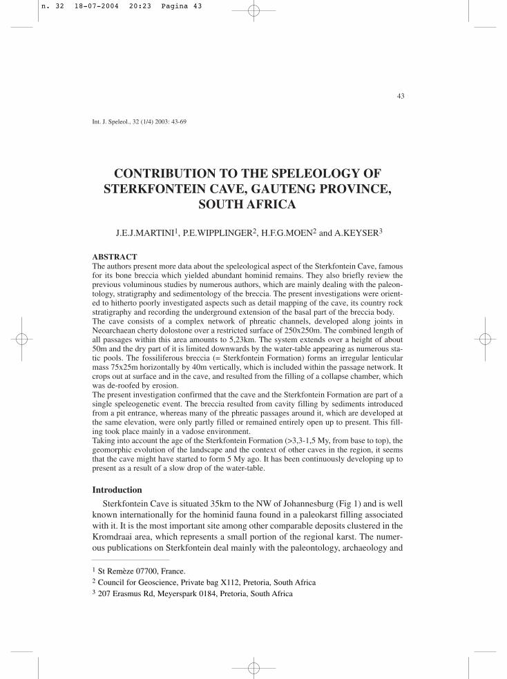
Sterkfontein Cave is situated 35km to the NW of Johannesburg (Fig 1) and is wellknown internationally for the hominid fauna found in a paleokarst filling associatedwith it. It is the most important site among other comparable deposits clustered in theKromdraai area, which represents a small portion of the regional karst. The numer-ous publications on Sterkfontein deal mainly with the paleontology, archaeology and
Int. J. Speleol., 32 (1/4) 2003: 43-69
1 St Remèze 07700, France.2 Council for Geoscience, Private bag X112, Pretoria, South Africa3 207 Erasmus Rd, Meyerspark 0184, Pretoria, South Africa
n. 32 18-07-2004 20:23 Pagina 43
44
sedimentology of this filling, and less with the cave itself. In this paper only the titlesmost relevant to the former topics are referenced.
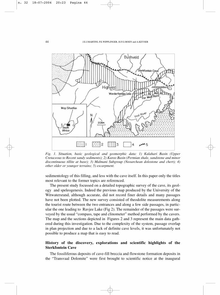
The present study focussed on a detailed topographic survey of the cave, its geol-ogy and speleogenesis. Indeed the previous map produced by the University of theWitwatersrand, although accurate, did not record finer details and many passageshave not been plotted. The new survey consisted of theodolite measurements alongthe tourist route between the two entrances and along a few side passages, in partic-ular the one leading to Ravjee Lake (Fig 2). The remainder of the passages were sur-veyed by the usual “compass, tape and clinometer” method performed by the cavers.The map and the sections depicted in Figures 2 and 3 represent the main data gath-ered during this investigation. Due to the complexity of the system, passage overlapin plan projection and due to a lack of definite cave levels, it was unfortunately notpossible to produce a map that is easy to read.
History of the discovery, explorations and scientific highlights of theSterkfontein Cave
The fossiliferous deposits of cave-fill breccia and flowstone formation deposits inthe “Transvaal Dolomite” were first brought to scientific notice at the inaugural
Fig. 1. Situation, basic geological and geomorphic data: 1) Kalahari Basin (UpperCretaceous to Recent sandy sediments); 2) Karoo Basin (Permian shale, sandstone and minordiscontinuous tillite at base); 3) Malmani Subgroup (Neoarchean dolostone and chert); 4)other older or younger terrains; 5) escarpment.
J.E.J.MARTINI, P.E.WIPPLINGER, H.F.G.MOEN and A.KEYSER
n. 32 18-07-2004 20:23 Pagina 44
45
Fig. 2. Map of Sterkfontein Cave. Legend: 1) cavity outline; 2) cavity outline under singleoverlay; 3) cavity outline under double overlay; 4) scarp and edge of pit in cave; 5) scarp andedge of pit at surface (=entrance); 6) blocks and scree; 7) walls of breccia and boulder block-ages; 8) Australopithecus skeleton; 9) masonry wall; 10) gates and fences; 11) flight of stairs.
CONTRIBUTION TO THE SPELEOLOGY OF STERKFONTEIN CAVE, GAUTENG PROVINCE, SOUTH AFRICA
n. 32 18-07-2004 20:23 Pagina 45
46
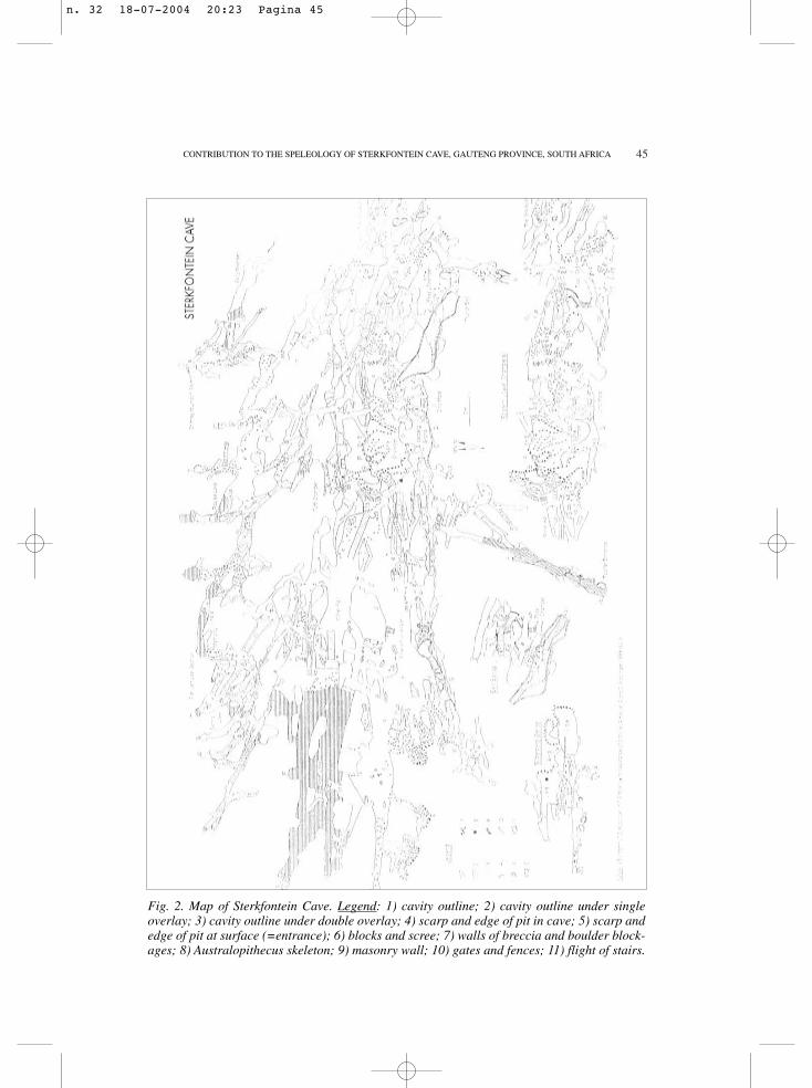
Fig. 3. Sections of Sterkfontein Cave. Positions indicated by capital letters on map Fig 2.Legend: 1) dolostone; 2) chert; 3) calcified old breccia and silt; 4) unconsolidated scree, siltand sand; 5) outline of side passage; 6) flight of stairs; 7) fence or gate.
J.E.J.MARTINI, P.E.WIPPLINGER, H.F.G.MOEN and A.KEYSER
n. 32 18-07-2004 20:23 Pagina 46
47
meeting of the newly formed Geological Society of South Africa by its firstSecretary, David Draper on 8 April 1895 (Draper 1896). C.K. Brain (1981) is of theopinion that Draper was describing the exposed cave sediments on Sterkfontein Hill.
The actual cave opening was first discovered by Mr. G. Martignalia after a blast. Hewas mining the Sterkfontein Hill calcite flowstone outcrop in 1896. He termed the open-ing a “wondergat” (marvelous hole). The cave was immediately explored and was foundto be very beautifully decorated by flowstone formations. The beauty of the cavesattracted wide interest and articles appeared in both South African and overseas journals.
The spectacular beauty of the cave had come to the attention of several geologistsin the former Transvaal Republic. In 1898 Draper stated at a meeting of the GeologicalSociety that he had taken steps to preserve the cave for the benefit of the public byapproaching the owners, who appeared to be cooperative. However, the protection ofthe cave was not to last long and the cave was irreparably damaged between 1918 and1920. At this time the owner, Mr. E.P. Binet was leasing the cave to a Mr. Nolan. Binetwas not prepared to extend the lease on expiry. This greatly infuriated Nolan, who thenproceeded to blast the flowstone formations with explosives.
During the 1920s the cave was exploited for calcite flowstone by the GlencairnLimestone Company. The operations were managed by Mr. G.W. Barlow, who sentspecimens of fossils recovered to various scientists.
In 1935 the already famous Dr. Robert Broom was appointed as paleontologist atthe Transvaal Museum in Pretoria. He immediately proceeded with his search foradult hominid remains, which would accord with the famous Taung Child discoveredin 1924 by R. A.Dart. He was conducting excavations in the same area ( Skurwebergand Gladysvale sites), when students of the University of the Witwatersrand showedhim some fossil baboons that had been found at Sterkfontein. Broom immediatelymade arrangements and visited Sterkfontein on 17th of August 1936 where he dis-covered a large portion of a skull and intact upper dentition of an adultAustralopithecus (Broom 1936).Subsequent regular visits by Broom to Sterkfonteinreturned a number of other australopithecine fossils as well as a wealth of other mam-malian material.
Shortly before World War II in 1939 mining of calcite was curtailed atSterkfontein due to a drop in the price of lime and with that the paleontological workalso came to an end for the duration of the war.
In 1947 Broom, assisted by Dr. J.T Robinson resumed excavations at Sterkfonteinusing funding arranged by the then Prime Minister of the Union of South Africa,General Jan C. Smuts, who was greatly fascinated by Broom’s remarkable discover-ies. Soon afterwards the most complete australopithecene skull was blasted out. Thisskull subsequently became known as Mrs. Ples.
Operations at Sterkfontein were again curtailed in 1949 when the digging teamwas moved to Swartkraans, another hominid deposit nearby.
In 1959 the owners of the farm Sterkfontein donated the 20 morgen containing theSterkfontein cave to the University of the Witwatersrand and the area became knownas the Isaac Edwin Stegman Nature Reserve. Excavations at Sterkfontein resumed in
CONTRIBUTION TO THE SPELEOLOGY OF STERKFONTEIN CAVE, GAUTENG PROVINCE, SOUTH AFRICA
n. 32 18-07-2004 20:23 Pagina 47

48
1966 under the direction of P.V. Tobias and A.R. Hughes and continued with greatsuccess under the direction of Tobias and R.J. Clarke up to the present. More than500 Australopithecus specimens have been discovered to date.
The two most spectacular discoveries were:
1. A specimen of Homo habilis (Stm. 53) found by Hughes in 1976.
2. Little Foot - some hominid foot bones which were discovered in a box markedbaboon postcranial by R.J.Clarke in 1994. He found that the bones fitted togeth-er to produce the most complete australopithecene foot known to date. The bonesoriginated in the so-called Silberberg Grotto. In 1997 Clarke decided to search forthe remainder of the specimen and sent two technicians with casts of the foot forpossible fit to search for the remainder of the fossil in the grotto. Within a daythey located the site where the original foot bones had been found. Clarke thencommenced to excavate the bones and to everybody’s surprise found a near-com-plete skeleton with a complete skull. This excavation is currently still on-goingand the find may represent a new taxon.
Sterkfontein is as yet the richest hominid site in South Africa and has the poten-tial to yield a wealth of fossils to scientists for many years to come.
As far as caving exploration is concerned, it seems that most sections were alreadyknown shortly after discovery, as they are easily accessible. This represented a cumu-lated length of passages amounting to about 2km. In 1984 a diver (P.Verhulsel) disap-peared in the Main Lake and was found dead of starvation 6 weeks later, in a chamberhitherto unexplored into which he had emerged (see details in Sefton et al 1985).During the rescue attempt, the members of the South African SpelaeologicalAssociation discovered and surveyed 892m of new passages. Only minor new sectionswere found during the survey by the authors, like for instance the Otto Maze (Fig 2).
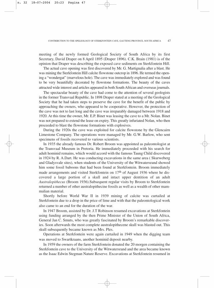
Two other caves occur immediately north of Sterkfontein, partly overlapping it:Lincoln and Fault Caves. They were discovered and explored at the same time asSterkfontein and have been mapped by the University of the Witwatersrand, proba-bly in the early seventies (Wilkinson 1973). In the same period and later, in 1984, themembers of the South African Spelaeological Association discovered new passagesin Lincoln Cave. In 1989-90, both Lincoln and Fault Caves were re-surveyed in moredetail and visually connected through a narrow, but impenetrable tube (Boshoff et al1990). Linking with Sterkfontein had been attempted several times in the past, albeitwithout success. In April 2001, however, after completion of the project it appearedfrom the survey that two passages in both caves, overlapping each others, were sep-arated by a floor only a few metres thick. By digging from below in a narrow chim-ney filled with rubble and then from above, a connection could be established, thusintegrating the Lincoln-Fault cave system with Sterkfontein Cave (Fig 3 and 4).
Geological context
The Sterkfontein Cave is developed in the Malmani Subgroup of late Archaean
J.E.J.MARTINI, P.E.WIPPLINGER, H.F.G.MOEN and A.KEYSER
n. 32 18-07-2004 20:23 Pagina 48
49
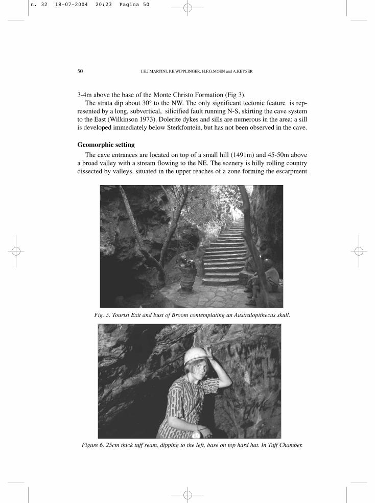
age (2,5-2,6 billion years), which has been deposited in the intracratonic TransvaalBasin (Button 1973). The lithology consists essentially of shallow marine stroma-tolitic dolostone with a variable amount of chert. The dolomite mineral is typicallyrich in Fe and Mn (up to 3% combined). Its thickness reaches 1450m in theSterkfontein area (Eriksson and Truswell 1974). Based on the abundance of chert, thesubgroup has been subdivided into 6 formations. The Oaktree Formation (180mthick) represents the basal unit, characterised by its very chert-poor nature. The over-lying unit, the Monte Christo Formation (700m thick) is rich in chert. It has thin butspectacular oolitic beds at its base. Sterkfontein Cave straddles the boundarybetween the two formations, but Lincoln and Fault caves are entirely hosted by theMonte Christo Formation (Fig 3). Two stratigraphic markers have been identified inthe cave. The first one is a tuff seam, up to 30cm thick, interstratified in the Oaktreedolostone 8-10m below the top of the formation (Fig 3and 6). Macroscopically itappears as a pale greenish-grey shale with ghosts of glass shards visible in thin sec-tions. It is widespread throughout the Transvaal Basin and has been successfully usedfor geochronometric dating (Walraven and Martini 1995). Another tuff seam, thinnerand more sporadically developed, has been indentified a few metres lower down. Thesecond marker is a 4-5m thick chert bed, with minor interstratified dolostone seams,
Fig. 4. Simplified map of Sterkfontein Cave (grey, overlays and details omitted) and Lincoln-Fault System (black). 1= Lincoln-Fault link; 2= Lincoln-Sterkfontein link. Map of Lincoln-Fault after Boshoff et al (1990).
CONTRIBUTION TO THE SPELEOLOGY OF STERKFONTEIN CAVE, GAUTENG PROVINCE, SOUTH AFRICA
n. 32 18-07-2004 20:23 Pagina 49
50
3-4m above the base of the Monte Christo Formation (Fig 3).The strata dip about 30° to the NW. The only significant tectonic feature is rep-
resented by a long, subvertical, silicified fault running N-S, skirting the cave systemto the East (Wilkinson 1973). Dolerite dykes and sills are numerous in the area; a sillis developed immediately below Sterkfontein, but has not been observed in the cave.
Geomorphic setting
The cave entrances are located on top of a small hill (1491m) and 45-50m abovea broad valley with a stream flowing to the NE. The scenery is hilly rolling countrydissected by valleys, situated in the upper reaches of a zone forming the escarpment
J.E.J.MARTINI, P.E.WIPPLINGER, H.F.G.MOEN and A.KEYSER
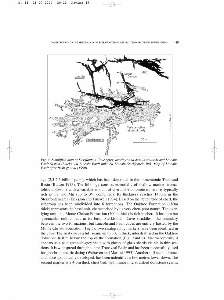
Fig. 5. Tourist Exit and bust of Broom contemplating an Australopithecus skull.
Figure 6. 25cm thick tuff seam, dipping to the left, base on top hard hat. In Tuff Chamber.
n. 32 18-07-2004 20:23 Pagina 50
51
separating two natural regions: the Highveld (1500-1600m) in the south, from theBushveld in the North (1000-1100) . These two regions represent surfaces pene-planed by erosion cycles. The Highveld corresponds more or less to the AfricanSurface, which started to develop after a continental uplift during the Cretaceous,whereas the Bushveld coincides in part with the Post-African I Surface generatedafter Early Miocene uplift and south-westwards tilting of the African Surface in thearea under consideration (Partridge and Maud 1987).
Due to the long existence of the African Cycle, the African Surface had been wellpeneplaned and covered with a thick weathering crust. During the development ofthe Post-African I Cycle, the African Surface underwent erosion by river systemsflowing both to the southwest (to the Atlantic) and to the north (to the Indian Ocean).On the northern system the erosion was more aggressive, with the development of anescarpment incising the Highveld. The southwestern erosion was more moderateresulting in the formation of a low-relief landscape not associated with an escarpmentas spectacular as in the northern case. This suggests that the renewal of erosion wasmainly the result of an increase of the talweg gradient of the African Surface by tilt-ing of the peneplain. This led to widespread degradation of the latter surface. 200kmto the west, both surfaces merge into the Kalahari Basin. Here sedimentation domi-nates over erosion (Fig 1).
About 1km to the north of the cave, the flat bottom of the valley has been incisedby a stream down to a depth of 8m (Robinson 1962, Wilkinson 1973), leaving grav-el terraces on both sides. This entrenchment is possibly due to a recent erosionrenewal.
Generalities on the karst of the Transvaal basin
It is necessary to summarize the nature of the regional karst as it differs from theclassic models. One characteristic is the deficiency in surface features like doline,polje, swallow-holes and disappearance of the surficial fluvial network. The lattermorphology is only observed, although it is not spectacular, on the very flat plateausof the southwestern quarter of the basin (Martini and Kavalieris 1976, Marker 1980).Elsewhere the dendritic network of streams is always well developed. The residualcover can be very thick, in places exceeding 100m.This is as a result of the large per-centage of insoluble impurities in the dolostone (Brink and Partridge 1965, Brink1979).
In contrast with the deficiency of surface karst morphology, caves are well devel-oped. They are of the hyperphreatic type, forming generally labyrinthic networks ofpassages which are controlled by joints, or broad flat chambers, the result of the dis-solution of chert-free beds sandwiched between cherty dolostone (Martini andKavalieris 1976). Chambers formed by ceiling breakdown after excessive dissolutionare also common. The caves do not seem to form well integrated systems, but ratherdevelop open channels only in zones where the dissolution for some reason was moreintense. The latter characteristic is suggested among others by the restricted exten-sion of the cave systems: the most remote places are not more than a few hundreds
CONTRIBUTION TO THE SPELEOLOGY OF STERKFONTEIN CAVE, GAUTENG PROVINCE, SOUTH AFRICA
n. 32 18-07-2004 20:23 Pagina 51
52
metres distant from the entrances, whereas the cumulated lengths of all passages maybe over 10km.
The flow of ground-water through the karst is very slow and where the water-tableis reached it forms pools that are apparently static. Perennial underground streamsare practically absent. According to measurements of the karst porosity, speleogene-sis is maximal just under the water-table, amounting to several per cent, and decreas-es rapidly deeper (Enslin and Kriel 1969). Penetrable caves still occur occasionallyat greater depth, however, for instance at 79m below the water-table, as observed byexploration after artificial de-watering of aquifers (Moen and Martini 1996). Animportant and well documented characteristic of the karst aquifer of the TransvaalBasin is its subdivision into compartments, separated by impervious subverticaldykes of dolerite and syenite, as well as by silicified faults.
Two types of detrital cave sediments may be distinguished. In the deep parts, notdirectly influenced by the surface, sedimentation is minimal and limited to autochto-nous material. The reason is that the phreatic flow is too slow to transport particulatematerial. The sediments consist of chert debris and dark-brown wad pellets detachedfrom the ceiling and the walls, and having accumulated on the floor. The materialknown as wad is the residue left in a quiet phreatic environment after incongruentdissolution of dolomite, which releases Mn and Fe oxides. During this process, theseoxides concentrate on the crystal junctions. As a result, after complete disappearanceof the carbonate, these oxides form a micro-boxwork pseudomorphing the dolostonetexture (Martini and Kavalieris 1976). When a cavity “bursts” up to the surface, byceiling breakdown or suffosion through the residual cover, alluvials are introducedinto the caves by occasional floods during storms. Most often, these alluvials consistof chert fragments, reddish silt and sand eroded from surface soils.
Description of the cave
Sterkfontein is a three-dimensional hyperphreatic maze of fissure passages typicalof the karst of the Transvaal basin. Its 25 entrances are the result of the intersectionof phreatic channels by the surface. These passages retain the same morphologydown to below the water-table, i.e. over an elevation of about 50m (Fig. 2 to 4). Thecave system is restricted to a 200x250x50m volume. However, the cumulative pas-sage development of Sterkfontein, including Lincoln Cave, amounts to 4,73km. Thisfigure increases to 5,23km if Fault Cave is added, although it is not yet convention-ally linked to the system, as only visual connection was achieved. Mining of calcitedid not considerably alter the morphology of the passages, except in the SilberbergGrotto. Here a particularly voluminous stalagmite and a flowstone sheet (the “Boss”)have been removed. This suggests that the chamber is mostly man-made. The mapindicates that the passages of the whole system follows two main directions of sub-vertical joints: the dominant one is mostly W to WNW and the subordinate one variesfrom N to NNE (Fig 2). The passage morphology is also controlled by the lithologyof the country rock. In the chert-poor Oaktree Formation, in which the greater part ofthe cave is developed, the passages belong dominantly to the fissure type. Here pas-
J.E.J.MARTINI, P.E.WIPPLINGER, H.F.G.MOEN and A.KEYSER
n. 32 18-07-2004 20:23 Pagina 52
53
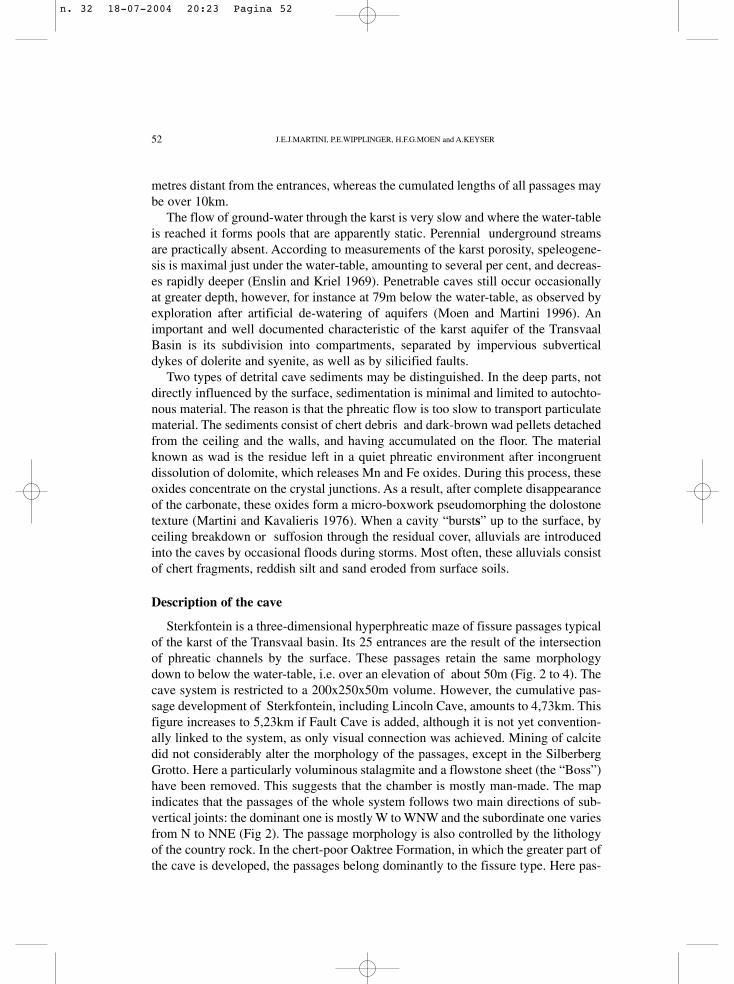
sages reach heights of 15m, while the widths are in the order of a few metres only.Large chambers can form by dissolution of partitions separating swarms of tightlyspaced passages. This is typically the case for the Elephant Chamber (Fig 7), where
Fig. 7. Elephant Chamber.Note long roof pendants.Person to the left gives scale.
CONTRIBUTION TO THE SPELEOLOGY OF STERKFONTEIN CAVE, GAUTENG PROVINCE, SOUTH AFRICA
the remnants of these partitions are left as long roof pendants reminiscent of trunks.Passages are often superimposed, adding more complexity to the map. This splittinginto several levels in a same joint is often due to “false” floors composed of rubbleand flowstone blockages, rather than undisturbed country rock. Compared to otherregional caves, the development by ceiling breakdown is relatively minor. The mainvoids of this latter type are Terror (alias Jacovec) and Fossil Chambers.
In the northern part of Sterkfontein Cave, i.e. in the P. Verhulsel Section, the areato the east of the latter, and in part of the Lincoln-Fault Cave System, the passagesdisplay a different morphology. They are still joint-controlled, but as they are devel-oped in the Monte Christo Formation, chert seams up to 30cm thick separate “stacks”of low (0,5-1m) but broad (2-5m) passages. For instance in the P.Verhulsel Section,up to 4 crawlways levels are in places superposed over a stratigraphic interval of only3-4m (Fig 3). These levels often merge into two or more passages by breakdown ofthe chert floors and develop into “canyons”. In this section, and further eastwards, itappears from the map that most passages stop against a same WSW-ENE line marked
n. 32 18-07-2004 20:23 Pagina 53
54
by pools. The latter represents the position where the 5m thick chert marker dipsunder the water-table. This prominent chert bed seems to have acted as a barrier,impeding passage development between Sterkfontein Cave and the Lincoln-FaultSystem. Only in the eastern part of the cave, on account of an unusual, completebreakdown of the chert ceiling, a connection could be established (April 2001 con-nection). In the Lincoln-Fault Cave System, the splitting of passages by chert layersis still observed, but is less characteristic than in Sterkfontein. The reason for this isthat the dolostone is less siliceous.
From the survey it appears that the volume of voids remains approximately con-stant from the surface down to the water-table, that is over an elevation difference ofabout 50 m. It is also obvious, that the longitudinal axes of the passages, even in theOaktree Formation, are generally inclined sub-parallel with the apparent dip of thecountry rock. These observations preclude the presence of preferential dissolutionlevels. This is not the rule everywhere in the karst of the Transvaal Basin. Cases areknown where phreatic mazes strictly developed at specific elevations: for instance inWonderfontein Cave (Fig 1), a 9,4km passage network which is restricted to an ele-vation range of only 3-4m (Kent et al 1978).
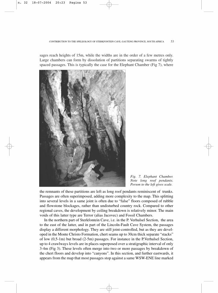
The nature of the original tensional joints controlling passage development hasbeen observed in several places on the chert ceilings, for instance in the P.VerhulselSection . Since chert is practically unaffected by karst dissolution, it is particularlyfavourable for the preservation of these cracks. The recorded width of these cracksvaries from fractions of a millimetre to one centimetre (Fig 8). The walls of the joints
J.E.J.MARTINI, P.E.WIPPLINGER, H.F.G.MOEN and A.KEYSER
Fig. 8. Open joint at chertceiling in Lesser Canyon,
Lincoln Cave. Scale in cen-timetres.
n. 32 18-07-2004 20:23 Pagina 54
55
are coated with tiny secondary quartz crystals which have grown before speleogene-sis. Open joints in dolostone, which are unaffected by dissolution are rare. Wherethese have been observed their surfaces are also coated with minute quartz crystals.The latter mineral sometimes impregnates the dolostone over a few millimetres onboth sides of the joint. Such open joints have been observed in most other caves inthe region and will be the subject of another article. It was proposed that they haveformed during the important tensional event associated with the flood basalt volcan-ism,which affected the entire sub-continent during the Early Jurassic (Kavalieris andMartini 1976).
In rare cases, passages are not controlled by subvertical joints, but by moderate-ly inclined fractures, like the eastern part of the long passage linking the tourist routewith Ravjee Lake. This fracture is possibly a very minor compression fault, alongwhich the initial cavities developed as primal voids having rhombic cross-sections.
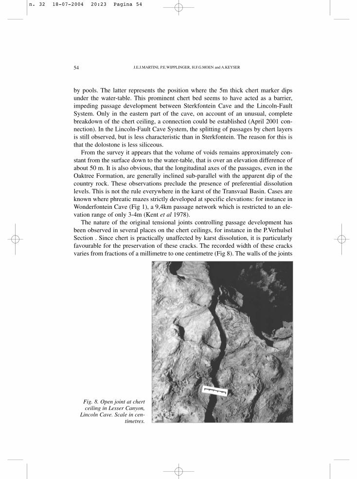
Hydrology
About 30 static pools have been reported in the cave system, the most importantby far being the Main Lake (Fig 9). With the exception of a small perched pool at theeastern end of the P.Verhulsel Section, they all mark the water-table. The depth of thepools has not been thoroughly investigated, but diving in the Main Lake and in thepools of the P.Verhulsel Section, indicates maxima of not more than 4m. Obviously
CONTRIBUTION TO THE SPELEOLOGY OF STERKFONTEIN CAVE, GAUTENG PROVINCE, SOUTH AFRICA
Fig. 9. Fissure passage, half-flood-ed at water-table level. Western endof Main Lake.
n. 32 18-07-2004 20:23 Pagina 55
56
greater depths have been estimated in Lincoln Cave. The water level of the lakesfluctuates slowly according to the preceding rainfall pattern. At present this is with-in a range of about 2m. Apparently the water flows to a spring situated 900m to thenorth of the cave. This spring is situated in the talweg of the broad valley mentionedpreviously. The position of the resurgence seems to be controlled by the dammingeffect of the N-S silicified fault, which was mentioned in the geology section andwhich prevents ground-water to flow eastwards. The spring elevation is very close tothat of the Main Lake (Wilkinson 1973).
Against this apparently simple and logic hydrological model, for previous level-ling of other pools has indicated great differences in elevation (Wilkinson 1973). Forinstance Ravjee Lake would be 4m lower than the Main Lake. The pool in FaultCave, the most distant, would be 9m lower. According to the present levelling, therespective discrepancy for Ravjee Lake amount to –0.5m. The exploration by diving(Wits Diving Club)also proved that the Main Lake and the pool situated immediate-ly to the north of the P.Verhulsel memorial must be on the same level, since they havebeen connected by diving (Sefton et al 1985). Careful levelling between the pool atthe end of the “Lesser Canyon” in Lincoln Cave, and the pool under the linking chim-ney in Sterkfontein (April 2001 connection) indicated that the latter is 18cm lowerthan the former. This difference is probably within the margin of error. Both poolsare therefore probably on same the level, although separated by the barrier formed bythe chert marker. It seems that the elevation differences between the other pools arenot more than decimetric rather than metric. A more accurate survey would be desir-able to confirm this conclusion.
Speleothems
Although the most massive speleothems have been removed by mining, remnantsof flowstone or dripstone of calcite or aragonite are still present. The latter mineralhas generally reverted to calcite. Evaporite-type speleothems are represented by pop-corn and aragonite frost on the walls. Sometimes these are associated with chalkymicrocrystalline hydromagnesite. These three carbonate minerals are very commonin other caves in the Transvaal Basin. The frequency of aragonite is related to theMg-rich nature of the ground-water (ex: Martini and Kavalieris 1978, Hill and Forti1997).
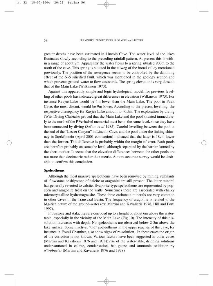
Flowstone and stalactites are corroded up to a height of about 6m above the water-table, especially in the vicinity of the Main Lake (Fig 10). The intensity of this dis-solution increases with depth. No speleothems are observed below 2-3m above thelake surface. Some inactive, “old” speleothems in the upper reaches of the cave, forinstance in Fossil Chamber, also show signs of re-solution . In these cases the originof the corrosion is not known. Various factors have been suggested in other caves(Martini and Kavalieris 1976 and 1978): rise of the water-table, dripping solutionsundersaturated in calcite, condensation, bat guano and ammonia oxidation byNitrobacter (Martini and Kavalieris 1976 and 1978).
J.E.J.MARTINI, P.E.WIPPLINGER, H.F.G.MOEN and A.KEYSER
n. 32 18-07-2004 20:23 Pagina 56
57
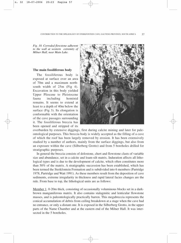
The main fossiliferous body
The fossiliferous body isexposed at surface over an areaof 70m and a maximum north-south width of 25m (Fig 4).Excavation in this body yieldedUpper Pliocene to Pleistocenefauna including hominidremains. It seems to extend atleast to a depth of 40m below thesurface (Fig 3). Its elongation isconformable with the orientationof the cave passages surroundingit. The fossiliferous breccia hasbeen opened and stripped of itsoverburden by extensive diggings, first during calcite mining and later for pale-ontological purposes. This breccia body is widely accepted as the filling of a caveof which the roof has been largely removed by erosion. It has been extensivelystudied by a number of authors, mainly from the surface diggings, but also froman exposure within the cave (Silberberg Grotto) and from 5 boreholes drilled forstratigraphic purposes.
In general the breccia consists of dolostone, chert and flowstone clasts of variablesize and abundance, set in a calcite and loam-silt matrix. Induration affects all litho-logical types and is due to the development of calcite, which often constitutes morethan 50% of the matrix. A stratigraphic succession has been established, which hasbeen termed the Sterkfontein Formation and is subdivided into 6 members (Partridge1978, Partridge and Watt 1991). As these members result from the deposition of cavesediments, extreme irregularity in thickness and rapid lateral facies changes are therule. From base to top, the lithological units are as follows:
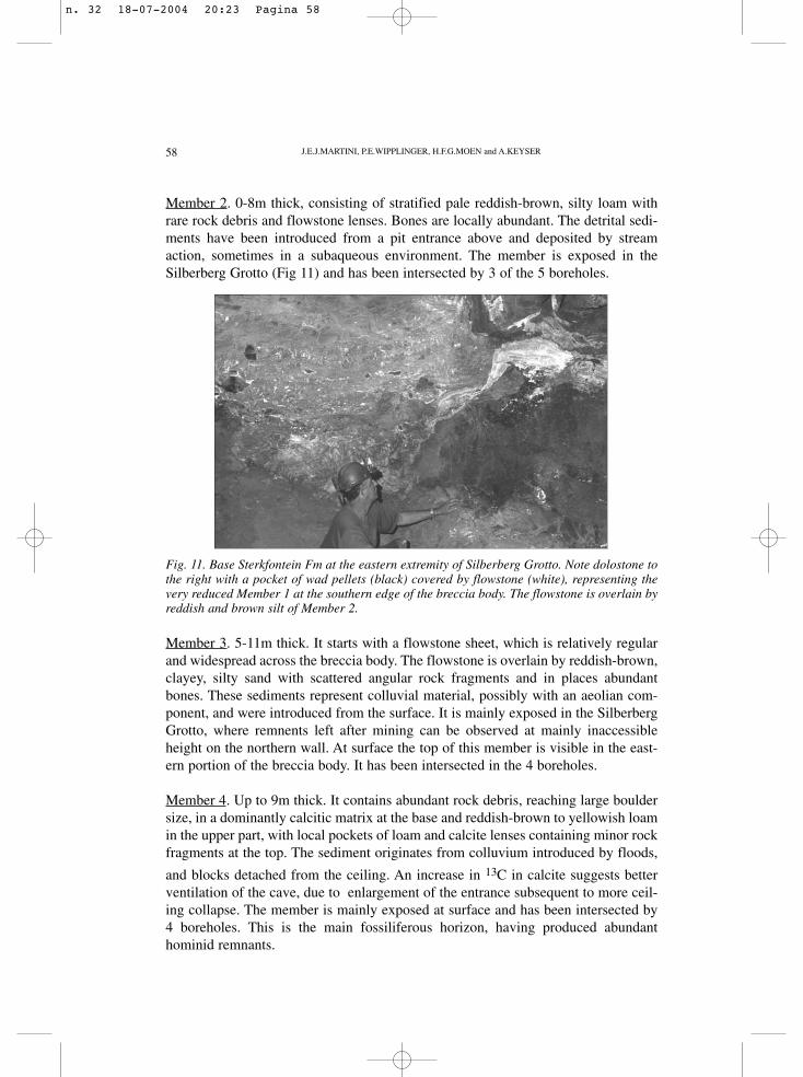
Member 1. 0-20m thick, consisting of occasionally voluminous blocks set in a dark-brown manganiferous matrix. It also contains stalagmitic and lenticular flowstonemasses, and is paleontologically practically barren. This megabreccia represents theconical accumulation of debris from ceiling breakdown at a stage when the cave hadno entrance, or only a distant one. It is exposed in the Silberberg Grotto, in the upperparts of the Name Chamber and at the eastern end of the Milner Hall. It was inter-sected in the 5 boreholes.
CONTRIBUTION TO THE SPELEOLOGY OF STERKFONTEIN CAVE, GAUTENG PROVINCE, SOUTH AFRICA
Fig. 10. Corroded flowstone adherentto the wall at western extremity ofMilner Hall, near Main Lake.
n. 32 18-07-2004 20:23 Pagina 57
58
Member 2. 0-8m thick, consisting of stratified pale reddish-brown, silty loam withrare rock debris and flowstone lenses. Bones are locally abundant. The detrital sedi-ments have been introduced from a pit entrance above and deposited by streamaction, sometimes in a subaqueous environment. The member is exposed in theSilberberg Grotto (Fig 11) and has been intersected by 3 of the 5 boreholes.
J.E.J.MARTINI, P.E.WIPPLINGER, H.F.G.MOEN and A.KEYSER
Fig. 11. Base Sterkfontein Fm at the eastern extremity of Silberberg Grotto. Note dolostone tothe right with a pocket of wad pellets (black) covered by flowstone (white), representing thevery reduced Member 1 at the southern edge of the breccia body. The flowstone is overlain byreddish and brown silt of Member 2.
Member 3. 5-11m thick. It starts with a flowstone sheet, which is relatively regularand widespread across the breccia body. The flowstone is overlain by reddish-brown,clayey, silty sand with scattered angular rock fragments and in places abundantbones. These sediments represent colluvial material, possibly with an aeolian com-ponent, and were introduced from the surface. It is mainly exposed in the SilberbergGrotto, where remnents left after mining can be observed at mainly inaccessibleheight on the northern wall. At surface the top of this member is visible in the east-ern portion of the breccia body. It has been intersected in the 4 boreholes.
Member 4. Up to 9m thick. It contains abundant rock debris, reaching large bouldersize, in a dominantly calcitic matrix at the base and reddish-brown to yellowish loamin the upper part, with local pockets of loam and calcite lenses containing minor rockfragments at the top. The sediment originates from colluvium introduced by floods,
and blocks detached from the ceiling. An increase in 13C in calcite suggests betterventilation of the cave, due to enlargement of the entrance subsequent to more ceil-ing collapse. The member is mainly exposed at surface and has been intersected by4 boreholes. This is the main fossiliferous horizon, having produced abundanthominid remnants.
n. 32 18-07-2004 20:23 Pagina 58
59
Member 5. Up to 5m thick, this unit rests unconformably on Member 4, which wasalready calcified since the latter has been observed as boulders included in Member5 (Robinson 1962). It consists of reddish-brown sandy loam with rock debris, occa-sional bones and stone tools. The mode of deposition is the same as that of Member4. At surface it is exposed in the western part of the breccia body.
Member 6. Up to 1,5m thick. It is comparable with the previous unit, but the matrixis dark reddish-brown. It also contains some bones and stone artifacts, probablyintroduced by early man. This member forms only a small outlier in the western partof the breccia body.
In the surface diggings, Members 3 to 6 display a gentle WNW dip, assumed torepresent the sedimentation slope. This suggests a detrital origin, from an entrancetowards the east (Robinson 1962, Partridge 1978) and also indicates that this filledpaleocave was inclined westwards, like many present-day passages in the cavebelow. A similar inclination is also suggested by ceiling remnants observed only inthe western side of the breccia body. The morphology of the ancient ceiling is typi-cal of an origin by breakdown (Robinson 1962).
As the breccia is calcite-rich, it was subsequently subjected to karst dissolution atthe surface. This resulted in the formation of narrow vertical tubular pits (“makon-dos”) and de-calcification associated with subsidence of the residuals into a “swal-low hole”. The latter contains mainly soft residuals from Member 4 and 5 and wasextensively excavated. Extraction of paleontological and archeological material wasgreatly facilitated by the soft nature of the material (Clark 1994). By digging deeperduring the paleontological excavation, the “swallow hole” broke into the NameChamber (Fig 1 and 2).
Other paleo-fills in the cave
Apart from the exposures in the Silberberg Grotto, the Name Chamber and theeastern end of the Milner Hall, which are directly and obviously part of the brecciabody (= Sterkfontein Formation) described previously, comparable occurrences ofindurated cave fill have been observed in many other places in the Sterkfontein CaveSystem. Stratified siliciclastics consisting of gravel and silt, plus flowstone layers,are sticking to the side wall and to the ceiling of the southern side of Terror Chamber.In this chamber breccia also fills fissure passages, forming clastic veins exposed inthe ceiling. As these occurrences are situated practically under the main breccia bodyand at the same elevation as the lower part of this body, it is very likely that they rep-resent more distal sediments of the Sterkfontein Formation. It is not possible, how-ever, to speculate which member they might belong to.
Three occurrences of cave filling to the west of the Elephant Chamber are locat-ed mainly at the ends of passages. Access to this filling is difficult due to obstructionby large boulders, the result of ceiling breakdown. By inspection of the map (Figure2) it seems possible that these boulder chokes are part of the same large, E-W elon-
CONTRIBUTION TO THE SPELEOLOGY OF STERKFONTEIN CAVE, GAUTENG PROVINCE, SOUTH AFRICA
n. 32 18-07-2004 20:23 Pagina 59
60
gated zone of collapse, which does not have an obvious surface expression.Calcification is well developed only in the eastern site.
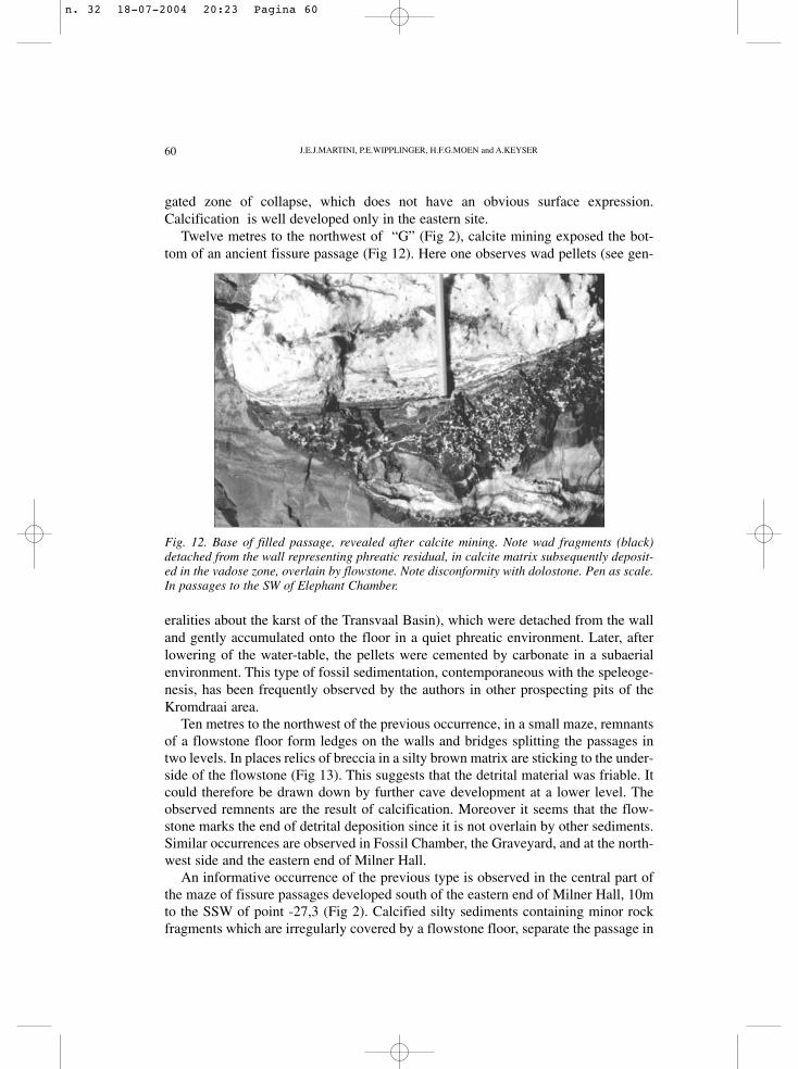
Twelve metres to the northwest of “G” (Fig 2), calcite mining exposed the bot-tom of an ancient fissure passage (Fig 12). Here one observes wad pellets (see gen-
J.E.J.MARTINI, P.E.WIPPLINGER, H.F.G.MOEN and A.KEYSER
Fig. 12. Base of filled passage, revealed after calcite mining. Note wad fragments (black)detached from the wall representing phreatic residual, in calcite matrix subsequently deposit-ed in the vadose zone, overlain by flowstone. Note disconformity with dolostone. Pen as scale.In passages to the SW of Elephant Chamber.
eralities about the karst of the Transvaal Basin), which were detached from the walland gently accumulated onto the floor in a quiet phreatic environment. Later, afterlowering of the water-table, the pellets were cemented by carbonate in a subaerialenvironment. This type of fossil sedimentation, contemporaneous with the speleoge-nesis, has been frequently observed by the authors in other prospecting pits of theKromdraai area.
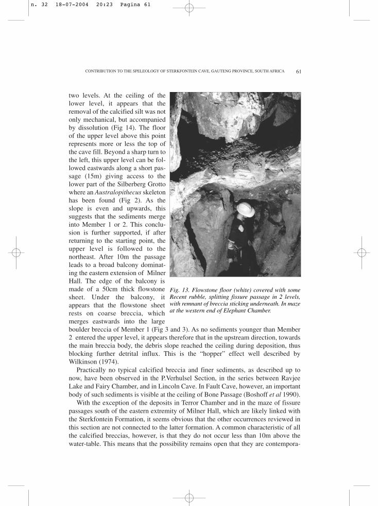
Ten metres to the northwest of the previous occurrence, in a small maze, remnantsof a flowstone floor form ledges on the walls and bridges splitting the passages intwo levels. In places relics of breccia in a silty brown matrix are sticking to the under-side of the flowstone (Fig 13). This suggests that the detrital material was friable. Itcould therefore be drawn down by further cave development at a lower level. Theobserved remnents are the result of calcification. Moreover it seems that the flow-stone marks the end of detrital deposition since it is not overlain by other sediments.Similar occurrences are observed in Fossil Chamber, the Graveyard, and at the north-west side and the eastern end of Milner Hall.
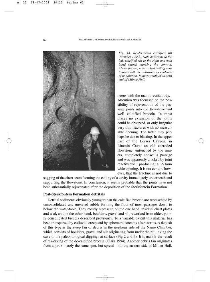
An informative occurrence of the previous type is observed in the central part ofthe maze of fissure passages developed south of the eastern end of Milner Hall, 10mto the SSW of point -27,3 (Fig 2). Calcified silty sediments containing minor rockfragments which are irregularly covered by a flowstone floor, separate the passage in
n. 32 18-07-2004 20:23 Pagina 60
61
two levels. At the ceiling of thelower level, it appears that theremoval of the calcified silt was notonly mechanical, but accompaniedby dissolution (Fig 14). The floorof the upper level above this pointrepresents more or less the top ofthe cave fill. Beyond a sharp turn tothe left, this upper level can be fol-lowed eastwards along a short pas-sage (15m) giving access to thelower part of the Silberberg Grottowhere an Australopithecus skeletonhas been found (Fig 2). As theslope is even and upwards, thissuggests that the sediments mergeinto Member 1 or 2. This conclu-sion is further supported, if afterreturning to the starting point, theupper level is followed to thenortheast. After 10m the passageleads to a broad balcony dominat-ing the eastern extension of MilnerHall. The edge of the balcony ismade of a 50cm thick flowstonesheet. Under the balcony, itappears that the flowstone sheetrests on coarse breccia, whichmerges eastwards into the largeboulder breccia of Member 1 (Fig 3 and 3). As no sediments younger than Member2 entered the upper level, it appears therefore that in the upstream direction, towardsthe main breccia body, the debris slope reached the ceiling during deposition, thusblocking further detrital influx. This is the “hopper” effect well described byWilkinson (1974).
Practically no typical calcified breccia and finer sediments, as described up tonow, have been observed in the P.Verhulsel Section, in the series between RavjeeLake and Fairy Chamber, and in Lincoln Cave. In Fault Cave, however, an importantbody of such sediments is visible at the ceiling of Bone Passage (Boshoff et al 1990).
With the exception of the deposits in Terror Chamber and in the maze of fissurepassages south of the eastern extremity of Milner Hall, which are likely linked withthe Sterkfontein Formation, it seems obvious that the other occurrences reviewed inthis section are not connected to the latter formation. A common characteristic of allthe calcified breccias, however, is that they do not occur less than 10m above thewater-table. This means that the possibility remains open that they are contempora-
CONTRIBUTION TO THE SPELEOLOGY OF STERKFONTEIN CAVE, GAUTENG PROVINCE, SOUTH AFRICA
Fig. 13. Flowstone floor (white) covered with someRecent rubble, splitting fissure passage in 2 levels,with remnant of breccia sticking underneath. In mazeat the western end of Elephant Chamber.
n. 32 18-07-2004 20:23 Pagina 61
62
neous with the main breccia body.Attention was focussed on the pos-sibility of rejuvenation of the pas-sage joints into old flowstone andwell calcified breccia. In mostplaces no extension of the jointscould be observed, or only irregularvery thin fractures with no measur-able opening. The latter may per-haps be due to blasting. In the upperpart of the Lesser Canyon, inLincoln Cave, an old corrodedflowstone, untouched by the min-ers, completely chokes a passageand was apparently cracked by jointreactivation, producing a 2-3mmwide opening. It is not certain, how-ever, that the fracture is not due to
sagging of the chert seam forming the ceiling of a cavity immediately underneath andsupporting the flowstone. In conclusion, it seems probable that the joints have notbeen substantially rejuvenated after the deposition of the Sterkfontein Formation.
Post-Sterkfontein Formation detritals
Detrital sediments obviously younger than the calcified breccia are represented byunconsolidated and unsorted rubble forming the floor of most passages down tobelow the water-table. They mostly represent, on the one hand, residual chert platesand wad, and on the other hand, boulders, gravel and silt reworked from older, poor-ly consolidated breccia described previously. To a variable extent this material hasbeen transported by colluvial creep and by ephemeral streams after storms. A depositof this type is the steep fan of debris in the northern side of the Name Chamber,which consists of boulders, gravel and silt originating from under the pit linking thecave to the paleontological diggings at surface (Fig 2 and 3). It is mainly the resultof reworking of the de-calcified breccia (Clark 1994). Another debris fan originatesfrom approximately the same spot, but spread into the eastern side of Milner Hall,
J.E.J.MARTINI, P.E.WIPPLINGER, H.F.G.MOEN and A.KEYSER
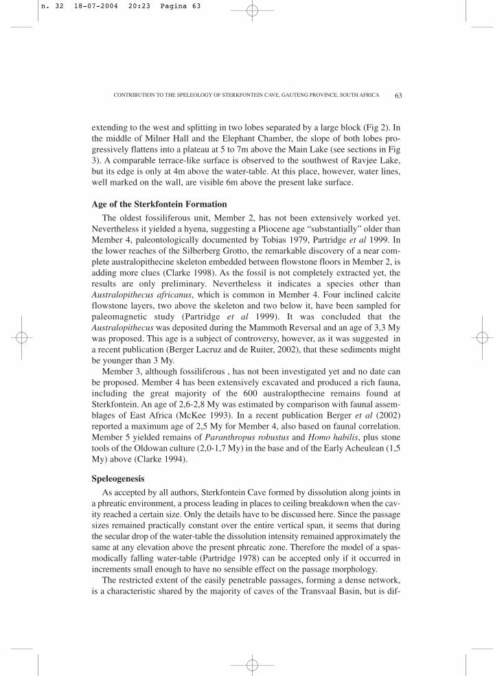
Fig. 14. Re-dissolved calcified silt(Member 1 or 2). Note dolostone to theleft, calcified silt to the right and wadband (dark) marking the contact.Above person, note arched ceiling con-tinuous with the dolostone as evidenceof re-solution. In maze south of easternend of Milner Hall.
n. 32 18-07-2004 20:23 Pagina 62
63
extending to the west and splitting in two lobes separated by a large block (Fig 2). Inthe middle of Milner Hall and the Elephant Chamber, the slope of both lobes pro-gressively flattens into a plateau at 5 to 7m above the Main Lake (see sections in Fig3). A comparable terrace-like surface is observed to the southwest of Ravjee Lake,but its edge is only at 4m above the water-table. At this place, however, water lines,well marked on the wall, are visible 6m above the present lake surface.
Age of the Sterkfontein Formation
The oldest fossiliferous unit, Member 2, has not been extensively worked yet.Nevertheless it yielded a hyena, suggesting a Pliocene age “substantially” older thanMember 4, paleontologically documented by Tobias 1979, Partridge et al 1999. Inthe lower reaches of the Silberberg Grotto, the remarkable discovery of a near com-plete australopithecine skeleton embedded between flowstone floors in Member 2, isadding more clues (Clarke 1998). As the fossil is not completely extracted yet, theresults are only preliminary. Nevertheless it indicates a species other thanAustralopithecus africanus, which is common in Member 4. Four inclined calciteflowstone layers, two above the skeleton and two below it, have been sampled forpaleomagnetic study (Partridge et al 1999). It was concluded that theAustralopithecus was deposited during the Mammoth Reversal and an age of 3,3 Mywas proposed. This age is a subject of controversy, however, as it was suggested ina recent publication (Berger Lacruz and de Ruiter, 2002), that these sediments mightbe younger than 3 My.
Member 3, although fossiliferous , has not been investigated yet and no date canbe proposed. Member 4 has been extensively excavated and produced a rich fauna,including the great majority of the 600 australopthecine remains found atSterkfontein. An age of 2,6-2,8 My was estimated by comparison with faunal assem-blages of East Africa (McKee 1993). In a recent publication Berger et al (2002)reported a maximum age of 2,5 My for Member 4, also based on faunal correlation.Member 5 yielded remains of Paranthropus robustus and Homo habilis, plus stonetools of the Oldowan culture (2,0-1,7 My) in the base and of the Early Acheulean (1,5My) above (Clarke 1994).
Speleogenesis
As accepted by all authors, Sterkfontein Cave formed by dissolution along joints ina phreatic environment, a process leading in places to ceiling breakdown when the cav-ity reached a certain size. Only the details have to be discussed here. Since the passagesizes remained practically constant over the entire vertical span, it seems that duringthe secular drop of the water-table the dissolution intensity remained approximately thesame at any elevation above the present phreatic zone. Therefore the model of a spas-modically falling water-table (Partridge 1978) can be accepted only if it occurred inincrements small enough to have no sensible effect on the passage morphology.
The restricted extent of the easily penetrable passages, forming a dense network,is a characteristic shared by the majority of caves of the Transvaal Basin, but is dif-
CONTRIBUTION TO THE SPELEOLOGY OF STERKFONTEIN CAVE, GAUTENG PROVINCE, SOUTH AFRICA
n. 32 18-07-2004 20:23 Pagina 63
64
ficult to explain. It might be due to zones of initial joints wider than usual, but thishypothesis needs to be demonstrated. Another possibility would be that the cave sys-tems developed where deep water wells up and mixes with ordinary ground-waterclose to surface. This model is suggested by comparison with the caves of northernNamibia, which also show restricted surface extension, but where there is evidenceof such upwelling for some of them (Martini and Marais 1996, Martini et al 1999).
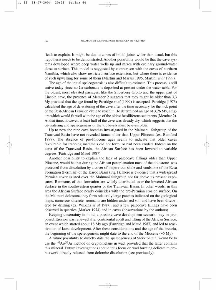
The age of the initial speleogenesis is also difficult to estimate. This process is stillactive today since no Ca-carbonate is deposited at present under the water-table. Forthe oldest, most elevated passages, like the Silberberg Grotto and the upper part ofLincoln cave, the presence of Member 2 suggests that they might be older than 3,3My,provided that the age found by Partridge et al (1999) is accepted. Partridge (1973)calculated the age of de-watering of the cave after the time necessary for the nick pointof the Post-African I erosion cycle to reach it. He determined an age of 3,26 My, a fig-ure which would fit well with the age of the oldest fossiliferous sediments (Member 2).At that time, however, at least half of the cave was already dry, which suggests that thede-watering and speleogenesis of the top levels must be even older.
Up to now the nine cave breccias investigated in the Malmani Subgroup of theTransvaal Basin have not revealed faunas older than Upper Pliocene (ex. Bamford1999). The absence of pre-Pliocene ages seems to indicate that older cavesfavourable for trapping mammals did not form, or had been eroded. Indeed on thekarst of the Transvaal Basin, the African Surface has been lowered to variabledegrees (Partridge and Maud 1987).
Another possibility to explain the lack of paleocave fillings older than UpperPliocene, would be that during the African peneplanation most of the dolostone wasprotected from dissolution by a cover of impervious shale and sandstone of the EccaFormation (Permian) of the Karoo Basin (Fig 1).There is evidence that a widespreadPermian cover existed over the Malmani Subgroup not far above its present expo-sures. Remnants of this formation are widely distributed over the lowered AfricanSurface in the southwestern quarter of the Transvaal Basin. In other words, in thisarea the African Surface nearly coincides with the pre-Permian erosion surface. Onthe Malmani dolostone they form relatively large patches indicated on the geologicalmaps, numerous discrete remnants are hidden under red soil and have been discov-ered by drilling (ex. Wilkins et al 1987), and a few paleocave fillings have beenobserved in quarries (Marker 1974) and in caves (observations by the authors).
Keeping uncertainty in mind, a possible cave development scenario may be pro-posed. Erosion was renewed after continental uplift and tilting of the African Surface,an event which started about 18 My ago (Partridge and Maud 1987) and led to reac-tivation of karst development. After these considerations and the age of the breccia,the beginning of the speleogenesis might date to the end of the Miocene (~5 My).
A future possibility to directly date the speleogenesis of Sterkfontein, would be touse the 40Ar/39Ar method on cryptomelane in wad, provided that the latter containsthis mineral. Future investigations should thus focus on wad forming delicate micro-boxwork directly released from dolomite dissolution (see previously).
J.E.J.MARTINI, P.E.WIPPLINGER, H.F.G.MOEN and A.KEYSER
n. 32 18-07-2004 20:23 Pagina 64
65
About the younger speleogenetic phases, the Sterkfontein Formation is informa-tive, as it indicates that 3,3 My ago the cave was already de-watered at 20-25m abovethe present water-table. That the secular drop of the water-table was irregular, com-prising temporary rises, is evidenced by re-solution of calcified silt and breccia about12m above the water-table (Fig 14). These oscillations might be linked to climaticvariations or to more local “accidents” in the evolution of the surficial drainage sys-tem. Similarly, speleothems are corroded up to 6m above the Main Lake (Fig 10).This oscillation was perhaps controlled by the resurgence, when at one stage thestream channel might have been choked by alluvium, thus forcing a localised rise ofthe water-table, as suggested by the 8m gravel terrace.
Conclusions and comparisons
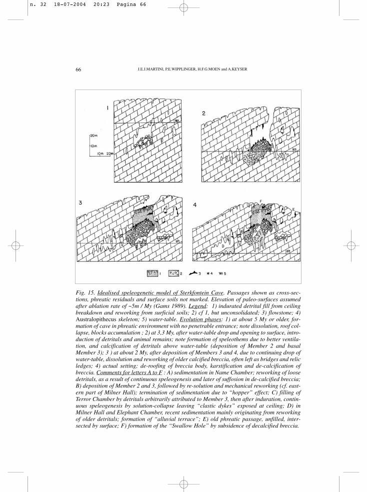
The mapping conducted during this project provides more data about the config-uration of the cave, added new passages and was an opportunity to clarify the detailsof the local stratigraphy of the Malmani Subgroup. The most significant contribution,however, is a better understanding of the basal part of the Sterkfontein Formation.Indeed at this level the main breccia body, a filled chamber generated by ceiling col-lapse, partly splits into clastic veins, which are infillings of phreatic fissure passages.These observations also confirmed that the latter formation is not a paleokarst fillingindependent from the actual cave. This misleading impression has been induced bythe general calcification of both breccia and siltstone by dripping water, also deposit-ing stalactites, stalagmites and flowstone floors, thus rendering it resistant to under-mining by continuing speleogenesis and vadose erosion. This also explains theabsence of soft sediments contemporaneous with the Sterkfontein Formation. It alsoappeared that the collapse chamber hosting this formation is contemporaneous withthe phreatic passages of the upper part of the cave, although they remained open upto now. These parts of the cave were not filled up, because of blockages (“hoppers”)preventing introduction of detritals from surface. A model of cave development ispresented at Figure 15.
Sterkfontein is an example of a cave still open and in formation after probablymore than 5 My and having escaped complete removal by surface ablation. Onefactor in favour of such a long preservation is a slow rate of karst evolution, a con-dition which is still met today: although the rainfall is about 80cm/y, the ground-water recharge amounts to only 15% due to high evapo-transpiration (Enslin andKriel 1967). Old caves which remained open up to present are known elsewhere inthe world, like for instance the highest ones in the Guadalupe Mountains, NewMexico. These caves are located in a semi-arid environment and formed by sul-phuric speleogenesis, an event dated at 12 My by 40Ar/39Ar method on alunite(Polyac et al 1998).
Another factor favouring long preservation is an entrance on the top of a hill,where ablation is weak and where only minimal residual material can enter the cave.In contrast, where the topography is flat, larger volumes of alluvium are engulfed andthe caves are rapidly filled up as soon as entrances form by suffosion in residual
CONTRIBUTION TO THE SPELEOLOGY OF STERKFONTEIN CAVE, GAUTENG PROVINCE, SOUTH AFRICA
n. 32 18-07-2004 20:23 Pagina 65
66 J.E.J.MARTINI, P.E.WIPPLINGER, H.F.G.MOEN and A.KEYSER
Fig. 15. Idealised speleogenetic model of Sterkfontein Cave. Passages shown as cross-sec-tions, phreatic residuals and surface soils not marked. Elevation of paleo-surfaces assumedafter ablation rate of ~5m / My (Gams 1989). Legend: 1) indurated detrital fill from ceilingbreakdown and reworking from surficial soils; 2) cf 1, but unconsolidated; 3) flowstone; 4)Australopithecus skeleton; 5) water-table. Evolution phases: 1) at about 5 My or older, for-mation of cave in phreatic environment with no penetrable entrance; note dissolution, roof col-lapse, blocks accumulation ; 2) at 3,3 My, after water-table drop and opening to surface, intro-duction of detritals and animal remains; note formation of speleothems due to better ventila-tion, and calcification of detritals above water-table (deposition of Member 2 and basalMember 3); 3 ) at about 2 My, after deposition of Members 3 and 4, due to continuing drop ofwater-table, dissolution and reworking of older calcified breccia, often left as bridges and relicledges; 4) actual setting; de-roofing of breccia body, karstification and de-calcification ofbreccia. Comments for letters A to F : A) sedimentation in Name Chamber; reworking of loosedetritals, as a result of continuous speleogenesis and later of suffosion in de-calcified breccia;B) deposition of Member 2 and 3, followed by re-solution and mechanical reworking (cf. east-ern part of Milner Hall); termination of sedimentation due to “hopper” effect; C) filling ofTerror Chamber by detritals arbitrarily attributed to Member 3, then after induration, contin-uous speleogenesis by solution-collapse leaving “clastic dykes” exposed at ceiling; D) inMilner Hall and Elephant Chamber, recent sedimentation mainly originating from reworkingof older detritals; formation of “alluvial terrace”; E) old phreatic passage, unfilled, inter-sected by surface; F) formation of the “Swallow Hole” by subsidence of decalcified breccia.
n. 32 18-07-2004 20:23 Pagina 66
67
cover or by rock ceiling collapse. An informative and well dated example is the pale-okarst of the Quercy, in southern France (Pélissier et al. 1999, and references there-in). This paleokarst reached a mature stage, with a thick soil cover, during the LowerEocene and was eventually fossilised under Middle Miocene basin sediments.During this 30 My span, karst activity was reduced, but potholes opened periodical-ly and were filled by bone-rich sediments almost instantly, geologically speaking.Indeed the paleontological content of more than 100 of these potholes indicated thateach of them contains a geochronologically punctual faunal assemblage, although theoverall ages vary from Lower Eocene to Lower Miocene. Where the African Surfacedeveloped on the Malmani dolostone, with regard to its protracted existence, a simi-lar mature karst might have formed, but would probably have been eroded in theSterkfontein area. Only 200-250km to the west of the cave, where sedimentationsupersedes erosion, paleokarst deposits related to the African Surface might be dis-covered. They should yield Upper Cretaceous to Miocene faunas and thus indirectlycontribute to a better understanding of the evolution of the karst of the Kromdraaiarea, including Sterkfontein Cave.
Acknowledgments
The authors are indebted to Dr R.J.Clark of the University of the Witwatersrand, whogave them permission to conduct the investigations in the cave. During the surveyand exploration they have been assisted by C.Menter, A. and O.Wipplinger, whowere often instrumental in climbing and squeezing through narrow holes.
REFERENCES
BAMFORD M. (1999). Pliocene fossil wood from an early hominid cave deposit, Sterkfontein,South Africa. South African J. Sc., 95, 231-237.
BERGER L.R., LACRUZ R., AND DE RUITER D.J. (2002). Brief communication: Revisedage estimates of Australopithecus-bearing deposits at Sterkfontein, South Africa. Amer. J.phys. anthropol. 119, 192-197.
BOSHOFF P., DURRHEIM R., FRASER A., MARTINI J.E.J., RALPH A. and SEFTON M.(1990). The Lincoln-Fault Cave System. South African Spelaeo. Ascn., 31, 60-64.
BRAIN C.K. (1981). The hunters or the hunted? University of Chicago Press, Chicago. 365 p.
BRINK A.B.A. (1979). Engineering geology of Southern Africa. Vol. 1. Building Publications,Pretoria, 319 p.
BRINK A.B.A. and PARTRIDGE T.C. (1965). Transvaal karst: some considerations of devel-opment and morphology, with special reference to sinkholes and subsidences on the FarWest Rand. South African Geogr. J., 47,11-34.
BROOM R. (1936). A new fossil anthropoid skull from South Africa. Nature, 138, 486-488.BUTTON A. (1973). The stratigraphic history of the Malmani Dolomite in the eastern and
CONTRIBUTION TO THE SPELEOLOGY OF STERKFONTEIN CAVE, GAUTENG PROVINCE, SOUTH AFRICA
n. 32 18-07-2004 20:23 Pagina 67
68
north-eastern Transvaal. Trans. Geol. Soc. South Africa, 76, 229-247.
CLARKE R.J. (1994). On some new interpretations of Sterkfontein stratigraphy. SouthAfrican J. Sc., 90, 211-214.
CLARKE R.J. (1998). First ever discovery of a well-preserved skull and associated skeletonof Australopithecus. South African J.Sc., 94, 460-463.
DRAPER D. (1896). Report of meeting, 8th April 1895. Geological Society of South Africa.Trans. Geol. Soc. South Africa 1, p1.
DRAPER D. (1898). Meeting of the geological Society of South Africa, 12th July 1897. Trans.geol. Soc. South Africa 3, p 63.
ENSLIN J.F. and KRIEL J.P. (1967). The assessment and possible future uses of the dolomiteground water resources of the Far West Rand, Transvaal, South Africa. Water for peaceconference, Washington 1967. 12 p.
ERIKSSON K.A. and TRUSWELL J.F. (1974). Stratotypes from the Malmani Subgroupnorth-west of Johannesburg, South Africa. Trans. Geol. Soc. South Africa, 77, 211-222.
GAMS I. (1989). International measurements of solution by means of limestone tablets. In:Kosa A. (Ed). Proc. Xth Internat. Congress Speleo., 2, Budapest, 473-475.
HILL C. and FORTI P. (1997). Cave minerals of the world. Nat. speleo. Soc., Huntsville (Ala),463p.
KAVALIERIS I. and MARTINI J. (1976). Structural control of some Western Transvaal caves.South African J. Sc., 72, 308-309.
KENT L.E., KAVALIERIS I., MARTINI J. and HUGO P.L.V. (1978). Wonderfontein Cave.Annals Geol. Surv. South Africa, 11, 303-308.
MARKER M.E. (1974). A note on the occurrence of Karoo sediments near Pretoria and itsrelevance to the dating of karst weathering. Trans. Geol. Soc. South Africa, 77, 69-70.
MARKER M.E. (1980). A systems model for karst development with relevance for SouthernAfrica. South African Geogr. J., 62, 151-163.
MARTINI J. and KAVALIERIS I. (1976). The karst of the Transvaal (South Africa). Intern. J.Speleo., 8, 229-251.
MARTINI J. and KAVALIERIS I. (1978). Mineralogy of the Transvaal caves. Trans. Geol.Soc. South Africa, 81, 47-54.
MARTINI J.E.J. and MARAIS J.C.E. (1996). Grottes hydrothermales dans le Nord-Ouest dela Namibie. Karstologia, 28 (2), 13-18.
MARTINI J.E.J., MARAIS J.C.E. and IRISH J. (1999). Contribution à l’étude du karst etgrottes du Kaokoland (Namibie). Karstologia, 34 (2), 1-8.
MCKEE J.K. (1993). Faunal dating of the Taung hominid fossil deposit. J. Human Evolution,25, 363-376.
J.E.J.MARTINI, P.E.WIPPLINGER, H.F.G.MOEN and A.KEYSER
n. 32 18-07-2004 20:23 Pagina 68
69CONTRIBUTION TO THE SPELEOLOGY OF STERKFONTEIN CAVE, GAUTENG PROVINCE, SOUTH AFRICA
MOEN H.F.G. and MARTINI J.E.J. (1996). The exploration of Swartgat Sinkhole. SouthAfrican Spelaeo. Ascn.Bull., 36,45-49.
PARTRIDGE T.C. (1973). Geomorphological dating of cave opening at Makapansgat,Sterkfontein, Swartkrans and Taung. Nature, 246, 75-79.
PARTRIDGE T.C. (1978). Re-appraisal of lithostratigraphy of Sterkfontein hominid site.Nature, 275, 282-286.
PARTRIDGE T.C. and MAUD R.R. (1987). Geomorphic evolution of Southern Africa sincethe Mesozoic. South African J. Geol., 90, 179-208.
PARTRIDGE T.C., SHAW J., HESLOP D. and CLARKE R.J. (1999). The new hominid skele-ton from Sterkfontein, South Africa: age and preliminary assessment. J. Quarternary Sc.,14, 293-298.
PARTRIDGE T.C. and WATT I.B. (1991). The stratigraphy of the Sterkfontein hominiddeposit and its relationship to the underground cave system. Paleont. Africana, 28, 35-40.
PÉLISSIÉ T., VIANEY-LIAUD M., MARANDAT B;, AYMARD K., CÉRES G. andGAFFARD K. (1999). Les phosphatières du Quercy. Spelunca, N° 73, 23-38.
POLYAK V.J., MCINTOSH W.C., GÜVEN N. and PROVINCIO P. (1998). Age and origin ofCarlsbad Cavern and related caves of the Guadalupe Mountains based on 40Ar/39Ar dat-ing on alunite. Science, 279, 1919-1922.
ROBINSON J.T. (1962). Australopithecines and artefacts at Sterkfontein, Part I. Sterkfonteinstratigraphy and the significance of the extension site. South African ArchaeologicalBull., 17, 87-107.
SEFTON M., MARTINI J. and ELLIS R. (1985). A report on the events surrounding thesearch for Mr P.Verhulsel at Sterkfontein Tourist Cave: the involvement of the SouthAfrican Spelaeological Association. 29th September 1984 to 6th January 1985 . SouthAfrican Spelaeo. Ascn. Bull., 26, 32-56.
TOBIAS P.V. (1979). The Silberberg Grotto, Sterkfontein, Transvaal, and its importance inpalaeoanthropological researches. South African J. Sc., 75, 161-164.
WILKINS C.B., ERIKSSON P.G. and VAN SCHALKWYK A. (1987). Two generations ofkarst fill sedimentary rocks within Chuniespoort Group dolomites south of Pretoria.South African J. Geol., 90, 155-167.
WALRAVEN F. and MARTINI J. (1995). Zircon Pb-evaporation age determination of theOaktree Formation, Chuniespoort Group, Transvaal Sequence: implications forTransvaal-Griqualand West basin correlations. South African J. Geol., 98, 58-67.
WILKINSON M.J. (1973). Sterkfontein Cave System: evolution of a karst form. UnpublishedM.A. thesis, University of the Witwatersrand, Johannesburg.
Received: 25 january 2003Accepted: 30 march 2003
n. 32 18-07-2004 20:23 Pagina 69