control gis and geo-information modelling · key words: geo-information modelling, control gis,...
TRANSCRIPT

Control GIS and Geo-information Modelling
DANA KLIMEŠOVÁ
Czech University of Agriculture, Prague Faculty of Economics and Management, Dept. of Information Engineering
Kamýcka 129, 165 21 Praha 6 – Suchdol, CZECH REPUBLIC
and Czech Academy of Sciences
Institute of Information Theory and Automation, Dept. of Image Processing Pod vodárenskou věží 4, 182 00 Prague 8,
KEY WORDS: Geo-information modelling, control GIS, spatial temporal approach, uncertainty, spatial decision support ABSTRACT: The contribution deals with the contextual design of spatial-temporal data, distinguishes three GIS level for the purposes of the regional development, land management and government and describes the role of the GIS Web services architecture that makes GIS more open, robust and interoperable in using and offers wide range of context information. Web has a unique ability to integrate diverse data through shared location and GIS Web services offer real potential for meeting the demands of users and will bring significant benefit to knowledge-based approaches application. On one hand the use of very heterogeneous data available on Web – multi-sensor, multi-band and others in the combination with multi-criteria conditions evaluation causes increasing of uncertainty we meet in the processes and consequently in results. On the other hand the same Web enable the use of wide context (temporal, spatial, local, objective, attribute oriented, relation oriented) on the level of knowledge based system, that influents in the sense of decreasing the uncertainty of data, classification process, analytical functions and increases the information value of decision support.
1 Introduction GIS manages location-based information and provides the tools to display and analyse it – whether it is vegetation types, population characteristics, economic development opportunities, telecommunication network, or regional urban sites study. The enlarging complexity of our world and deep interrelations of our activities in comparing with fragile harmony of new links call for the tool which can help us
to understand and evaluate the context of things and phenomena. In comparing with initial ideas and visions the ways of managing and distributing data and particularly the resolution of data sources has rapidly changed. Spatial data are collected and processed and during the last couple of years the data flows in and between organizations have extremely increased. In the connection with these facts also the data management tools and techniques are continually changed. It includes the automated knowledge acquiring, proper handling of large volumes of data, new accesses to data
Proceedings of the 8th WSEAS Int. Conference on Automatic Control, Modeling and Simulation, Prague, Czech Republic, March 12-14, 2006 (pp97-102)

interpretation and effective exchange of information between and among various institutions.
2 Geographical Modelling Geo-information processing is involved into the majority of projects of our current life. We are able to solve a lot of important tasks that are connected with generic questions that are frequently investigated. The location question involves querying a database to determine the types of features, which occur at a given place. The condition question is really the converse, since it involves finding the location of sites, which have certain characteristics. Where more than one type of data are involved this is sometimes referred to as the ‘intersection’ question since it necessitates finding the intersection of data sets. The trend question involves monitoring how things change over the time. The other questions are more complex and involve some type of spatial analysis. The routing question requires calculation of the best (fastest, shortest, most scenic, etc) route between places. The patterns question allows environmental and social scientists and planners to describe and compare the distribution of phenomena and to understand the processes, which account for their distribution. Finally, the modelling question allows different models of the world to be evaluated This, so called WHAT IF analysis, needs of course more powerful tools like neighbourhood operations, connectivity functions, contiguity functions, network functions, spread functions, seek or stream functions, view and visibility functions. These tools open the large space where the wide context of objects and phenomena can be incorporated into the processing and where the quite new quality of information can be achieved. 2.1 Control GIS Very roughly speaking, we can determine, considering the range of tasks, three basic levels of GIS use:
• Inventory GIS • Analytical GIS and • Control GIS
To the inventory GIS fit the imagination of cadastre. Usually large and masterly managed database where it is possible to find and also provide all information for touched sides and we can make do with comparatively simple function tools and with context corresponding to
the reasonable number of information layers. Main worry: to update and manage database. For the analytical GIS it is typical, without accounting of the range of database, in some sense permanently growing and very changeable amount of information layers that cover the different extent of changeable area of interest and call for the application of sequences of whole scale of functions named before. The top level of GIS usage it is control GIS, where as touch information layers hold true the same as in case of analytical GIS and the large ability is aided to implement knowledge models from different branches of scientific investigation of around world for wide context of evident as well as less evident connections, models of trends, objects and expected or predicted relations [2], [4]. The integral part of control GIS is the modelling where the information layers from real, artificial and virtual world are composed together to select optimal scenario or verify given hypothesis or assumptions. The contextual design of spatial data and further development of geo-information technologies, image processing techniques and the possibilities of object history modelling together with the geographical networks environment will provide quite new and considerably wider possibilities of using GIS. GIS architecture is open to incorporate new requirements of knowledge-based analysis and modelling, namely in connection with web designed spatial databases and temporal oriented approaches. This type of geo-information processing it is the resource, tool and means. It is modelling in most common sense. If we understand the standard geographical database as a digital model of the real world than control GIS can handle the DB, which is the result of temporal interface of standard DB with virtual and artificial models of real world. 2.2 Access to Data Thanks to the Internet and Mobile Internet GIS, Mobile Web Map Services and Mobile Web Analytical Services that facilitate the acquiring of data it is much easier to monitor and map temporal states of the objects and phenomena. Mobile Internet GIS and Mobile Web Map Services, it is a new solution that offers mobile Internet access to the data including theirs updated versions, provides the transmission of maps that are composed under the demands and the transfer of map attributes and provides
Proceedings of the 8th WSEAS Int. Conference on Automatic Control, Modeling and Simulation, Prague, Czech Republic, March 12-14, 2006 (pp97-102)

the access to the raster data, orthophotomaps and vector data. Web Analytical Services make possible to process and analyze spatial data through Internet and mobile internet. This system increases the access to information for the management in the field of forestry, agriculture, regional development, environment protection and others. Mentioned technologies (Mobile Internet GIS, Mobile Web Map Services, Mobile Web Analytical Services) can significantly increase the processing effect because they make possible:
• to increase the speed of finding information (phase of collection)
• to increase the ability to analyse the large files of information (phase of analysis)
• to increase the effect of the context evaluation (top analysis)
• to increase the effect of the presentation (distribution).
The speed of the reaction it is the critical factor of the competitiveness, the amount of information sources and the amount of potential important information included with them continually increase whereas the ability of people to absorb new information continually decrease. It means that the signification of intelligent information technologies expressively increases and the spatial temporal data analysis allowing spatial temporal evaluation of information open the new possibilities for decision support. The progress in new sensor technology for Earth observational remote sensing continues and increasingly high spectral resolution multispectral imaging sensors are developed and these sensors give more detailed and complex data for each picture element. The increasing resolution of the sources results in the increasing number of imaged objects (classes), increase the dimensionality of data, and moreover, the complexity of object structuring hierarchy is rapidly growing too. The changing society needs changing approaches to real world observation, modelling, analysis and evaluation. The concept of the time plays the significant role in our life and all our thoughts about the history, present time as well as about the future is not relevant enough without accounting the temporal axe. That is why the geo-society calls for temporal data, temporal oriented spatial databases. This need comes from natural necessity of registration of changes appearing around us on one hand and the need of monitoring of long-term processes and trends and theirs interrelations on the other one [5].
The great development of geographical databases and GIS technology oriented on spatial data at all has been caused by the fact that it corresponds very closely to our understanding of the around world. The same scheme is valid in case of the concept of time. The successful regional policy and development can be made only with permanent comparing the local resources with global possibilities. It needs a large amount of data and the spatial data typically has an extremely complex and namely variable structure. Moreover, to gain the information from remote sensed data it needs the program packages for the classification, segmentation and contextual evaluating of results, detection of changes and context sensitive analysis if possible together with using of knowledge based databases. All countries have a strong need to develop and use GIS as a basic tool for decision support processes in a variety fields. One of the new aspects will be the temporal context investigation, which can stay on different levels of application. There is no life without the time consideration. There is no past and no future. And the natural process connected with time accounting is analysis of changes. Further development it is the question of accessible information, knowledge-based decision making and context sensitive analysis applying [7].
3 Temporal Modelling The imagination of temporal object model is very exciting and it will bring quite new quality of evaluation processes, namely in the analysis of type WHAT, IF, which is temporary oriented and compose the virtual and artificial components. The question is how to model effectively interrelations of the space and time. Generally speaking, geographic information is a description of object with shape data and attribute data combined together. And each component can contain temporal information and can become the part of reproducible spatial-temporal processing of sequences of DB objects [3]. Automated process of evaluation of temporal data sets is called – temporal analysis. We need to know the history to be able understand the trends and model our future. The management of any thing, including acceptation of the important decisions, it is not possible to do having the inventory information. To be successful in management of things it means to account the changes,
Proceedings of the 8th WSEAS Int. Conference on Automatic Control, Modeling and Simulation, Prague, Czech Republic, March 12-14, 2006 (pp97-102)

understand the trends and effectively plan the changes if possible. The combination of spatial and temporal components will bring the new qualitative reasoning of geo-information [3], [8-9]. Temporal GIS it includes:
• To store • Manage • Process and • Visualize
time-varying spatial data. The temporal context model characterizes the processes of contextual coding, storage and retrieval Spatial-temporal databases represent huge amount of data, new technologies of processing and a new access and management of large databases and specific temporal based queries should be used to analyse spatial-temporal oriented databases To express any relationship of object state to selected temporal layers we can use the matrix to model the type of object temporal state. Briefly speaking, great amount of data asks for automation of the classification and interpretation process of spatial data without the necessity to collect and utilize the large training sets (Tyree, Long, 1997). The useful approach in the face of such conditions is to utilize hierarchy in analytical process. The incorporation of temporal components has been first implemented with the relational model and then with the object-oriented data models. The trend of temporal data modelling is moving from time-stamping layers (similar to relational tables) to time-stamping events or processes (similar to objects). Our decisions are becoming increasingly dependent on understanding of complex relations and phenomena in the world around and GIS technology is able to incorporate new requirements like decision tree context, temporal aspects and fuzzy design. The main goal has been to show selected aspects of this process and compare the increasing possibilities of the sources with the difficulties the object history implementation. 3.1 Temporal objects The understanding of the time and space as an integral reference brings a lot of problems with the necessity to
solve them. The significant part of problems is connected with the temporal slices creation [3], [6] and consequently with the processing and analysis of temporal data, integration of dynamical models into existing global geographical environment. To generate temporal slices it represents the interpolation of temporal layers and suitable integration into the spatial resolution [3]. It is evident that the method of nearest neighbour will not sole this task. Moreover, we have usually in disposal only temporal fragments to describe the continually changing natural objects. In practice, it is necessary to create different dynamical models with respect to the approaches how the time is considered [6]. For example, 3D model of snapshots looks to be very simple but the processing and storing of the temporal layers of observed area have to solve the problem of changing class, which the object belongs to with the accounting of temporal and spatial continuity. There are two types of methods for the selection of class where the temporal object belongs:
• the estimation of time of the change using the distance from the class boarder
• the estimation of the probability of belonging to the class using structural model focused on some class property – expansion, contraction or others.
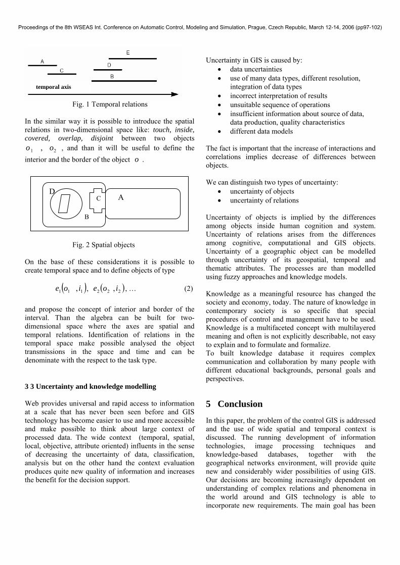
The first one is highly dependent on spatial temporal relations between classes surrounding the analyzed pixel. 3.2 Temporal-spatial relationships For the creation of different models it has to be clear in the basic temporal and spatial relations. It looks that very practical for these purposes are Allen temporal operators [12] that define relations between temporal intervals. The time is considered to be continual valuable, T is the set of measured times that corresponds to the set of real numbers and I is the set of temporal intervals. Let i is the temporal interval from I ,
][ 21 , tti = , where
., 2121 ttaTtt <∈ (1) The relations between the temporal intervals of type: before, equal, meets, overlaps, starts and theirs opposite operators [8], [9] are arranged in the fig 1.
Proceedings of the 8th WSEAS Int. Conference on Automatic Control, Modeling and Simulation, Prague, Czech Republic, March 12-14, 2006 (pp97-102)
D B
A
E C
Fig. 1 Temporal relations
In the similar way it is possible to introduce the spatial relations in two-dimensional space like: touch, inside, covered, overlap, disjoint between two objects
21 , oo , and than it will be useful to define the interior and the border of the object o .
Fig. 2 Spatial objects On the base of these considerations it is possible to create temporal space and to define objects of type ( )111 , ioe , ( )222 , ioe , … (2)
and propose the concept of interior and border of the interval. Than the algebra can be built for two-dimensional space where the axes are spatial and temporal relations. Identification of relations in the temporal space make possible analysed the object transmissions in the space and time and can be denominate with the respect to the task type. 3 3 Uncertainty and knowledge modelling Web provides universal and rapid access to information at a scale that has never been seen before and GIS technology has become easier to use and more accessible and make possible to think about large context of processed data. The wide context (temporal, spatial, local, objective, attribute oriented) influents in the sense of decreasing the uncertainty of data, classification, analysis but on the other hand the context evaluation produces quite new quality of information and increases the benefit for the decision support.
Uncertainty in GIS is caused by:
• data uncertainties • use of many data types, different resolution,
integration of data types • incorrect interpretation of results • unsuitable sequence of operations • insufficient information about source of data,
data production, quality characteristics • different data models
The fact is important that the increase of interactions and correlations implies decrease of differences between objects. We can distinguish two types of uncertainty:
• uncertainty of objects • uncertainty of relations
Uncertainty of objects is implied by the differences among objects inside human cognition and system. Uncertainty of relations arises from the differences among cognitive, computational and GIS objects. Uncertainty of a geographic object can be modelled through uncertainty of its geospatial, temporal and thematic attributes. The processes are than modelled using fuzzy approaches and knowledge models. Knowledge as a meaningful resource has changed the society and economy, today. The nature of knowledge in contemporary society is so specific that special procedures of control and management have to be used. Knowledge is a multifaceted concept with multilayered meaning and often is not explicitly describable, not easy to explain and to formulate and formalize. To built knowledge database it requires complex communication and collaboration by many people with different educational backgrounds, personal goals and perspectives. 5 Conclusion In this paper, the problem of the control GIS is addressed and the use of wide spatial and temporal context is discussed. The running development of information technologies, image processing techniques and knowledge-based databases, together with the geographical networks environment, will provide quite new and considerably wider possibilities of using GIS. Our decisions are becoming increasingly dependent on understanding of complex relations and phenomena in the world around and GIS technology is able to incorporate new requirements. The main goal has been
temporal axis
Proceedings of the 8th WSEAS Int. Conference on Automatic Control, Modeling and Simulation, Prague, Czech Republic, March 12-14, 2006 (pp97-102)

to show selected aspects of this process and compare the increasing possibilities of the sources with the difficulties of data contextual structuring and the object dynamics implementation.
Acknowledgement The Project Information and knowledge support of strategic control - MSM 6046070904 supports this work. REFERENCES [1] Armstrong, M. P., 1988, Temporality in spatial
databases. Proceedings: GIS/LIS'88, 2:880-889. [2] Benedikt, J., Reinberg, S., Riedl, L., 2002. A GIS
application to enhance cell-based information modeling. Information Sciences 142(2002): 151-160.
[3] Huang, S. B., Shibasaki R. Development of Genetic Algotithm/ Hill-climbing Method for Spatio-temporal Interpolation, 2003.
[4] Klimešová D., Ocelíková E., 2001. GIS and spatial data network. In: Globalisation versus Regionalism. (Tichá I. ed.). Sources of Sustainable Economic Growth in the Third Millennium. Czech University of Agriculture, Prague, 1-94.
[5] Klimešová D., Ocelíková E., 2001. Spatial data and context information. In: Space without Frontiers. Cartography Brazil, Porto Alegre, 22-25.
[6] Goldberg, D.E., (2003): Genetic Algorithm in Search, In Optimizing and Machine Learning, 2003.
[7] Klimešová D., Saic S., 1998. Feature Selection Algorithm and Correlation Cobweb, Pattern Recognition Letters 19(1998), 681-685.
[8] Claramunt, C., Thériault, M. and Parent, C., (1998): A qualitative representation of evolving spatial entities in Two-dimensional Spaces. In Innovations in GIS V , edited by Carver, S. (London: Taylor & Francis), pp. 119-129.
[9] May Yuan,2004, Temporal GIS and Spatio-Temporal Modeling, Department of Geography, University of Oklahoma.
[10] Cui, Z., Cohn, A. G. and Randell, D. A., (1993): Qualitative and topological relationships in spatial databases. In Advances in Spatial Databases, edited by Abel, D. J. and Ooi, B. C. (Singapore: Springer-Verlag), pp. 296-315.
[11] Liu, D.; Shi, W., et al., (2000): Accuracy Analysis and Quality Control of Spatial Data in GIS, Shanghai, 2000, Science & Technology Literature Press.
[12] Allen J.F.,(1984): Towards a general theory of actions and time. Artificial Intelligence, 23(2), pp. 123-154.
[13] Tansel, A. U., Clifford, J., Gadia, S., Jajodia, S., Segev, A., Snodgrass, R., ed., 1993, Temporal Databases: Theory, Design, and Implementation (Reading, MA: The Benjamin /Cummings Publishing Company, Inc.).
[14] Worboys, M. F., 1992, A model for spatio-temporal information. Proceedings: the 5th International Symposium on Spatial Data Handling, 2:602-611.
[15] Worboys, M. F., 1994, A unified model for spatial and temporal information. The Computer Journal, 37(1):26-34.
[16] Beller, A., Giblin, T., Le, K. V., Litz, S., Kittel, T., and Schimel, D., 1991, A temporal GIS prototype for global change research. Proceedings: GIS/LIS'91, 2:752-765.
Proceedings of the 8th WSEAS Int. Conference on Automatic Control, Modeling and Simulation, Prague, Czech Republic, March 12-14, 2006 (pp97-102)