control sections. objectives explain the purpose of the control sections in soil taxonomy. use...
TRANSCRIPT
Control Sections
Objectives
• Explain the purpose of the control sections in Soil
Taxonomy.
• Use Chapter 17, Keys to Soil Taxonomy to
determine various control sections for family and
series differentiae.
Rationale for family category and class differentiae
• Integrates physical and chemical properties important for plant growth and engineering use.
• Condenses a collection of soil properties into a few classes.
• Invokes a superb mental construct of the functional capacity of a soil.

There are several control sections in Soil Taxonomy
• Subgroup, great group, suborder, order
– Soil moisture regime
• Suborder, great group, order
– Soil temperature regime
• Family
– Particle-size classes and their substitutes– Mineralogy classes– Cation-exchange activity classes– Calcareous and reaction classes– Soil temperature classes– Classes of coatings on sands– Classes of permanent cracks
• Series control section
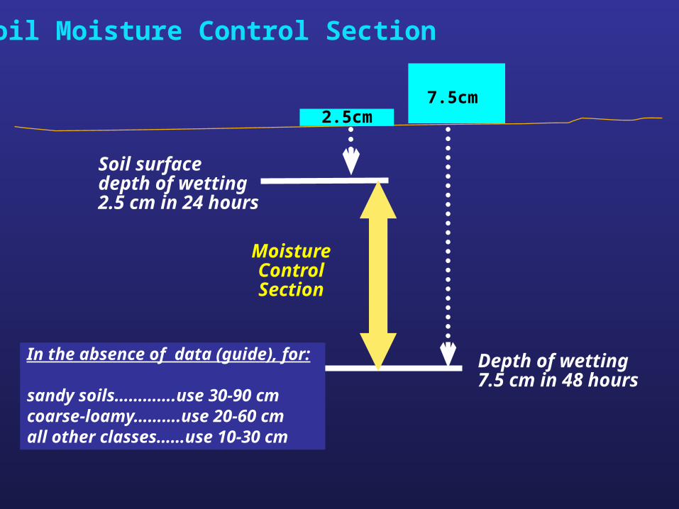
Soil Moisture Control Section
Soil surfacedepth of wetting2.5 cm in 24 hours
Depth of wetting7.5 cm in 48 hours
MoistureControlSection
In the absence of data (guide), for:
sandy soils………….use 30-90 cmcoarse-loamy……….use 20-60 cmall other classes……use 10-30 cm
7.5cm2.5cm
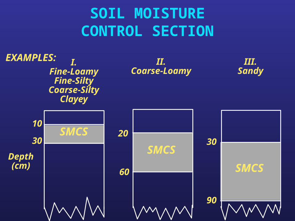
SOIL MOISTURECONTROL SECTION
EXAMPLES:
SMCS
SMCS
SMCS
10
3020
60
30
90
Depth(cm)
I.Fine-LoamyFine-SiltyCoarse-Silty
Clayey
II.Coarse-Loamy
III.Sandy
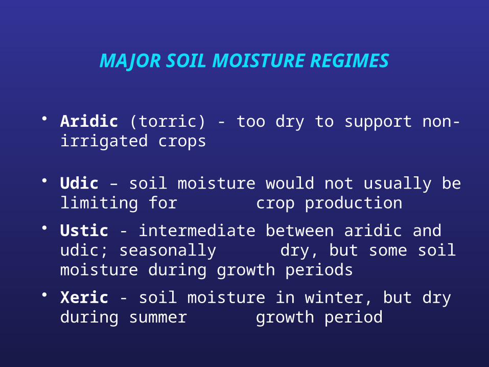
MAJOR SOIL MOISTURE REGIMES
• Aridic (torric) - too dry to support non-irrigated crops
• Udic – soil moisture would not usually be limiting for crop production
• Ustic - intermediate between aridic and udic; seasonally dry, but some soil moisture during growth
periods
• Xeric - soil moisture in winter, but dry during summer growth period
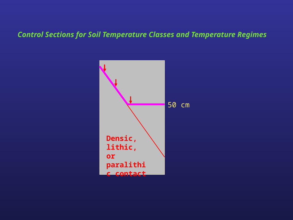
Control Sections for Soil Temperature Classes and Temperature Regimes
50 cm
Densic, lithic, or paralithic contact
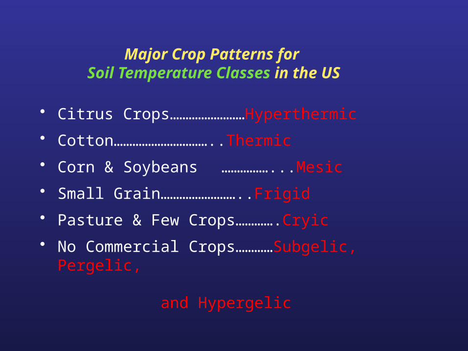
Major Crop Patterns for Soil Temperature Classes in the US
• Citrus Crops……………………Hyperthermic
• Cotton…………………………..Thermic
• Corn & Soybeans ……………...Mesic
• Small Grain……………………..Frigid
• Pasture & Few Crops………….Cryic
• No Commercial Crops…………Subgelic, Pergelic, and Hypergelic
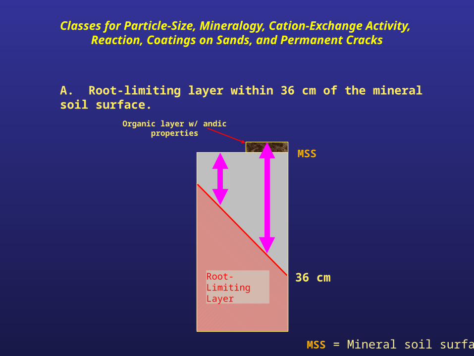
Classes for Particle-Size, Mineralogy, Cation-Exchange Activity, Reaction, Coatings on Sands, and Permanent Cracks
A. Root-limiting layer within 36 cm of the mineral soil surface.
36 cmRoot-Limiting Layer
Organic layer w/ andic properties
MSS
MSS = Mineral soil surface
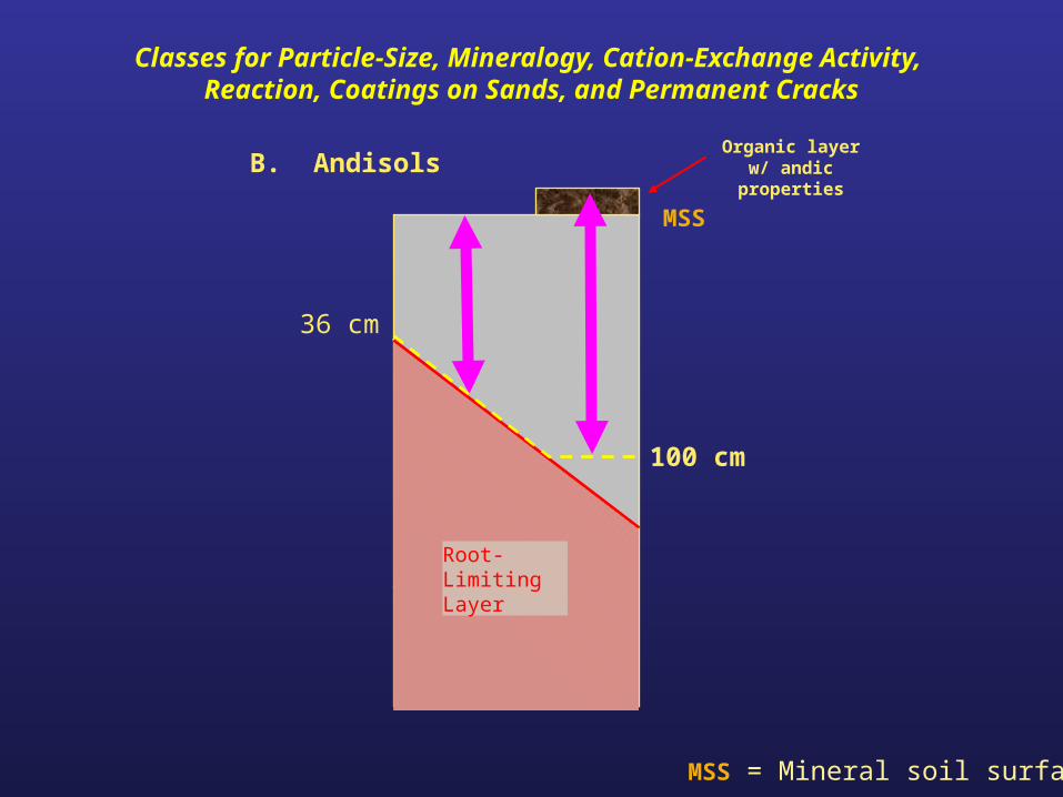
B. Andisols
100 cm
36 cm
Root-Limiting Layer
Organic layer w/ andic properties
Classes for Particle-Size, Mineralogy, Cation-Exchange Activity, Reaction, Coatings on Sands, and Permanent Cracks
MSS = Mineral soil surface
MSS
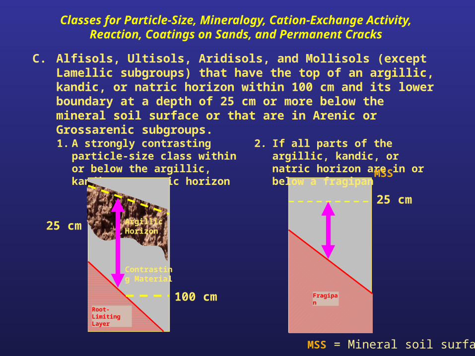
C. Alfisols, Ultisols, Aridisols, and Mollisols (except Lamellic subgroups) that have the top of an argillic, kandic, or natric horizon within 100 cm and its lower boundary at a depth of 25 cm or more below the mineral soil surface or that are in Arenic or Grossarenic subgroups.
25 cm
1. A strongly contrasting particle-size class within or below the argillic, kandic, or natric horizon
2. If all parts of the argillic, kandic, or natric horizon are in or below a fragipan
Fragipan100 cm
Contrasting Material
Root-Limiting Layer
25 cm Argillic Horizon
Classes for Particle-Size, Mineralogy, Cation-Exchange Activity, Reaction, Coatings on Sands, and Permanent Cracks
MSS = Mineral soil surface
MSS
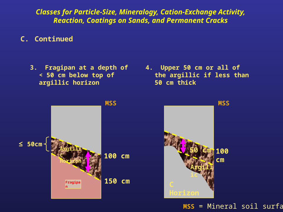
3. Fragipan at a depth of < 50 cm below top of argillic horizon
4. Upper 50 cm or all of the argillic if less than 50 cm thick
150 cmFragipan
100 cm
C Horizon
C. Continued
Fragipan
50 cm
Argillic
Argillic Horizon
≤ 50cm
100 cm
Classes for Particle-Size, Mineralogy, Cation-Exchange Activity, Reaction, Coatings on Sands, and Permanent Cracks
MSS MSS
MSS = Mineral soil surface
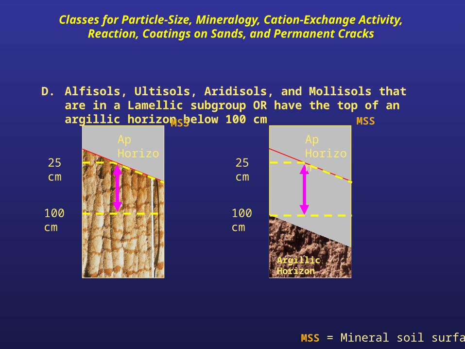
D. Alfisols, Ultisols, Aridisols, and Mollisols that are in a Lamellic subgroup OR have the top of an argillic horizon below 100 cm
100 cm
25 cm
Ap Horizon
Argillic Horizon
100 cm
25 cm
Ap Horizon
Classes for Particle-Size, Mineralogy, Cation-Exchange Activity, Reaction, Coatings on Sands, and Permanent Cracks
MSSMSS
MSS = Mineral soil surface
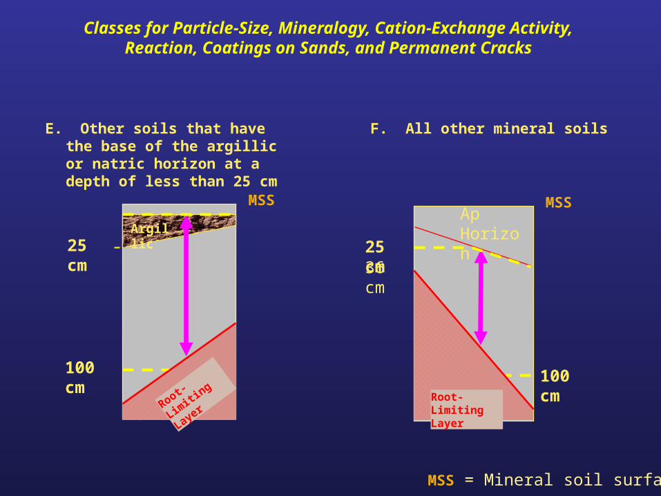
E. Other soils that have the base of the argillic or natric horizon at a depth of less than 25 cm
F. All other mineral soils
25 cm
100 cm
Ap Horizon
25 cm
100 cm
Argillic
Root-Lim
iting
Layer Root-Limiting Layer
36 cm
Classes for Particle-Size, Mineralogy, Cation-Exchange Activity, Reaction, Coatings on Sands, and Permanent Cracks
MSS = Mineral soil surface
MSSMSS
Control Section for the Calcareous Class
Control Section for theCalcareous Class
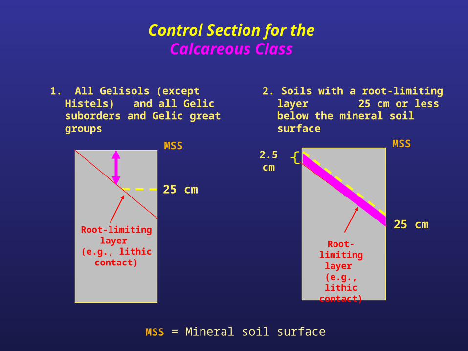
1. All Gelisols (except Histels) and all Gelic suborders and Gelic great groups
2. Soils with a root-limiting layer 25 cm or less below the mineral soil surface
25 cm
25 cm
Root-limiting layer
(e.g., lithic contact)
2.5 cm
Root-limiting layer
(e.g., lithic contact)
MSS MSS
MSS = Mineral soil surface
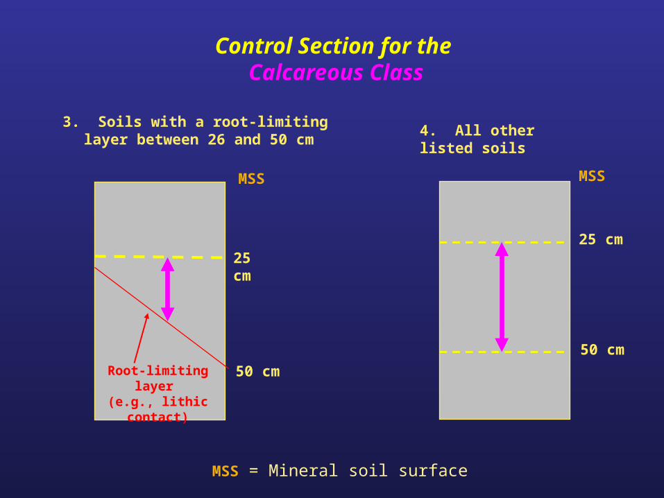
4. All other listed soils
25 cm
50 cm
Control Section for the Calcareous Class
3. Soils with a root-limiting layer between 26 and 50 cm
25 cm
50 cmRoot-limiting layer (e.g., lithic contact)
MSS MSS
MSS = Mineral soil surface
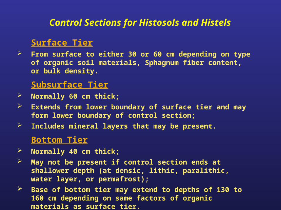
Surface Tier From surface to either 30 or 60 cm depending on type of organic
soil materials, Sphagnum fiber content, or bulk density.
Subsurface Tier Normally 60 cm thick; Extends from lower boundary of surface tier and may form lower
boundary of control section; Includes mineral layers that may be present.
Bottom Tier Normally 40 cm thick; May not be present if control section ends at shallower depth (at
densic, lithic, paralithic, water layer, or permafrost); Base of bottom tier may extend to depths of 130 to 160 cm
depending on same factors of organic materials as surface tier.
Control Sections for Histosols and Histels
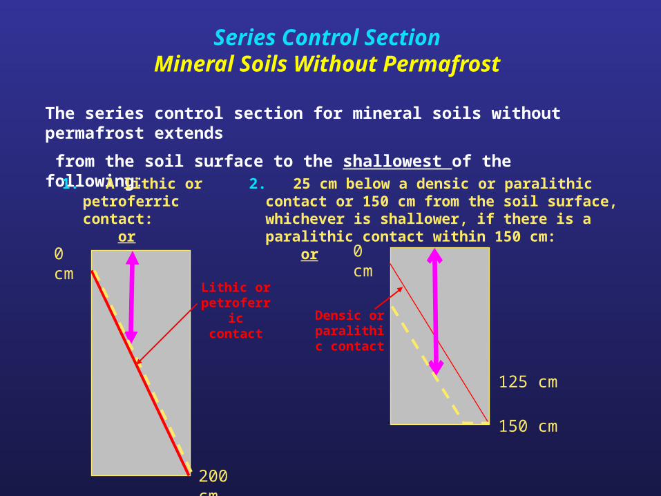
Series Control SectionMineral Soils Without Permafrost
The series control section for mineral soils without permafrost extends
from the soil surface to the shallowest of the following:
1. A lithic or petroferric contact: or
2. 25 cm below a densic or paralithic contact or 150 cm from the soil surface, whichever is shallower, if there is a paralithic contact within 150 cm: or
Densic or paralithic contact
0 cm
150 cm
125 cm
0 cm
Lithic or petroferric
contact
200 cm
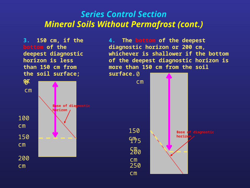
3. 150 cm, if the bottom of the deepest diagnostic horizon is less than 150 cm from the soil surface; or
4. The bottom of the deepest diagnostic horizon or 200 cm, whichever is shallower if the bottom of the deepest diagnostic horizon is more than 150 cm from the soil surface.
0 cm
100 cm
200 cm
150 cm
Base of diagnostic horizon
0 cm
175 cm
200 cm
150 cm
250 cm
Base of diagnostic horizon
Series Control SectionMineral Soils Without Permafrost (cont.)
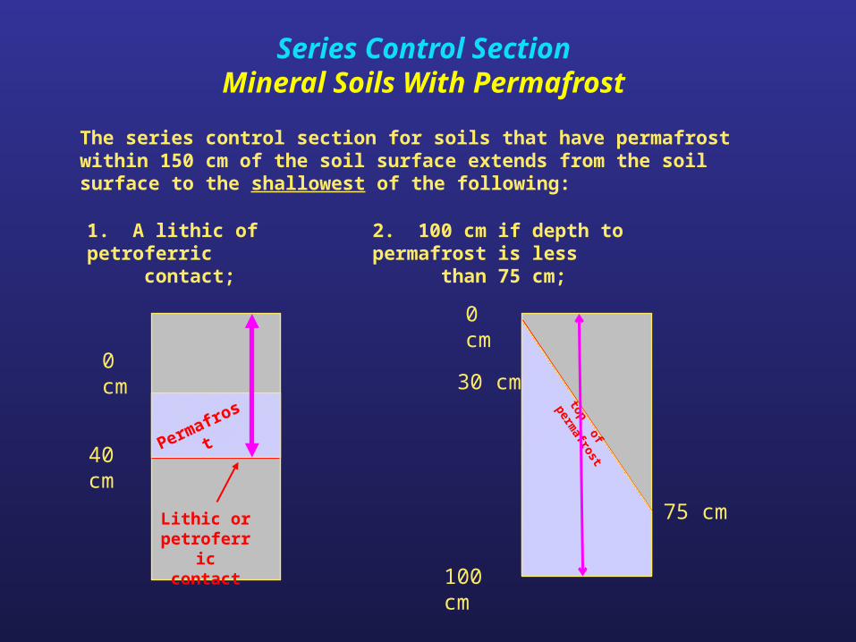
1. A lithic of petroferric contact;
2. 100 cm if depth to permafrost is less than 75 cm;
The series control section for soils that have permafrost within 150 cm of the soil surface extends from the soil surface to the shallowest of the following:
0 cm
40 cm
Lithic or petroferric
contact
0 cm
30 cm
100 cm
Permafrost
75 cm
top of permafrost
Series Control SectionMineral Soils With Permafrost
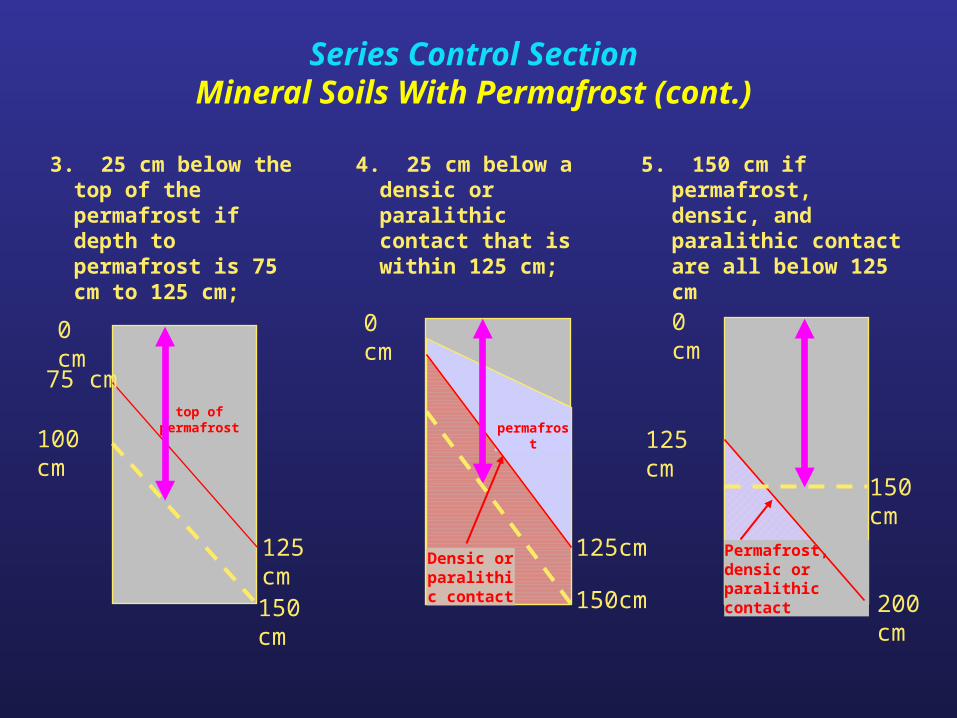
3. 25 cm below the top of the permafrost if depth to permafrost is 75 cm to 125 cm;
4. 25 cm below a densic or paralithic contact that is within 125 cm;
0 cm
top of permafrost
5. 150 cm if permafrost, densic, and paralithic contact are all below 125 cm
0 cm
125 cm100 cm
0 cm
150 cm
75 cm
150 cm
125 cm
200 cm
Permafrost, densic or paralithic contact
125cm
150cm
Densic or paralithic contact
permafrost
Series Control SectionMineral Soils With Permafrost (cont.)
Summary
• The family category provides information for engineering and agronomic uses.
• Control sections are used for the kinds of basic properties such as: soil moisture, soil temperature, various family class differentiae, and the soil series.
• Always indicate the kind of control section