conveyance and hydraulic structures - watershedconveyance and hydraulic structures dataset workshop...
TRANSCRIPT

W O R K I N G T O G E T H E R F O R S U S T A I N A B I L I T Y A N D R E S I L I E N C E
Conveyance and Hydraulic Structures
November 14, 2018
Jason Chapman (DOTD)
Dave Ramirez (USACE)

W O R K I N G T O G E T H E R F O R S U S T A I N A B I L I T Y A N D R E S I L I E N C E
USACE New Orleans District
Conveyance and Hydraulic Structures
DATASET WORKSHOP
Dave Ramirez, P.E., D.WRE
Chief, Water Management
New Orleans District
DATE 9:00 am – 10:30 am
L O U I S I A N A W A T E R S H E D I N I T I A T I V E 2
W O R K I N G T O G E T H E R F O R S U S T A I N A B I L I T Y A N D R E S I L I E N C E
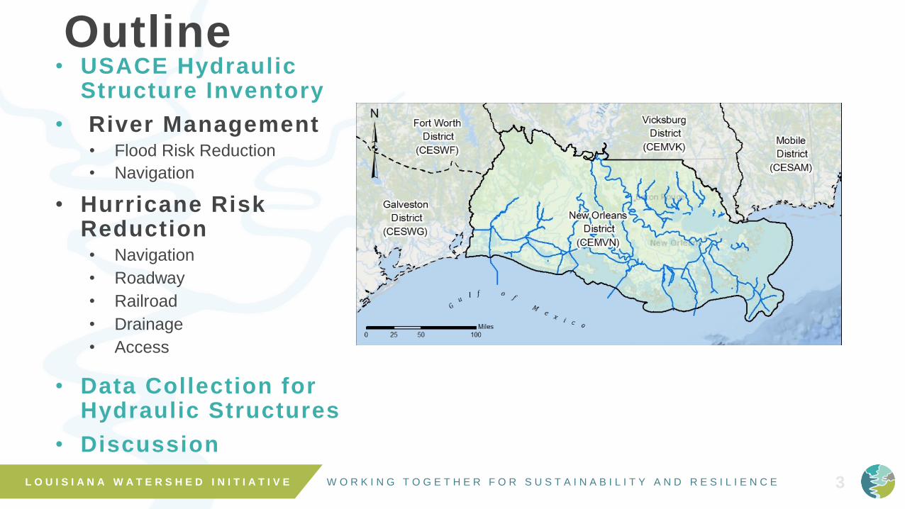
Outline• USACE Hydraulic
Structure Inventory
• River Management• Flood Risk Reduction
• Navigation
• Hurricane Risk Reduction • Navigation
• Roadway
• Railroad
• Drainage
• Access
• Data Collection for Hydraulic Structures
• Discussion
3L O U I S I A N A W A T E R S H E D I N I T I A T I V E

W O R K I N G T O G E T H E R F O R S U S T A I N A B I L I T Y A N D R E S I L I E N C E 4
New Orleans District
W O R K I N G T O G E T H E R F O R S U S T A I N A B I L I T Y A N D R E S I L I E N C E
BATON ROUGE
MORGANCITYMORGANCITY
Old River
Morganza
BonnetCarré NEW
ORLEANS
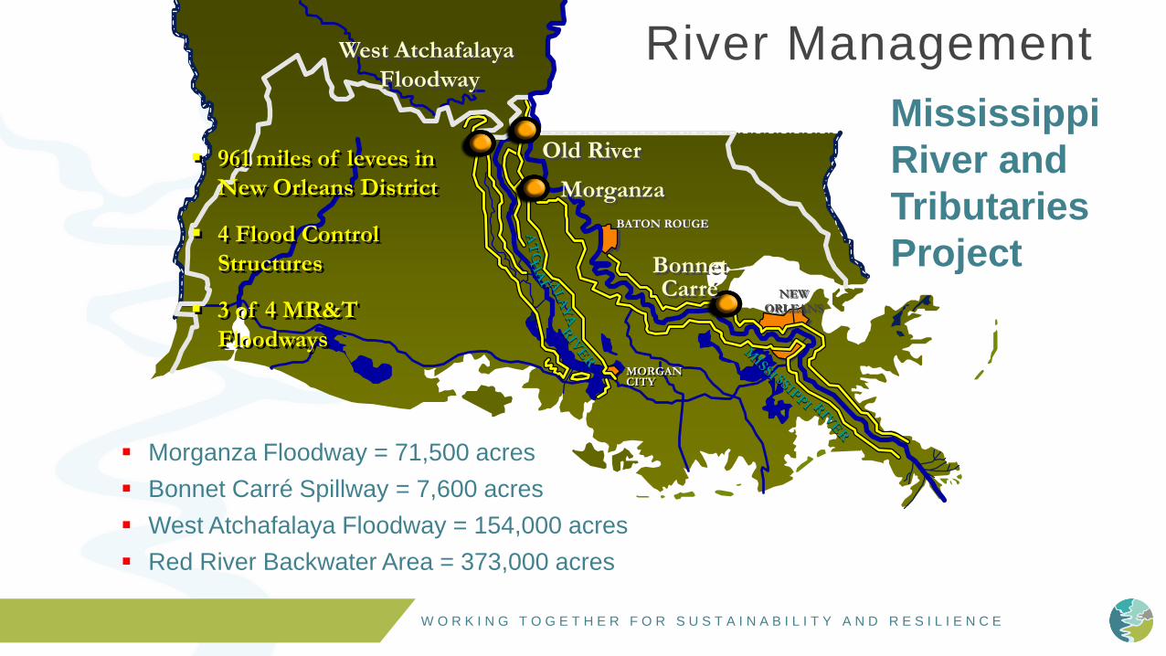
▪ 961 miles of levees in
New Orleans District
▪ 4 Flood Control
Structures
▪ 3 of 4 MR&T
Floodways
5
West Atchafalaya
Floodway
▪ Morganza Floodway = 71,500 acres
▪ Bonnet Carré Spillway = 7,600 acres
▪ West Atchafalaya Floodway = 154,000 acres
▪ Red River Backwater Area = 373,000 acres
River Management
Mississippi
River and
Tributaries
Project

W O R K I N G T O G E T H E R F O R S U S T A I N A B I L I T Y A N D R E S I L I E N C E
Cocodrie 2600 B.C. - 1600 B.C.
Teche 1900 B.C. - 700 B.C.
St. Bernard 800 B.C. - 300 B.C.
Lafourche 65 A.D. - 1300 A.D.
Modern 900 A.D. - PRESENT
Lake
Charles
Lafayette
Alexandria
Baton
Rouge
New Orleans
Ancient and Modern Courses
of the Mississippi RiverAtchafalaya River
Old River
W O R K I N G T O G E T H E R F O R S U S T A I N A B I L I T Y A N D R E S I L I E N C E
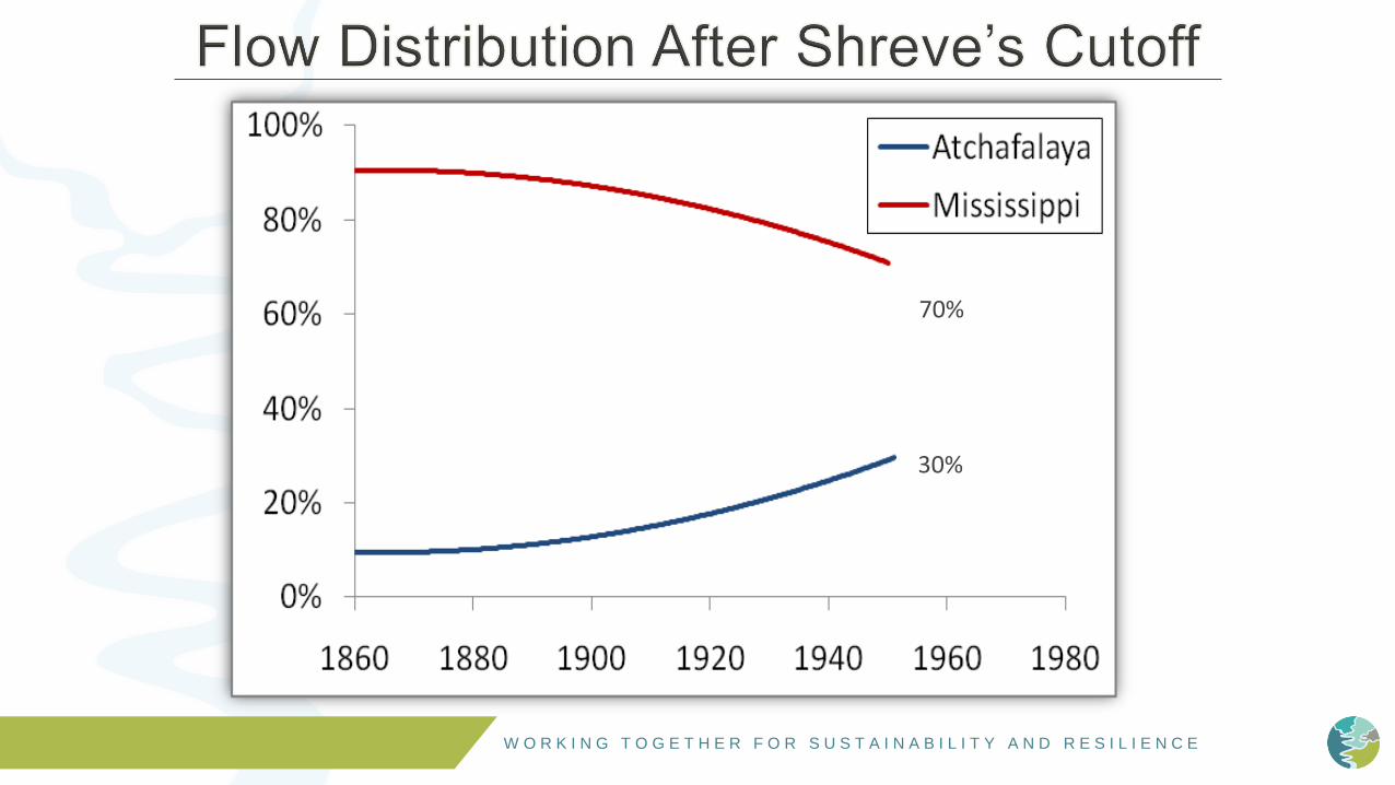
70%
30%

W O R K I N G T O G E T H E R F O R S U S T A I N A B I L I T Y A N D R E S I L I E N C E
The U.S. Army Corps of Engineers operates the Old River Control Complex
(ORCC) in accordance with the authorizing law, the Flood Control Act of
1954, to maintain a stable relationship between the Mississippi and
Atchafalaya Rivers
▪ Designed and is operated to prevent capture of the Mississippi River by the
Atchafalaya River
▪ Operated to maintain the distribution of flow and sediments between the
Mississippi and Atchafalaya Rivers in approximately the same proportion as
occurred naturally in 1950
▪ In 1950, the annual flow distribution below the latitude of Old River was
approximately 70 percent in the Mississippi River and 30 percent in the
Atchafalaya River (70/30 distribution)

W O R K I N G T O G E T H E R F O R S U S T A I N A B I L I T Y A N D R E S I L I E N C E

W O R K I N G T O G E T H E R F O R S U S T A I N A B I L I T Y A N D R E S I L I E N C E

W O R K I N G T O G E T H E R F O R S U S T A I N A B I L I T Y A N D R E S I L I E N C E
Bonnet Carre Spillway
• Completed 1932
• 7,600 acre Floodway
• Structure Operated 12 times
• Design Flow of 250,000 cfs
• 2011 Flows of 316,000 cfs

W O R K I N G T O G E T H E R F O R S U S T A I N A B I L I T Y A N D R E S I L I E N C E 12
Spillway Weir Elevations
High Bays Low Bays
17.2 ft 15.4 ft
W O R K I N G T O G E T H E R F O R S U S T A I N A B I L I T Y A N D R E S I L I E N C E
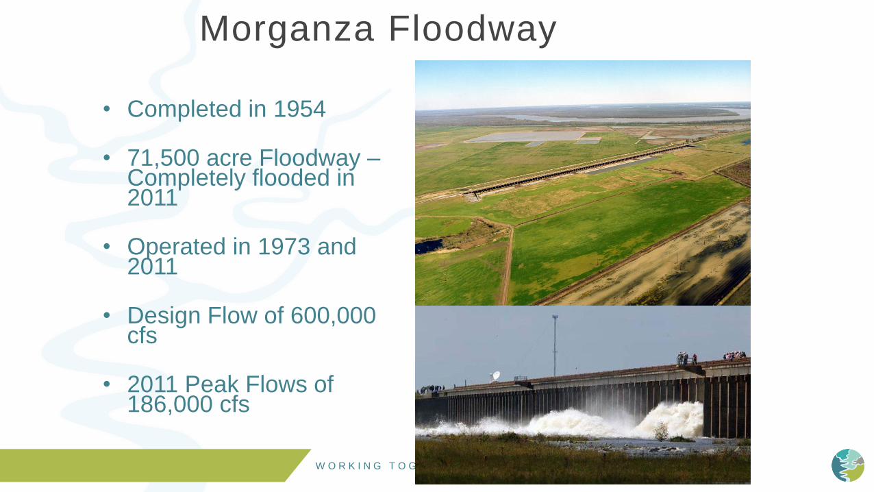
Morganza Floodway
• Completed in 1954
• 71,500 acre Floodway –Completely flooded in 2011
• Operated in 1973 and 2011
• Design Flow of 600,000 cfs
• 2011 Peak Flows of 186,000 cfs

W O R K I N G T O G E T H E R F O R S U S T A I N A B I L I T Y A N D R E S I L I E N C E F i l e N a m e 14
Spillway Weir Elevation – 37.5 ft
Top of Gates – 60.0 ft
Potato Levee – 45.0 ft

W O R K I N G T O G E T H E R F O R S U S T A I N A B I L I T Y A N D R E S I L I E N C E
Morgan City
AtchafalayaBasin
Floodway
WestAtchafalayaFloodway
MorganzaFloodway
Atchafalaya Basin Floodway System
Old River Control Complex
Atchafalaya River
Red River
Mississippi River
New Orleans
Bonnet CarreSpillway
W O R K I N G T O G E T H E R F O R S U S T A I N A B I L I T Y A N D R E S I L I E N C E
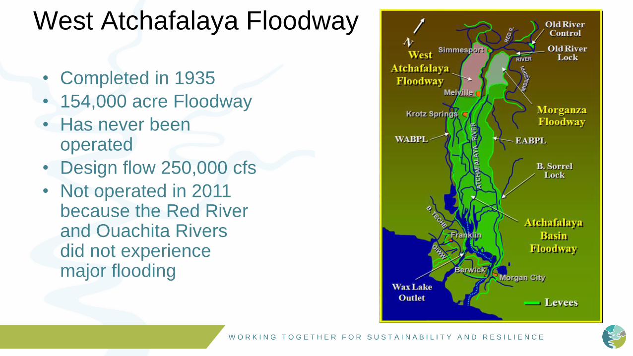
West Atchafalaya Floodway
• Completed in 1935
• 154,000 acre Floodway
• Has never been operated
• Design flow 250,000 cfs
• Not operated in 2011 because the Red River and Ouachita Rivers did not experience major flooding
W O R K I N G T O G E T H E R F O R S U S T A I N A B I L I T Y A N D R E S I L I E N C E L O U I S I A N A W A T E R S H E D I N I T I A T I V E 17
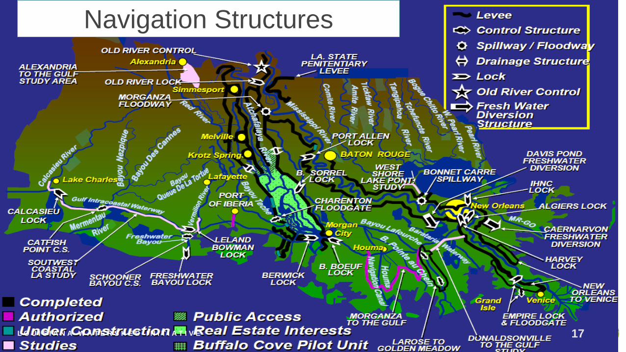
Navigation Structures

W O R K I N G T O G E T H E R F O R S U S T A I N A B I L I T Y A N D R E S I L I E N C E
City of New Orleans
Ground Elevations
From Canal St. at
Mississippi River
to the
Lakefront at U.N.O.NEW
ORLEANS
A
BLAKE PONTCHARTRAIN
A
MR&T
PROJECT DESIGN
FLOWLINE (18 FEET)
DE
RB
IGN
Y A
T I
-10
ES
PL
AN
AD
E A
T
ST
. C
LA
UD
E
CA
NA
L S
T A
T R
IVE
R
ST
LO
UIS
CA
TH
ED
RA
L
GE
NT
ILL
Y B
LV
D
AT
AL
LE
N
DIL
LA
RD
UN
IV
CA
MP
US
ST
AN
TH
ON
Y A
T
FIL
MO
RE
AV
E
WA
INR
IGH
T D
R
AT
L.
C. S
IMO
N
UN
O S
IDE
OF
WA
INW
RIG
HT
DR
LONDON AVENUE CANAL FLOODWALL
HURRICANE LEVEE / FLOODWALL (16.0 FEET)
30
20
10
0
-10
-20
30
20
10
0
-10
-20
EL
EV
AT
ION
S I
N F
EE
T N
GV
D
FLOODWALL ALONG
MISSISSIPPI RIVER
23 FT
Hurricane Risk Reduction
B
18

W O R K I N G T O G E T H E R F O R S U S T A I N A B I L I T Y A N D R E S I L I E N C E 19
IHNC Surge Barrier
SeabrookLondonOrleans17th St.
Harvey Floodgate
Bayou Segnette
West Closure Complex
Bayou Verret
Hero Canal
Caernarvon
Total System Openings: 493
Navigable Openings: 11
Roadway Openings: 144
Railroad Openings: 45
Access Openings: 134
Drainage Openings: 159
A Stronger System Than Ever Before
Bayou Dupre
Navigable Structure

W O R K I N G T O G E T H E R F O R S U S T A I N A B I L I T Y A N D R E S I L I E N C E
20
Trigger: 5.0 ft
Pumping Capacity: 2,200
cfs
Trigger: 3.0 ft
Pumping Capacity: 9,200
cfs
17th St. Canal Orleans Ave. Canal London Ave. Canal
Trigger: 2.5 ft
Pumping Capacity:
5,200 cfs
Outfall Canals

W O R K I N G T O G E T H E R F O R S U S T A I N A B I L I T Y A N D R E S I L I E N C E
Southeast Louisiana Urban Flood Damage
Reduction Project (SELA)Purpose
• Improve the storm water drainage systems to provide flood damage risk reduction from a ten-year rainfall event
Orleans Parish
• Improve 12 major drainage lines and 3 pumping stations
Jefferson Parish
• Improve 24 drainage canals and 4 pumping stations
Total Estimated Construction Value:
$960 M21

W O R K I N G T O G E T H E R F O R S U S T A I N A B I L I T Y A N D R E S I L I E N C E
Data Collection for Hydraulic Structures
• Over 120 Real-time gages• Stage
• Water temp.
• METs
• Over 150 high water staff gages• Bonnet Carre Spillway
• Morganza Spillway
• Atchafalaya Basin
22L O U I S I A N A W A T E R S H E D I N I T I A T I V E

W O R K I N G T O G E T H E R F O R S U S T A I N A B I L I T Y A N D R E S I L I E N C E
Hydraulic Structure Data Collection
23
• Mississippi & Atchafalaya Rivers• Navigation
• River forecasting
• Operation of control structures
e.g. Old River Control Structure affects
river forecast
• Staff gages at every flood control or
navigation structure.
• Large concentration surrounding
New Orleans• HSDRRS
• floodgates, pumping stations, surge
reduction barrier, outfall canals, levees
L O U I S I A N A W A T E R S H E D I N I T I A T I V E

W O R K I N G T O G E T H E R F O R S U S T A I N A B I L I T Y A N D R E S I L I E N C E
Data Availability
• MVN real-time gage data available to public online at Rivergages.com• Not funded/supported by MVN
• Maintained by Rock Island District
• No control if system crashes or goes offline
• Other ways for public to view data (DADDS, EDDN), but require station satellite ID and not user friendly
• Co-Op gages on USGS website (Current Conditions Louisiana Real-time Stream flow.)
24L O U I S I A N A W A T E R S H E D I N I T I A T I V E

W O R K I N G T O G E T H E R F O R S U S T A I N A B I L I T Y A N D R E S I L I E N C E
Discussion
L O U I S I A N A W A T E R S H E D I N I T I A T I V E 25

W O R K I N G T O G E T H E R F O R S U S T A I N A B I L I T Y A N D R E S I L I E N C E
Statewide Geospatial Topographic
Mapping Initiative (GIS)
DATASET WORKSHOP
Jason Chapman, P.E.
Louisiana DOTD
Data Collection & Management Systems
November 14, 2018 9:00 am – 10:30 am

W O R K I N G T O G E T H E R F O R S U S T A I N A B I L I T Y A N D R E S I L I E N C E L O U I S I A N A W A T E R S H E D I N I T I A T I V E 27
Why Do We Collect Data??
Federal and State Reporting• Federal Government Entities
• State Government Entities
• Local Planning Organizations
• Parish and City Officials
W O R K I N G T O G E T H E R F O R S U S T A I N A B I L I T Y A N D R E S I L I E N C E L O U I S I A N A W A T E R S H E D I N I T I A T I V E 28
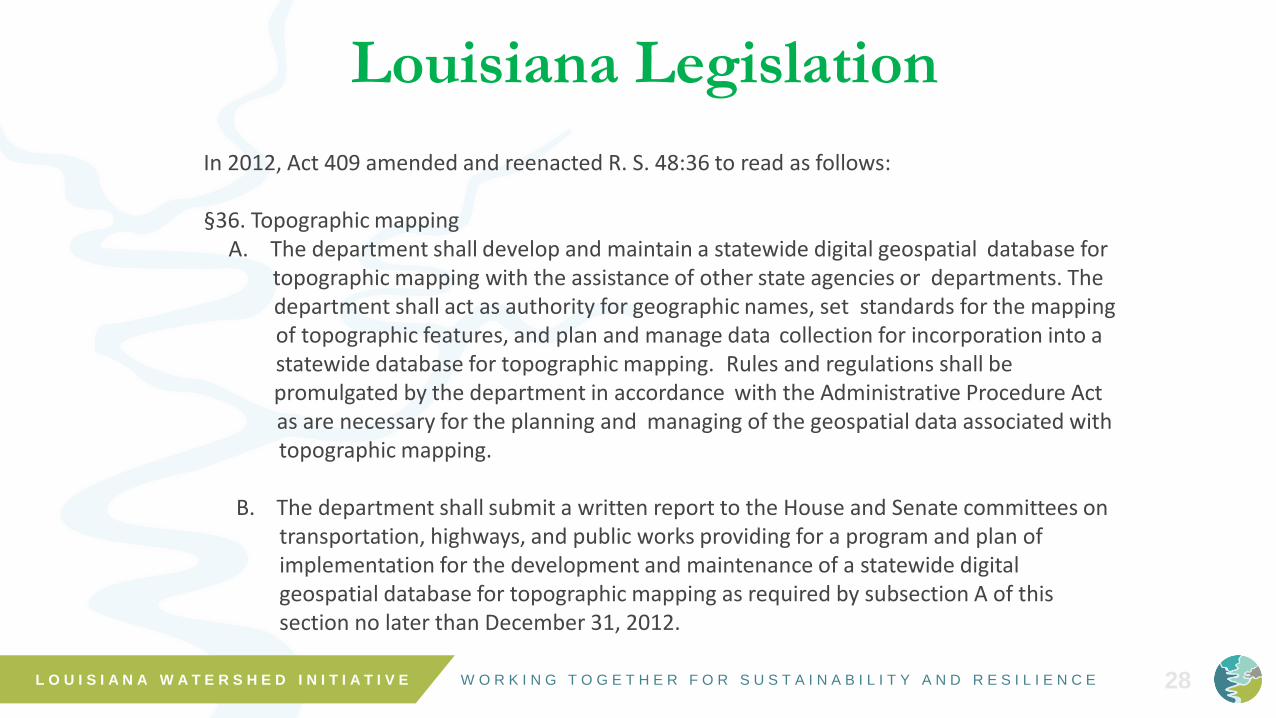
In 2012, Act 409 amended and reenacted R. S. 48:36 to read as follows:
§36. Topographic mappingA. The department shall develop and maintain a statewide digital geospatial database for
topographic mapping with the assistance of other state agencies or departments. Thedepartment shall act as authority for geographic names, set standards for the mappingof topographic features, and plan and manage data collection for incorporation into astatewide database for topographic mapping. Rules and regulations shall bepromulgated by the department in accordance with the Administrative Procedure Actas are necessary for the planning and managing of the geospatial data associated withtopographic mapping.
B. The department shall submit a written report to the House and Senate committees on transportation, highways, and public works providing for a program and plan of implementation for the development and maintenance of a statewide digital geospatial database for topographic mapping as required by subsection A of this section no later than December 31, 2012.
Louisiana Legislation
W O R K I N G T O G E T H E R F O R S U S T A I N A B I L I T Y A N D R E S I L I E N C E L O U I S I A N A W A T E R S H E D I N I T I A T I V E 29
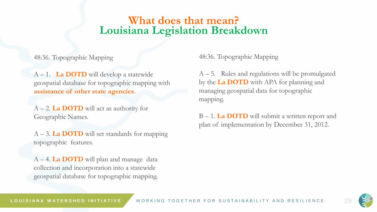
What does that mean?Louisiana Legislation Breakdown
48:36. Topographic Mapping
A – 1. La DOTD will develop a statewide
geospatial database for topographic mapping with
assistance of other state agencies.
A – 2. La DOTD will act as authority for
Geographic Names.
A – 3. La DOTD will set standards for mapping
topographic features.
A – 4. La DOTD will plan and manage data
collection and incorporation into a statewide
geospatial database for topographic mapping.
48:36. Topographic Mapping
A – 5. Rules and regulations will be promulgated
by the La DOTD with APA for planning and
managing geospatial data for topographic
mapping.
B – 1. La DOTD will submit a written report and
plan of implementation by December 31, 2012.

W O R K I N G T O G E T H E R F O R S U S T A I N A B I L I T Y A N D R E S I L I E N C E 30
Topographic Map

W O R K I N G T O G E T H E R F O R S U S T A I N A B I L I T Y A N D R E S I L I E N C E L O U I S I A N A W A T E R S H E D I N I T I A T I V E 31
BLM, Census, State Data
Ortho-Photography
LiDAR
USGS NHD
Census, State Data
BLM, Census, State Data
USGS Quads, DOQQ
GNIS, Local Data
Traditional
Basemap
Sources
Survey Data
Vegetation Cover
Imagery Services
Hydrography
Transportation
Boundaries
Structures
Louisiana
Statewide
GIS
Database
Digital Editing
Database
Elevation Data
Land Use
Louisiana Revised Statute 48:36
What is a Topographic Map??

W O R K I N G T O G E T H E R F O R S U S T A I N A B I L I T Y A N D R E S I L I E N C E L O U I S I A N A W A T E R S H E D I N I T I A T I V E 3232
Louisiana Imagery Service• DOTD is currently procuring an
Imagery Service to continue using
to create and maintain GIS data.
• Plans are to provide 2017+ imagery
statewide as collected by La DOTD
over a 3 – 5 year cycle.
2010 12” Imagery
2014 4” Imagery

W O R K I N G T O G E T H E R F O R S U S T A I N A B I L I T Y A N D R E S I L I E N C E L O U I S I A N A W A T E R S H E D I N I T I A T I V E 33
Hydrography Layer• GOHSEP and DOTD invested in the development
of the Hydrography Layer completed in 2014 using
the 2010 Imagery Layer
• Hydrography Layer includes:• Water Point Features
• Water Linear Features
• Water Polygon Features
• Swamp Features
• Shoreline Features
• Necessary updates to the USGS National
Hydrography Dataset for Louisiana are being
performed by La DEQ who is the USGS Steward.
W O R K I N G T O G E T H E R F O R S U S T A I N A B I L I T Y A N D R E S I L I E N C E L O U I S I A N A W A T E R S H E D I N I T I A T I V E 34
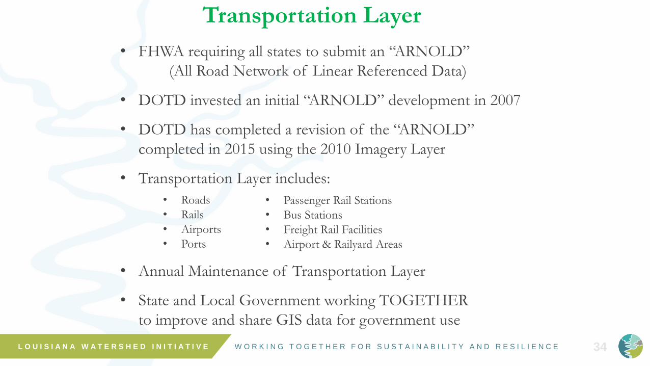
Transportation Layer
• FHWA requiring all states to submit an “ARNOLD”
(All Road Network of Linear Referenced Data)
• DOTD invested an initial “ARNOLD” development in 2007
• DOTD has completed a revision of the “ARNOLD”
completed in 2015 using the 2010 Imagery Layer
• Transportation Layer includes:
• Annual Maintenance of Transportation Layer
• State and Local Government working TOGETHER
to improve and share GIS data for government use
• Roads
• Rails
• Airports
• Ports
• Passenger Rail Stations
• Bus Stations
• Freight Rail Facilities
• Airport & Railyard Areas

W O R K I N G T O G E T H E R F O R S U S T A I N A B I L I T Y A N D R E S I L I E N C E L O U I S I A N A W A T E R S H E D I N I T I A T I V E 35
Transportation Layer
(New Orleans)

W O R K I N G T O G E T H E R F O R S U S T A I N A B I L I T Y A N D R E S I L I E N C E L O U I S I A N A W A T E R S H E D I N I T I A T I V E 36
https://www.fhwa.dot.gov/bridge/nbi.cfm

W O R K I N G T O G E T H E R F O R S U S T A I N A B I L I T Y A N D R E S I L I E N C E L O U I S I A N A W A T E R S H E D I N I T I A T I V E 37
Published Bridge Layer

W O R K I N G T O G E T H E R F O R S U S T A I N A B I L I T Y A N D R E S I L I E N C E L O U I S I A N A W A T E R S H E D I N I T I A T I V E 38
Elevation Layer
• DOTD is in the development process of an Elevation Layer using data
acquired through regular data collection contracts
• State Highway System is collected on a two year cycle using a detailed process
to assure accuracy of the x,y,z gps point data
• Non-State Roadways are being collected in a one-time cycle around the state
along with a number of roadway assets. This cycle will also provide accurate
x,y,z gps point data
• Two Features for the Louisiana Elevation Layer
• Digital Elevation Model features using the
roadway elevations and LIDAR data in cooperation with USGS
• Ground Elevation Contours feature

W O R K I N G T O G E T H E R F O R S U S T A I N A B I L I T Y A N D R E S I L I E N C E L O U I S I A N A W A T E R S H E D I N I T I A T I V E 39
Contour Development
Phase One

W O R K I N G T O G E T H E R F O R S U S T A I N A B I L I T Y A N D R E S I L I E N C E L O U I S I A N A W A T E R S H E D I N I T I A T I V E 40
Structures Layer • La DOTD has begun developing a Structures
Layer in the past two years
• La DOTD is working with various government
agencies as well as willing local address
authorities to:
• Develop a Building Footprint for all
structures in a Parish
• Map all Residential Addresses in a Parish
• Incorporate existing Structure and Address Data
as acquired into an improved statewide roadway
layer to provide government geocoding abilities
• Associate the addresses directly with the road
segment where they are located

W O R K I N G T O G E T H E R F O R S U S T A I N A B I L I T Y A N D R E S I L I E N C E L O U I S I A N A W A T E R S H E D I N I T I A T I V E 41
Boundaries Layer• La DOTD has begun working with La Secretary of State
to coordinate and use authoritative boundaries for GIS.
• Boundaries are determined by Local Government
authorities:
• Parish – Parish Boundary & Election Precinct
Boundaries
• Municipality – Municipal Boundary
• State – Agency Boundaries across State
• All Municipal boundary changes must be submitted to
Parish Registrar. Parish Registrar must submit all Parish
boundary changes to the LA SoS.
• Boundaries are compiled by La SoS and State
Demographer from Parish Registrars and provided to US
Census for Reapportionment.

W O R K I N G T O G E T H E R F O R S U S T A I N A B I L I T Y A N D R E S I L I E N C E L O U I S I A N A W A T E R S H E D I N I T I A T I V E 42
What’s the Collaboration Solution?
• DOTD Hosted GIS System
• Data Provided by Authoritative Sources• State Agencies
• Metropolitan Planning Areas
• Parishes
• Municipalities
• Low Cost Maintenance Methods Provided
• One Centralized Source for Data
Maintenance & Distribution

W O R K I N G T O G E T H E R F O R S U S T A I N A B I L I T Y A N D R E S I L I E N C E L O U I S I A N A W A T E R S H E D I N I T I A T I V E 43
One Possible Solution
Planning
District #1
NORPC
Federal Government
State Government
Planning
District #2
CRPCPlanning
District #3
SCPDC Planning
District #4
APC
Planning
District #5
IMCAL
Planning
District #6
KDRP
Planning
District #7
CDC
Planning
District #8
NDRP
Louisiana
Association of
Planning and
Development
Districts
Parish
ParishParish
Parish
W O R K I N G T O G E T H E R F O R S U S T A I N A B I L I T Y A N D R E S I L I E N C E L O U I S I A N A W A T E R S H E D I N I T I A T I V E 44
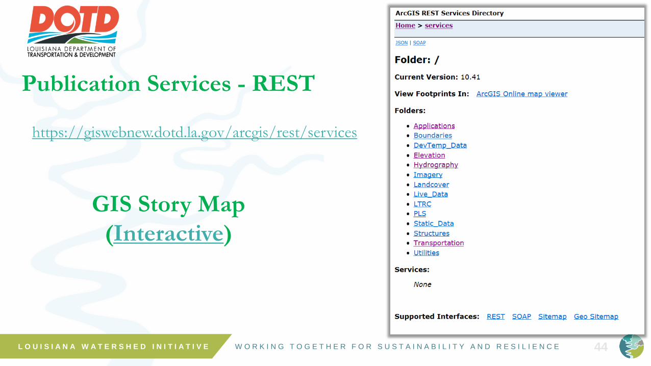
Publication Services - REST
https://giswebnew.dotd.la.gov/arcgis/rest/services
GIS Story Map
(Interactive)

W O R K I N G T O G E T H E R F O R S U S T A I N A B I L I T Y A N D R E S I L I E N C E L O U I S I A N A W A T E R S H E D I N I T I A T I V E 45

W O R K I N G T O G E T H E R F O R S U S T A I N A B I L I T Y A N D R E S I L I E N C E L O U I S I A N A W A T E R S H E D I N I T I A T I V E 46
Louisiana Statewide Geospatial Database
Create the Database
Receive & Compile the Data
Centralize the Data in One Location
Distribute the Data to All State Agencies
Receive Updated Data and Repeat the Cycle
The Goal for Geospatial Data is “One Source”
DOTD ArcGIS Rest Services
https://giswebnew.dotd.la.gov/arcgis/rest/services/
Jason Chapman, La DOTD
225-242-4578
Darryl Mack, La DOTD GIS Manager
225-379-1283

W O R K I N G T O G E T H E R F O R S U S T A I N A B I L I T Y A N D R E S I L I E N C E
THANK [email protected]
L O U I S I A N A W A T E R S H E D I N I T I A T I V E