cooks river catchment management strategy · occurred (ppk, 1999). a site at the end of third...
TRANSCRIPT

Cooks River Catchment
Management Strategy
Cooks River Catchment
Management Committee
December 1999
7496 cooks river catchment 26/5/00 12:17 PM Page a

FOREWORD 21 INTRODUCTION 31.1 The Cooks River Catchment 31.2 Native Flora and Fauna 51.3 People of the Catchment 81.4 Land Use 81.5 Update Since 1993 Strategic Plan 9
2.0 GUIDING PRINCIPLES, LEGISLATION AND POLICIES 112.1 Ecologically Sustainable Development (ESD) 112.2 Total Catchment Management (TCM) 112.3 National Policies and Strategies 132.4 State Legislation, Policies and Plans 142.5 Local Government Areas and Plans 162.6 NSW Water Reforms 18
3.0 STRATEGIC PLAN BACKGROUND 213.1 Aims of Strategic Plan 213.2 Development of the Strategic Plan 213.3 Strategic Plan Framework 22
4.0 STRATEGIC PLAN 234.1 Vision 234.2 Important Issues and Priorities 234.3 Goals and Objectives 29
5.0 ACTION PLAN 355.1 Overview 355.2 Water Action Plan 365.3 Land and Vegetation Action Plan 415.4 Biodiversity Action Plan 455.5 Cultural Heritage Action Plan 485.6 Education and Awareness Action Plan 49
APPENDIX A – CRCMC CONTACT DETAILS AND MEMBERS 54
REFERENCES AND FURTHER READING 55
GLOSSARY 56
Published by: Cooks River Catchment Management CommitteeISBN No: 0 95772770 4Printed by: J.S. McMillan Pty LtdCompiled by: Kathryn Burton
CONTENTS
1
7496 cooks river catchment 26/5/00 12:17 PM Page 1

2
The environmental problems of the Cooks River are almost legendary. Almost everyone has atale to tell about the river. In many ways the river is emblematic of the state of Sydney'senvironment. All the mistakes of the past are on display along its length.
This strategy reflects the desire of the comiunity to correct those mistakes and repair thedamage that has occurred to the Cooks River and the many creeks in its catchment.
This strategy follows the completion of the actions contained in the Cooks River CMC's 1993Strategic Plan. It builds on the actions completed under the 1993 Plan and seeks tocomplement the now very comprehensive planning framework for the catchment, including theCooks River Foreshores Strategy and the Cooks River Stormwater Management Plan.
There is every reason to be confident that most, if not all of the actions set out in this Strategycan be carried out in the not too distant future. The level of commitment that now exists in thecommunity and in government to work in very practical ways to improve the river is higherthan it has ever been.
This Strategy is largely a result of that commitment as expressed by the wide range ofenvironment and other community groups, and State and Local government authoritiesrepresented on the Catchment Management Committee.
The Cooks River Catchment Management Committee will continue to work for the communityand with government to improve the quality of the Cooks River catchment and contribute tomaking south-western Sydney a better place to live.
Cr Phil Morgans Chairperson of the Cooks River Catchment Management Committee
FOREWORD
7496 cooks river catchment 26/5/00 12:17 PM Page 2

11.1 THE COOKS RIVER CATCHMENT
The Cooks River is one of the smallest rivers in NSW but has one of the highestpopulation densities. Therefore, human activities have had, and continue to have, asignificant effect on the river.
The Cooks River drains a catchment of just over 100km2 in the inner south westernsuburbs of Sydney (Figure 1). The river begins as a small watercourse near ChulloraRailway Workshops and flows some 23km in a generally easterly direction to enterBotany Bay just south of the Kingsford Smith Airport.
INTRODUCTION
3
Figure 1: Cooks River Locality Map
7496 cooks river catchment 26/5/00 12:17 PM Page 3

1
On the way, it is joined by a number of tributaries, the most important being Cox’sCreek, which drains the Punchbowl area, Cup and Saucer Creek, which enters nearCanterbury, Wolli Creek, which begins in Beverly Hills, and Sheas Creek, which drainsthe Alexandria area and enters the Cooks River via the Alexandra Canal (Figure 2).
4
Figure 2: Cooks River Catchment
7496 cooks river catchment 26/5/00 12:17 PM Page 4

1
The majority of the catchment is highly developed, so the remnant bushland andsurrounding modified areas are regionally important. They have significant diversity andsupport an abundance of native fauna. Major areas of bushland are found in the WolliCreek Regional Park (45 hectares), Bardwell Valley Parklands (see Figure 3) and StottsReserve (11 hectares), Leo Smith Reserve (4 hectares) and the Freshwater CreekBushland at Chullora (area of bushland unknown due to on-going clearing by NationalRail). These contain valuable areas of good and potentially good bushland. However,for most of its length the river is flanked by parkland and open space, which is unusualamong urban watercourses.
Figure 3: Bardwell Valley Parklands
1.2 Native Flora and FaunaA brief summary of native flora and fauna is given here. Readers are referred to theCooks River Foreshores Strategic Plan (Clouston, 1997) for a more in-depth discussion,as well as the references shown.
Aquatic Flora and FaunaStudies of fish and macroinvertebrate communities within the Cooks River show alimited diversity of aquatic species. Species recorded are dominated by polychaetes andmolluscs, known to be tolerant of highly contaminated river systems. Fish species foundin the river include mullet, eel, galaxies and gobies, all of which are characteristic ofpolluted waterways (SWC, 1998).
Species diversity is highest within the tidally influenced sections of the river and rapidlydeclines with distance upstream (TEC, 1976). Surveys of aquatic fauna show that themouth of the river and its lower reaches have a much greater species diversity thanhabitats further upstream (TEC, 1976).
Prior to European settlement, the fish and shellfish caught in the Cooks River supportedlocal Aboriginal communities (TEC, 1995a). Today, all forms of commercial fishing arebanned in the Cooks River due to toxicants which accumulate within the fish andrepresent a health risk to consumers. A technical report by the Central Sydney AreaHealth Service (CSAHU, 1997) concluded that the taking of fish, shellfish andcrustaceans from the Cooks River should be banned for both recreational andcommercial operators. Currently, under the Fisheries Management Act, 1994, it is stillpermissible for recreational fishers to catch fish by the use of rod or handline (CSAHU,1997) such as shown in Figure 4.
5
7496 cooks river catchment 26/5/00 12:17 PM Page 5

1
Figure 4: Recreational fishing is still enjoyed by people in the Cooks River Catchment despite the banningof commercial fishing due to contamination.
WetlandsThe Cooks River catchment contains a number of wetlands that are considered to beregionally significant owing to their limited distribution and fragmented state. Thesewetlands offer locally valuable habitat for native fauna including birds, mammals, fish,reptiles, amphibians, insects and other invertebrates. The major wetlands within theCooks River Catchment are the Rockdale Wetlands, the Eve Street Wetlands (Arncliffe)and the Wolli Creek Wetlands (PPK, 1999). There is also a waterhole adjacent to theCooks River off Dibble Avenue, Dulwich Hill which has been used for many years as ahaven for several wetland bird species (TEC, 1995a).
MangrovesIn the Wolli Creek Wetlands, the mangrove area has increased rapidly over the lasttwenty years and is likely to continue to expand its range (Brown et al, 1988a). Atpresent around 2.4 hectares of mangroves now cover Wolli Creek’s tidal plain adjacentto Bayview Avenue, Turrella. A study of macroinvertebrate fauna of the Wolli Creekconducted by Brown et al (1988b), found the number of arthropod species to be fargreater than that reported ten years earlier in 1978.
Riparian and Foreshore Flora and FaunaThe native flora and fauna of the Cooks River valley survive in small remnants of theoriginal vegetation which occur primarily in open space and parkland areas along theforeshores of the River. The remaining bushland and foreshore vegetation remnants areconsidered to be of high ecological value and important for conservation of biodiversitywithin the region (TEC, 1995a). Some of these remnant bushland areas are describedbelow.
6
7496 cooks river catchment 26/5/00 12:17 PM Page 6

1
COOKS RIVER CLAY PLAIN SCRUB FOREST REMNANTSA remnant of the original clay-soil bushland, which was once widespread, remainsalong Freshwater Creek within the Chullora Railway Yards. This three hectares area ofremnant vegetation, known as the Cooks River Clay Plain Scrub Forest, is classified asan endangered ecological community and protected under the NSW Threatened SpeciesConservation Act, 1995. The Bankstown Bushland Society has been enhancing the valueof this remnant through a bush regeneration programme, however it is now part of aredevelopment programme by National Rail and clearing of parts of this bushland hasoccurred (PPK, 1999).
A site at the end of Third Avenue, Campsie, also supports an isolated, small remnant ofCooks River Clay Plain Scrub Forest. The site occupies about 0.5 hectares between theCooks River and its junction with a small stormwater canal (TEC, 1995a). The remnantvegetation at this site has scientific and natural heritage significance (TEC, 1995a).
A third remnant of this endangered ecological community, known as Cox’s CreekBushland, is located on the southern side of the Hume Highway, in Greenacre. Thebushland can be accessed via a laneway located at the junction of Sylvanus and DroneStreets, Greenacre. This small reserve, with a tributary of the Cox’s Creek traversing itfrom under Robert’s Road, adjoins the Finemores Depot and the old Bankstown SanitaryDepot (which is to become a refrigerated warehouse facility). Bankstown Council isgoing to retain a 25m buffer zone along the eastern side of this land and a similar bufferzone along the southern boundary. The Reserve is managed, however, by StrathfieldCouncil, as it is located in the Strathfield municipality.
Further remnants may be found along the River at Hedges Avenue in Freshwater Park.
WOLLI CREEK REGIONAL PARKThe Wolli Creek valley supports a diversity of natural environments, includingmangroves, heaths, eucalypt forests, wetlands and a pocket of coachwood-watergumrainforest (TEC, 1995a). This area was declared a Regional Park by the Premier of NSWin early 1999. A Plan of Management is being prepared for the Regional Park and isexpected to be completed by November, 1999.
BARDWELL VALLEY PARKLANDSBardwell Valley contains open woodlands of Angophora costata, Eucalyptus piperita,Turpentine and Lilly Pilly, shrubland and rare heath.
STOTTS RESERVEWith its stands of Blackbutt, Eucalyptus saligna (Blue Gum) and Scribbly Gum, StottsReserve provides an important wildlife corridor between the bushlands of BardwellValley and Wolli Creek.
Terrestrial FaunaTerrestrial fauna species that use the Cooks River catchment as habitat include a varietyof birds (such as Superb Fairy-wrens and New Holland Honeyeaters), Grey-headedFlying-Fox, Common Brushtail Possums, the Eastern Bush Rat (Rattus fuscipes), bats,lizards (such as the Common Blue Tongue) and frogs (such as the Striped Marsh Frog,the Common Froglet and the Green and Golden Bell Frog) (PPK, 1999).
The Green and Golden Bell Frog is a species of state significance; it is listed asendangered under the Threatened Species Conservation Act, 1995. The species has beenfound at the Enfield Marshalling Yards, Cox’s Creek Reserve, Eve Street Wetlands, andthe Rockdale Wetlands (PPK, 1999).
One of the breeding sites for the Green and Golden Bell Frog is the old brick pit locatedat the rear of houses in Wentworth Street. This site has recently been sold, and the newowners intend to have the site filled. New ponds are, however, to be provided for thefrogs.
7
7496 cooks river catchment 26/5/00 12:17 PM Page 7

1
1.3 People of the CatchmentAbout 400,000 people inhabit the Cooks River catchment which comprises over130,000 dwellings and more than 100,000 commercial and industrial premises. Thecatchment includes parts of 13 local government areas (see Section 2.5).
Aboriginal clans of the Cooks River Catchment include the Cadigal, Wangal, Kameygaland Bediagal. These were clans of the Darug people. Evidence of Aboriginal occupationin the catchment can be seen in middens along the Cooks River and from materialexcavated from the Alexandra Canal in the 1960’s (Marrickville Council, 1999).
1.4 Land UseThe Cooks River Catchment is host to a variety of land uses, ranging from industrial toopen space. A comprehensive account of land uses and pollution sources is given in theCooks River Catchment Pollution Source Inventory (CRCMC, 1997). The existing landzonings are discussed below.
Residential Land UseResidential land use is the predominant zoning within the catchment with the highestportion of residential developments being detached low-density dwellings. Within thepast decade there has been an increased level of medium to high-density residentialdevelopments, particularly in Canterbury, South Sydney and Marrickville localgovernment areas.
Industrial Land UseThe major portion of industrially zoned land is concentrated in the Port Botany area,along Alexandra Canal, within Tempe, and in the southern portion of the Strathfieldlocal government area. Industrial developments also occur along both the East Hills andthe South Coast railway lines and Canterbury Road.
Open Space and Recreation Land UseA thin corridor of open space fringing the Cooks River, Cox’s Creek, Wolli, Bardwell andFreshwater Creeks has survived development pressures as a result of hilly topographyand poor soil. This corridor constitutes a significant portion of the open space in theCooks River catchment. The foreshores of Muddy Creek, Alexandra Canal, Shea's Creekand Cup and Saucer Creek are more developed with less open space.
A portion of this significant open space corridor is owned by State authorities, includingSydney Water, Department of Public Works and Services, Department of Land andWater Conservation, Department of Urban Affairs and Planning, and the Roads andTraffic Authority. The State-owned lands along the south bank of Cooks River and WolliCreek, which has now been declared the Wolli Creek Regional Park, are used by thecommunity for passive recreation and contain remnants of natural bushland (CRCMC1993). The Rockdale Wetlands and Bardwell Valley are also areas used for passiverecreation. Many of these areas, such as Richardson’s Lookout in Marrickville (Figure 5),have recently been upgraded.
8
7496 cooks river catchment 26/5/00 12:17 PM Page 8

1
Figure 5: Richardson’s Lookout at Marrickville is a recreational area which was upgraded in May, 1999.
Transport Land UseThe Cooks River catchment contains some major national and state highways, railwaycorridors and Sydney's airport. Major roads in the catchment include the HumeHighway, Princes Highway, and General Holmes Drive. Four rail lines occur within thecatchment area: East Hills, Bankstown, Illawarra and Botany. In addition, three majorrail service areas occur: the Enfield Marshalling Yards in Strathfield, the ChulloraRailway Workshops in Bankstown, and the Eveleigh Railway Workshops in the SouthSydney Council area. Sydney (Kingsford-Smith) Airport, which covers approximately 660 hectares of reclaimed land, also lies within the catchment.
1.5 Update Since 1993 Strategic PlanIn the six years since the last Cooks River Catchment Management Strategy waslaunched, documents such as the Cooks River Foreshores Strategic Plan (Clouston,1997) and the Pollution Source Inventory (CRCMC, 1997) have been completed. TheCooks River Foreshores Strategic Plan was prepared for the Cooks River RegionalWorking Party (Marrickville Council, Strathfield Municipal Council, Canterbury CityCouncil, CRCMC, EPA, DLWC and Greening Australia) to focus on strategies to ensurethe River foreshores are managed in a coordinated manner. The Pollution SourceInventory was prepared by the CRCMC as a summary of identified pollution sources inthe catchment and a preliminary estimate of pollutant loads from each source.
Another document which is currently being developed is “Missing Jigsaw Pieces: TheBushplants of the Cooks River Valley” (Benson et al, in print) Other activities whichhave improved the environmental value of the Cooks River Catchment since 1993 aregiven below:
• In 1993, Sydney Water, in association with the local community, began restorationworks on a section now known as the Eve Street Wetlands in Arncliffe. This wetlandnow provides important refuge and feeding grounds for migratory birds and isconsidered of regional ecological value (Rockdale City Council, 1997–1998). The EveStreet Wetlands will, however, be impacted on by the development of the M5 EastMotorway which is being constructed across the northern edge of the wetlands. TheMotorway will reduce the habitat for wader birds. In an attempt to compensate for thisloss of habitat, the RTA is proposing to move the nesting sites of the waders acrossBotany Bay to a site at Kurnell.
9
7496 cooks river catchment 26/5/00 12:17 PM Page 9

1
• Mangroves have been re-established along sections of the Cooks River and MuddyCreek, particularly in the vicinity of Steel and Kendrick Parks. Mangroves have beenplanted by Marrickville Council around Fatima Island
• Although there are no large areas of remnant indigenous vegetation in the MarrickvilleCouncil area, a number of trees along the Cooks River, including mangroves, fig andpalm trees, have been recorded as significant in the Marrickville Heritage Study(Marrickville Council, 1994; TEC, 1995a)
• In recent years, efforts by local Councils, residents’ groups, and the National Trusthave assisted with the protection and enhancement of the Wolli Creek remnants area.The number of bird species found in this area has increased over the last twenty years,with current estimates of over 160 bird species (TEC, 1995b). Water birds includemigratory bird species that have travelled from Japan and Siberia and are protectedthrough international treaties (TEC, 1995b). This area has recently (March, 1999) beendeclared a Regional Park by the Premier of NSW
• Volunteer groups and the National Trust are active in Bardwell Valley, Stotts Reserve,Leo Smith Reserve and volunteers also work in Freshwater Creek bush at Chullora, theheadlands of Cooks River (within the area owned by National Rail)
• Implementation of a “Kids, Companies and Creeks” Environmental Education andAwareness Programme by the Cooks River Catchment Management Committee
• Cooks River Festival held annually
• Cooks River Catchment Management Committee Website set up
• Remediation of ex-landfill site by South Sydney Council into a park with wetlands
• Various groups, such as Cooks River Foreshores Working Group, have obtainedfunding through the National Heritage Trust funding programme and/or Cooks RiverCatchment Management Committee funding
• The various councils in the catchment have also developed and implemented anumber of programmes aimed at enhancing and/or restoring environmental values.Details of these can be found in the councils’ State of the Environment Reports (seeReference section).
10
7496 cooks river catchment 26/5/00 12:17 PM Page 10

The central theme of this Strategic Plan is the achievement of ecologically sustainabledevelopment (ESD) in order to protect and enhance biodiversity. The principle of TotalCatchment Management has also been used in the development of this Strategic Plan.
2.1 Ecologically Sustainable Development (ESD)The aim of ecological sustainability is to meet present requirements withoutcompromising the ability of future generations to meet their own requirements.
The guiding principles of ESD as agreed to by the Council of Australian Governments(COAG) (1992) are:
• Decision-making processes should effectively integrate both long and short termeconomic, environmental, social and equity considerations
• Where there are threats of serious or irreversible environmental damage, lack of fullscientific certainty should not be used as a reason for postponing measures to preventenvironmental degradation (the precautionary principle)
• The global dimension of environmental impacts of actions and policies should berecognised and considered
• The need to develop a strong, growing and diversified economy which can enhancethe capacity for environmental protection should be promoted
• Cost-effective and flexible policy instruments should be adopted, such as improvedvaluation, pricing and incentive mechanisms; decisions and actions should provide forbroad community involvement on issues which affect them (EPA, 1997).
ESD can be achieved through implementation of the precautionary principle,intergenerational equity (future generations should not have to pay for environmentaldegradation caused by previous generations), the conservation of biological diversityand ecological integrity, and improved valuation and pricing of environmentalresources. ESD should be considered in the decision-making process to ensure theeffective integration of economic and environmental considerations.
The Local Government Amendment (Ecologically Sustainable Development ) Act, 1997,amended the Local Government Act, 1993, to ensure councils would consider theprinciples of ESD in their planning processes.
2.2 Total Catchment Management (TCM)The NSW Government formalised a TCM Policy in 1984. An operational and legislativeframework for TCM was created by the passing of the Catchment Management Act in1989. TCM has bipartisan support.
The Catchment Management Act, 1989 defines TCM as:
“The coordinated and sustainable use of land, water, vegetation and other naturalresources on a catchment basis so as to balance resource utilisation and conservation.”
The objectives of the Act are to:
(a) coordinate policies, programmes and activities as they relate to TCM
(b) achieve active community participation in natural resource management
(c) identify and rectify natural resource degradation
GUIDING PRINCIPLES,LEGISLATIONAND POLICIES
11
2
7496 cooks river catchment 26/5/00 12:18 PM Page 11

2
(d) promote the sustainable use of natural resources and provide stable and productivesoil, high quality water and protective and productive vegetation cover within each ofthe State’s water catchments.
In order to achieve these objectives, the Act:
(a) provides for a network of Catchment Management Committees, coordinated by aState Catchment Management Coordinating Committee, and linking the governmentand the community to achieve the objectives of TCM; and
(b) provides for Catchment Management Trusts to replace Catchment ManagementCommittees in some situations in order to raise revenue for particular total catchmentmanagement purposes.
TCM is about providing management direction for a catchment and having everybodywithin a catchment consider the impacts of their activities on others and on thecatchment itself. The important features of TCM that will assist in the sustainable use ofresources are:
• Cooperation between governments, businesses and the community generally
• A coordinated approach to natural resource management
• Consideration of the impacts activities have on others
• Provision of a forum to resolve natural resource management conflicts
• An understanding of the ecosystems within the catchment
• Community identification of catchment issues and involvement in strategies to addressthe priorities
• Community access to government resources such as the National LandcareProgramme (NLP) which enables implementation of community action.
An important component of TCM is community involvement. Neighbours may cometogether as a group to tackle a common local issue (e.g. landcare groups) or mayprovide representatives to a Catchment Management Committee which has a broadercatchment perspective. Groups established to address catchment management issues areeligible for assistance to implement their actions through competitive funding grants andtechnical assistance from government departments, such as the Department of Land andWater Conservation, NSW Agriculture, the EPA and Local Government.
There are four elements of TCM that require attention if the goals of managing for ourfuture needs are to be achieved:
1. Look at the whole situation, as well as the parts
2. Involve all members of the community, including government and the general public
3. Cooperation between all parties
4. Plan for the future, as well as meet the needs of today
Why We Need TCMA catchment is an area supplying surface water to a common watercourse. Eachcatchment is separated by hills or ridges which direct the flow of water. TCM provides acoordinated and cooperative approach which will help to develop the best managementoption for the sustainable use of our natural resources. Water quality is one of thecommonest natural resource issues in a catchment. Other issues are biodiversity, landmanagement and cultural heritage.
The benefits of a catchment approach to management are centred around cooperationand the increased effectiveness of working together. When a community identifies itsissues and develops a cooperative plan to address them, then it is a powerful force inattracting support from government agencies, industries, education institutions and othercommunities with similar issues. Some of the specific benefits of a catchment approachare:
• A cooperative forum in which issues can be raised openly, plans can be made andissues resolved
12
7496 cooks river catchment 26/5/00 12:18 PM Page 12

2
• The integration of social and economic systems with the natural ecosystems and theuse of natural resources
• The ability to attract financial and technical support from a wide range of sources formanaging the natural resources of the catchment
• The efficient use of the catchment by sharing the expertise and resources alreadyavailable
• More efficient integration of natural resource management services to the people ofthe catchment
Apart from improving the health and productivity of a catchment, TCM provides benefitsto individuals through their involvement in the management of the catchment and theirincreased understanding of the need for all users to employ best management practices.
Catchment Management Committees (CMCs)Catchment Management Committees are responsible for implementing TCM, ensuring acommunication link between the government and the community while providingstrategic direction for resource managers in the catchment. The Cooks River (CRCMC)was formed in 1991. CMCs are composed of representatives from various organisations,government bodies and the general public. A list of the members of the CRCMC and theorganisation/interest they represent is given in Appendix A.
Each committee, or trust, decides on the actions needed to sustainably and equitablymanage a catchment for the present and future benefit of the local community. Thesedecisions are not made in isolation, but within the context of state laws andprogrammes. The different levels of plans and policies which guide natural resourcemanagement and some relevant national and state strategies, Acts and policies are setout below.
Catchment Management Strategic PlansThe actions agreed to by a CMC are incorporated into a TCM plan or strategy. Some ofthese actions are achieved voluntarily, with local communities and businessesconducting their business in a certain manner for the community’s long term benefit.Other requirements are put into effect by the government bodies represented on theCMC. CMCs cannot, themselves, compel individuals or public authorities to doanything. However, Regional Environmental Plans (REPs) and Local Environmental Plans(LEPs) are legislative instruments that can be used to implement TCM plans andstrategies.
Catchment strategies provide a framework for fostering cooperation and coordinationbetween landholders and other resource users, community groups, local governmentand state agencies. Strategies recognise the complex interactions that exist within naturalsystems and the need for a coordinated, catchment-wide approach to address resourcemanagement issues. They establish a long-term vision for the future, acknowledging theimportance of sustainability whilst recognising the need to integrate social, economicand environmental values.
Total Catchment Management and Planning provides a framework for the integratedimplementation of:
1. The catchment-applicable parts of national and state level plans, strategies andpolicies
2. Plans with catchment-wide, or sub-catchment-wide, scopes, like regional and localplans, water management plans, and vegetation management plans.
2.3 National Policies and StrategiesEnvironmental issues which have Australia-wide significance are addressed by nationalpolicies formulated by the Federal Government in cooperation with the States andTerritories. Some national policies may be designed to help Australia meet itsinternational obligations.
13
7496 cooks river catchment 26/5/00 12:18 PM Page 13

2
• Intergovernmental Agreement on the Environment (IGAE): defines and coordinatesfederal, state and territory governmental roles in environmental planning andmanagement
• National Strategy for Ecologically Sustainable Development (ESD): sets out principlesfor economic development which provides for equity between generations, safeguardsthe welfare of future generations, protects biological diversity and maintains essentialecological processes and life support systems
• Council of Australian Governments (COAG) Framework for Water Reform: basespricing and investment decisions on cost recovery, transparency and ecologicalsustainability. Clarifies water entitlements and allocations, including environmentalallocations, and water trading. Separates management, standard setting and regulatoryroles. Provides integrated catchment management approach to water issues, includinglocal decision-making and community education and involvement. Promotes use ofappropriate technologies
• National Strategy for the Conservation of Australia’s Biological Diversity: sets outprinciples for the implementation of the effective identification, conservation andmanagement of Australia’s biological diversity (genetic, species and ecosystem)
• National Water Quality Strategy: provides guidelines for water quality managementwhich: integrates economic and environmental goals in policies and activities;appropriately values environmental assets, providing equity within and betweengenerations; deals cautiously with risk and irreversibility; and recognises globaldimension of management decisions
Australia also has two international migratory bird agreements which are relevant to theCooks River Catchment. These are the China Australia Migratory Bird Agreement(CAMBA) and the Japan Australia Migratory Bird Agreement (JAMBA). The widerrecommendations of the Ramsar Convention also apply.
2.4 State Legislation, Policies and PlansUnder the Australian Constitution, the states are responsible for natural resourceplanning, legislation and decision-making. State natural resource policies and legislationprovide a broad framework within which to consider individual developments andbroader planning issues.
NSW Strategies• The State Strategy for Natural Resource Management pulls together actions identified
in existing policies, regional catchment management strategies and other initiatives.The strategy describes in clear terms the specific actions, responsibilities, performanceindicators and priorities needed to bring about sustainable natural resourcemanagement in New South Wales. The State Strategy helps to identify potential gapsand overlaps in proposed actions and will assist in establishing funding priorities fornatural resource management projects
• Regional and statewide natural resource management strategies will form the blueprintfor action at state, regional and local level and will focus on what the community andgovernment can achieve when the actions of many individuals, groups and agenciesare planned and coordinated. These strategies are flexible and dynamic to meet therequirements of a changing physical, economic and social environment.
State Catchment Management Coordinating CommitteeThe objective of the State Catchment Management Coordinating Committee (SCMCC) is to provide a central coordinating mechanism for the purpose of TCM throughout NewSouth Wales. The functions of the SCMCC are to:
(a) Coordinate the implementation of TCM strategies
(b) Monitor and evaluate the effectiveness of TCM strategies
(c) Advise the responsible Minister or other Ministers on any aspect related to TCM
14
7496 cooks river catchment 26/5/00 12:18 PM Page 14

2
(d) Coordinate the functioning of CMCs and maintain liaison with CatchmentManagement Trusts
(e) Undertake any other functions relating to NSW TCM Legislation
The NSW Government is implementing the second stage of a two stage process torevamp environmental legisation with the commencement of the Protection of theEnvironment Operations Act, 1999. This Act replaces the Clean Waters Act, thePollution Control Act, the Clean Air Act, the Noise Control Act, the EnvironmentalOffences and Penalties Act and the regulatory components of the Waste Minimisationand Management Act. There are a number of other Acts relevant to natural resourcemanagement in NSW:
• Water Administration Act, 1986: vests control and management of NSW surface waterand groundwater in the Minister for Land and Water Conservation
• Water Act, 1912: regulates extraction of surface water
• Crown Lands Act, 1989
• Fisheries and Oyster Farms Act, 1935
• Local Government Act, 1919
• Local Government Amendment Act, 1997
• National Parks and Wildlife Act, 1974
• Rivers and Foreshore Improvement Act, 1948: protects stability of banks and beds ofrivers and lakes
• Native Vegetation Conservation Act, 1997: protects native vegetation
• Fisheries Management Act, 1994: protects fish and their habitats
• Threatened Species Conservation Act, 1995: protects threatened species, populationsand ecological communities
• Environmental Planning and Assessment Act, 1979: regulates land use, through StateEnvironmental Planning Policies (SEPPs), Regional Environmental Plans (REPs) andLocal Environmental Plans (LEPs)
• Catchment Management Act, 1989: provides a framework for community andgovernment partnership in natural resource management. Provides context forcatchment management policies
NSW Policies NSW Policies relevant to catchment management of the Cooks River include:
• State Environmental Planning Policies (SEPPs): provide framework for plans whichaffect the environment – specifically, but not limited to, Regional Environmental Plans(REPs) and Local Environmental Plans (LEPs)
• State Rivers and Estuaries Policy (SREP): provides management objectives andprinciples to halt or reverse the overall rate of degradation in NSW rivers andestuaries, to ensure the long-term sustainability of their essential biophysical functions,and to maintain the beneficial use of these resources. This is achieved through thedevelopment of component policies, state rivers and estuaries reporting, and pilotriver and estuary resource information studies
• State Wetlands Management Policy (SREP component): encourages the sustainableuse, management and conservation of wetlands in NSW for the benefit of present andfuture generations. The policy ensures that the biophysical requirements of wetlandsare explicitly considered in natural resource management decision-making
• Groundwater Policy Framework Document (SREP component): to encourage thesustainable management of the state’s groundwater resources for the environmental,social and economic use of the people of NSW. The policy ensures thatgroundwater’s ecosystem support function and the sustainability of groundwater usewill be considered in resource management decision-making
15
7496 cooks river catchment 26/5/00 12:18 PM Page 15

2
• Total Catchment Management (TCM) Policy: promotes the sustainable andcoordinated use and management of land, water, vegetation and other naturalresources on a catchment basis. This is achieved by improving coordination betweenrelevant Government agencies, developing TCM strategies for each major catchmentin NSW by TCM committees, incorporating consideration of TCM into theenvironmental planning process, and encouraging community participation in TCM
• Weirs Policy (SREP component): halts, and where possible, reduces and remediatesthe negative environmental impacts of weirs. This is achieved by discouragingconstruction and enlargement of weirs, encouraging removal of redundant weirs andthe modification of remaining weirs to reduce environmental impacts. The policysupports the adoption of weir management plans which address weir operation,maintenance, and environmental impacts.
Agencies with Responsibilities in the Cooks River CatchmentFollowing is a list of the main agencies responsible for various aspects of themanagement of the Cooks River catchment.
• Environment Protection Authority (EPA)
• Sydney Water
• Department of Land and Water Conservation (DLWC)
• Roads and Traffic Authority (RTA)
• State Rail
• NSW Health
• Department of Urban Affairs and Planning (DUAP)
• Waterways Authority
• NSW Fisheries
• Department of Public Works and Services (DPWS)
2.5 Local Government Areas and PlansThe Cooks River Catchment comprises sections of 13 Local Government Areas. Thisadds to the complexity of implementing catchment-wide actions and highlights the needfor the coordinating role of the CRCMC. The 13 local councils and the percentage of theCooks River catchment which they each occupy is shown in Table 1. The catchmentboundaries relative to Local Government Areas are shown in Figure 6.
Table 1: Local Government Areas of the Cooks River Catchment
Local Government % of Catchment
Canterbury 23.7Rockdale 19.9Marrickville 11.9South Sydney 10.0Hurstville 9.1Bankstown 8.9Strathfield 6.7Botany Bay 5.3Burwood 1.9Auburn 0.8Randwick 0.7Kogarah 0.6Ashfield 0.5
(Canterbury City Council, 1997)
16
7496 cooks river catchment 26/5/00 12:18 PM Page 16

2
17
Figu
re 6
.Lo
cal G
over
nmen
t Are
as w
ithin
the
Coo
ks R
iver
Cat
chm
ent
7496 cooks river catchment 26/5/00 12:18 PM Page 17

2
Legislation relevant to Local Government is described under State Legislation, Policiesand Plans, as there is no legislation which is particular to one council. Individualcouncils do, however, develop their own Local Environment Plans and DevelopmentControl Plans as well as other policies which are relevant to their particular area. Thesehave been used as the basis for implementing many of the actions in the Action Plan.
Each of the thirteen councils within the Cooks River catchment has developed aManagement Plan which guides works and management activities for the future. Thesuccess of local management plans is assessed in local council Catchment Reports andState of the Environment Reports which are updated every two years.
An Association of Councils in the Cooks River catchment was formed in 1998 todevelop a Stormwater Management Plan (PPK, 1999). More detail on this document isgiven in Section 4.2.
Regional Organisations of CouncilsRegional Organisations of Councils (ROCs) consist of local government groupings whichare undertaking combined or regional State of the Environment reporting or developingRegional Management Strategies. This approach has been initiated due to therecognition by councils that many issues need to be managed on a regional basis. Thereare three Regional Organisations of Councils relevant to the Cooks River catchmentwhich comprise some of the councils of the Cooks River catchment. These are theSouthern Sydney Regional Organisation of Councils (SSROC), the Inner MetropolitanRegional Organisation of Councils (IMROC) and the Sydney Coastal Councils. Closecommunication is maintained between these groups and the CRCMC to avoidduplication of plans etc.
2.6 NSW Water ReformsIn 1994, the Council of Australian Governments (COAG) – comprising all States,Territories and the Commonwealth, agreed that there was an urgent need to take actionto improve the management of our water resources. Since then, NSW has committed toa range of water initiatives.
The NSW Government’s water reform agenda which commenced in 1995 is based onthree key goals:
• To better share the available water
• To enhance support to the rural water sector and
• To reshape how water management is delivered in NSW
The first actions included initiating the establishment of environmental objectives for thestate waterways and setting up the Healthy Rivers Commission. To strengthencommunity involvement, the Water Advisory Council (WAC) was established in 1996 toadvise on the implementation and broader impacts of the water reforms.
In August 1997, the Government announced its second stage – a water reformimplementation package, Securing Our Water Future. The aspects of these initiativeswhich apply to the Cooks River catchment are:
• Proposed Interim Environmental Objectives for NSW
• Establishing the government’s policies on groundwater and weirs
• Establishing River Management Committees
Implementation of the first two of the above aspects has begun in the Cooks Rivercatchment, however the establishment of a River Management Committee had notbegun by mid 1999. The Government will set water quality objectives for all intrastatecatchments. River Management Committees will be responsible for providing advice onwater quality management within their catchments.
18
7496 cooks river catchment 26/5/00 12:18 PM Page 18

2
Once environmental objectives have been established for NSW state rivers,groundwaters, estuaries and coastal waters, catchment plans will need to be developedand implemented to achieve them. A draft five year strategy is currently beingdeveloped for Water Management in NSW – 1999 to 2003.
Catchment Approach to Water Reforms The water reform package builds on the integrated catchment-based approach to naturalresources. The water reforms support broader reforms to TCM arising from theGovernment’s review of that process.
The National Water Quality Management Strategy (NWQMS) provides a framework forchoosing and setting interim water quality objectives. Economic evaluations haveidentified possible benefits and costs of the different water quality and river flow options(EPA, 1998).
Based on the proposals set out in the discussion papers, and an analysis of public input,the government will establish interim water quality objectives for all rivers and interimriver flow objectives for all unregulated rivers. To achieve the interim objectives,detailed action plans that set out necessary measures and strategies will be developed.
River MonitoringMonitoring of river health will be the responsibility of the State and local governmentsand the community. The EPA will be responsible for auditing catchment plans and otherstrategies needed to achieve the interim objectives. It will report to government on thesuccess of meeting the environmental objectives and targets.
The Government expects to set interim water quality objectives for all rivers and flowobjectives for unregulated rivers in 1999. This will provide agreed objectives for on-going planning and management of the Cooks River.
Catchment PlanningCatchment planning will be the key method of implementing water quality and riverflow objectives. Plans will be locally developed for each catchment with communityconsultation, and approved by the government. These plans will include guiding theGovernment’s own decision-making on environmental planning, pollution control andwater regulation and extraction. Development of the Catchment Plan for the CooksRiver will be coordinated by the DLWC. The Catchment Plan will help to rationalise thevarious existing and often overlapping plans and processes that affect all catchments,making them more effective and, in the long term, more economical and attainable.
Catchment planning will be a continuing process involving State and local government,industry, community groups, CMCs and resource users. The plans will provide aconsultative approach for defining more detailed targets, strategies or actions needed toachieve environmental objectives for each catchment.
19
7496 cooks river catchment 26/5/00 12:18 PM Page 19

2
How it all Fits Together
20
STATE GOVERNMENT
CATCHMENT
CONSTITUENTS, MEMBERS
SCMCC
Cooks RiverCMC
State Governmentagencies
Other groups,committees
Commonwealth agencies
ROCsLocal Government
Councils
River,Groundwater,
Vegetation MgtCommittees
NGOs
Landcare,Bushcare, Rivercare,
other communitygroups
Industry groups,REDOs
Estuary,Floodplain
Coastal MgtCommittees
CATCHMENT MANAGEMENT STRATEGY
PLAN & IMPLEMENT PLAN & IMPLEMENT PLAN & IMPLEMENT
PLAN
PLAN & IMPLEMENT PLAN & IMPLEMENT
PLAN
Figure 7: The relationship between the Cooks River Catchment Management Committee and the various government agencies and catchment groups
7496 cooks river catchment 26/5/00 12:18 PM Page 20

33.1 Aims of Strategic Plan
The aim of this Strategic Plan is to enhance, conserve and protect the natural resourcesof the Cooks River Catchment (CRC) while considering the social and economicrequirements of the community. The purpose of the Plan is to provide a tool for allmembers of the CRC, as well as government bodies and other organisations which havecontrol over aspects of the CRC. The Plan describes goals for water, land and vegetation,biodiversity, cultural heritage and community education. It also identifies specificactions required to achieve sustainable management as well as details on how toimplement these actions.
3.2 Development of the Strategic PlanThe decision to develop a new strategic plan was taken by the Cooks River CatchmentManagement Committee (CRCMC) early in 1997, following the release of the 1996Annual Report to the Community. Many of the goals of the 1993 Plan (CRCMC, 1993)had been achieved and a new plan was required, building on earlier processes butwith a longer view forward, into the next century. This is a 6 year plan for the period1999–2005.
The development of the Strategic Plan was a staged process. The CRCMC developed aninitial draft and used it as a basis for consultation with all key stakeholders. The CRCMCalso held broad-based community consultations as well as discussions with relevantgovernment agencies, local government and business and industry groups. Importantly,the consultation processes also specifically involved representatives of the Darugpeople.
The results of the consultations and discussions are reflected here. In addition, thisStrategic Plan takes into account other key local planning documents.
These include:
• Cooks River Total Catchment Management Committee’s Draft Management ActionPlan (1991)
• Cooks River Catchment Management Strategy (1993)
• Environmental Condition of the Cooks River and Community Vision Strategy (1995)
• Cooks River 1996 Annual Report to the Community (1996)
• Cooks River Foreshores Strategic Plan (1997)
• Cooks River Catchment Pollution Source Inventory (1997)
• State of the Environment Reports of various local councils
• Cooks River Stormwater Management Plan (1999)
• Botany Sands Aquifer Management Plan (in preparation)
Other regional documents which have been used in the development of this StrategicPlan include:
• Green Web Sydney (1997)
• Sydney Regional Coastal Management Strategy (1998)
• Interim Southern Sydney Regional Strategic Plan (1998)
A comprehensive reading list is provided at the end of this document.
The CRCMC will use this Strategic Plan and Action Plan to develop its own Action Plansand Business Plans. It is hoped that, through their committment to the Plan, key interestgroups and stakeholders will incorporate its actions into their planning processes toachieve a unified approach in the management of the CRC.
BACKGROUND
21
7496 cooks river catchment 26/5/00 12:18 PM Page 21

3.3 Strategic Plan FrameworkThe plan includes:
• A Natural Resource Management Strategy, or Strategic Plan, relevant to the CooksRiver and its catchment; provided by the vision, goals and objectives
• An Action Plan, providing a mechanism by which the Strategic Plan may be achieved,for all the stakeholders in the catchment
22
3
Figure 8. The river and its parklands provide habitat and recreational valueswhich should be protected and enhanced.
7496 cooks river catchment 26/5/00 12:18 PM Page 22

4
The Strategic Plan includes: a long term vision for the future; goals that have beenestablished to strive for that vision; objectives for reaching the goals; actions forachieving the objectives; and indicators (or outcomes) to measure the extent to whichthe goals have been achieved.
4.1 VisionThe Cooks River CMC’s vision for the Cooks River and its catchment is that the CooksRiver catchment will comprise:
a community which values and respects its natural resources and heritage, and whichis guided by the principles of ecologically sustainable development in a catchmentwhere biodiversity of both terrestrial and aquatic ecosystems is enhanced andprotected.
What Does the Vision Mean?The vision provides links and a common focus. It paints a picture of the ultimate goalsof the strategy which then determine the outcomes to be achieved. It directsmanagement strategies proposed to resolve issues and deal with problems.
Parts of the vision relate to areas of environment, culture and heritage, resource use,lifestyles and waterways administration and coordination.
4.2 Important Issues and PrioritiesThe identification of important issues specific to concerns within the catchment is thefirst step in counteracting the negative effects of human impacts within the catchment.
The CRCMC has identified FIVE main issues which are addressed in this Strategic Plan.These five issues encompass the environmental sectors of water, land, biodiversity andheritage. The goals of the Strategic Plan have then been based on these four issues plusthe issue of community education and awareness. Further identification of priority issuesis shown in the Action Plans.
Water QualityIssues relating to water quality include nutrient and contaminant loads in both thesediment and the water column, waste water disposal, litter, and recreational activities.Objectives and actions relating to water quality involve water cycle management as awhole. The strategic plan deals with the following catchment issues which affect waterquality:
• Contaminated sediments and water
• Surface litter
• Siltation and dredging
• Management of stormwater pollution
• Monitoring of industrial discharges
• Identification and management of point sources of pollution
• Management of water flows
• Habitat loss
• Loss of scenic amenity
• Wetland degradation and management
• Weed control
• Protection of viable habitats
• Flooding and floodplain management
23
STRATEGIC PLAN
7496 cooks river catchment 26/5/00 12:19 PM Page 23

24
Some of these issues are discussed in more detail below.
A comprehensive account of water quality in the CRC has been given in the Cooks RiverAnnual Report to the Community (1996). What little water quality testing has beenperformed in the past has been sporadic and inconsistent, therefore trends that indicatewhether water quality parameters have improved or not cannot be substantiated.
A water quality study using 6 sampling sites along the Rockdale Wetlands Corridor(Shennan, 1997) showed that none of the 6 sites complied with Australian and NewZealand Environment and Conservation Council (ANZECC) Water Quality Guidelines forFresh and Marine Waters (1992). A more comprehensive account of this study is givenin the Rockdale City Council State of the Environment Report 1997-1998.
Bankstown City Council has implemented a water quality monitoring programme intheir part of the catchment over the last three years (Bankstown City Council State of theEnvironment Report 1998). The results showed that the waterways in the Cooks Rivercatchment which were tested did not generally comply with ANZECC Guidelines (1992)as above.
The available data show that, on the whole, water quality continues to be poor. The lackof data highlights the need for a consistent, methodological, catchment-based water andsediment quality testing programme. This is required to ascertain whether the actionsundertaken to improve water quality are working. The issue of insufficient anduncoordinated water quality and sediment testing has been addressed in this StrategicPlan as part of the NSW Government’s Water Reform Agenda.
The issue of water flows is also important in the Cooks River catchment as many of thewaterway channels are concrete-lined or reinforced. This has contributed to flooding inmany areas. Various local councils have, however, restored some of these channels ashas been done at Steel and Warren Parks in Marrickville (Figures 9 and 10). Other channel restoration works are also planned by Strathfield Council and Sydney Water for the near future.
Figure 9: Restoration works in progress on the Cooks River Channel at Steel and Warren Parks,Marrickville.
4
7496 cooks river catchment 26/5/00 12:19 PM Page 24

4
25
Figure 10: Completed restoration of the Cooks River channel at Steel and Warren Parks, Marrickville.
GROUNDWATERThe Botany Basin is important both historically and as the only significant groundwatersource within about 45 kilometres of Sydney. Bore water supplies are used for industrialpurposes such as cooling and manufacture of paper and chemical products, and forrecreational irrigation of open space areas such as parks and gardens, golf links andbowling greens. Natural groundwater discharge from the sand bed aquifer supportsimportant, dependent ecosystems such as the Botany Wetlands (DLWC, 1998).
A significant component of the natural discharge also enters the Alexandra Canal.Theenvironmental condition of the groundwater that discharges to the canal will clearlyhave an impact on the surface water present in the canal. Hence the sustainablemanagement of the Botany Basin’s groundwater system is an important considerationwith respect to the management of the Alexandra Canal (DLWC, 1998).
The Sand Beds have an estimated groundwater storage volume of 170,000 megalitresmost of which is of low salinity. Current licensed use is around 11,000ML per year andwithin the estimated sustainable yield of 13-17,000ML/yr. However, the groundwater inthe aeolian sand environment is very susceptible to contamination and there is muchevidence of this having occurred from industrial spills and the effects of urbanisationwithin the basin (DLWC, 1998).
From the historical viewpoint it is of interest that this was Sydney’s second source ofwater. Busby’s Bore, a 4000m drive through the sandstone, brought water to the city fromCentennial Park until 1859, and then a supply system ran from Botany Swamps until 1886.
An initial statewide assessment of groundwater (known as the Aquifer Risk Assessment)confirmed that a management plan is needed for the Botany Sands Aquifer; the DLWChad already commenced the plan’s preparation following the recommendation of theBotany Aquifer Working Group. Aquifer systems (such as the Botany Sands Aquifer)which are dentified as being at risk, because of water quality criteria, are required tohave plans in place by 2000/01.
The Botany Sands Aquifer is currently judged to be stressed due to:
• the present environmental condition of the resource in some parts of the basin• high vulnerability of the resource to degradation due to land use activities• the significant role of the aquifer in sustaining the Botany Wetlands• the aquifer only being able to be developed to a slightly higher usage as a source of
water.
7496 cooks river catchment 26/5/00 12:19 PM Page 25

4
Preparation of the Plan commenced in late 1996. Tasks undertaken to date include:• preparation of a Groundwater Protection Map of the Botany Basin (DLWC, 1996)• review of licensing records and bore data statistics (DLWC, 1997)• overview of historical groundwater level and chemistry data (INSEARCH Ltd UTS, 1997)• initial community consultation workshops with selected stakeholders (October, 1997)• installation of nine new monitoring wells (piezometers) at selected locations
(Unisearch Ltd/DLWC, June/July, 1998).
A Botany Sands Groundwater Management Advisory Committee oversaw the initial tasksassociated with the preparation of the plan. A new committee with an independentchairperson has been established in accordance with composition rules for suchcommittees under the NSW Water Reform Agenda.
SEWAGE OVERFLOWSSewage overflows have been subjected to an Environmental Impact Statement (SWC,1998). The NSW EPA is currently completing the Determination Report which willdocument sewage overflow license approval conditions to mitigate adverseenvironmental and health effects from the overflows.
STORMWATERA Cooks River Stormwater Management Plan has recently been prepared to fulfil an EPADirective (Section 12 of the Protection of the Environment Administration Act, 1991)which requires all local councils to prepare catchment-based stormwater managementplans. An Association of councils was formed in the Cooks River catchment so as toallow an integrated catchment approach to the plan. A Stormwater Steering Committeecomprising members of the Association of Councils was set up to oversee developmentof the plan. To implement some of the priorities of the plan, the Steering Committeereceived an EPA Grant of $1.3 million in 1999.
Land and Vegetation ManagementThe CRCMC has identified foreshore area and watercourse channel improvements as amain priority within the catchment. Due to the long history of industrial activity in thecatchment, areas of contaminated land, such as the former Tempe waste disposal site(Figure 11) which has been subjected to an EPA remediation directive, present on-goingchallenges to the various agencies responsible for these areas. Another concern whichhas also been raised is commitment from the community, at all levels, to understand andappreciate the effects they may be having on the catchment and, ultimately, thewaterways. Other land and vegetation management issues which have been identifiedand for which appropriate actions proposed are:
• habitat loss• loss of scenic amenity• weed control• protection of viable habitats• contamination• waste management – disposal sites, industry waste, litter, dumping• management of run-off from construction sites• controls on new urban development• soil erosion• reclaimed land• transport developments.
WEEDSOne of the major impacts on the bushland and waterways of the Cooks River catchmentis the spread of exotic plant species. These weeds typically out-compete the nativespecies, impeding their regeneration. This results in significant changes in the structureand amenity of the local ecological communities.
26
7496 cooks river catchment 26/5/00 12:19 PM Page 26

4
27
Figure 11: Contaminated land at the former Tempe Waste Disposal site which has presented a challengeto Marrickville Council since the EPA issued a directive to remediate the site.
RECLAIMED LANDFilled sites in the Cooks River catchment include parts of the Kingsford Smith Airport,large areas along Alexandra Canal, Henson Park, Steel Park, Hurstville Aquatic Centre,Olds Park, Penshurst Park, Kempt Field, Laxton Reserve, Morton Park, Jarvie Park,Barton Park and Wicks Park (TEC, 1976).
Re-establishment of native vegetation is often difficult to achieve on reclaimed land.There are a number of factors responsible for this, including changes in soil chemistry,water absorption, and soil horizon structure. The heterogeneous (i.e. variable)composition of most fill material, unlike the relatively homogenous natural soils, mayvary with each load of material moved.
TRANSPORT DEVELOPMENTSThe Cooks River catchment still remains threatened by urban development, particularlyby road and rail developments such as:
• the M5 East Motorway which is currently under construction and will pass through thefloodplain of Wolli Creek and across the northern edge of the Eve Street Wetlands inArncliffe
• the Chullora Railway Yards development
• the potential redevelopment of Enfield Marshalling Yards
• the Eastern Distributor, which will pass through Woolloomooloo, Surry Hills, Redfern,Moore Park, Waterloo, Zetland, Kensington, Rosebery, Kingsford, Eastlakes andMascot
• the new Southern Railway Line is currently under construction and includes tunnelsunder the Cooks River at Tempe.
BiodiversityBiodiversity is the variety of all life forms, including micro-organisms, plants and animals,their genes and the ecosystems which they make up. Biodiversity is often used as anindicator of the “health” of an ecosystem. Ecosystems with a high biodiversity usuallyhave not been adversely impacted upon or have recovered from a negative impact.
Terrestrial fauna species in the Cooks River catchment are considered to be typical ofmost Sydney urban catchments, with the exception of the Eastern Bush Rat which is not
7496 cooks river catchment 26/5/00 12:19 PM Page 27

4
usually found in urban bushland. Pressures on native fauna and their habitats, as a resultof land clearing, intense development, recreation use, introduced fauna, pollution,draining and filling of wetlands, and fluctuating fire regimes, have greatly reducedspecies diversity (Clouston, 1997).
Due to the heavily urbanised nature of the Cooks River Catchment and the constantthreat of new developments, very little native flora and fauna remain. Protection andenhancement of biodiversity has therefore been identified as one of the most importantissues affecting the Catchment.
Cultural HeritageAn important issue in this part of inner Sydney is the awareness of the importance ofboth indigenous and non-indigenous cultural heritage (Figure 12). Recognition of thevalues and rights of the local Aboriginal population is a priority. Key issues which havebeen identified are:
• identification, enhancement and conservation of items and areas of cultural heritage
• consultation with Aboriginal people
• recognition of the rights of indigenous people.
Figure 12: The South Western Ocean Outfall Sewer Crossing at Wanstead Reserve is an item ofarchitectural heritage.
Community Education and AwarenessIf the goals of the Strategic Plan are to be achieved, commitment is required fromcommunity members within the catchment. This requires a widespread and evolvingcommunity education and awareness campaign. Government, industry and communitycooperation is also a necessity if the goals of the Strategic Plan are to be achieved. ThisStrategic Plan embraces a coordinated approach that reflects the complexity of thenatural world and the cultural values associated with it.
28
7496 cooks river catchment 26/5/00 12:19 PM Page 28

4
29
4.3 Goals and ObjectivesWe believe our vision can be realised if we can achieve the following:
Goal 1: Sustainable water management which includes the enhancement andprotection of natural flow regimes and natural processes, and improvementof water quality.
Goal 2: Land and vegetation management which follows the principles of EcologicallySustainable Development so that biodiversity is enhanced.
Goal 3: Aquatic and terrestrial ecosystems and habitats restored, rehabilitated,enhanced and protected so as to promote and/or maintain essentialecological processes and biodiversity.
Goal 4: Protection, conservation and enhancement of areas and items of culturalheritage, and respect for the contribution of Aboriginal people to thecatchment.
Goal 5: An informed and committed community, working to address priority naturalresource and environmental issues using the principles of EcologicallySustainable Development.
7496 cooks river catchment 26/5/00 12:19 PM Page 29

4
Water Management
GOAL 1
Sustainable water management which includes the enhancement and protection ofnatural flow regimes and natural processes, and improvement of water quality.
Rationale
This will encourage the return of native aquatic flora and fauna species which willincrease the biodiversity of waterways. To allow primary contact recreation, waterquality parameters must be improved substantially.
Objectives:
1.1 Achieve compliance with Australian and New Zealand Environment ConservationCouncil (ANZECC) Guidelines (1992) for proposed interim water qualityobjectives for the Cooks River catchment in accordance with the NSWGovernment Water Reforms (EPA, 1998)
1.2 The enhancement, restoration and protection of natural flows in water-bodies tosatisfy the NSW Environment Protection Authority’s Environmental FlowObjectives (1998)
1.3 Improve quality and monitor quantity of water in Botany Sands Aquifer
30
7496 cooks river catchment 26/5/00 12:20 PM Page 30

4
31
Land and Vegetation Management
GOAL 2
Land and vegetation management which follows the principles of EcologicallySustainable Development so that biodiversity is enhanced.
Rationale
Use of public access areas, particularly foreshore areas, requires management toensure ecosystems and habitats are restored, rehabilitated, enhanced andprotected so as to promote and/or maintain essential ecological processes,biodiversity, and recreational and aesthetic qualities.
Objectives:
2.1 Promote the provision of aesthetically pleasing recreational facilities by councilswhile protecting native flora and fauna habitats
2.2 Promote coordination between major stakeholders to ensure that access tobushland, wetlands and other open spaces does not encroach on environmentallysensitive areas
2.3 Integrated and coordinated land and water resource management practicesdeveloped and implemented between councils, State Agencies and communitygroups
2.4 Remove legislative and administrative impediments to, and support initiativeswhich facilitate, the use of best management practices in government, industryand community
2.5 Include ESD principles in land-use and development decisions and provideESD/precautionary principle input into the preparation of plans and policies
2.6 Remediate contaminated land in accordance with legislation and subject toprinciples of ESD.
7496 cooks river catchment 26/5/00 12:20 PM Page 31

4
32
Biodiversity
GOAL 3
Aquatic and terrestrial ecosystems and habitats restored, rehabilitated, enhanced andprotected so as to promote and/or maintain essential ecological processes andbiodiversity.
Rationale
Native flora and fauna require habitats which are free of weeds, pestsand contamination to give them an optimal chance of survival in this highlyurbanised catchment.
Objectives:
3.1 Enhance and protect the biodiversity of the Cooks River catchment
7496 cooks river catchment 26/5/00 12:20 PM Page 32

4
Cultural Heritage
GOAL 4
Protection, conservation and enhancement of areas and items of cultural heritage, andrespect for the contribution of Aboriginal people to the catchment.
Rationale
The history of the people of the Cooks River and its catchment will be recognised andunderstood, leading to greater appreciation of the role of the original inhabitants andlater arrivals.
Objectives:
4.1 Improved understanding of, and commitment to, the conservation, interpretationand appropriate public use of areas and items of cultural heritage
4.2 Increased awareness and understanding of the significance of the cultural heritageof the Cooks River catchment
4.3 The recognition of the rights and needs of indigenous people and theircontribution to the protection of items of cultural value
33
7496 cooks river catchment 26/5/00 12:20 PM Page 33

4
Education and Awareness
GOAL 5
An informed and committed community, working to address priority natural resourceand environmental issues using the principles of ecologically sustainable development.
Rationale
The catchment community needs to develop and adhere to practices which embraceTotal Catchment Management. Widespread community awareness of the relationshipbetween water quality and the surrounding catchment will lead to greater participationin positive environmental and decision-making processes.
Objectives:
5.1 Promote and raise awareness of the importance of increasing and maintaining thebiological diversity of the Cooks River catchment
5.2 The provision of adequate information to enable the catchment to be managedefficiently
5.3 Raise community awareness of Total Catchment Management and promote andprovide opportunities for community education and participation
34
7496 cooks river catchment 26/5/00 12:20 PM Page 34

55.1 Overview
To implement the Strategic Plan, specific actions are required. Suggested actions aregiven under each of the objectives along with who is responsible and how the actioncan be implemented. Actions are also prioritised according to urgency ofimplementation, as shown by the time-frame given. Upon review of the outcomeindicator, actions which have succeeded or have been completed can then bedemonstrated, and the next action can be undertaken. If the outcome indicator showsthat the action has not succeeded then an alternative action can be implemented.
The action plan includes:
1 Action: What the action involves
2 Responsibility: Working Groups and organistion(s) responsible for carrying out theaction
3 Activities: Activities required to implement actions with suggested documentsand/or resources required
4 Time-frame: Each action is designated a suggested time-frame in which tocommence and complete implementation. As this is a “livingdocument” time-frames may be reviewed by the various workinggroups and stakeholders assigned to implement the specific action oractivity and alter them as necessary
5 Outcomes: Accompanying each action or group of actions is an outcome orperformance indicator which will allow an assessment to be made ofthe success or otherwise of that action(s).
Working Groups
Five CRCMC working groups have been established in order to facilitate theimplementation of actions in this Plan. The five working groups are:
• Water Working Group WWG
• Land and Vegetation Working Group LVWG
• Biodiversity Working Group BWG
• Cultural Heritage Working Group CHWG
• Education and Awareness Working Group EWG
The Committee has agreed to combine the Cultural Heritage and Education andAwareness Working Groups due to the similarity of issues involved. The CMCCoordinator will be responsible for overall coordination of implementation of the Plan.
35
ACTION PLAN
7496 cooks river catchment 26/5/00 12:20 PM Page 35

5
36
1.1
Ach
ieve
com
plia
nce
with
Aus
tral
ian
and
New
Zea
land
Env
iron
men
tC
onse
rvat
ion
Cou
ncil
(AN
ZEC
C) G
uide
lines
(199
2)fo
r pr
opos
ed in
teri
m w
ater
qual
ity o
bjec
tives
for
the
Coo
ks R
iver
cat
chm
ent i
nac
cord
ance
with
the
NSW
Gov
ernm
ent W
ater
Ref
orm
s(E
PA, 1
998)
.
1.1.
1 Es
tabl
ish
a ca
tchm
ent-
base
d w
ater
and
sed
imen
tqu
ality
mon
itori
ngpr
ogra
mm
e us
ing
cons
iste
ntw
ater
qua
lity
indi
cato
rs a
ndte
chni
ques
. The
res
ults
will
high
light
maj
or s
ourc
es o
fpo
llutio
n an
d w
hich
pollu
tant
s re
quir
e pr
iori
tym
anag
emen
t.
1.1.
2 C
ontr
ol a
nd/o
ral
levi
ate
poin
t sou
rces
of
pollu
tion
as d
iscu
ssed
in th
ePo
llutio
n So
urce
Inve
ntor
y(1
997)
.Th
is a
ctio
n sh
ould
be
impl
emen
ted
at th
eco
mpl
etio
n of
Act
ion
1.1.
1.
• L
iais
e w
ith P
roje
ct M
anag
erre
spon
sibl
e fo
r im
plem
entin
gw
ater
qua
lity
test
ing
in C
ooks
Riv
er c
atch
men
t as
part
of
audi
ting/
educ
atio
n pr
ogra
mm
eus
ing
fund
s ac
quir
ed th
roug
hth
e st
orm
wat
er g
rant
from
the
EPA
.
• L
iais
e w
ith P
roje
ctM
anag
er a
s ab
ove
and
aspa
rt o
f sto
rmw
ater
gra
ntfu
nded
pro
gram
me
in 1
.1.1
.•
Ana
lyse
res
ults
of w
ater
qual
ity m
onito
ring
prog
ram
me.
• Im
plem
ent e
duca
tion
com
pone
nt o
f Kid
s,C
ompa
nies
and
Cre
eks
prog
ram
me.
• E
nsur
e al
l bus
ines
s,co
mm
erci
al a
nd in
dust
rial
prem
ises
are
edu
cate
d w
ith‘S
olut
ions
to P
ollu
tion’
liter
atur
e fr
om th
e EP
A.
• C
ounc
ils a
nd E
PAto
mon
itor
com
plia
nce
with
anti-
pollu
tion
legi
slat
ion.
WW
GC
ounc
ils
WW
GEW
GC
ounc
ilsEP
A
With
in 1
2 m
onth
s
1-3
year
s
• Im
plem
enta
tion
of a
catc
hmen
t-w
ide
rive
r,se
dim
ent a
nd g
roun
dwat
erm
onito
ring
pro
gram
me
usin
gm
etho
dolo
gy a
ppro
ved
byth
e EP
A.
OB
JEC
TIV
EA
CTI
ON
SA
CTI
VIT
IES
RES
PON
SIB
ILIT
YTI
ME
FRA
ME
OU
TCO
MES
Wat
er Q
ualit
y
5.2
WA
TER
AC
TIO
N P
LAN
Goa
l 1: S
usta
inab
le w
ater
man
agem
ent
whi
ch in
clud
es t
he e
nhan
cem
ent
and
prot
ecti
on o
f na
tura
l flo
w r
egim
es a
nd n
atur
al p
roce
sses
and
impr
ovem
ent
of w
ater
qua
lity
7496 cooks river catchment 26/5/00 12:20 PM Page 36

5
37
1.1.
3 Pr
ovid
e in
crea
sed
reso
urce
s, if
req
uire
d, to
mon
itor
curr
ent l
egis
latio
n to
ensu
re it
is e
nfor
ced,
eg
ensu
re th
at b
usin
esse
s ha
vetr
ade
was
te a
gree
men
ts to
disc
harg
e th
eir
was
te to
the
sew
er; e
nfor
cem
ent o
fse
dim
ent c
ontr
ols
etc.
1.1.
4 Im
plem
ent S
torm
wat
erM
anag
emen
t Pla
n an
dm
onito
r re
sults
.
1.1.
5 Pr
ovid
e nu
mbe
ring
of
mai
n st
orm
wat
er d
rain
outle
ts to
the
Riv
er a
ndtri
buta
ries
with
app
ropr
iate
sign
age
with
a ”
pollu
tion
hotli
ne”
phon
e nu
mbe
r. Th
isw
ill a
llow
mor
e ra
pid
iden
tific
atio
n of
any
sou
rces
of p
ollu
tion
once
det
ecte
d.
1.1.
6 En
cour
age
com
mun
itym
embe
rs to
inst
all w
ater
recy
clin
g sy
stem
s su
ch a
sho
useh
old
rain
wat
er ta
nks
for
outs
ide
wat
er u
se, e
g in
gard
ens,
was
hing
car
etc
.
1.1
Ach
ieve
com
plia
nce
with
Aus
tral
ian
and
New
Zea
land
Env
iron
men
tC
onse
rvat
ion
Cou
ncil
(AN
ZEC
C) G
uide
lines
(199
2)fo
r pr
opos
ed in
teri
m w
ater
qual
ity o
bjec
tives
for
the
Coo
ks R
iver
cat
chm
ent i
nac
cord
ance
with
the
NSW
Gov
ernm
ent W
ater
Ref
orm
s(E
PA, 1
998)
.
• In
spec
tion
staf
f con
duct
audi
ts s
imila
r to
the
proj
ect
fund
ed b
y th
e EP
Ain
the
Ale
xand
ra C
anal
cat
chm
ent.
This
will
be
fund
ed a
s pa
rtof
the
Coo
ks R
iver
Stor
mw
ater
Gra
nt a
s ab
ove.
• A
s pe
r C
ooks
Riv
erSt
orm
wat
er M
anag
emen
tPl
an (P
PK, 1
999)
.
• In
vest
igat
e fe
asib
ility
of
unde
rtak
ing
with
sig
nage
audi
t org
anis
ed b
y C
ooks
Riv
er F
ores
hore
s W
orki
ngG
roup
. App
ly fo
r C
MC
gran
t.
• D
evel
op p
olic
ies
and
educ
atio
nal p
rogr
amm
es,
incl
udin
g m
onet
ary
ince
ntiv
es.
• E
stab
lish
cond
ition
s on
deve
lopm
ent c
onse
nt, t
hede
velo
pmen
t and
/or
revi
sion
of D
CP’
s an
d pr
omot
e w
ater
cons
erva
tion
adva
ntag
es o
fus
ing
sam
e.
WW
GEW
GC
ounc
ilsEP
ASy
dney
Wat
er
WW
GEW
GSy
dney
Wat
erA
ll st
akeh
olde
rs
WW
G
WW
GEW
GC
ounc
ils
With
in 1
2 m
onth
s
Impl
emen
t pri
ority
actio
ns o
ver
5 ye
ars
With
in 1
2 m
onth
s
Com
men
ce a
ctio
nw
ithin
12
mon
ths
and
mai
ntai
n as
on-g
oing
act
ion
• P
ollu
tion
sour
ces
alle
viat
edas
sho
wn
by im
prov
ed w
ater
qual
ity p
aram
eter
s.
• S
ubst
antia
lly in
crea
sed
com
plia
nce
with
gui
delin
esan
d le
gisl
atio
n w
ithin
a 1
2m
onth
per
iod
follo
win
g au
dit.
• A
ctio
ns in
CR
SMP
are
com
plet
ed a
nd e
valu
ated
.
• In
crea
sed
inst
alla
tion
ofw
ater
rec
yclin
g sy
stem
s.
OB
JEC
TIV
EA
CTI
ON
SA
CTI
VIT
IES
RES
PON
SIB
ILIT
YTI
ME
FRA
ME
OU
TCO
MES
Pollu
tion
Stor
mw
ater
5.2
WA
TER
AC
TIO
N P
LAN
Goa
l 1: S
usta
inab
le w
ater
man
agem
ent
whi
ch in
clud
es t
he e
nhan
cem
ent
and
prot
ecti
on o
f na
tura
l flo
w r
egim
es a
nd n
atur
al p
roce
sses
and
impr
ovem
ent
of w
ater
qua
lity
7496 cooks river catchment 26/5/00 12:20 PM Page 37
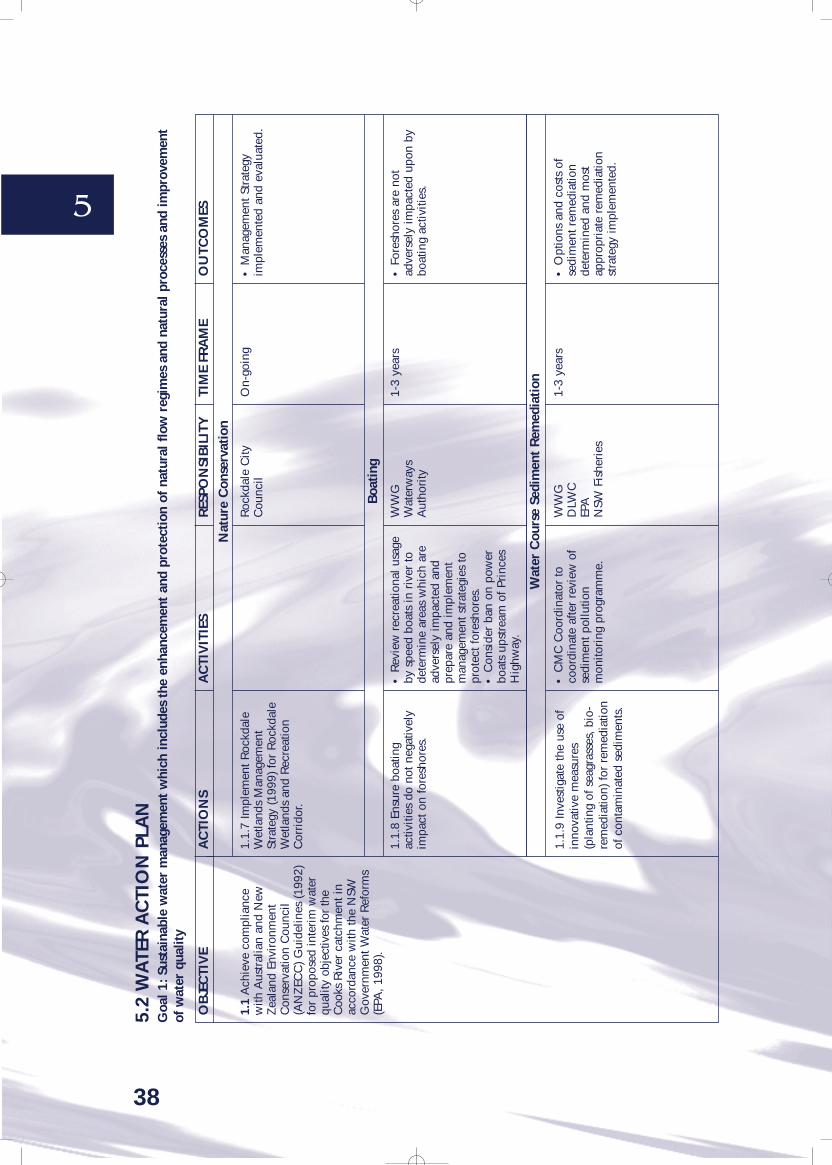
5
38
1.1.
7 Im
plem
ent R
ockd
ale
Wet
land
s M
anag
emen
tSt
rate
gy (1
999)
for
Roc
kdal
eW
etla
nds
and
Rec
reat
ion
Cor
rido
r.
1.1.
8 En
sure
boa
ting
activ
ities
do
not n
egat
ivel
yim
pact
on
fore
shor
es.
1.1.
9 In
vest
igat
e th
e us
e of
inno
vativ
e m
easu
res
(pla
ntin
g of
sea
gras
ses,
bio
-re
med
iatio
n) fo
r re
med
iatio
nof
con
tam
inat
ed s
edim
ents
.
1.1
Ach
ieve
com
plia
nce
with
Aus
tral
ian
and
New
Zea
land
Env
iron
men
tC
onse
rvat
ion
Cou
ncil
(AN
ZEC
C) G
uide
lines
(199
2)fo
r pr
opos
ed in
teri
m w
ater
qual
ity o
bjec
tives
for
the
Coo
ks R
iver
catc
hmen
t in
acco
rdan
ce w
ith th
e N
SWG
over
nmen
t Wat
er R
efor
ms
(EPA
, 199
8).
• R
evie
w r
ecre
atio
nal u
sage
by s
peed
boa
ts in
riv
er to
dete
rmin
e ar
eas
whi
ch a
read
vers
ely
impa
cted
and
prep
are
and
impl
emen
tm
anag
emen
t str
ateg
ies
topr
otec
t for
esho
res.
• C
onsi
der
ban
on p
ower
boat
s up
stre
am o
f Pri
nces
Hig
hway
.
• C
MC
Coo
rdin
ator
toco
ordi
nate
afte
r re
view
of
sedi
men
t pol
lutio
nm
onito
ring
pro
gram
me.
Roc
kdal
e C
ityC
ounc
il
WW
GW
ater
way
sA
utho
rity
WW
GD
LWC
EPA
NSW
Fis
heri
es
On-
goin
g
1-3
year
s
1-3
year
s
• M
anag
emen
t Str
ateg
yim
plem
ente
d an
d ev
alua
ted.
• F
ores
hore
s ar
e no
tad
vers
ely
impa
cted
upo
n by
boat
ing
activ
ities
.
• O
ptio
ns a
nd c
osts
of
sedi
men
t rem
edia
tion
dete
rmin
ed a
nd m
ost
appr
opri
ate
rem
edia
tion
stra
tegy
impl
emen
ted.
OB
JEC
TIV
EA
CTI
ON
SA
CTI
VIT
IES
RES
PON
SIB
ILIT
YTI
ME
FRA
ME
OU
TCO
MES
Nat
ure
Con
serv
atio
n
Boa
ting
Wat
er C
ours
e Se
dim
ent
Rem
edia
tion
5.2
WA
TER
AC
TIO
N P
LAN
Goa
l 1: S
usta
inab
le w
ater
man
agem
ent
whi
ch in
clud
es t
he e
nhan
cem
ent
and
prot
ecti
on o
f na
tura
l flo
w r
egim
es a
nd n
atur
al p
roce
sses
and
impr
ovem
ent
of w
ater
qua
lity
7496 cooks river catchment 26/5/00 12:20 PM Page 38

5
39
1.1.
10Pr
ovid
e do
g fa
eces
colle
ctio
n co
ntai
ners
and
educ
ate
publ
ic a
bout
sam
e.
1.1.
11In
vest
igat
e th
efe
asib
ility
of r
elea
sing
dun
gbe
etle
s in
the
catc
hmen
t to
assi
st in
red
ucin
g do
g fa
eces
.
1.1.
12Im
plem
ent s
ewag
eov
erflo
w a
bate
men
tpr
ogra
mm
e as
con
ditio
ns o
fse
wag
e ov
erflo
w li
cenc
esw
hen
gran
ted
by E
PA.
1.1.
13M
onito
r an
din
vest
igat
e ill
egal
conn
ectio
ns o
f sto
rmw
ater
to
sew
er.
1.1
Ach
ieve
com
plia
nce
with
Aus
tral
ian
and
New
Zea
land
Env
iron
men
tC
onse
rvat
ion
Cou
ncil
(AN
ZEC
C) G
uide
lines
(199
2)fo
r pr
opos
ed in
teri
m w
ater
qual
ity o
bjec
tives
for
the
Coo
ks R
iver
catc
hmen
t in
acco
rdan
ce w
ith th
e N
SWG
over
nmen
t Wat
er R
efor
ms
(EPA
, 199
8).
•Pr
ovid
e hi
ghly
vis
ible
cont
aine
rs w
ith a
ppro
pria
tesi
gnag
e in
are
as d
esig
nate
das
dog
exe
rcis
e ar
eas
inac
cord
ance
with
Com
pani
onA
nim
als
Act
•Ed
ucat
e pu
blic
via
oth
eren
viro
nmen
tal e
duca
tion
cam
paig
ns.
Infil
trat
ion/
Exfil
trat
ion
prog
ram
me
and
Aud
iting
/Env
iron
men
tal
revi
ews
as c
ompo
nent
of
Stor
mw
ater
aud
iting
prog
ram
me
in 1
.1.1
.
Cou
ncils
Cou
ncils
Sydn
ey W
ater
Sydn
ey W
ater
Stor
mw
ater
Aud
iting
Tea
mW
WG
1-3
year
s
1-3
year
s
With
in ti
mef
ram
esp
ecifi
ed o
n lic
ence
cond
ition
s
With
in ti
me-
fram
esp
ecifi
ed o
npr
ogra
mm
e
•D
ecre
ase
in n
umbe
r of
dog
faec
es v
isib
le in
pub
lic a
reas
and
redu
ctio
n in
faec
alco
lifor
m c
once
ntra
tions
inw
ater
qua
lity
test
res
ults
.
•D
ecre
ase
in n
umbe
r of
dog
faec
es v
isib
le in
pub
lic a
reas
and
redu
ctio
n in
faec
alco
lifor
m c
once
ntra
tions
inw
ater
qua
lity
test
res
ults
.
•Se
wag
e ov
erflo
ws
elim
inat
ed o
r im
pact
s of
sew
age
over
flow
s el
imin
ated
.
•N
o ill
egal
sew
er to
stor
mw
ater
con
nect
ions
.
OB
JEC
TIV
EA
CTI
ON
SA
CTI
VIT
IES
RES
PON
SIB
ILIT
YTI
ME
FRA
ME
OU
TCO
MES
Con
trol
of
Dog
s
Sew
age
5.2
WA
TER
AC
TIO
N P
LAN
Goa
l 1: S
usta
inab
le w
ater
man
agem
ent
whi
ch in
clud
es t
he e
nhan
cem
ent
and
prot
ecti
on o
f na
tura
l flo
w r
egim
es a
nd n
atur
al p
roce
sses
and
impr
ovem
ent
of w
ater
qua
lity
7496 cooks river catchment 26/5/00 12:20 PM Page 39

5
40
1.2
The
enha
ncem
ent,
rest
orat
ion
and
prot
ectio
n of
natu
ral f
low
s in
wat
er-b
odie
sto
sat
isfy
the
NSW
Envi
ronm
ent P
rote
ctio
nA
utho
rity
’s E
nvir
onm
enta
lFl
ow O
bjec
tives
(199
8).
1.3
Impr
ove
qual
ity a
ndm
onito
r qu
antit
y of
wat
er in
Bot
any
Sand
s A
quife
r.
1.2.
1Ex
amin
e th
e fe
asib
ility
of d
e-ch
anne
lisin
g as
man
yof
the
stor
mw
ater
dra
inag
ech
anne
ls in
the
catc
hmen
tas
pos
sibl
e to
ret
urn
them
tone
ar-n
atur
al c
ondi
tions
.
1.2.
2Pr
ovid
e ad
equa
teri
pari
an v
eget
atio
n bu
ffer
zone
s ar
ound
wat
erch
anne
ls a
s pe
r C
ooks
Riv
erFo
resh
ores
Str
ateg
ic P
lan.
Als
o re
fer
to G
reen
Web
–Sy
dney
(see
Act
ion
2.1.
1).
1.2.
3En
cour
age
appr
opri
ate
grou
ps to
app
ly fo
r si
te-
spec
ific
fund
ing
for
bank
and
wat
erco
urse
reha
bilit
atio
n.
1.3.
1Im
plem
ent B
otan
ySa
nds
Aqu
ifer
Man
agem
ent
Plan
whe
n re
leas
ed.
1.3.
2Im
plem
ent t
he N
SWG
roun
dwat
er P
olic
y.
•D
iscu
ss w
ith C
ounc
ils,
DLW
C a
nd o
ther
rel
evan
tau
thor
ities
.•
Ref
er to
Coo
ks R
iver
Fore
shor
es S
trat
egic
Pla
n(C
lous
ton,
199
7) a
nd p
repa
rem
anag
emen
t pla
n as
to h
owth
e w
ork
coul
d be
per
form
ed,
listin
g pr
iorit
y ar
eas
and
fund
ing
and
reso
urce
s re
quire
d.•
Mak
e su
bmis
sion
to E
PAto
obta
in S
torm
wat
er G
rant
fund
ing.
•En
cour
age
nativ
e ve
geta
tion
plan
ting
and
cons
erva
tion
ofes
tabl
ishe
d na
tive
vege
tatio
n.•
Con
trol
pes
ts a
nd w
eeds
.•
Mak
e su
bmis
sion
s to
obt
ain
NH
T, R
iver
care
, Lan
dcar
efu
ndin
g et
c.
•Im
plem
ent s
torm
wat
erdr
aina
ge c
hann
elre
habi
litat
ion
as p
er C
ooks
Riv
er S
torm
wat
erM
anag
emen
t Pla
n (1
999)
.
•A
Bot
any
Sand
s A
quife
rM
anag
emen
t Pla
n is
bei
ngde
velo
ped
as p
art o
f the
Wat
er R
efor
m P
acka
ge fo
rim
prov
ed w
ater
man
agem
ent,
in a
ccor
danc
e w
ith th
e St
ate
Gro
undw
ater
Pol
icy
(199
7).
•A
s pe
r N
SW G
roun
dwat
erPo
licy
(199
7).
WW
GD
LWC
EPA
NSW
Fis
heri
esC
ounc
ils
WW
GC
ounc
ils
WW
GC
ounc
ils
WW
GC
ounc
ilsD
LWC
EPA
Dep
t. of
Hea
lthA
ll gr
ound
wat
erus
ers
WW
GD
LWC
With
in 1
2 m
onth
s
3-6
year
s
1-3
year
s
With
in 3
mon
ths
ofre
leas
e of
pla
n
1-3
year
s
•Pr
epar
atio
n of
sto
rmw
ater
drai
nage
cha
nnel
reha
bilit
atio
n m
anag
emen
tpl
an.
•R
ipar
ian
zone
est
ablis
hed
with
nat
ive
vege
tatio
n w
hils
tal
so p
rovi
ding
are
as fo
rse
atin
g et
c.
•Pr
ogre
ssiv
e re
habi
litat
ion
ofdr
aina
ge c
hann
els
acco
rdin
gto
pri
ority
.
•Im
plem
enta
tion
of th
eG
roun
dwat
er M
anag
emen
tPl
an r
esul
ts in
impr
oved
grou
ndw
ater
qua
lity.
•G
ound
wat
er P
olic
yim
plem
ente
d un
til B
otan
ySa
nds
Aqu
ifer
Man
agem
ent
Plan
rel
ease
d, r
esul
ting
inim
prov
ed g
roun
dwat
er q
ualit
y.
OB
JEC
TIV
EA
CTI
ON
SA
CTI
VIT
IES
RES
PON
SIB
ILIT
YTI
ME
FRA
ME
OU
TCO
MES
5.2
WA
TER
AC
TIO
N P
LAN
Goa
l 1: S
usta
inab
le w
ater
man
agem
ent
whi
ch in
clud
es t
he e
nhan
cem
ent
and
prot
ecti
on o
f na
tura
l flo
w r
egim
es a
nd n
atur
al p
roce
sses
and
impr
ovem
ent
of w
ater
qua
lity
7496 cooks river catchment 26/5/00 12:20 PM Page 40

5
41
2.1
Prom
ote
the
prov
isio
n of
aest
hetic
ally
ple
asin
gre
crea
tiona
l fac
ilitie
s by
coun
cils
whi
le p
rote
ctin
gna
tive
flora
and
faun
aha
bita
ts.
2.2
Prom
ote
coor
dina
tion
betw
een
maj
or s
take
hold
ers
to e
nsur
e th
at a
cces
s to
bush
land
,wet
land
s an
d ot
her
open
spa
ces
does
not
encr
oach
on
envi
ronm
enta
llyse
nsiti
ve a
reas
.
2.3
Inte
grat
ed a
nd c
o-or
dina
ted
land
and
wat
erre
sour
ce m
anag
emen
tpr
actic
es d
evel
oped
and
impl
emen
ted
betw
een
coun
cils
, Sta
te A
genc
ies
and
com
mun
ity g
roup
s.
2.1.
1En
hanc
e, c
onse
rve
and
mai
ntai
n ar
eas
of p
ublic
open
spa
ce a
ndve
geta
tion/
wild
life
corr
idor
sfo
r pu
blic
acc
ess
whi
lst a
lso
allo
win
g fo
r co
nser
vatio
n of
habi
tats
and
eco
syst
ems.
2.1.
2Su
ppor
t cou
ncils
inim
plem
entin
g ac
tions
desc
ribe
d in
Coo
ks R
iver
Fore
shor
es S
trat
egic
Pla
n(C
lous
ton,
199
7) a
nd e
nsur
eac
tions
are
in a
ccor
danc
ew
ith b
est p
ract
ice
ofen
viro
nmen
tal p
rese
rvat
ion
and
coor
dina
ted
on a
catc
hmen
t bas
is.
2.2.
1In
crea
se n
ativ
ebu
shla
nd a
reas
to a
void
frag
men
tatio
n of
res
erve
s.
2.2.
2W
ork
with
all
rele
vant
auth
oriti
es a
nd g
roup
s to
over
view
the
desi
gn a
ndsi
ting
of w
alki
ng tr
acks
.
2.3.
1Es
tabl
ish
coor
dina
ted
plan
ning
pra
ctic
es w
ith lo
cal
gove
rnm
ents
, Dep
t. U
rban
Affa
irs
and
Plan
ning
and
the
CM
C.
Impl
emen
t•
The
Syd
ney
Reg
iona
lO
rgan
isat
ion
of C
ounc
ils(1
997)
Gre
en W
eb –
Syd
ney
• C
ooks
Riv
er F
ores
hore
sSt
rate
gic
Plan
(199
7).
•Im
plem
ent p
rior
ity a
ctio
nsfr
om C
RFS
P(1
997)
.
•En
sure
wal
king
trac
ks a
repl
aced
to a
void
adv
erse
impa
cts
to c
onse
rvat
ion
area
s.
•Pr
ovid
e in
put t
o pl
an-
mak
ing.
Cou
ncils
BW
GLV
WG
All
wor
king
gro
ups
Cou
ncils
Cou
ncils
BW
GLV
WG
Cou
ncils
BW
GLV
WG
Cou
ncils
EPA
Sydn
ey W
ater
RTA
DLW
C L
VW
G
On-
goin
g
On-
goin
g
On-
goin
g
On-
goin
g
On-
goin
g
•R
ecre
atio
nal f
acili
ties
dono
t adv
erse
ly im
pact
on
cons
erva
tion
area
s.
•Pr
ogre
ssiv
e Im
plem
enta
tion
of a
ctio
ns in
CR
FSP
(199
7).
•B
ushl
and
rese
rves
and
park
land
s ar
e le
ssfr
agm
ente
d.
•W
alki
ng tr
acks
hav
em
inim
al a
dver
se im
pact
on
cons
erva
tion
area
s.
•Pl
anni
ng c
oord
inat
ed a
ndin
tegr
ated
on
a ca
tchm
ent
basi
s.
OB
JEC
TIV
EA
CTI
ON
SA
CTI
VIT
IES
RES
PON
SIB
ILIT
YTI
ME
FRA
ME
OU
TCO
MES
5.3
LAN
D A
ND
VEG
ETA
TIO
N A
CTI
ON
PLA
NG
oal 2
. Urb
an m
anag
emen
t w
hich
fol
low
s th
e pr
inci
ples
of
Ecol
ogic
ally
Sus
tain
able
Dev
elop
men
t so
tha
t la
nd a
nd v
eget
atio
n is
man
aged
to
ensu
rebi
odiv
ersi
ty is
enh
ance
d
7496 cooks river catchment 26/5/00 12:20 PM Page 41

5
42
2.3
Inte
grat
ed a
nd c
o-or
dina
ted
land
and
wat
erre
sour
ce m
anag
emen
tpr
actic
es d
evel
oped
and
impl
emen
ted
betw
een
coun
cils
, Sta
te A
genc
ies
and
com
mun
ity g
roup
s.
2.4
Rem
ove
legi
slat
ive
and
adm
inis
trat
ive
impe
dim
ents
to, a
nd s
uppo
rt in
itiat
ives
whi
ch fa
cilit
ate,
the
use
ofbe
st m
anag
emen
t pra
ctic
esin
gov
ernm
ent,
indu
stry
and
com
mun
ity.
2.3.
2En
sure
all
com
mun
ityla
nd in
the
catc
hmen
t has
com
plet
ed P
lans
of
Man
agem
ent u
nder
Loc
alG
over
nmen
t Act
.
2.3.
3A
ll lo
cal g
over
nmen
tsbe
enc
oura
ged
to a
dopt
unifo
rm b
est p
ract
ice
Loca
lEn
viro
nmen
t Pla
ns in
rela
tion
to th
e re
duct
ion
ofpo
llutio
n fr
om a
ny w
ork
invo
lvin
g an
Env
iron
men
tal
Plan
ning
Inst
rum
ent e
.g.
deve
lop
buffe
r zo
nes
alon
gth
e ri
ver
for
new
indu
stri
alde
velo
pmen
ts.
2.3.
4Pr
oduc
e a
man
agem
ent p
lan
for
the
head
wat
ers
of th
e C
ooks
Riv
er.
2.4.
1Es
tabl
ish
awar
ds fo
rin
dust
ry a
nd p
rom
ote
best
prac
tice.
2.4.
2En
cour
age
indu
stry
tota
ke p
ositi
ve a
ctio
ns to
ass
ist
in th
e im
prov
emen
t of t
hem
anag
emen
t of t
he la
nd a
ndw
ater
res
ourc
es o
f the
catc
hmen
t.
•A
ssis
t in
prep
arat
ion
and
adop
tion
by c
ounc
ils o
fLE
P’s.
•Im
plem
ent i
n co
njun
ctio
nw
ith a
uditi
ng/e
duca
tion
prog
ram
me
outli
ned
inA
ctio
n 1.
1.1.
•In
dust
rial
/com
mer
cial
prem
ises
that
are
des
igna
ted
“env
iron
men
tally
frie
ndly
”us
ed a
s a
show
case
for
othe
rpr
emis
es w
ithin
the
catc
hmen
t.
LVW
GC
ounc
ils
LVW
GC
ounc
ils
BW
GLV
WG
Ban
ksto
wn
Cou
ncil
Cou
ncils
EWG
Cou
ncils
EPA
EWG
LVW
G
1-3
year
s an
dm
aint
ain
as o
n-go
ing
actio
n
On-
goin
g
1-3
year
s
With
in 1
2 m
onth
san
d m
aint
ain
as o
n-go
ing
actio
n
With
in 1
2 m
onth
san
d m
aint
ain
as o
n-go
ing
actio
n
•M
anag
emen
t Pla
nsde
velo
ped
and
impl
emen
ted
for
all c
omm
unity
land
.
•U
nifo
rm b
est p
ract
ice
LEP’
sde
velo
ped
and
impl
emen
ted.
•C
ooks
Riv
er H
eadw
ater
sM
anag
emen
t Pla
n de
velo
ped.
•In
dust
ry A
war
ds S
yste
mes
tabl
ishe
d.
•In
crea
se in
env
iron
men
tally
frie
ndly
act
ions
by
indu
stry
.
OB
JEC
TIV
EA
CTI
ON
SA
CTI
VIT
IES
RES
PON
SIB
ILIT
YTI
ME
FRA
ME
OU
TCO
MES
5.3
LAN
D A
ND
VEG
ETA
TIO
N A
CTI
ON
PLA
NG
oal 2
. Urb
an m
anag
emen
t w
hich
fol
low
s th
e pr
inci
ples
of
Ecol
ogic
ally
Sus
tain
able
Dev
elop
men
t so
tha
t la
nd a
nd v
eget
atio
n is
man
aged
to
ensu
rebi
odiv
ersi
ty is
enh
ance
d
7496 cooks river catchment 26/5/00 12:21 PM Page 42

5
43
2.4
Rem
ove
legi
slat
ive
and
adm
inis
trat
ive
impe
dim
ents
to, a
nd s
uppo
rt in
itiat
ives
whi
ch fa
cilit
ate,
the
use
ofbe
st m
anag
emen
t pra
ctic
esin
gov
ernm
ent,
indu
stry
and
com
mun
ity.
2.4.
3Su
ppor
t Reg
iona
lW
aste
Boa
rds.
2.4.
4R
educ
e ur
ban
runo
ffby
lim
iting
impe
rvio
ussu
rfac
es w
hen
land
scap
ing
and
exam
ine
the
feas
ibili
tyof
usi
ng s
emi-
perm
eabl
esu
rfac
es in
stea
d of
impe
rmea
ble
surf
aces
, if
poss
ible
.
2.4.
5En
cour
age
inst
alla
tion
of s
torm
wat
er d
eten
tion
and
rete
ntio
n ap
plia
nces
whe
ngr
antin
g co
nsen
t for
new
deve
lopm
ents
or
rede
velo
pmen
ts.
2.4.
6Im
plem
ent t
heSo
uthe
rn S
ydne
y R
egio
nal
Org
anis
atio
n of
Cou
ncil’
sSt
rate
gy o
n Er
osio
n an
dSe
dim
ent C
ontro
l for
bui
ldin
gsi
tes
thro
ugho
ut e
ntir
eca
tchm
ent (
SSR
OC
, 199
8).
Ensu
re im
plem
enta
tion
of:
•W
aste
Min
imis
atio
n an
dM
anag
emen
t Act
and
Reg
ulat
ions
, 199
5•
Kee
p A
ustr
alia
Bea
utifu
l(1
998)
Was
te M
inim
isat
ion
Man
ual f
or L
ocal
Gov
ernm
ent –
a g
uide
tore
sour
ces,
issu
es a
nd b
est
prac
tice.
•C
ounc
ils to
dev
elop
and
impl
emen
t lan
dsca
pe D
CPs
.
•D
evel
op L
EPs,
DC
Ps a
ndSe
ctio
n 94
of t
heEn
viro
nmen
tal P
lann
ing
and
Ass
essm
ent A
ct(c
ontr
ibut
ions
and
oth
erfu
ndin
g op
tions
, e.g
. rat
ere
venu
e) a
nd S
ectio
n 49
5 of
the
Loca
l Gov
ernm
ent A
ct(s
peci
al r
ates
).
• D
evel
op a
ppro
pria
te b
est
prac
tice
DC
Ps fo
r se
dim
ent
cont
rol.
• Im
prov
e po
licin
g an
den
forc
emen
t of r
egul
atio
ns.
LVW
GC
ounc
ils
LVW
GC
ounc
ils
LVW
GW
WG
Cou
ncils
LVW
GC
ounc
ilsEP
AD
LWC
With
in 1
2 m
onth
san
d m
aint
ain
as o
n-go
ing
actio
n.
1-3
year
s an
dm
aint
ain
as o
n-go
ing
actio
n.
1-3
year
s an
dm
aint
ain
as o
n-go
ing
actio
n.
1-3
year
s an
dm
aint
ain
as o
n-go
ing
actio
n.
•B
est p
ract
ice
impl
emen
ted
for
was
te d
ispo
sal a
ndm
inim
isat
ion.
•A
reas
of i
mpe
rvio
ussu
rfac
es in
new
deve
lopm
ents
min
imis
ed.
•N
ew d
evel
opm
ents
con
tain
appr
opri
ate
anti-
pollu
tion
infr
astr
uctu
re r
elev
ant t
o th
atde
velo
pmen
t.
•In
crea
se in
com
plia
nce
with
bes
t pra
ctic
e on
cons
truc
tion
site
s.
OB
JEC
TIV
EA
CTI
ON
SA
CTI
VIT
IES
RES
PON
SIB
ILIT
YTI
ME
FRA
ME
OU
TCO
MES
5.3
LAN
D A
ND
VEG
ETA
TIO
N A
CTI
ON
PLA
NG
oal 2
. Urb
an m
anag
emen
t w
hich
fol
low
s th
e pr
inci
ples
of
Ecol
ogic
ally
Sus
tain
able
Dev
elop
men
t so
tha
t la
nd a
nd v
eget
atio
n is
man
aged
to
ensu
rebi
odiv
ersi
ty is
enh
ance
d
7496 cooks river catchment 26/5/00 12:21 PM Page 43

5
44
2.5
Incl
ude
ESD
pri
ncip
les
in la
nd-u
se a
ndde
velo
pmen
t dec
isio
ns a
ndpr
ovid
e ES
D/p
reca
utio
nary
prin
cipl
e in
put i
nto
the
prep
arat
ion
of p
lans
and
polic
ies.
2.6
Rem
edia
te c
onta
min
ated
land
in a
ccor
danc
e w
ithle
gisl
atio
n an
d su
bjec
t to
prin
cipl
es o
f ESD
.
2.5.
1En
cour
age
all t
hose
mak
ing
deci
sion
s on
the
use
and
man
agem
ent o
f lan
dan
d w
ater
res
ourc
es w
ithin
the
catc
hmen
t to
use
the
rele
vant
pri
ncip
les
inA
gend
a 21
as
a ba
sis
for
thei
r de
cisi
on-m
akin
g.
2.5.
2A
dopt
and
sup
port
the
Sout
hern
Syd
ney
Reg
iona
lO
rgan
isat
ion
of C
ounc
il’s
(SSR
OC
) Gre
enho
use
Stra
tegy
.
2.5.
3D
evel
op p
lan
tom
anag
e bo
at la
unch
ing
and
retr
ieva
l so
as to
min
imis
eim
pact
s of
thes
e ac
tiviti
es o
nfo
resh
ores
.
2.5.
4C
ounc
ils to
mak
eLE
Ps/D
CPs
pro
vidi
ng fo
r a
min
imum
10m
set
back
from
the
rive
r an
d tr
ibut
arie
s fo
ral
l new
dev
elop
men
ts.
2.6.
1U
pdat
e an
d m
aint
ain
data
base
of c
onta
min
ated
site
s an
d en
cour
age
rem
edia
tion
of s
ame.
Impl
emen
t:•
Mar
rickv
ille
Cou
ncil
(199
7)M
arri
ckvi
lle A
gend
a 21
Envi
ronm
ent S
trat
egy
1997
.•
Inte
rnat
iona
l Cou
ncil
for
Loca
l Env
ironm
enta
l Ini
tiativ
es(1
996)
The
Loc
al A
gend
a 21
Plan
ning
Gui
delin
es –
an
Intr
oduc
tion
to S
usta
inab
leD
evel
opm
ent P
lann
ing.
• M
unic
ipal
Con
serv
atio
nA
ssoc
iatio
n (1
994)
Man
agin
gth
e Fu
ture
: ALo
cal
Gov
ernm
ent G
uide
to L
ocal
Age
nda
21.
• S
SRO
C (1
992)
AG
reen
hous
e St
rate
gy fo
r th
eSo
uthe
rn S
ydne
y R
egio
n.
• C
ounc
ils to
mak
e LE
P/D
CP
• A
ssis
t in
the
repo
rtin
g of
cont
amin
ated
site
s to
EPA
and
actio
ns b
y th
e EP
Aan
dla
ndow
ners
in a
ccor
danc
ew
ith C
onta
min
ated
Lan
dM
anag
emen
t Act
, 199
7.
LVW
GC
ounc
ils
LVW
GC
ounc
ils
Wat
erw
ays
Aut
hori
ty
LVW
GC
ounc
ils
LVW
GEP
AC
ounc
ils
With
in 1
2 m
onth
san
d m
aint
ain
as o
n-go
ing
actio
n
On-
goin
g
1-3
year
s
With
in 1
2 m
onth
san
d m
aint
ain
as o
n-go
ing
actio
n
With
in 1
2 m
onth
san
d m
aint
ain
as o
n-go
ing
actio
n
•ES
D P
rinc
iple
sin
corp
orat
ed in
to d
ecis
ion-
mak
ing
proc
ess.
•SS
RO
C (1
992)
AG
reen
hous
e St
rate
gy fo
r th
eSo
uthe
rn S
ydne
y R
egio
nap
prov
ed a
nd im
plem
ente
dth
roug
hout
cat
chm
ent.
•B
oat l
aunc
hing
Man
agem
ent P
lan
deve
lope
dan
d im
plem
ente
d.
•N
o ne
w p
ipin
g of
wat
erco
urse
cha
nnel
s.•
Incr
ease
d ar
ea o
f rip
aria
nzo
ne c
over
ed in
nat
ive
vege
tatio
n.
•N
umbe
r of
site
s on
data
base
incr
ease
s w
ithev
iden
ce o
f rem
edia
tion
bein
g un
dert
aken
on
know
nsi
tes.
OB
JEC
TIV
EA
CTI
ON
SA
CTI
VIT
IES
RES
PON
SIB
ILIT
YTI
ME
FRA
ME
OU
TCO
MES
5.3
LAN
D A
ND
VEG
ETA
TIO
N A
CTI
ON
PLA
NG
oal 2
. Urb
an m
anag
emen
t w
hich
fol
low
s th
e pr
inci
ples
of
Ecol
ogic
ally
Sus
tain
able
Dev
elop
men
t so
tha
t la
nd a
nd v
eget
atio
n is
man
aged
to
ensu
rebi
odiv
ersi
ty is
enh
ance
d
7496 cooks river catchment 26/5/00 12:21 PM Page 44

5
45
3.1
Enha
nce
and
prot
ect t
hebi
odiv
ersi
ty o
f the
Coo
ksR
iver
cat
chm
ent.
3.1.
1Pr
omot
e th
een
hanc
emen
t, re
habi
litat
ion
and
prot
ectio
n of
rip
aria
nve
geta
tion
area
s an
dco
rrid
ors.
• Im
plem
ent r
elev
ant
sect
ions
of C
RFS
P(C
lous
ton,
1997
) and
Sta
te o
f the
Envi
ronm
ent R
epor
ts.
• P
rodu
ce a
Rip
aria
n Z
one
Man
agem
ent P
olic
y an
den
sure
it is
inco
rpor
ated
as
ade
velo
pmen
t con
ditio
n.•
Ens
ure
any
ripa
rian
zon
ere
habi
litat
ion
conf
orm
s w
ithri
pari
an m
anag
emen
tgu
idel
ines
(DLW
C);
NSW
Gov
ernm
ent (
1993
) The
NSW
Gov
ernm
ent S
tate
Riv
ers
and
Estu
arie
s Po
licy;
Bri
sban
e C
ity C
ounc
il (1
995)
Urb
an S
trea
m R
ehab
ilita
tion:
Prin
cipl
es a
nd G
uide
lines
;N
SW G
over
nmen
t (19
96)
NSW
Wet
land
s M
anag
emen
tPo
licy;
DLW
C (1
999)
Loc
alG
over
nmen
t Gui
delin
es fo
rR
iver
ine
Cor
rido
rM
anag
emen
t.
BW
GC
ounc
ilsO
n-go
ing
•A
rea
of r
ipar
ian
zone
cove
red
in n
ativ
e ve
geta
tion
incr
ease
d.
OB
JEC
TIV
EA
CTI
ON
SA
CTI
VIT
IES
RES
PON
SIB
ILIT
YTI
ME
FRA
ME
OU
TCO
MES
Pres
erva
tion
of
Hab
itat
s, P
rote
ct A
reas
and
Rem
nant
Bus
hlan
d
5.4
BIO
DIV
ERSI
TYA
CTI
ON
PLA
NG
oal 3
.A
quat
ic a
nd t
erre
stri
al e
cosy
stem
s an
d ha
bita
ts a
re r
esto
red,
reh
abili
tate
d, e
nhan
ced
and
prot
ecte
d so
as
to p
rom
ote
and/
or m
aint
ain
esse
ntia
lec
olog
ical
pro
cess
es a
nd b
iodi
vers
ity
7496 cooks river catchment 26/5/00 12:21 PM Page 45

46
5
3.1
Enha
nce
and
prot
ect t
hebi
odiv
ersi
ty o
f the
Coo
ksR
iver
cat
chm
ent.
3.1.
2Pr
omot
e th
een
hanc
emen
t, re
habi
litat
ion
and
prot
ectio
n of
rip
aria
nve
geta
tion
area
s an
dco
rrid
ors
on b
oth
publ
ic a
ndpr
ivat
e la
nd.
3.1.
3Pr
omot
e an
d co
ntin
uelo
cal b
iodi
vers
ity s
tudi
es.
3.1.
4R
evie
w e
xtan
t are
as o
fec
osys
tem
s an
d ha
bita
ts a
nden
sure
thei
r fu
ture
as
area
sto
enh
ance
bio
dive
rsity
ispr
otec
ted.
If po
ssib
le, t
hese
area
s sh
ould
be
cons
olid
ated
and
incr
ease
d in
siz
e as
wel
las
reh
abili
tate
d an
den
hanc
ed w
hils
t als
oal
low
ing
publ
ic a
cces
sw
here
app
ropr
iate
.
• Im
plem
ent r
elev
ant
sect
ions
of C
RSF
P(1
997)
and
Stat
e of
the
Envi
ronm
ent
Rep
orts
.•
Impl
emen
t SEP
P19
–B
ushl
and
in U
rban
Are
as a
ndap
prop
riat
e LE
P’s,
DC
P’s
and
deve
lopm
ent c
onse
ntco
nditi
ons.
• P
rom
ote
initi
ativ
es w
hich
enco
urag
e co
nser
vatio
n su
chas
a C
ode
of C
ondu
ct,
Volu
ntar
y C
onse
rvat
ion
Agr
eem
ents
, NPW
S’s
Wild
life
Agr
eem
ents
as
wel
l as
Cou
ncil
Gui
delin
es fo
rpl
antin
g na
tive
vege
tatio
nw
hich
is a
lso
indi
geno
us.
•En
cour
age
peop
le to
part
icip
ate
in b
iodi
vers
ityst
udie
s an
d ex
amin
e fu
ndin
gop
tions
.
•R
evie
w e
ach
Cou
ncil’
sSt
ate
of th
e En
viro
men
tR
epor
ts fo
r do
cum
enta
tion
rega
rdin
g co
nser
vatio
n ar
eas
and
ensu
re th
ese
area
s ar
em
anag
ed a
nd m
aint
aine
d.
BW
GC
ounc
ils
BW
GC
ounc
ils
BW
GC
ounc
ils
With
in 1
2 m
onth
san
d m
aint
ain
as o
n-go
ing
With
in 1
2 m
onth
san
d m
aint
ain
as o
n-go
ing
With
in12
mon
ths
and
mai
ntai
n as
on-
goin
g
•In
crea
sed
area
of n
ativ
ebu
shla
nd th
roug
hout
catc
hmen
t.
•In
crea
sed
data
, inf
orm
atio
nan
d aw
aren
ess
onbi
odiv
ersi
ty in
the
catc
hmen
t.
•In
crea
sed
area
s of
cons
erva
tion
valu
e.
OB
JEC
TIV
EA
CTI
ON
SA
CTI
VIT
IES
RES
PON
SIB
ILIT
YTI
ME
FRA
ME
OU
TCO
MES
Pres
erva
tion
of
Hab
itat
s, P
rote
ct A
reas
and
Rem
nant
Bus
hlan
d
5.4
BIO
DIV
ERSI
TYA
CTI
ON
PLA
NG
oal 3
.A
quat
ic a
nd t
erre
stri
al e
cosy
stem
s an
d ha
bita
ts a
re r
esto
red,
reh
abili
tate
d, e
nhan
ced
and
prot
ecte
d so
as
to p
rom
ote
and/
or m
aint
ain
esse
ntia
lec
olog
ical
pro
cess
es a
nd b
iodi
vers
ity
7496 cooks river catchment 26/5/00 12:21 PM Page 46

5
47
3.1
Enha
nce
and
prot
ect t
hebi
odiv
ersi
ty o
f the
Coo
ksR
iver
cat
chm
ent.
3.1.
5D
isco
urag
e an
y fu
rthe
rde
velo
pmen
t on
all n
atur
alfo
resh
ore
area
s w
ith r
e-ve
geta
tion
pote
ntia
l.
3.1.
6D
evel
op s
trat
egie
s fo
rth
e m
anag
emen
t of
thre
aten
ed s
peci
es.
3.1.
7En
cour
age
the
inst
alla
tion
of a
nim
al h
ouse
sin
app
ropr
iate
are
as.
3.1.
8C
oord
inat
e un
iform
wee
d st
rate
gy w
ith a
ll lo
cal
gove
rnm
ents
thro
ugho
ut th
eca
tchm
ent.
3.1.
9Ex
amin
e th
e po
ssib
ility
of e
mpl
oyin
g pe
st (w
eed
and
fera
l ani
mal
s) c
ontr
ol o
ffice
rsfo
r th
e ca
tchm
ent i
n or
der
tode
vise
and
exe
cute
str
ateg
ies
and
actio
ns fo
r pe
stm
anag
emen
t.
3.1.
10En
cour
age
the
esta
blis
hmen
t of n
urse
ries
inLG
A’s
whi
ch s
peci
alis
e in
the
culti
vatio
n of
loca
l nat
ive
spec
ies
for
use
by c
ounc
ilsan
d th
e lo
cal c
omm
unity
.
•D
evel
op a
n R
EP.
•U
se th
e Th
reat
ened
Spe
cies
Con
serv
atio
n A
ct, 1
995.
•Pu
rsue
don
atio
ns o
f woo
dan
d lia
ise
with
sch
ools
and
TAFE
re
build
ing
hous
es in
woo
dwor
k cl
asse
s.
•In
vest
igat
e in
nova
tive,
cos
t-ef
fect
ive
way
s of
dea
ling
with
wee
ds a
nd e
nsur
e al
l cou
ncils
are
info
rmed
.
•Li
aise
with
Dep
t. of
Agr
icul
ture
and
NPW
S.
•Es
tabl
ish
nurs
erie
s an
dpr
omot
e an
d ad
vert
ise.
BW
GC
ounc
ilsD
UA
P
BW
GC
ounc
ilsN
PWS
BW
GC
ounc
ilsN
PWS
Com
mun
ity G
roup
s
BW
GC
ounc
ilsD
epar
tmen
t of
Agr
icul
ture
BW
GC
ounc
ils
BW
GC
ounc
ils
With
in 1
2 m
onth
san
d m
aint
ain
as o
n-go
ing
On-
goin
g su
ppor
t
1-3
year
s
1-3
year
s
1-3
year
s
1-3
year
s an
dm
aint
ain
as o
n-go
ing
•Th
reat
ened
Spe
cies
Man
agem
ent S
trat
egy
deve
lope
d.
•A
nim
al h
ouse
s in
stal
led.
•C
ost e
ffect
ive
anti-
wee
dst
rate
gies
are
dev
elop
ed a
ndim
plem
ente
d re
sulti
ng in
are
duct
ion
in w
eed
infe
stat
ion.
•Pe
st C
ontr
ol O
ffice
rem
ploy
ed fo
r C
ooks
Riv
erca
tchm
ent
•N
urse
ries
est
ablis
hed
lead
ing
to in
crea
sed
nativ
eve
geta
tion
plan
ting
in th
eca
tchm
ent.
OB
JEC
TIV
EA
CTI
ON
SA
CTI
VIT
IES
RES
PON
SIB
ILIT
YTI
ME
FRA
ME
OU
TCO
MES
Pres
erva
tion
of
Hab
itat
s, P
rote
ct A
reas
and
Rem
nant
Bus
hlan
d
Nat
ive
Wild
life
5.4
BIO
DIV
ERSI
TYA
CTI
ON
PLA
NG
oal 3
.A
quat
ic a
nd t
erre
stri
al e
cosy
stem
s an
d ha
bita
ts a
re r
esto
red,
reh
abili
tate
d, e
nhan
ced
and
prot
ecte
d so
as
to p
rom
ote
and/
or m
aint
ain
esse
ntia
lec
olog
ical
pro
cess
es a
nd b
iodi
vers
ity
Pest
s &
Wee
ds
7496 cooks river catchment 26/5/00 12:21 PM Page 47

5
48
4.1
Impr
oved
und
erst
andi
ngof
, and
com
mitm
ent t
o th
eco
nser
vatio
n, in
terp
reta
tion
and
appr
opri
ate
publ
ic u
seof
are
as a
nd it
ems
of c
ultu
ral
heri
tage
.
4.2
Incr
ease
d aw
aren
ess
and
unde
rsta
ndin
g of
the
sign
ifica
nce
of th
e cu
ltura
lhe
rita
ge o
f the
Coo
ks R
iver
catc
hmen
t.
4.3
The
reco
gniti
on o
f the
righ
ts a
nd n
eeds
of
indi
geno
us p
eopl
e an
d th
eva
lue
of th
eir
cont
ribu
tion
toth
e pr
otec
tion
of it
ems
ofcu
ltura
l val
ue.
4.1.
1U
nder
take
the
iden
tific
atio
n an
das
sess
men
t of A
bori
gina
l and
non-
Abo
rigi
nal h
erita
gesi
tes.
4.1.
2C
oord
inat
e av
aila
ble
data
on
rest
orat
ion
proj
ects
.
4.2.
1D
evel
op e
duca
tiona
lan
d co
mm
unity
info
rmat
ion
rega
rdin
g A
bori
gina
l her
itage
in r
egar
d to
the
use
of th
ela
nd a
nd w
ater
res
ourc
es o
fth
e ca
tchm
ent.
4.3.
1In
volv
emen
t of t
heA
bori
gina
l peo
ple
in th
em
anag
emen
t of t
he r
iver
and
its c
atch
men
t.
•C
ompi
le r
egis
ter
of c
urre
ntsi
tes
and
insp
ect a
nddo
cum
ent t
heir
con
ditio
n.•
Inve
stig
ate
any
othe
rpo
ssib
le s
ites.
•Pr
oduc
e a
Coo
ks R
iver
Cat
chm
ent H
erita
geed
ucat
ion
pack
age.
•In
corp
orat
e ed
ucat
iona
lm
ater
ial i
nto
othe
red
ucat
iona
l pro
gram
mes
.
•C
ontin
ue A
bori
gina
lm
embe
rshi
p of
the
CM
C.
NPW
SC
HW
GC
ounc
ilsN
atio
nal T
rust
of
NSW
Her
itage
Cou
ncil
Aus
tral
ian
Her
itage
Com
mis
sion
CH
WG
CH
WG
EWG
CM
C
1-3
year
s
With
in 1
2 m
onth
san
d on
-goi
ng
1-3
year
s
Con
tinue
•R
egis
ter
of lo
catio
n an
das
sess
men
t of s
igni
fican
tsi
tes.
•H
erita
ge in
form
atio
npa
ckag
e pr
oduc
ed a
nddi
stri
bute
d, w
ith in
crea
sed
com
mun
ity a
war
enes
s an
dkn
owle
dge
of lo
cal h
erita
ge.
•A
ll m
embe
rs o
f the
CR
CM
C a
war
e of
Nat
ive
Title
and
Abo
rigi
nal h
erita
geis
sues
in th
e ca
tchm
ent.
OB
JEC
TIV
EA
CTI
ON
SA
CTI
VIT
IES
RES
PON
SIB
ILIT
YTI
ME
FRA
ME
OU
TCO
MES
5.5
CU
LTU
RA
L H
ERIT
AG
EG
oal 4
: Pro
tect
ion,
con
serv
atio
n an
d en
hanc
emen
t of
are
as a
nd it
ems
of c
ultu
ral h
erit
age,
and
res
pect
for
the
con
trib
utio
n of
the
Abo
rigi
nal p
eopl
e to
the
catc
hmen
7496 cooks river catchment 26/5/00 12:21 PM Page 48

5
49
5.1
Prom
ote
and
rais
eaw
aren
ess
of th
e im
port
ance
of in
crea
sing
and
mai
ntai
ning
the
biol
ogic
al d
iver
sity
of
the
Coo
ks R
iver
cat
chm
ent.
5.2
The
prov
isio
n of
adeq
uate
info
rmat
ion
toen
able
the
catc
hmen
t to
bem
anag
ed e
ffici
ently
.
5.1.
1Pr
epar
e bi
odiv
ersi
tyed
ucat
iona
l mat
eria
lre
leva
nt to
Coo
ks R
iver
catc
hmen
t.
5.2.
1Es
tabl
ish
a da
taba
se o
fal
l rel
evan
t com
mun
ity a
ndgo
vern
men
t org
anis
atio
ns in
the
catc
hmen
t for
use
inm
aint
aini
ng o
n-go
ing,
mut
ually
sup
port
ive
rela
tions
hips
with
the
CM
C.
Thes
e re
latio
nshi
ps w
ill fo
rmth
e fo
unda
tion
of th
e C
MC
’sre
latio
nshi
p w
ith th
e w
ider
com
mun
ity fo
r th
e pu
rpos
esof
dis
sem
inat
ing
info
rmat
ion,
carr
ying
out
of w
orks
on
the
grou
nd a
nd p
oliti
cal s
uppo
rtfo
r th
e C
MC
Str
ateg
y.
5.2.
2C
lari
fy th
e ro
le o
f the
NSW
Gov
ernm
ent i
nm
onito
ring
of w
ater
qua
lity
in v
iew
of t
he W
ater
Ref
orm
agen
da a
nd in
clud
e th
epr
epar
atio
n of
a p
roto
col
and
mec
hani
sms
for
publ
icre
port
ing.
•C
onsu
lt w
ith C
omm
unity
Bio
dive
rsity
Net
wor
k.
• O
btai
n ap
prop
riat
eso
ftwar
e e.
g. A
cces
s on
whi
ch to
con
stru
ct d
atab
ase.
• O
btai
n lo
cal g
over
nmen
tco
mm
unity
dir
ecto
ries
for
sour
cing
info
rmat
ion
onco
mm
unity
and
gov
ernm
ent
orga
nisa
tions
. e.g
.•
Cha
mbe
rs o
f Com
mer
ce•
Env
iron
men
t Gro
ups
• E
thni
c co
mm
unity
orga
nisa
tions
• S
choo
ls•
Mem
bers
of P
arlia
men
t•
Rec
reat
iona
l Clu
bs•
Sta
te G
over
nmen
tA
genc
ies
• E
ngag
e st
uden
t (or
sim
ilar
qual
ified
per
son)
to d
esig
nda
taba
se a
nd p
rovi
detr
aini
ng o
n da
ta e
ntry
and
retr
ieva
l.
•C
onst
ruct
dat
abas
e of
wat
er q
ualit
y da
ta fr
om a
llso
urce
s th
roug
hout
catc
hmen
t so
that
all
data
isre
adily
ava
ilabl
e fr
om o
neso
urce
.
EWG
BW
G
CM
C C
oord
inat
or
EWG
WW
GEP
AD
LWC
Sydn
ey W
ater
Cou
ncils
1-3
year
s an
dm
aint
ain
as o
n-go
ing
With
in 1
2 m
onth
san
d m
aint
ain
as o
n-go
ing
With
in 1
2 m
onth
san
d m
aint
ain
as o
n-go
ing
•In
crea
sed
awar
enes
s an
dap
prec
iatio
n of
bio
logi
cal
dive
rsity
in th
e C
ooks
Riv
erca
tchm
ent.
•En
hanc
ed a
bilit
y of
CM
Cto
mai
ntai
n re
gula
r an
dtim
ely
cont
act w
ith th
eco
mm
unity
and
gov
ernm
ent
•M
ore
effe
ctiv
e di
stri
butio
nof
info
rmat
ion
on th
e ri
ver.
•O
pens
up
pros
pect
s fo
rm
ore
effe
ctiv
e di
alog
uebe
twee
n C
MC
and
inte
rest
edco
mm
unity
gro
ups.
•R
ole
of N
SWG
over
nmm
ent i
n w
ater
qual
ity m
onito
ring
cla
rifie
d.
OB
JEC
TIV
EA
CTI
ON
SA
CTI
VIT
IES
RES
PON
SIB
ILIT
YTI
ME
FRA
ME
OU
TCO
MES
5.6
EDU
CA
TIO
N A
ND
AW
AR
ENES
S A
CTI
ON
PLA
NG
oal 5
. An
info
rmed
and
com
mit
ted
com
mun
ity,
wor
king
to
addr
ess
prio
rity
nat
ural
res
ourc
e is
sues
usi
ng t
he p
rinc
iple
s of
eco
logi
cally
sus
tain
able
deve
lopm
ent
7496 cooks river catchment 26/5/00 12:21 PM Page 49

5
50
5.2
The
prov
isio
n of
adeq
uate
info
rmat
ion
toen
able
the
catc
hmen
t to
bem
anag
ed e
ffici
ently
.
5.2.
3C
omm
unic
ate
resu
ltsof
wat
er m
anag
emen
tre
sear
ch to
the
com
mun
ity,
polic
y-m
akin
g bo
dies
and
stak
ehol
ders
.
5.2.
4C
onso
lidat
e re
leva
ntpu
blic
atio
ns a
nd r
epor
ts in
toa
pack
age
for
incl
usio
n in
loca
l stu
dies
libr
ary
colle
ctio
ns th
roug
hout
the
catc
hmen
t.
5.2.
5Pr
omot
e an
d m
aint
ain
CM
C w
ebsi
te a
nd a
dd a
ndup
date
info
rmat
ion
regu
larl
y.
5.2.
6Fa
cilit
ate
acce
ss to
info
rmat
ion
abou
t the
land
and
wat
er r
esou
rces
of t
heca
tchm
ent t
o th
eco
mm
unity
, pol
icy-
mak
ing
bodi
es a
nd m
anag
emen
tst
akeh
olde
rs th
roug
h a
num
ber
of s
ourc
es.
5.2.
7H
ost a
reg
ular
foru
mto
rep
ort t
o th
e co
mm
unity
and
othe
r in
tere
sted
par
ties
on C
MC
act
ivity
in th
eca
tchm
ent a
nd o
n “T
he S
tate
of t
he R
iver
”.
•G
athe
r an
d di
stri
bute
info
rmat
ion
to C
MC
mem
bers
and
gen
eral
com
mun
ity v
ia w
ebsi
te a
ndC
ooks
Riv
er N
ewsl
ette
r.
•C
onsu
lt w
ith o
ther
wor
king
gro
ups.
•C
onsu
lt w
ith o
ther
wor
king
gro
ups.
• H
old
copi
es o
f oth
erre
late
d or
gani
satio
ns’
publ
icat
ions
for
publ
ic u
se.
• P
ublis
h a
new
slet
ter.
• P
rovi
de r
egul
ar m
edia
rele
ases
.•
Incl
ude
info
rmat
ion
with
rate
not
ices
, inc
ludi
ng in
com
mun
ity la
ngua
ges.
EWG
Cou
ncils
EWG
Cou
ncils
EWG
EWG
Cou
ncils
EWG
CM
C C
oord
inat
or
With
in 1
2 m
onth
san
d m
aint
ain
as o
n-go
ing
With
in 1
2 m
onth
san
d m
aint
ain
as o
n-go
ing
Con
tinue
With
in 1
2 m
onth
san
d m
aint
ain
as o
n-go
ing
Stag
ed o
ver
12m
onth
s fr
omco
mpl
etio
n of
data
base
•In
form
atio
n di
stri
bute
d.
•Pa
ckag
e pr
epar
ed a
nddi
stri
bute
d.
•C
MC
web
site
upd
ated
and
mai
ntai
ned.
•In
crea
sed
info
rmat
ion
dist
ribu
tion
via
a va
riet
y of
met
hods
.
•In
crea
sed
diss
emin
atio
n of
info
rmat
ion
thro
ugh
usin
gex
istin
g or
gani
satio
ns a
ndbu
ildin
g ne
twor
ks•
New
gro
ups
beco
min
gin
volv
ed in
sup
port
ing
CRC
MC
obj
ectiv
es.
•A
war
enes
sof
how
a b
road
spec
trum
of g
roup
s ca
nco
ntri
bute
to im
prov
ing
catc
hmen
t.•
Iden
tifyi
ng p
eopl
e w
ho m
ayw
ish
to b
ecom
e in
volv
ed in
CR
CM
C a
ctiv
ities
.
OB
JEC
TIV
EA
CTI
ON
SA
CTI
VIT
IES
RES
PON
SIB
ILIT
YTI
ME
FRA
ME
OU
TCO
MES
5.6
EDU
CA
TIO
N A
ND
AW
AR
ENES
S A
CTI
ON
PLA
NG
oal 5
. An
info
rmed
and
com
mit
ted
com
mun
ity,
wor
king
to
addr
ess
prio
rity
nat
ural
res
ourc
e is
sues
usi
ng t
he p
rinc
iple
s of
eco
logi
cally
sus
tain
able
deve
lopm
ent
7496 cooks river catchment 26/5/00 12:21 PM Page 50

5
51
5.2
The
prov
isio
n of
adeq
uate
info
rmat
ion
toen
able
the
catc
hmen
t to
bem
anag
ed e
ffici
ently
.
5.3
Rai
se c
omm
unity
awar
enes
s of
Tot
alC
atch
men
t Man
agem
ent a
ndpr
omot
e an
d pr
ovid
eop
port
uniti
es fo
r co
mm
unity
educ
atio
n an
d pa
rtic
ipat
ion.
5.2.
8H
ost s
peci
fic-i
nter
est
foru
ms
for
grou
ps w
ithco
mm
on in
tere
sts,
incl
udin
g:-
plan
ners
/eng
inee
rs,
land
scap
e ga
rden
ers,
coun
cil/c
omm
erci
al w
aste
man
agem
ent s
taff,
teac
hers
,C
ham
bers
of C
omm
erce
,bu
shla
nd g
roup
s et
c.
5.3.
1Ed
ucat
ion
prog
ram
mes
to r
un c
oncu
rren
tly w
ith th
eun
dert
akin
g of
cat
chm
ent-
base
d au
dits
incl
udin
g th
ead
optio
n an
d im
plem
enta
tion
of b
est m
anag
emen
t pra
ctic
esfo
r th
e m
inim
isat
ion
of w
ater
pollu
tion
by in
dust
ry,
deve
lope
rs, r
esid
ents
and
wat
erw
ay u
sers
.
5.3.
2En
cour
age
TAFE
and
univ
ersi
ties
to a
ssis
t with
tech
nica
l and
res
earc
hne
eds.
Prov
ide
supp
ort a
nd p
ract
ical
assi
stan
ce fo
r pr
ojec
ts.
• Id
entif
y TA
FEs
and
univ
ersi
ties
with
cou
rses
rele
vant
to c
atch
men
t iss
ues
– in
clud
ing
envi
ronm
enta
lsc
ienc
es, p
lann
ing,
soc
ial
scie
nces
, com
mun
icat
ions
,ar
ts, l
eisu
re s
tudi
es a
ndho
rtic
ultu
re.
• D
ecid
e on
pos
sibl
e to
pics
for
rese
arch
or
activ
ities
suita
ble
for
prac
ticum
.•
Dev
elop
pla
n w
ithin
CR
CM
C to
wri
te p
ropo
sals
for
rese
arch
/act
iviti
es,
supe
rvis
e an
d su
ppor
t stu
dent
s.•
Con
tact
hea
ds o
f rel
evan
tTA
FE’s
and
uni
vers
ities
toou
tline
wor
k on
CR
CM
C a
ndpo
ssib
le s
tude
nt in
volv
emen
t.
EWG
CM
C C
oord
inat
or
EWG
Cou
ncils
EWG
CM
C C
oord
inat
orC
ounc
ils
Stag
ed o
ver
12m
onth
s fr
omco
mpl
etio
n of
data
base
1-3
year
s an
dm
aint
ain
as o
n-go
ing
With
in 1
2 m
onth
san
d m
aint
ain
as o
n-go
ing
•A
t lea
st 6
foru
ms
held
per
year
.
•Ed
ucat
ion
prog
ram
me
impl
emen
ted.
•Sp
ecifi
c re
sear
chun
dert
aken
.
OB
JEC
TIV
EA
CTI
ON
SA
CTI
VIT
IES
RES
PON
SIB
ILIT
YTI
ME
FRA
ME
OU
TCO
MES
5.6
EDU
CA
TIO
N A
ND
AW
AR
ENES
S A
CTI
ON
PLA
NG
oal 5
. An
info
rmed
and
com
mit
ted
com
mun
ity,
wor
king
to
addr
ess
prio
rity
nat
ural
res
ourc
e is
sues
usi
ng t
he p
rinc
iple
s of
eco
logi
cally
sus
tain
able
deve
lopm
ent
7496 cooks river catchment 26/5/00 12:22 PM Page 51

5
52
5.3
Rai
se c
omm
unity
awar
enes
s of
Tot
alC
atch
men
t Man
agem
ent a
ndpr
omot
e an
d pr
ovid
eop
port
uniti
es fo
r co
mm
unity
educ
atio
n an
d pa
rtic
ipat
ion.
5.3.
3R
egul
arly
pub
licis
eim
prov
emen
ts in
the
catc
hmen
t.Th
e fo
rm o
f the
pub
licity
gene
rate
d w
ill v
ary
depe
ndin
g on
the
audi
ence
and
the
proj
ect.
5.3.
4Pr
ovid
e in
form
atio
n to
com
mun
ity m
embe
rs fr
omno
n-En
glis
h sp
eaki
ngba
ckgr
ound
s in
coo
pera
tion
with
cou
ncils
.
5.3.
5In
volv
emen
t of
com
mun
ity g
roup
s,or
gani
satio
ns a
nd in
divi
dual
sin
act
ions
to im
prov
e th
eim
pact
s of
hum
an a
ctiv
ities
on th
e ri
ver
and
itsca
tchm
ent.
5.3.
6En
sure
all
com
mun
itygr
oups
, gov
ernm
ents
and
busi
ness
sta
keho
lder
s ar
em
ade
awar
e of
CM
Cst
rate
gies
and
impl
emen
tatio
n.
• M
edia
rel
ease
s.•
New
slet
ter.
• P
rovi
de c
opy
for
othe
rre
late
d or
gani
satio
ns’
publ
icat
ions
.
•In
clud
e in
form
atio
n to
acco
mpa
ny r
ates
not
ices
etc
.•
Prep
are
brie
f mes
sage
toth
e co
mm
unity
on
the
impo
rtan
ce o
f the
riv
er a
ndtr
ansl
ate
into
com
mun
ityla
ngua
ges.
• S
eek
agre
emen
t of
coun
cils
to p
artic
ipat
e in
dist
ribu
tion
of m
essa
ge.
•Fa
cilit
ate
the
prov
isio
n of
Stre
amw
atch
kits
for
scho
ols.
•O
rgan
ise
scho
olpa
rtic
ipat
ion
with
in th
eca
tchm
ent p
ublic
isin
g th
ere
sults
.•
DU
AP
& E
PA(1
997)
Wha
tW
e N
eed
is a
n Ed
ucat
ion
Prog
ram
me.
EWG
Cou
ncils
EWG
Cou
ncils
EWG
WW
GSt
ream
wat
ch
CM
C C
oord
inat
or
With
in 1
2 m
onth
san
d m
aint
ain
as o
n-go
ing
12 m
onth
s fr
omad
optio
n of
str
ateg
y
With
in 1
2 m
onth
san
d m
aint
ain
as o
n-go
ing
1-3
year
s an
dm
aint
ain
as o
n-go
ing
•G
ener
atin
g pu
blic
ity fo
rim
prov
emen
t wor
ks a
ssis
tsth
e co
mm
unity
to g
ain
anap
prec
iatio
n of
the
posi
tive
futu
re fo
r th
e ri
ver
asop
pose
d to
the
prev
ailin
gne
gativ
e pe
rcep
tions
.
•C
MC
pro
file
rais
ed a
ndin
crea
sed
publ
ic a
war
enes
s.
•In
crea
sed
invo
lvem
ent o
fco
mm
unity
gro
ups.
•A
ll co
mm
unity
gro
ups,
gove
rnm
ents
and
bus
ines
sst
akeh
olde
rs a
war
e of
CM
Cst
rate
gies
and
impl
emen
tatio
n.
OB
JEC
TIV
EA
CTI
ON
SA
CTI
VIT
IES
RES
PON
SIB
ILIT
Yti
me-
fram
eO
UTC
OM
ES
5.6
EDU
CA
TIO
N A
ND
AW
AR
ENES
S A
CTI
ON
PLA
NG
oal 5
. An
info
rmed
and
com
mit
ted
com
mun
ity,
wor
king
to
addr
ess
prio
rity
nat
ural
res
ourc
e is
sues
usi
ng t
he p
rinc
iple
s of
eco
logi
cally
sus
tain
able
deve
lopm
ent
7496 cooks river catchment 26/5/00 12:22 PM Page 52

5
53
5.3
Rai
se c
omm
unity
awar
enes
s of
Tot
alC
atch
men
t Man
agem
ent a
ndpr
omot
e an
d pr
ovid
eop
port
uniti
es fo
r co
mm
unity
educ
atio
n an
d pa
rtic
ipat
ion.
5.3.
7Su
ppor
t and
enco
urag
e th
e de
velo
pmen
tof
loca
l act
ion
grou
ps a
ndpr
ovid
e su
ppor
t for
exi
stin
ggr
oups
to w
ork
on p
roje
cts.
5.3.
8Sp
onso
rshi
p of
loca
lac
tions
whi
ch in
volv
e TC
M.
CM
C C
oord
inat
orC
ounc
ils
CM
C C
oord
inat
orC
ounc
ils
On-
goin
g
On-
goin
g
•In
crea
sed
supp
ort f
or lo
cal
actio
n gr
oups
.
•In
crea
sed
num
ber
ofac
tions
whi
ch in
volv
e TC
M.
5.6
EDU
CA
TIO
N A
ND
AW
AR
ENES
S A
CTI
ON
PLA
NG
oal 5
. An
info
rmed
and
com
mit
ted
com
mun
ity,
wor
king
to
addr
ess
prio
rity
nat
ural
res
ourc
e is
sues
usi
ng t
he p
rinc
iple
s of
eco
logi
cally
sus
tain
able
deve
lopm
ent
7496 cooks river catchment 26/5/00 12:22 PM Page 53

54
Appendix ACRCMC Contact Details and Members
CRCMC members at 30 August, 1999.
David Beynon Landholder/Landuser (Chair)
Bryan Hall Landholder/Landuser (Deputy Chair)
James Carey Bankstown Council
Gordon Downey South Sydney City Council
Don Elvy Landholder/Landuser
Judy Finlason Landholder/Landuser
Bart Foley DLWC
Cr John Griffin Hurstville Council
Kieran Horkan EPA
Kathleen King Landholder/Landuser
John Murn Landholder/Landuser
Cindy Cunningham Rockdale City Council
Craig Sawyer Strathfield Council
Nola Taylor Environmental Interest
David West Landholder/Landuser
Annette Williams Sydney Water
Dominic Wykanak Landholder/Landuser
Staff:
Susan Hobley Project Officer
Jill Merrin Acting Coordinator
Rhonda Weir Clerical Officer
Contact Details:
Telephone (02) 9895 7153
Facsimile (02) 9895 7222
Email [email protected]
Postal address PO Box 786, Parramatta, NSW 2124
7496 cooks river catchment 26/5/00 12:22 PM Page 54

55
REFERENCES AND FURTHER READINGCooks River Catchment Plans, Reports and Strategies
CRCMC (1991) Cooks River Total Catchment Management Committee’s Draft ManagementAction Plan
CRCMC (1993) Cooks River Catchment Management Strategy
CRCMC (1996) Cooks River: 1996 Annual Report to the Community
Clouston (1997) Cooks River Foreshores Strategic Plan
CRCMC (1997) Cooks River Catchment Pollution Source Inventory
Hyder Consulting (1997) Alexandra Canal Water Environmental Plan
PPK (1999) Cooks River Stormwater Management Plan
TEC (1995) Environmental Condition of the Cooks River and Community Vision Strategy
Regional Strategies
SSROC (1992) A Greenhouse Strategy for the Southern Sydney Region
The Sydney Regional Organisation of Councils (1997) Green Web – Sydney
Sydney Coastal Councils (1997) Sydney Regional Coastal Management Strategy
Southern Sydney Regional Catchment Co-ordinating Committee (1998) Interim SouthernSydney Regional Strategic Plan
State of the Environment and Catchment Reports
Auburn Council (1996) State of the Environment Report.
EPA (1997) NSW State of the Environment Report, 1997.
Bankstown City Council (1998) State of the Catchments, 1997/1998, Bankstown.
Bankstown City Council (1998) State of the Environment Report.
Canterbury City Council (1996) State of the Environment Report.
Kogarah Municipal Council (1996) State of the Environment Report.
Marrickville Council (1997) State of the Environment Report.
Rockdale City Council (1997-1998) State of the Environment Report.
South Sydney Council (1996) State of the Environment Report.
Strathfield Municipal Council (1996) State of the Environment Report
Other References
ANZECC (Australian and New Zealand Environment and Conservation Council) (1992)Australian Water Quality Guidelines for Fresh and Marine Waters, National Water QualityManagement Strategy
Benson, D., Ondinea, D. and Bear, V. (In print) Missing Jigsaw Pieces: The Bushplants of theCooks River Valley.
Brown, K. R., Krassoi, F. R., Angus, C. and Underwood, P. (1988a) “The Mangroves of WolliCreek, Sydney”. Wetlands (Australia) 8(1)
Brown, K. R., Krassoi, F. R., Angus, C. and Underwood, P. (1988b) The MacroinvertebrateFauna of Benthic and Mangrove Communities of Wolli Creek. School of Biological andBiomedical Sciences, University of Technology, Sydney. (Unpublished)
CSAHU (Central Sydney Area Health Unit) (1997). Environmental health assessment of fish andoysters from the Cooks River – heavy metals and organochlorine pesticides. Central SydneyArea Health Unit Technical Report
DLWC (1996) Groundwater Protection Map of the Botany Basin
DLWC (1997) Review of licensing records and bore data statistics
DLWC (15/16 October 1997) Initial community consultation workshops with selectedstakeholders
DLWC (In preparation) Botany Sands Aquifer Management Plan
7496 cooks river catchment 26/5/00 12:22 PM Page 55

56
DLWC (1998) Dan McKibben, pers. comm.
EPA (Environment Protection Authority) (1996) Environmental Guidelines for MajorConstruction Sites. Best Practice Environmental Management Series.
EPA (Environment Protection Authority) (1997) Proposed Interim Environmental Objectives forNSW Waters: Coastal Rivers.
EPA (Environment Protection Authority) (1998) Managing Urban Stormwater: Source ControlDraft.
Marrickville Council (1994) Marrickville Heritage Study.
Marrickville Council (1999) Hayden Mancktelow, pers. comm.
PPK (1999) Cooks River Stormwater Management Plan.
Shennan, F. (1997) An Assessment of Water Quality in the Rockdale Wetlands and RecreationalCorridor in Metropolitan Sydney, Integrated Project. Southern Cross University.
SWC (Sydney Water Corporation) (1998) Licensing Sewerage Overflows – EnvironmentalImpact Statements.
Total Catchment Management (1997) Outcomes of the Review of Total Catchment Managementin New South Wales.
Total Environment Centre (TEC, 1976) Cooks River: Environmental Survey and LandscapeDesign.
Total Environment Centre (TEC, 1995a) Initial Report, Environmental Condition of the CooksRiver and Community Plan.
Total Environment Centre (TEC, 1995b) Final Report, Environment Condition of the Cooks Riverand Community Vision Strategy (Canterbury City Council).
GLOSSARYANZECC Australian and New Zealand Environment and Conservation Council
CMC Catchment Management Committee
CRC Cooks River Catchment
CRCMC Cooks River Catchment Management Committee
DCP Development Control Plan
DLWC Department of Land and Water Conservation
DPWS Department of Public Works and Services
DUAP Department of Urban Affairs and Planning
EPA Environment Protection Authority
IGAE Intergovernmental Agreement on the Environment
ESD Ecologically Sustainable Development
LEP Local Environment Plan
RTA Roads and Traffic Authority
SCC Sydney Coastal Councils
SCMCC State Catchment Management Co-ordinating Committee
SEPP State Environmental Planning Policy
SREP State Rivers and Estuaries Policy
SSROC Southern Sydney Regional Organisation of Councils
TCM Total Catchment Management
WAC Water Advisory Council
7496 cooks river catchment 26/5/00 12:22 PM Page 56