coordinated approaches to water, wildlife, forests...
TRANSCRIPT
Swan Ecosystem Center
Swan Basin Restoration:
Coordinated Approaches to Water, Wildlife, Forests, Wetlands, and Native Fish
July 30, 2010
Updated February, 2012
Prepared by: Ali Vissichelli
Swan Ecosystem Center, Montana Watershed Coordinating Council Montana Campus Compact, AmeriCorps VISTA
In consultation with Erickson Consulting, Inc

TABLE OF CONTENTS Page
List of Figures
List of Tables
List of Acronyms
Acknowledgements
Chapter 1. Introduction ……..……….…………………………………………………………….……. 1
Swan Basin Description ………………………………………………………………………… 1 Project Background …..……………………………………………………………….………… 1
Intent and Scope………………………………………………………………………………..... 1 Goals and Objectives…………………………………………………………………………….. 2
Chapter 2. Methods……………………………………………………………………………..….…… 4
Collaborative Approach…………………….……………………………………………………. 4 Incorporation of EPA’s Nine Minimum Elements ………………………………….…………... 5
Chapter 3. Water Quality ……………………………………………………………………………… 6
Mission …………………………….……………………………………………………………...6 Restoration Needs ……………………………………………………………………………….. 6 Swan Lake ………….…………………………………………………………………… 7
Jim Creek ……………………………………………………………………………….. 7 Goat Creek ……………………………………………………………………………… 7 Sedimentation to Steams ……………………………………………………………….. 7 Additional Water Quality Threats Identified by TAG ……………..…………………. 10
Native Fish and other Aquatic Life ……….…………………………………… 10 Drinking Water ……….……………………………………………………….. 11
Water Supply/In Stream Flow …………………………………………….…... 11 TAG Goals and Action Strategies…….…………………………...…………………… 11
Reducing Sedimentation from Roads (BMPs) …………………………………………. 11 Water Quality Monitoring ……………………………………………………………… 12 Education and Outreach ………………………………………………………….…….. 13
Conclusion and Outlook ……………………………………………………………………….. 14
Chapter 4. Native Fish ………………………………………………………………………………… 16
Introduction and Background …………………………………………………………….…….. 16 Mission …………………………………………………………………………………………. 16 Bull Trout ………………………………………………………………………………………. 16 Background ………………………….…………………………………………………. 16 Goals and Objectives …………………………………………………….…………….. 17 Restoration Effort ….………………………………………………………………....… 17 Critical Habitat …………………………………………………………………………. 17 Westslope Cutthroat Trout ……………………………………………………………………… 19 Background and Goals …………………………………………………………………. 19

Current Status ………………………………………………………………………...… 20 Conservation Populations ……………………………………………………………… 20 Restoration Strategies ………………………………………………………………….. 22 Chapter 5. Wildlife …………………………………………………………………………………….. 23
Introduction and Goals ………………………………………….………………………………. 23 Restoration Needs ………………………………………………………………………………. 23 Restoration Strategies ………………………………………………………………………...… 25 Swan Valley Bear Resources …………………………………….…………………….. 25 Future Planning ……………………………………………………………………….. 25 Chapter 6. Forest Stewardship………………………………………………………………………... 26
Introduction ……………………………………………………………………………………... 26 Goal 1: Seek Opportunities for Coordination……….………………………………………. 26 Goal 2. Seek Opportunities for Collaboration ………………..………………………………… 27 Next Steps ………………………………………………………………………………………. 27
Chapter 7. Wetlands …………………………………………………………………………………… 29
Introduction ……………………………………………………………………………………... 29 Restoration Needs ………………………………………………………………………………. 29 Restoration Strategies ………………………………………………………………...………… 29 Goals and Objectives …………………………………….…………………………….. 29 Process …………………………………………………………………………………. 29 Chapter 8. Conclusion ………………………………………………………………………………….
Appendices……………………………………………………………………………………………… [Note: Appendices A-E align with the five subcommittees of the Swan Lands Coordinating Committee. These appendices include meeting notes, annual reports, and other updates and reports generated by each subcommittee over time.]
Appendix A Water Quality
Appendix B Native Fish
Appendix C Wildlife
Appendix D Forest Stewardship
Appendix E Wetlands
Appendix F Management Plans and Mandates
Appendix G 2011-2012 Expertise/Involvement of Primary Agency and Nonprofit Partners

LIST OF FIGURES
Figure 1. Swan Basin Restoration, Project Area
Figure 2. Swan Watershed, National Hydrology Dataset Map
Figure 3. FWS Proposed 2010 Critical Habitat for Bull Trout, Swan River and Lakes
Figure 4. Westslope Cutthroat Trout Population Assessment Based on Historic Range, Swan Basin
2009
Figure 5. Westslope Cutthroat Trout Conservation Populations, Swan Basin
Figure 6. Montana Legacy Project (TNC/TPL 2010 draft)
LIST OF TABLES
Table 1. Source Allocations for Swan Lake Table 2. Source Load Allocations for Jim and Goat Creek
Table 3. Threats to Native Fish and Other Aquatic Life
Table 4. Westslope Cutthroat Trout Conservation Population Characteristics, Swan Basin
Table 5. Restoration Priorities for Westslope Cutthroat Trout, Swan Basin Table 6. Impacts to Wildlife from Development

LIST OF ACCRONYMS
AHOD Areal Hypolimnetic Deficit
BMP Best Management Practice
C.A.P.S Crucial Area Planning for Species
CFLRP Collaborative Forest Landscape Restoration Project
CSKT Confederated Salish and Kootenai Tribes
DEQ Montana Department of Environmental Quality
DNRC Montana Department of Natural Resources and Conservation
DO Dissolved Oxygen
EPA Environmental Protection Agency
FNF Flathead National Forest (USFS)
FroSAM Forest Roads Sediment Assessment Methodology
FRS Forest Roads Survey
FWS United States Fish and Wildlife Service
HUC Hydrologic Unit Code
IGBA Interagency Grizzly Bear Agreement
ITEEM Integrated Transportation and Ecological Enhancements for Montana
LWD Large Woody Debris
MCTSC Montana Cutthroat Trout Steering Committee
MOU Memorandum of Understanding
MTFWP Montana Fish Wildlife & Parks
NPS Non-Point Source
NwC Northwest Connections
PCTC Plum Creek Timber Company
PIBO PACFISH/INFISH Biological Opinion Effectiveness*
POC Particulate Organic Carbon
QAPP Quality Assurance Project Plan
SAP Sampling and Analysis Plan
SBR Swan Basin Restoration
SEC Swan Ecosystem Center
SLCC Swan Lands Coordinating Committee
SMZ Streamside Management Zone
SVBR Swan Valley Bear Resources
SVBTWG Swan Valley Bull Trout Working Group

TMDL Total Maximum Daily Load
TMDL Water Quality Protection Plan and TMDL for the Swan lake Watershed
TNC The Nature Conservancy
TPL The Trust for Public Land
TSS Total Suspended Solids
TU Trout Unlimited
USFS United States Forest Service
WCT Westslope Cutthroat Trout
WEPP Water Erosion Prediction Project
WRP Watershed Restoration Plan * PacFish is the nick name applied to the "Interim Strategies for Managing Anadromous Fish Producing Watersheds in Eastern Oregon, Washington, Idaho and Portions of California" InFish is the extension of PacFish standards for Inland Native Fish in the same area—essentially non-anadromous salmonids that were listed or considered for listing.

ACKNOWLEDGEMENTS
Producing a collaborative plan of this scale takes the time and the input of many people. It was through the participation of the Swan Lands Coordinating Committee members and the members of each of its subcommittees, Conservation Strategies, Forest Stewardship, Native Fish, Water Quality, Wetlands, and Wildlife, that this document was created. The members of the Swan Ecosystem Center staff deserve added recognition for their knowledge and support, in particular, Anne Dahl and Michael Palladini. In addition, the enthusiasm and information contributed by Beth Gardner, Flathead Nation Forest, was invaluable to the plan’s completion. Special mention also goes to Robert Ray and Donna Erickson.

Swan Basin Restoration 2012
1
CHAPTER 1. INTRODUCTION
Swan Basin Description The Swan River Basin is a subbasin of the Interior Columbia River Basin. The Swan River finds its origin at Graywolf Lake in the Mission Mountains. The river flows north, first emptying into Swan Lake, then Flathead Lake, and eventually the Pacific Ocean via the Columbia River. The Swan River valley encompasses 410,000 acres of Northwest Montana. It is a glacial valley, bordered by the Mission Mountains Wilderness on the west and by the Swan Range and Bob Marshall Wilderness on the east (Figure 1). Approximately 93% of the basin is public land, with the remaining 7% private. Most of the basin’s public land is managed by the Flathead National Forest and to a lesser extent by the Montana Department of Natural Resources and Conservation. In recent years the ownership pattern of the Swan basin has changed dramatically as a result of the Montana Legacy Project1. Hundreds of lakes and wetlands are scattered throughout the Valley, providing exceptional habitat for native plant and animal species, including grizzly bears, bull trout and more rare plants than anywhere else in Montana. The basin is considered to provide a critical ecological link and wildlife corridor between the Canadian Yukon to the north and Greater Yellowstone Ecosystem to the south. Project Background Swan Basin Restoration (SBR) evolved from a 319 Funds Agreement between the Montana Department of Environmental Quality (DEQ) and the Swan Ecosystem Center (SEC). SEC was tasked with the development of a water quality restoration plan for the Swan River Watershed, consistent with the Environmental Protection Agency’s (EPA) nine minimum elements for a Watershed Restoration Plan2. However, SBR’s scope was soon extended to go beyond water quality, with restoration planning being geared towards the terrestrial ecosystems that 1 Pre Legacy Project, Swan Valley ownership consisted of a checkerboard pattern of intermixed private, state, and federal lands with Plum Creek Timber Company lands. 2 DEQ Agreement No. 209068 Attachment A, Task 3
comprise the Swan River Watershed as well. This comprehensive approach was largely motivated by the acquisition of nearly 45,000 acres of former Plum Creek land as part of the Montana Legacy Project. The plan was also created with consideration for the U.S. Fish and Wildlife Service Partners for Fish and Wildlife Program, standards for a Swan River Watershed Site Specific Plan. Intent and Scope The primary purpose of the SBR is to be an adaptive plan, regularly updated, that fosters coordination and collaboration among stakeholders and community members, as a means of restoring, maintaining, and protecting the Swan’s aquatic, hydrologic, and terrestrial ecosystems and their beneficial uses. The SBR provides a framework for cooperation, offering avenues by which stakeholders can function collectively, while respecting and acknowledging individual agency or group constraints. The contextual scope of the document is limited to cooperative planning, with the focus on restoration. The plan does not offer restoration techniques; rather, it identifies collective restoration needs and strategies. The restoration actions discussed are not an exhaustive list of all restorative efforts in the valley. The SBR is not a landscape assessment. In 2004, an Upper Swan Valley Landscape Assessment was prepared by the SEC.3 The geographic scope of the plan includes the Swan River Watershed in its entirety, from the Swan-Clearwater divide to the outlet of Swan Lake, between the Mission Mountain Wilderness and Swan Range. The plan’s scope extends across multiple land ownerships. This document is not regulatory. Rather, participating agencies and organizations are expected to adhere principally to their respective groups’ management protocol. The strategies presented in this document are offered as guidelines and are designed to maximize the impact, scope, and efficiency of individual agency or group restoration and conservation efforts. 3 Available as a PDF at swanecosystemcenter.org

Swan Basin Restoration 2012
2
Goals and Objectives The Swan Basin Restoration Plan was developed to meet the following planning goals and objectives: Goal (1) Produce a meaningful, dynamic, site-specific approach.
Objective (1) Coordinate with relevant stakeholders and residents. Objective (2) Identify local resource values and needs. Objective (3) Indentify information and data needs. Objective (4) Develop strategies for adaptive management.
Goal (2) Promote multi-agency and interdisciplinary coordination.
Objective (1) Develop/define methods for collaborative action. Objective (2) Indentify areas of mutual interest/concern. Objective (3) Create a framework for strategic action (where feasible).

Swan Basin Restoration 2012
1
Figure 1. Swan Basin Restoration Project Area (including ownerships)

Swan Basin Restoration 2012
4
Stakeholders and residents meet for a field tour regarding the Forest Service’s Hemlock Elk Fuels Reduction and Forest Health Project
CHAPTER 2. METHODS Collaborative Approach The Swan Valley has a strong history of interagency coordination, due in part to the challenges associated with the valley’s checkerboard pattern of land ownership. In 1999, in response to the intended divestment of Plum Creek Timber Company lands, the Swan Ecosystem Center formed the Swans Lands Coordinating Committee (SLCC), an information-sharing stakeholder group. Subsequently, six committees emerged as subgroups of the larger SLCC. These committees evolved to address specific conservation issues, including forest stewardship, landscape conservation, water quality, wetlands, and wildlife. The newest committee, focused on the Swan Valley’s native fish populations, formed in 2009 in tandem with SBR planning. SLCC participants have included: Swan Valley residents; representatives from the Confederated and Salish Kootenai Tribes (CSKT); Flathead National Forest (FNF); Friends of the Wild Swan; Missoula County Rural Initiatives; Montana Department of Natural Resources (DNRC); Montana Fish, Wildlife, & Parks (MTFWP); Montana Land Reliance; Northwest Connections (NwC); Plum Creek Timber Company (PCTC); SEC; Swan View Coalition; The Nature Conservancy (TNC); The Trust for Public Land (TPL); Vital Ground Foundation; and several others.
The plan’s framework is designed to accommodate the SLCC structure, acknowledging each subcommittee’s role as a collaborative body under which collective restoration planning is accomplished. The plan was created through consultation with the SLCC and its subcommittees and the application of best available science and data. The SLCC oversaw the plan’s development. Its subcommittees provided the scientific and logistical information necessary to identify restoration goals and needs and prioritize and actuate projects. Each subcommittee is unique, with its own specific goals and strategies. Therefore, the SBR does not offer one comprehensive restoration approach or strategy. To give groups the flexibility to establish a methodology that meets their specific needs and objectives, subcommittees are separated as chapters within the plan: Chapter 3 Water Quality; Chapter 4 Native Fish; Chapter 5 Wildlife; Chapter 6 Forests; Chapter 7 Wetlands. Generally, each section offers restoration goals, needs, and strategies pertaining to its resource focus; however, the approach varies according to the needs and status of each subcommittee. While subcommittees are distinctive, they are not exclusive. It is important to note that within the watershed all five resource topics are intimately linked and most often efforts aimed towards one focus usually impacts another. For instance, while Water Quality and Native Fish are separated as distinct focal groups, the connection between them is obvious, as good water health is essential for native fish habitat. Unlike the other subcommittees, the Conservation Strategies Committee’s scope is not limited to one natural resource; rather, it extends to water quality, native fish, wetlands, wildlife, and forests, with focus placed on fostering restoration and conservation opportunities among stakeholders and residents. Due to this fundamental distinction, the Conservation Strategies Subcommittee’s role in restoration was not incorporated into the plan at this time.
Swan Basin Restoration 2012
5
Incorporation of the EPA’s Nine Minimum Elements It is essential that the SBR meets the DEQ stipulated standards articulated in DEQ Agreement No. 209068, Attachment A, Task 3, which states “Contractor [Swan Ecosystem Center] will develop the water component of a comprehensive Swan Watershed Restoration Plan that meets DEQ and EPA WRP requirements. Contractor will complete a Watershed Restoration Plan (WRP) consistent with requirements for EPA’s nine minimum elements…” The EPA’s required elements are: 1. An identification of the causes and sources. 2. An estimate of the load reductions expected for the management measures. 3. A description of NPS4 management measures that will need to be implemented. 4. An estimate of the amounts of technical and financial assistance needed. 5. An information/education component. 6. A schedule for implementing the NPS management measures. 7. A description of interim, measurable milestones. 8. A set of criteria that can be used to determine whether loading reductions are being achieved over time. 9. A monitoring component to evaluate effectiveness of the implementation efforts over time. 4 Non Point Source
Clarification of these elements is offered on EPA’s website5. Each of these elements has been incorporated into the Water Quality (Chapter 3) section of the SBR.
5 www.epa.gov/nps/Section319/319guide03

Swan Basin Restoration 2012
6
CHAPTER 3. WATER QUALITY Mission The Swan River Basin holds more surface water than any other watershed in Montana, with 16% of its approximate 410,000 acres characterized as river, stream, pot hole, pond, lake, marsh, or wetland. These wetlands, riparian areas, and stream sides provide significant habitat function for native fish, including the federally-listed threatened species, bull trout, which require clear, cold streams with little sedimentation. Riparian areas are also vital to numerous wildlife species and songbirds and serve as critical habitat corridors. The superb water quality is also important for drinking water and recreational opportunities for humans. Figure 2 shows the streams within the watershed. The Water Quality Technical Advisory Group (TAG) of the Swan Lands Coordinating Committee (SLCC) has been working since 2004 to protect the water quality and quantity in Swan Lake and its tributaries, to fully support aquatic life and protect beneficial uses. The group prioritizes implementation of water quality monitoring and watershed restoration based on recommendations provided in the Water Quality Protection Plan and TMDLs for the Swan Lake Watershed (TMDL) completed in 2004. TAG has included representatives from: Swan Ecosystem Center; Northwest Connections; Flathead National Forest; Friends of the Wild Swan; Plum Creek Timber Company; Missoula County Rural Initiatives; PBS&J Consulting; Montana Fish, Wildlife, and Parks; The Trust for Public Land; The Nature Conservancy; Lake County Planners Office; Montana Department of Environmental Quality; and Montana Department of Natural Resources and Conservation. Listed below are the water quality goals outlined in the TMDL that the TAG has referenced to frame restoration projects6: 1. Reduce the overall threat of impairment to any of the beneficial uses supported by Swan Lake; 2. Ensure full recovery of the cold-water fish 6 TMDL Section 7.0, Page 83
beneficial uses to Goat and Jim Creeks; 3. Avoid conditions where additional water bodies within the Swan Lake Watershed become impaired; 4. Promote a cooperative approach to water quality protection activities among landowners and other stakeholders; 5. Continue to monitor conditions in the watershed to identify additional impairment conditions, track progress toward protecting water bodies in the watershed, and provide early warning if water quality starts to deteriorate (DEQ 2004). Please see Appendix A, which includes annual updates on the accomplishments, priorities and activities of the Water Quality Technical Advisory Committee. Restoration Needs The following section first offers restoration needs as defined by the TMDL, including causes and sources of impairment and measures necessary to reach desired conditions. Also included are additional restoration needs identified by the TAG; these are organized by the following list of water quality values: native fish and other aquatic life; clean drinking water; water supply/in stream flows. The TMDL identified particulate organic carbon and sedimentation as pollutants threatening or impairing the beneficial uses of Swan Lake, Goat Creek, and Jim Creek water bodies currently listed on the Montana 303 (d) list. While two specific tributaries--Jim Creek and Goat Creek-- require special consideration, the identification of Swan Lake effectively encompasses pollutant contributions from the entire Swan Valley. Table 2-1 of the TMDL summarizes water bodies on the 303 (d) list for 1996-2002 and the probable causes/pollutants for impairment.7
7 TMDL, Page 9
Swan Basin Restoration 2012
7
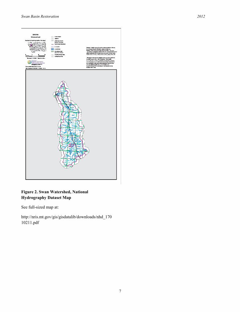
Figure 2. Swan Watershed, National Hydrography Dataset Map
See full-sized map at:
http://nris.mt.gov/gis/gisdatalib/downloads/nhd_17010211.pdf

Swan Basin Restoration 2012
8
The following information, excerpted from the TMDL, offers numeric targets for desired conditions and corresponding allocations,for example. the estimated load allotment to streams that will attain and maintain water quality standards. Targets and allocations are only provided for 303 (d) listed water bodies. Further clarification and justification for targets and allocations can be found in Sections 7 and 8 of the TMDL8.
Swan Lake
Primary Targets:
No decreasing percent saturation of dissolved oxygen (DO) in the bottom waters of Swan Lake and no increase in the spatial extent of the low DO area in the lake.
No increasing trend of nutrient and
chlorophyll a concentrations, no increasing trophic state index trends, and no decreasing trend in Secchi depth values in Swan Lake.
Secondary Targets:
No increasing trend in phosphorous, nitrogen, Total Suspended Solids (TSS) and organic carbon loads associated with human impacts entering Swan Lake from the Swan River.
Application of Montana Adapted Forestry Best Management Practices (BMPs) at stream crossings and near stream road segments.
o Applying BMPs to the extent
practical to the top75 sediment-producing sites identified in Section 5.2 and Appendix F.
o Applying BMPs to all new road segments.
No reductions in overall average
riparian canopy density and no increases in the spatial extent of the riparian zone in which canopy density is less than
8 TMDL, Pages 83-110
50% based on a comparison to the aerial photo assessment that was conducted for the TMDL based on 1997 aerial photography.
Jim Creek Primary Targets:
McNeil core substrate fine sediment (<6.35 mm) levels of no more than 35%.
Pools and Large Woody Debris: 50% pools with cover and at least 50 pieces of large woody debris (LWD) per 1,000 feet of channel.
Macro invertebrate community metrics associated with sediment must indicate full support conditions based on standard DEQ protocols.
Goat Creek
Primary Targets:
Total Suspended Sediment of less than 30 mg/l during peak flow conditions.
Macroinvertebrate community metrics associated with sediment must indicate full support conditions based on standard DEQ protocols.
Sedimentation to streams
During the initial TMDL assessment, 702 road/stream crossings were inventoried. Of these 702 crossings, 318 were noted to be sources, contributing 799 tons of sediment to streams. Crossings did not have equal impacts; only 50 sites contributed to 70% of total erosion, with all other crossings individually having a minor affect. A breakdown of sediment distribution to tributaries can be found in the TMDL9.
9 TMDL Figure 5-2, Page 31

Swan Basin Restoration 2012
9
Table 1. Source Load Allocations for Swan Lake10
10 TMLD, Table 8-1, Page 100 11 Particulate Organic Carbon 12 Streamside Management Zone
Source Area/Type Allocation Methods to Achieve Allocation
Road Erosion: Nutrient and POC11 loading associated with sediment
delivery from road erosion.
40% total reduction in modeled sediment loading from road stream
crossings (as defined in Section 5.2.1) based on the Forest Road Survey
(FRS) method
Road BMPs.
Riparian and Streambank Protection: Nutrient and POC loading associated
with eroding banks, loss of woody debris and riparian vegetation
impacts.
10% decrease in total loading throughout the Swan Lake
Watershed. Canopy density is used as a surrogate to measure progress.
Protect vegetation and banks on private, non-forest lands; recovery
from past riparian harvest; maintain and protect adequate channel
migration zones; compliance with Montana’s SMZ12 law.
Other Timber Harvest Impacts: Nutrient and POC loading from timber harvest (other than road
erosion and riparian harvest covered above); this also includes road
culvert failures.
No loading increase.
Ensure that mass wasting, peak flow increases, road failures, and hillslope
erosion impacts are controlled via implementation of restoration
activities and BMPs and reasonable land, soil and water conservation
practices.
Septic, Near-Shore (Swan Lake) and Additional Private (non-timber)
Landowner Management Activities: Nutrient and POC loading from
these sources.
Septic loading directly to Swan Lake: 3635 kg of nitrogen 100 kg of
phosphorous per year – this reflects no increase to Swan Lake based on
conservatively high loading estimates from Section 5.10. Also, no increased loading due to near-shore and other landowner property management
activities.
Septic maintenance, upgrades and other BMPs; private landowner management practices to limit
pollutant loading; continued training and education of septic contractors; adherence to state nondegradation
policy and other applicable state and local regulations.
Road Traction Sanding
Reduced loading via development and implementation of road sanding
and sediment delivery BMPs (performance-based allocation).
Development and implementation of road sanding and sediment delivery
BMPs.
Airborne Sources: Nutrient loading from airborne sources.
Allocation is contingent upon Flathead Lake TMDL phase
allocation approach for this source category.
Sources and loading rates need better definition.
Future Point Sources: Potential nutrient loading from yet-to-be
identified point sources.
An allocation consistent with the nutrient TMDL will be developed if a
point source is proposed.
Wastewater and other water treatment methods.
Swan Basin Restoration 2012
10
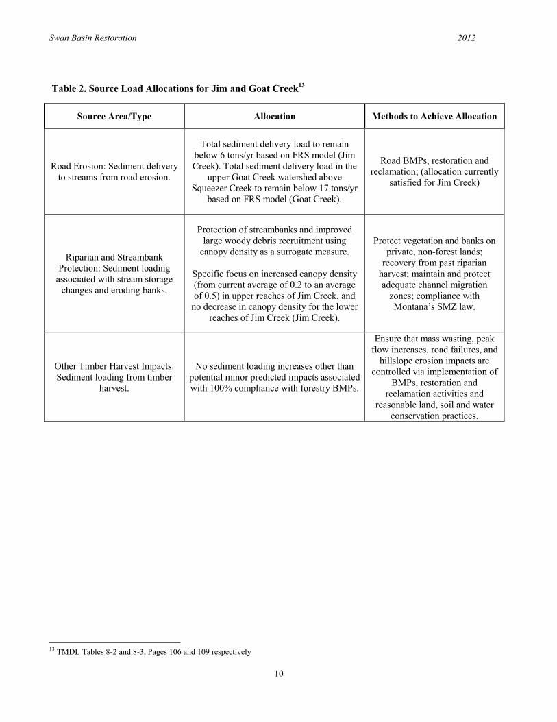
Table 2. Source Load Allocations for Jim and Goat Creek13
13 TMDL Tables 8-2 and 8-3, Pages 106 and 109 respectively
Source Area/Type Allocation Methods to Achieve Allocation
Road Erosion: Sediment delivery to streams from road erosion.
Total sediment delivery load to remain below 6 tons/yr based on FRS model (Jim Creek). Total sediment delivery load in the
upper Goat Creek watershed above Squeezer Creek to remain below 17 tons/yr
based on FRS model (Goat Creek).
Road BMPs, restoration and reclamation; (allocation currently
satisfied for Jim Creek)
Riparian and Streambank Protection: Sediment loading
associated with stream storage changes and eroding banks.
Protection of streambanks and improved large woody debris recruitment using
canopy density as a surrogate measure.
Specific focus on increased canopy density (from current average of 0.2 to an average of 0.5) in upper reaches of Jim Creek, and
no decrease in canopy density for the lower reaches of Jim Creek (Jim Creek).
Protect vegetation and banks on private, non-forest lands;
recovery from past riparian harvest; maintain and protect adequate channel migration
zones; compliance with Montana’s SMZ law.
Other Timber Harvest Impacts: Sediment loading from timber
harvest.
No sediment loading increases other than potential minor predicted impacts associated with 100% compliance with forestry BMPs.
Ensure that mass wasting, peak flow increases, road failures, and
hillslope erosion impacts are controlled via implementation of
BMPs, restoration and reclamation activities and
reasonable land, soil and water conservation practices.

Swan Basin Restoration 2012
11
Additional water quality threats identified by the
Water Quality Technical Advisory Group (TAG)
As a supplement to the TMDL, the TAG employed information collected from subsequent research efforts, monitoring data, professional observations, and other sources of best available science to identify current or potential threats to what the TAG
considered to be resources of value. These values are native fish and other aquatic life; clean drinking water; water supply/ in-stream flows. Listed in this section are water bodies that are known or suspected of being subjected to a threat or potential threat to resource values. This information can be used in conjunction with the TMDL in future project planning and prioritization
Native Fish and other aquatic life threatened value The threats to aquatic life are listed in Table 3 by water body in priority order. Justification for ranking is provided in the “rationale” column. Table 3. Threats to Native Fish and Other Aquatic Life
14 Integrated Transportation and Ecological Enhancements for Montana
Water body Stressor Cause Source Rationale Information Source
Cilly, Perry, Rumble, Soup, and Cooney
Creeks
Little or no habitat
connectivity
Poorly designed culverts block some or all of upstream fish
passage
Highway 83
Culverts block the most mileage of fish habitat; Cooney Creek may be
blocking bull trout
ITEEM 14inventory
Condon, Smith, and Peterson Creeks and
Beaver Lakes outflow Creek. Other barriers may exist on former
Plum Creek lands and are expected to be
discovered in the next few years.
Little or no habitat
connectivity
Poorly designed culverts block some or all of upstream fish
passage
Various Forest Service roads
Less mileage blocked than the highway
culverts
2002 USFS inventory
Swan River
Elevated water temperatures and decreased summer flows
Decreasing trend of snowpack, earlier runoffs
Climate Conditions
Threat and potential impacts are of great
concern, however, not ranked as highest priority because it
cannot be modeled and few actionable solutions exit to address climate
change as a cause
Temperature data by TAG. Flow data is
assumed based on patterns observed elsewhere
Holland Creek Elevated water temperature Ponding
Water diversion ditch on NFS land is ponding water
upstream
localized impact to Holland Creek but not critical for the rest of
the Swan Valley
USFS data
Red Butte, Hemlock, and Kraft Creeks
Elevated water temperature
Loss of stream shade
2004 Crazy Horse fire
localized to those streams and will
naturally decrease as vegetation returns
USFS data

12
Drinking water The potential for subdivision and development may pose a threat to drinking water (and other resource values) derived from adjacent streams or groundwater. Residential and commercial development increases the potential of septic discharge, herbicides, pesticides, fertilizers, pharmaceuticals, petroleum, and other pollutants reaching drinking water. There are no known actionable threats at this time; however, this issue should be monitored.
Water supply/ in stream flow Insufficient water supply for both consumptive needs and aquatic life is a potential threat in Lost Creek due to an increased demand for consumptive uses. At present, an application by the water rights holder is on file to divert the stream. The application has been denied, but can be resubmitted.
TAG Goals and Strategies
Since 2004, the TAG has focused on three main goals; reduce sedimentation from roads; monitor water quality; and provide public education on water quality topics. These goals align with many of the allocation targets identified in tables 1-3. The restoration activities undertaken by TAG follow guidelines developed in the existing Quality Assurance Project Plan (QAPP), completed in 2006 and delivered to DEQ. In addition, Sampling and Analysis Plans (SAP) address specific projects and TMDL objectives, and data collection and monitoring reports document changes in water quality. SAPs are developed and submitted to DEQ for approval prior to project implementation. The sections below show strategies for achieving the TAG’s three broad goals. Reduce Sedimentation from Roads (BMPs)
Section 915 of the TMDL defines strategies for water quality protection and improvement that address
15 TMDL Pages 111-17
specific land-use activities. Using the recommendations and strategies of the TMDL as a guide, the TAG has implemented successive road restoration projects annually, beginning in FY 2006. Prioritization of project sites is done yearly, aligned with the 319 Grant for Nonpoint Source Pollution funding cycle. Prioritization begins with a site recommendation from a representative of the Flathead National Forest. The TAG then evaluates the site with a field tour to identify specific source locations for repair. The tour is followed by a stakeholder discussion to finalize the proposed project area and scope. As of 2010, three restoration projects had been completed on roads classified among the top 75 sediment-producing. These restoration projects also included sites contributing sediment loads to adjacent streams that were not included in the top 75. As a result of these projects, an estimated 130 tons/year of sediment loading to streams has been reduced, according to the 2008 Swan Lake Watershed TMDL Implementation Program: Target Status Report. While the TMDL assessment has been a valuable tool in guiding road restoration projects, its inventory was not exhaustive and there are gaps that limit its function. For example, in recent years, the TAG has indentified many uninventoried sites to be significant sources of sedimentation. The TMDL only evaluated roads that crossed streams, excluding those roads close to streams that have the potential to be sources of chronic erosion. Additionally, the role of undersized or poorly installed stream culverts was not adequately considered in the initial TMDL development. Under-sized culverts may work fine for years but then catastrophically fail during a high water event and contribute very large amounts of sediment, possibly exceeding all other sources.
Ongoing BMP implementation, done independently by the USFS and DNRC also limits the TMDL for prioritizing projects. Since 2002, the Forest Service has independently (without 319 grants) reduced 60 tons of sediment (and associated nitrogen, phosphorus, and particulate organic carbon) at previously-identified sites by means of timber sale BMP improvements and appropriated funding. The work locations were in Holland, Barber, Glacier, and Beaver Creek watersheds. Future timber sales and associated BMP work planned in the Cat, Dog and Lion Creek drainages should reduce an additional 45

Swan Basin Restoration 2012
13
tons of sediment. Plum Creek Timber reports that they have reduced sediment to streams by an estimated 36% since the mid 1990’s by means of BMPs on haul routes. Therefore, in FY 2010-2011, two assessment projects were completed to update the status of the TMDL and inform TAG decision making in future road restoration prioritization. Both Forest Road Sediment Assessment Methodology (FroSAM) and Water Erosion Prediction Project (WEPP) monitoring was done at the top 75 sediment-producing sites identified in the TMDL. This inventory serves to monitor and evaluate progress made since the TMDL was written. Additionally, an assessment of over 100 stream crossing in the Glacier Creek sub-watershed were surveyed to estimate sediment loading.. Erosion potential to all scoured streams was estimated using WEPP, a methodology consistent with Forest Service protocol. The Glacier Creek survey also included a culvert risk assessment conducted using scoring developed by the Flathead National Forest and US Fish and Wildlife Service.
With this new information the TAG will use the same project prioritizing methodology used in previous years, recommending and prioritizing restoration needs in Glacier Creek. The group intends to follow a similar strategy, working sub-watershed by sub-watershed. The TAG will select a sub-watershed (prioritization based on size of sub-watershed, ownership make-up, grizzly bear habitat, and opportunity for cooperation), gather funding to inventory the road network, prioritize and plan the restoration work and then seek funding to correct problems. The TAG has previously worked in annual cycles but it may be more efficient to work on two sub-watersheds simultaneously and allow two years per project. It is likely that with continual road restoration projects, the entire Swan Lake watershed can have all significant road-related erosion problems resolved in about 10 years at the estimated cost of $1,650,000. The group will continue to seek funding from DEQ’s Nonpoint Source program as well as Future Fisheries and other available sources. Additionally, a new program through the Forest Service called Collaborative Forest Landscape Restoration Progra (CFLRP) is focusing restoration
efforts on the Swan Valley. In 2010, the Southwest Crown of the Continent16, which includes Swan Valley acreage, was selected to be 1 of the 10 CFLRP regions. The program will offer outstanding partnership funding to protect water quality. Monitor Water Quality
Section 10 of the TMDL describes a water quality monitoring and assessment plan, including monitoring parameters and evaluation methods for 303 (d) listed streams17. Additionally, all project and trend monitoring follows the guidelines presented in the Swan Quality Assurance Project Plan (QAPP), approved in 2006 by DEQ.18 Pre- and post- FroSAM monitoring is done for each road restoration project. In addition, trend monitoring has occurred in Swan Lake and many of its tributaries. From 2004 to 2006, SEC collected DO concentration data in Swan Lake’s north and south basins and DEQ continued this monitoring from 2007-2009. Areal Hypolimnetic Deficit (AHOD) was also incorporated into the Swan Lake monitoring program. SEC has also collected temperature data in Swan River and five of its tributaries, noted for high quality bull trout habitat, since 2005. The Flathead National Forest has conducted stream monitoring in accordance with PACFISH/INFISH Biological Opinion Effectiveness Monitoring Program (PIBO) protocol since 2008. A summary of monitoring results and water body status can be found in the Swan Lake Watershed TMDL Implementation Program: Target Status Report (PBS&J 2008)19.
Pre- and post- FroSAM monitoring: Conducted to verify correct implementation of restoration techniques. Monitoring results indicate that installing drain dips and new ditch relief culverts and other actions
16 The Southwest Crown of the Continent includes: Swan Lake Ranger District, Flathead National Forest; Seeley Lake Ranger District, Lolo National Forest; and Lincoln Ranger District, Helena National Forest. 17 TMDL Section 10, Pages 119-126 18 The QAPP is currently under revision (2012). The plan will be updated to include WEPP monitoring protocol and information regarding Beaver Creek. 19 Available at swanecosystemcenter.org
Swan Basin Restoration 2012
14
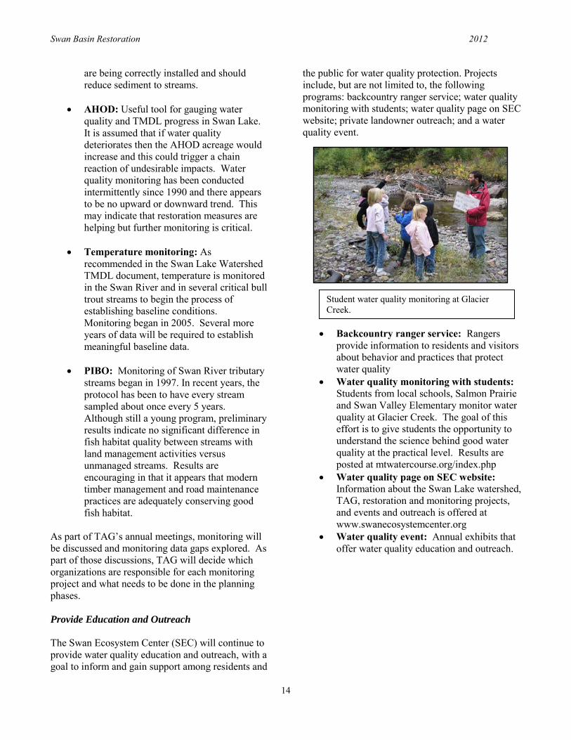
Student water quality monitoring at Glacier Creek.
are being correctly installed and should reduce sediment to streams.
AHOD: Useful tool for gauging water quality and TMDL progress in Swan Lake. It is assumed that if water quality deteriorates then the AHOD acreage would increase and this could trigger a chain reaction of undesirable impacts. Water quality monitoring has been conducted intermittently since 1990 and there appears to be no upward or downward trend. This may indicate that restoration measures are helping but further monitoring is critical.
Temperature monitoring: As
recommended in the Swan Lake Watershed TMDL document, temperature is monitored in the Swan River and in several critical bull trout streams to begin the process of establishing baseline conditions. Monitoring began in 2005. Several more years of data will be required to establish meaningful baseline data.
PIBO: Monitoring of Swan River tributary
streams began in 1997. In recent years, the protocol has been to have every stream sampled about once every 5 years. Although still a young program, preliminary results indicate no significant difference in fish habitat quality between streams with land management activities versus unmanaged streams. Results are encouraging in that it appears that modern timber management and road maintenance practices are adequately conserving good fish habitat.
As part of TAG’s annual meetings, monitoring will be discussed and monitoring data gaps explored. As part of those discussions, TAG will decide which organizations are responsible for each monitoring project and what needs to be done in the planning phases. Provide Education and Outreach
The Swan Ecosystem Center (SEC) will continue to provide water quality education and outreach, with a goal to inform and gain support among residents and
the public for water quality protection. Projects include, but are not limited to, the following programs: backcountry ranger service; water quality monitoring with students; water quality page on SEC website; private landowner outreach; and a water quality event.
Backcountry ranger service: Rangers provide information to residents and visitors about behavior and practices that protect water quality
Water quality monitoring with students: Students from local schools, Salmon Prairie and Swan Valley Elementary monitor water quality at Glacier Creek. The goal of this effort is to give students the opportunity to understand the science behind good water quality at the practical level. Results are posted at mtwatercourse.org/index.php
Water quality page on SEC website: Information about the Swan Lake watershed, TAG, restoration and monitoring projects, and events and outreach is offered at www.swanecosystemcenter.org
Water quality event: Annual exhibits that offer water quality education and outreach.

Swan Basin Restoration 2012
15
Conclusion and Outlook The TAG meets annually to set goals, recommend project activities, and identify potential partners and funding sources. Budgets are then developed for specific projects that can be completed over the next several months. If needed, grant funding is solicited. Please see Appendix A for information on projects planned, timeframes, and work accomplished.
[Right] John Wachsmuth [top] (MTFWP) and Beth Gardner (FNF) [below] speak with visitors at the 2009 water quality event, part of Huckleberry Days, Swan Lake.

Swan Basin Restoration 2012
16
CHAPTER 4. NATIVE FISH Introduction and Background
Diverse native and non-native fish species occupy the high quality waters of the Swan River basin. Native species include bull trout, westslope cutthroat trout, mountain whitefish, pygmy whitefish, slimy sculpin, northern pikeminnow, peamouth, longnose sucker, and largescale sucker. Non-natives include lake trout, rainbow trout, kokanee salmon, brook trout, northern pike, yellow perch, largemouth bass, lake whitefish, brook stickleback, central mudminnow, and pumpkinseed (Fish, Wildlife & Parks). This chapter focuses principally on bull trout, federally listed as “threatened” and westslope cutthroat trout, a Montana "species of special concern." These two species serve as management indicator species to all others. Historically, bull trout and westslope cutthroat trout maintained a robust and stable range in the lake and its tributaries. However, in the last 50 years, both populations have become a concern for government agencies, conservation organizations, and fishing groups. In 2009, a group of stakeholders identified the need for a more concentrated effort for westslope cutthroat trout restoration in the Swan watershed and formed the Native Fish Subcommittee of the SLCC. Participation in the Native Fish Subcommittee consists of representatives from Flathead Trout Unlimited (TU); Montana Department of Natural Resources and Conservation; Montana Fish, Wildlife & Parks; US Fish and Wildlife Service (FWS); USFS Flathead National Forest; Northwest Connections; and Swan Ecosystem Center. The Native Fish Subcommittee encourages restoration of the Swan Basin’s threatened native fish populations through coordinated management and monitoring and efficient implementation of existing conservation and restoration plans. Please see Appendix B for updates on the Native Fish Subcommittee’s accomplishments, activities and priorities.
Bull Trout Background
The Swan basin’s cold, clear waters provide high quality habitat for native bull trout populations and have allowed the species to remain stable despite its “threatened” status under the Endangered Species Act. Swan Lake populations are even considered healthy enough to be one of very few lakes in the United States that permits bull trout recreational harvest. However, the presence of non-native lake trout in the system is considered to be a real threat to bull trout’s security in the Swan. Concern for this threat came in the late 1990’s when anglers reported catching adult-sized (20-30 inch) lake trout in Swan Lake and the Swan River. Surveys completed in the Swan Lake watershed, from 2003-2005, revealed a growing presence of juvenile lake trout, indicating reproductive success within the system. Fear that lake trouts’ expanding population would ultimately diminish or eradicate bull trout populations is based on similar fisheries elsewhere that proved unable to cope the with stress of lake trout competition. Significant progress has been made in addressing threats to bull trout in the Swan basin due to the collaborative efforts of the multi-agency, Swan Valley Bull Trout Working Group (SVBTWG), which formed in 2004. This group has a Memorandum of Understanding, referred to hereinafter as bull trout MOU20, signed in 2005. The SVBTWG formed with representatives from MTFWP; DNRC; TU; FWS; FNF; and CSKT, for the purpose of developing “coordinated conservation measures for the long-term protection of bull trout in the Swan River watershed, Montana and addressing the threat of lake trout to the ecological integrity of bull trout in the Swan River watershed.” Goals and Objectives: Bull Trout
The Swan Lands Native Fish Subcommittee is
20 MOU available online: http://www.montanatu.org/issuesandprojects/library%20files/final_mou.pdf

Swan Basin Restoration 2012
17
committed to implementing the goals and strategies defined by the bull trout MOU: Goal “The management goal for bull trout in Swan Lake and the Swan River drainage (including Holland and Lindbergh Lakes) is to ensure the long-term, self-sustaining persistence of bull trout as the dominant piscivore within this ecosystem. In order to accomplish that goal we will emphasize the migratory life history strategy of bull trout; strive to maintain genetic diversity; and protect or enhance current distribution and abundance of bull trout local populations. Attainment of the management goal should result in a continuing opportunity to sustain recreational fishing opportunities for bull trout.”
Objective 1 Assess the threat that a reproducing lake trout population in Swan Lake and drainage presents to the existing bull trout resource. Objective 2 Design an effective monitoring program in order to document population trends of bull trout and lake trout in the Swan drainage. Objective 3 Organize and implement a Work Group action plan, to include a research agenda, educational and outreach program, and fishery management recommendations.
Restoration Effort Projects undertaken by the SVBTWG over the past several years include a lake trout distribution and feasibility control study, a mark and recapture population estimate, and depletion estimate. A three-year lake trout removal project began in 2009. According to the SVBTWG Experimental Removal of Lake Trout in Swan Lake, MT: 2009 Annual Report, the objective of the project is to “evaluate the efficacy of gill nets as a management tool to control the expansion of the lake trout population while minimizing the impact of these non-native fish on the bull trout and kokanee fisheries.” The short-term goal is to remove 50% of lake trout. In its inaugural year the effort resulted in the removal of 5,213 lake trout. This is a 54% reduction of lake
trout over 165mm in length and suggests that the project has a viable chance for success. The project continues into 2010 field season. The group prepares annual progress reports that offer population status and restoration strategies and accomplishments21. Critical habitat
Bull trout’s “threatened” listing under the Endangered Species Act places the species under federal regulation. The USFWS has designated Swan Lake and 17 of its tributaries as bull trout Critical Habitat (Figure 3)22.
21 Links to reports from 2004-present are available through Trout Unlimited at www.montanatu.org. 22 More information about FWS’s Critical Habitat designations for bull trout is available online at www.fws.gov/pacific/bulltrout/CrHabitat.

Swan Basin Restoration 2012
18
Figure 3. FWS Proposed 2010 Critical Habitat for Bull Trout, Swan River and Lakes

Swan Basin Restoration 2012
19
Westslope Cutthroat Trout Background and goals
Steps have been taken to aid in the recovery of westslope cutthroat trout throughout Montana, with a Memorandum of Understanding, referred to hereinafter as cutthroat trout MOU, signed in 2007. The short-term priority of the Native Fish Subcommittee is to establish a SRB management plan for westslope cutthroat trout. Objectives are to:
1. Determine the current status of westslope
cutthroat trout: identification of pure populations or those that can be expanded; identify populations at risk.
2. Designate focus areas within the watershed. 3. Prioritize restoration projects. 4. Implement restoration strategies as per the
westslope cutthroat trout MOU.
Historically westslope cutthroat trout enjoyed wide abundance in the Swan, occupying an estimated 500 miles of the watershed’s stream habitat. In the 1940’s, rainbow and brook trout were introduced to the Swan watershed. Both species found reproductive success. Brook trout are widely distributed in many tributaries and rainbow trout dominate the Swan River. Additionally, some Yellowstone cutthroat trout and golden trout were stocked in mountain lakes. Their presence in the system threatens the westslope cutthroat’s stability, impacting resource availability (in the case of brook trout and other species) and genetic purity (in the case of rainbow trout). Other factors, such as timber harvest and angler overharvest, may have also been a population stress to westslope cutthroat over time. Westslope cutthroat populations across the state of Montana have encountered similar threats, and the species has declined. The Memorandum of Understanding and Conservation Agreement for Westslope Cutthroat Trout and Yellowstone Cutthroat Trout in Montana was developed and signed in 2007 by the Montana Cutthroat Trout Steering Committee (MCTSC)23. The MCTSC includes multiple stakeholders across Montana including, but not limited to CSKT,
23 cutthroat MOU available online: http://MTFWPiis.mt.gov/content/getItem.aspx?id=28662
MTFWP, DNRC, PCTC, TU, USFS, and USFWS. Suggested implementation of the agreement would be “through more detailed regional and/or watershed conservation programs that are developed locally.” As such, the Swan Lands Native Fish Committee’s Swan Westslope Cutthroat Trout (WCT) Restoration Strategy is being developed to the following goals defined in the cutthroat MOU:
1. Ensure the long-term, self-sustaining persistence of each subspecies distributed across their historic range (identified in 2003, 2005 statewide status of westslope cutthroat trout in the U.S.).
2. Maintain the genetic integrity and diversity of non-introgressed populations, as well as diversity of life histories.
3. Protect the ecological, recreational, and economic values associated with [westslope cutthroat trout].
The objectives are:
1. Maintain, secure, and/or enhance all “conservation populations.”24
2. Continued effort to determine the status of cutthroat populations.
3. Seek collaborative opportunities to
restore and/or expand populations. 4. Continued monitoring. 5. Provide public outreach, technical
information, inter-agency coordination, administrative assistance, and financial resources to meet objectives and conserve cutthroat trout.
24 A “conservation population” is any population comprised of individuals that have no evidence of genetic introgression determined by genetic testing or populations with unique ecological or behavioral traits; a more detailed definition is available through the cutthroat MOU.

Swan Basin Restoration 2012
20
Current status
Figure 4 depicts the current status of westslope cutthroat trout in their historic range of steam habitat in the Swan Basin. Values were derived from a 2009 inter-agency data compilation and represent best available knowledge as of this date; values are subject to change in accordance with new data. Conservation populations The 20% of stream habitat occupied by genetically unaltered westslope cutthroat is not contiguous. Pure populations are currently known to be in 17 distinct stream segments and are designated as “conservation populations” (Figure 5). These populations show great variation in size, genetic purity, and security, all of which are considered by the Native Fish Subcommittee for project prioritization. Table 4 shows a summary of the 17 conservation populations (Swan WCT Restoration Strategy).
25 Numbers in italics indicate a supposed population estimate
Name Length (miles) Population Total25 Genetic Purity (percent) Threats
Bond 2.7 421 100 (estim.) Brook trout, hybridization
Cedar 4.4 5,570 100 None
Cooney 5.4 Unknown 100 Brook trout, development
Dog 6.2 2,100 95-100 Brook trout, hybridization
Groom 2.9 1,000 100 (estim.) Brook trout
Herrick Run 1.8 290 100 Demographic or stochastic risks
Kraft 11.9 miles 12,200 95-100 Brook trout, hybridization
Lindbergh-Crystal 10.4 1,100 Unknown Brook trout, hybridization
Lion 3.3 Unknown Unknown None
NF Lost 3.8 miles 807 100 Brook trout
SF Lost Unknown Unknown Unknown Unknown
Owl 1.3 147 100 (estim.) Brook trout, demographic or stochastic risks
Piper 4.9 3,200 Unknown Brook trout
Pony 1.3 1,092 99 Brook trout, hybridization
Sixmile 3.1 2,000 100 (estim.) None
Whitetail 0.5 300-750 100 Unknown
Wolf 3 miles 1700 95-99 Hybridization
20%
51%
29%
Westslope cutthroat trout population assesment in historic range, Swan Basin
2009
Genetically unaltered populations
Introgressed or scarce populations
Absent in historic range
Figure 4. Westslope cutthroat trout population assessment based on historic range, Swan Basin 2009 (note: the status of cutthroat trout in lakes is not incorporated into this assessment)
Table 4. Westslope Cutthroat Trout Conservation Population Characteristics, Swan Basin (Alphabetical).

Swan Basin Restoration 2012
21
Figure 5. Westslope Cutthroat Trout Conservation Populations, Swan Basin

Swan Basin Restoration 2012
22
Restoration strategies
The Native Fish Subcommittee has developed a prioritization matrix of restoration strategies. Table 5 offers restoration actions for each of the 17 conservation populations. Actions are coded by priority. An implementation schedule has not yet been developed. Priorities are based upon
available knowledge and subject to future assessment coordinated by the Native Fish Subcommittee.
Table 5. Restoration Priorities for Westslope Cutthroat Trout, Swan Basin
Site High Priority Moderate Priority Low Priority
Bond __ __
Evaluate barrier feasibility
Brook trout suppression
Cedar Restoration of lakes, if needed Evaluate and secure barrier Reduce risk of wildfire
Cooney Decision about Hwy 83 culvert Private landowner agreement
Dog __ Needs evaluation __
Groom __ Needs evaluation Herrick Run __ __ Habitat restoration
Kraft Install barrier Suppress brook trout, if needed __
Lindbergh-Crystal __ Needs evaluation __
Lion __ __ __
NF Lost Create secure barrier Suppress brook trout
SF Lost Unknown Unknown Unknown
Owl
Secure barrier
Eradicate brook trout
__ __
Piper __ __ Reduce risk of wildfire Pony __ Needs evaluation
Sixmile __ __ Private landowner agreement
Whitetail Brook trout eradication
immediately downstream
Expand to additional tributaries __
Wolf __ Evaluate and secure barrier Private landowner agreement

Swan Basin Restoration 2012
23
CHAPTER 5. WILDLIFE Introduction and Goals In addition to aquatic species, diverse and abundant terrestrial and avian wildlife species also benefit from the Swan basin’s high quality habitat. They include but are not limited to grizzly and black bear, lynx, wolverine, mountain lion, bobcat, whitetail and mule deer, elk, mountain goat, moose, bald and golden eagle, peregrine falcon, common loon, and northern goshawk. Initially, the Swan Lands Wildlife Subcommittee coalesced around the critical status of the Swan Valley’s grizzly bear populations. While the group’s short-term action strategies are still geared mostly toward grizzly bears, the subcommittee's focus has since broadened to include other of the basin’s native wildlife. The subcommittee’s goals are to: 1) sustain abundant and diverse aquatic, avian, and terrestrial native species; and 2) facilitate opportunities for human communities to exist in the natural environment, with stress on positive cohabitation with wildlife. Objectives are to:
1. Promote coordination among land owners and managers.
2. Promote data sharing and species reporting among stakeholders and with the public.
3. Expand and maintain public outreach,
education, and assistance. 4. Implement action strategies associated
with urgent need. Please see Appendix C for updates and reports that show the Wildlife Subcommittee’s accomplishments, activities and priorities. Restoration Needs To begin restoration planning, the Wildlife Subcommittee first outlined potential restoration
needs for wildlife by cohort, considering threats, the cause(s) for these threats, and the known or potential severity of each threat (Appendix A). Cohorts are ungulates; large and mid-sized carnivores; small mammals/rodents; cavity nesters; avian predators; migratory waterfowl; neotropical migrants; fire-dependent bird species; amphibians and reptiles; and pollinators. The subcommittee then distinguished those threats that were felt to be of greatest concern, which could be reasonably addressed. Human (residential) development was identified as the greatest threat to wildlife, coupled with four high-priority impacts. First, housing developments fragment the landscape, reducing or eliminating connectivity, which inhibits wildlife movement. Second, development may eliminate and/or reduce cover retention (both security screening and overstory cover). Third, agricultural and residential land conversion can alter and/or disturb habitat. Lastly, the increased potential for negative human-wildlife interaction correlates with increased residential density. Negative interactions include habituation and human attractants that can result in management deaths and intolerance, misunderstanding, and insufficient public outreach and education. Additionally, forest management was identified, not as a threat, but as critical to wildlife security. Forestry management should be monitored, refined, and maintained.

Swan Basin Restoration 2012
24
Table 6. Impacts to Wildlife from Development
Impact Sources of Information Information Gaps Existing Restoration Projects
Loss and/or reduction of habitat connectivity
MTFWP subdivision commentary ; MTFWP winter
range maps/aerial photos; MTFWP C.A.P.S26
Reliable historical estimates and reliable population
viability information for small mammals/rodents
__
Habitat alteration and/or disturbance
Aerial photos; MTFWP C.A.P.S __ __
Loss and/or reduction of cover retention
DNRC GIS databases on mapped winter range; MFWP Winter Range Maps; Aerial
photos/GIS modeling for security area; Agency Stand
Level Inventory GIS databases; NwC tracking data
__ __
Negative human-wildlife interaction: Management
deaths associated with habituation, human attractants
MTFWP Mortality records; IGBC27 guidelines; State of
Montana structure digitization
Unreported conflicts/ mortalities
Bear Resistant Garbage Container Loaner Program; SVBR28 property consulting
Negative human-wildlife interaction: Intolerance;
misidentification; insufficient public knowledge
MTFWP mortality records; MTFWP game warden; Swan
Valley Bear Ranger
Unreported conflicts/ mortalities
MFWP hunter education, online education; SVBR Bear Fair,
Wake-up Social
26 MTFWP Crucial Area Planning for Species 27 Interagency Grizzly Bear Agreement 28 Swan Valley Bear Resources

Swan Basin Restoration 2012
25
[Above] Fencing project prescribed by SVBR property consultation program, funded through SVBR by the Northern Rockies Conservation Cooperative. [Left] Bear-resistant garbage bin available through SVBR Loaner Program.
Restoration Strategies This section presents restoration strategies for the high-priority impacts identified above, offering both a summary of existing programs aimed at addressing needs and approaches for future consideration. Swan Valley Bear Resources
Swan Valley Bear Resources (SVBR) is a smaller task force of the Wildlife Subcommittee that provides community resources to promote a positive coexistence between people and bears. SVBR active partners include NwC, SEC, and the Swan Valley Bear Ranger, with support from DNRC, MTFWP, USFWS, USFS, Defenders of Wildlife, Interagency Grizzly Bear Committee, and private donations. Many of the initiatives executed by the SVBR serve to address the high priority concern of negative human-wildlife interactions. While other defined impacts are considered to be of greater threat, actionable solutions are limited by the regulations and protocols of county planning. Negative human-wildlife interaction is more easily addressed by community programs. Swan Valley Bear News, Bear Fair, and Spring Wake-up Social are education and outreach programs that provide opportunity for experts in the bear research, management, and conservation fields to relay information to the residents, in an attempt to combat issues such as insufficient public knowledge and/or public intolerance. Property consultation and a Bear Resistant Garbage Container Loaner Program serve to limit the human attractants on private property. More information about these projects is available in the 2009 SVBR annual report29. The SVBR plans to continue its effort to promote human-bear co-existence. Specific projects include a bear conflict/observation database, neighborhood networking, fencing projects, and continuation of existing programs.
29 Available online: www.swanecosystemcenter.org/ documents/stewardship/wildlife/SwanValleyBearResources-AnnualReport-2009.pdf
Future planning
To more specifically address the threat of human development and the consequences associated with it, the Wildlife Subcommittee has developed the following strategies:
1. Promote coordination among stakeholders and private residents as they are planning habitat-altering activities;
2. Develop ‘best practices’ for developers and others wishing to promote wildlife co-existence and reduce impacts to overall habitat quality and connectivity;
3. Work with Rural Initiatives, federal and
state agencies, and local conservation organization on inventories and analyses aimed at addressing the pattern of human development.

Swan Basin Restoration 2012
26
CHAPTER 6. FOREST STEWARDSHIP Introduction The forests of the Swan Valley are among the most diverse and productive in Montana. These forests play an integral role in sustaining the Valley's ecosystems and the community. The Forest Stewardship Subcommittee brings public and private land owners and land managers together to ensure that the forests of the Swan Valley continue to support a local wood products industry, healthy wildlife populations, diverse native plant communities and ample recreational opportunities. Participants in the Forest Stewardship Subcommittee currently include representatives from the Department of natural Resources and Conservation, Flathead national Forest, Northwest Connections, Swan Ecosystem Center, The Trust for Public Land, The Nature Conservancy, Northwest Management, as well as private residents and contractors. For the past several years, the group has focused on management challenges associated with the Valley’s checkerboard ownership pattern and, more recently, the blocking of that checkerboard stemming from the Montana Legacy Project. Now that the Legacy Project (Figure 6.) is implemented the subcommittee has the opportunity to focus its efforts more exclusively on restoration and sustainability. This new opportunity is met by new challenges, one of which is the unfamiliar and, at times, complex conditions of The Nature Conservancy/Trust for Public Land’s Fiber Supply Agreement with Plum Creek Timber Company30. Given the group’s transitional status, the subcommittee members are unable to develop restoration priorities and projects at this time. Instead, the subcommittee developed preliminary objectives and actionable steps that will aid in future coordinated and collaborative restoration. Since each agency has its own forest plan or mandate, there is more potential for coordination than true collaboration
30 Agreement between TPL/TNC and PCTC whereby TNC/TPL is obligated to provide 92 MM board feet of timber to Plum Creek over 10 years, harvested off Legacy lands. Harvest will be third party certified as sustainable forestry.
Please see Appendix D for updates and reports that show the Forest Stewardship Subcommittee’s accomplishments, activities and priorities.
Goal 1. Seek Opportunities for Coordination
One goal of the Forest Stewardship Subcommittee is to productively use limited dollars and time. Coordination between agencies and groups is essential for achieving this goal, so that individual efforts are not wasted or duplicated and all relevant funding options are being explored. In order to facilitate better coordination, the Forest Stewardship Subcommittee proposes the following objectives/strategies:
1. Emphasis upon forest management. The group promotes active forest management to restore or sustain mutual resource values, using means deemed appropriate respective to each agency (List of agency mandates available in Appendix B);
2. Encouragement of private forestland management and restoration. To facilitate good forest management practices on and restoration of the watershed’s privately owned forestlands the group aims to promote the development and/or expansion of programs that provide technical and financial assistance to landowners for completion of on-the-ground conservation and restoration projects.
3. End of year coordination meetings. The group seeks to continue meeting annually or bi-annually for the purpose of disseminating information, regarding projects and funding.
4. Attention to collective impact. To ensure
management is environmentally appropriate and cost beneficial, strategies look at landscape scale impacts.

Swan Basin Restoration 2012
27
5. Mapping initiative. To better coordinate individual projects, the group proposes map overlays showing planned work areas. Possible components include DNRC planned projects for the next three years, FNF planned projects for the next three years, and Northwest Management forest inventory. In addition to the outlook mapping described above, the subcommittee proposes mapping to illustrate the cumulative effects of public and private forest management. Components may include fuels mitigation work done by DNRC, FNF, and private residents through SEC actuated grants.
Goal 2. Seek Opportunities for Collaboration The Forest Stewardship Subcommittee identified a forest roads assessment as the greatest opportunity to collaborate. Roads are linked with all restoration efforts to be done in the basin. Weed management, fuels mitigation, road restoration, habitat restoration, vegetation management, and most other activities require roads. The conversion of Legacy lands to federal land provides a valuable opportunity to regard the basin’s current road system through a process that involves agency managers, logging contractors, conservationists, and other stakeholders in forest resources. Roads may be the single most important area for common management purposes. Next Steps Following the completion of primary objectives some next steps for the Forest Stewardship Subcommittee include:
Spatially explicit planning with identification of priority need areas
Weed management strategies, aligned with CFLRP funding.

Swan Basin Restoration 2012
28
Figure 6. Montana Legacy Project, Swan Watershed

Swan Basin Restoration 2012
29
Ditch draining large glacial wetland on private ownership in the Kraft Creek area.
CHAPTER 7. WETLANDS
Introduction One of the most unique and ecologically important aspects of the Swan basin is its abundance and variety of wetlands. These wetlands, and all of the connected riparian linkages that run between them, function as high quality habitat for many of the basin’s most sensitive plant and animal species. Important ecosystem services such as water purification, flood control and groundwater recharge are achieved through these wetlands. The Wetlands Subcommittee functions mainly through partnerships with private and public landowners in the Swan Valley to prevent wetlands conversion and to restore high priority wetlands. The subcommittee was formed in 2008 to identify, assess, prioritize and conserve wetlands for the benefit of people, fish, wildlife and native plants. Please see Appendix E for updates and reports that show the Wetlands Subcommittee’s accomplishments, activities and priorities.
Restoration Needs The need for wetland restoration in the Swan basin is the consequence of three primary threats or sources of impairment.
1. Full or partial wetland drainage. Prevalent on former homestead lands where drainage occurred to create pasture land.
2. Dredging or deepening of natural wetland basins, which diminishes or eliminates ecological value
3. Poor management; i.e. poor grazing practices that degrade wetland health.
Restoration Strategy Goals and objectives
The goal of the Wetland Subcommittee’s restoration and conservation strategy is to produce a visual “roadmap” that will aid in choosing collaborative and cooperative projects on wetlands in need of restoration or conservation. Objectives are to:
Rank each wetlands in the Swan River watershed as a “high”, “moderate” or “low” priority for protection/restoration;
Produce a visual display of prioritization results to assist in development of wetland protection/restoration strategies, including identification and implementation of specific projects.
Process
The subcommittee began by choosing conservation targets. The conservation targets were selected to be indicators of the health and productivity of the system. Conservation targets were identified to be: loons; trumpeter swans; plant species of concern; herpertofauna diversity; and wetland resources/ waterfowl. For each conservation target, a set of criteria (based on scientific data and expert opinion) was developed. The criteria served as a filter by which habitat was evaluated and subsequently ranked. Criteria were developed to discern sections of highest value or potential value to the conservation target, not to identify areas of greatest stress. The criteria for each conservation target can be found in Appendix C. Spatial analysis was then conducted using these criteria filters, illustrating sections of highest value. It is these spatial outputs that will

Swan Basin Restoration 2012
30
serve as the foundation by which project areas are determined. Figures 7-X show the results from the criteria-based spatial analysis31.
31 Note: Spatial analysis and development of this plan were done concurrently. Completion of these analyses did not occur in time for project prioritization based on these results to be in included in this document.
Swan Basin Restoration 2012
31
CHAPTER 8. CONCLUSION Swan Basin Restoration is meant to be a living document that should be altered or added to as new information becomes available and as SLCC subcommittees better define their respective roles within the watershed, particularly moving beyond the Legacy Project. Swan Basin Restoration has the potential to not only guide restoration planning for subcommittees individually, but also for the SLCC committee structure as a whole, offering greater opportunity for coordination among subcommittees. The SLCC structure is a model for cooperative watershed management. Continued efforts to enhance the ability of agencies and groups to communicate and coordinate with each other will serve to benefit the Swan basin's natural resources. Periodic Review and Revision of the SRB Plan This plan will be kept alive and current in two main ways. Each subcommittee will prepare a short update, at least annually, that outlines its accomplishments, activities, and priorities for that year. These reports are added to Appendices A-E. Second, every three years, each subcommittee reviews its restoration planning goals, objectives and strategies found in Chapters 3-7, considering best available scientific information, results of prior projects, funding capacity, and other factors.

Appendix A – Threats to Wildlife in the Swan Basin as Indentified by the Swan Lands Wildlife Subcommittee
1
Value Stressor Cause/Source
Cause/source rating (High, moderate,
low)
Known/ potential problems and problem areas
Sources of Information Information Gaps Comments
Ungulates
Loss of winter range/ habitat stacking and
over-browsing
Forest management activity
in critical winter range High
Areas ( of varied ownership) east of Swan River, especially areas with
south, southwest aspects that have been clear-cut or heavily thinned -
north side at the mouth of Lion Canyon and similar areas at the
mouths of major tributaries coming out of the Swan (i.e. Cooney, Holland,
Goat, Squeezer, etc)
Winter Range maps: MFWP; DNRC; Aerial photos of PC
lands
Effects on seasonal ranges from climate
change; long-term effects from wildland-urban
interface management
PC may have GIS database on their land that they have
shared with USFS or TNC
Fuels reduction in winter
range Moderate
In order of potential for negative effects to thermal cover on winter
range: Meadow Smith project, Cooney McKay project, and Holland Pierce
project
MFWP Winter Range Maps; Aerial photos of
predominately FS sections; Monitoring results post
treatment
Effects on seasonal ranges from climate
change; long-term effects from WUI fuels mgmt
Residential development High Permanent loss on many residential
properties; See above MDFWP Winter Range Maps;
Aerial photos
Disturbance related to
humans and domestic pets Low Extent of the problem
Loss of habitat
connectivity
Forest management Moderate Legacy lands MDFWP Winter Range Maps;
Aerial photos

Appendix A – Threats to Wildlife in the Swan Basin as Indentified by the Swan Lands Wildlife Subcommittee
2
Development Moderate Permanent loss on many residential
properties, areas of new development
Subdivision commentary by MFWP; MFWP winter range
maps/aerial photos
Threats to security habitat (increases
human/animal encounters during hunting season or
other times)
GIS modeling for security areas e.g. buffer 1/2 mile
from active roads etc. literature reflects different
modeling for species
High road densities Low PC/former PC ownership seem to have the highest road densities
Agency/PC GIS road density databases; SVGBCA (closure
effectiveness figures) and (USFS) A19 monitoring
reports
Over time, if not used, roads will re-vegetate and become less of a negative factor to wildlife security
Road Closure violations
(damaged gates, 4-wheeler and motorcycle use)
Low Forestlands adjacent to private
property and older PC closure areas
Annual SVGBCA (closure effectiveness figures) and
(USFS)A19 monitoring report
Extent of violations (e.g. levels of illegal OHV use and effects on security)
Low cover habitat ratios or lack of screening cover from
open roads caused by excessive harvesting
Moderate Private land (agricultural conversion, residence areas, PCTC legacy lands)
Agency Stand Level Inventory GIS databases; Security
modeling/ MFWP Winter Range Maps/ Aerial photos
Long distances to cover
caused by excessive harvesting
Moderate Private land (agricultural conversion, residence areas, PCTC legacy lands)
MDFWP Winter Range Maps / Aerial photos
Highway mortality http://mdtinfo.mdt.mt.gov/research/docs/research_proj/seeley/final_repo
rt.pdf
Montana DOT (Pat Basting) or FWP
Links to two studies done by MDT, one specifically
deals with WVC's on Hwy 83

Appendix A – Threats to Wildlife in the Swan Basin as Indentified by the Swan Lands Wildlife Subcommittee
3
Speed limit High Hwy. 83 MDFWP, Highway Dept.,
anecdotal
Traffic volume (see MDOT
report) High (see
MDT report) Hwy. 83 (see MDT report)
MDFWP, Highway Dept., anecdotal
Disease
Human feeding of deer and elk - potential for chronic
wasting disease Low
Disease transmission from
livestock to wild populations
Low Grazing permits by USFS or
DNRC; FWP biologists
How much livestock use in Swan on priv.
property?
possibly affecting mt. goat populations?
Large Carnivores
Management deaths
Habituation- human
attractants High (for
bears) Areas adjacent to private property;
areas coded MS:1 by IGBC
IGBC guidelines and structure digitization by State of
Montana; MFWP Mortality records
Unreported conflicts/ mortalities
Livestock Low-
moderate
No livestock losses have been confirmed so far (for wolves), but at least one claim of harassment of horses. But it's only a
matter of time as there are some/many small
producers throughout the valley that have goats, sheep, llamas, horses,
cattle, etc well integrated within the urban interface. I believe there has been at least 1 instance of livestock loss/grizzly bear - last year?
Illegal killing

Appendix A – Threats to Wildlife in the Swan Basin as Indentified by the Swan Lands Wildlife Subcommittee
4
Misidentification, lack of
education Moderate (for
bears) MFWP mortality records
unreported conflicts/ mortalities
Malicious/ low tolerance low-high Areas adjacent to private property unreported mortalities 1 documented illegal mortality documented
Negative human/wildlife
interactions/ perceptions
Increased density of
residential development Moderate-
High Areas adjacent to private property
MDFWP reports; Bear Ranger; game warden
Unreported incidents
Deer feed, bringing prey
close to homes Low
Areas adjacent to private property; desire to have deer and other wildlife
in yard
MDFWP reports; Bear Ranger; game warden
Unreported incidents
Gardens, livestock Moderate Areas adjacent to private property
IGBC guidelines and season dietary habits of bears; MFWP
reports; Bear Ranger; game warden
Unreported incidents
Intolerance/
misunderstanding/ low public knowledge
Moderate; High wolves
Areas adjacent to private property MDFWP reports; Bear Ranger;
game warden Unreported incidents
Highway mortality NwC tracking data or MTFWP
telemetry data; MDOT (Pat Basting)
Are certain crossing areas preferred by large
carnivores?

Appendix A – Threats to Wildlife in the Swan Basin as Indentified by the Swan Lands Wildlife Subcommittee
5
Carcasses along highway Moderate Adjacent to Hwy 83 or forest roads
(wolves) Highway Dept. and MDFWP
1 forest road vehicle collision documented so far
and 1 highway mortality (for wolves).
High bisects-need for
natural habitat
Limited food source White bark pine, berry crops, drought,
climate change, fire suppression
What is going on with army-cutworm moths
and other important high elevation insect food resources for bears?
Natural fluctuations in food source can be worsened by
management decisions (e.g. not aligning hunting quotas to adjust for prey
abundance)
Moderate Other protein source for bears besides declining
white bark pine?
Although there may be other factors further influencing ungulate
populations like FWP tag sales and veg manipulation
in winter range, white-tailed deer pops would
normally fluctuate and wolf population otherwise
robust enough to adapt on their own.
Insects and disease Moderate
Climate change Low to
Moderate
Prescriptive literature appearing through UMT,
USFWS, USGS, and private organizations
How climate change will actually affect wildlife?
Loss/reduction of
habitat connectivity

Appendix A – Threats to Wildlife in the Swan Basin as Indentified by the Swan Lands Wildlife Subcommittee
6
Fire suppression Effects of fire suppression and forest management on lynx forage habitat?
Forest management
practices Moderate
Canada Lynx Conservation Assessment and Strategy;
Aerial photos
Habitat
alteration/disturbance
Residential development High Private land (agricultural conversion,
residence areas) Aerial photos
Inappropriate forest
management for wildlife species
Moderate
Timber harvest in sensitive
areas; forest management/winter range
Moderate
Threats to security habitat (increases
human/animal encounters during hunting season or
other times)

Appendix A – Threats to Wildlife in the Swan Basin as Indentified by the Swan Lands Wildlife Subcommittee
7
High road densities Low to
Moderate
PC/former PC ownership appears to have the highest road densities- older
PC closure areas adjacent to forestlands; Miscommunication
between agencies for actual travel behind gated roads; forestlands
adjacent to private property
Agency/PC GIS road density databases; SVGBCA and A19
monitoring reports
If agencies are contacting F.S. district to travel
behind gates?
Forest Service tracks administrative road usage
important for other agencies to coordinate; Over time, if not used,
roads will re-vegetate and become less of a negative
factor
Road Closure violations
(damaged gates, 4-wheeler and motorcycle use)
Moderate Private land (agricultural conversion, residence areas, PCTC legacy lands)
Annual SVGBCA monitoring report (Closure effectiveness figures); security modeling; MFWP Winter Range Maps;
Aerial photos
Extent of violations (e.g. levels of illegal OHV use and effects on security)
Low cover habitat ratios or lack of screening cover from
open roads caused by excessive harvesting
Moderate Private land (agricultural conversion, residence areas, PCTC legacy lands)
Agency stand level inventory GIS databases; MFWP Winter
Range Maps; Aerial photos
Long distances to cover
caused by excessive harvesting
Moderate Private land (agricultural conversion, residence areas, PCTC legacy lands)
MDFWP Winter Range Maps / Aerial photos
Mid-size Carnivores
Over trapping Trapping quotas, trapper education FWP
Road densities combined with isolated patches of
good habitat Moderate
Agency GIS databases/ air photos/FWP biologists; MFWP trapping records
Unreported trapping results

Appendix A – Threats to Wildlife in the Swan Basin as Indentified by the Swan Lands Wildlife Subcommittee
8
state trapping quotas don’t
accurately reflect Swan Valley populations
Low Reliable population
viability info
Forest fragmentation
In adequate representation of mesic old growth, mature, structural
complexity, and multi-storied forest, especially in low elevations (valley
bottom). Much of the former Plum Creek sections that have been clear-cut are problematic, especially areas across all ownerships that have been clear-cut too close to streams which
are typically mature, mesic, and structurally complex. Examples
include, Glacier Creek, Cooney Creek, Smith Creek, Cold Creek, and pretty much every other major Swan River
tributary.
Agency stand level inventory GIS databases/ air photos
Timber harvest that does not necessarily recognize
and/or adequately preserve natural corridors
Moderate NwC tracking database and
MT Natural Heritage database; Aerial photos
Where or If species occur in the Swan?
Highway 83 Low Along highway corridor
Habitat loss/reduction
Inappropriate forest
management for wildlife species
High Highest potential on private and PCTC
legacy lands; also potential on FS forestlands
Historical information; GIS modeling; aerial photos
Wetland alteration--
dredging, digging High Private lands
County records and aerial photos
Extent of alteration on private property
Specific to riparian/wetland species
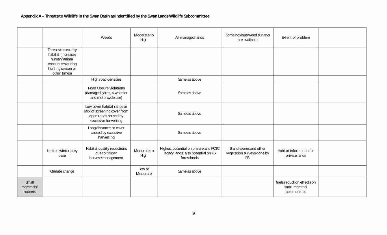
Appendix A – Threats to Wildlife in the Swan Basin as Indentified by the Swan Lands Wildlife Subcommittee
9
Weeds Moderate to
High All managed lands
Some noxious weed surveys are available
Extent of problem
Threats to security habitat (increases
human/animal encounters during hunting season or
other times)
High road densities Same as above
Road Closure violations
(damaged gates, 4-wheeler and motorcycle use)
Same as above
Low cover habitat ratios or lack of screening cover from
open roads caused by excessive harvesting
Same as above
Long distances to cover
caused by excessive harvesting
Same as above
Limited winter prey
base
Habitat quality reductions due to timber
harvest/management
Moderate to High
Highest potential on private and PCTC legacy lands; also potential on FS
forestlands
Stand exams and other vegetation surveys done by
FS.
Habitat information for private lands
Climate change Low to
Moderate Same as above
Small mammals/
rodents
fuels reduction effects on small mammal communities

Appendix A – Threats to Wildlife in the Swan Basin as Indentified by the Swan Lands Wildlife Subcommittee
10
Habitat loss/reduction Low to
Moderate Removal of downed woody debris for
fuels reduction
Timber harvest records for FS and PCTC, aerial photos,
historical vegetation records
Reliable historical estimates and reliable
population viability information
habitat connectivity roads low
Cavity Nesters
Lack of suitable nest
sites
Snag removal from
firewood cutting High
Road closure violations lead to additional large snag removal along road corridors -open roads and near
private property
Anecdotal and firewood permit records/conversations
Lack of snag recruitment
due to moderate and high severity fire exclusion
High Forestlands Fire History records Reliable historical
information on snag availability
Removal of snags by post-
fire and insect/disease salvage logging
Moderate PCTC Legacy lands Aerial photos and logging
records for PCTC
lack of large diameter snags recruitment due to harvest
of mature (live) trees High PC Legacy lands
Agency stand level inventory GIS databases; Aerial photos
and logging records for PC
Avian predators
Decreased ability to locate and capture prey (importance varies by species)

Appendix A – Threats to Wildlife in the Swan Basin as Indentified by the Swan Lands Wildlife Subcommittee
11
Increase in small/young tree densities due to fire
exclusion Low Ponderosa pine stands
Historical vegetation records for the Swan Valley; also
broad scale studies
Harvest of suitable perch sites -i.e. larger trees (can be issue for short-duration
perch-an-scan hunters)
Low Private lands and PCTC Legacy lands Aerial photos and forest mgmt records for PCTC
Reproductive failure
Harvest of nest trees Moderate Same as snag discussion
Timber harvest around nest site during breeding season
Moderate Same as snag discussion
Loss of suitable nest sites for eagles and
ospreys
Removal of large snags, lack of large snag recruitment
Moderate Adjacent to lakes; especially near
residences/cabins Aerial photos; habitat surveys
Historical info on habitat quality
Migratory waterfowl
interference during
nesting
What role mid to upper elevation lakes play for migratory birds in the
Swan?
boats/ jet skies Moderate to
High Lakes with homes
Loon Ranger reports; anecdotal; surveys
Unreported incidents and mortalities
human activity on the
shoreline
stress preventing
nesting at new/historic sites
Boat traffic Moderate to
High Lakes with homes
Loon Ranger reports; anecdotal; surveys
Unreported incidents and mortalities
Development

Appendix A – Threats to Wildlife in the Swan Basin as Indentified by the Swan Lands Wildlife Subcommittee
12
Recreation
Loss of breeding
habitat
Manipulation/destruction of wetland and riparian
habitats High
Private property; especially where agricultural conversion has taken
place
Past and present aerial photos; anecdotal
Reliable historical information on snag
availability
Neotropical migrants
Loss of high quality nesting and foraging
habitat
a variety of Forest Service and Avian Center point
counts
Manipulation/destruction
of wetland and riparian areas
High Private property; especially where agricultural conversion has taken
place
Past and present aerial photos; anecdotal
Reliable historical information on snag
availability
Loss of structural and
compositional complexity in forest stands
Moderate Highest potential for problem areas would be private and PCTC Legacy
lands
Extent of negative effects is not known
Fire-dependent bird species
Loss of suitable foraging habitat
Landscape-scale fire exclusion
High Reliable population
viability needs
Loss of suitable nest
sites
Moderate/high severity fire
exclusion High
Reliable population viability needs
Post-fire salvage logging Moderate to
High
Reliable population viability needs

Appendix A – Threats to Wildlife in the Swan Basin as Indentified by the Swan Lands Wildlife Subcommittee
13
Amphibians & reptiles
Habitat loss/reduction Amphibian surveys (FS;
other?); older vs. newer aerial photos
Climate change Low to
Moderate
Extent of problem; historical vs. existing
reference points.
Development High Private lands Aerial photos; county records
Wetland alteration High Private lands Aerial photos; county records
Pollinators
Lack of food source Weeds Extent of problem;
historical vs. existing reference points.

Appendix B – List of Management Plans and Mandates
1
Flathead National Forest Land and Resource Management Plan (Forest Plan) provides the Flathead National Forest with management direction towards defined goals. The plan includes: desired conditions; objectives; guidelines; suitability of areas; special areas. The Forest Plan does not establish law, regulations, or policy.
State Forest Land Management Plan is programmatic plan for the Department of natural Recourses. It provides general policies and guidelines for management, but does not offer precise targets for individual resources or offer site-specific land use planning. The U.S. Fish and Wildlife Service administers the Endangered Species Act for native fish and wildlife. The act stipulates development of recovery planning and provides enforcement of federal protection laws. The Swan Valley Grizzly Bear Conservation Agreement with the Plum Creek Timber Company and The Nature Conservancy, Department of Natural Resources and Conservation, US Forest Service, and the US Fish and Wildlife Service. Montana Administrative Rules for Forest Management, Streamside Management Zones: Best Management Practices for Forestry indicate measures designed to protect soil and water resources. The following table, provided by Missoula County Rural Initiatives, lists the existing regulations for land development in Missoula County:
Name and Permitting Agency Extent of Protection Setback or Regulation
A. Montana Natural Streambed and Land Preservation Act (310 Permit) Missoula Conservation District
Streambed and immediate banks of perennial streams/rivers
Regulates (prohibits some activities) ground disturbing activities in or on the banks of a stream on private projects. Prohibits the removal of stream bank vegetation within the immediate banks of the stream. “Immediate” is not defined by a distance. Some buffer widths have been set for some streams and rivers ranging from a minimum of 10 feet on small streams up to 50 feet on large streams and rivers.
B. Stream Protection Act (124 Permit) Montana Fish Wildlife and Parks
Streambed and immediate bank
Regulates (prohibits some activities) ground disturbing activities on the bed or banks of a stream on public projects.
C. Montana Floodplain and Floodway Management Act Missoula County/Floodplain Administrator
100 year floodplain as identified by FEMA.
No building in the floodway – variable distance
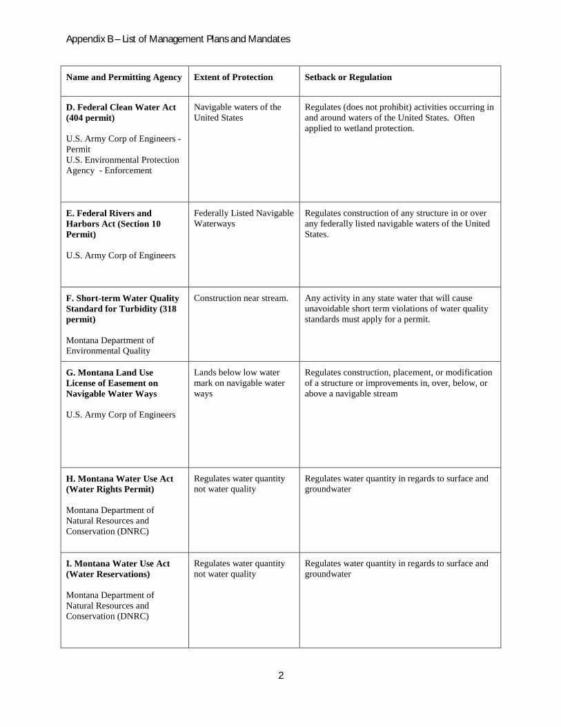
Appendix B – List of Management Plans and Mandates
2
Name and Permitting Agency Extent of Protection Setback or Regulation
D. Federal Clean Water Act (404 permit) U.S. Army Corp of Engineers - Permit U.S. Environmental Protection Agency - Enforcement
Navigable waters of the United States
Regulates (does not prohibit) activities occurring in and around waters of the United States. Often applied to wetland protection.
E. Federal Rivers and Harbors Act (Section 10 Permit) U.S. Army Corp of Engineers
Federally Listed Navigable Waterways
Regulates construction of any structure in or over any federally listed navigable waters of the United States.
F. Short-term Water Quality Standard for Turbidity (318 permit) Montana Department of Environmental Quality
Construction near stream. Any activity in any state water that will cause unavoidable short term violations of water quality standards must apply for a permit.
G. Montana Land Use License of Easement on Navigable Water Ways U.S. Army Corp of Engineers
Lands below low water mark on navigable water ways
Regulates construction, placement, or modification of a structure or improvements in, over, below, or above a navigable stream
H. Montana Water Use Act (Water Rights Permit) Montana Department of Natural Resources and Conservation (DNRC)
Regulates water quantity not water quality
Regulates water quantity in regards to surface and groundwater
I. Montana Water Use Act (Water Reservations) Montana Department of Natural Resources and Conservation (DNRC)
Regulates water quantity not water quality
Regulates water quantity in regards to surface and groundwater

Appendix B – List of Management Plans and Mandates
3
Name and Permitting Agency Extent of Protection Setback or Regulation
J. Stormwater Discharge Permit Montana Department of Environmental Quality
Regulates runoff from ground disturbing activities on more than 1 acre
Regulates activities within 100 feet of a stream.
L. Local Regulations: Riparian Resource Protection Zone City of Missoula
No net loss of riparian area Variable depending on site
L. Local Regulations: Subdivision Regulations Missoula County
Boundary of riparian vegetation
Variable depending on extent of existing vegetation
L. Local Regulations: Shoreline Regulations Missoula County
Shorelines and beds of lakes, adjacent wetlands, ponds 20 acres or greater
20’ shoreline protection zone
L. Local Regulations: Septic Permit Missoula County/Health Dept.
Septic systems and components
50’ septic components 100’ septic system 100’ from floodplain/floodprone area
General Mining Laws/Small Miner's Placer and Dredge Operations
Montana Department of Environmental Quality
Mining Projects Apply to anyone operating a placer, dredge, hardrock, coal, sand, or gravel mine on private or public land.

Appendix C. Wetland Priortization Criteria Outline
1
Swan River Watershed Wetland Prioritization Analysis Criteria Outline Objectives:
· Rank each wetland in the Swan River watershed as a “high”, “moderate” or “low” priority for protection/restoration using the criteria in the following outline (criteria will be weighted based on scientific data and expert opinion).
· Produce a visual display of prioritization results to assist in development of wetland protection/restoration strategies, including identification and implementation of specific projects.
Note: Filters under each conservation value (i.e. under each Roman numeral) are hierarchical; “A.” ranks higher than “B.”, “1.” ranks higher than “2.”, “a” ranks higher than “b”, “1)” ranks higher than “2)”. Major conservation values are not hierarchical (e.g. loons are not a higher priority than water howellia). Criteria Outline: I. Loons A. Filters for evaluating loon habitat (Hammond 2009, G. Bissell personal communication, C. Hammond personal communication) 1. Occupied territorial wetland: nesting has occurred or was attempted in the last five years (Coded as “A” in 2009 Conservation Plan for the Common Loon in Montana, Appendix A). 2. Historic territorial wetland: nesting has not been attempted in the last five years. Either old nesting records exist or territorial pair has occupied wetland during nesting season (Coded as “B” in 2009 Conservation Plan for the Common Loon in Montana, Appendix A). 3. Potential territorial wetland (< 5000 ft elevation) a. Occupied territory within 10 miles 1) Single, permanent wetland > 13 acres with suitable foraging wetland(s) within 6 miles (suitable foraging wetland = permanent, semi-permanent water regime, > 5 acres 2) Single, permanent wetland > 13 acres with no suitable foraging wetlands within 6 miles 3) Permanent wetland > 5 acres with permanent or semi-permanent wetland(s) within 6 miles (for foraging) b. No occupied territory within 10 miles

Appendix C. Wetland Priortization Criteria Outline
2
1) Single, permanent wetland > 13 acres with suitable foraging wetland(s) within 6 miles (suitable foraging wetland = permanent, semi-permanent water regime, > 5 acres 2) Single, permanent wetland > 13 acres with no suitable foraging wetlands within 6 miles 3) Permanent wetland > 5 acres with permanent, semi- permanent wetland(s) within 6 miles (for foraging) 4. Foraging wetland a. Critical nesting-season foraging wetland, whether or not used for nesting (Coded as “F1” in 2009 Conservation Plan for the Common Loon in Montana, Appendix A). b. Nesting season foraging wetland: frequently used by loons for nesting-season foraging but not critical foraging habitat. Observations of loons occur 50% or more of the years surveyed but are not likely a nearby nesting pair (Coded as “F2” in 2009 Conservation Plan for the Common Loon in Montana, Appendix A). II. Trumpeter Swans A. Filters for evaluating trumpeter swan habitat (Mitchell 1994) 1. Potential territorial wetland (must have following characteristics: semi- permanent/permanent water regime, > 5 acres, < 5000 ft elevation, >10% emergent vegetation natural or artificial islands , minimum of 100 ft open water , foraging (seasonal/temporary) wetlands within four square mile area of potential territory III. Plant Species of Concern (Shelly 1997, Woessner 2001, M. Mantas personal communication, S.
Mincemoyer personal communication) A. Filters for evaluating plant species of concern occurrence 1. Water howellia a. Documented howellia wetland. b. Potential howellia wetland: depressional wetland with following characteristics - 3100-4500 ft elevation, receding water regimes, < 2.5 acres 2. Fen occurrence (fens support more plant species of concern than any other wetland type in the watershed, including fen-dependent species, and are considered rare).

Appendix C. Wetland Priortization Criteria Outline
3
a. Known fen location (compiled fen spatial data for Swan Valley will be available from MT NHP - spring, 2010). 3. Documented occurrence of any other rare plant. IV. Herpetofauna Diversity (MT Field Guide 2010, B. Gardiner personal communication, B. Maxwell
personal communication) A. Filters for evaluating herpetofauna habitat 1. Wetland with 5 or greater reptile/amphibian species 2. Wetland with 3-4 reptile/amphibian species 3. Wetland with 1-2 reptile/amphibian species V. Wetland Resources / Breeding waterfowl A. Filters for evaluating wetland resources / breeding waterfowl habitat (breeding waterfowl use a complex of different wetland types and densities through the different stages of the breeding season) 1. Wetland density within a one mile radius of focal wetland (one mile = approximate home range size of breeding female mallard). a. > 20 wetland basins within one mile b. 16-20 wetland basins within one mile c. 11-15 wetland basins within one mile d. 6-10 wetland basins within one mile e. 1-5 wetland basins within one mile 2. Wetland acres within a one mile radius of focal wetland. a. >100 wetland acres within one mile b. 81-100 wetland acres within one mile c. 61-80 wetland acres within one mile d. 41-60 wetland acres within one mile e. 21-40 wetland acres within one mile f. 1-20 wetland acres within one mile

Appendix C. Wetland Priortization Criteria Outline
4
3. Wetland types within a one mile radius of focal wetland (using Cowardin System: permanent, semi- permanent, seasonal, temporary, saturated, riparian wetland, riverine) a…g. list # of types within one mile hierarchically, with all 7 types present receiving the highest weight to just one type present receiving the lowest weight. Literature Cited Cowardin, L. M., V. Carter, F. C. Golet, E. T. LaRoe. 1979. Classification of wetlands and deepwater
habitats of the United States. U.S. Department of the Interior, Fish and Wildlife Service, Washington, D.C. Jamestown, ND: Northern Prairie Wildlife Research Center Online.
Hammond, C. A. H. 2009. Conservation Plan for the Common Loon in Montana. Montana Department
of Fish, Wildlife and Parks, Kalispell, MT. Mitchell, C. D. 1994. Trumpeter Swan (Cygnus buccinator). IN The Birds of North America, No. 105
(A. Poole and F. Gill, editors). Philadelphia: The Academy of Natural Sciences; Washington, D.C.: The American Ornithologists' Union.
Montana Field Guide. 2010. Western Toad — Bufo boreas. . Retrieved on March 16, 2010, from
http://FieldGuide.mt.gov/detail_AAABB01030.aspx Shelly, J.S. 1997. Conservation Strategy: Howellia aquatilis. USDA Forest Service Flathead National
Forest, Kalispell, Montana.
U.S. Fish & Wildlife Service. 1994. National Wetlands Inventory Data. U.S. Fish & Wildlife Service National Wetlands Inventory, St. Petersburg, Florida.
Montana Field Guide. 2010. Western Toad — Bufo boreas. . Retrieved on March 16, 2010, from
http://FieldGuide.mt.gov/detail_AAABB01030.aspx Woessner, W.W. 2001. Preserving the function of unique wetlands critical to the survival of water
howellia in the Swan Valley, Montana. Montana Department of Environmental Quality, Helena, Montana.

Appendix D. List of Participating Agencies
Missoula County Rural Initiatives
Montana Department of Environmental Quality
Montana Department of Natural Resources and Conservation
Montana Fish Wildlife & Parks
Northwest Connections
The Nature Conservancy
PBS&J Consulting
Swan Ecosystem Center
The Trust for Public Land
US Fish and Wildlife Service
USDA Forest Service, Flathead National Forest