core tests and test wells oumalik area, alaska · core tests and test wells oumalik area, alaska by...
TRANSCRIPT
Core Tests and Test Wells
Oumalik Area, AlaskaEXPLORATION OF NAVAL PETROLEUM RESERVE NO. 4
AND ADJACENT AREAS, NORTHERN ALASKA, 1944-53
PART 5, SUBSURFACE GEOLOGY AND ENGINEERING DATA
GEOLOGICAL SURVEY PROFESSIONAL PAPER 305-A
Prepared and published at the request of and
in cooperation with the U. S. Department of
the Navy, OJjice of Naval Petroleum and
Oil Shale Reserves
Core Tests and Test Wells
Oumalik Area, AlaskaBy FLORENCE M. ROBINSON
With Paleontology of Test Wells and Core Tests in the Oumalik Area, Alaska
By HARLAN R. BERGQUIST
EXPLORATION OF NAVAL PETROLEUM RESERVE NO. 4 AND ADJACENT AREAS, NORTHERN ALASKA, 1944-53
PART 5, SUBSURFACE GEOLOGY AND ENGINEERING DATA
GEOLOGICAL SURVEY PROFESSIONAL PAPER 305-A
Prepared and published at the request of and in cooperation with the U. S. Department of
the Navy, Office of Naval Petroleum and Oil Shale Reserves
UNITED STATES GOVERNMENT PRINTING OFFICE, WASHINGTON : 1956

UNITED STATES DEPARTMENT OF THE INTERIOR
Fred A. Seaton, Secretary
GEOLOGICAL SURVEY
Thomas B. Nolan, Director
For sale by the Superintendent of Documents, U. S. Government Printing Office Washington 25, D. C. - Price 31-75 (paper cover)
CONTENTS
Introduction to Part 5_______________________________Core tests and test wells, Oumalik area_________ _______Abstract.__________________________________________Introduction _______________________________________
Acknowledgments__ _ __________________________Structure ______________________________________Purpose of tests._______________________________
Stratigraphy _______________________________________Quaternary deposits___________________________
Gubik formation Pleistocene._______________Cretaceous rocks______________________________
Chandler formation (Killik tongue)___________Grandstand formation_______________________Topagoruk formation______________________Oumalik formation________________________
Upper Jurassic(?) and Lower Cretaceous(?) rocks._ Core tests_______________________________________
Description of cores and cuttings _________________Ikpikpuk core test !________________________Oumalik core test l.________________________Oumalik core test 2_________________________Oumalik core (foundation) tests 1-10________Oumalik core tests 11 and 12_______________
Oumalik core test 11____._______________Oumalik core test 12____________________
Heavy-mineral studies_________________________Core analyses._________________________________Oil and gas__________________________________Logistics and drilling operations._________________
Oumalik test well !.____________________________Heavy-mineral studies.__________________________Description of cores and cuttings.________________Core analyses._________________________________Oil and gas____________________________________
Oil and gas shows_________________________Formation tests.___________________________Gas analyses.______________________________Quantity of gas___________________________
Logistics__ ___________________________________Drilling operations._____________________________
Rig foundation.__________________________Drilling notes._____________________________Power plant______________________________Heat transfer control._______________________
Page 1 5 5 5 55688888899
1010101011121316162023232424252626424343444545454646464848
Oumalik test well 1 Continued.Drilling operations Continued Page
Drill and core bits_____-_-___-__________--__ 48Drilling mud_______________________________ 48Hole-deviation record_-_____________________ 50Key seats________________________________ 50Electric logging and temperature survey.______ 51Velocity survey___________________________ 51
Summary of thermal investigations, by Max C.Brewer._____________________________________ 51
East Oumalik test well 1__________________________ 51Heavy-mineral studies______________________.____ 52Description of cores and cuttings _________________ 52
Homco side-wall coring results______________ 60Core analyses._________________________________ 61Oil and gas________-_____------_---_---_-__--_- 61Logistics_ ____________________________________ 61Drilling operations______________________________ 62
Rig foundation_____________________________ 62Drilling notes______________________________ 62Drill and core bits_______________________-_- 62Drilling mud_______________________ 62Hole deviatfon___________________-_________ 63Electric logging___________________________ 63
Summary of thermal investigations, by Max C. Brewer. 63Literature cited___________________________________ 64Paleontology of test wells and core tests in the Oumalik
area, Alaska, by Harlan R. Bergquist-.__________ 65Oumalik test well l_-_____--_-_-____---______-_- 65
Grandstand formation (30-2, 825 feet) _ _ _ ___ 65Topagoruk formation (2,835-4, 860 feet) ____ 65Oumalik formation (4,860-10,880 feet). _ _ ___ 66 Upper Jurassic (?) and Lower Cretaceous (?)
rocks undifferentiated (10,880-11,872 feet,total depth) _____________________ 66
East Oumalik test well 1_ 66Pleistocene and Recent (?) deposits____________ 66Killik tongue of the Chandler formation (50-730
feet)________.________________ 66Grandstand formation (730-3,050 feet) _ ____ 66Topagoruk formation (3,050-5,200 feet) _ _ _ __ 67Oumalik formation (5,200-6,035 feet) _ _ _ ____ 67
Ikpikpuk and Oumalik core tests.________________ 67Selected bibliography__________________________ 68
Index._-_-____--_-_-------------_-------------_--- 69
in
IV
PLATE
CONTENTS
ILLUSTRATIONS[Plates 3-6 are in pocket]
Page1. Drilling rigs, Oumalik core test 1 and Oumalik
test well !_________._._______ Faces 122. Refrigeration system, Oumalik test well 1__ Faces 133. Graphic logs of the Ikpikpuk and Oumalik
core tests.4. Graphic log of Oumalik test well 1.5. Graphic log of East Oumalik test well 1.6. Relative abundance of heavy minerals,
Oumalik area, northern Alaska.
FIGURE 1. Index map of Alaska showing location of Naval Petroleum Reserve No. 4________________ 1
FIGURE 2. Index map of northern Alaska__ __________3. Nomenclature of the Cretaceous ro^ks of
northern Alaska._______________________4. Map showing location of Oumalik test well 1,
East Oumalik test well 1, Oumalik core test 1, and Ikpikpuk core test !_____________
5. Structure-contour map of the Oumali> anti cline. ______ ___________________________
6. Map showing location of Oumalik test well 1, Oumalik core tests 2, 11, 12, and O imalik core (foundation) tests 1-10____________
Page23
EXPLORATION OF NAVAL PETROLEUM RESERVE NO. 4 AND ADJACENT AREAS, NORTHERN ALASKA, 1944-5?
PART 5, SUBSURFACE GEOLOGY AND ENGINEERING DATA
INTRODUCTION
By FLORENCE M. ROBINSON
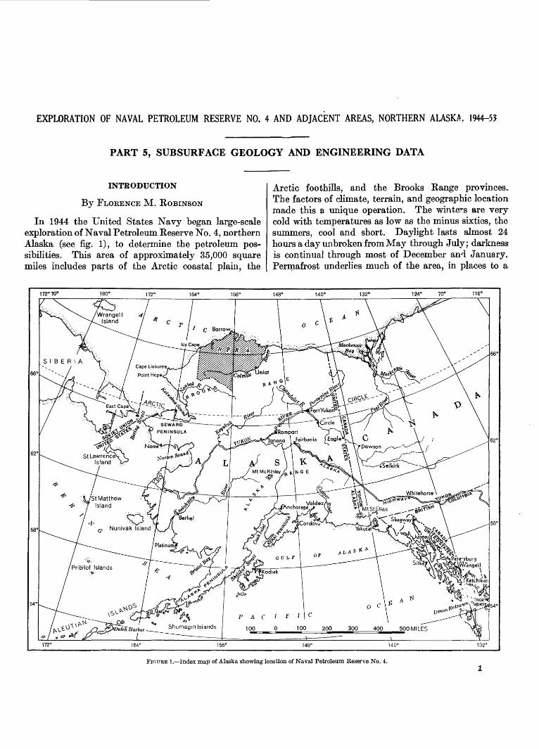
In 1944 the United States Navy began large-scale exploration of Naval Petroleum Reserve No. 4, northern Alaska (see fig. 1), to determine the petroleum pos sibilities. This area of approximately 35,000 square miles includes parts of the Arctic coastal plain, the
Arctic foothills, and the Brooks Range provinces- The factors of climate, terrain, and geographic location made this a unique operation. The winters are very cold with temperatures as low as the minus sixties, the summers, cool and short. Daylight lasts almost 24 hours a clay unbroken from May through July; darkness is continual through most of December and January. Permafrost underlies much of the area, in places to a
172°70° 132" 124° 10° 116°
0 100 200 300 400 500 MILES
FIOURE 1. Index map of Alaska showing location of Naval Petroleum Reserve No. 4.
EXPLORATION OP NAVAL PETROLEUM RESERVE NO. 4, ALASKA, 1944-53
168° 164° 160'
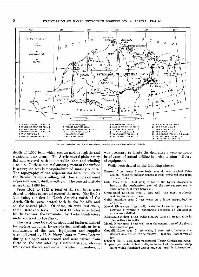
1 SOUTH BARROW TEST WELL 12 SOUTH BARROW TEST WELL 23 SOUTH BARROW TEST WELL 34 SOUTH BARROW TEST WELL 45 AVAK TEST WELL 16 NORTH SIMPSON TEST WELL 1
7 SIMPSON TEST WELL 18 TOPAGORUK TEST WELL 19 EAST TOPAGORUK TEST WELL 1
10 FISH CREEK TEST WELL 1 1 I KAOLAK TEST WELL 1 12 MEADETEST WELL 1
13 OUMALIK TEST WELL 114 EAST OUMALIK TEST WELL 115 SQUARE LAKE TEST WELL I16 TITALUK TEST WELL 117 WOLF CREEK TEST WELL 118 WOLF CREEK TEST WELL 2
19 WOLF CREEK T"ST WELL 320 GUBIK TEST WELL 121 GUBIK TEST WELL 222 KNIFEBLADE TEST WELL 123 KNIFEBLADE TEST WELLS 2 AND2A24 GRANDSTAND TEST WELL 125 UMIAT TEST WELLS 1-11
FIGURE 2. Index map of northern Alaska, showing location of test wells and oilfields.
depth of 1,000 feet, which creates serious logistic and construction problems. The Arctic coastal plain is very flat and covered with innumerable lakes and winding streams. In the summer about 60 percent of the surface is water; the rest is mosquito-infested marshy tundra. The topography of the adjacent northern foothills of the Brooks Range is rolling, with low tundra-covered ridges and broad, shallow valleys. The general altitude is less than 1,000 feet.
From 1944 to 1952 a total of 81 test holes were drilled in widely separated parts of the area. (See fig. 2.) The holes, the first in North America north of the Arctic Circle, were located both in the foothills and on the coastal plain. Of these, 36 were test wells, and 45 were core tests. The first 16 holes were drilled by the Seabees; the remainder, by Arctic Contractors under contract to the Navy.
The tests were located on structural features defined by surface mapping, by geophysical methods or by a combination of the two. Equipment and supplies were delivered by U. S. Navy boats to Point Barrow during the open-water season and were carried from there to the test sites by Caterpillar-tractor-drawn trains over the ice and snow in winter. Therefore, it
was necessary to locate the drill sites a year or more in advance of actual drilling in order to plan delivery of equipment.
Wells were drilled in the following places:
Barrow: 5 test wells, 5 core tests; several holers reached Pale ozoic (?) rocks at shallow depth; 2 wells produced gas fromJurassic rocks.
Fish Creek area: 1 test well; drilled in the Upr>er Cretaceousbasin in the northeastern part of the reserve; produced asmall amount of very heavy oil.
Grandstand anticline area: 1 test well; the most southerlytest; in Cretaceous rocks.
Gubik anticline area: 2 test wells on a large gas-productiveanticline.
Kaolak River area: 1 test well; located in the western part of thereserve; a primarily nonmarine sequence of Cretaceousstrata were drilled.
Knifeblade Ridge: 3 test wells; shallow tests on an anticline inthe northern foothills.
Meade River area: 1 test well; near the central part of the river;had shows of gas.
Oumalik River area: 2 test wells; 5 core testi; includes thedeepest hole drilled in the reserve; 1 test well had shows ofgas.
Sentinel Hill: 1 core test; penetrated Upper Cr?.taceous rocks. Simpson peninsula: 2 test wells; includes 1 of the earlier deep
holes which furnished important stratigrapl'c information.
CORE TESTS AND TEST WELLS, OUMALIK AREA, ALASKA
Simpson Seeps: 34 core tests; a shallow oilfield was defined bythe series of core tests.
Square Lake: 1 test well; a prospect northwest of Umiat definedby seismic and photogeologic techniques.
Titaluk River area: 1 test well; located on an anticline mappedprimarily by field and photogeologic methods.
Topagoruk River area: 2 test wells; in the central part of thecoastal plain; a deep test penetrated rocks ranging in agefrom Devonian to Pleistocene.
Umiat: 11 test wells; many produced oil. Wolf Creek area: 3 test wells; relatively shallow tests; shows of
gas.
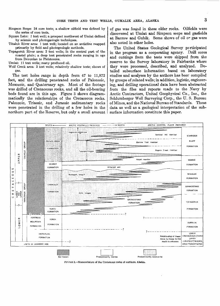
The test holes range in depth from 47 to 11,872 feet, and the drilling penetrated rocks of Paleozoic, Mesozoic, and - Quaternary age. Most of the footage was drilled of Cretaceous rocks, and all the oil-bearing beds found are in this age. Figure 3 shows diagram- matically the relationships of the Cretaceous rocks. Paleozoic, Triassic, and Jurassic sedimentary rocks were penetrated in the drilling of a few holes in the northern part of the Reserve, but only a small amount
of gas was found in these older rocks. Oilfields were discovered at Umiat and Simpson seeps and gasfields at Barrow and Gubik. Some shows of oil o? gas were also noted in other holes.
The United States Geological Survey participated in the program as a cooperating agency. Drill cores and cuttings from the tests were shipped from the reserve to the Survey laboratory in Fairbanks where they were processed, described, and analyzed. De tailed subsurface information based on laboratory studies and analyses by the authors has beer compiled by groups of related wells; in addition, logistic, engineer ing, and drilling operational data have been abstracted from the files and reports made to the Navy by Arctic Contractors, United Geophysical Co., Inc., the Schlumberger Well Surveying Corp., the U. S. Bureau of Mines, and the National Bureau of Standards. These data as well as a geological interpretation of the sub surface information constitute this paper.
Predominantly marine Predominantly nonmanne
. Nomenclature of the Cretaceous rocks of northern Alaska.

EXPLORATION OF NAVAL PETROLEUM RESERVE NO. 4 AND ADJACENT AREAS, NORTHERN ALASKA, 1944-53
GORE TEST AND TEST WELLS, OUMALIK AREA, ALASKA
By FLORENCE M. ROBINSON
ABSTRACT
The Oumalik test wells and core tests were drilled in the years 1947-51 as a part of the exploration program of Naval Petroleum Reserve No. 4, northern Alaska. These tests are located on the Oumalik anticline about 100 miles south-southeast of Point Barrow. Oumalik test well 1 and East Oumalik test well 1 were drilled primarily to test sandstones of Cretaceous age on the structure, which was delineated by geophysical means. The core tests, which were drilled before the deeper holes, served primarily for stratigraphic and foundation studies.
The depth of the holes ranges from 47 feet in a foundation test to 11,872 feet in Oumalik test well 1, the deepest test well drilled in the Petroleum Reserve. The stratigraphic section penetrated consists of the Nanushuk group and the Topagoruk and Oumalik formations, of Early and Late Cretaceous age, plus a unit of Late Jurassic (?) and Early Cretaceous (?) age. Shows of oil were negligible. Drilling of Oumalik test well 1 revealed some shows of high-pressure and low-volume gas which is of little present commercial value.
INTRODUCTION
Five core holes, ten foundation tests, and two test wells were drilled in the Oumalik River region on the Oumalik anticline, near the northern boundary of the Arctic foothills province, at lat 69°50 / N. and between long 155°15 / W. and 156°15' W. The name "Oumalik" comes from the Eskimo name of a small river which heads in the area.
The core holes were preliminary tests drilled on an anticline discovered in 1947 by reflection seismograph. Geophysical and geological investigations in this area led to the drilling in 1949 and 1950 of the two deep tests: Oumalik test well 1 on the crest of the anticline and East Oumalik test well 1 on a subsidiary high at the east end. Inasmuch as rock exposures are practic ally nonexistent, the stratigraphy of the area is known only from cores and cuttings from the wells. This report describes in detail the strata penetrated, as well as the logistics, engineering, and drilling operations.
ACKNOWLEDGMENTS
Information for this report was compiled from daily and final reports made to the U. S. Navy by Arctic
374616 56 2
Contractors, United Geophysical Co., Inc., TH Schlum- berger Well Surveying Corp., and the U. S. Geological Survey. Gas analyses were made by the National Bureau of Standards, Washington, D. C., the U. S. Bureau of Mines, Amarillo, Tex., and the Smith- Emery Co., Los Angeles, Calif. The help of the person nel connected with the above organizations is gratefully acknowledged.
Unless otherwise noted, the core and cutting analyses were made by the staff of the U. S. Geological Survey in Fairbanks, Alaska. Microfossils were identified by Harlan R. Bergquist. The stratigraphic distribution of fossils in the test wells of northern Alaska vill be pre sented by him in another chapter of this series. Mega- fossils were identified by Ralph W. Imlay and Roland W. Brown. P. D. Krynine and S. T. YuHer made reservoir analyses and furnished some additional data on porosity and permeability. The heavy-mineral zones were determined as part of a regional study of heavy minerals by Robert H. Morris. A summary of thermal investigations of Oumalik test well 1 was fur nished by Max C. Brewer.
STRUCTURE
The Oumalik area (fig. 4) was first explored by the U. S. Geological Survey in cooperation with the Navy, using an airborne magnetometer, during 1945 and 1946. United Geophysical Co., Inc., made a reconnaissance gravity survey and a limited detailed survey of the area in 1947. These surveys indicate that the Oumalik anticline lies in a regional gravity low soutl west of a gravity high that extends from a point northwest of Umiat to Smith Bay (Payne and others, 1951, sheet 2, fig. 9). In general, the observed gravity low covers most of the southwestern part of Naval Petroleum Reserve No. 4.
The Oumalik anticline was discovered later in 1947 by reflection seismograph (United Geophysical Co.), in the course of checking magnetic anomal^s to the northeast. Additional seismic surveys, both reflection and refraction, were made in the OumaJik-middle
5
6 EXPLORATION OF NAVAL PETROLEUM RESERVE NO. 4, ALASKA, 1944-53
156 155°30'
/ ^m -f$ J^--,r~^ ^. A :*.»OUMALIK CORE TEST 1 IKPIKPUK CORE TEST 1 ^-Yr^V:..
^ 3":^- * Ki»er C^r"" ^
^-^^r-_^ ^rojjMAujL^sr--- i- A_^f^ J^TESTli/ELLfe^,-,--^r^Z-^Ti 5^ T Vii^^:^.
^h^^^L-^\,^~, _ ^^-j^S
156° 155°30'
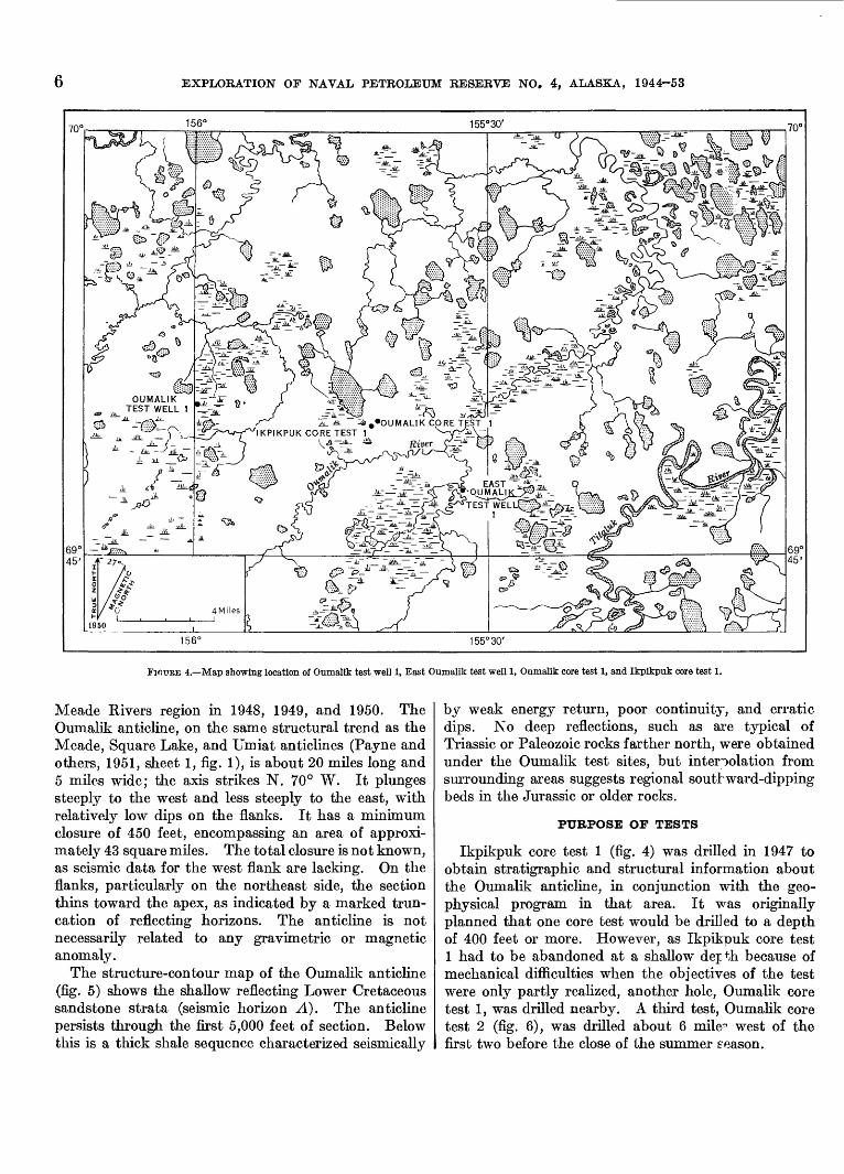
FIOURE 4. Map showing location of Oumalik test well 1, East Oumalik test well 1, Oumalik core test 1, and Ikpikpuk core test 1.
Meade Rivers region in 1948, 1949, and 1950. The Oumalik anticline, on the same structural trend as the Meade, Square Lake, and Umiat anticlines (Payne and others, 1951, sheet 1, fig. 1), is about 20 miles long and 5 miles wide; the axis strikes N. 70° W. It plunges steeply to the west and less steeply to the east, with relatively low dips on the flanks. It has a minimum closure of 450 feet, encompassing an area of approxi mately 43 square miles. The total closure is not known, as seismic data for the west flank are lacking. On the flanks, particularly on the northeast side, the section thins toward the apex, as indicated by a marked trun cation of reflecting horizons. The anticline is not necessarily related to any gravimetric or magnetic anomaly.
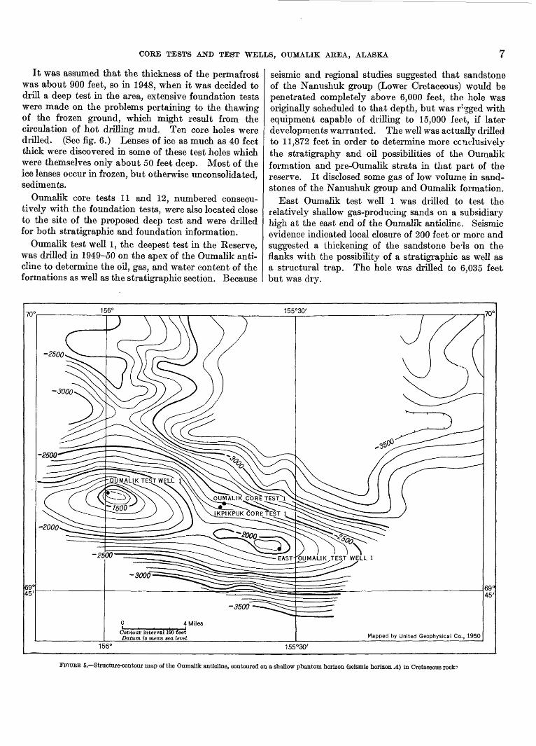
The structure-contour map of the Oumalik anticline (fig. 5) shows the shallow reflecting Lower Cretaceous sandstone strata (seismic horizon A). The anticline persists through the first 5,000 feet of section. Below this is a thick shale sequence characterized seismically
by weak energy return, poor continuity, and erratic dips. No deep reflections, such as are typical of Triassic or Paleozoic rocks farther north, were obtained under the Oumalik test sites, but interpolation from surrounding areas suggests regional southward-dipping beds in the Jurassic or older rocks.
PURPOSE OF TESTS
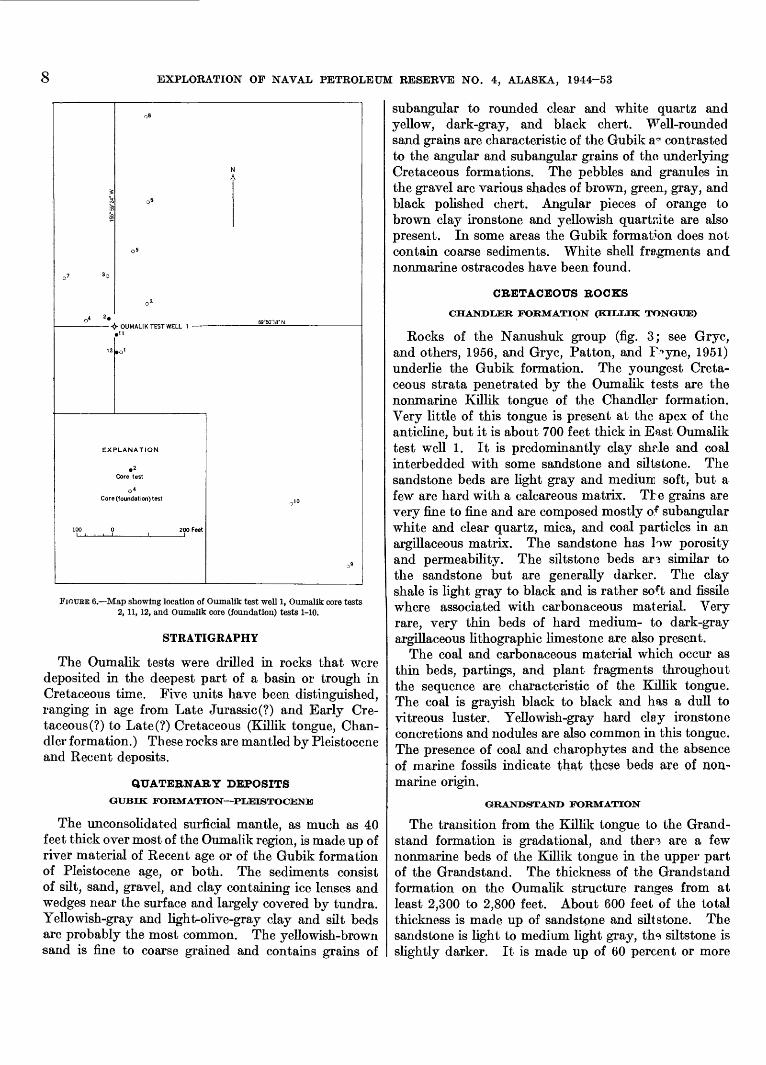
Ikpikpuk core test 1 (fig. 4) was drilled in 1947 to obtain stratigraphic and structural information about the Oumalik anticline, in conjunction with the geo physical program in that area. It was originally planned that one core test would be drilled to a depth of 400 feet or more. However, as Ikpikpuk core test 1 had to be abandoned at a shallow depth because of mechanical difficulties when the objectives of the test were only partly realized, another hole, Oumalik core test 1, was drilled nearby. A third test, Oumalik core test 2 (fig. 6), was drilled about 6 muV west of the first two before the close of the summer season.
CORE TESTS AND TEST WELLS, OUMALIK AREA, ALASKA
It was assumed that the thickness of the permafrost was about 900 feet, so in 1948, when it was decided to drill a deep test in the area, extensive foundation tests were made on the problems pertaining to the thawing of the frozen ground, which might result from the circulation of hot drilling mud. Ten core holes were drilled. (See fig. 6.) Lenses of ice as much as 40 feet thick were discovered in some of these test holes which were themselves only about 50 feet deep. Most of the ice lenses occur in frozen, but otherwise unconsolidated, sediments.
Oumalik core tests 11 and 12, numbered consecu tively with the foundation tests, were also located close to the site of the proposed deep test and were drilled for both stratigraphic and foundation information.
Oumalik test well 1, the deepest test in the Reserve, was drilled in 1949-50 on the apex of the Oumalik anti cline to determine the oil, gas, and water content of the formations as well as the stratigraphic section. Because
seismic and regional studies suggested that sandstone of the Nanushuk group (Lower Cretaceous) would be penetrated completely above 6,000 feet, the hole was originally scheduled to that depth, but was r^ged with equipment capable of drilling to 15,000 feet, if later developments warranted. The well was actually drilled to 11,872 feet in order to determine more conclusively the stratigraphy and oil possibilities of the Oumalik formation and pre-Oumalik strata in that part of the reserve. It disclosed some gas of low volume in sand stones of the Nanushuk group and Oumalik formation.
East Oumalik test well 1 was drilled to test the relatively shallow gas-producing sands on a subsidiary high at the east end of the Oumalik anticline. Seismic evidence indicated local closure of 200 feet or more and suggested a thickening of the sandstone beis on the flanks with the possibility of a stratigraphic as well as. a structural trap. The hole was drilled to 6,035 feet but was dry.
S > 'OUMALIK TEST WELL 1
Mapped by United Geophysical Co., 1950156° 155°30'
FIOUEE 5. Structure-contour map of the Oumalik anticline, contoured on a shallow phantom horizon (seismic horizon A) in Cretaceous rock?
8 EXPLORATION OF NAVAL PETEOLEUM RESERVE NO. 4, ALASKA, 1944-53
- -<> OUMALIK TEST WELL
EXPLANATION
Core (foundation) test
FIOTJEE 6. Map showing location of Oumalik test well 1, Oumalik core tests 2,11, 12, and Oumalik core (foundation) tests 1-10.
STRATIGRAPHY
The Oumalik tests were drilled in rocks that were deposited in the deepest part of a basin or trough in Cretaceous time. Five units have been distinguished, ranging in age from Late Jurassic (?) and Early Cre taceous (?) to Late(?) Cretaceous (Killik tongue, Chan dler formation.) These rocks are mantled by Pleistocene and Recent deposits.
QUATERNARY DEPOSITSGUBIK FORMATION PUOBTOCENE
The unconsolidated surficial mantle, as much as 40 feet thick over most of the Oumalik region, is made up of river material of Recent age or of the Gubik formation of Pleistocene age, or both. The sediments consist of silt, sand, gravel, and clay containing ice lenses and wedges near the surface and largely covered by tundra. Yellowish-gray and light-olive-gray clay and silt beds are probably the most common. The yellowish-brown sand is fine to coarse grained and contains grains of
subangular to rounded clear and white quartz and yellow, dark-gray, and black chert. Well-rounded sand grains are characteristic of the Gubik a^ contrasted to the angular and subangular grains of tho underlying Cretaceous formations. The pebbles and granules in the gravel are various shades of brown, green, gray, and black polished chert. Angular pieces of orange to brown clay ironstone and yellowish quartaite are also present. In some areas the Gubik formation does not contain coarse sediments. White shell fragments and nonmarine ostracodes have been found.
CRETACEOUS BOCKS
CHANDLER FORMATION (KTT.TTK: TONGUE)
Rocks of the Nanushuk group (fig. 3; see Gryc, and others, 1956, and Gryc, Patton, and F^yne, 1951) underlie the Gubik formation. The youngest Creta ceous strata penetrated by the Oumalik tests are the nonmarine Killik tongue of the Chandler formation. Very little of this tongue is present at the apex of the anticline, but it is about 700 feet thick in East Oumalik test well 1. It is predominantly clay shrle and coal interbedded with some sandstone and siltstone. The sandstone beds are light gray and medium soft, but a few are hard with a calcareous matrix. Tte grains are very fine to fine and are composed mostly of subangular white and clear quartz, mica, and coal particles in an argillaceous matrix. The sandstone has low porosity and permeability. The siltstone beds ar3 similar to the sandstone but are generally darker. The clay shale is light gray to black and is rather soft and fissile where associated with carbonaceous material. Very rare, very thin beds of hard medium- to dark-gray argillaceous lithographic limestone are also present.
The coal and carbonaceous material which occur as thin beds, partings, and plant fragments throughout the sequence are characteristic of the Killik tongue. The coal is grayish black to black and has a dull to vitreous luster. Yellowish-gray hard clay ironstone concretions and nodules are also common in this tongue. The presence of coal and charophytes and the absence of marine fossils indicate that these beds are of non- marine origin,
GRANDSTAND FORMATION
The transition from the Killik tongue to the Grand stand formation is gradational, and ther3 are a few nonmarine beds of the Killik tongue in the upper part of the Grandstand. The thickness of the Grandstand formation on the Oumalik structure ranges from at least 2,300 to 2,800 feet. About 600 feet of the total thickness is made up of sandstone and siltstone. The sandstone is light to medium light gray, th^ siltstone is slightly darker. It is made up of 60 percent or more
CORE TESTS AND TEST WELLS, OUMALIK AREA, ALASKA 9
of subangular, rarely subrounded, white and clear quartz grains and varying amounts of dark-gray chert, coal, and rock fragments. Grain size decreases from medium to very fine with depth. The sandstone is silty, very argillaceous, and moderately hard to hard and has rare carbonaceous and micaceous laminae. The sandstone beds are similar to those in the Killik tongue except that they are thicker, harder, and more massive and the average grain size is slightly larger and the matrix is more calcareous. Ripple marks and excellent small-scale crossbedding with dips as high as 20° are present, particularly in the lower 1,000 feet of section. Some contorted beds suggesting soft rock flowage were found.
The clay shale and claystone, making up the rest of the formation, are medium light to medium dark gray, hard, have micaceous partings, contain very rare pyrite, and in places grade into hard massive clay- stone with very irregular to conchoidal fracture. In the first 900 feet and rarely in the lower part the shale is medium dark gray to grayish black, very carbona ceous and fissile. There are no very thick beds of coal, but very thin ones (1 inch or less) interbedded with the shale are relatively common in some parts of the sec tion, particularly in the first 900 feet. The coal is vitreous to dull black; brownish lignite is also present. This dark shale and coal is considered to belong to the Killik tongue. Black carbonaceous fragments and plant impressions are relatively abundant throughout.
In the Oumalik area the Grandstand formation is more calcareous than in other areas studied. Almost all the sandstones have a somewhat calcareous matrix which reduces the porosity and permeability. Hard thin medium- to dark-gray argillaceous limestone beds are rare.
The presence of Foraminifera, a few mollusk, and crinoid fragments throughout much of the section indicates that the Grandstand formation is largely marine in origin.
TOPAGORUK FORMATION
No sharp lithologic break exists between the Grand stand and Topagoruk formations; the bottom of the Grandstand is picked as the base of the predominantly sandy section. The Topagoruk is 90 percent clay shale and silty clay shale and 10 percent siltstone and sand stone, with a trace of coal. The proportion of coarser material decreases with depth. The formation is about 2,100 feet thick.
Lithologically, the clay shale and siltstone are essen tially the same as in the Grandstand formation above but are slightly darker. Most of the rocks are medium hard but in a few places have been reported by the driller as soft, waxy, or possibly slightly bentonitic.
The porosity and permeability are low, ard the car bonate content, high. The section is marine and fossiliferous.
OUMALIK FORMATION
The Oumalik formation in Oumalik test well 1, the only hole on the structure that was drilled through the entire formation, is about 6,000 feet thbk and can be divided into two marine units an upper shale unit, 4,410 feet thick, and a lower sandy shale, 1,610 feet thick.
The upper shale unit is a monotonous section of clay shale, medium dark to dark gray, slightly micaceous, carbonaceous, and pyritic. Shaly cleavage parallel to the bedding is good to poor. Where cleavr.sje is poor, the rock can be considered a claystone. Siltstone and sandy siltstone occur very sparingly in the section. The siltstone occurs in thin medium-light- to medium- gray laminae which are a little harder than the clay shale. The siltstone shows very rare ripple marks and small-scale crossbedding. The upper unit is noncalcareous.
The lower sandy shale unit of the Oumalik formation is made up of about 40 percent siltstone and sandstone, in addition to clay shale of the type described above. The upper unit grades into the lower, but the contact is placed at the top of the first sandstone of appreciable thickness; none of the sandstone beds are more than 30 feet thick. The sandstone and siltstone are medium light to medium gray, hard, massive, silty, and very fine to fine grained. The grains are sub°.ngular to angular and estimated to be 50 percent white and clear quartz and 15 percent shiny black carbonaceous ma terial or bitumen; the remainder is mica, altered feld spar (?), and other minerals cemented by r,rgillaceous material or perhaps by a small amount of calcite or dolomite. Excellent small-scale crossbedding and some ripple marks are also present in this lower unit.
The carbonate content is relatively higl?, and the porosity, low; the sandstone is almost impermeable.
A few chips of bluish-gray clay shale (bentonitic?) occur very rarely in the cuttings in the lowest 500 feet of the formation. Cuttings from the basal part of the lower unit also contain rare chips having lithologic characteristics suggestive of the Upper Jurassic (?) and Lower Cretaceous (?) below they may possibly contain reworked material. These chips of shale con tain rounded medium to coarse quartz grains and a small amount of medium-olive-gray quartzitic-appear- ing siltstone.
Partings of bitumen and carbonaceous plant frag ments or impressions are very rare in the Oumalik formation.
In the deeper parts of the Lower Cretaceous basin, in which the Oumalik test wells are located, the upper
10 EXPLORATION OF NAVAL PETROLEUM RESERVE NO. 4, ALASKA, 1944-53
contact of the Oumalik formation appears to be grada- tional into the overlying Topagoruk formation, al though an angular unconformity between these forma tions can be demonstrated in other areas. The con tact in this well was placed below the silty section of the Topagoruk formation, beneath the lowest occur rence of the fauna of the Nanushuk group, and at the first occurrence of Dorothia chandlerensis Tappan, an index microfossil of the Oumalik formation. Shale of the Oumalik formation is darker than shale of the Topagoruk formation. The sandstones are also slightly darker because they contain less white and clear quartz in proportion to the other minerals and matrix. The sand grains are more angular than those of the Topagoruk.
UPPER JURASSIC(P) AND LOWER CRETACEOUS(P)ROCKS
The most pronounced lithologic break in Oumalik test well 1 is between the Oumalik formation and the underlying rocks, and it may represent an un conformity. The age of the 992 feet of beds im mediately below this break hi Oumalik test well 1 is doubtful. Lithologically, the section is the same throughout, and the bottom of the unit was not reached. The beds may be a part of the Okpikruak formation of Early Cretaceous age; they may be Late Jurassic in age; or they may be gradational from Upper Jurassic to Lower Cretaceous. The various possibilities are discussed from a paleontological point of view by Harlan R. Bergquist on pages 65-68. Lithologically, this section of doubtful age does not closely resemble the Okpikruak formation of the outcrop 90 miles to the south, but it has some of the peculiarities of the Upper Jurassic section in Topagoruk test well 1, which is 55 miles north. Perhaps the upper few hundred feet of rocks, containing Aucella sublaevis Keyserling, can be correlated with the Okpikruak formation, but the relation of these upper beds to the Okpikruak forma tion found in the outcrop is dubious.
These Upper Jurassic (?) and Lower Cretaceous (?) rocks are made up of clay shale interbedded with as much as 10 percent siltstone and very fine sandstone. The clay shale is dark gray to grayish black, is moder ately hard, and has plates of mica, larger than those in the formations above, scattered abundantly through out. Very rare to common well-rounded, slightly frosted clear quartz grains up to very coarse size are embedded, individually or as streaks, in shale. Also present hi the shale are soft pellets, very fine to medium grained, of pale-green clay or glauconite (?). Some of the rounded quartz grains are surrounded by crystalline pyrite.
The siltstone and sandstone range from medium light gray to medium olive gray. The medium-olive- gray material is made up almost entirely of colorless and transparent or clear brownish angular to sub- angular quartz; it is very hard and tight, has a slight glassy quartzitic sheen in the hand specimen, and is very slightly calcareous to noncalcareous. No pyrite, glauconite, or rounded grains were observed in the sandstone and siltstone.
Very rare pebbles and granules of dark chert and quartz are present. Large chips of pyrite were found in the ditch, and nodules, in the bottom-hole core.
Rocks older than the Upper Jurassic(?) are not known in the Oumalik area. Geophysical surveys failed to detect a high-velocity break which might be indicative of limestone of Paleozoic age. Interpolation from areas to the west suggests that the depth to "base ment" (Paleozoic?) rocks of the type found near Barrow may be about 20,000 feet.
CORE TESTS
DESCRIPTION OF CORES AND CUTTINGS
The following lithologic descriptions, with the exception of Oumalik core (foundation) tests 1-10, were made by the author. The brief descriptions of the foundation tests were made by the driller or geolo gist at the time the holes were drilled. All material was described dry; colors were determined by compari son to the Rock Color Chart (Goddarc1 and others, 1948). The term "trace" as used here is defined as less than 3 percent and in most cases les^ than 1 per cent. Clay ironstone is a sideritic, dens?, and rather hard mudstone that generally effervesces very slowly hi cold dilute hydrochloric acid.
Abundance of microfossil specimens mentioned at the beginning of each core description hi Oumalik core tests 11 and 12 and in the test wells is defined as follows: 1-4 very rare, 5-11 rare, 12-25 common, 26-50 abundant, and over 50 very abundant.
The latitudes and longitudes of these core tests are based on preliminary surveys and are subject to correc tion. All elevations in the area, including those used on seismic lines, were taken from a base elevation established at an airstrip by numerous aircraft altimeter readings.
ZKPIKPUK CORE TEST 1
Location: Lat 69°49'36" N., long 155°41'57" W. Elevation: Ground, 170 feet; kelly bushing, 180 feet. Spudded: July 9, 1947.Completed: July 17, 1947, junked and abandoned. Total depth: 178 feet.
Ikpikpuk core test 1 was located near the camp site occupied by United Geophysical Co.'s seismo-
COKE TESTS AND TEST WELLS, OUMALIK AEEA, ALASKA 11
graph party 46. Seismic evidence indicates that the hole was located off the crest on the north flank of the Oumalik anticline (see fig. 5), as contoured on shallow sandstone strata of Cretaceous age. The top of the Cretaceous section in this hole is approximately 400 feet stratigraphically higher than the uppermost Cretaceous penetrated in drilling East Oumalik test well 1. (See p. 8.)
No samples were received for the upper 39 feet of the hole. The first sample, at 39 feet, is Cretaceous, with surface contamination suggesting that the Pleisto cene and (or) Recent mantle is 30 feet thick or less. The hole from 39 feet to total depth is in both the Lower and Upper Cretaceous, probably in the nonmarine Chandler formation of the Nanushuk group. (See pi. 3.)
The hole was abandoned when the N-rods twisted off at 90 feet.
The samples from this test are very poor. The cuttings consist almost entirely of contaminating ma terial from the surface and are not necessarily indicative of the formations penetrated. The cores are also poor and badly infiltrated by drilling mud. All depths are measured from the kelly bushing.
Lithologic description
[Where no core number is given, description is from cuttings]
Core Depth (feet)
0-10 10-39 39-98
98-108
108-149
149-159
Description
Kelly bushing to ground level. No samples received.Sand, light-olive-gray, unconsolidated, medium-
to coarse-grained; grains round to subround and made up of 80 percent clear, yellow, and white quartz, 20 percent dark-gray and black chert. A few shiny black coal chips at 84-94 ft. Clay (drilling mud) loosely cements some of the grains; white pelecypod shell fragments and ostracodes present. Trace of light-gray very calcareous cement throughout.
Recovered 4 ft:Clay shale, medium-light- to medium-gray,
fissile, soft; rare dark-gray carbonaceous noncalcareous clay shale. This part of core badly broken by drill and infiltrated by drilling mud. Well-rounded black and yellow chert granules and pebbles found in mud in middle of recovered section are probably surface contamination. Dip of beds indeterminate.
Sand and drilling mud as above. Larger pro portion of subangular grains with increasing depth. Also a gradual increase tn proportion of white and clear quartz to yellow quartz. No sandstone chips recovered.
Recovered 5 ft:1 ft 6 in., sand, unconsolidated. This sand
is ground-up medium-grained sandstone of Cretaceous age (subangular white and clear quartz and carbonaceous particles)
Lithologic description Continued
Core Depth (feet)
159-178
Description
and a liberal amount of surface material (subround yellow and clear qrartz grains, a few rounded chert granule?), chips of clay shale, and black low-grade coal, all loosely embedded in drilling raud. Some calcareous material in mud probably is ground-up cement.
3 ft 6 in., siltstone, medium-light-gray, hard, with irregular fracture; grains nostly white and clear quartz and minute particles of carbonaceous material; beds approximately flat lying, some small-scale crossbedding.
Sand and drilling mud. Sand grains are very fine to fine, made up of 85 percent white and clear quartz; remainder is yellow quartz, gray and black chert, dark-colored rock frag ments and black carbonaceous material. This sand is a mixture of surf roe material and ground-up sandstone of Cretaceous age.
OUMALIK CORE TEST 1
Location: Lat 69°49'45" N., long 155°41'30" W. Elevation: Ground, 245 feet; kelly bushing, 255 feet. Spudded: July 21, 1947.Completed: July 29, 1947, junked and abandoned. Total depth: 392 feet.
Oumalik core test 1 is located approximately one- quarter of a mile northeast of Ikpikpuk core test 1. (See fig. 4.) Although they are relatively close to gether, Oumalik core test 1 probably started as much as 100 feet higher in the section because of its higher ele vation and position farther downdip on the flank of the anticline. Correlation between the two holes is diffi cult, owing to poor samples.
Samples were not obtained from the upper 30 feet of the hole. The sample from 30-foot depth is Cre taceous in age. Contamination in this and lower sam ples indicates that overlying Pleistocene and (or) Recent sediments are the same as those in Ikpikpuk core test 1; that is, rounded fine to course sand, rounded granules of yellow and black chert, and soft light-olive-gray to dusky-yellow clay.
The Lower and Upper Cretaceous rocks, probably of the Chandler formation, drilled in the rest of the hole are mostly clay shale with a few beds of sandstone and siltstone. The hole was abandoned when the drillers were unable to recover a core barrel stuck at 88 feet.
The cuttings from this test are very poor. About 95 percent of the samples represents contaminating cement, drilling mud, and near-surface Pleistocene or Recent sand and is not necessarily indicative of the formations penetrated. All depths are measured from the kelly bushing.
12 EXPLORATION OF NAVAL PETROLEUM RESERVE NO. 4, ALASKA, 1944-53
Lithologic description
[Where no core number is given, description is from cuttings]
Core Depth (feet)
0-10 10-30 30-102
102-112
112-152
152-162
162-170
170-180
180-199
199-209
Description
Kelly bushing to ground level. No samples received.Silt and clay (or drilling mud), light-olive-gray;
some sand with rounded varicolored grains. As much as 90 percent white cement contam ination.
Recovered 3 ft 6 in.:Clay, light-olive-gray to dusky-yellow, soft;
contains relatively modern appearing tun dra plant fragments; moderately calcare ous, without visible bedding; streaks of yellowish clay which effervesce with HC1 are probably sideriticJ
Cement contamination as much as 90 percent, also clay, silt, and sand in every sample. About 30 percent of sand made up of sub- angular Cretaceous sand grains, but horizon from which they came cannot be determined.
Recovered 7 ft:2 ft 9 in., sandstone, light-gray, hard, argil
laceous, moderately calcareous. Dip 10°-15°.
9 in., clay shale, medium-gray, soft, sandy.1 ft 3 in., siltstone, yellowish-gray, medium-
hard, slightly sandy.2 ft, clay shale, yellowish-gray, soft to
medium-hard.3 in., claystone, yellowish-gray, medium-
hard, noncalcareous.Cement contamination 50 percent, near-surface
sand 20 percent. Clay shale, medium-light- gray. Sandstone, light-gray, medium- grained; grains are subangular and made up of 75 percent white and clear quartz; re mainder is dark rock fragments, chert and coal; calcareous. Clay ironstone present, moderate yellowish brown.
Cement 30 percent, near-surface sand 30 per cent, also sandstone, clay shale, clay iron stone. Some clay shale is medium dark gray.
Cement contamination 85 percent. Clay shale, medium-light-gray. Surface sand, fine- to coarse-grained, and granules of yellow and black chert.
Recovered 1 ft 6 in.:Clay shale, medium-light-gray to grayish-
black; recovery consists almost entirely of broken chips. Upper 6 in. made up of drilling mud with chips of shale embedded, also some sand grains. Some of the shale is very dark and carbonaceous. Rare fragments of shiny black coal. A few specks of amber found in the carbonaceous beds. Lowest 2 in. of recovery consists of very light-gray sandy siltstone, that con tains rare carbonaceous particles. The "siltstone" may possibly be cement con tamination. Clay shale is noncalcareous. Parts of drilling mud very calcareous.
Lithologic description Continued
Core Depth (feet)
209-219
219-252
252-262
262-300
300-310
310-320 320-330
330-340
340-350
350-360 360-370
370-383 383-392
Description
Recovered 1 ft 6 in.:1 ft, drilling mud, contains small chips of
clay shale, sand, pebbles; calcareous. 6 in., claystone, medium-light-gray, medium-
hard, irregular fracture, COE tains numerous dark-gray plant fragments also a clear yellow piece of amber in th? claystone.
Clay lumps (mostly drilling mud) mixed with sand. Sand, unconsolidated, iight-olive- gray, medium-grained; grains subrounded to rounded, made up of 90 percent clear and some white quartz with a yellowish cast, also black chert, and a few rock particles. This sand is mostly near-surface contamination.
Recovered 8 ft:Siltstone, light- to medium-li^ht-gray, hard,
noncalcareous; has irregular fracture, very argillaceous and grades into silty claystone. Silt made up of 90 percent white and clear quartz; remainder is carbonaceous and micaceous particles; dip 10° (?); a few steeper dips probably represent cross- bedding.
Clay lumps mixed with sand as at 220-250 ft, some cement contamination. Dull black coaly particles at 290-300 ft;
Recovered 8 ft:2 ft, siltstone, light-gray, hard, moderately
calcareous.6 ft, interbedded siltstone, clay shale, and
coal, soft to medium-hard, dark-greenish- gray to medium-gray. Entire core badly fractured; carbonaceous iraterial in the shale.
Sand and clay. Clay shale 60 percent, medium-gray and small
amount of dark-gray; remainder is sand. Sand 50 percent, medium-light-gray clay shale
50 percent. Sand; trace of clay shale, medium-light-gray
and dark-gray.Sand with trace of dark-gray dry shale. Sand with trace of medium-light-gray clay
shale.Sand, clay shale, clay ironstone, cement. No recovery. Lost tool in hole.
OUMALJDK CORE TEST 2
Location: Lat 69°50'18" N., long 155°59'24" W. Elevation: Ground, 178 feet; kelly bushing not known. Spudded: Sept. 8, 1947.Completed: Sept. 10, 1947, junked and abandoned. Total depth: 190 feet.
The drill site for Oumalik core test 2 is on the apex of the anticline approximately 6 miles west of Ikpikpuk core test 1 and just 26 feet northwest of Oumalik test well 1. (See fig. 6.) This hole was drilled with geo-
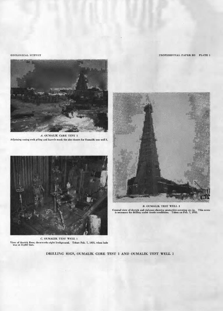
GEOLOGICAL SURVEY PROFESSIONAL PAPER 305 PLATE 1
A. OUMALIK CORE TEST 1
Adjoining casing rack piling and barrels mark the site chosen for Oumalik test well 1
General view of derrick and righouse showing protective covering on rig. This cover is necessary for drilling under Arctic conditions. Taken on Feb. 7, 1950.
C. OUMALIK TEST WELL 1
View of derrick floor; draw-works right background. Taken Feb. 7, 1950, when hole was at 11,007 feet.
DRILLING RIGS, OUMALIK CORE TEST 1 AND OUMALIK TEST WELL 1
GEOLOGICAL SURVEY PROFESSIONAL PAPER 305 PLATE 2
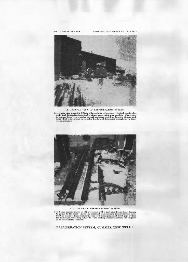
A. GENERAL VIEW OF REFRIGERATION SYSTEM
Surge tank with fan and D 8 Caterpillar radiator right center. Six-inch pipe headers and 1-inch distribution hoses lead to pilings under substructure on left. The coolant is pumped from return header through radiator, cooled by fan, into storage tank from which it is pumped into outflow header and distributed throughout rig foun dation members.
B. CLOSE UP OF REFRIGERATION SYSTEM
Two 6-inch headers (pipes on left are extras) with 1-inch distribution hoses leading to pilings to the right. Air-cooled diesel oil at subfreezing temperatures is circu lated by means of these headers through steel-casing piling and 4-inch pipe wells in the foundation containing subgrade. The cooling process maintains the subgrade in its frozen stable condition.
REFRIGERATION SYSTEM, OUMALIK TEST WELL 1
COBE TESTS AND TEST WELLS, OUMALIK AEEA, ALASKA
physical shothole drilling equipment after the seismic program for the 1947 season was essentially completed.
Forty feet of Gubik formation (Pleistocene) consist ing of pale-yellowish-brown clay and light-olive-gray sand is present at the top of this test. The rest of the hole is in the Grandstand formation (Lower and Upper Cretaceous) of the Nanushuk group. The beds from 40 to 70 feet are nonfossilif erous and consist of medium- light-gray clay shale and some medium-dark-gray carbonaceous shale, a trace of light-gray siltstone, and 20 to 50 percent black coal with vitreous luster and conchoidal fracture. The coaly beds probably repre sent a few intertonguing beds of the nonmarine Chan dler formation.
The marine Verneuilinoides borealis microfauna appears in this core test at 70 feet. From 70 feet to the total depth at 190 feet the Grandstand is made up primarily of medium-light-gray clay shale with some medium-dark-gray clay shale. Some light-gray sandy siltstone and a small amount of medium-bluish-gray hard argillaceous limestone are also present.
The hole was abandoned at 190 feet because of a stuck drill pipe.
The cuttings from Oumalik core test 2 are poor and very contaminated. No cores were taken because no core barrel was available. All depths are measured from ground level.
Lithologic description
[No core; descriptions from cuttings only]
Depth (feet)
0-10
10-30
30-40
40-50
50-60
Description
Clay, pale-yellowish-brown. Sand 30 percent, light- olive-gray; grains, medium to coarse, subrounded to rounded, made up largely of clear and white quartz, also many grains of clear yellow quartz, common dark-gray or black chert, and rare chert grains of other colors. Ostracodes, mollusk frag ments, and tundra plant fragments present.
Clay, pale-yellowish-brown, slightly silty. Sand 15 percent, as above. Ostracodes present.
Gravel, pebbles, and granules of moderate yellowish- brown, dark-yellowish-brown, olive-gray, green, and black chert. Also rare sandstone, quartzite, and yellow quartz pebbles. Fragments of dark-yellow ish-orange to light-brown clay ironstone. Chert and rock pebbles are well rounded, but clay iron stone is angular. Sand 15 percent, as described above.
Coal 50 percent, black, with vitreous luster, conchoidal fracture. Clay shale 10 percent, medium-light- gray, and clay ironstone, light-olive-gray. Sand, 40 percent, is contamination from above.
Clay shale, medium-light-gray; some medium-dark- gray carbonaceous clay shale, trace of light-gray siltstone. Coal, 20 percent, as above.
Lithologic description Continued
Depth (feet)
60-70
70-100
100-110
110-120
120-140 140-150 150-160
160-170
170-190
Description
Clay shale, medium-light-gray, 60 percent. Light- gray siltstone 25 percent, contains small amount of very fine sand and carbonaceous partic'es; moder ately calcareous. Coal 10 percent, vitreous, black, with blocky fracture. Clay ironstone 5 percent, light-olive-gray to olive-gray.
Clay shale, medium-dark-gray, and light-gray silt- stone; trace of coal and ironstone.
Siltstone, light-gray, slightly calcareous. Medium- light-gray clay shale, 30 percent.
Limestone, medium-bluish-gray, hard, very argilla ceous, with small white veinlets.
Clay shale, medium-light-gray.Clay shale, medium-light-gray, trace of siltstone.Clay shale, medium-light-gray, and light-gray sandy
siltstone.Clay shale, medium-light to medium-gray; 5 percent
light-gray siltstone and 5 percent shiny black coal, with conchoidal fracture; trace of very fine sand stone.
Clay shale, medium-light-gray; coal 30 percent; also traces of very fine-grained sandstone, siltstone, and clay ironstone.
OUMALIK CORE (FOUNDATION) TESTS 1-1O
Location: Near Oumalik test well 1. (See fig. 6.)Elevation: Not known, but probably between 170-180 feet
above sea level. Spudded: October 1948. Completed: October 1948.
Ten shallow core (foundation) tests and tv^o deeper holes were drilled all within 900 feet of tl °> site of Oumalik test well 1; Nos. 1 and 2 should net be con fused with Oumalik core tests 1 and 2, described on pages 11 and 12. None of the samples from these shallow foundation tests were shipped to Fairbanks. The descriptions for 1-8 are from the driTer's logs, and the descriptions for 9 and 10 were made at the Barrow soil laboratory.
Soil tests were made in Barrow from February to June 1949. The project was set up primarily for gaining information concerning properties of the soils at Oumalik, in relation to foundation and refrigeration problems. Studied also were the effects of temperature changes on the physical properties of frozer soil and the strength properties of frozen soil. This information was needed for designing rig foundations for future wells to be drilled in the Reserve. Tests and procedures were used which would yield the required engineering data with a minimum of time and expense. Tests and equipment were improvised for adfreeze, bearing, shear, and heat conductivity. Standard testing pro cedures (American Society for Testing Materials) were used to determine liquid limit, plastic limit, mechanical analysis, moisture content, density, and specif c gravity.
374616 56 8
14 EXPLORATION OF NAVAL PETROLEUM RESERVE NO. 4, ALASKA, 1944-53
Som tests
A Pleij thid grav few thes fron
Core
e of the> 1-10 v Q exam stocene s in th el, and feet of e shalk i groun
Depth (feet)
samples from the Oumalik core (foundation) s^ere used in the studies, ination of the driller's logs suggests that and (or) Recent cover is as much as 40 feet e area, made up of clay, silt, sand, and contains numerous ice lenses. Only a very mown Cretaceous strata were penetrated in )W holes. Depths are probably measured d level.
Lithologic descriptions
Description
Oumalik core (foundation) test 1
1
2
3
4
5
6
0-10
10-20
20-30
30-40
40-47
47-50
Recovered 9 ft: Tundra, clay, and silt with ice lenses.
Recovered 7 ft: Silt with ice lenses and streaks of ice at 16 and
20ft. Recovered 9 ft:
Silt. Recovered (unknown):
Silt with ice lenses. Recovered 10 ft:
Silt, sand, and gravel (light), with streak of ice at 44 ft.
Recovered (unknown) : Sandy shale.
Oumalik core (foundation) test 2
1
2
3
4
5
6
0-7
7-10
10-20
20-30
30-40
40-50
Recovered 7 ft: Tundra, clay, and silt with streak of ice at 2 ft.
Recovered 3 ft: Ice.
Recovered 10 ft: Ice and silt with streak of clay.
Recovered 10 ft: Ice with streaks of silt.
Recovered 10 ft: Ice with streaks of silt.
Recovered 8 ft 6 in. : Silt and sand with ice lenses.
' Oumalik core (foundation) test 3
1
2
3
4
5
0-10
10-20
20-30
30-40
40-50
Recovered 10 ft: Tundra, clay, and silt with ice lenses (narrow).
Recovered 10 ft: Ice, silt, and clay to 12 ft, ice to 20 ft.
Recovered 5 ft: Ice.
Recovered 10 ft: Silt and sand with ice lenses (narrow) .
Recovered 10 ft: Silt and sand with ice lenses and streaks of
gravel.
Lithologic description Continued
Core Depth (feet) Description
Oumalik core (foundation) test 4
1
2-5
6
7
8
0-7
7-36
36-40
40-47
47-50
Recovered (unknown) : Tundra, clay, silt.
Recovered 29 ft: Ice.
Recovered 4 ft: Sand and ice.
Recovered 7 ft: Sand with ice lenses.
Recovered 3 ft: Sand, shale, and gravel.
Oumalik core (foundation) test 5
1
2,3
4
5
0-10
10-30
30-40
40-49
Recovered 10 ft: Tundra, clay, and ice.
Recovered 20 ft: Ice.
Recovered 10 ft: Silt and sand with ice lenses (narrow).
Recovered 9 ft: Silt and sand, and sandy shale.
Oumalik core (foundation) test 6
1
2
3
4
5
0-10
10-20
&\j ou
30-40
40-48
Recovered 10 ft: Tundra, clay, and ice.
Recovered 7 ft: Silt and ice.
Recovered 10 ft: Silt, sandy clay, and ice with a streak of gravel.
Recovered 10 ft: Ice, sand, sandy clay, gravel, and shale.
Recovered 8 ft: Ice and shale with streaks of yellow clay and
gravel.
Oumalik core (foundation) test 7
1
2
3
4
5
0-10
10-20
20-30
30-37
37-47
Recovered 10 ft: Tundra, clay, ice, and silt.
Recovered 10 ft: Silt, ice, sandy clay, and gravel.
Recovered 10 ft: Sand, clay, and ice.
Recovered (?) : Sandy clay.
No report.
Oumalik core (foundation) test 8
1 2 3 4
5
0-10 10-20 20-30 30-40
40-50
Tundra, clay to 2 ft, ice to 10 ft. Ice to 15 ft, silt and ice to 20 ft. Silt and ice. Sand, sandy blue clay, and gravel to 35 ft, sandy
clay and ice to 40 ft. Sandy shale and shale with ice.
CORE TESTS AND TEST WELLS, OUMALIK AREA, ALASKA 15
Lithologic description Continued
Oumalik core (foundation) test 9 1
Depth (feet)
0-0.8 0. 8-2. 5
2. 5-11. 0
11. 0-12. 0
12. 0-15. 0
15. 0-16. 016. 0-16. 5
16. 5-17. 2
17. 2-18. 018. 0-19. 5
19. 5-20. 3
20. 3-21. 3
21. 3-22. 1
22. 1-22. 8
22. 8-23. 7
23. 7-24 3 24 3-25. 0 25. 0-27. 2
27. 2-28. 0
28. 0-29. 3
29. 3-30. 030. 0-31. 831. 8-34. 4
34. 4-37. 037. 0-38. 838. 8-40. 0
40. 0-41. 741. 7-42. 542. 5-48. 7 48. 7-50. 0
Description
Peat, many ice lenses parallel to surface.Ice, with some silty clay; strata generally parallel
to surface; air pockets in ice.Ice, nearly pure, granular, contains air pockets up
to one-fifth of an inch. Contains some very fine organic material.
Ice with some clay; ice lenses oriented nearly vertical.
Clay, blue-gray; ice lenses up to one-fiftieth of an inch, appears compact; strata of brown peat at bottom.
Ice and peat, peat well decomposed.Clay, blue-gray, no organic material, very few ice
lenses.Silty clay strata with brown peat; many ice. lenses
up to one-fiftieth of an inch parallel to surface.Silty clay; many ice lenses and dikes.Clay and sand, mottled gray and yellow, inter
stitial ice only, appears compact; strata with bands of clay as much as" two-fifths of an inch thick.
Ice, pure, with many air bubbles and some organic material at bottom.
Clay, mottled brown-gray, contains some organic material, very few ice lenses, vertical and hori zontal ice lenses.
Clay, mottled brown-gray; angular pebbles; few ice lenses to one-fifth of an inch, ice dikes to one- tenth of an inch.
Clay, mottled brown-gray, compact, some organic material, long vertical ice dikes, some lenses to one twenty-fifth of an inch.
Clay, brownish-gray, compact with angular chert pebbles; few ice dikes up to one-third of an inch.
Clay, compact, ice lenses up to one-tenth of an inch.Clay, gray, no ice lenses, interstitial ice is granular.Clay, grayish-black, with some chert pebbles; no
ice lenses.Clay, grayish-black, with chert pebbles; ice lenses
one twenty-fifth of an inch thick spaced about one-half of an inch apart.
Clayey silt, grayish-black, fine-grained; chert peb bles; few small ice lenses.
Same as above except no pebbles.Clayey silt, light-gray; few thin ice lenses.Silt, compact, dark-gray background with lighter
gray spots; few very small ice lenses.Silt, light-gray, compact; no ice structures.Silt, mottled grayish-green, compact.Silt, mottled grayish-green, turning dark gray at
bottom.Silt, dark-gray, turning blackish gray at bottom.Coal and thin layers of silt.Silt, dark-gray, coal pebbles throughout.Silt, dark-gray; many vertical ice layers and lenses.
Lithologic description Continued
Oumalik core (foundation) test 10 1
Depth (feet)
0. 0-1. 5
1. 5-4. 7
4 7-5. 5
5. 5-7. 0
7. 0-9. 6
9. 6-10. 010. 0-12. 6
12. 6-12. 712. 7-13. 2
13. 2-14 0 14 0-15. 0 15. 0-15. 6 15. 6-15. 9
15. 9-17. 217. 2-18. 3
18. 3-18. 918. 9-19. 119. 1-20. 020. 0-20. 8
20. 8-21. 921. 9-23. 0
23. 0-24 8
24 8-25. 0 25. 0-27. 227. 2-28. 9
28. 9-30. 0
30. 0-40. 0
40. 0-50. 0
Description
Peat, brown, fibrous, gradual change to well- decomposed peat with ice pockets ard lenses atbottom; small amounts of clay.
Clay, light-brownish-gray; many ice lenses anddikes; fine fibrous material, small airount of silt;flows when thawed.
Peat, fine fibrous, with light-gray clay; many lensesand dikes of ice, with small air pockets.
Clay, light-brownish-gray; numerous small icelenses; fibrous peat.
Clay, light-brownish-gray, silty, lenses of ice, airspaces; flows when thawed.
Ice, brownish-gray clay, and fibrous material. Clay, gray, vertical layers of peat, few very small
ice dikes.Peat, brown, fibrous. Clay, gray, brown fibrous peat not confined to
layers.Peat and clay. Clay, light-gray, little peat. Clay, light-gray, few very small ice lenses. Sand, fine, light-grayish-brown, pebbles, minute ice
crystals and veins.Clay, gray, few small ice lenses, trace of peat. Silt, light-brownish-gray, streaks of gray clay,
minute ice veins.Sand, fine, brownish-gray, no clay, ice veins. Clay, sandy. Sand, fine, no clay. Sandstone, fine-grained, buff, chert pebHes as much
as one-fourth of an inch in diameter. Silt, gray, chert pebbles. Silt, clayey brownish-gray, compact, numerous
small pebbles, few up to one-half of an inch, verysmall ice crystals throughout, few larsie ice lensesand dikes.
Clay, gray, splotches of brown sand, few large icelenses and dikes.
Peat and clay.Clay, gray, few lenses and dikes of ice. Clay, silty, light-brownish-gray, few ice dikes and
lenses. Clayey silt, streaks of fine sand, few ice dikes and
lenses. Recovered 3 ft:
0.0-1.7 ft, silt, clayey, dark-gray, rrottled light gray, few brown silt pockets, fe^ small ice lenses and dikes.
1.7-2.3 ft, similar to above.2.3-3.0 ft, silt, clayey, dark-gray, mottled light
gray, very few small ice dikes and lenses, brown chert pebbles on outside of core.
Recovered 2.4 ft:0.0-1.5 ft, silt, clayey, dark-gray, mottled light
gray, small brown chert pebbles on outside of core, 1 pebble 1J4 x }i x J4 in. at 0.2 ft.
1.5-2.4 ft, similar to above.
Most core numbers, depths, and recoveries unknown.
16 EXPLORATION OF NAVAL PETROLEUM RESERVE NO. 4, ALASKA, 1944-53
OUMAIJK CORE TESTS 11 AND 12
Both of these tests were primarily foundation testsdrilled to obtain shallow subsurface information neededfor planning the drilling of Oumalik test well 1 . Oumalik core test 11 is approximately 25 feet south of, and 12 isapproximately 75 feet south of, Oumalik test well 1.(See fig. 6.)
OUMAIIK COKE TEST 11
Location: Lat 69°50'18" N.. long 155°59'24" W.Elevation: Ground, 171.5 feet; kelly bushing not known.Spudded: Mar. 9, 1949.Completed: Mar. 22, 1949, dry and abandoned.Total depth: 303 feet.
Oumalik core test 11 was cored completely, withabout 61 percent core recovery. Only 14 feet of Pleistocene and (or) Recent sediments is present. Thisconsists of soft and friable light-olive-gray clay and silt.Below this is the Grandstand formation (Lower Cretaceous and Upper Cretaceous) of the Nanushuk group,made up of light- to dark-gray clay shale, and light- gray siltstone. A few beds of very fine-grained light-gray sandstone are present. A very small amount ofcoal, clay ironstone, and a few leaf imprints also werefound, but the section is predominantly marine as indicated by the microfauna.
All depths are recorded as having been measuredfrom the cellar floor of nearby Oumalik test well 1.(probably within a few feet of ground level).
Lithologic description
{ OOTG
i
2
3
Depth(feet)
5>^-14/6
14}£-24y6
24^-33
D r p
Recovered 8 ft 11 in.: Microfossils veryrare.
6 ft, clay, light-olive-gray, silty, friable,very uniform.
1 ft, silt, light-olive-gray, friable, severalsubangular pebbles of moderate brownclay ironstone.
1 ft 11 in., clay and silt, light-olive-gray,unconsolidated.
Recovered 2 ft 9 in. : Microfossils very abundant.
Clay shale, light- to dark-gray with brownish streaks; carbonaceous; badly brokenand infiltrated with drilling mud; colormay be a result of infiltration of mud.
Recovered 5 ft 8 in.: Microfossils common.4 ft, clay shale, light- to dark-gray, friable;
infiltrated with drilling mud. Concretions of dense clay ironstone, yellow-brown or gray with yellowish cast,slightly calcareous, as much as )£ x iy% in.in diameter, with conchoidal fracture.
1 ft 8 in., clay shale, medium- to dark-gray, friable, with a large amount ofblack carbonaceous shale; scattered
Litholoffic description Continued
Core
4
5
6
7
Depth(feet)
33-39%
39^-49%
49%-57
57-67
Description
small chips of coal; some infiltrated drilling mud.
Recovered 10 ft: Microfossis absent.Clay shale with drilling mud; slightly cal
careous, dark-gray with large amountof black carbonaceous" material andground-up coal. Piece of coal %x%x2in. suggests coal seam. Coal black,vitreous, laminated, with blocky fracture.
Recovered 5 ft: Microfossilr very rare.3 ft 9 in., clay shale, medium-gray, friable,
with scattered fragments of coal, also scattered dark-gray carbonaceous flakes; core badly infiltrated with drilling mud.
3 in., clay shale or drilling mud, very darkgray; large amount of black carbonaceous shale; chips of coal. Streaks ofbrown silt.
6 in., clay shale, medium- to dark-gray, friable. Scattered chipr of coal. Corebadly infiltrated with drilling mud.
6 in., clay shale, medium-gray, friable,with streaks of light-gray siltstone and dark-gray carbonaceous material. Shale slightly calcareous in spots which mightbe the result of infiltration of drillingmud.
Recovered 3 ft 6 in. : Microfossils absent. 7 in., clay or drilling ir'id, light-gray,
moderately calcareous, friable, containing scattered small chips of dark-graycarbonaceous clay shale.
1 in., clay ironstone concretion, 1x2x2in., moderate yellowish-brown surface,grading to yellow-gray core; dense,heavy, noncalcareous, has conchoidalfracture.
1 ft, clay shale, light- tc medium-gray,noncalcareous, friable, badly infiltratedwith drilling mud.
9 in., clay shale, medium- to dark-gray,friable, noncalcareous, with scatteredblack carbonaceous flakes and blackshiny carbonized plant remains.
1 ft 1 in., clay shale, light- to medium-gray,noncalcareous, friable, badly infiltratedwith drilling mud. Clf.ystone concretion, light-gray, dense, heavy, noncalcareous, with conchoidal fracture.
Recovered 10 ft: Microfossilr absent.2 in., siltstone, light-gray, noncalcareous,
moderately indurated, and unstratified,with scattered flakes o* dark-gray toblack carbonaceous material.
4 in., siltstone, light-gray, good cleavageinterlaminated with c1 ark-gray clayshale; bedding planes marked with blackcarbonaceous material ard minute micaceous flakes.
CORE TESTS AND TEST WELLS, OTJMALIK AREA, ALASKA 17
Litholoffic description Continued
Core
8
9
10
11
Depth (feet)
67-77
77-87
87-97
97-107
Description
3 in., clay shale, light- to medium-gray,noncalcareous, friable, badly infiltratedwith drilling mud; scattered flakes ofcarbonaceous material.
1 ft, siltstone, medium-gray, scattereddark-gray to black carbonaceous material that probably is plant remains without orientation of long direction offlakes. Moderately indurated, noncalcareous.
5 ft, 1 in., siltstone, light-gray with somemedium-gray laminae, commonly showing small-scale crossbedding. Beddingplanes marked in places by micaceousand black carbonaceous material including probable carbonized plant fragments. Moderately indurated, noncalcareous. Fair vertical jointing at depthsof 59, 61, and 62 ft.
3 ft, 1 in., clay shale, medium-light-gray,with laminae showing small-scale cross-bedding, dipping as high as 18°. Sample is noncalcareous, moderately indurated, with scattered carbonaceous material along bedding planes. Color ofcrossbedded laminae grades from domi-nantly light at top of section to domi-nantly medium gray at base. Dip 2°.
Recovered 2 ft 9 in.: Microfossils abundant.Mainly drilling mud, with scattered clay
shale fragments throughout, dark-gray,fissile, noncalcareous.
Recovered 7 ft 9 in.: Microfossils common.2 ft 9 in., clay shale, medium- to dark-gray,
noncalcareous, friable, badly infiltratedwith drilling mud; dense, heavy clayironstone concretion, }£ x 1 x 1 in., dark-yellowish-brown on surface, light-yellowish-gray interior.
9 in., clay shale, dark-gray, nonealcareous,fissile, badly infiltrated with drillingmud.
4 ft 3 in., this part of the core badly contaminated with drilling mud with scattered fragments of medium-gray, friable,noncalcareous clay shale.
Recovered 5 ft: Microfossils very abundant.2 ft 9 in., clay shale, dark-gray, moderately
indurated with lenses of medium-graysiltstone in the bottom 3 in. Rarespecks of black carbonaceous material.
2 ft 3 in., siltstone, medium-gray, inter-bedded with very thin layers of highlycarbonaceous black clay shale andplant remains. Some of the carbonaceous laminae have a vitreous ' luster.Some infiltrated drilling mud.
Recovered 10 ft: Microfossils rare.1 ft 9 in., clay shale, medium- to dark-gray,
Litholoffic description Continued
Core
12
13
14
15
16
Depth (feet)
107-112
112-117
117-127
[127-137
137-147
Description
friable, with black carbonaceous fragments probably plant remains. Some-infiltrated drilling mud.
1 ft 9 in., claystone, medium- to dark-gray, moderately well indurated, withblack carbonaceous fragments in randomorientation. Grades in the last 5 in.into a very fine-grained siltstone.Noncalcareous.
1 ft 6 in., siltstone, medium-gray, noncalcareous, with vertical jointing and carbonaceous fragments as immediatelyabove. No bedding apparent.
5 ft, siltstone, medium-gray, grains slightlycoarser than part of core immediatelyabove. Noncalcareous, well-indurated.Thin bedding layers apparent as a resultof slight changes in color and minutemica flakes. Crossbedding is visiblewith dips as high as 20°; vertical jointing. About 6 in. from the bctto.n are afew lenses of dark-gray well-induratedsiltstone. Beds approximately flat lying.
Recovered 3 ft: Microfossils absent.Siltstone, siliceous, medium-gray, very
well indurated, tight, with Tttle or no-bedding apparent.
Recovered 4 ft: Microfossils absent.2 ft 8 in., siltstone, medium-gray, siliceous
very well indurated, grades in last footof this section of the core nto an extremely hard and tight, very finegrained medium-gray sandstone. Beds.flat lying.
1 ft 4 in., clay shale, medium-gray, friable,nearly fissile, noncalcareous; some infiltrated drilling mud.
Recovered 7 ft 3 in: Microfossils abundant.Clay shale, medium- to dark-gny, friable,
noncalcareous. Some infiltrated drillingmud.
Recovered 7 ft: Microfossils very abundant.5 ft 3 in., clay shale, dark- to medium-gray,
friable, noncalcareous; part of sectioninfiltrated with drilling mud; rare thin(one-sixteenth of an inch) lenses of light-gray siltstone in upper 8 in. Claystoneconcretion % x 1 x 1 in., light-yellowish-gray, dense, at bottom of section. Bedsapproximately flat lying.
1 ft 6 in., clay shale, medium-gray, badlyinfiltrated with drilling mud, friable.
3 in., claystone, light-gray with yellowishcast, well-indurated, noncalcareous; con-choidal fracture.
Recovered 9 ft: Microfossils common.11 in., clay shale, slightly silty, dark- to
medium-gray, moderately indurated,noncalcareous.
18 EXPLORATION OF NAVAL PETROLEUM RESERVE NO. 4, ALASKA, 1944-53
Liihologic description Continued
Core
17
Depth (feet)
147-157
Description
5 in., clay shale, noncalcareous, friable,dark-gray, intercalated with discontinuous vitreous coaly laminae.
6 in., clay shale, dark-gray, moderatelyindurated, noncalcareous, with scattereddark-gray flakes of carbonaceous material.
6 in., drilling mud, containing fragments ofblack friable clay shale and chips ofblack vitreous coal.
10 in,, clay shale, medium-gray, slightlysilty, friable, noncalcareous, with dark-gray to black carbonaceous flakes, probably plant remains, scattered throughout; infiltrated with drilling mud.
6 in., clay shale, medium-gray, noncalcareous, moderately indurated, withdark-gray to black carbonized plantremains.
1 ft 3 in., clay shale, light-gray, noncalcareous, moderately indurated, withdark-gray to black carbonized plantfragments, including rare leaf imprints.
7 in., clay shale, medium-gray, friable;badly infiltrated with drilling mud; contains scattered flakes of dark-gray carbonaceous material.
1 ft 10 in., claystone, medium-gray,moderately indurated, noncalcareous,with scattered dark-gray carbonizedplant fragments.
1 ft 1 in., siltstone, light-gray, moderatelyindurated, with scattered dark-grayflakes of carbonaceous material; slightlyto moderately calcareous, possibly owingto infiltrated drilling mud.
2 in., clay shale, black, moderately indurated, noncalcareous, with muchblack, shiny carbonized plant remains.
5 in., black carbonaceous shale, as above;badly infiltrated with drilling mud.
Recovered 7 ft: Microfossils absent.5 in., coal fragments, as large as % x % x 1
in., black; subvitreous, conchoidal fracturing; no visible stratification.
1 ft 10 in., clay shale, medium-gray,slightly silty, moderately indurated,noncalcareous; dark-gray to black carbonaceous material marks beddingplanes. Carbonized plant fragmentsscattered throughout; at 149 ft, afriable noncalcareous 1-in. layer ofinterlaminated dark-gray shale andblack vitreous coaly material.
9 in., siltstone, medium-gray, well-indurated, noncalcareous; black to dark-gray carbonaceous material and carbonized plant fragments scattered throughout.
Liihologic description Continue!
Core
18
19
Depth (feet)
157-167
167-177
Description
4 ft., claystone, light-gray, well-indurated,noncalcareous, slightly silty in some sections. Dark-gray carbonaceous plantremains scattered throughout.
Recovered 10 ft: Microfoss'ls absent.1 ft 2 in., clay shale, medium-gray,
moderately indurated, slightly calcareous.
2 in., claystone, light-gray with yellowishcast, dense, heavy, rath conchoidalfracture, probably is a concretion.
2 ft 2 in., clay shale, meiium-gray, non-calcareous, friable to moderately indurated; partly infiltrated with drillingmud; dark-gray carbonaceous plantremains scattered sparsely throughout.
3 ft 4 in., sandstone, very fine-grained,light-gray, well-indurated; streaks ofdark-gray carbonaceous clay shale withone-half of an inch intercalated laminaeof siltstone; very fine sandstone andblack carbonaceous material at base.
8 in., clay shale, medium-gray, moderatelyindurated, slightly calcareous.
9 in., sandstone, very finegrained, light-gray, noncalcareous, moderately indurated, silty and clayey matrix.Numerous dark-gray carbonaceous andmicaceous laminae and some partingsof clay shale or siltstoii? mark irregulardiscontinuous bedding planes. Dip 1°.
1 ft 9 in., siltstone, otherwise same asabove.
Recovered 7 ft 9 in.: Microfossils common.1 ft 9 in., siltstone, light- to medium-gray;
interbedded with thin layers (up to }i in.in thickness but generally much thinner)of black carbonaceous material; alsocontains numerous scattered plant fragments. Blocky fracture noted 'onthicker carbonaceous layers, also vitreous luster coal (?). The last 3 in.contains lenses of medium-gray clayshale and claystone. Clay ironstone atat the bottom of this core is mediumgray with a yellowish cast, has conchoidal fracture. Dip as indicated bybedding in this core is approximately 5°to walls of core. Some crossbeddingpresent, but even more prominent is thecurving of the darker laminae over andunder lenses of clay shale, distortionpossibly the result of slumping or minorreworking of the sediments.
6 ft, clay shale, mediuir- to dark-gray,noncalcareous, moderately indurated; afew laminae or lenses of siltstone, alsoblack carbonaceous plant remains scattered throughout. Bedding and dis-
CORE TESTS AND TEST WELLS, OUMALIK AREA, ALASKA 19
Lithologic description Continu ed
Core
20
21
99AA
Depth (feet)
177-187
187-197
1 Q*7 9n7
Description
tortion of laminae essentially as des- cribed above. The clay shale less wellindurated and somewhat infiltratedwith drilling mud in lower foot ofsection.
Recovered 8 ft 2 in: Microfossils absent.1 ft, coal, carbonaceous material, and
medium-gray friable clay shale. Corebadly broken up and infiltrated withdrilling mud. Coal chips as much asthree-fourths of an inch in thicknesspresent, bedded, black, with vitreousluster and blocky to conchoidal fracture.
8 in., clay shale, medium-gray, moderately indurated.
1 ft, siltstone, medium-gray, grading tovery fine-grained light-gray sandstone inmiddle of this part of core and then backinto siltstone. Siltstone, moderately indurated; shows faint bedding approximately at right angles to walls of core.Sandstone, very well indurated, tight,siliceous, massive or with only veryfaint trace of bedding. Black carbonaceous remains with random orientation throughout this part of core.
1 ft 5 in., silty clay shale, medium-gray,moderately indurated, noncalcareous ;black carbonaceous fragments scatteredthroughout.
3 ft 10 in., siltstone, light-gray, well-indurated, with some thin lenses ofsandstone and clay shale; dip of bedsnot well defined. Swirly bedding; cross- beds with dips as high as 12°; only afew fragments of carbonaceous material.Slightly calcareous in the finer grainedlayers.
3 in., as immediately above but withlarger proportion of clay shale.
Recovered 4 ft 9 in.: Microfossils very rare.7 in., interbedded clay shale and siltstone
medium-gray, moderately indurated, with black carbonaceous fragments, slightly calcareous.
3 ft 2 in., clay shale, medium- to dark-gray, moderately indurated; has some tend ency to fracture nearly vertically, effervesces mildly with HC1. Dip 1°.
1 ft, drilling mud with scattered chips of medium-gray clay shale and black car bonaceous material.
Tj J f\ .pj. . "\filnt*r\-f!r\ctal'\ct a Vvo^-kf* 4-jrL"t/ov erect ^ lu. lyjut/roiOoSiiQ tiDseiiu* 1 ft, claystone, silty, medium-gray, moder
ately indurated, with scattered dark-gray carbonized plant remains.
1 ft, siltstone, light-gray, moderately indurated, slightly calcareous (possiblyowing to infiltrated drilling mud); two
Lithologic description Continued
Cor
23
24
25
26
27
Depth (feet)
207-217
217-227
227-237
237-247
247-257
Description
claystone concretions, dense, hard, light-to dark-gray, slightly calcareous, 2 x 2 x1 in. in size.
Recovered 2 ft: Microfossils very rare.3 in., siltstone, medium-gray, moderately
indurated, slightly calcareous; dark-graycarbonaceous material on beddingplanes.
1 ft 9 in., clay shale, medium-;<?ray, moderately indurated, slightly calcareous.
Recovered 2 ft: Microfossils common.9 in., drilling mud, containing chips of
medium-gray, friable clay shale.3 in., coal chips, brownish-black, dull to
subvitreous, with blocky fracture.1 ft, sandstone, fine-grained, light-gray,
slightly argillaceous, moderately indurated, massive.
Recovered 2 ft: Microfossils absent.1 ft 9 in., same as above.3 in., siliceous sandstone, fine-grained, very
well indurated, medium-gray, veryslightly calcareous, massive; has conchoidal fracture.
Recovered 9 ft: Microfossils absent.Sandstone, light-gray, very fine-grained,
well-indurated, slightly argillaceous,noncalcareous; scattered dark-brown toblack carbonaceous laminre mark inclined discontinuous planer dipping asmuch as 18°, possibly small-scale cross-bedding. Between 238 and 240 ft arepebbles of moderately indurated dark-yellowish-brown slightly calcareous clay ironstone, with cross sections from }i x }4to 1 x 2 in. ; pebbles have subrounded toangular outlines, long axes lie at low(maximum 20°) angles. Carbonaceouslaminae bend over or under pebbles, orare slightly displaced by them. Bordersof pebbles show sandstone-filled networkof cracks. Four pebbles visible in one5-in. core. Effective porosity at 238 ft normal to bedding is 18.8 percent and 19.3 percent parallel to bedding. Airpermeability at this depth is 26.2 milli darcys and 13.8 millidarcys respectively.
Recovered 10ft: Microfossils absent. Sandstone, light-gray, very fine-grained,
siliceous, massive, very we?l indurated. Beds flat lying. The following porosity and permeability determirations weremade.
ripnth Air Effectiveffppn permeability porosityueeu (millidarcys) (percent)
250 normal...--.- <9 ~ 14.7250 parallel.... ... <8 16.9 256 normal __ . __ <8 _ _ 256 parallel .... <11 15.5
20 EXPLOEATION OF NAVAL PETROLEUM RESERVE NO. 4, ALASKA, 1944-53
Lithologic description Continued
CoreDepth (feet)
28 257-266
29 266-276
30
31
276-280
280-288
32 288-296
33 296-303
Description
Recovered 2 ft: Microfossils very rare.5 in., sandstone, light-gray, completely
ground up and irregularly recemented with drilling mud (?). 1 ft 7 in., clay shale (or drilling mud?), medium- to dark-gray, poorly indurated, noncalcareous. One fragment of inter- bedded coal and siltstone three-fourths of an inch thick; one pyrite concretion one-third of an inch in diameter.
Recovered 2 ft 9 in.: Microfossils absent.5 in., siltstone, medium-gray, moderately
indurated, noncalcareous.5 in., claystone. slightly silty, light-gray,
well-indurated, noncalcareous.11 in., siltstone, light-gray, well-indurated,
very slightly calcareous.1 ft, siltstone, medium-gray, siliceous,
well-indurated, noncalcareous. Recovered 4 ft: Microfossils absent.
Clay shale, medium-gray, moderately in durated to friable, noncalcareous; mostly infiltrated with drilling mud. Beds flat lying.
Recovered 1 ft 9 in.: Microfossils absent.1 ft 1 in., clay shale, slightly silty, medium-
gray, moderately indurated, noncalcare ous. Dense clay ironstone concretions, light-gray with yellowish cast, have con- choidal fracture and are slightly cal careous, }£ x 1 x 1 in. in size.
8 in., sandy siltstone, light-gray, well- indurated, noncalcareous, with scattered dark-gray carbonaceous partings.
Recovered 4 ft 6 in.: Microfossils very rare.1 ft, clay shale, friable, medium-gray,
badly infiltrated with drilling mud.9 in., clay shale, medium-gray, moderately
indurated, slightly calcareous; contains black carbonaceous fragments.
2 ft 9 in., silty claystone, medium-gray, moderately indurated, slightly calcare ous; contains black plant remains. Beds approximately flat lying.
Recovered 7ft: Microfossils common.8 in., clay shale, silty, medium-gray,
slightly calcareous, moderately indu rated; scattered flakes of dark-gray car bonaceous plant remains.
1 ft 7 in., siltstone, light-gray, well-indu rated, slightly calcareous, with dark- gray carbonaceous material marking bedding planes; scattered intercalations of medium-gray clay shale.
4 ft 9 in., clay shale, medium-gray, well- indurated, slightly calcareous, slightly silty, with scattered black carbonized flakes of plant remains, including a leaf imprint. Two small pelecypods at ap- proximately 302 ft. Dip 1°.
OUMALIK CORE TEST 18
Location: Lat 69°50'18" N., long 155°59'24" V^.Elevation: Ground, approximately 172 feet; kelly bushing not
known.Spudded: Probably drilled in April 1949.Completed: Probably drilled in April 1949; dry and abandoned. Total depth: 300 feet.
Oumalik core test 12 (see fig. 5) is in essentially the same structural position as core test 11. The approximately 17-foot thickness of Pleistocene and (or) Recent is clay in which ice is interbedded. The Grand stand formation is the same as in core test 11.
No ditch samples were taken from this test, and the section is not completely represented by the recovered cores. Consequently, there are a few parts which could not be described. The datum from which depths were measured is not known but was probably close toground level.
Lithologic description
Core
1
23
4
5
6-9
10
11
12
Depth (feet)
0-10
10-1717-22
22-27
27-32
32-42^42}£-47}£
47^-50
50-54
Deseriptior
Recovered 10 ft: Microfossils absent.Clay, medium-dark-olive-gray, soft;
much vegetal material. Apparentlyabout 7 ft of the recovery was ice.
No core received in Fairbanks.Recovered 4 ft: Microfossils abundant.
2 ft, clay, light-brownish-gray, grading to medium-gray clay with grayish-yellow streaks.
1 ft, clay, medium-d"fk-gray, shaly,with very small shell fragments onsome partings; carbonaceous laminae at base.
1 ft, clay, medium-light-gray.Recovered 4 ft: Microfossils abundant.
Clay, medium-light-gr-ay, with streaksof grayish-yellow c?ay; rare silty orcarbonaceous lamirae in top 1 if.
Recovered 1 ft 4 in.: Microfossils absent.
Clay, medium-light-grsy, slightly silty.No cores received in Fairbanks.Recovered 5 ft: Microfossils absent.
4 ft 8 in., clay shale, medium-gray,with small yellow'sh-gray streaksthroughout; scattered carbonizedmacerated plant regains.
4 in., slaystone, meiium-light-gray,very slightly silty, with scatteredcarbonized plant remains.
Recovered 1 ft 4 in. : Microfossils absent.Clay shale, medium-gray, with scat
tered macerated carbonized plantremains; one clay ironstone nodule1 x 1 x 3 in.
Recovered 3 ft 2 in. : Microfossils absent.3 ft, claystone and clay shale, medium-
gray, silty, with sone carbonaceouspartings and fragments of carbonized plant remains.
COEE TESTS AND TEST WELLS, OUMALIK AREA, ALASKA 21
Lithologic description Continued
Core
13
14
15
16
17
18 19
20
21
22
Depth (feet)
54-58
58-59>£
59&-60>£
60/2-65 (?)
65-71
71-76 76-81
81-84/2
84/2-92
92-96/2
Description
2 in., siltstone, medium-light-gray,argillaceous, hard, very slightly calcareous, with scattered carbonaceous partings. Beds approximatelyflat lying.
Recovered 3 ft: Microfossils very rare.1 ft 10 in., siltstone, medium-light-
gray, argillaceous, with gentle crosa-bedding marked by carbonaceouspartings; scattered plant fragments.
1 ft 2 in., clay shale, medium-gray,slightly silty, with rare carbonizedmacerated plant remains.
Recovered 8 in.: Microfossils absent.Same as above. Dip 1J^°.
Recovered 1 ft: Microfossils absent. Siltstone, medium-dark-gray, very
argillaceous; calcareous or dolo-mitic (?); with rare fragments of macerated carbonized plant remains. Dip 1}£°.
Recovered 4 ft 6 in. (?) : Not sampled formicrofossils.
11 in., same as above. 8 in., clay shale, medium-gray,
slightly silty. 2 ft 4 in., siltstone, medium-light-
gray, argillaceous with scattered carbonized macerated plant fragments.
6 in., siltstone, dark-gray, dolomiticas above.
Recovered 6 ft: Microfossils absent. Clay shale, medium-gray, very
slightly silty in part, with sub-conchoidal fracture to fissile cleavage. Dip 1°.
No core received in Fairbanks. Recovered 5 ft: Microfossils very
abundant.Clay'shale, medium-gray, fissile.
Recovered 2 ft 8 in.: Microfossils veryabundant.
Clay shale, medium- to medium-dark-gray, fissile.
Recovered 5 ft: Microfossils veryabundant.
Clay shale, medium-dark-gray, fissile,subconchoidal fracture.
Recovered 3 ft 3 in.: Microfossils veryabundant.
6 in., coal.6 in., clay shale, dark-gray carbona
ceous, blocky, with carbonized plantfragments, grades into underlyingrock.
6 in., clay shale, medium-dark-gray,with scattered carbonized plantfragments.
Lithologic description Continued
Core
23
24
25-27 28
29
30
Depth (feet)
96^-106^
106^-116
116-126 126-135
135-144
144-147
Description
1 ft, siltstone, medium-dark-gray,argillaceous with numerous carbonized plant remains.
1 ft 3 in., clay shale, medium-dark-gray. Beds flat lyinp.
Recovered 10 ft: Microfossils abundant.8 ft, clay shale, medium-gray, with
subconchoidal fracture to fissilecleavage.
. 2 ft, clay shale, medi^m-dark-gray,and interlaminated medium-light-gray siltstone with carbonaceousstreaks and macerated carbonizedplant remains. Graces to medium-gray carbonaceous siltstone at base.
Recovered 8 ft 6 in.: Microfossils very rare.
3 ft 6 in., siltstone, medium-gray,sandy, with carbonaceous-argilla ceous partings marl;ing moderateto strong (as much as 20°) cross-bedding. Noncalcareous.
5 ft, sandstone, medium-light-gray, veryfine grained at top, grading through medium to fine in the bottom 1 ft;very silty and argillr^eous, noncal- careous, with carbonaceous len-ticles and partings showing cross- bedding as above. Upper half ofbottom foot of core contains sub-rounded fragments of shale, ranging from % to 1 in. in diameter;they compose about 60 percent of the rock, the matrix of which islike the fine to medium sand immediate" y above and1 below. Bedsapproximately .flat lying.
No cores received in Fairbanks. Recovered 8 ft 6 in.: Microfossils rare.
Clay shale, dark-gray to medium- dark-gray, micaceous or slightlysilty.
Recovered 8 ft: Microfossils rare.4 in., coal and black carbonaceous
clay shale.6 ft 5 in., clay shale, medium-dark-
gray, with shaly to fissile cleavage.1 ft 2 in., sandstone, medium-light-
gray, very fine- to fine-grained,with carbonaceous partings marking crossbedding dipping as highas 20°. Dip of beds 1J*°.
1 in, coal.Recovered 2 ft 2 in.: Microfossils ab
sent.1 ft, clay shale, med'um-dark-gray,
fissile, with very thin beds of coal,grades into underlying rock.
37461 Or 56-
22 EXPLORATION OF NAVAL PETROLEUM RESERVE NO. 4, ALASKA, 1944-53
Lithologic description Continued
Core
31
32
33
34
35
36
37
38
39
Depth (feet)
147-151
151-157
157-162
162-164
164-174
174-184
184-189
189-192
192-195
195-196^
Description
1 ft 2 in., siltstone, medium-gray, withslight crossbedding marked bycarbonaceous laminae.
Recovered 3 ft 9 in.: Microfossils absent.
2 ft 8 in., siltstone, medium-gray,very argillaceous, noncalcareous,with carbonized plant fragmentssome carbonaceous streaks andpartings. Dip 2°.
1 ft 1 in., clay shale, medium-gray,with conchoidal fracture.
Recovered 5 ft 9 in.: Microfossils veryrare.
Clay shale, medium-gray, with conchoidal fracture to fissile cleavage.
Recovered 5 ft: Microfossils very rare.1 ft 4 in., sandstone, medium-light-
gray, very fine-grained, with carbonaceous streaks.
1 ft 2 in., clay shale, medium-gray,grades into underlying rock.
2 ft 6 in., siltstone, medium-light-gray, and very fine-grained sandstone, with carbonaceous partings.
Recovered 2 ft: Microfossils absent.Siltstone, medium-light-gray as above.
Dip 1°.Recovered 10 ft: Microfossils common.
5 ft, clay shale, medium-gray, fissile.1 ft 3 in., clay shale, medium-dark-
gray, silty; grades into underlying rock.
3 ft 9 in., clay shale, medium- gray,fissile; as above.
Recovered 4 ft 4 in.: Microfossils absent.
8 in., coal.3 ft 8 in., clay shale, medium-gray;
badly mixed with drilling mud.Recovered 5 ft: Microfossils very abun
dant.1 ft, siltstone and clay shale inter-
bedded, micaceous, medium-light-to medium-dark-gray.
4 ft, clay shale, medium-gray, fissile;poker chip cleavage in lower part.
Recovered 3 ft: Microfossils very abundant.
Clay shale, medium-gray; as above.Dip 1°.
Recovered 3 ft: Microfossils very abundant.
Claystone, medium-gray, with numerous carbonized plant fragments;slightly silty; slightly micaceous toward base.
No samnle.
Lithologic description Continued
Core
40
41
42
43-4748
49,5051
52
53,54
55
56
57
Depth (feet)
196&-201J*
201J*-206#
206^-211/2
211^-236/2236#-241#
241)4-252252-257
257-262
262-267
267-272
272-277
277-280
Description
Recovered 3 ft 4 in.: Microfossils absent.
Siltstone, medium-gray, very argillaceous, with rare carbonized plantfragments; grades to medium-light-gray siltstone at base.
Recovered 5 ft: Microfoss;ls absent.Clay shale, medium-gray, slightly
silty, micaceous, and siltstone,badly infiltrated with drilling mud.Two J^-in. beds of grayish-yellowclaystone at 204 ft.
Recovered 5 ft: Microfossils very rare.1 ft, siltstone and claj' shale, intre-
laminated, medium-dark-gray, withcarbonaceous partings.
4 ft, clay, medium-gray, shaly, veryuniform. Dip 1°.
No cores received in Fairbanks.Recovered 5 ft: Microfoss'Js absent.
Siltstone, medium-light-gray, sandy,noncalcareous; grading to silty veryfine-grained sandstone at bottom.
No cores received in Fairbanks.Recovered 5 ft: Microfoss'ls common.
Sandstone, very fine-grained, silty; asabove, with scattered yellowish.gray clay ironstone lenses as muchas 1 in. in diameter. Dip 1J^°.
Recovered 5 ft: Microfossils common.4 ft 9 in, clay shale, medium-dark-
gray, with }^-in. yellovdsh-gray clayironstone bed at 262 ft.
3 in., small (maximum one-half inchin diameter) fragments of coalmixed with drilling mud.
Recovered 4 ft 9 in.: Microfossils absent.4 ft 6 in., (cores labeled ambiguously)
clay shale, medium-dr.rk-gray.3 in., siltstone, medium- gray (may be
top of core 53).Recovered 5 ft: Microfossits absent.
3 ft, claystone, medium-gray, silty,grading into 6 in. of medium-light-gray crossbedded siltstone withcarbonaceous partings
1 ft 6 in., claystone, medium-gray,silty, as above, with }£-in. bed ofyellow-gray clay ironstone at 671 ft.
6 in., siltstone, medium-gray, veryargillaceous. Beds approximatelyflat lying.
Recovered 5 ft: Microfossfs very rare.Clay shale, medium-gray, excellent
cleavage to fissile.Recovered 3 ft: Microfossils common.
Same as above. Beds approximatelyflat Ivinsr.
CORE TESTS AND TEST WELLS,^OUMALIK AREA, ALASKA 23
LitJiologic description Continued
Core
58
5960
Depth (feet)
280-287
287-296 296-300
Description
Recovered 7 ft: Microfossils common.1 ft 6 in., same as above, with thin
(maximum one-eighth of an inch) beds and laminae of yellow-gray clay ironstone and with increasing amount of silt toward bottom. A 1-in. bed of clay ironstone at 281 ft grades into clay shale above and below.
3 ft, siltstone, medium-light-gray, with carbonaceous partings; alternates with iriterlaminated medium-dark- gray to dark-gray claystone and med ium-light-gray siltstone; some lam inae are highly distorted, probably by contemporaneous deformation, while laminae above and below are flat lying or have differing gentle dips (maximum 5°).
2 ft 6 in., clay shale, medium-dark- gray, with %- to 1-in. clay ironstone beds at 285, 285& and 286 ft. Beds flat lying.
No core received in Fairbanks. Recovered 3 ft 6 in.: Microfossils com
mon.2 ft 6 in., clay shale, medium-gray;
badly infiltrated with drilling mud.1 ft, clay shale, light-olive-gray, waxy;
badly mixed with drilling mud.
HEAVY-MINERAL STUDIES
The sandstone samples were disaggregated and treated with dilute hydrochloric acid to remove the carbonates. The disaggregate was sieved and the material passing the 80-mesh and retained on the 235-mesh screens was separated in bromoform (specific gravity, 2.7) and methylene iodide (specific gravity, 3.0) into light, medium, and heavy fractions. Slides of the heavy fractions (specific gravity, 3.0+) were prepared with canada balsam or aroclor.
Ikpikpuk core test 1 was sampled, but the samples were not processed. No samples were taken from Oumalik core tests 2 and 12, nor were any taken from the foundation tests.
Mineral zones. The heavy minerals were studied by Robert H. Morris, who found that the opaque heavy minerals were nondiagnostic for zonation purposes. He also found the following criteria useful in delimiting zones of the nonopaque heavy minerals: (1) Relative abundance of certain minerals, (2) proportion of garnet grains etched to garnet grains with conchoidal fracture, (3) presence of diagnostic minerals or mineral suites,
(4) degree of rounding, (5) grain shape, or fo^m, such as euhedral or anhedral.
Oumalik core test 1. The three heavy-mineral sam ples obtained from Oumalik core test 1 from the depth of 140 to 320 feet are representative of the hornblende zone. (See pi. 6.)
Oumalik core test 11. The two heavy-mineral sam ples taken from a depth of 220 to 260 feet in Oumalik core test 11 are assigned to the hornblende zone. (See pi. 6.)
CORE ANALYSES
Core analyses were run on some sandstore and shale cores, and determinations of effective porosity, air permeability, carbonate content, specific gravity, and grain size are contained in the following tables. The porosity and permeability of the one srmple from Oumalik core test 1 was determined in 194.7 by P. D. Krynine. All other analyses were made in the Fair banks laboratory of the U. S. Geological Survey. The Washburn-Bunting method was used by the Survey to determine porosity, and a Hayward Permeameter was used to determine permeability. No core analyses were made foe Ikpikpuk core test 1, and Oumalik core tests 2 and 12. No records on the shallow foundation tests, other than a few thermistor readings, are available.
In Oumalik core test 1, at a depth of If4 feet (core 2), the effective porosity was 11.2 percent, and the air permeability was 4.9 millidarcys. The carbonate content was insignificant.
Sieve analysis of core 2, 154 feet, Oumalik core test 1
Grain size (Wentwortli scale)
Sand:very coarse. coarse_____- medium___.
very fine__ Silt and clay.
Total_
Percent (by weight)
1. 243. 620. 135.0
99.9
Specific gravity of core samples, Oumalik co~e test 1
Core
2 _ _____ __
23 --
Depth (in feet)
153155205
Specific gravity
2. 292.432.25
Lithology
Sandstone.Siltstone.Clay shale.
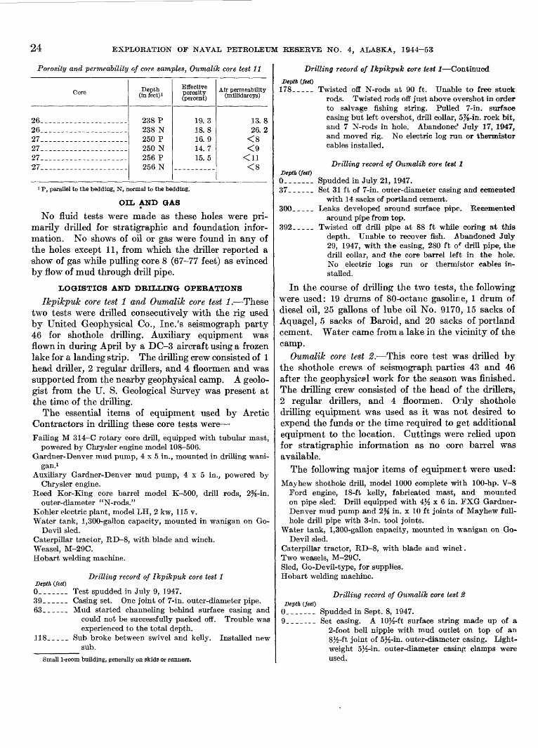
EXPLORATION OF NAVAL PETROLEUM RESERVE NO. 4, ALASKA, 1944-53
Porosity and permeability of core samples, Oumalik core test 11
Core
262627272727
Depth (infeet)i
238 P 238 N 250 P 250 N 256 P 256 N
Effective porosity (percent)
19. 3 18. 8 16. 9 14. 7 15.5
Air permeability (millidarcys)
13. 8 26. 2
<8 <9
<8
1 P, parallel to the bedding, N, normal to the bedding.
OIL AND GAS
No fluid tests were made as these holes were pri marily drilled for stratigraphic and foundation infor mation. No shows of oil or gas were found in any of the holes except 11, from which the driller reported a show of gas while pulling core 8 (67-77 feet) as evinced by flow of mud through drill pipe.
LOGISTICS AND DRILLING OPERATIONS
Ikpikpuk core test 1 and Oumalik core test 1. These two tests were drilled consecutively with the rig used by United Geophysical Co., Inc.'s seismograph party 46 for shothole drilling. Auxiliary equipment was flown in during April by a DC-3 aircraft using a frozen lake for a landing strip. The drilling crew consisted of 1 head driller, 2 regular drillers, and 4 floormen and was supported from the nearby geophysical camp. A geolo gist from the U. S. Geological Survey was present at the time of the drilling.
The essential items of equipment used by Arctic Contractors in drilling these core tests were Failing M 314-C rotary core drill, equipped with tubular mast,
powered by Chrysler engine model 108-506.Gardner-Denver mud pump, 4 x 5 in., mounted in drilling wani-
gan. 1Auxiliary Gardner-Denver mud pump, 4x5 in., powered by
Chrysler engine.Reed Kor-King core barrel model K-500, drill rods, 2%-in.
outer-diameter "N-rods."Kohler electric plant, model LH, 2 kw, 115 v.Water tank, 1,300-gallon capacity, mounted in wanigan on Go-
Devil sled.Caterpillar tractor, RD-8, with blade and winch.Weasel, M-29C.Hobart welding machine.
Drilling record of Ikpikpuk core test 1 Depth (feet)0--___ Test spudded in July 9, 1947. 39______ Casing set. One joint of 7-in. outer-diameter pipe.63______ Mud started channeling behind surface casing and
could not be successfully packed off. Trouble wasexperienced to the total depth.
118_____ Sub broke between swivel and kelly. Installed newsub.
Small 1-room building, generally on skids or runners.
Drilling record of Ikpikpwk core test 1 Continued
Depth (feet)178_.___ Twisted off N-rods at 90 ft. Unable to free stuck
rods. Twisted rods off just above overshot in order to salvage fishing string. Pulled 7-in. surface casing but left overshot, drill collar, 5%-in. rock bit, and 7 N-rods in hole. Abandonee1 July 17, 1947, and moved rig. No electric log run or thermistor cables installed.
Drilling record of Oumalik core test 1Depth (feet)0. _ ___ Spudded in July 21, 1947.37______ Set 31 ft of 7-in. outer-diameter casing and cemented
with 14 sacks of portland cement.300_____ Leaks developed around surface pipe. Recemented
around pipe from top.392_____ Twisted off drill pipe at 88 ft while coring at this
depth. Unable to recover fish. .Abandoned July 29, 1947, with the casing, 280 ft of drill pipe, the drill collar, and the core barrel left in the hole. No electric logs run or thermistor cables in stalled.
In the course of drilling the two tests, the following were used: 19 drums of 80-octane gasoline, 1 drum of diesel oil, 25 gallons of lube oil No. 9170, 15 sacks of Aquagel, 5 sacks of Baroid, and 20 sacks of portland cement. Water came from a lake in the vicinity of the camp.
Oumalik core test 2. This core test was drilled by the shothole crews of seismograph parties 43 and 46 after the geophysical work for the season was finished. The drilling crew consisted of the head of the drillers, 2 regular drillers, and 4 floormen. Oily shothole drilling equipment was used as it was not desired to expend the funds or the time required to get additional equipment to the location. Cuttings were relied upon for stratigraphic information as no core barrel was available.
The following major items of equipmert were used:Mayhew shothole drill, model 1000 complete with 100-hp. V-8
Ford engine, 18-ft kelly, fabricated mast, and mounted on pipe sled". Drill equipped with 4% x 6 in. FXG Gardner- Denver mud pump and 2% in. x 10 ft joints of Mayhew full- hole drill pipe with 3-in. tool joints.
Water tank, 1,300-gallon capacity, mounted in wanigan on Go- Devil sled.
Caterpillar tractor, RD-8, with blade and winch.Two weasels, M-29C.Sled, Go-Devil-type, for supplies.Hobart welding machine.
Depth (feet)Drilling record of Oumalik core test 2
Spudded in Sept. 8, 1947.Set casing. A 10J_-ft surface string made up of a
2-foot bell nipple with mud outlet on top of an 8}_-ft joint of 5%-in. outer-diameter casing. Light weight 5J^-in. outer-diameter casing clamps were used.
CORE TESTS AND TEST WELLS, OTJMALIK AREA, ALASKA 25
Drilling record of Oumalik core test 2 Continued
Depth (feet)190_ _ _ _ _ While reaming, the casing parted at weld below clamp
and dropped to a depth of 42 ft but was fished out. A piece of casing, cut out with a welding torch, fell into the hole, lodged at 42 ft, and was not recovered. Hole abandoned Sept. 10, 1947, with 15 ft of drill rods and a rock bit in the hole. The 5}_-in. casing was removed. No electric logs were run or ther mistor cables installed.
In the course of drilling the following were used: 120 gallons of 80-octane gasoline, 25 gallons of diesel oil, 10 quarts of lubricating oil SAE 20, and 3 sacks of Aquagel.
Oumalik core (foundation) tests 1-10. There is no information on the logistics or drilling of Oumalik core (foundation) tests 1-10. Thermistors were in stalled in some of the holes and temperature records were utilized in designing the foundation for Oumalik test well 1.
Oumalik core test 11. Oumalik core test 11 was drilled with a Failing 1500 rig. (See pi. 1-A) The crew was supported from a geophysical camp. Details on the rest of the equipment, material, and manpower utilized were not recorded. An Arctic Contractors petroleum engineer and a geologist were present during the drilling of the core test.
Drilling record of Oumalik core test 11 Depth (feet)
0_______ Spudded in Mar. 9, 1949.14.2_____ Set conductor pipe, 8^-in.127_ _ _ _ _ Lost circulation around conductor pipe. Recemented.303_____ Suspended coring operations and bailed hole dry
Mar. 22, 1949.
Oumalik core test 12. No engineering data are available. Thermocouples were probably installed in Oumalik core tests 11 and 12 upon their completion.
OUMALIK TEST WELL 1
Locatipn: Lat 69°50'18" N., long 155°59'24" W. Elevation: Ground, 176 feet; kelly bushing, 194 feet. Spudded: June 11, 1949.Completed: Apr. 23, 1950, plugged and abandoned. Total depth: 11,872 feet.
Oumalik test well 1 (pi. l-B) is located on the apex of the Oumalik anticline (see fig. 5) in an area of low hummocks and ridges, in a slight depression that covers several square miles, and away from any major drainage. The latitude and longitude given above is subject to correction as no detailed topographic surveys have been made in the area. However, the location as shown in figure 4 is accurate with respect to the local drainage.
The following is a list of depths at which the different stratigraphic units are found in Oumalik test well 1.
Depth (feet)18-30__________________ Recent and (or) Gubik forma
tion. 30-2,825_________________ Grandstand formation.
2,825-4,860___________---_-_ Topagoruk formation.4,860-10,880.--------------- Oumalik formation.
10,880-11,872 (total depth) ____ Upper Jurassic (?) and LowerCretaceous(?)
The first sediments penetrated (from 18 to 30 feet) in the well are river material of Recent age and (or) Gubik formation of Pleistocene age. The sediments consist of silt, sand, gravel, and clay with tundra and ice as described on page 8. Actually, not much clay was found, but some was probably present and was washed out during preparation of the samples. Rare white shell fragments of Pleistocene cr Recent age were found.
The youngest Cretaceous rock penetrated in Oumalik test well 1 is the Grandstand formation, at 30-2,825 feet. Because Oumalik test well 1 is structurally higher than East Oumalik test well 1, the former started some 700 feet stratigraphically lower. Thus, ercept for possibly a few thin beds, the Killik tongue of the Chandler formation is not present in Ouiralik test well 1. The Grandstand formation is 2,795 feet thick in the well and is made up of approximately 45 percent sandstone and siltstone, 50 percent clay shale, and 5 percent coal or carbonaceous material.
Although this section is quite calcareous, very little true limestone was found 22 inches in the core at 528 feet is medium-gray dense hard limestone with much brown drusy siderite lining incipient fractures. Identi cal material was noted in the cuttings at 550 feet. Some medium-dark-gray crystalline limestone was found in the ditch at 690-700 feet. The carbonate (probably partly dolomite) content of the sandstone and siltstone ranges from 8 to 47 percent, averaging 25 percent. Porosity ranges from 0.4 to 19.3 percent, and permeability, from impermeable to 34 millidarcys.
Thin beds of coal are fairly common in the first 900 feet and between 2,300 and 2,500 feet. Good fernlike and grasslike leaf impressions occur in cores at 517-528 feet. Very rare yellowish to brownish-gny clay ironstone concretions also were found.
As a rule the beds are flat lying or dip as much as 5°, although ripple marks and crossbedding witb dips as much as 20° are present. "Swirly" beds are, present at 2,800 feet; slickensides are very rare. Shows of gas, faint petroliferous odors, and straw-colored cnts were obtained from several sandstone beds in the Grandstand formation.
The Topagoruk formation was penetrated between 2,825 and 4,860 feet in this test. The formation is fossiliferous and mostly clay shale with about 10
26 EXPLORATION OF NAVAL PETROLEUM RESERVE NO. 4, ALASKA, 1944-53
percent siltstone and sandstone. The porosity of the siltstone and sandstone sections ranges from 1 to 18 per cent; permeability is less than 5 millidarcys; and the carbonate content ranges from 10 to 25 percent. The dip of the beds ranges from almost flat to 25°, with the average dip about 4°; the higher dips possibly reflect large-scale crossbedding or faults. A few partings of black bitumen are present. Pale cuts and faint oil odors were obtained in most of the cored sands. Gas found at 3,240-3,244 feet had a shut-in pressure of 1,350 pounds per square inch and a gas reading of 5.7 milliamperes on the Baroid gas detector.
The type section of the Oumalik formation is in this test well (Robinson, Rucker, and Bergquist, 1956). The Oumalik formation is 6,020 feet thick (4,860- 10,880 feet) and is divisible into two parts an upper shale unit between 4,860 and 9,270 feet and a lower sandy shale between 9,270 and 10,880 feet. (See p. 9.) The carbonate content of the sandstone and siltstone, measured quantitatively at selected points, ranges from 12.2 to 17.4 percent; the sand stone is impermeable to air, and the porosity ranges from 2.8 to 11.4 percent.
Several pronounced fracture zones with slickensides and sometimes with fault gouge were noted at 5,100 to 5,900 feet, 7,200 to 7,800 feet, and 8,400 to 8,700 feet. The repeated occurrence of slickensides throughout the shale section suggests local fracturing of incompetent beds.
Shows of gas were detected in the lower part of the Oumalik formation from 8,000 to 10,850 feet; faint to fair petroliferous odor was noted on fresh fractures, but no cuts were obtained.
The oldest rocks in Oumalik test well 1 are of Late Jurassic (?) and Lower Cretaceous (?) age, described on page 10. These beds are flat lying or dip as much as 10°, as indicated by two cores only. A few shows of gas were noted.
HEAVY-MINERAL STUDIES
Three heavy-mineral zones were recognized by R. H. Moms in Oumalik test well 1 (pi. 6). The glauco- phane zone ranges from 434 feet to 2,954 feet. Glaucophane occurrences within this zone are sporadic. The zoned zircon zone ranges from 1,794 to 3,954 feet. The uppermost 1,000 feet of this zone extends into the lower part of the glaucophane zone. The stratigraphic section, 3,994 to 9,394 feet, is predominantly shale; therefore, no heavy-mineral samples were taken. The augite zone ranges from 9,454 feet to 10,654 feet.
DESCRIPTION OF CORES AND CUTTINGS
The following lithologic description was made by the author using cores, well cuttings, and to some extent the electric log. (Seepi. 4.) Many of the well cuttings were badly contaminated with cement and a fine grained white quartz sand. Some of the depths at which this contamination was particularly noted are 1,230-1,460 feet, 1,740-1,770 feet, 1,850-1,870 feet, 2,000-2,030 feet, 2,760-3,200 feet, and 8,000-8,150 feet. Depths are measured from the top of the kelly bushing.
Lithologic description
[Where no core number is listed, description is based on cutting samples]
Core
____
_ _______
_ __ __ __ _
_ _ ______
________
____________
Depth (feet)
0-18
18-2525-30
30-3535-50
50-6060-70
70-8080-110
110-120120-130
130-140140-150150-160
Remarks
Height of derrick floor above groundlevel.
Tundra, ice, and silt.Sand and gravel; gravel made up of
polished subangular chert and a fewquartz granules, primarily variousshades of yellow and dark gray; alarge amount of dark-yellowish-orangeto light- brown angular clay- ironstonegranules; also rare pieces of pale-yellowish-brown quartzite and otherrocks. Sand is fine grained, made upprimarily of subangular clear andwhite quartz, also some yellow quartzplus a few chert pebbles. Somesuggestion of clay. Rare (Pleistoceneor Recent?) white shell fragments.The base of the Gubik and top ofthe Grandstand forrration is placedat 30 feet.
No samples received.Clay shale, medium-olive-gray, and a
large amount of grryish-black carbonaceous shale, very rare chips ofcoal, also some fine-grained sand;sand grains somewhat better roundedthan at 25-30 ft.
No samples received.Clay shale, dark- and light-gray, iron
stone concretions, and considerableamount of vitreous black coal.
No samples received.Siltstone, medium-gray, and medium-
gray clay shale; ironstone concretions,small amount of coal, noncalcareous.
No samples received.Siltstone, medium-dark-gray, slightly
sandy, argillaceous, friable.No samples received.Clay shale and siltstone.Clay shale with silty streaks.
CORE TESTS AND TEST WELLS, OUMALIK AREA, ALASKA 27
Lithologic descr iption C ontinued
Core
1
____
____
____
________
________
____
____
____
2
Depth (feet)
160-180
180-250l
250-260
260-270
270-280280-360
360-370370-440
440-450450-460
460-470
470-517
517-528
Remarks
Recovered 15 ft:Cement. Took core from inside
22-in. casing to ascertain conditionof cement. Not sent to Fairbanks.
No samples received in Fairbanks.Well geologist reports as follows:
180-189, sandstone, silty to very finegrained, gray, moderately hard,argillaceous.
189-199, shale, gray, silty, micaceous,carbonaceous.
199-201, coal, lignite to subbitumi-nous, broken.
201-210, sandstone and shale in thinbeds.
210-244, clay shale, dark-gray, silty,carbonaceous streaks.
244-249, sandstone, very fine- to finegrained, gray, slightly argillaceous,carbonaceous.
Silty clay shale, medium-light-gray,slightly calcareous, cement contamination.
Sandstone, medium-light-gray, veryfine-grained, argillaceous, very slightlycalcareous.
Sandstone and siltstone as above.Clay shale, medium-light-gray to me
dium-gray, and slightly calcareoussilt shale; rare clay ironstone at 310 ft,small amount of sandstone at 320 ft,and carbonaceous streaks at 350-360 ft.
No samples received.Clay shale, medium-light-gray to medi
um-gray. At 390, 410, and 440 ft asmall amount of medium-grainedsandstone made up of medium-light-gray light-colored quartz, dark chert,rock fragments, and coal fragments;moderately calcareous.
No samples received.Sandstone, fine- to medium-grained,
"salt and pepper" appearance, sub-angular white and clear quartz, darkchert; argillaceous, calcareous matrix,also some clay shale and clay ironstone concretions.
Coal, vitreous, black, and dark-graycarbonaceous clay shale; also somemedium-light-gray shale.
Clay shale, medium-gray, carbonaceousstreaks, micaceous, ironstone at 480ft, possibly some silt.
Recovered 10 ft: Microfossils absent.2 ft 5 in., siltstone, very fine, medium-
to medium-dark-gray, hard, mica-
Lithologic description Continued
Core
____
____
____
____--__
________
3
Depth (feet)
528-560
560-570
570-680
680-690690-700
700-710710-723
723-733
Remarks
ceous, very calcareous ; bedding somewhat irregular, lenticular, but essentially at right angles to walls ofcore; fracture irregular but tendsto parallel bedding. This section ofthe core is characterized by numerous dull and a few vitreous blackcarbonaceous plant impressions. El-atides sp. was identified.
2 ft, siltstone, very fine, as above, butwith fewer plant remains. Gradesinto rock below.
3 ft 9 in., silty claystone, medium-gray, very calcareous, not fissilebut tends to fracture roughly parallel to bedding; contains many blackcarbonaceous plant remains. Gink-go digitata (Brongnirrt) Heer ispresent.
1 ft 10 in., limestone, medium-gray,dense, hard; much brown drusysiderite lining incipient fractures.
Clay shale, medium- to dark-gray,carbonaceous; also siltstone, a verylittle limestone at 550 ft.
Clay shale, and limestone, medium-gray;drusy ' siderite, some coal. Echinoid(?) spine.
Clay shale (and claystone) interbeddedwith siltstone, clay shale, medium-light- to medium-dark-gray, slightlycalcareous, has carbonaceous streaks,black plant impressions, a little pyriteand coal; and siltstone, medium-gray,calcareous, contains carbonaceous particles. Very slight shc^r of gas inditch at 625 ft.
No samples received.Limestone, medium-dark-gray, crystal
line, also slightly to moderately calcareous claystone.
No samples received.Clay shale and claystone, r^edium-light-
to medium-dark-gray; rare clay ironstone concretions.
Recovered 10 ft: Microfosals common.3 ft 5 in., clay shale, medium-dark- to
dark-gray, noncalcareous, fissile;breaks in laminae 3 mm thick orless; a few small pyrite concretions.
7 in., siltstone, medium-gray, massive,hard, carbonaceous and micaceousflakes; grades in last 2 in. to siltyclaystone with carbonaceous plantremains; very calcareous.
8 in., clay shale, med ! um-dark- todark-gray, noncalcareous, fissile;
28 EXPLORATION OF NAVAL PETROLEUM RESERVE NO. 4, ALASKA, 1944-53
Lithologic description Continued
Core
__
____ ___
____
______
4
Depth (feet)
733-830
830-840840-850
850-870
870-880880-890
890-900900-911
911-921
Kemarks
breaks in laminae 3 mm thick orless; vitreous black carbonizedplant remains.
6 in., claystone, medium- to medium-da rk-gray, silty, moderately calcareous; bedding indistinct butprobably at right angles to walls ofcore; fracture irregular; many blackcarbonaceous plant impressions,light-brown discolorations frequently rimming plant remains. Gradesinto rocks below.
2 ft 4 in., siltstone, very fine, medium-gray, massive, hard, moderatelycalcareous; irregular fracture; contains black carbonaceous plant impressions.
4 in., clay shale, with carbonaceousfragments as above; noncalcareous.
2 ft 2 in., siltstone, argillaceous,medium-gray, moderately calcareous; mostly massive but withslightly shaly structure at 732 ft;contains hard thin carbonaceouslaminae and carbonaceous plantimpressions.
Clay shale, siltstone, carbonaceous shale,and coal at 750 ft; some very fine- tofine-grained sandstone with calcareouscement and pale to yellowish-brownclay ironstone concretions, at 820 ft.
No sample received.Sandstone, medium-light-gray, fine- to
medium-grained, "salt and pepper";and medium- to medium-dark-grayclay shale.
Clay shale with carbonaceous plantimpressions, some pyrite; some coaland dark shale at 870 ft.
No sample received.Coal, fine sand, and dark-gray clay
shale.No sample received.Interbedded clay shale, medium-dark-
gray, and medium-light-gray sandysiltstone, slightly calcareous.
Recovered 10 ft: Microfossils absent.3 ft 9 in., very argillaceous siltstone,
medium-gray, moderately hard;calcareous in spots; cleavage irregular but tends to parallel bedding.
4 ft 2 in., claystone or clay shale,medium- to medium-dark-gray,silty, slightly calcareous; fracturesroughly parallel to the bedding inlayers about 1 in. thick; lower footmore massive. Slickensides dip 30°at very base.
Lithologic description Continued
Core
____
________
5
6
7
8
Depth (feet)
921-940940-950
950-960960-968
968-979
979-984
984-989
989-994
Remarks
9 in., sandstone, medirm-light-gray,very fine- to fine-grain ?d, calcareousmatrix, fairly hard.
3 in., claystone, as in at ove 4 ft 2 in.part of core; contains carbonaceousplant remains.
1 ft 1 in., sandstone, medium-light-gray, between fine- and medium-grained, subrounded grains; primary mineral is quartz; numerousvery thin micaceous1 and carbonaceous laminae. Very calcareouscement; by quantitative analysis thecarbonate content at 921 ft is 22.1percent by weight; cut at samedepth was a very faint-straw colorand had a very pale-yellow residue.At 921 ft effective porosity and airpermeability parallel to beddingare 9.48 percent and less than 5millidarcys respectively; and 8.55percent and less than 5 millidarcysnormal to the bedding.
No samples received.Sandstone, medium-light-gray, "salt
and pepper," fine- to medium-grained;moderately calcareous cement.
No samples received.Clay shale, dark-gray, carbonaceous,
and coal.Recovered 6 in.: Microfossils absent.
Siltstone and sandston?, light-gray,friable; silt to very fine sand, verycalcareous, very faint oil stain,good odor, and light-straw-coloredcut.
Recovered 6 in.: Microfossils absent.Sandstone, light-gray, moderately
hard, very fine- to fine-grained,very calcareous; grains subrounded;rare thin black carbonaceous laminae; very faint oil stain, good odor,and light-straw-colored cut. Carbonate content 15.1 percent byweight. Effective porosity of onesample is 15.2 percent, and air permeability 34 millidarcys.
Recovered 2 ft 6 in.: Microfossils absent.
Sandstone, light-gray, very finegrained, very calcareous, hard butbadly broken; fair odor, straw-colored cut from 988 ft.
Recovered 4 ft 6 in.: Microfossilsabsent.
Sandstone, light-gray, very fine- tofine-grained, hard, massive, verycalcareous; fair odor, very faint-yellowish cut from 991 ft. Effec-
CORE TESTS AND TEST WELLS, OUMALIK AREA, ALASKA 29
Lithologic description Continued
Core
9
10
11
__________
12
----
____
________
Depth (feet)
994-999
991-1,004
1,004-1,010
1,010-1,0201,020-1,0301,030-1,033
1,033-1,038
1,038-1,050 1,050-1,060 1,060-1,0701,070-1,080
1,080-1,090 1,090-1,100 1,100-1,110
1,110-1,150
1,150-1,1601,160-1,170
1,170-1,180
Remarks
tive porosity and air permeabilityof one sample parallel to beddingare 13.15 percent and 9.7 millidarcys respectively, and 13.43 percent and 5.6 millidarcys normal tobedding. Carbonate content 20.4percent by weight.
Recovered 1 ft: Microfossils absent.Sandstone as above, also some inter-
bedded siltstone; very calcareous;faint petroliferous odor.
Recovered 1 ft: Microfossils absent.Siltstone, grading from very fine-grained
sandstone at top, medium-light-gray, with medium-dark-gray carbonaceous and micaceousp artings;hard; carbonaceous plant impressions; very calcareous; very faintpetroliferous odor.
Recovered 2 ft 4 in. Microfossils absent.1 ft, siltstone as above, dip 2°; grades
into rock below.1 ft 4 in., clay shale, medium-dark-
gray, silty, hard, has black carbonaceous plant remains, rather hacklycleavage; slightly calcareous.
No samples received.Clay shale and sandy siltstone.Sandstone, medium-light-gray, very fine
grained to silty; well geologist reportsdead tarlike oil at 1,028-1,033 ft;spotty fluorescence; no cut or odor.
Recovered 4 ft 'Microfossils absent.Clay shale, medium-dark- to dark-
gray, rather hard, slightly to moder ately calcareous; carbonaceous and micaceous partings; tends to have irregular fracture rather than good cleavage.
Silty sandstone and clay shale. Clay shale and siltstone. No sample received.Silty sandstone, very fine, very calcar
eous and clay shale.No sample received. Clay shale. Siltstone and very fine-grained sand
stone, some clay shale.Clay shale, medium-light- to medium-
dark-gray; some dark-gray shale andcoal at 1,130 ft and 1,150 ft.
No sample received.Sandstone, fine- to medium-grained,
moderately calcareous; subangularwhite quartz 60 percent, also rock andcoal fragments; also dark shale, coal,and brownish lignite.
No sample received.
Lithologic description Continued
Core
____
13
14
15
16
Depth (feet)
1,180-1,190
1,190-1,195
1,195-1,205
*
1,205-1,210
1,210-1,215
l,215-l,23u
1,230-1,410
1,410-1,422
Remarks
Clay shale, light- and dark-gray, andcoal.
Sandstone, light-colored shale, and asmall amount of dark shale and coal.
Recovered 10 ft: Microfossils absent.Siltstone, medium-light-gray, hard;
contains scattered ve~y thin sandstone layers, some darker laminaewhich contain a largsr proportionof carbonaceous material; silt contains mica; carbonate content at1,201 ft is 28.3 percert by weight;dip approximately 3°. At 1,201 fteffective porosity and air permeability parallel to becMing 3.4 percent and less than 5 irillidarcys, respectively, and 2.4 percent and lessthan 5 millidarcys normal to bedding.
Recovered 5 ft: Microfossils very rare.6 in., siltstone as above but contains
larger carbonaceous fragments andmore common carbonaceous laminae.'
4 ft 6 in., clay shale, medium-dark- todark-gray, rather hard, very slightlycalcareous in spots; h^s good shalycleavage; numerous carbonaceousand micaceous partings.
Recovered 5 ft: Microfofdls very rare.8 in., siltstone, medium-gray, argil
laceous, micaceous, carbonaceous,and slightly calcareons, hard; becomes more argillaceous in lowest 2 in.; dip approximately 5°; slick- ensides noted in last inch; dip 50°.
4 ft 4 in., silty clay shale or claystone, medium-dark- to darl'-gray; rather hard; slightly .calcareous; carbona-
' ceous flecks and micr. in partings; tends to have irregular fracture where carbon and mici. partings are absent.
Siltstone and shaly clay, medium-light-gray.
Clay shale, medium-gray, slightly to moderately calcareous; some carbo naceous impressions. Pimples contaminated with cement.
Recovered 3 ft 4 in: Mic~ofossils rare.Clay shale and claystone, medium-
dark-gray, moderately hard, slightly to moderately calcareous; hassome good shaly cleavage but alsotends to break irregularly alongbedding planes in layers more than1 in. thick; partings showing bestshaly cleavage are silty and micaceous; numerous medium-dark-gray
374616 56 5 *
30 EXPLORATION OP NAVAL PETROLEUM RESERVE NO. 4, ALASKA, 1944-53
Lithologic description Continued
Core
________
________
17
18
19
20
Depth (feet)
1,422-1,4501,450-1,490
1,490-1,5101,510-1,604
1,604-1,609
1,609-1,619
1,619-1,626
1,626-1,637
Remarks
silty lenses present; clayey layersbend over and around the silt; blackcarbonaceous plant remains andcoaly flecks common throughout;a few small specimens of Corbula?sp. at about 1,417 ft.
No samples received.Siltstone, medium-light-gray, argilla
ceous, some very fine sand, also clayshale. Well geologist reports veryfaint odor of kerosene at 1,470-1,480ft. Top occurrence of Ditrupa sp.at 1,470 ft.
Clay shale, medium-gray.Clay shale and siltstone; a small amount
of very fine-grained sandstone.Recovered 1 ft 10 in.: Microfossils
absent.Sandstone, medium-light-gray, hard,
very fine-grained, noncalcareous;grains mostly subangular; primarymineral quartz; grains coated andcemented by very fine powderywhite silty material; thin, irregular,black coaly partings and flecks common; no shows. At 1,606 ft effective porosity 10.9 percent and airpermeability 8.8 millidarcys parallelto bedding.
Recovered 8 ft 6 in. : Microfossils absent.Sandstone as above, bedding as indi
cated by carbonaceous-micaceousstreaks shows dips ranging fromessentially flat lying to 12° withina few inches; grain size as large asfine sand but cemented with muchfiner material. At 1,614 ft effectiveporosity and air permeability parallel to bedding 10.35 percent and lessthan 5 millidarcys respectively and9.92 percent and less than 5 millidarcys normal to bedding.
Recovered 6 ft 4 in. : Microfossils absent.Sandstone as immediately above, very
faint petroliferous odor, very faintcut and very pale-yellow residuefrom 1,622 ft. At 1,622 ft effectiveporosity and air permeability parallel to bedding 9.85 percent and lessthan 5 millidarcys and 9.45 percentand less than 5 millidarcys normalto bedding.
Recovered 11 ft: Microfossils absent.10 ft, sandstone as above, becomes
silty toward base; noncalcareous;5° average dip; no shows. At 1,634ft effective porosity and air permeability parallel to bedding 7.92 percent and less than 5 millidarcys and
Lithologic description Continued
Core
________
____
____
____
21
____
-.___
22
23
Depth(feet)
1,637-1,6601,660-1,740
1,740-1,780
1,780-1,790
1,790-1,797
1,797-1,803
.1,803-1,850
1,850-1,965
1,965-1,966
1,966-1,967
Remarks
8.09 percent and less than 5 millidarcys normal to bedding.
1 ft, siltstone and shale, interbedded.Siltstone, medium-light-gray, withcarbonaceous streaks- grades fromsandstone above; stale, medium-dark-gray, silty, non calcareous.
Clay shale, medium-gray; siltstone.Sandstone, fine-grained, calcareous, pri
marily subangular white quartz;coaly particles; some coal and shalyclay.
Clay shale, medium-light- to medium-dark-gray; streaks of very fine sand.
Sandstone, fine- to medium-grained,slightly to moderately calcareous.
Clay shale, medium- to medium-dark-gray; coal.
Recovered 4 ft: Microfosfils absent.Clay shale, dark-gray to grayish-
black, fissile and brittle, noncalcareous, very carbonaceous; contains numerous black plant impressions and many laminae of coal;dip about 4e > but some of the thincoaly streaks dip as much as 25°through the shale. Coal, vitreous,black; has irregular fracture; showsa faint suggestion of bedding;occurs in laminae up to 2 cm thickbut generally much thinner 1 mmor less; the thicker coal laminae aremostly in bottom foot.
Clay shale, medium-dark-gray; smallamount of coal at 1,81C-1,820 ft.
Sandstone, silty to fine-grained, medium-light-gray, slightly to moderatelycalcareous; and med'um-light- tomedium-dark-gray clay; streaks ofcoal from 1,850-1,860, 1,890-1,920,and 1,940-1,950 ft.
Recovered 9 in.: Microfoesils absent.Siltstone, medium-gray, hard, mas
sive, calcareous.Recovered 9 in. : Microfoesils absent.
Siltstone as* above; smr.U calcite veindips about 45° through core. Cross-bedding dipping as much as 20° isfaintly visible. Both this core andone above show mod3rate but veryslow reaction with 25 percent coldhydrochloric acid. A vigorous reaction takes place wl ?n the core ispowdered. At 1,966 ft effective porosity and air permeability 0.42 percent and less than 5 millidarcys,respectively, paralle1 to bedding,and 0.36 percent and less than 5millidarcys normal to bedding.
CORE TESTS AND TEST WELLS, OUMALIK AREA, ALASKA 31
Lithologic descnpfrwm-r-Continued
Core
____
___-
________
____
____
____
24
Depth (feet)
1,967-1,990
1,990-2,000
2,000-2,0102,010-2,030
2,030-2,050
2,050-2,090
2,090-2,140
2,140-2,151
2,151-2,161
Remarks
Carbonate content at same depth47 percent by weight.
Coal, vitreous, black, and medium-dark-gray shale, plus a small amount ofmedium-light-gray siltstone.
Sandstone, very fine-grained, and medium- to medium-dark-gray clay shale.
Clay shale, cement contamination.Clay shale, medium-gray, and fine
grained very slightly calcareous siltysandstone.
Clay shale, dark-gray, and coal; smallamount of siltstone toward base.
Sandstone, medium-light-gray, finegrained, and medium-dark-gray clayshale; pyrite, a little coal at 2,070-2,080 ft.
Clay shale, cement, and sand (sand iscontamination, possibly from cellarof well).
Sandstone, medium-light-gray, mostlysubangular white quartz, with somegray chert, and clay shale; noncal-careous.
Recovered 8 ft: Microfossils common.2 ft, interbedded siltstone and clay
shale, about 33 percent shale and66 percent silt. Siltstone, medium-light-gray, hard, noncalcareous;bedding and crossbedding as indicated by slight differences of grainsize and color show local dips ashigh as 20*,. general dip probably3°-5°. Clay shale, medium-dark-gray, moderately hard. Contactsbetween shale and silt quite sharp;undulatory nature of some of contacts suggests ripple marks; estimated wave length 2 in., amplitudeone-twelfth of an inch. Layer one-twelfth of an inch thick near bottomis siltstone containing thin flatfragments of shale as much as \%in. in length a sort of intraforma-tional conglomerate. A few partings have vitreous, black flakes andfragments of coal. One 1%-in. layerof fine-grained sandstone at 2, 152 ft.
2 ft 4 in., sandstone and siltstone, veryfine-grained, medium-light-gray,hard; throughout most of sectionbedding not pronounced except incenter where micaceous and carbonaceous partings are present;dip 5°. Slight petroliferous odor.At 2,154 ft effective porosity andair permeability parallel to bedding3.43 percent and less than 5 milli-darcys, respectively, and 3.83 per-
Lithologic description Continued
Core
25
»
__
_
__
__
26
__
__
____
_ _* _
27
Depth (feet)
2,161-2,171
2,171-2,190
2,190-2,210
2,210-2,220
2,220-2,310
2,310-2,330
2,330-2,340
2,340-2,351
2,351-2,356
2,356-2,390
2,390-2,420
2,420-2,4302,430-2,500
2,500-2,5202,520-2,529
2,529-2,539
Remarks
cent and less than 5 millidarcysnormal to bedding. Carbonatecontent at same deptl 8 percent byweight.
3 ft 8 in., interbedded siltstone andshale as above in this- core, -25 percent siltstone, 75 percent shale.
Recovered 10 ft: Microfossils common.Interbedded siltstone, medium-light-
gray, and medium-drrk-gray shaleas above. Siltstone, 20 percent,shale, 80 percent. Silty lenticles inthe clay shale.
Sandstone, silty to fine-grained, medium-light-gray; and medium-dark-grayshale; some coal at 2,18^-2,190 ft.
Clay shale and a small anrount of sandstone.
Sandstone, silty to fine-grained, andsome medium-dark-gray clay shale.
Clay shale, medium-gray to grayish-black; streaks of coal throughout,particularly at 2,240-2,?50 and 2,280-2,290 ft; also streaks of silt.
Coal, vitreous black, irregular fraeture,and medium-dark-gray clay shale.
Sandstone, medium-light-gray, veryfine- to fine-grained, and medium-dark-gray clay; noncalcareous.
Clay shale, medium-dark- to dark-gray,moderately hard, coal streaks at2,340-2,350 ft, slightly calcareous tononcalcareous.
Recovered 5 ft: Microfossils common.Interbedded siltstone, medium-light-
gray, and medium-dark-gray clayshale; similar to core 25 except thatshale is siltier, harde^, and has lessshaly cleavage. On the whole, distinction between siltstone and shaleis not as great as abcve.
Clay shale, coal streaks at 2,370-2,390ft.
Clay shale, medium-de^k-gray, andvery fine-grained sandstone.
Coal and dark-gray clay shale.Clay shale, medium- to medium-dark-
gray, and small amount of medium-light-gray siltstone; latter is slightlycalcareous; a very little very finesand; small amount of coal at 2,450-2,460 ft; pyrite present; clay ironstone at 2,440-2,450 ft.
Clay shale and siltstone, 1 :1 ratio. -Clay shale, some siltstoce, and a little
coal.Recovered 8 ft 6 in.: Microfossils absent.
2 ft 4 in., siltstone and shaly. silt, medium-light-gray, noncalcareous fairly
32 EXPLORATION OF NAVAL PETROLEUM RESERVE NO. 4, ALASKA, 1944-53
Lithologic description Continued
Core
____
____
____
____
____
___-____
____
28
Depth (feet)
2,539-2,570
2,570-2,610
2,610-2,620
2,620-2,700
2,700-2,710
2,710-2,7302,730-2,740
2,740-2,756
2,756-2,757
Remarks
hard; tends to have a shaly cleavageparallel to bedding; bedding andcrossbedding visible owing to slightdifference in color; dips as high as20°; regional dip probably close to3° or 4°; faint petroliferous odor,pale-straw-colored cut from 2,531ft.
6 ft 2 in., interbedded siltstone andclay shale. Siltstone as above.Clay shale medium- to dark-gray,moderately hard, noncalcareous.Lenticles of silt and "ripple marks"similar to those described in core 24present.
Clay shale, plus small amounts of silt-stone; clay ironstone concretion at2,550-2,560 ft, a very little coal at2,540-2,550 ft and 2,560-2,570 ft.
Clay shale, medium-dark- to dark-gray,and varying amounts of medium-light-gray silty sandstone and siltstone.Crinoid fragment at 2,590-2,600 feet.
Clay shale, medium-dark- to dark-gray,and very fine-grained medium-light-gray sandstone.
Clay shale, medium-dark-gray, moderately hard; streaks of sandy siltstoneand coal at 2,660-2,700 'ft (particularly in last 10 ft); clay ironstone at2,620-2,630 ft. Crinoid fragment at2,670-2,680 ft.
Sandstone, very fine-grained, and silt-stone, clay shale, and a little coal.
Clay shale and siltstone.Clay shale, medium-dark-gray, and
medium-light-gray siltstone, about 50percent of each. Also a small amountof very fine-grained sandstone andcoal.
Clay shale, 50 percent, medium-dark-gray; and sandstone, 50 percent,medium-light-gray, very fine- to finegrained; 70 percent white and clearquartz, matrix slightly calcareous.
Recovered 1 ft: Microfossils absent.3 in., siltstone, light- to medium-light-
gray, hard; a few black carbonaceous plant, impressions; moderateeffervescence with cold 25 percentHC1. At 2,756 ft effective porosity1.78 percent and air permeabilityless than 5 millidarcys parallel tobedding.
6 in., sandstone, light- to medium-light-gray, hard; numerous vitreous and dull black coaly fragmentsand partings; fine-grained (somegrains slightly coarser); primarilysubangular clear, milky, and some
Lithologic description Continued
Core
29
____
30
31
32
Depth (feet)
2,757-2,760
2,760-2,767
2,767-2,777
2,777-2,787
2,787-2,792
Remarks
gray quartz grains; has calcareouscement. No odor; no cut from2,756}$ ft. At 2,75^ ft effectiveporosity parallel to bedding 3.74percent and carbonate content 7.88percent by weight; sample unsuitable for permeability determination.
3 in., clay shale or claystone, medium-dark-gray, hard, sligl tly calcareous;shaly cleavage not prominent, a fewmicaceous partings.
Recovered 3 ft: Microfos^ils absent.Clay shale or claystone, medium-dark-
gray, hard; shaly cleavage notprominent; about 3 in. of medium-light-gray siltstone and very finesandstone at 2,758 ft; sharp butwavy or "ripple-mark-like" contacts between silt and shale. Below 2,758 ft shale contains greatdeal of silt therefore slightly lighter in color. Carbonaceous material, both finely disseminated andas larger fragments in certainlaminae, is abundant. Siltstone ismoderately calcareous.
Cement plus a small amount of clayshale (10%-in. casing set at 2,762 ft).
Recovered 10 ft: Microfossils absent.5 ft, siltstone, mediurr- to medium-
dark-gray, argillaceous, massive,fairly hard, very slightly calcareous;contains both biotite and muscovite,also a large amount of dull toshiny black carbonaceous or bituminous material.
5 ft, claystone, medium-dark-gray,slightly shaly, micaceous, veryslightly calcareous, contains finelydisseminated carbonrceous material, few laminae of silte tone as above.
Recovered 10 ft: Microfo^sils very rare.2 ft 6 in., siltstone as described in core
above, slight petroliferous odor onfresh fracture.
4 ft, claystone as in core 30; veryslightly calcareous, high-angle fracturing (about 80°) common; someslickensides; slight petroliferousodor on fresh fracture; grades intorocks below. .
3 ft 6 in., clay shale, medium-dark-gray, hard; not noticeably fractured, cleaves parallel to bedding(?);diP 4°.
Recovered 1 ft 3 in.: Microfossils veryrare.
Claystone or clay sh^le, medium-dark-gray, with lenses and laminae
CORE TESTS AND TEST WELLS, OUMALIK ABBA, ALASKA 33
Lithologic description Continued
Core
33
34
35
36
37
3839
Depth (feet)
2,792-2,799
2,799-2,809
2,809-2,819
2,819-2,829
2,829-2,836
. 2,836-2,8412,841-2,851
Remarks
of medium-gray very slightly qal-careous siltstone; contacts betweenirregular but sharply defined; verysmall amount of fracturing indicated; one very thin lens of medium-light-gray very fine-grained sandstone.
Recovered 4 ft: Microfossils very rare.1 ft 6 in., interbedded clay shale and
siltstone as immediately above;siltstone fragments in the shale suggest partial consolidation and reworking at time of deposition, asort of intraformational conglomerate.
2 ft, siltstone, medium-light-gray,hard, ranges from shale to very finegrained sandstone; very slightlycalcareous; slight petroliferous odor.
6 in., claystone, medium-dark-gray,fairly hard, noncalcareous; has irregular fracture.
Recovered 8 ft: Microfossils absent. 1 ft 4 in., broken zone containing
fragments of siltstone, medium-gray, hard, carbonaceous, micaceous, very slightly calcareous; no fragments over \}k in. in diameter.
3 ft 2 in., siltstone, medium-light- gray, with carbonaceous dark-gray hard laminae; concentric swirly structure indicated by smallchanges in 'texture and color, possibly a phenomenon of soft rock flowage. Grades into rock below.
3 ft 6 in., interbedded siltstone andclay shale.
Recovered 10 ft: Microfossils absent.Claystone and clay shale, medium-
dark- to dark-gray, silty, hard, car bonaceous, micaceous, slightly calcareous; some shaly cleavage.
Recovered 2 ft 4 in.: Microfossils absent.Claystone as above; high-angle frac
tures and slickensides; slightly calcareous. Top of the Topagorukformation is placed at 2,825 feet.
Recovered 6 ft 6 in.: Microfossils common.
Clay shale, medium-dark-gray, withnumerous lenses, laminae, and partings of medium-light-gray siltstone,carbonaceous, very slightly calcareous.
No recovery.Recovered 8 ft 4 in.: Microfossils com
mon.4 ft 9 in., clay shale with silt laminae
as in core 37.
Lithologic description Continued
Core
____
____
40
41
42
Depth (feet)
2,851-3,000
3,000-3,022
3,022-3,032
3,032-3,090 3,090-3,100
3,100-3,140
3,140-3,180
3,180-3,222
3,222-3,232
3,232-3,240 3,240-3,244
,
3,244-3,254
Remarks
1 ft 3 in., clay shale as above but fractured; fractures small rnd irregular;very little displacement of beds.
2 ft 4 in., clay shale as ir first part ofcore.
Clay shale or claystone, medium-dark-gray, essentially noncalcareous.Streaks of slightly calcareous medium-light-gray sandy siltstone,particularly at 2,900-2,910, 2,920-2,930, 2,960-2,970 ft; grains suban-gular, about 60 percent lightquartz. Many ditch samples contaminated with very light-yellowish-gray sand-cement mixture (sandthought to come from well cellar).
Clay shale, medium-darh-gray. Silt-stone at 3,010-3,020 ft. Muchsand and cement contamination.
Recovered 3 ft: Microfossi's common.Interbedded clay shale and siltstone
as in core 37; noncalcrreous.Clay shale, medium-dark-gray. Siltstone and clay shale in even propor
tion; carbonaceous particles very rare. Clay shale, medium-dark-gray, noncal
careous; trace of siltston?. Sand and cement contamination, clay
shale. Clay shale, medium-dark-gray, mica
ceous, also medium-gray siltstone at 3,180-3,190 ft; noncalcareous.
Recovered 8 ft 4 in.: Microfossils common.
4 ft 4 in., clay shale and claystone,medium-dark-gray, hard, fairlygood cleavage, micaceous.
4 ft, clay shale as above, but softer and more fissile.
Clay shale. Sandstone, medium-light-gray, fine- to
medium-grained. Following determinations made on some finegrained chips recovered from rigfloor during heading of well onSept. 30, 1949. No cut, very pale-yellow residue; effective porosity18 percent; carbonate content 10.2percent by weight.
Recovered 4 ft 6 in.: Microfossils veryrare.
1 ft 8 in., clay shale, rather soft, as inlast part of core above.
9 in., sandstone, medium-light-gray,massive, hard, fine-grained; grainsprimarily angular white quartz, asmall amount of biotite and pyrite.Strong odor on fresh fracture.Effective porosity 1.59 percent andair permeability less than 3
34 EXPLORATION OP NAVAL PETROLEUM RESERVE NO. 4, ALASKA, 1944-53
Lithologic description Continued
Core
43
4445
____
________
46
________
Depth (feet)
3,254-3,262
3,262-3,2723,272-3,282
3,282-3,320
3,320-3,4003,400-3,455
3,455-3,465
3,465-3,4803,480-3,490
- Remarks
millidarcys. Carbonate content24.2 percent by weight.
4 in., clay shale, soft as above.7 in., sandstone, as above, strong
naphthalike odor on fresh fracture,pale-straw-colored cut, pale-yellowresidue from 3,251 ft.
1 ft 2 in., clay shale, as above, somesandstone interbedded.
Recovered 8 ft: Microfossils absent.1 ft 8 in., claystone, medium-light-
gray, fairly soft, noncalcareous;darker laminae increase towardbottom and grade into rock below.
2 ft 8 in., clay shale, medium-dark-gray, moderately hard, noncalcareous, with good cleavage.
1 ft 7 in., sandstone, very fine, andmedium-gray hard massive silt-stone; angular white quartz isprimary mineral; mica present;somewhat calcareous silty matrix.Faint odor; straw-colored cut andpale-yellow residue from 3,260 ft.At 3,260 ft effective porosity 9.2percent and air permeability lessthan 4 millidarcys. Carbonatecontent 14.23 percent.
9 in., clay shale, medium-dark-gray,micaceous.
1 ft 4 in., siltstone and sandstone asabove; faint odor.
No recovery.Recovered 10 ft: Microfossils absent.
3 ft, clay shale, medium-dark-gray,with laminae and irregular lenticlesof medium-light-gray siltstone.
7 ft, claystone and shale, medium-dark-gray, hard; poorly developedcleavage; dip of beds estimated 4°.
Sandy siltstone and sandstone, medium-light-gray, very fine-grained, slightlycalcareous to noncalcareous; andmedium-dark-gray clay shale. Smallamount of coal at 3,280-3,290 ft.
Siltstone and shale.Clay shale, medium-dark- to dark-gray,
with silty streaks.Recovered 5 ft: Microfossils common.
Clay shale, medium-dark-gray, hard,carbonaceous, micaceous; interbedded with a few thin irregularlaminae of medium-light-gray silt-stone; noncalcareous; dips as muchas 5°.
No samples received.Sandy siltstone, medium-light-gray
sandstone, and clay shale.
Litholoffic description Con tin ued
Core
47
48
____
4950
51
________
52
Depth (feet)
3,490-3,500
3,500-3,510
3,510-3,700
3,700-3,7103,710-3,712
3,712-3,713
3,713-3,7403,740-3,752
3,752-3,756
Remarks
Recovered 7 ft 3 in.: Microfossils absent.Siltstone, medium-light-gray, hard,
with dark carbonaceous micaceouspartings; very slightly calcareous;estimated 2° dip; very faint petroliferous odor on fresh fracture. At3,494 ft effective porosity 14 percentand air permeability 4.9 millidarcys.At 3,495 ft effective porosity 14.3percent; sample unsuitable for permeability determination.
Recovered 8 ft: Microfoss-ils absent.2 ft, siltstone, medi^m-light-gray,
hard; also a small amount of veryfine-grained sandstorm, micaceous,very slightly calcareous; grades atbottom into rock below.
6 ft, clay shale and claystone, medium-dark-gray, hard, silty, micaceous,very slightly calcareous; containcarbonaceous flecks; interbeddedwith thin irregular laminae andlenses of medium-li^ht-gray silt-stone. Dips range from 4° to 25° probably a reflection of large-scalecrossbedding.
Clay shale and claystone, medium-dark-to dark-gray, moderate^ hard, micaceous, with streaks of medium-light-to medium-dark-gray siltstone 1colordarker because of abundance of carbonaceous particles; some partings ofblack bitumen present; noncalcareous.
No recovery.Recovered 2 in.: Microfossils abundant.
Clay shale, medium-dark-gray, hard,noncalcareous.
Recovered 6 in.: Microfossils abundantClay shale as above; dip 10°.
No samples received.Sandstone, medium-gray, very fine
grained, silty, slightly calcareous;made up of subangular quartz andcarbonaceous particles argillaceousmatrix, thin streaks of bitumen.Some clay shale.
Recovered 3 ft 6 in.: Microfossils absent.Siltstone, medium-gray, moderately
hard, micaceous, moderately calcareous to noncalcareous; grainsprimarily quartz, but siltstone isvery argillaceous grrding to siltyclaystone in places; small (up to 2mm long) fragments of black carbonaceous material disseminatedthroughout; dips 3° or less; faintodor, pale-straw-colcred cut andvery pale residue from 3,752}£ ft.
CORE TESTS AND TEST WELLS, OTJMALIK AREA, ALASKA 35
Lithologic description Continued
Core
____
53
54
____
____
55
56
Depth (feet)
3,756-3,802
3,802-3,812
3,812-3,817
3,817-3,855
NOTE:
3,995-4,005
4,005-4,010
Remarks
At 3,752}i ft effective porosity 12.0percent and permeability less than1 millidarcy. Faint odor, no cut,greasy film from 3,755 ft. At 3,755ft effective porosity 6.0 percent andair permeability 1 millidarcy.
Clay shale and siltstone, medium-gray,with carbonaceous flecks and streaksof bitumen; very fine-grained sandstone 3,770-3,800 ft; slightly calcareous in spots.
Recovered 8 ft 9 in.: Microfossils absent.Interbedded argillaceous siltstone and
silty claystone, medium- to medium-dark-gray, noncaleareous; numerousblack carbonaceous-micaceous partings; a few carbonaceous fragments;some shaly cleavage; very low to20° dip (regional dip 3°); slightpetroliferous odor in siltier parts.No cut; very pale-yellow residue at3,805 ft.
Recovered 5 ft: Microfossils absent.Claystone, medium- to medium-dark-
gray, hard, silty; scattered irregular laminae of medium-light-graysiltstone. One slickensided fracture dips 55° at 3,816 ft; beds nearlyflat lying; essentially noncaleareous;no shows.
Clay shale, medium-dark-gray; siltstone;and some very fine sandstone.
Section from 3,855-9,278 ft is monotonous sequence of clay shale or clay-stone, medium-dark-gray, slightlymicaceous and carbonaceous,slightly silty* in part; section becomes siltier in last 1,000 ft. Goresand variations in this clay shaleare described below.
Recovered 1 ft: Microfossils rare.Shaly clay, medium-gray, nonsilty,
noncarbonaceous, nonmicaceous,noncaleareous; considerably softerin contrast to all shale described incores above; somewhat waxy (kao-linitic?) ; fair shaly cleavage; bedsessentially flat lying (?).
Recovered 5 ft: Microfossils common.Interbedded claystone and clay.
Claystone, medium-dark-gray, fairly hard, silty; has minute micaceousand carbonaceous flecks, also hastiny fiberlike stringers of pyrite.The clay is softer, quite silty, andslightly lighter in color, kaolinitic,rarely has shaly cleavage; noncal-careous.
Lithologic description Continued
Core
____
____
__-_
57
____
__--
58
_ __ _
__--
__--
__- -
59
Depth (feet)
4,200-4,210
4,420-4,440
4,670-4,690
Remarks
4,010-4,020 ft.Siltstone, medium-dark-gray, argil
laceous, slightly calcareous; smallamount.
4.030-4,040 ft.Siltstone, argillaceous.
4,040-4,070 ft.Siltstone, medium-light-gray; a little
bitumen in the shale at 4,050-4,060ft; trace.
4,140-4,160 ft.Siltstone, medium-light-gray.
Recovered 1 ft: Microfossils absent.Claystone, medium-gray, noncaleare
ous; shaly cleavage not well developed; moderately lard; veryslightly waxy.
4,250-4,260 ft.Trace of bitumens.
4,290-4,300 ft.Sandstone, medium-light-gray, very
fine-grained, silty, sligHly calcareous; small amount.
4,320-4,330 ft.Siltstone, medium-gray; trace.
4,340-4,350 ft.Siltstone, medium-gray; bitumen;
trace.4,380-4,390 ft.
Siltstone, medium-gray, slightly calcareous; trace.
Recovered 20 ft: Microfossils veryabundant.
Clay shale, medium- to m?dium-dark-gray, moderately hard; fairly goodcleavage; only slightly silty inspots; noncaleareous; d; r> 5°.
4,444-4,450 ft.Siltstone, medium-gray; trace.
4,490-4,500 ft.Siltstone, medium-gray; trace.
4,540-4,550 ft.Siltstone, bitumen; trace.
4,650-4,670 ft.Siltstone, medium-gray, very slightly
calcareous; trace.Recovered 16 ft 6 in.: Microfossils
rare.Clay shale, medium- torn ̂ dium-dark-
gray; essentially as in core above,hard, and siltier. Laminae up tohalf an inch thick of m^dium-light-gray siltstone scattered1 throughoutsection; estimated 90 p?xcent shale,10 percent siltstone. Some of thethicker of these silty laminae haveslight petroliferous odor; noncaleareous; 7° dip.
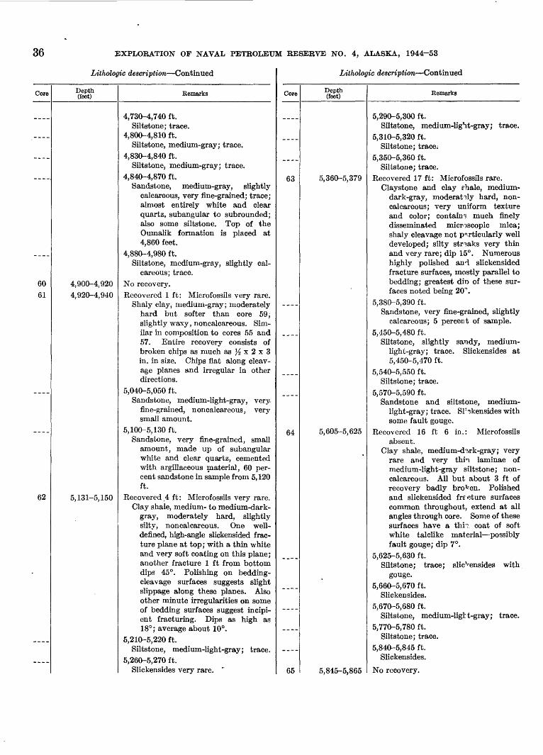
36 EXPLORATION OP NAVAL PETROLEUM RESERVE NO. 4, ALASKA, 1944-53
Lithologic description Continued
Core
____
____
____
____
60
61
____
____
62
-_-_
Depth (feet)
4,900-4,920
4,920-4,940
5,131-5,150
Remarks
4,730-4,740 ft.Siltstone; trace.
4,800-4,810 ft.Siltstone, medium-gray; trace.
4,830-4,840 ft.Siltstone, medium-gray; trace.
4,840-4,870 ft.Sandstone, medium-gray, slightly
calcareous, very fine-grained; trace;almost entirely white and clearquartz, subangular to subrounded;also some siltstone. Top of theOumalik formation is placed at4,860 feet.
4,880-4,980 ft.Siltstone, medium-gray, slightly cal
careous; trace.No recovery.
Recovered 1 ft: Microfossils very rare.Shaly clay, medium-gray; moderately
hard but softer than core 59,slightly waxy, noncalcareous. Similar in composition to cores 55 and57. Entire recovery consists ofbroken chips as much as Yz x 2 x 3in. in size. Chips flat along cleavage planes and irregular in otherdirections.
5,040-5,050 ft.Sandstone, medium-light-gray, very-
fine-grained, noncalcareous, verysmall amount.
5,100-5,130 ft.Sandstone, very fine-grained, small
amount, made up of subangularwhite and clear quartz, cementedwith argillaceous material, 60 percent sandstone in sample from 5,120ft.
Recovered 4 ft : Microfossils very rare.Clay shale, medium- to medium-dark-
gray, moderately hard, slightlysilty, noncalcareous. One well-defined, high-angle slickensided fracture plane at top; with a thin whiteand very soft coating on this plane;another fracture 1 ft from bottomdips 45°. Polishing on bedding-cleavage surfaces suggests slight slippage along these planes. Alsoother minute irregularities on some of bedding surfaces suggest incipi ent fracturing. Dips as high as18°; average about 10°.
5,210-5,220 ft.Siltstone, medium-light-gray; trace.
5,260-5,270 ft.Slickensides very rare. ~
Lithologic description Continued
Core
63
____
____
64
____
____
65
Depth (feet)
5,360-5,379
5,605-5,625
5,845-5,865
Remarks
5,290-5,300 ft.Siltstone, medium-light-gray; trace.
5,310-5,320 ft.Siltstone; trace;
5,350-5,360 ft.Siltstone; trace.
Recovered 17 ft: Microfossils rare.Claystone and clay rhale, medium-
dark-gray, moderately hard, non-calcareous; very uniform textureand color; contains much finelydisseminated microscopic mica;shaly cleavage not particularly welldeveloped; silty streaks very thinand very rare; dip 15°. Numeroushighly polished and slickensidedfracture surfaces, mostly parallel tobedding; greatest din of these surfaces noted being 20°.
5,380-5,390 ft.Sandstone, very fine-grained, slightly
calcareous; 5 percent of sample.5,450-5,480 ft.
Siltstone, slightly sandy, medium-light-gray; trace. Slickensides at5,450-5,470 ft.
5,540-5,550 ft.Siltstone; trace.
5,570-5,590 ft.Sandstone and siltstone, medium-
light-gray; trace. Sl:<?kensides withsome fault gouge.
Recovered 16 ft 6 in.: Microfossilsabsent.
Clay shale, medium-d'wk-gray; veryrare and very thin laminae ofmedium-light-gray siltstone; non-calcareous. All but about 3 ft ofrecovery badly broken. Polishedand slickensided frrcture surfacescommon throughout, extend at allangles through core. Some of thesesurfaces have a thn coat of softwhite talclike material possiblyfault gouge; dip 7°.
5,625-5,630 ft.Siltstone; trace; slic^ensides with
gouge.5,660-5,670 ft.
Sliplr^ncEirl^Q kjllL/Ji-t!JJolU.t!l5.
5,670-5,680 ft. Siltstone, medium-ligtt-gray; trace.
5,770-5,780 ft.Siltstone; trace.
5,840-5,845 ft.Slickensides.
No recovery.
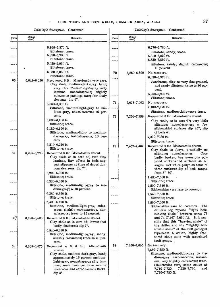
CORE TESTS AND TEST WELLS, OUMALIK AREA, ALASKA 37
Lithologic description Continued
Core
66
_-__
67
____
____
---..
68]
69
Depth (feet)
.
6,041-6,056
6,285-6,293
6,498-6,506
6,669-6,675
.
Remarks
5,865-5,870 ft.Siltstone; trace.
5,890-5,900 ft.Siltstone; trace.
5,920-5,930 ft.Siltstone; trace.
6,030-6,040 ft.Siltstone; trace.
Recovered 6 ft: Microfossils very rare. Clay shale, medium-dark-gray, hard;
very rare medium-light-gray siltylaminae; noncalcareous; slightly micaceous partings rare; fair shaly cleavage; dip 9°.
6,060-6,080 ft.Siltstone, medium-light-gray to me
dium-gray, noncalcareous; 10 percent.
6,090-6,100 ft.Siltstone; trace.
6,180-6,190 ft.Siltstone, medium-light- to medium-
dark-gray, noncalcareous; 10 percent.
6,210-6,220 ft.Siltstone; trace.
Recovered 8 ft: Microfossils absent.Clay shale as in core 66, rare silty
laminae, tiny offsets in beds suggest slippage at time of deposition;noncalcareous; dip 7°.
6,293-6,300 ft.Siltstone; trace.
6,320-6,360 ft.Siltstone, medium-light-gray to me
dium-gray; 5-10 percent.6,380-6,390 ft.
Siltstone; trace.6,400-6,498 ft.
Siltstone, medium-light-gray, micaceous, slightly carbonaceous, non-calcareous; trace to 15 percent.
Recovered 8 ft: Microfossils absent.Clay shale as in core 66; lowest foot
badly shattered; dip 7°.6,540-6,650 ft.
Siltstone, medium-light-gray, sandy, slightly calcareous; trace to 20 percent.
Recovered 4 ft 6 in.: Microfossilsabsent.
Clay shale, medium-dark-gray, hard;approximately 15 percent medium-light-gray, noncalcareous silty laminae; some partings have minutemicaceous and carbonaceous flecks;dip 5°.
Lithologic description Continued
Core
__-.
70
71
72
73
_
74_ _ _ _
Depth (feet)
6,880-6,890
7,078-7,092
7,250-7,258
7,452-7,467
7,650-7,665
Remarks .
6,770-6,780 ft.Siltstone, sandy; trace.
6,810-6,820 ft.6,850-6,860 ft.
Siltstone, sandy, slightly calcareous;10 percent
No recovery.6,920-6,970 ft.
Sandstone, silty to very fine-grained, and sandy siltstone; trace to 30 per cent.
6,980-6,990 ft. Siltstone; trace.
No recovery.7,100-7,120 ft.
Siltstone, medium-aght-srray; trace.Recovered 6 ft: Microfossi1 ? absent.
Clay shale, as in core 61; very littlesiltstone; noncalcareous; a fewslickensided surfaces dip 45°; dipof beds 4°.
7,370-7380 ft.Siltstone; trace.
Recovered 9 ft: Microfossils absent.Clay shale as above, essentially no
siltstone; noncalcareous. Corebadly broken, has mxmerous polished slickensided surfaces at allangles, soft white gouge on some ofthese surfaces; dip of beds rangesfrom 3°-30°.
7,480-7,500 ft.Siltstone; trace.
7,500-7,540 ft.Slickensides very rare to common.
7,540-7,550 ft.Siltstone; trace.
7,590-7,660 ft.Slickensides rare to common. The
driller's log reports "tight hole,heaving shale" between cores 73and 74 (7,467-7,650 ft). It is possible that this "heaving shale" ofthe driller and the "^lightly ben-tonitic shale" of the r^ell geologistrepresents a softer, highly frac tured shale zone with associatedfault gouge. ,
No recovery.7,660-7,780 ft.
Siltstone, medium-light-eray to medium-gray, carbonaceous, micaceous; very slightly calcareous; trace.Slickensides rare, some gouge at7,710-7,720, 7,730-7,750, and7,770-7,780 ft.
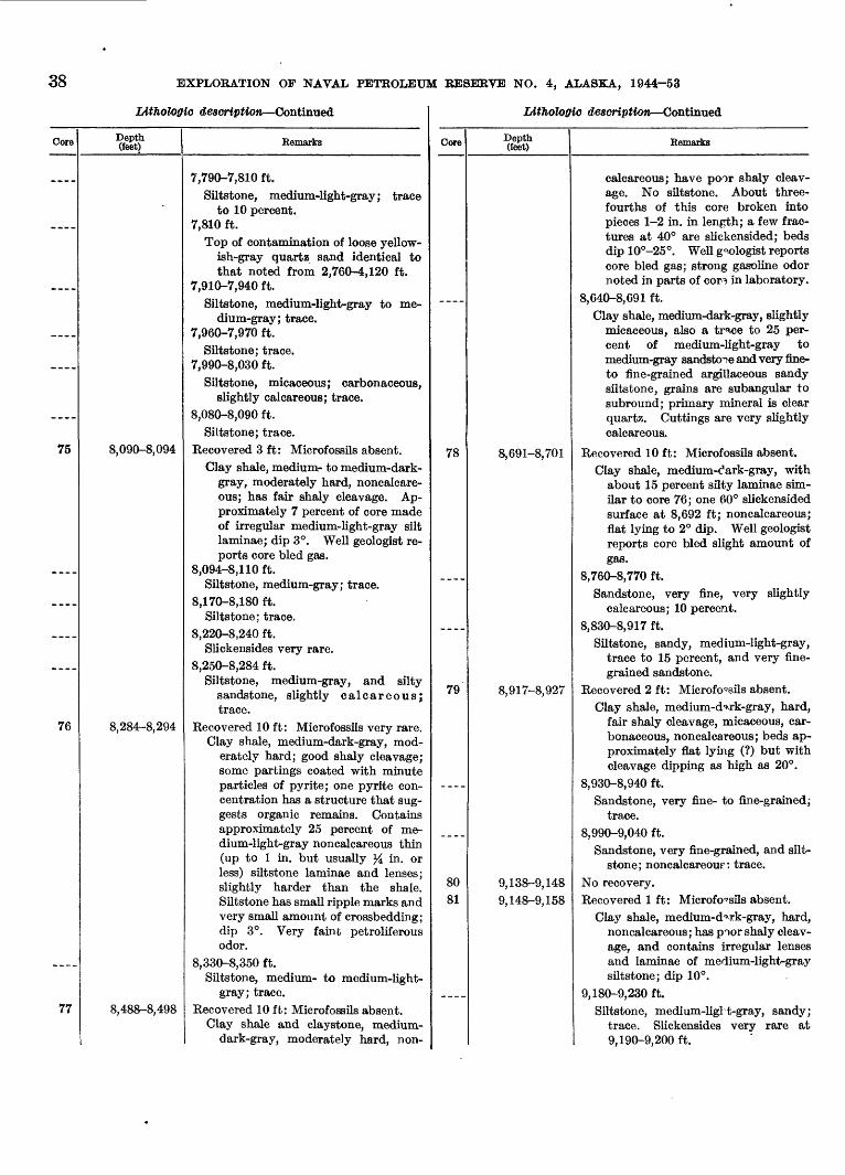
EXPLORATION OF NAVAL PETROLEUM RESERVE NO. 4, ALASKA, 1944-53
LitJiologio description Continued
Core
__
75
____
____
76
____
77
Depth (feet)
8,090-8,094
8,284-8,294
8,488-8,498
Remarks
7,790-7,810 ft.Siltstone, medium-light-gray; trace
to 10 percent.7,810 ft.
Top of contamination of loose yellow ish-gray quartz sand identical to that noted from 2,760-4,120 ft.
7,910-7,940 ft.Siltstone, medium-light-gray to me
dium-gray; trace.7,960-7,970 ft.
Siltstone; trace.7,990-8,030 ft.
Siltstone, micaceous; carbonaceous, slightly calcareous; trace.
8,080-8,090 ft.Siltstone; trace.
Recovered 3 ft: Microfossils absent.Clay shale, medium- to medium-dark-
gray, moderately hard, noncalcare-ous; has fair shaly cleavage. Approximately 7 percent of core madeof irregular medium-light-gray siltlaminae; dip 3°. Well geologist reports core bled gas.
8,094-8,1 10 ft. Siltstone, medium-gray; trace.
8 1 "7ft S 1 SO ft,1 <U o,loU ID.
Siltstone; trace.8,220-8,240 ft.
Slickensides very rare.8,250-8,284 ft.
Siltstone, medium-gray, and silty sandstone, slightly calcareous;trace.
Recovered 10 ft: Microfossils very rare. Clay shale, medium-dark-gray, mod
erately hard; good shaly cleavage; some partings coated with minuteparticles of pyrite; one pyrite concentration has a structure that suggests organic remains. Containsapproximately 25 percent of medium-light-gray noncalcareous thin (up to 1 in. but usually % in. orless) siltstone laminae and lenses;slightly harder than the shale.Siltstone has small ripple marks andvery small amount of crossbedding;dip 3°. Very fainfc petroliferousodor.
8,330-8,350 ft.Siltstone, medium- to medium-light-
gray; trace.
Recovered 10 ft: Microfossils absent.Clay shale and claystone, medium-
dark-gray, moderately hard, non-
Lithologio description Continued
Core
78
79
____
8081
____
Depth (feet)
8,691-8,701
8,917-8,927
9,138-9,148
9,148-9,158
Remarks
calcareous; have poor shaly cleavage. No siltstone. About three-fourths of this core broken intopieces 1-2 in. in lenpth; a few fractures at 40° are slickensided; beds dip 10°-25°. WeU geologist reports core bled gas; strong gasoline odor noted in parts of cor3 in laboratory.
8,640-8,691 ft.Clay shale, medium-dark-gray, slightly
micaceous, also a trace to 25 percent of medium-light-gray tomedium-gray sandstone and very fine-to fine-grained argillaceous sandy siltstone, grains are subangular to subround; primary mineral is clearquartz. Cuttings are very slightlycalcareous.
Recovered 10 ft: Microfossils absent.Clay shale, medium-dark-gray, with
about 15 percent silty laminae similar to core 76; one 60° slickensidedsurface at 8,692 ft; noncalcareous;flat lying to 2° dip. Well geologistreports core bled slight amount ofgas.
8,760-8,770 ft. Sandstone, very fine, very slightly
calcareous; 10 percent.8,830-8,917 ft.
Siltstone, sandy, medium-light-gray,trace to 15 percent, and very fine grained sandstone.
Recovered 2 ft: Microfossils absent.Clay shale, medium-d^rk-gray, hard,
fair shaly cleavage, micaceous, car bonaceous, noncalcareous; beds ap proximately flat lying (?) but with cleavage dipping as high as 20°.
8,930-8,940 ft.Sandstone, very fine- to fine-grained;
trace.8,990-9,040 ft.
Sandstone, very fine-grained, and silt- stone; noncalcareou? : trace.
No recovery.Recovered 1 ft: Microfo^sils absent.
Clay shale, medium-d->rk-gray, hard,noncalcareous; has poor shaly cleavage, and contains irregular lensesand laminae of medium-light-graysiltstone; dip 10°.
9, 180-9,230 ft.Siltstone, medium-ligl t-gray, sandy;
trace. Slickensides very rare at9, 190-9,200 ft.
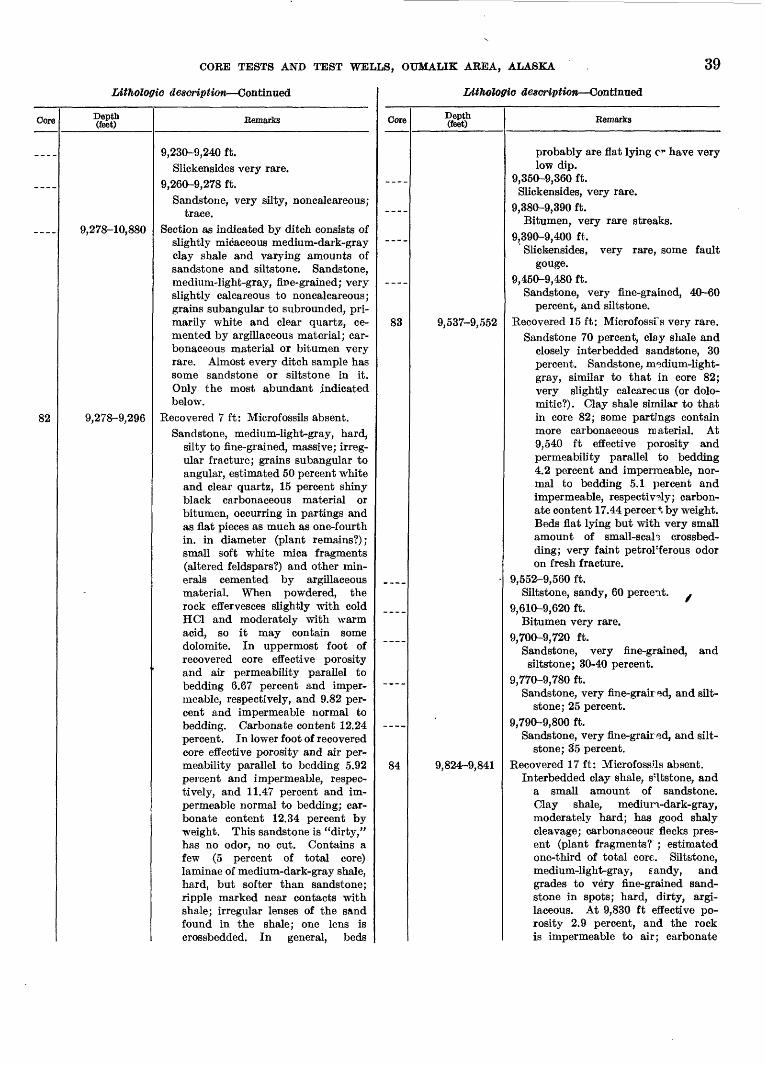
CORE TESTS AND TEST WELLS, OUMALIK AREA, ALASKA 39
Lithologic description Continued
Core
82
Depth (feet)
9,278-10,880
9,278-9,296
-
Remarks
9,230-9,240 ft.
Slickensides very rare.
9,260-9,278 ft.
Sandstone, very silty, noncalcareous; trace.
Section as indicated by ditch consists of slightly micaceous medium-dark-gray clay shale and varying amounts ofsandstone and siltstone. Sandstone,medium-light-gray, fine-grained; veryslightly calcareous to noncalcareous;grains subangular to subrounded, primarily white and clear quartz, cemented by argillaceous material; carbonaceous material or bitumen veryrare. Almost every ditch sample hassome sandstone or siltstone in it.Only the most abundant indicatedbelow.
Recovered 7 ft: Microfossils absent.
Sandstone, medium-light-gray, hard,silty to fine-grained, massive; irregular fracture; grains subangular toangular, estimated 50 percent whiteand clear quartz, 15 percent shinyblack carbonaceous material orbitumen, occurring in partings andas flat pieces as much as one-fourthin. in diameter (plant remains?);small soft white mica fragments(altered feldspars?) and other minerals cemented by argillaceousmaterial. When powdered, therock effervesces slightly with coldHC1 and moderately with warmacid, so it may contain somedolomite. In uppermost foot of recovered core effective porosityand air permeability parallel to bedding 6.67 percent and imper meable, respectively, and 9.82 per cent and impermeable normal tobedding. Carbonate content 12.24percent. In lower foot of recoveredcore effective porosity and air permeability parallel to bedding 5.92percent and impermeable, respectively, and 11.47 percent and impermeable normal to bedding; carbonate content 12.34 percent byweight. This sandstone is "dirty,"has no odor, no cut. Contains afew (5 percent of total core)laminae of medium-dark-gray shale,hard, but softer than sandstone;ripple marked near contacts withshale; irregular lenses of the sandfound in the shale; one lens iscrossbedded. In general, beds
Lithologic description Continued
Gore
----
____
83
_-__
____
84
Depth (feet)
9,537-9,552
9,824-9,841
Remarks
probably are flat lying or have verylow dip.
9,350-9,360 ft. Slickensides, very rare.
9,380-9,390 ft.Bitumen, very rare streaks.
9,390-9,400 ft, Slickensides, very rare, some fault
gouge.9,450-9,480 ft.
Sandstone, very fine-grained, 40-60percent, and siltstone.
Recovered 15 ft: Microfossfs very rare.Sandstone 70 percent, clay shale and
closely interbedded sandstone, 30percent. Sandstone, m^dium-light-gray, similar to that in core 82;very slightly calcareous (or dolo-mitic?). Clay shale similar to thatin core 82; some partings containmore carbonaceous material. At9,540 ft effective porosity andpermeability parallel to bedding4.2 percent and impermeable, normal to bedding 5.1 percent andimpermeable, respectively; carbonate content 17.44 percer*, by weight.Beds flat lying but with very smallamount of small-seal? crossbed-ding; very faint petrol'ferous odoron fresh fracture.
9,552-9,560 ft.Siltstone, sandy, 60 percent.
9,610-9,620 ft.Bitumen very rare.
9,700-9,720 ft.Sandstone, very fine-grained, and siltstone; 30-40 percent.
9,770-9,780 ft. Sandstone, very fine-graired, and silt-
stone; 25 percent.9,790-9,800 ft.
Sandstone, very fine-graired, and silt-stone; 35 percent.
Recovered 17 ft: MicrofossHs absent.Interbedded clay shale, s'ltstone, and
a small amount of sandstone.Clay shale, mediun-dark-gray,moderately hard; has good shalycleavage; carbonaceous1 flecks present (plant fragments? ; estimatedone-third of total core. Siltstone,medium-light-gray, eandy, andgrades to very fine-grained sandstone in spots; hard, dirty, argi-laceous. At 9,830 ft effective porosity 2.9 percent, and the rockis impermeable to air; carbonate
40 EXPLORATION OF NAVAL PETROLEUM RESERVE NO. 4, ALASKA, 1944-53
Litholoffic description Continued
Core
____
___-
-.__-
85
86
____
__ __
____
Depth (feet)
10,009-10,029
V
10,233-10,253
Remarks
content 12.89 percent by weight.Excellent small-scale crossbedding;crossbeds dip as high as 25°. Truedip of beds approximately flat orvery low. Very slight petroliferousodor on fresh fracture.
9,850-9,870 ft.Siltstone and very fine-grained sand
stone; 30 percent.9,880-9,900 ft.
Siltstone and very fine-grained sandstone; 30-35 percent.
9,970-10,000 ft.Siltstone and very fine-grained sand
stone; 25-40 percent.Recovered 20 ft: Microfossils very rare.
Siltstone, medium-light to medium-dark-gray, color depending onamount of argillaceous materialpresent; grades into very silty clayshale on one hand and sandy silt-stone on the other. Contacts notvery sharp, as in core 84. Somesoft-rock flowage indicated. Shalystreaks are micaceous and carbonaceous (small plant fragments);very slightly calcareous.
10,050-10,080 ft. Sandstone, medium-light-gray, fine
grained, very slightly calcareous tononcalcareous; 50-70 percent; grainssubangular to subrounded and are80 percent white and clear quartz;argillaceous matrix.
10,200-10,210 ft. Siltstone, sandy; 25 percent.
Recovered 15 ft: MLrofossils rare.Interbedded siltstone, clay shale, and
a very small amount of sandstoneas in core 84. Clay shale, 30 percent, micaceous and carbonaceous.Siltstone very slightly calcareous;has many clay partings and excel lent small-scale crossbedding; beds essentially flat lying. At 10,250 fteffective porosity 3.4 percent, androck is impermeable; carbonate content 16.06 percent by weight.
10,280-10,300 ft.Siltstone, sandy; 25 percent.
10,3 10-10,340 ft.Siltstone, sandy; 20-30 percent.
10,360-10,380 ft.Siltstone, sandy; 25 percent.
10, 380-10,390 ft.Clay shale, medium-dark-gray; and
30-50 percent medium-light-graysilty very argillaceous very fine-
Litholoffio description Continue*
Core
____
87
----
__
88
Depth (feet)
10,453-10,473
10,669-10,682
Remarks
grained sandstone; contains alteredfeldspar (?). A few chips of bluish-gray clay shale, kaolinitic or bento-nitic (?). These cMps occur veryrarely in ditch samples down to10,600 ft.
10,390-10,400 ft.Clay shale, medium-dark- to dark-
gray. Shale is slightly darkerbelow this point.
Recovered 2 ft 8 in. : Microfossils veryrare.
Siltstone, medium-light-gray tomedium-gray, hard, sandy, argillaceous; made up primarily of whitequartz and mica, chlorite, andother alteration products, also contains numerous soft black carbonaceous particles and plantremains; is interbedded with mediumdark-gray to dark-gray micaceouscarbonaceous clay shale (10 percentof total recovery) small amount ofsmall-scale crossbedding. Clayshale not quite as h<j,rd as siltstone.Siltstone silghtly to moderately calcareous. Dip of b^ds 2°. Effective porosity 2.8 percent and air permeability 9 miUidarcys (plug chipped); carbonate content 15.67percent by weight.
10,500 ft.Between 10,500 and 1C 870 ft the rock
is mostly clay shale, medium-dark-to dark-gray, slightly micaceous; one chip of shale containing rounded grains of cnartz, mediumto coarse, in each sample from thefollowing depths: 10,490-10,510, 10,630-10,640, and 10,860-10,870ft. Very small amount of carbonaceous material or bitumen;also very rare pyrite. Siltstone isin some places medium-olive-gray and has a glassy glittering appear ance. Very rare chips of siltstoneor sandstone mottled with brownspecks (iron oxide?). These slight differences in composition suggest agradation from, or perhaps reworked, material from the Aucellazone below.
10,580-10,590 ft.Sandstone and siltstone, medium-
light- to medium-dark-gray, verydirty; argillaceous matrix; 30 percent.
Recovered 8 ft: Microfossils very rare.Interbedded siltstone and clay shale,
CORE TESTS AND TEST WELLS, OTJMALIK AREA, ALASKA 41
Litholoffic description Continued
Core
----
____
___
89
Depth (feet)
10,880-11,872
10,992-11,007
Remarks
about 60 percent clay shale andsilty clay shale and 40 percentsiltstone. Clay shale, silty, medium-dark-gray; numerous small shinyblack carbonaceous flecks ; fair shalycleavage. Siltstone, medium-light-gray to medium-gray, hard, argillaceous ; contains rare streaks of veryfine sand and a few black carbonaceous plant impressions; probablyhas very low porosity and permeability. Some contacts betweenshale and siltstone are sharp, othersgradational; dip 5°-20°; higherdips are probably crossbedding.Fair petroliferous odor in some ofsilty sections; no cut in CCU fromsample taken 4 ft from top.
10,840-10,850 ft.Siltstone, sandy; 20 percent.
Clay shale, medium-dark-gray to grayish-black, micaceous; contains well-rounded, slightly frosted, brownish-clear quartz grains up to very coarseembedded individually or in streaksin shale. Also traces of siltstone andvery fine-grained sandstone, medium-light to medium-olive-gray, micaceous.Medium-olive-gray siltstone and sandstone are very tight and have glassysheen in hand specimen. Pyrite rareto common. Cores and variations aredescribed below.
10,880-10,890 ft.
Clay shale, grayish-black. Top of the Upper Jurassic (?) and LowerCretaceous (?) is at 10,880 ft.
10,890-10,992 ft.
Clay shale fragments containing glau-conite (?), well-rounded quartzgrains, and rare pyrite. Trace to10 percent medium-gray sandstoneand siltstone.
Recovered 4 ft 6 in.: Microfossils rare.Siltstone and clay shale interbedded
in very thin laminae. Clay shale,70 percent of recovery, silty, dark-gray to grayish-black, moderatelyhard; breaks irregularly parallel tobedding, plates of mica lying parallel to bedding are very prominentin hand specimens. Siltstone, 30percent of recovery, medium-dark-olive-gray ; 98 percent quartz, angular to subangular, some very fine
LitJiolOffic description Continued
Core Depth (feet) Remarks
sand grains; no megascopic carbonaceous material noted. Siltstoneoccurs as very thin laminae, irregular lenses, and nodules in clayshale. Slight change in lithologyfrom core 88. The following features are noted: Clay stale in core88 is lighter in color and lacks theprominent mica plates (althoughmica is present) . Clay s^ale in core88 is slightly harder than in 89.Sandy siltstone of core 88 is composed of subangular to mbroundedquartz and dark mineral grains;quartz is clear, some slightly frosted, giving a milky appearance(hence, a lighter color to the wholesample). Siltstone of core 89 isfiner grained, better sorted, almost all more angular quartz and has avitreous luster. Clay particleslodged in reentrants of quartzgrains give grains a darker olive-brown cast and probahly accountfor darker color of siltstone as awhole. Noncalcareous; no shows;beds essentially flat lyin?:. Severalcasts of Aucella sublaevis Keyserlingand other pelecypods were found 1ft from bottom.
11,010-11, 140 ft.Glauconite (?), very rare; well-rounded
quartz grains rare; large chips ofpyrite rare to common.
11, 140-1 1,270 ft.Rounded quartz grains very rare.
Pyrite rare to common. noTfi 1 1 ocn t-t-,^/U ii,6o\J It.
Chert, one dark granule, one chip ofsandstone with well-rounded grainsof quartz containing some glauco-nite (?).
11,280-11,320 ft.Pyrite abundant.
11,320-1 1,330 ft.Sandstone with rounded grains and
glauconite (?) very rare.11, 330-1 1,51 Oft.
Rounded quartz grains very rare;traces of glassy-looking s; ltstone andvery fine-grained sandstone. Pyriteabundant.
11,510-1 1,520 ft.Rounded pebble of very dark-gray
chert.11,520-11,530 ft.
Clay shale fragment bear'ng Aucella-like rib impressions.
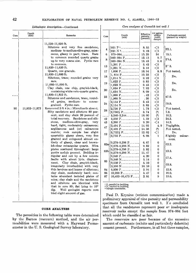
42 EXPLORATION OF NAVAL PETROLEUM RESERVE NO. 4, ALASKA, 1944-53
Lithologic description Continued
Core
90
Depth (feet)
11,852-11,872
Remarks
11,530-11,620 ft.Siltstone and very fine sandstone,
medium- to medium-olive-gray, mica ceous, glassy in part; trace. Rare to common rounded quartz grains up to very coarse size. Pyrite rare to common.
11,620-11,630 ft.Quartz, one granule.
11,630-11,680 ft.Siltstone, trace; rounded grains very
rare. 11,680-11,690 ft.
Clay shale, one chip, grayish-black, containing white vein-quartz grains.
11,690-11,852 ft.Siltstone and sandstone, trace, round
ed grains, medium- to coarse grained. Pyrite rare.
Recovered 3 ft 4 in.: Microfossils absent.Silty sandstone and siltstone 80 per
cent, and clay shale 20 percent of total recovery. Sandstone and silt- stone, medium-olive-gray, very hard, tight, moderately calcareous; argillaceous and (or) calcareous matrix; rock sample has slight quartzitic glassy sheen, very fine grained and composed almost en tirely of glassy, clear and brown ish-clear subangular quartz. Mica plates scattered throughout: large pyrite nodule present. Bedding ir regular and cut by a few minute faults with about %-in. displace ment. Clay shale, grayish-black, irregularly interbedded with very thin laminae and lenses of siltstone; clay shale, moderately hard; con tains abundant isolated plates of mica; clay shale and the sandstone and siltstone are identical with that in core 89; flat lying to 10° dip. Well geologist reports core bled slight amount of gas.
CORE ANALYSES
The porosities in the following table were determined by the Barnes (vacuum) method, and the air per meabilities were measured with a Hayward Perme- ameter in the U. S. Geological Survey laboratory.
Core analyses of Oumalik test well 1
Core
4
6
8
13
17
18
19
20
23
24
28
4243
47
52
82a
82b
83
848687
Depth (feet)
{ Q21 P i921 N 2 _ _ _ .__979-984_____ ______
[989-994 P_____ _-___[989-994 N_________[1,201 P _ _________U,201 N_. __________
1,606 P______--____{1,614 P________-__-[1,614 N __ _ --__[l 622 P1 1,622 N___._______-[1,634 P____________|l,634 N.____ ____ _[1,966 P. _ -----[1,966 N _ _________[2,154 P_____--____-[2,154 N_ ________[2,756 P____________[2,756^ P_______ _3,240-3,244. ____ __3,250 P______-__ _3,260 P_____-___ ___
[3,494 P____ _ _____[3,495 P_--___----_-/3,752}_ P_-_________[3,755 P____________
[9,278-9,296 P____._[9,278-9,296 N_ _ __[9,278-9,296 P______[9,278-9,296 N___ _
{9,540 P- _ ___ _ __9,540 N __ _____ _9,550 P _____ _9,550 N______ _ _._9,830 P_______._ __10,250 P______ _ __10,453-10,473 P____
Eflective porosity (percent)
8.559.48
15.2513. 1513.433.422.44
10. 9410. 35
9. 929.859.457. 928.09.42.36
3.433. 831.783. 74
18.001. 599. 20
14. 0514.3612.026.08
6. 679. 825. 92
11.474. 205. 145. 10
10. 102. 943.472.81
Ah- perme ability (milli-
darcys)
^K
<t'*\
349.75. 6
<5<5
8. 8<5<5^^<5^^<5<5<5<5<5^e
(3)
(3)
^q
<44. 9
(3)
<11
00000000009
Carbonate content (percent by weight)
J22.1.
15.1.
12-1.4.
\2^.B.
Not tested.
} Do.
J Do.
} Do.
J47.0.
J19.9.
Not tested.7.8.10.2.24.3.14.2.Negligible.Not tested.
Do.S ightly calcar
eous.
J12.2.
J12.3.
J17.4.
J13.8.
12.8.16.0.15.6.
1 P, parallel to bedding. 5 N, normal to bedding. 3 Sample unsuitable.
Paul D. Krynine (written communication) made a preliminary appraisal of nine porosity and permeability specimens from Oumalik test well 1. F.e concluded that all the sandstones represent poor OF inadequate reservoir rocks except the sample from 974-984 feet which could be classifie d as fair.
The reservoirs are poor because of the excessive amount of carbonate (calcite and particularly dolomite) cement present. Furthermore, in all but three samples,
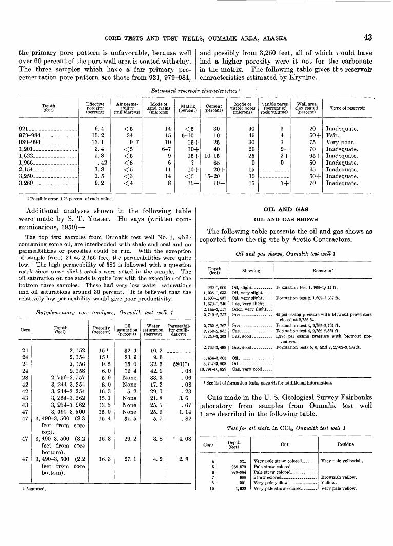
CORE TESTS AND TEST WELLS, OUMALIK AREA, ALASKA 43
the primary pore pattern is unfavorable, because well over 60 percent of the pore wall area is coated with clay. The three samples which have a fair primary pre- cementation pore pattern are those from 921, 979-984,
and possibly from 3,250 feet, all of which v^ould have had a higher porosity were it not for the carbonate in the matrix. The following table gives tb<5 reservoir characteristics estimated by Krynine.
Estimated reservoir characteristics 1
Depth (feet)
921_. ______________979-984__ __ ______989-994___-__-_____1,201______ _- --_1,622 __ _ ___ _____l,966__________--___2,154.. _____________3,250-_____-____---_3,260__--__-__---__-
Effective porosity (percent)
9.415. 213. 13.49. 8.42
3.81.59. 2
Air perme ability
(millidarcys)
^t\
349. 7
^f\^
^c
^ ̂
<3<4
Mode of sand grains (microns)
141510
6-7Q
611148
Matrix (percent)
^ "
Clfl
15+10+1 ^4-
?
10+^ c
10-
Cement (percent)
30102540
10-156520 +
15-2010-
Mode of visible pores
(microns)
4045302025
0153015
Visible pores (percent of
rock volume)
3432-94-
0
qj_
Wall area clay coated (percent)
2050 +757065+506550+70
Type of reservoir
Inadequate.Fair.
Inadequate.
Inadequate.Inadequate.
1 Possible error ±25 percent of each value.
Additional analyses shown in the following table were made by S. T. Yuster. He says (written com munications, 1950)
The top two samples from Oumalik test well No. 1, while containing some oil, are interbedded with shale and coal and no permeabilities or porosites could be run. With the exception of sample (core) 24 at 2,156 feet, the permeabilities were quite low. The high permeability of 580 is followed with a question mark since some slight cracks were noted in the sample. The oil saturation on the sands is quite low with the exception of the bottom three samples. These had very low water saturations and oil saturations around 30 percent. It is believed that the relatively low permeability would give poor productivity.
Supplementary core analyses, Oumalik test well 1
Core
2424242428424243434747
47
47
Depth (feet)
2, 1522, 1542, 1562, 158
2, 756-2, 7573, 244-3, 2543, 244-3, 2543, 254-3, 2623, 254-3, 2623, 490-3, 500
3, 490-3, 500 (2.3feet from coretop).
3, 490-3, 500 (3.2feet from corebottom) .
3, 490-3, 500 (2.2feet from corebottom).
Porosity (percent)
15 '15 i
9.56.05.98. 0
16. 315. 113. 515. 015. 4
16.3
16. 3
Oil saturation (percent)
32. 423.915.019.4
NoneNone
5.2NoneNoneNone31. 5
29. 2
27. 1
Water saturation (percent)
16.29.6
32.542.033.317.229.021.825.525.95.7
3.8
4. 2
Permeabil ity (milli- darcys)
580(?).08. 06.08.23
3.6.67
1. 14.82
4.08
2. 8
i Assumed.
OIL AND GAS
OIL AND GAS SHOWS
The following table presents the oil and gas shows as reported from the rig site by Arctic Contractors.
Oil and gas shows, Oumalik test well 1
Depth (feet)
Qfin_ i fifin
1, 028-1, 033 1, 603-1, 637 1, 670-1, 740 2, 144-2, 157 2, 740-2, 757
2,762-2,8513,240-3,263
2, 762-3, 498
3, 484-3, 503
10, 791-10, 829
Showing
Oil, slight Oil, very slight. Oil, very slight .. Gas, very slight Odor, very slight
Oil Oil Gas, very good.
Remarks 1
Formation test 2, 1,607-1,637 ft.
closed at 2,756 ft. Formation test 3, 2,762-2,767 ft.Formation test 4, 2,762-2,851 ft.
venters. Formation tests 5, 6, and 7, 2,762-3,498 ft.
1 See list of formation tests, page 44, for additional information.
Cuts made in the U. S. Geological Survey Fairbanks laboratory from samples from Oumalik test well 1 are described in the following table.
Test for oil stain in CCl*, Oumalik test well 1
Core
45678
19
Depth (feet)
921968-979979-984
QSS
1.622
Cut
Verv nale straw colored _
Eesidue
Yellow.Verv r. ale vellow.
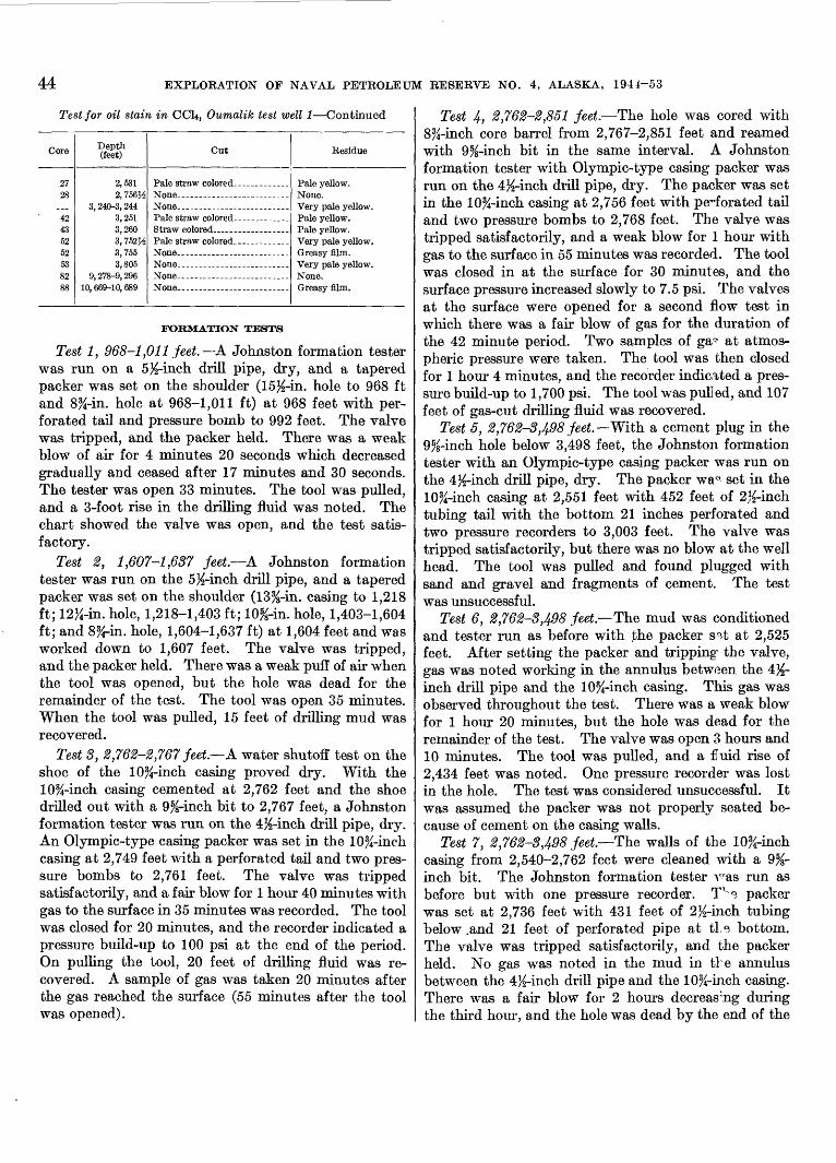
44 EXPLORATION OF NAVAL PETROLEUM RESERVE NO. 4, ALASKA, 1944-53
Test for oil stain in CCLj, Oumalik test well 1 Continued
Core
27°8
424352525382QQ
Depth (feet)
2,5312, 756H
3, 240-3, 2443,2513,2603, 752H3,7553,805
9, 278-9, 296
Cut Residue
FORMATION TESTS
Test 1, 968-1,011 feet. A Johnston formation tester was run on a 5X-inch drill pipe, dry, and a tapered packer was set on the shoulder (15X-in. hole to 968 ft and 8%-in. hole at 968-1,011 ft) at 968 feet with per forated tail and pressure bomb to 992 feet. The valve was tripped, and the packer held. There was a weak blow of air for 4 minutes 20 seconds which decreased gradually and ceased after 17 minutes and 30 seconds. The tester was open 33 minutes. The tool was pulled, and a 3-foot rise in the drilling fluid was noted. The chart showed the valve was open, and the test satis factory.
Test 2, 1,607-1,637 feet. A Johnston formation tester was run on the 5%-inch drill pipe, and a tapered packer was set on the shoulder (13%-in. casing to 1,218 ft; 12%-in. hole, 1,218-1,403 ft; 10%-in. hole, 1,403-1,604 ft; and 8%-in. hole, 1,604-1,637 ft) at 1,604 feet and was worked down to 1,607 feet. The valve was tripped, and the packer held. There was a weak puff of air when the tool was opened, but the hole was dead for the remainder of the test. The tool was open 35 minutes. When the tool was pulled, 15 feet of drilling mud was recovered.
Test 3, 8,76%-®,767 feet A water shutoff test on the shoe of the 10%-inch casing proved dry. With the 10%-inch casing cemented at 2,762 feet and the shoe drilled out with a 9%-inch bit to 2,767 feet, a Johnston formation tester was run on the 4X-inch drill pipe, dry. An Olympic-type casing packer was set in the 10%-inch casing at 2,749 feet with a perforated tail and two pres sure bombs to 2,761 feet. The valve was tripped satisfactorily, and a fair blow for 1 hour 40 minutes with gas to the surface in 35 minutes was recorded. The tool was closed for 20 minutes, and the recorder indicated a pressure build-up to 100 psi at the end of the period. On pulling the tool, 20 feet of drilling fluid was re covered. A sample of gas was taken 20 minutes after the gas reached the surface (55 minutes after the tool was opened).
Test 4, 2,762-2,851 feet. The hole was cored with 8%-inch core barrel from 2,767-2,851 feet and reamed with 9%-inch bit in the same interval. A Johnston formation tester with Olympic-type casing packer was run on the 4%-inch drill pipe, dry. The packer was set in the 10%-inch casing at 2,756 feet with perforated tail and two pressure bombs to 2,768 feet. The valve was tripped satisfactorily, and a weak blow for 1 hour with gas to the surface in 55 minutes was recorded. The tool was closed in at the surface for 30 minutes, and the surface pressure increased slowly to 7.5 psi. The valves at the surface were opened for a second flow test in which there was a fair blow of gas for the duration of the 42 minute period. Two samples of ga^ at atmos pheric pressure were taken. The tool was then closed for 1 hour 4 minutes, and the recorder indicated a pres sure build-up to 1,700 psi. The tool was pulled, and 107 feet of gas-cut drilling fluid was recovered.
Test 5, 2,762-3,498 feet. With a cement plug in the 9%-inch hole below 3,498 feet, the Johnston formation tester with an Olympic-type casing packer was run on the 4X-inch drill pipe, dry. The packer wa^ set in the 10%-inch casing at 2,551 feet with 452 feet of 2%-inch tubing tail with the bottom 21 inches perforated and two pressure recorders to 3,003 feet. The valve was tripped satisfactorily, but there was no blow at the well head. The tool was pulled and found plugged with sand and gravel and fragments of cement. The test was unsuccessful.
Test 6, 2,762-3,498 feet. The mud was conditioned and tester run as before with the packer s a-t at 2,525 feet. After setting the packer and tripping1 the valve, gas was noted working in the annulus between the 4%- inch drill pipe and the 10%-inch casing. This gas was observed throughout the test. There was a weak blow for 1 hour 20 minutes, but the hole was dead for the remainder of the test. The valve was open 3 hours and 10 minutes. The tool was pulled, and a £uid rise of 2,434 feet was noted. One pressure recorder was lost in the hole. The test was considered unsuccessful. It was assumed the packer was not properly seated be cause of cement on the casing walls.
Test 7, 2,762-3,498 feet The walls of the 10%-inch casing from 2,540-2,762 feet were cleaned with a 9%- inch bit. The Johnston formation tester v^as run as before but with one pressure recorder. Tv e packer was set at 2,736 feet with 431 feet of 2%-inch tubing below .and 21 feet of perforated pipe at tie bottom. The valve was tripped satisfactorily, and the packer held. No gas was noted in the mud in the annulus between the 4%-inch drill pipe and the 10%-inch casing. There was a fair blow for 2 hours decreasing during the third hour, and the hole was dead by the end of the
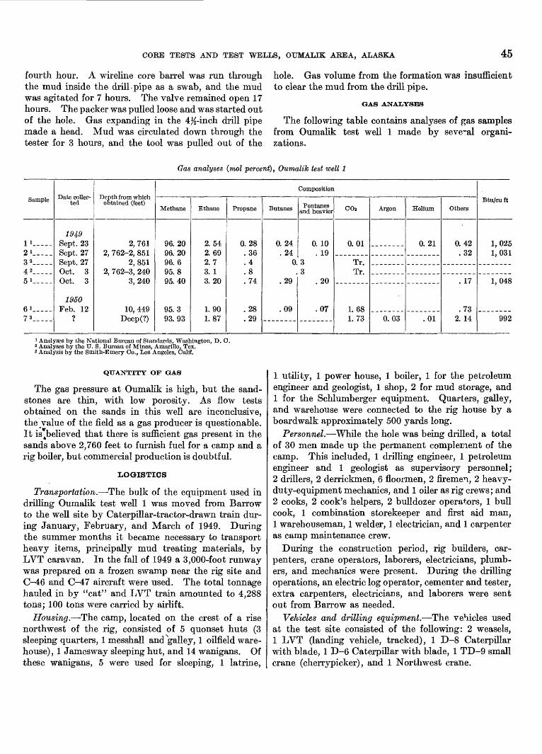
CORE TESTS AND TEST WELLS, OUMALIK AREA, ALASKA 45
fourth hour. A wireline core barrel was run through the mud inside the drill pipe as a swab, and the mud was agitated for 7 hours. The valve remained open 17 hours. The packer was pulled loose and was started out of the hole. Gas expanding in the 4K-inch drill pipe made a head. Mud was circulated down through the tester for 3 hours, and the tool was pulled out of the
hole. Gas volume from the formation was insufficient to clear the mud from the drill pipe.
GAS ANALYSES
The following table contains analyses of gas samples from Oumalik test well 1 made by several organi zations.
Gas analyses (mol percent), Oumalik test well 1
Sample
1 !_-_._
2i.--_-3 2-__-4 2____-5 1-.--
6i-___7 3 ___-_
ted
1949 Sept. 23Sept. 27Sept. 27Oct. 3Oct. 3
1950 Feb. 12
?
obtained (feet)
2,7612, 762-2, 851
2,8512, 762-3, 240
3,240
10 449Deep(?)
Methane
96.2096.2096. 695.8Q^J 40
95.393.93
Ethane
2.542. 692.73. 13.20
1. 901.87
Propane
0.28.36. 4.8. 74
.28
.29
Butanes
0.24. 24
0.
.29
.09
Composition
Pentanes and heavier
0. 10. 19
33
.20
.07
C02
0.01
Tr.Tr.
1.681. 73
Argon
0.03
Helium
0. 21
.01
Others
0.42.32
. 17
.732. 14
Btu/cu ft
1,0251,031
1,048
992
1 Analyses by the National Bureau of Standards, Washington, D. C. a Analyses by the U. S. Bureau of Mines, Amarillo, Tex. 8 Analysis by the Smith-Emery Co., Los Angeles, Calif.
QUANTITY OF GAS
The gas pressure at Oumalik is high, but the sand stones are thin, with low porosity. As flow tests obtained on the sands in this well are inconclusive, the value of the field as a gas producer is questionable. It is^believed that there is sufficient gas present in the sands above 2,760 feet to furnish fuel for a camp and a rig boiler, but commercial production is doubtful.
LOGISTICS
Transportation. The bulk of the equipment used in drilling Oumalik test well 1 was moved from Barrow to the well site by Caterpillar-tractor-drawn train dur ing January, February, and March of 1949. During the summer months it became necessary to transport heavy items, principally mud treating materials, by LVT caravan. In the fall of 1949 a 3,000-foot runway was prepared on a frozen swamp near the rig site and C-46 and C-47 aircraft were used. The total tonnage hauled in by "cat" and LVT train amounted to 4,288 tons; 100 tons were carried by airlift.
Housing. The camp, located on the crest of a rise northwest of the rig, consisted of 5 quonset huts (3 sleeping quarters, 1 messhall and Ngalley, 1 oilfield ware house), 1 Jamesway sleeping hut, and 14 wanigans. Of these wanigans, 5 were used for sleeping, 1 latrine,
1 utility, 1 power house, 1 boiler, 1 for the petroleum engineer and geologist, 1 shop, 2 for mud storage, and1 for the Schlumberger equipment. Quarters, galley, and warehouse were connected to the rig house by a boardwalk approximately 500 yards long.
Personnel. While the hole was being drilled, a total of 30 men made up the permanent complement of the camp. This included, 1 drilling engineer, 1 petroleum engineer and 1 geologist as supervisory personnel;2 drillers, 2 derrickmen, 6 floormen, 2 firemen, 2 heavy- duty-equipment mechanics, and 1 oiler as rig crews; and 2 cooks, 2 cook's helpers, 2 bulldozer operators, 1 bull cook, 1 combination storekeeper and first aid man, 1 warehouseman, 1 welder, 1 electrician, and 1 carpenter as camp maintenance crew.
During the construction period, rig builders, car penters, crane operators, laborers, electricians, plumb ers, and mechanics were present. During the drilling operations, an electric log operator, cementer and tester, extra carpenters, electricians, and laborers were sent out from Barrow as needed.
Vehicles and drilling equipment. The vehicles used at the test site consisted of the following: 2 weasels, 1 LVT (landing vehicle, tracked), 1 D-8 Caterpillar with blade, 1 D-6 Caterpillar with blade, 1 TD-9 small crane (cherrypicker), and 1 Northwest crane.
46 EXPLORATION OF NAVAL PETROLEUM RESERVE NO. 43 ALASKA, 1944-53
The amounts of the major items used in drilling by Arctic Contractors were as follows:
!_______ 136-foot Ideco derrick.!_______ 350-ton Ideco crown block, six 48-inch sheaves.l-_.____ 350-ton Ideco traveling block, five 48-inch
sheaves. !_______ Byron-Jackson Super Triplex hook, ser. 4300.1_______ Wilson Super Titan drawworks.3_____._ General Motors quad 6 diesel engines.2_____._ C-350 National mud pumps.2_ ______ Link-Belt 48 x 60-inch mud shakers.!____--_ Ideco rotary table, ser. HS-23-B.!___-___ Ideal R-3 swivel.!____.__ Cameron QRC blowout preventer.!___-___ Hydril GK blowout preventer. !_______ Shaffer double-gate blowout preventer.3_______ 150-barrel mud tanks with ditches.3_______ 250-barrel storage tanks (1 water, 2 mud).1_ ______ 90-barrel "pill" tank.!_______ Kewanee boiler, 75 hp.!_______ Halliburton cementing unit.!___-___ Schlumberger electric logging unit.
Fuel, water, and lubricant consumption. The ma terials used while drilling the test were as follows: 330,361 gallons of diesel fuel, 5,743 gallons of gasoline, 1,926,943 gallons of water, 1,130 pounds of grease, 1,520 pounds of thread lubricant, 1,002 gallons of No. 9110 lubricant, SAE 10, 2,514 pounds of No. 9170 lubricant, SAE 20, and 403 pounds of No. 9500 lubri cant, SAE 50.
DRILLING OPERATIONS
RIG FOUNDATION
The swampy surface at the site of Oumalik test well 1 presented numerous problems of foundation instal lation and necessitated unusual precautions to prevent thawing of the permafrost and subsequent settling of the rig. After detailed studies were made of perma frost reaction to heat transfer, steel piling was designed with a system to circulate a refrigerant to keep the ground frozen. Arctic Contractors (written communi cation, November 1950) described the installation as follows:
Analysis of the allowable substructure loads resulted in the selection of 8^-in. steel piling as the means of transferring the loads to the ground. In order to attain positive control over the frost zone the piling was designed to permit circulation of a refrigerating fluid (diesel oil). Insurance against radial thawing from the well hole was gained by inserting a galvanized steel heat-emissivity shield in the annulus between the 13%-in. and 22-in. casing. The shield, 18 in. in diameter, extended from the cellar to a depth of 219.19 ft and was landed on top of a packer set between the 22-in. and 13%-in. casing. A circulating joint in the 13%-in. casing was located immediately above the packer to permit the draining of fluids from the annulus between the 22-in. and the 13%-in. casings. A special manifolding ring for circulating refrigerant through the annulus between the 22-in. and the 13%-in. casing was fabricated at Barrow. Three
refrigeration wells 4 inches in diameter were installed to a depth of 240 ft. at a distance of 5 feet from the well center line. Re frigerant was circulated through these wells to prevent thawing from the hole. As further insurance against possible delay caused by thawing, a beam fabricated from 10^-in. casing was installed beneath the cellar floor. This bear^ was also re frigerated.
The subsurface temperatures were obtained by means of a system of thermocouples, and temperature readings were logged at three day intervals. The subsurface temperature showed a steady increase from June 10, 1949, when the rig was put into operation, and on Dec. 3, 1949, circulation was started through those areas which were considered critical. Circulation con tinued until April 29, 1950. Concurrent thermocouple readings indicated that the system was capable of maintaining the ground at the desired temperature. The rate of heat transfer ranged from 4 tons to 50 tons of refrigeration per day. Cooling of the refrigerating fluid was accomplished by pumping the oil through a fan-equipped radiator located outside the righouse. The amount of refrigeration available depended upor the ambient air temperature which varied during the period from a high of plus 20° F. to a minimum of minus 53° F. [See pi. 2.]
Although the original cost of labor and material was high, the operation was satisfactory as no settling was observed. By steaming, this type of pile can be recovered for future use.
DRILLING NOTES
The following table contains selected notes from the drilling records of the Arctic Contractors' petroleum engineer.
Notes from drill records
Depth (feet)
247.5_
1,221.
1,229.
Pemarks
Well spudded in on June 11, 1949.Casing set; 28%-in. outer diameter (28-in.
inner diameter) shop-made, 3.8-in. roll plate with plain ends installed with cellar floor support truss. Flush with cellar floor at top and 5 ft long.
Casing set; 22%-in. outer diameter (22-in. inner diameter) shop-made, %-in. rolled plate welded, slip joint casing with drive shoe on bottom. Cemented with 200 sacks Hi-Early cement treated with 2 percent CaCl2 . Found cement bridge in pipe at 128 ft. Drilled out with 21-in. bit, taking core 1, 160-180 ft; recov ered 15 ft of cement.
Drill collar twisted off at 96T ft while ream ing. Ran overshot and recovered fish. Drill collar had broken off below box.
Pulled bit minus two cones. Wore out three 9%-in. Globe baskets tr;nng to recover cones and wore out two P^-in. W7R bits milling on fish.
Had trouble running 13%-in. casing to bottom of hole. While opening hole, twisted another drill collar off at 525 ft. Recovered fish after 15 hr. Installed 18-in. emissivity shield from cellar floor to top of 22-in. packer at 219 ft. Set

COKE TESTS AND TEST WELLS, OTJMALIK AREA, ALASKA 47
Depth (feet)
1,803-
2,024_
2,356_
2,529.
2,760-
2,762.
3,244_
7,793.
Notes from drill records Continued
Bemarks
casing at 1,218 ft; 13%-in. outer diameter (12.615-in. inner diameter), 54.4 Ib, API seamless, grade J-55, range 2, 8 round thread, long T and C, with Baker guide shoe and Baker float collar. Cemented with 317 sacks of Oil Well Regular cement treated with 2 percent CaCl2 . Float collar at 1,185 ft; 22-in. packer and circulating joint at 219 ft. Circulating joint was later removed and replaced with die collar connection.
_____ Threads on 5}.>-in. kelly-cock badly galled. Replaced 5%-in. kelly with 3}_>-in. kelly; 5M-in- kelly was repaired in Barrow shop.
.__-_ Twisted off drill collar leaving sub and bit in hole. Recovered fish.
.____ Weld between the 13%-in. casing and the Baash-Ross landing head broke. Re moved blowout preventers and sent land ing head to Barrow shop where it was rewelded.
.___. Circulation broke between 13^-in. and 22%-in. casings, mud returning to cellar inside of 22%-in. casing. Removed blowout preventers. Cut away supports for flange on 13%-in. casing and casing dropped 10 in. Tried four times to close circulating joint but was unsuccessful.
.____ Well started to blow gas. Treated and eventually raised mud weight to 113^ Ib per cu ft to maintain positive control of the gas. Set cement plug at 303 ft. Pulled 13%-in. casing from 222 ft where it had parted in middle of circulating joint. Four joints of casing were in bad condition; one joint bent, rest had flat tened ends. Bailed down to 237 ft. Ran 13%-in. casing with die nipple and wooden guide. Screwed into top of 13^-in. casing withheld 40 tons test. Cemented with 100 sacks of cement treated with 2 percent CaCl2 . Welded Baash-Ross base to 22%-in. casing and grouted it into cellar floor. Installed control gates. Found joint still leaking.
.____ Set casing 10%-in. outer diameter (9.76 inner diameter), 55.5 Ib, API seamless, grade N-80, range 2, Hydril flush joint with square threads, with 282 sacks Oil Well Regular cement treated with 2 per cent CaCl2 . Baker float shoe and Baker float collar at top of lower joint.
____ Well started to head. Closed blowout preventers and pressure built up to 1,350 psi. Mixed mud to 100 Ibs per cu ft and bled pressure off through fill-up line. Circulation established with heavy mud and well killed. No test because of in sufficient quantities of weight material.
____ Caving shale very troublesome; formations were successfully mudded off.
Notes from drill records Continued
Depth (feel)
8,426-10,838.
10,838_
11,007.
11,637.
11,872.
Remarks
While drilling and reaming this portion of hole, pump pressures indicated possible washouts. Pulled top 20 to 25 stands and located washed out tool joint boxes on eight different occasions.
Twisted off drill collar pin. Ran Bowen overshot and recovered fish. Returns from bottom severely gas cut. Increased mud weight to 1Q1% Ibs per cu ft.
Drill pipe pulled into a key seat and stuck with bottom of core barrel at 3,512 ft. Washed over fish and ran Bowen overshot with jars and bumper sub. Jarred fish in two at top of core barrel, leaving top of fish at 3,491 ft. Washed over fish and fish dropped down hole. Recovered fish. Increased mud weight to 104 Ibs per cu ft to limit quantity of gas in bottom returns after round trips. (See pi. 1.)
Inspected 10%-in. casing and found top joints were damaged by contirnous wear owing to misalinement. Set t^o cement plugs; backed off and pullei 10%-in. casing from 302 ft. Reran 1C joints of new 10%-in. casing and screwed into lower portion. Cleaned out plugs.
Completed drilling Apr. 6, 1950. Opera tions suspended Apr. 23, 1950. Com pletion status: All casing was left in hole. Prior to final testing from 2,752 to 3,498 ft, a cement plug was set at 3,400 to 3,600 ft, but top of plug wa« found at 3,498 ft. After testing, a cement plug was set at 2,543 to 2,815 ft, and ro evidence of gas leaking through the plug was found. A thermistor cable was installed to 730 ft. From cellar floor upward the follow ing equipment was installed: a Baash- Ross landing base, 20-in., Series 600; a spool, 20-in., Series 600, to 12-in., Series 900; a landing spool, 12-in., Fsries 900, to 10-in., Series 1500; a shop-made head consisting of a plate, 10 in., Series 1500, with two 2^_>-in. nipples and one 1-in. nipple with 1-in. Nordstrom plug valve; two 2}_S-in. nipples have packing glands through which thermistor cables run. Hole was left full of mud.
Coldest outdoor temperature was minus 58°F. Derrick house and heating facili ties proved to be sufficient even during coldest weather. Only time lost owing to weather was approximately 12 hr on February 1 and 2 when wind? increased to gale force. While drilling in January the bearings on one crown sheave burned out. In enclosed derricks the crown blocks opwate under very warm tempera tures rather than under Arctic conditions, as the warm air is concentrated at top of derrick.
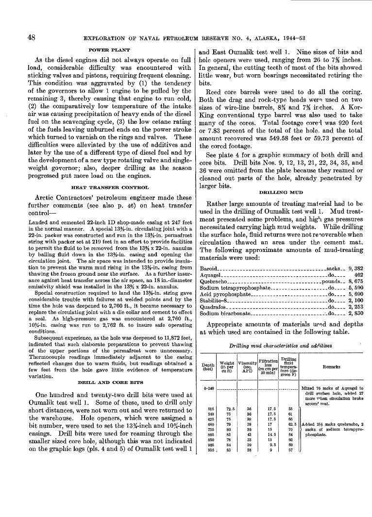
48 EXPLORATION OF NAVAL PETROLEUM RESERVE NO. 4, ALASKA, 1944-53
POWER PLANT
As the diesel engines did not always operate on full load, considerable difficulty was encountered with sticking valves and pistons, requiring frequent cleaning. This condition was aggravated by (1) the tendency of the governors to allow 1 engine to be pulled by the remaining 3, thereby causing that engine to run cold, (2) the comparatively low temperature of the intake air was causing precipitation of heavy ends of the diesel fuel on the scavenging cycle, (3) the low cetane rating of the fuels leaving unburned ends on the power stroke which turned to varnish on the rings and valves. These difficulties were alleviated by the use of additives and later by the use of a different type of diesel fuel and by the development of a new type rotating valve and single- weight governor; also, deeper drilling as the season progressed put more load on the engines.
HEAT TRANSFER CONTROL
Arctic Contractors' petroleum engineer made these further comments (see also p. 46) on heat transfer control Landed and cemented 22-inch ID shop-made casing at 247 feet in the normal manner. A special 13%-in. circulating joint with a 22-in. packer was constructed and run in the 13%-in. permafrost string with packer set at 219 feet in an effort to provide facilities to permit the fluid to be removed from the 13% x 22-in. annulus by bailing fluid down in the 13%-in. casing and opening the circulation joint. The air space was intended to provide insula tion to prevent the warm mud rising in the 13%-in. casing from thawing the frozen ground near the surface. As a further insur ance against heat transfer across the air space, an 18 in.-diameter emissivity shield was installed in the 13% x 22-in. annulus.
Special construction required to land the 13%-in. string gave considerable trouble with failures at welded points and by the time the hole was deepened to 2,760 ft., it became necessary to replace the circulating joint with a die collar and cement to effect a seal. As high-pressure gas was encountered at 2,760 ft., 10%-in. casing was run to 2,762 ft. to insure safe operating conditions.
Subsequent experience, as the hole was deepened to 11,872 feet, indicated that such elaborate preparations to prevent thawing of the upper portions of the permafrost were unnecessary. Thermocouple readings immediately adjacent to the casing reflected changes due to warm fluids, but readings obtained a few feet from the hole gave little evidence of temperature variation.
DRILL AND CORE BITS
One hundred and twenty-two drill bits were used at Oumalik test well 1. Some of these, used to drill only short distances, were not worn out and were returned to the warehouse. Hole openers, which were assigned a bit number, were used to set the 13%-inch and 10%-inch casings. Drill bits were used for reaming through the smaller sized core hole, although this was not indicated 011 the graphic logs (pis. 4 and 5) of Oumalik test well 1
and East Oumalik test well 1. Nine sizes of bits and hole openers were used, ranging from 26 to 7% inches. In general, the cutting teeth of most of the bits showed little wear, but worn bearings necessitated retiring the bits.
Reed core barrels were used to do all the coring. Both the drag and rock-type heads were used on two sizes of wire-line barrels, 8% and 1% inches. A Kor- King conventional type barrel was also used to take many of the cores. Total footage corei was 920 feet or 7.83 percent of the total of the hole, and the total amount recovered was 549.58 feet or 59.73 percent of the cored footage.
See plate 4 for a graphic summary of both drill and core bits. Drill bits Nos. 9, 12, 13, 21, 22, 34, 35, and 36 were omitted from the plate because they reamed or cleaned out parts of the hole, already penetrated by larger bits.
DRILLING MUD
Rather large amounts of treating material had to be used in the drilling of Oumalik test well 1. Mud treat ment presented some problems, and high, gas pressures necessitated carrying high mud weights. While drilling the surface hole, fluid returns were not recoverable when circulation thawed an area under the cement mat. The following approximate amounts of mud-treating materials were used:
Baroid___________________________sacks__ 9, 382Aquagel- __________________________________do____ 462Quebracho___________________________pounds__ 8, 675Sodium tetrapyrophosphate.___________________do____ 5, 590Acid pyrophosphate_____________________do _ 5, 690Stabilite-8______________________do__ 2,100Quadrafos________________________dp__ 2, 253Sodium bicarbonate________________________-_do____ 2, 830
Appropriate amounts of materials ured and depths at which used are contained in the following table.
Drilling mud characteristics and additives
Depth (feet)
A.9/IQ \f^£it.a
515540625680735805850905935
Weight Oh per cuft)
72.57575798083788483
Viscosity (sec. API)
363638393643333938
Filtration loss
(cu cm per 30min)
17.517.517.5171514.5139.59
Drilling fluid
tempera ture (de grees F)
55616662.57064606057
Remarks
Mixed 76 sacks of Aquagel todrill s'nrface hole, added 27more T^hen circulation brokearounc1 mat.
Added 2}i sacks quebracho, 2sacks of sodium tetrapyro-phosphate.
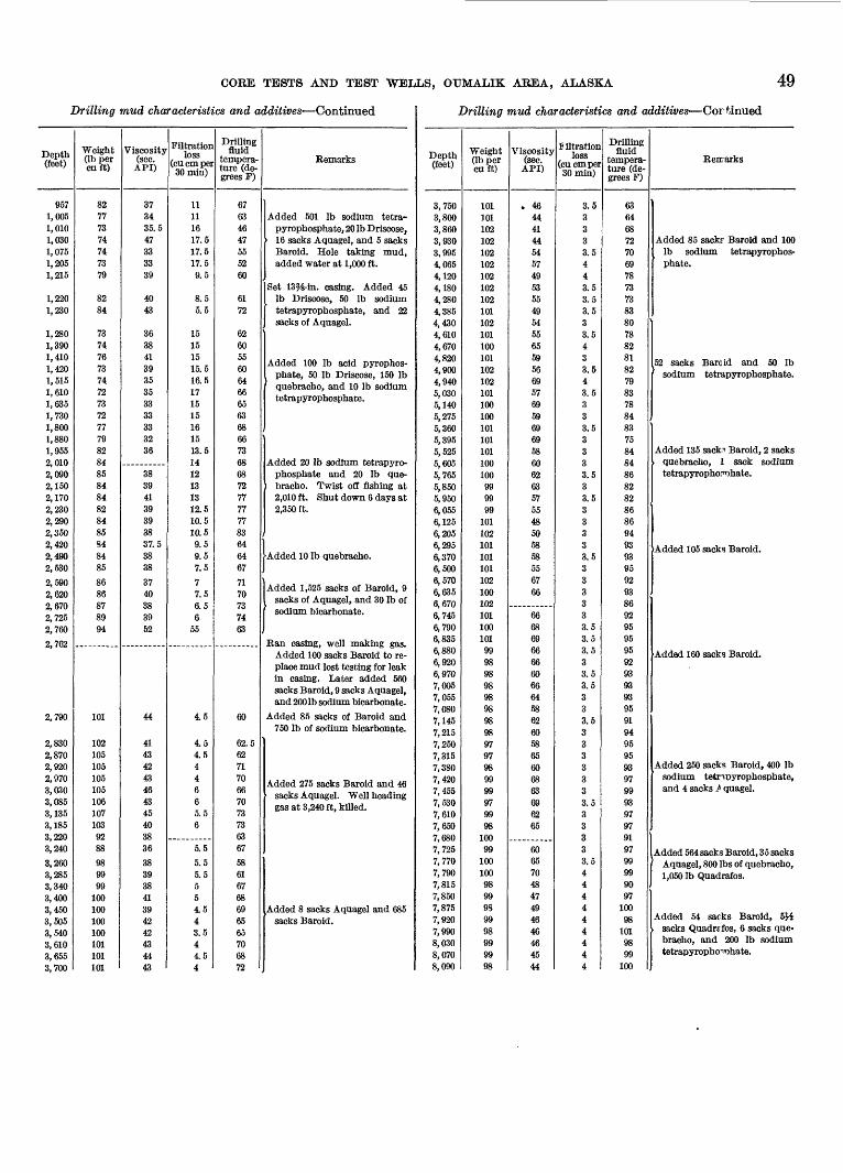
COEE TESTS AND TEST WELLS, OUMALIK AEEA, ALASKA 49
Drilling mud characteristics and additives Continued
Depth (feet)
9571,0051,0101,0301,0751,2051,215
1,2201,230
1,2801,3901,410 1,420 1,515 1,610 1,6351,7301,8001,8801,9552,0102,0902,1502,1702,2302,2902,3502,420 2,4902,530
2,590 2,620 2,670 2,7252,7609 Iff)ill t\J£l
2,790
2,8302,8702,9202,970 3,030 3,085 3,1353,1853,2203,240
3,2603,2853,3403,4003,450 3,5053,5403,6103,6553,700
Weight (Ib per cuft)
82777374747379
8284
737476 73 74 72 73727779828485848482848584 8485
86 86 87 8994
101
102105105105 105 106 1071039288
989999
100100 100100101101101
Viscosity (sec.
API)
373435.547333339
4043
363841 39 35 35 3333333236
38394139393837.5 3838
37 40 38 3952
44
41434243 46 43 45403836
38393841394242434443
Filtration loss
(cu cm per 30min)
11111617.517.517.59.5
8.55.5
151515 15.5 16.5 17 1515161513.51412131312.510.510.59.5 9.57.5
7 7.5 6.5 6
55
4.5
4.54.544 6 6 5.56
5.5
5.55.5554.5 43.544.54
Drilling fluid
tempera ture (de grees F)
67634647555260
6172
626055 60 64 66 65636866736868727777778364 6467
7170 73 7463
60
62.5627170 66 70 73736367
5861676869 6565706872
Remarks
Added 501 Ib sodium tetra-pyrophosphate, 20 Ib Driscose,
16 sacks Aquagel, and 5 sacksBaroid. Hole taking mud,added water at 1,000 ft.
Set 13^-in. casing. Added 45Ib Driscose, 50 Ib sodiumtetrapyrophosphate, and 22sacks of Aquagel.
Added 100 Ib acid pyrophos- phate, 50 Ib Driscose, 150 Ib quebracho, and 10 Ib sodium tetrapyrophosphate.
Added 20 Ib sodium tetrapyrophosphate and 20 Ib quebracho. Twist off fishing at2,010 ft. Shut down 6 days at2,350 ft.
Added 10 Ib quebracho.
Added 1,525 sacks of Baroid, 9 sacks of Aquagel, and 30 Ib of sodium bicarbonate.
Ran casing, well making gas.Added 100 sacks Baroid to replace mud lost testing for leakin casing. Later added 560sacks Baroid, 9 sacks Aquagel,and 200 Ib sodium bicarbonate.
Added 85 sacks of Baroid and750 Ib of sodium bicarbonate.
Added 275 sacks Baroid and 46 1 sacks Aquagel. Well heading
gas at 3,240 ft, killed.
Added 8 sacks Aquagel and 685 sacks Baroid.
Drilling mud characteristics and additives Cortinued
Depth (feet)
3,7503,8003,8603,9303,9954,0654,1204,1804,2804,3854,4304,6104,6704,820 4,900 4,940 5,030 5,1405,2755,3605,3955,5255,6055,7655,8505,9506,0556,1256,2056,295 6,3706,5006,570 6,635 6,670 6,7456,7906,8356,8806,9206,9707,0057,0557,0807,1457,2157,2507,3157,3807,420 7,455 7,530 7,6107,6507 6807,7257,7707,7907,8157,8507,875 7,9207,9908,0308,0708,090
Weight Qb per cuft)
101101102102102102102102102101102101100101 102 102 101 100100101101101100100
999999
101102101 101101102 100 102 101100101999898QQyoQQyo98989897979899 99 97 9998
10099
100100989998 9998999998
Viscosity (sec.
API)
. 4644414454574953554954556559 56 69 57 69596969586062635755485058 585567 66
666869666660666458626058656068 63 69 6265
606570484749 4646464544
liltration loss
(cucmper 30min)
3.53333.5443.53.53.533.543 3.5 4 3.5 333.533
3.533.53333 3.533 3 3 33.53.53.533. 53. 5
33.533333 3 3.5 33333.54444 44444
Drilling fluid
tempera ture (de grees F)
6364687270697873738380788281 82 79 83 7884837584QAOT:
86828286869493 939592 93 86 929595959293QQ iTO
QOiTO
95919495959397 99 93 9797919799999097
100 98
1019899
100
Remarks
Added 85 sacks- Baroid and 100Ib sodium tetrapyrophosphate.
52 sacks Baroid and 50 Ib sodium tetrapyrophosphate.
Added 135 sack^ Baroid, 2 sacksquebracho, 1 sack sodiumtetrapyrophoFDhate.
Added 105 sacks Baroid.
Added 160 sacks Baroid.
Added 250 sacks Baroid, 400 Ibsodium tetnpyrophosphate, and 4 sacks / quagel.
Added 564 sacks Baroid, 35 sacksAquagel, 800 Ibs of quebracho,1,050 Ib Quadrafos.
Added 54 sacks BaroJd, &Hsacks Quadrafos, 6 sacks quebracho, and 200 Ib sodiumtetrapyropho^hate.
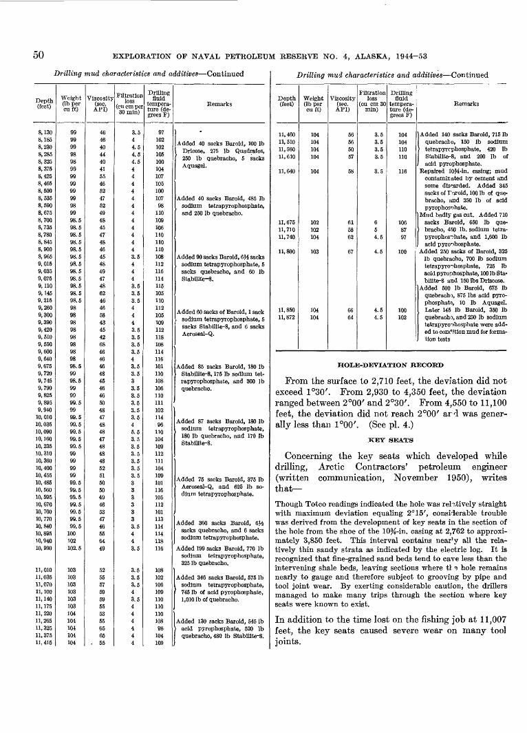
50 EXPLORATION OF NAVAL PETROLEUM RESERVE NO. 4, ALASKA, 1944-53
Drilling mud characteristics and additives Continued
Depth(feet)
8,1308,1858,2308,285ft 3950, O40
8,3758,4258,4658,5008,5358,5908,6758,7008,7358,7808,8458,9008,9659,0159,0359,0759,1109,1459,2159,260
9,3909 4209,5109,5509 fi(\{\ i UUU
9,6409,6759,7209,7459,790 9,8259,8959,940
10, 01010, 035 10,09010,16010, 23510, 310 10, 36010,40010, 455 10, 48510,56010, 59510, 67010, 70010, 770 10 84010, 89510,94010, 990
11,01011,03511,07011, 100 11,140 11, 17511, 22011, 26511,325 11,37511, 415
Weight(Ib per cuft)
999999Qfi«7O
Qfi«7O
9999999999989998.598.598.598.598.598.598.598.598.598.598.598.59898 98Qfi00
9898QQ OO
9898.59998.599 9999.599 99.599.5 99.599.599.599 999999QQ F»ay. oQQ F»ay. o
99.599.599.599.5 99 5
100102102.5
103103103103 103 103104104104 104104
Viscosity(sec.
API)
46464044404155465247524948454748464548494748624646CDOo
4345426846 4646484546 465048 4748
474848 485251 505049465347
556449
52555759 59 55535565 65
. 55
Filtrationloss
(cu cm per SOmin)
3.544.54. 54.54444444444443.54443.53.53.544 43.53.53.53 r
. 0
43.53.533.5 3.53.53.5 3.54 5.53.53.53.5 3.53.53.5
3333o r O. 0
4
43.5
3.53.53.54 3.5 4444 44
Drillingfluid
tempera ture (degrees F)
9710210210510010410710510010798
110109106no110110108112116114115105110112105 109112118108114 116101110108106 110111102 11496
110104109112 111104109 101116105112101113 114114118116
108102106109 110 11011010898
104109
Remarks
Added 40 sacks Baroid, 100 IbDricose, 275 Ib Quadrafos,250 Ib quebracho, 5 sacks
'
Added 40 sacks Baroid, 485 Ibsodium tetrapyrophosphate,and 250 Ib quebracho.
Added 90 sacks Baroid, &H sackssodium tetrapyrophosphate, 5sacks quebracho, and 60 IbStabilite-8.
Added 60 sacks of Baroid, 1 sacksodium tetrapyrophosphate, 5 sacks Stabilite-8, and 6 sacksA6ros6sl~ C£
Added 85 sacks Baroid, 180 IbStabilite-8, 175 Ib sodium tetrapyrophosphate, and 300 Ibquebracho.
Added 87 sacks Baroid, 180 Ib sodium tetrapyrophosphate,180 Ib quebracho, and 170 Ib Stabilite-8.
Added 75 sacks Baroid, 375 IbAeroseal-Q, and 625 Ib sodium tetrapyrophosphate.
Added 360 sacks Baroid, 6}^sacks quebracho, and 6 sackssodium tetrapyrophosphate.
Added 199 sacks Baroid, 770 Ibsodium tetrapyrophosphate, 325 Ib quebracho.
Added 346 sacks Baroid, 575 Ibsodium tetrapyrophosphate,745 Ib of acid pyrophosphate, 1,010 Ib of quebracho.
Added 130 sacks Baroid, 545 Ibacid pyrophosphate, 520 Ib quebracho, 480 Ib Stabilite-8.
Drilling mud characteristics and additives Continued
Depth(feet)
11,46011, 51011,56011, 610
11,640
11, 67511, 71011,740
11,800
11, 85011,872
Weight(Ib per cuft)
104104104104
104
102102104
103
104104
Viscosity(sec. API)
56565057
58
615862
67
6664
Filtrationloss
(cu cm 30 min)
3.53.53.53.5
3.5
654.5
4.5
4.54.5
Drillingfluid
tempera ture (degrees F)
104104110110
116
1068797
100
100102
Remarks
Added 140 sacks Baroid, 715 Ibquebracho, 150 Ib sodiumtetrapyrcphosphate, 420 IbStabilite-8, and 200 Ib ofacid pyrophosphate.
Repaired 10i&-in. casing; mudcontaminated by cement andsome discarded. Added 345sacks of Turoid, 100 Ib of quebracho, and 350 Ib of acidpyrophosnhate.
Mud badly gas cut. Added 710sacks Baroid, 650 Ib quebracho, 450 Ib. sodium tetrapyrophosphate, and 1,600 Ibacid pyrophosphate.
Added 250 sacks of Baroid, 325Ib quebracho, 700 Ib sodiumtetrapyrophosphate, 725 Ibacid pyrophosphate, 100 Ib Stabilite-8 and 150 Ibs Driscose.
Added 500 Ib Baroid, 675 Ibquebracho, 875 Ibs acid pyrophosphate, 10 Ib Aquagel.Later 145 Ib Baroid, 350 Ibquebracho, and 250 Ib sodium tetrapyrophosphate were added to condition mud for formation tests
HOLE-DEVIATION RECORD
From the surface to 2,710 feet, the deviation did notexceed 1°30'. From 2,930 to 4,350 feet, the deviationranged between 2°00' and 2°30'. From 4,550 to 11,100feet, the deviation did not reach 2°00' ard was generally less than 1°00'. (See pi. 4.)
KEY SEATS
Concerning the key seats which developed whiledrilling, Arctic Contractors' petroleum engineer(written communication, November 1950), writesthat
Though Totco readings indicated the hole was relatively straightwith maximum deviation equaling 2° 15', considerable troublewas derived from the development of key seats in the section ofthe hole from the shoe of the 10%-in. casing at 2,762 to approximately 3,850 feet. This interval contains nea^y all the relatively thin sandy strata as indicated by the electric log. It isrecognized that fine-grained sand beds tend to cave less than theintervening shale beds, leaving sections where tl 3 hole remainsnearly to gauge and therefore subject to grooving by pipe andtool joint wear. By exerting considerable caution, the drillersmanaged to make many trips through the section where key seats were known to exist.
In addition to the time lost on the fishing job at 11,007feet, the key seats caused severe wear on many tooljoints.
CORE TESTS AND TEST WELLS, OUMALIK AREA, ALASKA 51
BUECTRIC LOGGING ANI> TEMPERATURE SURVEY
The electric log and temperature surveys run by the Schlumberger Well Surveying Corp. are shown in the following table. No electrical temperature survey was made at the final depth, but maximum temperature readings taken at the bottom of the hole when the various runs were made indicate a temperature gradient of 1.25°F per 100 feet of depth and a bottom hole temperature of 175°F at the final depth.
Electric log runs and temperature surveys
Run
1 __2 __--__'___-3 -__ ~- 4---_____-_____5___. __________Discarded. ____6__--___.__.___7 __8_---____--____
9 _ HL______-_____
Date
1949 June 28July 4Aug. 7Sept. 16Oct. 9Oct. 22Oct. 24Dec. 2Dec. 12
1950 Mar. 4Apr. 6
Depth (feet)
248-1, 0131, 013-1, 2211, 221-2, 5412, 541-2, 7642, 764-3, 6993, 699-5, 1313, 699-5, 3655, 365-8, 0248, 024-8, 420
8, 420-11, 47511, 475-11, 754
Maximum temperature
No reading.No reading.62°F.No reading.74°F.Short in cable.96°F.130°F.130°F.
175°F.175°F.
VELOCITY SURVEY
Seismograph velocity surveys were made on the hole at depths of 5,605 and 11,872 feet in an attempt to obtain a high-velocity break which probably would have been indicative of the limestone of the Lisburne group (Mississippian). However, the highest velocities ob tained were on the order of 13,000 feet per second and probably originated in a sandstone-s*hale sequence. These surveys were made by the United Geophysical Co., Inc.
SUMMARY OF THERMAL INVESTIGATIONS
By MAX C. BREWER
A thermal cable, containing 28 thermistors spaced for different depths, was installed in Oumalik test well 1 to a depth of 735 feet on Apr. 22, 1950. The highly viscous mud kept the cable from penetrating to the planned depth of 1,248 feet even though the cable had heavy weights attached just below the bottom thermistor.
The readings taken on Apr. 23, 1950, gave temper atures that ranged from 3.4°C at 227 feet to 11.1°C at 687 feet. The temperatures above 227 feet averaged 4.3°C.
When the site was visited 011 Aug. 9, 1950, it was found that all the conductors in the cable showed
open circuits, indicating that the conductors were broken. The one set of thermal measurements from this well, taken so soon after the completion of the drilling, do not allow for any particularly significant interpretation.
The cable above the ground surface showed no evi dence of damage, and it was therefore asrumed that the break occurred at some depth below the surface. It was first believed that the well casing: collapsed, because the fluid surrounding the casing froze and severed the thermistor cable in the process. This supposition was strengthened by the observation of constriction, near 670 feet in depth, in the tubing recovered from another well, South Barrow test well 2.
More recent evidence has indicated that casing collapse is probably not nearly as frequent as it was assumed to be in 1950. Four sets of cabler have been lost under similar conditions since that tune. In three sets it was proved that the cables failed because the metal conductors (1) were designed for strength, (2) were brittle as a result of the alloying, and (3) lacked the ductility necessary to stretch as the ice in the casing expanded. In none of these was there casing collapse. No clear cut evidence is available to indicate the presence or absence of casing collapse in the fourth cable loss.
EAST OUMALIK TEST WELL 1
Location: Lat 69°47'29" N., long 155°32'39" W. Elevation: Ground, 277 feet; kelly bushing, 293 feet. Spudded: Oct. 23, 1950.Completed: Jan. 7, 1951, dry and abandoned. Total depth: 6,035 feet.
East Oumalik test well 1 is located on c, high ridge above an unnamed creek that flows into the Oumalik River (fig. 4). Topographic relief in the area is about 100 feet; streams are incised.
The exact thickness of the permafrost in this well is not known. Numerous lenses of ice wer^ drilled in both the Gubik formation and the Killik tcngue of the Chandler formation. The deepest ice noted by the well geologist in the hole was between 740 and 750 feet. Temperature readings obtained from thermistors, installed in the hole after completion of drilling, are inconclusive.
The following is a list of depths at which the various stratigraphic units are found in East Oumalik test well 1:
Depth (feet) 16-50_______________ Recent and (or) Gubik formation.50-730._______________ Chandler formation (Killik tongue).
730-3,050______________ Grandstand formatior,3,050-5,200._-___-.__--__ Topagoruk formation. 5,200-6,035 (total depth) _ _ Oumalik formation.
52 EXPLORATION OF NAVAL PETROLEUM RESERVE NO. 4, ALASKA, 1944-53
The first 34 feet penetrated by the drill consists of relatively unconsolidated fine sand, silt, and clay of Pleistocene and possibly Recent age. (See pi. 5.) Ostracodes and white shell fragments were found in the well cuttings. Underlying the surficial mantle are 680 feet (50-730 ft) of the nonmarine Killik tongue of the Chandler formation. (See p. 8.) It is pre dominantly clay shale and coal interbedded with a total of about 80 feet of sandstone and 75 feet of silt- stone.
The Grandstand formation, part of the lower marine section of the Nanushuk group, is present between 730 and 3,050 feet. It is differentiated from the Killik tongue of the Chandler formation by the presence of an abundant marine fauna. The highest occurrence of this fauna marks the approximate top of the thickest sandstone section in the Oumalik area. About 600 feet of the total thickness of the Grandstand is made up of sandstone and siltstone. The rest is mostly clay shale. Argillaceous limestone occurs in thin beds between 1,150 and 1,450 feet. Some of this calcareous section may be dolomitic or sideritic, as it reacts slowly with cold dilute hydrochloric acid. A few clay ironstone concretions were noted.
The abundant and varied Verneuilinoides borealis microfauna is present throughout, as well as a number of associated megafossils. Although the sandstone beds of the Grandstand formation are the major oil- producing Cretaceous unit in Naval Petroleum Reserve No. 4, they were essentially dry in this test.
The 2,150-foot marine sequence from 3,050 feet to approximately 5,200 feet in East Oumalik test well 1 is correlated with the Topagoruk formation. In this well the formation consists of 95 percent silty clay shale and clay shale and only about 5 percent sandstone. The top of the formation is placed at the base of the pre dominantly sandy section of the overlying Grandstand formation. The Topagoruk formation also contains an excellent Verneuilinoides borealis microfauna.
East Oumalik test well 1 penetrated 835 feet of the Oumalik formation from 5,200 feet to the bottom of the hole at 6,035 feet. It is a medium-gray to medium- dark-gray clay shale, with the latter color predominat ing. No sandstone and only rare siltstone is present. Pyritic specimens of Lithocampe? sp., a radiolarian dis tinctive of the Oumalik formation, occur below 5,705 feet.
The contact between the Oumalik and Topagoruk formations is placed somewhat arbitrarily at 5,200 feet in the shale section. In general the shale above 5,200 feet is more silty, lighter colored, and contains the Verneuilinoides borealis microfauna characteristic of the Topagoruk formation. The angular uncomformity and
lithologic break present between the two formations in test holes hi the northern part of the Reserve are absent here in the deepest part of the Cretaceous depositional basin where Early Cretaceou7 sedimenta tion probably was continuous.
HEAVY-MINERAL STUDIES
Two heavy-mineral zones are recognized by Robert H. Morris hi East Oumalik test well 1 (pi. 6), the glaucophane zone and the zoned zircon zone. The glaucophane zone is represented by one srmple at 526 feet. Other minerals of the sample from £15 feet have the general characteristics of the glaucophane zone, but glaucophane is absent. The zoned zircon zone is recognized (in four samples) from 1,693 to 3,869 feet.
DESCRIPTION OF CORES AND CUTTINGS
The well cuttings from which the folk wing record was made were of good quality. See plate 5 for a summary of the lithologic material and engineering data. Depths are measured from the top of the kelly bushing.
Lithologic description
[Where no core number is listed, description is based on cutting samples]
Core
.__-
___-___-
Depth (feet)
0-16
16-3030-50
50-90
90-106106-126
Description
Kelly bushing to ground bvel.No samples received.Ice (reported by well geologist), sand,
silt, and clay. Sand, moderate-yellowish-brown, very fine- to medium-grained. Grains subrounded torounded; 80 percent yellow andyellowish-orange quartz and clearquartz with yellowish east; 10 percentwhite and clear quar*,z, 5 percentblack chert and coal; aleo yellow chertand rare chert of other colors. Someyellowish-gray clay. Rare, whiteshell fragments and ostracodes.
Clay, yellowish-gray to medium-light-gray, and sand as above. Rare rockfragments, clay ironstone. The top ofthe Chandler formation is placed at50 feet.
No samples received.Sandstone, siltstone, limestone, and clay
shale. Sandstone and siltstone,medium-light-gray, very fine- to finegrained; grains subangular to raresubrounded; 95 pereert white andclear quartz, also carbonaceous particles. Clay shale, light-gray; containscarbonaceous particles. Limestone,medium- to medium-dark-gray, argillaceous, lithographic, with veinlets ofwhite crystalline calcite.
CORE TESTS AND TEST WELLS, OUMALIK AREA, ALASKA 53
Lithologic description Continued
Core
_ _ -
1
--
__--
__--
_ _- -
2
Depth (feet)
126-146
146-156
156-166
166-190
190-220
220-240
240-250
250-270
270-280
280-310
310-320
Description
Clay shale, light- and medium-gray withbrownish cast. Some sandstone,stiltstone, and vitreous black coalchips.
Sandstone, light-gray, medium-grained,subangular to subrounded; largelywhite and clear quartz; also carbonaceous particles, some grains of glau-conite and yellow quartz.
Recovered 1 ft: Microfossils rare.Material recovered consists primarily
of drilling mud containing chips ofshale and coal. Clay shale or clay-stone (?), medium-light-gray tomedium-gray, medium-soft; thinlaminae (to % in.) of black coal.Rare light-gray sandy to silty shalechips, slightly calcareous. Minutelyshattered coal particles; appears tobe coal ground up and repackedwhile drilling. Dip undetermined.
Clay shale, light-gray, also hard dark-gray clay shale that resembles limestone but is only slightly calcareous.Rare vitreous black coal chips. Clayironstone, light-olive-gray and yellowish-brown, has carbonaceous fragments.
Sandstone grading to siltstone below200 ft. Sandstone, light-gray, veryfine-grained with very fine coalystreaks and carbonaceous partings.Brownish-yellow clay ironstone, plantimpressions. Very rare chips of coal.
Clay shale, light-gray, also yellowish-gray silty clay ironstone.
Sandstone, light-gray, very fine- tofine-grained; some grayish-orange clayironstone.
Sandstone, siltstone, and clay shale,dark carbonaceous partings, non-calcareous.
Clay shale, light-gray and medium-dark-gray.
Sandstone, light-gray, fine- to medium-grained; subangular, 90 percent whiteand clear quartz, remainder of grainsmostly carbonaceous particles; whitepowdery matrix; numerous carbonaceous partings; non calcareous, moderately porous to drop test.
Recovered 2 ft 5 in.: Microfossils absent.
Siltstone, light-gray, medium-soft andfriable, sandy, very argillaceous,"dirty." Some streaks of fine- tomedium-grained .sandstone; sub-angular grains, mostly white andclear quartz; very light-gray clayey
Litholoffio description Continued
Core
___-__--
___-
__--
___-
__--
___-
__--
--
_ ___
_ _--
__--
___
___-
3
Depth(feet)
320-330330-350
350-370
370-380
380-400
400-410
410-420
420-430
430-460
460-470
470-480
480-490
490-500
500-517
517-527
Description
cementing material. A few laminae of medium-gray clay shale.Rare thin black layers and fragments of coal; noncalcareons; dipsprobably low; core slightly brokenup.
No sample.Clay shale, light-gray, and some sand
stone; thin layers of coal.Sandstone, fine-grained, si'tstone, and
clay shale. Some clay shale is darkgray; numerous carbonaceous particles in the sandstone.
Clay shale, light-gray, anc1 much carbonaceous dark-gray shale. Light-gray siltstone. Calcareous shell fragments of pelecypods.
Sandstone, light-gray, fine-grained;quartz with carbonaceous and ironstone particles; plant fragments inpartings; slightly calcareous. A smallamount of light-gray clay shale.
Clay shale, medium-light-gray, rarecoaly particles.
Siltstone, light-gray; black carbonaceous plant fragments.
Clay shale and siltstone; plant fragments.
Siltstone, light- and medium-light-gray,slightly sandy; yellowish-gray clayironstone chunks. Smal] amount ofgrayish-black carbonaceous shale.
Clay shale, medium-light- and medium-gray; rare shiny black coal chips.
Siltstone, clay shale, light-gray and verydark-gray; also coal chips.
Coal (hah* the sample), dull to vitreous,black. Clay shale, medium-light-gray.
Clay shale, medium-gray, and siltstone;carbonaceous particles.
Coal 60 percent of samp1 '?, grayish-black and black, dull to shiny; clayshale, light-olive-gray. Cla y ironstone,grayish-yellow.
Recovered 10 ft: Microfossi's absent.5 ft 7 in., clay shale, medium-light- to
medium-dark-gray, soft and slightlyfissile; tends to break into littlechips when dried out, moderateamount of very thin black coalystreaks and carbonaceous fragments. Grayish-yellow clay ironstone concretion (%-ic. diameter)from 517% ft; noncalcareous toslightly calcareous toward base.
4 ft 5 in., sandstone, sirstone, andclay shale, thinly interbedded, becoming progressively sardier towardthe bottom of core, medium hard.
54 EXPLORATION OF NAVAL PETROLEUM RESERVE NO. 4, ALASKA, 1944-53
lAthologic description Continued
Core
___ _
____
_ ___
_ __ _
____
_ ___
____
____
____
____
_ _ __
Depth (feet)
527-530
530-550
550-560
560-570
570-600
600-610
610-620
620-640
640-650650-660660-670
670-690
Description
Clay shale, medium-gray. Siltstone,light-gray. Sandstone, light-gray,fine-grained, subangular, primarilyquartz, some coal particles andmica. Partings of carbonaceousand coaly material; some blackfragmental carbonaceous plant remains. Two-in. bed of very hardyellowish-gray clay ironstone atbase. At 526 ft effective porosity11.5 percent; impermeable; carbonate content 13.3 percent byweight. Bedding well defined because of changes in compositionand color; range of dips (to 15°)suggest crossbedding, dip generally about 5°; sandstone and silt-stone slightly calcareous; no oil orgas shows.
Sandstone, light-gray, fine-grained, sub-angular; white quartz and dark carbonaceous particles, plant impressions, and carbonaceous partings.
Clay shale, medium-light-gray; rareplant impressions; some ironstone;very small amount of coal chips.
Sandstone, light-gray, very fine- to finegrained. Clay shale, clay ironstonecarbonaceous partings.
Limestone and calcareous siltstone,medium-dark-gray, hard. Veinlet ofwhite calcite. Clay shale, medium-light-gray.
Clay shale, medium-light-gray and dark-olive-gray; some dull coaly chipsyellowish-gray clay ironstone.
Coal and carbonaceous shale, grayish-black to black, 50 percent. Clayshale, medium-light-gray, clay ironstone.
Clay shale, black and medium-light-gray. Rare coal chips, clay ironstone.
Sandstone, light-gray, fine-grained, sub-angular to subrounded grains, mostlywhite and clear quartz; coaly; side-ritic; micaceous particles common;carbonaceous partings; slightly tomoderately calcareous (possibly do-lomitic reacts slowly but steadilywith cold dilute acid.). Some medium-dark-gray siltstone near base.
Siltstone, light-gray, sandy.Sandstone, siltstone, and clay shale.Clay shale 60 percent, grayish-black;
rare shiny black coal chips; alsomedium-light-gray clay shale; clayironstone.
Coal and black shale 40-70 percent, clayshale and clay ironstone, minor finegrained sandstone.
Lfitliologic description Continued
Core
____
____
____
____
45
____
________
____
____
____
____
___..
6
Depth (feet)
690-700
700-710
710-720
720-730
730-740
740-750750-755
755-765
765-775775-795
795-805
805-865
865-875
875-895
895-950
950-956
Description
Sandstone, very fine-grained, and silt-stone; very rare coal chips.
Siltstone 50 percent, light-gray, andmedium-light-gray clay shale.
Clay shale 80 percent, and fine-grainedsandstone.
Sandstone, light-gray, very fine- to finegrained, slightly to moderately calcareous. Clay shale, carbonaceouspartings.
Clay shale, medium-light-gray. Thetop of the Grandstand formation isplaced at 730 feet.
No recovery.Recovered 5 ft: Microfossils very
abundant.Clay shale, roedium-dark-gray, very
silty, hard; fair cleavage parallel tobedding, light-colored paper-thinlayers of siltstone common, particularly in lower third of core;grayish-yellow clay ironstone concretions or lenses at 751 and 752 ft;irregular pyrite nod ile at 751)4 ft;scattered carbonaceous plant fragments in partings. Siltstone isslightly calcareous; beds are flatlying.
Siltstone and sandstone, light- tomedium-light-gray, sFghtly calcareous.
Clay shale and sandstone-Sandstone, light-gray, fire-grained, sub-
angular; 75 percent white and clearquartz grains; 10 percent carbonaceous particles; also mica and someyellowish quartz grains; very slightlycalcareous; carbonaceous coaly partings.
Siltstone, medium-light-gray, carbonaceous partings.
Clay shale, medium-light-gray, carbonaceous partings and plant impressions.Argillaceous siltstone at 825-835 ft.Chips of coal at 855-865 ft.
Coal, dull to vitreous, black, irregularfracture; 50 percent of sample. Clayshale, medium-light-gray; somepyrite.
Sandy siltstone and clay shale, medium-light-gray; very small amount of coal.
Sandstone, light-gray, fine- to medium-grained (mostly fine), subangulargrains, 85 percent white and clearquartz; carbonaceous particles andmica common.
Recovered 6 ft: Microfossils absent.Siltstone and clay shale, interbedded.
Clay shale, medium-light- to medium-gray, hard; good cleavage paral-
CORE TESTS AND TEST WELLS, OTJMALIK AREA, ALASKA 55
Litholoffic description Continued
Depth (feet)
956-960 960-980
980-1,040
1,040-1,050 1,050-1,080
1,080-1,100
1,100-1,110
1,110-1,140
1,140-1,150
1,150-1,156
1,156-1,185
1,185-1,205
1,205-1,225
Description
lei to bedding. Siltstone, light- gray, hard, grades very rarely into very fine-grained sandstone; slightly calcareous. Excellent small-scale crossbedding (laminae to one-quar ter of an inch) at 951 ft, "swirly" bedding at 951 % ft. Lenses and irregular beds with dips to 20° (large-scale crossbedding) at 953 ft; dip generally about 4°.
No sample.Clay shale, medium-light-gray, and
sandstone; carbonaceous partings; grayish-yellow clay ironstone.
Sandstone, light-gray, very fine- to fine grained, and clay shale.
No sample.Clay shale and sandstone, slightly cal
careous.Coal, 40-80 percent of samples, vitreous,
black, and clay shale, medium-light- gray. Inoceramus prisms.
Siltstone, medium-light-gray; contami nated by cement.
Clay shale, medium-light- to medium- gray, moderately calcareous; rare plant impressions; brownish-gray clay ironstone 1,130-1,140 ft.
Clay shale, very fine-grained sandstone, and trace of siltstone; plant impres sions.
Recovered 6 ft: Microfossils absent. Claystone, medium-light- to medium-
dark-gray, hard; irregular fracture roughly parallel to bedding; good shaly cleavage rare; small black carbonaceous plant fragments in some partings; scattered slightly lighter colored silty streaks; mod erately to very calcareous; grades to argillaceous (and dolomitic?) limestone at 1,155 ft; tiny white calcareous veinlets at this depth nearly vertical through core. Beds approximately flat lying; rare steep er dipping crossbeds.
Clay shale, medium-light- to medium- gray; some dark-gray, moderately calcareous; plant impressions rare; clay ironstone 1,175-1,185 ft.
Clay shale, medium-light- to medium- dark-gray; coaly partings; some py- rite. Also small amount of very fine grained light-gray moderately cal careous sandstone.
Clay shale, medium-light-gray, and very argillaceous medium-dark-gray lime stone; small amount of light-gray, very "dirty" and very fine-grained
Litholoffic description Continued
Core Depth (feet)
1,225-1,235
1,235-1,245
1,245-1,275
1,275-1,295
1,295-1,315
1,315-1,325
1,325-1,335
1,335-1,345
1,345-1,350 1,350-1,360
1,360-1,410
1,410-1,420
1,420-1,440
Description
sandstone; plant impressions; brown ish-gray clay ironstone.
Clay shale, medium-light- to light-gray;pyrite.
Sandstone 40 percent, light-gray; white quartz grains and many carbonaceous particles; moderately calcareous. Also medium-light-gray clay shale and dark-gray carbonaceous shale.
Clay shale, medium-light-g~ay; minor amount of light-gray sandy siltstone.
Clay shale, medium-light- to medium- gray.
Clay shale, medium-light- to medium- dark-gray; trace of light-gray moder ately calcareous siltstone.
Sandstone and siltstone 60 percent;medium-light-gray clay shale.
Limestone 30 percent, meiium-dark- gray, very argillaceous and silty, hard. Also clay shale.
Clay shale, medium-light-gray; plantimpressions; pyrite; clay ironstone.
No sample. Recovered 10 ft: Microfcssils very
abundant.6 ft 7 in., clay shale, medium- to
medium-dark-gray, medium-hard, fair shaly cleavage, conchoidal fracture; rare thin laminae of medium-gray siltstone. Quarter- inch brownish-gray clay ironstone layers at approximately 1,351 ft and 1,352 ft, pelecypods found be tween 1,354 and 1,356 ft were identified as Anomia sp., Psilo- myaf sp., and Arctica? sp.
3 ft 5 in., clay shale anc1 siltstone, similar to upper part o* core but with larger proportion of silt. Silt- stone, medium-gray, argillaceous; has irregular fracture ronghly par allel to bedding; contains fairly numerous black carbonaceous plant fragments; moderately calcareous; beds approximately flat lying.
Clay shale, medium-light- and medium- dark-gray; trace of siltstone and very fine-grained, light-gray sardstone.
Limestone, medium-gray, very silty; grades into very calcareous siltstone.
Sandstone, light-gray, fine-grained, hard, tight; mostly subangular, white and clear quartz grains; carbonrceous par ticles abundant; black plant impres sions; white vein calcite very rare. Also siltstone and clay shale toward base.
56 EXPLORATION OF NAVAL PETROLEUM RESERVE NO. 4, ALASKA, 1944-53
Lithologic description Continued
Core
____
____
____
____
9
__
__
__
____
10
Depth (feet)
1,440-1,480
1,480-1,500
1,500-1,530
1,530-1,540
1,540-1,550
1,550-1,560
1,560-1,570
1,570-1,590
1,590-1,630
1,630-1,660
1,660-1,692
1,692-1,702
Description
Clay shale, medium-light- to medium-dark-gray; yellowish-gray clay ironstone 1,440-1,450 ft, 1,460-1,470 ft;coal partings 1,470-1,480 ft; pyrite.
Clay shale, medium-light- to medium-gray; minor amount siltstone and finegrained sandstone; pyrite.
Clay shale, medium-light-gray; shinyblack coal chips rare; pyrite.
Clay shale, medium-light- to medium-gray; sandy siltstone; pyrite common;one chip of coal.
Clay shale, medium-light-gray, slightlycalcareous; small amount of clay ironstone.
Recovered 7 ft 6 in.: Microfossils abundant.
Clay shale, medium-dark-gray, medium-hard, brittle, fissile; conchoi-dal fracture; brown-shelled pelecy-pod (unidentified) at 1,560 ft; non-calcareous; beds flat lying.
Clay shale, medium-light- to medium-gray.
Clay shale, medium- to medium-dark-gray, and small amount of very finegrained very calcareous sandstone;trace of siltstone.
Clay shale, medium-light- to medium-dark-gray; brownish clay ironstone;carbonaceous partings and plant impressions; pyrite chunks.
Sandstone, medium-light-gray, fine- tomedium-grained; largely white andclear quartz grains; some mica; about10 percent carbonaceous particles;slightly calcareous. Clay shale, dark-gray; rare shiny black coal chips1,630-1,640 ft.
Sandstone as above, very fine- to finegrained; almost entirely quartz grains;moderately calcareous; some medium-dark-gray very calcareous clay shaleor argillaceous limestone 1,680-1,690ft.
Recovered 10 ft: Microfossils very rare.Sandstone, light-gray, hard, massive,
very fine- to fine-grained with scattered medium-sized grains; 85 percent subangular white and clearquartz grains; calcareous cement;very rare isolated medium-dark-grayshale chips % in. in diameter in thesandstone; chips lie flat parallel tobedding. One inch of medium-grayclay shale 2 in. from top of core.At 1,693 ft effective porosity 11.6percent; air permeability less than 1millidarcy, and carbonate content18.23 percent by weight. Spotty
Lithologic description Continued1
Core
_ ___
_ ___
____
_ ___
________
____
____
____
________
11
_ _ _ ____
____
Depth (feet)
1,702-1,760
1,760-1,790
1,790-1,810
1,810-1,820
1,820-1,8301,830-1,840
1,840-1,900
1,900-1,920
1,920-1,940
1,940-1,9501,950-1,968
1,968-1,974
1,974-1,9801,980-1,990
1,990-2.020
Description
stain and oil odor, light-straw-colored cut, yellow residue at 1,700ft; beds flat lying;. Inoceramusprisms in microfossil cut.
Sandstone as in core above, fine-grainedbecoming very fine with depth; alsomedium- to medium-dark-gray clayshale, quantity increasing with depth.Inoceramus prisms 1,740-1,750 ft.
Clay shale, medium- to medium-dark-gray; 50 percent siltstone 1,770-1,780ft.
Sandstone 50 percent, Tjht-gray, veryfine- to fine-grained, and clay shale 50percent.
Sandstone, light-gray, very fine- tomedium-grained, (latter rare), mostlywhite and clear quartz grains andcarbonaceous particles; 10 percentclay shale. Inoceramus prisms.
Sandstone, siltstone, and1 clay shale.Clay shale, medium-gray, slightly cal
careous; rare plant impressions; 10percent sandstone.
Clay shale, medium- to medium-dark-gray.
Clay shale and small amount of softlight-gray very fine-grained sandstone; pyrite.
Sandstone, light-gray, very fine-grainedto silty, rather soft; 20 percent clayshale, medium-light- to medium-gray.
Siltstone and clay shale; pyrite.Sandstone, very fine-grained to silty;
50 percent clay shale, medium-light-to medium-dark-gray; pyrite.
Recovered 6 ft 8 in. : Mic~of ossils absent.Interbedded siltstone, two-thirds, and
clay shale, one-tl ;rd. Siltstone,light-gray, hard; 95 percent whiteand clear quartz grains, with coalygrains and subangular, very rare,very fine sand grains; carbonaceous-micaceous partings; noncalcareousto very slightly calcareous. Clayshale, medium-gray, hard; containsminute micaceous partings, noncalcareous. Siltstone has excellentsmall-scale crossbecMing with dipsto 15°, ripple marks noted on breaksbetween silt and shale, amplitude% in. and length about 1% in.; dip1°; no shows.
Clay shale.Sandstone, light-gray, very fine-grained,
and siltstone 70 percent; clay shale30 percent, slightly calcareous.
Clay shale, medium-lig^t- to medium-dark-gray. Sandy siltstone 10-35percent.
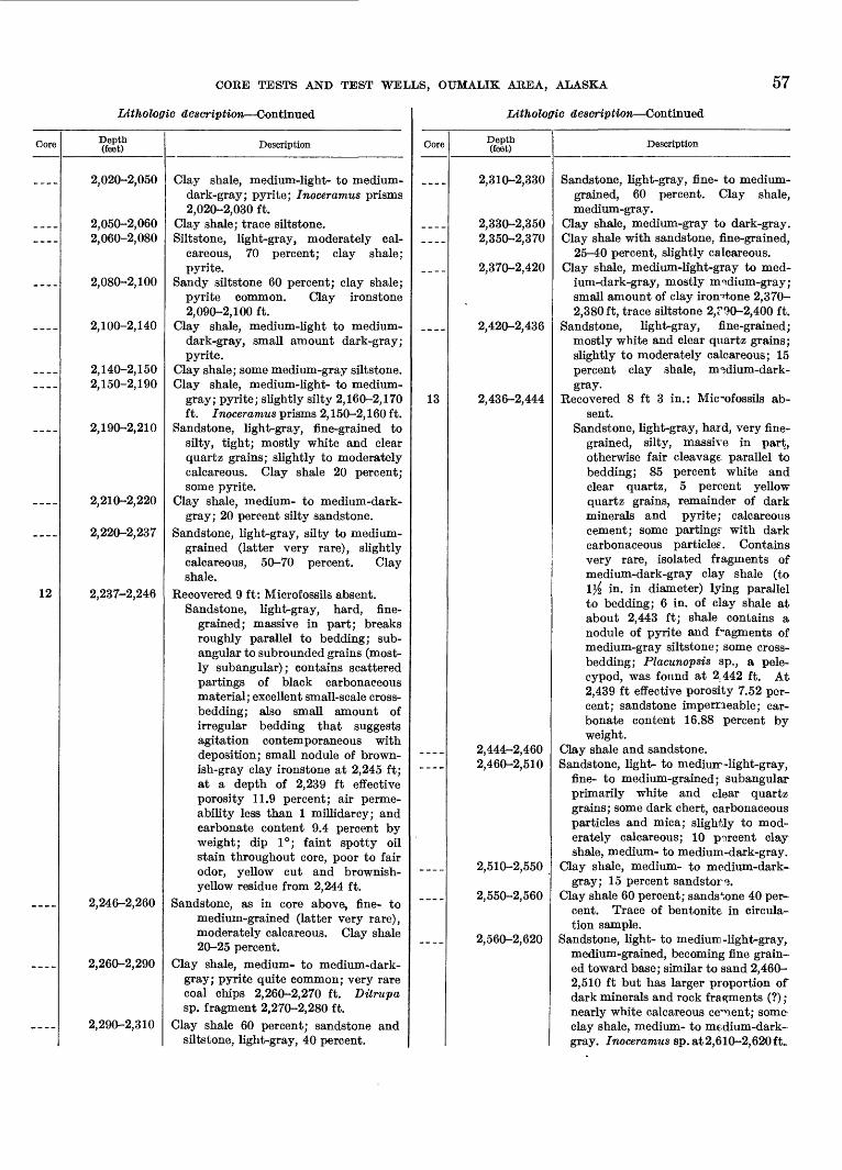
COEE TESTS AND TEST WELLS, OUMALIK AREA, ALASKA 57
Litholoffic description Continued.
Core
________
____
____
________
____
____
___
12
____
____
____
Depth (feet)
2,020-2,050
2,050-2,0602,060-2,080
2,080-2,100
2,100-2,140
2,140-2,1502,150-2,190
2,190-2,210
2,210-2,220
2,220-2,237
2,237-2,246
2,246-2,260
2,260-2,290
2,290-2,310
Description
Clay shale, medium-light- to medium-dark-gray; pyrite; Inoceramus prisms2,020-2,030 ft.
Clay shale; trace siltstone.Siltstone, light-gray, moderately cal
careous, 70 percent; clay shale;pyrite.
Sandy siltstone 60 percent; clay shale;pyrite common. Clay ironstone2,090-2,100 ft.
Clay shale, medium-light to medium-dark-gray, small amount dark-gray;pyrite.
Clay shale; some medium-gray siltstone.Clay shale, medium-light- to medium-
gray; pyrite; slightly silty 2,160-2,170ft. Inoceramus prisms 2, 150-2, 160 ft.
Sandstone, light-gray, fine-grained tosilty, tight; mostly white and clearquartz grains; slightly to moderatelycalcareous. Clay shale 20 percent;some pyrite.
Clay shale, medium- to medium-dark-gray; 20 percent silty sandstone.
Sandstone, light-gray, silty to medium-grained (latter very rare), slightlycalcareous, 50-70 percent. Clayshale.
Recovered 9 ft: Microfossils absent.Sandstone, light-gray, hard, fine
grained; massive in part; breaks roughly parallel to bedding; sub- angular to subrounded grains (most ly subangular); contains scatteredpartings of black carbonaceousmaterial; excellent small-scale cross-bedding; also small amount ofirregular bedding that suggestsagitation contemporaneous with deposition; small nodule of brownish-gray clay ironstone at 2,245 ft;at a depth of 2,239 ft effectiveporosity 11.9 percent; air perme ability less than 1 millidarcy; andcarbonate content 9.4 percent byweight; dip 1°; faint spotty oilstain throughout core, poor to fairodor, yellow cut and brownish-yellow residue from 2,244 ft.
Sandstone, as in core above, fine- tomedium -grained (latter very rare),moderately calcareous. Clay shale 20-25 percent.
Clay shale, medium- to medium-dark-grayj pyrite quite common; very rarecoal chips 2,260-2,270 ft. Ditrupasp. fragment 2,270-2,280 ft.
Clay shale 60 percent; sandstone andsiltstone, light-gray, 40 percent.
Litholoffic description Continued
Core
________
____
____
13
____
____
____
Depth (feet)
2,310-2,330
2,330-2,3502,350-2,370
2,370-2,420
2,420-2,436
2,436-2,444
2,444-2,4602,460-2,510
2,510-2,550
2,550-2,560
2,560-2,620
Description
Sandstone, light-gray, fine- to medium-grained, 60 percent. Clay shale,medium-gray.
Clay shale, medium-gray to dark-gray.Clay shale with sandstone, fine-grained,
25-40 percent, slightly calcareous.Clay shale, medium-light-gray to med
ium-dark-gray, mostly medium-gray;small amount of clay ironstone 2,370-2,380ft, trace siltstone 2,?90-2,400 ft.
Sandstone, light-gray, fine-grained;mostly white and clear quartz grains;slightly to moderately calcareous; 15percent clay shale, nndium-dark-gray.
Recovered 8 ft 3 in.: Microfossils absent.
Sandstone, light-gray, hard, very finegrained, silty, massive in part,otherwise fair cleavage parallel tobedding; 85 percent white andclear quartz, 5 percent yellowquartz grains, remainder of darkminerals and pyrite; calcareouscement; some parting? with darkcarbonaceous particle?. Containsvery rare, isolated fragments ofmedium-dark-gray clay shale (to!}£ in. in diameter) lying parallelto bedding; 6 in. of clay shale at about 2,443 ft; shale contains a nodule of pyrite and fragments of medium-gray siltstone; some cross- bedding; Placunopsis sp., a pele-cypod, was found at 2,442 ft. At2,439 ft effective porosity 7.52 percent; sandstone impermeable; carbonate content 16.88 percent byweight.
Clay shale and sandstone.Sandstone, light- to mediuir -light-gray,
fine- to medium-grained; subangularprimarily white and clear quartz grains; some dark chert, carbonaceousparticles and mica; slightly to moderately calcareous; 10 percent clayshale, medium- to medium-dark-gray.
Clay shale, medium- to medium-dark-gray; 15 percent sandstorm.
Clay shale 60 percent; sandstone 40 per cent. Trace of bentonite in circulation sample.
Sandstone, light- to medium -light-gray,medium-grained, becoming fine grain ed toward base; similar to sand 2,460-2,510 ft but has larger proportion ofdark minerals and rock fragments (?);nearly white calcareous ce^nent; someclay shale, medium- to medium-dark-gray. Inoceramus sp. at 2,6 10-2, 620 ft_
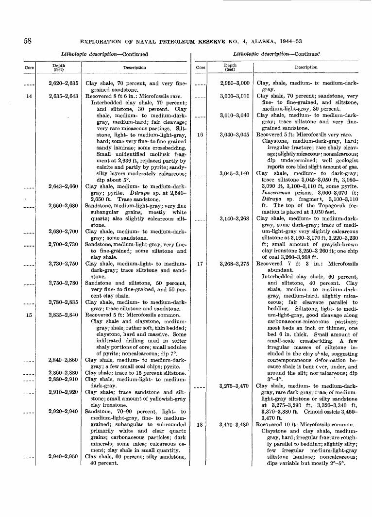
58 EXPLORATION OF NAVAL PETROLEUM RESERVE NO. 4, ALASKA, 1944-53
Litholoffio description Continued
Core
14
____
___.
___ _
____
__--
____
____
15
____
________
____
____
Depth (feet)
2,620-2,635
2,635-2,643
2,643-2,660
2,660-2,680
2,680-2,700
2,700-2,730
2,730-2,750
2,750-2,780
2,780-2,835
2,835-2,840
2,840-2,860
2,860-2,8802,880-2,910
2,910-2,920
2,920-2,940
2,940-2,950
Description
Clay shale, 70 percent, and very finegrained sandstone.
Recovered 8 ft 6 in. : Microf ossils rare.Interbedded clay shale, 70 percent;
and siltstone, 30 percent. Clayshale, medium- to medium-dark-gray, medium-hard; fair cleavage;very rare micaceous partings. Silt-stone, light- to medium-light-gray,hard; some very fine- to fine-grainedsandy laminae; some crossbedding.Small unidentified mollusk fragment at 2,636 ft, replaced partly bycalcite and partly by pyrite; sandy-silty layers moderately calcareous;dip about 5°.
Clay shale, medium- to medium-dark-gray; pyrite. Ditrupa sp. at 2,640-2,650 ft. Trace sandstone.
Sandstone, medium-light-gray; very finesubangular grains, mostly whitequartz; also slightly calcareous silt-stone.
Clay shale, medium- to medium-dark-gray; some sandstone.
Sandstone, medium-light-gray, very fine-to fine-grained; some siltstone andclay shale.
Clay shale, medium-light- to medium-dark-gray; trace siltstone and sandstone.
Sandstone and siltstone, 50 percent,very fine- to fine-grained, and 50 percent clay shale.
Clay shale, medium- to medium-dark-gray; trace siltstone and sandstone.
Recovered 5 ft: Microfossils common.Clay shale and claystone, medium-
gray; shale, rather soft, thin bedded;claystone, hard and massive. Someinfiltrated drilling mud in softershaly portions of core; small nodulesof pyrite; noncalcareous; dip 7°.
Clay shale, medium- to medium-dark-gray; a few small coal chips; pyrite.
Clay shale; trace to 15 percent siltstone.Clay shale, medium-light- to medium-
dark-gray.Clay shale; trace sandstone and silt-
stone; small amount of yellowish-grayclay ironstone.
Sandstone, 70-90 percent, light- tomedium-light-gray, fine- to medium-grained; subangular to subroundedprimarily white and clear quartzgrains; carbonaceous particles; darkminerals; some mica; calcareous cement; clay shale in small quantity.
Clay shale, 60 percent; silty sandstone,40 percent.
Litholoffic description Continued
Core
-_--
____
16
____
__-_
17
____
18
Depth (feet)
2,950-3,000
3,000-3,010
3,010-3,040
3,040-3,045
3,045-3,140
3,140-3,268
3,268-3,275
3,275-3,470
3,470-3,480
Description
Clay, shale, medium- tc medium-dark-gray.
Clay shale, 70 percent; sandstone, veryfine- to fine-grained, and siltstone,medium-light-gray, 30 percent.
Clay shale, medium- to medium-dark-gray; trace siltstone and very finegrained sandstone.
Recovered 5 ft: Microfossils very rare.Claystone, medium-dark-gray, hard;
irregular fracture; rare shaly cleavage; slightly micaceous : noncalcareous;dip undetermined; well geologistreports core bled sligbt amount of gas.
Clay shale, medium- to dark-gray;trace siltstone 3,045-3,050 ft, 3,080-3,090 ft, 3,100-3,110 ft, some pyrite.Inoceramus prisms, 3,060-3,070 ft;Ditrupa sp. fragmert, 3,100-3,110ft. The top of the Topagoruk formation is placed at 3,050 feet.
Clay shale, medium- to medium-dark-gray, some dark-gray; trace of medium-light-gray very slightly calcareoussiltstone at 3,160-3,170 ft, 3,220-3,230ft; small amount of grayish-brownclay ironstone 3,250-3 260 ft; one chipof coal 3,260-3,268 ft.
Recovered 7 ft 3 in.: Microfossilsabundant.
Interbedded clay shale, 60 percent,and siltstone, 40 percent. Clayshale, medium- to medium-dark-gray, medium-hard, slightly micaceous; fair cleavage parallel tobedding. Siltstone, light- to medium-light-gray, good cleavage alongcarbonaceous-micaceous partings;most beds an inch or thinner, onebed 6 in. thick. Small amount ofsmall-scale crossbeiding. A fewirregular masses of siltstone included in the clay s^ale, suggestingcontemporaneous deformation because shale is bent c ver, under, andaround the silt; nor calcareous; dip3°-4°.
Clay shale, medium- to medium-dark-gray, rare dark-gray; t^-ace of medium-light-gray siltstone or silty sandstoneat 3,275-3,290 ft, 3,320-3,340 ft,3,370-3,380 ft. Crinoid ossicle 3,460-3,470 ft.
Recovered 10 ft: Microfossils common.Claystone and clay shale, medium-
gray, hard; irregular fracture roughly parallel to bedding; slightly silty;few irregular meiium-light-graysiltstone laminae; noncalcareous;dips variable but mostly 2°-5°.
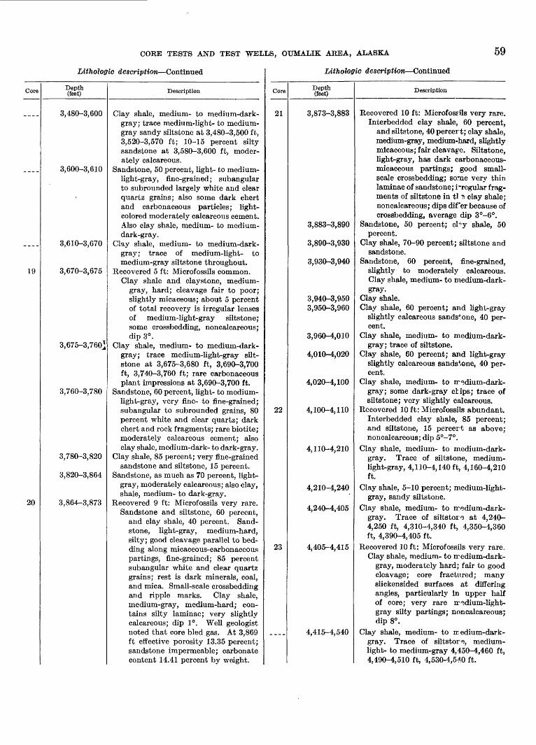
CORE TESTS AND TEST WELLS, OUMALIK AREA, ALASKA 59
Litholoffic description Continued
Core
____
____
19
20
Depth (feet)
3,480-3,600
3,600-3,610
3,610-3,670
3,670-3,675
3,675-3,760]
3,760-3,780
3,780-3,820
3,820-3,864
3,864-3,873
Description
Clay shale, medium- to medium-dark-gray; trace medium-light- to medium-gray sandy siltstone at 3,480-3,500 ft,3,520-3,570 ft; 10-15 percent siltysandstone at 3,580-3,600 ft, moderately calcareous.
Sandstone, 50 percent, light- to medium-light-gray, fine-grained; subangularto subrounded largely white and clearquartz grains; also some dark chertand carbonaceous particles; light-colored moderately calcareous cement.Also clay shale, medium- to medium-dark-gray.
Clay shale, medium- to medium-dark-gray; trace of medium-light- tomedium-gray siltstone throughout.
Recovered 5 ft: Microfossils common.Clay shale and claystone, medium-
gray, hard; cleavage fair to poor;slightly micaceous; about 5 percentof total recovery is irregular lensesof medium-light-gray siltstone;some crossbedding, noncalcareous;dip 3°.
Clay shale, medium- to medium-dark-gray; trace medium-light-gray silt-stone at 3,675-3,680 ft, 3,690-3,700ft, 3,740-3,760 ft; rare carbonaceousplant impressions at 3,690-3,700 ft.
Sandstone, 60 percent, light- to medium-light-gray, very fine- to fine-grained;subangular to subrounded grains, 80percent white and clear quartz; darkchert and rock fragments; rare biotite;moderately calcareous cement; alsoclay shale, medium-dark- to dark-gray.
Clay shale, 85 percent; very fine-grainedsandstone and siltstone, 15 percent.
Sandstone, as much as 70 percent, light-gray, moderately calcareous; also clay, shale, medium- to dark-gray.
Recovered 9 ft: Microfossils very rare. Sandstone and siltstone, 60 percent,
and clay shale, 40 percent. Sand stone, light-gray, medium-hard, silty; good cleavage parallel to bedding along micaceous-carbonaceouspartings, fine-grained; 85 percentsubangular white and clear quartzgrains; rest is dark minerals, coal,and mica. Small-scale crossbeddingand ripple marks. Clay shale,medium-gray, medium-hard; contains silty laminae; very slightlycalcareous; dip 1°. Well geologistnoted that core bled gas. At 3,869ft effective porosity 13.35 percent;sandstone impermeable; carbonatecontent 14.41 percent by weight.
Litholoffic description Continued
Core
21
22
23
Depth (feet)
3,873-3,883
3,883-3,890
3,890-3,930
3,930-3,940
3,940-3,9503,950-3,960
3,960-4,010
4,010-4,020
4,020-4,100
4,100-4,110
4,110-4,210
4,210-4,240
4,240-4,405
4,405-4,415
4,415-4,540
Description
Recovered 10 ft: Microfossils very rare.Interbedded clay shale, 60 percent,
and siltstone, 40 percert; clay shale,medium-gray, medium-hard, slightlymicaceous; fair cleavage. Siltstone,light-gray, has dark carbonaceous-micaceous partings; good small-scale crossbedding; some very thinlaminae of sandstone; irregular fragments of siltstone in tl ? clay shale;noncalcareous; dips direr because ofcrossbedding, average dip 3°-6°.
Sandstone, 50 percent; cl^y shale, 50percent.
Clay shale, 70-90 percent; siltstone andsandstone.
Sandstone, 60 percent, fine-grained,slightly to moderately calcareous.Clay shale, medium- to medium-dark-gray.
Clay shale.Clay shale, 60 percent; and light-gray
slightly calcareous sandstone, 40 percent.
Clay shale, medium- to medium-dark-gray; trace of siltstone.
Clay shale, 60 percent; and light-grayslightly calcareous sandstone, 40 percent.
Clay shale, medium- to rredium-dark-gray; some dark-gray clips; trace ofsiltstone; very slightly calcareous.
Recovered 10ft: Microfossils abundant.Interbedded clay shale, 85 percent;and siltstone, 15 percert as above;noncalcareous; dip 5°-7°.
Clay shale, medium- to medium-dark-gray. Trace of siltstone, medium-light-gray, 4, 110-4, 140 ft, 4,160-4,210ft.
Clay shale, 5-10 percent; medium-light- gray, sandy siltstone.
Clay shale, medium- to iredium-dark- gray. Trace of siltstorg at 4,240- 4,250 ft, 4,310-4,340 ft, 4,350-4,360 ft, 4,390-4,405 ft.
Recovered 10 ft: Microfossils very rare.Clay shale, medium- to iredium-dark-
gray, moderately hard; fair to goodcleavage; core fractured; manyslickensided surfaces at differingangles, particularly in upper halfof core; very rare rr<3dium-light-gray silty partings; noncalcareous;dip 8°.
Clay shale, medium- to re edium-dark-gray. Trace of siltstor*?, medium-light- to medium-gray 4,450-4,460 ft,4,490-4,510 ft, 4,530-4,540 ft.
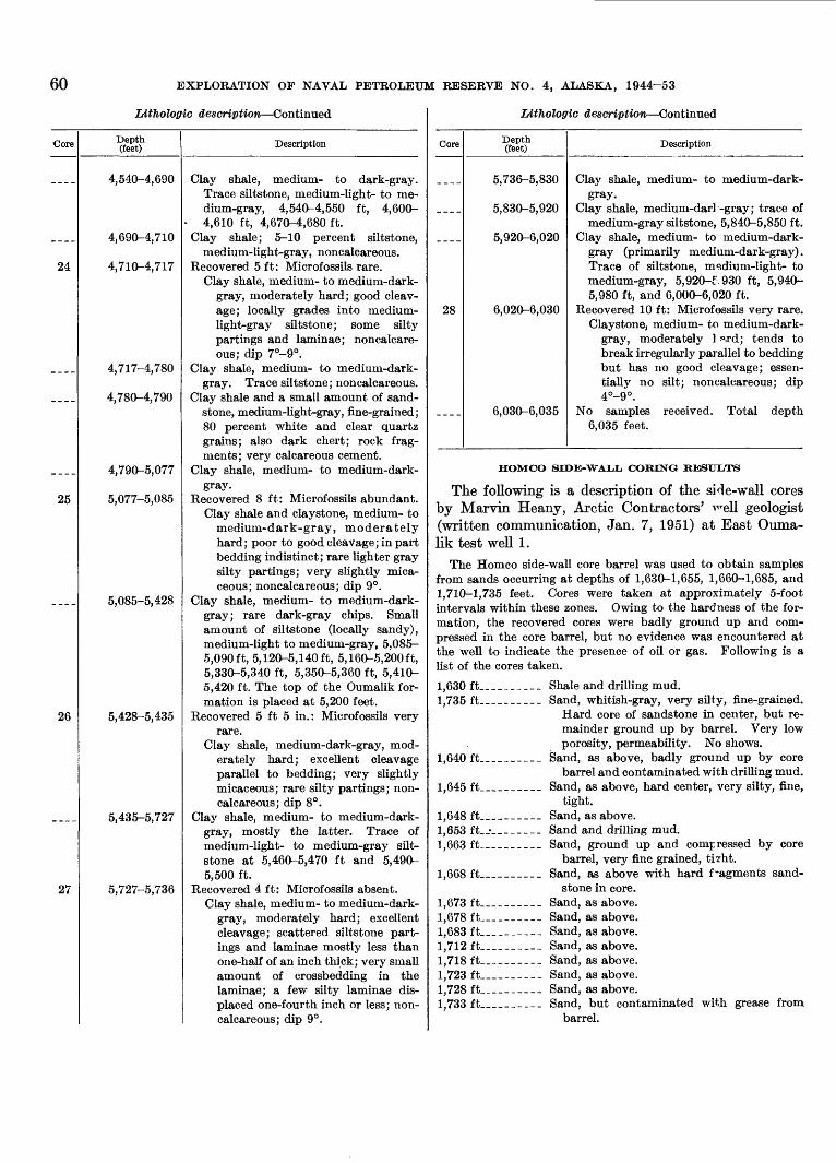
60 EXPLORATION OF NAVAL PETROLEUM RESERVE NO. 4, ALASKA, 1944-53
Litholoffic description Continued
Core Depth (feet)
24
4,540-4,690
4,690-4,710
4,710-4,717
25
4,717-4,780
4,780-4,790
4,790-5,077
5,077-5,085
5,085-5,428
26 5,428-5,435
27
5,435-5,727
5,727-5,736
Description
Clay shale, medium- to dark-gray. Trace siltstone, medium-light- to me dium-gray, 4,540-4,550 ft, 4,600- 4,610 ft, 4,670-4,680 ft.
Clay shale; 5-10 percent siltstone,medium-light-gray, noncalcareous.
Recovered 5 ft: Microfossils rare. Clay shale, medium- to medium-dark-
gray, moderately hard; good cleav age; locally grades into medium- light-gray siltstone; some silty partings and laminae; noncalcare ous; dip 7°-9°.
Clay shale, medium- to medium-dark- gray. Trace siltstone; noncalcareous.
Clay shale and a small amount of sand stone, medium-light-gray, fine-grained; 80 percent white and clear quartz grains; also dark chert; rock frag ments; very calcareous cement.
Clay shale, medium- to medium-dark- gray.
Recovered 8 ft: Microfossils abundant. Clay shale and claystone, medium- to
medium-dark-gray, moderately hard; poor to good cleavage; in part bedding indistinct; rare lighter gray silty partings; very slightly mica ceous; noncalcareous; dip 9°.
Clay shale, medium- to medium-dark- gray; rare dark-gray chips. Small amount of siltstone (locally sandy), medium-light to medium-gray, 5,085- 5,090ft, 5,120-5,140 ft, 5,160-5,200 ft, 5,330-5,340 ft, 5,350-5,360 ft, 5,410- 5,420 ft. The top of the Oumalik for mation is placed at 5,200 feet.
Recovered 5 ft 5 in.: Microfossils veryrare.
Clay shale, medium-dark-gray, mod erately hard; excellent cleavage parallel to bedding; very slightly micaceous; rare silty partings; non- calcareous; dip 8°.
Clay shale, medium- to medium-dark- gray, mostly the latter. Trace of medium-light- to medium-gray silt- stone at 5,460-5,470 ft and 5,490- 5,500 ft.
Recovered 4 ft: Microfossils absent. Clay shale, medium- to medium-dark-
gray, moderately hard; excellent cleavage; scattered siltstone part ings and laminae mostly less than one-half of an inch thick; very small amount of crossbedding in the laminae; a few silty laminae dis placed one-fourth inch or less; non- calcareous; dip 9°.
Litholoffic description Continued
Core
28
Depth (feet)
5,736-5,830
5,830-5,920
5,920-6,020
6,020-6,030
6,030-6,035
Description
Clay shale, medium- to medium-dark- gray.
Clay shale, medium-darl'-gray; trace of medium-gray siltstone, 5,840-5,850 ft.
Clay shale, medium- to medium-dark- gray (primarily medium-dark-gray). Trace of siltstone, medium-light- to medium-gray, 5,920-£.930 ft, 5,940- 5,980 ft, and 6,000-6,020 ft.
Recovered 10 ft: Microfossils very rare. Claystone, medium- to medium-dark-
gray, moderately 1 f»,rd; tends to break irregularly parallel to bedding but has no good cleavage; essen tially no silt; noncalcareous; dip 4°-9°.
No samples received. Total depth 6,035 feet.
HOMCO SIDE-WALL CORING RESULTS
The following is a description of the side-wall cores by Marvin Heany, Arctic Contractors' T^ell geologist (written communication, Jan. 7, 1951) at East Ouma lik test well 1.
The Homco side-wall core barrel was used to obtain samples from sands occurring at depths of 1,630-1,655, 1,660-1,685, and 1,710-1,735 feet. Cores were taken at approximately 5-foot intervals within these zones. Owing to the hardness of the for mation, the recovered cores were badly ground up and com pressed in the core barrel, but no evidence was encountered at the well to indicate the presence of oil or gas. Following is a list of the cores taken.
1,630 ft___ __ _ Shale and drilling mud.1,735ft________ Sand, whitish-gray, very silty, fine-grained.
Hard core of sandstone in center, but re mainder ground up by barrel. Very low porosity, permeability. No shows.
1,640ft________ Sand, as above, badly ground up by corebarrel and contaminated with drilling mud.
1,645 ft________ Sand, as above, hard center, very silty, fine,tight.
1,648 ft________ Sand, as above.1,653 ft_ _ _ _____ Sand and drilling mud.1,663ft________ Sand, ground up and compressed by core
barrel, very fine grained, tizht.1,668ft________ Sand, as above with hard fragments sand
stone in core.1,673 ft____-__ Sand, as above.1,678 ft________ Sand, as above.1,683 ft________ Sand, as above.1,712 ft________ Sand, as above.1,718 ft________ Sand, as above.1,723 ft________ Sand, as above.1,728 ft________ Sand, as above.1,733 ft________ Sand, but contaminated with grease from
barrel.
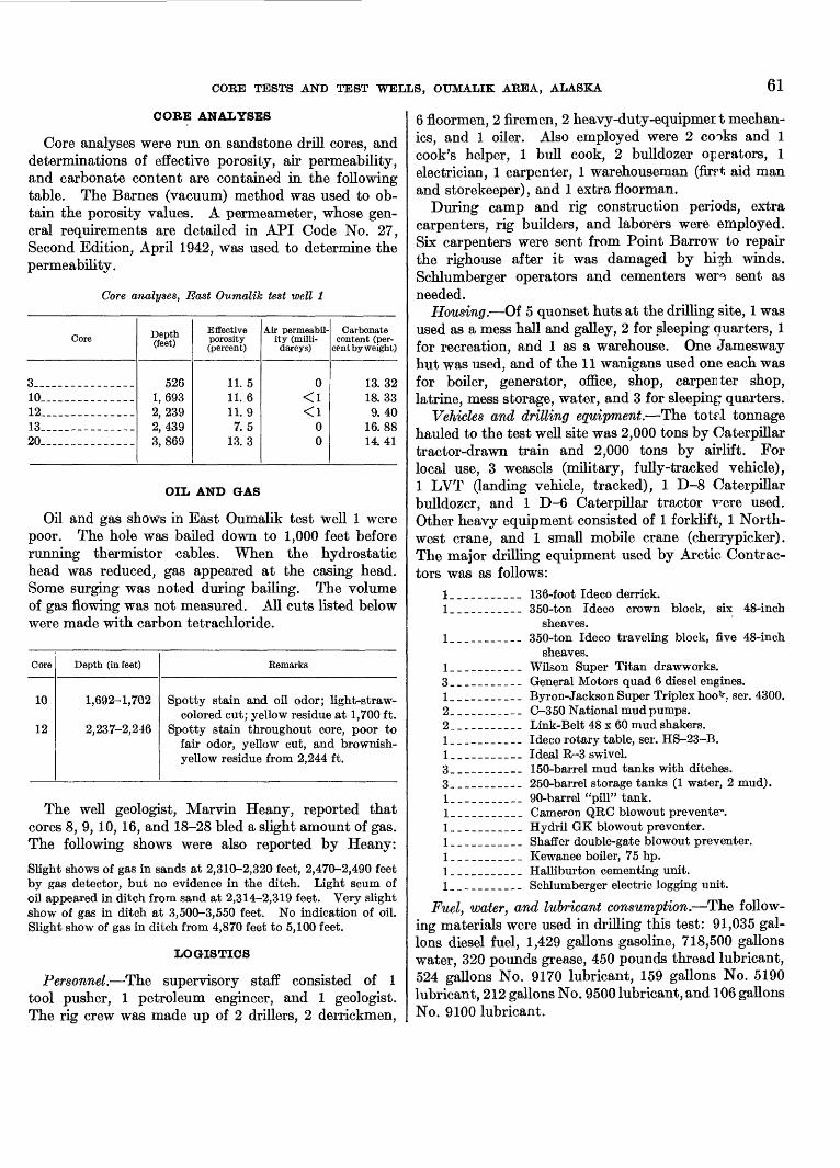
CORE TESTS AND TEST WELLS, OTJMALIK AREA, ALASKA 61
CORE ANALYSES
Core analyses were run on sandstone drill cores, and determinations of effective porosity, air permeability, and carbonate content are contained in the following table. The Barnes (vacuum) method was used to ob tain the porosity values. A permeameter, whose gen eral requirements are detailed in API Code No. 27, Second Edition, April 1942, was used to determine the permeability.
Core analyses, East Oumalik test well 1
Core
3__ -----------10 ____________12 __ _ __.-_--13 -----------20 ------------
Depth (feet)
5261,6932,2392,4393,869
Effective porosity (percent)
11. 511.611 Q7.5
13.3
Air permeabil ity (milli- darcys)
0<1<1
00
Carbonate content (per
cent by weight)
13.3218.33
Q 4ft16.8814.41
OIL AND GAS
Oil and gas shows in East Oumalik test well 1 were poor. The hole was bailed down to 1,000 feet before running thermistor cables. When the hydrostatic head was reduced, gas appeared at the casing head. Some surging was noted during bailing. The volume of gas flowing was not measured. All cuts listed below were made with carbon tetrachloride.
Core
10
12
Depth (infect)
1,692-1,702
2,237-2,246
Eemarks
Spotty stain and oil odor; light-straw- colored cut; yellow residue at 1,700 ft.
Spotty stain throughout core, poor to fair odor, yellow cut, and brownish- yellow residue from 2,244 ft.
The well geologist, Marvin Heany, reported that cores 8, 9, 10, 16, and 18-28 bled a slight amount of gas. The following shows were also reported by Heany:
Slight shows of gas in sands at 2,310-2,320 feet, 2,470-2,490 feet by gas detector, but no evidence in the ditch. Light scum of oil appeared in ditch from sand at 2,314-2,319 feet. Very slight show of gas in ditch at 3,500-3,550 feet. No indication of oil. Slight show of gas in ditch from 4,870 feet to 5,100 feet.
LOGISTICS
Personnel. The supervisory staff consisted of 1 tool pusher, 1 petroleum engineer, and 1 geologist. The rig crew was made up of 2 drillers, 2 derrickmen,
6 floormen, 2 firemen, 2 heavy-duty-equipmer t mechan ics, and 1 oiler. Also employed were 2 cooks and 1 cook's helper, 1 bull cook, 2 bulldozer operators, 1 electrician, 1 carpenter, 1 warehouseman (firrt aid man and storekeeper), and 1 extra floorman.
During camp and rig construction periods, extra carpenters, rig builders, and laborers were employed. Six carpenters were sent from Point Barrow to repair the righouse after it was damaged by hi^h winds. Schlumberger operators and cementers wer^ sent as needed.
Housing. Of 5 quonset huts at the drilling site, 1 was used as a mess hall and galley, 2 for sleeping quarters, 1 for recreation, and 1 as a warehouse. One Jamesway hut was used, and of the 11 wanigans used one each was for boiler, generator, office, shop, carpenter shop, latrine, mess storage, water, and 3 for sleeping quarters.
Vehicles and drilling equipment. The totrl tonnage hauled to the test well site was 2,000 tons by Caterpillar tractor-drawn train and 2,000 tons by airlift. For local use, 3 weasels (military, fully-tracked vehicle), 1 LVT (landing vehicle, tracked), 1 D-8 Caterpillar bulldozer, and 1 D-6 Caterpillar tractor vrere used. Other heavy equipment consisted of 1 forklift, 1 North west crane, and 1 small mobile crane (cherrypicker). The major drilling equipment used by Arctic Contrac tors was as follows:
l_________-_ 136-foot Ideco derrick.1.________-- 350-ton Ideco crown block, six 48-inch
sheaves. l_______-_-- 350-ton Ideco traveling block, five 48-inch
sheaves.l___-_--__-- Wilson Super Titan drawworks.3___-------- General Motors quad 6 diesel engines.l_______-_-- Byron-Jackson Super TriplexhooV, ser. 4300.2___-------- C-350 National mud pumps.2___-_------ Link-Belt 48 x 60 mud shakers.1___-------- Ideco rotary table, ser. HS-23-B.1___________ Ideal R-3 swivel.3___-______- 150-barrel mud tanks with ditches.3________-__ 250-barrel storage tanks (1 water, 2 mud).
90-barrel "pill" tank.Cameron QRC blowout prevente*1.Hydril GK blowout preventer.Shaffer double-gate blowout preventer.Kewanee boiler, 75 hp.Halliburton cementing unit.Schlumberger electric logging unit.
Fuel, water, and lubricant consumption. The follow ing materials were used in drilling this test: 91,035 gal lons diesel fuel, 1,429 gallons gasoline, 718,500 gallons water, 320 pounds grease, 450 pounds thread lubricant, 524 gallons No. 9170 lubricant, 159 gallons No. 5190 lubricant, 212 gallons No. 9500 lubricant, and 106 gallons No. 9100 lubricant.
62 EXPLORATION OP NAVAL PETROLEUM RESERVE NO. 4, ALASKA, 1944-53
DRILLING OPERATIONS
RIG FOUNDATION
The following discussion of the rig foundation was supplied by Arctic Contractors' petroleum engineer (written communication, June 1951).
The Wilson Super Titan rig, equipped with a steel substruc ture, was set on a foundation of 12 by 12 timbers. The refrig eration circulation system consisted of a 1-inch pipe cleated to the under side of each timber. The pipes were hose-connected and manifolded into 9 separate circuits off the main headers. Diesel oil, cooled by three mechanical refrigeration units, each of 0.42-ton capacity, was circulated through the refrigeration sys tem. Oil and ground temperatures were obtained from ther mometers and thermocouples.
Construction of the foundation was not completed until late spring. The ambient air temperature at that time was well above freezing, requiring that the muck be frozen back by the refrigeration system. This proved to be a slow process since the plant was of insufficient capacity to rapidly extract large quanti ties of heat from the ground.
During the drilling operation, the ground under the mud pits thawed below the timber sills, requiring shimming under these sections. Part of the excessive thawing was due to drainage of waste water from the derrick through these areas.
[DRILLING NOTES
The following table is composed of selected notes from the drilling records of the Arctic Contractors' petroleum engineer.
Notes from drill records Depth (feet)
0-______________ Well spudded in at 2 p. m., Oct. 23, 1950,with 15-in. bit.
106_____________ Casing set. 16%-in. outer diameter, 42 Ib,welded slip joint, Western Pipe and Steel, welded plate casing with Baker casing shoe. Cemented with 65 sacks of Cal- Seal. Cemented around top through 1-in. pipe to 40 ft with 59 sacks of Cal-Seal. Top 55 ft were jacketed with 22-in. welded slip joint casing.
1,100__________ Casing set. 11 %-in. outer diameter seamless47 Ib (thread and coupling) grade J-55, 8 round thread, API casing with Baker Tubing Float Collar. Cemented with 550 sacks of cement. First and last 100 sacks were treated with calcium chloride.
Both casing cement operations were con ducted without incident. Though the 16-inch casing cement job was apparently satisfactory at the completion of the job, subsequent circulation of warm fluid caused the circulation to channel by and returns appeared in the cellar. Efforts to overcome the condition were not entirely satisfactory and hole was made to 1,103 feet and reamed to 15J>£ inches with partial or complete returns appearing in the cellar. Mud was circulated from the cellar and drilling continued.
1,702___ _________ Winds of gale force demolished rig house.Shut down 12 hours (Nov. 10, 1950).
3,298 _________ Shut down 17j4 hours owing to high winds(Nov. 27, 1950).
Notes from drill records Continued Depth (feet)
6,030__________ Ran Homco side-wall core barrel; obtainedcores at 5-ft intervals from sands at 1,630-1,655, 1,660-1,685, and 1,710-1,735 ft.
6,035.___________ Mud bailed down to a level of approximately1,000 ft. Five thermistor cables and the following equipment were installed: Land ing base (11% x 12 in., series 900) top 19 in. above cellar floor with plate welded on top and 10% x 5 in. nipple welded on plate.
No drill stem or other tests o* fluid produc tivity were made. This well was drilled without mechanical failure in machinery. Failures in drill pipe were numerous, but all were detected by decreased pump pres sure, indicative of a washout. Fifteen such washouts were detected, but pipe was pulled and singles exchanged without necessitating fishing. The failures were similar and occurred at similar places in the joints: cracks developed about 3 in. from the end of the upset where boxes are screwed on. The fluid passed through the break, down the threaded section of the drill pipe and tool joint box, then left the drill stem at the bottom of the box.
DRILL AND CORE BITS
Three 15-inch and forty 10%-inch bits were used to drill East Oumalik test well 1. Bearing wear rather than dulled teeth necessitated retiring moet of the bits. The surface hole was drilled to 106 feet, using a 15-inch bit, and was opened to 26 inches with a Reed hole opener. Below 106 feet a 10%-ineh hole v^as drilled to 1,103 feet and opened to 15 inches using 15-inch bits and a reamer. Below 1,103 feet the hole was drilled to 6,035 feet (total depth) using 10%-inch bits to drill and to ream the 8%-inch cored intervals.
A Reed wire-line core barrel and five 8%-inch rock bits were used to core a total of 230-feet.
DRILLING MUD
Mud control presented only minor problems. Most of the rocks penetrated produced heavy mud (90 Ib per cu ft) of very low viscosity. Practically no treat ing material or agents were used. A rather large amount of natural mud was eliminated from time to time. As gel strength was very low, 9 sachs of Aquagel were added to the system after drilling to 5,300 feet. Hole condition was excellent at all times.
About the following amounts of mud materials were used hi drilling this well:
Aquagel-____________________ 33 sacksPyrophosphates______________ 1). sacksQuebracho___________________ 6j4 sacksDriscose_____________________ 3 sacks (150 pounds)Gel flake___________________ 6 sacks
Data on drilling mud and additives are contained in the following table.
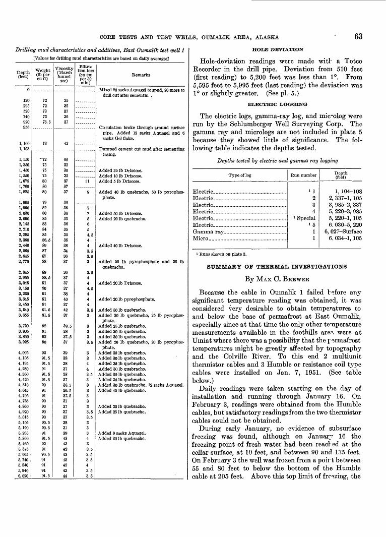
CORE TESTS AND TEST WELLS, OUMALIK AREA, ALASKA 63
Drilling mud characteristics and additives, East Oumalik test well 1
[Values for drilling mud characteristics are based on dally averages]
Depth (feet)
0
120295520740920956
1,1001,103
1,1501,3501,4501,5501,6751,7601,825
1,9051,9602,0302,0902,1452,2102,2852,3502,4402,5602,6452,770
2,8452,9553,0453,1503,2603,3453,4503,5403,655
3,7203,8053,8603,925
4,0054,1054,1954,2804,3604,4204,5104,6454,7054,7854,8604,9205,0155,1055,1905,2555,3605,4605,5755,6655,7405,8405,9406,020
Weight (Ib per cuft)
7272737373.5
73
-72
757575808080
7982808583848586.589878788
8988.5919091919191.591.5
92919290
9291.591.59191.591.59091919090909090.590.59191.5929190.591919191.5
Viscosity (Marsh funnel
sec)
3535373637
42
60323035373737
363636353635353538343637
363737373840374237
39.53837. ,537
39383837383736.536.537.5373737373837394343424343454344
Filtra tion loss (cu cm per 30 min)
11
9
775654.5443.53.53
3.5444.54443.53
3333.5
33443.53333333.53.5333433.53.53.543.53.5
Remarks
Mixed 20 sacks Aquagel to spud, 20 more todrill out after cementln .
Circulation broke through around surfacepipe. Added 12 sacks Aquagel and 6sacks Gel Sake.
Dumped cement cut mud after cementingcasing.
Added 35 Ib Drlscose.Added 10 Ib Drlscose.Added 5 Ib Drlscose.
Added 40 Ib quebracho, 50 Ib pyrophos-phate.
Added 50 Ib Driscose.Added 20 Ib quebracho.
Added 40 Ib Drlscose.
Added 25 Ib pyrophosphate and 25 Ibquebracho.
Added 20 Ib Drlscose.
Added 20 Ib pyrophosphate.
Added 50 Ib quebracho.Added 30 Ib quebracho, 25 Ib pyrophos
phate.Added 25 Ib quebracho.Added 30 Ib quebracho.Added 30 Ib quebracho.Added 20 Ib quebracho, 20 Ib pyrophos
phate.Added 30 Ib quebracho.Added 30 Ib quebracho.Added 35 Ib quebracho.Added 30 Ib quebracho.Added 30 Ib quebracho.Added 30 Ib quebracho.Added 30 Ib quebracho, 12 sacks Aquagel.Added 45 Ib quebracho.
Added 30 Ib quebracho.Added 25 Ib quebracho.
Added 9 sacks Aquagel.Added 30 Ib quebracho.
HOLE DEVIATION
Hole-deviation readings were made with a Totco Recorder in the drill pipe. Deviation from 510 feet (first reading) to 5,200 feet was less than 1°. From 5,595 feet to 5,995 feet (last reading) the deviation was 1° or slightly greater. (See pi. 5.)
ELECTRIC LOGGING
The electric logs, gamma-ray log, and mic~olog were run by the Schlumberger Well Surveying Corp. The gamma ray and micrologs are not included in plate 5 because they showed little of significance. The fol lowing table indicates the depths tested.
Depths tested by electric and gamma ray logging
Type of log
Electric __ ____ _ _ ____ _ _
Micro____ _____ _ ____ _ _ __
Run number
i 1
234
1 Speciali 5
11
Depth (feet)
1, 104-1082, 337-1, 1053, 985-2, 3375, 220-3, 9855, 220-1, 1056. 030-5, 220
6, 027-Surface6, 034-1, 105
1 Runs shown on plate 3.
SUMMARY OP THERMAL INVESTIGATIONS
By MAX C. BEEWEK
Because the cable in Oumalik 1 failed before any significant temperature reading was obtained, it was considered very desirable to obtain temperatures to and below the base of permafrost at East Oumalik, especially since at that time the only other temperature measurements available in the foothills are.'1, were at Umiat where there was a possibility tha,t the permafrost temperatures might be greatly affected by topography and the Colville River. To this end 2 multiunit thermistor cables and 3 Humble or resistance coil type cables were installed on Jan. 7, 1951. (See table below.)
Daily readings were taken starting on the day of installation and running through January 16. On February 3, readings were obtained from the Humble cables, but satisfactory readings from the two thermistor cables could not be obtained.
During early January, no evidence of subsurface freezing was found, although on Januar7 16 the freezing point of fresh water had been read: ed at the cellar surface, at 10 feet, and between 90 and 135 feet. On February 3 the well was frozen from a poirt between 55 and 80 feet to below the bottom of the Humble cable at 205 feet. Above this top limit of freezing, the
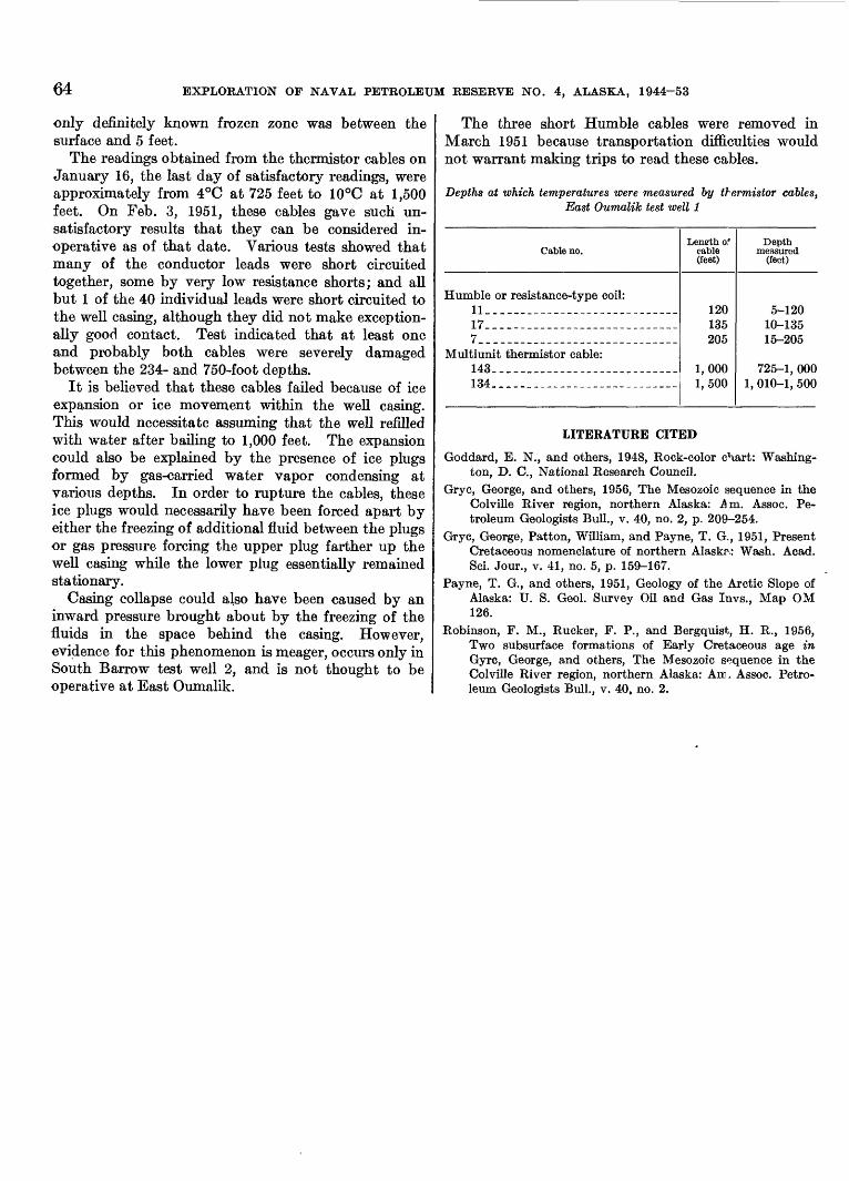
64 EXPLORATION OF NAVAL PETROLEUM RESERVE NO. 4, ALASKA, 1944-53
only definitely known frozen zone was between the surface and 5 feet.
The readings obtained from the thermistor cables on January 16, the last day of satisfactory readings, were approximately from 4°C at 725 feet to 10°C at 1,500 feet. On Feb. 3, 1951, these cables gave such un satisfactory results that they can be considered in operative as of that date. Various tests showed that many of the conductor leads were short circuited together, some by very low resistance shorts; and all but 1 of the 40 individual leads were short circuited to the well casing, although they did not make exception ally good contact. Test indicated that at least one and probably both cables were severely damaged between the 234- and 750-foot depths.
It is believed that these cables failed because of ice expansion or ice movement within the well casing. This would necessitate assuming that the well refilled with water after bailing to 1,000 feet. The expansion could also be explained by the presence of ice plugs formed by gas-carried water vapor condensing at various depths. In order to rupture the cables, these ice plugs would necessarily have been forced apart by either the freezing of additional fluid between the plugs or gas pressure forcing the upper plug farther up the well casing while the lower plug essentially remained stationary.
Casing collapse could also have been caused by an inward pressure brought about by the freezing of the fluids in the space behind the casing. However, evidence for this phenomenon is meager, occurs only in South Barrow test well 2, and is not thought to be operative at East Oumalik.
The three short Humble cables were removed in March 1951 because transportation difficulties would not warrant making trips to read these cables.
Depths at which temperatures were measured by thermistor cables, East Oumalik test well 1
Cable no.
Humble or resistance-type coil: 11__ ______ _ ______________ __17. ____________________________7_._ ______ ___ __ ___________
Multiunit thermistor cable: 143_ ___________ ________________134__ __________________________
Length of cable (feet)
120135205
1,0001,500
Depth measured
(feet)
5-12010-13515-205
725-1, 0001, 010-1, 500
LITERATURE CITED
Goddard, E. N., and others, 1948, Rock-color chart: Washing ton, D. C., National Research Council.
Gryc, George, and others, 1956, The Mesozoic sequence in the Colville River region, northern Alaska: .Am. Assoc. Pe troleum Geologists Bull., v. 40, no. 2, p. 209-254.
Gryc, George, Patton, William, and Payne, T. G,, 1951, Present Cretaceous nomenclature of northern Alaska: Wash. Acad. Sci. Jour., v. 41, no. 5, p. 159-167.
Payne, T. G., and others, 1951, Geology of the Arctic Slope of Alaska: U. S. Geol. Survey Oil and Gas Invs., Map OM 126.
Robinson, F. M., Rucker, F. P., and Bergquist, H. R., 1956, Two subsurface formations of Early Cretaceous age in Gyre, George, and others, The Mesozoic sequence in the Colville River region, northern Alaska: Am. Assoc. Petro leum Geologists Bull., v. 40, no. 2.
PALEONTOLOGY OF TEST WELLS AND CORE TESTS IN THE OUMALIK AREA, ALASKA.
By HAELAN K. BEEGQUIST
SOURCE OF SAMPLES
During the drilling of wells on the Oumalik anticline in connection with the exploration of Naval Petroleum Reserve No. 4, northern Alaska, samples from cores and cuttings from 2 deep test wells and 3 core tests were prepared for paleontologic study in the U. S. Geological Survey laboratory at Fairbanks, Alaska. The samples were washed and picked under the author's super vision ; a total of 947 samples were examined for micro- fossils, of which 624 samples were from Oumalik test well 1; 190 were from East Oumalik test well 1; and 133 were from Oumalik core tests 1, 2, 11, and 12 and Ikpikpuk core test 1. No samples were available from the other core tests.
A number of the species in these wells are new and have been described by Mrs. Helen Tappan Loeblich (Tappan, 1951, 1956).
OUMALIK TEST WELL 1
All core samples and ditch samples from every 10- or 20-foot interval in Oumalik test well 1 were examined for microfossils. Approximately 920 feet of cores were taken, but microfossils were recovered from only 29 of the 90 cores. Most of the cores below the one at 4,420- 4,440 feet were barren. Some of the cores contained 1 or 2 specimens, but a few cores had common to abun dant specimens of certain species.
Only a few more than 1,000 specimens of Foraminif- era, representing 18 arenaceous species and 4 cal careous species, were found in ditch and core samples from the 2,800 feet of the Grandstand formation penetrated in drilling this test hole. These species are typically associated with Verneuilinoides borealis Tap- pan, an arenaceous foraminifer which is the dominant species in the shallow-water marine fauna of the Grandstand-Topagoruk formations, and whose name is therefore used to designate the faunal zone. In the Grandstand formation in this test hole, V. borealis occurs in most of the ditch samples and in some of the cores, and constitutes 60 percent of the fauna. It is most numerous in ditch samples, but its abundance is confined to intervals above the 1,150-foot depth. The next most abundant (7 percent) species is Haplophrag- moides topagorukensis Tappan. A few other species make up 5 or 6 percent each, but most species found in the Grandstand formation in this test well constitute
only 1 or 2 percent of the total specimens collected from the formation.
GRANDSTAND FORMATION (3O-2,825
Only a few Foraminifera occurred in samples in the upper few hundred feet of beds of the Grandstand for mation penetrated in drilling this test well. Of the few found, Verneuilinoides borealis was common to abun dant at 130 feet and at 160 feet. A core from 517-528 feet was barren of microfossils, but carborized plant remains of Cretaceous age were in it. A few charophyte oogonia were in ditch samples below this <xr*e. About 60 percent of the cores from the Grandstand formation were barren, but a core from 723-733 feet carried 35 percent of all specimens recovered from cores. In this core V. borealis and Gaudryinella irregularis Tappan were common, and there were a few specimens each of Ammobaculites tyrrelli Nauss, Miliammina manitobensis Wickenden, and Inoceramus prisms.
Inoceramus prisms occurred in cores at 1,410-1,422 and 1,626-1,637 feet, and intermittently in ditch sam ples through 2,590 feet. A shell fragment of Ditrupa sp.3 was found at 1,470-1,480 feet. IE the test holes drilled in the Umiat field, the Grandstand anti cline, and the Topagoruk Kiver and Simpson peninsula areas, the fragmentary shells of Inoceramus and Ditrupa constitute a subzone of the Verneuilinoides borealis faunal zone and range through most of the Grandstand formation and a part of the underlying Topagoruk formation.k
In a core at 2,351-2,361 feet in the lower part of the Grandstand formation, only fragments of Btthysiphon vitta Nauss were common and mark the first occurrence of this species in any abundance in this test hole. Other species were rare, but among them were two small specimens of Qaudryina nanushukensis Tappan.
TOPAGORUK FORMATION (2,825-4,860 FEET)
A greater number of species and specimens of Fora minifera of the Verneuilinoides borealis faunal zone were recovered from the Topagoruk formation than from the Grandstand formation, and these came from 11 of the 19 recovered cores.
8 Curved tubular shells from the Cretaceous beds of northern Alaska were for merly referred to Laevidentalium sp. or Dentalium sp. Determinations by Ralph W. Imlay show that these shells are not scaphopods but are worm tubes of the genus Ditrupa.
65
66 EXPLORATION OP NAVAL PETROLEUM RESERVE NO. 4, ALASKA, 1944-53
Twenty-four arenaceous species and six calcareous species were identified in 515 specimens picked from core samples, and 706 specimens were identified from ditch samples. In the core samples Haplophragmoides topagorukensis numerically leads all species with 47 percent of the total number of specimens; Textularia topagorukensis Tappan comprises 13 percent of the total, and Bathysiphon vitta, 11 percent. The remaining species range downward from 5 specimens for Verneui- linoides borealis to 1 specimen for Gaudryinetta irregu- laris.
A fauna of 10 species was picked from a core sample near the top of the formation (2,841-2,851 feet) where Haplophragmoides topagorukensis and Tritaxia mani- tobensis Wickenden were common and Textularia topa gorukensis was abundant.
OUMALEK FORMATION (4,860-10,880 FEET)
Of the 23 cores taken in this formation 18 were barren, whereas the ditch samples, though fossiliferous, are contaminated by the V. borealis fauna from the over lying beds.
About 20 specimens of 6 long-ranging species (com mon to the Nanushuk group) occurred in the 4 or 5 fossiliferous cores in the Oumalik formation. Dorothia chandlerensis Tappan, a species found in the lower part of the Torok formation, was found in the Oumalik formation in this test hole and was used to mark the top of the formation. Three other specimens of D. chandlerensis were found in three ditch samples (8,130 feet, 8,310 feet, and 9,310 feet). Eight pyritic casts of a radiolarian, Dictyomitrat sp. came from a core sample from 10,233-10,240 feet. Pyritic casts of another radiolarian, Lithocampef sp., were found in ditch samples (8,050-8,060 feet and 10,210-10,220 feet) and in cores from 10,233-10,240 feet and from 10,669- 10,682 feet. Pyritic casts of the latter radiolarian are also characteristic of the lower part of the Torok formation.UPPER JURASSIC (?) AND LOWER CRETACEOUS (?) ROCKS UNDIFFERENTIATED (10,880-11,872 FEET, TOTAL DEPTH)
The only Foraminifera found in cores from the beds below the Oumalik formation in this test hole came from a sample at 10,992-11,007 feet in which were also molluscan casts which K. W. Imlay has identified as Aucella sublaevis Keyserling, of Early Cretaceous (mid dle Valanginian) age; this species is limited to the lower 200 feet of the Okpikruak formation in northern Alaska. The associated Foraminifera are specimens of Haplophragmoides which are more like H. canui Tap- pan of Late Jurassic age (Oxfordian) than any other species. Other specimens of H. cf. H. canui were scattered through many of the ditch samples but were most numerous in the upper 150 feet of the unit.
In some of the ditch samples there are Foraminifera that are contamination from higher bed* and a few that are suggestive of Late Jurassic (Oxfordian or lower Kimmeridgian) species that have b^.en found in Topagoruk test well 1 and in some outcrop samples. Fossils from these rocks have been described by Mrs. Helen Tappan Loeblich (Tappan, 1955). Two speci mens of questionable Gaudryina topagorukensis Tap- pan, a small species whose chambers have greater width than height, were found in samples from 10,920- 10,930 feet and 11,360-11,370 feet and compare quite favorably to specimens of G. topagorukensis from Topagoruk test well 1. A few coarse-grained arena ceous planispiral specimens (11,140-11,150 feet, 11,ISO- 11,190 feet, and 11,690-11,700 feet) resemble an unnamed species of Haplophragmoides found in samples from the lower part of the Tiglukpuk fornation on the East Fork of the Nanushuk River and along Welcome Creek (tributary to Kanayut Creek) in tH Siksikpuk- Nanushuk Rivers area, Alaska. Within the interval from 11,400 to 11,550 feet five calcite-filled specimens of a small Globulina (G. topagorukensis? Tappan) were found. The similarity of these Foraminifera to species of Jurassic age presents the possibilit7 of a Late Jurassic age for most of the beds below the Oumalik formation in this test hole.
EAST OUMALIK TEST WELL 1
PLEESTOCENE-RECENT(?) DEPOSITS
A few broken smooth-valved ostracod°,s in a ditch sample at 30-40 feet resemble the valves of a present- day species found along the Arctic coast. No species characteristic of the Gubik formation wer^ noted.
KTT/r.nr TONGUE OF THE CHANDLER FORMATION (SO-730FEET)
Except for scattered occurrences of Verneuilinoides borealis Tappan and a few specimens of MUiammina awunensis Tappan in this well, the Killik tongue of the Chandler formation is essentially barren.
GRANDSTAND FORMATION (730-3,050 FEET)
The top of the Grandstand formation was placed at the top (730 feet) of the Verneuilinoides lorealis faunal zone, where very abundant specimens of Verneuili noides borealis and Trochammina rutherfordi Stelck and Wall appear in association with common specimens of MUiammina awunensis and a few specimens of Gaud- ryinella irregularis Tappan, Textularia tcpagorukensisf Tappan, and Siphotextulariaf rayi Tappan. Through the succeeding 350 feet of section Verneuilinoides borealis is common to abundant in ditch samples, whereas other species are only sparingly present. Cores from 950-956 feet and from 1,150-1,156 feet
CORE TESTS AND TEST WELLS, OUMALIK AREA, ALASKA 67
were barren. In core 8 from 1,350-1,360 feet Ver- neuilinoides borealis was very abundant, and fragments of Ammobaculites humeif Nauss were found in the same sample along with specimens of ostracodes and charo- phyte oogonia. Specimens of Verneuilinoides borealis, Haplophragmoides topagorukensis Tappan, and Psam- minopelta bowsheri Tappan were abundant in core 9 from 1,550-1,560 feet. Most of the succeeding cores through 2,446 feet were barren, but Verneuilinoides borealis was fairly persistent in the ditch samples through that part of the section.
Along with Foraminifera, fragments of the worm tube Ditrupa sp. were found in a ditch sample at 1,850 feet and in core 14 from 2,635-2,645 feet. Ino- ceramus prisms appeared first in core 10 from 1,692- 1,702 feet and also occurred in core 14.
The Verneuilinoides borealis fauna persists in ditch samples through the lower part (about 2,446-3,250 feet) of the Grandstand formation, but relatively few species and specimens were found in the cores. Only Haglophragmoides topagorukensis was common in one core (2,835-2,840 feet), where the highest fragments of Bathysiphon vitta Nauss also occurred.
Calcareous Foraminifera were very scarce in the Grandstand formation; the first one, Pallaimorphina ruckerae Tappan, appeared low in the section in a ditch sample from 2,080-2,090 feet. Three specimens of Eponides morani Tappan were found in the core from 2,635-2,640 feet: a specimen of Gavelinella stictata (Tappan) and one of Pallaimorphina ruckerae were found in the core from 2,835-2,840 feet.
A specimen of Gaudryina nanushukensis Tappan was found in a ditch sample from 2,950-2,960 feet; scattered specimens occurred in ditch samples from 3,150 feet through 5,710 feet.
TOPAGORT7K FORMATION (3,050-5,200 FEET)
The best development of the Verneuilinoides borealis faunal zone in this well is in the upper 500 to 600 feet of the Topagoruk formation. Core 17 from 3,268- 3,275 feet furnished the largest fauna of the well, having 13 species, with Haplophragmoides topagorukensis, Verneuilinoides borealis, and Eurycheilostoma robinsonae Tappan of common occurrence, and a few specimens of Bathysiphon brosgei Tappan, Pelosina complanata Franke, Psamminopelta bowsheri, MUiammina awunen- sis, Gaudryina hectori Nauss, Tritaxia manitobensis Wickenden, Lenticulina macrodisca (Reuss), Valvuli- neria loetterlei (Tappan), Pallaimorphina ruckerae, and Gavelinella stictata. In a core from 3,670-3,675 feet nine species occurred, but only Haplophragmoides topagorukensis and Verneuilinoides borealis were common.
Although never common, Ammobaculites humei Nauss occurred low in the Grandstand formation, and in the upper part of the Topagoruk formation in ditch samples and in the cores from 3,470-3,480 feet and 3,670-3,675 feet. It is probably not found in the lower part of the Topagoruk formation of this test, though a few specimens occurred in ditch samples. P^ecimens of Ammobaculites tyrrelli Nauss were rare and were identified in only a few samples.
Gaudryina nanushukensis was found sparingly from 3,150 feet to 5,710 feet, but its rare occurences were hi the upper part of the Topagoruk formation. It was not found in the Grandstand formation of this test, although it does occur in that formation in Oumalik test well 1.
The fauna apparently fades gradually with depth, as in core 22 (from 4,100-4,110 feet) the only species is Haplophragmoides topagorukensis, but it occurs in abundance. In the lower beds of the Topagoruk formation, the ditch samples contain a fairly constant fauna, which may be contamination, because in the cores below 4,400 feet the species typical of the Ver neuilinoides borealis faunal zone were almost completely absent. In a core from 5,077-5,085 feet Textularia topagorukensis? was abundant. This species was sparingly present throughout the Verneuilincides bore alis faunal zone in this well, but in Oumalik test well 1 it was common in some cores in the upper p<vrt of the Topagoruk formation.
OUMALJK FORMATION (5,200-6,035 FEET)
All except the last core taken from the Oumalik formation in this well were barren. The exception, the bottom-hole core, contained a few specimens, but these were so poorly preserved that positive identifica tions could not be made. Pyritic specimens of the
ia, Lithocampe? sp., and Dictyomitra? sp. ap- ditch samples from 5,710-5,720, 5,810-5,820,
and 5,890-5,900 feet. The pyritic Lithocampa,f marks the Oumalik formation in its type section, Ournalik test weU 1.
IKPIKPUK AND OUMALIK CORE TES^S
Samples from Ikpikpuk core test 1 and Oumalik core tests 1, 2, 11, and 12 were studied in the laboratory at Fairbanks. Samples from Oumalik core (foundation) tests 1-10 were never received at the laboratory.
Ikpikpuk core test 1 and Oumalik core test 1. Very little paleontologic information came from these two core tests because of the shallow depth of the holes and the poor quality of the samples. Two cores were taken in the Ikpikpuk core test, but these and all ditch samples were badly contaminated with surficial material, mak ing them valueless for age determinations. Common
68 EXPLORATION OF NAVAL PETROLEUM RESERVE NO. 4, ALASKA, 1944-53
to all the samples were specimens of a smooth-walled species of nonmarine ostracode Candona cf. C. Candida (Muller), which is apparently indigenous to beds of Pleistocene and Recent age in the uppermost part of the hole. In Oumalik core test 1 all the ditch samples and three of the cores (down to 209 feet) are contam inated with the same species of Pleistocene and Recent ostracode. A solitary specimen of Pelosina complanata Franke in a sample from 210-220 feet and Inoceramus prisms in a ditch sample from 330-340 feet provide meager evidence of marine beds of Cretaceous age in Oumalik core test 1, but these fossils offer no clue as to which formations were penetrated.
Oumalik core test 2. About 40 feet of possible Gubik formation covered the Cretaceous rocks in this core test. In the upper 10 feet were ostracode valves that F. M. Swain has identified as Ilyocypris cf. /. bradyi Sars, a lacustrine species.
The fossiliferous Grandstand formation (Lower and Upper Cretaceous) occurs from 70 feet to the total depth, below beds defined as the Chandler formation by Miss Robinson. Only a charophyte oogonium was found in samples from the Chandler, but there were light-brown, somewhat compressed tests of Verneuili- noides borealis Tappan in most of the samples from the Grandstand formation. This species was very abun dant in the lowest 40 feet of samples. In a few of the samples, particularly from the lowest 30 feet, were a few specimens of Miliammina awunensis Tappan, Qaudryina hectori Nauss, and Trochammina rutherfordi S.telck and Wall. Two specimens of charophyte oogonia, which are the same as the specimen found in the Chandler and suggest some contamination during drilling, were in two samples.
Oumalik core test 11. The Grandstand formation was penetrated at 14 feet in this core test beneath a thin mantle of Pleistocene strata. In the first sample £14-24 feet) were common numbers of compressed tests of
Miliammina awunensis and Trochammina rutherfordir and a great abundance of Verneuilinoides borealis. These fossils, with the addition of a few others, continue- through 137 feet of the core test but ar^ relatively in conspicuous in the remainder of the samp^s. The most fossiliferous core was from 127-137 feet, where V. bore alis was very abundant, Psamminopelta subcircularis Tappan and Trochammina rutherfordi were abundant, and there were a few specimens of each of three other species.
Oumalik core test 12. Foraminifera of the Verneu ilinoides borealis faunal zone appeared abruptly in the core at 17 to 27 feet and were irregularly distributed throughout the lower samples from the hole. The most numerous were Verneuilinoides borealis and Trocham mina rutherfordi, each being common to abundant in 6> samples. Gaudryinella irregularis Tappan was abund ant in 3 samples; Psamminopelta subcircularis was abundant to common in 4 samples; and Pelosina com planata, Psamminopelta bowsheri, and Qaudryina hectori each had one common to abundant occurrence. A few specimens of Miliammina awunensis occurred in 5 samples.
SELECTED BIBLIOGRAPHY
Nauss, A. W., 1947, Cretaceous microfossils of Alberta: Jour, Paleontology, v. 21, no. 4, p. 329-434.
Stelck, C. R., and Wall, J. H., 1955, Foraminifera of the Ceno- manian Dunveganoceras zone from Peace River area of west ern Canada: Alberta Res. Council Rept. 70.
Tappan, Helen, 1951, Northern Alaska indox Foraminifera:. Cushman Foundation Foram. Research, v. 2, pt. 1.
1955, Foraminifera from the Arctic Slope of Alaska,, part 2, Jurassic Foraminifera: U. S. Geol. Survey Prof. Paper 236-B.
1956, New Cretaceous Foraminifera from northernAlaska: U. S, Natl. Mus. Bull. 215 (in pr^ss).
Wickenden, R. T. D., 1932, New species of Foraminifera from the Upper Cretaceous of the prairie provinces: Royal Soc. Canada Proc. and Trans., 3d ser., v. 26, sec. 4.
INDEX
Abstract_-------__ .--__. . .__ 5Acknowledgments__ -----.----____-- 5Ammobaeuliteshumei.......... ___.--._---. 66,67
tyrretti..- ............................... 65,67Area of Reserve No. 4..-. __.-____..._ 1 Arctic Contractors, quoted... ____ 46,48,50,62 Aucetta sublaevis....................... .... 10,66Augite zone, Oumalik test well I---.-..----- 26 awunensis, Miliammina........... ...___. 66,67,68
B
Barrow test wells, location..___..-___ ..- 2 Basement rocks, depth to..___---.___--. 10 Bathysiphon brosgei.... . 67
vitta..................................... 65,66,67Bibliographies____._____________'64,68 borealis, Verneulinoides................... 65,66,67,68.bowsheri, Psamminopetta.................. .... 67bradyi, Ulyocypris................ . 68Brooks Range.__._. _ . . 2 brosgei, Bathysiphon- -......_ . 67
Candida, Condone...... __________ 67Candona Candida................................ 67wnui, Haplophragmoides.-...................... 66Chandler formation_______.._.__ 25,51,68
East Oumalik test well 1, paleontology. __ 66 Killik tongue 8
jhandlerensis, Dorothia...... -_-__-------_ 10,66Charophytes.----__ - 8Coal. 8,9,16,25wmplanata, Pelosina......... .. 67,68Cores and cuttings, description, East Oumalik
test well I--- . . 52-60Oumalik test well 1 __ ... 26-42
Core analyses- .._- _ ... 25-24East Oumalik test well 1....... ........ 61Oumalik test well 1 . __ ___ 42-43
Core and drill bits, East Oumalik test well 1 62 Cretaceous rocks...__.____ ___ 3,8-10
Lower.-----..__ 10Oumalik test well 1, paleontology_ 66
Crinoids_ -__ 9
D
Daylight, extent of._____... ------- 1Dictyomitra sp.....__-_------ .-_. 66Ditrupa sp ... . 65, 67 JOorothia chandlerensis ......................... 10,66Drill and core bits, East Oumalik test well 1_. 62
Oumalik test well 1... _..... __ 48 Drilling equipment, East Oumalik test well 1. 61
Oumalik test well 1 _. _________ 45 Drilling mud, East Oumalik test well 1 _ 62-63
Oumalik test well I...____. .. 48-50 Drilling notes, East Oumalik test well 1.. __ - - - 62
Oumalik test well 1______ . __ 46-47 Drilling operations. (See East Oumalik test
well 1 and Oumalik test well 1.)
EPage
East Oumalik test well 1__ _ _ 51-64 core analyses___________...__ 61cores and cuttings, description........... _ 52-60drilling operations--.________ ___ 62-63 heavy-mineral studies..___________ 52 Homco side-wall coring results .. __ 60logistics________.______.___ 61 oilandgas_.________________ 61 paleontology. ---- ----------_ ._. 66-67rig foundation...-________.-___ 62
Electric logging, East Oumalik test well 1 __ 63 Oumalik test well 1 .................... 51
Eponidesmorani........................ .___ 67
Fish Creek test wells, location Flowage, rock.... ______ Foraminifera. ________ Formation te
featt Oumalik test well 1 . .
2 9 9
44-45 61
48
Gaudryina hectori
topagoruken&i.. ̂ Gaudryinettafrregularis
stictata ...................................Glauconite .__.___________........Qlaucophane zone, East Oumalik test welll*.«L.
Oumalik test well I.._____**& **......Globulinatopagorukensis........................Grandstand anticline_________. ____
test wells in area of-_________.......Grandstand formation___________ 8-9,
East Oumalik test well 1, paleontology.O umalik test well 1, paleontology.-..-
Gubik anticline, test wells in area of. _ Gubik formation.
i7,( i,67
6665,66
6710522666652
25,516665
Haplophragmoides canui............ JrSj&fcLiV 66topagorukensis............________ 65,66,67
Heany, Marvin, Arctic Contractors quoted__ 60,61Heat transfer control, Oumalik test well 1... _ 48Heavy-mineral studies.._____________ 23
studies, East Oumalik test well 1_____ 52studies, Oumalik test well 1...__..--__ 26
hectori, Gaudryina______.______._.. 67,68Hole deviation, East Oumalik test well 1.. 63
Oumalik test well 1..._._-__ 50Homco side-wall coring results, East Oumalik
test well I - . - 60Housing, East Oumalik test well 1 ____ 61
Oumalik test well 1___ __ ... 45humei, Ammobacuiites.......................... 66,67
Ice lenses_________-..--__...._ 7Ikpikpuk core test 1.-___.-__-___.--_. 10-11
logistics.. _ _ .--.-.-. --. 24paleontology.____.__.___... . 67-68
Page llyocypris bradyi................................ 68Inoceramus prisms. _.__________._.. 65,67 Introduction.--...--__-__________ 5-8 Introduction to part 5- ______. ______. 1-3 irregularis, Gaudryinella......................... 65,66
Jurassic rocks, upper.-_________.___ 10 paleontology of at Oumalik test well 1__. 66
K
Kaolak River area test wells, location__ ___ 2 Key seats, Oumalik test well 1________ 50 Killik tongue, Chandler formation.____ 8,25,51,66 Knifeblade Ridge test wells, location______ 2
Lenticulina macrodisca.......................... 67Ltthocampe sp __ __._________ 52,66 loetterlei Valvulineria........................... 67Logistics, East Oumalik test well 1____ __ 61
Oumalik test well 1___. ....__..._ 45,46 Logistics and drilling operations_______.. 24-25 Lubricant consumption, East Oumalik te^t well
I.-- 61Oumalik test well 1____________.. 46
M
67maerodisca, Lenticulina...-..-............... .manitobensts, Miliammina...................... 65
Tribute... ............................... 66,67Meade River area test wells, location..____ 2 Microfossils, definition of terms relating to quan
tity of 10Miliammina awunensis.. _________._ 66,67,68
manitobensis.....................-.......... 65Mollusks.._______________.____ 9 morani,Eponides............................... 67
N
National Bureau of Standards, analysis b^..... 45 Nanushuk group.___..._.__ .__. 52,66 nanushukensis, Gaudryina--.................... 65,67
O
Oil and gas, East Oumalik test well 1_ - __. 61Oumalik test well 1.................... . 43-45
Okpikruak formation__.__________. 10,66Ostracodes--- -.__.. . 66
nonmarine. . . 8Oumalik anticline. _ 5-6Oumalik core test 1_____-____....__- 11-12
logistics..--____ ..._____------ 24paleontology_ - - - 67-68
Oumalik core test 2_____._________. 12-13logistics 24-25paleontology- - 68
Oumalik coie test 11-_____.... _... 16-20logistics.- - 25paleontology-_ . . ... 68
Oumalik core test 12---. . - 20-23logistics.- - - 25paleontology_ 68
70 INDEX
PageOumalik core (foundation) tests 1-110_____ 13-15
logistics- 25Oumalik formation______________ 9-10,51
East Oumalik test well 1, paleontology.... - 67Oumalik test well 1, paleontology. ___ 66type section. ____ ____ ___ 26
Oumalik River area test wells, location____ 2Oumalik test well 1_._ ..__-.__ 25-51
core, analyses_ ---- ___ 42-43description_______________ 26-42
cutting descriptions____________.. 26-42 drill and core bits______________ 48 drilling mud.. . ................... 48-50drilling notes. ...... ..... ....... 46-47drilling operations. __.... ___ 46-51electric logging and temperature survey.... 51heat transfer control ..._-.-.-.___ 48 heavy-mineral studies- - 26 hole-deviation record. .... . 50key seats. -- - . _ 50 logistics. _. __. __... 45-46 oil and gas.__._ __.. __... 43-45 paleontology._.__ ____ __.. 66 power plant ...- .... . -.. 48rig foundation________________ 46 thermal investigation, summary of by Max
C. Brewer_ ____ __.. 51 velocity survey.__ __...---.___. 51
Paleontology by Harlan R. Bergquist- ____ 65-68East Oumalik test well 1 .. 66-67Oumalik and Ikpikpuk core tests . 67-68Oumalik test well 1. . . . 65-66
Pattaimorphinaruckerae...--..... . 67Pelorina eomplanata___..___ _.. 67,68Permafrost . 1-2,7,13,46,51,62,63Permeability, East Oumalik test well l.__.... 61
Oumalik core test 11_..__________ 24Oumalik test well 1- . 42-43
Personnel, East Oumalik test well 1 61Oumalik test well 1. _ 45
Pleistocene deposits___ __ 8East Oumalik test well 1, paleontology... 66-67
PagePorosity, East Oumalik test well 1_ ._.. 61
Oumalik core test 11_..._____-_-- 24 Oumalik test well 1 42-43
Power plant, Oumalik test well 1. 48 Psamminopetta bowsherl........................ 67
lubdrcularis.........................-___ 68
QQuaternary deposits.
R66rayi, Siphotextularia-
Recent deposits, East Oumalik test well 1, paleontology __ ..... _ -_- ..... 66-67
Rig foundation, East Oumalik test well ! __ 62Oumalik test well 1 - --- 46
ruckerae PaOaimorphlna. ~.~ . ........ . .... .. 67Tutkerfordi, Trochammina ........... ...-. ....... 66,68
8Seismic surveys- . _ 5 Sentinel Hill test wells, location ... 2 Side-wall coring results, East Oumalik test well
1. ___ .... _ . __ ........... _ .. 60Simpson peninsula test wells, location .. 2 Simpson Seeps test wells, location . 3 Siphotextularia rayl..... ......... . ..... . ... ... 66Smith-Emery Co., analyses by 45 Specific gravity, core samples, Oumalik core
test 1..... 23Square Lake test wells, location. -------- 3ttictata, Gavdinetta...-. ..... ... ... - - 67Stratigraphy __ ........ - ..... . 8-10Structural features . . t*.,**^. 5-6 suftcfrcuJoris, Psamminopelta.. ..... ..-, ».« 68
.................... ........ 10,66
Temperatures. ___ Terms, definition of.
51,63-64 10
......... 66Thermal investigation, East Oumalik test well
1, by Max C. Brewer.. 63-64 Oumalik test well 1, by Max C. Brewer. 51
Page Tiglukpuk formation.. .....__._...___ 66Titaluk River area test wells, location_____ 3Topagoruk formation. .. 9,25,51
East Oumalik test well 1, paleontology..... 67Oumalik test well 1, paleontclogy __ 65-66
Topagoruk River area test wells, location___ 3 Topagoruk test well 1 66 topagorukensis, Gaudryina....................... 66
Gto&tdfoa .. 66Haplophragmoides....................... 65,66,67TeztvJaria.................................. 66
Torok formation.-._----- _ ._- 66Trace, definition of__ . ..._........_ 10Transportation, Oumalik test we1! 1. __. __ 45 TritaxiamanUobensis........................... 66,67Trochammina rvtherfordL................. ...... 66,68tyrretti, Ammobaculitea.......................... 65,67
TT
Umiat test wells, location.... .__ __ 3 United States Bureau of Mines, analyses by_ 45
Vatoulinerialoetterki.-......................... 67Vehicles, East Oumalik test well 1. ______ 61
Oumalik test well 1. . . 45Velocity survey, Oumalik test well 1. 51Verneuilinoides borealls................ 52,65,66,67,68ritta, Bathysiphon............................ 65,66,67
W
Wells, location of. . 2-3Wolf Creek area test wells, location 3Water consumption, East OumaP<: test well 1.. 61
Oumalik test well I.......__ . ... 46
Yuster, 8. T., quoted .. 43
Z
Zircon zone, East Oumalik test well 1 52 Oumalik test well 1. . 26
H. S. GOVERNMENT PRINTING OFFICE: 1958