corner inlet water quality improvement plan€¦ · · 2016-12-12corner inlet water quality...
TRANSCRIPT

Corner Inlet Water QualityImprovementPlan 2013
© West Gippsland Catchment Management Authority
First published 2013.
This publication is copyright. No part may be reproduced by any process except in accordance with the provisions of the Copyright Act 1968.
Disclaimer
This publication may be of assistance to you but the West Gippsland Catchment Management Authority (WGCMA) and its employees do not guarantee that the publication is without flaw of any kind or is wholly appropriate for your particular purposes and therefore disclaims all liability for any error, loss or other consequences which may arise from you relying on any information in this publication.
Users of this document should satisfy themselves concerning its application to, and where necessary seek expert advice in respect of, their situation.
The level of government investment in this strategy will depend upon budgets and Government priorities.
Accessibility
This document is also available in pdf format on the WGCMA website www.wgcma.vic.gov.au
Acknowledgements
The development of this report has involved the collective effort of a number of departments and individuals. In particular:
• Primaryauthors - Michelle Dickson (WGCMA) - GeoffParkandAnnaRoberts(NaturalDecisions)
• Contributingauthors - CraigBeverly(DEPI) - Tracey Jones and Eleisha Keogh (WGCMA) - SimoneWilkieandGregPeters(RivernessConsulting) - Jan Barton (Deakin University)
• TechnicalsupportfromDEPIstaffKerryStott,OlgaVigiak, Jane McInnes, Terry McLean, Nick Dudley, David ShambrookandGregO’Brien
• TechnicalPanelmembersLlewVale(independentchairandlocallandholder),DrPaulBoon,DrJonHinwood,DrCraigBeverly,DrIanRutherford,TimAllenandKylieDebono
• OrganisationsrepresentedontheCornerInletSteeringCommitteeGippslandPorts,SouthGippslandWater,HVPPlantations,YarramYarramLandcareNetwork,SouthGippsland Landcare Network, Department of Environment andPrimaryIndustries,GippslandCoastalBoard,SouthGippsland Shire Council, Wellington Shire Council, EnvironmentalProtectionAuthority,GippsDairyandParksVictoria
• Editingandgraphicdesign - VanessaFacey(InDetailComms&PR) - Wendy Schlipalius (Italicherry Design Studio)
• Photographywiththanksto: - 1st Foster Cub Group - HancockVictorianPlantations - InDetailComms&PR–VanessaFacey - Jonathon Stevenson - ParksVictoria–RogerFenwick,JonathonStevenson - Sally-AnneHenderson - Sharyn Allott - South Gippsland Landcare Network - South Gippsland Water - TarmoARaadick - WGCMA - Michelle Dickson, Vanessa Facey, Mandy Leggett,PeterNewgreen - Aerial photos, Michael Malone - Corner Inlet Connections photos, David Fletcher - YarramYarramLandcareNetwork
This document acknowledges the Aboriginal Traditional OwnersoftheCornerInletcatchmentandrecognisestheirconnection to their ancestral lands and waters.
Contents Acknowledgements
Executive Summary 2
1 Introduction 4
2 Catchment Characteristics 12
3 Values and Significance 18
4 Hydrology and Water Quality 27
5 Environmental Flows 36
6 Program Logic – linking water quality and environmental values 46
7 Prioritisation and Cost Benefit Results 50
8 Delivery Mechanisms 62
9 Implementation Programs 65
10 Works Program 72
11 Future Challenges to Water Quality Improvement 82
12 Reasonable Assurance Statement 85
13 References 87
Appendix 1 90
Appendix 2 96
Acronyms 99
Corner Inlet Water Quality Improvement Plan 2013 | 1
2 | Corner Inlet Connections
Corner Inlet supports outstanding environmental values that have been recognised through its listing as a wetland of international importance under the Ramsar Convention. Its tributaries also have important economic, environmental and social values.
Due to its size and diversity of habitats, Corner Inlet supports many nationally and internationally significant aquatic and semi-aquatic plant and animal populations. Corner Inlet, including the area known as Nooramunga, is the most southerly marine embayment and tidal mudflat system of mainland Australia. The area also has significant cultural value to the Traditional Land Owners, the Gunaikurnai, Bunurong and Boon Wurrung people.
The inlet and surrounding catchment supports commercial fishing, tourism and recreation activities. The region has a strong agricultural history, including beef, mixed grazing enterprises and dairy, and supports production forestry.
The condition and extent of important habitat including seagrass meadows, sandflats, mangroves and saltmarsh are threatened by nutrient and sediment pollution that results mostly from catchment land uses.
The Corner Inlet Water Quality Improvement Plan (WQIP) has been developed to significantly improve the quality of water entering the Corner Inlet Ramsar Site in order to protect its unique and significant values. Achieving this aim requires a measurable reduction in the level of nutrients and suspended sediment loads from surrounding catchments.
The WQIP provides a consolidated understanding of the water quality issues within the Corner Inlet catchment, particularly those related to sediment, nitrogen and phosphorus. Of all the values of and within the Ramsar site, seagrass was selected as a critical ecosystem component that is sensitive to impacts from elevated loads of nutrient and sediment. As well as being likely to adversely affect the extent and condition of seagrass (and other key habitats), there are probable flow-on impacts from nutrient and sediment pollution on other important ecosystem components including fish and bird populations. The WQIP has been based on the assumption that reducing sediment and nutrient loads entering the Ramsar site will lead to an improvement in the condition and extent of seagrass within Corner Inlet.
Actions and management practices to reduce sediment and nutrient loads have been selected using models and decision-support tools based on available science, current knowledge and data, and supplemented by comprehensive economic considerations. Past and current studies have been important sources of information.
The Albert River and the Jack River catchments contribute the greatest amount of sediment and nitrogen to Corner Inlet, with the Franklin, Agnes and Tarra Rivers and the Western Tributaries also being important. The Western Tributaries contribute the most phosphorus to Corner Inlet, followed by the Jack and Albert catchments.
In addition to considering amount of nutrient and sediment transported, actions to reduce catchment nutrient and sediment inputs into Corner Inlet should consider other issues including impacts on environmental flow and the degree of acceptability and adoptability of management actions to local landholders. Impacts relating to climate change, such as increased frequency of extreme storm events, reduced water availability, sea-level rise and increased shoreline erosion, are also important. While not able to be considered with the available information for this WQIP, as knowledge improves, climate change factors will be a major future consideration.
Water quality objectives set for the WQIP have been based on ‘SMART’ principles; those that are specific, measurable, attainable, realistic and time-bound. The water quality objectives are as ambitious as possible in order to protect the environmental values of Corner Inlet, whilst balancing the needs to maintain income from agriculture and other social, economic and environmental enterprises.
Executive Summary
Corner Inlet Water Quality Improvement Plan 2013 | 3
The agreed and achievable WQIP targets are:
• CornerInletcatchments,atleast15%totalnitrogen,15%totalphosphorus,10%totalsuspendedsedimentreductionby2033
• Nooramungacatchments,atleast10%totalnitrogen10%,totalphosphorus,5%totalsuspendedsedimentreductionby2033.
State-of-the-art techniques, including integrated bioeconomic modelling and INFFER (Investment Framework for Environmental Resources) analyses were used as the basis for assessing the costs and benefits of achieving water quality objectives using available scientific, expert and local knowledge.
The Corner Inlet WQIP sets an Australian benchmark in terms of realistic costs to achieve water quality improvements. Given its high environmental values and relatively small catchment area (approximately 2,300km2),protectingthevaluesofCornerInletwillbeeasierthanformanyotherthreatenednationalwater quality hotspots.
To achieve the most cost-effective nutrient and sediment load reductions, extensive actions are required in all river catchments flowing to the embayment. The largest reductions are predicted to be required from the Western Tributaries (for nitrogen and phosphorus), the Albert and Jack catchments (nitrogen, phosphorus and sediment), and the Franklin and Agnes catchments (sediment).
Giventhatagriculturemakesup50%ofcatchmentlanduse,andbecauseofthescaleoftheactionsrequired to meet identified water quality objectives, the WQIP identifies that payments will need to be made to landholders to encourage the adoption of Best Management Practices (BMPs). The WQIP assumes that payments to landholders will need to be based on lost opportunity costs to production to offset profit losses. In addition, continued works will be required for traditional waterway management activities, including gully and streambank rehabilitation. The costs to achieve and maintain water quality objectivesareestimatedtobeintheorderof$8.95m/yearfordirectworks,withadditionalfundsrequiredto enable activities and investigations to fill identified knowledge gaps. Should this level of funding not become available, the West Gippsland CMA and partners will do what they can to work towards the objectives with available funds, political and community will.
Strong partnerships within the region are crucial to the implementation of both on-ground works and the associated enabling activities identified in the WQIP. The West Gippsland CMA and the Corner Inlet Connections Program partnership, involving government agencies (national, state and local), industry, landowners and the community, will oversee the implementation of the WQIP.
Aswellasfocusingontheshorttomediumterm,long-term(30+year)thinkingisrequiredregardingthevision for Corner Inlet. If it is determined that aspirational-level water quality targets are required to protect Corner Inlet, particularly in the context of agricultural intensification trends, the values of Corner Inlet (and many other national water quality hotspots) will be difficult to maintain. These trends, combined with predicted future impacts from climate change, pose considerable challenges for maintaining the ecological integrity of Corner Inlet.
It is important to begin a discussion with the community and public funders about the trade-offs involved between maintaining environmental values and productive land use in the catchment. Such discussions will ensure that active decisions can be made and will provide the community with information and time to think about the trade-offs involved. Institutional arrangements, assembling a stronger evidence-base, development of appropriate metrics and innovative market-based approaches (such as nutrient trading schemes) are also important elements to investigate for achieving beneficial outcomes at low cost and within the limits of community and political acceptability.
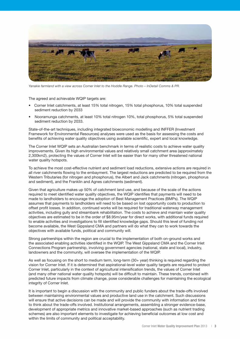
Yanakie farmland with a view across Corner Inlet to the Hoddle Range. Photo – InDetail Comms & PR.
4 | Corner Inlet Connections
1. Introduction1.1 The need for a water quality improvement plan
A World Renowned Ramsar WetlandCorner Inlet supports outstanding environmental values that have been recognised through its listing as a wetland of international importance under the Ramsar Convention. The Corner Inlet Ramsar Site includes the areas known as Corner Inlet and Nooramunga and is the most southerly marine embayment and tidal mudflat system of mainland Australia.
Corner Inlet is valued as:
• afeeding,nestingandbreedingareaforthousandsofwaterbirdsandoneofthemostimportantareasin Victoria for resident and migratory and shorebirds
• auniquesystemofbarrierislandsandtidalmudflats
• theworld’smostsoutherlypopulationofWhiteMangrove(Avicennia marina)
• thelargestareaofBroad-leafedSeagrass(Posidonia australis) in Victoria
• habitattomorethan390nativeplantand160nativeanimalspeciesandadiversityofmarineinvertebrates
• anareaofoutstandingfishhabitatthatcontributestocommercialfishing,tourismandrecreationopportunities in the region.
ThesevaluesarehighlightedintheEcologicalCharacterDescription(ECD)forCornerInlet(BMTWBM2011).
People and ProductionSituatedinsouth-easternVictoria,theCornerInletcatchmentisapproximately2,300km2insizeandstretches along the South Gippsland coastline from Woodside to Wilsons Promontory. It is a highly productive area, supporting dairy, beef and mixed grazing enterprises and significant areas of production forestry.TheregionsupportsasignificantVictoriancommercialbayandinletfishery,including18licensedcommercial fishers.
Impacts Upon HabitatsThe health and extent of the Corner Inlet Ramsar Site’s important habitats, such as seagrass meadows, sand flats, mangroves and saltmarsh, can be affected by nutrient and sediment pollution.
This pollution has an impact on the delicate balance of organisms that rely on these habitats. Over recent years, changes in local seagrass health and distribution and the presence of algae have been of concern to local fishers, recreational users and local community members.
Protecting Corner Inlet’s Ecological ValuesTo help to protect the ecological character of this significant wetland, the West Gippsland Catchment Management Authority (WGCMA), with funding provided by the Australian Government, is developing a Water Quality Improvement Plan (WQIP) for the Corner Inlet catchment.
This plan will guide investment in on-ground actions within the catchment to address water quality issues in the Corner Inlet and identifies the research and monitoring required to improve knowledge about the site. The plan has an emphasis on working with local communities to achieve the identified priorities.
Corner Inlet Water Quality Improvement Plan 2013 | 5
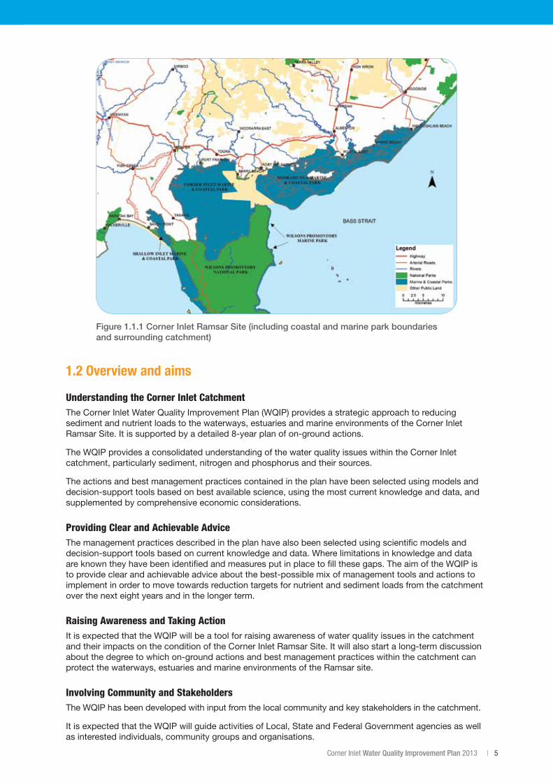
Figure 1.1.1 Corner Inlet Ramsar Site (including coastal and marine park boundaries and surrounding catchment)
1.2 Overview and aims
Understanding the Corner Inlet Catchment The Corner Inlet Water Quality Improvement Plan (WQIP) provides a strategic approach to reducing sediment and nutrient loads to the waterways, estuaries and marine environments of the Corner Inlet Ramsar Site. It is supported by a detailed 8-year plan of on-ground actions.
The WQIP provides a consolidated understanding of the water quality issues within the Corner Inlet catchment, particularly sediment, nitrogen and phosphorus and their sources.
The actions and best management practices contained in the plan have been selected using models and decision-support tools based on best available science, using the most current knowledge and data, and supplemented by comprehensive economic considerations.
Providing Clear and Achievable AdviceThe management practices described in the plan have also been selected using scientific models and decision-support tools based on current knowledge and data. Where limitations in knowledge and data are known they have been identified and measures put in place to fill these gaps. The aim of the WQIP is to provide clear and achievable advice about the best-possible mix of management tools and actions to implement in order to move towards reduction targets for nutrient and sediment loads from the catchment over the next eight years and in the longer term.
Raising Awareness and Taking ActionIt is expected that the WQIP will be a tool for raising awareness of water quality issues in the catchment and their impacts on the condition of the Corner Inlet Ramsar Site. It will also start a long-term discussion about the degree to which on-ground actions and best management practices within the catchment can protect the waterways, estuaries and marine environments of the Ramsar site.
Involving Community and StakeholdersThe WQIP has been developed with input from the local community and key stakeholders in the catchment.
It is expected that the WQIP will guide activities of Local, State and Federal Government agencies as well as interested individuals, community groups and organisations.
6 | Corner Inlet Connections
1.3 Scope
What Constitutes Corner Inlet?Throughout the WQIP, several terms are used to refer to or describe the Corner Inlet Ramsar Site and its surrounding catchment.
• CornerInletRamsarSite(theRamsarsite)
The whole of the Ramsar site will be referred to as the Corner Inlet Ramsar Site or the Ramsar site and references within the marine areas will be Corner Inlet for the western part of the Ramsar site and Nooramunga for the eastern part. The Ramsar site includes the areas of Corner Inlet and Nooramunga MarineandCoastalParksandtheCornerInletMarineNationalPark(refertofigure1.1.1).AlsorefertoSection2.1forabroaderdescription.
• CornerInlet Unless otherwise stated, Corner Inlet refers to the collective water body that is Corner Inlet and Nooramunga.
• CornerInletcatchment Unless otherwise stated, this term refers to the land and waterways that are adjacent to the entire Corner Inlet Ramsar Site.
• CornerInletandNooramunga These are the two halves of what constitutes the Corner Inlet Ramsar Site. They have very different physical features and hydrodynamics and the WQIP acknowledges this through the development of separate objectives and works programs for each.
• ThecatchmentsofCornerInletandNooramunga On occasion, it may be necessary to refer separately to the areas that constitute the catchments of the two halves of the Corner Inlet Ramsar Site:
- Corner Inlet catchment – the land adjacent to the western part of the Corner Inlet Ramsar Site
- Nooramunga catchment – the land adjacent to the eastern part of the Corner Inlet Ramsar Site.
Sediment and Nutrient LoadsThe Corner Inlet WQIP addresses the specific threat from increased loads of nutrient and sediment to the estuaries, waterways and marine areas of the Corner Inlet Ramsar Site.
All other planning arrangements relating to the management of the Ramsar site are described below.
Other issues in Corner Inlet and NooramungaAt a federal level the Environment Protection and Biodiversity Conservation Act 1999 (EPBC Act) establishes a framework for managing Ramsar sites. This includes the preparation of a Ramsar Site Management Plan. A number of Ramsar Site Management Plans are currently due for renewal in Victoria, including Corner Inlet.
In Victoria, the Victorian Waterway Management Strategy brings wetlands, rivers and estuaries into a single planning framework. Regional implementation of the Victorian Waterway Management Strategy will occur through the development of ten Regional Waterway Strategies (formerly River Health Strategies).
To avoid duplication of planning activities, it is anticipated that the Regional Waterway Strategies will, where possible, align with any existing planning requirements for waterways.
The Corner Inlet WQIP is based on available data and modelling. As such it has not been able to account for climate change impacts. It is acknowledged that future impacts from climate change on the coastal and estuarine environments of Corner Inlet could be significant. Notwithstanding this, the proposed actions in this WQIP are worthwhile and likely to be effective in protecting the values from the impacts of excess nutrient and sediment. As the ability to predict impacts from climate change improves, this knowledge could help inform adaptive management measures for the Corner Inlet WQIP.
Corner Inlet Water Quality Improvement Plan 2013 | 7
1. Introduction
Regional Waterway StrategyThe Victorian and Australian Governments have agreed that the renewal process for Ramsar Site Management Plans will occur through the development of the ten Regional Waterway Strategies. Within the Regional Waterway Strategy, Ramsar site planning will provide for the conservation and wise use of Corner Inlet so as to maintain and, where practical, restore the ecological values that are the basis for its recognition as a Ramsar site.
The planning will provide a framework and the necessary information to make sure that decisions regarding the use, development and ongoing management of Corner Inlet are made with full regard to the Ramsar values.
Within the Regional Waterway Strategy, planning for the Corner Inlet Ramsar site will:
• setouttheRamsarsitemanagementplanningarrangements
• describethevaluesoftheRamsarsite
• setlong-termresourceconditiontargetsfortheRamsarsite
• describethethreatstothevaluesoftheRamsarsite
• describehowtheecologicalcharacteroftheRamsarsitewillbemonitored,evaluatedandreported
• developaworkprogramfortheRamsarsite.
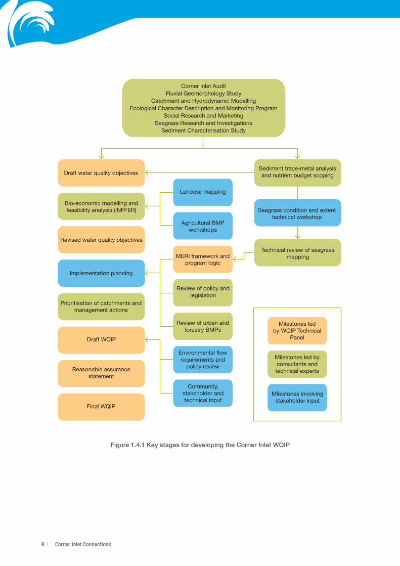
1.4 Approach and supporting projectsThe development of the Corner Inlet WQIP broadly involves the following inter-related activities:
1. Capturingcurrentknowledge
2. Establishing water quality dependant environmental values
3. Developingwaterqualityobjectivesthatintegratelandmanagement,catchmentwaterqualityandmarine ecosystem considerations
4. Identifying appropriate management strategies to achieve water quality objectives
5. Developingaworksprogram,andmodelling,monitoringandadaptivemanagementstrategies
6. Preparingareasonableassurancestatementthatdescribeshowimplementingtheplanwillachievetheplan’s objectives and any policy or legislative impediments to implementation and long term protection of the ecosystem.
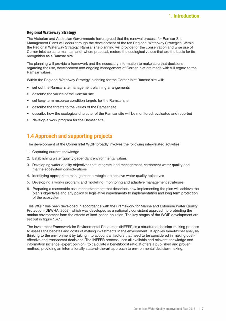
This WQIP has been developed in accordance with the Framework for Marine and Estuarine Water Quality Protection(DEWHA,2002),whichwasdevelopedasanationallyconsistentapproachtoprotectingthemarine environment from the effects of land-based pollution. The key stages of the WQIP development are setoutinfigure1.4.1.
The Investment Framework for Environmental Resources (INFFER) is a structured decision-making process to assess the benefits and costs of making investments in the environment. It applies benefit:cost analysis thinking to the environment by taking into account all factors that need to be considered in making cost-effective and transparent decisions. The INFFER process uses all available and relevant knowledge and information (science, expert opinion), to calculate a benefit:cost ratio. It offers a published and proven method, providing an internationally state-of-the-art approach to environmental decision-making.
8 | Corner Inlet Connections
Figure 1.4.1 Key stages for developing the Corner Inlet WQIP
Corner Inlet AuditFluvial Geomorphology Study
Catchment and Hydrodynamic ModellingEcological Character Description and Monitoring Program
Social Research and MarketingSeagrass Research and Investigations
Sediment Characterisation Study
Draft water quality objectives
Bio-economic modelling and feasibility analysis (INFFER)
Revised water quality objectives
Implementation planning
Prioritisation of catchments and management actions
Draft WQIP
Reasonable assurancestatement
Final WQIP
Landuse mapping
Agricultural BMP workshops
MERI framework and program logic
Review of policy and legislation
Review of urban and forestry BMPs
Environmental �ow requirements and
policy review
Community,stakeholder and technical input
Milestones ledby WQIP Technical
Panel
Milestones led by consultants and technical experts
Milestones involving stakeholder input
Technical review of seagrass mapping
Seagrass condition and extent technical workshop
Sediment trace-metal analysis and nutrient budget scoping
Corner Inlet Water Quality Improvement Plan 2013 | 9
In2005,theWGCMAandtheGippslandCoastalBoardcommissionedCSIRO(Malloyet.al.,2005)toundertake an environmental audit of the embayment of Corner and Nooramunga and their surrounding catchments. The audit concluded that the values of the Ramsar site were threatened by inflows of nutrient and sediment from the catchment.
Following the CSIRO findings, the Corner Inlet Ramsar Site was included on the list of National Water Quality Hotspots by the Australian Government. The listing of the area as a water quality hotspot enabled funding to be obtained for studies into the environmental values at risk from poor water quality, and allowed for the collation of baseline data to understand and address water quality issues.
TheCSIROaudit(Molloyet.al.,2005)andtheCornerInletEcologicalCharacterDescription(BMTWBM,2011)pointtoathreattoCornerInletfromelevatedloadsofnutrientandsedimentwithinruralrunoff.Potentially,ithasanimpactonseagrassthroughreducedlightavailabilityduetoincreasedturbidityand/or epiphyte or algal growth. This, in addition to anecdotal evidence from commercial fishers of loss of seagrassasfarbackas1972(Poore,1978)andperceivedrelationshipbetweenthesechangesandpoorwater quality from the catchment, have been key drivers for work to date in Corner Inlet.
Support for investigations into catchment water quality has been underpinned by the assumption that reducing sediment and nutrient loads from catchment sources will lead to an improvement in the condition and extent of seagrass in Corner Inlet and Nooramunga.
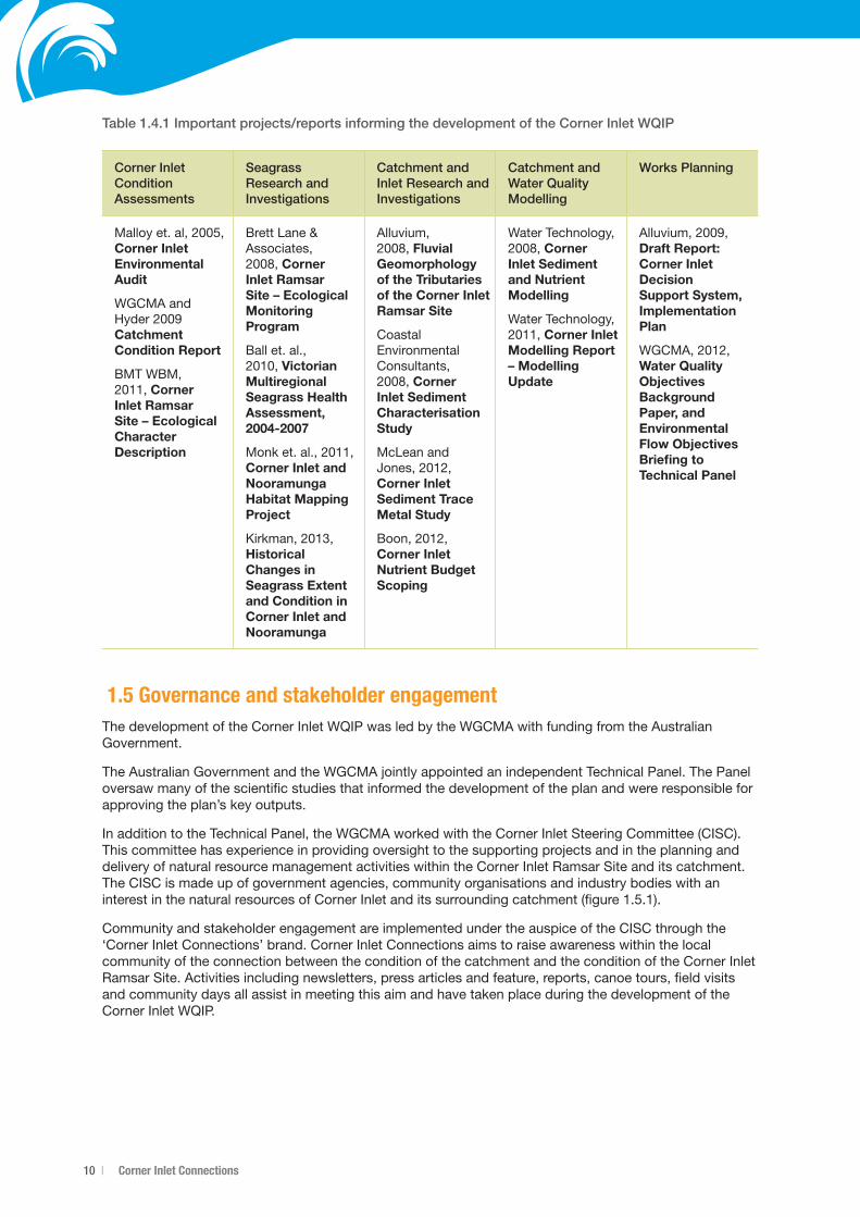
There have been many studies that have informed the development of the Corner Inlet WQIP. Some of these studies were specifically commissioned to support the WQIP, whilst others were already underway or had other objectives. Collectively, these studies have focused on five essential areas, which are:
1. ConditionAssessment
2. Seagrass Research and Investigations
3. CatchmentResearchandInvestigations
4. Catchment and Water Quality Monitoring
5. WorksPlanning.
Table1.4.1outlinesthemainreportsthathaveinformedthedevelopmentoftheWQIP.
1. Introduction
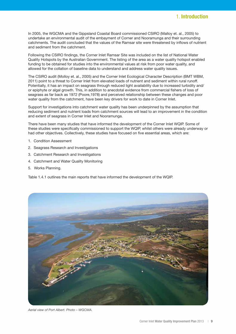
Aerial view of Port Albert. Photo – WGCMA.
10 | Corner Inlet Connections
Table 1.4.1 Important projects/reports informing the development of the Corner Inlet WQIP
Corner Inlet Condition Assessments
Seagrass Research and Investigations
Catchment and Inlet Research and Investigations
Catchment and Water Quality Modelling
Works Planning
Malloyet.al,2005,Corner Inlet Environmental Audit
WGCMA and Hyder2009Catchment Condition Report
BMT WBM, 2011,Corner Inlet Ramsar Site – Ecological Character Description
Brett Lane & Associates, 2008,Corner Inlet Ramsar Site – Ecological Monitoring Program
Ball et. al., 2010,Victorian Multiregional Seagrass Health Assessment, 2004-2007
Monket.al.,2011,Corner Inlet and NooramungaHabitat Mapping Project
Kirkman,2013,Historical Changes in Seagrass Extent and Condition in Corner Inlet and Nooramunga
Alluvium, 2008,Fluvial Geomorphology oftheTributariesof the Corner Inlet Ramsar Site
Coastal Environmental Consultants, 2008,Corner Inlet Sediment Characterisation Study
McLean and Jones,2012,Corner Inlet SedimentTraceMetal Study
Boon,2012,Corner Inlet NutrientBudgetScoping
Water Technology, 2008,Corner Inlet Sediment andNutrientModelling
Water Technology, 2011,Corner Inlet Modelling Report – Modelling Update
Alluvium,2009,Draft Report: Corner Inlet Decision Support System, Implementation Plan
WGCMA,2012,Water Quality Objectives Background Paper, and Environmental Flow Objectives Briefing to TechnicalPanel
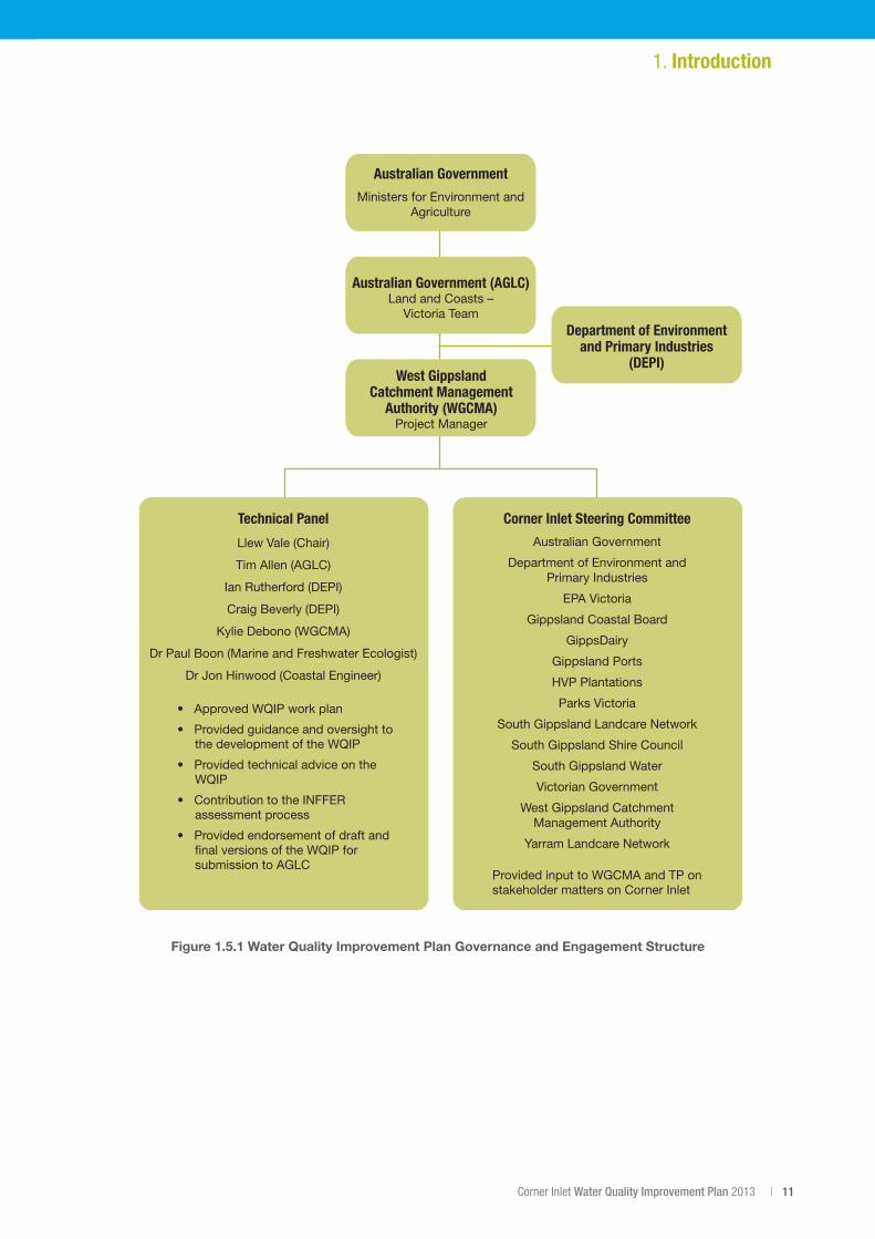
1.5 Governance and stakeholder engagement The development of the Corner Inlet WQIP was led by the WGCMA with funding from the Australian Government.
The Australian Government and the WGCMA jointly appointed an independent Technical Panel. The Panel oversaw many of the scientific studies that informed the development of the plan and were responsible for approving the plan’s key outputs.
In addition to the Technical Panel, the WGCMA worked with the Corner Inlet Steering Committee (CISC). This committee has experience in providing oversight to the supporting projects and in the planning and delivery of natural resource management activities within the Corner Inlet Ramsar Site and its catchment. The CISC is made up of government agencies, community organisations and industry bodies with an interestinthenaturalresourcesofCornerInletanditssurroundingcatchment(figure1.5.1).
Community and stakeholder engagement are implemented under the auspice of the CISC through the ‘Corner Inlet Connections’ brand. Corner Inlet Connections aims to raise awareness within the local community of the connection between the condition of the catchment and the condition of the Corner Inlet Ramsar Site. Activities including newsletters, press articles and feature, reports, canoe tours, field visits and community days all assist in meeting this aim and have taken place during the development of the Corner Inlet WQIP.
Corner Inlet Water Quality Improvement Plan 2013 | 11
1. Introduction
Figure 1.5.1 Water Quality Improvement Plan Governance and Engagement Structure
Australian Government
Ministers for Environment and Agriculture
Australian Government (AGLC)Land and Coasts –
Victoria Team
West GippslandCatchment Management
Authority (WGCMA)Project Manager
Department of Environmentand Primary Industries
(DEPI)
Technical Panel
Llew Vale (Chair)
Tim Allen (AGLC)
Ian Rutherford (DEPI)
Craig Beverly (DEPI)
Kylie Debono (WGCMA)
Dr Paul Boon (Marine and Freshwater Ecologist)
Dr Jon Hinwood (Coastal Engineer)
Corner Inlet Steering Committee
Australian Government
Department of Environment andPrimary Industries
EPA Victoria
Gippsland Coastal Board
GippsDairy
Gippsland Ports
HVP Plantations
Parks Victoria
South Gippsland Landcare Network
South Gippsland Shire Council
South Gippsland Water
Victorian Government
West Gippsland CatchmentManagement Authority
Yarram Landcare Network
Provided input to WGCMA and TP on stakeholder matters on Corner Inlet
• Approved WQIP work plan
• Provided guidance and oversight to the development of the WQIP
• Provided technical advice on the WQIP
• Contribution to the INFFER assessment process
• Provided endorsement of draft and final versions of the WQIP for submission to AGLC
12 | Corner Inlet Connections
2. Catchment Characteristics2.1 Location and landscape
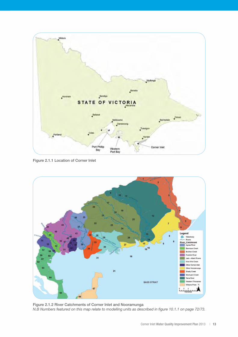
Corner Inlet Ramsar SiteTheCornerInletRamsarSiteislocatedapproximately260kmsouth-eastofMelbourne,nearWilsonsPromontoryinVictoria,figure2.1.1.ItincludestheareasofCornerInletandNooramungaMarineandCoastalParks and the Corner Inlet Marine National Park.
The67,186haCornerInletRamsarSiteisVictoria’sthirdlargestandsouthern-mostembaymentandisdissectedby a network of deep tidal channels. These channels drain and fill from the inlet’s entrance point to Bass Strait in the east of the embayment and provide access to four small ports – Port Franklin, Port Welshpool, Port Albert and Barry Beach.
TheCornerInletRamsarSiteincorporatesanareaofapproximately630km2ofwhichapproximately540km2 is water, sand and mudflats with the area remaining accounted for by islands and fringing wetlands (Parks Victoria, 2005).
Corner Inlet Catchment (including Nooramunga)With national parks, waterways, farmland and coast, the land surrounding Corner Inlet is a place of natural beauty, productivity and internationally recognised environmental values.
The catchment surrounding the Corner Inlet Ramsar Site is bound to the north by the Strzelecki Range, with the Hoddle Range forming the north-west boundary.
Thecatchmentoccupiesanareaof2300km2 and curves around the inlet from Woodside to Wilsons Promontory. The landscape is characterised by steep slopes and short gullies and the inlet is bordered by a narrow crescent of undulating coastal plains at the foot of the hills.
Corner Inlet supports important areas of coastal saltmarsh vegetation and mangrove, including the world’s most southerly occurrence of White Mangrove. Its upper catchment, high in the Strzelecki Range, has stands of tall, wet forest and pockets of both cool and warm temperate rainforest still intact (but much reduced from their pre-European extent), mostly preserved in Tarra-Bulga National Park.
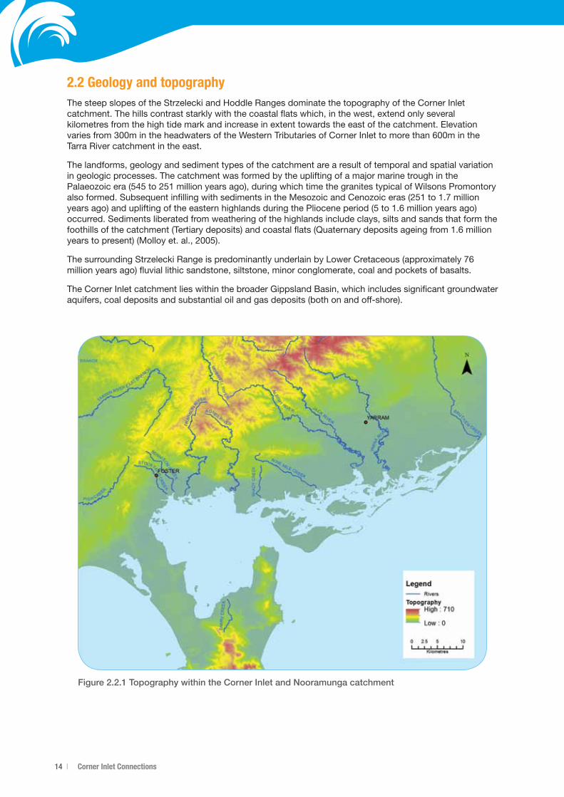
The Corner Inlet Ramsar Site is fed by a system of waterways stretching from the Strzelecki and Hoddle Ranges, through fertile countryside, to the coast. Collectively known as the Western Tributaries, a number of small streams, including Old Hat, Poor Fellow Me, Dead Horse, Silver, Golden, Stockyard and Muddy Creeks, flow into the Ramsar site. Larger freshwater flows from this area come from the Franklin and Agnes Rivers. To the east, and draining to Nooramunga, are the Bruthen, Nine Mile and Shady Creeks and the Jack, Albert and Tarra Rivers (figure2.1.2).
The mountainous northern coastline of Wilsons Promontory National Park, with its iconic granite formations and diverse vegetation communities, rises to form the southern boundary of the Corner Inlet Ramsar Site. Most of the northern part of Wilsons Promontory is classified as a wilderness zone. From these northern shores the Yanakie Isthmus and a number of islands within the embayment can be seen.
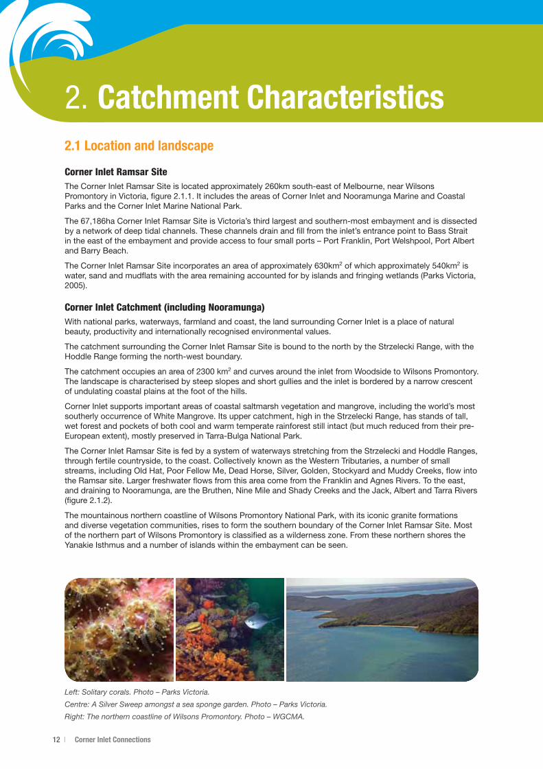
Left: Solitary corals. Photo – Parks Victoria.
Centre: A Silver Sweep amongst a sea sponge garden. Photo – Parks Victoria.
Right: The northern coastline of Wilsons Promontory. Photo – WGCMA.
Corner Inlet Water Quality Improvement Plan 2013 | 13
Figure 2.1.1 Location of Corner Inlet
Figure 2.1.2 River Catchments of Corner Inlet and Nooramunga N.B Numbers featured on this map relate to modelling units as described in figure 10.1.1 on page 72/73.
14 | Corner Inlet Connections
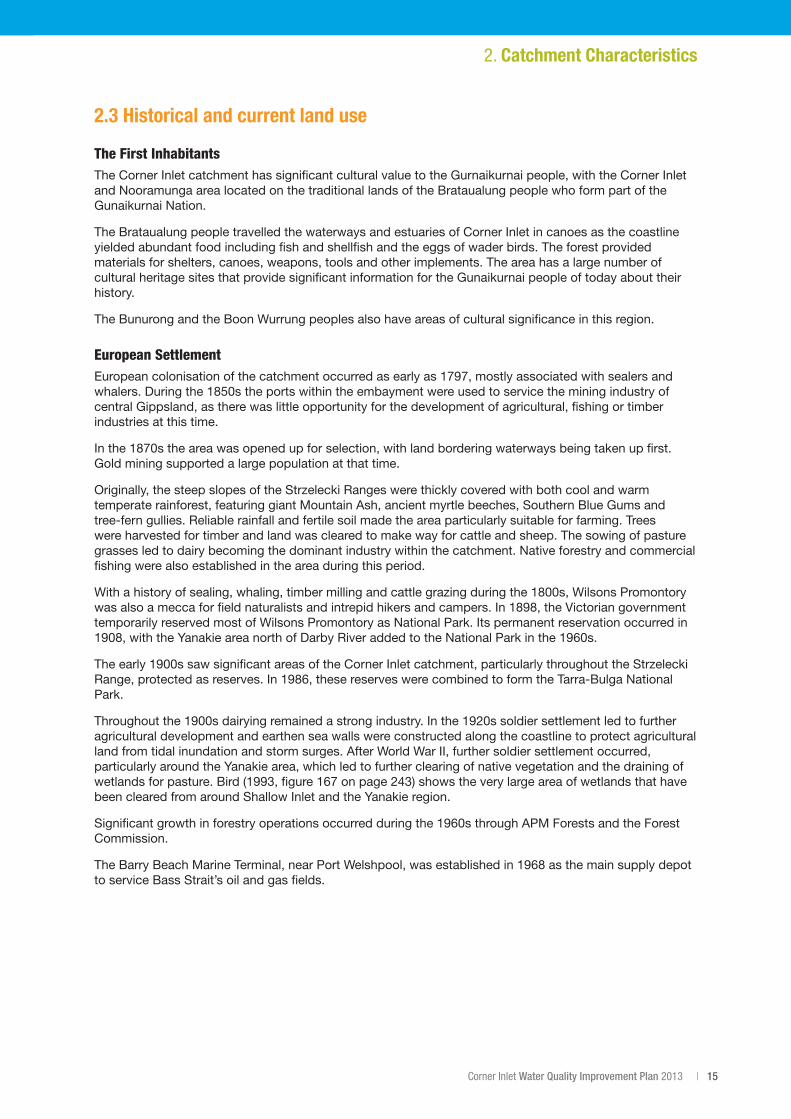
2.2 Geology and topographyThe steep slopes of the Strzelecki and Hoddle Ranges dominate the topography of the Corner Inlet catchment. The hills contrast starkly with the coastal flats which, in the west, extend only several kilometres from the high tide mark and increase in extent towards the east of the catchment. Elevation variesfrom300mintheheadwatersoftheWesternTributariesofCornerInlettomorethan600mintheTarra River catchment in the east.
The landforms, geology and sediment types of the catchment are a result of temporal and spatial variation in geologic processes. The catchment was formed by the uplifting of a major marine trough in the Palaeozoicera(545to251millionyearsago),duringwhichtimethegranitestypicalofWilsonsPromontoryalsoformed.SubsequentinfillingwithsedimentsintheMesozoicandCenozoiceras(251to1.7millionyearsago)andupliftingoftheeasternhighlandsduringthePlioceneperiod(5to1.6millionyearsago)occurred. Sediments liberated from weathering of the highlands include clays, silts and sands that form the foothillsofthecatchment(Tertiarydeposits)andcoastalflats(Quaternarydepositsageingfrom1.6millionyearstopresent)(Molloyet.al.,2005).
ThesurroundingStrzeleckiRangeispredominantlyunderlainbyLowerCretaceous(approximately76million years ago) fluvial lithic sandstone, siltstone, minor conglomerate, coal and pockets of basalts.
The Corner Inlet catchment lies within the broader Gippsland Basin, which includes significant groundwater aquifers, coal deposits and substantial oil and gas deposits (both on and off-shore).
Figure 2.2.1 Topography within the Corner Inlet and Nooramunga catchment
Corner Inlet Water Quality Improvement Plan 2013 | 15
2.3 Historical and current land use
The First InhabitantsThe Corner Inlet catchment has significant cultural value to the Gurnaikurnai people, with the Corner Inlet and Nooramunga area located on the traditional lands of the Brataualung people who form part of the Gunaikurnai Nation.
The Brataualung people travelled the waterways and estuaries of Corner Inlet in canoes as the coastline yielded abundant food including fish and shellfish and the eggs of wader birds. The forest provided materials for shelters, canoes, weapons, tools and other implements. The area has a large number of cultural heritage sites that provide significant information for the Gunaikurnai people of today about their history.
The Bunurong and the Boon Wurrung peoples also have areas of cultural significance in this region.
European SettlementEuropeancolonisationofthecatchmentoccurredasearlyas1797,mostlyassociatedwithsealersandwhalers.Duringthe1850stheportswithintheembaymentwereusedtoservicetheminingindustryofcentral Gippsland, as there was little opportunity for the development of agricultural, fishing or timber industries at this time.
Inthe1870stheareawasopenedupforselection,withlandborderingwaterwaysbeingtakenupfirst.Gold mining supported a large population at that time.
Originally, the steep slopes of the Strzelecki Ranges were thickly covered with both cool and warm temperate rainforest, featuring giant Mountain Ash, ancient myrtle beeches, Southern Blue Gums and tree-fern gullies. Reliable rainfall and fertile soil made the area particularly suitable for farming. Trees were harvested for timber and land was cleared to make way for cattle and sheep. The sowing of pasture grasses led to dairy becoming the dominant industry within the catchment. Native forestry and commercial fishing were also established in the area during this period.
Withahistoryofsealing,whaling,timbermillingandcattlegrazingduringthe1800s,WilsonsPromontorywasalsoameccaforfieldnaturalistsandintrepidhikersandcampers.In1898,theVictoriangovernmenttemporarily reserved most of Wilsons Promontory as National Park. Its permanent reservation occurred in 1908,withtheYanakieareanorthofDarbyRiveraddedtotheNationalParkinthe1960s.
Theearly1900ssawsignificantareasoftheCornerInletcatchment,particularlythroughouttheStrzeleckiRange,protectedasreserves.In1986,thesereserveswerecombinedtoformtheTarra-BulgaNationalPark.
Throughoutthe1900sdairyingremainedastrongindustry.Inthe1920ssoldiersettlementledtofurtheragricultural development and earthen sea walls were constructed along the coastline to protect agricultural land from tidal inundation and storm surges. After World War II, further soldier settlement occurred, particularly around the Yanakie area, which led to further clearing of native vegetation and the draining of wetlandsforpasture.Bird(1993,figure167onpage243)showstheverylargeareaofwetlandsthathavebeen cleared from around Shallow Inlet and the Yanakie region.
Significantgrowthinforestryoperationsoccurredduringthe1960sthroughAPMForestsandtheForestCommission.
TheBarryBeachMarineTerminal,nearPortWelshpool,wasestablishedin1968asthemainsupplydepotto service Bass Strait’s oil and gas fields.
2. Catchment Characteristics
16 | Corner Inlet Connections
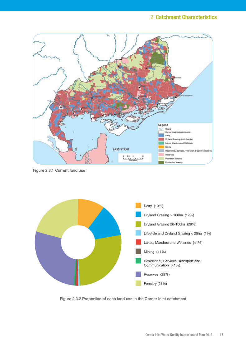
Current Land UseCurrentlanduseismappedinfigure2.3.1usingupdateddatafrom2012regardingagriculturallanduses.Theproportionofeachlanduseisshowninfigure2.3.2.Agricultureisthedominantlanduseactivityinthecatchment,constitutingjustover50%oftotallanduse.Drylandgrazing(beefandsheep)comprisesapproximately40%oftotallanduse,withdairyingcomprising10%(figure2.3.2).
During recent times there have been two important changes to land use in the Corner Inlet catchment. The first is the consolidation of dairy farms into larger enterprises. The second is the increase in smaller scale dryland grazing and growth in lifestyle-type properties.
In2006dairyingoccurredon42%offarmswithinthebroaderSouthGippslandcatchment(Dayet.al.,2012).Thedecadeto2012wasdifficultfordairyanddrylandgrazingduetodroughtandtighttermsoftrade.Day(2012)reportsthatin2010therewerearound20dairyfarmsintheCornerInletandNooramunga catchment, and it was estimated there would be a further drop in the total number of dairy farmsby2012.By2012itwasestimatedthattherewere122dairyfarmsinthecatchmentthatwereadjacent to a tributary waterway of Corner Inlet and Nooramunga. Some dairy farms have converted to dryland grazing enterprises but other dairy farms have merged, resulting in farms that are larger and often (butnotalways)moreproductive(Day,2012).
The productivity of beef and sheep industries during a similar time period was also volatile due to drought conditions. Strong productivity gains were recorded amongst larger producers and appear to be associated with increasing economies of scale, and greater use of feedlots to finish cattle. Medium producers achieved productivity growth by more efficiently using inputs. Small producers appear to have turned off stock and significantly reduced input requirements to try and avoid the consequences of higher input costs (MLA,2008).
Productionforestcoversapproximately21%ofthecatchment.Eightypercentofthisisavailableforloggingandtherestissetasideasbuffersandreserve.Onaverage3%ofproductionforestlandisloggedinanygivenyear(Riverness,2013).
Significantly,28%ofthecatchmentisprotectedandsetasideasParksandReserves.Thisincludespartsof the Wilsons Promontory National Park, Tarra Bulga National Park, Corner Inlet and Nooramunga Marine and Coastal Parks, Crown water frontages and numerous smaller reserves.
Estimatessuggesturbangrowthanddevelopmentinthecatchmentoverthenext30yearswillbeminimal,averagingaround2.3%(Ipsos-Eureka,2010).Thecurrentextentofurbanareasislessthan1%ofthetotalcatchment area.
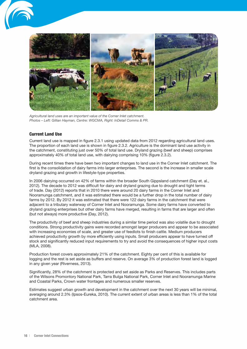
Agricultural land uses are an important value of the Corner Inlet catchment. Photos – Left: Gillian Hayman, Centre: WGCMA, Right: InDetail Comms & PR.
Corner Inlet Water Quality Improvement Plan 2013 | 17
2. Catchment Characteristics
Figure 2.3.1 Current land use
Figure 2.3.2 Proportion of each land use in the Corner Inlet catchment
Dairy (10%)
Dryland Grazing > 100ha (12%)
Dryland Grazing 20-100ha (28%)
Lifestyle and Dryland Grazing < 20ha (1%)
Lakes, Marshes and Wetlands (<1%)
Mining (<1%)
Residential, Services, Transport and Communication (<1%)
Reserves (28%)
Forestry (21%)
18 | Corner Inlet Connections
3. Values and SignificanceCorner Inlet was listed as a Wetland of International Importance under the Ramsar Conventionin1982.Duetoitslargeareaanddiversityofhabitats,itsupportsanumber of internationally significant aquatic and semi-aquatic plant and animal populations. The site has high environmental value and is largely in a near natural condition(BMTWBM,2011).
Historically undervalued as a mud and mangrove coastline, Corner Inlet’s unique environmental features are increasingly recognised as assets worth protecting.
The area encompassed by the Ramsar site is a large tide dominated embayment. It consists of a submerged plain covered by sand and mudflats with well-developed seagrass beds and large sand islands, particularly in the Nooramunga end of the site. A system of channels drain and fill from the inlet’s entrance point with Bass Strait to the east.
The values supporting the listing of the Corner Inlet Ramsar Site are:
• Diversityofwetlandmegahabitats–seagrass,mudandsandflats,mangroves,saltmarsh,permanentshallow marine water.
• Abundanceanddiversityofwaterbirds,inparticularthebarriersandislandsprovideimportantbird breeding sites. Thirty-two species of wading birds have been recorded at the Corner Inlet and Nooramungawithpopulationsoftenreachingcloseto30,000birdsormorethan20%ofVictoria’ssummertimewadingbirdpopulation.Nearly50%ofthemigratorywadingbirdsthatspendtheirwinterin Victoria do so in Corner Inlet and Nooramunga.
• Presenceofnationallythreatenedspecies;Orangebelliedparrot,Australiangrayling,Fairyternand Growling grass frog. In addition, fifteen threatened flora species and twenty-two threatened fauna species have been recorded in Corner Inlet and it supports the most southernmost mangrove community in the world.
• Supportsoutstandingfishhabitatvaluesthatcontributetotheecologicalconditionandsustainabilityofthe region.
(BMTWBM,2011,andCornerInletSteeringCommittee,2008).
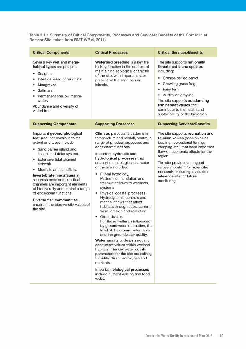
The critical components, processes and services of the Corner Inlet Ramsar Site as described in the EcologicalCharacterDescriptionaresetoutintable3.1.1.
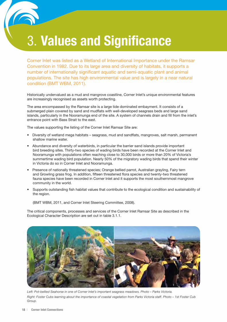
Left: Pot-bellied Seahorse in one of Corner Inlet’s important seagrass meadows. Photo – Parks Victoria.
Right: Foster Cubs learning about the importance of coastal vegetation from Parks Victoria staff. Photo – 1st Foster Cub Group.
Corner Inlet Water Quality Improvement Plan 2013 | 19
Table 3.1.1 Summary of Critical Components, Processes and Services/ Benefits of the Corner Inlet Ramsar Site (taken from BMT WBM, 2011)
Critical Components Critical Processes Critical Services/Benefits
Several key wetland mega-habitat types are present:
• Seagrass
• Intertidalsandormudflats
• Mangroves
• Saltmarsh
• Permanentshallowmarinewater.
Abundance and diversity of waterbirds.
Waterbird breeding is a key life history function in the context of maintaining ecological character of the site, with important sites present on the sand barrier islands.
The site supports nationally threatened fauna species including:
• Orange-belliedparrot
• Growlinggrassfrog
• Fairytern
• Australiangrayling.
The site supports outstanding fish habitat values that contribute to the health and sustainability of the bioregion.
Supporting Components Supporting Processes Supporting Services/Benefits
Important geomorphological features that control habitat extent and types include:
• Sandbarrierislandandassociated delta system
• Extensivetidalchannelnetwork
• Mudflatsandsandflats.
Invertebrate megafauna in seagrass beds and sub-tidal channels are important elements of biodiversity and control a range of ecosystem functions.
Diverse fish communities underpin the biodiversity values of the site.
Climate, particularly patterns in temperature and rainfall, control a range of physical processes and ecosystem functions.
Important hydraulic and hydrological processes that support the ecological character of the site includes:
• Fluvialhydrology. Patterns of inundation and freshwater flows to wetlands systems
• Physicalcoastalprocesses. Hydrodynamic controls and marine inflows that affect habitats through tides, current, wind, erosion and accretion
• Groundwater. For those wetlands influenced by groundwater interaction, the level of the groundwater table and the groundwater quality.
Water quality underpins aquatic ecosystem values within wetland habitats. The key water quality parameters for the site are salinity, turbidity, dissolved oxygen and nutrients.
Important biological processes include nutrient cycling and food webs.
The site supports recreation and tourism values (scenic values, boating, recreational fishing, camping etc.) that have important flow-on economic effects for the region.
The site provides a range of values important for scientific research, including a valuable reference site for future monitoring.
20 | Corner Inlet Connections
3.1 SeagrassThe67,186haRamsarwetlandfeaturesseagrassmeadowsthatareofhighecologicalvalue.Theyareacrucial component of the feeding and breeding cycles of many organisms and are the backbone of the inlet’s complex ecosystems.
There are four species of seagrass in the inlet:
• Heterozostera nigricaulis
• Zosteramuelleri
• Halophilaaustralis
• Posidonia australis(Roobet.al.,1998).
An additional species, Amphibolis antarctica, occurs in more exposed waters in the vicinity of Corner Inlet andNooramunga(Hindellet.al.,2009).
The areas of Posidonia australis (broad leafed seagrass) in Corner Inlet and Nooramunga are the only large patchesofthisspeciesinVictoria(Kirkman,2013;Ballet.al.,2010).
Seagrass is a driver of the marine ecology and has a critical role in carbon sequestration, providing habitat and food for fauna including fish and migratory and resident wader birds. The seagrass meadows also support an array of marine life such as the Pot-bellied Seahorse, King George Whiting, seastars and sponges, and communities of sea squirts and anemones.
Although the conservation of all species of seagrass in Corner Inlet and Nooramunga is important, the protection of areas of Posidonia australis is particularly crucial as this species is rare in Victoria and, at least on the east coast of Australia, takes decades to re-establish following disturbance and loss.
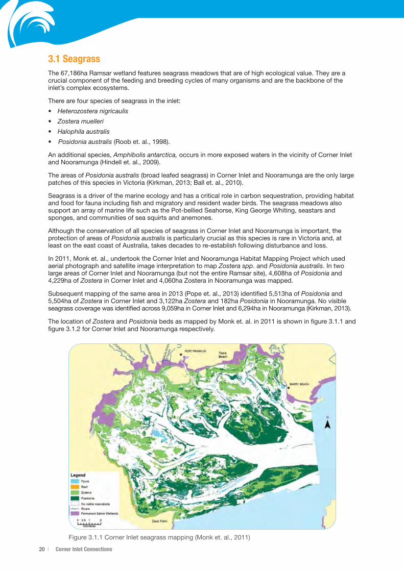
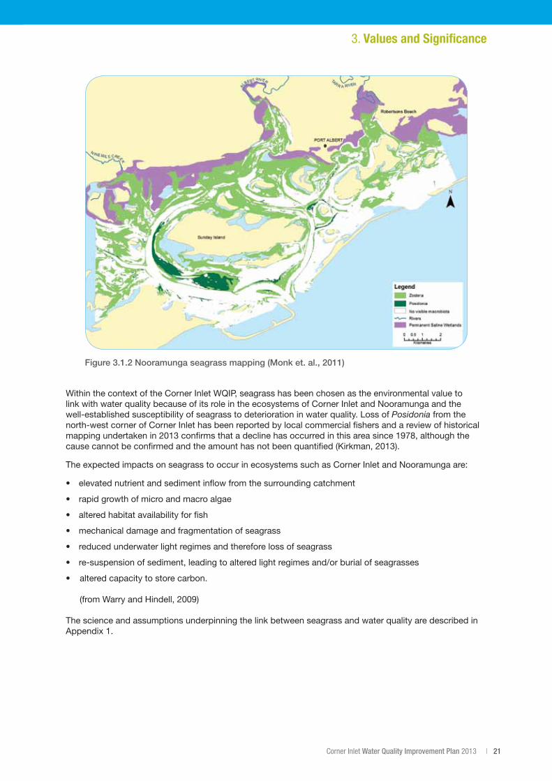
In2011,Monket.al.,undertooktheCornerInletandNooramungaHabitatMappingProjectwhichusedaerial photograph and satellite image interpretation to map Zosteraspp. and Posidonia australis. In two largeareasofCornerInletandNooramunga(butnottheentireRamsarsite),4,608haofPosidonia and 4,229ha of ZosterainCornerInletand4,060haZosterainNooramungawasmapped.
Subsequentmappingofthesameareain2013(Popeet.al.,2013)identified5,513haofPosidonia and 5,504haofZosterainCornerInletand3,122haZosteraand182haPosidonia in Nooramunga. No visible seagrasscoveragewasidentifiedacross9,059hainCornerInletand6,294hainNooramunga(Kirkman,2013).
The location of Zostera and PosidoniabedsasmappedbyMonket.al.in2011isshowninfigure3.1.1andfigure3.1.2forCornerInletandNooramungarespectively.
Figure3.1.1CornerInletseagrassmapping(Monket.al.,2011)
Corner Inlet Water Quality Improvement Plan 2013 | 21
Figure 3.1.2 Nooramunga seagrass mapping (Monk et. al., 2011)
3. Values and Significance
Within the context of the Corner Inlet WQIP, seagrass has been chosen as the environmental value to link with water quality because of its role in the ecosystems of Corner Inlet and Nooramunga and the well-established susceptibility of seagrass to deterioration in water quality. Loss of Posidonia from the north-west corner of Corner Inlet has been reported by local commercial fishers and a review of historical mappingundertakenin2013confirmsthatadeclinehasoccurredinthisareasince1978,althoughthecausecannotbeconfirmedandtheamounthasnotbeenquantified(Kirkman,2013).
The expected impacts on seagrass to occur in ecosystems such as Corner Inlet and Nooramunga are:
• elevatednutrientandsedimentinflowfromthesurroundingcatchment
• rapidgrowthofmicroandmacroalgae
• alteredhabitatavailabilityforfish
• mechanicaldamageandfragmentationofseagrass
• reducedunderwaterlightregimesandthereforelossofseagrass
• re-suspensionofsediment,leadingtoalteredlightregimesand/orburialofseagrasses
• alteredcapacitytostorecarbon.
(fromWarryandHindell,2009)
The science and assumptions underpinning the link between seagrass and water quality are described in Appendix1.
22 | Corner Inlet Connections
3.2 Social and economic valuesCorner Inlet and Nooramunga are protected as Marine and Coastal Parks, with a smaller area off the northern shoreline of Wilsons Promontory protected as the Corner Inlet Marine National Park. The stunning landscape and natural beauty of the area make it a popular location for boating, camping, fishing and passive recreational activities such as bird watching and walking. Visitors to Corner Inlet are attracted from thelocalareaaswellasfromfurtherafield,particularlyMelbourne(DSE,2003).
CornerInletisestimatedtoattract150,000visitordaysperyear,withtourisminputstothelocaleconomyestimatedat$22.5million(DSE,2003).VisitorstoCornerInletareoftenattractedtotheareabyitsproximity to Wilsons Promontory National Park and easy driving distance from Melbourne.
Corner Inlet is one of only three bays or estuaries in Victoria where commercial fishing is allowed. In March 2011therewere89BayandInletFisheryAccessLicenceswith18oftheminCornerInlet(DPICommercialFishProductionInformationBulletin,2011),providingavaluableportionoffresh,locallycaughtfinfishforVictorian seafood consumers. The average annual commercial value of major fish species in Corner Inlet between2005and2010was$2.4M.However,thefulleconomicandsocialvalueofcommercialfishingoperations in Corner Inlet should not be measured by wholesale production value alone with the industry playinganimportantroleinprovidingemploymentincoastalcentresacrossSouthGippsland(DPI,2011).
The catchment’s steep slopes and coastal flats have been farmed for generations, and the region is renowned for its productive primary industries.
In2006,milkproducedintheCornerInletandnearbyNinetyMileBeachsub-regionhadagrossvalueof$195.8M(IPSOS,2010).Dairyingisveryimportanttothelocaleconomy,accountingfor62%ofthelocalagricultural production value. Beef is the second most valuable commodity in the Corner Inlet and Ninety MileBeachsub-regionwithannualproductionworth$70.5M;thisisfollowedbycropsandpasturescutforhay($17.8M)andsheep($11.4M).
Estimates of the overall economic, cultural and environmental values are clearly substantial, but also limited by data availability. The economic value of tourism, while already large is expected to grow significantly over time.
The area is also experiencing diversification with many new and emerging enterprises taking hold in the area as a result of South Gippsland’s increasing popularity as a destination for sea-changers and tree-changers.
The Corner Inlet catchment has a strong history of natural resource management and on ground works. There are long serving and active networks of Landcare groups, and active participation by farmers in industry best management practise programs to reduce the impact of nutrient and sediment run-off from their land. This stewardship ethos is driven by community members and landholders passionate about caring for the land, preserving and enhancing the environment and contributing to the health of Corner Inlet and its surrounding catchment. The WGCMA and industry bodies such as GippsDairy also act as stewards of change through the delivery of projects that encourage and support adoption of best management practices through programs such as GipRip and Core4.
Left: Migratory waders in flight, mostly Bar-tailed Godwits. Photo – Parks Victoria.
Centre: Doughboy scallop amongst broad leaf seagrass. Photo – Parks Victoria.
Right: Fishing boats at Port Welshpool wharf. Photo – InDetail Comms & PR.
Corner Inlet Water Quality Improvement Plan 2013 | 23
Aboriginal Cultural HeritageIndigenous Australians have a strong cultural connection to country and the preservation of cultural heritage is extremely important. There are many areas of Aboriginal cultural sensitivity within the West Gippsland Catchment Management region and the Corner Inlet and Nooramunga area that have significant cultural value to the Traditional Land Owners. The Corner Inlet and Nooramunga region of the West Gippsland Catchment is significant to the Gunaikurnai people, the Bunurong people and the Boon Wurrung people.
Who are the Gunaikurnai?Thereareapproximately3,000GunaikurnaipeopleandtheGunaikurnaipeoplearemadeupoffivemajorclans. Below is the official spelling of the clans endorsed by the Gunaikurnai Elders’ Council, and a brief description of each clan area:
• Brabralung people in Central Gippsland. Mitchell, Nicholson and Tambo Rivers; south to about Bairnsdale and Bruthen.
• Brataualung people in South Gippsland. From Cape Liptrap and Tarwin Meadows east to the mouth of Merriman Creek; inland to near Mirboo; at Port Albert and Wilsons Promontory.
• Brayakaulung people around the current site of Sale. Providence Ponds, Avon and Latrobe Rivers; west of Lake Wellington to Mounts Saw Saw and Howitt.
• Krauatungalung people near the Snowy River. Cape Everard (Point Hicks) to Lakes Entrance; on Cann, Brodribb, Buchan and Snowy Rivers; inland to about Black Mountain.
• Tatungalung people near Lakes Entrance on the coast. Along Ninety Mile Beach and about Lake Victoria and Lake Wellington from Lakes Entrance southwest to mouth of Merriman Creek; also on Raymond Island in Lake King.
In2010,theFederalCourtdeterminedundertheNative Title Act 1993 that the Gunaikurnai people hold native title over much of Gippsland, encompassing parts of the Corner Inlet and Nooramunga area. In addition to this, the Gunaikurnai people have entered into an agreement with the Victorian Government under the Traditional Owner Settlement Act 2010, which formally recognises them as the traditional owners over land within that area. The determination and agreement area extends from West Gippsland nearWarragul,easttotheSnowyRiverandnorthtotheGreatDividingRangeandincludes200mofseacountry offshore.
Thereareover400CulturalHeritagesitesintheWestGippslandCatchmentManagementregion.Theseprovide a link to the past for contemporary Aboriginal people. All Aboriginal sites found in Victoria are protected. Aboriginal sites and places are important because of their historic and cultural value to Aboriginal people and the wider community. Sites may be located on private and public land and need to be protected to prevent damage from erosion and land use changes. Sites that show Aboriginal occupation of the region include:
• significantscartrees • artefacts • campsites
• grindinggrooves • rockshelters • artsites
• stonearrangements • ceremonialgrounds • quarries
• sacredsites.
The Gunaikurnai Land and Waters Aboriginal Corporation (GLaWAC) is the Registered Aboriginal Party for this region, they should be contacted for all enquiries regarding Aboriginal Cultural Heritage.
The WGCMA works very closely with Traditional Owners on all projects. This document acknowledges the Aboriginal Traditional Owners of the Corner Inlet catchment and recognises their connection to their ancestral lands and waters.
3. Values and Significance

24 | Corner Inlet Connections
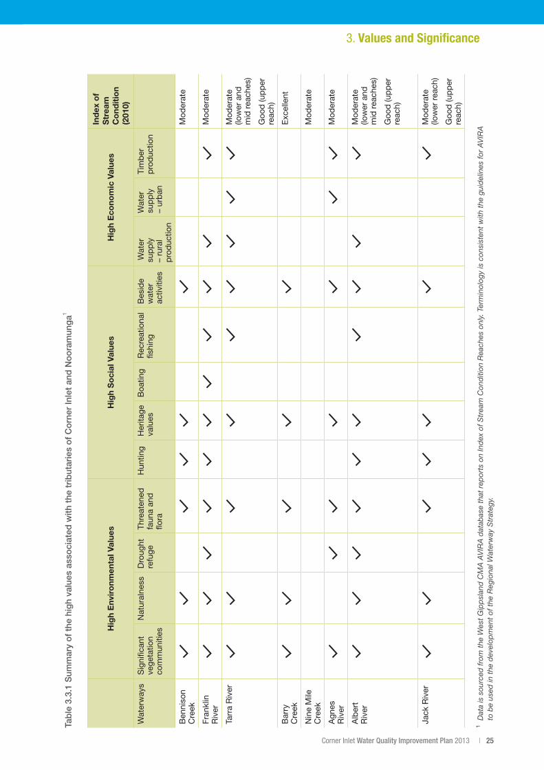
3.3 Values of the tributary waterwaysThe waterways that flow into Corner Inlet and Nooramunga have environmental, social and economic values in their own right.
The Franklin and Agnes Rivers have high economic values that include the supply of water for agricultural production. The estuary of the Franklin River is associated with commercial fishing and tourism.
The Agnes River Falls are the highest single-span falls in Victoria and are a popular destination for picnicking and sight-seeing. Below the falls the Agnes River flows through a gorge before making its way through farmland to Corner Inlet. At the top of the falls, off-take is diverted to a water treatment plant that provides potable water for many towns in the surrounding district.
The upper reach of the Tarra River flows through a National Park and reserve where there are camping and recreational opportunities along its banks. The Tarra River provides water for the township of Yarram and agricultural production in the district.
The Jack and Albert Rivers flow from forested areas in the Strzelecki Range, through farmland that supports dairy, beef and sheep enterprises. The Hiawatha Falls are locally important for site-seeing. The Jack and Albert Rivers have significant remnant vegetation in the upper sections and numerous tributary waterways. The Jack and Albert Rivers, combined, have the highest catchment area in Corner Inlet and Nooramunga and are subject to erosion processes particularly in the mid reaches. There is an avulsion risk just upstream of the current confluence of the two rivers that has the potential to liberate a large amount of sediment to Corner Inlet.
In the far east of the catchment, Bruthen Creek has undergone significant changes in physical form as a result of clearing and dredging and draining of swamps and continues to undergo active erosion. The estuary of Bruthen Creek flows out at McLoughlins Beach and is associated with the high recreational use of this area including boating, fishing and camping.
The Western Tributaries and Bennison and Stockyard Creeks are short waterways that drain through farmland before entering Corner Inlet in the west of the catchment. Stockyard Creek flows through the township of Foster and is valued for its scenic amenity.
A number of other smaller waterways including Nine Mile Creek, Muddy Creek and Shady Creek flow to Corner Inlet through farmland and coastal wetland vegetation. In addition, several small waterways including Barry Creek flow into Corner Inlet from the northern coastline of Wilsons Promontory. See figure 2.1.2.
TheenvironmentalconditionofwaterwaysinCornerInletandNooramungawasassessedin2010aspartof the state-wide Index of Stream Condition (ISC) program. This program assessed the majority of the tributary waterways as being in moderate condition, with three reaches in good condition (Tarra, Albert and Jack Rivers) and one reach in excellent condition (Barry Creek). Those reaches in moderate condition were largely located in areas of agricultural use or production forestry and had impacts to their hydrology, riparian vegetation, water quality and aquatic biodiversity. The reaches in good and excellent condition were located in areas of public land and were ranked highly across all metrics of the ISC.
The West Gippsland Regional Waterway Strategy (in development) will address the management of these waterways through a prioritised eight-year work program. A summary of the high values associated with themajorcatchmentwaterwaysofCornerInletandNooramungaisprovidedintable3.3.1.
Left: Aboriginal grinding grooves. Photo – WGCMA.
Right: Freshwater shell midden. Photo – WGCMA.
Corner Inlet Water Quality Improvement Plan 2013 | 25
Hig
h E
nvir
onm
enta
l Val
ues
Hig
h S
oci
al V
alue
sH
igh
Eco
nom
ic V
alue
s
Ind
ex o
f S
trea
m
Co
ndit
ion
(201
0)
Wat
erw
ays
Sig
nific
ant
vege
tatio
n co
mm
uniti
es
Nat
ural
ness
Dro
ught
re
fuge
Thre
aten
ed
faun
a an
d
flora
Hun
ting
Her
itage
va
lues
Boa
ting
Rec
reat
iona
l fis
hing
Bes
ide
wat
er
activ
ities
Wat
er
sup
ply
–
rura
l p
rod
uctio
n
Wat
er
sup
ply
–
urb
an
Tim
ber
p
rod
uctio
n
Ben
niso
n C
reek
Mod
erat
e
Fran
klin
R
iver
Mod
erat
e
Tarr
a R
iver
Mod
erat
e (lo
wer
and
m
id r
each
es)
Goo
d (u
pp
er
reac
h)
Bar
ry
Cre
ekE
xcel
lent
Nin
e M
ile
Cre
ekM
oder
ate
Agn
es
Riv
erM
oder
ate
Alb
ert
Riv
erM
oder
ate
(low
er a
nd
mid
rea
ches
)
Goo
d (u
pp
er
reac
h)
Jack
Riv
erM
oder
ate
(low
er r
each
)
Goo
d (u
pp
er
reac
h)
1D
ata
is s
ourc
ed fr
om t
he W
est
Gip
psl
and
CM
A A
VIR
A d
atab
ase
that
rep
orts
on
Ind
ex o
f Str
eam
Con
diti
on R
each
es o
nly.
Ter
min
olog
y is
con
sist
ent
with
the
gui
del
ines
for
AV
IRA
to
be
used
in t
he d
evel
opm
ent
of t
he R
egio
nal W
ater
way
Str
ateg
y.
3. Values and Significance
Tab
le 3
.3.1
Sum
mar
y o
f th
e hi
gh
valu
es a
sso
ciat
ed w
ith t
he t
rib
utar
ies
of
Co
rner
Inle
t an
d N
oo
ram
ung
a1
26 | Corner Inlet Connections
3.4 Values of the surrounding catchmentMany people connect with Corner Inlet and its catchment because of its unique, fertile landscape and its important environmental values. With national parks, waterways, farmland and coast, the areas surrounding Corner Inlet are a place of natural beauty, productivity and internationally recognised environmental values.
This diverse combination of natural features makes it an attraction for tourists and the number of visitors from Australia and overseas increases each year.
The northern coastline of Wilsons Promontory National Park, which forms the southern border of the Corner Inlet catchment, is ecologically significant and popular with tourists.
To the north of the catchment, the Strzelecki Range supports old-growth Mountain Ash and Myrtle Beech forest and the genetically unique Strzelecki Koala. The ranges are significant for their cool temperate rainforests, most notably Tarra Bulga National Park, which present an array of activities for tourists to enjoy, including native bird watching, walks and picnic areas. Pockets of warm temperate rainforest still remain in the Strzelecki Range.
Vegetation communities closer to the coast, such as mangroves and coastal saltmarsh, provide shelter and feeding and breeding habitat for a range of wildlife such as a range of migratory and resident waterbirds and the endangered Orange-bellied Parrot. Coastal vegetation is also of high value as it helps protect the coastlinefromerosion(Gedanet.al.,2011).
Fauna including the South Gippsland Spiny Crayfish, River Blackfish and Australian Grayling are recorded in the major waterways that drain to Corner Inlet. Other native fish including Australian Smelt, Tupong, Southern Pygmy Perch, Estuary Perch and Short-finned Eels have also been recorded in the Agnes and TarraRivers(DSE,2009).
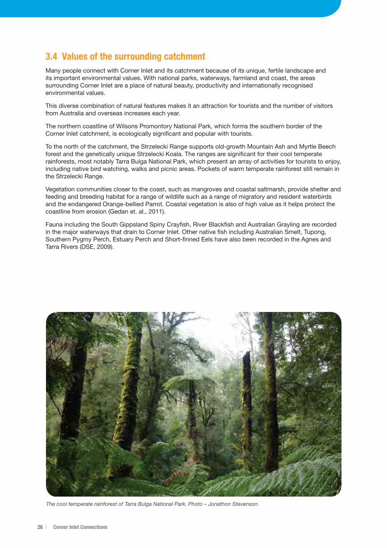
The cool temperate rainforest of Tarra Bulga National Park. Photo – Jonathon Stevenson.
Corner Inlet Water Quality Improvement Plan 2013 | 27
4. Hydrology and Water Quality4.1 Catchment hydrologyRainfall in the catchment of Corner Inlet varies significantly from north to south, and to a lesser extent west toeast,witharangefrom800mmto1250mmperannum.Theobserveddailyrainfallinthecatchmentcanbe highly variable in response to weather patterns including east coast lows and south-westerly fronts. As aresult,streamhydrologyisalsohighlyvariableintimeandspace(BMTWBM,2011).
Flow in the short permanent waterways of the Corner Inlet catchment is ‘flashy’ in the sense that the waterways respond very quickly to heavy rainfall due to their small catchment areas and relatively short riverlength(Alluvium,2008;AustralianGovernment,2011).Flowsarestronglyseasonal,withhighflowsinwinter-spring(August-September)andlowflowsinsummer(WaterTechnology,2008).Highflowsmayflush the estuarine reaches of the waterways of all salt water, and import large volumes of freshwater, sedimentandnutrientstotheembayment(WaterTechnology,2008).
The catchments that drain to Corner Inlet have higher flows than those flowing to Nooramunga. Average annualinflowstoCornerInlet(105,000ML/yr)areaboutoneandahalftimestheinflowstoNooramunga(77,000ML/yr).Thisislargelyduetohigherrainfallinthewesternendofthecatchment,butgeologicalandtopographic differences are also likely to be contributing factors.
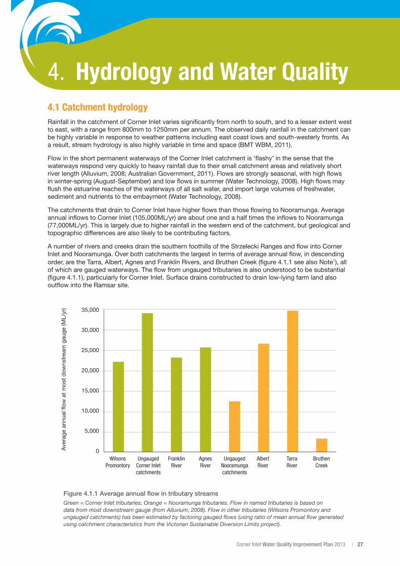
A number of rivers and creeks drain the southern foothills of the Strzelecki Ranges and flow into Corner Inlet and Nooramunga. Over both catchments the largest in terms of average annual flow, in descending order,aretheTarra,Albert,AgnesandFranklinRivers,andBruthenCreek(figure4.1.1seealsoNote1), all of which are gauged waterways. The flow from ungauged tributaries is also understood to be substantial (figure4.1.1),particularlyforCornerInlet.Surfacedrainsconstructedtodrainlow-lyingfarmlandalsooutflow into the Ramsar site.
Figure 4.1.1 Average annual flow in tributary streams Green = Corner Inlet tributaries; Orange = Nooramunga tributaries. Flow in named tributaries is based on data from most downstream gauge (from Alluvium, 2008). Flow in other tributaries (Wilsons Promontory and ungauged catchments) has been estimated by factoring gauged flows (using ratio of mean annual flow generated using catchment characteristics from the Victorian Sustainable Diversion Limits project).
35,000
30,000
25,000
20,000
15,000
10,000
5,000
0Wilsons
PromontoryUngauged
Corner Inlet catchments
Ave
rage
ann
ual �
ow a
t m
ost
dow
nstr
eam
gau
ge (M
L/yr
)
Franklin River
Agnes River
Ungauged Nooramunga catchments
Albert River
Tarra River
Bruthen Creek
28 | Corner Inlet Connections
The frequency of high flow events resulting from rainfall is an important factor for catchment hydrology and theresultingwaterquality.Thefrequencyofsuchevents,wheremeandailyflowis>100ML/day,intheAgnesandTarraRiverswereanalysedfortheperiod1987-2006toinformthedevelopmentoftheCornerInletcatchmentmodel.Theanalysisshowedthathighfloweventscommonlyoccurbetweensixand14times per year.
During the period analysed, the frequency of high flow events declined in line with increased drought conditionsinthemid2000swithonlytwohighfloweventsrecordedin2006(WaterTechnology,2008).AsoutlinedintheReasonableAssuranceStatement(Section12)themodelwascalibratedinarelativelydryperiod(1997-2006)andtherewasacknowledgementthathighflow(andthereforehighload)eventswerenot captured and, as such, the nutrient loads from the calibrated model have been under-estimated.
Intheyearssince2006,highwinterandspringrainfallhasre-establishedandwithitanincreasedfrequency of high flow events, likely resulting in higher loads of sediment and nutrient to the Corner Inlet Ramsar Site.
Note1 – The surface water inflows reported here are based on data from the lowest active gauge in each catchment. While the total annual surface water inflow to Corner Inlet and Nooramunga is very similar to that estimated by the catchment modelling undertaken for the study area (182,775 ML/yr and 181,770 ML/yr respectively), the proportion of these inflows contributed by the various individual streams differs significantly. For example: the highest contributing stream based on gauge data, the Tarra River (34,804ML/yr) (figure 3), is estimated to be the third largest contributor by the catchment model (19,995ML/yr). The second highest contributing stream, the Albert River (26,718ML/yr) (figure 3), is estimated by the catchment model to be the highest contributor (47,260ML/yr). This could be due in part to some gauges being located relatively high in their catchments, therefore not capturing all tributaries e.g. Albert River at Hiawatha.
4.2 GroundwaterGroundwater may contribute flows to the Corner Inlet Ramsar Site either directly as a groundwater discharge into the marine embayment or indirectly via discharge to inflowing streams. Little is known about directgroundwaterdischargetoCornerInletandNooramunga.Slomp&VanCappellen(2004)concludedthat “submarine groundwater discharges were most important in shallow, permeable aquifers comprised of sands or limestone”, which is a category that most of the aquifers surrounding Corner Inlet fall into, ”with highratesofgroundwaterrecharge”(Adamset.al.,2008).Anestimateofdirectgroundwaterdischargeto Corner Inlet, made to inform the development of the catchment model of the study area, was that groundwatercontributedabout10%oftotalannualmodelledsurfacerunoff(WaterTechnology,2008).
The Latrobe Group Aquifer (LGA) underlies the Corner Inlet catchment and contains significant volumes of goodqualitywaterthatisusedpredominatelyforirrigation(approximately11,300ML/year)aroundthetownofYarram(SRW,2010).Afurther110,000ML/yearisextractedthroughoff-shoreoilandgasproduction(CSIRO,2004).Evidencesuggeststhatthisoff-shoreextractionhasmadeasignificantandconsistentcontributiontodeclineingroundwaterlevelson-shore,withlevelsdroppingbyanaverageof1m/yearoverthelastfewdecades(SRW,2010).
The declining groundwater levels in the LGA are linked to a reduction in base flows to a number of streams acrosstheCornerInletcatchment,wheretheaquiferoutcropsorisclosetothesurface(SKM,2005).Thisincludes the southern edges of the Strzelecki Ranges north of Yarram, where the aquifer is intersected by the Tarra, Jack and Albert Rivers. Work is currently underway through the Department of Environment and Primary Industries to quantify the extent and magnitude of these base flow reductions.
While total annual direct groundwater discharge to Corner Inlet and Nooramunga may be insignificant relative to total annual surface water inflows, groundwater contribution to river base-flows may be significant during periods of low surface water flows, and direct groundwater discharge could be of localised importance in some areas. Increased groundwater salinity (resulting from seawater intrusion), reduced base-flows and coastal subsidence, are potential consequences of declining groundwater levels that are of relevance to the long-term environmental condition of the Corner Inlet Ramsar Site.
Corner Inlet Water Quality Improvement Plan 2013 | 29
4.3 Embayment hydrodynamicsThe majority of the area of Corner Inlet and Nooramunga is made up of shallow marine waters and of intertidal flats, with the remainder being barrier islands and fringing wetlands, some of which may be inundated by marine waters during the very highest tides or during storm surges. The intertidal area of the Corner Inlet Ramsar Site is dissected by a network of channels that drain and fill via five permanent entrances that allow exchange with Bass Strait.
Hydrodynamicmodellingcompletedin2008indicatesthattheembaymentiswellflushedwithmorethan60%ofwatervolumeexchangedoveranaveragetidecycle(WaterTechnology,2008).Thereisvariability, with Corner Inlet being much better flushed than Nooramunga. This is a function of the fast draining channels between the intertidal flats in Corner Inlet compared with the network of barrier islands in Nooramunga. This results in very low residence times in Corner Inlet, perhaps only a few tidal cycles, where as in Nooramunga it is estimated to be up to a week.
In addition, the hydrodynamic modelling results indicate that:
• Morethan40%oftheareaoftheCornerInletRamsarSiteisexposedduringatypicalspringlowtide. Not all of the intertidal flats are exposed due to their flat slope and because of friction there is insufficient time during a tide cycle for all the water to drain completely before the next incoming tide.
• ExchangedoesoccurbetweenCornerInletandNooramunga,particularlythroughLewisChannelbetween Port Welshpool and Little Snake Island.
Asimulationlinkingcatchmentandreceivingwaters(hydrodynamic)modelswasalsocompletedin2008(WaterTechnology,2008).Thesimulationincludedrepresentationsoftide,windandriverflowconditions,and the use a simple tracer to follow river flows as they enter the embayment. The simulation did not consider mixing, settling or ecological processes.
The simulation indicated that the zones of influence for each river outlet were limited to localised regions and the river flows (and their sediment and nutrient load) diluted very quickly upon entering the embayment.
Whilst the modelling results are understandably a simplified representation of a very complex environment, theyalignwithinvestigations(CEC,2008;McLeanandJones,2011)intosedimentcharacteristicswithinCorner Inlet and Nooramunga, which reported that as described in Section 4.4.
4. Hydrology and Water Quality
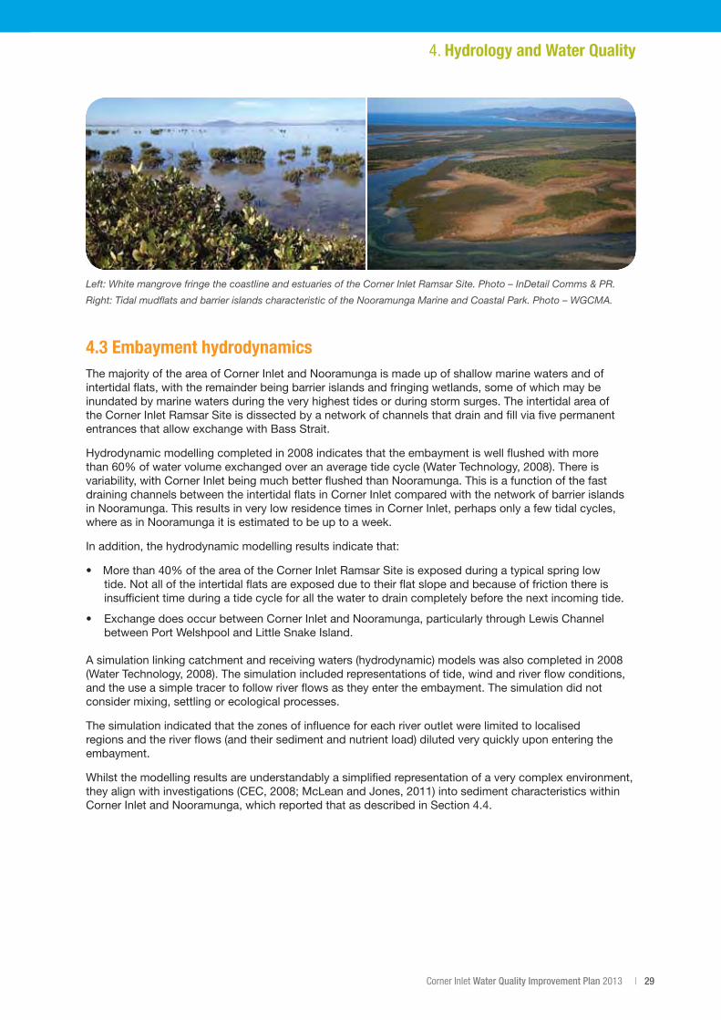
Left: White mangrove fringe the coastline and estuaries of the Corner Inlet Ramsar Site. Photo – InDetail Comms & PR.
Right: Tidal mudflats and barrier islands characteristic of the Nooramunga Marine and Coastal Park. Photo – WGCMA.
30 | Corner Inlet Connections
4.4 Water quality issuesLocal community members, farmers, commercial fishers and natural resource management (NRM) agencies working within Corner Inlet and Nooramunga have long been concerned that nutrient and sediment flowing into the embayment may be putting seagrass meadows and other habitats, including mangroves, mudflats and saltmarsh, at risk.
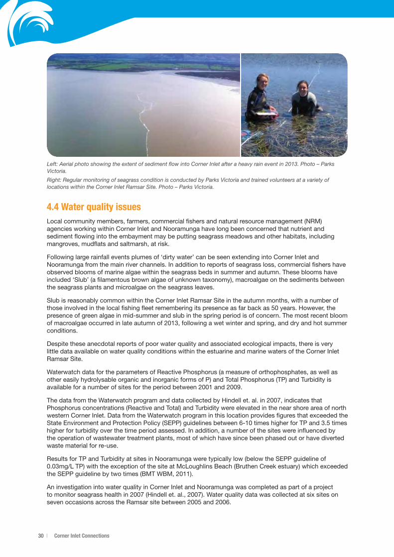
Following large rainfall events plumes of ‘dirty water’ can be seen extending into Corner Inlet and Nooramunga from the main river channels. In addition to reports of seagrass loss, commercial fishers have observed blooms of marine algae within the seagrass beds in summer and autumn. These blooms have included ‘Slub’ (a filamentous brown algae of unknown taxonomy), macroalgae on the sediments between the seagrass plants and microalgae on the seagrass leaves.
Slub is reasonably common within the Corner Inlet Ramsar Site in the autumn months, with a number of thoseinvolvedinthelocalfishingfleetrememberingitspresenceasfarbackas50years.However,thepresence of green algae in mid-summer and slub in the spring period is of concern. The most recent bloom ofmacroalgaeoccurredinlateautumnof2013,followingawetwinterandspring,anddryandhotsummerconditions.
Despite these anecdotal reports of poor water quality and associated ecological impacts, there is very little data available on water quality conditions within the estuarine and marine waters of the Corner Inlet Ramsar Site.
Waterwatch data for the parameters of Reactive Phosphorus (a measure of orthophosphates, as well as other easily hydrolysable organic and inorganic forms of P) and Total Phosphorus (TP) and Turbidity is availableforanumberofsitesfortheperiodbetween2001and2009.
ThedatafromtheWaterwatchprogramanddatacollectedbyHindellet.al.in2007,indicatesthatPhosphorus concentrations (Reactive and Total) and Turbidity were elevated in the near shore area of north western Corner Inlet. Data from the Waterwatch program in this location provides figures that exceeded the StateEnvironmentandProtectionPolicy(SEPP)guidelinesbetween6-10timeshigherforTPand3.5timeshigher for turbidity over the time period assessed. In addition, a number of the sites were influenced by the operation of wastewater treatment plants, most of which have since been phased out or have diverted waste material for re-use.
Results for TP and Turbidity at sites in Nooramunga were typically low (below the SEPP guideline of 0.03mg/LTP)withtheexceptionofthesiteatMcLoughlinsBeach(BruthenCreekestuary)whichexceededtheSEPPguidelinebytwotimes(BMTWBM,2011).
An investigation into water quality in Corner Inlet and Nooramunga was completed as part of a project tomonitorseagrasshealthin2007(Hindellet.al.,2007).WaterqualitydatawascollectedatsixsitesonsevenoccasionsacrosstheRamsarsitebetween2005and2006.
Left: Aerial photo showing the extent of sediment flow into Corner Inlet after a heavy rain event in 2013. Photo – Parks Victoria.
Right: Regular monitoring of seagrass condition is conducted by Parks Victoria and trained volunteers at a variety of locations within the Corner Inlet Ramsar Site. Photo – Parks Victoria.
Corner Inlet Water Quality Improvement Plan 2013 | 31
The key findings relating to water quality were:
• ThesurfacewaterswithintheembaymentofCornerInletandNooramungaareusuallyofocean-water salinity, except for short periods in summer when evaporation can cause salinities to slightly exceed those of sea water. Nutrient sampling undertaken through this project indicates that Phosphate concentrations were typically quite low (consistent with Waterwatch observations), however elevated Nitrogenconcentrations(ammoniumandnitrate/nitrite)wereapparent,particularlyaroundYanakiebutalso around Port Franklin, Foster and Welshpool. The levels of ammonium in water samples at some sitesweremorethan20timestheSEPPguidelineforestuaries.
• NutrientlevelsthroughoutCornerInletandNooramungawerelowerthanthoserecordedintheGippsland Lakes, but significantly higher than those found in Port Phillip Bay.
• MetalsandpesticidesdonotappeartobesignificantissuesinCornerInletandNooramunga.
Sediment analysis within Corner Inlet and Nooramunga was undertaken by the University of Wollongong in 2011(McLeanandJones,2011).Thisanalysisfoundthat:
• DepositionofclaysandsiltstakesplacemainlyintheupperestuarinereachesofthetributariesofCorner Inlet and Nooramunga, prior to entering the embayment.
• Finesedimentthatenterstheembaymentduringhighflowsdoesnotsettleintheenergeticmainchannels and sandflats and is only found in backwater areas.
• SedimentswithinCornerInletandNooramungaallfallwithintheANZECCguidelinesforsedimentquality.
The absence of long-term water quality data for the marine waters of Corner Inlet and Nooramunga makes it difficult to determine the level of change in water quality conditions over time and the relationship this has with the issues observed by members of the local community. Given the importance of the Corner Inlet Ramsar Site, the degree of data available and community observations, there is cause for concern about maintaining values.
4.5 Current catchment water quality statusThestatusofwaterqualityintheCornerInletcatchmentwasreportedin2010fortheCornerInletCatchmentConditionReport(WGCMAandHyder,2010).Waterqualityobjectivesforindividualparametersare set in the State Environment Protection Policy (SEPP) Waters of Victoria. Trigger limits (guidelines) are set within the SEPP based on accepted ranges and minimum and percentile values for sampling sites over theperiodofayear(WGCMAandHyder,2010).
Water quality data for the Corner Inlet catchment can be summarised as:
• Dissolvedoxygencouldonlybeassessedatfiveofapotential12sitesduetoinsufficientdata.TheSEPP objectives for dissolved oxygen were not met at any of the five eligible sites.
• SEPPobjectivesforTotalPhosphoruswerenotmetatanyofthesitesintheFranklinandAgnesRiversand Bennison Creek.
• TherewasinsufficientdatatomakeconclusionsregardingTotalNitrogen.
• WaterqualityintheCornerInletcatchmentisgenerallybetterintheuppercatchmentareasanddeteriorates downstream.
• SEPPobjectivesforpHweremetatallsamplingsites.
Data from Nooramunga Corner Inlet Community Water Monitoring Project was utilised to assess attainmentofSEPPobjectivesforwaterqualityparametersatselectedsitesduring2008.Itshouldbenotedthat2008wasaparticularlydryyearwithhightemperaturesandlowrainfall,whichisuncharacteristic for the region. In addition, the results do not provide for the influence of rainfall events on waterquality.ItispossiblethattheSEPPlevelsareexceededmorethanindicatedinfigure4.5.1becauseof the acknowledged lack of capture data for high flow events in water quality monitoring.
4. Hydrology and Water Quality
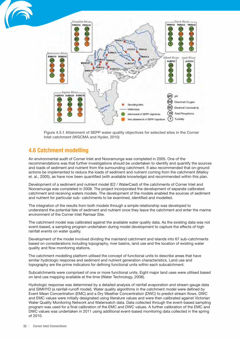
32 | Corner Inlet Connections
Figure 4.5.1 Attainment of SEPP water quality objectives for selected sites in the Corner Inlet catchment (WGCMA and Hyder, 2010)
4.6 Catchment modellingAnenvironmentalauditofCornerInletandNooramungawascompletedin2005.Oneoftherecommendations was that further investigations should be undertaken to identify and quantify the sources and loads of sediment and nutrient from the surrounding catchment. It also recommended that on-ground actions be implemented to reduce the loads of sediment and nutrient coming from the catchment (Malloy et.al.,2005),ashavenowbeenquantified(withavailableknowledge)andrecommendedwithinthisplan.
Developmentofasedimentandnutrientmodel(E2/WaterCast)ofthecatchmentsofCornerInletandNooramungawascompletedin2008.Theprojectincorporatedthedevelopmentofseparatecalibratedcatchment and receiving waters models. The development of the models enabled the sources of sediment and nutrient for particular sub- catchments to be examined, identified and modelled.
The integration of the results from both models through a simple relationship was developed to understand the potential fate of sediment and nutrient once they leave the catchment and enter the marine environment of the Corner Inlet Ramsar Site.
The catchment model was calibrated against the available water quality data. As the existing data was not event-based, a sampling program undertaken during model development to capture the effects of high rainfall events on water quality.
Developmentofthemodelinvolveddividingthemainlandcatchmentandislandsinto67sub-catchmentsbased on considerations including topography, river basins, land use and the location of existing water quality and flow monitoring stations.
The catchment modelling platform utilised the concept of functional units to describe areas that have similar hydrologic response and sediment and nutrient generation characteristics. Land use and topography are the prime indicators for defining functional units within each subcatchment.
Subcatchments were comprised of one or more functional units. Eight major land uses were utilised based onlandusemappingavailableatthetime(WaterTechnology,2008).
Hydrologic response was determined by a detailed analysis of rainfall evaporation and stream gauge data and SIMHYD (a rainfall-runoff model). Water quality algorithms in the catchment model were defined by Event Mean Concentration (EMC) and a Dry Weather Concentration (DWC) to predict stream flows. DWC and EMC values were initially designated using literature values and were then calibrated against Victorian Water Quality Monitoring Network and Waterwatch data. Data collected through the event-based sampling program was used for a final calibration of the EMC and DWC values. A further calibration of the EMC and DWCvalueswasundertakenin2011usingadditionalevent-basedmonitoringdatacollectedinthespringof2010.
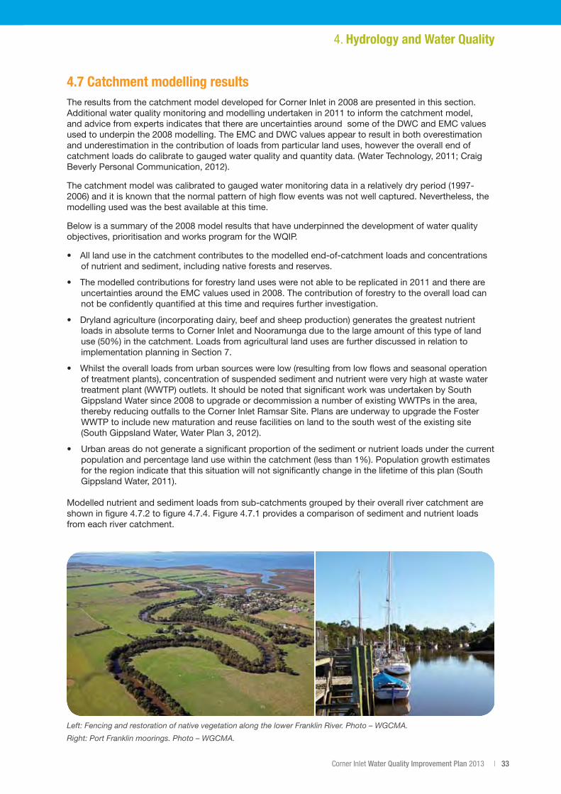
Corner Inlet Water Quality Improvement Plan 2013 | 33
4.7 Catchment modelling results TheresultsfromthecatchmentmodeldevelopedforCornerInletin2008arepresentedinthissection.Additionalwaterqualitymonitoringandmodellingundertakenin2011toinformthecatchmentmodel,and advice from experts indicates that there are uncertainties around some of the DWC and EMC values usedtounderpinthe2008modelling.TheEMCandDWCvaluesappeartoresultinbothoverestimationand underestimation in the contribution of loads from particular land uses, however the overall end of catchmentloadsdocalibratetogaugedwaterqualityandquantitydata.(WaterTechnology,2011;CraigBeverlyPersonalCommunication,2012).
Thecatchmentmodelwascalibratedtogaugedwatermonitoringdatainarelativelydryperiod(1997-2006)anditisknownthatthenormalpatternofhighfloweventswasnotwellcaptured.Nevertheless,themodelling used was the best available at this time.
Belowisasummaryofthe2008modelresultsthathaveunderpinnedthedevelopmentofwaterqualityobjectives, prioritisation and works program for the WQIP.
• Alllanduseinthecatchmentcontributestothemodelledend-of-catchmentloadsandconcentrationsof nutrient and sediment, including native forests and reserves.
• Themodelledcontributionsforforestrylanduseswerenotabletobereplicatedin2011andthereareuncertaintiesaroundtheEMCvaluesusedin2008.Thecontributionofforestrytotheoverallloadcannot be confidently quantified at this time and requires further investigation.
• Drylandagriculture(incorporatingdairy,beefandsheepproduction)generatesthegreatestnutrientloads in absolute terms to Corner Inlet and Nooramunga due to the large amount of this type of land use(50%)inthecatchment.LoadsfromagriculturallandusesarefurtherdiscussedinrelationtoimplementationplanninginSection7.
• Whilsttheoverallloadsfromurbansourceswerelow(resultingfromlowflowsandseasonaloperationof treatment plants), concentration of suspended sediment and nutrient were very high at waste water treatment plant (WWTP) outlets. It should be noted that significant work was undertaken by South GippslandWatersince2008toupgradeordecommissionanumberofexistingWWTPsinthearea,thereby reducing outfalls to the Corner Inlet Ramsar Site. Plans are underway to upgrade the Foster WWTP to include new maturation and reuse facilities on land to the south west of the existing site (SouthGippslandWater,WaterPlan3,2012).
• Urbanareasdonotgenerateasignificantproportionofthesedimentornutrientloadsunderthecurrentpopulationandpercentagelandusewithinthecatchment(lessthan1%).Populationgrowthestimatesfor the region indicate that this situation will not significantly change in the lifetime of this plan (South GippslandWater,2011).
Modelled nutrient and sediment loads from sub-catchments grouped by their overall river catchment are showninfigure4.7.2tofigure4.7.4.Figure4.7.1providesacomparisonofsedimentandnutrientloadsfrom each river catchment.
4. Hydrology and Water Quality
Left: Fencing and restoration of native vegetation along the lower Franklin River. Photo – WGCMA.
Right: Port Franklin moorings. Photo – WGCMA.
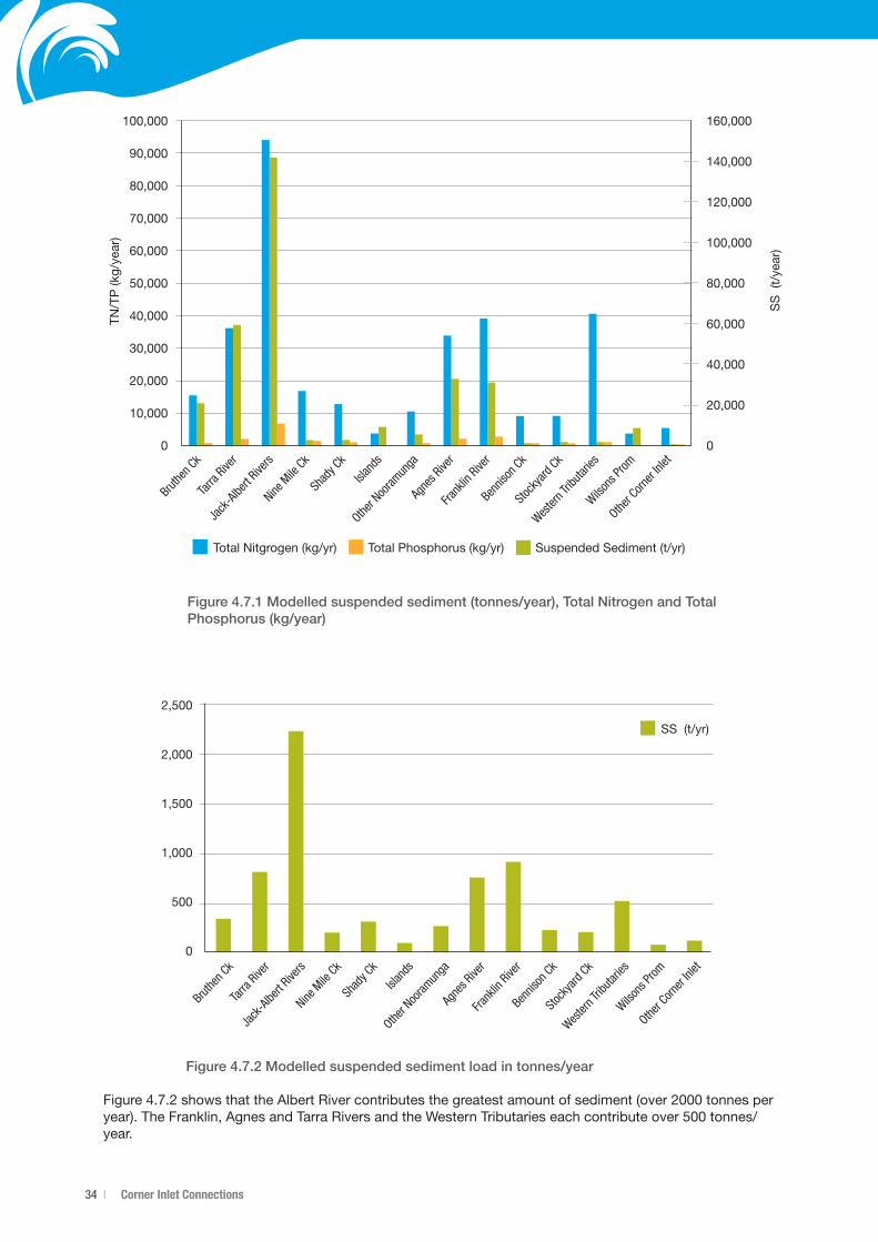
34 | Corner Inlet Connections
Figure 4.7.2 Modelled suspended sediment load in tonnes/year
Figure4.7.2showsthattheAlbertRivercontributesthegreatestamountofsediment(over2000tonnesperyear).TheFranklin,AgnesandTarraRiversandtheWesternTributarieseachcontributeover500tonnes/year.
Figure 4.7.1 Modelled suspended sediment (tonnes/year), Total Nitrogen and Total Phosphorus (kg/year)
100,000
90,000
80,000
70,000
60,000
50,000
40,000
30,000
20,000
10,000
0
160,000
140,000
120,000
100,000
80,000
60,000
40,000
20,000
0
Bruthe
n Ck
Tarra
River
Jack
-Albe
rt Rive
rsNine
Mile
CkSh
ady C
kIsl
ands
Other N
ooram
unga
Agne
s Rive
rFra
nklin
River
Bennis
on Ck
Stock
yard
Ck
Wester
n Trib
utarie
sWils
ons P
romOthe
r Corn
er Inl
et
TN/T
P (k
g/ye
ar)
SS
(t/
year
)
Total Nitgrogen (kg/yr) Total Phosphorus (kg/yr) Suspended Sediment (t/yr)
2,500
2,000
1,500
1,000
500
0
Bruthe
n Ck
Tarra
River
Jack
-Albe
rt Rive
rsNine
Mile
CkSh
ady C
kIsl
ands
Other N
ooram
unga
Agne
s Rive
rFra
nklin
River
Bennis
on Ck
Stock
yard
Ck
Wester
n Trib
utarie
sWils
ons P
romOthe
r Corn
er Inl
et
SS (t/yr)
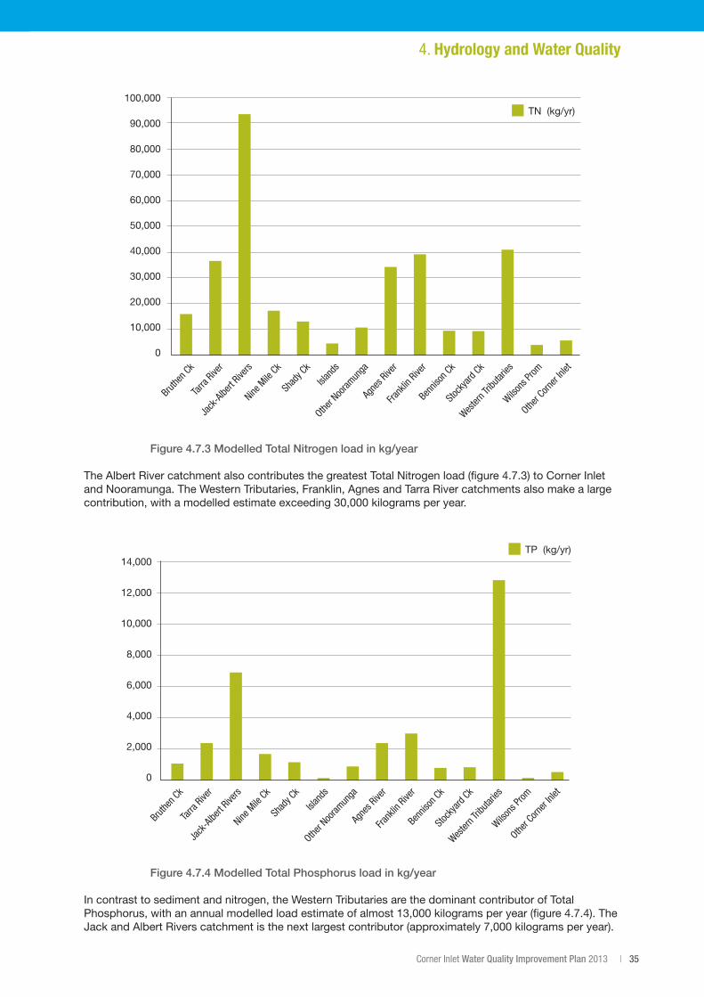
Corner Inlet Water Quality Improvement Plan 2013 | 35
Figure 4.7.3 Modelled Total Nitrogen load in kg/year
TheAlbertRivercatchmentalsocontributesthegreatestTotalNitrogenload(figure4.7.3)toCornerInletand Nooramunga. The Western Tributaries, Franklin, Agnes and Tarra River catchments also make a large contribution,withamodelledestimateexceeding30,000kilogramsperyear.
Figure 4.7.4 Modelled Total Phosphorus load in kg/year
In contrast to sediment and nitrogen, the Western Tributaries are the dominant contributor of Total Phosphorus,withanannualmodelledloadestimateofalmost13,000kilogramsperyear(figure4.7.4).TheJackandAlbertRiverscatchmentisthenextlargestcontributor(approximately7,000kilogramsperyear).
4. Hydrology and Water Quality
100,000
90,000
80,000
70,000
60,000
50,000
40,000
30,000
20,000
10,000
0
Bruthe
n Ck
Tarra
River
Jack
-Albe
rt Rive
rsNine
Mile
CkSh
ady C
kIsl
ands
Other N
ooram
unga
Agne
s Rive
rFra
nklin
River
Bennis
on Ck
Stock
yard
Ck
Wester
n Trib
utarie
sWils
ons P
romOthe
r Corn
er Inl
et
TN (kg/yr)
14,000
12,000
10,000
8,000
6,000
4,000
2,000
0
Bruthe
n Ck
Tarra
River
Jack
-Albe
rt Rive
rsNine
Mile
CkSh
ady C
kIsl
ands
Other N
ooram
unga
Agne
s Rive
rFra
nklin
River
Bennis
on Ck
Stock
yard
Ck
Wester
n Trib
utarie
sWils
ons P
romOthe
r Corn
er Inl
etTP (kg/yr)
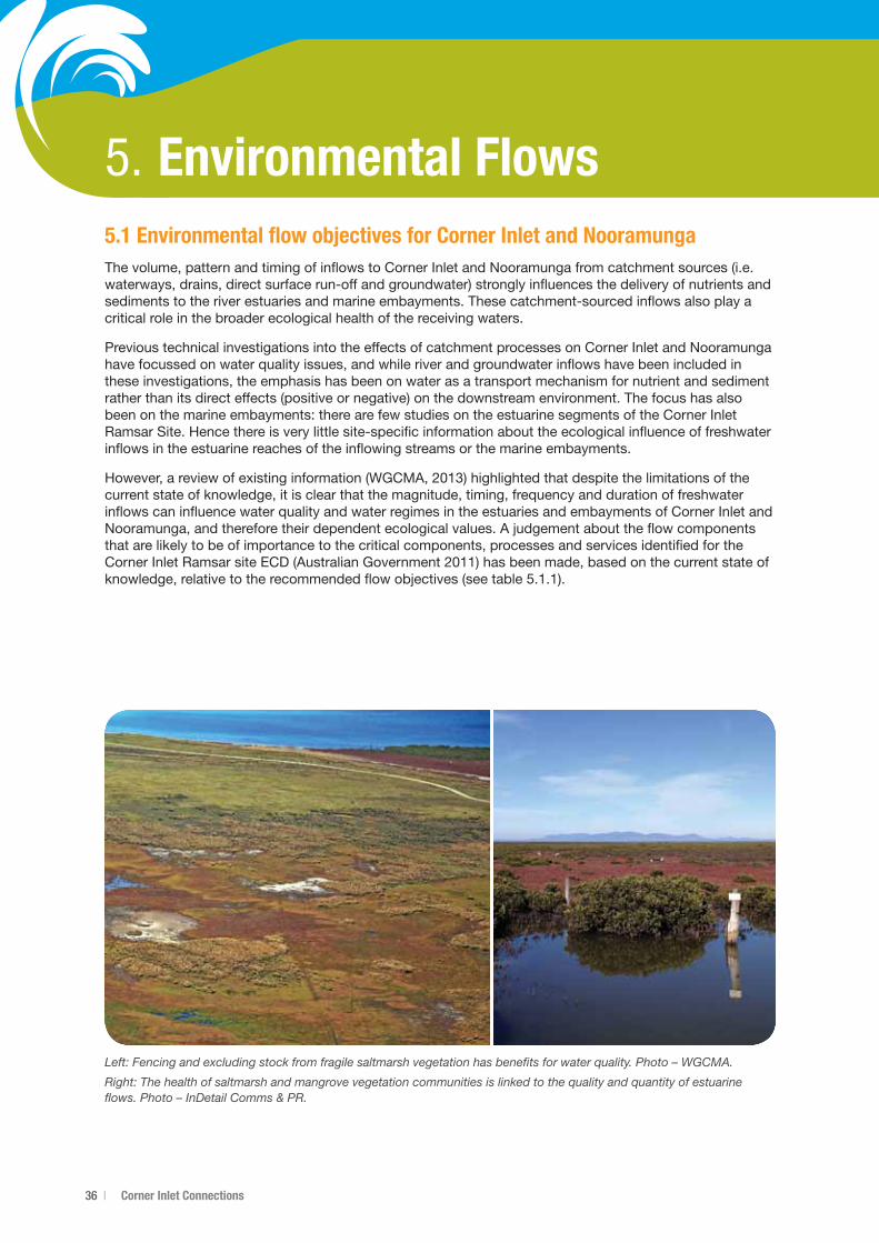
36 | Corner Inlet Connections
5. Environmental Flows5.1 Environmental flow objectives for Corner Inlet and NooramungaThe volume, pattern and timing of inflows to Corner Inlet and Nooramunga from catchment sources (i.e. waterways, drains, direct surface run-off and groundwater) strongly influences the delivery of nutrients and sediments to the river estuaries and marine embayments. These catchment-sourced inflows also play a critical role in the broader ecological health of the receiving waters.
Previous technical investigations into the effects of catchment processes on Corner Inlet and Nooramunga have focussed on water quality issues, and while river and groundwater inflows have been included in these investigations, the emphasis has been on water as a transport mechanism for nutrient and sediment rather than its direct effects (positive or negative) on the downstream environment. The focus has also been on the marine embayments: there are few studies on the estuarine segments of the Corner Inlet Ramsar Site. Hence there is very little site-specific information about the ecological influence of freshwater inflows in the estuarine reaches of the inflowing streams or the marine embayments.
However,areviewofexistinginformation(WGCMA,2013)highlightedthatdespitethelimitationsofthecurrent state of knowledge, it is clear that the magnitude, timing, frequency and duration of freshwater inflows can influence water quality and water regimes in the estuaries and embayments of Corner Inlet and Nooramunga, and therefore their dependent ecological values. A judgement about the flow components that are likely to be of importance to the critical components, processes and services identified for the CornerInletRamsarsiteECD(AustralianGovernment2011)hasbeenmade,basedonthecurrentstateofknowledge,relativetotherecommendedflowobjectives(seetable5.1.1).
Left: Fencing and excluding stock from fragile saltmarsh vegetation has benefits for water quality. Photo – WGCMA.
Right: The health of saltmarsh and mangrove vegetation communities is linked to the quality and quantity of estuarine flows. Photo – InDetail Comms & PR.
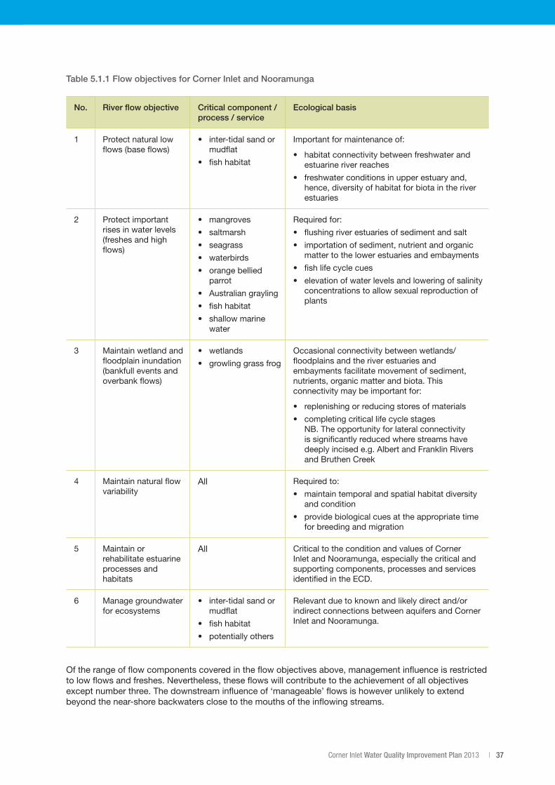
Corner Inlet Water Quality Improvement Plan 2013 | 37
Table 5.1.1 Flow objectives for Corner Inlet and Nooramunga
No. River flow objective Critical component / process / service
Ecological basis
1 Protect natural low flows (base flows)
• inter-tidalsandormudflat
• fishhabitat
Important for maintenance of:
• habitatconnectivitybetweenfreshwaterandestuarine river reaches
• freshwaterconditionsinupperestuaryand,hence, diversity of habitat for biota in the river estuaries
2 Protect important rises in water levels (freshes and high flows)
• mangroves
• saltmarsh
• seagrass
• waterbirds
• orangebelliedparrot
• Australiangrayling
• fishhabitat
• shallowmarinewater
Required for:
• flushingriverestuariesofsedimentandsalt
• importationofsediment,nutrientandorganicmatter to the lower estuaries and embayments
• fishlifecyclecues
• elevationofwaterlevelsandloweringofsalinityconcentrations to allow sexual reproduction of plants
3 Maintain wetland and floodplain inundation (bankfull events and overbank flows)
• wetlands
• growlinggrassfrog
Occasionalconnectivitybetweenwetlands/floodplains and the river estuaries and embayments facilitate movement of sediment, nutrients, organic matter and biota. This connectivity may be important for:
• replenishingorreducingstoresofmaterials
• completingcriticallifecyclestages NB. The opportunity for lateral connectivity is significantly reduced where streams have deeply incised e.g. Albert and Franklin Rivers and Bruthen Creek
4 Maintain natural flow variability
All Required to:
• maintaintemporalandspatialhabitatdiversityand condition
• providebiologicalcuesattheappropriatetimefor breeding and migration
5 Maintain or rehabilitate estuarine processes and habitats
All Critical to the condition and values of Corner Inlet and Nooramunga, especially the critical and supporting components, processes and services identified in the ECD.
6 Manage groundwater for ecosystems
• inter-tidalsandormudflat
• fishhabitat
• potentiallyothers
Relevantduetoknownandlikelydirectand/orindirect connections between aquifers and Corner Inlet and Nooramunga.
Of the range of flow components covered in the flow objectives above, management influence is restricted to low flows and freshes. Nevertheless, these flows will contribute to the achievement of all objectives except number three. The downstream influence of ‘manageable’ flows is however unlikely to extend beyond the near-shore backwaters close to the mouths of the inflowing streams.
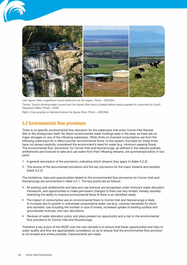
38 | Corner Inlet Connections
5.2 Environmental flow provisionsThere is no specific environmental flow allocation for the waterways that enter Corner Inlet Ramsar Site or the embayment itself. No direct environmental water holdings exist in the area, as there are no major storages on any of the inflowing waterways. While limits on licensed consumptive use from the inflowing waterways do in effect provide ‘environmental flows’ to the system, the basis for these limits have not always explicitly considered the environment’s need for water (e.g. minimum passing flows). The environmental flow ‘provisions’ for Corner Inlet and Nooramunga, as defined in the relevant policies, entitlements and licences to take and use water from their inflowing streams, are summarised below in two parts:
1. Ageneraldescriptionoftheprovisions,indicatingwhichstreamstheyapplyto(table5.2.2).
2. The source of the documented provisions and the key provisions for the major streams and aquifers (table5.2.3).
The limitations, risks and opportunities related to the environmental flow provisions for Corner Inlet and Nooramungaaresummarisedintable5.2.1.Thekeypointsareasfollows:
• AllexistingbulkentitlementsandtakeanduselicencesarerecognisedunderVictoria’swaterallocationframework, and opportunities to make permanent changes to them are very limited, thereby severely restricting the ability to improve environmental flows (if there is an identified need).
• TheimpactofconsumptiveuseonenvironmentalflowstoCornerInletandNooramungaislikelyto increase due to growth in unlicensed consumptive water use (e.g. volumes harvested for stock and domestic use including the number or size of bores), increased uptake of existing surface and groundwater licences, and new allocations.
• Reviewsofwaterallocationpolicyandplanspresentanopportunityandarisktotheenvironmentalflow provisions for Corner Inlet and Nooramunga.
Therefore a key action of the WQIP over the next decade is to ensure that these opportunities and risks to water quality and flow are appropriately considered, so as to ensure that the environmental flow provision is not eroded and where possible, improvements are made.
Left: Agnes Falls, a significant tourist attraction for the region. Photo – WGCMA.
Centre: Toora’s drinking water comes from the Agnes River and is treated before being supplied to customers by South Gippsland Water. Photo – SGW.
Right: Cows grazing on farmland above the Agnes River. Photo – WGCMA.
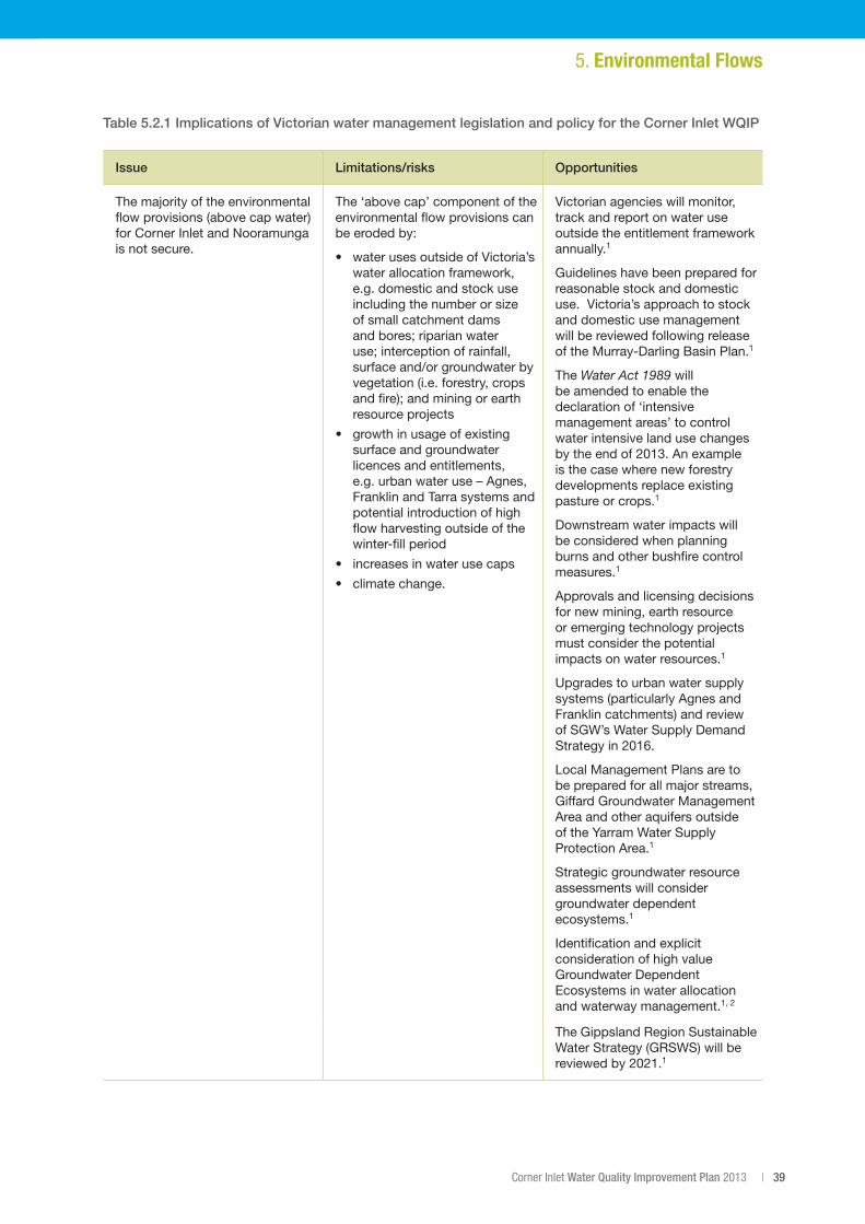
Corner Inlet Water Quality Improvement Plan 2013 | 39
Table 5.2.1 Implications of Victorian water management legislation and policy for the Corner Inlet WQIP
Issue Limitations/risks Opportunities
The majority of the environmental flow provisions (above cap water) for Corner Inlet and Nooramunga is not secure.
The ‘above cap’ component of the environmental flow provisions can be eroded by:
• waterusesoutsideofVictoria’swater allocation framework, e.g. domestic and stock use including the number or size of small catchment dams and bores; riparian water use; interception of rainfall, surfaceand/orgroundwaterbyvegetation (i.e. forestry, crops and fire); and mining or earth resource projects
• growthinusageofexistingsurface and groundwater licences and entitlements, e.g. urban water use – Agnes, Franklin and Tarra systems and potential introduction of high flow harvesting outside of the winter-fill period
• increasesinwaterusecaps
• climatechange.
Victorian agencies will monitor, track and report on water use outside the entitlement framework annually.1
Guidelines have been prepared for reasonable stock and domestic use. Victoria’s approach to stock and domestic use management will be reviewed following release of the Murray-Darling Basin Plan.1
The Water Act 1989 will be amended to enable the declaration of ‘intensive management areas’ to control water intensive land use changes bytheendof2013.Anexampleis the case where new forestry developments replace existing pasture or crops.1
Downstream water impacts will be considered when planning burns and other bushfire control measures.1
Approvals and licensing decisions for new mining, earth resource or emerging technology projects must consider the potential impacts on water resources.1
Upgrades to urban water supply systems (particularly Agnes and Franklin catchments) and review of SGW’s Water Supply Demand Strategyin2016.
Local Management Plans are to be prepared for all major streams, Giffard Groundwater Management Area and other aquifers outside of the Yarram Water Supply Protection Area.1
Strategic groundwater resource assessments will consider groundwater dependent ecosystems.1
Identification and explicit consideration of high value Groundwater Dependent Ecosystems in water allocation and waterway management.1,2
The Gippsland Region Sustainable Water Strategy (GRSWS) will be reviewedby2021.1
5. Environmental Flows

40 | Corner Inlet Connections
Issue Limitations/risks Opportunities
The ability to modify existing bulk entitlement/licencerulesandoil/gasextractionlicences,andtherefore freshwater inflows to Corner Inlet and Nooramunga, is very limited.
Bulk entitlements issued under the Water Act 1989 can only be permanently changed at the request of the bulk entitlement holder,orfollowingastatutory15year water resource review.
Take and use licences issued under the Water Act 1989 can only be amended when they are due for renewal, through a statutory management plan or followinga15yearwaterresourcereview.
A statutory review of water availability in Victoria is required in2019.
Improving knowledge of groundwater-surface water interaction and the effects of declining water levels in the Latrobe Group Aquifer (LGA) on stream flow in the Yarram Water Supply Protection Area (WSPA).
The need for a review of the Yarram WSPA monitoring program and/orgroundwatermanagementplan is considered annually by SRW.
The Victorian Government will advocateforoil/gasextractionenvironment plans to be revised if significant new risks are identified, including risks associated with the LGA.1
A lack of quantitative knowledge of site specific relationships between inflows and aquatic species and communities (including ecological thresholds) for Corner Inlet and Nooramunga.
This prohibits an understanding of the effects of current and future wateruse/managementonCornerInlet and Nooramunga and their inflowing streams.
Revised winter-fill caps and reviewofthesein20211 provides time to improve flow-ecology understanding and, in the interim, places the onus on those seeking greater volumes to undertake detailed assessments.
An approved method for determining the environmental flow requirements of Victorian estuaries now exists.2
The GRSWS will be reviewed by 2021.1
1 Policy/actions contained within the Gippsland Region Sustainable Water Strategy (DSE 2011) 2 Policy/actions contained within the draft Victorian Waterway Management Strategy (DSE 2012)
Continued from page 39... Table 5.2.1 Implications of Victorian water management legislation and policy for the Corner Inlet WQIP
Left: The upper catchment of the Jack and Albert Rivers. Photo – Sally-Anne Henderson.
Right: Canoeists paddling the lower reach of the Albert River. Photo – WGCMA.
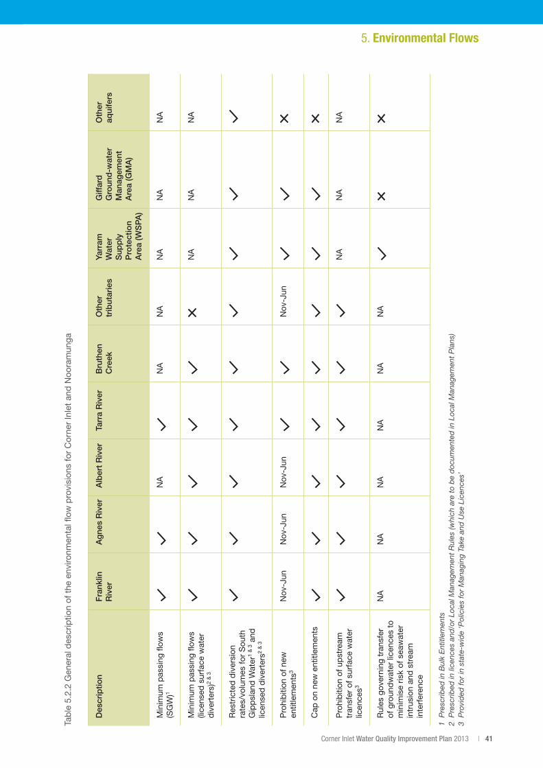
Corner Inlet Water Quality Improvement Plan 2013 | 41
Table5.2.2G
eneraldes
criptio
nofthe
env
ironm
entalfl
owprovision
sforCorne
rInletan
dNoo
ramun
ga
Des
crip
tion
Fra
nklin
R
iver
Ag
nes
Riv
erA
lber
t R
iver
Tarr
a R
iver
Bru
then
C
reek
Oth
er
trib
utar
ies
Yarr
am
Wat
er
Sup
ply
P
rote
ctio
n A
rea
(WS
PA
)
Giff
ard
G
roun
d-w
ater
M
anag
emen
t A
rea
(GM
A)
Oth
er
aqui
fers
Min
imum
pas
sing
flow
s (S
GW
)1N
AN
AN
AN
AN
AN
A
Min
imum
pas
sing
flow
s (li
cens
ed s
urfa
ce w
ater
d
iver
ters
)2&3
NA
NA
NA
Res
tric
ted
div
ersi
on
rates/vo
lumes
forSou
th
Gip
psl
and
Wat
er1&3 a
nd
licen
sed
div
erte
rs2&3
Pro
hib
ition
of n
ew
entit
lem
ents
3N
ov-J
unN
ov-J
unN
ov-J
unN
ov-J
un
Cap
on
new
ent
itlem
ents
Pro
hib
ition
of u
pst
ream
tr
ansf
er o
f sur
face
wat
er
licen
ces3
NA
NA
NA
Rul
es g
over
ning
tra
nsfe
r of
gro
und
wat
er li
cenc
es t
o m
inim
ise
risk
of s
eaw
ater
in
trus
ion
and
str
eam
in
terf
eren
ce
NA
NA
NA
NA
NA
NA
1 P
resc
ribed
in B
ulk
Ent
itlem
ents
2
Pre
scrib
ed in
lice
nces
and
/or
Loca
l Man
agem
ent
Rul
es (w
hich
are
to
be
doc
umen
ted
in L
ocal
Man
agem
ent
Pla
ns)
3 P
rovi
ded
for
in s
tate
-wid
e ‘P
olic
ies
for
Man
agin
g Ta
ke a
nd U
se L
icen
ces’
5. Environmental Flows
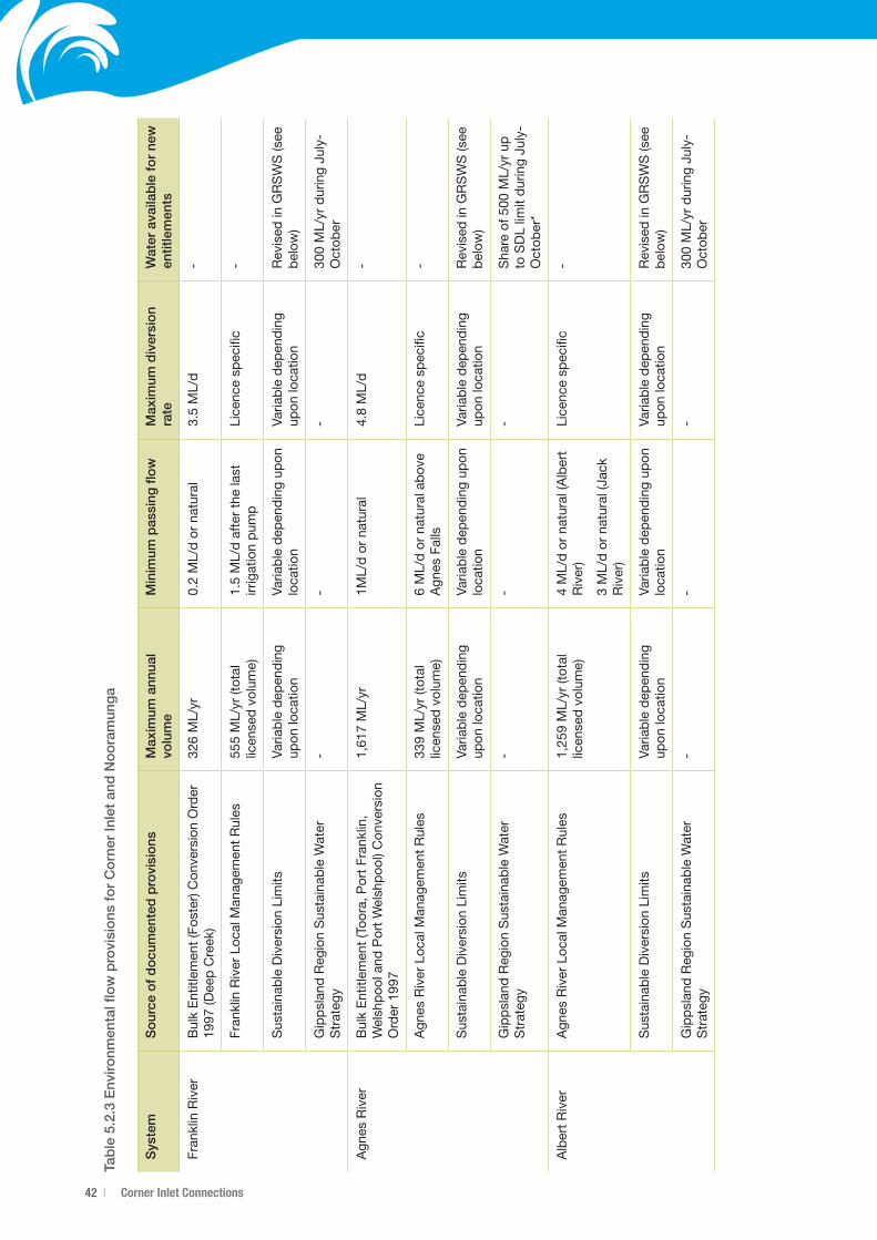
42 | Corner Inlet Connections
Tab
le 5
.2.3
Env
ironm
enta
l flo
w p
rovi
sio
ns f
or
Co
rner
Inle
t an
d N
oo
ram
ung
a
Sys
tem
So
urce
of
do
cum
ente
d p
rovi
sio
nsM
axim
um a
nnua
l vo
lum
eM
inim
um p
assi
ng fl
ow
Max
imum
div
ersi
on
rate
Wat
er a
vaila
ble
fo
r ne
w
entit
lem
ents
Fran
klin
Riv
erB
ulk
Ent
itlem
ent
(Fos
ter)
Con
vers
ion
Ord
er
1997
(Dee
pC
reek
)32
6ML/yr
0.2ML/dorna
tural
3.5ML/d
-
Fran
klin
Riv
er L
ocal
Man
agem
ent
Rul
es55
5ML/yr(total
licen
sed
vol
ume)
1.5ML/dafterthe
last
irrig
atio
n p
ump
Lice
nce
spec
ific
-
Sus
tain
able
Div
ersi
on L
imits
V aria
ble
dep
end
ing
upon
loca
tion
Varia
ble
dep
end
ing
upon
lo
catio
nVa
riab
le d
epen
din
g up
on lo
catio
n R
evis
ed in
GR
SW
S (s
ee
bel
ow)
Gip
psl
and
Reg
ion
Sus
tain
able
Wat
er
Str
ateg
y-
--
300ML/yrduringJu
ly-
Oct
ober
Agn
es R
iver
Bul
k E
ntitl
emen
t (T
oora
, Por
t Fr
ankl
in,
Wel
shp
ool a
nd P
ort
Wel
shp
ool)
Con
vers
ion
Order199
7
1,61
7ML/yr
1ML/dorna
tural
4.8ML/d
-
Agn
es R
iver
Loc
al M
anag
emen
t R
ules
339ML/yr(total
licen
sed
vol
ume)
6ML/dorna
turala
bov
eA
gnes
Fal
lsLi
cenc
e sp
ecifi
c-
Sus
tain
able
Div
ersi
on L
imits
Varia
ble
dep
end
ing
upon
loca
tion
Varia
ble
dep
end
ing
upon
lo
catio
nVa
riab
le d
epen
din
g up
on lo
catio
n R
evis
ed in
GR
SW
S (s
ee
bel
ow)
Gip
psl
and
Reg
ion
Sus
tain
able
Wat
er
Str
ateg
y-
--
Sha
reof5
00M
L/yrup
to S
DL
limit
dur
ing
July
-O
ctob
er*
Alb
ert
Riv
erA
gnes
Riv
er L
ocal
Man
agem
ent
Rul
es1,25
9 ML/yr(total
licen
sed
vol
ume)
4ML/dorna
tural(Albert
Riv
er)
3ML/dorna
tural(Ja
ck
Riv
er)
Lice
nce
spec
ific
-
Sus
tain
able
Div
ersi
on L
imits
Varia
ble
dep
end
ing
upon
loca
tion
Varia
ble
dep
end
ing
upon
lo
catio
nVa
riab
le d
epen
din
g up
on lo
catio
n R
evis
ed in
GR
SW
S (s
ee
bel
ow)
Gip
psl
and
Reg
ion
Sus
tain
able
Wat
er
Str
ateg
y-
--
300 ML/yrduringJu
ly-
Oct
ober
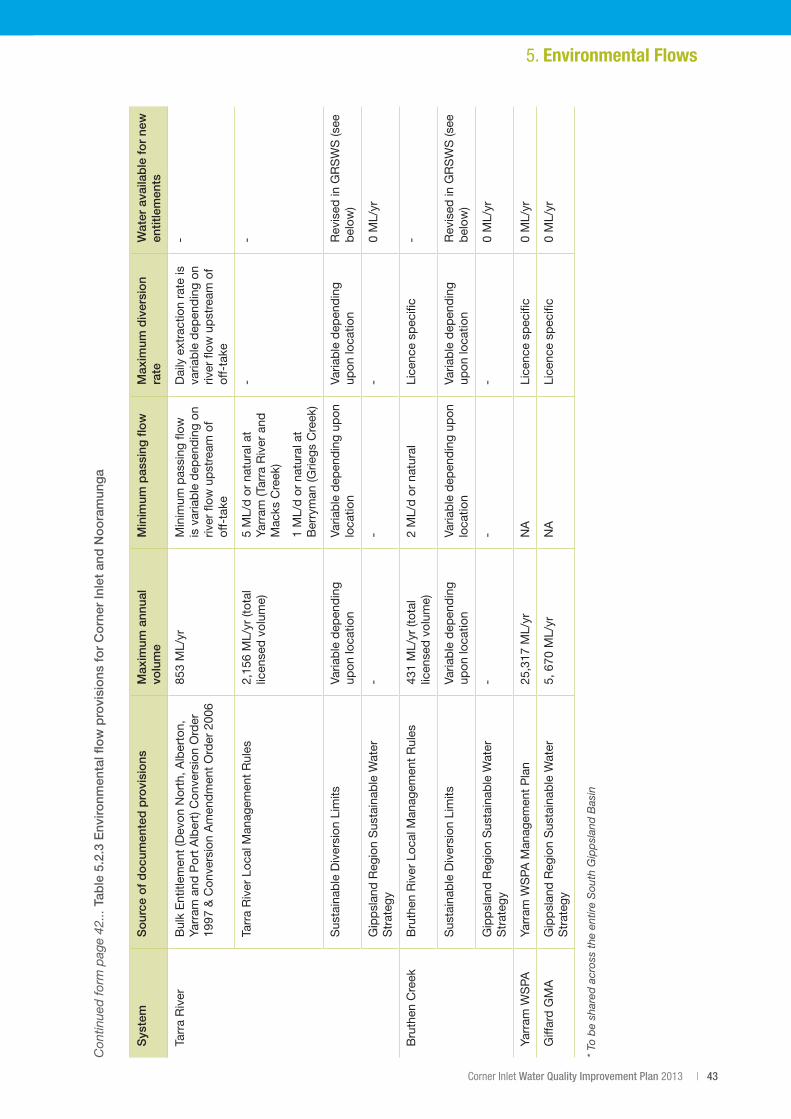
Corner Inlet Water Quality Improvement Plan 2013 | 43
Sys
tem
So
urce
of
do
cum
ente
d p
rovi
sio
nsM
axim
um a
nnua
l vo
lum
eM
inim
um p
assi
ng fl
ow
Max
imum
div
ersi
on
rate
Wat
er a
vaila
ble
fo
r ne
w
entit
lem
ents
Tarr
a R
iver
Bul
k E
ntitl
emen
t (D
evon
Nor
th, A
lber
ton,
Ya
rram
and
Por
t A
lber
t) C
onve
rsio
n O
rder
19
97&C
onve
rsionAmen
dmen
tOrder200
6
853ML/yr
Min
imum
pas
sing
flow
is
var
iab
le d
epen
din
g on
riv
er fl
ow u
pst
ream
of
off-
take
Dai
ly e
xtra
ctio
n ra
te is
va
riab
le d
epen
din
g on
riv
er fl
ow u
pst
ream
of
off-
take
-
Tarr
a R
iver
Loc
al M
anag
emen
t R
ules
2,15
6ML/yr(total
licen
sed
vol
ume)
5ML/dorna
turala
tYa
rram
(Tar
ra R
iver
and
M
acks
Cre
ek)
1ML/dorna
turala
tB
erry
man
(Grie
gs C
reek
)
--
Sus
tain
able
Div
ersi
on L
imits
Varia
ble
dep
end
ing
upon
loca
tion
Varia
ble
dep
end
ing
upon
lo
catio
nVa
riab
le d
epen
din
g up
on lo
catio
nR
evis
ed in
GR
SW
S (s
ee
bel
ow)
Gip
psl
and
Reg
ion
Sus
tain
able
Wat
er
Str
ateg
y-
--
0ML/yr
Bru
then
Cre
ekB
ruth
en R
iver
Loc
al M
anag
emen
t R
ules
431ML/yr(total
licen
sed
vol
ume)
2ML/dorna
tural
Lice
nce
spec
ific
-
Sus
tain
able
Div
ersi
on L
imits
Varia
ble
dep
end
ing
upon
loca
tion
Varia
ble
dep
end
ing
upon
lo
catio
nVa
riab
le d
epen
din
g up
on lo
catio
nR
evis
ed in
GR
SW
S (s
ee
bel
ow)
Gip
psl
and
Reg
ion
Sus
tain
able
Wat
er
Str
ateg
y-
--
0ML/yr
Yarr
am W
SPA
Yarr
am W
SPA
Man
agem
ent
Pla
n25
,317
ML/yr
NA
Lice
nce
spec
ific
0ML/yr
Giff
ard
GM
AG
ipp
slan
d R
egio
n S
usta
inab
le W
ater
S
trat
egy
5,670
ML/yr
NA
Lice
nce
spec
ific
0ML/yr
* To
be
shar
ed a
cros
s th
e en
tire
Sou
th G
ipp
slan
d B
asin
Con
tinue
d fo
rm p
age
42...
Tab
le 5
.2.3
Env
ironm
enta
l flo
w p
rovi
sio
ns f
or
Co
rner
Inle
t an
d N
oo
ram
ung
a
5. Environmental Flows
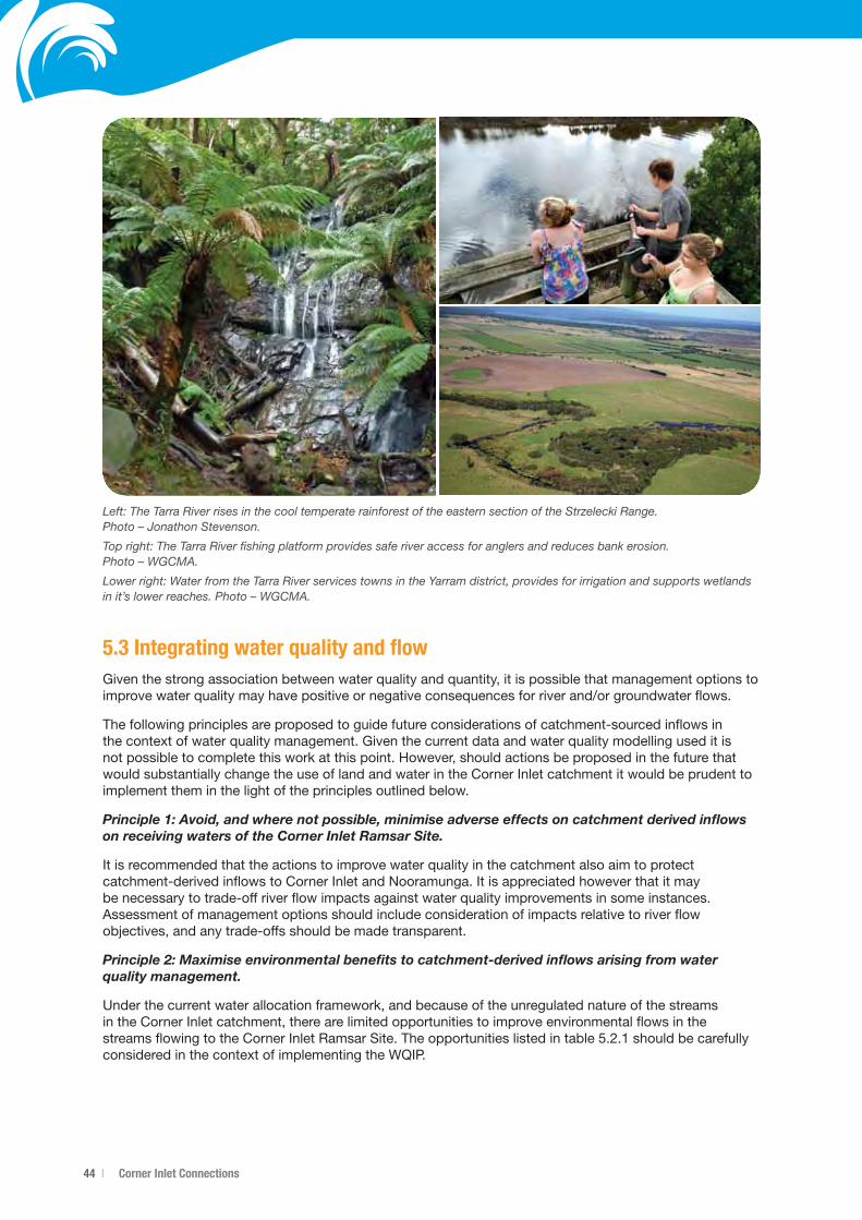
44 | Corner Inlet Connections
5.3 Integrating water quality and flowGiven the strong association between water quality and quantity, it is possible that management options to improvewaterqualitymayhavepositiveornegativeconsequencesforriverand/orgroundwaterflows.
The following principles are proposed to guide future considerations of catchment-sourced inflows in the context of water quality management. Given the current data and water quality modelling used it is not possible to complete this work at this point. However, should actions be proposed in the future that would substantially change the use of land and water in the Corner Inlet catchment it would be prudent to implement them in the light of the principles outlined below.
Principle 1: Avoid, and where not possible, minimise adverse effects on catchment derived inflows on receiving waters of the Corner Inlet Ramsar Site.
It is recommended that the actions to improve water quality in the catchment also aim to protect catchment-derived inflows to Corner Inlet and Nooramunga. It is appreciated however that it may be necessary to trade-off river flow impacts against water quality improvements in some instances. Assessment of management options should include consideration of impacts relative to river flow objectives, and any trade-offs should be made transparent.
Principle 2: Maximise environmental benefits to catchment-derived inflows arising from water quality management.
Under the current water allocation framework, and because of the unregulated nature of the streams in the Corner Inlet catchment, there are limited opportunities to improve environmental flows in the streamsflowingtotheCornerInletRamsarSite.Theopportunitieslistedintable5.2.1shouldbecarefullyconsidered in the context of implementing the WQIP.
Left: The Tarra River rises in the cool temperate rainforest of the eastern section of the Strzelecki Range. Photo – Jonathon Stevenson.
Top right: The Tarra River fishing platform provides safe river access for anglers and reduces bank erosion. Photo – WGCMA.
Lower right: Water from the Tarra River services towns in the Yarram district, provides for irrigation and supports wetlands in it’s lower reaches. Photo – WGCMA.
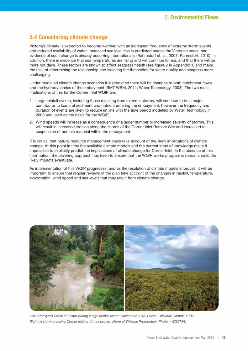
Corner Inlet Water Quality Improvement Plan 2013 | 45
5.4 Considering climate changeVictoria’s climate is expected to become warmer, with an increased frequency of extreme storm events and reduced availability of water. Increased sea level rise is predicted across the Victorian coast, and evidenceofsuchchangeisalreadyoccurringinternationally(Rahmstorfet.al.,2007;Rahmstorf,2010).Inaddition, there is evidence that sea temperatures are rising and will continue to rise, and that there will be morehotdays.Thesefactorsareknowntoaffectseagrasshealth(seefigure2inAppendix1)andmakethe task of determining the relationship and isolating the thresholds for water quality and seagrass more challenging.
Under modelled climate change scenarios it is predicted there will be changes to both catchment flows andthehydrodynamicsoftheembayment(BMTWBM,2011;WaterTechnology,2008).Thetwomainimplications of this for the Corner Inlet WQIP are:
1. Largerainfallevents,includingthoseresultingfromextremestorms,willcontinuetobeamajorcontributor to loads of sediment and nutrient entering the embayment, however the frequency and duration of events are likely to reduce (in line with the time period modelled by Water Technology in 2008andusedasthebasisfortheWQIP).
2. Wind speeds will increase as a consequence of a larger number or increased severity of storms. This will result in increased erosion along the shores of the Corner Inlet Ramsar Site and increased re-suspension of benthic material within the embayment.
It is critical that natural resource management plans take account of the likely implications of climate change. At this point in time the available climate models and the current state of knowledge make it impossible to explicitly predict the implications of climate change for Corner Inlet. In the absence of this information, the planning approach has been to ensure that the WQIP works program is robust should the likely impacts eventuate.
As implementation of this WQIP progresses, and as the resolution of climate models improves, it will be important to ensure that regular reviews of the plan take account of the changes in rainfall, temperature, evaporation, wind speed and sea levels that may result from climate change.
5. Environmental Flows
Left: Stockyard Creek in Foster during a high rainfall event, November 2013. Photo – InDetail Comms & PR.
Right: A storm crossing Corner Inlet and the northern shore of Wilsons Promontory. Photo – WGCMA.
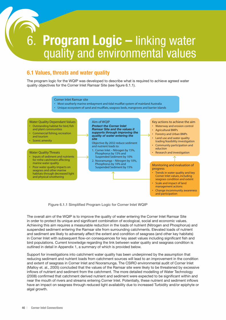
46 | Corner Inlet Connections
6. Program Logic – linking water quality and environmental values6.1 Values, threats and water quality The program logic for the WQIP was developed to describe what is required to achieve agreed water qualityobjectivesfortheCornerInletRamsarSite(seefigure6.1.1).
Figure 6.1.1 Simplified Program Logic for Corner Inlet WQIP
The overall aim of the WQIP is to improve the quality of water entering the Corner Inlet Ramsar Site in order to protect its unique and significant combination of ecological, social and economic values. Achieving this aim requires a measurable reduction in the loads of nutrient (Nitrogen and Phosphorus) and suspended sediment entering the Ramsar site from surrounding catchments. Elevated loads of nutrient and sediment are likely to adversely affect the extent and condition of seagrass (and other key habitats) in Corner Inlet with subsequent flow-on consequences for key asset values including significant fish and bird populations. Current knowledge regarding the link between water quality and seagrass condition is outlinedindetailinAppendix1,asummaryofwhichisprovidedbelow.
Support for investigations into catchment water quality has been underpinned by the assumption that reducing sediment and nutrient loads from catchment sources will lead to an improvement in the condition and extent of seagrass in Corner Inlet and Nooramunga. The CSIRO environmental audit of Corner Inlet (Malloyet.al.,2005)concludedthatthevaluesoftheRamsarsitewerelikelytobethreatenedbyexcessiveinflows of nutrient and sediment from the catchment. The more detailed modelling of Water Technology (2008)confirmedthatcatchmentderivednutrientandsedimentwereexpectedtobesignificantwithinandnear the mouth of rivers and streams entering Corner Inlet. Potentially, these nutrient and sediment inflows haveanimpactonseagrassthroughreducedlightavailabilityduetoincreasedTurbidityand/orepiphyteoralgal growth.
Corner Inlet Ramsar site• Most southerly marine embayment and tidal mudflat system of mainland Australia• Unique ecosystem of sand and mudflats, seagrass beds, mangroves and barrier islands
Water Quality Dependant Values• Outstanding habitat for bird, fish
and plant communities• Commercial fishing, recreation
and tourism• Scenic amenity
Water Quality Threats• Inputs of sediment and nutrients
for mthe catchment affecting marine water quality
• Poor water quality impacts on seagrass and other marine habitats through decreased light and physical smothering
Aim of WQIPProtect the Corner Inlet Ramsar Site and the values it supports through improving the quality of water entering the siteObjective: By 2032 reduce sediment and nutrient loads to:1. Corner Inlet – Nitrogen by 15%,
Phosphorus by 15% and Suspended Sediment by 10%
2. Nooramunga – Nitrogen by 10%, Phosphorus by 10% and Suspended Sediment by 15%
Monitoring and evaluation of progress• Trends in water quality and key
Corner Inlet values, including seagrass condition and extent
• Scale and impact of land management actions
• Change incommunity awareness and participation
Key actions to achieve the aim• Waterway and erosion control• Agricultural BMPs• Forestry and Urban BMPs• Land use and water quality
trading feasibility investigation• Community participation and
eduction• Research and investigation
Corner Inlet Water Quality Improvement Plan 2013 | 47
Seagrass is one of a number of wetland mega-habitat types that forms a critical component of the Corner Inlet Ramsar Site, and which underpins critical ecosystem processes and the services and benefits that result(BMTWBM,2011).TheconceptualmodeldevelopedbyWarryandHindell(2009),highlightstheecological importance of seagrass communities for a range of economic, social and environmental values. The model also outlines the deleterious impacts of elevated nutrient and sediment from catchment run-off on these values.
Given all these factors, central to the Program Logic for the Corner Inlet WQIP is a focus on reducing sediment and nutrient loads to the Corner Inlet Ramsar Site in order to maintain and improve the extent and condition of seagrass communities.
Agreed water quality objectives have been based on ‘SMART’ principles; those that are Specific, Measurable, Attainable, Realistic and Time-bound. SMART objectives are required as a basis for linking and quantifying the actions required to achieve specified nutrient and sediment load reductions in the Corner Inlet and Nooramunga catchments. Two decision support tools were used to assess the costs and benefits of reducing water quality threats. These tools, bioeconomic modelling and INFFER (Investment FrameworkforEnvironmentalResources,www.inffer.org,Pannellet.al.,2011)wereimplementedusingavailable scientific, expert and local knowledge (more detail of the approach and results is provided in Section7).
Setting SMART objectives supported an understanding of the scale of works and actions required. It also required definition of clear assumptions about the effectiveness (technical feasibility) of proposed actions including best management practices, waterway and erosion fencing activities and changes in land use if other actions could not meet objectives. The scale of works required to meet these objectives is significant and will require large-scale adoption across the land use areas examined. Therefore the method assumes that payments to farmers would be required in order to recognise lost opportunity costs to production in order to offset profit losses that may result from the implementation of objectives. The INFFER analysis identified the appropriate mix of policy tools required and ensured that the best estimate of costs to achieve specified water quality objectives and to protect the values of the Corner Inlet Ramsar Site was made.
6.2 How the objectives were developed Using available catchment modelling as the baseline information, the SMART objectives were developed basedonthetotalmaximumloadofpollutant/stobeachieved.(Anon.,2002).TheWQIPTechnicalPaneldecided to base the development of water quality objectives on the link between sediment and nutrient (N,P)andseagrassconditionandextent.Asdescribedinsection6.1andAppendix1,seagrassiscentralto the ecology of the Corner Inlet Ramsar Site, and plays a critical role in commercial and recreational fisheries(Kirkman,2013;Poore,1978).Manywaterbirds,includingmigratorywaders,forageinintertidalseagrass beds.
Development of the initial (called ‘aspirational’) water quality objectives by the Technical Panel involved a range of considerations, which were outlined in a discussion paper prepared by the WGCMA (Dickson, 2012,unpublished).Theyinclude:
• Acknowledgementofdifferencesincatchmentcharacteristicsandembaymenthydrodynamicsandtheir potential impacts on seagrass beds. This made it sensible to have different objectives for each of the Nooramunga and Corner Inlet catchment areas of the Ramsar site. Nutrients are likely to be of most concern in Corner Inlet (elevated TP concentrations near seagrass beds in particular), whereas excessive sediment is believed to be of greater concern in Nooramunga.
• Uncertaintyaboutlocation-specificthresholdsandrelationshipsbetweennutrientandsedimentloadreduction and extent and condition of seagrass beds for Corner Inlet and Nooramunga. Whilst there are well-documented relationships between nutrients and seagrass for other sites in Australia and overseas, the Technical Panel felt that such results could not be extrapolated sufficiently well for the Corner Inlet Ramsar Site due to the particular conditions in the embayment and the particular seagrass species present.
• ReferencetootherWaterQualityImprovementPlanswherenutrientreductionobjectivesarecommonlysetabove30%andwithlimitedconsiderationoffeasibilityorcosttoachievetargets.
48 | Corner Inlet Connections
• PreviousINFFERworkdoneintheGippslandLakeswhichshowedthat40%Ploadreductioninvolvedeconomically,sociallyandpoliticallyunacceptablelandusechanges(Robertset.al.,2012).
• KnowledgethattheenvironmentalconditionofCornerInletisbetterthanthatoftheGippslandLakes,with the Corner Inlet Ramsar Site better flushed through tidal exchange. This suggests that lower nutrient reduction objectives than for the Gippsland Lakes are likely to be acceptable for the Corner Inlet Ramsar Site in order to maintain ecological values.
Basedonthis,theTechnicalPanelinitiallyset20-year‘aspirational’objectivesforeachoftheCornerInletand Nooramunga catchments. The aspirational objectives were revised to ‘Implementation Plan’ objectives following bioeconomic modelling and INFFER analysis that estimated that large-scale changes to the composition of land uses would be required to achieve the aspirational objectives.
The results were deemed to be not feasible due to the social and political impacts this would cause and uncertainty around the water quality requirements of the Corner Inlet part of the Ramsar site. Both sets of objectivesareshownbelow.Objectiveshavebeensetasthe%reductionrequiredfrombaselineloads.They are expressed in terms of Total Nitrogen (TN), Total Phosphorus (TP) or Total Suspended Sediment (TSS)estimatedfromtheavailablecatchmentmodellingusingtheE2model(WaterTechnology,2008).
1) Aspirational objectives CornerInlet–30%TN,30%TP,10%TSS;Nooramunga–20%TN,20%TP,20%TSSby2033.
2) Implementation Plan objectives CornerInlet–15%TN,15%TP,10%TSS;Nooramunga–10%TN,10%TP,10%TSSaby2033.
a Notethatfollowingprioritisationandbioeconomicmodelling(seeSection7PrioritisationandCost Benefit results) the Implementation Plan TSS target able to be achieved for Nooramunga was only 5%–allotherobjectiveswerepredictedtobeachievablewiththecostsoutlined.
6.3 The link between values, water quality objectives and program logicAs outlined earlier, central to the Program Logic for the Corner Inlet WQIP is a focus on reducing sediment and nutrient delivery to the Corner Inlet Ramsar Site in order to maintain and improve the extent and condition of seagrass communities. The SMART objectives and the available underpinning science and knowledge base provide the basis for developing a sound and costed project for the Corner Inlet WQIP.
INFFER was used to assess how to achieve objectives that aim to protect the values of the Corner Inlet Ramsar Site from deterioration due to sediment and nutrient loads, primarily from agricultural land use. In additiontothesimplifiedProgramLogicdiagram(Figure6.1.1),thedetailedProgramLogic(figure6.3.1)sets out the links between the values and objectives, along with all other important factors, that need to be considered in the development of a robust project. Unlike many Program Logic approaches where the causal links are loose and unquantified, the relationships between various factors in INFFER are explicit and quantified where appropriate.
Left: Seagrass meadows are a vital part of the Corner Inlet Ramsar Site. Photo – WGCMA.
Right: Six-spined Leatherjacket. Photo – Parks Victoria.
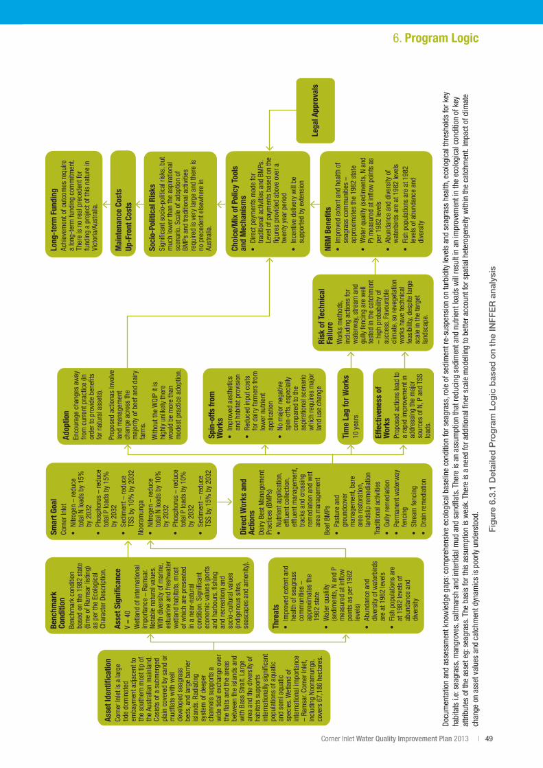
Corner Inlet Water Quality Improvement Plan 2013 | 49
Fig
ure
6.3.
1 D
etai
led
Pro
gra
m L
og
ic b
ased
on
the
INF
FE
R a
naly
sis
6. Program Logic
Asse
t Ide
ntifi
catio
nCo
rner
Inle
t is
a la
rge
tide
dom
inat
ed
emba
ymen
t adj
acen
t to
the
sout
hern
mos
t tip
of
the
Aust
ralia
n m
ainl
and.
Co
sist
s of
a s
ubm
erge
d pl
ain
cove
red
by s
and
or
mud
flats
with
wel
l de
velo
ped
seag
rass
be
ds, a
nd la
rge
barr
ier
isla
nds.
Rad
iatin
g sy
stem
of d
eepe
r ch
anne
ls s
uppo
rts a
w
ide
tidal
exc
hang
e ov
er
the
flats
and
the
area
s be
twee
n th
e is
land
s an
d w
ith B
ass
Stra
it. L
arge
ar
ea a
nd th
e di
vers
ity o
f ha
bita
ts s
uppo
rts
inte
rnat
iona
lly s
igni
fican
t po
pula
tions
of a
quat
ic
and
sem
i aqu
atic
sp
ecie
s. W
etla
nd o
f in
tern
atio
nal i
mpo
rtanc
e –
Ram
sar.
Corn
er In
let,
incl
udin
g No
oram
unga
, co
vers
67,
186
hect
ares
.
Adop
tion
Enco
urag
e ch
ange
s aw
ay
from
cur
rent
pra
ctic
e (in
or
der t
o pr
ovid
e be
nefit
s fo
r nat
ural
ass
ets)
.
Prop
osed
act
iona
s in
volv
e la
nd m
anag
emen
t ch
ange
acr
oss
the
maj
ority
of b
eef a
nd d
airy
fa
rms.
With
out t
he W
QIP
it is
hi
ghly
unl
ikel
y th
ere
wou
ld b
e m
ore
than
m
odes
t pra
ctic
e ad
optio
n.
Effe
ctiv
enes
s of
W
orks
Prop
osed
act
ions
lead
to
a ra
pid
impr
ovem
ent i
n ad
dres
sing
the
maj
or
sour
ces
of N
, P a
nd T
SS
load
s.
Risk
of T
echn
ical
Fa
ilure
Wor
ks m
etho
ds,
incl
udin
g ac
tions
for
wat
erw
ay, s
tream
and
gu
lly fe
ncin
g ar
e w
ell
test
ed in
the
catc
hmen
t –
high
pro
babi
lity
of
succ
ess.
Fav
oura
ble
clim
ate,
so
reve
geta
tion
wor
ks h
ave
tech
nica
l fe
asib
ility
, des
pite
larg
e sc
ale
in th
e ta
rget
la
ndsc
ape.
Long
-ter
m F
undi
ngAc
hiev
emen
t of o
utco
mes
requ
ire
a lo
ng-t
erm
fund
ing
com
mitm
ent.
Ther
e is
no
real
pre
cede
nt fo
r fu
ndin
g a
proj
ect o
f thi
s na
ture
in
Vict
oria
/Aus
tralia
.
Soci
o-Po
litic
al R
isks
Sign
ifica
nt s
ocio
-pol
itica
l ris
ks, b
ut
muc
h lo
wer
than
the
aspi
ratio
nal
scen
ario
. Sca
le o
f ado
ptio
n of
BM
Ps a
nd tr
aditi
onal
act
iviti
es
requ
ired
is v
ery
larg
e an
d th
ere
is
no p
rece
dent
els
ewhe
re in
Au
stra
lia.
Choi
ce/M
ix o
f Pol
icy
Tool
s an
d M
echa
nism
s•
Dire
ct p
aym
ents
mad
e fo
r tra
ditio
nal a
ctiv
ities
and
BM
Ps.
Leve
l of p
aym
ents
bas
ed o
n th
e fig
ures
pro
vide
d ab
ove
over
a
twen
ty y
ear p
erio
d•
Ince
ntiv
e de
liver
y w
ill b
e su
ppor
ted
by e
xten
sion
NRM
Ben
efits
• Im
prov
ed e
xten
t and
hea
lth o
f se
agra
ss c
omm
uniti
es –
ap
prox
imat
es th
e 19
82 s
tate
•
Wat
er q
ualit
y (s
edim
ents
, N a
nd
P) m
easu
red
at in
flow
poi
nts
as
per 1
982
leve
ls•
Abun
danc
e an
d di
vers
ity o
f w
ater
bird
s ar
e at
198
2 le
vels
• Fi
sh p
opul
atio
ns a
re a
t 198
2 le
vels
of a
bund
ance
and
di
vers
ity
Thre
ats
• Im
prov
ed e
xten
t and
he
alth
of s
eagr
ass
com
mun
ities
–
appr
oxim
ates
the
1982
sta
te
• W
ater
qua
liity
(s
edim
ents
, N a
nd P
m
easu
red
at in
flow
po
ints
as
per 1
982
leve
ls)
• Ab
unda
nce
and
dive
rsity
of w
ater
bird
s ar
e at
198
2 le
vels
• Fi
sh p
opul
atio
ns a
re
at 1
982
leve
ls o
f ab
unda
nce
and
dive
rsity
Lega
l App
rova
ls
Mai
nten
ance
Cos
tsUp
-Fro
nt C
osts
Spin
-offs
from
W
orks
• Im
prov
ed a
esth
etic
s an
d ha
bita
t pro
visi
on•
Redu
ced
inpu
t cos
ts
for d
airy
farm
ers
from
lo
wer
nut
rient
ap
plic
atio
n•
No m
ajor
neg
ativ
e sp
in-o
ffs, e
spec
ially
co
mpa
red
to th
e as
pira
tiona
l sce
nario
w
hich
requ
ires
maj
or
land
use
cha
nge
Tim
e La
g fo
r Wor
ks10
yea
rs
Benc
hmar
k Co
nditi
onBe
nchm
ark
cond
ition
ba
sed
on th
e 19
82 s
tate
(ti
me
of R
amsa
r lis
ting)
as
per
the
Ecol
ogic
al
Char
acte
r Des
crip
tion.
Asse
t Sig
nific
ance
V =
40
Wet
land
of i
nter
natio
nal
impo
rtanc
e –
Ram
sar.
Nota
ble
natu
ral v
alue
s.
With
div
ersi
ty o
f mar
ine,
es
tuar
ine
and
fresh
wat
er
wet
land
hab
itats
, mos
t of
whi
ch a
re p
rese
nted
in
a n
ear-
natu
ral
cond
ition
. Sig
nific
ant
econ
omic
val
ues
(por
ts
and
harb
ours
, fish
ing
and
recr
eatio
n) a
nd
soci
o-cu
ltura
l val
ues
(indi
geno
us s
ites,
se
asca
pes
and
amen
ity).
Dire
ct W
orks
and
Ac
tions
Dairy
Bes
t Man
agem
ent
Prac
tices
(BM
Ps)
• Nu
trien
t app
licat
ion,
ef
fluen
t col
lect
ion,
ef
fluen
t man
agem
ent,
track
s an
d cr
ossi
ng
rem
edia
tion
and
wet
ar
ea m
anag
emen
tBe
ef B
MPs
• Pa
stur
e an
d gr
ound
cove
r m
anag
emen
t, ba
re
area
rest
orat
ion,
la
ndsl
ip re
med
iatio
nTr
aditi
onal
act
iviti
es•
Gully
rem
edia
tion
• Pe
rman
ent w
ater
way
fe
ncin
g•
Stre
am fe
ncin
g•
Drai
n re
med
iatio
n
Smar
t Goa
lCo
rner
Inle
t•
Nitro
gen
– re
duce
to
tal N
load
s by
15%
by
203
2•
Phos
phor
us –
redu
ce
tota
l P lo
ads
by 1
5%
by 2
032
• Se
dim
ent –
redu
ce
TSS
by 1
0% b
y 20
32No
oram
unga
• Ni
troge
n –
redu
ce
tota
l N lo
ads
by 1
0%
by 2
032
• Ph
osph
orus
– re
duce
to
tal P
load
s by
10%
by
203
2•
Sedi
men
t – re
duce
TS
S by
15%
by
2032
Docu
men
tatio
n an
d as
sess
men
t kno
wle
dge
gaps
: com
preh
ensi
ve e
colo
gica
l bas
elin
e co
nditi
on fo
r sea
gras
s, ro
le o
f sed
imen
t re-
susp
ensi
on o
n tu
rbid
ity le
vels
and
sea
gras
s he
alth
, eco
logi
cal t
hres
hold
s fo
r key
ha
bita
ts i.
e: s
eagr
ass,
man
grov
es, s
altm
arsh
and
inte
rtida
l mud
and
san
dflat
s. T
here
is a
n as
sum
ptio
n th
at re
duci
ng s
edim
ent a
nd n
utrie
nt lo
ads
will
resu
lt in
an
impr
ovem
ent i
n th
e ec
olog
ical
con
ditio
n of
key
at
tribu
tes
of th
e as
set e
g: s
eagr
ass.
The
bas
is fo
r thi
s as
sum
ptio
n is
wea
k. T
here
is a
nee
d fo
r add
ition
al fi
ner s
cale
mod
ellin
g to
bet
ter a
ccou
nt fo
r spa
tial h
eter
ogen
eity
with
in th
e ca
tchm
ent.
Impa
ct o
f clim
ate
chan
ge o
n as
set v
alue
s an
d ca
tchm
ent d
ynam
ics
is p
oorly
und
erst
ood.