corridor strategy - planning.nsw.gov.au
TRANSCRIPT

__
CORRIDOR STRATEGY\\ HURLSTONE PARK
Fine Grain, Public Domain and Station Integration Study
Design Presentation28 October 2016
Prepared for the NSW Government
Prepared by Tribe Studio Pty Ltd Nominated Registered Architect Hannah Tribe 7833 NSW

__
CONTENTS
1.0 INTRODUCTION2.0 ASSETS, LIABILITIES AND OPPORTUNITIES TABLE3.0 KEY OPPORTUNITIES MAP4.0 THE PROPOSAL 4.1 CRINAN ST, FLOSS ST, TOWN SQUARE, VILLAGE CENTRE 4.2 CYCLE AND PEDESTRIAN 4.3 DENSITY 4.4 RIVER FRONT PARKS5.0 APPENDIX 5.1 SITE ANALYSIS

__
\\ Hurlstone Park \\
\\ Corridor Strategy \\ \\ Tribe Studio \\\\ Page 3 \\
This report is prepared by Tribe Studio Pty Ltd in response the Brief from the Office
of the Government Architect dated 21.09.2016 titled Sydenham to Bankstown Corridor
Strategy: Fine Grain, Public Domain and Station Integration Study.
The construction of the new Metro line presents a once in a generation urban place
making opportunity. This report presents a public domain led, integrated urban vision
for the Hurlstone Park and Canterbury precincts along the corridor informed by fine
grain site analysis and subsequent critique of the broader brushstroke Sydenham to
Bankstown Urban Renewal Corridor Strategy (Department of Planning, October 2015).
Fine Grain Site Analysis of Cantebury is included in the site analysIs at Appendix 5.1.
The body of this study is composed of Key Opportunities within the precinct (arising
out of site analysis) and Proposals for the precincts.
Hurlstone Park is a largely residential area, characterised by low density residential
development, largely Federation and inter-war. It is bound by the busy, arterial
Canterbury Road to the North and West, New Canterbury Road to the North, The Cooks
River to the South and Dulwich Hill to the East.
It has an existing, quiet, low-rise high street, Crinan Street which has brick shop-top
housing and a continuous street awning. Crinan Street meets Floss and Duntroon Street
at the rail line, and the junction contorts into a kind of five-ways over at the station exit.
There are commercial buildings at the junction on all these streets.
There are scattered multi-residential developments within the area, ranging from
modest 2 storey interwar walk-ups to enormous 1970s strata amalgamations.
Canterbury Road and New Canterbury Road are busy streets, with four lanes of traffic,
scant vegetation and mixed development including the RSL, petrol stations, single
storey bungalows, shop top housing.
The Cooks River to the South is bound on both sides by well kept landscaping. There
is a continuous bike/pedestrian path along the river, and the path ranges from quite
intimate in scale, to being the edge of large parks and recreation spaces stringing
along the river.
\\ Introduction \\
0 100 500
50 200
1.0 INTRODUCTION

__
\\ Hurlstone Park \\
\\ Corridor Strategy \\ \\ Tribe Studio \\\\ Page 4 \\
\\ Opportunity Matrix \\
2.0 ASSESTS, LIABILITIES AND OPPORTUNITIES TABLE (ARISING FROM SITE ANALYSIS (APPENDIX 5.1))
KEY ASSETS LIABILITIES KEY OPPORTUNITIES
RIVERSIDE PARKS + CONTINUOUS BIKE/PEDESTRIAN PATH
River and River path – views, open space, access to big sky, run/
walk/cycle to Botany Bay (10Km), passive and active recreation
places, variety of outdoor open spaces in scale, design,
vegetation, edge condition, beautiful heritage bridges, access
to park and river frontage on South side, some good landscape
design and river edge (notably superior to Canterbury portion of
path)
Some poor landscape design – edges where parks meet roads,
where parks meet private property, connections to the north
sometimes poorly resolved/difficult to navigate.
Lacklustre / poor amenities buildings.
- Improve park edges – retaining, fencing, planting, seating,
parking
- Improve park facilities including barbecues, picnic areas,
seating, play equipment, sporting equipment, youth facilities
- Density at park edge – increase residential density at park
frontage. Note that orientation and topography may make multi-
unit residential development undesirable due to lack of solar
access.
TOWN CENTRE Two storey brick shop-top housing character. Small scale retail
tenancies attract small businesses (note that many currently
untenanted). Charming village feel. Commercial hub at station/
transportation hub.
Low scale of development feels very ‘sleepy’ especially given
rise to rail crossing. The existing station building and large
intersection is a missed opportunity for a sense of town centre/
arrival.
Disconnection between north and south retail zones across rail
line.
Carparking at station lost urban/open space opportunity.
Poor street planting.
Vehicle heavy and dominant, with two lanes parking, two lanes
traffic.
Many corners create engaging street geometry but current
massing/architecture does not take advantage of this condition.
Station entry poor. Not aligned Crinan Street axis. Poor
architectural quality. Urban anticlimax.
- Enliven Crinan Street commercial/retail corridor. Ground plane
and landscaping. Align new Metro exit with Crinan Street axis
- Convert parking into town square. Activate town square edge
on South side with weekend market/other uses. Preserve 2
storey shop-top character, while increasing population/activity/
liveliness.
- Use existing five-ways street geometry to create engaging
corner architecture condition to describe the town centre (a
small Piccadilly Circus or large Darlinghurst Gaol).
- Increase density on south side of railway. Create ‘terminus’
urban wall. Improve laneway conditions/address Increase
heights and density within 200m radius of station to north.
- Utilise the drama of the gradual rise up Crinan Street from
north to south to create a town centre with presence/height and
a focus (town square and station exit).
CANTERBURY AND NEW CANTERBURY ROADS
Major arterial roads defining the northern boundary of Hurlstone
Park. The area is described by arterials to the north and the
river to the south, meaning that although the suburb is only 9km
from the city, it feels incredibly quiet, pedestrian friendly and like
a destination, rather than a path to somewhere else.
Canterbury and New Canterbury Roads are four lane roads with
no parking, scant crossings and poor pedestrian environments.
There is a mix of building types along these roads, ranging from
multi unit residential to large hospitality (RSL, pubs), petrol
stations, warehouse retail, shop top housing and single storey
bungalows in suburban gardens. Many commercial tenancies are
vacant.
These roads create an abrupt break in the established tree
canopy and restrict pedestrian and cycle.movement.
Vehicle dominant.
Canterbury and New Canterbury Roads, in the Hurlstone
Park and Canterbury precincts, are well within the 800m
walking/cycling distance of the railway station exits. This is a
key opportunity to rezone these sites for high density living
and in doing so, address the ground plane condition. Ground
plane should include: street trees, low street planting, shade/
rain protection (from colonnade or awnings), separation of
pedestrians from high-speed car edge, more pedestrian/bike
crossings/ bike lane introduction of enterprise corridor for the
length of the Hurlstone Park and Canterbury portions of these
roads.

__
\\ Hurlstone Park \\
\\ Corridor Strategy \\ \\ Tribe Studio \\\\ Page 5 \\
0 100 500
50 200
Key Opportunities and Assets
Improve Pedestrian and Cycling environments Canterbury and New Canterbury Roads
Improve green environments Canterbury and New Canterbury Roads
Retain and preserve existing heritage character, single storey street address. Enhance existing street
planting to extend tree canopy. Note that much of leafy character of Hurlstone Park is established by
trees on private property.
New station square at proposed metro exit/terminus to Crinan Street retail zone. Opportunity for
markets.
Strategic land acquistions to establish cycleway in rail corridor and take advantage of lovely character
and existing mature planting
Improve park edges, especially at interface of public and private property.
New pedestrian and cycle access at Foorde Street. Enhance north-South connections and access to
riverfront amenity.
Enhance and enliven existing village centre. Use street geometry and rise over rail line to create
dramatic architectural presence/sense of arrival.
Improve park facilities including toilets, play equipment, sports facilities, shade, pic nic areas, bbqs,
bollards and planting to street edges.
Metro Station
New urban pocket park to New Canterbury Road. Creates curtelage for existing Church to South and
provides green respite.
\\ Key Opportunities Map \\
\\ Aerial View \\
__
- Improve Pedestrian and Cycling environments
at Canterbury and New Canterbury Roads
- Improve green environments at Canterbury and
New Canterbury Roads
- Retain and preserve existing heritage character,
single storey street address
- Enhance existing street planting to extend tree
canopy (Note that much of leafy character of
Hurlstone Park is established by trees on private
property).
- Areas where tree canopy is largely established
by trees on private property
- New station square at proposed metro exit
north /terminus to Crinan Street retail zone
- Opportunity for markets/ cafe seating
- Explore potential for strategic land acquistions/
new setback controls to establish cycleway in rail
corridor and take advantage of lovely character
and existing mature planting
- Improve park edges, especially at interface of
public and private property
- Improve park facilities including toilets, play
equipment, sports facilities, shade, pic nic areas,
bbqs, bollards and planting to street edges
- New Dunstaffenage Street and cycle access at
Foord Avenue. Enhance North-South connections
and access to riverfront amenity
- Enhance and enliven existing village centre. Use
street geometry and rise over rail line to create
dramatic architectural presence/sense of arrival/
corner architecture
- Metro Station
- New urban pocket park to New Canterbury Road.
Creates curtelage for existing church to South and
provides green respite
3.0 KEY OPPORTUNITIES MAP

__
\\ Hurlstone Park \\
\\ Corridor Strategy \\ \\ Tribe Studio \\\\ Page 6 \\
\\ Photos of Existing Site \\
CANTERBURY AND NEW CANTERBURY ROADS
__
Improve interface with private domain. Remove ad-hoc residential fence edge condition
__
Crinan St - enhance village character, explore potential for corner architecture
and sense of arrival at village centre
__
New Canterbury Rd - Increase
density, greenery + pedestrian
amenity
__
Quiet pedestrian streets - protect and enhance
TOWN CENTRE
RIVERSIDE PARKS + CONTINUOUS BIKE/PEDESTRIAN PATH
\\ Key Opportunities Map \\
__
Carpark at train station - potential for new station square,
market place, outdoor cafe seating.
__
Arterial roads on boundary - Canterbury Rd - Opportunity to increase density, improve
pedestrian + cycle amenity, create green canopy, create street wall and increase density.

__
\\ Hurlstone Park \\
\\ Corridor Strategy \\ \\ Tribe Studio \\\\ Page 7 \\
\\ The Proposal \\
__
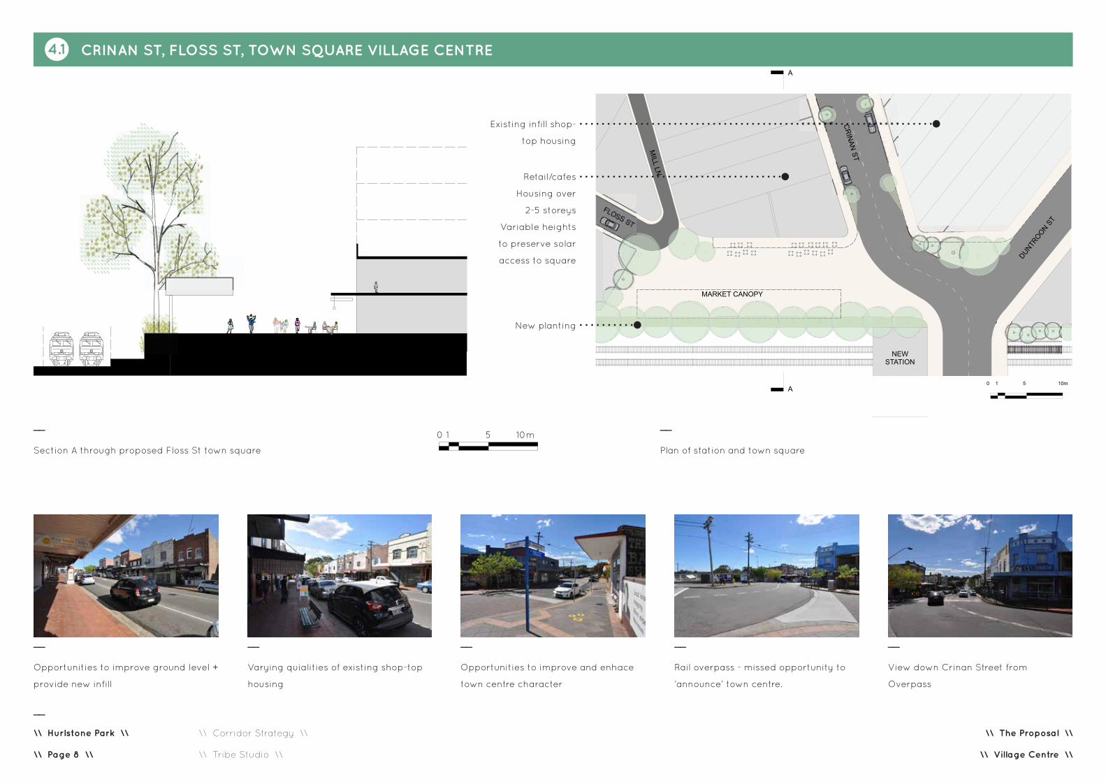
Crinan Street, Floss Street, Town Square Village Centre
- Retain existing high quality 2 storey shop-top housing.
Preserve character and grain of Crinan and Floss Street
shopping precincts. Preserve affordable, small scale retail.
Preserve affordable housing provision.
- New sympathetic shop-top housing infill to Crinan and
Floss Streets. Establish awning and parapet controls.
- Proposed Metro location, entry to align Crinan St axis
- Proposed Station Square, weekend markets, landscaping,
outdoor cafe seating
- New corner architecture expression to define town centre
- New rear lanes to separate single residential sites from
areas of proposed increased density. (Subject to detailed
masterplan.)
Cycle and Pedestrian
- Cycle and pedestrian routes to connect rail corridor,
existing river front cycle route. Improved North-South
connections including underpass at Foorde Street,
enhanced street planting for provision of shade and
continuity of tree canopy
- Preserve single storey heritage residential character to
key streets. Foorde Avenue/Dunstaffenage Street, Floss
Street, Duntroon Street. Preserve heritage character, small
rise and scale and retain/protect mature trees on private
property that are largely responsible for establishing leafy
canopy in Hurlstone Park.
1. Town Centre. Crinan Road, Floss Street, New Station Square, New Canterbury Road
Retain existing high quality 2 storey shop-top housing. Preserve character and grain of Crinan and
Floss Street shopping precincts. Preserve affordable, small scale retail. Preserve affordable housing
provision.
New sympathetic shop-top housing infill to Crinan and Floss Streets. Establish
awning and parapet controls.
2. Canterbury Road
New masterplan for Canterbury Road to cross precinct boundaries. Masterplan
to include density, use, street planting, improved pedestrian and cycle
environment.
Proposed Metro location. Entry to align Crinan Street axis
Proposed Station Square, weekend markets, landscaping, outdoor cafe seating
3. Improved Pedestrian and Cycling Connections
Cycle and pedestrian routes connection rail corridor, existing river front cycle
route, improved north-south connections including underpass at Foorde Street,
enhanced street planting for provision of shade and continuity of tree canopy
Parkland. Improve facilities including sporting, play, bathrooms, seating,
barbeques, shade provision
4. Cooks River and Parks
Improve edge condition at interface with private property including introduction
of fence controls, controls related to new housing types, planting, etc
5. Preserve
- Crinan Street and Floss Street Shop-top village character.
- Street trees, mature trees on private property, tree canopy character by
preserving key single storey residential streets
- Heritage houses and heritage character or precinct
- Single storey street address to Dunstrafenage Street
- Open space at Bowling Club site. Future uses may include childcare centre
and park.
0 100 500
50 200
Preserve single storey heritage residential character to key streets. Foorde
Avenue/Dunstaffenage Street, Floss Street, Duntroon Street. Preserve heritage
character, small rise and scale and retain/protect mature trees on private
property that are largely responsible for establishing leafy canopy in Hurlstone
Park.
New corner architecture expression to define town centre
New rear lanes to separate single residential sites from areas of proposed
increased density. Subject to detailed masterplan.
Proposed pocket park at church on New Canterbury Road. Retaing existing
Bowling Club as open outdoor space on Crinan Street
River Front Parks
- Parkland. Improve facilities including sporting, play,
toilets, seating, barbeques, shade provision
- Improve edge condition at interface with private
property including introduction of fence controls,
controls related to new housing types, planting, etc
- Existing Bolwing Club to be preserved as open
space.
Preserve
- Crinan Street and Floss Street Shop-top village
character
- Street trees, mature trees on private property, tree
canopy character
- Heritage houses and heritage character or precinct
- Single storey street address to Dunstrafenage Street
- Open space at Bowling Club site. Future uses may
include childcare centre and park
4.0 THE PROPOSAL
__
\\ Hurlstone Park \\
\\ Corridor Strategy \\ \\ Tribe Studio \\\\ Page 8 \\
MARKET CANOPY
NEWSTATION
0 1 5 10m
CR
INAN
ST
DUNTROON S
T
A
A
FLOSS ST
MILL LN
\\ The Proposal \\
\\ Village Centre \\
4.1 CRINAN ST, FLOSS ST, TOWN SQUARE VILLAGE CENTRE
__
Section A through proposed Floss St town square
__
Plan of station and town square
__
Opportunities to improve ground level +
provide new infill
__
Varying quialities of existing shop-top
housing
__
Opportunities to improve and enhace
town centre character
__
Rail overpass - missed opportunity to
‘announce’ town centre.
__
View down Crinan Street from
Overpass
SECTION - TOWN SQUARE0 1 5 10m
SECTION - TOWN SQUARE0 1 5 10m0 1 5 10m
Retail/cafes
Housing over
2-5 storeys
Variable heights
to preserve solar
access to square
New planting
Existing infill shop-
top housing

__
\\ Hurlstone Park \\
\\ Corridor Strategy \\ \\ Tribe Studio \\\\ Page 9 \\
\\ The Proposal \\
\\ Perspective \\
4.1 CRINAN ST, FLOSS ST, TOWN SQUARE VILLAGE CENTRE
__
The Floss Street Carpark will be converted to a new Station Square,
creating a pedestrian terminus to Crinan Street and a focal point of
the village centre. The new Metro Exit will be accessed off this square,
on axis with Crinan Street. Market Facilities will be located along the
southern edge of the square. New shops on the northern edge will face
the square.
Crinan Street’s existing shop-top character will be preserved. Better
examples of the type will be preserved. Detracting examples will be
replaced with higher density housing, that still slots into the awning and
parapet language of the street. Shop-top housing will increase in height
at the 5-ways intersection, creating dramatic corner architecture .
Ground plane and landscape improvements will be implemented along
Crinan and Floss Streets.
The increase in density around the town centre, on the existing 5-ways
street geometry will create a dynamic town centre focus through corner
architecture. Podium designs should not be considered as they diminish
to power of the corner. Top floor setbacks should not be considered. The
strength of the proposal is in drama, creating a centre of the town, where
it is currently poorly defined.
__
Existing carpark adjacent to train station. Opportunity to create vibrant and
sensitive character of place.
__
New town centre and heights at critical corners. Central square, market place, outdoor seating. View from new station square.

__
\\ Hurlstone Park \\
\\ Corridor Strategy \\ \\ Tribe Studio \\\\ Page 10 \\
\\ The Proposal \\
\\ Perspective \\
__
Existing view to station from Crinan St
__
Location
4.1 CRINAN ST, FLOSS ST, TOWN SQUARE VILLAGE CENTRE
__
Proposed view to station and station square from Crinan St. Retail higher quality shop-top housing. New sympathetic 2-3
storey infill respecting parapet and awning lines. Increased heights at critical corners. Street planting and ground plane

__
\\ Hurlstone Park \\
\\ Corridor Strategy \\ \\ Tribe Studio \\\\ Page 11 \\
\\ The Proposal \\
\\ Precedents \\
__
Precedents - Corner Architecture
Corner architecture creates engaging, dynamic urban spaces
__
Precedents - Town squares, markets, active shop-top precincts
New station square with pavilion provides public event space and sense of place
4.1 CRINAN ST, FLOSS ST, TOWN SQUARE VILLAGE CENTRE
__
Street trees and shop-top housing
__
Covered market place
__
Multi-purpose canopy for markets, seating at town centre

__
\\ Hurlstone Park \\
\\ Corridor Strategy \\ \\ Tribe Studio \\\\ Page 12 \\
\\ The Proposal \\
4.2 CYCLE AND PEDESTRIAN
0 100 500
50 200
Existing River Front Parks
Cycle Path at Rail Corridor. Strategic site acquistions and setback controls
required to realise continuous path.
New underpass at Foorde Street to enhance pedestrian and cycle
connections
Cycle and pedestrian routes. Link Canterbury and New Canterbury Roads
to riverfront amenity and continuous river front cycle/pedestrian way on
Cooks River.
Rail corridor cycle path discontinuous at Canterbury. Rail path to detour
along Cooks River
\\ Cycle and Pedestrian \\
__
- Existing River Front Parks.
- Cycle Path at Rail Corridor.
- Points where cycle path meets private property.
Explore setback controls/aquisition.
- New underpass at Foord Avenue to enhance
pedestrian and cycle connections. North and south
access to river front paths.
- Cycle and pedestrian routes. Link Canterbury and
New Canterbury Roads through Hurlstone Park to
riverfront amenity and continuous river front cycle/
pedestrian way on Cooks River.
__
Existing river front bike / walk path
__
Mature street planting
__
No pedestrian/cycle access under rail
corridor at Foorde St
__
Existing river front bike/ walk path
__
Excellent pedestrian amenity - shady,
heritage architecture.

__
\\ Hurlstone Park \\
\\ Corridor Strategy \\ \\ Tribe Studio \\\\ Page 13 \\
\\ The Proposal \\
\\ Perspective \\
__
Hurlstone Park is well serviced by the existing cycle/pedestrian path along the Cooks River,
connecting to Botany Bay. This cycle way can link Hurlstone Park/Canterbury to the proposed
Sydenham-Bankstown rail corridor cycleway, providing outstanding cycling amenity in the area.
In order to establish the rail corridor cycleway in Hurlstone Park, there will need to be some
strategic acquisitions of land and/or establishment of increased setbacks to new developments.
At the fine grain, Hurlstone Park will benefit from increase north-south cycling connections,
linking the proposed higher density Canterbury and New Canterbury Roads to the River
frontage. Key cycle routes should have enhanced street planting and shade provision.
At Foord Avenue, there should be a new underpass to the rail line, facilitating the safe movement
of pedestrians and cyclists North-South to the River.
__
Existing heritage underpass on Foord Ave
__
Proposed development of green belt along rail corridor and enhanced North-South connection
including pedestrian and cycle underpass at Foord Ave
4.2 CYCLE AND PEDESTRIAN

__
\\ Hurlstone Park \\
\\ Corridor Strategy \\ \\ Tribe Studio \\\\ Page 14 \\
\\ The Proposal \\
\\ Density \\
4.3 DENSITY
Existing 2 Storey Shop-top of heritage/charming character to be retained
Shop-top infill up to 4 storeys. Respect parapet and awning lines.
5 - 7 storey residential development.
NOTE - no podium treatements to key corner architecture sites.
2 -3 storey residential development
Canterbury Road subject to separate masterplan
Explore 2-3 storey townhouse development to river/park frontages facing south
0 100 500
50 200
Explore potential for increased density facing north at river front. Note this is
outside of the study area.
Key corner sites earmarked for maximum heights
__
- Existing 2 Storey Shop-top of heritage/charming character to be retained
- Shop-top infill up to 4 storeys. Respect parapet and awning lines.
- Canterbury Road subject to separate masterplan
- 5 - 7 storey residential development.
Note: no podium treatements to key corner architecture sites.
- 2 -3 storey residential development
- Key corner sites earmarked for maximum heights
- Explore 2-3 storey townhouse development to river/park frontages facing south
- Explore potential for increased density facing north at river front.
Note: this is outside of the study area.

__
\\ Hurlstone Park \\
\\ Corridor Strategy \\ \\ Tribe Studio \\\\ Page 15 \\
SECTION - DUFFENSTANAGE ST
0 1 5 10m
PLAN - DUFFENSTANAGE ST
0 1 5 10m
\\ The Proposal \\
\\ Density \\
4.3 DENSITY
Single storey
federation
bungalows
typically
Mature trees on
private property
create canopy
and character for
Hulstone Park
__
Existing Section - Duffenstanage Street
__
Existing Plan - Duffenstanage Street nominal
Retain single resitential, single storey language. This will preserve existing street trees and trees on private
property
__
Proposed Section - Crinan Street
New infill to respect amenity, parapets and sight lines
__
Proposed plan - Crinan Street

__
\\ Hurlstone Park \\
\\ Corridor Strategy \\ \\ Tribe Studio \\\\ Page 16 \\
\\ The Proposal \\
\\ Density \\
__
Existing section of river front
__
Proposed section of river front.
Explore potential for 2-3 storey townhouse development
__
Precedents - Higher density at river front parks
Improve edges by orientating housing towards river. Higher density housing takes advantage of outlook and park setting
4.3 DENSITY
PUBLICPRIVATEROAD
RESERVE
PRIVATE
Explore potential to
increase public land and
improve edge condition
as part of rezoning

__
\\ Hurlstone Park \\
\\ Corridor Strategy \\ \\ Tribe Studio \\\\ Page 17 \\
__
Large open playing fields. Poor edges,
amenity, buildings, BBQ structures
\\ The Proposal \\
\\ River Front Parks \\
4.4 RIVER FRONT PARKS
__
Continuous path
__
Varying spatial and landscape qualities
__
Private/public interface is poor
0 100 500
50 200
Existing River Front Parks
Cycle Path at Rail Corridor. Strategic site acquistions and setback controls
required to realise continuous path.
New underpass at Foorde Street to enhance pedestrian and cycle
connections
Cycle and pedestrian routes. Link Canterbury and New Canterbury Roads
to riverfront amenity and continuous river front cycle/pedestrian way on
Cooks River.
Improvements to Park interface with road. New bollards, retaining walls,
planting strategy, signage
Improvements to Park interface with private property. Investigate
opportunites to increase density at park interface and turn new residential
buildings to face the park, increasing passive surveillance and improving
edge activity. Increased density may not be appropriate due to topography
and orientation. In this case, sheet metal fences should be banned, as
they prohibit vegetation growth. Introduce edge plantings to conceal
'shanty-town' of private fences which currently make up the edge
condition of the park.
Key Projects to include amenity blocks, barbeque facilities, inventive
active recreation zones and play equipment, seating, shade, various
treatments of the river edge, planting upgrades, bollards, lighting,
retaining etc.
__
- Existing River Front Parks
- Cycle and pedestrian routes. Link Canterbury and
New Canterbury Roads to riverfront amenity and
continuous river front cycle/pedestrian way on Cooks
River
- Improvements to Park interface with road. New
bollards, retaining walls, planting strategy, signage.
- Key Projects. These include amenity blocks,
barbeque facilities, inventive active recreation
zones and play equipment, seating, shade, various
treatments of the river edge, planting upgrades,
bollards, lighting, retaining etc
- Improvements to Park interface with private
property. Investigate opportunites to increase density
at park interface and turn new residential buildings
to face the park, increasing passive surveillance
and improving edge activity. NB: Increased density
may not be appropriate due to topography and
orientation. In this case, sheet metal fences should be
banned as they prohibit vegetation growth. Introduce
edge plantings to conceal ad-hoc private fences
which currently make up the edge condition of the
park.
__
Occasionally a house faces the park

__
\\ Hurlstone Park \\
\\ Corridor Strategy \\ \\ Tribe Studio \\\\ Page 18 \\
\\ The Proposal \\
\\ Precedents \\
__
Precedents - River Edge
Active engagement with river, refined edges, pedestrian and cycle paths
4.4 RIVER FRONT PARKS
__
Precedents - Amenities
Public amenities at the river front, including bbq facilities, shade structures, toilets and seating.
5.0 APPENDIX

5.1 SITE ANALYSIS
\\ Site Analysis \\
__
\\ Hurlstone Park \\
\\ Corridor Strategy \\ \\ Tribe Studio \\\\ Page 20 \\
\\ Introduction \\
Hurlstone Park is a largely residential area, characterised by low density
residential development, largely Federation and inter-war. It is bound by
the busy, arterial Canterbury Road to the North and West, New Canterbury
Road to the North, The Cooks River to the South and Dulwich Hill to the
East.
It has an existing, quiet, low-rise high street, Crinan Street which has brick
shop-top housing and a continuous street awning. Crinan Street meets
Floss and Duntroon Street at the rail line, and the junction contorts into a
kind of five-ways over at the station exit. Commercial buildings bleed onto
these streets.
There are scattered multi-residential developments within the area,
ranging from modest 2 storey interwar walk-ups to enormous 1970s strata
amalgamations.
Canterbury Road and New Canterbury Road are busy streets, with four
lanes of traffic, scant vegetation and mixed development including the RSL,
petrol stations, single storey bungalows, shop top housing.
The Cooks River to the South is bound on both sides by well kept
landscaping. There is a continuous bike/pedestrian path along the river,
and the path ranges from quite intimate in scale, to being the edge of
large parks and recreation spaces stringing along the river. 0 100 500
50 200

5.1 SITE ANALYSIS
\\ Site Analysis \\
__
\\ Hurlstone Park \\
\\ Corridor Strategy \\ \\ Tribe Studio \\\\ Page 21 \\
__
Crinan Street is retail high street that
crosses rail line
__
Garden suburb heritage character
\\ Introduction \\
__
Park - River side parks create outstanding amenity and recreation opportunities
__
Established street trees and mature
trees on private land create canopy.
__
New Canterbury Road. Vehicle dominant, poor pedestrian and cycle environment.

5.1 SITE ANALYSIS
\\ Site Analysis \\
__
\\ Hurlstone Park \\
\\ Corridor Strategy \\ \\ Tribe Studio \\\\ Page 22 \\
\\ Topography \\
TOPOGRAPHY
__
Hurlstone Park is largely flat in its northern parts, with a steep slope down
to the river at the South.
The sloping areas of the suburb display uniquely Sydney vegetation
patterns: sandstone outcrops with vertical vegetation, large eucalypts etc
and affords views down to the river from surrounding streets. Topography
near the river contorts pedestrian and cycle access to the river.
The high street, Crinan Road, rises up gently to the south at the
rail crossing, creating a sense of arrival at town centre/station exit.
Unfortunately, current urban and architectural design does not take
advantage of this natural sense of village centre.
The fact that Hurlstone Park slopes down to the river at the South means
that views/outlook and solar access are in opposite directions. The
topography does not lend itself naturally to the siting of increased density
at the river front as solar access and overshadowing will present difficult
issues to overcome.
__
Largely flat precint
__
Gentle slope on Crinan Street up to south
__
Near the river, stone cuttings visible
__
River-side paths + level playing fields
__
Stone cuttings facing south create unique
vegetation chraracter.

5.1 SITE ANALYSIS
\\ Site Analysis \\
__
\\ Hurlstone Park \\
\\ Corridor Strategy \\ \\ Tribe Studio \\\\ Page 23 \\
\\ Landscape \\
1
2 3
4
5
1 2 3 4 5__
Casuarina forests at river edge
__
Active recreation space/sports fields at
river edge
__
Path at river edge
__
Burnett St pocket park
__
Foord Av pocket park
LANDSCAPE
__
Hurlstone Park has a network of large and small green
spaces stringing along the edge of the Cooks River. There
are quiet intimate paths through casuarina forests, and
large spaces for sports and active recreation. There has
been some recent attention paid to the edge condition
along the river with paving, planting and seating upgrades.
Where the river front parks meets private property there is
room for systematic improvement to the public domain. In
many places, a patchwork of private fences forms the park
edge, giving it an ad-hoc edge character.
Improvements to the park interface with surrounding streets
is also an opportunity. Siting of amenities is at times poor.
Bollard design and edge treatment is of low quality. In
contrast with the upgrades to planting, seating, edge details
etc on the river edge of the park, it looks poor.
There is also an opportunity for some inventive play spaces
in the river side parks.
There are several pocket parks in Hurlstone Park. At
Burnett Street, Edgeware School meets a park born out
of the sloped terrain and exposed sandstone floaters.
This is a unique, shady park adjacent to a school and a
great opportunity for some inventive play equipment that
acknowledges the park’s natural features.
At the significant rail underpass on Foord Avenue/
Dunstaffenage Street, there is a triangular pocket park,
again with play equipment. This is a lovely park, that
again takes advantage of the topography and it is a mini
destination along the key route, North - South to the Cooks
River.
Unfortunately, there is no pedestrian/cycle linkage under
the rail adjacent to the car access. This presents a key
opportunity for improvement.

5.1 SITE ANALYSIS
\\ Site Analysis \\
__
\\ Hurlstone Park \\
\\ Corridor Strategy \\ \\ Tribe Studio \\\\ Page 24 \\
6
6 7 8 9 10__
Bowling green
__
Street planting
__
Vegetated green belt at rail corridor
Fenced off
__
Canterbury Rd
__
New Canterbury Rd
7
8
9
10
\\ Site Analysis \\
\\ Landscape \\
__
On the north side of Hurlstone Park’s high street, Crinan
Road, there is a Bowling Club offering open space in a
natural gully. This open space separates the commercial
end of the street from the residential, and should be
maintained as an open space, even if the private ownership
of the club changes hands. A key opportunity to explore is
the siting of a daycare centre on this site, taking advantage
of the open space, proximity to train/public transport and
commercial/retail area.
Street Planting and Green Character
Hurlstone Park’s character is largely established by the
small house in large suburban lot typology. There is
extensive street planting on many streets with a range of
maintenance levels. Significantly, large trees on private
land, in back gardens and in strata gardens, make an
enormous contribution to the sense of consistent tree
canopy within the area.
Adjacent to the south side of the rail-line, there is a heavily
vegetated green belt of varying widths. This forms part
of the green strategy and is designated for conversion to
public land as a bike route. At the fine grain, it becomes
apparent that connections across this belt of green need
attention and there are a few ‘chunks’ of taken out of the
belt, where private land butts up to the rail corridor. In the
rezoning of the area, these sites may be earmarked for
acquisition or should be subject to setback controls that
facilitate the continuous bike corridor.
Canterbury Road and New Canterbury Road
Canterbury Road and New Canterbury Road are both
four traffic lane roads that have scant planting and few
crossings. They are vehicle dominant.
A new landscape strategy for Canterbury and New
Canterbury Roads is a key opportunity. The goal should be
to transform these streets into pleasant pedestrian/cycle
environments and connect a green corridor through the
precinct.
5.1 SITE ANALYSIS
\\ Site Analysis \\
__
\\ Hurlstone Park \\
\\ Corridor Strategy \\ \\ Tribe Studio \\\\ Page 25 \\
0 100 500
50 200
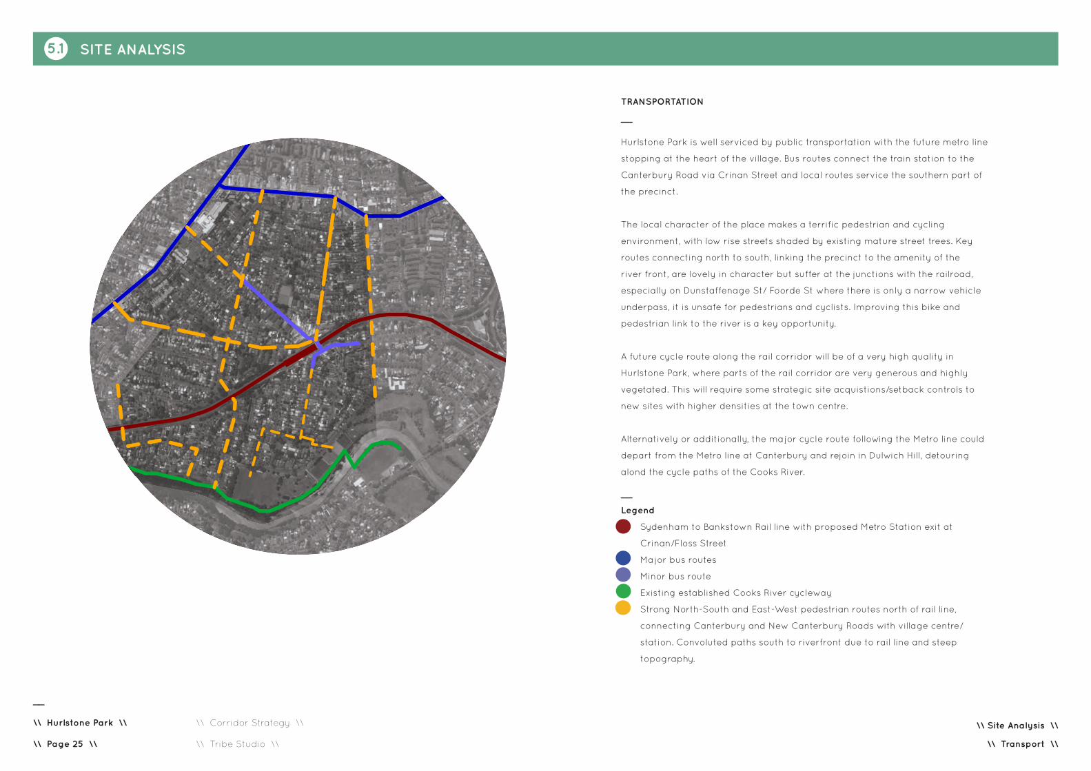
Sydenham to Bankstown Rail line with proposed Metro Station exit at Crinan/Floss Street
Major Bus Routes
Minor Bus Routes
Existing established Cooks River cycleway
Strong North-South and East-West pedestrian routes north of rail line, connecting Canterbury and New Canterbury Roads with village centre/station. Convoluted paths south to riverfront due to rail line and steep topography.
\\ Transport \\
__
Legend
Sydenham to Bankstown Rail line with proposed Metro Station exit at
Crinan/Floss Street
Major bus routes
Minor bus route
Existing established Cooks River cycleway
Strong North-South and East-West pedestrian routes north of rail line,
connecting Canterbury and New Canterbury Roads with village centre/
station. Convoluted paths south to riverfront due to rail line and steep
topography.
TRANSPORTATION
__
Hurlstone Park is well serviced by public transportation with the future metro line
stopping at the heart of the village. Bus routes connect the train station to the
Canterbury Road via Crinan Street and local routes service the southern part of
the precinct.
The local character of the place makes a terrific pedestrian and cycling
environment, with low rise streets shaded by existing mature street trees. Key
routes connecting north to south, linking the precinct to the amenity of the
river front, are lovely in character but suffer at the junctions with the railroad,
especially on Dunstaffenage St/ Foorde St where there is only a narrow vehicle
underpass, it is unsafe for pedestrians and cyclists. Improving this bike and
pedestrian link to the river is a key opportunity.
A future cycle route along the rail corridor will be of a very high quality in
Hurlstone Park, where parts of the rail corridor are very generous and highly
vegetated. This will require some strategic site acquistions/setback controls to
new sites with higher densities at the town centre.
Alternatively or additionally, the major cycle route following the Metro line could
depart from the Metro line at Canterbury and rejoin in Dulwich Hill, detouring
alond the cycle paths of the Cooks River.

5.1 SITE ANALYSIS
\\ Site Analysis \\
__
\\ Hurlstone Park \\
\\ Corridor Strategy \\ \\ Tribe Studio \\\\ Page 26 \\
__
Bus Routes
__
Bicycle paths well established at river front
__
Dunstaffenage St, one of the main North-South links
__
Parking at railway edge on Floss St
__
Train - heritage station buildings + stone cutting
\\ Transport \\
__
Station building at heart of town centre.
Anti climatic.

5.1 SITE ANALYSIS
\\ Site Analysis \\
__
\\ Hurlstone Park \\
\\ Corridor Strategy \\ \\ Tribe Studio \\\\ Page 27 \\
HERITAGE
__
Housing
Hurlstone Park has a heritage character. It was planned in the garden
suburb model, but on a more modest scale than Burwood or Strathfield.
The neighbourhood character is established by single storey brick and tile
bungalows in several styles: Queen Anne, Edwardian, Victorian, Federation,
interwar and Californian bungalow. The planning pattern is predominantly
small house in large garden and large trees give the sense of a continuous
tree canopy. It is a unique, nostalgic environment and should be preserved.
(Key opportunity: preserving the heritage character of Hurlstone Park is a
key opportunity and it should be noted that the boundaries of this potential
Conservation Area spill into the Canterbury study area. Local government
should establish rules and guidelines to preserve the single storey street
address, significant trees, heritage materials and palettes)
Crinan Street, Floss Street and Shop-Top retail precinct.
The commercial and retail centre of Hurlstone Park is a modestly scaled
village sited predominantly on the north side of the rail-line, spilling over
the rail bridge in a contorted five-ways to the south side. It is not a major
arterial road. Many of the retail tenancies are vacant.
The two storey shop-top form and character to Crinan Road is charming
and loved by the locals. While the buildings themselves are not brilliant
examples of the type, they are much loved by the residents and create
a charming, fine grain village character. The better examples should be
retained, and the detracting examples should be replaced with sensitive
infill.
\\ Heritage \\
Heritage items at 01.10.2016NB Canterbury Council have since listed 51 additional sites.
Heritage items
Identify contributory/charming shop-top housing

5.1 SITE ANALYSIS
\\ Site Analysis \\
__
\\ Hurlstone Park \\
\\ Corridor Strategy \\ \\ Tribe Studio \\\\ Page 28 \\
__
Examples of Victorian and Federation bungalows
__
Heritage listed rail underpass - poor condition
__
Shop top housing - varying conditions
\\ Heritage \\

5.1 SITE ANALYSIS
\\ Site Analysis \\
__
\\ Hurlstone Park \\
\\ Corridor Strategy \\ \\ Tribe Studio \\\\ Page 29 \\
\\ Built Character \\
0 100 500
50 200
BUILT CHARACTER AND SCALE
__
Housing
The predominant building type is the single storey bungalow. There are also many new single
residences up to two storeys. Residential apartment buildings generally slot into the suburban
subdivision pattern. They range in age from interwar to 1970s and 80s. There are some
particularly poor examples from late last century where siting is poor, street address is poor,
and all evidence would suggest that internal amenity is poor (bad orientation, low ceilings,
entries miles off the street frontage etc).
It is assumed these buildings are strata titled and therefore difficult to replace. While they are
not ideal residential developments, they will protect a level of affordable housing within the
precinct. The corridor strategy presents a unique opportunity to revisit this building type and
prepare strategies for its future.
Shop top housing and town centre
The station block of Crinan street is characterised by shop top housing, with small lot
sizes (approximately 6-10m retail frontages) serviced by rear lanes. The fine grain of this
development and its charming form are a key part of establishing Hurlstone Park’s sense of
place and its centre.
While the shop-top housing creates a charming scale at Crinan Street, the place where
the roads converge is a missed urban design opportunity. The exisiting station entry is
small in scale. The end of Crinan street is announced by a paling fence and an ad hoc
carpark. Creating a focal point at the station and immediate surroundings and an engaging
pedestrian/shopper/commuter experience at Hurlstone Park center is a key opportunity.
Park and River Edges
The southern edge of Hurlstone Park is where the residential meets park and river. This edge
contains a mixture of types including bungalows, contemporary two storey town houses and
apartment buildings. It is an area of potential densification but it should be noted that due
to orientation and topography, it may be impossible to meet solar access requirements of
current codes for residential flat buildings.

5.1 SITE ANALYSIS
\\ Site Analysis \\
__
\\ Hurlstone Park \\
\\ Corridor Strategy \\ \\ Tribe Studio \\\\ Page 30 \\
\\ Built Character \\
__
Single Houses
__
Shop top housing - Crinian Road
__
Park edges - poor interface with private domain
__
Multi-unit residential up to two storeys
__
New houses + contemporary rear additions
__
New Canterbury Rd - Mix of building types, scales and characters. Lots of
new construction establishing 2-3 storey street wall. Up to 5 storeys setback.
Continuous awnings
__
Canterbury Rd - mix of building types, scales, characters. No consistent elements
__
Private fences to public parks.

5.1 SITE ANALYSIS
\\ Site Analysis \\
__
\\ Hurlstone Park \\
\\ Corridor Strategy \\ \\ Tribe Studio \\\\ Page 31 \\
\\ Summary of Opportunities and Issues \\
KEY ASSETS LIABILITIES KEY OPPORTUNITIES
RIVERSIDE PARKS + CONTINUOUS BIKE/PEDESTRIAN PATH
River and River path – views, open space, access to big sky, run/
walk/cycle to Botany Bay (10Km), passive and active recreation
places, variety of outdoor open spaces in scale, design,
vegetation, edge condition, beautiful heritage bridges, access
to park and river frontage on South side, some good landscape
design and river edge (notably superior to Canterbury portion of
path)
Some poor landscape design – edges where parks meet roads,
where parks meet private property, connections to the north
sometimes poorly resolved/difficult to navigate.
Lacklustre / poor amenities buildings.
- Improve park edges – retaining, fencing, planting, seating,
parking
- Improve park facilities including barbecues, picnic areas,
seating, play equipment, sporting equipment, youth facilities
- Density at park edge – increase residential density at park
frontage. Note that orientation and topography may make multi-
unit residential development undesirable due to lack of solar
access.
TOWN CENTRE Two storey brick shop-top housing character. Small scale retail
tenancies attract small businesses (note that many currently
untenanted). Charming village feel. Commercial hub at station/
transportation hub.
Low scale of development feels very ‘sleepy’ especially given
rise to rail crossing. The existing station building and large
intersection is a missed opportunity for a sense of town centre/
arrival.
Disconnection between north and south retail zones across rail
line.
Carparking at station lost urban/open space opportunity.
Poor street planting.
Vehicle heavy and dominant, with two lanes parking, two lanes
traffic.
Many corners create engaging street geometry but current
massing/architecture does not take advantage of this condition.
Station entry poor. Not aligned Crinan Street axis. Poor
architectural quality. Urban anticlimax.
- Enliven Crinan Street commercial/retail corridor. Ground plane
and landscaping. Align new Metro exit with Crinan Street axis
- Convert parking into town square. Activate town square edge
on South side with weekend market/other uses. Preserve 2
storey shop-top character, while increasing population/activity/
liveliness.
- Use existing five-ways street geometry to create engaging
corner architecture condition to describe the town centre (a
small Piccadilly Circus or large Darlinghurst Gaol).
- Increase density on south side of railway. Create ‘terminus’
urban wall. Improve laneway conditions/address Increase
heights and density within 200m radius of station to north.
- Utilise the drama of the gradual rise up Crinan Street from
north to south to create a town centre with presence/height and
a focus (town square and station exit).
CANTERBURY AND NEW CANTERBURY ROADS
Major arterial roads defining the northern boundary of Hurlstone
Park. The area is described by arterials to the north and the
river to the south, meaning that although the suburb is only 9km
from the city, it feels incredibly quiet, pedestrian friendly and like
a destination, rather than a path to somewhere else.
Canterbury and New Canterbury Roads are four lane roads with
no parking, scant crossings and poor pedestrian environments.
There is a mix of building types along these roads, ranging from
multi unit residential to large hospitality (RSL, pubs), petrol
stations, warehouse retail, shop top housing and single storey
bungalows in suburban gardens. Many commercial tenancies are
vacant.
These roads create an abrupt break in the established tree
canopy and restrict pedestrian and cyclemovement.
Vehicle dominant.
Canterbury and New Canterbury Roads, in the Hurlstone
Park and Canterbury precincts, are well within the 800m
walking/cycling distance of the railway station exits. This is a
key opportunity to rezone these sites for high density living
and in doing so, address the ground plane condition. Ground
plane should include: street trees, low street planting, shade/
rain protection (from colonnade or awnings), separation of
pedestrians from high-speed car edge, more pedestrian/bike
crossings/ bike lane introduction of enterprise corridor for the
length of the Hurlstone Park and Canterbury portions of these
roads.

5.1 SITE ANALYSIS
\\ Site Analysis \\
__
\\ Hurlstone Park \\
\\ Corridor Strategy \\ \\ Tribe Studio \\\\ Page 32 \\
\\ Summary of Opportunities and Issues \\
0 100 500
50 200
Key Opportunities and Assets
Improve Pedestrian and Cycling environments Canterbury and New Canterbury Roads
Improve green environments Canterbury and New Canterbury Roads
Retain and preserve existing heritage character, single storey street address. Enhance existing street
planting to extend tree canopy. Note that much of leafy character of Hurlstone Park is established by
trees on private property.
New station square at proposed metro exit/terminus to Crinan Street retail zone. Opportunity for
markets.
Strategic land acquistions to establish cycleway in rail corridor and take advantage of lovely character
and existing mature planting
Improve park edges, especially at interface of public and private property.
New pedestrian and cycle access at Foorde Street. Enhance north-South connections and access to
riverfront amenity.
Enhance and enliven existing village centre. Use street geometry and rise over rail line to create
dramatic architectural presence/sense of arrival.
Improve park facilities including toilets, play equipment, sports facilities, shade, pic nic areas, bbqs,
bollards and planting to street edges.
Metro Station
New urban pocket park to New Canterbury Road. Creates curtelage for existing Church to South and
provides green respite.
__
- Improve Pedestrian and Cycling environments
at Canterbury and New Canterbury Roads
- Improve green environments at Canterbury and
New Canterbury Roads
- Retain and preserve existing heritage character,
single storey street address
- Enhance existing street planting to extend tree
canopy
(Note that much of leafy character of Hurlstone
Park is established by trees on private property)
- Areas where tree canopy is largely established
by trees on private property
- New station square at proposed metro exit
north /terminus to Crinan Street retail zone
- Opportunity for markets/ cafe seating
- Explore potential for strategic land acquistions/
new setback controls to establish cycleway in rail
corridor and take advantage of lovely character
and existing mature planting
- Improve park edges, especially at interface of
public and private property
- Improve park facilities including toilets, play
equipment, sports facilities, shade, pic nic areas,
bbqs, bollards and planting to street edges
- New Dunstaffenage Street and cycle access at
Foord Avenue. Enhance North-South connections
and access to riverfront amenity
- Enhance and enliven existing village centre
- Use street geometry and rise over rail line to
create dramatic architectural presence/sense of
arrival/ corner architecture
- Metro Station
- New urban pocket park to New Canterbury Road.
Creates curtelage for existing church to South and
provides green respite

5.1 SITE ANALYSIS
\\ Site Analysis \\
__
\\ Hurlstone Park \\
\\ Corridor Strategy \\ \\ Tribe Studio \\\\ Page 33 \\
\\ Summary of Opportunities and Issues \\
CANTERBURY AND NEW CANTERBURY ROADS
__
Improve interface with public and private domain
__
Crinan St - enhance village character, explore potential for corner architecture
__
Carpark at train station. Potential new station/ town square,
marketplace and outdoor seating.
__
New Canterbury Rd.
__
Quiet pedestrian streets - protect and enhance, and protect trees on private
property.
__
Canterbury Rd - Improve pedestrian + cycle amenity, increase density and create green
canopy.
TOWN CENTRE
RIVER AND PATH
__
Landscape design upgrade.