cortes island coastal plan - british columbia · national library of canada cataloguing in...
TRANSCRIPT

Ministry of Sustainable Resource Management
Coast & Marine Planning Branch
Cortes Island Coastal Plan for Shellfish Aquaculture
Draft May 16, 2003

National Library of Canada Cataloguing in Publication Data British Columbia. Coast and Marine Planning Branch. Cortes Island Coastal Plan for Shellfish Aquaculture. Also available on the Internet. ISBN 0-7726-4991-X 1. Shellfish culture - British Columbia – Cortes Island - Planning. 2. Shellfish culture – Government policy - British Columbia. 3. Aquaculture industry - British Columbia – Cortes Island - Planning. 4. Coastal zone management – Government policy – British Columbia – Cortes Island. 5. Cortes Island (B.C.) I. British Columbia. Ministry of Sustainable Resource Management. II. Title. SH367.C3B74 2003 639.4’097111 C2003-960133-1

Cortes Island Coastal Plan for Shellfish Aquaculture DRAFT May 16, 2003
ii
Contents Contents........................................................................................................................................... ii Letter from the Ministry of Sustainable Resource Management (MSRM) .................................... iv Acknowledgements ......................................................................................................................... v Definitions and Acronyms.............................................................................................................. vi 1.0 Introduction ......................................................................................................................... 1
1.1 Plan Rationale and Intent................................................................................................ 1 1.2 Jurisdiction and Scope..................................................................................................... 6 1.3 Planning Process.............................................................................................................. 7
2.0 Plan Area Description........................................................................................................ 10 2.1 General Location & Description.................................................................................... 10 2.2 Summary of Physiographic Resources .......................................................................... 10 2.3 Summary of Biological Features ................................................................................... 18 2.4 Social and Economic Profile ......................................................................................... 24 2.5 Economic Activities ...................................................................................................... 27
3.0 Plan Framework and Direction.......................................................................................... 32 3.1 Use of the Plan............................................................................................................... 32 3.2 Strategic Direction: The Vancouver Island Land Use Plan.......................................... 32 3.3 Resource Maps, Planning Units and Unit Data ............................................................. 33 3.4 Planning Unit Direction................................................................................................. 35
Unit 1 Cortes Island North ..................................................................................................... 37 Unit 2 Sutil Channel............................................................................................................... 39 Use Recommendations Unit 3 Carrington Bay ..................................................................... 40 Unit 3 Carrington Bay............................................................................................................ 41 Unit 4 Marina Island .............................................................................................................. 43 Unit 5 Gorge Harbour ............................................................................................................ 45 Unit 6 Cortes Island South ..................................................................................................... 49 Unit 7 Strait of Georgia.......................................................................................................... 51 Unit 8 Squirrel Cove .............................................................................................................. 53
4.0 Approval and Regulation of Shellfish Aquaculture .......................................................... 55 4.1 Agency Review and Regulatory Responsibility ............................................................ 55 4.2 Compliance and Enforcement related to existing operations ........................................ 56 4.3 Enforceable Code of Practice ........................................................................................ 56 4.4 Dispute Resolution and Assessment of Farm Practices................................................. 57 4.5 Compliance and Enforcement of Existing Operations in Gorge Harbour ..................... 58
5.0 Environmental, Economic and Community Implications of the Plan .............................. 59 5.1 Environmental Implications of Recommendations ....................................................... 59 5.2 Economic Implications of Recommendations............................................................... 61 5.3 General Assessment....................................................................................................... 62
6.0 Plan Implementation.......................................................................................................... 64 6.1 Plan Implementation, Monitoring and Review.............................................................. 64
Appendix 1. First Nations, Agency, and Interest Group Discussions ............................... 65 Appendix 2. Governance Principles for Sustainable Resource Management ........................ 66 Appendix 3. Terms of Reference ........................................................................................... 67 Appendix 4. Summary of Public Concerns ............................................................................ 74 Appendix 5. VILUP Designation ........................................................................................... 79 Appendix 6. Dispute Resolution Process ............................................................................... 80

Cortes Island Coastal Plan for Shellfish Aquaculture DRAFT May 16, 2003
iii
Appendix 7. Decision Tools for Siting Shellfish Aquaculture............................................... 85 Appendix 8. References (includes website addresses) ........................................................... 88
Cortes Island Coastal Plan for Shellfish Aquaculture DRAFT May 16, 2003
iv
Letter from the Ministry of Sustainable Resource Management (MSRM)
Reference: Dear Reader: Re: Public Review of Draft Cortes Island Coastal Plan for Shellfish Aquaculture We are pleased to provide this draft Plan for public review. If you have any comments on this draft Plan, please provide them in writing by the end of the day on June 20, 2003 to: Joe Truscott Senior Coastal Planning Officer Coast and Marine Planning Branch PO Box 9373 STN PROV GOVT Victoria BC V8W 9M3 Tel: 250-387-9570 Fax 250-356-7950 Email address: [email protected] This draft plan, which will be subject to revision based on comments received from the public as well as further federal and provincial agency review, has been prepared in accordance with provincial jurisdiction over coastal and foreshore areas of British Columbia’s coast. The final plan, once complete, is intended to assist Land and Water BC, Inc. and other provincial agencies when considering applications for shellfish aquaculture. It will also assist the local community and the Klahoose and Sliammon First Nations by identifying opportunities for sustainable shellfish aquaculture development. It will prove a useful tool for individual development proponents, including local entrepreneurs and non-resident interests, by identifying in advance the opportunities, constraints and limitations to shellfish aquaculture development around Cortes Island. The plan will also identify mechanisms available to address issues related to existing industry operation in the plan area. This plan and the process used in its preparation satisfy the governance principles for sustainability that have been developed by our ministry on behalf of government. The Ministry is pleased to note that Regional District of Comox Strathcona and the Klahoose and Sliammon First Nations have supported, and participated in, development of this plan. As a living document, the final plan will likely be subject to variations and amendments, in accordance with changing circumstances and new information. In the meantime, I look forward to seeing this plan play its role in fulfilling the government’s objective of strengthening the economy of our rural heartlands.

Cortes Island Coastal Plan for Shellfish Aquaculture DRAFT May 16, 2003
v
Acknowledgements The Draft Cortes Island Coastal Plan was shaped by the advice and kind support of many individuals. Special thanks are extended to the Regional District of Comox Strathcona for assisting the Ministry with public and technical input to the Plan, particularly George Sirk (Regional District Board and Director of Area I) and Gerard LeBlanc (Manager of Planning). The draft Plan could not have been successfully prepared without the participation of the Klahoose and Sliammon First Nations, particularly Chief Councilor Ray Noble (Klahoose) and Councilor Denise Smith (Sliammon). . The Plan has benefited from hard work and insight of a plan advisory committee, composed of the following local community members: (names to come) also provided important information at the advisory committee meetings. Several provincial and federal government staff made important contributions to the Plan. Thanks are extended to Barron Carswell, Bill Harrower, Jim Russell, Yves Anataya and Jaclyn Hunter (MAFF), David Cruickshank (Regional Office, MSRM), Duncan Williams, Keith Anderson, Neil Banera (LWBC), Judy Davis (WLAP, Nanaimo), Barry Miller (MOF, Powell River), Patti Menning (DFO, Campbell River), Ken Brock, (Canadian Wildlife Service, Vancouver), Jim Naylor (Canadian Coast Guard, Vancouver). The draft plan was prepared by Joe Truscott with assistance from Graham Winterbottom (CMPB, Victoria) with technical and mapping support from Rick Deegan (MSRM, Decision Support Services). Valuable consulting assistance was provided by Gary Robinson (Socio-economic description) and Coastal and Oceans Resources, Inc, and Archipelago Marine Research (Environmental description).

Cortes Island Coastal Plan for Shellfish Aquaculture DRAFT May 16, 2003
vi
Definitions and Acronyms Adaptive Management: Adaptive management involves specific management prescriptions in the face of uncertainty, monitoring the results of those prescriptions and then revising management approaches accordingly. Shellfish Aquaculture: The growing of shellfish under controlled conditions. Beach Culture: Culture of shellfish in or on the beach in the intertidal area between high and low tide. For example, oyster culture is on the beach and in the case of clam culture the animals live in the substrate under the beach surface. Benthic: Pertaining to the seabed or bottom. Biophysical Capability: The biological and physical ability of local waters to be utilized for aquaculture, based on an analysis of physical and biological characteristics and on the environmental requirements for successful aquaculture. Blue Listed Species: Any indigenous species or subspecies considered to be vulnerable in British Columbia. CWS: Canadian Wildlife Service, Environment Canada CMPB: Coast and Marine Planning Branch, MSRM Farm Gate Value: The price paid to farmers for product delivered to the processing plant. FOC: Fisheries and Oceans Canada Extensive Aquaculture: The growing of plants and animals in natural waters with no supplemental feed. Foreshore (intertidal) area: the area between the mean high tide and low tide mark (i.e. below zero tide). FPPA: Farm Practices Protection (Right to Farm) Act Invertebrates: Includes red and green urchins, octopus, crab, prawn, shrimp, sea cucumbers and other shellfish such as clams, oysters, scallops and geoducks. Intensive Aquaculture: The growing of plants and animals in natural or man-made containers of water with feed supplementation or enrichment. Land Act Reserve: A reserve established on LWBC reference maps to temporarily withdraw Crown land from disposition by tenure. A reserve is placed over an area to enable other agencies to undertake planning, to provide temporary protection or to maintain options for future use. UREP: A Land Act reserve or notation of interest established for the “use, recreation and enjoyment of the public.” LWBC (Land and Water British Columbia Inc.): The Provincial special operating agency for Crown land administration (formerly BC Assets & Land Corporation) MAFF: Provincial Ministry of Agriculture, Food and Fisheries MOF: Provincial Ministry of Forests Marine Protected Area (MPA ): A marine protected area may be established under a variety of Provincial and Federal government statutes, either as a temporary or permanent area for the conservation or protection of important biological, recreational and cultural features or values. An MPA may include a Provincial Marine Park, Ecological Reserve, Wildlife Management Area, Federal National Marine Conservation Area under the National Marine Conservation Act, fishery closure under the Federal Fisheries Act, or a Marine Protected Area under the Canada Oceans Act. MSRM: Provincial Ministry of Sustainable Resource Management. Responsibilities include resource use planning and resource information management and mapping. MWLAP: Provincial Ministry of Water, Land and Air Protection. Responsibilities agency include planning and management of Provincial Parks and Protected Areas . Near shore area: the sub tidal area below low tide mark, generally extending to the 20 metre is bathymetry depth.

Cortes Island Coastal Plan for Shellfish Aquaculture DRAFT May 16, 2003
vii
Offshore area: the sub tidal area seaward of the 20 metre is bathymetric depth. Off-bottom culture: Culture of shellfish such as oysters and scallops in deeper water offshore of the low tide areas using floating structures such as rafts and longlines. Red Listed Species: Includes any indigenous species or subspecies that have, or are candidates, for status as extirpated, endangered, or threatened species in British Columbia RDCS: Regional District of Comox-Strathcona. Risk: Risk is unavoidable and present in virtually every human situation and has many acceptable definitions all with the common theme of uncertainty of outcomes. Here, “risk” refers to the uncertainty that surrounds future events and outcomes. It is the expression of the likelihood (i.e. probability) and negative effect (i.e.hazard) of an event. Risk Averse: A strong aversion to (or tendency to avoid) a policy or decision that involves risk. Sanitary Shellfish Closure: FOC closure of an area to shellfish harvesting due to bacterial contamination. This applies to harvest of wild and cultured shellfish. SFU: Simon Fraser University Sub-tidal culture: Culture of shellfish in areas below low tide where the culture is subsurface with no surface floats or structures (e.g., geoduck culture takes place on the seabed in sub-tidal areas). Suitability: A policy-based judgement of whether a particular type of development is suitable and appropriate in a given area from the perspective of desirability and compatibility with other uses or risk of negative environmental effects. Sustainable: Environmentally, socially and economically sustainable. Upland area: the terrestrial area extending inland from the natural boundary of the sea. UREP: A Land Act reserve or notation of interest established for the “use, recreation and enjoyment of the public.” Vancouver Island Summary Land Use Plan: The 2000 Vancouver Island Summary Land Use Plan completed in 2000 is a consolidation of The Province’s 1994 Vancouver Island Land Use Plan

Cortes Island Coastal Plan for Shellfish Aquaculture DRAFT May 16, 2003
1
1.0 Introduction The Plan area is located at the north end of the Strait of Georgia east of Vancouver and Quadra Islands and west of West Redonda Island and Desolation Sound. The Plan area includes all near-shore waters, shoreline and intertidal areas within the Plan area up to the High tide mark (Figure 1). The area lies within the traditional territory of the Klahoose, Sliammon and Homalco First Nations and within the Statement of Intent area of the Hamatla Treaty Society. It is within the administrative boundaries of the Regional District of Comox Strathcona, Electoral Area I. Although all four First Nations Groups were invited to participate in this planning process, only the Klahoose and Sliammon First Nations did choose to participate. The Plan area includes Marina and Twin Islands and all the waters surrounding Cortes Island, including Lewis Channel, Sutil Channel and Baker Passage. The Plan Area does not include land or waters associated with adjacent provincial parks, which include Von Donop Inlet.
1.1 Plan Rationale and Intent This is a Plan designed to address a specific issue, resource use conflict at the community level between shellfish aquaculture and other uses. The Plan has also been designed to meet strategic planning priorities of the Vancouver Island Land Use Summary Plan (VILUP) completed in 2000 (see section 3.2 for VILUP details).
Current Situation and Future Interest Cortes Island, and particularly Gorge Harbour with its sheltered waters and ideal shellfish growing conditions, has been a provincially significant shellfish aquaculture area for over 20 years. The area is also highly valued for its visual, recreational and tourism values and, in addition to supporting year-round residents, is the subject of increased development of cottage lots, retirement homes and seasonal use by people who live off-island. The island supports a growing tourism industry and has considerable potential for future tourism sector growth. Cortes Islanders, whether shellfish growers or not, generally view shellfish aquaculture as a significant contributor to the economy of the area and as a significant component of island character and activities. This recognition is epitomized by the islanders’ support for the Oyster Festival held in May each year. A number of areas around the island, including Gorge Harbour, have good or medium biophysical capability for shellfish aquaculture, including Japanese oysters, Manila clams and Pacific scallops and this is reflected by a number of existing shellfish aquaculture sites around the island for these species as well as mussels (See Section 2.5 for production figures and Planning Unit Maps in Section 3.0 for their location). Most off-bottom (i.e. raft or long line) and beach culture sites involve growing of oysters, but some beach sites involve clam culture. Sub-tidal culture of geoducks is also practiced at the south end of Marina Island. (for general information about shellfish culture in BC go to: http://www.bcsga.ca/ . For information on shellfish aquaculture technologies go to: www.bcsga.ca/bcsgirs/main/sgmain.htm ). While both beach and off bottom culture is practiced around Cortes Island, development has concentrated significantly in Gorge Harbour due to a combination of high biophysical capability and infrastructure proximity. Most of the areas with biophysical capability for beach culture of shellfish in Gorge Harbour are occupied by tenures, thereby leaving little opportunity for further expansion of beach culture in the Harbour. If one were to only consider shellfish aquaculture biophysical capability without considering potential for conflict, there would still be considerable potential for off-bottom culture in Gorge Harbour.

Cortes Island Coastal Plan for Shellfish Aquaculture DRAFT May 16, 2003
2
However, in developing this Plan the potential for conflict also has to be considered. Around Cortes Island, outside Gorge Harbour, there is also considerable biophysical capability, particularly for beach culture, but off-bottom culture is restricted to a few localised areas due to exposure. Many of the natural clam beaches not currently under aquaculture tenure are of interest to commercial wild clam harvesters and recreational harvesters as well. Most farmers practicing beach culture in Gorge Harbour are content to continue their operations without further expansion. A few existing growers in Gorge Harbour have stated that a long period of restricted opportunity to expand existing off-bottom sites has affected them adversely from an economic standpoint. Accordingly, they wish to obtain modest expansions, primarily for off-bottom culture, with reduced use of mechanized equipment. Such an expansion in Gorge Harbour, would collectively amount to a total of about 10-15 hectares of increased tenure in Gorge Harbour. One off-bottom tenure holder in Gorge Harbour is pursuing a change in his shellfish aquaculture management plan to permit a significant expansion of the number of rafts within his existing tenure in order to culture mussels. The BC Shellfish Growers Association views Cortes Island and, particularly Gorge Harbour, as a provincially significant shellfish growing area with considerable remaining biological carrying capacity and would like to see the province identify the area as a priority area for shellfish aquaculture as an environmentally sustainable industry. The Klahoose First Nation would like to develop two new off-bottom culture operations in Gorge Harbour and additional off-bottom facilities in Squirrel Cove as well as a number of beach culture operations in the south part of Cortes Island. The Sliammon First Nation has also expressed an interest in some beach culture opportunities, but not in Gorge Harbour. One non-First Nations Group has expressed an interest in one new off-bottom operation there as well. Development of 3 new facilities in Gorge Harbour would collectively represent an increase in area under tenure to new operations of about 15 hectares. The Plan Area also contains an array of sensitive resources and cultural values (see Section 2.0). The Cortes Island Area also supports a range of economic activities that are important to the Cortes Island community as well as surrounding communities. These include commercial fisheries, log handling and storage, marine transportation, and public and commercial recreation, and shellfish aquaculture. These values and issues were reflected in the Vancouver Island Summary Land Use Plan (2000) which included the Cortes Coastal Plan area as a high planning priority area with high usage and potential for conflict over resource use in specific areas. Members of the Cortes community stress the importance of these other values and have strongly emphasized that provincial agencies and the Regional District of Comox Strathcona must consider the potential for impact from shellfish aquaculture operations and future development as they regulate the existing industry and plan for future development.
Resource Use Conflict Resource conflict between shellfish culture and other resource users, particularly upland residents, has dramatically intensified in Gorge Harbour in the last ten years. Increased numbers of rafts at a few sites and significantly increased mechanization at one site have raised strong concerns among some Cortes Island residents that environmental, noise and visual impacts from farms are reducing the quality of life in Gorge Harbour (See Appendix 1 for Summary of Public Concerns). Some concerned residents have also stated that provincial agencies have not effectively addressed tenure and Management Plan non-compliance and that the Regional District is not adequately addressing visual and noise disturbance. Concerned islanders have also expressed worry that any increase in the amount of shellfish culture in Gorge Harbour will exceed the area’s biological carrying capacity.

Cortes Island Coastal Plan for Shellfish Aquaculture DRAFT May 16, 2003
3
Concerned islanders indicate that most shellfish growers live and work in harmony with other island residents, but fear that expansion or new development will result in increased mechanization of the industry with a concomitant loss of quality of life, reduced tourism potential and decreased land value. A number of island residents, including some shellfish growers have stated that the province and Regional District of Comox Strathcona (RDCS) have not been adequately enforcing the industry to meet their respective regulations and bylaws as they relate to tenure and management plan compliance and also control of visual and noise disturbance. At the same time not all Plan area residents are clear on what the regulatory roles and capabilities of provincial and local government regulatory agencies are with respect to enforcement. As a result of the escalating conflicts in this area, Land and Water BC (LWBC), Inc. and the Ministry of Agriculture, Food and Fisheries (MAFF) placed a hold on any applications for shellfish aquaculture expansion or new development for Gorge Harbour pending the results of the Cortes Coastal Plan for Shellfish Aquaculture (The Plan or The Cortes Coastal Plan). In addition LEBC, MAFF and RDCS committed to collaboratively implementing a compliance and enforcement program, but after Plan completion in order to take advantage of the information provided by the Plan.
Regional District of Comox Strathcona (RDCS) RDCS has collaborated with the province in development of the Cortes Coastal Plan in order to guide shellfish aquaculture development in an environmentally, socially and economically sustainable manner. However, given that this is a provincial Plan, the Regional District has reserved the right to disagree with Plan provisions, if it sees fit. RDCS has recently embarked on a community review of the existing Zoning Bylaw for Cortes Island with the intent of updating it. However, given the contentious nature of shellfish culture in Gorge Harbour and the development of this Plan, the Regional District is awaiting the outcome of this Plan before addressing the aquaculture provisions of the Zoning Bylaw. Bacterial contamination of marine areas from sewage discharges is an issue of concern for all island residents, whether shellfish harvesters or not. Areas of particular concern are Gorge Harbour, Squirrel Cove and Carrington Bay, all of which are currently designated as “No Discharge Zones” under federal regulations. RDCS has already made great efforts to promote control of sewage contamination. The Regional District looks to the Cortes Coastal Plan to support its efforts to implement mechanisms to maintain and improve water quality in order to sustain environmental, tourism, recreation and shellfish aquaculture values on the Island.
Plan Intent Through its coastal plans, such as the Cortes Plan, the Ministry of Sustainable Resource Management (MSRM) identifies development opportunities and provides land management recommendations that foster economic development and environmental protection. These outcomes benefit coastal communities and the province, and are consistent with the provincial government’s strategy for revitalizing the economy of British Columbia’s “heartlands.” The provincial government is also committed to increasing the role and benefits of First Nations in economic activities. Several First Nations as named above have traditionally used the Cortes Island area for centuries and the use and health of its resources remain vital to their cultural and economic well-being. This Plan attempts to respect and accommodate these uses, while reinforcing participation of First Nations in economic activities. The Cortes Coastal Plan has been designed to guide decisions on land tenure applications for new or expanded shellfish aquaculture development, inform related local government zoning

Cortes Island Coastal Plan for Shellfish Aquaculture DRAFT May 16, 2003
4
and clarify what Provincial and Local Government mechanisms are available to address issues with the existing industry. Through such plans the Province seeks to balance social and environmental issues and the needs of resource users on the coast and at the same time provide economic opportunities for coastal communities. While Cortes Island is no exception in this regard, it does represent a challenge, given the needs of the shellfish aquaculture industry, the density of existing development in Gorge Harbour and the particular value that residents and resource users place on the area. As a result, this Plan has been designed to employ a transparent and science-based approach to:
• Identify whether or not additional area should be provided for expansion or new shellfish aquaculture development;
• Document what tools are available to address issues associated with existing shellfish aquaculture operations; and, where possible,
• Provide management direction for shellfish aquaculture in the Plan area. Provincial agencies have worked in close collaboration with the RDCS in order to prepare this Plan. While the Plan relates primarily to marine areas, it does consider residential development on the land adjacent to the marine areas in terms of the potential for conflict. The Cortes Island Coastal Plan provides the basis for shellfish aquaculture development on an environmentally sustainable basis. This Plan is consistent with the MSRM governance principles for sustainability, presented in Appendix 1. Terms of Reference for this Plan are found in Appendix 3.

Cortes Island Coastal Plan for Shellfish Aquaculture DRAFT May 16, 2003
5
Figure 1. Cortes Plan Area

Cortes Island Coastal Plan for Shellfish Aquaculture DRAFT May 16, 2003
6
1.2 Jurisdiction and Scope Jurisdiction1 in the coastal zone is complicated by the relationship between land (including seabed) ownership and legislative authority over resources. There is a common public misconception that the Province has no jurisdiction or role in coastal management, due to federal government authority over fisheries management, marine mammal management, migratory birds, and marine transportation and safety, and the high profile of these issues in coastal communities. The Province, however, is an important land owner in the coastal zone. The Province owns the foreshore (intertidal) areas of its coastline. In addition, the Province owns coastal “inland waters”, or waters “within the jaws of the land” (intra fauces terrae), and the lands covered by these waters. Inland waters are waters within an indented coastline, such as harbours, bays and estuaries, including areas between headlands along the outer coast. The Supreme Court of Canada, in a 1984 decision, also confirmed the Province’s ownership of the waters and the lands, minerals and other natural resources of the seabed and subsoil in the Georgia, Juan de Fuca, Johnstone and Queen Charlotte Straits. Thus, many sub-tidal areas are also owned by the Province. Offshore areas along British Columbia’s western coastline from the low water mark, or from the boundaries of inland waters, seaward to the territorial limit are owned by the federal government. Accordingly, the Province’s ownership and legislative jurisdiction over such matters as the management of provincially owned public lands, provide the rationale for provincial coastal planning, park and ecological reserve establishment, and tenure of coastal foreshore and inland waters. Land and Water BC, Inc. (LWBC) allocates and administers the use of provincially-owned aquatic lands through tenures for aquaculture and many other activities. In addition, the Ministry of Agriculture, Food and Fisheries (MAFF) approves and regulates aquaculture operations through Aquaculture Licences and associated Shellfish Aquaculture Management Plans under the Fisheries Act ). The Ministry of Land, Water and Air Protection (MWLAP) is tasked with waste management under the Waste Management Act and wildlife habitat protection under the Wildlife Act. Fisheries and Oceans Canada (FOC) manages fisheries and navigational safety under the Fisheries, and Navigable Waters Protection Acts, respectively, and the environmental assessment of development proposals under the Canadian Environmental Assessment Act and the Fisheries Act. The Canadian Wildlife Service is responsible for the protection of migratory birds under the Wildlife Act and Migratory Birds Convention Act. All of these Federal and Provincial agencies are responsible for enforcement under their regulatory mandates. Local governments, such as RDCS and private property owners also influence coastal management activity through Official Community Plans, Zoning By-laws, regulations and development requirements, and upland owner riparian rights. In addition, First Nations have legally established Aboriginal rights that may be potentially affected by coastal developments, and which must therefore be taken into account by the provincial government in the decision making process for foreshore and nearshore use applications. Provincial consultation policies reflect recent court decisions and require provincial agencies to seek to accommodate First Nations interests in land use decision making processes.
1 This overview is neither a legal interpretation, nor a position statement of the Province of British Columbia; nor does it address First Nations’ rights and title issues.

Cortes Island Coastal Plan for Shellfish Aquaculture DRAFT May 16, 2003
7
The Klahoose, Sliammon, Homalco and Hamatla Treaty Society First Nations are in the treaty negotiation process with the provincial and federal governments. These First Nations have made claims of rights and title over land and waters in the Plan Area. This Plan provides recommendations for areas where shellfish aquaculture applications to the province would be acceptable in the foreshore and nearshore, which is under provincial jurisdiction. Aquaculture is part of a range of tenure programs that are administered by Land and Water British Columbia, Inc. (LWBC). While the Plan addresses shellfish aquaculture it also takes into account recreation and conservation values that should be reserved or limited with respect to shellfish aquaculture tenure opportunities. The Plan does not replace the tenure referral process of LWBC, nor does it imply that areas that it identifies as acceptable for shellfish aquaculture application will be approved by LWBC after the referral process is completed. This Plan does not make recommendations regarding use of private land, federal land, or Indian Reserves. Its recommendations are not intended to limit any treaty negotiations or settlements that may occur respecting foreshore and nearshore rights, ownership or uses. Its recommendations are also not intended to alter or interfere with provincial legislation or local area by-laws; although it is preferred that local government plans will be consistent with this Plan.
1.3 Planning Process The planning process used to develop and complete the Cortes Coastal Plan is generalized in Table 1. The process was led by government staff and took a consultative approach to public and interest group engagement, rather than consensus-based negotiation using stakeholder planning tables.

Cortes Island Coastal Plan for Shellfish Aquaculture DRAFT May 16, 2003
8
Table 1: Generalized Process for the Cortes Sound Coastal Plan September 2001 Province commits to preparation of Coastal Plan for Cortes Island and
initiates development of terms of reference January 2002 Confirm provincial technical team and confirm process with RDCS
Enlist RDCS shellfish committee as advisory committee to the Regional District for the Cortes Costal Plan
March - June 2002 Confirm terms of reference Confirm process with RDCS
March - June 2002 Develop and acquire resource data and appropriate map products
May – June 2002 Hold initial discussions with advisory committee Hold first Plan open house
January – April 2003 Confirm process with Klahoose and Sliammon First Nations Update resource map information based on local input Develop draft planning units, unit descriptions and recommendations and review with advisory committee Additional meetings with individual stakeholder groups and Klahoose and Sliammon First Nation representatives
March 2003 Review draft Planning Unit information with RDCS staff and Director April 2003 Review draft Planning Unit information with First Nations ( Klahoose,
Sliammon and Hamatla Treaty Society) April 2003 Make Draft Planning Unit revisions with advisory committee May 2003 Post draft Plan on website
Review draft Plan with advisory committee, stakeholder groups, First Nations government agencies; make appropriate revisions Formal draft plan review with Klahoose, Sliammon and Hamatla Treaty Society
May- 2003 Develop economic and environmental assessment of the Plan Hold final public open house & meeting with advisory committee
June 2003 Final review and refinement of draft Plan with agencies and Sliammon, Klahoose and Hamatla Treaty Society staff Post draft final Plan on website Formal review by RDSC
June 2003
Complete Provincial government approval process
June 2003 Sign-off by Minister of SRM Public announcement of Plan
Consultation with the public took place primarily through a public open house meeting, held on June 19, 2002 and a combination open house and public meeting held May 24th, 2003. Draft resource maps, Planning Unit maps and information, and Plan contents were also reviewed with interest groups, stakeholders, industry associations, First Nations and the advisory committee at various stages of the process. A list of these groups and meetings is provided in Appendix 4. The Regional District of Comox Strathcona (RDCS) established a shellfish planning committee in January 2002 to address shellfish aquaculture issues on Cortes Island. Upon request from MSRM, RDCS agreed to have the shellfish committee also operate as an advisory committee to provide feedback on the draft plan to the Province and the Regional District Director for Area I, George Sirk, on the Cortes Coastal Planning Process. MSRM and other agency staff met with the advisory committee on 5 or 6 separate occasions

Cortes Island Coastal Plan for Shellfish Aquaculture DRAFT May 16, 2003
9
between June 2002 and May 2003. Advisory group meetings were open to the public and took place on Cortes Island. Meetings were also held with a number of individual industry and stakeholder Groups Federal and provincial agencies provided important advice and information during Plan development. In addition, a number of provincial agencies participated in final review of the Plan, prior to its approval (see acknowledgements on page v). Representatives of the Klahoose and Sliammon First Nations participated with government staff in the development of the Plan, and the Klahoose First Nation participated in the advisory committee. The Regional District of Comox Strathcona also participated extensively in the development of this Plan. RDCS views the Plan as a tool and package of information that will help inform a Cortes Island Zoning Bylaw review currently under way and also provide a resource reference for land use regulation, continuing land use referrals and assessment of development proposals.

Cortes Island Coastal Plan for Shellfish Aquaculture DRAFT May 16, 2003
10
2.0 Plan Area Description 2.1 General Location & Description Cortes Island is located on Canada’s Pacific Coast at the northern end of the Strait of Georgia. The island is characterized by a predominately rocky shoreline with numerous protected bays, deep channels, and nearshore sand and gravel flats at the southern end of the island. The Plan Area includes the Crown foreshore and near-shore areas surrounding Cortes Island as well as Marina Island and the Twin Islands (See Figure 1). The Plan Area does not include land or waters associated with parks, including Von Donop Inlet Provincial Park. The Plan Area is also adjacent to the Desolation Sound Marine Park.
2.2 Summary of Physiographic Resources
Geologic Setting The coastal waterways of British Columbia are located in a coastal trough known as the Georgia-Hecate Depression. Formed around 150 million years ago through the process of continental drift; the depression extends from the Gulf of Alaska to the Gulf of California. Since its inception, the Georgia Depression has undergone a number of changes. Periods of upwelling, glacial scouring, erosion and deposition has shaped the Georgia Depression into its present form. These processes have formed the anomalous “Seymour Arch”; a section of high terrane that bisects the depression. This section of upwelling was subsequently shaped by several periods of glaciation to form the complex system of channels and islands in which Cortes is located. With the final retreat of the Cordilleran Ice Sheet 14,000 years ago, a mantle of sand and gravel were deposited over the surface of Cortes and surrounding islands. Almost all the rocky shoreline of Cortes Island is made up of granitic bedrock. Portions of the Twin Islands are made of sedimentary bedrock, which is common throughout much of the Strait of Georgia coastline. Marina Island is comprised completely of unconsolidated glacial deposits that are easily eroded and transported by wave action.

Cortes Island Coastal Plan for Shellfish Aquaculture DRAFT May 16, 2003
11
Temperature Cortes Island has a mild climate with gradual seasonal variation. Temperatures in the area are moderate throughout the year with monthly means ranging from 3°C in January to 18°C in July (Figure 2). Snow and freezing temperatures may occur in winter, but tend to be less severe and shorter lasting than adjacent continental areas. The temperatures in the Cortes Island area are highly consistent with the Strait of Georgia as a whole.
Figure 2. Monthly Average Temperature A comparison of Cortes with stations in Comox, Nanaimo, Powell
River and Vancouver. Source: Environment Canada Climate Norms.
Mean Monthly Temperatures
0
5
10
15
20
Jan Feb Mar Apr May Jun Jul Aug Sep Oct Nov Dec
Month
Tem
pera
ture
(C)
Cortes Is Comox Powell River Nanaimo Vancouver
Cortes Island Coastal Plan for Shellfish Aquaculture DRAFT May 16, 2003
12
Mean Monthly Rainfall
0
50
100
150
200
Jan Feb Mar Apr May Jun Jul Aug Sep Oct Nov Dec
Rai
nfal
l (m
m)
Cortes Is Comox Powell River Nanaimo Vancouver
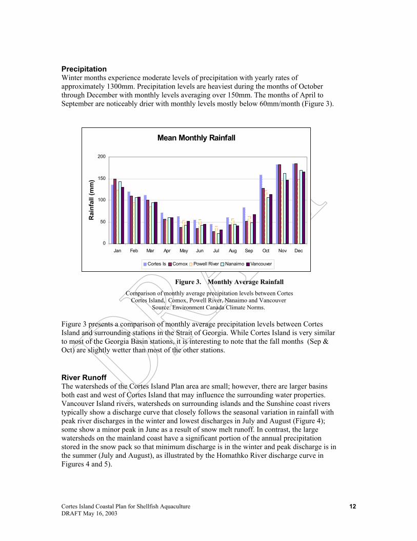
Precipitation Winter months experience moderate levels of precipitation with yearly rates of approximately 1300mm. Precipitation levels are heaviest during the months of October through December with monthly levels averaging over 150mm. The months of April to September are noticeably drier with monthly levels mostly below 60mm/month (Figure 3).
Figure 3. Monthly Average Rainfall Comparison of monthly average precipitation levels between Cortes
Cortes Island, Comox, Powell River, Nanaimo and Vancouver Source: Environment Canada Climate Norms.
Figure 3 presents a comparison of monthly average precipitation levels between Cortes Island and surrounding stations in the Strait of Georgia. While Cortes Island is very similar to most of the Georgia Basin stations, it is interesting to note that the fall months (Sep & Oct) are slightly wetter than most of the other stations.
River Runoff The watersheds of the Cortes Island Plan area are small; however, there are larger basins both east and west of Cortes Island that may influence the surrounding water properties. Vancouver Island rivers, watersheds on surrounding islands and the Sunshine coast rivers typically show a discharge curve that closely follows the seasonal variation in rainfall with peak river discharges in the winter and lowest discharges in July and August (Figure 4); some show a minor peak in June as a result of snow melt runoff. In contrast, the large watersheds on the mainland coast have a significant portion of the annual precipitation stored in the snow pack so that minimum discharge is in the winter and peak discharge is in the summer (July and August), as illustrated by the Homathko River discharge curve in Figures 4 and 5).

Cortes Island Coastal Plan for Shellfish Aquaculture DRAFT May 16, 2003
13
Mean Monthly River Discharge
0
50
100
150
Jan Feb Mar Apr May Jun Jul Aug Sep Oct Nov Dec
Dis
char
ge (c
ubic
met
res/
sec)
Campbell Oyster Puntledge Nanaimo
Figure 4. Mean Monthly River Discharges Comparison of monthly average discharge for Vancouver Is Rivers
Source: Inland Waters Directorate 1991
Figure 5. Mean Monthly River Discharges Comparison of monthly average discharge for Vancouver Is Rivers and
the Homathko River Source: Inland Waters Directorate 1991
The implications of these discharge patterns for marine planning purposes are two-fold: (a) waters can be quite seasonally variable in terms of salinity as a result of different discharge regimes and (b) the surrounding waters may be quite stratified as a result of significant freshwater discharge, especially from the mainland fjords. The Fraser River discharge, which is ten times the Homathko River and peaks in June, may influence the water structure throughout the Strait of Georgia.
Mean Monthly River Discharge
0100200
300400500600
700800
Jan Feb Mar Apr May Jun Jul Aug Sep Oct Nov Dec
Dis
char
ge (c
ubic
met
res/
sec)
Campbell Oyster Puntledge Nanaimo Homathko

Cortes Island Coastal Plan for Shellfish Aquaculture DRAFT May 16, 2003
14
Summary of Oceanographic Features The oceanographic region in the vicinity of Cortes Island is a transitional one with well-mixed, cold, saline channels to the north and stratified, estuarine like Georgia Basin and fjords to the south and east. Intense tidal mixing along the channels keeps stratification from forming but the cool, upwelled water is low in oxygen. The strong stratified regions to the east, caused by freshwater surface runoff from the fjords, and to the south, caused by freshwater runoff from the Fraser River results in high surface water temperatures during the summer. This warm surface layer frequently supports algal blooms.
Sea Surface Salinity Salinity in the Northern Strait of Georgia is influenced primarily by the freshwater runoff from watersheds of the Basin. Coastal fjords decrease salinity levels though the discharge of freshwater from the vast glacial basins located at their heads and from discharge of the Fraser River (Figure 6). Light station data of measured salinity in the region illustrates the seasonal variations that typically occur as a result of seasonal variation in discharge. The curves show a strong minimum salinity in July associated with the Fraser River freshet.
The surrounding straits and channels of Cortes connect the many fjord systems of the area to the Strait of Georgia. Although more stable than the adjacent inlets of Desolation Sound, salinity levels of the plan area are moderately influenced by the seasonal freshwater discharge from these systems.
Figure 6. Monthly Salinity values
Comparison of Monthly Salinity from C. Mudge (‘36-’84) and Chrome Is (‘61-’03) Light Stations
Source: DFO Website To the west, Lewis and Calm Channels display a relatively stable water column. Lower salinity occurs towards the northern end due to runoff from Bute and Toba Inlet, yet dissipates when reaching Teakerne Arm. Northwest of Cortes, Sutil Channel shows a more stable water column with little dilution and steady temperatures. South of Cortes, the Strait of Georgia is significantly influenced by the freshwater discharge of the Fraser River and Howe Sound. This seasonal dilution, erratically dispersed by winds
Mean Monthly Salinity
25
26
27
28
29
30
Jan Feb Mar Apr May Jun Jul Aug Sep Oct Nov Dec
Salin
ity (p
pt)
Chrome Is C. Mudge

Cortes Island Coastal Plan for Shellfish Aquaculture DRAFT May 16, 2003
15
mean Monthly Sea Surface Temperature
02468
1012141618
Jan Feb Mar Apr May Jun Jul Aug Sep Oct Nov Dec
Tem
pera
ture
(C)
Chrome Is C. Mudge
and tides, sweeps up the Sunshine Coast as a semi-dilute mass forming a distinct boundary of salinity and temperature in the waters between Cortes and Texada Island.
Sea Surface Temperature Summer sea surface temperatures in the Northern Strait of Georgia are known to be quite warm and are a key attractant for tourists in the region. Figure 7 presents sea surface temperature data from Chrome Island, at the south end of Denman Is and Cape Mudge, at the south end of Quadra Island, where lower temperatures are probably a result of mixing and upwelling Johnston Strait water.
Figure 7. Average Sea Surface Temperatures A comparison of sea surface temperature measurements recorded at
Chrome Is (‘61-’03) and Cape Mudge (‘37-’84) lighthouse stations of the Strait of Georgia. Source: DFO Website
These values present average monthly temperatures recorded from 1968-2002 and provide broad level characteristics for the Strait of Georgia. Recorded summer temperatures are more than twice winter measurements.

Cortes Island Coastal Plan for Shellfish Aquaculture DRAFT May 16, 2003
16
5 0 5 Kilometers
Wave ExposureSemi ExposedSemi ProtectedProtectedVery Protected
Cortes Is
Wind & Waves The shoreline wave exposure levels are extremely important in controlling the distribution of biota along the shore as well as providing an important constraint to development along the coast. A generalized view of exposure is indicated in Figure 8 and shows that the southwest corner of the island is the most exposed. Most other portions of the coast are relatively protected, with the most sheltered areas in the harbours and lagoons. Wave action is also important in redistributing sediment along the coast, especially where sediments are easily eroded, such as on Marina Island; sediment is transported from the south-facing shore to the north where it is re-deposited as a spit.
Figure 8. Generalised Wave Exposure Levels
Currents & Tides Currents are generated by tidal action and by winds and are extremely important in creating mixing energy that contributes to a break-down of stratification in high current areas. Areas of high current are generally well-mixed with higher productivity levels than similar low current areas. In addition, currents represent an important consideration in the distribution of nutrients and planktonic larvae. As a rule, human activities generally avoid high current areas as lower current areas provide alternatives due to the inherent design and management challenges of higher energy conditions. Exceptions may be made for aquaculture practices that rely upon current flow for oxygenation and dispersal of wastes. The tidal range in the Plan Area is between 3 and 4 m (Figure 9). Tides vary from almost diurnal (one tide per day) to semi-diurnal (two tides per day) throughout a lunar cycle. The variation in tidal elevation leads to strongly zonated species along the coast, with species in the upper intertidal zone adapted to lengthy drying periods and species in the lower intertidal zone adapted to short drying periods. The tidal variation also regulates the wave action across the intertidal zone and can be important in controlling pollutant impacts (i.e., oil spills).

Cortes Island Coastal Plan for Shellfish Aquaculture DRAFT May 16, 2003
17
W h a le to w n B a y P re d ic te d T id e s
0
1
2
3
4
5
6
1 0 1 5 2 0 2 5 3 0
A p ri l 2 0 0 3
Tida
l Ele
vatio
n (m
)
Changes in the tidal elevation also create currents throughout the region, however most currents are weak, <2 knots, except in some of the most restricted passages (The Gorge - 4 knots and Uganda Passage 3 knots).
Figure 9. Tidal elevation curve for Whaletown over a lunar cycle (~2 weeks)
Seabed Relief Seabed or benthic relief refers to the overall regularity of the seabed. An area with low relief will have a relatively uniform slope and little variation in elevation, for example a flat mud bottom. High relief areas exhibit considerable ranges in slope and elevation, as in the case of a rock reef. Relief plays a role in water column mixing but more obviously, an area with high relief is indicative of a more complex habitat for many organisms, notably rockfish and lingcod. The seabed of Cortes is of moderate relief with a relatively uniform slope of 5-20%. The depths of the western shores of Calm and Lewis Channels range from 100-200 metres while the eastern shores of Sutil Channel quickly drop to greater depths of 200-400 metres. Southern areas are more moderate with depths of 50-100 metres. Notably more complex areas of bottom relief include the surrounding seabed of the Subtle Island and around the Twin Islands.
Seabed Substrate Seabed substrate refers to the overall composition of the seafloor. Substrate can range from mud through sand to hard surfaces, including bedrock, boulders and cobble. Surfical sediment type is a significant factor for marine ecosystem composition as well as the potential effects of development. Soft substrates of mud and sand provide habitat for a variety of invertebrate species as well as foraging grounds for seabirds. Most of the deep seabed around Cortes Island appears to consist of mud, particularly to the east and north of the island. Nearshore areas are variable and more appropriately indexed by the coastal substrate (see section below). To the south, Marina Island and the Sutil Peninsula represent large erosional glacial deposits that include veneers of boulders and cobble in the nearshore and sand in the deeper offshore.

Cortes Island Coastal Plan for Shellfish Aquaculture DRAFT May 16, 2003
18
Generalized Shore Types
Rock23%
Rock + Sediment
28%
Sediment43%
Estuary + Lagoons
6%
2.3 Summary of Biological Features
Shore Zone Habitat Shore zone habitat is primarily determined by the wave exposure level and the substrate type along the coast. Mobile substrates such as sand or small gravel prevent the development of attached perennial flora and fauna. Immobile substrates, such as bedrock or large boulders, typically have well developed attached flora and fauna, whose species assemblages are largely determined by the wave exposure level. The generalized occurrence of substrates in the plan area is shown in Figure 10 and summarized in Figure 11. Of the slightly more than 200 km of shoreline, bedrock or bedrock-controlled shoreline is more common on the northern portion of the island. Sedimentary shorelines, including sandflats and sand & gravel beaches, are more common on the southern shores (Marina Island and Sutil Point). Estuaries and lagoons make up about 10% of the coast. Superimposed on these generalized trends, is the fact that many areas of rock headlands and small sand & gravel pocket beaches lead to considerable complexity around the islands. The large salt-water lagoons (head of Carrington Bay, Mason’s Landing) are a regionally significant feature of Cortes Island and are uncommon along the BC coast.
Figure 10. Generalised Shore Types around Cortes Island
Intertidal and shallow sub-tidal rocky reefs provide highly complex substrate and are important for groundfish, such as lingcod and rockfish. These reefs also provide diverse habitat for micro and macro-algae, benthic invertebrates and many species of non-commercial fish, particularly in more exposed areas. The soft substrate of intertidal mudflats and sand beaches provide habitat for invertebrate species which live within the substrate (infauna such as clams, worms and burrowing crustaceans). These infaunal species are extremely important food sources for shorebirds and other waterfowl. The nearshore biota of the Cortes Island Plan area can be generally categorized into three habitat types:
Rocky Shores Most of the rocky shores of Cortes Island occur in lower wave exposures, relative to the open Strait of Georgia. Communities typical of semi-protected and protected rocky shores include assemblages of attached plants and invertebrates, usually showing across-shore intertidal zonation. Upper intertidal bio-bands include: acorn barnacles, rockweed (Fucus), Pacific oysters and blue mussels, while the lower intertidal zone has a low turf of mixed red algae, associated with Japanese weed (Sargassum) and with bladed kelps (Laminaria spp.). Species diversity is usually higher on the semi-protected wave exposures than at the protected wave exposures. However there are also areas where tidal currents generate high marine species diversity (i.e. The Gorge).

Cortes Island Coastal Plan for Shellfish Aquaculture DRAFT May 16, 2003
19
5 0 5 K i l o m e t e r s
Shore Typerockrock + sedime n t sedimentestuaries + lag o o n s man made
Cortes Is
Figure 11. Summary of Cortes Island shore zone habitat
Protected Inlets and Bays In the most protected wave exposures, intertidal shorelines may look bare of attached biota. In the upper intertidal zone particularly at the heads of bays associated with freshwater streams or seepages, areas of salt-tolerant herbs and grasses form a distinct wetland species assemblage. Many protected inlets have rocky substrate in the upper intertidal, with muddy lower intertidal and shallow subtidal zones. The heads of the inlets are often characterized by protected tidal flats. Biota of these protected bays and inlets typically include acorn barnacle and rockweed (Fucus) in rocky, upper intertidal zones (sometimes sparsely distributed) and eelgrass (Zostera) in the lower intertidal muds. Associated invertebrates include various species of crabs, moon snails and clams.
Beaches and Tidal Flats In the Plan Area, the highest wave exposure shorelines, on the south end of Cortes Island, are mostly mobile sand and gravel sediments and wide tidal flats. In the upper intertidal zone these shorelines tend to be bare of visible biota (due to the sediment mobility) but, in the lower intertidal zone, wide tidal flats occur (e.g. around Marina Island). These lower intertidal flats include lush eelgrass (Zostera) beds, mobile epifauna such as seastars and bivalves and worms within the substrate (infauna). Scattered boulders provide stable attachment for larger algae, adding species diversity to these areas.

Cortes Island Coastal Plan for Shellfish Aquaculture DRAFT May 16, 2003
20
Marine Plants Marine plant groups consist of (A) microscopic marine floating algae or “phytoplankton”, (B) marine vascular plants or “sea grasses,” and (C) marine attached algae or “seaweeds”. Phytoplankton provides the basis of the ocean food web. These minute, single celled plants are eaten by zooplankton which in turn are the food for fish and larger invertebrates. They are present in all of the marine waters of Cortes, and their abundance varies seasonally with the availability of light and nutrients. When nutrients and light are optimal, high concentrations of phytoplankton (“blooms”) can occur and may colour the water red, brown or green (e.g. “red tide”). Some species produce potent toxins that concentrate in filter feeding bivalves (clams and oysters) that can cause paralytic shellfish poisoning (PSP) and are a seasonal public health hazard. Other species can injure or kill without toxins, such as dinoflagellates with serrated spines that lodge in fish gill tissues. Eelgrass (Zostera marina) is a marine vascular plant that grows in underwater meadows or “beds”, rooted in finer sand substrates. These beds are most commonly found in protected waters in the lower intertidal and shallow subtidal zones, often at the heads of inlets. Eelgrass beds provide important rearing habitat for a variety of fish and invertebrate species including crab, herring, and juvenile salmon. They are also extremely productive and play an important role in stabilizing the finer substrate in which they grow. Eelgrass beds are sensitive to many foreshore development activities and are difficult to restore once disturbed. Over the past decade a smaller introduced species of eelgrass (Zostera japonica) has been expanding in range within the Strait of Georgia. This species grows at a higher elevation in the intertidal zone. Within the Cortes Plan area, eelgrass beds are most extensive around Marina Island, Smelt Bay, the east side of Sutil Point, and Squirrel Cove. There are also eelgrass beds in Von Donop Inlet and the smaller bays on the northwest side of Cortes Island. Salt marsh communities (Salicornia and Distichlis) often occur at the heads of bays or along sections of shore with freshwater seepage. Like eelgrass beds, marsh communities are biologically productive and important fish and wildlife habitat. They are also sensitive to human disturbance including alternation of runoff pattern and physical disturbance. On Cortes Island salt marsh communities are most common in Squirrel Cove, Coulter Bay, the head of Whaletown Bay and around Cortes Bay. Canopy forming kelp beds (Nereocystis or bull kelp) are relatively uncommon on the Cortes shoreline. The most notable bull kelp beds are on the east side of the Subtle Islands and the south end of Twin Islands. The rocky shores of the Strait of Georgia support a wide diversity of algal species which often occur as bands vertically distributed across the intertidal and shallow subtidal zone. Characteristic algal bands in the Strait of Georgia include rockweed (Fucus), Japanese weed (Sargassum), green and red algal species (Ulva and a host of red algae species) and bladed kelps (particularly Laminaria and Agarum). Algal diversity and cover is generally greater in more exposed or high current areas such as the entrance to Gorge Harbour, and the rocky islets between Carrington Bay and Marina Island.
Invertebrates The Plan Area contains a variety of invertebrate species that are harvested for commercial, recreational and First Nations use. Intertidal clams (littleneck, manila and butter clams) are the most commonly harvested bivalves. These clam species generally occupy mixed substrates of gravel, sand, mud and shell in the intertidal zone. Manila clams are found slightly higher in the intertidal zone than littlenecks, and butter clams occur into the subtidal zone. There are regionally significant intertidal clam beds on the beaches of Marina Island

Cortes Island Coastal Plan for Shellfish Aquaculture DRAFT May 16, 2003
21
and Sutil Point and additional mapped beds at Squirrel Cove, Coulter Bay, Mary Point and Von Donop Inlet. There are likely also many smaller clam beds in suitable substrates in many locations within the plan area. A number of beaches in the Plan Area are subject to seasonal and permanent closures for the harvesting of bivalves. These closures may occur as a result of sanitary conditions, as well as marine toxins such as red tide. Information on these areas may be found at http://www.pac.dfo-mpo.gc.ca/ops/fm/shellfish/closures/area13/area_13.htm Geoducks are large clams that occur in the lower intertidal and subtidal zones to depths of over 100 metres. They are found in sand and gravel/sand substrates and have been commercially fished by divers since the 1970’s. The commercial geoduck fishery is the most valuable invertebrate fishery in British Columbia in terms of landed value. Geoducks are harvested on a three year rotational basis, with fisheries planned for the Strait of Georgia in 2003, 2006 and 2009. The Underwater Harvesters Association has identified a number of major commercial geoduck beds in the plan area, but does not want that information published in this Plan. Several geoduck aquaculture tenures and enhancement sites exist in the vicinity of Marina Island. Dungeness crabs are found to depths up to 100 metres, often in moderate to strong current areas with sandy bottoms. They are abundant in estuaries as well as more exposed areas. They are usually fished by trap, have a high commercial fishery value, and are important recreationally and for First Nation fishery purposes. Commercial crab fishing activity in the Plan area is low, but is greater at the head of adjacent inlets. Several species of shrimp are found in Plan area waters. They are harvested recreationally by traps and commercially by trawl gear (pink shrimp) or traps (prawns). Shrimp are generally found on the bottom, although some species range throughout the water column. Shrimp trawl activity in the Plan area occurs primarily at the south end of the Cortes Island (off Sutil Point and Marina Island and in Baker Passage). Prawns are the largest and most commercially lucrative of the Pacific coast shrimp species. They are primarily bottom dwellers, with typical habitat including the steeply sloping fjord inlets typically in waters of between 75 and 150 metres depth. They are commercially fished using traps set individually or on longlines. The Cortes Island area is considered to be a productive prawn fishing area (both commercially and recreationally) and fishing occurs around the islands at depths (75 to 125m) suitable for prawns. Red and green sea urchins are also found in the Plan area, generally in shallow areas with rocky substrates, moderate wave exposure and moderate to strong currents. Urchins graze extensively on algae, which in some locations results in drastic reduction of kelp and other seaweed beds. Urchins are commercially harvested by divers and processed for roe. There is a commercial quota for both red and green urchins in the Cortes Island plan area. There are a number of sea cucumber species in the Cortes plan area, although the giant red (California) sea cucumber is the largest and the only species commercially harvested. It is found from the intertidal zone to depths of about 250 metres, on a variety of substrate and current conditions. Sea cucumbers are harvested by divers, usually during autumn and winter, and are also a food resource to First Nations. Commercial harvesting is limited to 25% of the BC coast due to lack of stock information for certain areas. There is a small commercial quota for the Quadra/Cortes Island area. Bed areas are mapped by Fisheries and Oceans (DFO) and the Sea Cucumber Harvester’s Association but the data are confidential.
Cortes Island Coastal Plan for Shellfish Aquaculture DRAFT May 16, 2003
22
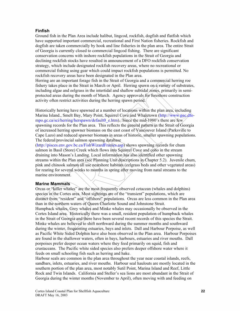
Finfish Ground fish in the Plan Area include halibut, lingcod, rockfish, dogfish and flatfish which have supported important commercial, recreational and First Nation fisheries. Rockfish and dogfish are taken commercially by hook and line fisheries in the plan area. The entire Strait of Georgia is currently closed to commercial lingcod fishing. There are significant conservation concerns with inshore rockfish populations in the Strait of Georgia and declining rockfish stocks have resulted in announcement of a DFO rockfish conservation strategy, which include designated rockfish recovery areas, where no recreational or commercial fishing using gear which could impact rockfish populations is permitted. No rockfish recovery areas have been designated in the Plan area. Herring are an important forage fish in the Strait of Georgia and a commercial herring roe fishery takes place in the Strait in March or April. Herring spawn on a variety of substrates, including algae and eelgrass in the intertidal and shallow subtidal zones, primarily in semi-protected areas during the month of March. Agency approvals for foreshore construction activity often restrict activities during the herring spawn period. Historically herring have spawned at a number of locations within the plan area, including Marina Island., Smelt Bay, Mary Point, Squirrel Cove and Whaletown (http://www.pac.dfo-mpo.gc.ca/sci/herring/herspawn/default0_e.htm). Since the mid-1980’s there are few spawning records for the Plan area. This reflects the general pattern in the Strait of Georgia of increased herring spawner biomass on the east coast of Vancouver Island (Parksville to Cape Lazo) and reduced spawner biomass in areas of historic, smaller spawning populations. The federal/provincial salmon spawning database (http://pisces.env.gov.bc.ca/FishWizardFrames.asp) shows spawning records for chum salmon in Basil (Store) Creek which flows into Squirrel Cove and coho in the stream draining into Mason’s Landing. Local information has also identified other spawning streams within the Plan area (see Planning Unit descriptions in Chapter 5.2). Juvenile chum, pink and chinook salmon all use nearshore habitats (eelgrass beds and other vegetated areas) for rearing for several weeks to months in spring after moving from natal streams to the marine environment.
Marine Mammals Orcas or “killer whales” are the most frequently observed cetacean (whales and dolphins) species in the Cortes area. Most sightings are of the “transient” populations, which are distinct from “resident” and “offshore” populations. Orcas are less common in the Plan area than in the northern waters of Queen Charlotte Sound and Johnstone Strait. Humpback whales, Grey whales and Minke whales may occasionally be observed in the Cortes Island area. Historically there was a small, resident population of humpback whales in the Strait of Georgia and there have been several recent records of this species the Strait. Minke whales are believed to shift northward during the summer months and southward during the winter, frequenting estuaries, bays and inlets. Dall and Harbour Porpoise, as well as Pacific White Sided Dolphin have also been observed in the Plan area. Harbour Porpoises are found in the shallower waters, often in bays, harbours, estuaries and river mouths. Dall porpoises prefer deeper ocean waters where they feed primarily on squid, fish and crustaceans. The Pacific white sided species also prefers deeper offshore water where it feeds on small schooling fish such as herring and hake. Harbour seals are common in the plan area throughout the year near coastal islands, reefs, sandbars, inlets, estuaries, and river mouths. Harbour seal haulouts are mostly located in the southern portion of the plan area, most notably Sutil Point, Marina Island and Reef, Little Rock and Twin Islands. California and Steller’s sea lions are most abundant in the Strait of Georgia during the winter months (November to April), often moving with and feeding on

Cortes Island Coastal Plan for Shellfish Aquaculture DRAFT May 16, 2003
23
herring returning to the Strait to spawn in March. Sea lions do not breed in the Strait of Georgia, and information is limited as to existence and location of haul-outs around Cortes during the winter and spring.
Birds The Strait of Georgia is an important resting and feeding area for spring and fall migratory marine and shore birds. The strait is also an important over-wintering area for marine birds including loons, cormorants, diving ducks and gulls. These species require continued access to sheltered bays and waterways, including estuaries and marshes. Species nesting in the strait include glaucous winged gulls, cormorants, pigeon guillemot and marbled murrulet. These longer-term visitors and resident species generally have additional management requirements, such as protection of specific breeding areas or habitats, and management of human activity or disturbance at critical times of the year. Important bird use areas include Cortes Bay, Sutil Point, Manson's Landing, Marina Island and the shores of Sutil Channel. Seabird breeding colonies in the Strait of Georgia have been identified by the Canadian Wildlife Service. There are documented seabird breeding colonies at Three Islets (pigeon guillemot and black oystercatchers) and neighbouring Little rock (black oystercatchers and glaucous winged gulls). In addition there is a documented great blue heron nesting colony near Whaletown. The second largest marine bird (glaucous winged gulls, pigeon guillemots and pelagic cormorants) breeding colony in the Strait of Georgia (Mitlenatch Island) is located about 10 km southwest of the Plan area.
Red & Blue Listed Species The provincial Conservation Data Centre (CDC) of the Ministry of Water, Land and Air Protection tracks plant and animal species at risk in British Columbia. These species may be at risk due to reductions in population size or threats to habitat resulting from human activities. Alternately these species may have very limited range within the province or a critical stage of their life cycle (e.g. breeding) occurs in very specific habitat or small area within the province. Red listed species are plants and animals which are being considered for the more formal designation of extirpated (no longer exists in the wild), endangered or threatened. Red listing flags these species as being at risk. Blue listed species are considered to be vulnerable in British Columbia. Vulnerable species are of special concern because of characteristics that make them particularly sensitive to human activities or natural events. Blue listed species are considered at a lower level of risk than red listed species. Table 2 shows red and blue listed marine birds and mammals likely to occur in the Cortes Plan area. Red and blue listings have not been completed for marine fish. CDC does maintain a list of red and blue listed marine algae and invertebrates, however information on the distribution of these species is generally lacking in coastal British Columbia. Most data are single occurrence records or from a very limited area. Table 2. Red and Blue listed marine birds, mammals and fish found in the Cortes Plan Area. Birds Western Grebe Aechmophorus occidentalis Red Great Blue Heron, subspecies Ardea herodias Blue Surf Scoter Melanitta perspicillata Blue Common Murre Uria aalge Red Marbled Murrelet Brachyramphus marmoratus Red Mammals Killer Whale (Northeast Pacific Resident population) Orcinus orca population 1 Blue

Cortes Island Coastal Plan for Shellfish Aquaculture DRAFT May 16, 2003
24
Killer Whale (Northeast Pacific Offshore population) Orcinus orca population 2 Blue Killer Whale (West Coast Transient population) Orcinus orca population 3 Blue Harbor Porpoise Phocoena phocoena Blue Grey Whale Eschrichtius robustus Blue Humpback Whale Megaptera novaeangliae Blue Northern Sea Lion Eumetopias jubatus Red Fish Eulachon Thaleichys pacificus Blue
2.4 Social and Economic Profile
Community and Demographic Profile The plan area is located within the Comox-Strathcona Regional District Electoral Area I. It is also contained in the traditional territories of the Klahoose, Sliammon and Homalco First Nations and some of the member First Nations of the Hamatla Treaty Society. There is no municipal level of government. There are several settlements, including Whaletown, Mansons Landing, Squirrel Cove and Cortes Bay. The Klahoose band has two reserves, Tork and Squirrel Cove reserves near Squirrel Cove. The Sliammon Band’s reserve (Paukeanum) is located near Mansons Landing. Community services on the island include a health centre, library, volunteer fire hall, community halls, school (up to grade 10). Campbell River is the regional center for goods and services not readily available on Cortes Island. The plan area is accessed primarily by water. BC Ferries operates scheduled ferry service
between Quadra Island and Whaletown, and from Quadra Island to Campbell River. Travel time between Whaletown and Campbell River is about 2 hours, which inhibits commuting for employment, entertainment, and the flow of goods and services. Over the past 15 years annual ridership on the Quadra/Cortes ferry has grown at an annual average rate of 2%. The busiest time is the summer months of July/August (reflecting the island’s tourism business), which has also grown at about 2% per year. The February/March period (reflective of travel by permanent residence) has grown at 1%/year over the same period.
The Cortes population is 1,000 persons (Census 2001). This is an increase of 5% relative to the 1996 Census. This growth is comparable to the provincial growth over the same period of 4.9%. However, many of BC’s rural areas lost population relative to the 1996 Census, so Cortes Island’s population gains may be significant when viewed from this perspective. For instance, three of the six regional districts on Vancouver Island lost population relative to the 1996 Census. The Comox-Strathcona Regional District (RD) declined 1.5%. According to the Census, first nation people make up about 10% of the plan area population (about 100 persons) compared to 7% for the RD. The average family size of 2.6 persons is slightly smaller than the RD’s of 2.8 persons. The mobility of the Cortes Island population is
Trend in Ferry Ridership
0
20,000
40,000
60,000
80,000
100,000
120,000
86 88 90 92 94 96 98 00 02
pass
enge
rs
Annual
July/August
Feb/March
Linear (Annual)

Cortes Island Coastal Plan for Shellfish Aquaculture DRAFT May 16, 2003
25
similar to provincial average, with about 20% of the population changing address in the past year.
The age profile of the population differs from that of the RD. That is, there are relatively fewer persons in the younger and older age groups, and a higher proportion of persons in the 45-65 age group. This profile may be reflective of the level of services available on the island. For instance, schooling is available to grade 10, which may incline families with teenage children to re-locate. Similarly, the island has basic health services (i.e. a clinic and doctor) that may not be sufficient for older age groups. It is also the case that ferry connections do not facilitate commuting to Vancouver Island for employment opportunities.
A population forecast for Cortes Island is not prepared by BC Stats. The latest long term forecast for the RD and Vancouver Island indicates that, over the longer term, the RD’s population growth
is expected to grow slightly faster than the rest of the island. Most of this growth is attributable to in-migration. This would suggest relatively robust growth for the plan area. However, it is also the case that the Vancouver Island population will “age” significantly over the next thirty years. If Cortes Island’s level of services to the older population continues to be relatively limited, this age group would be less inclined to move to the island. This factor would moderate expected population growth that may occur for the RD generally.
First Nations: Cortes Island is within the traditional territories of the Klahoose and
the Sliammon first nations. Other first nations have also indicated traditional use practices or sites in the plan area, but these interests are not addressed here. The Klahoose First Nation population is about 290 persons, but not all band members live in the plan area. About 60 families live on the Tork reserve. There is no road access to Squirrel Cove Reserve and it is not inhabited. The band is negotiating treaty settlement under the BC treaty process. It is at stage 4 of the six step process. The band’s principle income generating activity is associated with shellfish harvesting (i.e. oysters and clams) on the band’s tenures. Production from the shallow water tenures is ramping up relative to recent performance. Harvesting activity employ 8-10 persons. The produce is sold to off-island processors. The band foresees potential for expanding aquaculture activities, by increasing shellfish production from current and future tenures, farming other species (e.g. sea cucumbers, black cod), and the like. The band also harvests shellfish for subsistence and ceremonial purposes.
Historic and Forecast Population Growth
-10%
0%
10%
20%
30%
86-91 91-96 96-01 01-06 06-11 11-16 16-21 21-26 26-31
% g
row
th in
5 y
rs.
RDVancouver Is.
Age Profile
0%
10%
20%
30%
40%
under 15 15-44 45-64 65+
Cortes '01RD '01Cortes '31(est.)

Cortes Island Coastal Plan for Shellfish Aquaculture DRAFT May 16, 2003
26
The band holds a wood lot on the Island with an allowable annual harvest volume of 1,104 cubic metres. There has been no harvesting on the wood lot since 1996, but has commenced again this year. Harvesting employs about three persons. The logs are sold on the open market and transported off-island for processing. The band is not presently active in the tourism/recreation industry. The band has a co-management agreement with BC Parks for the Ha’thayin (Von Donop) Provincial Marine Park, but to date this has not involved active band participation. There is potential for providing eco-tourism services (e.g. bear viewing), and providing services to recreational boaters which may be developed in the future. The band holds a gillnetting license, but commercial salmon fishing has not historically been an important income earning activity. The Sliammon First Nation has reserve land near Mansons Landing ((Paukeanum). The reserve is not inhabited. The band’s economic activities in the plan area will be submitted in the future (contact: Denise Smith).
Economy This section examines the important income generating economic activities in Cortes Island’s formal economy. The economic perspective presented here corresponds to the formal economy. The economic significance of barter exchange and other unrecorded activities is not addressed in this profile. Formal sector income is derived from employment, and non-employment sources. The plan area’s employment participation rate (i.e. percent of prime age persons in the workforce) is 67% compared to a provincial rate of 65%. The unemployment rate was 6.7% (2001 Census) compared to a provincial average of 8.5%. Forty six percent of the plan area workforce indicated they work from home as compared to 10% provincially. Eighteen percent have no fixed workplace address as compared to 11% provincially. Given the island’s small economic base and the difficulty in commuting to Campbell River (the region’s major employment centre), the preponderance of home based offices is understandable. Non-employment sources of income are transfer payments, investment income, pension income and the like. According to the 2001 Census, there were 560 persons in the Island’s labour force, or 56% of the population. This is higher than the RD or BC ratio of about 50%, but consistent with the larger proportion of working age persons on the island. The larger employers include BC Ferries, the School District, Hollyhock Resort, 4 stores and shell fish farming.
Commercial fishing does not appear to be a significant economic activity, with perhaps 4 boats involved . The distribution of the labour force among industries gives an indication of the relative importance of income and employment generating activities. According to the 2001 Census, about 25% of the plan area labour force were in goods producing activities (i.e. primary industries such as forestry, fishing, and agriculture; and manufacturing such as wood processing, food processing). Significantly lower proportion of the labour force was in wholesale and retail
trade, but a higher proportion in “other services”. Tourism related industries (i.e. food and
12%
13%8%2%
23%
18%
25%
13%
13%
14%4%
17%
14%
24%
5%16%
16%6%
17%
17%
22%
0%
20%
40%
60%
80%
100%
Cortes Island Comox-Strath BC
Labour Force by Industry
Other services Business services Health and ed.FinanceTradeManufacturing/Const.Primary
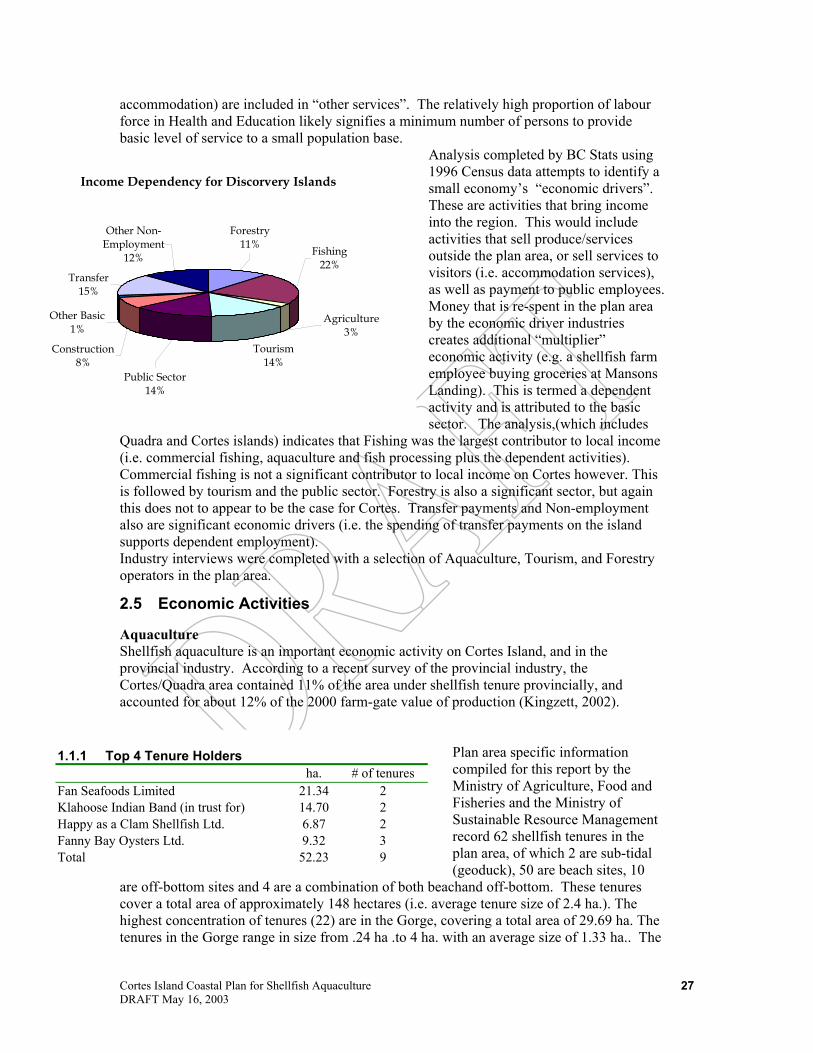
Cortes Island Coastal Plan for Shellfish Aquaculture DRAFT May 16, 2003
27
accommodation) are included in “other services”. The relatively high proportion of labour force in Health and Education likely signifies a minimum number of persons to provide basic level of service to a small population base.
Analysis completed by BC Stats using 1996 Census data attempts to identify a small economy’s “economic drivers”. These are activities that bring income into the region. This would include activities that sell produce/services outside the plan area, or sell services to visitors (i.e. accommodation services), as well as payment to public employees. Money that is re-spent in the plan area by the economic driver industries creates additional “multiplier” economic activity (e.g. a shellfish farm employee buying groceries at Mansons Landing). This is termed a dependent activity and is attributed to the basic sector. The analysis,(which includes
Quadra and Cortes islands) indicates that Fishing was the largest contributor to local income (i.e. commercial fishing, aquaculture and fish processing plus the dependent activities). Commercial fishing is not a significant contributor to local income on Cortes however. This is followed by tourism and the public sector. Forestry is also a significant sector, but again this does not to appear to be the case for Cortes. Transfer payments and Non-employment also are significant economic drivers (i.e. the spending of transfer payments on the island supports dependent employment). Industry interviews were completed with a selection of Aquaculture, Tourism, and Forestry operators in the plan area.
2.5 Economic Activities
Aquaculture Shellfish aquaculture is an important economic activity on Cortes Island, and in the provincial industry. According to a recent survey of the provincial industry, the Cortes/Quadra area contained 11% of the area under shellfish tenure provincially, and accounted for about 12% of the 2000 farm-gate value of production (Kingzett, 2002).
Plan area specific information compiled for this report by the Ministry of Agriculture, Food and Fisheries and the Ministry of Sustainable Resource Management record 62 shellfish tenures in the plan area, of which 2 are sub-tidal (geoduck), 50 are beach sites, 10
are off-bottom sites and 4 are a combination of both beachand off-bottom. These tenures cover a total area of approximately 148 hectares (i.e. average tenure size of 2.4 ha.). The highest concentration of tenures (22) are in the Gorge, covering a total area of 29.69 ha. The tenures in the Gorge range in size from .24 ha .to 4 ha. with an average size of 1.33 ha.. The
Income Dependency for Discorvery Islands
Tourism14%
Construction8%
Other Basic1%
Transfer15%
Other Non-Employment
12%
Forestry11%
Public Sector14%
Fishing22%
Agriculture3%
1.1.1 Top 4 Tenure Holders ha. # of tenures
Fan Seafoods Limited 21.34 2 Klahoose Indian Band (in trust for) 14.70 2 Happy as a Clam Shellfish Ltd. 6.87 2 Fanny Bay Oysters Ltd. 9.32 3 Total 52.23 9

Cortes Island Coastal Plan for Shellfish Aquaculture DRAFT May 16, 2003
28
next large concentration of tenures is around Marina Island, consisting of 19 tenures covering 54.55 ha. The second and third largest tenures (11 ha. and 10 ha.) are located there. The largest single tenure is held in trust by the Klahoose band at Squirrel Cove (11.7 ha.). The four largest tenure holders collectively hold 9 tenures covering 36% of the tenured area. The tenures include both beach and deep water sites. A number of the industry participants interviewed held both types of tenures. At least a couple of the deep water tenures essentially sub-let space to members of the organization (i.e. Bee Islets Growers, Cortes Shellfish Coop whose tenure is outside the plan area). Most of the tenures appear to be held by owner-operators that reside in the Plan area or nearby (i.e. Campbell River). While the tenures appear to be held by a large number of operators, production is concentrated on a relatively small number of tenures. That is, the top ten tenures account for about 60% of the total farm gate value (in 2000 and 2001). Similarly, the average sales revenue per tenure is about $30,000, while the median income is about $19,000/tenure. These statistics suggest an industry that is composed of a relatively large number of part-time, or small operators and a relatively small number of highly productive operations. Industry interviews indicated that there has been some consolidation of operators on Cortes,
but small operators still largely dominate it. A reliable indicator of industry consolidation is a rising tenure value and the number of tenures changing hands.
A rising price will induce less productive farmers to sell (as they can make more by selling than continuing to work the tenure). The new owner must be more productive (to justify the price paid for the tenure) which usually means an increase in invested capital. Industry participants indicated that tenure values have been increasing, but data on transaction values was not reviewed. Oysters are the primary species produced. These are sold shucked or in the shell. Clams and mussels are also produced in significant volume. Many operators sell to licensed processors. Shell fish processors are located on Vancouver Island and Vancouver. Some operators have their produce custom processed and retain responsibility for finding a final customer. Final markets are varied. Examples of direct sales include customers (i.e. restaurants) in Vancouver, Toronto and Hawaii. Operators that sold direct indicated a
doubling of their profit margin as compared to selling to a processor. The farm gate value of shellfish production according to MAFF statistics has ranged from $813,000 in 1997 to about $1.5 million in 2001. The latest year recorded the highest sales, which is attributed to the large increase in revenue from the sale of clams and mussels.
1.1.2 Production from plan area Shellfish Tenures 97 98 99 00 01
Clams & Mussels('000 lbs) 60 127 92 97 226 Oysters ('000 doz) 220 265 229 269 242 Oysters ('000 gallon) 2 3 8 5 9 Number Reporting 36 47 43 42 48 value per site ($000/tenure) $ 22.57 $ 24.92 $ 22.43 $28.10 $ 31.56
-100200300400500600700800900
$000
97 98 99 00 01
years
Farmgate Values from Plan Area Tenures
Clams & MusselsOysters (shell)Oysters (shucked)

Cortes Island Coastal Plan for Shellfish Aquaculture DRAFT May 16, 2003
29
Industry interviews indicated that on an area basis, deep water leases are typically more productive than beach operations. Cortes Island producers indicated sales revenue per raft of between $5,000 to $15,000 (shucked and half shell respectively). Interviews also indicated that between 30-40 rafts per hectare could be efficiently worked with about half of the rafts harvested each year. This would indicate for Cortes Island a sales revenue coefficient of $75,000-$225,000 per ha. per year for deep water tenures. Relative to the provincial average for deep water operations, the sales revenue of the Cortes farms is significantly higher. MSRM compiled a profile of an efficient deep water shellfish aquaculture operation based on industry survey and other analysis. Annual sales revenue for this representative operator (or building block) was in the order of $55,000-$75,000 (MSRM, 2002). The productivity of beach tenures is relatively more variable since it depends on the quality of the substrate as well as improvements by the farmer. Cortes Island industry interviews indicated gross sales values ranging from $10,000/ha to $18,000/ha. . The industry average is $8000/hectare (GSGislason & Associates, July 2002). The smallest operations that could support a viable economic operation was estimated by industry operators to be about 5 rafts for a deep water operation. About 1.5 to 2 hectares of a good beach tenure is about the smallest economically viable size for this growing method. It generally takes about 5 years to develop a farm from start-up to an economically viable operating unit. With respect to industry employment, a consistent estimate of 15 rafts to support one full time equivalent position was reported by several operators. Beginning wage is about $12 per hour, and the more experienced individual receiving $15 per hour. This corresponds to an annual wage in the order of $21,000 per year. Given farm gate value in 2001 of $1.5 million (and reduced by 50% to account for expenses), this would indicate industry supports some 36 full time equivalent (fte)positions. These full time position are manifest as full time, part time and seasonal jobs. Hence the number of people holding jobs at some point during the year could reasonably be double the estimate of fte. It is noted that a recent estimate of direct employment for the Cortes Island/Quadra Island shellfish industry was 44 full time positions (Salter, 2002). Operators indicated that the farm operation itself did not generate large local expenditure on local goods and services. Most of the local economic impact would be from the responding of wages paid to employees. This could be in the order of $750,000 in recent years, which is substantial in this small island economy. Cortes Island aquaculture output stimulates additional activity in BC with the processing and retailing of the final product. It is reported that the BC input/output model has estimated a total job multiplier of 1.75 for the aquaculture industry. This would indicate that the 36 full time equivalent position on Cortes Island would support additional employment of 27 full time positions, most of these would be in processing plant and supply firms on Vancouver Island, and retail sales on Cortes Island. Total employment is estimated to be 63 full time equivalent positions.
Tourism and Public Recreation Visitors to the Island create a demand for a range of goods and services that support local incomes and employment. Many of the prime attractions for visitors are saltwater based or along the coast. The primary season is June through August. This season is reflected in BC Ferries monthly
Monthly Ferry Ridership
2002
1986
0
2,000
4,000
6,000
8,000
10,000
12,000
14,000
16,000
18,000
Jan Feb Mar Apr May Jun Jul Aug Sep Oct Nov Dec
pass
enge
rs

Cortes Island Coastal Plan for Shellfish Aquaculture DRAFT May 16, 2003
30
passenger statistics, which compares annual monthly passenger traffic in 1986 and 2002. Relative to 1986, monthly passenger traffic has increased in every month. There is an evident increase in the shoulder season passenger traffic. The “tourism industry” is comprised of a variety of establishments, some of which serve island residents as well as visitors. For example, the stores and restaurants serve both residents and visitors needs. A distinction is made between visitor spending, which is new income (or basic income) verses resident spending which is re-circulation of basic income. Island facilities that cater almost exclusively to visitors are motels (4 in number), bed and breakfast operations (9), rental cabins, parks, campgrounds, marinas, and adventure tourism operations. According to recent visitor data, the Smelt Bay provincial park is the busiest of the three provincial parks on the island. The largest operator in the industry, Hollyhock Resort, indicated that it currently employs 12-15 persons full time, and 75 to 80 persons on a seasonal basis. The resort has increased its
business in recent years2 by extending its operating season, which is presently April through November. In the latest year, about 2,300 guests visited the facilities with an average stay of about 5 days. Employment and income estimate for the Island’s tourism industry was not readily available. Based on the make-up of the island’s industry, it is estimated that the industry supports about 85 full time equivalent positions, though a much larger number of persons are actually employed on a seasonal basis. It is estimated that the industry pays annual wages to on-
island employees of some $1.3 million in recent years. Gross revenue generated by the Island’s industry is about $2.9 million. Hollyhock Resort accounts for about 70% of the industry’s economic impact on the island.
Forestry Commercial management activity occurs on public and private forestlands. With respect to the management of Crown forestland, two replaceable Timber Sales Licenses are issued with a total annual harvest of 900 cubic meters. The Klahoose Band holds a wood lot license with an approved annual harvest of 1,104 cubic metres. Most of the remainder of the commercially valuable Crown timber volume is under forest license to Canadian Forest Products. Presently, actual forest harvesting activity is very low. Cutting permits are approved for the wood lot and the timber sales licenses and at the time of writing harvest was taking place on the wood lot. Weyerhauser Canada owns about 1,600 hectares of private forest land. The company is in the process of selling parcels of land. Six parcels have been sold, and ten parcels are expected to be offered for sale in the near future. The parcels range in size from 10 acres to 160 acres. The land is zoned F1 (permits 1 domicile) and is subject to development
2 This has been made possible by investing in winterizing the facility.
1.1.3 Provincial and Regional Parks on Cortes Island Park Name size (ha) salt water
access average annual person visits2
Smelt Bay1 16 a 11,887 Mansons Landing1 47 a 6,072 Ha'thayin (Von Donop) Marine Park1
1277 a 3,574
Kwas Lake 249 na Cortes Boat Launch 1 a na Carrington Bay 214 a na
Notes 1. denotes provincial park, otherwise regional park 2. average for 1999 and 2000 except Ha'thayin Marine Park which is 1999 only

Cortes Island Coastal Plan for Shellfish Aquaculture DRAFT May 16, 2003
31
covenants. The new owner may continue to manage the land as a working forest. Apparently several of the six parcels sold will continue as privately managed forest land. It was indicated that the covenants are intended to respect the parcels’ the ecological values. Development plans are subject to review by Nature Trust of BC. There is no permanent wood-manufacturing mill on the Island. In general, timber harvested on the island is transported to manufacturing facilities elsewhere.

Cortes Island Coastal Plan for Shellfish Aquaculture DRAFT May 16, 2003
32
3.0 Plan Framework and Direction 3.1 Use of the Plan The Cortes Island Coastal Plan is designed to assist prospective land tenure applicants, First Nations, local government, LWBC and other government agencies in dealing with shellfish aquaculture applications for the use of provincial Crown foreshore and nearshore tenures. The Plan may also provide a useful tool to assist in the marketing of community and First Nations economic development. The Plan is also designed to provide a context for enforcement and compliance measures taken by regulatory agencies to address issues associated with existing operations. The Plan is expected to provide an information base that agencies can use to address issues such as trespass, and social impacts, within the limits of their jurisdiction and describe the relative regulatory roles of key agencies involved in regulating the shellfish aquaculture industry. Use of the Plan should benefit First Nations, local government, LWBC and other government agencies by screening or filtering potential Crown land applications which may have limited likelihood of success. In this way, work loads of these agencies and organizations can be expected to be lowered in both volume and level of complication or controversy. The Plan can also inform the public on what activities each agency is responsible for. Although the Plan has been developed with the assistance and support of the Regional District of Comox Strathcona, the Plan is not intended to replace the need for referrals to local government. Similarly, the Plan is not intended to replace provincial or federal agency referrals or to absolve LWBC from addressing its legal obligations to consult with First Nations on land tenure applications. With the exception of other compelling constraints or LWBC application requirements, applications for uses that are consistent with the Plan should be accepted and evaluated by LWBC. The Plan is not intended to directly address operational or production requirements associated with shellfish aquaculture because day to day regulation of activities is the responsibility of Statutory Decision Makers, under their respective statutes and regulatory instruments such as Crown land tenures, Aquaculture Licences and Regional District Zoning. This Plan recognizes the responsibility of RDCS to develop Zoning Bylaws. If any provisions of this Pan do not prove consistent with RDCS Zoning provisions, this Plan will be subject to any province-wide policy that may address inconsistency between Local Government Bylaws and Coastal Plans. Future development of offshore oil and gas resources was not considered in developing the Plan. This Plan and its recommendations will not affect or prejudice any offshore oil and gas development, including any land requirements for offshore oil and gas activities.
3.2 Strategic Direction: The Vancouver Island Land Use Plan The recommendations of the Cotes Island Coastal Plan are intended to be consistent with the general direction provided by the goals, objectives and strategies outlined in the Vancouver Island Land Use Plan (VILUP). Although many descriptions are terrestrially oriented, the VILUP does recognize the high recreation, tourism and aquaculture potential of the area and also the potential for conflict. This Plan responds to VILUP recommendation for high planning priority and provides detailed planning recommendations consistent with the strategic direction of the VILUP. The Plan Area is included within one Resource Management Zone and coastal planning unit identified by the VILUP. Those zones are summarized below in Table . Appendix 5 presents the detailed management provisions associated with each of these VILUP zones.

Cortes Island Coastal Plan for Shellfish Aquaculture DRAFT May 16, 2003
33
Table 3: Vancouver Island Land Use Plan Resource Management Zones VILUP Coastal Planning Unit
Location: Overall Management Guidance
Planning Priority
SMZ-32: Quadra Cortes
Northern tip of Quadra Island, Cortes, Read and Maurelle Islands
General Management Zone, with significant recreation/scenery and tourism values and immediate significance for biodiversity conservation; forest management practices should be adapted in design and scale to fit the nature, scale and sensitivities of the northern Gulf Island/southern Johnstone Strait environment.
High
3.3 Resource Maps, Planning Units and Unit Data The area covered by this Plan has been divided into 8 planning units. Several resource maps have been prepared that have assisted in the development of this Plan. The planning unit boundaries are largely based on the provincial Marine Ecosystem Classification System with some modification to reflect human use patterns and specific biological features. The Planning Units do not include Provincial Parks. Future versions of this Plan may require Planning Unit modification to accommodate future oceans planning work by Fisheries and Oceans Canada (FOC) and any associated aquatic management boards that may be set up. Section 3.4 of this Plan presents descriptions and management recommendations related to shellfish aquaculture for each of these units. For each planning unit, the Plan provides a description and map of resource attributes, existing tenured uses, non-tenured activities, status of adjacent upland, and resource capabilities for selected uses. These Maps and the legends to go with them are available at the following sites (there is only one legend for all the Planning Unit Maps, whereas the other maps each have their own legend): website: http://srmwww.gov.bc.ca/dss/projects/sarp/cortes.htm (map gallery) and ftp site:
ftp://gis.luco.gov.bc.ca/pub/coastal/cortes/pdf (resource maps) ftp://gis.luco.gov.bc.ca/pub/coastal/cortes/jpg (planning unit maps and legend) Although some upland features are shown on the maps, the Plan does not prescribe uses for these upland areas. Planning unit descriptions and attributes reflect data drawn from two sources. Established government databases are the source of most of the data in this Plan. Spatial information used in this Plan is available on the Ministry website at: http://srmwww.gov.bc.ca/dss/coastal/planning/Cortes.htm. Such data have been collected and assembled according to standardized methods determined by the Province’s Resource Inventory Committee. This approach helps to ensure the quality and consistency of those data.

Cortes Island Coastal Plan for Shellfish Aquaculture DRAFT May 16, 2003
34
An equally important source of data provided in the descriptions and attributes is local knowledge gained through stakeholder consultation for this Plan. Although local knowledge documented in this Plan has been recognized, displayed on the Planning Unit Maps and used to provide insight into particular attributes of an area, it cannot readily be added to established government databases without being gathered and validated according to provincial data inventory standards. Planning unit attributes, in Section 3.4 that are based on local knowledge are included on the maps and identified as such in the planning unit descriptions. While these data are useful and important to the Plan, users of this Plan should understand that such information has not been validated by government or included in “official” government databases. Planning unit descriptions and maps in Section 3.4 also contain data regarding capability of areas to support aquaculture. These capability assessments which are based on field sampling and reconnaissance, provide broad scale analysis of biophysical conditions for beach culture of oysters and manila clams, and deepwater culture of scallops and oysters. Such data provide a general guide to areas of medium and high shellfish culture capability, but cannot be used with certainty to select individual sites, without site-specific feasibility studies. The physical attribute tables at the beginning of each Planning Unit section (i.e. substrate, roughness, slope, etc.), are taken from the provincial Marine Ecological Classification System at the Ecounit level as well as a report that SRM contracted to a consultant for an area overview, and refer to deeper water features. The nearshore attribute descriptions which follow (intertidal and shallow sub-tidal) can be quite different. (i.e. the nearshore substrate of a unit could be predominately rock with a steep slope in contrast to the offshore seabed which may not be steeply sloping).

Cortes Island Coastal Plan for Shellfish Aquaculture DRAFT May 16, 2003
35
3.4 Planning Unit Direction Following are descriptions of each Planning Unit along with siting and management recommendations for shellfish aquaculture. These were developed using general and specific use conditions outlined in Appendix 7. There is a planning unit map corresponding to each of the unit descriptions and provisions below. The Planning Unit maps are available at the following two locations: website: http://srmwww.gov.bc.ca/dss/projects/sarp/cortes.htm (map gallery) ftp://gis.luco.gov.bc.ca/pub/coastal/cortes/jpg (planning unit maps and legend)
In addition to providing information on biological values, physical shoreline, aquaculture biophysical capability, ownership and tenure, and non-tenured activities, each planning unit map provides the locations of potential sites, based on conflict analysis, capability and local knowledge. The Advisory Committee has requested that that all remaining clam beaches be preserved for wild harvest. This plan has identified some beaches as potential development sites, but here flags them collectively as an issue that needs to be addressed at the site-specific application stage. Table 4 provides a description of the physiographic attributes (from the Marine Ecosystem Classification System) that are outlined at the beginning of each planning unit description below.
Table 4. Ecosystem Classifications Depth
Shallow 0-20m Photic 20-50m Mid-depth 50-200m
Deep 200-1000m
Abyssal > 1000m
Temperature (summer at seabed bottom) Warm 9-15°C Cool <9°C Slope Flat 0-5% Sloping 5-20% Steep >20% Current High >3knots Low < 3knots Substrate Mud Sand Hard Exposure (wave/fetch exposure)

Cortes Island Coastal Plan for Shellfish Aquaculture DRAFT May 16, 2003
36
High Moderate Low Roughness (seabed relief) High Moderate Low

Cortes Island Coastal Plan for Shellfish Aquaculture DRAFT May 16, 2003
37
Unit 1 Cortes Island North Marine Area 1297 ha Shoreline 16 km
Substrate Mud Slope Sloping Exposure Low Depth Deep
Current Low Benthic Summer Temp Warm Roughness Low
Description: This section of shoreline is dominated by narrow rocky shorelines, a few sand and gravel pocket beaches and relatively long gravel beach (due west of Teakerne Arm). Wave exposures are relatively low (protected) except at a few locations where wave fetches of greater than 10 km occur (e.g., northern tip). Currents are reportedly low in Lewis Channel (<2knots). The area appears to be influenced by runoff from Toba and Bute Inlets. Local residents report the area is subject to westerly and northeasterly winds that cause rough water and that Lewis Channel is affected by polar outflow winds from Bute Inlet. The offshore seabed relief is relatively uniform and seabed sediments in deeper water appear to be mud. The unit contains relatively few nearshore uses due to its rocky shoreline and narrow waterways. Unit Attributes: • Nearshore Habitat: predominately rocky shore habitat • Prawn fishing, urchins • Intertidal clam beach (1 identified) • Eelgrass bed (1 identified ) in pocket beach • The area is a high use area for pleasure craft at certain times of the year due to direct
route and visual quality. Current Uses and Activities: • Shellfish tenures (1 beach site and 1 combined beach and off-bottom site collectively
occupying 8.08 ha). Data were not available for the relative amount of beach occupied by the combined tenure.
• General tenures (2) • Sutil and Lewis Channels are identified as major transportation routes for both
commercial and recreational vessels

Cortes Island Coastal Plan for Shellfish Aquaculture DRAFT May 16, 2003
38
Use recommendations
Tenure Recommendations Shellfish Beach Aquaculture
Existing: Acceptable The use is considered acceptable and appropriate subject to regulatory requirements and zoning policy. Future Use: Conditionally Acceptable. The use is considered conditionally acceptable. New applications for this use should be accepted for processing and evaluation only if they meet the terms of relevant Management Provisions in the Plan and subject to zoning policy.
Shellfish Off-Bottom Aquaculture
Existing Use: The use is considered acceptable and appropriate subject to regulatory requirements and zoning policy. Future Use: Conditionally Acceptable. The use is considered conditionally acceptable. New applications for this use should be accepted for processing and evaluation only if they meet the terms of relevant Management Provisions in the Plan and subject to zoning policy.
Sub-Tidal Culture
Existing Use: Absent. Future Use: Conditionally Acceptable. The use is considered conditionally acceptable. New applications for this use should be accepted for processing and evaluation only if they meet the terms of relevant Management Provisions in the Plan and subject to zoning policy.
Management Provisions • While applications are conditionally acceptable throughout the unit specific potential sites are
identified on planning unit map #1.

Cortes Island Coastal Plan for Shellfish Aquaculture DRAFT May 16, 2003
39
Unit 2 Sutil Channel Marine Area 1409 ha. Shoreline 35 km
Substrate Mud Slope Sloping Exposure Low Depth Mid-Depth
Current Low Benthic Summer Temp Warm Roughness Moderate
Description: This unit consists of a portion of the northern shoreline of Sutil Channel, but does not include Von Donop Marine Park, a Provincial Park area. This Planning Unit contains a mixture of bedrock shores, small pocket beaches of sand and gravel, and sand flats. Locals have indicated the area is subject to strong westerly winds. Attributes: • Nearshore Habitats: Rocky shore and small protected bay habitats • CWS Area of Use for migratory birds • Intertidal clam beaches (4 identified) • Eelgrass beds (1 identified) • Herring spawn: Shoreline north of Quartz Bay • Commercial Marine Tourism operators have identified the area as an important for
pleasure and tour boating. Current Uses and Activities: • Campsites (2) • Safe anchorages (1) • Shellfish aquaculture tenures (2 off-bottom and 2 combined beach and off-bottom
tenures collectively occupying 7.79 ha.). No data were available on the relative portions of beach to off-bottom occupied by the combined tenures.
• Area has been identified by commercial tourism operators as a priority for maintaining visual quality

Cortes Island Coastal Plan for Shellfish Aquaculture DRAFT May 16, 2003
40
Use Recommendations
Tenure Recommendations Shellfish Beach Aquaculture
Existing Use: Acceptable The use is considered acceptable and appropriate subject to regulatory requirements and zoning policy. Future Use: Conditionally Acceptable. The use is considered conditionally acceptable. New applications for this use should be accepted for processing and evaluation only if they meet the terms of relevant Management Provisions in the Plan and subject to zoning policy.
Shellfish Off Bottom Aquaculture
Existing Use: Acceptable The use is considered acceptable and appropriate subject to regulatory requirements and zoning policy. Future Use: Conditionally Acceptable. The use is considered conditionally acceptable. New applications for this use should be accepted for processing and evaluation only if they meet the terms of relevant Management Provisions in the Plan and subject to zoning policy.
Sub-Tidal Culture
Existing Use: absent. Future Use: Conditionally Acceptable. The use is considered conditionally acceptable. New applications for this use should be accepted for processing and evaluation only if they meet the terms of relevant Management Provisions in the Plan and subject to zoning policy .
Management Provisions • Provincial Park policy currently does not permit new commercial aquaculture tenures within
marine parks. • While applications are conditionally acceptable throughout the unit specific potential sites are
identified on planning unit map #2. • Management Plans in applications for potential off-bottom culture sites must provide for
maintained safe anchorages in areas where adjacent safe anchorages are located. .

Cortes Island Coastal Plan for Shellfish Aquaculture DRAFT May 16, 2003
41
Unit 3 Carrington Bay Marine Area 1043 ha Shoreline 23 km
Substrate Mud Slope Sloping Exposure Low Depth Mid-Depth
Current Low Benthic Summer Temp Warm Roughness Moderate
Description: This unit contains Carrington Bay and Carrington Lagoon as well as the shorelines of Sutil Channel, extending from Quartz Bay to Subtle Island. This north-facing shore is dominated by bedrock-controlled shores, a few sand and gravel flats and the unusual salt lagoon, which fills at the highest part of the tide, at the head of Carrington Bay. Exposures are moderate on the outer shores (wave fetch distance >10 km) and large driftwood piles at the mouth of Carrington Lagoon are indicative of occasional storms. Most of the offshore is reported to be muddy. The area is characterized by high biological values and a diversity of commercial and recreational uses. Attributes: • Nearshore Habitats: Rocky shore and protected bay habitats, some tidal flat habitat • CWS Area of Use for Migratory Birds: entire outer shoreline of Sutil Channel • Eelgrass (5-identified) • Herring spawn: southern shores of Carrington Bay, Quartz Bay • Shellfish deep water capability: oyster and scallop, Good or Moderate throughout
Carrington Bay and Coulter Bay • Shellfish beach culture capability: clam and oyster, Good in Coulter Bay and adjacent
bays approximately 1km south and 1km north of Coulter Bay • Intertidal Clam beaches (3 identified) • Important area for commercial clam digging • Sutil Channel has been identified as a prime day use area by recreational tourism
operators • Area designated as a No Discharge Zone under Pleasure Craft Sewage Discharge
Regulations • Areas of High Biodiversity: Coulter Island, Plunger Passage • Locals have indicated that Carrington Bay receives heavy westerly winds, resulting in
rough water. Current Uses and Activities: • Shellfish aquaculture tenures(4 beach sites occupying a total of 7.25 ha, 1 off-bottom
site occupying .74 ha and one combined beach and off-bottom site occupying 9.81 ha) • Safe anchorages (3) • Campsites (3) • Proposed Regional Park over Carrington Bay • Locals have indicated that beaches in this area are important for commercial clam
digging.

Cortes Island Coastal Plan for Shellfish Aquaculture DRAFT May 16, 2003
42
Use Recommendations Tenure Recommendations Shellfish Beach Aquaculture Existing Use: Acceptable The use is considered acceptable and appropriate subject to
regulatory requirements and zoning policy. Future Use: Conditionally Acceptable. The use is considered conditionally acceptable. New applications for this use should be accepted for processing and evaluation only if they meet the terms of relevant Management Provisions in the Plan and subject to zoning policy.
Shellfish Off-bottom Aquaculture Existing Use: Acceptable The use is considered acceptable and appropriate subject to
regulatory requirements and zoning policy. Future Use: Conditionally Acceptable. The use is considered conditionally acceptable. New applications for this use should be accepted for processing and evaluation only if they meet the terms of relevant Management Provisions in the Plan and subject to zoning policy.
Sub-Tidal Culture Existing Use: absent.
Conditionally Acceptable. The use is considered conditionally acceptable. New applications for this use should be accepted for processing and evaluation only if they meet the terms of relevant Management Provisions in the Plan and subject to zoning policy.
Management Provisions • While applications are conditionally acceptable throughout the unit specific potential sites are
identified on planning unit map #3. • Culture is not acceptable in Carrington Lagoon due to shallow depths. • Management Plans in applications for potential off-bottom culture sites must provide for
maintained safe anchorages in areas where adjacent safe anchorages are located. .
Cortes Island Coastal Plan for Shellfish Aquaculture DRAFT May 16, 2003
43
Unit 4 Marina Island Marine Area 3763 ha Shoreline 45 km
Substrate Mud Slope Sloping Exposure Low Depth Photic
Current Low Benthic Summer Temp Warm Roughness Low
Description: The Marina Island subsection of the plan has the largest component of sedimentary beaches in the area. Marina Island is a large glacial deposit that is being eroded by storm waves from the southeast. There are very wide erosional flats (e.g., Marina Reef), typically with a veneer of boulder and cobble over sand. Local naturalists report that Marina Reef and Sutil Point Reef in planning unit 6 are two of only a few highly diverse ecosystems of this character in British Columbia Waters. Shark Spit to the north is formed from the deposition of eroded sand-sized sediment. The high wave exposures that occur on the southern shore of Marina Island and the abundance of glacial sediments, make this area more dynamic and complex. Sand and gravel beaches are common along much of the Cortez Island shoreline in this area and wide sand flats are found south of Manson's Landing. The lagoon at Manson’s Landing is reported to be mostly sand and mud substrate. The unit supports a high number of recreational uses, biological values and commercial uses. Attributes: • Nearshore Habitats: predominately beach and tidal flat habitat • CWS Area of Use by migratory birds: Northern point of Marina Island (Shark Spit),
shoreline of Manson’s Landing and Sutil Point • Large intertidal clam beaches (3 identified) • Important geoduck beds • Seal and/or sea lion haul out or rafting site (5 identified) • Salmon Streams at Mason’s Landing and Whaletown (2 identified) • Extensive eelgrass beds (17 identified) • Shellfish Deepwater capability: oyster and scallop Good or Moderate extending from
Subtle Islands to Deadman Island including the northern shores of Marina Island • Shellfish Beach Capability: clam and oyster Good or moderate extending from Subtle
Islands to Deadman Island including the northern shores of Marina Island • Areas of high marine biodiversity: Plunger Passage, Manson’s Landing and Gorge
Harbour entrance, Marina Reef • Herring Spawn: Southern shoreline of Marina Island, Whaletown Bay • Indian Reserve: approximately 1km south of Manson’s Landing • High biological values along western and southern shores of Marina Island, including
Marina Reef • Strong local interest in designation of Marina Island Reef at the southwest end of Marina
Island (circled area on planning unit map) as a Marine Protected Area (MPA). The RDCS Regional Board signed a resolution in 1998 that this area should be designated as a MPA.
Current Uses and Activities: • Indian reserve: Sliammon, 1km south of Manson’s Landing • Campsites (1) at Shark Spit

Cortes Island Coastal Plan for Shellfish Aquaculture DRAFT May 16, 2003
44
• Safe anchorages (3) • Shellfish aquaculture tenures (17 beach sites occupy a total of 33.21 ha. and 2 sub-tidal
geoduck sites occupying 21.34 ha.) • UREP: Uganda Passage • Manson’s Landing Provincial Marine Park • Private Moorage (9) • Public Wharf (2) BC Ferries dock at Whaletown Bay • Boat Launch (1) Manson’s Landing Use Recommendations:
Tenure Recommendations Shellfish Beach Aquaculture
Existing Use: Acceptable. The use is considered acceptable and appropriate, subject to regulatory requirements and zoning policy. Future Use: Conditionally Acceptable. The use is considered conditionally acceptable. New applications for this use should be accepted for processing and evaluation only if they meet the terms of relevant Management Provisions in the Plan and subject to zoning policy .
Shellfish Off-bottom Aquaculture
Existing Use: absent Future Use: Not Acceptable. With a few exceptions, the use is considered inappropriate. Applications for this use should not be accepted for processing and evaluation, except for opportunity areas indicated on planning unit map #4 because of exposure, conflict with other uses and biological values.
Sub -Tidal Culture
Existing Use: Acceptable. The use is considered acceptable and appropriate, subject to regulatory requirements and zoning policy. Future Use: Conditionally Acceptable. The use is considered conditionally acceptable. New applications for this use should be accepted for processing and evaluation only if they meet the terms of relevant Management Provisions in the Plan and subject to zoning policy.
Management Provisions • Where applications are conditionally acceptable throughout the unit specific potential sites are
identified on planning unit map #4. • Activities should avoid disturbance of Marina Island Reef. The reef should be considered for a Land
Act Map reserve until its appropriateness for marine protection can be reviewed under the auspices of a Marine Protected Area Strategy, once completed.

Cortes Island Coastal Plan for Shellfish Aquaculture DRAFT May 16, 2003
45
Unit 5 Gorge Harbour Marine Area 364 ha Shoreline 16 km
Substrate Mud Slope Sloping Exposure Moderate Depth Photic
Current Low Benthic Summer Temp Warm Roughness Low
Description: Gorge Harbour is a large enclosed harbour entered by a narrow passage. The distinguishing features of Gorge Harbour are the low wave exposures in the harbour that provide all-weather protection, and the narrow bedrock entrance (the Gorge) where currents can exceed 4 knots. Most of the north-facing shore is a mixture of bedrock and sand & gravel beaches whereas the south-facing shore is primarily sand or sand & gravel beaches. The seabed is reportedly mostly mud; water depths are limited to less than 35m. Restricted water exchange contributes to elevated temperatures within the area during the summer, although locals have reported an area of very cold up welling water that occurs periodically in the southwest portion of the harbour. The area is characterized by high biological values and supports a high number of commercial, recreational and private uses. Attributes: • Nearshore Habitats: mix of beach and protected inlet habitats • Shellfish deepwater capability: oyster and scallops Good or Moderate throughout, • Shellfish beach capability : Good in various bays • Salmonid streams (3 reported) • Searun cutthroat trout (local knowledge) • High bird values (local knowledge) • Area of High Marine Biodiversity: (1) The Gorge entrance • Area designated as a No Discharge Zone under Pleasure Craft Sewage Discharge
Regulations • Area is recognized as a prime tourist destination • The entrance to the Gorge and Gorge Harbour are areas of high visual quality • Area of use by migratory birds • Important habitat for many juvenile fish species • Local recommendation that entire area be classified as a sensitive marine habitat • The Marina provides the only marine fuel for Cortes as well as amenities to floating and
general public • A biological carrying capacity study conducted in 2002 indicates that the area could
support substantially more shellfish culture than currently exists in the planning unit without impacting Plankton production in the harbour.
Current Uses and Activities: • Shellfish aquaculture tenures (15 beach culture sites occupying 16.44 ha and 7 off-
bottom sites occupying 13.25 ha. The off-bottom tenures collectively occupy approximately 2.3% of the water area in Gorge Harbour, although two of these off-bottom tenures contain small beach culture areas)
• Private Moorage (8) • Light industrial (2) • Log handling site (1) • Marina (1)

Cortes Island Coastal Plan for Shellfish Aquaculture DRAFT May 16, 2003
46
• Safe anchorage areas throughout Gorge Harbour • Major transportation route for commercial, local and tourist vessels

Cortes Island Coastal Plan for Shellfish Aquaculture DRAFT May 16, 2003
47
Use Recommendations:
Tenure Recommendations Shellfish Beach Aquaculture
Existing Use: Acceptable. The use is considered acceptable and appropriate, subject to regulatory requirements and zoning policy. Future development: Conditionally Acceptable. The use is considered conditionally acceptable. New applications for this use should be accepted for processing and evaluation only if they meet the terms of relevant Management Provisions in the Plan and subject to zoning policy.
Shellfish Deep Water Aquaculture
Existing Use: Acceptable. The use is considered acceptable and appropriate subject to regulatory requirements and zoning policy. Future Development: Conditionally Acceptable. The use is considered conditionally acceptable. New applications for this use should be accepted for processing and evaluation only if they meet the terms of relevant Management Provisions below and subject to zoning policy. Acceptance of an application does not guarantee that a tenure will be approved.
Sub -Tidal Culture
Existing Use: Absent Future Use: Conditionally Acceptable. The use is considered conditionally acceptable. New applications for this use should be accepted for processing and evaluation only if they meet the terms of relevant Management Provisions in the Plan and subject to zoning policy . Acceptance of an application does not guarantee that a tenure will be approved.
Management Provisions The harbour will be divided into two sections according to the dotted line shown on Planning Unit Map) in order to guide the management of development in the harbour. Further development and management of shellfish aquaculture in the area will take place in two phases:
1. Phase 1 • Provincial compliance Inspections and enforcement regime will be completed to
satisfactorily address Crown Land tenure non-compliance (I.e. trespass issues) and management Plan inconsistencies
• Acceptance of applications for expansion of existing tenures • Together, applications for expansion not to exceed a total of 15 ha in the aggregate. • No individual tenures, including expansion plus tenure existing prior to the Plan, to exceed
4.5 ha. • New Management Plans must reflect a consideration of, and attempts to manage visual
impact. • Recommended development of Aquaculture Zoning Bylaw that includes a zone that
addresses mechanization in order to control the level of mechanization in the Harbour (subject to community review process).
2. Phase 2 (only to be initiated after completion of Phase 1) • Acceptance of applications for 2 new off bottom sites in the area south of the dotted line. One
site would be for First Nation development and one site for non-First Nation development. Total area occupied by new tenures would not exceed 5 ha.
• Normal requirements for navigational safety apply. • Any new use of beach culture predator netting will be subject to a monitoring program, as a
Management Plan requirement, approved by MAFF.

Cortes Island Coastal Plan for Shellfish Aquaculture DRAFT May 16, 2003
48
• The Plan supports the construction of a sewage pump out station to help maintain water quality in Gorge Harbour, given its “No Discharge Zone” status.
• New off-bottom culture operations should be subject to control of mechanization (i.e. structures) through zoning.
• BC Farm Industry Review Board (formerly, The Farm Practices Board) could be involved to determine what level of mechanization would constitute a “Normal Farm Practice” under the Farm Practices “Right to Farm” Act.) in specific cases (see Appendix 6: Dispute Resolution Process)
• Management Plans in applications for potential off-bottom culture sites must provide for maintained safe anchorages in areas where adjacent safe anchorages are located.
Cortes Island Coastal Plan for Shellfish Aquaculture DRAFT May 16, 2003
49
Unit 6 Cortes Island South Marine Area 2174 ha Shoreline 32 km
Substrate Mud Slope Sloping Exposure Moderate Depth Photic
Current Low Benthic Summer Temp Warm Roughness Low
Description: This unit consists of Sutil Point Peninsula, Twin Islands and Cortes Bay. The Sutil Peninsula is one of the more exposed portions of Cortes Island, with open fetches to the Strait of Georgia. The peninsula is a glacial deposit and erosion has created wide flats with boulder/cobble veneers and a few depositional areas with sand beaches (e.g., Smelt Bay). Local naturalists report that Sutil Point Reef in this planning unit and Marina Reef in planning unit 4 are two of only a few highly diverse ecosystems of this character in British Columbia waters. The Twin Islands and Cortes Bay are a more typical mixture of bedrock shores and sand & gravel beaches. Exposures are lower than Sutil Point and, in Cortes Bay, there are very sheltered shores. The sedimentary rocks that crop out along the wet shore of the Twin Islands contrasts to the granitic rocks found on the remainder of the Cortes Island shoreline. There is considerable offshore relief around the Twin Islands and near Cortes Bay, suggesting that the seabed is a mixture of rock shoals and channels with mud/sand covers. The peninsula holds a high number of biological values while the Twin Islands and Cortes Bay contain a high concentration of recreational and private uses. Attributes: • Nearshore Habitats: predominately beach and tidal flat, some rocky shore and protected
inlet habitat (Twin Islands and Cortes Bay area) • CWS Area of Use by migratory birds: entire unit • Documented marine bird breeding; Little Rock, Three Islets • Large intertidal clam beaches throughout the entire shoreline of Sutil Point. • Important geoduck beds • Herring spawn: Smelt Bay • Shellfish Deepwater capability: rated Good, Oysters and Scallops in Cortes Bay • Shellfish Beach capability: rated Medium, clams and scallops • Seal/Sea lion haul outs: Little Rocks (2), Sutil Point (1) • Extensive eelgrass beds (14 identified) • High marine species diversity: offshore of Sutil Point • Local interest in designation of Sutil Point Reef as Marine Protected Areas • Cortes Bay has been identified as a prime tourism destination by recreational tourism
operators • Area is important for commercial clam harvests • First Nation interest in Gold Mine Bay (2small bays east of Cortes Bay and at northeast
end of planning unit) • Strong local interest in designation of Sutil Point Reef (circled area on planning unit
map) as a Marine Protected Area (MPA). The RDCS Regional Board signed a resolution in 1998 that this area should be designated as a MPA.
Current Uses and Activities: • Shellfish Aquaculture: (1 beach tenure of 3.74 ha and 1 off-bottom site of 3.13 ha.) • Private moorage (8)
Cortes Island Coastal Plan for Shellfish Aquaculture DRAFT May 16, 2003
50
• UREP area south of Cortes Bay • Marinas (3) • Boat Launch (2) • Campsites (1) • Public Wharf (1) • Commercial tenure (1) seasonal use • Safe anchorages (5) Use Recommendations
Tenure Recommendations Shellfish Beach Aquaculture
Existing Use: Acceptable. The use is considered acceptable and appropriate, subject to regulatory requirements and zoning policy. Future Use: Conditionally Acceptable. The use is considered conditionally acceptable. New applications for this use should be accepted for processing and evaluation only if they meet the terms of relevant Management Provisions in the Plan and subject to zoning policy .
Shellfish Deep Water Aquaculture
Existing Use: Acceptable. The use is considered acceptable and appropriate, subject to regulatory requirements and zoning policy. Future Use: Conditionally Acceptable. The use is considered conditionally acceptable. New applications for this use should be accepted for processing and evaluation only if they meet the terms of relevant Management Provisions in the Plan and subject to zoning policy.
Sub -Tidal Aquaculture
Existing Use: absent. Future Use: Conditionally Acceptable. The use is considered conditionally acceptable. New applications for this use should be accepted for processing and evaluation only if they meet the terms of relevant Management Provisions in the Plan and subject to zoning policy. Acceptance of an application does not guarantee that a tenure will be approved.
Management Provisions • While applications are conditionally acceptable throughout the unit specific potential sites are
identified on planning unit map #6. • Activities should avoid disturbance of Sutil Point Reef. The reef should be considered for a
Land Act Map reserve until its appropriateness for marine protection can be reviewed under the auspices of a Marine Protected Area Strategy, once completed.
• Management Plans in applications for potential off-bottom culture sites must provide for maintained safe anchorages in areas where adjacent safe anchorages are located.

Cortes Island Coastal Plan for Shellfish Aquaculture DRAFT May 16, 2003
51
Unit 7 Strait of Georgia Marine Area 670 ha Shoreline 5 km
Substrate Mud Slope Sloping Exposure Moderate Depth Moderate
Current Low Benthic Summer Temp Warm Roughness Moderate
Description: This plan area is mostly offshore and includes only a short length of the Twin and Cortes island shoreline. The Mary Point area of Cortez Island consists of a series of rock cliff headlands with sand and gravel flats at the heads of the associated bays. Exposure is moderate as the bays are open to the southeast storm wind direction (fetches ~ 15km). Attributes: • Predominately offshore habitat, rocky nearshore habitats • CWS Area of Use by migratory birds: entire unit • Shellfish Deepwater Capability: good or moderate off Turn Point • Shellfish Beach Capability: Good or Moderate off Turn Point • Historic herring spawning around Mary Point • Intertidal clam beaches: Turn Point, bays adjacent to Mary Point • Eelgrass beds (2 identified) • Seal/ Sea lion haul out: Iron Point off the Twin Islands • First Nations interest in shellfish opportunities at Turn Point Current Uses and Activities: • No existing complete shellfish aquaculture tenures although 1 beach tenure was
previously farmed at Turn Point. South tip of one beach tenure from planning unit 8 is in this Planning Unit.
• Campsites (1) • Marine and telecommunications utility crossing northeast end of unit • Turn Point previously held one beach tenure, currently the site is vacant

Cortes Island Coastal Plan for Shellfish Aquaculture DRAFT May 16, 2003
52
Use Recommendations:
Tenure Recommendations Shellfish Beach Aquaculture
Existing Use: Acceptable. The use is considered acceptable and appropriate, subject to regulatory requirements and zoning policy. Future Use: Conditionally Acceptable. The use is considered conditionally acceptable. New applications for this use should be accepted for processing and evaluation only if they meet the terms of relevant Management Provisions in the Plan and subject to zoning policy. Acceptance of an application does not guarantee that a tenure will be approved.
Shellfish Deep Water Aquaculture
Existing Use: Absent Future Use: Conditionally Acceptable. The use is considered conditionally acceptable. New applications for this use should be accepted for processing and evaluation only if they meet the terms of relevant Management Provisions in the Plan and subject to zoning policy. Acceptance of an application does not guarantee that a tenure will be approved.
Sub-Tidal Culture
Existing Use: Absent Future Use: Conditionally Acceptable. The use is considered conditionally acceptable. New applications for this use should be accepted for processing and evaluation only if they meet the terms of relevant Management Provisions in the Plan and subject to zoning policy. Acceptance of an application does not guarantee that a tenure will be approved.
Management Provisions • While applications are conditionally acceptable throughout the unit specific potential sites are
identified on planning unit map #7.

Cortes Island Coastal Plan for Shellfish Aquaculture DRAFT May 16, 2003
53
Unit 8 Squirrel Cove Marine Area 1677 ha Shoreline 48 km
Substrate Hard Slope Sloping Exposure Low Depth Mid-Depth
Current Low Benthic Summer Temp Warm Roughness Low
Description: Squirrel Cove is a protected harbour that contains a diversity of uses and biological values. The Squirrel Cove planning unit is east-facing towards Desolation Sound and includes mostly coarse sediment beaches with interspersed bedrock cliffs. Fetches are limited to less than 15 km to the east and Squirrel Cove proper is very protected. The approaches to Squirrel Cove and the islands within Squirrel Cove are bedrock but much of the cove shoreline is either sand flats or sand & gravel flats. Headlands at Boulder and Junction Points are bedrock controlled. Squirrel Cove is reported to be very warm in the summer and the location of frequent plankton blooms. Seabed sediments are primarily muddy sands and seabed relief is low to moderate. The Cove contains a First Nations reserve and UREP area. Water quality has been identified as an issue in terms of sanitary closures due to bacterial contamination. Attributes: • Nearshore Habitats: rocky shore and protected inlet • CWS Area of Interest for Migratory birds: entire unit • Shellfish Beach capability: Good for oysters, scallops and clams at Squirrel Cove. • Shellfish Deepwater capability: oysters and scallops rated Good to Moderate from
Boulder Point and entrance of Squirrel Cove south to the end of the unit. • Eelgrass beds (9 identified) • Intertidal clam beaches: (6 identified) • Documented salmon spawning stream; Basil (Store) Creek. • Area designated as a No Discharge Zone under Pleasure Craft Sewage Discharge
Regulations Current Uses and Activities: • Indian Reserve: Klahoose southwest shore of Squirrel Cove, western shore of lagoon
entrance • UREP: Squirrel Cove, excluding the lagoon • Safe anchorages (4) • Shellfish aquaculture (7 beach tenures occupying 22.2 ha and one off-bottom tenure
occupying 3 ha) • Campsites (2) • Marine telecommunications and utilities tenure (1) south end of unit extending from
Tiber Bay

Cortes Island Coastal Plan for Shellfish Aquaculture DRAFT May 16, 2003
54
Use Recommendations: Tenure Recommendations Shellfish Beach Aquaculture
Existing Use: Acceptable. The use is considered acceptable and appropriate, subject to regulatory requirements and zoning policy. Future Use: Conditionally Acceptable. The use is considered conditionally acceptable. New applications for this use should be accepted for processing and evaluation only if they meet the terms of relevant Management Provisions in the Plan and subject to zoning policy. Acceptance of an application does not guarantee that a tenure will be approved.
Shellfish Deep Water Aquaculture
Existing Use: Acceptable. The use is considered acceptable and appropriate, subject to regulatory requirements and zoning policy. Future Use: Conditionally Acceptable. The use is considered conditionally acceptable. New applications for this use should be accepted for processing and evaluation only if they meet the terms of relevant Management Provisions in the Plan and subject to zoning policy. Acceptance of an application does not guarantee that a tenure will be approved.
Sub-Tidal Culture
Existing Use: Absent Future Use: Conditionally Acceptable. The use is considered conditionally acceptable. New applications for this use should be accepted for processing and evaluation only if they meet the terms of relevant Management Provisions in the Plan and subject to zoning policy. Acceptance of an application does not guarantee that a tenure will be approved.
Management Provisions • While applications are conditionally acceptable throughout the unit specific potential sites are
identified on planning unit map #8. • The Plan supports the construction of a sewage pump out station in Squirrel Cove to help
maintain water quality, given its “No Discharge Zone” status. • Management Plans in applications for potential off-bottom culture sites must provide for
maintained safe anchorages in areas where adjacent safe anchorages are located.

Cortes Island Coastal Plan for Shellfish Aquaculture DRAFT May 16, 2003
55
4.0 Approval and Regulation of Shellfish Aquaculture
4.1 Agency Review and Regulatory Responsibility The Ministry of Agriculture, Food and Fisheries (MAFF), which is the Lead agency for aquaculture development in BC has the responsibility to license all forms of commercial aquaculture, including shellfish culture under the Fisheries Act and Aquaculture Regulation. Through site investigations and field data collection, as well as a detailed review of a proposed Shellfish Aquaculture Management Plan, MAFF biologists assess the biophysical capability and technical feasibility of any aquaculture proposal prior to approval and licensing. Included as part of the Aquaculture Licence is the approved Shellfish Aquaculture Management Plan which determines species of culture, and a variety of other operating requirements. The Aquaculture Licence also includes a number of standard provisos and may also include special provisos (e.g. predator netting monitoring requirements) determined by site-specific circumstances. MAFF is responsible for inspections and enforcement related to Aquaculture Licence Provisions. The responsibilities of the Ministry of Water, Land and Air Protection (WLAP) include planning and management for wildlife, recreational fisheries, habitat, Parks and Protected Areas. WLAP reviews proposed shellfish aquaculture operations in this context. Land and Water BC, Inc. (LWBC) is a special operating agency responsible for administering the Land Act. Under the Land Act most commercial activities that take place on Crown land, including the seabed, where owned by the province, requires a tenure. All proposals requiring tenure must go through an interagency referral process coordinated by LWBC. LWBC also enforces provisions of the Land Act. The main agencies involved in the review process are MAFF, LWBC, Fisheries and Oceans Canada (FOC). Navigable Waters Protections Act. Applications for any new tenure, tenure expansion, or alteration of an existing facility may call for an environmental assessment under the Canadian Environmental Assessment Act (CEAA) if a Navigable Waters Protection Act (NWPA) permit is required. The Canadian Coast Guard (now an agency within FOC) review addresses navigational safety of a proposal under the NWPA. The FOC and Coast Guard reviews are major determining factors in approval of proposed projects. FOC reviews applications to assess the potential for negative impacts on fish and fish habitat. Coast Guard reviews applications to ensure that only sites in safe locations are permitted and that appropriate markers and navigation safety measures are implemented. The review process involves a number of existing technical siting and compatibility criteria that agencies use in assessing applications for shellfish aquaculture tenures (For those criteria and the agencies responsible see Decision Tools for Siting Shellfish Aquaculture: Technical Siting and Compatibility Criteria in Appendix 7). Regional District of Comox Strathcona Like all local governments, RDCS has the authority to regulate land use under the Local Government Act in its respective Electoral Areas, including Cortes Island. It is anticipated that this will continue under the pending Local Government Charter. Land use planning and regulation can be effected through Official Community Plans (OCP) and Zoning Bylaws, respectively, which enable the control of conditions such as type of use, density of activities (i.e. structures as well as coverage) and as distance set backs. OCPs and Zoning Bylaws must go through a community review process prior to approval. Noise bylaws can be used to control noise. Nuisance bylaws can be used to control activities that are a nuisance, but would not be classified as “Normal Farm Practices” by the Farm Practices Board (now

Cortes Island Coastal Plan for Shellfish Aquaculture DRAFT May 16, 2003
56
called the BC Farm Industry Review Board) under the Farm Practices (Right to Farm) Act (FPPA). For a description of the FPPA and its relationship to farm practices, which include licensed aquaculture, see the following website: http://www.agf.gov.bc.ca/resmgmt/fppa/refguide/intro.htm
4.2 Compliance and Enforcement related to existing operations At the outset of this planning process, it was evident that there were issues of compliance and enforcement that needed to be addressed in Gorge Harbour. While the Baynes Sound Coastal Plan for Shellfish Aquaculture Plan was being developed in 2002, MAFF, MWLAP, MSRM and LWBC developed a Provincial “Service Agreement on the Coordination of Compliance and Enforcement” in 2002. The Agreement is available at: www.agf.gov.bc.ca/fisheries/compl/service%20agreement2.pdf. This agreement provides the basis for coordinated inspection and enforcement services to be applied in all areas of the province, including Gorge Harbour. In addition, the provincial regulatory agencies and the RDCS have also agreed to coordinate their enforcement programs to be most effective and, where possible, avoid overlaps or gaps. In the summer of 2002, MAFF Fisheries Inspectors implemented an inspection program in Gorge Harbour to determine levels of compliance with government regulations as well as the voluntary Code of Practice developed by the BC Shellfish Growers Association. MAFF has also hired additional licensing and enforcement staff to meet the increased requirements for compliance and enforcement in the province. While this Plan is primarily a forward looking exercise, it was evident that the information provided by it would be of use in effecting a program to bring non-compliant growers back into compliance. As a result, the provincial regulatory agencies and RDCS decided to wait for Plan completion before effecting the enforcement programs so that they would be most effectively integrated with the Plan. All agencies have committed to effecting their enforcement programs in the Gorge, upon completion of the Plan. A Service Agreement on Coordination of Compliance and Enforcement Programs has been struck between Ministry of Agriculture, Food and Fisheries, Ministry of Water, Land and Air Protection, Ministry of Sustainable Resource Management, and Land and Water British Columbia, Inc. This agreement which can be viewed at the following website address outlines in detail the roles of each agency regarding inspection and enforcement. http://www.agf.gov.bc.ca/fisheries/compl/service%20agreement2.pdf
4.3 Enforceable Code of Practice In the spring of 2002, the Province undertook an exercise to prepare an enforceable provincial Code of Practice (Standards of Operation). A consultant developed a draft Code and undertook public consultations on that draft. The Province is now finalizing the Code which is anticipated to be in force by June 2003 as part of the requirement under the aquaculture Licence of every shellfish farmer. Once in effect, this Code will have significant implications for Cortes Island and, in particular Gorge Harbour. Information on the Code of Practice can be viewed at: http://www.agf.gov.bc.ca/fisheries/Shellfish/cop.htm#Final%20COP

Cortes Island Coastal Plan for Shellfish Aquaculture DRAFT May 16, 2003
57
4.4 Dispute Resolution and Assessment of Farm Practices During the Planning process it became evident that better dispute resolution is needed in Gorge Harbour. It also became evident that there some lack of clarity on what constitutes a Normal Farm Practice allowable under the Farm Practices Protection (Right to Farm) Act (FPPA). See the following website for more detail on the FPPA: http://www.agf.gov.bc.ca/resmgmt/fppa/refguide/intro.htm This Plan has been designed to proactively identify social and environmental conflicts at the heart of past disputes and avoid future similar disputes before they occur. However, plans seldom eliminate all disputes. As a result the Plan also articulates a dispute resolution process. In Gorge Harbour, some disputes may still arise over the operation of specific aquaculture facilities. A dispute resolution process already exists under the FPPA) (called “Complaint Resolution Process” in the Act), but it is apparent that residents of Cortes Island are not well acquainted with the process and how to use it. To address that difficulty, the Plan provides detailed description and flowchart of that process in Appendix 6. The main body for overseeing disputes around aquaculture is the BC Farm Industry Review Board. The Board was originally established as the Farm Practices Board under the FPPA in 1996, and is responsible for providing a fair and equitable process for resolving farm practices disputes out of court. The FPPA prohibits nuisance lawsuits from being brought against operators in normal farm practices. The Board also exists to address disputes related to the aquaculture industry by providing a non-litigious process for resolving conflicts between farm operators and their neighbours. The Board consists of up to 20 members who represent both farming and non-farming interests across the Province. The Board is also responsible for making recommendations and resolving disputes as to whether aquaculture operations are using normal practices1. It should be recognized that the Farm Practices Board only deals with disputes over "normal" farm practices, not land-use or allocation issues. Site-specific land-use and allocation issues are addressed by LWBC. The Board encourages new and innovative technology but emphasizes that as proposed operations grow in size, and proximity to neighbours, the need increases for the proponent to mitigate impacts on those neighbours. Depending on site-specific circumstances, there may be exceptions and grey areas. This may necessitate a Board review of a specific activity and then a ruling on whether it is a “Normal Farm Practice” or not. Because site-specific circumstances vary from one area to another, there is no clear list of what constitutes a “Normal Farm Practice” for aquaculture for every situation. The Board has indicated that proponents should demonstrate good land use planning of their operations.
1 The fundamental policy of the FPPA is that farmers have a right to farm in BC’s important farming areas, provided they use normal farm practices and follow other legislation listed in the Act. The FPPA applies to all licensed commercial aquaculture operations in The Province. Under the FPPA “Normal Farm Practices” are those conducted by a farm business in a manner consistent with proper and accepted customs and standards as established and followed by similar farm business under similar circumstances. The BC Farm Industry Review Board is the authority for determining what is or is not a “Normal Farm Practice”.

Cortes Island Coastal Plan for Shellfish Aquaculture DRAFT May 16, 2003
58
4.5 Compliance and Enforcement of Existing Operations in Gorge Harbour
As indicated earlier, Cortes Island residents raised a number of issues regarding existing operations in Gorge Harbour. These issues are listed below along with the agency responsible for addressing the issue and the mechanism available to accomplish that. These agencies have committed to implementing a coordinated compliance and enforcement program in Gorge Harbour upon completion of this Plan:
1. Unauthorized Use: (tenure holder not occupying proper tenure location): LWBC under the Land Act.
2. Beach Access: LWBC under the Land Act. 3. Licensee does not follow provisions of Management Plan (e.g. number of rafts, species
cultured, special provisos, predator netting monitoring programs): MAFF under provisions of the Aquaculture Licence and the Aquaculture Regulation.
4. Mechanical Tumblers: MAFF Aquaculture Licence; RDCS Zoning; RDCS Noise Bylaw (Note Zoning bylaw development subject to a community review, and there is currently not a Noise Bylaw in effect, but one could be developed)
5. Existence and Height of structures: RDCS Zoning 6. Setbacks: RDCS zoning 7. Visual Impacts: RDCS Zoning of structures; BC Enforceable Shellfish Aquaculture Code
of Practice 8. Litter on Beach: MAFF enforceable Shellfish Aquaculture Code of Practice 9. Excessive Mechanization/Normal Farm Practices: BC Farm Industry Review Board –
Complaint Resolution Process under the FPPA 10. Noise Impacts (e.g. generator noise): RDCS Noise Bylaw

Cortes Island Coastal Plan for Shellfish Aquaculture DRAFT May 16, 2003
59
5.0 Environmental, Economic and Community Implications of the Plan
5.1 Environmental Implications of Recommendations Methodology Most human activities have the potential to both positively and negatively affect the environment. Understanding the significance of negative effects and probability of their occurrence (i.e. risk) is critical in deciding whether to allow, or how to manage, any proposed resource development activities. Probability of occurrence is a key component of risk analysis, but is extremely difficult to determine in qualitative (non-numerical) assessments such as this. Consequently, describing the effects if they were to occur is a conservative way of removing probability of occurrence as a barrier to the evaluation. It was then possible to focus primarily on whether severity, duration and extent of potential effects were low, moderate or high. During the development of the Baynes Sound Coastal Plan for Shellfish Aquaculture in 2001 and 2002 it became apparent that a qualitative assessment of the potential effects of shellfish aquaculture was necessary. As a result Archipelago Marine research was hired to review the literature specific to Baynes Sound but also from an international perspective. Archipelago also consulted with scientists studying shellfish aquaculture impacts and described the potential effects in terms of severity, duration and extent, if they were to occur, and indicated where significant uncertainties exist. Shellfish aquaculture as practiced in the Cortes Island area is quite similar in nature to that practiced in Baynes Sound, with three exceptions:
1. There is not channelizing of streams on Cortes Island. The primary need for channelizing streams in Baynes Sound was to address sedimentation effects on shellfish farms from the construction of the Island Highway.
2. There is substantially less use of clam predator netting on Cortes Island than in Baynes Sound.
3. There is no vehicular use of the intertidal area on Cortes due to access difficulties. As a result, most of the conclusions from the Archipelago were applied to the Cortes Island Plan area. The Archipelago Report can be viewed at the following website: http://srmwwwt.gov.bc.ca/rmd/coastal/planning/south_island/baynes/index.htm Summary of Assessment Several conclusions and recommendations related to environmental effects derived during the Baynes Sound work can also be applied to Cortes Island. Based on the contractor’s relative ratings it can be concluded that most shellfish culture activities, if they were to occur, present a low to moderate risk to the environment. The exceptions to this of stream channelling and vehicular use of the intertidal areas of Baynes Sound would not apply to Cortes Island. Although use of clam predator netting is likely to result in low to moderate negative impacts with short duration upon removal of netting, some uncertainty still remains concerning the significance of these potential impacts. However, in the Case of Cortes, there is expected to be little use of predator netting in the future, compared to Baynes Sound. Major studies by Simon Fraser University and the Canadian Wildlife Service, currently under way, on birds and shore zone

Cortes Island Coastal Plan for Shellfish Aquaculture DRAFT May 16, 2003
60
ecosystems in Baynes Sound, Barkley Sound and the Malaspina Inlet Complex are expected to yield information to address this uncertainty. On Cortes Island there are also the same uncertainties regarding the timing and habitat requirements of beach spawning animals such as sand lance and therefore time window requirements for shellfish beach aquaculture. However, since the Baynes sound Plan, MSRM hired Archipelago to conduct a survey of these animals in Baynes Sound and some information was obtained on the habitat requirements and spawn timing for sand lance. (Report to be posted on MSRM website in early June 2002). In the case of Baynes Sound substrate type (generally found in the upper intertidal above most beach culture operations) and exposure were significant habitat determinants. Such a study has not yet been done for Cortes, but much of the generic information from the Baynes work can be applied to Cortes, given its proximity to Cortes and related information from Puget Sound. In that regard, existing information on substrate type and exposure type from Cortes shoreline mapping can be used to identify areas where special care must be taken in the use of time windows for beach shellfish operations. The significance of potential impacts from off-bottom culture is less than from beach culture. There are some biological values that are important to consider in the siting of shellfish farms. A number of siting criteria currently in use by review agencies (see Appendix 7: Decision Tools for Siting Shellfish Aquaculture). A number of positive effects from shellfish aquaculture can also occur. These include coastal stewardship, improved water quality and sediment productivity, improved sediment quality, predation refuges and structural habitat features. For instance, in the case of Gorge Harbour and Squirrel Cove the existence of shellfish aquaculture can help strengthen the rationale for the installation of a sewage pump-out station to reduce the potential for bacterial contamination. Biological Carrying Capacity of Gorge Harbour Biological carrying capacity of a system is the ability of the environment to maintain a certain level of ecosystem production and functioning. Although carrying capacity involves more factors than food supply and may vary depending on fluctuating environmental factors, food supply plays a key role in maintaining the carrying capacity of a system. Most systems have an inherent flexibility to meet significantly increased food demands, without negative effects, but there are limits to the demands that any system can handle. Culturing shellfish places an increased demand on the food supply of a system. The carrying capacity of the BC coast for shellfish culture is considered to be generally high, given the temperate climate combined with estuarine and coastal up-welling conditions that recharge nutrients for phytoplankton production. However, in some relatively restricted waterways that support provincially significant shellfish production (e.g. Gorge Harbour on Cortes Island, and Malaspina Inlet system and Baynes Sound), there has been some uncertainty regarding carrying capacity for shellfish culture, prompting research into this topic and related aspects of ocean circulation. Due to concerns expressed over the concentration of shellfish culture in a relatively enclosed area, a carrying capacity study was conducted of Gorge Harbour. The study included oceanographic observations for Gorge Harbour and Strait of Georgia from Sept. 11 to Oct. 29, 2000. This included depth profiles of Temperature, Salinity, and Chlorophyll-a at 18 sites, and current measurements and weather data. The study also included a computer oceanographic model that was calibrated (field tested) using actual data from Gorge Harbour and shown to perform successfully. Sedimentation and food uptake experiments were also part of the study. The study and follow-up field monitoring has spanned a number of years. The follow-up monitoring has been at a station established since July 2001, with regular monitoring (each 2

Cortes Island Coastal Plan for Shellfish Aquaculture DRAFT May 16, 2003
61
month period) of environmental conditions (T, S, chl-a, Turbidity) and oyster growth, survival and biofouling. In comparison with other sites in Desolation Sound and other areas in coastal B.C., Gorge Harbour site ranks as one of the very highest in terms of favourable conditions for oyster growth and oyster performance. Key findings of the study include: 1. Primary production of phytoplankton is currently higher within Gorge Harbour than the Strait
of Georgia. 2. It is estimated that 1151 aquaculture rafts could be placed within Gorge Harbour before
phytoplankton concentrations within the water body would be reduced to levels similar to those measured in the Strait of Georgia.
The study also made several recommendations regarding ways to increase oyster production through site management and better siting of operations A detailed report on the Carrying Capacity study can be found on the following website: http://www.kingzett.bc.ca/projects/gorge2.htm
5.2 Economic Implications of Recommendations
5.2.1 Methodology The North Island Straits Coastal Plan, completed in late 2002, included an attempt to conduct an abridged multiple accounts analysis (MAA) as a means to assess economic implications of that Plan’s recommendations. This method is used by provincial planning agencies and Crown corporations to systematically document and evaluate impacts from different perspectives or “accounts.”4 The multiple accounts evaluation proved very difficult because the Plan cannot guarantee that an application will be made or that applications will be approved and result in new tenured developments. This assessment of economic implications of the Cortes Island Coastal Plan is subject to the same economic assessment limitations as the North Island Straits Plan, and will therefore rely largely on qualitative assessment. A list of the types of shellfish aquaculture is presented in Table 5. Sub-Tidal culture is not listed as there is still limited economic information on that type of culture and there are so few existing operations employing that type of culture in the Plan area. While these data cannot readily be used to quantify the economic effects of the Cortes Island Coastal Plan, it does illustrate the economic effect of the various uses contemplated by the Plan.
Table 5 Comparative Economic Impact Coefficients for Selected Coastal Uses that may Occur in the Plan Area Foreshore/ Nearshore Use Capital
Investment ($'000/site)
Annual Direct Jobs (PYs/site)
Annual Total Jobs (PYs/site)
Annual Direct BC Revenue* ($/site)
Shellfish Beach Aquaculture 150 0.9 1.60 9,700 Shellfish Off-bottom Aquaculture 110 2.0 3.30 21,500 Marine Plant Aquaculture 6 2.0 3.30 21,500
4 See Social and Economic Impact Assessment for Land and Resource Management Planning in British Columbia: Interim Guidelines, Integrated Resource Planning Committee, August, 1993. The guidelines for land and resource management planning are currently being reviewed and updated.

Cortes Island Coastal Plan for Shellfish Aquaculture DRAFT May 16, 2003
62
Foreshore/ Nearshore Use Capital Investment ($'000/site)
Annual Direct Jobs (PYs/site)
Annual Total Jobs (PYs/site)
Annual Direct BC Revenue* ($/site)
Floating Lodges 1150 11.0 13.30 43,900 Commercial Rec. Base Camps 490 4.9 5.80 19,600 Heli-Log Drop Sites ** 460 4.0 8.30 60,000 Log Sorts 850 1.5 3.10 22,500 Log Storage Pens 225 1.0 2.10 15,000 Public Docks and Wharves 56 1.8 3.6 26,000 Commercial Docks and Wharves 740 15.7 32.5 236,000 Tidewater Industrial 1300 47.8 58.3 121,000 Sources: North Island Straits Coastal Plan, MSRM, December 2002 * Includes taxes on direct, indirect and induced incomes as well as direct LWBC lease / rental fees. ** Capital investment estimate for heli-log drop sites assumes 6 sites each operated for 2 months per year.
5.3 General Assessment The Cortes Island Coastal Plan designates shellfish aquaculture use as acceptable if already tenured in a given planning unit. Although not a multiple use plan, the Cortes Plan also recognizes and supports other existing tenured uses and existing activities that are neither tenured nor managed by the Province (e.g. recreation activities) where they are known to occur. In most planning units, existing shellfish aquaculture tenures are designated as acceptable, except for cases where they are absent. No applications for new tenures were in process prior to approval of this Plan, although a umber of growers, particularly in Gorge Harbour have expressed an interest in submitting expansion applications, once the plan is complete. Regarding potential new applications, alternative locations may have cost and profitability implications for planned and proposed uses which can have indirect employment, provincial revenue and community impacts. These impacts are not quantified due to their uncertain nature and a lack of readily available data. The Cortes Island Coastal Plan will primarily affect future uses and related economic development. Quantitative estimates of the incremental impacts of the Plan on key commercial uses were not identified, as mentioned above, due to the speculative nature of determining future sites. The Plan may impose costs on certain shellfish aquaculture activities, particularly where uses are conditionally acceptable. However, since the Plan’s main impact is to establish general direction for dealing with applications, rather than changing specific siting criteria, it is unlikely that these costs would be greater than under the current management regime. In addition to the implications for specific coastal uses, the Cortes Island Coastal Plan has some indirect socio-economic benefits that result from coastal planning that cannot be quantified but can be stated in general qualitative terms as follow.
Plan Benefits These include greater investor certainty and reduced capital and operating costs resulting from affirmation of existing shellfish aquaculture and clearer management direction for new shellfish aquaculture development, which should clarify the terms and conditions governing the siting approval process administered by LWBC. Reduction in resource conflicts is also an anticipated benefit that will result in sustainable economic development. The proportion of new investment and employment opportunities that will accrue to communities and residents of the Plan Area depends on the local sourcing of labour and

Cortes Island Coastal Plan for Shellfish Aquaculture DRAFT May 16, 2003
63
materials, supplies and equipment. Local sourcing depends on factors such as the type of shellfish aquaculture, the proximity of the development to communities in the Plan Area, local production capacity and the hiring policies of tenure holders. Economic benefits of the Plan are expected to accrue to both the Plan Area and to larger communities in the surrounding area. The above discussion applies to both First Nation and non-First Nation communities. Unemployment rates among First Nations are typically much higher than for non-aboriginal population, and First Nations communities are much more reliant upon a mixed-subsistence economy which relies on marine food sources, particularly fisheries, to supplement household incomes or compensate for low incomes. First Nations are now viewing shellfish aquaculture opportunities as a way to significantly contribute to the economic sustainability of their communities. Aboriginal harvests of marine resources are likely to remain important parts of the Aboriginal income stream in the Plan Area. The Plan encourages increased involvement for the Plan Area First Nations in economic activities, while respecting traditional resource based uses and activities. If properly implemented, the Plan should have positive economic implications, for First Nations, and especially the Klahoose First Nations.
Plan Costs There would be a potential for some costs from new shellfish aquaculture development, if it were to preclude other activities or negatively affect other uses as stated by some concerned stakeholders (e.g. negative tourism impacts or reduced property values). However, based on concerns raised by the Cortes Island community, the Plan has been designed to maximize the potential for shellfish culture expansion in areas where the potential for conflict is reduced and to minimize new development, or mitigate the potential for impact from new development, where the potential for conflict is high. As a result, incremental economic or social costs from new development are expected to be minimized as a result of the Plan.

Cortes Island Coastal Plan for Shellfish Aquaculture DRAFT May 16, 2003
64
6.0 Plan Implementation 6.1 Plan Implementation, Monitoring and Review Three years from the anniversary date of Plan approval, the Ministry of Sustainable Resource Management (MSRM) will prepare an audit report on tenure applications and approvals that addresses the degree of compliance with the Plan. A listing of interpretation issues, Plan variation requests and any public comments received during the three year period, as well as recommended plan amendments will be included in the report along with recommended actions or plan adjustments. The audit report will be presented to the standing interagency committee chaired by MSRM. The committee will use this report as the basis of a formal Plan review, which may lead to the redrafting and reaffirmation of the Plan by government. The process for redrafting or reaffirmation will include discussions with affected local government, First Nations, members of the planning advisory committee, boards associated with integrated oceans management, and interest groups. Any revised or modified Plan will be posted on the MSRM website. Implementation schedule yet to be developed.
Cortes Island Coastal Plan for Shellfish Aquaculture DRAFT May 16, 2003
65
Appendix 1. First Nations, Agency, and Interest Group Discussions Table 7 Government, First Nations and Interest Groups Contacted in Plan Development Group, Agency, Nation Nature of Contact First Nations, Regional Government, and Community Klahoose and Sliammon First Nations and Hamatla Treaty Society
Several staff meetings meetings with Klahoose and Sliammon, one staff meeting with Hamatla Treaty Society.
Regional District of Comox Strathcona Staff and Regional Director
Several meetings
Cortes Coastal Plan Advisory Committee Local meetings (5-6) Industry BC Shellfish Growers Association Meetings (2) Area B Clam Harvesters Meeting (1) Three private Tourism operators Meeting/information exchange Underwater Harvesters Association Information exchange BC Salmon Farmers Association Information exchange Marine Harvest Sea Farms information exchange Fishing Vessel Owners Association Meeting (1) Cortes Island Shellfish Growers Meeting (1) Provincial and Federal Agencies Canadian Wildlife Service information exchange Fisheries and Oceans Canada Meeting (1); information exchange Land & Water BC Meetings (many); information exchange Ministry of Forests information exchange Ministry of Agriculture, Food & Fisheries Meetings (many); information exchange Ministry of Water, Land & Air Protection (Parks) information exchange Non-Government Organizations Alliance for Responsible Shellfish Farming Meetings (2); information exchange Friends of Cortes Island Meeting (1); information exchange Council of BC Yacht Clubs Meeting (1); information exchange Coastal Tourism Operators Association Meeting/information exchange Tourism Comox Valley Meting/information exchange Individual stakeholders and members of the public Many written (email) and verbal (telephone)
communications and information exchanges

Cortes Island Coastal Plan for Shellfish Aquaculture DRAFT May 16, 2003
66
Appendix 2. Governance Principles for Sustainable Resource Management
6.1.1 Vision Sustainable resource management that optimizes economic development of the province’s natural resources while protecting ecosystem integrity, enhancing community well being and ensuring an enduring legacy of prosperity for future generations.
6.1.2 Goals A strong, competitive and vibrant provincial economy A supportive social infrastructure Safe, healthy communities and a sustainable environment Sound Governance
6.1.3 Principles Accountability: Setting performance-based standards and indicators and implementing mechanisms for compliance, auditing and reporting on progress towards sustainable resource management. An effective enforcement regime is a key part of accountability. Certainty: Making timely and clear resource management decisions within a predictable and understandable regulatory framework. Competitiveness: Ensuring that British Columbia remains internationally competitive by removing barriers to investment and promoting open trade. Continual improvement: Learning from the past and looking for new and improved approaches to resource management. Efficiency: Maximizing the net benefits arising from the allocation, development and use of natural resources. Innovation: Encouraging innovative approaches, technologies and skills to ensure the sustainability of natural resources. Integration: Ensuring that resource management decisions integrate economic, environmental and social considerations for the benefit of present and future generations. Science-based decision-making: Making justifiable decisions informed by science-based information and risk assessment. Shared responsibility: Encouraging co-operation among First Nations; federal, provincial and local governments; industry and non-governmental organizations in developing and implementing resource management policies. Transparency: Establishing open and understandable decision-making processes including consulting with key interests prior to making decisions. Transparency also includes the public release of monitoring and compliance records, and tracking of sustainability indicators.

Cortes Island Coastal Plan for Shellfish Aquaculture DRAFT May 16, 2003
67
Appendix 3. Terms of Reference
June, 2002
TERMS OF REFERENCE
CORTES ISLAND COASTAL PLAN FOR SHELLFISH AQUACULTURE
RATIONALE Shellfish aquaculture has been a part of the resource use mosaic in the Cortes Island area for about 30 years. Biophysical capability studies of the waters and beaches conducted in the Plan area by the Ministry of Agriculture, Food and Fisheries indicate potential opportunities for further shellfish aquaculture development and shellfish growers would like to realize this potential. The coastal landscapes of the Cortes Island area also provide visually attractive scenery and productive fish and wildlife habitat. Many upland property owners and residents in the Plan area have stated concerns about noise and visual impacts, loss of property values, resource use conflicts and uncertainty around carrying capacity of the area for shellfish aquaculture. Some members of the shellfish aquaculture industry have also stated a need for government to foster greater economic sustainability of the local industry. The Regional District of Comox-Strathcona (CSRD) and the Cortes Island community have been instrumental in the creation of a Shellfish Aquaculture Planning Committee to address issues surrounding shellfish aquaculture. This committee is made up of people that represent a range of island interests. While this group has made some progress, it has had difficulty resolving planning, siting and regulatory issues without provincial involvement. The Regional District of Comox-Strathcona is also revising the zoning bylaw for the area. The Cortes Island Coastal Plan for Shellfish Aquaculture (Cortes Island Coastal Plan) is designed to enhance sustainable development of the shellfish aquaculture industry, reinforce environmental values associated with industry operation and reduce conflicts between the shellfish growers and other coastal resource users, including adjacent upland property owners. This will be accomplished through a government-led process that will involve collaboration with the local community, tenure holders and interest groups in the area. Federal, First Nations and the RDCS governments will also be included in Plan development. The Cortes Island Coastal Plan process will deliver a Coastal Plan specific to shellfish aquaculture issues by end of March 2003. A major goal of this planning process is to resolve future conflicts between other resource uses and shellfish aquaculture industrial use of the foreshore. The Plan will also guide tenuring and management of the shellfish aquaculture industry in the foreshore and nearshore areas, contribute to the Ministry's goal of

Cortes Island Coastal Plan for Shellfish Aquaculture DRAFT May 16, 2003
68
increasing Crown land tenure decision making efficiency, and, where possible, identify sustainable* development opportunities for shellfish aquaculture. This Planning process is not intended to develop a community Plan but may provide information for future community planning process (e.g. current RDCS zoning review). PLAN PURPOSE AND SCOPE The primary purpose of the Cortes Island Coastal Plan is to address conflicts between the shellfish aquaculture industry and other resource users through a plan that will guide the management and allocation of marine lands, including intertidal areas for shellfish aquaculture. Where possible, the planning process will make recommendations regarding ways to enhance the economic sustainability of the local industry. The Plan will not direct management of private lands and First Nation Reserves, but may identify where marine environmental quality or areas normally suitable for shellfish culture are affected by upland activities or where shellfish aquaculture development is or would be affecting upland activities. The Plan is intended to consider the views and interests of the local and First Nations communities and other interested parties in guiding the long-term sustainable use of the coastal land and resources by the shellfish aquaculture industry in the Cortes Island area. Located at the northern end of the Strait of Georgia, Cortes Island is bounded by Lewis Channel on the East and Sutil Channel on the West. The Plan area includes the Crown foreshore and near-shore areas surrounding Cortes Island as well as Marina Island and the Twin Islands (See Map1). Both the Klahoose and Sliammon First Nations have traditional territory within the Plan area. The Plan will not limit any treaty discussions that occur within the Plan area. The Plan does not affect Federal and Provincial Legislation (e.g. Provincial Parks). The Plan recognizes the role of the RDCS in regional planning. Although the Plan may make comments regarding upland activities, it will not take the place of land use planning undertaken by other jurisdictions, such as the Regional District or First Nations. Concurrent to the Cortes Island Coastal Plan process, the province is implementing a compliance and enforcement program in a number of areas of the province, including Cortes Island, and is developing an enforceable provincial code of practice (standards of operation) for the shellfish aquaculture industry. These exercises will help inform the planning process. 1. The Plan will identify key attributes, existing uses and activities and management areas for
shellfish aquaculture, including recommendations where applications for shellfish aquaculture would be acceptable.
2. The Plan will be used by provincial tenuring agencies to guide future allocation and use of
Crown foreshore and nearshore areas for shellfish aquaculture. 3. Where feasible the Plan will identify localised areas for shellfish aquaculture economic
development opportunity. 4. The Plan may identify where critical marine habitat and marine sensitive areas warrant
additional consideration and study in terms of their acceptability for shellfish aquaculture.

Cortes Island Coastal Plan for Shellfish Aquaculture DRAFT May 16, 2003
69
5. To enhance economic development opportunities, the Plan may address potential co-operative management arrangements with First Nations, local government and small businesses for the administration, management and uses of foreshore and nearshore land for shellfish aquaculture.
The table of contents suggested on page 6 provides a general outline of the products that are anticipated by the Action Planning process. . THE PLANNING PROCESS Two Public Open Houses will be held on Cortes Island, one at the beginning of the Planning process and one at the end. The first will be to present information and answer questions about the process and the second to present and answer questions on draft Plan products and solicit feedback for Plan editing. Individual stakeholders, such as aquaculture and tourism associations, will be contacted by the Province and will be maintained on a mailing list to update participants on the Plan and process. STAKEHOLDER PARTICIPATION The following list of stakeholders, government agencies and industry has been initially developed as a basis for participation and feedback on the Cortes Island Coastal Plan for Shellfish Aquaculture. Throughout the Planning process, additional organisations or associations may be included as required. Friends of the Gorge Friends of Cortes Island Cortes Island Seafood Association Area B Clam Management Advisory Committee Council of BC Yacht Clubs Coastal Tourism Operators Association Cortes Island Shellfish Co-operative Alliance for Responsible Shellfish Harvesting Sea Kayak Groups and Companies BC Wildlife Federation BC Shellfish Growers Association BC Salmon Farmers Association Forest Companies Harbour Authority * Sustainable means socially, economically and environmentally sustainable Marine Operators Association Council of Marine Carriers United Fishermen and Allied Workers Union Fishing Vessel Owners Association Underwater Harvesters Commercial Fishers (draggers and shrimp fishers)
Cortes Island Coastal Plan for Shellfish Aquaculture DRAFT May 16, 2003
70
The existing Cortes Island Shellfish Aquaculture Committee established by the Regional District and which includes Klahoose First Nations representation may function as a local advisory body to assist in obtaining public and community feedback (see flow chart). PROJECT MANAGEMENT The Cortes Island Coastal Plan project will be jointly managed by the Coast Region and the Coast and Marine Planning Branch, and supported by Decision Support Services Division of the Ministry of Sustainable Resource Management. The Department of Fisheries and Oceans will provide advice to the Plan and the RDCS and First Nations will play a collaborative role in development of the Plan. Other government agencies expected to participate at key points throughout the process include: • Land and Water BC (formerly BC Assets and Lands Corporation); • Ministry of Agriculture, Food and Fisheries; • Ministry of Water Land and Air Protection; • Department of Fisheries and Oceans (includes input from Canadian Coast Guard); • Canadian Wildlife Service; The Ministry of Sustainable Resource Management will approve the final Plan.

Cortes Island Coastal Plan for Shellfish Aquaculture DRAFT May 16, 2003
71
PLAN PROCESS
Confirm Terms of Reference with Regional District and First Nations
June/02
Province assembles resource data and appropriate map folio with DSS
May- June/02
Analysis and identification of Plan objectives and area-based designations. July – January/03
Draft Plan Jan-Feb 2/03
Community, Economic and Environmental
Analysis March/03
Regional District Planning Advisory Group to provide input from local
communities and interests and to discuss potential products and information
requirements
May-December/02
Plan Revisions March/03
Sign-off by Government End March/03
Province meets Planning Advisory Group & Klahoose Band to review information/scope issues. June/02
Open House to discuss process and maps June/02
Second Open House, Feb/03

Cortes Island Coastal Plan for Shellfish Aquaculture DRAFT May 16, 2003
72
Planning Report Table of Contents
Acknowledgements SECTION 1
Introduction Plan Intent Business Case Plan Location and Scope Plan Process
SECTION 2 General Location & Description Summary of Physiographic Resources Summary of Oceanographic Resources Summary of Biological Resources
SECTION 3 Summary Socio-Economic and Community Profiles
SECTION 4 Existing Coastal Land Use Pattern
SECTION 5 Management Areas
Planning Direction
SECTION 6 Community, Economic and Environmental Assessment of Plan
SECTION 7 Plan Implementation, Monitoring and Review
APPENDICES Terms of Reference References Website Reports and Information:
TECHNICAL/BACKGROUND REPORTS Oceanographic Resources Sea Surface Salinity and Oxygenation Wave climate Currents Tides Sea Surface Temperature Shore Zone Habitats Carrying capacity study of Gorge Harbour

Cortes Island Coastal Plan for Shellfish Aquaculture DRAFT May 16, 2003
73

Cortes Island Coastal Plan for Shellfish Aquaculture DRAFT May 16, 2003
74
Appendix 4. Summary of Public Concerns
Cortes Island Coastal Plan Draft
Public Comment Summary
An Open House was held on Cortes Island on June 18, 2002 to introduce Island residents to the planning process and terms of reference, solicit feedback on issues and concerns and determine if there was additional local ecological knowledge in the community that could be useful for the Plan. During the open house, questionnaires were made available to participants in attempt to determine the issues that people feel are important as they relate to the shellfish aquaculture industry on Cortes Island. People were able to either hand in their questionnaires at the end of the session or to mail them in later. A total of 47 responses were received. Although 6 of these responses were letters received in May of 2002, they were included with the responses received as a result of the solicitation that accompanied the Open House. One response included a petition collected in April of 2002 which included 207 names, primarily residents of Cortes Island. The petition advocated mechanization in shellfish aquaculture industry. Two groups submitted responses; the Friends of Gorge Harbour and the Council of BC Yacht Clubs Because of the large number of responses, the length and of some of the individual responses, and the repetitiveness of some, they are summarized below. There were 14 responses that clearly advocated the shellfish industry on Cortes Island. The remaining 33 stated concerns with the shellfish industry on Cortes Island that varied including concerns with specific operational practices, the impact on the environment, lack of regulation, etc. Many of these responses indicated that shellfish farming could continue but given certain provisos such as siting away from residential areas, tenures to be issued locally, no mechanization etc. In addition to the comments received as a direct result of the Open House, many telephone calls and emails have been received, again reflecting a mix of opinions on how much development should occur in Gorge Harbour. A few individuals have provided numerous letters and emails, including photographs taken in the area demanding that government address noise, visual disturbance and compliance issues related to one operation near a residentially area be addressed immediately by government prior to completion of the Coastal Plan. Most of the local shellfish growers live in the Cortes Island Community. Of those, most feel that mechanization of the industry increases the margin of profit and reduces the risk of injury, but recognize there is a significant issue around mechanization of Gorge Harbour, given that it is a multiple use area. As a result, most local growers advocate only a moderate mechanization of the industry so that the industry can more peacefully co-exist with other users and residents of the Gorge.

Cortes Island Coastal Plan for Shellfish Aquaculture DRAFT May 16, 2003
75
Below is a summary of the relevant issues that were raised in the responses received: 1. Regulation • Many of the responses expressing concerns with shellfish culture stated that the local by-
laws were not being enforced or called for the by-laws to be respected and the current Official Community Plan (OCP) to be upheld. Many of the responses supported the intent of the current by-laws for “passive” aquaculture, but excluding shellfish culture that relied on mechanization and the industrial activities associated with fish farms.
• One response expressed concern that the provincial government is not working in partnership with the local government in areas of overlapping jurisdiction, and that as a result growers and the general public have been left with an unclear picture of the regulatory environment with respect to zoning. The respondent felt that due to the absence of clear policy statements as to what “normal farm practices” are (especially in terms of mechanization) growers are unjustifiably being accused of not complying with zoning by-laws.
• The petition requests that the zoning by-laws be changed to permit the use of equipment used for growing, harvesting, grading and sorting to more realistically reflect the needs of the oyster industry.
• There was also the feeling by some that the provincial government was not enforcing the conditions of the aquaculture leases.
• A need was expressed for an effective process of compliance with bylaws and lease conditions.
• Several responses stated that some licences were currently in trespass, expanding outside their boundaries and that they needed to be made to comply.
• Regarding the Code of Practice (COP), a couple of responses felt that the COP should be mandatory and not voluntary. One response felt that the COP was inadequate omitting consideration of the negative environmental impacts of shellfish aquaculture. The petition requested that the COP be included in the by-laws.
• One response felt it prudent that a study of the development of shellfish aquaculture in other countries be undertaken. We may be able to learn from and apply the regulation experience of other countries as well from the environmental impacts studies they have undertaken.
2. Planning Process • Several respondents suggested that any policy decisions regarding shellfish culture,
including expansion, must be held in abeyance until new aquaculture by-laws are in place.
• A couple of respondents felt that the map data presented at the Open House was flawed, in particular the temperature data map.
• One respondent felt that the next meeting should be a public meeting rather than an Open House to allow for an exchange of viewpoints.
• A number of respondents stated that planning must take into consideration all resource values and users and that balance is needed, favoring no interest group.
• Concern was expressed in some responses from shellfish aquaculture advocates and those opposed to shellfish aquaculture or its expansion that the other side is a vocal minority and that government policy should not be unduly influenced by this.
• A couple of respondents stated that care must be taken not to destroy spawning, nesting or feeding habitat for wildlife when planning shellfish aquaculture operations.

Cortes Island Coastal Plan for Shellfish Aquaculture DRAFT May 16, 2003
76
• One respondent felt that the Shellfish Advisory Committee was made up of a majority of oyster farmers and was not representative of the island’s population.
3. Potential for Visual and Noise Impacts of shellfish aquaculture • Many of the respondents expressing concern were opposed to shellfish aquaculture in
residential areas, feeling it detracted from the natural beauty of the area and reduced the quality of life of island residents. Most of these were upland residents that felt the view and serenity that they had purchased and were paying large taxes for was being destroyed by the rafts and structures that they feel are unsightly and the noise (workers talking/yelling as well as the noise of any machinery used) associated with shellfish aquaculture activities. Many upland residents felt their property values had diminished as a result of the establishment of shellfish aquaculture in their area. One response threatened legal action to compensate for the diminished property values the felt were being caused by shellfish aquaculture.
• Much opposition was expressed regarding mechanized shellfish aquaculture in particular, primarily due to the noise created by the machinery involved in two operations in Gorge Harbour. Concern was expressed that expansion of the existing industry would result in further mechanization of the industry in Gorge Harbour.
• Several respondents shellfish aquaculture detracted from recreational (e.g. kayaking) and tourism experiences and that these opportunities were being diminished as a result. Many tourists arriving in boats anchor and use the same bays that are being used for shellfish aquaculture. Many tourists also visit the lodges and bed and breakfasts on the waterfront.
• One respondent stated the lights used in some shellfish aquaculture operations at night were distracting.
• One respondent recommended that in residential areas operations must be of an appropriate size to reduce their visual impact and the human impact on the area.
• One respondent recommended limitations on the height of structures on the rafts to lessen their intrusion on the landscape.
• One respondent recommended that hours or operation for shellfish aquaculture should be restricted, and that noise intensity abatement was required.
• One respondent stated that the Gorge area has a mixture of upland zones including residential, rural residential, rural, industrial, tourist recreation commercial and forestry and that the area is being misrepresented as a residential area. As such they felt shellfish aquaculture is an appropriate activity and that the recreational property owners have unrealistic expectations for the rural areas (i.e. little or no industrial activity). This respondent felt that since the current by-laws permit home-based commercial activity to generate noise during the day that the same should hold true for shellfish aquaculture.
• 4. Potential for Impacts of shellfish aquaculture on Anchorage, Navigation and Beach Access • Several respondents expressed concern that the rafts used for off-bottom culture take up
anchorage space that could otherwise be used by tourists and that the rafts were a hazard to navigation. Identifiable lighting was recommended for the outer anchored marker buoys.
• Several respondents stated that beach culture leases were preventing access to the beaches.
• One respondent stated that rebar and predator netting on the beaches can cause damage to small boats and recommended signage be required where netting exists.

Cortes Island Coastal Plan for Shellfish Aquaculture DRAFT May 16, 2003
77
• One respondent recommended that beach culture lease holders be required to post appropriate bonds and carry sufficient liability insurance in case of any accidents involving the public.
• A response by the Council of British Columbia Yacht Clubs included recommendations regarding the siting of leases in various situations.
5. Potential for Environmental Impacts of Shellfish Aquaculture • Several respondents noted a concern with debris such as styrofoam and netting that
litters the beaches, having been washed ashore from the off bottom culture rafts. • Concern was expressed with the availability of toilet facilities for shellfish aquaculture
workers. It was recommended that shellfish aquaculture operations provide their own toilet facilities and have proper sewage disposal.
• A concern was expressed over the stench resulting from decaying matter associated with shellfish aquaculture operations.
• A couple of respondents expressed concern of the impact of predator netting on wildlife, diversity(predator removal) and the geochemical cycling of nutrients.
• Several respondents expressed concern over the effect of shellfish aquaculture on ecosystem structure, diversity and functioning.
• Several respondents pointed out that shellfish growers are advocates for maintaining water quality and that the Cortes Plan needs to protect shellfish aquaculture from pollution originating from upland activities, recreation, tourism and fuel spills from boats and float planes.
• One respondent was concerned that the potentially beneficial environmental impacts of shellfish aquaculture, as summarized in the Archipelago Marine Research report for Baynes Sound, were considered the “industry view” and not given a high enough profile.
• Many respondents felt that environmental studies were required to determine and monitor the impact of shellfish aquaculture on the environment and that expansion should not be considered until the results are available and ensure sustainability. One response suggested an impartial body should use modeling to determine the effect on oysters (and consequently to the shellfish aquaculture industry) in the event of future changes to water temperature. Another suggested that research needed to be done to determine cadmium toxicity levels, its source and make recommendations for mitigating this.
• A couple of responses requested publication of the Gorge Harbour Carrying Capacity report by the end of July, stating that the public needs to scrutinize this before work on the Draft Plan begins. There was also concern expressed with the interpretation and conclusions of this report.
6. Potential Economic Impacts of Shellfish Aquaculture • Several respondents, including the petition, state that shellfish aquaculture employs the
largest number of full time workers on the island and is vital to the economy. They are grateful for the stable employment and reasonable income that shellfish aquaculture provides.
• One respondent expressed concern that the benefits of shellfish aquaculture to the local community as a whole are not being considered and that community economic development issues should be given a higher profile in the Action Plan especially in light of the decline of the forestry and fisheries sectors and resultant job losses in many coastal communities.
• One respondent stated that a socio-economic impact study be undertaken. Another suggested that a study be done to determine the affect of mechanization on employment.

Cortes Island Coastal Plan for Shellfish Aquaculture DRAFT May 16, 2003
78
Another response suggested that with mechanization the number of jobs will decrease and so will the benefits to the local economy.
• One respondent felt that tourism is being affected negatively by shellfish aquaculture and pointed out that tourism employs many people on the island and this employment has economic spin offs.
• A couple of respondents warned that short term economics should not override long-term environmental (and economic) considerations.
7. Types of Shellfish Aquaculture Operation/Tenure • Many responses showed support for “passive” non mechanized shellfish aquaculture. • Many respondents, including the petition, showed support for “mechanized” shellfish
aquaculture. Mechanized operations, specifically the most mechanized operation in Gorge Harbour, were credited with supplying full time employment. Reduced back strain was also a benefit sited for mechanization.
• Several respondent recommended that any expansion involving new leases should be issued to a community oyster grower cooperative in order to keep the employment and other economic benefits local. In order to keep the licences in the hands of locals one response recommended making them non-transferable or non-saleable. Another recommended that they should only be transferred or sold to locals.
• One respondent suggested a study be conducted on the impact of lease transfer as there is a fear that the leases will be concentrated into the hands of a few such as in the forest industry.
• One respondent felt that where it was deemed beneficial by the community to remove an existing licence for an area, a trust fund could be setup for its purchase similar to land trusts.
• One respondent stated that tenures should not be issued on speculative basis and that the existence of many small growers was more desirable for the community than a few large ones.
• One respondent stated that in order to encourage small local-based business, tenures must be located so that they are easily accessible by islanders. Remote locations would not foster this due to increased costs for transportation and infrastructure.

Cortes Island Coastal Plan for Shellfish Aquaculture DRAFT May 16, 2003
79
Appendix 5. VILUP Designation
6.1.4 SMZ-32: Quadra-Cortes Location: Northern tip of Quadra Island (outside of SMZ 19), Cortes, Read and Maurelle
Islands Total Area: approximately 19,200 ha Primary Values: Overall Management Guidance:
General Management Zone with significant recreation/visual and tourism values and immediate significance for biodiversity conservation; forest management practices should be adapted in design and scale to fit the nature, scale and sensitivities of the northern Gulf Island/southern Johnstone Strait environment
Description of Forest Values and Objectives Visual Resources:
Description : highly visually sensitive coastline Objective: General visual resource management with high emphasis on coastline
Tourism Resources:
Description: high values, levels of use and opportunities associated with coast/marine Objective: General Tourism Management
Fish: Description: Anadromous values Objective: General Fish Management
Wildlife:
Description: lower to intermediate values associated with wetlands and coast/marine (marbeled murrelet. Bald eagle, etc.) Objective: General Wildlife Management
Water:
Description: generally stable terrain, low equivalent clearcut area. Objective: General Watershed Management
Recreational Resources
Description: values associated with land/marine interface Objective: General Recreation Resource Management
Cultural Heritage Resources:
Objective: General Cultural Heritage Resource Management
Timber: Description: lower to moderate productivity, almost entirely second growth timber Objective: General Timber Resource Management
Biodiversity:
Description: this zone is comprised by the Quadra draft landscape unit, which also encompasses the Quadra Special Management Zone, as well as the Cortes draft landscape unit; almost entirely CWHxm1 and xm2 which are regionally under represented; few remaining in old forests Objective: general biodiversity conservation
Cave/Karst:
Objective: General Cave/karst Management
Non Forest Aquaculture
Description: Abundant areas of good potential for coastal finfish and shellfish culture, many existing operations Objective:
Mineral Resources Description: High metallic mineral potential; modertate industrial mineral potential; some mineral tenures

Cortes Island Coastal Plan for Shellfish Aquaculture DRAFT May 16, 2003
80
Appendix 6. Dispute Resolution Process Dispute Resolution Options (see flow chart below) If an individual has site-specific concerns regarding noise, aesthetics, or other disturbances arising from a shellfish aquaculture operation it is recommended that she/he consider pursuing the following three options in sequence for dispute resolution. The following discussion makes reference to “complaint” and “complainants”. No pejorative connotation is intended with this terminology. It is used to be consistent with language in the Farm Practices Protection (Right to Farm) Act and the Farm Practices Board Formal Complaint Process. Option 1. Initially contact the operator to discuss the concerns. In many cases, the operator may be able to explain the nature of the operation and/or resolve the concern at this local level. Option 2. If the person has talked to the aquaculture operator and has not been able to resolve the concern, or, if the complainant feels uncomfortable communicating with the shellfish operator directly, he/she may contact Aquaculture Licensing and Compliance Branch staff at MAFF. All complaints received concerning possible legislative, regulatory or licence violations will be logged and a case file initiated by a MAFF Fisheries Inspector to assess the validity of the complaint. Depending on the outcome of the case file, appropriate enforcement sanctions may apply. Referrals to appropriate regulatory agencies, such as the Fisheries and Oceans Canada, the Ministry of Water, Land and Air Protection and LWBC will also be conducted by MAFF Inspectors, depending on the Inspector’s findings. Complainants can contact 1-250-897-7540 to register their complaint. MAFF staff will endeavour to develop a timely and reasonable resolution to a concern. Often peer advisors - aquaculture operators familiar with the farm practices in question - play an important role in such a resolution. Option 3. If the concerned party does not wish to approach the aquaculture operator directly or contact Licensing and Compliance staff at MAFF, they can file a complaint directly with the. The BC Farm Industry Review Board. The full process is pictured in a flowchart and outlined in detail in 2.0 below. The Board will undertake an initial investigation by contacting all the interested parties and give the complainant the opportunity to be heard. The Board then has a number of options:
a. The Board can "refuse" the complaint if it considers it trivial, frivolous, vexatious or not made in good faith. b. The Board can, if it is acceptable to all the parties, adjourn the matter to the informal MAFF "concerns" process. c. The Board can use a formal "settlement" process that may include MAFF, peer advisors and/or a mediator. The FPB oversees this process. d. The Board can convene a hearing. The hearing panel must either dismiss the complaint or order the farmer to cease or modify the practice in question. The panel may also refuse the complaint for the same reasons as in "a" above. FPB decisions can be appealed to the Supreme Court on an issue of law or jurisdiction.

Cortes Island Coastal Plan for Shellfish Aquaculture DRAFT May 16, 2003
81
Contacts for Ministry of Agriculture, Fisheries and Food and the Farm Practices Board: BC Farm Industry Review Board, Attention Jim Collins 3rd floor, 1007 Fort St. PO Box 9129 STN PROV GOVT Victoria, V8W 9B5 250-356-1677 MAFF Aquaculture Licensing and Compliance Branch 2500 Cliffe Avenue Courtenay, BC, V9N 5M6 250-897-7540

Cortes Island Coastal Plan for Shellfish Aquaculture DRAFT May 16, 2003
82
Dispute Resolution Process
Identified Concern
Aquaculture Operator
MAFF Office Courtenay
Board and Staff
Hearing Panel
Formal Settlement Process (MAFF, peers, and/or mediators)
Discussions with individual and operator
Initiatinparty mrefer matter tBoard oMAFF
Direct Discussions
At any time parties may use informal MAFF process File direct with Farm
Practices Board
Issue Refused
Farmer Ordered
to Change Practices
Issue Dismissed
Issue Unresolved
Issue Resolved
Initiating party may file
complaint with FPB
Issue can be appealed to Supreme Court if parties not
satisfied

Cortes Island Coastal Plan for Shellfish Aquaculture DRAFT May 16, 2003
83
BC Farm Industry Review Board Formal Complaint Process (Revised September 5, 2000)
Steps/Action 1. A potential complainant contacts the BC Farm Industry Review Board (Board) prior
to filing an official complaint. Board staff will informally discuss the nature of the complaint with the complainant and explain the formal complaint process under the legislation. If the person does not wish to file an official complaint, they will be redirected to the MAFF (MAFF) office nearest to them for information on MAFF’s informal ‘concerns’ process. No further Board action will normally be taken unless a formal complaint is filed.
2. An official complaint is filed. It must be in writing and have information regarding the
nature of the complaint, the name and address of the complainant, the name and address of the farmer and the location of the farm. It must also be accompanied by a non-refundable filing fee of $100.00. The normal extent of MAFF staff involvement in the filing of a formal complaint (if the informal process has failed or a person does not wish to use it) would be to provide the potential complainant with the preceding information and the Board’s address and telephone number.
3. Board staff will acknowledge receipt of the complaint and send a letter to the complainant
and the farmer explaining the complaints process in detail. Staff’s letter to the farmer will also enclose a copy of the written notice of complaint and any supporting documentation the complainant provided with the notice.
4. In most cases, following the receipt of a complaint, a member and staff representative of the
Board will visit the complainant and the farmer at the location of the complaint. This informal visit will be used to establish expeditious and effective communication with the parties, to ensure that the Board process is understood and to assist the Board staff in preparing for Steps #5 and #6. The member will not serve on any Board panel that may eventually hear the complaint and details of the visit will not, without the agreement of the parties, be communicated to the hearing panel.
5. In consultation with the parties, Board staff will commence assembling background
information and identifying any other ‘interested parties’ that might become involved. Normally, Board staff will contact the appropriate MAFF, or other external agency, office as part of this background investigation.
6. Board staff will make initial recommendations to the Board chair regarding the best
approach, or combination of approaches (see Steps #7-11) to handle the complaint. The chair will then issue the appropriate direction(s). Usually, this direction will include the establishment of a hearing panel regardless of whether the complaint will be proceeding directly to a hearing.
7. If deemed appropriate, and before appointing a panel, the chair may seek to determine
whether the complaint should be referred to a panel for the purposes of a hearing. After giving the complainant an opportunity to be heard on the issue, the chair will decide whether the subject matter of the application is trivial, the application is frivolous, vexatious or is not

Cortes Island Coastal Plan for Shellfish Aquaculture DRAFT May 16, 2003
84
made in good faith, or whether the complainant has a sufficient personal interest in the subject matter of the application. If so, the chair may ‘refuse’ the complaint.
8. If acceptable to all parties, the complaint may be adjourned in order for the parties to
participate in the MAFF ‘concerns’ process. The Board would not be directly involved pending a successful resolution, or the failure to achieve one.
9. If Step #8 is not used, the formal ‘settlement’ process may be utilized. This may include
MAFF, peer advisors, and/or a mediator (all “knowledgeable persons”). This is similar to Step #8, except that the Board maintains an active and direct management of the process.
10. A pre-hearing conference is held. This will occur if the settlement process is not used, or if it
fails. This is a formal process, conducted in person or by telephone, to confirm the issues and parties involved, to identify the background information required and to set the date, time, location and procedures for the hearing.
11. A hearing is conducted. This will be done on a date and in a location suitable to all parties.
Although a standard hearing process is employed, the formality and type of hearing (which may include a tour of the farm) will vary depending on the issues and parties involved.
After a hearing has begun, the panel may ‘refuse’ the complaint for the same reasons as the
chair might in Step #7. At any time before a panel decision is issued, the complaint can return to (or commence) the
settlement process in order to attempt a resolution not requiring an Board decision. 12. A decision is issued by the Board panel. The Board must dismiss the complaint or order
the farmer to cease or modify the practice in question. Once the written ‘reasons for decision’ are issued, the Board’s role in the complaint is essentially terminated. A copy of the FPB’s decision will be forwarded to the MAFF office of primary interest, upon request.
13. A party to the appeal has 60 days in which to appeal the Board’s decision to the Supreme
Court of British Columbia on a question of law or jurisdiction. If the farmer does not comply with the decision of the Board, a court may order the farmer to
comply, the farmer may be subject to contempt proceedings and he or she will be open to nuisance and other actions initiated in the courts or at the Local government level.
In certain cases, the Board may follow up with post-decision comments and/or
recommendations regarding larger issues that may have been identified during the resolution of a complaint.

Cortes Island Coastal Plan for Shellfish Aquaculture DRAFT May 16, 2003
85
Appendix 7. Decision Tools for Siting Shellfish Aquaculture General Considerations Beach, Off-Bottom or Sub-tidal aquaculture is initially identified as acceptable if the use already exists and is tenured in a unit. These uses are also identified as conditionally acceptable if they do not exist in the unit, but would be considered potentially compatible with existing values and resources, depending on the submission of more specific information with a tenure application. This applies in many planning units. Such information could include: biophysical capability, results of a required review process, local knowledge and recommendations, fulfillment of unit-specific management recommendations, or development of operating guidelines set by regulatory agencies. Specific siting conditions or limitations developed before or after the Plan would also apply to cases where a use has been identified as conditionally acceptable. A use is initially identified as not acceptable if the use is currently not present in the unit as a an already tenured use and: the biophysical capability assessment of the area shows no or poor capability for the use; if information and input determines there is an expectation of significant user or resource conflicts, or if the use is considered incompatible with adjacent upland designations. An activity (i.e. not tenured or managed by the provincial government) is identified as absent from a unit, based on information known about the activity. Potential sites are identified on the planning unit maps where the potential for conflict with other uses is low, or where there is insufficient information to determine the potential for conflict (conflict analysis left to the site-specific application state).
Technical Siting and Compatibility Criteria for Tenured Uses The following references are intended to clarify how management direction may vary depending on specific circumstances. Where no source is cited, management direction is considered to apply in all situations Key: A: Acceptable M: Specific Management Provisions required to address interaction. Refer to management direction in for specific planning units S: Siting Criteria established to address interaction T: Timing window established to address activities/uses during critical periods R: Criteria identified to trigger provincial interagency referral NC: Not Compatible – no overlap permitted Sources: MOU: November 2001 MOU between BCAL (LWBC) and Provincial Referral Agencies SMP: Provincial Shellfish Management Plan – MAFF/LWBC Use/Resource Compatibility and Referral Requirements : Shellfish Beach Aquaculture Water Depth Salmon Stream (mouth) S- Shellfish culture is not to be conducted within the braided channels
of any salmonid creek. (SMP) T - Activities are to be timed to minimize impacts on plants and animals (e.g. avoiding main spawning windows) (SMP)
Clam/ Oyster Beach R - No overlap, referral to WLAP required if application is within 100m (MOU)
Eelgrass Beds NC: No overlap – 5m minimum (SMP)

Cortes Island Coastal Plan for Shellfish Aquaculture DRAFT May 16, 2003
86
R: referral to WLAP required if application is within 100m. (MOU) S: Installation of any structures must not alter or disrupt eelgrass habitats (MOU,SMP)
Kelp Beds NC - No gear and/or floating structures to be established over kelp bed habitats (SMP)
Rocky Reefs NC - No gear and/or floating structures to be established over rocky reef habitats (SMP)
Estuaries/ Lagoons R: Referral to WLAP required if application is within100m(MOU) Salt Marshes and Mudflats R: Where identified as a sensitive ecosystem, a provincial tenure is
required for applications within 30m (MOU) M - Installation of any structures must not alter or disrupt salt marsh habitats (SMP)
Seal/ Sea lion Haulout R: Referral to WLAP required if application is within 500m (MOU) Whale Feeding Areas or Migration Pathways
R: Referral to WLAP required if application is within 500m (MOU)
Eulachon Migration and Rearing T - Activities are to be timed to minimize impacts on plants and animals (e.g. avoiding main spawning windows) (SMP)
Herring Spawning and Migration T - Activities are to be timed to minimize impacts on plants and animals (e.g. avoiding main spawning windows) (SMP)
Waterfowl habitat M – Uncultivated or harvested “leave strips” should be incorporated within the design of beach culture tenures to minimize overall impact on shore birds. Leave strips to cover at least 30% of the tenure area at any given time. (MOU BMP) T - Where possible, aquaculture activity should take place during periods of low bird use (Both seasonal and diurnal) (MOU BMP)
Seabird Colonies R: Referral to WLAP required if application is within 500m - Includes rafting and congregating areas as well as colonies (MOU)
Wildlife Trees/ Heronries R: Referral to WLAP required if application is within 100m (MOU) Invertebrate Habitat R: Where identified as a sensitive ecosystem, a provincial tenure is
required for applications within 30m (MOU) Red/ Blue Species M – species specific considerations Parks, Ecological Reserves, Marine Protected Areas
NC
Areas of significant heritage or cultural value
To be addressed through referrals to MSRM: Archaeology and Registry Services Branch and affected First Nations
Use/Resource Compatibility and Referral Requirements: Shellfish Deep Water Aquaculture Water Depth Salmon Stream (mouth) S - Shellfish culture is not to be conducted within the braided channels
of any salmonid creek. (SMP) T - Activities are to be timed to minimize impacts on plants and animals (e.g. avoiding main spawning windows) (SMP)
Clam/ Oyster Beach R - No overlap. Referral to WLAP required if application is within 100m (MOU)
Eelgrass Beds NC - No overlap – 5m minimum buffer(SMP) R: Referral to WLAP required if application is within 100m. (MOU) S: Installation of any structures must not alter or disrupt eelgrass habitats (MOU, SMP)
Kelp Beds NC - No gear and/or floating structures to be established over kelp

Cortes Island Coastal Plan for Shellfish Aquaculture DRAFT May 16, 2003
87
bed habitats (SMP) Rocky Reefs NC - No gear and/or floating structures to be established over rocky
reef habitats (SMP) Estuaries/ Lagoons R: Referral to WLAP required if application is within 100m (MOU) Salt Marshes and Mudflats R: Where identified as a sensitive ecosystem, a provincial tenure is
required for applications within 30m (MOU) M - Installation of any structures must not alter or disrupt salt marsh habitats (SMP)
Seal/ Sea lion Haulout R: Referral to WLAP required if application is within 500m (MOU) Whale Feeding Areas or Migration Pathways
R: Referral to WLAP required if application is within 500m (MOU)
Eulachon Migration and Rearing T - Activities are to be timed to minimize impacts on plants and animals (e.g. avoiding main spawning windows) (SMP)
Herring Spawning and Migration T Activities are to be timed to minimize impacts on plants and animals (e.g. avoiding main spawning windows) (SMP) M – Herring spawn on longlines be left until eggs hatch and larvae emerge (SMP)
Waterfowl habitat M - Longline netting (where used) should extend a minimum of 20m below the surface of the water to minimize conflict with diving ducks. (MOU BMP) T - Where possible, aquaculture activity should take place during periods of low bird use (Both seasonal and diurnal) (MOU BMP)
Seabird Colonies R: Referral to WLAP required if application is within 500m Includes rafting and congregating areas as well as colonies (MOU)
Wildlife Trees/ Heronries R: Referral to WLAP required if application is within 100m (MOU) Invertebrate Habitat R: Where identified as a sensitive ecosystem, a provincial tenure is
required for applications within 30m (MOU) Red/ Blue Species M: species specific considerations Parks, Ecological Reserves, Marine Protected Areas
NC
Areas of significant heritage or cultural value
R: Address through referrals to MSRM: Archaeology and Registry Services Branch and affected First Nations

Cortes Island Coastal Plan for Shellfish Aquaculture DRAFT May 16, 2003
88
Appendix 8. References (includes website addresses) Aboriginal Labour Force Characteristics from the 1996 Census, Indian and Northern Affairs Canada, March, 2001. . British Columbia Government. 2002. Baynes Sound Coastal Plan for Shellfish Aquaculture. Coast and Marine Planning Branch. Victoria, BC. Bennett, B. 1989. The Oceanic Field Guide to the Gray Whale. Sasquatch Books, WA. 50 p. Bodkin, M.B. 1988. Effects of kelp forest removal on associated fish assemblages in central California, J. Exp. Mar. Biol. Ecol. 117:227-238. Bodkin, M.B. 1986. Fish assemblages in Macrocystis and Nereocystis forests off central California. US Natl. Mar. Fish. Bull. 84:799-807. Breen, P.A., T.A. Carson, J.B. Foster, and E.A. Stewart. 1982. Changes in sub-tidal community structure associated with British Columbia sea otter transplants. Mar. Ecol. Prog. Ser. 7:13-20. BC Commercial Catch Statistics – 1995. Fisheries and Oceans Canada (Vancouver 2002), http://www-sci.pac.dfo-mpo.gc.ca/sa/Commercial/commhome.htm. British Columbia Government. 2003. Final Draft Kyuquot Coastal Plan. Coast and Marine Planning Branch. Victoria, BC British Columbia Government. 2002. North Islands Straits Coastal Plan. Coast and Marine Planning Branch. Victoria. British Columbia Government. 2000. Vancouver Island Land Use Plan. Victoria, BC. British Columbia Government. 1997. An Overview of Key Conservation, Recreation and Cultural Heritage Values in British Columbia’s Marine Environment. BC Land Use Coordination Office, Victoria, BC. British Columbia Local Area Economic Dependencies and Impact Ratios- 1996, May, 1999; also unpublished data. British Columbia Light Stations: salinity and temperature data 1970-2002, Fisheries and Oceans Canada, Pacific Region, Science Branch (posted at: http://www.pac.dfo mpo.gc.ca/sci/pages/lighthousedata.htm) Caldwell, D.K. and M.C. Caldwell. 1980. The Audubon Society Field Guide to North American Fishes, Whales, and Dolphins. New York: Alfred A. Knopf Inc. 848 p. Community Facts – Comox Strathcona Regional District, BC Statistics, Ministry of Management Services, (Victoria 2001). Campbell River Forest District Profile, Campbell River Forest District, BC Ministry of Forests (Victoria 2002), http://www.for.gov.bc.ca/vancouvr/district/campbell/index.htm Canadian Tide and Current Tables 2002, Vol. 6. Hydrographic Chart Distribution Office, Fisheries and Oceans Canada, (Ottawa 2002). Cowan, I.M. and C.J. Guiguet. 1960. The Mammals of British Columbia. British Columbia Provincial Museum Handbook. No 11. 413 p. Department of Fisheries and Oceans. 2003. Fisheries and Oceans Canada Pacific Region Catch Statistics website. http://www.pac.dfo-mpo.gc.ca/ops/fm Department of Fisheries and Oceans. 2002a. Fish Stocks of the Pacific Coast: Online Book. http://www-comm.pac.dfo-mpo.gc.ca/publications/speciesbook/default_e.htm Department of Fisheries and Oceans. 2002b. Geoduck Fishery – Pacific Region, Overview of the Fishery. Fisheries and Oceans Pacific Region website. Nov 19, 2002. Department of Fisheries and Oceans. 2001. Lingcod (Ophiodon elongatus). DFO Science Stock Status Report A6-18 (2001). 5 pp. Department of Fisheries and Oceans. 2000. FishWizard Maps and Escapement Information for the Artlish River. http://pisces.env.gov.bc.ca/FishWizardFrames.asp
Cortes Island Coastal Plan for Shellfish Aquaculture DRAFT May 16, 2003
89
Department of Fisheries and Oceans. 1990 Fish Habitat Inventory and Information Program (FHIIP). Stream Summary Catalogue. , Vancouver, B.C. 200+ pp. Dorcey, A.H., K.J. Hall, D.A. Levy and I. Tesaki. 1983. Estuarine Habitat management: A Prospectus for Tilbury Slough. Westwater Research Centre, U.B.C. Vancouver, B.C. 62 pp. Duggins, D.O., J.E. Eckman, and A.T. Sewell. 1990. Ecology of understory kelp environments. II. Effects of kelp on recruitment of benthic invertebrates. J. Exp. Mar. Biol. Ecol. 143:27-45. Duggins, D.O., C.A.Simenstad, and J.A. Estes. 1989. Magnification of secondary production by kelp detritus in coastal marine ecosystems. Science. 245:170-173. Eichbaum, W.M. 1996. The role of marine and coastal protected areas in the conservation and sustainable use of biological diversity. Oceanography, Vol 9. No. 1 pp. 60-70. Fishing for Money, G. Gislason, et al, June 1998. Ford, J.K.B., G.M. Ellis, and K.C. Balcomb. 1994. Killer Whales. Univ. of British Columbia Press, Vancouver. 102 p. Ford, J.K.B. and G.M. Ellis. 1999. Transients – Mammal Hunting Killer Whales. Univ. of British Columbia Press, Vancouver. 96 p. Fourth Quarter 2001, BC Statistics, Ministry of Management Services, (Victoria 2002). GSGislason & Associates Ltd. Beach Shellfish Aquaculture in BC: An Economic Profile. Kingzett Professional Services Inc., Profile and Potential of the BC Shellfish Aquaculture Industry. June 2002. 78 pages. Prepared for Ministry of Sustainable Resource Management. July 2002 Map of Geographical Extents, Comox Strathcona Regional District (Courtenay 2002), http://www.rdcs.bc.ca/. Ministry of Sustainable Resource Management. Building Block: Deepwater Shellfish Aquaculture-An Economic Profile. July 2002. Morgan, K.H., K. Vermeer and R.W. McKelvey. 2002. Atlas of pelagic birds of western Canada. Occasional paper No 72. Canadian Wildlife Service. 72 p. O’Clair, R.M., and S.C. Lindstrom. 2000. North Pacific Seaweeds. Plant Press, Friday Harbor, WA. 161 pp. Phillips, R.C. 1984. The ecology of eelgrass meadows in the Pacific northwest: a community profile. U.S. Fish. Wildl. Serv. Rep. FWS/OBS-84/24. Plants of Coastal British Columbia, Jim Pojar and Andy MacKinnon, BC Ministry of Forests and Lone Pine Publishing, Vancouver BC, 1994. Quarterly Regional Statistics, Comox Strathcona Regional District, Richardson, John, and Carter Newell. 2002. Building a model for Sustainable West Coast Shellfish Aquculture Production: Productive Capacity Study of Gorge Harbour, Cortes Island, BC. British Columbia Shellfish Growers Association. Nanaimo, BC. Regional District 25 Comox Strathcona Statistical Profile, BC Statistics, Ministry of Management Services, (Victoria 2001). Sailing Directions, BC Coast (South Portion), Vol 1, 15th Edition, Canada Department of Fisheries and Oceans, Ottawa ON, 1990. Salter Blair, Shellfish Industry Economic Impact Analysis. Vancouver Island Economic Development Association (VIEDA) . December 2002. Seashore of British Columbia Field Guide, Ian Shelton, Lone Pine Publishing, Vancouver BC, 1998. Sliammon Treaty Society, Report to the Ministry of Sustainable Resource Management on the Malaspina Complex Integrated Coastal Plan. January 29, 2003 Statistics Canada, 1996 Census labour force data. Statistics Relating to Regional and Municipal Governments in BC, BC Ministry of Community, Aboriginal and Women’s Services, (Victoria 2001).

Cortes Island Coastal Plan for Shellfish Aquaculture DRAFT May 16, 2003
90
Tourism Sector Monitor, BC Stats, Ministry of Management Services, Victoria (2001)
Information used in preparation of the environmental overview portion of the Plan (organized by subject title) Geologic Setting - Geological map of BC http://www.em.gov.bc.ca/mining/geolsurv/bedrock/mapsonline/mapsonline.htm Air Temperature and Rainfall Environment Canada Climate Norms http://www.msc-smc.ec.gc.ca/climate/station_catalogue/index_e.cfm River Runoff Inland Waters Directorate 1989 Historical streamflow summary, British Columbia. Inland Waters Directorate, Water Resources Branch, Water Survey of Canada, Ottawa, 1058 p. Surface Water Temperature and Salinity DFO LightStation Data - http://www.pac.dfo-mpo.gc.ca/ Tides and Currents Nobeltec Tide and Current Nautical Software Wave Exposure and Shore Type Draft MSRM Shorezone Dataset Eelgrass Draft MSRM Shorezone Dataset and mapped local information, provided, courtesy, Friends of Cortes Island Salt March Communities Draft MSRM Shorezone Dataset Nereocystis (Bull Kelp Beds) Draft MSRM Shorezone Dataset Intertidal Clams Harbo, R. K. Marcus and T. Boxwell. 1997. Intertidal Clam Resources Vol. II: The Southern Inside Waters. Can, Manu. Rpt. Fish Aquat. Sci. 2417 and mapped local information Geoducks DFO/UHA geoduck harvest bed locations and bed quotas (confidential information) Prawns, Shrimp and Dungeness Crab Laurie Chambers, Sunshine Seafoods, Lund A. Belamar Lisenced Prawn Fisher, Cortes Island, BC

Cortes Island Coastal Plan for Shellfish Aquaculture DRAFT May 16, 2003
91
Herring Spawning DFO Herring Spawn Geographic Database http://www.pac.dfo-mpo.gc.ca/sci/herring/bulletin.htm Salmon Spawning Streams DFO/BC MWALP Fish Wizard Database http://pisces.env.gov.bc.ca/FishWizardFrames.asp Seal and Sea Lion Haulouts Mapped local information, courtesy, Friends of Cortes Island Sea Bird Breeding Colonies Vermeer K. and R.W. Butler 1987. The ecology and status of marine and shoreline birds in the Strait of Georgia, BC. Spec. publ. Can.Wildl. Serv., Ottawa Red and Blue Listed Species BC Conservation Data Centre - http://srmwww.gov.bc.ca/atrisk/index.html