countryside access strategy for shropshire 2008 -...
TRANSCRIPT
1
Countryside Access Strategy for Shropshire
2008 - 2018
For further information or to obtain a copy of this document Please contact us at: Countryside Service Shropshire County Council Shirehall Abbey Foregate Shrewsbury SY2 6ND Tel: 01743 255061 [email protected] This document, and many supporting and related documents, is also available on our website. Follow the links from the web address below: http://www.shropshire.gov.uk/countryside.nsf Figures in this document have been based upon the Ordnance Survey mapping with the permission of The Controller of H. M. Stationery Office, © Crown Copyright. Unauthorised reproduction infringes Crown Copyright and may lead to prosecution or civil proceedings. Shropshire County Council, 100019801, 2008.
1
Contents Page
Forward by Councillor Barbara Craig 2 Vision statement 3 Executive summary 4 1 Introduction 7 2 Strategic context 10 3 How the County Council manages 13
access to the countryside 4 Countryside access in Shropshire - balancing 16
what people need with what is available Key to Action Plans 26 Action Plan 27
5 Working with communities 32 Action Plan 37 6 Making local journeys 39 Action Plan 43 7 Health and wellbeing 46 Action Plan 50 8 Access to the Shropshire countryside for everyone 52 Action Plan 55 9 Visiting Shropshire’s countryside 57 Action Plan 63 10 Implementing, monitoring and reviewing the 65
Countryside Access Strategy 11 Policy statements 67 Glossary 84 Acknowledgements 85 References 85 Appendix A Strategic context chart 86
2
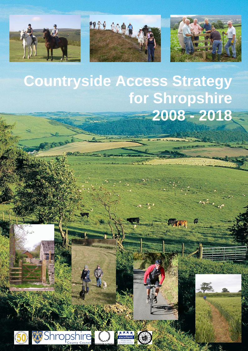
Forward Councillor Barbara Craig Portfolio Holder for Community Services As well as using the extensive rights of way network, there are many other ways that people enjoy the countryside in Shropshire. For example there are many hectares of open access land, areas that people can walk where they wish, forest tracks, canal tow paths, disused railway lines, and paths provided by various landowning bodies. Added to this there are National Nature Reserves, country parks, local nature reserves and heritage sites. This strategy considers all these opportunities and by responding to local needs seeks to modernise the access network and to make the countryside a welcoming place for everyone. Shropshire County Council has been improving rights of way. This strategy looks beyond the Council’s statutory duties and develops the positive benefits that walking, riding and cycling can bring to our lives. A modern and fit for purpose access network will provide many advantages for local residents and visitors alike. In addition to providing people with the opportunity to enjoy Shropshire’s distinctive and renowned landscape the implementation of this plan will achieve wider social, economic and environmental goals. For example the benefits of exercise in the countryside to people’s health is well understood as is the contribution made by walking, riding and cycling to Shropshire’s tourism economy. Rights of way can also provide routes for people to travel to work, to school or to shops, so helping ease road congestion. Resources are inevitably limited and developing new partnerships and finding new sources of funding will be important to the delivery of this strategy. Planned actions will need to be prioritised.
Barbara Craig
3
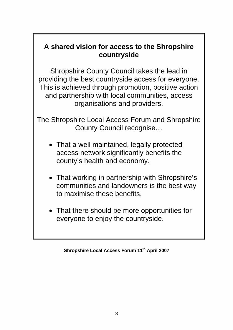
A shared vision for access to the Shropshire
countryside
Shropshire County Council takes the lead in providing the best countryside access for everyone. This is achieved through promotion, positive action
and partnership with local communities, access organisations and providers.
The Shropshire Local Access Forum and Shropshire
County Council recognise…
• That a well maintained, legally protected access network significantly benefits the county’s health and economy.
• That working in partnership with Shropshire’s
communities and landowners is the best way to maximise these benefits.
• That there should be more opportunities for
everyone to enjoy the countryside.
Shropshire Local Access Forum 11th April 2007

4
Executive summary The Countryside Access Strategy for Shropshire considers existing countryside access opportunities within the county and, by responding to local needs, seeks to modernise the access network and to make the countryside a more welcoming place for everyone. The strategy considers all access opportunities, not just those provided through the Council’s statutory obligations. When referring to the ‘countryside’ the strategy also includes the more urban routes and networks that provide essential access to services. A modern and fit for purpose access network will provide many advantages for local residents and visitors alike. In addition to providing people with the opportunity to enjoy Shropshire’s distinctive and renowned landscape the implementation of the strategy will achieve wider social, economic and environmental goals. For example, the benefits of exercise in the countryside to people’s health are well understood as is the contribution made by walking, horse riding and cycling to Shropshire’s tourism economy. Rights of way can also provide routes for people to travel to work, to school or to shops, so helping ease road congestion and green-house gas emissions. What access is currently available In addition to over 3,400 miles (5,500km of rights of way, there are many other ways that people can enjoy the countryside in Shropshire. For example, the public have access to over 10,000 hectares of open access land, Shropshire County Council manages 16 Countryside Heritage Sites, Shropshire Wildlife Trust manages 34 nature reserves and the District Authorities, Natural England, the Forestry Commission and the National Trust also provide public access to land within their management. Landowners may also offer permissive or informal paths. However, even with this wealth of paths and places available, there are areas of the county where access opportunities are less abundant. Paradoxically, this is often in the places where people live. Dividing the county up into landscape character areas - Shropshire Hills, Clun Hills, Shropshire Plains, Mid Severn and Oswestry Uplands - reveals the differences that the landscape and settlement patterns have on access provision. In summary: • Access for walkers throughout Shropshire is generally good. • The Shropshire Hills and Clun Hills areas have the best access for all
users. • Demand for access is high for all users in the Shropshire Plains area; this
large area only contains a quarter of the rights of way network. • The Shropshire Plains and Oswestry Uplands areas provide the least
opportunities for horse riders and cyclists who want to get off-road. • Carriage drivers and motorised users have limited access opportunities.
5
What people have told us Establishing what people want when accessing the countryside is integral to the success of the Countryside Access Strategy. Over 2,500 questionnaires were analysed and user groups also told us what local people wanted. Information provided by Parish Councils, the Parish Paths Partnership, local user forums and the actions included within Parish Plans also proved invaluable as did input from the Local Access Forum. The main issues raised through the consultation were:
• Access to the countryside is important and valued by everyone. • People usually visit the countryside with family and friends to exercise,
relax, for a sense of wellbeing, to improve their health or to walk their dog. People also like to just sit and admire the view, look at wildlife or to picnic.
• People want improvements to rights of way such as better signage and fewer physical barriers.
• Walking is by far the most popular activity, followed by cycling and then horse riding.
• Local circular routes are preferred. • People want more information on what access opportunities are
available. • Most people use rights of way for pleasure rather than for local
journeys. • Horse riders and cyclists want to link up and extend bridleways to
create more circular off-road routes. • Safety improvements to important road crossings and the minor roads
that are used extensively by recreational users are needed. What are we going to do? After setting out what access is presently available and what people want, the remaining chapters of the strategy describe how the County Council intends to deliver improvements for access to different groups of people. These chapters cover:
• Working with communities • Making local journeys • Health and wellbeing • Access to the Shropshire countryside for everyone • Visiting Shropshire’s countryside
Each chapter describes the subject, what is presently available, what people have told us during the preparation of the strategy, future priorities for Shropshire, and concludes with detailed action plans. The main actions within the strategy include:
• Increasing and improving opportunities for everyone to access the Shropshire countryside.
• Making improvements to the rights of way network. • Improving information on access opportunities for users.
6
• Increasing the number of local promoted circular routes. • Developing more off-road routes particularly for horse riders and
cyclists. • Improving safety especially at road crossings. • Encouraging more community participation in countryside access
issues. • Promoting the benefits that access to the countryside brings to both
mental and physical health. • Encouraging people to walk and cycle for local journeys. • Fully understanding what would encourage hard-to-reach groups to
better access the countryside. • Promoting Shropshire as a walking, horse riding and cycling
destination. Resources are inevitably limited and developing new partnerships and finding new sources of funding will be important to the delivery of this strategy. Planned actions will need to be prioritised. Polices have been developed to support the delivery of the strategy. These outline the County Council’s approach to a number of situations, for example how maintenance and enforcement actions are prioritised and how the countryside is made more accessible to those with mobility and other difficulties. What next The County Council is required to make a new assessment and to review this strategy within 10 years. Thereafter, the Council is required to review the strategy at not more than ten year intervals. The Countryside Access Strategy is a statutory document and will form an important part of Shropshire’s Local Transport Plan (LTP). The LTP sets out a vision and objectives for transport in Shropshire looking forward to the year 2020. It is anticipated that the Countryside Access Strategy will become an integral part of the LTP at its next review in 2011.
7
1 Introduction People in Shropshire and visitors to the county place a high value on the beauty and tranquillity of its landscape. They also expect the highest standards of access management, allowing them to explore this landscape. This strategy provides the framework that will steer the development of the county’s access network for the next 10 years. 1.1 Why develop the Countryside Access Strategy? The Countryside and Rights of Way Act 20001 requires all local authorities to prepare and publish a 10 year plan for the ‘improvement’ of public rights of way by November 2007. The production of this strategy meets the requirements of this legislation by:
• Assessing the extent to which local rights of way meet the present and likely future needs of Shropshire’s residents and visitors.
• Developing the opportunities provided by local rights of way (in particular by footpaths, cycle tracks, bridleways and byways, also and including permissive routes) for exercise and other forms of open-air recreation and enjoyment.
• Examining the accessibility of local rights of way for those with mobility problems and sensory impairments also considering the needs of families with children and pushchairs and others who do not currently use this resource.
• Providing a statement of action that the authority proposes to take for the management of local rights of way, to ensure an improved network fit for future use.
Section 60(5) of the Act defines ‘local rights of way’ as including footpaths, cycle tracks, bridleways, restricted byways and byways open to all traffic within the authority’s area. The Guidance2 does not contain any definition of an ‘improvement’, but it envisages that it might include:
• Better information and promotion, including web based information. • Improved maintenance, repair and way marking. • Additional links to improve the network. • Better access for particular groups of users. • Identification of sustainable travel routes such as ‘Safe Routes to
School’. 1.2 Assessing what is available Historically people used routes and paths to carry out their daily lives. Before the advent of the motor car these journeys were made by foot, horse or carriage. This historic highway system has effectively become the modern road and rights of way network.

8
The current access network is not just concerned with public rights of way, although these are extensive. It also includes open access land, permissive access and other places where people are encouraged to walk, ride and cycle. The network is an important part of the lives of Shropshire’s residents and vital to the visitor economy. It provides places for people to enjoy fresh air and to exercise and is also a pleasant and valuable alternative for people travelling into and around Shropshire’s towns and villages for work and leisure. The value of the access network in supporting sustainable leisure and travel and encouraging appreciation of the natural environment is becoming more important. This is even more so as the volume and speed of traffic on many country roads increases. 1.3 Establishing the need This strategy has been written following in-depth consultation to discover the needs and views of all types of users. It is not intended to provide detailed solutions to access problems, but to take a strategic approach to managing and developing public access to the countryside. 1.4 The scope of the Countryside Access Strategy In Shropshire the number of recorded rights of way does not provide a full picture of access opportunities within the countryside. People also use forest tracks, canal tow paths, disused railways lines, commons, open spaces and a host of access opportunities provided by different landowning bodies. In addition there is a wealth of open access areas available for recreation, provided by many other land managers in the county. When referring to the ‘countryside’ the Access Strategy also includes the more urban routes and networks within Shropshire that provide essential access to services. This plan considers all access opportunities, not just those provided through the Council’s statutory obligations. 1.5 The development of the Countryside Access Strategy Shropshire is England’s largest inland county and its varied landscapes have had a great influence on the concentrations and distribution of access. The landscape character areas have been used as a basis to assess the existing access provision. Each area has been considered in terms of:
• The topography and landscape character. • The extent and density of the access network. • The population density and settlement patterns. • The health characteristics of that population. • The extent and types of use.
Extensive consultation carried out over a two year period involved the general public, users of the access network, local communities, national bodies, the Local Access Forum and other stakeholders. This provided information on how people use the network, what they want and where they want it.
9
The access assessment and public consultation has provided the means to match availability with need and produce action plans to assist the County Council in developing the access network over the next 10 years. 1.6 Policy Statements A number of existing or new Policy Statements have been revised or developed to support the delivery of the Countryside Access Strategy’s aims and objectives. These outline the County Council’s approach to a number of situations. For example how maintenance and enforcement actions are prioritised and how the countryside is made more accessible to those with mobility and other difficulties (see Chapter 11 Policy Statements). 1.7 Action Plans Action Plans show how the County Council and an array of partners intend to develop the countryside access network during the time of this strategy. The Action Plans provide information on staffing requirements, timescales, funding and a priority score for each action. Each year annual plans will be developed to progress the Action Plans. 1.8 Implementation, monitoring and review The Council is required to make a new assessment and to review the Countryside Access Strategy within 10 years. Thereafter, the Council is required to review the document at not more than ten year intervals. The strategy will form an important part of Shropshire’s Local Transport Plan (LTP)3. The LTP sets out a vision and objectives for transport in Shropshire looking forward to the year 2020. The LTP has been developed in line with Government guidance and takes into account the public’s and stakeholders’ views. It is intended that the Countryside Access Strategy will be a distinct strand within the LTP at its next review in 2011. This strategy will respond to the changing needs of users, land managers and new legislation. Annual reviews will take place in consultation with the Local Access Forum. Annual reports and progress summaries will be published at the end of each financial year. 1 Countryside and Rights of Way Act 2000 http://www.opsi.gov.uk/Acts/acts2000/20000037.htm 2 Rights of Way Improvement Plans – Statutory Guidance to Local Highway Authorities in England November 2002 http://www.defra.gov.uk/wildlife-countryside/cl/rowip/rowip.pdf 3 Shropshire’s Local Transport Plan 2006 -2011 http://www.shropshire.gov.uk/traveltransport.nsf

10
2 Strategic context The Countryside Access Strategy will make an important contribution to the delivery of many other plans and strategies that affect the daily lives of people within Shropshire. The main plans and strategies are listed in Appendix A. Three strategies are worth particular mention. Our aim is to ‘ensure the policies and action plans contained in the Access Strategy are incorporated into these three strategies and others as appropriate’. 2.1 Shropshire Partnership Community Strategy 2006-2010 This strategy provides a framework for Shropshire's new Local Area Agreement (LAA) and targets. It has four main aims.
Community Strategy Aims Countryside Access Strategy Children and Young People
Encourage young people to connect to the countryside through active volunteering and green gym activities. Improved and increased access to the countryside for young families.
Healthier Communities and Older People
Improvements to the network and removing barriers; increasing access for the less mobile. Increased participation in walking for health.
Safer and Stronger Communities
Increase opportunities for community involvement though local volunteering groups, Walking Festivals and guided walks programmes.
Sustainable Communities
Improve the rights of way network to encourage people to walk or cycle for local journeys rather than use the car.
2.2 Local Transport Plan 2006/7-2010/11 The Plan sets out a vision and objectives for transport in the County. It has four overarching aims for local transport in Shropshire.
Local Transport Plan Countryside Access Strategy Accessibility To improve access to jobs and facilities in ways which are sustainable.
New or improved links to market towns from rural areas and into the wider countryside increases access at a local level.
Environment To protect and improve the built and natural environment and reduce the impact of traffic on local communities.
Transport in Shropshire is the biggest single contributor to greenhouse gas emissions. Encouraging more people to walk and cycle rather than use the car helps reduce these emissions. Promoting integrated links with public transport and the access network that increase sustainable travel also reduces pollution and congestion.

11
Local Transport Plan Countryside Access Strategy Economy To support sustainable economic activity and rural regeneration.
Provide a well-maintained and promoted path network that encourages walking, horse riding and cycling providing opportunities for rural tourism and other local economic benefits.
Safety and health To create safer roads and healthier, more secure communities.
Advocate the use of the rights of way network to improve the health and wellbeing of communities.
2.3 Shropshire Hills Area of Outstanding Natural Beauty Management
Plan, 2004-2009 The Shropshire Hills AONB covers 23% of Shropshire and the Management Plan, aims to strengthen active conservation of the area's natural beauty. The plan’s main aims that relate to the Countryside Access Strategy are: AONB Management Plan Aims Countryside Access Strategy The distinctive landscape character and value of the Shropshire Hills is maintained through the positive management of change.
Improve the access network so it makes a positive contribution to maintaining the landscape.
The contribution of valued features to the landscape of the Shropshire Hills is maintained or enhanced.
Work carried out on improving access on areas of high biodiversity, particularly SSSIs, will be managed in accordance with statutory obligations and in consultation with the AONB. Quiet enjoyment activities will be promoted in the AONB to protect tranquillity.
Farming, forestry and other rural businesses which contribute positively to the distinctive landscape character and value of the Shropshire Hills are supported.
Use of local materials and local skills, where possible, when carrying out improvements to the access network helps rural businesses.
Public enjoyment and access to the Shropshire Hills supports the local economy and contributes to peoples’ quality of life whilst conserving the special qualities of the AONB.
Provide a well maintained and promoted path network that encourages walking, horse riding and cycling providing opportunities for sustainable rural tourism and other local economic benefits. Advocate the use of the rights of way network to improve the health and wellbeing of communities. Links between access promotion and sustainable transport will be made wherever possible.
There is a high level of awareness, understanding and appreciation of the special qualities of the Shropshire Hills AONB.
The use of meaningful interpretation on promoted material raises awareness and understanding of the landscape.
12
2.4 Environmental considerations It is recognised that the full implementation of the Countryside Access Strategy may have an impact on the environment. Key areas for consideration include: CO2 emissions, especially from transport The UK’s target for reducing CO2 emissions has recently been increased to a 60% reduction by 2050. Road transport currently accounts for 20% of the UK’s CO2 emissions and is the fastest growing area. The fact that the majority of people access the countryside by car is therefore an issue. Biodiversity Local authorities have a duty under s40 of the NERC Act 2006 to consider biodiversity in the work they do. Shropshire is rich in biodiversity, both within and outside designated sites. Many of the most popular locations for walking are also Sites of Special Scientific Interest, where disturbance to wildlife and erosion can result. These areas require especially careful management of access and appropriate promotion can help to reduce impacts. Heritage Heritage features, which can often be within designated sites, can be vulnerable to erosion. There is also potential for access infrastructure works to cause damage to these features. Knowledge of the features will enable early consideration of the issue and ensure that practical measures are taken on the ground to avoid most problems. Noise Noise may be an issue where vehicles lawfully use rights of way, especially in remoter countryside areas valued for their tranquillity. Tranquillity maps recently produced by the Campaign for the Protection of Rural England show that nationally and in the West Midlands context, the Shropshire Hills in particular are significant as a remaining area of tranquillity. Promoting understanding Enjoyment of access to the countryside is a key way in which people gain awareness of and a sense of connection with the environment, and so has a very positive role to play in this respect. Including information in promotional material to help people to understand more about the countryside will help to engender a caring, sensitive approach by users.
13
3 How Shropshire County Council manages access to the countryside
3.1 The rights of way network Within Shropshire the current rights of way network was defined on the Definitive Map for Shropshire in the 1950s. Shropshire is a large inland county with a correspondingly extensive rights of way network of more than 3,400 miles (5,500km). The condition of the rights of way network is measured by one National Indicator – BVPI 178, the ease of use of the rights of way network. Following a programme of recent investment there has been an upward trend in performance for BVPI 178 from 36% in 2002/03 to 78.7% in 2007/08. Shropshire is now to one of the top performing Councils in the country for this rights of way performance indicator. 3.2 Countryside Access Team The Countryside Access Team forms part of the County Council’s Countryside Service, which is also responsible for managing the Council’s Countryside Heritage Sites. The team as a whole supports Shropshire’s communities to undertake access and nature conservation improvements. The Countryside Access Team currently consists of 19 core staff who are responsible for access maintenance, access mapping, access enforcement and access development. Access Maintenance Team The Access Maintenance Team is based at the Old Nills Quarry in Pontesbury and is responsible for:
• Erecting furniture on the rights of way network including stiles, signposts, gates and bridges.
• Clearing vegetation and improving surfaces. • Carrying out a programme of capital works (mainly bridges and
surfacing) primarily delivered by contractors. • Supporting and developing the Parish Paths Partnership with up to 250
volunteers working throughout the county. • Implementing projects to maintain and improve promoted routes such
as Offa’s Dyke National Trail, the Severn Way, the Shropshire Way and the Jack Mytton Way.
• Maintaining open access land in the county. Much of the work carried out by the Access Maintenance Team is generated by problem reports from the public, user groups and local councils. In a typical year the team resolve approximately 500 maintenance related problems. The Team also responds to other challenges such as the extensive flood damage that occurred in the summer of 2007.
14
The team is also responsible for the Parish Access Project, which is a five year funded project (terminating in March 2009) to restore nearly 2,000km of the rights of way network in 82 parishes. Work is carried out both by an in-house team of staff, and external contractors. Access Mapping Team The Access Mapping Team is responsible for all aspects of maintaining the Definitive Map. This Map shows the legally defined rights of way network within the county. 2008 was celebrated as the 50th anniversary of this access network. The County Council have a duty to keep the Map under continual review. The types of legal changes that can be made are:
• Definitive Map Modification Orders including additions, deletions, upgradings and downgradings, and varying particulars such as width and line.
• Public Path Orders including diversions, creation orders/agreements and extinguishments.
The team also comments on planning applications for developments that affect rights of way and provides information for land charge searches for property sales. Although the Definitive Map shows many public routes, it is acknowledged that it is an incomplete record. Many routes that have public rights through both past historical or present day use by the public are not depicted on the map. The ‘Countryside and Rights of Way Act 2000’ (CRoW) recognised that the continual updating of the Definitive Map for making additions based on historical usage could prejudice landowners. It therefore proposed a 2026 cut-off date for historical claims for historic routes, known as ‘Lost Ways’. This part of the legislation has yet to be enacted. The Access Mapping Team also manages open access land implementation and the access restrictions in the county, a new responsibility defined under the CRoW Act. Access Enforcement Team The Access Enforcement Team is responsible for ensuring that land owners and land managers comply with their legal responsibility to keep rights of way on their land open and unobstructed. The team receives between 1,500–2,000 complaints each year from the public. Approximately 1,000 of these fall within the responsibility of the Enforcement Team and relate to obstructions on the rights of way network. The Team resolve approximately 50% of these problems year on year. Rights of way can be obstructed for a number of reasons including:
• By something physical such as fences, hedges, crops and buildings. • By dangerous animals, such as bulls in fields. • Landowners who deter the public from using a right of way. • Health and safety issues which are hazardous to the public; such as
electric fences, damaged stiles or gates etc.
15
Access Development Team The Access Development Team is responsible for preparing and reviewing the Countryside Access Strategy and its annual work programmes. In doing this the Countryside Access Team is supported by the Shropshire Local Access Forum and other user forums. The Access Development Team is also responsible for promoting the access network to the public, including the development of long distance and short circular routes.

16
4 Countryside access in Shropshire - balancing what people need with what is available
Our aim is to: ‘ensure that the access network meets the needs of Shropshire residents and visitors whilst recognising the special qualities of the landscape’. This chapter looks at what the county’s access network offers the people who use it and what should be done to encourage its use by more people. 4.1 What access is available There are over 3,400 miles (5,500km) of public rights of way in Shropshire. They include footpaths, bridleways, restricted byways and byways open to all traffic but they only make up part of the access network. There are other paths and tracks that the public also have access to. People use forest tracks, canal tow paths, disused railway lines, unclassified county road network, commons and paths provided by various landowning bodies. There are over 10,000 hectares of open access land, areas that people can walk where they wish. Added to this there are National Nature Reserves, country parks, local nature reserves and heritage sites. All of these make up Shropshire’s access network. However, even with this wealth of paths and places available, there are areas of the county where access opportunities are less abundant. Paradoxically, this is (often) in the places where the most people live. Using Natural England landscape character areas1 reveals the differences that the changing landscape and settlement patterns can have on access provision (see Figure 4.1a). The Shropshire Hills and Clun Hills areas cover half of the county; they are rural, sparsely populated and popular with visitors. Most of the area is within the Shropshire Hills Area of Outstanding Natural Beauty (AONB) 2 and designated as an Environmentally Sensitive Area. The area includes 60% of the county’s rights of way network, over three quarters of it is open access land and the Stiperstones National Nature Reserve. The high density of rights of way, extensive areas of open access land, many hectares of Forestry Commission3 land and numerous country parks and wildlife and heritage sites, make it a good place for walking. Consequently, there are many promoted routes, both long distance and circular, in these areas. Horse riders and cyclists are also well provided for, and where the bridleway network is more limited the minor road network is used extensively. For carriage drivers and motorised users the access network is less extensive. The Shropshire Plain area covers a third of the county, contains over half of its population but has only a quarter of the rights of way network. This puts more pressure and demand on rights of way particularly those close to where people live. Walkers have the most choice with good footpath routes in most
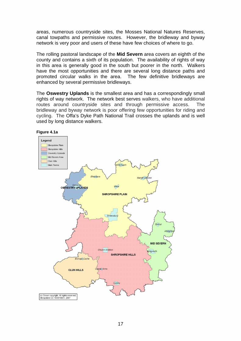
17
areas, numerous countryside sites, the Mosses National Natures Reserves, canal towpaths and permissive routes. However, the bridleway and byway network is very poor and users of these have few choices of where to go. The rolling pastoral landscape of the Mid Severn area covers an eighth of the county and contains a sixth of its population. The availability of rights of way in this area is generally good in the south but poorer in the north. Walkers have the most opportunities and there are several long distance paths and promoted circular walks in the area. The few definitive bridleways are enhanced by several permissive bridleways. The Oswestry Uplands is the smallest area and has a correspondingly small rights of way network. The network best serves walkers, who have additional routes around countryside sites and through permissive access. The bridleway and byway network is poor offering few opportunities for riding and cycling. The Offa’s Dyke Path National Trail crosses the uplands and is well used by long distance walkers. Figure 4.1a
18
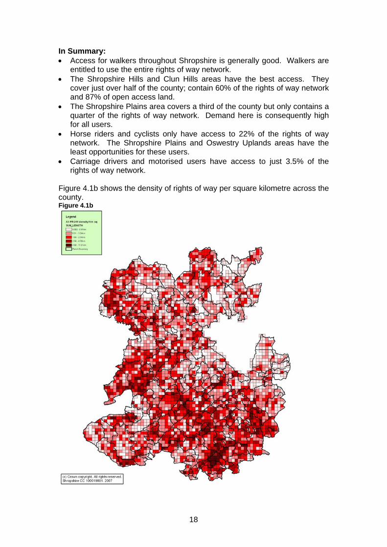
In Summary: • Access for walkers throughout Shropshire is generally good. Walkers are
entitled to use the entire rights of way network. • The Shropshire Hills and Clun Hills areas have the best access. They
cover just over half of the county; contain 60% of the rights of way network and 87% of open access land.
• The Shropshire Plains area covers a third of the county but only contains a quarter of the rights of way network. Demand here is consequently high for all users.
• Horse riders and cyclists only have access to 22% of the rights of way network. The Shropshire Plains and Oswestry Uplands areas have the least opportunities for these users.
• Carriage drivers and motorised users have access to just 3.5% of the rights of way network.
Figure 4.1b shows the density of rights of way per square kilometre across the county. Figure 4.1b
19
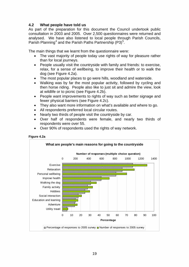
4.2 What people have told us As part of the preparation for this document the Council undertook public consultation in 2003 and 2005. Over 2,500 questionnaires were returned and analysed. We have also listened to local people through Parish Councils, Parish Planning4 and the Parish Paths Partnership (P3)5. The main things that we learnt from the questionnaire were:
• The vast majority of people today use rights of way for pleasure rather than for local journeys.
• People usually visit the countryside with family and friends: to exercise, relax, for a sense of wellbeing, to improve their health or to walk the dog (see Figure 4.2a).
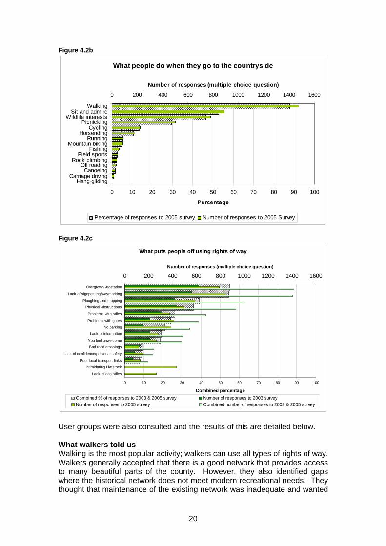
• The most popular places to go were hills, woodland and waterside. • Walking was by far the most popular activity, followed by cycling and
then horse riding. People also like to just sit and admire the view, look at wildlife or to picnic (see Figure 4.2b).
• People want improvements to rights of way such as better signage and fewer physical barriers (see Figure 4.2c).
• They also want more information on what’s available and where to go. • All respondents preferred local circular routes. • Nearly two thirds of people visit the countryside by car. • Over half of respondents were female, and nearly two thirds of
respondents were over 55. • Over 90% of respondents used the rights of way network.
Figure 4.2a
What are people's main reasons for going to the countryside
0 10 20 30 40 50 60 70 80 90 100
ExerciseRelaxation
Personal wellbeingImprove health
Walking the dogFamily activity
HobbiesSocial interaction
Education and learningAdventure
Utility travel
Percentage
0 200 400 600 800 1000 1200 1400
Number of responses (multiple choice question)
Percentage of responses to 2005 survey Number of responses to 2005 survey
20
Figure 4.2b
What people do when they go to the countryside
0 10 20 30 40 50 60 70 80 90 100
WalkingSit and admire
Wildlife interestsPicnicking
CyclingHorseriding
RunningMountain biking
FishingField sports
Rock climbingOff roading
CanoeingCarriage driving
Hang-gliding
Percentage
0 200 400 600 800 1000 1200 1400 1600
Number of responses (multiple choice question)
Percentage of responses to 2005 survey Number of responses to 2005 Survey
Figure 4.2c
What puts people off using rights of way
0 10 20 30 40 50 60 70 80 90 100
Overgrown vegetation
Lack of signposting/waymarking
Ploughing and cropping
Physical obstructions
Problems with stiles
Problems with gates
No parking
Lack of information
You feel unwelcome
Bad road crossings
Lack of confidence/personal safety
Poor local transport links
Intimidating Livestock
Lack of dog stiles
Combined percentage
0 200 400 600 800 1000 1200 1400 1600Number of responses (multiple choice question)
Combined % of responses to 2003 & 2005 survey Number of responses to 2003 surveyNumber of responses to 2005 survey Combined number of responses to 2003 & 2005 survey
User groups were also consulted and the results of this are detailed below. What walkers told us Walking is the most popular activity; walkers can use all types of rights of way. Walkers generally accepted that there is a good network that provides access to many beautiful parts of the county. However, they also identified gaps where the historical network does not meet modern recreational needs. They thought that maintenance of the existing network was inadequate and wanted
21
more routes to be open and in good repair. The main issues for walkers when accessing the countryside were; overgrown vegetation, lack of signposting and waymarking, ploughing and cropping and obstructions. Stiles on rights of way were considered to be significant physical barriers to those less able and to dog walkers. Lack of information on walking opportunities is also a barrier. People would walk more if they had access to more short circular local routes and also more time. In summary more people would be encouraged to walk if:
• Routes were better maintained. • There was more information on where to go. • There were more short circular walks, promoted and in good condition. • There were more guided walks. • There was more promotion of dog friendly places. • If gaps and missing links in the network were filled.
What cyclists told us Cycling and mountain biking is the second most popular activity. Cyclists are a varied group, some stay on roads while others like to go off-road. Cyclists who go off-road can use the same rights of way as horse riders. The main issues for cyclists when accessing the countryside were; overgrown vegetation, lack of signposting and waymarking, obstructions, problems with gates and lack of information. Cyclists also use the road network extensively and consultation carried out with local cycling groups and the Shropshire Cycling Forum6 has also provided feedback on this issue. Working with Council cycling officers will increase our knowledge of this topic. In summary more people would be encouraged to cycle if:
• Routes were better maintained. • There was more information on use of bridleways and byways. • There were more off-road routes. • There were safer road crossings. • Routes had better surfaces.
What horse riders told us? Horse riding is the third most popular activity. Horse riders can use bridleways and byways; this access network varies across the county. Horse riders said they didn’t have enough off-road circular routes. In addition their current network was fragmented with many cul-de-sac routes and missing links. Riders used minor roads extensively to link up the bridleway network. Crossing major roads was a significant problem for them. Riders felt that the existing network should be open and in good repair. The main barriers to horse riders are problems with gates, overgrown vegetation, lack of signposting and waymarking, ploughing and cropping and poor road crossings. In summary more people would be encouraged to horse ride if:
• More was done to link up and extend bridleways to create circular routes.
22
• All bridleways were maintained to a standard suitable for horse riders. • Safer road crossings were established. • Minor roads that are used extensively were safer. • Parking for horse boxes was identified.
What carriage drivers told us Carriage drivers have access to a new category of rights of way - restricted byways as well as byways open to all traffic (BOAT). These routes form 3.5% of the rights of way network. Carriage drivers represented only 2% of respondents to the consultation. Although they had similar needs to horse riders they specifically stated that:
• All byways and restricted byways should be open and useable. • Safer road crossings are required. • Parking for horse boxes should be identified.
What motorised vehicle users told us Motorised vehicle users have access to 86km of byway, 1.6% of the right of way network. They also have access to, as do other users, 102km of unsurfaced unclassified county roads (UCRs). A small number of questionnaires, 2%, were filled in by motorised users and further information was obtained from the Byways Liaison Group7. The approach to managing the byway network through discussion with users and encouraging volunteers is supported. In summary motorised vehicles users would like to see:
• Clear signage and improved maintenance on byways. • Unsurfaced UCRs managed alongside the byway network.
What less mobile people told us Over a sixth of the people who responded to our questionnaire considered themselves to be less mobile. More than a third were over the age of 65 and could also have problems with mobility. The main barriers to access were stiles, which many people had difficulty climbing over. This also applies to families with young children using pushchairs. Replacing stiles with gaps or gates (a ‘least restrictive’ principle) would overcome these physical barriers to access. What Parish Councils told us All Parish Councils in the County were consulted and over 60 responded, including several Parish Path Partnership groups. Actions from the 44 Parish Plans that included access improvements have also been taken into account (also see Chapter 5 Working with communities). The main points raised from Parish Councils were:
• Countryside access was important to all parishes. • More than three quarters thought that there were enough rights of way. • They wanted physical improvements to rights of way. • All preferred circular routes. • Most wanted better information and promotion at a local level. • Better opportunities for responsible dog walkers were required. • Improved access for the less mobile was needed.

23
• Poor road crossings should be improved. • They wanted improved access links between the town and countryside. • The need for more bridleways was identified.
What the Local Access Forum told us The Shropshire Local Access Forum (LAF)8 has been consulted throughout the development of the strategy. In general they agreed with the consultation results and stressed that:
• All parishes should have improved information. • Circular routes linking parishes are needed. • Signage and maintenance is important and should be improved. • There is a lack of bridleways and a need to identify missing links. • Major roads are a barrier and crossing points need to be improved. • Use of the minor road network is important to recreational users. • Access for all is important; physical barriers should be removed. • Multi user routes like disused railway lines should be developed. • There is a need to advise users on farming and countryside issues.
4.3 What next for Shropshire? The consultation results have made it clear that Shropshire’s countryside access network is a significant asset and is important to its local communities. This access network is valued for its contribution to recreation, people’s physical and mental health, their sense of community and as a place to go with family and friends. Shropshire’s special landscape qualities, particularly within the Shropshire Hills AONB, attract people. The Countryside Access Strategy must find a balance between promoting access and protecting this landscape. To ensure that we meet our aim of ensuring that the access network meets the needs of Shropshire residents and visitors we will work with partners to: 1. Increase and improve opportunities for everyone to access
Shropshire’s hills, woodlands and watersides and balance this with conserving what makes them special.
2. Increase our knowledge of infrastructure and maintenance issues
on the access network. 3. Overcome and reduce the number of physical barriers on the rights
of way network which affect people’s ability to access the countryside, specifically: • Overgrown vegetation and surfacing • Lack of signposting • Ploughing and cropping • Obstructions • Stiles as a barrier to access • Inappropriate gates as a barrier to access • Missing bridges • Crossings on busy roads • Poor links from urban areas to the surrounding countryside
24
4. Improve provision of advice and information about the access
network for users. 5. Increase the number of short circular walks developed, particularly
in the Shropshire Plains area, from centres of population. 6. Improve walking opportunities in areas of poor provision. 7. Overcome some of the specific barriers to increased walking which
concern availability of parking, guided walks programmes and lack of dog friendly places.
8. Improve opportunities for cyclists to access the countryside and
specifically provide: • More information on use of bridleways and byways • More off-road routes • Safer road crossings • Better surfaces
9. Develop more bridleways particularly in the Shropshire Plains and
Oswestry Uplands areas. 10. Improve opportunities for horse riders to access the countryside,
and specifically provide: • Improved maintenance • Circular routes that extend and link the existing network • More off-road routes • Safer road crossings
11. Improve the accessibility of the restricted byway network for
carriage drivers and provide safer road crossings. 12. Provide sustainable management of byways and unclassified
county roads in partnership with user groups.
25
1 Landscape character areas - All of England has been divided into areas with similar landscape character, Joint Character Areas (JCAs). The five areas within Shropshire are: 61. Shropshire Cheshire and Staffordshire Plains 63. Oswestry Uplands 65. Shropshire Hills 66. Mid Severn Sandstone Plateau 98. Clun and North West Hereford Hills http://www.defra.gov.uk 2 Shropshire Hills AONB http://www.shropshirehillsaonb.co.uk 3 Forestry Commission http://www.forestry.gov.uk 4 Community Council Parish Plans http://www.shropshire-rcc.org.uk/supporting_local_people/parish_plans 5 Parish Paths Partnership (P3) – groups of volunteers who undertake tasks to improve their local access network. http://www.shropshire.gov.uk/countryside.nsf 6 Cycle Forum - group formed by the County Council and local cyclists to encourage more cycling and provide safer cycling facilities in Shropshire. http://www.shropshire.gov.uk 7 Byways Liaison Group – group set up by the County Council to aid dialogue with legitimate users of and improve the condition of BOATs and unsurfaced UCRs in Shropshire. http://www.shropshire.gov.uk/countryside.nsf 8 Shropshire Local Access Forum (LAF) – statutory body set up to advise the County Council and Natural England on how to make the countryside more accessible. http://www.shropshire.gov.uk/countryside.nsf

26
Key to the action plans Staffing
Partnerships are required to implement this action.
Action delivered within existing staff capacity.
Project
Time limited project either externally funded or delivered within existing resources.
Timescales Q Quick win to be met within existing capacity.
Short term Can be achieved within 1-2 years.
Medium term Can be achieved within 3-4 years.
Long term An ongoing action 5+ years.
Funding £ £5,000 - £10,000
££ £10,000 - £30,000
£££ £30,000 - £100,000
££££+ £100,000 - £300,000
pa Annual commitment required to sustain action.
Funding source Core From within existing County Council Countryside
Service revenue and capital budgets.
New New funding required particularly from external funders.
Priority 1 Desirable actions that add value to a statutory
duty.
2 Actions that would further improve peoples experience.

27
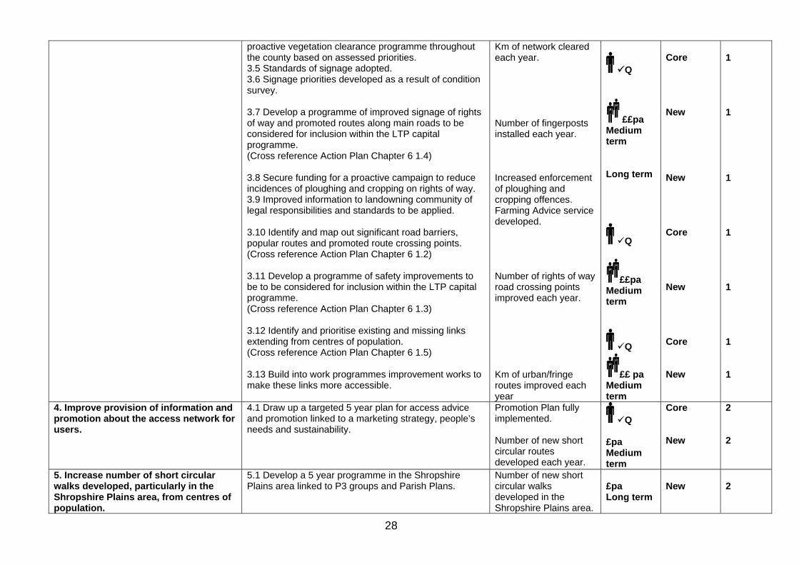
Chapter 4 Countryside access in Shropshire – balancing what people need with what is available Aim Action Indicator Staffing
and timescale
Funding source Core/New
Priority 1/2
1. Increase and improve opportunities for everyone to access Shropshire’s hills, woodlands and watersides and balance this with conserving what makes them special.
1.1 With appropriate partners, formulate a strategic approach to managing access pressures on popular conservation sites, e.g. Long Mynd, Stiperstones. 1.2 Identify and map areas of poor provision for access and explore alternative mechanisms to overcome gaps. 1.3 Encourage other access providers to dedicate their sites as open access land. 1.4 Target areas for development and work with land managers and other partners to provide access 1.5 Work with landowners and other partners to investigate increased opportunities to access watersides
Targeted action plan developed to manage access pressures in Shropshire. Number of new sites with improved public access available.
£pa Medium term
New
2
2. Increase our knowledge of the infrastructure and maintenance issues on the rights of way network.
2.1 Secure funding for a one off 100% condition survey to be undertaken and entered onto the CAMs database. (Cross reference Action Plans Chapter 6 1.1 and Chapter 7 4.1)) 2.2 Develop a system to provide condition information and closures online for the public. 2.3 Develop a plan and secure funding for a regular programme of inspection regimes.
% of the rights of the way network surveyed and information entered onto CAM’s database. All rights of way survey information kept up to date every 5 years.
Project £££ Short term Long term
New New
1 1
3. Overcome and reduce the number of physical barriers on the rights of way network which affect people’s ability to access the countryside, and specifically: • Overgrown vegetation and
surfacing • Lack of signposting • Ploughing and cropping • Obstructions • Stiles as a barrier to access • Inappropriate gates as a barrier to
access • Missing bridges • Major road crossings • Poor links from population centres
to the surrounding countryside
3.1 Secure funding to maintain improvements to the network through the preparation of an Asset Management Plan. 3.2 To consider each identified barrier and develop work programmes which improve accessibility linked to applying the ‘least restrictive’ principle. (Cross reference Action Plan Chapter 8 1.1) 3.3 Develop a pilot project aimed at proactive clearance and surface improvements based around popular and urban/fringe routes. (Cross reference Action Plan Chapter 6 1.8). 3.4 Develop a plan and secure funding for a roll out of a
5 year work programme developed. Km of rights of way improved annually. BVPI maintained at 85% or above. Km of network improved for easier access annually. Pilot project completed. Proactive clearance /surfacing programme developed countywide.
Long term ££ pa Long term Project ££ Medium term
Long term
New New New
New
1 1 1
1
28
proactive vegetation clearance programme throughout the county based on assessed priorities. 3.5 Standards of signage adopted. 3.6 Signage priorities developed as a result of condition survey. 3.7 Develop a programme of improved signage of rights of way and promoted routes along main roads to be considered for inclusion within the LTP capital programme. (Cross reference Action Plan Chapter 6 1.4) 3.8 Secure funding for a proactive campaign to reduce incidences of ploughing and cropping on rights of way. 3.9 Improved information to landowning community of legal responsibilities and standards to be applied. 3.10 Identify and map out significant road barriers, popular routes and promoted route crossing points. (Cross reference Action Plan Chapter 6 1.2) 3.11 Develop a programme of safety improvements to be to be considered for inclusion within the LTP capital programme. (Cross reference Action Plan Chapter 6 1.3) 3.12 Identify and prioritise existing and missing links extending from centres of population. (Cross reference Action Plan Chapter 6 1.5) 3.13 Build into work programmes improvement works to make these links more accessible.
Km of network cleared each year. Number of fingerposts installed each year. Increased enforcement of ploughing and cropping offences. Farming Advice service developed. Number of rights of way road crossing points improved each year. Km of urban/fringe routes improved each year
Q
££pa Medium term Long term
Q
££pa Medium term
Q
££ pa Medium term
Core New New Core New Core New
1 1 1 1 1 1 1
4. Improve provision of information and promotion about the access network for users.
4.1 Draw up a targeted 5 year plan for access advice and promotion linked to a marketing strategy, people’s needs and sustainability.
Promotion Plan fully implemented. Number of new short circular routes developed each year.
Q £pa Medium term
Core New
2 2
5. Increase number of short circular walks developed, particularly in the Shropshire Plains area, from centres of population.
5.1 Develop a 5 year programme in the Shropshire Plains area linked to P3 groups and Parish Plans.
Number of new short circular walks developed in the Shropshire Plains area.
£pa Long term
New
2
29
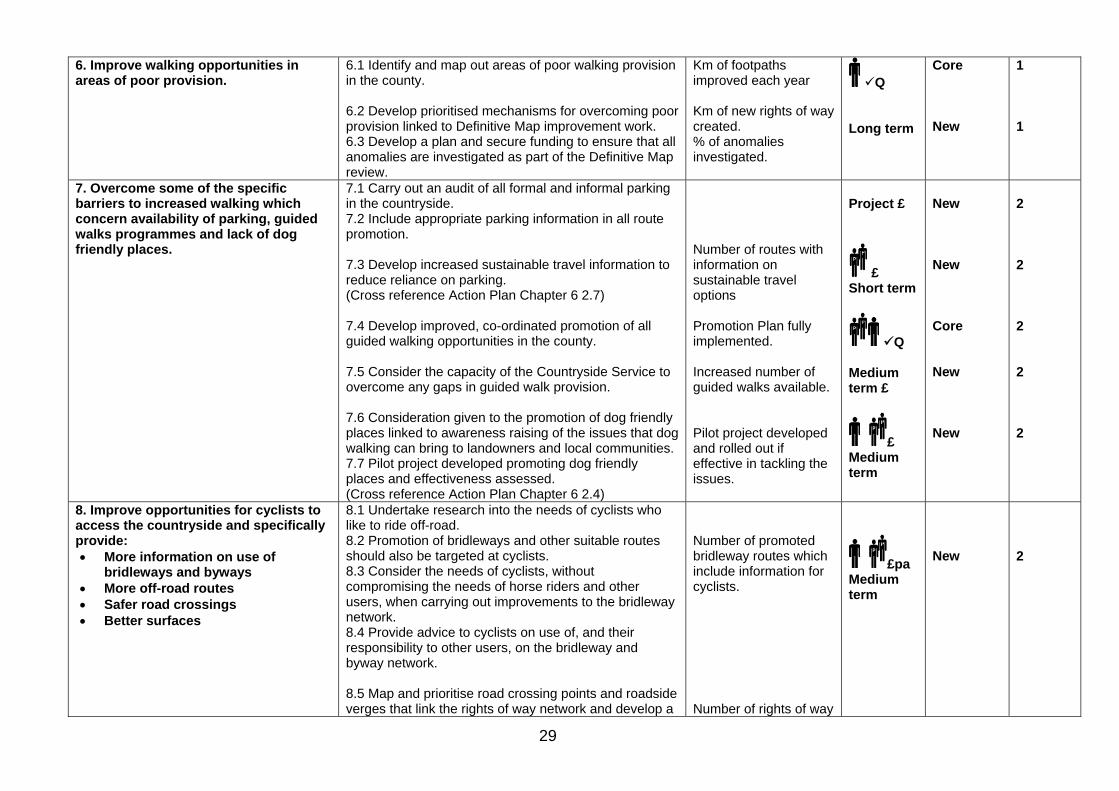
6. Improve walking opportunities in areas of poor provision.
6.1 Identify and map out areas of poor walking provision in the county. 6.2 Develop prioritised mechanisms for overcoming poor provision linked to Definitive Map improvement work. 6.3 Develop a plan and secure funding to ensure that all anomalies are investigated as part of the Definitive Map review.
Km of footpaths improved each year Km of new rights of way created. % of anomalies investigated.
Q Long term
Core New
1 1
7. Overcome some of the specific barriers to increased walking which concern availability of parking, guided walks programmes and lack of dog friendly places.
7.1 Carry out an audit of all formal and informal parking in the countryside. 7.2 Include appropriate parking information in all route promotion. 7.3 Develop increased sustainable travel information to reduce reliance on parking. (Cross reference Action Plan Chapter 6 2.7) 7.4 Develop improved, co-ordinated promotion of all guided walking opportunities in the county. 7.5 Consider the capacity of the Countryside Service to overcome any gaps in guided walk provision. 7.6 Consideration given to the promotion of dog friendly places linked to awareness raising of the issues that dog walking can bring to landowners and local communities. 7.7 Pilot project developed promoting dog friendly places and effectiveness assessed. (Cross reference Action Plan Chapter 6 2.4)
Number of routes with information on sustainable travel options Promotion Plan fully implemented. Increased number of guided walks available. Pilot project developed and rolled out if effective in tackling the issues.
Project £
£ Short term
Q Medium term £
£ Medium term
New New Core New New
2 2 2 2 2
8. Improve opportunities for cyclists to access the countryside and specifically provide: • More information on use of
bridleways and byways • More off-road routes • Safer road crossings • Better surfaces
8.1 Undertake research into the needs of cyclists who like to ride off-road. 8.2 Promotion of bridleways and other suitable routes should also be targeted at cyclists. 8.3 Consider the needs of cyclists, without compromising the needs of horse riders and other users, when carrying out improvements to the bridleway network. 8.4 Provide advice to cyclists on use of, and their responsibility to other users, on the bridleway and byway network. 8.5 Map and prioritise road crossing points and roadside verges that link the rights of way network and develop a
Number of promoted bridleway routes which include information for cyclists. Number of rights of way
£pa Medium term
New
2
30
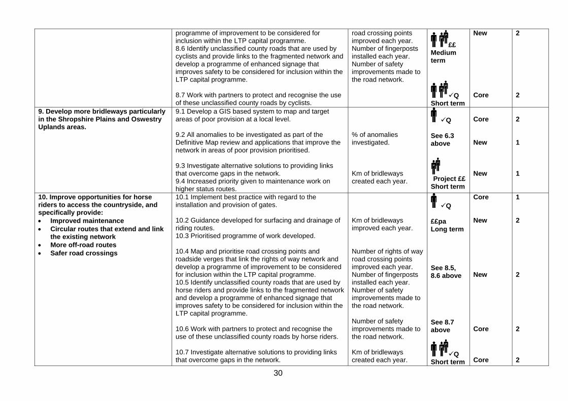
programme of improvement to be considered for inclusion within the LTP capital programme. 8.6 Identify unclassified county roads that are used by cyclists and provide links to the fragmented network and develop a programme of enhanced signage that improves safety to be considered for inclusion within the LTP capital programme. 8.7 Work with partners to protect and recognise the use of these unclassified county roads by cyclists.
road crossing points improved each year. Number of fingerposts installed each year. Number of safety improvements made to the road network.
££ Medium term
Q Short term
New Core
2 2
9. Develop more bridleways particularly in the Shropshire Plains and Oswestry Uplands areas.
9.1 Develop a GIS based system to map and target areas of poor provision at a local level. 9.2 All anomalies to be investigated as part of the Definitive Map review and applications that improve the network in areas of poor provision prioritised. 9.3 Investigate alternative solutions to providing links that overcome gaps in the network. 9.4 Increased priority given to maintenance work on higher status routes.
% of anomalies investigated. Km of bridleways created each year.
Q See 6.3 above
Project ££
Short term
Core New New
2 1 1
10. Improve opportunities for horse riders to access the countryside, and specifically provide: • Improved maintenance • Circular routes that extend and link
the existing network • More off-road routes • Safer road crossings
10.1 Implement best practice with regard to the installation and provision of gates. 10.2 Guidance developed for surfacing and drainage of riding routes. 10.3 Prioritised programme of work developed. 10.4 Map and prioritise road crossing points and roadside verges that link the rights of way network and develop a programme of improvement to be considered for inclusion within the LTP capital programme. 10.5 Identify unclassified county roads that are used by horse riders and provide links to the fragmented network and develop a programme of enhanced signage that improves safety to be considered for inclusion within the LTP capital programme. 10.6 Work with partners to protect and recognise the use of these unclassified county roads by horse riders. 10.7 Investigate alternative solutions to providing links that overcome gaps in the network.
Km of bridleways improved each year. Number of rights of way road crossing points improved each year. Number of fingerposts installed each year. Number of safety improvements made to the road network. Number of safety improvements made to the road network. Km of bridleways created each year.
Q ££pa Long term See 8.5, 8.6 above See 8.7 above
Q Short term
Core New New Core Core
1 2 2 2 2
31
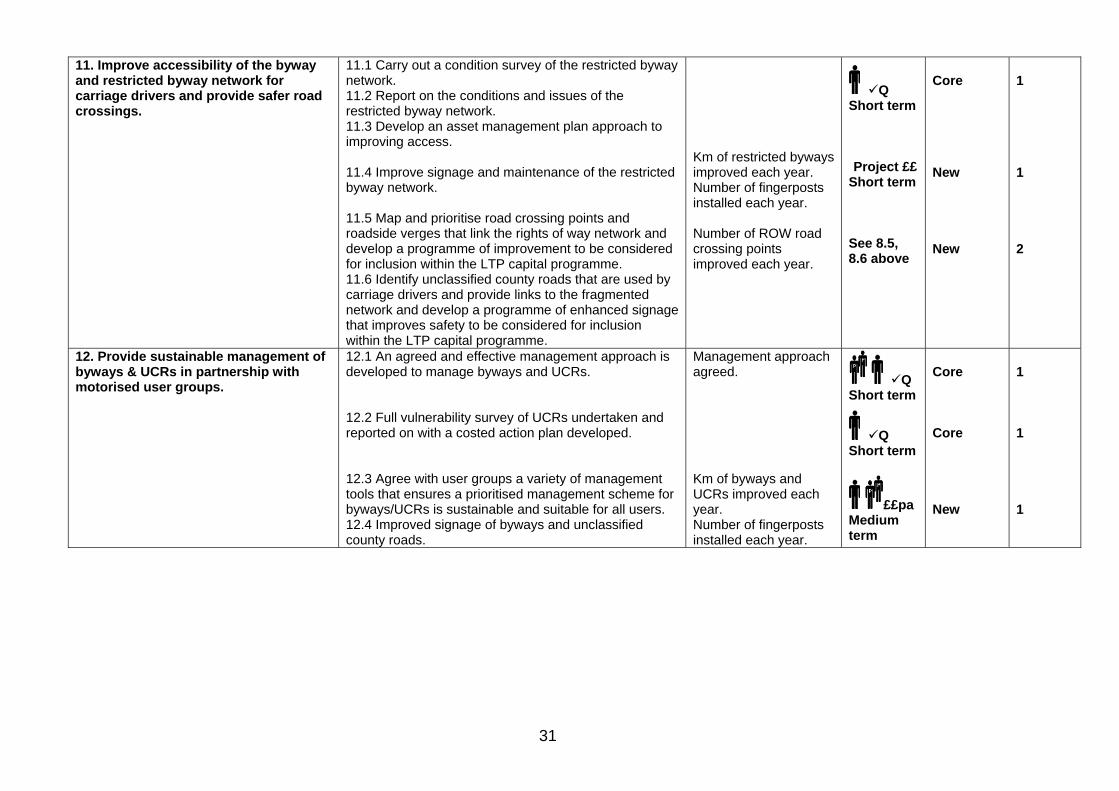
11. Improve accessibility of the byway and restricted byway network for carriage drivers and provide safer road crossings.
11.1 Carry out a condition survey of the restricted byway network. 11.2 Report on the conditions and issues of the restricted byway network. 11.3 Develop an asset management plan approach to improving access. 11.4 Improve signage and maintenance of the restricted byway network. 11.5 Map and prioritise road crossing points and roadside verges that link the rights of way network and develop a programme of improvement to be considered for inclusion within the LTP capital programme. 11.6 Identify unclassified county roads that are used by carriage drivers and provide links to the fragmented network and develop a programme of enhanced signage that improves safety to be considered for inclusion within the LTP capital programme.
Km of restricted byways improved each year. Number of fingerposts installed each year. Number of ROW road crossing points improved each year.
Q Short term Project ££
Short term See 8.5, 8.6 above
Core New New
1 1 2
12. Provide sustainable management of byways & UCRs in partnership with motorised user groups.
12.1 An agreed and effective management approach is developed to manage byways and UCRs. 12.2 Full vulnerability survey of UCRs undertaken and reported on with a costed action plan developed. 12.3 Agree with user groups a variety of management tools that ensures a prioritised management scheme for byways/UCRs is sustainable and suitable for all users. 12.4 Improved signage of byways and unclassified county roads.
Management approach agreed. Km of byways and UCRs improved each year. Number of fingerposts installed each year.
Q Short term
Q Short term
££pa Medium term
Core Core New
1 1 1

32
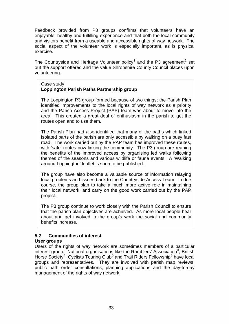
5 Working with communities Our aim is to: ‘encourage and support local communities wishing to make use of and develop access to Shropshire’s countryside’. People value their local access network. They recognise that good access promotes individual health and wellbeing as well as wider community, social and economic benefits. Active volunteering, health walks, conservation projects and walking festivals all provide a focus for community life and promote local ownership and engagement. Working with communities provides the Countryside Access Team with an insight into the needs of Shropshire people at a local level. It also gives local communities the opportunity to influence how access to the countryside is managed. 5.1 Communities of place Local Parish and Town Councils Parish and town councils form the focal point for many community activities. Engaging with these councils provides involvement in local issues at an early stage. For example, local councils are involved with parish map reviews, public path order consultations, planning applications, and the day-to-day management of the rights of way network. Over 60 parish and town councils have contributed to the production of this strategy. Community and Parish Plans Parish Plans are based on a survey of local opinions, needs and aspirations carried out by the community itself. Plans identify which features and local characteristics people value and an agreed action plan then helps them to achieve their goals. Access to the countryside is clearly important to many parishes as nine out of ten include related actions (see case study). Parish Paths Partnership (P3) People can influence decisions and work together to resolve access issues by joining local Parish Paths Partnerships (P3) groups. The Partnership has been running in Shropshire since February 1993. There are now 52 active groups of volunteers, involving more than 250 people, covering over 90 parishes. The P3 groups have strong links to the local community and around half are part of or report to parish or town councils. P3 groups carry out practical improvements to the rights of way network, undertake survey work, organise guided walks and develop and promote routes. Several new groups have started as a result of actions within Parish Plans.
33
Feedback provided from P3 groups confirms that volunteers have an enjoyable, healthy and fulfilling experience and that both the local community and visitors benefit from a useable and accessible rights of way network. The social aspect of the volunteer work is especially important, as is physical exercise. The Countryside and Heritage Volunteer policy1 and the P3 agreement2 set out the support offered and the value Shropshire County Council places upon volunteering. 5.2 Communities of interest User groups Users of the rights of way network are sometimes members of a particular interest group. National organisations like the Ramblers’ Association3, British Horse Society4, Cyclists Touring Club5 and Trail Riders Fellowship6 have local groups and representatives. They are involved with parish map reviews, public path order consultations, planning applications and the day-to-day management of the rights of way network.
Case study Loppington Parish Paths Partnership group The Loppington P3 group formed because of two things; the Parish Plan identified improvements to the local rights of way network as a priority and the Parish Access Project (PAP) team was about to move into the area. This created a great deal of enthusiasm in the parish to get the routes open and to use them. The Parish Plan had also identified that many of the paths which linked isolated parts of the parish are only accessible by walking on a busy fast road. The work carried out by the PAP team has improved these routes, with ‘safe’ routes now linking the community. The P3 group are reaping the benefits of the improved access by organising led walks following themes of the seasons and various wildlife or fauna events. A ‘Walking around Loppington’ leaflet is soon to be published. The group have also become a valuable source of information relaying local problems and issues back to the Countryside Access Team. In due course, the group plan to take a much more active role in maintaining their local network, and carry on the good work carried out by the PAPproject. The P3 group continue to work closely with the Parish Council to ensurethat the parish plan objectives are achieved. As more local people hear about and get involved in the group’s work the social and community benefits increase.
34
In addition, the County Council has established a Walkers Forum7, Cycle Forum, Shropshire Riding and Carriage Driving Groups8 and Byways Liaison Group. Consultation with all these groups provides insight into specific needs and develops understanding between all parties. Local Access Forum The Shropshire Local Access Forum was formed in 2003. Members of the Forum represent a wide range of interests including landowners, walkers, horse riders, carriage drivers, disabled access, tourism and conservation. The Forum advises the County Council on all strategic aspects of countryside access within the county including the Countryside Access Strategy. While carrying out these functions the Forum takes into account the needs of land management and the desirability of conserving the natural environment of Shropshire. The Forum works to develop a constructive and inclusive approach to improvements to access to the countryside. The differing interests of members enable the Forum to consider local circumstances, to engage in constructive debate and to suggest solutions. Landowners and farmers Landowners and farmers are an integral part of local communities and farming practices have helped shape today’s landscape. The majority of rights of way cross land in their ownership and they have an important role in maintaining this access. Landowners are responsible for maintaining stiles and gates, reinstating paths after ploughing, keeping paths clear of growing crops and cutting back overhanging vegetation. They have additional responsibilities where they own or manage open access land. In addition landowners may provide permissive access through agri-environment schemes9. These routes form useful additional access particularly where they fill gaps in the rights of way network. 5.3 What we have been told The value that local communities put on access to the countryside cannot be overestimated. It enhances people’s sense of place, giving people a sense of physical and mental wellbeing. In addition the network provides economic opportunities to local businesses. The key issues raised by local communities are that they:
• Need physical improvements to the rights of way network including better stiles and gates, more signposts and waymarking. Gated routes are preferable as they provide easier access.
• Need more opportunities to volunteer and to join P3 groups. • Need more information about access. • Need more promoted routes. • Need more recognition of the health benefits of access to the
countryside and more health walks. • Need more places to walk dogs and more dog stiles.
35
• Need more off-road access for horse riders and cyclists. • Would like the recreational use of disused railway lines and canal
towpaths to be developed. • Would like to see improved road crossings. • Would like to see improved links from urban areas into the countryside. • Would like more promotion of the country code10 to users. • Would like better car parking facilities in some areas.
Many of these issues have also been raised through the general consultation outlined in Chapter 4 and elsewhere. Only specific community actions are included here. 5.4 What we will do to support local communities Local communities clearly value the access network which plays an important part in their everyday lives. Consultation has provided opportunities which will enable us to continue and improve our support for communities. To achieve our aim to encourage and support local communities wishing to make use of and develop access to Shropshire’s countryside we will work to: 1. Provide advice and support at a local level to communities
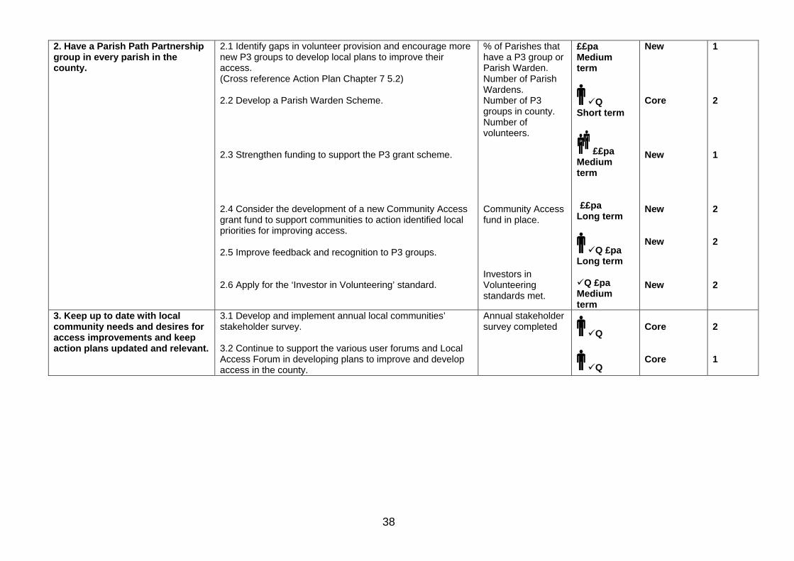
wishing to improve their access to the countryside. 2. Have a Parish Path Partnership group in every parish in the
county. 3. Keep up to date with local community needs and desires for
access improvements and keep Action Plans updated and relevant.
36
1 Countryside and Heritage Volunteer policy – being developed to ensure standard policies and procedures adopted for volunteers across Cultural Services. www.shropshire.gov.uk 2 Parish Paths Partnership Agreement – sets out the scope, roles and responsibilities of the partners involved in volunteering with P3. www.shropshire.gov.uk 3 Ramblers – Britain's biggest walking charity. Promotes walking and improves conditions for everyone who walks. http://www.ramblers.org.uk 4 British Horse Society – the UK’s largest equestrian charity with a particular concern for access issues. http://www.bhs.org.uk 5 Cyclists Touring Club – the UK’s national cycling organisation. http://www.ctc.org.uk 6 Trail Riders Fellowship – national, voluntary and non-competitive organisation who enjoyed exploring 'Green Roads' by motorcycle. http://www.trf.org.uk 7 Walkers Forum – group formed by the County Council and local walkers to promote discussion and improve access for walkers in Shropshire. http://www.shropshire.gov.uk/countryside.nsf 8 Shropshire Riding and Carriage Driving Groups – group formed by the County Council and local horse riders and carriage drivers to promote discussion and improve access for equestrians in Shropshire. http://www.shropshire.gov.uk/countryside.nsf 9 Countryside Stewardship schemes – work involving permissive public access to the countryside called Conservation Walks and Rides. http://www.defra.gov.uk/rural/publicaccess/default.htm 10 Country Code – advice for the public and land managers’ developed by Natural England.http://www.countrysideaccess.gov.uk

37
Chapter 5 Working with communities Aim Action Indicator Staffing
and timescale
Funding source Core/New
Priority 1/2
1. Provide advice and support at a local level to communities wishing to improve their access to the countryside.
1.1 Update and build on the existing audit of Parish Planning in the county and map out local community access plans around the 9 major themes:
1. Physical improvements to the rights of way network. 2. More opportunities to volunteer and join a P3 group. 3. More information and more promoted routes. 4. More recognition of the health benefits of access to
the countryside and more health walks. 5. More suitable places to walk dogs. 6. More easier access gated routes. The use of
disused railway lines and towpaths needs to be explored.
7. Improvements to road crossings that are a barrier to access.
8. Improved links from some centres of population into the countryside.
9. Better car parking in some areas. 1.2 Increase capacity to develop projects to respond to community needs linked to Parish Planning and Access Strategy consultation. 1.3 Provide strategic links between local communities, access providers and funding partners to ensure that community priorities are taken forward. 1.4 Discuss with and encourage individual local groups in their plans for access. Help with grant or funding bids to implement parish action plans. 1.5 Develop cluster parish projects and funding bids around meeting local community priorities for improvements. 1.6 Develop ‘Parish Packs’ of mapping and access information and community access boards in all parishes. 1.7 Develop an advice and information programme for landowners and users of the network which will enable each party to understand their responsibilities.
Number of community projects annually.
Q
£££pa Medium term See 2.1 below See 2.1 below See 2.1 below Project £pa Medium term
Project £pa Medium term
Core New New New New New New
1 2 2 2 2 2 2
38
2. Have a Parish Path Partnership group in every parish in the county.
2.1 Identify gaps in volunteer provision and encourage more new P3 groups to develop local plans to improve their access. (Cross reference Action Plan Chapter 7 5.2) 2.2 Develop a Parish Warden Scheme. 2.3 Strengthen funding to support the P3 grant scheme. 2.4 Consider the development of a new Community Access grant fund to support communities to action identified local priorities for improving access. 2.5 Improve feedback and recognition to P3 groups. 2.6 Apply for the ‘Investor in Volunteering’ standard.
% of Parishes that have a P3 group or Parish Warden. Number of Parish Wardens. Number of P3 groups in county. Number of volunteers. Community Access fund in place. Investors in Volunteering standards met.
££pa Medium term
Q Short term
££pa Medium term ££pa
Long term
Q £pa Long term
Q £pa Medium term
New Core New New New New
1 2 1 2 2 2
3. Keep up to date with local community needs and desires for access improvements and keep action plans updated and relevant.
3.1 Develop and implement annual local communities’ stakeholder survey. 3.2 Continue to support the various user forums and Local Access Forum in developing plans to improve and develop access in the county.
Annual stakeholder survey completed
Q
Q
Core Core
2 1
39
6 Making local journeys Our aim is to: ‘increase peoples’ use of the rights of way network for local journeys to support a sustainable transport network’. Rights of way are a valuable resource not only for recreation but also for walking or cycling to work, school, shops or leisure facilities instead of going by car. 6.1 The national context Climate change caused by the increase in concentrations of ‘greenhouse gases’ such as carbon dioxide is recognised as a threat to the environment. Concentrations of these gases have risen by 50% over the last 20 years and road transport is a major contributory factor. The fact that the majority of people access the countryside by car is therefore an issue. Public provision of access needs to focus on encouraging and enabling sustainable patterns of use. The strategy has many areas of strength and potential on which to build this approach, for example:
• Focusing promotion of access close to where people live helps to minimise travel.
• Walking, cycling and horse riding are low impact activities provided the travel associated with them is not high. Encouraging people to spend more time doing these activities would reduce impacts.
• The countryside access network, especially around settlements, plays a supporting role in sustainable transport for functional purposes, e.g. walking or cycling to work or shops.
Some of the Government guidance on how the transport system should be managed over the next 20 to 30 years is included within ‘The Future of Transport’1, ‘statutory guidance on Local Transport Plans’2 and ‘Walking and Cycling: an action plan’3. The guidance contains targets for increased walking and cycling in order that they become a real alternative method of transport for local trips. The main walking and cycling actions that have been identified by these reports are:
• Promoting the use of school travel plans, workplace travel plans and personalised journey planning to encourage people to consider alternatives to using their cars.
• Creating a culture and improved local environment so that cycling and walking are seen as attractive alternatives to car travel in both urban and rural areas.
• Promoting walking as a healthy and more preferable option to the car for short journeys.
• Promoting cycling as an alternative form of transport for local journeys. • Integrating the Countryside Access Strategy within the LTP.
The guidance also sets out the requirement for Highway Authorities to produce an accessibility strategy. This should relate to the ease with which

40
people can get to key services and facilities, such as places of work and learning, health care, shops and leisure venues. ‘Unlocking the potential of the rural urban fringe’4 looks at the interaction and links between urban fringe routes and the wider environment. ‘The rural urban fringe forms a vital part of sustainable towns and cities. It inspires urban living that is connected to nature, to the countryside and our responsibilities to the wider environment.’ 6.2 What happens in Shropshire Shropshire is a large, predominantly rural county with a low population for its size. It is served by a road network of 5,664km. In addition to this there are over 5,500km of rights of way which form an integral part of the public highway network. These rights of way network are a valuable resource not only for recreation but also for access by foot and cycle to work, school, shops or leisure facilities instead of going by car. Although the majority of the rights of way network falls within the rural parts of the county, many routes also follow urban footways through housing estates or run along alleyways. 194km of the rights of way network are within Shropshire’s main centres of population (see Figure 6.2a - red routes). An additional 1,961km of rights of way are within 3km of these areas – the urban fringe – and link outlying settlements with the main centres of population (see Figure 6.2a – green routes). Figure 6.2a

41
Some of these routes are already used for local journeys. Cycleways, through Shrewsbury for example, sometimes follow footpaths or bridleways. Only a small percentage of respondents to the strategy consultation stated that they used rights of way for local journeys. This appears to under represent actual use which could be because people walking or cycling on the more urban routes do not associate or recognise them as rights of way. To further develop and increase the use of the rights of way network for local journeys, existing routes need to be improved. Where a specific need has been identified new routes may need to be created. People will only be encouraged to change their patterns of behaviour and to walk or cycle on short local trips through the provision of a welcoming environment. Improved signage, better surfaces and furniture, safer road crossings and more information have all been raised as issues through the consultation. This applies equally to urban and rural routes. Consultation has shown that people think it is important to improve links and create new access between urban areas and rural communities. The implementation of the Countryside Access Strategy will identify key routes to be targeted for improvements and gaps where new routes are needed. In all these instances promoting the use of and improving the condition of the rights of way network can produce a cost effective method of reducing reliance on use of cars. Shropshire’s Local Transport Plan 2006-2011 Shropshire’s LTP recognises that transport is not an end in itself but is integral to people’s everyday lives. It sets out sets out a vision and objectives for local transport in the county looking forward to the year 2020. The LTP has set out four overarching aims for local transport in Shropshire how they relate to the Access strategy is set out in Chapter 2. The LTP recognises that the rights of way network is a valuable asset and plays a substantial role in encouraging people to walk and cycle more for local journeys. It also recognises the needs of horse riders. The LTP makes a number of recommendations:
• Better signing of rights of way from highways. • Targeted safety improvements where rights of way cross or run
alongside roads, especially on well-used routes. • Support for ‘Quiet Lane’ schemes. • Improvements to rights of ways where they meet transport priorities. • Development of ‘quality walking routes,’ which may include upgrading
footpaths, to increase opportunities for people to walk rather than use their car.
• Develop new rural footways, which may include upgrading of an existing right of way.
• Development of safer routes to schools, which could include the use of and improvements to rights of way.
• Expand and improve cycle networks in urban areas, which could include rights of way.

42
• Recognition of the need for off-road cycle routes. • Improved trunk road crossings and footway provision for walkers,
cyclists and equestrians. • Support sections of the Ride UK national bridleway network that uses
public roads. • Use appropriate maintenance techniques including the maintenance of
road side verges to allow equestrian use. 6.3 What next for Shropshire It is important to recognise that people will only be encouraged to walk and cycle more for local journeys if the routes that connect residential areas to key destinations are improved. These routes could include rights of way. It is clear that maintenance standards on these rights of way need to be improved to encourage people to use the network more for local journeys. To meet our aim to ‘increase people’s’ use of the rights of way network for local journeys’ the following objectives have been identified: 1. Work to integrate the implementation of the Countryside Access
Strategy and Local Transport Plan: and take forward significant improvements to local walking cycling networks that encourage people to walk and cycle for local journeys.
2. Improve provision, marketing and promotion of the rights of way
network in urban areas and the associated health benefits of this physical activity.
1 The Future of Transport – Government white paper July 2004 http://www.dft.gov.uk/about/strategy/whitepapers/fot 2 Guidance on Local Transport Plans: Second Edition 2004 - Dept. for Transport http://www.dft.gov.uk/pgr/regional/ltp/guidance/fltp/fullguidanceonlocaltransport3657 3 Walking and Cycling Action Plan 2004 - Dept. for Transport http://www.dft.gov.uk/pgr/sustainable/walking/actionplan 4 ‘Unlocking the potential of the rural urban fringe’ - consultation by the Countryside Agency and Groundwork in 2004 http://www.naturalengland.org.uk
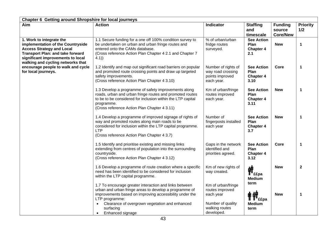
43
Chapter 6 Getting around Shropshire for local journeys Aim Action Indicator Staffing
and timescale
Funding source Core/New
Priority 1/2
1. Work to integrate the implementation of the Countryside Access Strategy and Local Transport Plan: and take forward significant improvements to local walking and cycling networks that encourage people to walk and cycle for local journeys.
1.1 Secure funding for a one off 100% condition survey to be undertaken on urban and urban fringe routes and entered onto the CAMs database. (Cross reference Action Plan Chapter 4 2.1 and Chapter 7 4.1)) 1.2 Identify and map out significant road barriers on popular and promoted route crossing points and draw up targeted safety improvements. (Cross reference Action Plan Chapter 4 3.10) 1.3 Develop a programme of safety improvements along roads, urban and urban fringe routes and promoted routes to be to be considered for inclusion within the LTP capital programme. (Cross reference Action Plan Chapter 4 3.11) 1.4 Develop a programme of improved signage of rights of way and promoted routes along main roads to be considered for inclusion within the LTP capital programme. LTP (Cross reference Action Plan Chapter 4 3.7) 1.5 Identify and prioritise existing and missing links extending from centres of population into the surrounding countryside. (Cross reference Action Plan Chapter 4 3.12) 1.6 Develop a programme of route creation where a specific need has been identified to be considered for inclusion within the LTP capital programme. 1.7 To encourage greater interaction and links between urban and urban fringe areas to develop a programme of improvements based on improving accessibility under the LTP programme: • Clearance of overgrown vegetation and enhanced
surfacing • Enhanced signage
% of urban/urban fridge routes surveyed. Number of rights of way road crossing points improved each year. Km of urban/fringe routes improved each year. Number of fingerposts installed each year Gaps in the network identified and priorities agreed. Km of new rights of way created. Km of urban/fringe routes improved each year Number of quality walking routes developed.
See Action Plan Chapter 4 2.1 See Action Plan Chapter 4 3.10 See Action Plan Chapter 4 3.11 See Action Plan Chapter 4 3.7 See Action Plan Chapter 4 3.12
££pa Medium term
££pa Medium term
New Core New New Core New New
1 1 1 1 1 2 1
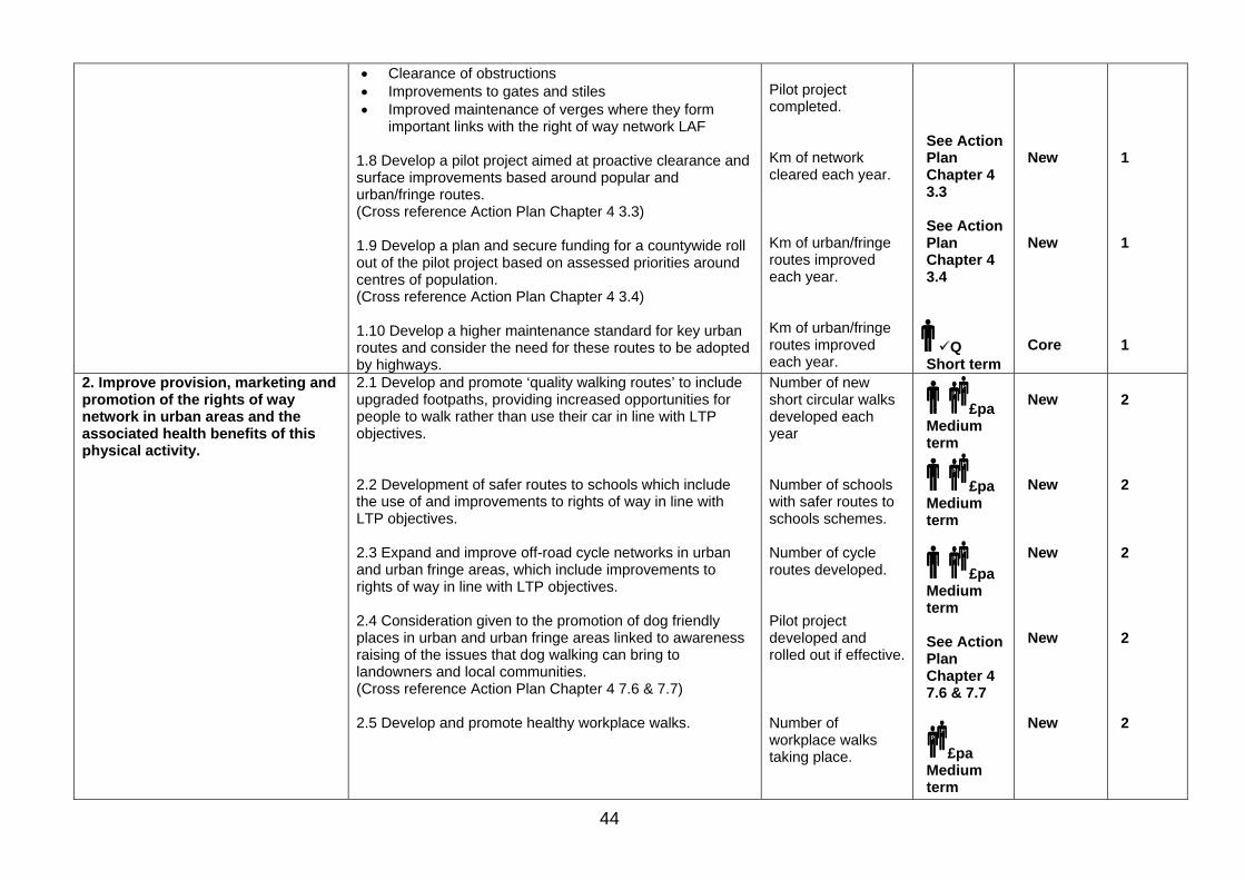
44
• Clearance of obstructions • Improvements to gates and stiles • Improved maintenance of verges where they form
important links with the right of way network LAF 1.8 Develop a pilot project aimed at proactive clearance and surface improvements based around popular and urban/fringe routes. (Cross reference Action Plan Chapter 4 3.3) 1.9 Develop a plan and secure funding for a countywide roll out of the pilot project based on assessed priorities around centres of population. (Cross reference Action Plan Chapter 4 3.4) 1.10 Develop a higher maintenance standard for key urban routes and consider the need for these routes to be adopted by highways.
Pilot project completed. Km of network cleared each year. Km of urban/fringe routes improved each year. Km of urban/fringe routes improved each year.
See Action Plan Chapter 4 3.3 See Action Plan Chapter 4 3.4
Q Short term
New New Core
1 1 1
2. Improve provision, marketing and promotion of the rights of way network in urban areas and the associated health benefits of this physical activity.
2.1 Develop and promote ‘quality walking routes’ to include upgraded footpaths, providing increased opportunities for people to walk rather than use their car in line with LTP objectives. 2.2 Development of safer routes to schools which include the use of and improvements to rights of way in line with LTP objectives. 2.3 Expand and improve off-road cycle networks in urban and urban fringe areas, which include improvements to rights of way in line with LTP objectives. 2.4 Consideration given to the promotion of dog friendly places in urban and urban fringe areas linked to awareness raising of the issues that dog walking can bring to landowners and local communities. (Cross reference Action Plan Chapter 4 7.6 & 7.7) 2.5 Develop and promote healthy workplace walks.
Number of new short circular walks developed each year Number of schools with safer routes to schools schemes. Number of cycle routes developed. Pilot project developed and rolled out if effective. Number of workplace walks taking place.
£pa Medium term
£pa Medium term
£pa Medium term See Action Plan Chapter 4 7.6 & 7.7
£pa Medium term
New New New New New
2 2 2 2 2
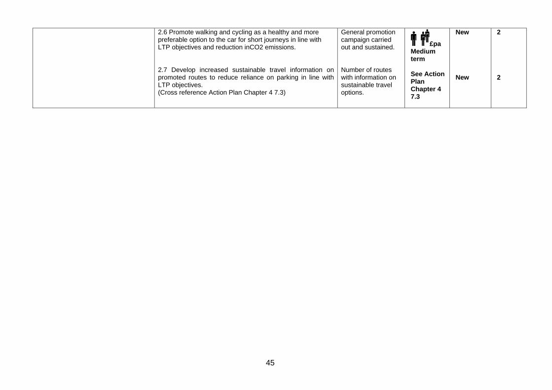
45
2.6 Promote walking and cycling as a healthy and more preferable option to the car for short journeys in line with LTP objectives and reduction inCO2 emissions. 2.7 Develop increased sustainable travel information on promoted routes to reduce reliance on parking in line with LTP objectives. (Cross reference Action Plan Chapter 4 7.3)
General promotion campaign carried out and sustained. Number of routes with information on sustainable travel options.
£pa Medium term See Action Plan Chapter 4 7.3
New New
2 2
46
7 Health and wellbeing Our aim is to: ‘improve people’s health by encouraging more people to be active in the countryside’. 7.1 What are the benefits of physical activity? Nationally people’s levels of physical activity are declining. ‘Choosing Health, Making Healthy Choices Easier’1 identifies that over a third of people are not active enough to benefit their health. Scientific evidence shows that an active lifestyle is the key to a better health. Being physically active can reduce the risk of premature death by 20-30%, and the chance of developing major chronic diseases by up to 50%. In older people it helps to promote independence and reduces the likelihood of fall-related injuries. Increased physical activity does not just have benefits to physical health. The mental health charity MIND has reported that regular physical activity can make people feel better. It helps to relieve depression and anxiety, reduces stress and increases a feeling of wellbeing. Walking, cycling and horse riding in the countryside are enjoyable, sustainable ways to take exercise. In addition, it is widely accepted that contact with the natural environment is important to people and promotes a feeling of wellbeing. Formal sports events and competitions also have an impact on people’s health. Competitions like; triathlons, runs, orienteering, canoeing, mountain-biking and horse riding raise the profile of both the countryside and sport for health and wellbeing. For most people, the easiest and most convenient forms of physical activity are those that can be incorporated into everyday life. Recreational walking, cycling and horse riding in the countryside, walking and cycling to work, and active volunteering can all contribute to the recommendation that each of us should take 30 minutes of exercise, 5 days a week. The link between easy access to the countryside and physical activity has been well documented. A recent RSPB report2 stated that ‘The countryside can be seen as a great outpatient department whose therapeutic value is yet to be fully realised.’ 7.2 What happens in Shropshire Shropshire is a large, predominantly rural county with a low population for its size. It has a relatively large concentration of older people and life expectancy is generally high. The relationship between deprivation and ill health is well documented and many illnesses and diseases, for example coronary heart disease, are found more frequently in areas of higher deprivation. The Index of Multiple Deprivation3 is an important indicator and shows where pockets of deprivation occur in Shropshire (see Figure 7.2a). The consultation for this strategy showed that the links between physical activity, its health benefits and access to the countryside were recognised by
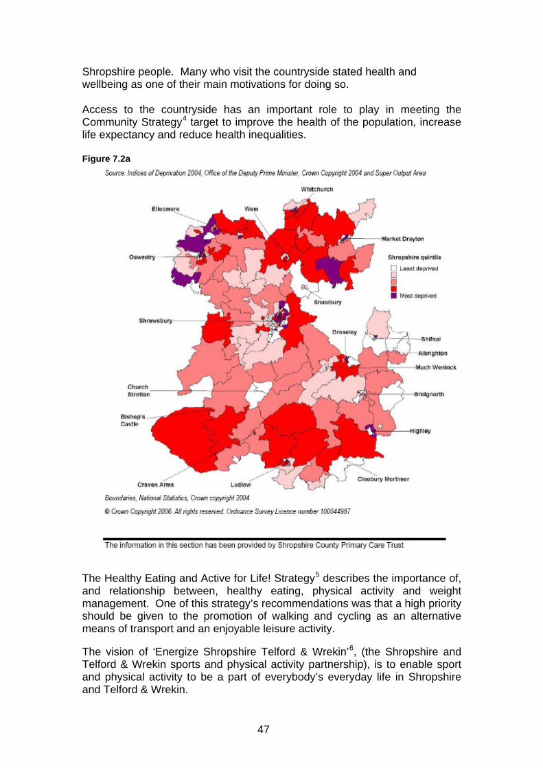
47
Shropshire people. Many who visit the countryside stated health and wellbeing as one of their main motivations for doing so. Access to the countryside has an important role to play in meeting the Community Strategy4 target to improve the health of the population, increase life expectancy and reduce health inequalities. Figure 7.2a
The Healthy Eating and Active for Life! Strategy5 describes the importance of, and relationship between, healthy eating, physical activity and weight management. One of this strategy’s recommendations was that a high priority should be given to the promotion of walking and cycling as an alternative means of transport and an enjoyable leisure activity. The vision of ‘Energize Shropshire Telford & Wrekin’6, (the Shropshire and Telford & Wrekin sports and physical activity partnership), is to enable sport and physical activity to be a part of everybody’s everyday life in Shropshire and Telford & Wrekin.

48
Working with the Primary Care Trust7 and Energise STW, the County Council have developed the ‘Walking for LIFE!’ project, an initiative to increase physical activity levels in the county. The vision of the project is ‘to provide a continuum of walking opportunities to encourage all people, particularly those who are sedentary or inactive, to get active and stay active.’ The project’s focus is to develop and promote opportunities for Shropshire people to increase their physical activity from the doorstep and in the countryside. It is achieving this by supporting guided walking for health schemes and developing more opportunities for people to walk independently. It is also encouraging more people to take part in volunteering in the countryside, for example through the Parish Paths Partnership (see case study). 7.3 What next for Shropshire The use of the countryside access network has a valuable role to play in supporting the physical and mental health of the people of Shropshire. Although to a certain extent this is recognised, significant improvements can be made through the Access Strategy. Most benefit can be obtained by targeting specific groups to get more active.
Case study Pontesbury Parish Paths Partnership (P3) Group The Pontesbury P3 group formed in the spring of 2006 as a response to local discussion and consultation as part of the Pontesbury Parish Plan. The group’s initial aim was to improve access to rights of way, both withinthe parish and the surrounding area. In their first year the volunteers carried out work to improve 100 stiles and numerous bridges and gates. This improved access to many paths within the locality. To celebrate this, the group organised a summer ‘Family Walk Day’ which proved to be very popular. In the following spring of 2007 a ‘Beating the Parish Bounds’ walk was held. In addition the group are involved in a project to improve access for all along a nearby disused railway line. The opening of the new Medical Centre in Pontesbury village promoted a member of the P3 group to encourage people in the community to create healthy walks in and around the village. With help from the ‘Walking for Life!’ project these walks have since become very popular. A display to promote the benefits of ‘active volunteering’ was put up in the surgery and walk leader training under the Walking for Health initiative has been undertaken. There are plans to promote a short circular walk starting directly from the medical centre. Work to improve access to these routes by putting in gates instead of stiles has already been done and the group are also producing a leaflet.
49
To meet our aim to ‘improve people’s health by encouraging more people to be active in the countryside’ the following objectives have been identified: 1. Improve promotion of the benefits that access to the countryside
brings to both mental and physical health. 2. Provide more outdoor recreation activities through work with
Energize STW, Shropshire PCT and other leisure providers. 3. Increase the number of Walking for Health schemes and ensure
that the groups are sustainable. 4. Provide accessible, high-quality walking and cycling routes close
to where people live and other appropriate locations. 5. Promote and encourage people to increase their physical activity
levels through progression into other activities. 6. Increase the number of people undertaking ‘active’ volunteering
in the County through Parish Paths Partnership schemes. 1 Choosing Health, Making Healthy Choices Easier – Government white paper published November 2004 http://www.dh.gov.uk/en/Policyandguidance/Organisationpolicy/Modernisation/Choosinghealth/index.htm 2 Natural Fit Can Green Space and Biodiversity Increase Levels of Physical Activity? - report by Dr William Bird for the Royal Society for the Protection of Birds http://www.rspb.org.uk/Images/natural_fit_full_version_tcm5-60619.pdf 3 Indices of deprivation 2004 – published by Office of the Deputy Prime Minister (ODPM) combine a number of indicators, chosen to cover a range of economic, social and housing issues into a single deprivation score for each small area in England. http://www.communities.gov.uk 4 Shropshire Partnership Community Strategy 2006-2010 - provides a framework for Shropshire's new Local Area Agreement (LAA) http://www.shropshire.gov.uk/shroppart.nsf 5 The Healthy Eating and Active for Life! Strategy 2004 - produced by the Shropshire Partnership 6 Energize STW county sports partnership - vision is to enable sport and physical activity to be a part of everybody’s everyday life in Shropshire and Telford & Wrekin http://www.energizestw.org.uk/ http://www.shropshire.gov.uk/sspart.nsf 7 Shropshire County Primary Care Trust (PCT) was established on 1st April 2002, it is responsible for the delivery of health services to its population. http://www.shropshirepct.nhs.uk
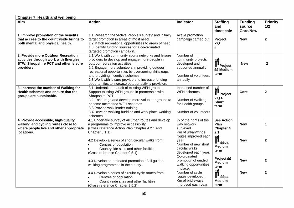
50
Chapter 7 Health and wellbeing Aim Action Indicator Staffing
and timescale
Funding source Core/New
Priority 1/2
1. Improve promotion of the benefits that access to the countryside brings to both mental and physical health.
1.1 Research the ‘Active People’s survey’ and initially target promotion in areas of most need. 1.2 Match recreational opportunities to areas of need. 1.3 Identify funding sources for a co-ordinated targeted promotion campaign.
Active promotion campaign carried out.
Project
Q £
New
2
2. Provide more Outdoor Recreation activities through work with Energize STW, Shropshire PCT and other leisure providers.
2.1 Work with community sports networks and leisure providers to develop and engage more people in outdoor recreation activities. 2.2 Engage more volunteers in providing outdoor recreational opportunities by overcoming skills gaps and providing incentive schemes. 2.3 Work with leisure providers to increase funding opportunities to increase outdoor activity provision.
Number of community projects developed and supported annually Number of volunteers annually
Project ££ Medium term
New
2
3. Increase the number of Walking for Health schemes and ensure that the groups are sustainable.
3.1 Undertake an audit of existing WFH groups. Support existing WFH groups in partnership with Shropshire PCT. 3.2 Encourage and develop more volunteer groups to become accredited WFH schemes. 3.3 Provide walk leader training. 3.4 Develop walking buddies and work place working schemes.
Increased number of WFH schemes. Number of Walking for Health groups Number of volunteers
Project Q £
Short term
Core
2
4. Provide accessible, high-quality walking and cycling routes close to where people live and other appropriate locations.
4.1 Undertake survey of all urban routes and develop a programme to improve accessibility. (Cross reference Action Plan Chapter 4 2.1 and Chapter 6 1.1)) 4.2 Develop a series of short circular walks from: • Centres of population • Countryside sites and other facilities (Cross reference Chapter 9 5.1) 4.3 Develop co-ordinated promotion of all guided walking programmes in the county. 4.4 Develop a series of circular cycle routes from: • Centres of population • Countryside sites and other facilities (Cross reference Chapter 9 5.2).
% of the rights of the way network surveyed. Km of urban/fringe routes improved each year. Number of new short circular walks developed each year. Co-ordinated promotion of guided walking opportunities in place. Number of cycle routes developed. Km of bridleways improved each year.
See Action Plan Chapter 4 2.1
££pa Medium term Project ££ Medium term
££pa Medium term
New New New New
1 2 2 2
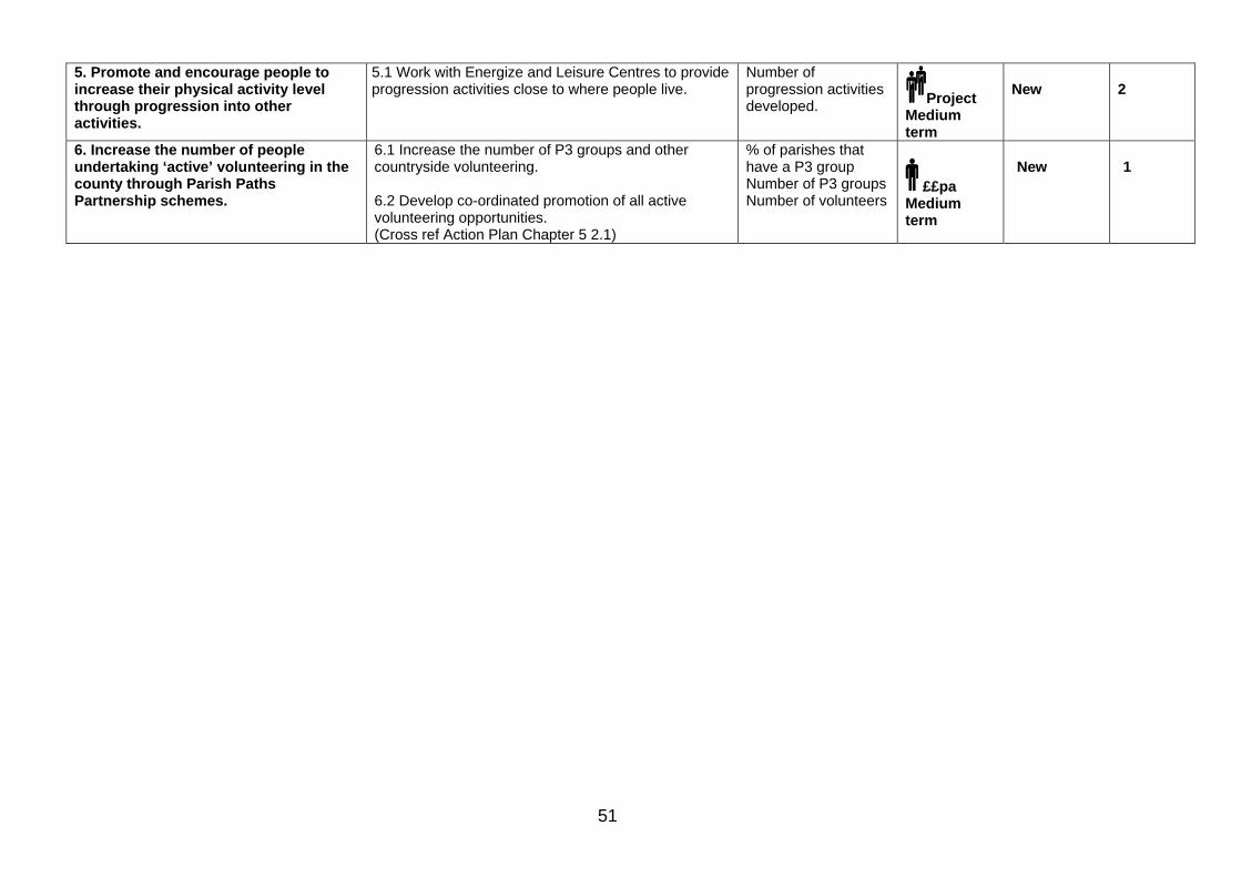
51
5. Promote and encourage people to increase their physical activity level through progression into other activities.
5.1 Work with Energize and Leisure Centres to provide progression activities close to where people live.
Number of progression activities developed. Project
Medium term
New
2
6. Increase the number of people undertaking ‘active’ volunteering in the county through Parish Paths Partnership schemes.
6.1 Increase the number of P3 groups and other countryside volunteering. 6.2 Develop co-ordinated promotion of all active volunteering opportunities. (Cross ref Action Plan Chapter 5 2.1)
% of parishes that have a P3 group Number of P3 groups Number of volunteers
££pa Medium term
New
1

52
8 Access to the Shropshire countryside for everyone
Our aim is to: ‘increase the opportunities for hard to reach groups to access the Shropshire countryside’. 8.1 Why access for everyone The majority of people who access the countryside are white, middle-aged, middle class and able-bodied. The Rural White Paper1 argued that the countryside should be a source of enjoyment for people from all sectors of society. It stated that people with disabilities, people from ethnic minorities, young people and people from urban areas were under represented in the countryside. Shropshire is one of the most sparsely populated county’s in England. It has a relatively high concentration of older people and a falling number of young people2. Although Shropshire has a very small population of black and ethnic groups there are opportunities to consult with these communities from elsewhere within the West Midlands region3. To provide an inclusive Countryside Access Strategy the needs of under represented, hard-to-reach groups must be taken into account. Access needs to be considered in its broadest sense. We should take steps to ensure that routes are as accessible as possible and when opportunities arise to improve access, they should be taken. 8.2 What access is available at present Most of Shropshire’s easier access opportunities are targeted around countryside sites. The Council has produced a guide to those areas suitable for wheelchair users. The Walking for LIFE! Project is improving opportunities for older people and the sedentary population to access the countryside more. The Shropshire Outdoors Project is improving the accessibility of countryside sites for people with physical and learning disabilities and mental health problems. At Oak Farm in Ditton Priors access has been improved to help people with learning disabilities experience the countryside (see case study). 8.3 What people have told us In order to provide better opportunities for everyone to access the Shropshire countryside it is essential to find out what people want. Over a sixth of the people who responded to our questionnaire considered themselves to be less mobile. Their main barriers to access were problems with stiles, lack of signposting and waymarking, overgrown vegetation, problems with gates, obstructions and lack of parking. Nearly a third of respondents were over 65 and raised similar issues. People also want more information on what’s available and where to go. The main issues were:
• A lack of signage and waymarking - good signage is essential.
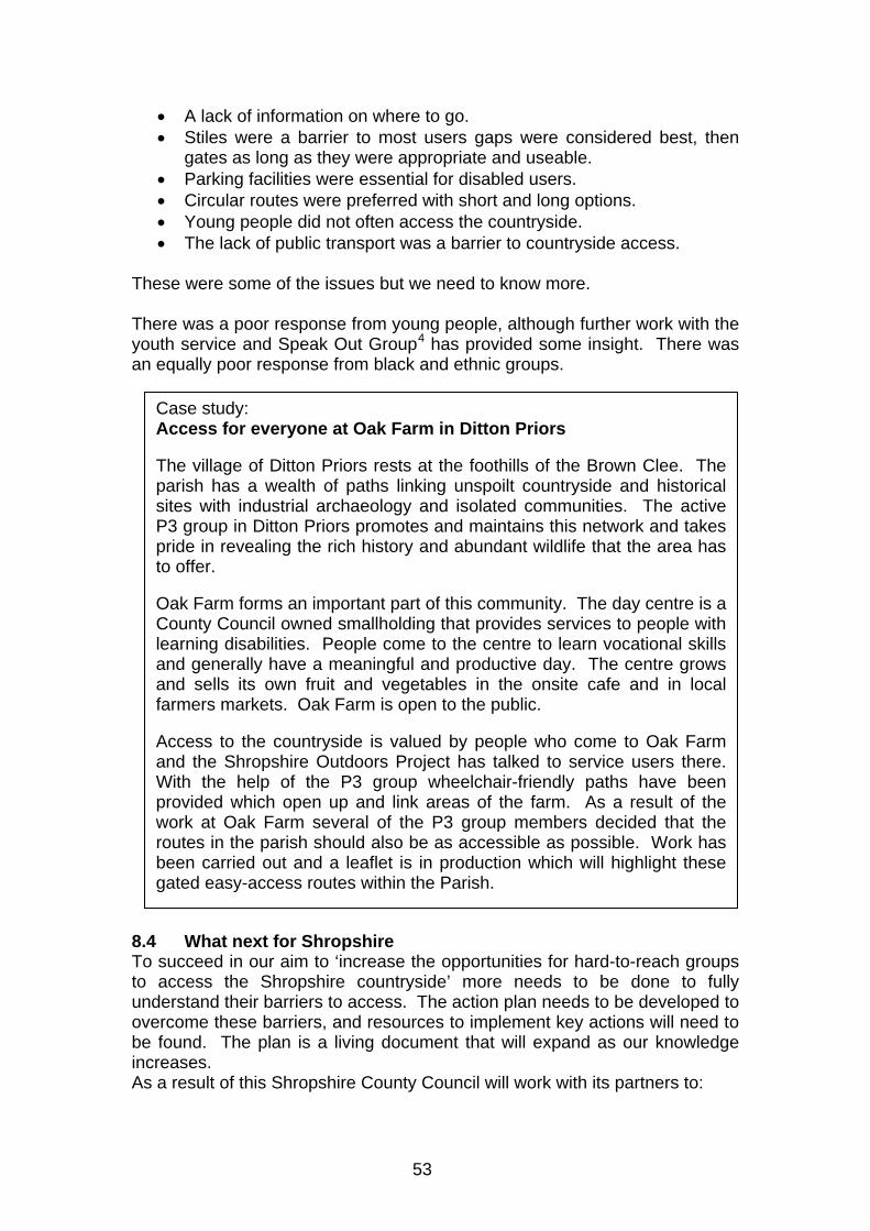
53
• A lack of information on where to go. • Stiles were a barrier to most users gaps were considered best, then
gates as long as they were appropriate and useable. • Parking facilities were essential for disabled users. • Circular routes were preferred with short and long options. • Young people did not often access the countryside. • The lack of public transport was a barrier to countryside access.
These were some of the issues but we need to know more. There was a poor response from young people, although further work with the youth service and Speak Out Group4 has provided some insight. There was an equally poor response from black and ethnic groups.
8.4 What next for Shropshire To succeed in our aim to ‘increase the opportunities for hard-to-reach groups to access the Shropshire countryside’ more needs to be done to fully understand their barriers to access. The action plan needs to be developed to overcome these barriers, and resources to implement key actions will need to be found. The plan is a living document that will expand as our knowledge increases. As a result of this Shropshire County Council will work with its partners to:
Case study: Access for everyone at Oak Farm in Ditton Priors The village of Ditton Priors rests at the foothills of the Brown Clee. The parish has a wealth of paths linking unspoilt countryside and historical sites with industrial archaeology and isolated communities. The active P3 group in Ditton Priors promotes and maintains this network and takes pride in revealing the rich history and abundant wildlife that the area has to offer. Oak Farm forms an important part of this community. The day centre is a County Council owned smallholding that provides services to people with learning disabilities. People come to the centre to learn vocational skills and generally have a meaningful and productive day. The centre grows and sells its own fruit and vegetables in the onsite cafe and in local farmers markets. Oak Farm is open to the public. Access to the countryside is valued by people who come to Oak Farm and the Shropshire Outdoors Project has talked to service users there. With the help of the P3 group wheelchair-friendly paths have been provided which open up and link areas of the farm. As a result of the work at Oak Farm several of the P3 group members decided that the routes in the parish should also be as accessible as possible. Work has been carried out and a leaflet is in production which will highlight these gated easy-access routes within the Parish.
54
1. Ensure the mechanisms to improve access to the countryside are maintained and improved applying the ‘least restrictive’ principle.
2. Talk with hard-to-reach groups to understand their barriers to access
and find out what would encourage them to access the Shropshire countryside more.
3. Work to ensure that the opportunities to access the Shropshire
countryside are available for everyone. 4. Improve policy development to embed the overall aim within the work
of the Countryside Service and ensure improvements are long-term. 5. Incorporate the information from hard-to-reach groups regarding
improved access within the Action Plans and secure additional resources to implement.
6. Understand the needs and interest of people with learning
difficulties, mental health problems and sensory impairment and make it easier for them to participate in countryside activities.
7. Ensure that recommendations within the Action Plan are
implemented and plans and policies are kept under review. 1 The Rural White Paper: Our Countryside: The Future – A Fair Deal for Rural England published November 2000 http://www.defra.gov.uk/rural/ruralwp/default.htm 2 Shropshire Profile 2007 http://www.shropshire.gov.uk/factsfigures.nsf 3 West Midlands Statistics Online – Census 2001 http://www.statistics.gov.uk 4 The SO (Speaking Out) Group is a group of young people aged 11 -18; formed in 2003 to support the Members of Youth Parliament (MYPs) and to give young people a voice. http://www.shropshire.gov.uk/youth.nsf
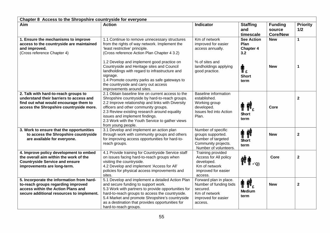
55
Chapter 8 Access to the Shropshire countryside for everyone Aim Action Indicator Staffing
and timescale
Funding source Core/New
Priority 1/2
1. Ensure the mechanisms to improve access to the countryside are maintained and improved. (Cross reference Chapter 4)
1.1 Continue to remove unnecessary structures from the rights of way network. Implement the ‘least restrictive’ principle. (Cross reference Action Plan Chapter 4 3.2) 1.2 Develop and implement good practice on Countryside and Heritage sites and Council landholdings with regard to infrastructure and signage. 1.4 Promote country parks as safe gateways to the countryside and carry out access improvements around sites.
Km of network improved for easier access annually. % of sites and landholdings applying good practice.
See Action Plan Chapter 4 3.2
£ Short term
New New
1 1
2. Talk with hard-to-reach groups to understand their barriers to access and find out what would encourage them to access the Shropshire countryside more.
2.1 Obtain baseline line on current access to the Shropshire countryside by hard-to-reach groups. 2.2 Improve relationship and links with Diversity officers and other community groups. 2.3 Review existing research around equality issues and implement findings. 2.3 Work with the Youth Service to gather views from young people.
Baseline information established. Working group developed. Issues fed into Action Plan.
£ Short term
Core
2
3. Work to ensure that the opportunities to access the Shropshire countryside are available for everyone.
3.1 Develop and implement an action plan through work with community groups and others for improving access opportunities for hard-to-reach groups.
Number of specific groups supported. Number of targeted Community projects. Number of volunteers.
Short term
New
2
4. Improve policy development to embed the overall aim within the work of the Countryside Service and ensure improvements are long-term.
4.1 Provide training for Countryside Service staff on issues facing hard-to-reach groups when visiting the countryside. 4.2 Develop and implement ‘Access for All’ policies for physical access improvements and sites.
Training provided Access for All policy developed. Km of network improved for easier access.
Q)
Core
2
5. Incorporate the information from hard-to-reach groups regarding improved access within the Action Plans and secure additional resources to implement.
5.1 Develop and implement a detailed Action Plan and secure funding to support work. 5.3 Work with partners to provide opportunities for hard-to-reach groups to access the countryside. 5.4 Market and promote Shropshire’s countryside as a destination that provides opportunities for hard-to-reach groups.
Forward plan in place. Number of funding bids secured. Km of network improved for easier access.
£ Medium term
New
2
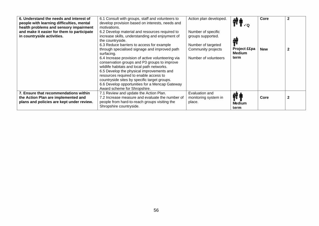
56
6. Understand the needs and interest of people with learning difficulties, mental health problems and sensory impairment and make it easier for them to participate in countryside activities.
6.1 Consult with groups, staff and volunteers to develop provision based on interests, needs and motivations. 6.2 Develop material and resources required to increase skills, understanding and enjoyment of the countryside. 6.3 Reduce barriers to access for example through specialised signage and improved path surfacing. 6.4 Increase provision of active volunteering via conservation groups and P3 groups to improve wildlife habitats and local path networks. 6.5 Develop the physical improvements and resources required to enable access to countryside sites by specific target groups. 6.6 Develop opportunities for a Mencap Gateway Award scheme for Shropshire.
Action plan developed. Number of specific groups supported. Number of targeted Community projects Number of volunteers
Q
Project ££pa Medium term
Core New
2 2
7. Ensure that recommendations within the Action Plan are implemented and plans and policies are kept under review.
7.1 Review and update the Action Plan. 7.2 Increase measure and evaluate the number of people from hard-to-reach groups visiting the Shropshire countryside.
Evaluation and monitoring system in place.
Medium term
Core
2
57
9 Visiting Shropshire’s countryside Our aim is ‘to provide a high quality access network that supports a thriving sustainable tourism economy’. 9.1 The national context The importance of rights of way and wider countryside access to the country’s tourism industry is nationally recognised. The Rural White Paper1 acknowledged that ‘the countryside is an enormous recreational asset, with its high quality landscape, fresh air, open space and tranquillity’. Tourists were traditionally regarded as people visiting from overseas or from different parts of the country. Today people visiting friends, family or attractions within their own locality are also thought of as tourists or visitors. Recent national research shows that nearly two thirds of adults in England went on a day visit to the countryside in 2002-32. The most popular outdoor activity was walking. It is estimated that 12 million domestic trips and 1.53 million overseas trips were made to the West Midlands in 20023, the most popular outdoor activities were walking (93%) or cycling. 9.2 The economic benefit of visitors A recent independent report commissioned by the Ramblers’ Association4 highlights the economic benefits of walking to local businesses. It states that walking in England generates between £1.4 million to £2.7 million income annually in rural areas and creates the equivalent of between 180,558 and 245,560 full time equivalent jobs. The Strategy for the Horse Industry England and Wales 20065 believes that equestrian tourism is a growing market and that the horse industry is also a significant economic contributor to the rural economy. In a recent report by Advantage West Midlands6 informal recreation accounted for at least £420 million of annual expenditure in the West Midlands region. The closure of all rights of way during the Foot and Mouth Disease epidemic in 2001 brought significant economic hardship to businesses in Shropshire. Economic impact studies at the time showed how these closures affected Shropshire’s visitor economy. For example a study of the impact on businesses in Church Stretton found that all of the 258 who participated showed a drop in income from the previous year; some by as much as 61%. 9.3 Sustainable tourism – what it means to Shropshire The Shropshire Tourism Strategy 20047 revealed that the main appeal of Shropshire is in the unspoilt landscape and peaceful, relaxing ambience of the area. ‘It has an attractive, varied and well-managed landscape from the plains, Meres and Mosses in the north to the hill country of the south, offering
58
opportunities for leisure activities and special interest pursuits’. Its peacefulness, tranquillity, slow pace of life and a friendly local welcome are also identified as strengths. The strategy adds that a ‘key goal in the future development of tourism in the county should be reinforcement of the sense of place. Shropshire is a tranquil, relaxing rural county with a remarkable and varied landscape. It is these intrinsic qualities that are of paramount appeal to visitors and residents alike and every effort should be made to ensure that they are reinforced through any developments that take place in future.’ The strategy believes that:
• The landscape should be promoted as the primary appeal of the area and underlying all other themes and activities.
• All developments and initiatives should be appropriate in scale and complementary in character to existing facilities and environment within the county.
• The health-giving and wellbeing benefits of the rural experience should be given emphasis in product developments and in marketing.
• Due regard should be made to ensure that the quality of the environment is respected and protected. Shropshire should aim to achieve status as a Green Globe destination.
Studies have shown that Shropshire Hills AONB is particularly popular with visitors. The importance of managing the development of tourism in the AONB to ensure that it does not erode the special qualities of the area is identified within the AONB Management Plan8. Local Councils9 also recognise that the landscape and rural experience are key attractors for visitors who are becoming increasingly important economically. 9.4 What Shropshire offers visitors Many visitors come to Shropshire for its special landscape qualities, its space and its tranquillity. The Access Strategy consultation has told us that people like to visit hills and woodland most. The Shropshire Hills AONB is particularly popular. The Shropshire Tourism Strategy 2004 revealed that walking, cycling and horse riding are amongst the most popular activities. It identified that 2.9 million visitors carry out some walking activity while in Shropshire. The biggest market is for short walks up to 3 miles long. Serious walkers represent a relatively small proportion of the total walking market. By far the largest market is visitors who walk as part of their holiday. The Tourism Strategy recommends that ongoing investment in maintaining and improving Shropshire’s network of public paths will grow existing markets and can be used to reach new ones. The Shropshire Tourism Research Unit10 carried out research in 2005 on both the walking and equine tourism markets. They concluded that Shropshire already has a lot to offer walkers and horse riders. Its countryside and peace and tranquillity were particular strengths. The walking market would benefit from more accommodation providers catering specifically for walkers and continued investment in maintaining and improving Shropshire’s right of way
59
network. The two key things that would attract more equestrians to Shropshire were better access to and increased number of bridleways and improved promotion of Shropshire as an equine tourism destination. Shropshire’s access assets The Shropshire countryside provides many places for visitors to walk, ride and cycle. There are hundreds of miles of rights of way and other tracks and trails, many countryside sites, thousands of hectares of open access land and many promoted routes. The Long Mynd and Stiperstones are nationally renowned and attract thousands of visitors a year. The National Trust estimates that Carding Mill Valley alone attracts over 350,000 people a year. The recognition of these assets helps reinforce Shropshire’s identity and strengthens the sense of place of the area and its associated landscape qualities. Access within popular areas needs careful management. Visitor pressure can cause damage to the places and landscapes that people have come to see and enjoy. Heavily used paths need careful management. The selected promotion of certain routes along with raising awareness of sensitive flora and fauna issues can help alleviate these problems. The Shropshire Hills AONB addresses many of these issues within its management plan Long distance paths Shropshire has many long distance footpaths, bridleways and cycle routes that are managed and promoted by Shropshire County Council. These include: • The Shropshire Way – long distance footpath • The Severn Way - long distance footpath • The Maelor Way - long distance footpath • The Simon Evans Way - long distance footpath • The Jack Mytton Way – long distance bridleway • The Kerry Ridgeway – long distance bridleway • Sections of the National Cycle Network – long distance cycle route Offa’s Dyke Path National Trail The Offa’s Dyke National Trail passes along the county’s border with Wales. These 83km are some of the trail’s most physically challenging and remote sections. Circular routes Circular routes are popular with visitors. The County Council actively promotes several circular routes for walkers, horse riders and cyclists. Consultation has shown that visitors want short circular routes in key areas with clear information. Linking start points to settlements where possible will help to minimise transport overall, limit traffic on minor roads and maximise economic returns to businesses.
60
Other attractions Places such as Acton Scott Historic Working Farm Museum, the Shropshire Hills Discovery Centre and the Mere at Ellesmere attract thousands of visitors and hold festivals and events throughout the year. There is a potential to raise the profile of what the countryside has to offer through the development and enhancement of these existing festivals and events. Shropshire’s 431 Scheduled Ancient Monuments, its canal network and the River Severn are already popular with visitors. Other features include Wroxeter Roman City, the historic towns of Ludlow and Shrewsbury and the Ironbridge Gorge World Heritage Site. Many of these assets are accessible from rights of way, permissive paths and/or on open access land. Walking Festivals and events Walking festivals are held in Bishop’s Castle, Cleobury Mortimer and Church Stretton. The festivals are popular with locals and visitors and offer long and short guided walks (see case study). Church Stretton and Bishop’s Castle have also recently obtained the Walkers are Welcome standard. In addition events like the Long Mynd Hike attract hundreds of competitors each year.
Case study: Cleobury Mortimer Footpaths Association – guided walks and festivals
The Cleobury Mortimer Footpaths Association (CMFA) formed in 1990, is one of the strongest and most active groups in the Parish Paths Partnership scheme, with in excess of 50 members. The group is independent but maintains strong links with the local Parish Council and other groups in the area. They carry out large quantities of practical work delivered by regular well attended working parties. The group is also keen on the promotion and interpretation of the local access network. They are responsible for the ‘Simon Evans Way,’ a footpath broadly following the route taken by the local postman after his return from the First World War. CMFAs latest project is the creation and promotion of a link between the Shropshire Way (at Titterstone Clee summit) and the Severn Way (at Highley). Much of what the group deliver can be accessed through the Cleobury Country website and locally in Cleobury Mortimer through various retail outlets. With a view to encouraging visitor numbers and providing benefit to the local economy, the group organise a walking festival, in addition to its annual programme of led walks. In 2007 the Solstice festival attracted over 210 adults and 21 children on the Food and Ale Trail. Many stayed overnight for the music festival and 33 went on the Severn Walk the next day.

61
Activity web sites There are three web-sites which promote opportunities for walking, horse riding and cycling in the county. They help visitors to find out what is available where and provide downloadable guides and leaflets. A further site is also being developed to promote ‘outdoor activities’ in Shropshire. www.shropshirewalking.co.uk www.shropshireriding.co.uk www.shropshirecycling.co.uk 9.5 Summary of the main opportunities for Shropshire Shropshire is a popular destination for visitors who enjoy countryside activities including walking, horse riding and cycling. There are significant economic benefits to local communities and opportunities for this market to expand. These are low impact activities which are compatible with a sustainable tourism approach in the County. Ways can be found to encourage more of these activities while minimising overall transport, traffic on rural roads and impacts on biodiversity and heritage. To meet our aim ‘to provide a high quality access network that supports a thriving sustainable tourism economy’ we have identified the following objectives: 1. Ensure that promoted walking, cycling and horse riding routes
supported by the County Council are maintained to the highest standard and that good interpretation is embedded in route promotion.
2. Implement a higher standard of maintenance on well used and
promoted walking, cycling and horse riding routes of significant importance for tourism.
3. Ensure that access promotion to visitors is compatible with
environmental considerations, (wildlife, heritage and sustainable transport), and promote understanding of these aspects to visitors and providers.
4. Encourage local businesses to relate their services to promoted
routes, to maximise economic benefit and improve facilities for visitors.
5. Improve the recognition of Shropshire as a destination for
walking, cycling, horse riding and sustainable tourism. 6. Provide an increased number of promoted walking, cycling and
riding routes. 7. Provide a co-ordinated approach to access promotion that is of a
high standard.
62
8. Develop support for walking festivals and guided walks
programme. 1 The Rural White Paper: Our Countryside: The Future – A Fair Deal for Rural England published November 2000 http://www.defra.gov.uk/rural/ruralwp/default.htm 2 Great Britain Day Visits Survey 2002/3 - Survey undertaken by the Countryside Agency, Countryside Council for Wales, British Waterways, Dept.Culture, Media and Sport, Environment Agency, Forestry Commission, Scottish Natural Heritage, VisitBritain, VisitScotland and Wales Tourist Board. http://www.countryside.gov.uk/LAR/Recreation/visits/dayvisits02-03.asp 3 West Midlands Regional Visitor Survey 2002 - prepared for Advantage West Midlands Heart of England Tourists Board http://www.heartofenglandtouristboard.co.uk 4 The Economic and Social Value of Walking 2003 - Independent report for the Ramblers. http://www.ramblers.org.uk/campaigns/EconVal.pdf 5 Strategy for the Horse Industry by British Horse Industry Confederation and DEFRA http://www.bhic.co.uk/industry-strategy.php http://www.defra.gov.uk/rural/horses/pdfs/en-horse-industry-strategy.pdf 6 The Informal Recreation and the Regional Economy of the West Midlands - January 2003 for Countryside Agency and Advantage West Midlands 7 A Tourism Strategy for Shropshire – January 2004 Commissioned by Shropshire County Council and funded by Advantage West Midlands. http://www.shropshire.gov.uk/tourism.nsf/open 8 Shropshire Hills Area of Outstanding Beauty Management Plan 2004 – 2009 http://www.shropshirehillsaonb.co.uk 9 Bridgnorth District Local Plan 1996 – 2011 http://www.bridgnorth-dc.gov.uk The Oswestry Local Plan (under review) http://www.oswestrybc.gov.uk Shrewsbury & Atcham Borough - ‘A Visitor Economy Strategy and Action Plan 2005 – 2009’ http://www.shrewsbury.gov.uk The North Shropshire District Local Plan 2000-2011 http://www.northshropshiredc.gov.uk 10 Shropshire’s Tourism Research Unit (STRU) – report on the walking December 2005 and market study on Equestrian Tourism March 2005. http://www.shropshire.gov.uk/tourism.nsf

63
Chapter 9 Access for visitors Aim Action Indicator Staffing
and timescale
Funding source Core/New
Priority 1/2
1. Ensure that promoted walking, cycling and horse riding routes supported by the County Council are maintained to the highest standard and that good interpretation is embedded in route promotion.
1.1 Introduce a hierarchical quality control system to ensure that promoted routes are of a high standard.
Quality control system in place.
Q
Core
2
2. Implement a higher standard of maintenance on well used and promoted walking, cycling and horse riding routes of significant importance for tourism.
2.1 Carry out an audit of all recognised promoted routes and develop work programmes based on the quality standards to be applied. 2.2 Prioritise work programmes and implement.
Work programme in place
£ Project Short term
New
2
3. Ensure that access promotion to visitors is compatible with environmental considerations, (wildlife, heritage and sustainable transport), and promote understanding of these aspects to visitors and providers.
3.1 Formulate a strategic approach to managing access pressures on popular conservation sites. (Cross reference Action Plan Chapter 4 1.1 and 41) 3.3 Include information about Shropshire’s countryside in access promotion material for visitors to raise awareness, understanding and responsible behaviour. 3.4 Link access promotion where possible to public transport e.g. Shuttle bus and other bus routes, linear walks/bike rides between railway stations. Cross reference Action Plan Chapter 4 7.3 and Chapter 6 2.7)
Targeted action plan developed to manage access pressures in Shropshire. Interpretive guidance in place linked to 5 year plan. Number of routes with information on sustainable travel options.
See Action Plan Chapter 4 1.1 See 3.1 and 4.1 below See Action Plan Chapter 4 7.3
New Core New
2 2 2
3. Encourage local businesses to relate their services to promoted routes, to maximise economic benefit and improve facilities for visitors.
3.1 Engage with partners and develop thematic and interpretative approach to route promotion to create greater understanding of the landscape and its communities. Locations planned to minimise conservation and transport impacts, and opportunities to link to public transport maximised. • Identify existing accommodation providers • Identify possible parish clusters for development • Identify themes for interpretation on new routes
3.2 Incorporate interpretation in new publications.
Interpretive guidance in place linked to 5 year plan. Number of routes with information on sustainable travel options.
Q
Core
2
4. That Shropshire is recognised as a walking, horse riding and cycling destination.
4.1 Draw up a targeted 5 year plan for access promotion linked to a marketing strategy and peoples needs.
5 year plan in place.
Q
Core
2
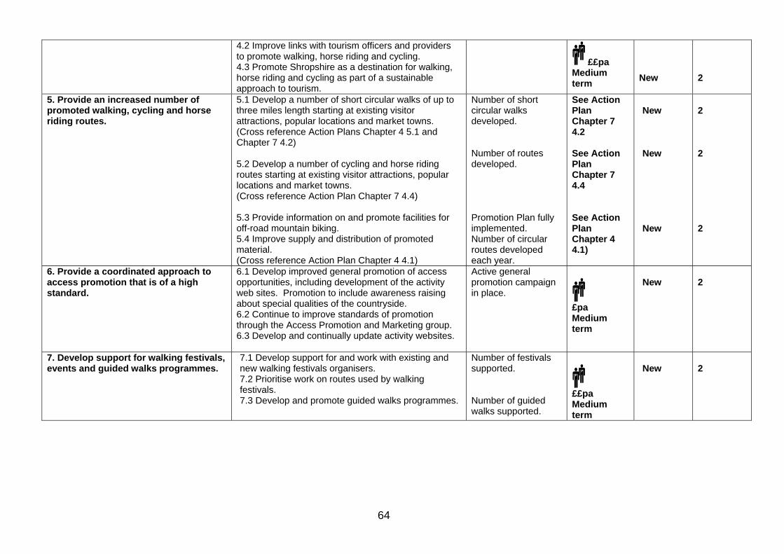
64
4.2 Improve links with tourism officers and providers to promote walking, horse riding and cycling. 4.3 Promote Shropshire as a destination for walking, horse riding and cycling as part of a sustainable approach to tourism.
££pa Medium term
New
2
5. Provide an increased number of promoted walking, cycling and horse riding routes.
5.1 Develop a number of short circular walks of up to three miles length starting at existing visitor attractions, popular locations and market towns. (Cross reference Action Plans Chapter 4 5.1 and Chapter 7 4.2) 5.2 Develop a number of cycling and horse riding routes starting at existing visitor attractions, popular locations and market towns. (Cross reference Action Plan Chapter 7 4.4) 5.3 Provide information on and promote facilities for off-road mountain biking. 5.4 Improve supply and distribution of promoted material. (Cross reference Action Plan Chapter 4 4.1)
Number of short circular walks developed. Number of routes developed. Promotion Plan fully implemented. Number of circular routes developed each year.
See Action Plan Chapter 7 4.2 See Action Plan Chapter 7 4.4 See Action Plan Chapter 4 4.1)
New New New
2 2 2
6. Provide a coordinated approach to access promotion that is of a high standard.
6.1 Develop improved general promotion of access opportunities, including development of the activity web sites. Promotion to include awareness raising about special qualities of the countryside. 6.2 Continue to improve standards of promotion through the Access Promotion and Marketing group. 6.3 Develop and continually update activity websites.
Active general promotion campaign in place.
£pa Medium term
New
2
7. Develop support for walking festivals, events and guided walks programmes.
7.1 Develop support for and work with existing and new walking festivals organisers. 7.2 Prioritise work on routes used by walking festivals. 7.3 Develop and promote guided walks programmes.
Number of festivals supported. Number of guided walks supported.
££pa Medium term
New
2
65
10 Implementing, monitoring and reviewing the Countryside Access Strategy
The Statutory Guidance for the Countryside Access Strategy indicates that it should be fully reviewed every ten years. It is the County Council’s intention to formally consult on and review this strategy every five years. The first review will be undertaken alongside the preparation for the next Local Transport Plan (LTP) for Shropshire to cover the period from 2011. It is anticipated that at this point the access strategy will become an integral part of the LTP. Reviews will then be aligned with Local Transport Plan reviews. Such reviews are currently every five years. This strategy is a shared document and its successful delivery will depend on the contribution of a range of partners in addition to the County Council. It is also intended to be a working document. We will always be looking at ways that we can improve performance. The Access Strategy builds upon the County Council’s existing statutory duties and should not conflict with these or reduce the effectiveness with which they are carried out. The Countryside Access Strategy will inform the completion of detailed annual work plans and will act as a reference point for all future development planning and reporting, and associated project development. The County Council will make the best use of internal and external funding to implement this strategy. It will not be immediately possible to achieve everything outlined within this strategy. Whilst its completion is a statutory requirement, no additional funding has been provided by Government to assist with its delivery. Much of what is described within this strategy is additional to the day to day work of maintaining an accessible access network for Shropshire. Therefore, a large number of actions will be dependant on sourcing new external funding as well as partnership working. Funding sources could include Sport and Heritage lottery and Natural England. Actions will continue to be prioritised in line with available resources and this will require a flexible approach to the development and delivery of detailed and realistic work plans. In order to be successful in attracting new funding and developing new partnerships, links will be made between the provision of an accessible access network within the County and broader community benefits including health, tourism, reducing car dependence, safe routes to school and work and leisure. An immediate short term aim will be to secure LTP funding for actions that can deliver LTP priorities. A medium term aim will be to include some Access Strategy actions within the next Local Area Agreement to be agreed in 2009/10. Sourcing funding and developing partnerships are not the only factors that may limit delivery of this strategy. Some actions may require legal procedures or agreements with third parties that can not be easily achieved. Delivery of

66
many projects will rely on the goodwill of landowners and land managers to create new access either by dedication or by permissive agreement. Performance indicators will be developed linked to actions and related outputs included within the Access Strategy. As far as possible and practical these will be included within key County strategic documents including the Community Strategy and the County Council Corporate Plan. Systems will be designed to collect information from partners on their contribution to the achievement of the strategy. An annual report will summarise progress made against the annual action plan and the strategy. This will be published on the County Council’s web site and will be widely publicised. The Local Access Forum will have a key role in both scrutinising and agreeing annual work plans and in receiving regular progress reports. The Countryside Access Strategy will be included as a standing item on all Local Access Forum agendas. Annual reports will also be provided to the County Council Cabinet and Scrutiny committees.

67
11 Policy Statements A number of existing or new Policy Statements have been revised or developed to support the delivery of the Countryside Access Strategy aims and objectives. The statements will assist the County Council in carrying out its statutory duties in relation to the rights of way network and prioritising improvements to countryside access in Shropshire. There are policy statements on: 1. Prioritisation of enforcement and maintenance as a result of
problems reported on the rights of way network. 2. Providing easier access to the rights of way network. 3. Countryside access enforcement. 4. Ploughing and cropping of rights of way. 5. Surfacing of rights of way. 6. Motorised vehicles, byways and unsurfaced, unclassified county
roads. 7. Statutory provision for gates and stiles. 8. Definitive Map Modification Orders. 9. Public Path Orders.
68
POLICY STATEMENT 1 Prioritisation of enforcement and maintenance as a result of problems
reported on the countryside access network The Council receives approximately 1,500 to 2,000 reports each year from members of the public of problems on the countryside access network. Currently 51% (2006) of reported problems are resolved. The purpose of this policy statement is to set out how the Council prioritises problem reports for subsequent action and resolution.
Policy Statement
The Council:
• Recognises the legitimate right of the public to use and enjoy the public countryside access network.
• Recognises that problems with the network can have a significant impact on people’s enjoyment of the countryside.
• Will manage individual routes on a systematic prioritised basis with action taken according to risk to the public, need, impact and access priorities as outlined in the Countryside Access Strategy.
• Will report regularly to users and others on progress in resolving problems.
The Council’s detailed approach to prioritising problems for action and resolution is based on the following circumstances:
1. The seriousness of the obstruction - Is there a health and safety risk to members of the public using the route?
2. The likely frequency of use and location of route – Is the route already promoted, clearly well used or alternatively remote or rarely used? Is the route in an urban or urban fringe location or a countryside site?
3. The identity of the complainant – the Parish Council (having a particular status by virtue of s 130(6) of the Highways Act) or Parish Paths Partnership Group.
4. Outstanding legal issues - Are there legal issues such as landholders disputing the definitive line or applying for a diversion? Is the landholder committing a repeat offence where legal proceedings have been instigated?
5. Is there an alternative route available to allow the walk/ride etc to continue?
6. Is the route capable of being used by different users or is it an easy access route?
7. If agreement is gained to provide easier access furniture under the ‘least restrictive’ principle on a specific route, this work will also be prioritised as the Council are keen to see improvements in this area generally.
A scoring matrix has been devised to take into account all of the above issues – this will be kept under review and updated as and when required.

69
In addition to the above the service, when prioritising reported problems, will take into account and seek to maximize resources, both financial and staffing, to ensure best value and service efficiency. The service will concentrate on attempting to resolve all high and medium status problems. In addition, if low category issues exist in an area where work is already programmed, some of these will be dealt with at that time for reasons of efficiency and expediency. The proactive ‘action area’ approach is currently being delivered through the Parish Access Project. This proactive approach will continue alongside the resolution of reported problems, with an increased emphasis on providing easier access, which will be a priority in deciding whether or not the Council undertakes improvement works in parish areas.
References: Countryside Sub Committee 13th February and 11th September 1997 – Priority matrix and action area approach. Countryside Access Strategy for Shropshire 2008-2018 Approval and Review This Policy Statement was approved by Council on 14th December 2007. This Policy Statement will be reviewed a minimum of every five years, the next review occurring in 2013.
70
POLICY STATEMENT 2 Providing easier access to the countryside access network
The Disability Discrimination Act 2005 makes it unlawful for public authorities when carrying out their duties to discriminate against people with disabilities. This, alongside an ageing population and the aim to encourage more active lifestyles, makes it more important than ever that everything possible is done to make the countryside access network accessible. The British Standard, BS 5709:2006, enshrines the principle of providing access to the countryside for everyone. However due to the nature of the landscape and how it is used, this will not always be possible. The purpose of this policy statement is to outline the Council’s stance in providing easier access to the countryside.
Policy Statement The Council will:-
• Work to ensure that everyone has an equal opportunity to access public rights of way, the wider access network and Countryside Heritage Sites wherever possible following the ‘least restrictive’ principle and British Standard 5709:2006.
• Significantly reduce the number of physical barriers to access by adopting the ‘least restrictive’ principle.
• Only authorise the ‘least restrictive’ option for new fence lines and other boundaries where ever possible.
• Ensure that its work reflects the strategic direction and policies of the authority in meeting the needs of disabled people.
• Adopt wherever possible and reasonable, recognised standards and current best practice of provision for disabled people, where they exist.
• Follow and take due account of relevant legislation relating to disability. • Work with other sections of the Council, landowners, user groups and
partner organisations to deliver this policy and to influence the work of others.
• Consult and involve disabled people about the implementation of this policy, and their needs and aspirations for access to the countryside.
• Ensure that disabled people have clear, accessible and understandable information about what access is available and its accessibility.
• Review staff and volunteer training needs and provide training in equal opportunities, disability awareness and specific issues around planning and delivering accessibility improvements to the countryside.
• Monitor and evaluate progress in implementing this policy and provide feedback to key stakeholders.
“Least restrictive” means:-
• A gap is the preferred option. • If a gap is not practicable due to stock control, then a stock-proof gate
should be used. • If a gate is not practicable and the route is a footpath then a kissing

71
gate may be used. • Where stiles already exist but are no longer required, the Council will
consider its removal. • In all instances the Council will seek to replace existing stiles with
gates through negotiation. • Where safety is at risk or to prevent unlawful use of the access
network, the Council will consider using its powers to erect suitable barriers.
References Disability Discrimination Act 2005 Countryside and Rights of Way Act 2000 By all reasonable means Countryside Agency 2005 Shropshire County Council Equality & Diversity Policy 2004-2007 (under review) British Standard BS 5709:2006 Countryside Access Strategy for Shropshire 2008-2018 Approval and Review This Policy Statement was approved by Council on 14th December 2007. This Policy Statement will be reviewed a minimum of every five years, the next review occurring in 2013.
72
POLICY STATEMENT 3 Countryside access enforcement
It is a duty of the Council to safeguard the right of the public to use and enjoy the countryside access network. This policy statement sets out how the Council will undertake this duty. Enforcement is carried out in a number of ways:
• Provision of advice for landholders and occupiers. • Investigation of reports of obstruction to the network. • Working with partners in the provision of information and evidence. • Targeted enforcement campaigns, such as the annual Ploughing and
Cropping campaign. In order to achieve the above it will be necessary after initial investigation to determine how best to resolve the matter and to prioritise cases accordingly taking into account the priority criteria (See policy statement on ’Prioritisation of enforcement and maintenance as a result of problems reported on the countryside access network’)
Policy Statement The Council recognises the need for:
• Courtesy towards all those we deal with. • Consistency in investigating and interpreting the law. • Confidentiality of people who report alleged offences and to the alleged
offender in line with the Data Protection Act 1998. • Impartiality in dealing with all people. • Balance between the alleged offence and the course of enforcement
action taken. • Landowners and users to fulfil their legal obligations and to recognise
the rights and responsibilities of others. The Council will:
• Work within the guidelines accompanying this policy statement regarding prevention, negotiation and enforcement.
• Recognise the legitimate right of the public to use and enjoy the public countryside access network.
• Always attempt to negotiate with landholders to resolve reported problems amicably before any formal enforcement action is taken. If this approach fails, formal enforcement action will be considered as per this guidance.
• Work with local and farming communities, including Defra to enhance and promote the enjoyment of the rights of way network.
73
Detailed guidelines for taking enforcement action Protection of the rights of way network and the resolution of infringements require a three pronged approach: 1. Prevention By far the most effective means of protecting the rights of way network for the public is to prevent offences taking place. This can be achieved by providing a free access advice service to farmers and landholders. The Council will actively seek ways to raise the profile of rights of way with the farming community, working together to keep the network open and available for the use and enjoyment of the public.
2. Negotiation Land ownership and use of the land can change rapidly. It is recognised that many alleged offences occur as a result of ignorance of legal requirements to maintain rights of way, or even knowledge of the existence of rights of way on land. Officers will initially seek to resolve the majority of cases through negotiation with landholders prior to formal enforcement action being pursued. 3. Formal Enforcement Enforcement matters may be concluded in a number of ways. The decision to pursue enforcement action and the nature of the action required should be made after two key elements have been considered.
• Can the evidential requirements of the legislation covering the alleged offence be met in full?
• Is enforcement action in the public interest? The primary aim of enforcement action is to restore access. The proportionality principle set out within the Government’s Enforcement Concordat will be taken into account when deciding which course of action to pursue. The action pursued should be balanced and reasonable, and commensurate to the scale of the offence. Consideration will be taken of the following factors when determining the appropriate course of action:
• Whether the person committing the offence had any previous warnings, cautions or criminal record.
• Whether the evidential requirements of the legislation breached can be met in full.
• The likelihood of the Courts to fine on conviction at the upper end of the scale for the offence.
Decisions taken in enforcement cases should be balanced, rational and robust in the face of scrutiny. The following avenues are available when pursuing formal enforcement. Formal notice: This should be served as a prerequisite of enforcement action in all cases where conciliation has failed to resolve any infringement of rights of way legislation.
74
Warning: Where a matter is resolved on receipt of a notice the landholder or person responsible may be warned as to their future conduct and legal responsibilities in respect of rights of way. Caution: Where the evidential requirements can be met for a particular piece of legislation but it is not considered that it is appropriate to bring a prosecution, the offender may be offered the option of a caution. Non-acceptance of the offer of a caution will lead to the matter being placed before the courts. Prosecution: Where an infringement is serious in nature, the offender has previously been prosecuted or cautioned or the offence is commonplace and the focus of enforcement action, prosecution will be pursued. As a prosecuting authority the investigation of rights of way offences will be conducted within the spirit of the Police and Criminal Evidence Act 1984, and with due regard to the Human Rights Act 1998. Practical Action: In many cases of rights of way infringement, practical action should be considered along with other forms of enforcement action. The Council may use its powers with appropriate notice to resolve problems e.g. remove an obstruction on a path. The use of practical action makes the path available to the public without the inevitable delays associated with court action. In all cases where practical action is pursued the full costs of that action should be reclaimed. References Central and Local Government Concordat on Good Enforcement 1998. Countryside Access Strategy for Shropshire 2008-2018. Approval and review This Policy Statement was approved by Council on 14th December 2007. This Policy Statement will be reviewed a minimum of every five years, the next review occurring in 2013.

75
The Highways Act 1980 requires that all rights of way should be open and freely available at all times and as Highway Authority, the Council has a duty to assert the public’s right to use and enjoy rights of way. With the introduction of the Rights of Way Act 1990 (now consolidated into The Highways Act 1980), the Council also has a duty to ensure that all rights of way are clear of crops. This policy statement sets out the Council’s approach to tackling ploughing and cropping issues. The Council has no discretionary powers on this issue, so the policy statement has been adopted to ensure even treatment and a consistent approach for all. The Council seeks to work with landholders to ensure that the requirements set out in the legislation are met. Each year, an increasing number of land occupiers are complying in carrying out their duties. In addition progress has recently been made in reducing the number of routes obstructed because of ploughing and cropping incidents. This improvement is in part due to working with volunteer groups on an annual targeted ploughing and cropping campaign and landowners increased compliance with their legal responsibilities. However many complaints regarding ploughing and cropping are still received.
Policy Statement In November 1998 the Council approved a policy of progressively firmer action in the event of persistent non compliance of ploughing and cropping procedures and reinstatement. Council Officers will always attempt to make a conciliatory approach in the case of first offences. However, the Council has limited resources and protracted negotiation cannot be undertaken in cases of non-reinstatement after ploughing or obstruction by crops. In such cases, the Council will take firm action, which could result in prosecution through the Courts where land occupiers fail in their duties. The aim of prosecution would be to deter any further offence. In addition, the Council has the power to take direct default action where requests to comply with the legislation fail. In all cases, the Council will endeavour to recover its costs.
References Countryside Sub-Committee 10th November 1998 Approval and Review This Policy Statement was approved by Council on 14th December 2007. This Policy Statement will be reviewed a minimum of every five years, the next review occurring in 2013.
POLICY STATEMENT 4 Ploughing and cropping on rights of way
76
POLICY STATEMENT 5
Surfacing of rights of way The Council is responsible for and has an obligation to maintain the surface of rights of way; this is contained within the Highways Act 1980. The extent of the duty to maintain requires that rights of way should be kept in such a state as to be safe and fit for ordinary traffic which could reasonably be expected to use it. In practice, the decision as to what surface to provide, if any, depends on the level of use and its legal status. The purpose of this policy statement is to set out the Council’s stance on surfacing rights of way.
Policy Statement
The Council will: • Ensure that the choice of surfacing material will be chosen to balance
the needs of all path users, cost, sustainability, local distinctiveness and the local environment. This will equally apply where the Council is carrying out the surfacing or consenting to third parties carrying out the works.
• Normally maintain a surface only to the standard needed for designated public use. Where a footpath, bridleway or restricted byway co-exists with a private vehicular route, and the damage is caused by this private vehicular use, it will be the responsibility of those with private vehicular rights to repair the damage to an agreed standard.
• Determine the level of public versus private use causing damage to byways open to all traffic. The level of responsibility will often be split between holders of private rights and the Council.
• Provide materials, where possible, as its contribution towards repair where public use is determined to be partially responsible for damage.
• Only consent to third parties changing the surface type of a route (or part of a route) where the proposed surface type will be compatible with its public uses and where there is a legal agreement for its future maintenance.
Further detailed considerations There is no obligation to provide a metalled surface or similar on a byway open to all traffic in order to enable the public to use the route with vehicles. When considering surfaces on higher status routes which carry horse traffic, there are specific considerations which need to be taken. The network of rights of way is a resource that enables people to access the countryside off the metalled highway network. The Council is committed to retaining the rural feel of the network wherever possible. It is accepted that there are instances where hard surfaces are required for example where private vehicular access is required. Tarmac can be hazardous as it can be slippery and nationally there have been a number of accidents with horses. For this reason the
77
Council will very carefully consider any application for tarmac or other sealed surfaces on a route on a case by case basis. Public rights of way in urban areas present a different set of management challenges to those in rural areas. The public may not be aware which routes are rights of way, and which are pavements or are on the List of Streets. In reality the difference is of no interest to the walking public, except in who to complain to if there is a problem. Generally paths in urban areas need to have a better surface than rural paths. They are often sealed with asphalt, or have a stone or concrete surface. In these situations the routes are maintained by the divisional surveyors as part of the surfaced highway network. Many rights of way are privately maintainable to a higher status than that for public use. Where dual liability exists the Council is only responsible for maintenance to the public status. If, for example, a landowner has provided a sealed surface for vehicular use on a farm track that has public bridleway rights, the Council cannot be held responsible for maintenance beyond that required for reasonable bridleway use. The Council is also only responsible for the repair of damage caused by public use of a route. There can frequently be dual responsibility for repair with both the Council and landholders of private rights responsible. The level of responsibility must be determined on a case by case basis prior to works being agreed. References Highways Act 1980 Making the Best of Byways – DEFRA, December 2005 Countryside Access Strategy for Shropshire 2008-2018 Approval and Review This Policy Statement was approved by Council on 14th December 2007 This Policy Statement will be reviewed a minimum of every five years, the next review occurring in 2013
78
POLICY STATEMENT 6 Motorised vehicles, byways and unsurfaced unclassified county roads
Nationally and within Shropshire there are tensions and sensitivities concerning the usage of byways and unclassified county roads over which motorised vehicles have a right of passage. These are generally centred on the inappropriate usage of unsurfaced routes, where the physical characteristics are such that motorised usage can cause damage. In addition, concerns are also expressed at the obtrusive noise of vehicles in the countryside. This policy statement provides guidance on the approach to be adopted by the Council in the management of byways and unsurfaced, unclassified county roads.
Policy Statement
The Council:
• Recognises the legitimate right of motorised vehicle owners to use legally designated byways and unclassified county roads.
• Recognises that the motorised use of this network can have an impact on other people’s enjoyment of the countryside, and can damage wildlife, heritage and tranquillity.
• Will manage individual routes on a systematic proactive prioritised basis with action taken according to need, impact, sustainability and best practice, taking into account the guidance issued by Defra in 2005 – ‘Making the Best of Byways’.
• Will not actively promote the use of this network for motorised vehicle use.
• Will promote codes of conduct and information which encourages considerate and responsible use of the network by vehicle users.
• Will work with user groups including the Vehicle User Liaison Forum to develop and implement a sensitive consensus based approach to the management of routes.
References Making the Best of Byways, DEFRA, December 2005 Report to Shropshire County Council Scrutiny Panel, 7 March 2006 Report to Shropshire Local Access Forum, 13 July 2006 Report to the Shropshire Hills Area of Outstanding Natural Beauty Partnership, 19 October 2006 AONB Position Statement on off-road vehicles June 2006 Approval and Review This Policy Statement was approved by Council on 14th December 2007. This Policy Statement will be reviewed a minimum of every five years, the next review occurring in 2013.
79
POLICY STATEMENT 7 Statutory provision for stiles and gates
The statutory provisions for gates and stiles are contained in s.145, 146 and 147 of the Highways Act 1980. The landowner must maintain stiles and gates on footpaths and bridleways in a safe condition for use by the public. If the landowner incurs expense in complying then they are entitled to recover at least 25% of the cost from the Council. In line with accepted practice elsewhere in the country, the Council have adopted the practice of supplying gate and stile kits to landowners instead of making a monetary payment. All standard furniture supplied by the Council conforms to British Standard 5709:2006 which enshrines the ‘least restrictive’ principle into all access provision. The purpose of this policy statement is to set out the Council’s stance in the statutory provision of stiles and gates.
Policy Statement The Council will:
• Provide stile and gate kits to landowners, in lieu of meeting 25% of reasonable costs. The supply of the kit is discretionary and does not imply that the Council takes responsibility for the repair of the structure.
• Require any new stiles and gates to be authorised as per legislative guidance and apply any conditions necessary for local situations.
• Ensure that any authorisations for stiles and gates take into account the ‘least restrictive’ principle to ensure that there are as few as possible barriers on the network.
• Ensure in carrying out proactive maintenance provision, that the ‘least restrictive’ principle is applied wherever possible. In addition there will be an emphasis on supplying and installing gates, but only supplying stile kits.
References Highways Act 1980 British Standard 5709:2006 Approval and Review This Policy Statement was approved by Council on 14th December 2007. This Policy Statement will be reviewed a minimum of every five years, the next review occurring in 2013.

80
POLICY STATEMENT 8 Definitive Map and Statement Modification Orders
The Definitive Map and Statement is a legal document which provides conclusive evidence that the rights of way shown on it exist. The Map and Statement is not a complete record of all rights of way and many more unrecorded public rights may exist. Under the Wildlife and Countryside Act 1981 anyone may apply to have routes added to the Definitive Map or to have it altered in some way. Due to the volume of claims and evidence which is discovered to amend the Definitive Map, it is common practice for all Highway Authorities to have a policy which details the order in which applications will be processed as resources do not allow for all claims to be dealt with at once. The policy is also necessary to defend any appeals which are made to the Secretary of State by applicants. For Further Information
Policy Statement The Council recognises:
• The legal requirement for provision of a Definitive Map and Statement that correctly records the alignment and legal status of all public rights of way.
• The need and value to the network of recording all ‘Lost Ways’ where historical documentation supports their existence.
The Council will prioritise applications to amend the Definitive Map as follows:-
1. Applications received based solely on user evidence will be a first priority. Those that fall within an area which has not undergone the district review process to date will be dealt with first; the remainder will be dealt with in order of receipt.
2. If the application is for a route that is being threatened by potential development works.
3. If the application is for a route which is very contentious locally. 4. If the application is for a route of ‘strategic importance’ or forms part
of a promoted route supported by the Council. 5. Where an amendment to a route would significantly improve public
safety. 6. Where the application would resolve a significant gap in the
network. 7. Where the application is for a route of a higher status than that of a
footpath. 8. Where an application assists in meeting other objectives within the
Countryside Access Strategy. 9. Where an application resolves an error on the current Definitive
Map.
81
Further Considerations Following the Countryside and Rights of Way (CROW) Act 2000 Natural England was tasked by the government to find the best way to record all lost rights of way in England. It has been estimated that nearly 10% of England’s rights of way do not appear on Definitive Maps. These could be lost forever if the Definitive Maps are not brought up to date by 2026. References Council meeting 24th February 2006 Cabinet 7th February 2006 Rights of Way Committee 5th April 2006 Countryside Access Strategy for Shropshire 2008-2018 Approval and Review This Policy Statement was approved by Council on 14th December 2007. This Policy Statement will be reviewed a minimum of every five years, the next review occurring in 2013.

82
POLICY STATEMENT 9 Public Path Orders for footpaths, bridleways and restricted byways
The Highways Act 1980 gives the Council the power to make a public path diversion order if it can be shown that it is in the interests of the landowner or in the interests of the public. A right of way may be extinguished if it can be shown that it is no longer needed for public use or is unnecessary. Public rights of way can also be created either by agreement or by order. Public path orders are usually based on preference and do not rely on the discovery of evidence. The Council can also process public path orders that meet new criteria relating to school security and the protection of Sites of Special Scientific Interest. Public path diversion or extinguishment orders to enable built development to take place are usually dealt with under the Town and Country Planning Act 1990 by the local planning authority. Due to the volume of applications made to amend the Definitive Map under the provisions of the Highways Act 1980, it is common practice for all Highway Authorities to have a policy statement which details the priority against which applications will be processed and assessed.
Policy Statement The Council will prioritise applications for Public Path Orders where they meet one or more of the following criteria:
1. All fee paying applications will be dealt with in order of receipt, unless they also fulfil one of the following priorities.
2. Applications where there is a clear benefit to public safety. 3. Applications where the Council is the planning authority. 4. Applications that help to achieve priorities identified within the
Countryside Access Strategy. 5. Orders where applicants have the right of appeal. 6. Orders to correct anomalies or long standing built development
obstructions. 7. Orders which would benefit a route running through an SSSI. 8. Orders in the interest of school security. 9. Orders to benefit crime prevention.
The following conditions will apply to new Public Path Orders. The status of the route must not be in dispute at the time of the application, unless the Public Path Order is being implemented concurrently with an application under sec.53 of the Wildlife and Countryside Act 1981. Prior to any order being made the Definitive route should be open, clear and safe to use. Only in exceptional circumstances will an order proceed where the Definitive line is not open. The applicant must agree to meet the Council’s costs of promoting the order and bringing the new path into a fit condition for public use.
83
If a route is to be diverted onto land in different ownership then the applicant must obtain written consent from the landowner affected and must also agree to pay compensation as a result of the proposal. Orders will not be confirmed until all necessary works are undertaken to Council standards. If increased maintenance responsibilities result from the order then maintenance agreements will be entered into with the landowner. All applications received will adhere to the ‘least restrictive’ principle, unless natural, historical, legal or physical circumstances prevent this and overall there is a clear public gain. The width normally acceptable for routes subject to orders will be 1.8 metres for unenclosed footpaths, 2.0 metres for enclosed footpaths, 3.0 metres for unenclosed bridleways, 4.0 metres for enclosed bridleways and 5.0 metres for restricted byways if not defined historically. If the route to be created is unenclosed then this will become a condition of the order itself. Nothing in this policy is intended to prevent the Council promoting a Public Path Order where it considers it appropriate to do so in the public interest. The Council will make a full charge for the recovery of its costs from the applicant unless :-
• The order resolves a Definitive Map issue. • The application results in significant additional rights for the public and
for priorities identified within the Countryside Access Strategy. • The order will resolve a Health and Safety issue on the network. • The route is affected by longstanding development, undertaken when
the County Council was the planning authority. In these instances costs will be proportioned according to the individual circumstances. References Countryside Access Strategy for Shropshire 2008-2018 Countryside Sub-Committee February and November 1997 Approval and Review This Policy Statement was approved by Council on 14th December 2007 This Policy Statement will be reviewed a minimum of every five years, the next review occurring in 2013.
84
Glossary of access related terms This short glossary briefly explains the main access related terms in the order they appear in the strategy. Right of way – routes that are legally defined and shown on the Definitive Map. Definitive Map – legal document that records the different categories of rights of way. Footpath (FP) – access for people on foot only (but can be used by wheelchairs). Bridleway (BW) – access for people on foot, horseback and cycle. Restricted byway (RB) – access for people on foot, horseback, cycle and non-motorised vehicle e.g. horse and cart. Byway open to all traffic (BOAT) – access for people on foot, horseback, cycle and wheeled vehicles of any kind. Open access land – land identified through the CROW Act 2000 where people have the right to walk, run, climb, picnic and bird-watch. Countryside Heritage Sites – countryside sites owned and managed by Shropshire County Council. Public Path Orders – legal orders that alter rights of way usually made at a landowners request. Modification Orders – legal orders which can add, change the particulars, or delete rights of way. Changes made on the discovery of evidence. Lost Ways – routes that historically existed but are not presently shown on the Definitive Map. Signposts – finger posts used to show where a right of way leaves a public road. Waymarks – circular discs attached to signposts, stiles or gates which show the category of the right of way. Dog stiles – small gate, built into stile or fence, to allow dogs to get through. Cycletrack – can have various meanings, in this instance access for people on cycles and usually foot. Permissive access – routes where the landowner has provided access for the public that is on a permissive basis. These routes are not shown on the Definitive Map. CAM’s database – Countryside Access Management system for recording and managing rights of way data. Urban routes and footways – routes within centres of population that can be pavements or surfaced footways, can also include rights of way. Used by people to go about their daily lives e.g. to get to shops, school, work etc. Unclassified county road (UCR) – these roads form part of the minor highway network. Some are surfaced and well used by vehicles others are unsurfaced and mainly used for recreational journeys. Jack Mytton Way – long distance bridleway in Shropshire Shropshire Way – long distance footpath in Shropshire Severn Way - long distance footpath following the River Severn Offa’s Dyke Path – long distance National Trail along the Welsh border.
85
Acknowledgments Many people have freely given their time and expertise to help produce the Countryside Access Strategy. In particular the contribution by the general public and user groups has been invaluable in enabling us to fully assess the needs of people when accessing the countryside. The involvement of members of The Local Access Forum has enabled their diverse knowledge to improve many aspect of the strategy. There are other people and organisations too numerous to mention but to all we give our grateful thanks. References The main documents referred to in the Countryside Access Strategy have been referenced at the end of the relevant chapters. The other documents and sources that were used in preparation of the background papers have also been referenced in those reports. The maps and photographs used in this document are produced by Shropshire County Council and cannot be reproduced without permission.

86
Appendix A
Shropshire Countryside Access Strategy 2007 -2017 A shared vision for access to the Shropshire Countryside ‘Shropshire County Council takes the lead in providing the best countryside access for everyone. This is achieved through promotion, positive action and partnership with local communities, access organisations and providers. The Shropshire Local Access Forum and Shropshire County Council recognise…
• That a well maintained, legally protected access network significantly benefits the County’s health and economy
• That working in partnership with Shropshire’s communities and landowners is the best way to maximise these benefits
• That there should be more opportunities for everyone to enjoy the countryside ‘
Aims Ensure that the access network meets the needs of Shropshire residents and visitors whilst recognising the special qualities of the landscape. Encourage and support local communities wishing to make use of and develop access to Shropshire’s countryside. Increase people’s use of the rights of way network for local journeys to support a sustainable transport network. Improve people’s health by encouraging more people to be active in the countryside. Increase the opportunities for hard to reach groups to access the Shropshire countryside. Provide a high quality access network that supports a sustainable approach to tourism. Main Actions Increase and improve opportunities for everyone to access Shropshire’s countryside in balance with conserving what makes them special. Reduce the number of physical barriers on the rights of way network and improve maintenance standards. Provide improved education and information on the access network for users. Improve and increase number of walking, horse riding and cycling opportunities in the County and improve the accessibility of the byway and restricted byway network. Provide advice and support to local communities in improving access to the countryside through active volunteering and P3 groups. Integrate the Countryside Access Strategy within the Local Transport Plan and secure LTP funding for access improvements. Improve the access network within and around centres of population for local journeys. Increase peoples physical activity levels by promoting the benefits that access to the countryside brings to both mental and physical health. Work with partners to provide more outdoor recreational activities. Increase the number of Walking for Health (WFH) schemes. Increase number of people undertaking ‘active’ volunteering in the County. Make it easier for people with learning difficulties, mental health problems and sensory impairment to participate in countryside activities. Improve access to the countryside for under represented groups. Ensure promoted walking and riding routes, supported by the County Council, are of the highest standard and increase number of routes. Promote Shropshire as a walking, horse riding and cycling destination. Develop support for walking festivals and guided walks programmes.
Vision ‘To establish Shropshire as a high quality rural tourism destination that uses the area’s distinctive landscape, environment and heritage assets to provide unique opportunities for relaxing, short leisure breaks for couples and activity focused family holidays. At the same time Shropshire will continue to take full advantage of its proximity to key markets for the continued expansion of business tourism as well as day visitor facilities’. The aims of the Tourism Action Plan currently being delivered are to: attract more visitors to Shropshire who will stay longer and spend more; enhance the capacity of Shropshire’s tourism industry to contribute to economic regeneration encourage prosperity and growth in Shropshire’s tourism industry.
3 Strands for intervention A healthy eating strategy A physical activity strategy A management of obesity strategy
Vision “That the natural beauty of the Shropshire Hills is conserved and enhanced through partnership working. That this approach guides sustainable environmental, social and economic change. That such change takes place in ways which are sensitive to the area’s unique geological, ecological, historic, cultural and economic assets. That these assets are supported and reinforced in ways which promote greater public appreciation and enjoyment of this special and nationally important landscape.
Vision “In Shropshire, all children and young people matter. We will work together and in partnership with families and carers to give every child and young person the best opportunities today and for the future.” 5 Outcomes for Children Be healthy Enjoy and Achieve Stay Safe Make a positive contribution Achieve economic well being
Vision "To improve significantly the quality of life for Shropshire people”. Aims Work with others to deliver joined up, affordable, accessible and quality services. Create and protect a healthy, independant and safe way of life for all. Work with all our communities and keep them connected. Safeguard and strengthen Shropshire’s unique environment. Always carry out our core duties – to educate, to care, to keep Shropshire moving.
Vision “To improve significantly the quality of life for Shropshire people by working together Priorities Children and Young People Healthier Communities and Older People Safer and Stronger Communities Sustainable Communities (Economy, Environment, Transport, Housing)
Vision “An economically vibrant, healthy, inclusive and sustainable society where people meet many of their needs locally, served by an integrated transport system which allows people to have good and reliable access to jobs, services, learning and leisure opportunities, and which protects and enhances environmental quality and human health.” Aims Accessibility. To improve access to jobs and facilities in ways which are sustainable, particularly for people from disadvantaged groups or areas; Environment. To protect and improve the built and natural environment and reduce the impact of traffic on local communities; Economy. To support sustainable economic activity and rural regeneration; Safety and health. To create safer roads and healthier, more secure communities.
SHROPSHIRE’S LOCAL TRANSPORT PLAN
2006-2011
SHROPSHIRE PARTNERSHIP COMMUNITY STRATEGY 2006-2010
CHILDREN & YOUNG PEOPLE’S PLAN
2006-2009
SHROPSHIRE HILLS AONB MANAGEMENT
PLAN 2004-2009
HEALTHY EATING AND ACTIVE FOR LIFE!
2004
SHROPSHIRE TOURISMSTRATEGY
2004
CORPORATE PLAN 2006–2011
CO
UN
TRYS
IDE
AC
CES
S ST
RA
TEG
Y –
2007
-201
7

87
Notes

88

89

90
Photograph supplied by Virtual Shropshire
If you or someone you know would like this publication in large print, Braille or on audio tape please contact us and this will be arranged. If you would like this publication in another language, we can translate it for you. Please contact: Countryside Access Team Shropshire County Council Shirehall Abbey Foregate Shrewsbury Shropshire SY2 6ND Email: [email protected] For further information visit our website www.shropshire.gov.uk