countryside stewardship - assets.publishing.service.gov.uk · capital grant application form...
TRANSCRIPT

Countryside Stewardship How to complete the Countryside Stewardship Capital Grant Application Form
Revised 20th March 2018
www.gov.uk/countrysidestewardship
The European Agricultural Fundfor Rural Development:
Europe investing in rural areas
Countryside Stewardship Capital Grant Application Form Notes1
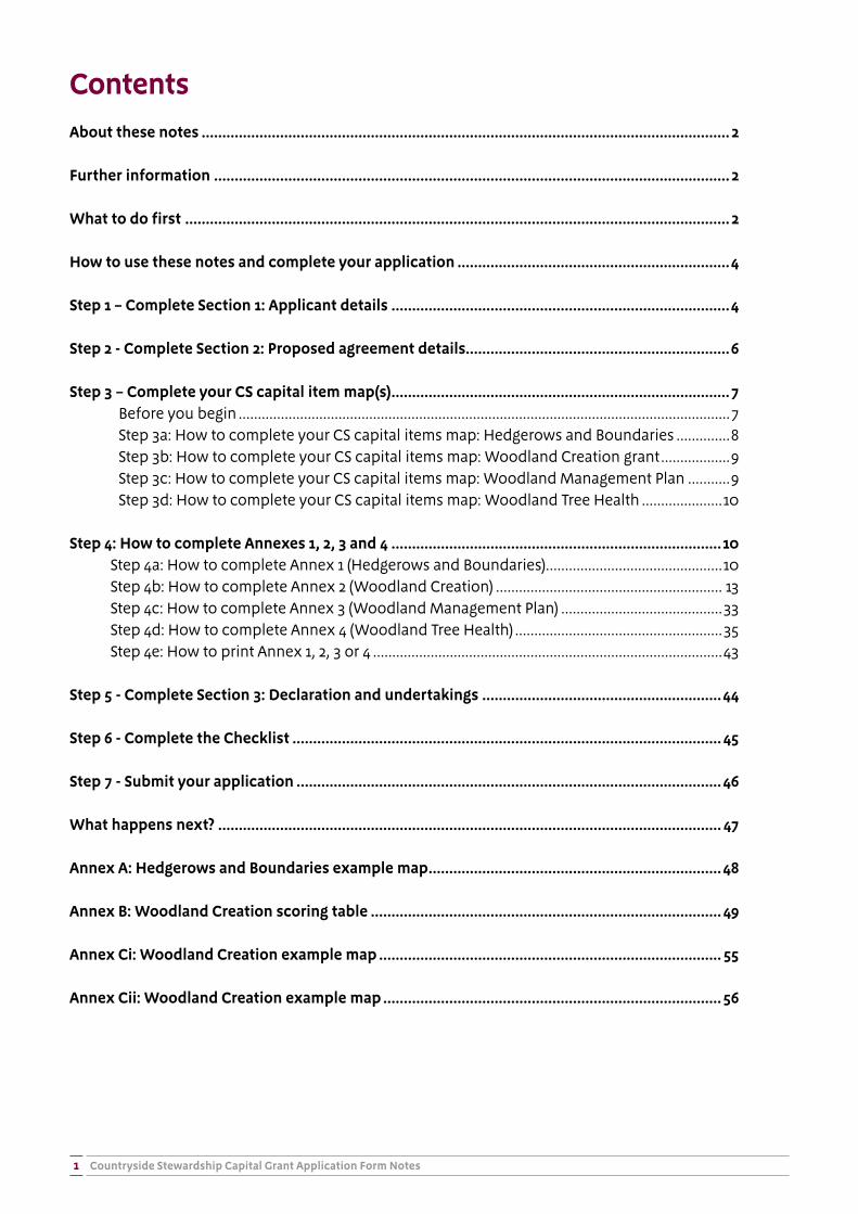
ContentsAbout these notes ................................................................................................................................ 2
Further information ............................................................................................................................. 2
What to do first .................................................................................................................................... 2
How to use these notes and complete your application ..................................................................4
Step 1 – Complete Section 1: Applicant details ..................................................................................4
Step 2 - Complete Section 2: Proposed agreement details ................................................................6
Step 3 – Complete your CS capital item map(s) ..................................................................................7Before you begin ................................................................................................................................7Step 3a: How to complete your CS capital items map: Hedgerows and Boundaries ..............8Step 3b: How to complete your CS capital items map: Woodland Creation grant ..................9Step 3c: How to complete your CS capital items map: Woodland Management Plan ...........9Step 3d: How to complete your CS capital items map: Woodland Tree Health .....................10
Step 4: How to complete Annexes 1, 2, 3 and 4 ................................................................................10Step 4a: How to complete Annex 1 (Hedgerows and Boundaries) ..............................................10Step 4b: How to complete Annex 2 (Woodland Creation) ........................................................... 13Step 4c: How to complete Annex 3 (Woodland Management Plan) ..........................................33Step 4d: How to complete Annex 4 (Woodland Tree Health) ......................................................35Step 4e: How to print Annex 1, 2, 3 or 4 ...........................................................................................43
Step 5 - Complete Section 3: Declaration and undertakings ..........................................................44
Step 6 - Complete the Checklist ........................................................................................................ 45
Step 7 - Submit your application .......................................................................................................46
What happens next? .......................................................................................................................... 47
Annex A: Hedgerows and Boundaries example map .......................................................................48
Annex B: Woodland Creation scoring table ..................................................................................... 49
Annex Ci: Woodland Creation example map ................................................................................... 55
Annex Cii: Woodland Creation example map ..................................................................................56
Countryside Stewardship Capital Grant Application Form Notes 2
About these notesThese notes set out the information needed to complete your application form to apply for a Countryside Stewardship (CS) Hedgerows and Boundaries, Woodland Creation, Woodland Management Plan or Woodland Tree Health agreement.
Please read the notes carefully and refer to them as you work through your application. Take the time to ensure you complete your application accurately. If you complete the CS application form in full and include all supporting documents it will help Natural England and the Forestry Commission make a decision on your application as quickly as possible.
Further informationIf you have read the notes and are still not sure how to complete the form please contact Natural England using the contact details in Annex 3 of the relevant Countryside Stewardship Hedgerows and Boundaries Grant Manual and relevant Woodland Management Plan Grant Manual or Annex 2 of the relevant Countryside Stewardship Woodland Creation Grant Manual and relevant Woodland Tree Health Grant Manual (as applicable to your application).
These manuals are available from Capital Grants section of the Countryside Stewardship page:
https://www.gov.uk/government/collections/countryside-stewardship-get-paid-for-environmental-land-management#capital-grants
Reference is made to the manuals throughout these notes; please refer back to this link to access them.
What to do firstBefore you complete your application:
Read:
� For Hedgerows & Boundaries applications, the relevant Countryside Stewardship Hedgerows and Boundaries Grant Manual
� For Woodland Creation applications, the relevant Countryside Stewardship Woodland Creation Grant Manual
� For Woodland Management Plan applications, the relevant Countryside Stewardship Woodland Management Plan Grant Manual
� For Woodland Tree Health applications, the relevant Countryside Stewardship Woodland Tree Health Grant Manual
Countryside Stewardship Capital Grant Application Form Notes3
Make sure that:
� you have downloaded the Countryside Stewardship Capital Grant application form and either the Countryside Stewardship Capital Grant Application Form Annex 1: Hedgerows and Boundaries, the Countryside Stewardship Capital Grant Application Form Annex 2: Woodland Creation, the Countryside Stewardship Capital Grant Application Form Annex 3: Woodland Management Plan or the Countryside Stewardship Capital Grant Application Form Annex 4: Woodland Tree Health as appropriate to your application type.
� Application forms are available from www.gov.uk/government/publications/countryside-stewardship-capital-grant-application-form
� you, and the land that you are including in your application, are eligible for Countryside Stewardship (see Section 3 ‘Who can apply’ of the relevant Countryside Stewardship Hedgerows and Boundaries Grant Manual, Countryside Stewardship Woodland Creation Grant Manual, Countryside Stewardship Woodland Management Plan Grant Manual and the Countryside Stewardship Woodland Tree Health Grant Manual).
� you have read and understood the Countryside Stewardship scheme rules and requirements including the terms and conditions on Gov.uk.
� you have registered all of the land in your application on the Rural Payments Service and that you have a Single Business Identifier (SBI) number and a Vendor number. Please note you can only apply for capital items on a hedgerow, wall or earth bank which forms the boundary of a land parcel registered to your SBI on the Rural Payments Service.
For information on registering your land on the Rural Payments Service see the ‘Register land and making mapping changes (including RLE1)’ guidance at
� https://www.gov.uk/government/publications/rural-payments-registering-and-updating-your-details/rural-payments-registering-and-updating-your-details#register-land-and-making-mapping-changes-including-rle
� If you already receive payments from the Rural Payments Agency (RPA) you will have a Vendor number. Please contact the RPA if you do not know your Vendor number or need to obtain a Vendor number for the first time.
� you have a County Parish Holding (CPH) number
For information on obtaining a CPH number see the ‘Get a CPH number from the Rural Payments Agency’ guidance at www.gov.uk/get-a-cph-number-from-the-rural-payments-agency
� you have all of the necessary supporting documents required for your application (e.g. photographs).
Once you are content that you have all the information and supporting documentation you need, use the guidance below to complete your application.
Countryside Stewardship Capital Grant Application Form Notes4
How to use these notes and complete your applicationThe notes below describe what you need to tell us and give details of any supporting documents that you must send in with your application. To complete your application follow the steps below in the order shown.
Step 1 – Complete Section 1: Applicant DetailsComplete this Section to record the applicant(s) details.
Question 1 Enter the Single Business Identifier number of the applicant’s business named in Question 1.
Question 2 Enter the title that you wish the proposed agreement to be known by, for example the land or farm name.
Question 3 Complete (a) to (g) with the applicant details for the proposed agreement. The Business name in (b) should be the name (beneficiary) that is registered with the RPA for the applicant’s SBI at Question 1.
These details will continue to be used to contact you about your agreement if your application is successful. You should inform us immediately of any changes to your contact information.
Question 4 If the applicant named in Question 3 is not the main contact, please complete (a) to (g) with the details of the person who should be contacted about this application.
Question 5 Enter the six digit Vendor number of the applicant named in Question 3.
Question 6 Enter the County Parish Holding (CPH) number of the applicant named in Question 3. You should enter the CPH of the land you are including in the application. If you have more than one holding please enter the CPH of your primary holding.
Question 7 If you are VAT registered, tick ‘Yes’ otherwise tick ‘No’.
Question 8 Tick one box only to let us know the legal trading status of the applicant and add details where these are requested (for Partnership, Charity, Public Sector Body and Unincorporated Associations).
Question 9 Tick the first box to confirm that:
� all of the land in the application has been registered on the Rural Payments service;
� for all of the parcels in the application, the land details held on the Rural Payments service as shown online are correct at the date of submitting the application or;
Tick the second box to confirm that:
� RPA have been notified of any corrections required via an RLE1 form
Question 10 (a) The applicant must confirm here that they have management control over all of the land being included in this application, so that they can meet the Declaration and Undertakings in Section 3, for the entire length of the proposed agreement (2 years from the Agreement Start Date).
Countryside Stewardship Capital Grant Application Form Notes5
(b) If the applicant currently has management control of all of the land being included in the application for the length of durability requirement and can meet the Declaration and Undertakings in Section 4, tick ‘Yes’ and continue to Question 11, otherwise tick ‘No’ and complete Question 10 (c).
(c) You will need to make a countersigned application with each person who would take over the applicant’s responsibilities should they cease to have management control over part/all of the land – this would normally be the landlord or other person who actually has the management control. Arrange for each counter signatory to complete a CS Land Ownership and Control form (available from www.gov.uk/government/publications/countryside-stewardship-land-ownership-and-control-form). Once this has been done tick the box at 10 (b) to confirm that you have attached a CS Land Ownership and Control form for each counter signatory required for your application.
(d) If any of the counter-signatories are a public body tick ‘Yes’ and go to Question 10.(e), otherwise got to Question 11.
(e) If you tick ‘Yes’ to 10. (d) you must supply a copy of your tenancy agreement with you application, tick ‘Yes’ here to confirm that this has been done.
For more information see the Section on ‘Management control, eligibility and scheme rules’ of the applicable CS Capital Grant Manual.
Question 11 (a) If you are a tenant tick ‘Yes’ and go to Question 11 (b), otherwise tick ‘No’ and go to Question 12.
(b) If the applicant has any obligations in their tenancy to carry out environmental management tick ‘Yes’ and complete Question 11 (c), otherwise tick ‘No’ and continue to Question 12.
(c) Please tick to confirm that the applicant is not seeking funding for the obligations at 11 (c) in their application.
Question 12 (a) If any of the land being included in the application is common and/or shared grazing land, tick ‘Yes’ and go to Question 12 (b), otherwise tick ‘No’ and continue to Question 13.
(b) NOTE: Hedgerows and Boundaries grant is ineligible on common land
For Woodland Creation, and Woodland Tree Health grants, you will need to read the Countryside Stewardship: common land and shared grazing supplement and include a CS common land and shared grazing supplementary application form with your application. Once this has been done, please tick the box at 12 (b) to confirm that you have read the supplement and attached the form with your application.
NOTE: Woodland Management Plan grant applicants are not required to submit a CS common land and shared grazing supplementary application form.
For more information see the Section on ‘Common land and shared grazing’ of the applicable CS Capital Grant Manual.
Question 13 (a) If you are an agent (or a partnership representative acting as an agent) on behalf of the applicant(s) tick ‘Yes’ and complete Question 13 (b), otherwise tick ‘No’ and go to Question 14.
Countryside Stewardship Capital Grant Application Form Notes6
(b) The individual(s) on whose behalf you are applying must give you permission to act on their behalf in Rural Payments before submitting this application. A guide to setting permissions in Rural Payments can be found at: https://www.gov.uk/government/publications/countryside-stewardship-authorise-an-agent
Once this has been done please tick the box at 14 (b) to confirm you have the appropriate permission levels set for Countryside Stewardship applications in Rural Payments for this business.
Question 14 (a) If anyone else claims BPS payments on any land parcels included within the application tick ‘Yes’ and complete Question 14.(b), otherwise tick ‘No’ and go to Question 15.
(b) Tick the appropriate box to identify whether you are the landlord or tenant
(c) NOTE: Hedgerows and Boundaries grant is not allowed where someone else is claiming BPS on any land parcels in the application (‘dual use’).
For other types of application, if anyone else claims BPS payments on any land parcels included within the application, you must read the Section on Dual Use of the applicable CS Capital Grant Manual, provide the required evidence with your application and tick ‘Yes’ to confirm that you have done this.
Question 15 This application form can be used to apply for either the Hedgerows and Boundaries grant, Woodland Creation grant, Woodland Management Plan OR Woodland Tree Health grant; tick one box to indicate which grant you are applying for. If you want to apply for multiple grants you must complete a separate application form for each grant.
Question 16 Please provide the county/counties where the land in the application is located.
Question 17 If the applicant receives other funding other than from the Basic Payment Scheme for the management of the land parcels included in this application tick ‘Yes’ otherwise tick ‘No’ and go to question 18.
If you tick ‘Yes’ enter the details of the other funding in the box below Question 17.
Question 18 Tick ‘Yes’ to confirm that you have reviewed the eligibility and requirements for all the capital items you are applying for, and are aware of the supporting documentation you will be asked to provide (including relevant consents and labelled photographs as described in the relevant CS manual at Section 6.6).
For more information see the Countryside Stewardship Grants tool at: www.gov.uk/countryside-stewardship-grants,
Question 19 Tick ‘Yes’ to confirm that you have completed an Application map to the required standard as detailed in Step 3 below.
Step 2 - Complete Section 2: Proposed agreement details
Complete Section 2 to record the details of the agreement you are applying for.
Question 20 only needs to be completed if you are applying for a Hedgerows and Boundaries capital grant. If you are applying for a Woodland Creation, Woodland Management Plan or Woodland Tree Health capital grant, please go to Question 21.
Countryside Stewardship Capital Grant Application Form Notes7
Question 20 If any of the land included in the application is designated by HM Revenue & Customs as national heritage property under the conditional exemption tax incentive (heritage property relief), tick ‘Yes’, otherwise tick ‘No’.
If you tick ‘Yes’ and you are applying for any of the capital items marked as “needs checking” in Section 3.3.1 of the relevant Countryside Stewardship Hedgerows & Boundaries Manual, please enter the name of the exempt property as it appears on the HMRC website (www.hmrc.gov.uk/heritage/lbsearch.htm) in the box at Question 21 .
Questions 21 - 22 only need to be completed if you are applying for a Woodland Creation grant. If you are applying for a Hedgerows & Boundaries, Woodland Management Plan or Woodland Tree Health capital grant, please go to Section 3.
Question 21 If the applicant has held an Environmental Stewardship agreement on any of the land parcels registered to the SBI in this application in the last ten years, please tick ‘Yes’ in 21 (a), enter all scheme details on the Woodland Creation Annex 2 then indicate in 21 (b) that you agree to amend your ES agreement to be offered a woodland creation agreement. This process must be started at the earliest opportunity and can be discussed in further detail by calling the appropriate CS Hub office in Annex 4 of the relevant Countryside Stewardship Woodland Creation Grant Manual. Otherwise tick ‘No’.
If the applicant is a member of a Countryside Stewardship Facilitation Fund Group tick ‘Yes’ and provide the Group’s name in the box below Q22, otherwise tick ‘No’.
For information on the Countryside Stewardship Facilitation Fund see www.gov.uk/government/collections/countryside-stewardship-facilitation-funding
Question 22 Provided your Woodland Creation grant application is successful and you are eligible to receive maintenance payments, please indicate here whether or not you wish to apply for the Woodland Creation Maintenance option (WD1) upon completion of your capital works. The process for claiming these payments will be explained when you have made your final claim for your planting at the end of your woodland creation agreement.
Step 3 – Complete your CS capital item map(s)Complete your map(s) to record the location of your CS capital items on your map(s). You will need to cross-refer the locations on the maps with the details recorded in the relevant Annex (see Step 4: How to complete Annexes 1 and 2).
Before you begin
Choose your capital items from the appropriate Countryside Stewardship Capital Grant Manual applicable to your application. Hedgerows & Boundaries, Woodland Creation and Woodland Tree Health grants use multiple capital items, as outlined in the manuals. Woodland Management Plan applications only use one capital item (PA3).
Countryside Stewardship Capital Grant Application Form Notes8
More information on each capital item can be found using the CS Grant Finder tool at www.gov.uk/countryside-stewardship-grants
Please take care to measure capital item lengths and quantities accurately as errors may lead to the reduction of payments and to penalties being imposed.
Please follow step 3a for Hedgerows and Boundaries applications, 3b for Woodland Creation applications, 3c for Woodland Management Plan applications and 3d for Woodland Tree Health applications.
Step 3a: How to complete your CS capital items map: Hedgerows and Boundaries
A map is required with your application to show where the capital items you are applying for will be located on your land. If your application is successful and you are offered an agreement, the map you supply will also become your ‘Agreement Map’ and it therefore needs to be clear, legible and meet certain standards.
The map can be sourced from a variety of places; for example Rural Payments Land Viewer or www.magic.gov.uk/ If using magic.gov.uk please use the ‘export map tool’ as this adds the required licence information. Whatever source is used please ensure that it has the copyright licence for this use.
The map must meet the following requirements:
� A3 or A4 in size (either is acceptable).
� 1:2,500 or 1:10,000 scale, unless using the Rural Payments Land Viewer to produce a map as it will automatically scale the map to fit A4 which is acceptable.
� It must show the whole land parcel on which the boundaries to be included are located and the boundaries of the land parcel must be clear.
The map must include the following:
� Map number. Include the unique map number and total number of maps e.g. 1 of 3.
� Scale of the map.
� Single Business Identifier (SBI) – consisting of 9 digits; application year; and agreement title (as detailed on the application form), to be written on the top right.
� Name of business or applicant – this should be the name (beneficiary) that is registered with the Rural Payments Agency (RPA) for the SBI, to be written on the right hand side.
� If there are no numbered OS grid lines a 6 figure OS grid reference for the centre of the map, to be written on the bottom left (format AB 123 456).
� Land parcel reference number e.g. SK 1234 5678, for the land parcels where the capital items will be undertaken. Capital items can only be included on a hedge, wall, stone-faced hedgebank or earth bank which forms the boundary of a land parcel registered to the applicant’s business (SBI).
� Circle the land parcel reference number for all parcels that are to be included in the application.

Countryside Stewardship Capital Grant Application Form Notes9
� Mark the boundaries to be included in the application with a thick black line.
� Please note that you only need to include the field parcel(s) adjacent to one side of each boundary, you don’t need to include the parcels on both sides of a boundary.
� Use black ink for all annotations on the map. If a mistake is made do not use correction fluid, strike through the mistake instead.
See Annex A of these notes for an example map for the CS Hedgerows and Boundaries grant.
Step 3b: How to complete your CS capital items map: Woodland Creation grant
Please note that the base map for your ‘application map’ for a Woodland Creation application can either be sourced through the Natural England map request service or created and supplied by the applicant, as long as any maps meet the minimum mapping standards, set out in section 5.5.1 of the relevant Countryside Stewardship Woodland Creation Grant Manual.
If the map supplied by the applicant does not meet these requirements or the minimum standards outlined in 5.5.1, they will be sent a fresh base map from Natural England. They will need to complete this map to the minimum standard and return it to Natural England.
Applicants can request a map through Natural England by calling the appropriate office as listed in Annex 4 of the of the relevant Countryside Stewardship Woodland Creation Grant Manual.
It is recommended that you request this map as early as possible, as there is a 5 day turnaround time.
Supplementary maps should also be provided to show the detail of your woodland planting, e.g. species choice and open space. These maps can be created using the Natural England map request service, or the applicant’s own GIS software.
For information on the detail of the map(s) to supply as part of your Woodland Creation Grant application, including minimum mapping standards, please see section 5.5.1 of the relevant Countryside Stewardship Woodland Creation Grant Manual.
Example Woodland Creation maps can be seen at Annex C i and ii.
Step 3c: How to complete your CS capital items map: Woodland Management Plan
The base map for your ‘application map’ for a Woodland Management Plan application can either be sourced through the Forestry Commission’s map request service or created and supplied by the applicant, as long as any maps meet the minimum mapping standards, set out in section 4.5.3 of the relevant Woodland Management Plan Grant Manual.
Only one map showing the application area is required. Once your agreement has been issued and you submit your draft woodland management plan to the Forestry Commission, further maps will be required. Please see Annex 2 of the relevant Countryside Stewardship Woodland Management Plan Grant Manual for more information.
Countryside Stewardship Capital Grant Application Form Notes10
For information on the detail of the map(s) to supply as part of your Woodland Management Plan Grant application, including minimum mapping standards, please see section 4.5.3 of the relevant Countryside Stewardship Woodland Management Plan Grant Manual.
Step 3d: How to complete your CS capital items map: Woodland Tree Health
Please note that the base map for your ‘application map’ for a Woodland Tree Health application can either be sourced through the Natural England map request service or created and supplied by the applicant, as long as any maps meet the minimum mapping standards, set out in section 5.4.1 if the relevant Countryside Stewardship Woodland Tree Health Grant Manual.
Applicants can request a map through Natural England by calling the appropriate office as listed in Annex 2 of the relevant Countryside Stewardship Woodland Tree Health Grant Manual. Please note that there is a 5 day turnaround time for this service.
For information on the detail of the map(s) to supply as part of your Woodland Tree Health application, including minimum mapping standards, please see section 5.4 of the relevant Countryside Stewardship Woodland Tree Health Grant Manual.
Step 4: How to complete Annexes 1, 2, 3 and 4Please follow step 4a for Hedgerows and Boundaries applications, 4b for Woodland Creation applications, 4c for Woodland Management Plan applications and 4d for Woodland Tree Health applications. If you need to print out an Annex instructions are provided in step 4e.
Step 4a: How to complete Annex 1 (Hedgerows and Boundaries)
For each CS capital item you wish to include in your application complete the Annex 1 ‘Capital Items’ data sheet table.
Annex 1 is available from www.gov.uk/government/publications/countryside-stewardship-capital-grant-application-form
The following notes supplement the instructions in the Annex:
The spreadsheet annex contains formulae that will help you complete the form more quickly if you complete it in the right order; the formulae pre-populate information in later sections, removing the need to re-enter the same information again. Therefore, it is imperative that you start at the ‘START HERE’ worksheet and complete worksheets 1a and 1b in this order.
Countryside Stewardship Capital Grant Application Form Notes11
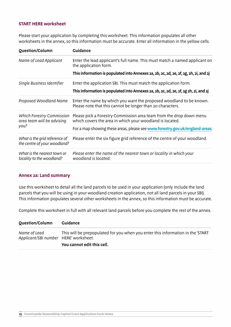
START HERE worksheet
Please start your application by completing this worksheet. The lead applicant and SBI information populates all other worksheets in the annex, so this information must be accurate. Enter all information in the yellow cells.
Question/Column Guidance
Name of Lead Applicant
Enter the lead applicant’s full name. This must match a named applicant on the application form.
Single Business Identifier
Enter the application SBI. This must match the application form.
This information is populated into Annexes 1a, 1b and the Summary
Annex 1a: Land Summary worksheet
Use this worksheet to list the land parcels where the boundary work will be carried out. You can only apply for capital items on a hedge, wall or bank which forms the boundary of a field registered to your SBI and over which you have full management control for at least 2 years from the start of the agreement. Include here the land parcels registered to your SBI where the capital works will be carried out.
Works on a Scheduled Monument (SM) or Site of Special Scientific Interest (SSSI) are not eligible; this includes work on the boundary of these sites. If the field parcel contains a SM or SSSI you must ensure the capital works in your application are not located on the SM or SSSI or their boundaries. You can use http://www.magic.gov.uk/ to check for the presence of SMs and SSSIs on your land (under Land based designations – statutory on the interactive map layer).
Question/Column Guidance
Name of Lead Applicant/SBI number
This will be prepopulated for you when you enter this information in the ‘START HERE’ worksheet.
You cannot edit this cell.
OS Map Sheet ref/National Grid no.
Please enter the reference number for the land parcel on the Rural Payments Service in the format LP12345678. IMPORTANT: Do not use a space within the reference, or an error message will be shown. This will need to be taken into account if copying and pasting field numbers into the spreadsheet.
Only record the field parcels adjacent to one side of each boundary where capital items will be located; you do not need to include the land parcels on both sides of a boundary.
All land parcels in the application must be registered to the applicant’s SBI.
You can also include your personal name for the field against each land parcel reference to help you identify individual fields more easily.
You can only enter one parcel number per line. Only include land parcels being used in your Hedgerows and Boundaries grant application.
Countryside Stewardship Capital Grant Application Form Notes12
Question/Column Guidance
Total land parcel size (ha)
Please enter (to 2 decimal places) the total area of this land parcel in hectares.
Does this parcel contain a SSSI?
Please pick ‘Yes’ if any part of this parcel contains a Site of Special Scientific Interest (SSSI).
You must ensure no capital items in your application are located on the SSSI.
Does this parcel contain a Scheduled Monument?
Please pick ‘Yes’ if any part of this parcel contains a Scheduled Monument (SM).
You must ensure no capital items in your application are located on the SM.
Annex 1b: Capital items
Use this worksheet to record the quantities of capital items you are applying for on each land parcel. This information must be broken down per boundary in each land parcel, i.e. the number of hedgerow trees or metres of wall restoration must be documented for each boundary and land parcel included in the application.
Question/Column Guidance
Name of Lead Applicant/SBI number
This will be prepopulated for you when you enter this information in the ‘START HERE’ worksheet.
You cannot edit this cell.
Parcel Name Use the dropdown to select a land parcel using the name entered for it on Annex 1a, if no name has been entered on Annex 1a this will show the OS parcel reference instead.
You cannot edit this cell.
OS parcel reference This will be prepopulated for you when you select the Parcel Name
You cannot edit this cell.
Hedgerow and boundary capital items
Please enter the amount of each capital item you wish to apply for on each boundary. A short description of each item can be found by clicking on the item code. Enter the amount of the capital item to two decimal places for length based options (e.g. 12.00 metres) and the total number for TE1 Planting hedgerow tree. The quantities must correspond to the amount of work which will be carried out on the boundaries adjacent to the land parcel and marked on the application map.
Evidence worksheet
This worksheet indicates where evidence is required. Green boxes show the type of evidence required and have a dropdown that should be used to indicate if the evidence has been provided, which will either be photos, or extra information on a supplementary map, e.g.
Countryside Stewardship Capital Grant Application Form Notes13
� TE1: record of where trees are to be planted.
� BN12: location of any wall-side trees, saplings and stone features.
� BN5, BN6: location of existing hedgerow trees in each length of hedge.
Summary worksheet
This worksheet provides a summary of the capital items included in your application and the total value. The values are pre-populated from information in the ‘Start here’, ‘Annex 1a’ and ‘Annex 1b’ worksheets. The Summary worksheet is not editable; if you want to change the values you must adjust the entries in the other Annexes and the Summary worksheet will be automatically updated.
Step 4b: How to complete Annex 2 (Woodland Creation)
The Woodland Creation annex has been designed to capture all the information needed to complete your Woodland Creation application. This includes information on your land parcels, constraints, any prior agreements on the holding and the capital items you wish to apply for on each land parcel. Please fill this annex in with as much detail as you can.
Annex 2 is available from www.gov.uk/government/publications/countryside-stewardship-capital-grant-application-form
This annex is self-calculating and self-populating. As you complete the earlier worksheets in the annex, the later worksheets are prepopulated with relevant information, saving the need to repeat similar information. Therefore, it is imperative that you start at the ‘START HERE’ worksheet and complete the annex in order.
Electronic submissions are the preferred method for Woodland Creation Grant applications, meaning that your Forestry Commission Woodland Officer has access to your electronic, self-calculating version of the annex.
The table below explains the purpose of each worksheet.
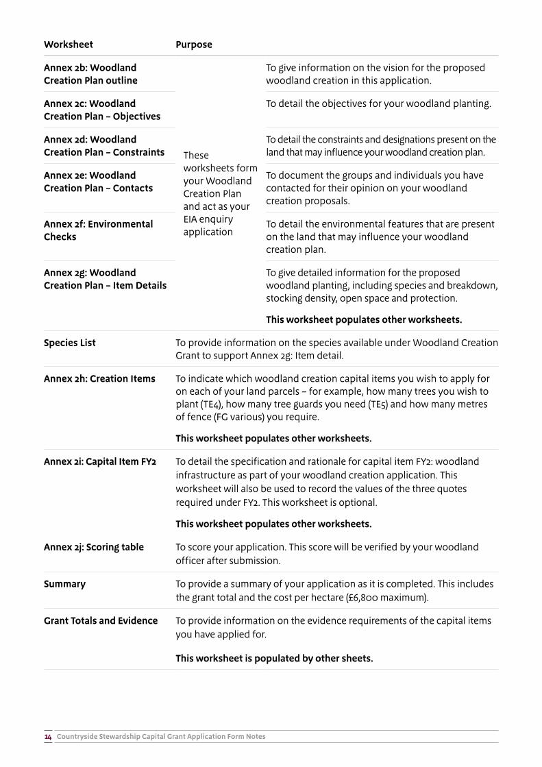
Worksheet Purpose
START HERE To capture the applicant’s basic details – these will then be populated through the annex.
This worksheet populates other worksheets
Annex 2a: Land Summary To give an overview of all the land parcels included in this application and the land conditions on these parcels. For example, this table is used to indicate the presence of Sites of Special Scientific Interest (SSSI), Scheduled Monuments (SM) and any parcels containing pre-existing Environmental Stewardship (ES) agreements.
This worksheet populates other worksheets
Countryside Stewardship Capital Grant Application Form Notes14
Worksheet Purpose
Annex 2b: Woodland Creation Plan outline
These worksheets form your Woodland Creation Plan and act as your EIA enquiry application
To give information on the vision for the proposed woodland creation in this application.
Annex 2c: Woodland Creation Plan – Objectives
To detail the objectives for your woodland planting.
Annex 2d: Woodland Creation Plan – Constraints
To detail the constraints and designations present on the land that may influence your woodland creation plan.
Annex 2e: Woodland Creation Plan – Contacts
To document the groups and individuals you have contacted for their opinion on your woodland creation proposals.
Annex 2f: Environmental Checks
To detail the environmental features that are present on the land that may influence your woodland creation plan.
Annex 2g: Woodland Creation Plan – Item Details
To give detailed information for the proposed woodland planting, including species and breakdown, stocking density, open space and protection.
This worksheet populates other worksheets.
Species List To provide information on the species available under Woodland Creation Grant to support Annex 2g: Item detail.
Annex 2h: Creation Items To indicate which woodland creation capital items you wish to apply for on each of your land parcels – for example, how many trees you wish to plant (TE4), how many tree guards you need (TE5) and how many metres of fence (FG various) you require.
This worksheet populates other worksheets.
Annex 2i: Capital Item FY2 To detail the specification and rationale for capital item FY2: woodland infrastructure as part of your woodland creation application. This worksheet will also be used to record the values of the three quotes required under FY2. This worksheet is optional.
This worksheet populates other worksheets.
Annex 2j: Scoring table To score your application. This score will be verified by your woodland officer after submission.
Summary To provide a summary of your application as it is completed. This includes the grant total and the cost per hectare (£6,800 maximum).
Grant Totals and Evidence To provide information on the evidence requirements of the capital items you have applied for.
This worksheet is populated by other sheets.
Countryside Stewardship Capital Grant Application Form Notes15
START HERE worksheet
Please start your application by completing this worksheet. This information populates all other worksheets in the annex, so this information must be accurate. Enter all information in the yellow cells.
Question/Column Guidance
Name of Lead Applicant Enter the lead applicant’s full name. This must match a named applicant on the application form.
This information is populated into Annexes 2a, 2b, 2c, 2d, 2e, 2f, 2g, 2h, 2i, and 2j
Single Business Identifier Enter the application SBI. This must match the application form.
This information is populated into Annexes 2a, 2b, 2c, 2d, 2e, 2f, 2g 2h, 2i, and 2j
Proposed Woodland Name Enter the name by which you want the proposed woodland to be known. Please note that this cannot be longer than 20 characters.
Which Forestry Commission area team will be advising you?
Please pick a Forestry Commission area team from the drop down menu which covers the area in which your woodland is located.
For a map showing these areas, please see www.forestry.gov.uk/england-areas.
What is the grid reference of the centre of your woodland?
Please enter the six figure grid reference of the centre of your woodland.
What is the nearest town or locality to the woodland?
Please enter the name of the nearest town or locality in which your woodland is located.
Annex 2a: Land summary
Use this worksheet to detail all the land parcels to be used in your application (only include the land parcels that you will be using in your woodland creation application, not all land parcels in your SBI). This information populates several other worksheets in the annex, so this information must be accurate.
Complete this worksheet in full with all relevant land parcels before you complete the rest of the annex.
Question/Column Guidance
Name of Lead Applicant/SBI number
This will be prepopulated for you when you enter this information in the ‘START HERE’ worksheet.
You cannot edit this cell.
Countryside Stewardship Capital Grant Application Form Notes16
Question/Column Guidance
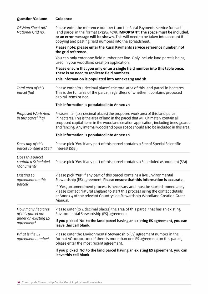
OS Map Sheet ref/National Grid no.
Please enter the reference number from the Rural Payments service for each land parcel in the format LP1234 5678. IMPORTANT: The space must be included, or an error message will be shown. This will need to be taken into account if copying and pasting field numbers into the spreadsheet.
Please note: please enter the Rural Payments service reference number, not the grid reference.
You can only enter one field number per line. Only include land parcels being used in your woodland creation application.
Please ensure that you only enter a single field number into this table once. There is no need to replicate field numbers.
This information is populated into Annexes 2g and 2h
Total area of this parcel (ha)
Please enter (to 4 decimal places) the total area of this land parcel in hectares. This is the full area of the parcel, regardless of whether it contains proposed capital items or not.
This information is populated into Annex 2h
Proposed Work Area in this parcel (ha)
Please enter (to 4 decimal places) the proposed work area of this land parcel in hectares. This is the area of land in the parcel that will ultimately contain all proposed capital items in the woodland creation application, including trees, guards and fencing. Any internal woodland open space should also be included in this area.
This information is populated into Annex 2h
Does any of this parcel contain a SSSI?
Please pick ‘Yes’ if any part of this parcel contains a Site of Special Scientific Interest (SSSI).
Does this parcel contain a Scheduled Monument?
Please pick ‘Yes’ if any part of this parcel contains a Scheduled Monument (SM).
Existing ES agreement on this parcel?
Please pick ‘Yes’ if any part of this parcel contains a live Environmental Stewardship (ES) agreement. Please ensure that this information is accurate.
If ‘Yes’, an amendment process is necessary and must be started immediately. Please contact Natural England to start this process using the contact details at Annex 4 of the relevant Countryside Stewardship Woodland Creation Grant Manual.
How many hectares of this parcel are under an existing ES agreement?
Please enter (to 4 decimal places) the area of this parcel that has an existing Environmental Stewardship (ES) agreement.
If you picked ‘No’ to the land parcel having an existing ES agreement, you can leave this cell blank.
What is the ES agreement number?
Please enter the Environmental Stewardship (ES) agreement number in the format AG00000000. If there is more than one ES agreement on this parcel, please enter the most recent agreement.
If you picked ‘No’ to the land parcel having an existing ES agreement, you can leave this cell blank.

Countryside Stewardship Capital Grant Application Form Notes17
Question/Column Guidance
What is the expiry date of the existing ES agreement?
Please enter the expiry date of the most recent Environmental Stewardship agreement on this parcel, in the format DD/MM/YY.
If you picked ‘No’ to the land parcel having an existing ES agreement, you can leave this cell blank.
Annexes 2b, 2c, 2d, 2e, 2f and 2g: The Countryside Stewardship Woodland Creation Plan
Annex 2b: Woodland Creation Plan
You must complete a woodland creation plan as a part of your Countryside Stewardship application. This plan performs the function of a management plan for the establishment period (years 1 to 10) of your new woodland. It should detail what you plan to do, how you plan to do it and what the woodland will deliver for the Countryside Stewardship Scheme. You should also include a brief description of how you propose to ensure that the woodland you create through this grant will progress to become established woodland at the end of the 10 year management payment phase (if you are applying for this option – WD1).
Your woodland design and proposal must align with the UK Forestry Standard (see: http://www.forestry.gov.uk/ukfs ).
You must also apply to the Forestry Commission for an opinion on whether a proposal for afforestation is likely to have significant impact on the environment. However, the woodland creation plan included in Annex 2 of the Woodland Creation Grant is considered sufficient for this purpose. As such, you DO NOT need to submit a separate Environmental Impact Assessment (EIA) application form, but you do need to provide all of the information asked for in Annex 2b-2g.
Where a question asks for brief details on mitigation you may be required to provide further details on these actions in additional documentation to be submitted with your application form.
Complete all worksheets with as much detail as you can to be sure that we can easily understand your proposal.
Question/Column Guidance
Name of Lead Applicant/SBI number
This will be prepopulated for you when you enter this information in the ‘START HERE’ worksheet.
You cannot edit this cell.
Do you have a Forestry Commission approved Woodland Creation Plan, via the Woodland Creation Planning Grant?
Please pick ‘Yes’ from the drop down menu if you hold a Forestry Commission approved Woodland Creation Plan via the Woodland Creation Planning Grant on the area of land you are applying to. This may help to inform your CS Woodland Creation grant application.
If you picked ‘Yes’ please complete question 1b by filling in the reference number or name of your existing Woodland Creation Plan.
If you picked ‘No’ the cell will turn grey and you can leave this blank.
Countryside Stewardship Capital Grant Application Form Notes18
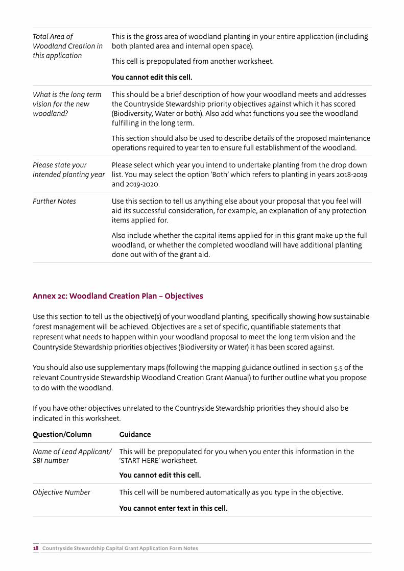
Total Area of Woodland Creation in this application
This is the gross area of woodland planting in your entire application (including both planted area and internal open space).
This cell is prepopulated from another worksheet.
You cannot edit this cell.
What is the long term vision for the new woodland?
This should be a brief description of how your woodland meets and addresses the Countryside Stewardship priority objectives against which it has scored (Biodiversity, Water or both). Also add what functions you see the woodland fulfilling in the long term.
This section should also be used to describe details of the proposed maintenance operations required to year ten to ensure full establishment of the woodland.
Please state your intended planting year
Please select which year you intend to undertake planting from the drop down list. You may select the option ‘Both’ which refers to planting in years 2018-2019 and 2019-2020.
Further Notes Use this section to tell us anything else about your proposal that you feel will aid its successful consideration, for example, an explanation of any protection items applied for.
Also include whether the capital items applied for in this grant make up the full woodland, or whether the completed woodland will have additional planting done out with of the grant aid.
Annex 2c: Woodland Creation Plan – Objectives
Use this section to tell us the objective(s) of your woodland planting, specifically showing how sustainable forest management will be achieved. Objectives are a set of specific, quantifiable statements that represent what needs to happen within your woodland proposal to meet the long term vision and the Countryside Stewardship priorities objectives (Biodiversity or Water) it has been scored against.
You should also use supplementary maps (following the mapping guidance outlined in section 5.5 of the relevant Countryside Stewardship Woodland Creation Grant Manual) to further outline what you propose to do with the woodland.
If you have other objectives unrelated to the Countryside Stewardship priorities they should also be indicated in this worksheet.
Question/Column Guidance
Name of Lead Applicant/SBI number
This will be prepopulated for you when you enter this information in the ‘START HERE’ worksheet.
You cannot edit this cell.
Objective Number This cell will be numbered automatically as you type in the objective.
You cannot enter text in this cell.
Countryside Stewardship Capital Grant Application Form Notes19
Woodland Creation Objective
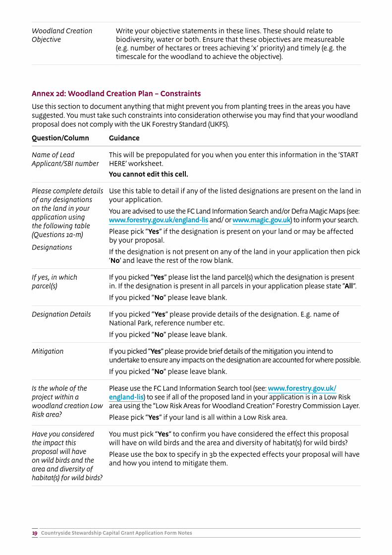
Write your objective statements in these lines. These should relate to biodiversity, water or both. Ensure that these objectives are measureable (e.g. number of hectares or trees achieving ‘x’ priority) and timely (e.g. the timescale for the woodland to achieve the objective).
Annex 2d: Woodland Creation Plan – Constraints
Use this section to document anything that might prevent you from planting trees in the areas you have suggested. You must take such constraints into consideration otherwise you may find that your woodland proposal does not comply with the UK Forestry Standard (UKFS).
Question/Column Guidance
Name of Lead Applicant/SBI number
This will be prepopulated for you when you enter this information in the ‘START HERE’ worksheet.You cannot edit this cell.
Please complete details of any designations on the land in your application using the following table (Questions 1a-m)
Designations
Use this table to detail if any of the listed designations are present on the land in your application.
You are advised to use the FC Land Information Search and/or Defra Magic Maps (see: www.forestry.gov.uk/england-lis and/ or www.magic.gov.uk) to inform your search.
Please pick “Yes” if the designation is present on your land or may be affected by your proposal.
If the designation is not present on any of the land in your application then pick ‘No’ and leave the rest of the row blank.
If yes, in which parcel(s)
If you picked “Yes” please list the land parcel(s) which the designation is present in. If the designation is present in all parcels in your application please state “All”.
If you picked “No” please leave blank.
Designation Details If you picked “Yes” please provide details of the designation. E.g. name of National Park, reference number etc.
If you picked “No” please leave blank.
Mitigation If you picked “Yes” please provide brief details of the mitigation you intend to undertake to ensure any impacts on the designation are accounted for where possible.
If you picked “No” please leave blank.
Is the whole of the project within a woodland creation Low Risk area?
Please use the FC Land Information Search tool (see: www.forestry.gov.uk/england-lis) to see if all of the proposed land in your application is in a Low Risk area using the “Low Risk Areas for Woodland Creation” Forestry Commission Layer.
Please pick “Yes” if your land is all within a Low Risk area.
Have you considered the impact this proposal will have on wild birds and the area and diversity of habitat(s) for wild birds?
You must pick “Yes” to confirm you have considered the effect this proposal will have on wild birds and the area and diversity of habitat(s) for wild birds?
Please use the box to specify in 3b the expected effects your proposal will have and how you intend to mitigate them.
Countryside Stewardship Capital Grant Application Form Notes20
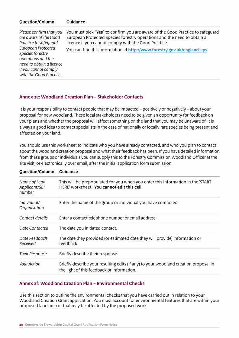
Question/Column Guidance
Please confirm that you are aware of the Good Practice to safeguard European Protected Species forestry operations and the need to obtain a licence if you cannot comply with the Good Practice.
You must pick “Yes” to confirm you are aware of the Good Practice to safeguard European Protected Species forestry operations and the need to obtain a licence if you cannot comply with the Good Practice.
You can find this information at http://www.forestry.gov.uk/england-eps.
Annex 2e: Woodland Creation Plan – Stakeholder Contacts
It is your responsibility to contact people that may be impacted – positively or negatively – about your proposal for new woodland. These local stakeholders need to be given an opportunity for feedback on your plans and whether the proposal will affect something on the land that you may be unaware of. It is always a good idea to contact specialists in the case of nationally or locally rare species being present and affected on your land.
You should use this worksheet to indicate who you have already contacted, and who you plan to contact about the woodland creation proposal and what their feedback has been. If you have detailed information from these groups or individuals you can supply this to the Forestry Commission Woodland Officer at the site visit, or electronically over email, after the initial application form submission.
Question/Column Guidance
Name of Lead Applicant/SBI number
This will be prepopulated for you when you enter this information in the ‘START HERE’ worksheet. You cannot edit this cell.
Individual/Organisation
Enter the name of the group or individual you have contacted.
Contact details Enter a contact telephone number or email address.
Date Contacted The date you initiated contact.
Date Feedback Received
The date they provided (or estimated date they will provide) information or feedback.
Their Response Briefly describe their response.
Your Action Briefly describe your resulting edits (if any) to your woodland creation proposal in the light of this feedback or information.
Annex 2f: Woodland Creation Plan – Environmental Checks
Use this section to outline the environmental checks that you have carried out in relation to your Woodland Creation Grant application. You must account for environmental features that are within your proposed land area or that may be affected by the proposed work.
Countryside Stewardship Capital Grant Application Form Notes21
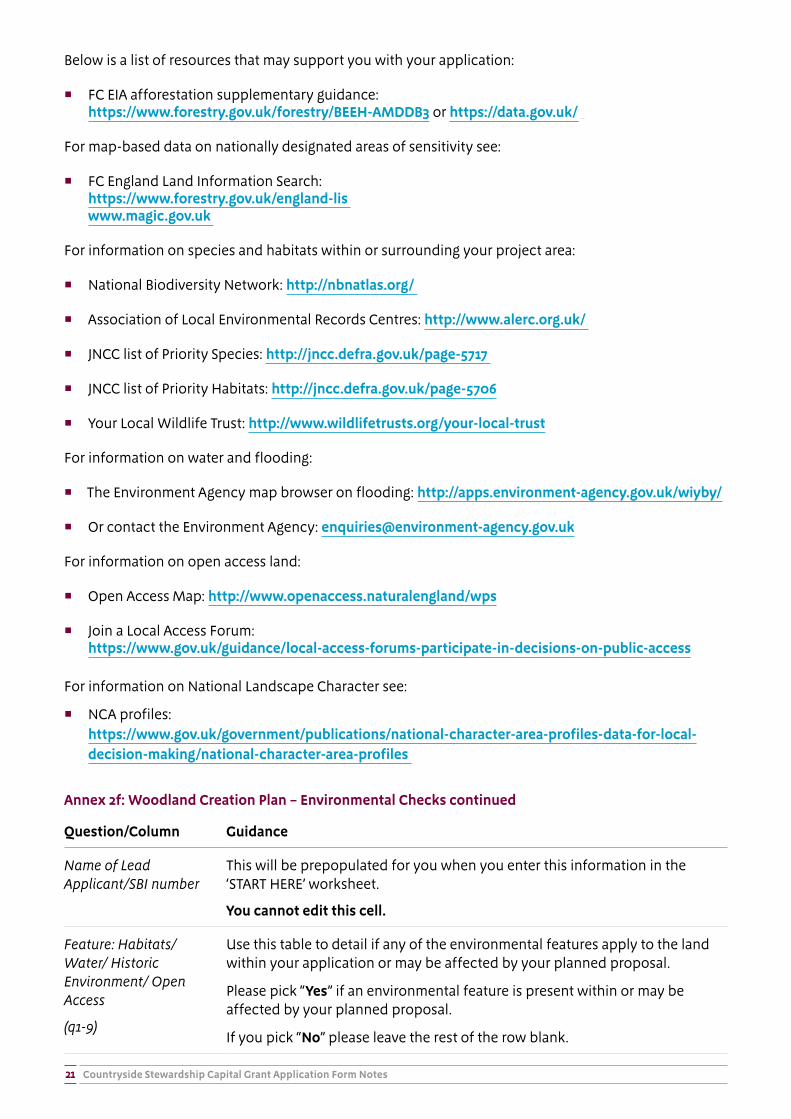
Below is a list of resources that may support you with your application:
� FC EIA afforestation supplementary guidance: https://www.forestry.gov.uk/forestry/BEEH-AMDDB3 or https://data.gov.uk/
For map-based data on nationally designated areas of sensitivity see:
� FC England Land Information Search: https://www.forestry.gov.uk/england-lis
www.magic.gov.uk
For information on species and habitats within or surrounding your project area:
� National Biodiversity Network: http://nbnatlas.org/
� Association of Local Environmental Records Centres: http://www.alerc.org.uk/
� JNCC list of Priority Species: http://jncc.defra.gov.uk/page-5717
� JNCC list of Priority Habitats: http://jncc.defra.gov.uk/page-5706
� Your Local Wildlife Trust: http://www.wildlifetrusts.org/your-local-trust
For information on water and flooding:
� The Environment Agency map browser on flooding: http://apps.environment-agency.gov.uk/wiyby/
� Or contact the Environment Agency: [email protected]
For information on open access land:
� Open Access Map: http://www.openaccess.naturalengland/wps
� Join a Local Access Forum:https://www.gov.uk/guidance/local-access-forums-participate-in-decisions-on-public-access
For information on National Landscape Character see:
� NCA profiles:https://www.gov.uk/government/publications/national-character-area-profiles-data-for-local-decision-making/national-character-area-profiles
Annex 2f: Woodland Creation Plan – Environmental Checks continued
Question/Column Guidance
Name of Lead Applicant/SBI number
This will be prepopulated for you when you enter this information in the ‘START HERE’ worksheet.
You cannot edit this cell.
Feature: Habitats/ Water/ Historic Environment/ Open Access
(q1-9)
Use this table to detail if any of the environmental features apply to the land within your application or may be affected by your planned proposal.
Please pick “Yes” if an environmental feature is present within or may be affected by your planned proposal.
If you pick “No” please leave the rest of the row blank.
Countryside Stewardship Capital Grant Application Form Notes22
Question/Column Guidance
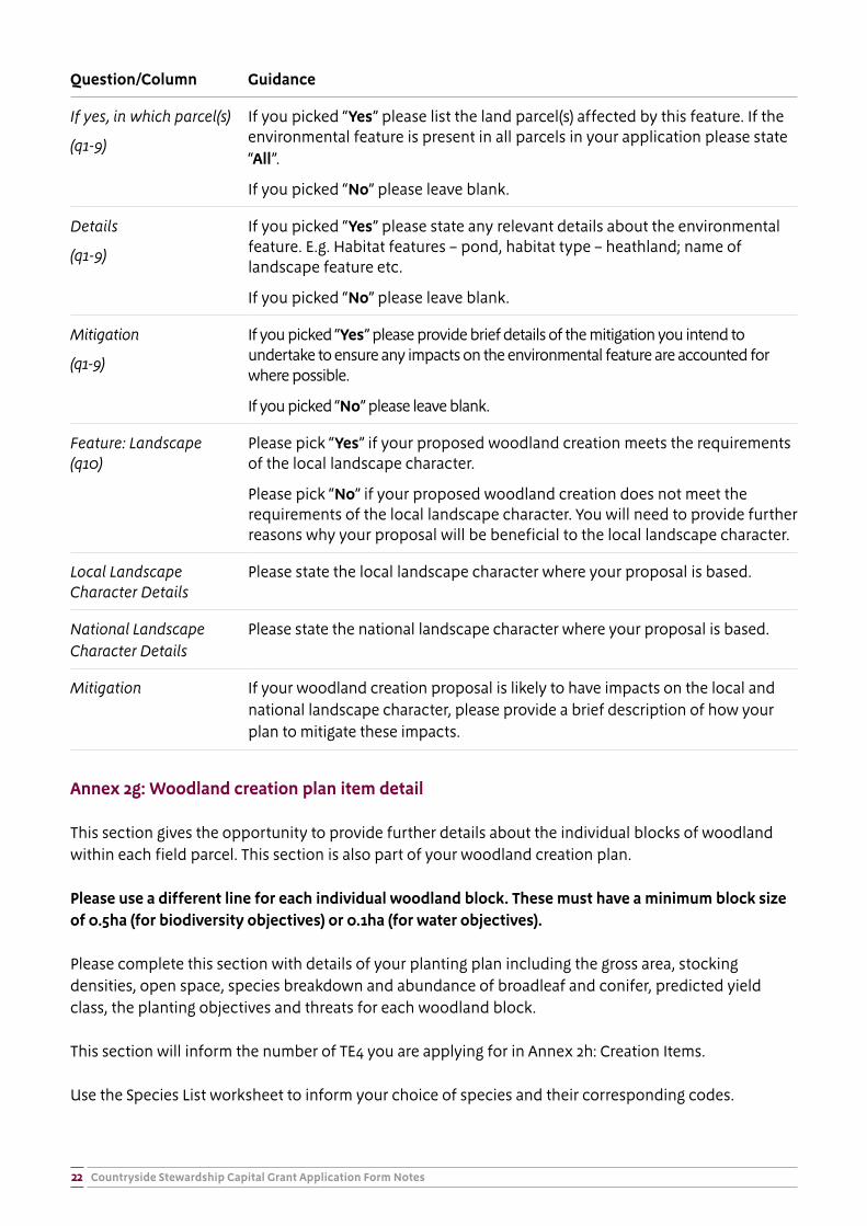
If yes, in which parcel(s)
(q1-9)
If you picked “Yes” please list the land parcel(s) affected by this feature. If the environmental feature is present in all parcels in your application please state “All”.
If you picked “No” please leave blank.
Details
(q1-9)
If you picked “Yes” please state any relevant details about the environmental feature. E.g. Habitat features – pond, habitat type – heathland; name of landscape feature etc.
If you picked “No” please leave blank.
Mitigation
(q1-9)
If you picked “Yes” please provide brief details of the mitigation you intend to undertake to ensure any impacts on the environmental feature are accounted for where possible.
If you picked “No” please leave blank.
Feature: Landscape (q10)
Please pick “Yes” if your proposed woodland creation meets the requirements of the local landscape character.
Please pick “No” if your proposed woodland creation does not meet the requirements of the local landscape character. You will need to provide further reasons why your proposal will be beneficial to the local landscape character.
Local Landscape Character Details
Please state the local landscape character where your proposal is based.
National Landscape Character Details
Please state the national landscape character where your proposal is based.
Mitigation If your woodland creation proposal is likely to have impacts on the local and national landscape character, please provide a brief description of how your plan to mitigate these impacts.
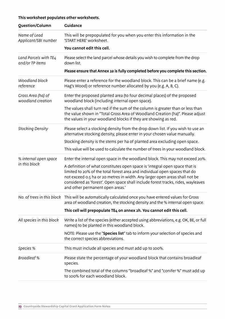
Annex 2g: Woodland creation plan item detail
This section gives the opportunity to provide further details about the individual blocks of woodland within each field parcel. This section is also part of your woodland creation plan.
Please use a different line for each individual woodland block. These must have a minimum block size of 0.5ha (for biodiversity objectives) or 0.1ha (for water objectives).
Please complete this section with details of your planting plan including the gross area, stocking densities, open space, species breakdown and abundance of broadleaf and conifer, predicted yield class, the planting objectives and threats for each woodland block.
This section will inform the number of TE4 you are applying for in Annex 2h: Creation Items.
Use the Species List worksheet to inform your choice of species and their corresponding codes.
Countryside Stewardship Capital Grant Application Form Notes23
This worksheet populates other worksheets.
Question/Column Guidance
Name of Lead Applicant/SBI number
This will be prepopulated for you when you enter this information in the ‘START HERE’ worksheet.
You cannot edit this cell.
Land Parcels with TE4 and/or TP items
Please select the land parcel whose details you wish to complete from the drop down list.
Please ensure that Annex 2a is fully completed before you complete this section.
Woodland block reference
Please enter a reference for the woodland block. This can be a brief name (e.g. Hag’s Wood) or reference number allocated by you (e.g. A, B, C).
Gross Area (ha) of woodland creation
Enter the proposed planted area (to four decimal places) of the proposed woodland block (including internal open space).
The values shall turn red if the sum of the column is greater than or less than the value shown in “Total Gross Area of Woodland Creation (ha)”. Please adjust the values in your woodland blocks if they are showing as red.
Stocking Density Please select a stocking density from the drop down list. If you wish to use an alternative stocking density, please enter in your chosen value manually.
Stocking density is the stems per ha of planted area excluding open space.
This value will be used to calculate the number of trees in your woodland block.
% internal open space in this block
Enter the internal open space in the woodland block. This may not exceed 20%.
A definition of what constitutes open space is ‘integral open space that is limited to 20% of the total forest area and individual open spaces that do not exceed 0.5 ha or 20 metres in width. Any larger open areas shall not be considered as ‘forest’. Open space shall include forest tracks, rides, wayleaves and other permanent open areas.’
No. of trees in this block This will be automatically calculated once you have entered values for Gross area of woodland creation, the stocking density and the % internal open space.
This cell will prepopulate TE4 on annex 2h. You cannot edit this cell.
All species in this block Write a list of the species (either accepted using abbreviations, e.g. OK, BE, or full names) to be planted in this woodland block.
NOTE: Please use the “Species list” tab to inform your selection of species and the correct species abbreviations.
Species % This must include all species and must add up to 100%.
Broadleaf % Please state the percentage of your woodland block that contains broadleaf species.
The combined total of the columns “broadleaf %” and “conifer %” must add up to 100% for each woodland block.
Countryside Stewardship Capital Grant Application Form Notes24
Question/Column Guidance
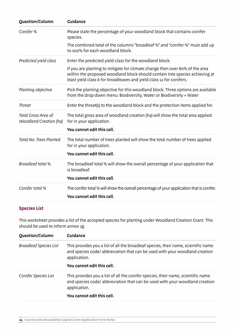
Conifer % Please state the percentage of your woodland block that contains conifer species.
The combined total of the columns “broadleaf %” and “conifer %” must add up to 100% for each woodland block.
Predicted yield class Enter the predicted yield class for the woodland block.
If you are planting to mitigate for climate change then over 80% of the area within the proposed woodland block should contain tree species achieving at least yield class 6 for broadleaves and yield class 12 for conifers.
Planting objective Pick the planting objective for this woodland block. Three options are available from the drop down menu: Biodiversity, Water or Biodiversity + Water
Threat Enter the threat(s) to the woodland block and the protection items applied for.
Total Gross Area of Woodland Creation (ha)
The total gross area of woodland creation (ha) will show the total area applied for in your application.
You cannot edit this cell.
Total No. Trees Planted The total number of trees planted will show the total number of trees applied for in your application.
You cannot edit this cell.
Broadleaf total % The broadleaf total % will show the overall percentage of your application that is broadleaf.
You cannot edit this cell.
Conifer total % The conifer total % will show the overall percentage of your application that is conifer.
You cannot edit this cell.
Species List
This worksheet provides a list of the accepted species for planting under Woodland Creation Grant. This should be used to inform annex 2g.
Question/Column Guidance
Broadleaf Species List This provides you a list of all the broadleaf species, their name, scientific name and species code/ abbreviation that can be used with your woodland creation application.
You cannot edit this cell.
Conifer Species List This provides you a list of all the conifer species, their name, scientific name and species code/ abbreviation that can be used with your woodland creation application.
You cannot edit this cell.
Countryside Stewardship Capital Grant Application Form Notes25
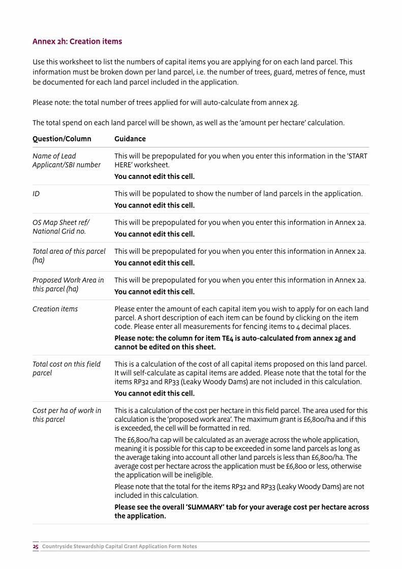
Annex 2h: Creation items
Use this worksheet to list the numbers of capital items you are applying for on each land parcel. This information must be broken down per land parcel, i.e. the number of trees, guard, metres of fence, must be documented for each land parcel included in the application.
Please note: the total number of trees applied for will auto-calculate from annex 2g.
The total spend on each land parcel will be shown, as well as the ‘amount per hectare’ calculation.
Question/Column Guidance
Name of Lead Applicant/SBI number
This will be prepopulated for you when you enter this information in the ‘START HERE’ worksheet.
You cannot edit this cell.
ID This will be populated to show the number of land parcels in the application.
You cannot edit this cell.
OS Map Sheet ref/National Grid no.
This will be prepopulated for you when you enter this information in Annex 2a.
You cannot edit this cell.
Total area of this parcel (ha)
This will be prepopulated for you when you enter this information in Annex 2a.
You cannot edit this cell.
Proposed Work Area in this parcel (ha)
This will be prepopulated for you when you enter this information in Annex 2a.
You cannot edit this cell.
Creation items Please enter the amount of each capital item you wish to apply for on each land parcel. A short description of each item can be found by clicking on the item code. Please enter all measurements for fencing items to 4 decimal places.
Please note: the column for item TE4 is auto-calculated from annex 2g and cannot be edited on this sheet.
Total cost on this field parcel
This is a calculation of the cost of all capital items proposed on this land parcel. It will self-calculate as capital items are added. Please note that the total for the items RP32 and RP33 (Leaky Woody Dams) are not included in this calculation.
You cannot edit this cell.
Cost per ha of work in this parcel
This is a calculation of the cost per hectare in this field parcel. The area used for this calculation is the ‘proposed work area’. The maximum grant is £6,800/ha and if this is exceeded, the cell will be formatted in red.
The £6,800/ha cap will be calculated as an average across the whole application, meaning it is possible for this cap to be exceeded in some land parcels as long as the average taking into account all other land parcels is less than £6,800/ha. The average cost per hectare across the application must be £6,800 or less, otherwise the application will be ineligible.
Please note that the total for the items RP32 and RP33 (Leaky Woody Dams) are not included in this calculation.
Please see the overall ‘SUMMARY’ tab for your average cost per hectare across the application.
Countryside Stewardship Capital Grant Application Form Notes26
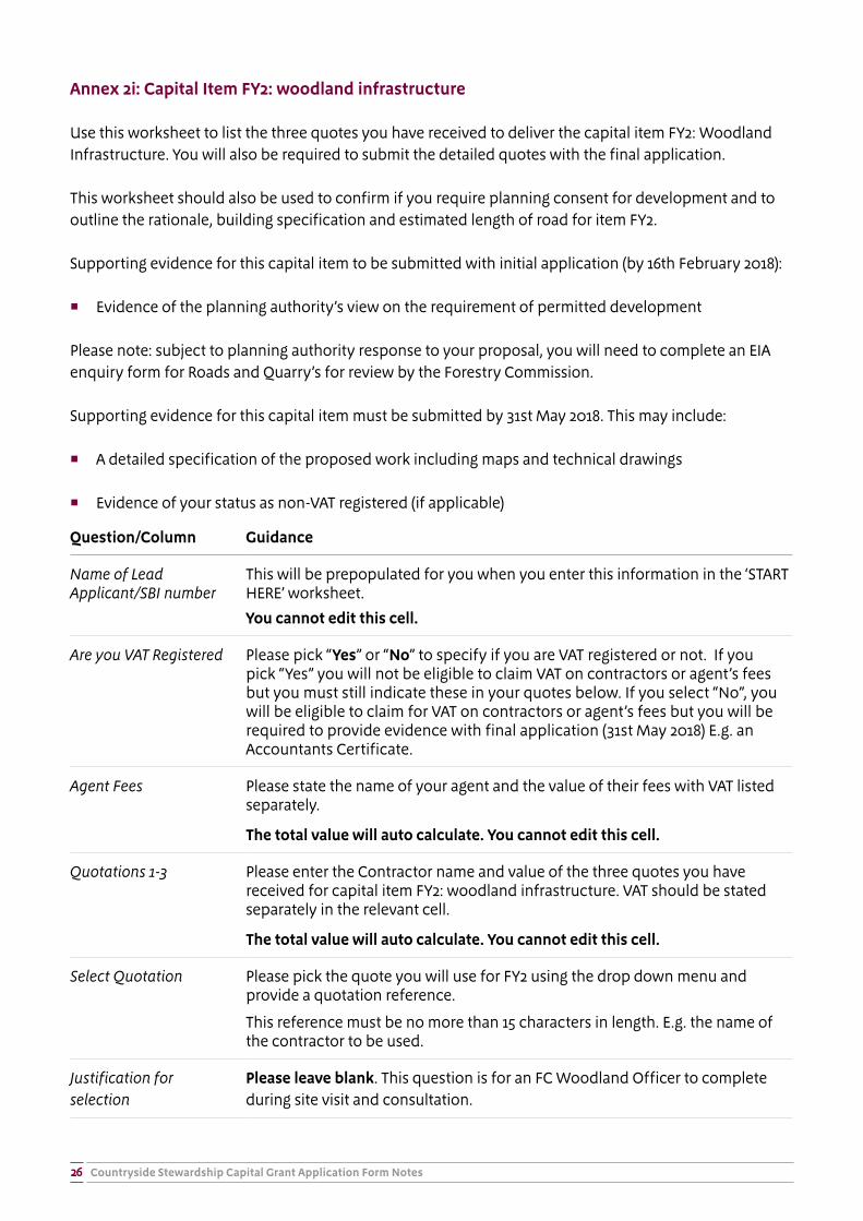
Annex 2i: Capital Item FY2: woodland infrastructure
Use this worksheet to list the three quotes you have received to deliver the capital item FY2: Woodland Infrastructure. You will also be required to submit the detailed quotes with the final application.
This worksheet should also be used to confirm if you require planning consent for development and to outline the rationale, building specification and estimated length of road for item FY2.
Supporting evidence for this capital item to be submitted with initial application (by 16th February 2018):
� Evidence of the planning authority’s view on the requirement of permitted development
Please note: subject to planning authority response to your proposal, you will need to complete an EIA enquiry form for Roads and Quarry’s for review by the Forestry Commission.
Supporting evidence for this capital item must be submitted by 31st May 2018. This may include:
� A detailed specification of the proposed work including maps and technical drawings
� Evidence of your status as non-VAT registered (if applicable)
Question/Column Guidance
Name of Lead Applicant/SBI number
This will be prepopulated for you when you enter this information in the ‘START HERE’ worksheet.
You cannot edit this cell.
Are you VAT Registered Please pick “Yes” or “No” to specify if you are VAT registered or not. If you pick “Yes” you will not be eligible to claim VAT on contractors or agent’s fees but you must still indicate these in your quotes below. If you select “No”, you will be eligible to claim for VAT on contractors or agent’s fees but you will be required to provide evidence with final application (31st May 2018) E.g. an Accountants Certificate.
Agent Fees Please state the name of your agent and the value of their fees with VAT listed separately.
The total value will auto calculate. You cannot edit this cell.
Quotations 1-3 Please enter the Contractor name and value of the three quotes you have received for capital item FY2: woodland infrastructure. VAT should be stated separately in the relevant cell.
The total value will auto calculate. You cannot edit this cell.
Select Quotation Please pick the quote you will use for FY2 using the drop down menu and provide a quotation reference.
This reference must be no more than 15 characters in length. E.g. the name of the contractor to be used.
Justification for selection
Please leave blank. This question is for an FC Woodland Officer to complete during site visit and consultation.

Countryside Stewardship Capital Grant Application Form Notes27
Question/Column Guidance
Selection approved by Woodland Officer (name and date)
Please leave blank. This question is for an FC Woodland Officer to complete during site visit and consultation.
Total actual costs of infrastructure, including VAT and agents fees (where applicable)
This will be populated once you have selected a quote. It will show the total actual costs of infrastructure including VAT and agents fees (where applicable).
You cannot edit this cell.
Payment: 40% of actual costs:
This will be populated once you have selected a quote. It will show the value of the payment you will actually receive under your Woodland Creation agreement (40% of actual costs).
You cannot edit this cell.
Will your work be permitted development?
Please pick “Yes” if your work will be permitted development.
Does your work require planning permission?
Please pick “Yes” if your work will require planning permission.
Do you have planning permission in place?
Please pick “Yes” if you have planning permission in place. If your work does not require planning permission please pick “NA”.
Please state approximate length and proposed building specification for Woodland Infrastructure (FY2):
Please state the proposed specifications of road for FY2 using the categories listed under “Type of road”. Please use the “other” cell to specify any other type of work to be undertaken.
You should state the approximate length of road in metres (to 4 decimal places) next to the relevant specification.
Please refer to Operations Note 25 to inform your specification choice.
The total Length (m) will auto calculate.
What is your rationale for applying for this capital item:
Please provide a detailed explanation of how this item will benefit your overall woodland creation plan. You should factor in how this will benefit the establishment of your new woodland and the future management.
Please select ‘Yes’ to confirm that you have attached a detailed specification (including maps and technical drawings) of the project with your application.
Please pick “Yes” to confirm you have attached all supporting information with your application. This will include a detailed specification for the quotation chosen which should include maps and technical drawings.
Countryside Stewardship Capital Grant Application Form Notes28
How to score your application and complete Annex 2j
All applications must be submitted with a score, inputted and calculated on Annex 2j. Upon receipt of your application and completion of a site visit, a Forestry Commission Woodland Officer will validate your score. Applications which progress to final submission will be subject to a ranking process against a nationally determined ‘cut-off’ score to decide whether they will progress to agreement. Schemes will also be subject to the normal consultation and Environmental Impact Assessment Regulations considerations. For more information on the scoring process, please see section 5.4.3 of the relevant Countryside Stewardship Woodland Creation Grant Manual.
In order to progress, each application:
� will need to reach a minimum threshold score of 12
� must deliver against biodiversity and/or water objectives and meet the relevant design criteria outlined in the table below i.e. it is not acceptable to only achieve points against the ‘cross cutting’ objective.
� must meet the minimum agreement and block size thresholds as outlined in the relevant Countryside Stewardship Woodland Creation Grant Manual.
Scoring for Biodiversity and Water priorities:
Applications will be scored at the application level and to have an eligible scheme, the woodland must meet the requirements for either biodiversity and/or water. It is not possible to score only under the ‘cross-cutting’ objective.
If a woodland passes the spatial gateway and design requirements for either biodiversity and/or water, it can be scored. The gateways are described below, further information and detail can be found Annex B at the end of these notes.
The gateways for each priority are:
� Biodiversity - Habitat Networks – All the proposed woodland must fall within the Biodiversity Habitat Priority Layer (higher or lower) and the application must meet the design gateway in relation to tree species choice being appropriate to the location.
� Biodiversity – Priority Species – A minimum of 50% of the proposed woodland must fall within the priority species layer and the design needs to be appropriate to the targeted priority species.
� Biodiversity – Woodland Bird Assemblage – A minimum of 50% of the proposed woodland must fall within a woodland bird assemblage area and the design must benefit one or more of the woodland bird species listed for the area.
� Improve Water Quality – A minimum of 50% or 1ha (whichever is the greater) of the proposed woodland must be within a priority area (higher or lower) and the design meet the relevant design criteria.
� Reduce Flood Risk – A minimum of 50% or 1ha (whichever is the greater) of the proposed woodland must be within a priority area (higher or lower) and the design meet the relevant design criteria.
Countryside Stewardship Capital Grant Application Form Notes29
Scoring for cross-cutting priorities:
If your woodland passes the gateway criteria for the cross-cutting objectives, then a flat rate score of 9 is added. The objectives within the cross-cutting priority are:
� Climate Change Mitigation (Yield class)
� Climate Change Adaptation (Keeping Rivers Cool)
� Landscape Scale and Partnerships
Calculating your score:
To calculate the total score, the calculation is:
Area (ha) of planting against the priority layer X (multiplied by) points per hectare for that objective.
Different priority layers have different points per hectare scores. These are listed on the worksheet in Annex 2j.
Some priority objectives have a ‘higher’ and a ‘lower’ spatial layer. Where a woodland block spans both higher and lower spatial layers, the higher score is to be applied to the total area of the block. This saves the need to measure what proportion of the block falls in the higher layer and which falls in the lower layer.
For example, if part of a 10ha woodland block lies within the higher spatial layer and the rest lies within the lower spatial layer, the entire block of woodland can be counted as higher (10ha), meaning the entire area is multiplied by the higher score.
It is possible for an area to score against multiple priorities. For example, the 10ha woodland block example used above could also pass the spatial and design gateways for the woodland bird assemblage, meaning the 10ha will be scored a second time. Simply record the area of this woodland block in Annex 2j against both priorities.
To work out the area of your planting in each priority layer, please check the Land Information Search (LIS) website at www.forestry.gov.uk/england-lis.
The application will be scored for eligibility on the basis of the application areas you supply. Accuracy and consistency between the base map provided with your application and the area figure in the application form are your responsibility; any subsequent correction or amendment to the application areas may affect the eligibility of your application and are your responsibility to communicate.
Further information on designing woodland to create priority habitats for biodiversity or priority species and to improve water quality or reduce flood risk can be found on the Forestry Commission web pages at http://www.forestry.gov.uk/forestry/BEEH-9SZH46.
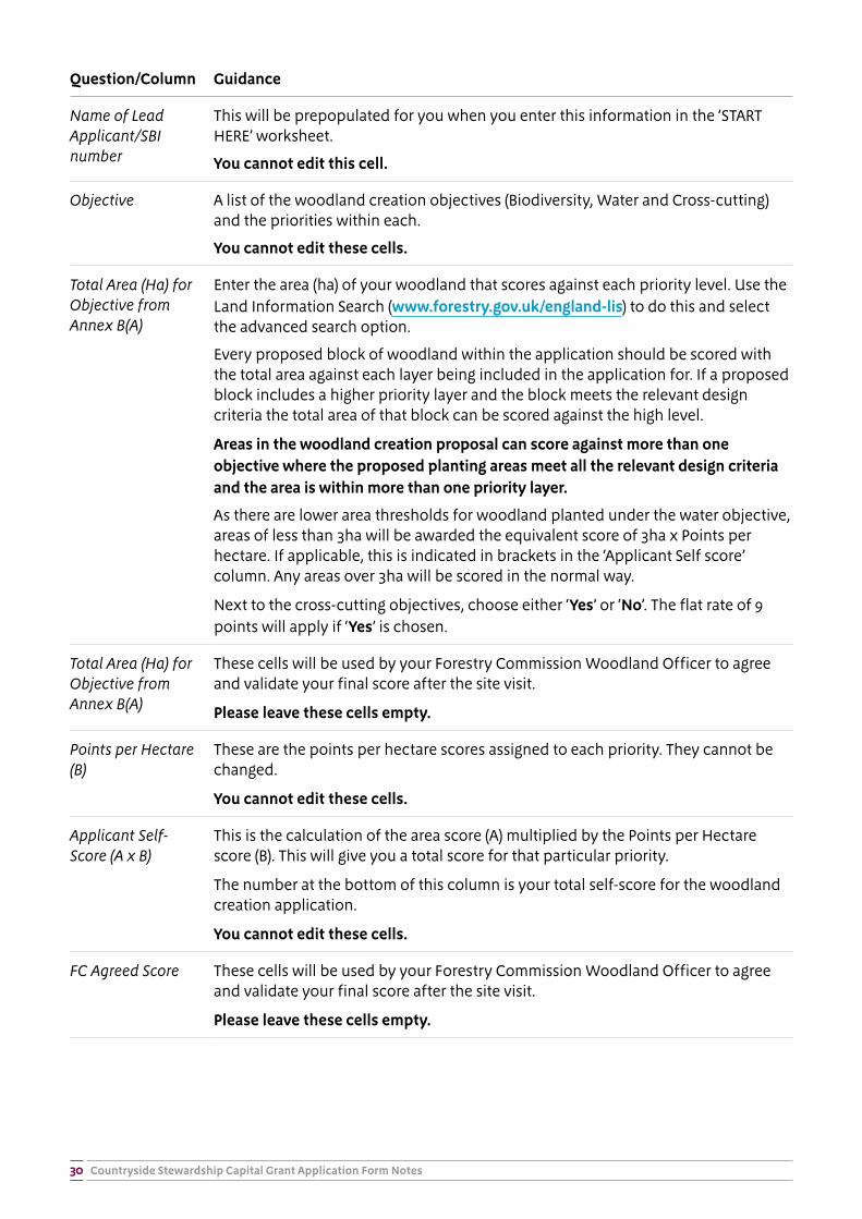
Annex 2j - Scoring
This worksheet contains a table to calculate your woodland creation application score. The table is self-calculating.
Countryside Stewardship Capital Grant Application Form Notes30
Question/Column Guidance
Name of Lead Applicant/SBI number
This will be prepopulated for you when you enter this information in the ‘START HERE’ worksheet.
You cannot edit this cell.
Objective A list of the woodland creation objectives (Biodiversity, Water and Cross-cutting) and the priorities within each.
You cannot edit these cells.
Total Area (Ha) for Objective from Annex B(A)
Enter the area (ha) of your woodland that scores against each priority level. Use the Land Information Search (www.forestry.gov.uk/england-lis) to do this and select the advanced search option.
Every proposed block of woodland within the application should be scored with the total area against each layer being included in the application for. If a proposed block includes a higher priority layer and the block meets the relevant design criteria the total area of that block can be scored against the high level.
Areas in the woodland creation proposal can score against more than one objective where the proposed planting areas meet all the relevant design criteria and the area is within more than one priority layer.
As there are lower area thresholds for woodland planted under the water objective, areas of less than 3ha will be awarded the equivalent score of 3ha x Points per hectare. If applicable, this is indicated in brackets in the ‘Applicant Self score’ column. Any areas over 3ha will be scored in the normal way.
Next to the cross-cutting objectives, choose either ‘Yes’ or ‘No’. The flat rate of 9 points will apply if ‘Yes’ is chosen.
Total Area (Ha) for Objective from Annex B(A)
These cells will be used by your Forestry Commission Woodland Officer to agree and validate your final score after the site visit.
Please leave these cells empty.
Points per Hectare (B)
These are the points per hectare scores assigned to each priority. They cannot be changed.
You cannot edit these cells.
Applicant Self-Score (A x B)
This is the calculation of the area score (A) multiplied by the Points per Hectare score (B). This will give you a total score for that particular priority.
The number at the bottom of this column is your total self-score for the woodland creation application.
You cannot edit these cells.
FC Agreed Score These cells will be used by your Forestry Commission Woodland Officer to agree and validate your final score after the site visit.
Please leave these cells empty.
Countryside Stewardship Capital Grant Application Form Notes31
Summary worksheet
This worksheet provides a summary of your application.
Question/Column Guidance
Name of Lead Applicant/SBI number
This will be prepopulated for you when you enter this information in the ‘START HERE’ worksheet.
You cannot edit this cell.
Capital item (within cap)
This is the list of capital items available in Woodland Creation Grant.
You cannot edit these cells.
Overall quantity for this item across the agreement
These self-calculating cells show the sum total of each capital item in your application. For example, the total number of trees (TE4) applied for or the total length of each fence type. These cells will automatically fill in as you complete Annex 2h.
You cannot edit this cell.
Unit of measurement
This is the unit of measurement for each capital item, e.g. metres, trees etc
You cannot edit this cell.
Overall cost for this item across the agreement
These self-calculating cells will show how much grant you are applying for, for each capital item individually. This is the cost across the full agreement (i.e. all land parcels included in the application).
You cannot edit this cell.
Total This is the total for the capital items included within the cap that you have applied for (the sum total of all capital items included in the cap of £6,800 per ha).
You cannot edit this cell.
Average cost per hectare across this application
This shows the average cost per hectare across the whole application (for capital items within the cap). This average must be equal to or less than £6,800/ha or the application will be ineligible.
If the £6,800/ha cap has been reached or exceeded, this cell will be formatted in red. Please return to annex 2g & 2h to edit the amount of capital items applied for to bring the application back under the cap.
You cannot edit this cell.
Cap exceeded? This cell indicates whether or not the £6,800/ha cap has been exceeded.
You cannot edit this cell.
Capital Item (excluded from cap)
This is the list of capital items available in Woodland Creation Grant outside of the cap.
You cannot edit this cell.
Overall quantity for this item across the agreement
These self-calculating cells show the sum total of each capital item in your application. These capital items are all calculated as “units”. These cells will automatically fill in as you complete Annex 2h and 2i.
You cannot edit this cell.
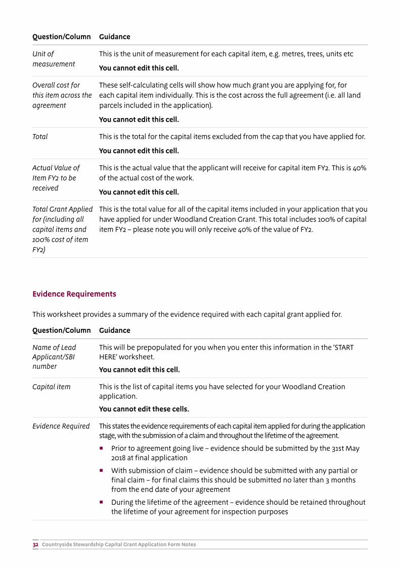
Countryside Stewardship Capital Grant Application Form Notes32
Question/Column Guidance
Unit of measurement
This is the unit of measurement for each capital item, e.g. metres, trees, units etc
You cannot edit this cell.
Overall cost for this item across the agreement
These self-calculating cells will show how much grant you are applying for, for each capital item individually. This is the cost across the full agreement (i.e. all land parcels included in the application).
You cannot edit this cell.
Total This is the total for the capital items excluded from the cap that you have applied for.
You cannot edit this cell.
Actual Value of Item FY2 to be received
This is the actual value that the applicant will receive for capital item FY2. This is 40% of the actual cost of the work.
You cannot edit this cell.
Total Grant Applied for (including all capital items and 100% cost of item FY2)
This is the total value for all of the capital items included in your application that you have applied for under Woodland Creation Grant. This total includes 100% of capital item FY2 – please note you will only receive 40% of the value of FY2.
Evidence Requirements
This worksheet provides a summary of the evidence required with each capital grant applied for.
Question/Column Guidance
Name of Lead Applicant/SBI number
This will be prepopulated for you when you enter this information in the ‘START HERE’ worksheet.
You cannot edit this cell.
Capital item This is the list of capital items you have selected for your Woodland Creation application.
You cannot edit these cells.
Evidence Required This states the evidence requirements of each capital item applied for during the application stage, with the submission of a claim and throughout the lifetime of the agreement.
� Prior to agreement going live – evidence should be submitted by the 31st May 2018 at final application
� With submission of claim – evidence should be submitted with any partial or final claim – for final claims this should be submitted no later than 3 months from the end date of your agreement
� During the lifetime of the agreement – evidence should be retained throughout the lifetime of your agreement for inspection purposes
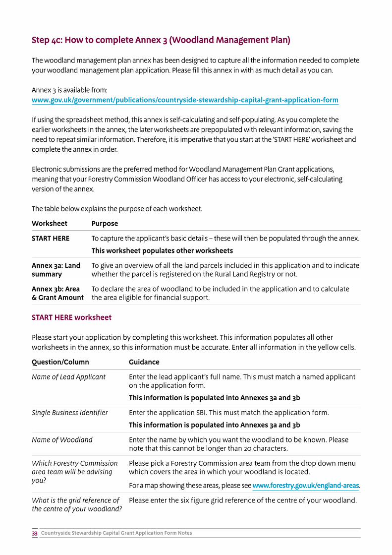
Countryside Stewardship Capital Grant Application Form Notes33
Step 4c: How to complete Annex 3 (Woodland Management Plan)
The woodland management plan annex has been designed to capture all the information needed to complete your woodland management plan application. Please fill this annex in with as much detail as you can.
Annex 3 is available from: www.gov.uk/government/publications/countryside-stewardship-capital-grant-application-form
If using the spreadsheet method, this annex is self-calculating and self-populating. As you complete the earlier worksheets in the annex, the later worksheets are prepopulated with relevant information, saving the need to repeat similar information. Therefore, it is imperative that you start at the ‘START HERE’ worksheet and complete the annex in order.
Electronic submissions are the preferred method for Woodland Management Plan Grant applications, meaning that your Forestry Commission Woodland Officer has access to your electronic, self-calculating version of the annex.
The table below explains the purpose of each worksheet.
Worksheet Purpose
START HERE To capture the applicant’s basic details – these will then be populated through the annex.
This worksheet populates other worksheets
Annex 3a: Land summary
To give an overview of all the land parcels included in this application and to indicate whether the parcel is registered on the Rural Land Registry or not.
Annex 3b: Area & Grant Amount
To declare the area of woodland to be included in the application and to calculate the area eligible for financial support.
START HERE worksheet
Please start your application by completing this worksheet. This information populates all other worksheets in the annex, so this information must be accurate. Enter all information in the yellow cells.
Question/Column Guidance
Name of Lead Applicant Enter the lead applicant’s full name. This must match a named applicant on the application form.
This information is populated into Annexes 3a and 3b
Single Business Identifier Enter the application SBI. This must match the application form.
This information is populated into Annexes 3a and 3b
Name of Woodland Enter the name by which you want the woodland to be known. Please note that this cannot be longer than 20 characters.
Which Forestry Commission area team will be advising you?
Please pick a Forestry Commission area team from the drop down menu which covers the area in which your woodland is located.
For a map showing these areas, please see www.forestry.gov.uk/england-areas.
What is the grid reference of the centre of your woodland?
Please enter the six figure grid reference of the centre of your woodland.
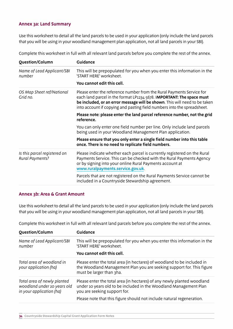
Countryside Stewardship Capital Grant Application Form Notes34
Annex 3a: Land Summary
Use this worksheet to detail all the land parcels to be used in your application (only include the land parcels that you will be using in your woodland management plan application, not all land parcels in your SBI).
Complete this worksheet in full with all relevant land parcels before you complete the rest of the annex.
Question/Column Guidance
Name of Lead Applicant/SBI number
This will be prepopulated for you when you enter this information in the ‘START HERE’ worksheet.
You cannot edit this cell.
OS Map Sheet ref/National Grid no.
Please enter the reference number from the Rural Payments Service for each land parcel in the format LP1234 5678. IMPORTANT: The space must be included, or an error message will be shown. This will need to be taken into account if copying and pasting field numbers into the spreadsheet.
Please note: please enter the land parcel reference number, not the grid reference.
You can only enter one field number per line. Only include land parcels being used in your Woodland Management Plan application.
Please ensure that you only enter a single field number into this table once. There is no need to replicate field numbers.
Is this parcel registered on Rural Payments?
Please indicate whether each parcel is currently registered on the Rural Payments Service. This can be checked with the Rural Payments Agency or by signing into your online Rural Payments account at www.ruralpayments.service.gov.uk.
Parcels that are not registered on the Rural Payments Service cannot be included in a Countryside Stewardship agreement.
Annex 3b: Area & Grant Amount
Use this worksheet to detail all the land parcels to be used in your application (only include the land parcels that you will be using in your woodland management plan application, not all land parcels in your SBI).
Complete this worksheet in full with all relevant land parcels before you complete the rest of the annex.
Question/Column Guidance
Name of Lead Applicant/SBI number
This will be prepopulated for you when you enter this information in the ‘START HERE’ worksheet.
You cannot edit this cell.
Total area of woodland in your application (ha)
Please enter the total area (in hectares) of woodland to be included in the Woodland Management Plan you are seeking support for. This figure must be larger than 3ha.
Total area of newly planted woodland under 10 years old in your application (ha)
Please enter the total area (in hectares) of any newly planted woodland under 10 years old to be included in the Woodland Management Plan you are seeking support for.
Please note that this figure should not include natural regeneration.
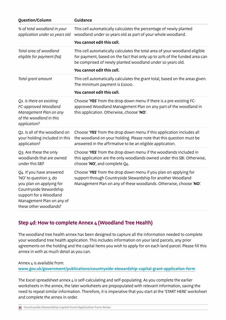
Countryside Stewardship Capital Grant Application Form Notes35
Question/Column Guidance
% of total woodland in your application under 10 years old
This cell automatically calculates the percentage of newly planted woodland under 10 years old as part of your whole woodland.
You cannot edit this cell.
Total area of woodland eligible for payment (ha)
This cell automatically calculates the total area of your woodland eligible for payment, based on the fact that only up to 20% of the funded area can be comprised of newly planted woodland under 10 years old.
You cannot edit this cell.
Total grant amount This cell automatically calculates the grant total, based on the areas given. The minimum payment is £1000.
You cannot edit this cell.
Q1. Is there an existing FC-approved Woodland Management Plan on any of the woodland in this application?
Choose ‘YES’ from the drop down menu if there is a pre-existing FC-approved Woodland Management Plan on any part of the woodland in this application. Otherwise, choose ‘NO’.
Q2. Is all of the woodland on your holding included in this application?
Choose ‘YES’ from the drop down menu if this application includes all the woodland on your holding. Please note that this question must be answered in the affirmative to be an eligible application.
Q3. Are these the only woodlands that are owned under this SBI?
Choose ‘YES’ from the drop down menu if the woodlands included in this application are the only woodlands owned under this SBI. Otherwise, choose ‘NO’, and complete Q4.
Q4. If you have answered ‘NO’ to question 3, do you plan on applying for Countryside Stewardship support for a Woodland Management Plan on any of these other woodlands?
Choose ‘YES’ from the drop down menu if you plan on applying for support through Countryside Stewardship for another Woodland Management Plan on any of these woodlands. Otherwise, choose ‘NO’.
Step 4d: How to complete Annex 4 (Woodland Tree Health)
The woodland tree health annex has been designed to capture all the information needed to complete your woodland tree health application. This includes information on your land parcels, any prior agreements on the holding and the capital items you wish to apply for on each land parcel. Please fill this annex in with as much detail as you can.
Annex 4 is available from: www.gov.uk/government/publications/countryside-stewardship-capital-grant-application-form
The Excel spreadsheet annex 4 is self-calculating and self-populating. As you complete the earlier worksheets in the annex, the later worksheets are prepopulated with relevant information, saving the need to repeat similar information. Therefore, it is imperative that you start at the ‘START HERE’ worksheet and complete the annex in order.
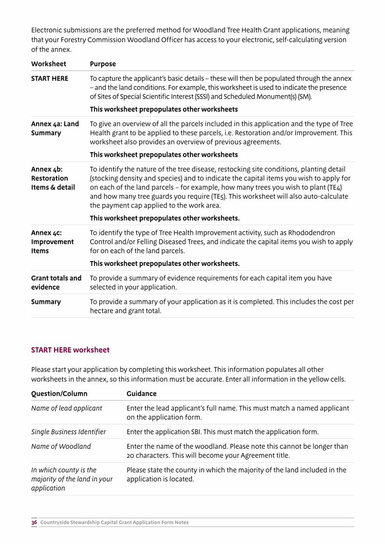
Countryside Stewardship Capital Grant Application Form Notes36
Electronic submissions are the preferred method for Woodland Tree Health Grant applications, meaning that your Forestry Commission Woodland Officer has access to your electronic, self-calculating version of the annex.
Worksheet Purpose
START HERE To capture the applicant’s basic details – these will then be populated through the annex – and the land conditions. For example, this worksheet is used to indicate the presence of Sites of Special Scientific Interest (SSSI) and Scheduled Monument(s) (SM).
This worksheet prepopulates other worksheets
Annex 4a: Land Summary
To give an overview of all the parcels included in this application and the type of Tree Health grant to be applied to these parcels, i.e. Restoration and/or Improvement. This worksheet also provides an overview of previous agreements.
This worksheet prepopulates other worksheets
Annex 4b: Restoration Items & detail
To identify the nature of the tree disease, restocking site conditions, planting detail (stocking density and species) and to indicate the capital items you wish to apply for on each of the land parcels – for example, how many trees you wish to plant (TE4) and how many tree guards you require (TE5). This worksheet will also auto-calculate the payment cap applied to the work area.
This worksheet prepopulates other worksheets.
Annex 4c: Improvement Items
To identify the type of Tree Health Improvement activity, such as Rhododendron Control and/or Felling Diseased Trees, and indicate the capital items you wish to apply for on each of the land parcels.
This worksheet prepopulates other worksheets.
Grant totals and evidence
To provide a summary of evidence requirements for each capital item you have selected in your application.
Summary To provide a summary of your application as it is completed. This includes the cost per hectare and grant total.
START HERE worksheet
Please start your application by completing this worksheet. This information populates all other worksheets in the annex, so this information must be accurate. Enter all information in the yellow cells.
Question/Column Guidance
Name of lead applicant Enter the lead applicant’s full name. This must match a named applicant on the application form.
Single Business Identifier Enter the application SBI. This must match the application form.
Name of Woodland Enter the name of the woodland. Please note this cannot be longer than 20 characters. This will become your Agreement title.
In which county is the majority of the land in your application
Please state the county in which the majority of the land included in the application is located.
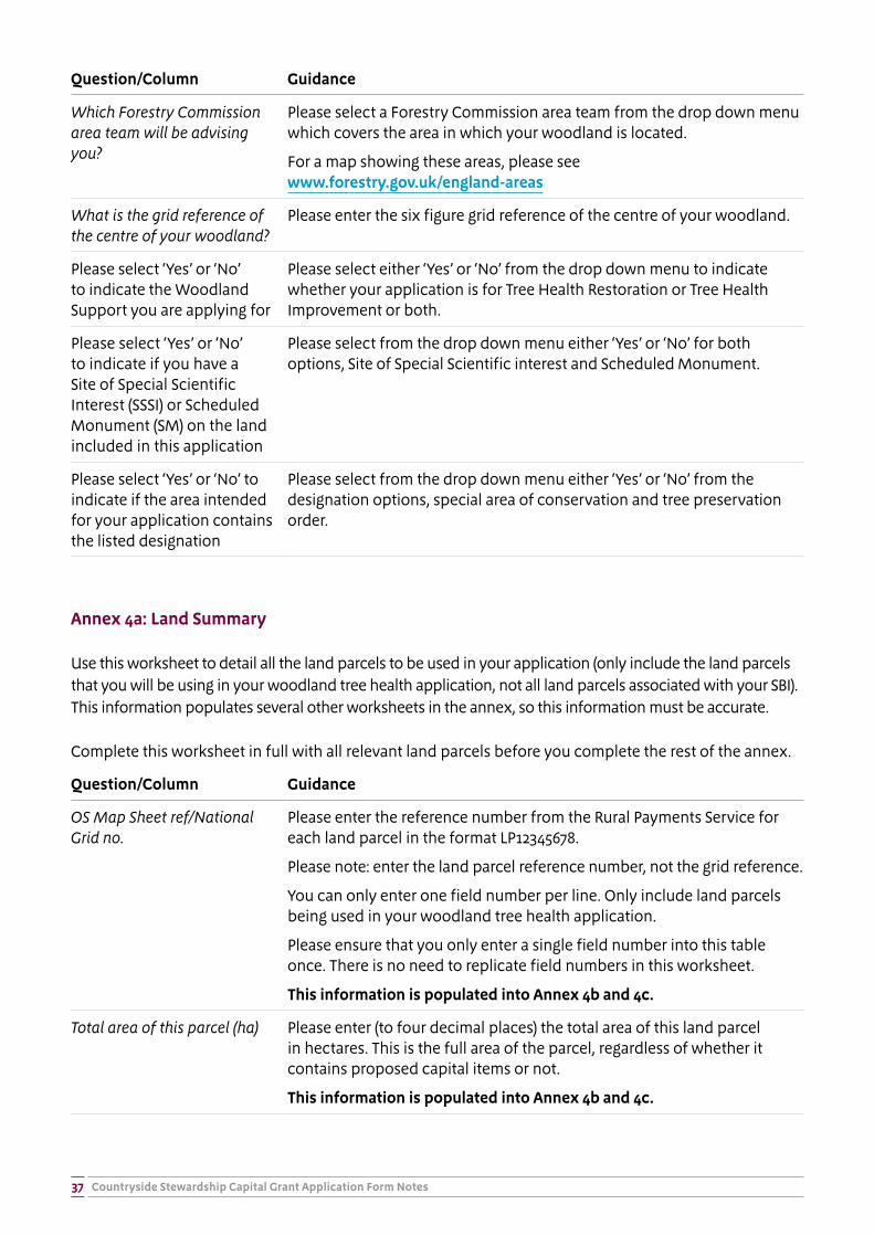
Countryside Stewardship Capital Grant Application Form Notes37
Question/Column Guidance
Which Forestry Commission area team will be advising you?
Please select a Forestry Commission area team from the drop down menu which covers the area in which your woodland is located.
For a map showing these areas, please see www.forestry.gov.uk/england-areas
What is the grid reference of the centre of your woodland?
Please enter the six figure grid reference of the centre of your woodland.
Please select ‘Yes’ or ‘No’ to indicate the Woodland Support you are applying for
Please select either ‘Yes’ or ‘No’ from the drop down menu to indicate whether your application is for Tree Health Restoration or Tree Health Improvement or both.
Please select ‘Yes’ or ‘No’ to indicate if you have a Site of Special Scientific Interest (SSSI) or Scheduled Monument (SM) on the land included in this application
Please select from the drop down menu either ‘Yes’ or ‘No’ for both options, Site of Special Scientific interest and Scheduled Monument.
Please select ‘Yes’ or ‘No’ to indicate if the area intended for your application contains the listed designation
Please select from the drop down menu either ‘Yes’ or ‘No’ from the designation options, special area of conservation and tree preservation order.
Annex 4a: Land Summary
Use this worksheet to detail all the land parcels to be used in your application (only include the land parcels that you will be using in your woodland tree health application, not all land parcels associated with your SBI). This information populates several other worksheets in the annex, so this information must be accurate.
Complete this worksheet in full with all relevant land parcels before you complete the rest of the annex.
Question/Column Guidance
OS Map Sheet ref/National Grid no.
Please enter the reference number from the Rural Payments Service for each land parcel in the format LP12345678.
Please note: enter the land parcel reference number, not the grid reference.
You can only enter one field number per line. Only include land parcels being used in your woodland tree health application.
Please ensure that you only enter a single field number into this table once. There is no need to replicate field numbers in this worksheet.
This information is populated into Annex 4b and 4c.
Total area of this parcel (ha) Please enter (to four decimal places) the total area of this land parcel in hectares. This is the full area of the parcel, regardless of whether it contains proposed capital items or not.
This information is populated into Annex 4b and 4c.
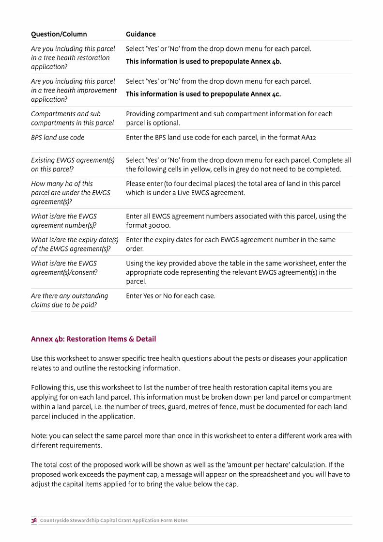
Countryside Stewardship Capital Grant Application Form Notes38
Question/Column Guidance
Are you including this parcel in a tree health restoration application?
Select ‘Yes’ or ‘No’ from the drop down menu for each parcel.
This information is used to prepopulate Annex 4b.
Are you including this parcel in a tree health improvement application?
Select ‘Yes’ or ‘No’ from the drop down menu for each parcel.
This information is used to prepopulate Annex 4c.
Compartments and sub compartments in this parcel
Providing compartment and sub compartment information for each parcel is optional.
BPS land use code Enter the BPS land use code for each parcel, in the format AA12
Existing EWGS agreement(s) on this parcel?
Select ‘Yes’ or ‘No’ from the drop down menu for each parcel. Complete all the following cells in yellow, cells in grey do not need to be completed.
How many ha of this parcel are under the EWGS agreement(s)?
Please enter (to four decimal places) the total area of land in this parcel which is under a Live EWGS agreement.
What is/are the EWGS agreement number(s)?
Enter all EWGS agreement numbers associated with this parcel, using the format 30000.
What is/are the expiry date(s) of the EWGS agreement(s)?
Enter the expiry dates for each EWGS agreement number in the same order.
What is/are the EWGS agreement(s)/consent?
Using the key provided above the table in the same worksheet, enter the appropriate code representing the relevant EWGS agreement(s) in the parcel.
Are there any outstanding claims due to be paid?
Enter Yes or No for each case.
Annex 4b: Restoration Items & Detail
Use this worksheet to answer specific tree health questions about the pests or diseases your application relates to and outline the restocking information.
Following this, use this worksheet to list the number of tree health restoration capital items you are applying for on each land parcel. This information must be broken down per land parcel or compartment within a land parcel, i.e. the number of trees, guard, metres of fence, must be documented for each land parcel included in the application.
Note: you can select the same parcel more than once in this worksheet to enter a different work area with different requirements.
The total cost of the proposed work will be shown as well as the ‘amount per hectare’ calculation. If the proposed work exceeds the payment cap, a message will appear on the spreadsheet and you will have to adjust the capital items applied for to bring the value below the cap.
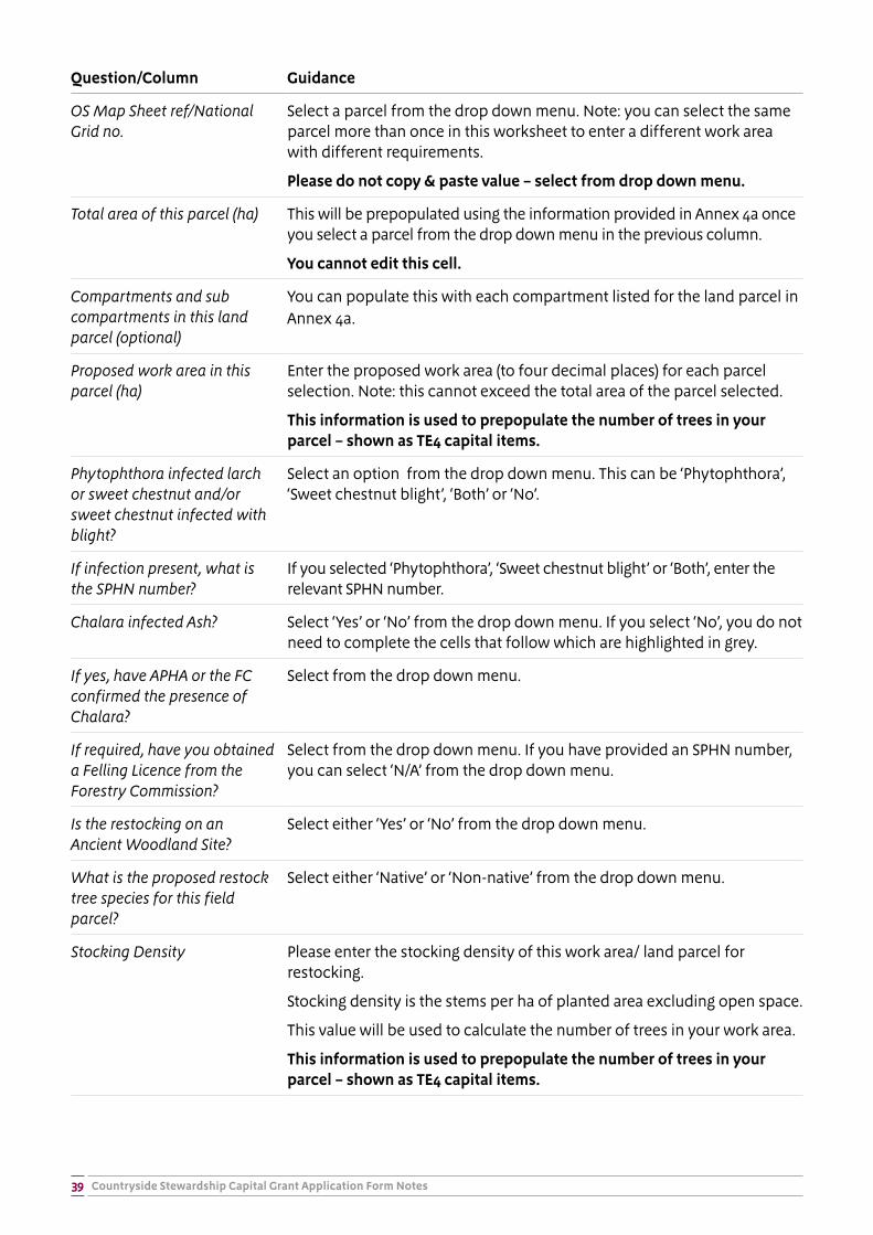
Countryside Stewardship Capital Grant Application Form Notes39
Question/Column Guidance
OS Map Sheet ref/National Grid no.
Select a parcel from the drop down menu. Note: you can select the same parcel more than once in this worksheet to enter a different work area with different requirements.
Please do not copy & paste value – select from drop down menu.
Total area of this parcel (ha) This will be prepopulated using the information provided in Annex 4a once you select a parcel from the drop down menu in the previous column.
You cannot edit this cell.
Compartments and sub compartments in this land parcel (optional)
You can populate this with each compartment listed for the land parcel in Annex 4a.
Proposed work area in this parcel (ha)
Enter the proposed work area (to four decimal places) for each parcel selection. Note: this cannot exceed the total area of the parcel selected.
This information is used to prepopulate the number of trees in your parcel – shown as TE4 capital items.
Phytophthora infected larch or sweet chestnut and/or sweet chestnut infected with blight?
Select an option from the drop down menu. This can be ‘Phytophthora’, ‘Sweet chestnut blight’, ‘Both’ or ‘No’.
If infection present, what is the SPHN number?
If you selected ‘Phytophthora’, ‘Sweet chestnut blight’ or ‘Both’, enter the relevant SPHN number.
Chalara infected Ash? Select ‘Yes’ or ‘No’ from the drop down menu. If you select ‘No’, you do not need to complete the cells that follow which are highlighted in grey.
If yes, have APHA or the FC confirmed the presence of Chalara?
Select from the drop down menu.
If required, have you obtained a Felling Licence from the Forestry Commission?
Select from the drop down menu. If you have provided an SPHN number, you can select ‘N/A’ from the drop down menu.
Is the restocking on an Ancient Woodland Site?
Select either ‘Yes’ or ‘No’ from the drop down menu.
What is the proposed restock tree species for this field parcel?
Select either ‘Native’ or ‘Non-native’ from the drop down menu.
Stocking Density Please enter the stocking density of this work area/ land parcel for restocking.
Stocking density is the stems per ha of planted area excluding open space.
This value will be used to calculate the number of trees in your work area.
This information is used to prepopulate the number of trees in your parcel – shown as TE4 capital items.
Countryside Stewardship Capital Grant Application Form Notes40
Question/Column Guidance
% internal open space in this block
Please enter the % internal space in this work area. This should not exceed 20%.
A definition of what constitutes open space is ‘integral open space that is limited to 20% of the total forest area and individual open spaces that do not exceed 0.5 ha or 20 metres in width. Any larger open areas shall not be considered as forest. Open space shall include forest tracks, rides, wayleaves and other permanent open areas.’
This information is used to prepopulate the number of trees in your parcel – shown as TE4 capital items.
All species in this block Write a list of the species (use either abbreviations, e.g. OK, BE, or full names) to be planted in this work area.
Species % This must include all species and must add up to 100%.
Payment cap per ha This will be prepopulated based on previous tree health questions.
You cannot edit this cell.
Total payment cap for proposed work area
This will be prepopulated based on previous tree health questions.
You cannot edit this cell.
Capital items on this field parcel with per unit cost (TE4, TE5, FG9, FG1, FG2, FG4, FG5, FG12, FG14, FG15)
Please enter the amount of each capital item you wish to apply for on each land parcel and work area. A short description of each item can be found by hovering over the item code. Please enter all measurements for fencing items to 4 decimal places.
Please note: Item TE4 - supply and plant a tree will be prepopulated once you have entered values for proposed work area in this land parcel, the stocking density and the % internal open space.
Total cost of proposed work area
This is a calculation of the cost of all capital items proposed on this land parcel and work area. It will self-calculate as capital items are added. This column will highlight orange and a message will appear if the payment cap has been exceeded.
You cannot edit this cell.
Cost per ha of Proposed Work Area in this parcel
This is a calculation of the cost per hectare in this land parcel and work area.
You cannot edit this cell.
Annex 4c: Improvement items
Use this worksheet to confirm eligibility for this element of the grant and identify and list the number of tree health improvement capital items you are applying for on each land parcel. This information must be broken down per land parcel included in the application.
Note: you can select the same parcel more than once in this worksheet to enter a different work area with different requirements.

Countryside Stewardship Capital Grant Application Form Notes41
Question/Column Guidance
OS Map Sheet ref/National Grid no.
Select the land parcel from the drop down menu. You must have completed Annex 4a in full in order to complete this worksheet.
Note: you can select the same parcel more than once in this worksheet to enter a different work area with different requirements.
Please do not copy & paste value – select from drop down menu.
Total area of this parcel (ha) This will be prepopulated once you select a parcel from the drop down menu in the previous column using the information provided in Annex 4a.
You cannot edit this cell.
Compartments and sub compartments in this land parcel
You can populate this with each compartment listed for the land parcel in Annex 4a.
Are you applying for support to control Rhododendron (item SB6) on this parcel?
Select ‘Yes’ or ‘No’ from the drop down menu.
If yes, how are you confirming your eligibility?
To be eligible to receive grant support for Rhododendron control, the Rhododendron must either be infected with Phytophthora ramorum or Phytophthora kernoviea (confirmed by a Statutory Plant Health Notice (SPHN)) or be within 3km of a SPHN.
If you selected ‘Yes’ in the previous column, please select from the drop down menu either ‘Written confirmation of infection’ or ‘Within 3km of an SPHN’ or ‘Both’.
Area you applying for support to fell diseased trees (item SB1) on this parcel?
Select ‘Yes’ or ‘No’ from the drop down menu.
If yes, what is your SPHN number?
To be eligible to receive grant support to fell diseased trees, immature larch infected with Phytophthora ramorum must be confirmed by a Statutory Plant Health Notice (SPHN)
Enter the SPHN number in this column.
Total area of rhododendron control (item SB6) in this field parcel (ha)
Enter the total proposed work area for rhododendron control in this land parcel, to four decimal places.
Option Code/Description Select the appropriate option Code (SB6a, SB6b or SB6c) according to the most accurate description of the slope and size of the rhododendron.
Payment (per ha) This cell is auto-calculated according to the item Code chosen in the previous column.
You cannot edit this cell.
Countryside Stewardship Capital Grant Application Form Notes42
Question/Column Guidance
Total amount payable for rhododendron control in this work area
The total amount payable for the proposed rhododendron control work is auto-calculated based on the total area of rhododendron control in the parcel and the item code selected.
You cannot edit this cell.
Total area of diseased trees to be felled (item SB1) in this field parcel (ha)
Enter the total proposed work area, to four decimal places, for felling immature larch infected with Phytophthora ramorum in the selected land parcel.
Option Code/Description Select the appropriate option Code (SB1a, SB1b, SB1c, SB1d, SB1e, SB1f) according to the most accurate description of the method of cut and stem diameter).
Payment (per ha) This cell is auto-calculated according to the item Code chosen in the previous column.
You cannot edit this cell.
Total amount payable for felling diseased trees in this work area
The total amount payable for the proposed felling diseased trees work is auto-calculated based on the total area of diseased trees to be felled and the item code selected.
You cannot edit this cell.
Grant totals and evidence
This work sheet provides a summary of the grant totals and evidence requirements for each capital item selected in your application.
Question/Column Guidance
Capital Item/Option Summarises the capital items for Restoration and/or Improvement selected in this application.
Overall quantity on this application
Summarises the quantity per capital item selected in the application.
Overall cost for this item in this application
Summarises the total cost of the proposed work (not the total amount available, i.e. the payment cap) per capital item.
Evidence required – Prior to application
Identifies the evidence required prior to application – this may need to be provided with your application or a reference number stated in the appropriate column and worksheet in the Annex.
Evidence required – Prior to agreement going live
Identifies the evidence required prior to the agreement going live, once your initial application has been submitted.
Evidence required – During the lifetime of the agreement
Identifies the evidence and record keeping required throughout the lifetime of the agreement (for example, photographs).
Countryside Stewardship Capital Grant Application Form Notes43
Summary
This worksheet provides a summary of your application. The Restoration and Improvement grants are presented separately in this worksheet.
Question/Column Guidance
Total planting area in this application (ha)/ Total area of rhododendron control and/or diseased tree felling in this application (ha)
Summarises the total work area, to four decimal places, included in this application.
Total cost for TE4 & TE5/ Total cost for SB6
Summarises the total cost for the capital items selected (TE4 & TE5 for Restoration and SB6 for Improvement)
Total cost for all fencing & gates/ Total cost for SB1
Summarises the total cost of the capital items selected (fencing and gate items for Restoration (FG2, FG4, FG9, FG12, FG14, FG15) and SB1 for Improvement)
Total amount payable Summarises the total amount payable (i.e. the total grant funding available) for Restoration and Improvement as appropriate.
Step 4e: How to print Annex 1, 2, 3 or 4
To print out an Annex: click on File > Print. Under the ‘Printers’ heading, check that the printer you wish to use is selected and amend if necessary. In the Settings field, choose Print Entire Workbook and then click on the Print icon.
Note that to save ink all worksheets will print out without colour. To print a worksheet in colour, click on File > Print > Page Layout and on the Sheet tab remove the tick for Black and White. You will need to do this for each worksheet you wish to print in colour.
IMPORTANT NOTE: If you will be printing the Annex, do not use ‘Page Layout’ on the View tab as it will reset the print area and prevent the annex from printing correctly. If this happens you will need to set your own print area for each of these worksheets by clicking on the Page Layout tab at the top, selecting the area you wish to print e.g. to from the Annex heading to the end of all of the data rows you have completed, and clicking on Print Area > Set Print Area.
Countryside Stewardship Capital Grant Application Form Notes44
Step 5 - Complete Section 3: Declaration and undertakingsComplete Section 3 to confirm that you have read and understood the requirements of the Countryside Stewardship scheme and the undertakings that you are making in submitting your application.
� Read the declaration, undertakings and warning carefully.
� If you are applying for a Hedgerows and Boundaries, Woodland Tree Health grant or Woodland Management Plan grant, sign Section 3 and enter your name in block letters, your capacity (e.g. sole trader, company director, agent etc) and the date of your signature. If you are applying for a Woodland Creation, a signature is not required at the initial submission, and instead will not be required until after the site visit. Please leave the signature section blank.
The party/parties that sign the application at Section 3 must have full authority and capacity to represent and bind the applicant.
If the applicant is a partnership and the partners have not appointed an Application Submission Agent using Rural Payments, all partners must sign.
Countryside Stewardship Capital Grant Application Form Notes45
Step 6 - Complete the ChecklistComplete the checklist to make sure that you have fully completed your application and attached any required supporting documents and evidence, including photographs.
Further information on the supporting documents and evidence you may need to submit with your application is available in the relevant Countryside Stewardship Hedgerows and Boundaries Grant Manual, Countryside Stewardship Woodland Creation Grant Manual, Woodland Management Plan Grant Manual or Countryside Stewardship Woodland Tree Health Grant Manual - (as applicable to your application), the capital item descriptions in the CS Grants tool at www.gov.uk/countryside-stewardship-grants and the Countryside Stewardship: Record keeping and inspection requirements at www.gov.uk/government/publications/countryside-stewardship-record-keeping-and-inspection-requirements.

Countryside Stewardship Capital Grant Application Form Notes46
Step 7 - Submit your applicationYou must sign your application and any supporting forms (not including Annex 1, 2, 3 or 4) by hand. If you are submitting by email you will need to print out the relevant section(s)/form(s) to sign, sign them by hand and scan the documents back into your computer. Please remember to include Annex 1, 2, 3 or 4 (as applicable) with your application.
If applying for Woodland Creation, Woodland Management Plan or Woodland Tree Health grants Annex 2, 3 or 4 must be submitted electronically, even if other documents are submitted by post.
Please send all Parts of the completed form together with maps and other supporting documents to the Natural England office or email address shown in the ‘Important information about your application’ document attached to your application form.
It is recommended that you obtain proof of postage for these and any other documents you send to Natural England. You are advised to retain a copy of your completed application form and maps.
Countryside Stewardship Capital Grant Application Form Notes47
What happens next?Once your application has been received by Natural England, it will be checked to see that:
� you meet the eligibility requirements;
� all the necessary details have been entered on your application form and evidence received; and
� all of your maps have been completed
If your application fails any of the above checks, we will contact you to explain what is wrong and how the failed check(s) can be corrected (if applicable).
If you are applying for Woodland Creation, at this point a Forestry Commission Woodland Officer will be in contact to conduct a site visit and discuss your application, making any edits (in discussion with you) as needed. They will also begin the consultation process as discussed in section 6.2 of the relevant Countryside Stewardship Woodland Creation Grant Manual.
The Hedgerows and Boundaries grant and Woodland Creation grant are competitive, which means that not everyone who applies will be successful. A scoring process based on environmental benefit will be used to select successful applicants.
What will happen if your application has been successful?
If your application is accepted you will be offered an agreement.
What will happen if your application has been unsuccessful?
We will tell you if your application has not been successful.
If you are unsuccessful, you may submit a written representation to Natural England. Your case will then be reviewed.
Woodland Management Plan and Woodland Tree Health grants are not competitive. As long as you meet the eligibility criteria as set out in the respective Countryside Stewardship manual, you will be offered an agreement.
Countryside Stewardship Capital Grant Application Form Notes48
Annex A: Hedgerows and boundaries example map
Countryside Stewardship Capital Grant Application Form Notes 20th December 201649
Annex B: Woodland Creation scoring table
CS Priority Objective Spatial Gateway Design Requirements Scoring LIS Layer colour
Biodiversity Priority Habitat Networks
o pass the spatial gateway for Priority Habitat Networks the land on which the proposed woodland is to be created must be situated wholly within a priority habitat network area (higher or lower).
To check this, open the data layer in LIS (www.forestry.gov.uk/england-lis) titled ‘CS Biodiversity Priority Habitat Network’. There are two priority layers, ‘High’ and ‘Lower’, corresponding to the colours in the column to the right.
You must show within your woodland creation plan that:
� Your proposal has a total area greater than 3ha
� The individual block size is greater than 0.5ha
� A minimum of 80% of the gross area is made up from native broadleaved species (of which up to 20% can be honorary /advancing natives)
� A maximum of 20% of the gross area can be non-natives
Your application must identify the right tree species for the Priority Habitat area (see information at www.forestry.gov.uk/forestry/BEEH-9SZH46 and in the relevant Countryside Stewardship Woodland Creation Grant Manual). You must confirm this species choice with your local Woodland Officer at the site visit.
The ‘High’ priority layer scores 8 points per hectare. The ‘Lower’ priority layer scores 4 points per hectare.
If the LIS layer shows that any part of a woodland block falls into the higher priority layer, the entire area of the block can be scored as high (area multiplied by 8 points). Otherwise, the entire block is scored as low (area multiplied by 4 points).
In Annex 2j of the woodland creation annex, record the total area of proposed woodland creation scoring as high or lower. This will be multiplied by 8 or 4 points automatically to give an ‘Applicant self-score’.
HIGHER
LOWER
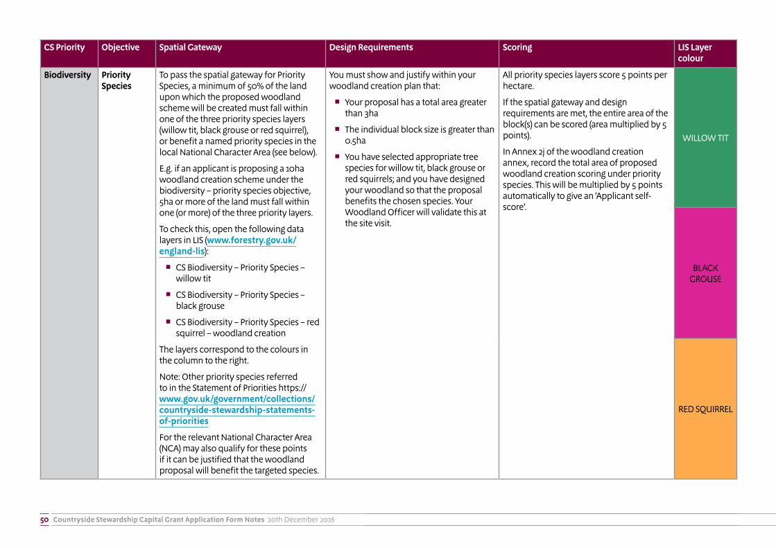
Countryside Stewardship Capital Grant Application Form Notes 20th December 201650
CS Priority Objective Spatial Gateway Design Requirements Scoring LIS Layer colour
Biodiversity Priority Species
To pass the spatial gateway for Priority Species, a minimum of 50% of the land upon which the proposed woodland scheme will be created must fall within one of the three priority species layers (willow tit, black grouse or red squirrel), or benefit a named priority species in the local National Character Area (see below).
E.g. if an applicant is proposing a 10ha woodland creation scheme under the biodiversity – priority species objective, 5ha or more of the land must fall within one (or more) of the three priority layers.
To check this, open the following data layers in LIS (www.forestry.gov.uk/england-lis):
� CS Biodiversity – Priority Species – willow tit
� CS Biodiversity – Priority Species – black grouse
� CS Biodiversity – Priority Species – red squirrel – woodland creation
The layers correspond to the colours in the column to the right.
Note: Other priority species referred to in the Statement of Priorities https://www.gov.uk/government/collections/countryside-stewardship-statements-of-priorities
For the relevant National Character Area (NCA) may also qualify for these points if it can be justified that the woodland proposal will benefit the targeted species.
You must show and justify within your woodland creation plan that:
� Your proposal has a total area greater than 3ha
� The individual block size is greater than 0.5ha
� You have selected appropriate tree species for willow tit, black grouse or red squirrels; and you have designed your woodland so that the proposal benefits the chosen species. Your Woodland Officer will validate this at the site visit.
All priority species layers score 5 points per hectare.
If the spatial gateway and design requirements are met, the entire area of the block(s) can be scored (area multiplied by 5 points).
In Annex 2j of the woodland creation annex, record the total area of proposed woodland creation scoring under priority species. This will be multiplied by 5 points automatically to give an ‘Applicant self-score’.
WILLOW TIT
BLACK GROUSE
RED SQUIRREL
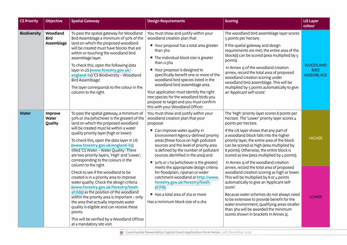
Countryside Stewardship Capital Grant Application Form Notes 20th December 201651
CS Priority Objective Spatial Gateway Design Requirements Scoring LIS Layer colour
Biodiversity Woodland Bird Assemblage
To pass the spatial gateway for Woodland Bird Assemblage a minimum of 50% of the land on which the proposed woodland will be created must have blocks that are within or touching the woodland bird assemblage layer.
To check this, open the following data layer in LIS (www.forestry.gov.uk/england-lis) ‘CS Biodiversity – Woodland Bird Assemblage’.
The layer corresponds to the colour in the column to the right.
You must show and justify within your woodland creation plan that:
� Your proposal has a total area greater than 3ha
� The individual block size is greater than 0.5ha
� Your proposal is designed to specifically benefit one or more of the woodland bird species listed in the woodland bird assemblage area.
Your application must identify the right tree species for the woodland birds you propose to target and you must confirm this with your Woodland Officer.
The woodland bird assemblage layer scores 5 points per hectare.
If the spatial gateway and design requirements are met, the entire area of the block(s) can be scored (area multiplied by 5 points).
In Annex 2j of the woodland creation annex, record the total area of proposed woodland creation scoring under woodland bird assemblage. This will be multiplied by 5 points automatically to give an ‘Applicant self-score’.
WOODLAND BIRD
ASSEMBLAGE
Water Improve Water Quality
To pass the spatial gateway, a minimum of 50% or 1ha (whichever is the greater) of the land on which the proposed woodland will be created must lie within a water quality priority layer (high or lower)
To check this, open the data layer in LIS (www.forestry.gov.uk/england-lis) titled ‘CS Water – Water Quality’. There are two priority layers, ‘High’ and ‘Lower’, corresponding to the colours in the column to the right.
Check to see if the woodland to be created is in a priority area to improve water quality. Check the design criteria (www.forestry.gov.uk/forestry/beeh-9t7ld9) as the position of the woodland within the priority area is important – only the area that actually improves water quality is eligible and can receive these points.
This will be verified by a Woodland Officer at a mandatory site visit.
You must show and justify within your woodland creation plan that your proposal:
� Can improve water quality in Environment Agency-defined priority areas (these focus on high pollutant sources and the level of priority area is defined by the number of pollutant sources identified in the area) and
� 50% or 1 ha (whichever is the greater) meets the appropriate design criteria for floodplain, riparian or wider catchment woodland at http://www.forestry.gov.uk/forestry/beeh-9t7ld9
� Has a total area of 1ha or more
Has a minimum block size of 0.1ha.
The ‘High’ priority layer scores 8 points per hectare. The ‘Lower’ priority layer scores 4 points per hectare.
If the LIS layer shows that any part of a woodland block falls into the higher priority layer, the entire area of the block can be scored as high (area multiplied by 8 points). Otherwise, the entire block is scored as low (area multiplied by 4 points).
In Annex 2j of the woodland creation annex, record the total area of proposed woodland creation scoring as high or lower. This will be multiplied by 8 or 4 points automatically to give an ‘Applicant self-score’.
Because water schemes do not always need to be extensive to provide benefit for the water environment, qualifying areas smaller than 3ha will be awarded the minimum scores shown in brackets in Annex 2j.
HIGHER
LOWER
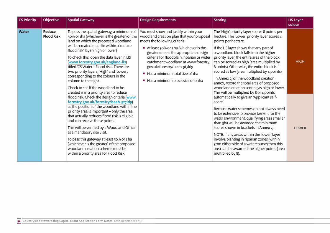
Countryside Stewardship Capital Grant Application Form Notes 20th December 201652
CS Priority Objective Spatial Gateway Design Requirements Scoring LIS Layer colour
Water Reduce Flood Risk
To pass the spatial gateway, a minimum of 50% or 1ha (whichever is the greater) of the land on which the proposed woodland will be created must lie within a ‘reduce flood risk’ layer (high or lower)
To check this, open the data layer in LIS (www.forestry.gov.uk/england-lis) titled ‘CS Water – Flood risk’. There are two priority layers, ‘High’ and ‘Lower’, corresponding to the colours in the column to the right.
Check to see if the woodland to be created is in a priority area to reduce flood risk. Check the design criteria (www.forestry.gov.uk/forestry/beeh-9t7ld9) as the position of the woodland within the priority area is important – only the area that actually reduces flood risk is eligible and can receive these points.
This will be verified by a Woodland Officer at a mandatory site visit.
To pass this gateway at least 50% or 1 ha (whichever is the greater) of the proposed woodland creation scheme must be within a priority area for Flood Risk.
You must show and justify within your woodland creation plan that your proposal meets the following criteria:
� At least 50% or 1 ha (whichever is the greater) meets the appropriate design criteria for floodplain, riparian or wider catchment woodland at www.forestry.gov.uk/forestry/beeh-9t7ld9
� Has a minimum total size of 1ha
� Has a minimum block size of 0.1ha
The ‘High’ priority layer scores 8 points per hectare. The ‘Lower’ priority layer scores 4 points per hectare.
If the LIS layer shows that any part of a woodland block falls into the higher priority layer, the entire area of the block can be scored as high (area multiplied by 8 points). Otherwise, the entire block is scored as low (area multiplied by 4 points).
In Annex 2j of the woodland creation annex, record the total area of proposed woodland creation scoring as high or lower. This will be multiplied by 8 or 4 points automatically to give an ‘Applicant self-score’.
Because water schemes do not always need to be extensive to provide benefit for the water environment, qualifying areas smaller than 3ha will be awarded the minimum scores shown in brackets in Annex 2j.
NOTE: If any areas within the ‘lower’ layer involve planting in riparian zones (within 30m either side of a watercourse) then this area can be awarded the higher points (area multiplied by 8).
HIGH
LOWER
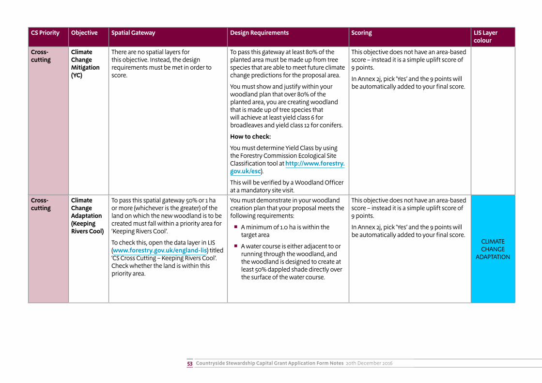
Countryside Stewardship Capital Grant Application Form Notes 20th December 201653
CS Priority Objective Spatial Gateway Design Requirements Scoring LIS Layer colour
Cross-cutting
Climate Change Mitigation (YC)
There are no spatial layers for this objective. Instead, the design requirements must be met in order to score.
To pass this gateway at least 80% of the planted area must be made up from tree species that are able to meet future climate change predictions for the proposal area.
You must show and justify within your woodland plan that over 80% of the planted area, you are creating woodland that is made up of tree species that will achieve at least yield class 6 for broadleaves and yield class 12 for conifers.
How to check:
You must determine Yield Class by using the Forestry Commission Ecological Site Classification tool at http://www.forestry.gov.uk/esc).
This will be verified by a Woodland Officer at a mandatory site visit.
This objective does not have an area-based score – instead it is a simple uplift score of 9 points.
In Annex 2j, pick ‘Yes’ and the 9 points will be automatically added to your final score.
Cross-cutting
Climate Change Adaptation (Keeping Rivers Cool)
To pass this spatial gateway 50% or 1 ha or more (whichever is the greater) of the land on which the new woodland is to be created must fall within a priority area for ‘Keeping Rivers Cool’.
To check this, open the data layer in LIS (www.forestry.gov.uk/england-lis) titled ‘CS Cross Cutting – Keeping Rivers Cool’. Check whether the land is within this priority area.
You must demonstrate in your woodland creation plan that your proposal meets the following requirements:
� A minimum of 1.0 ha is within the target area
� A water course is either adjacent to or running through the woodland, and the woodland is designed to create at least 50% dappled shade directly over the surface of the water course.
This objective does not have an area-based score – instead it is a simple uplift score of 9 points.
In Annex 2j, pick ‘Yes’ and the 9 points will be automatically added to your final score.
CLIMATE CHANGE
ADAPTATION
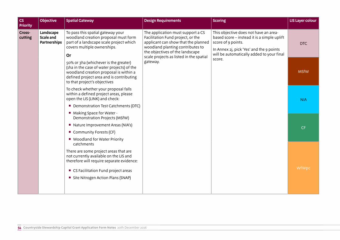
Countryside Stewardship Capital Grant Application Form Notes 20th December 201654
CS Priority
Objective Spatial Gateway Design Requirements Scoring LIS Layer colour
Cross-cutting
Landscape Scale and Partnerships
To pass this spatial gateway your woodland creation proposal must form part of a landscape scale project which covers multiple ownerships.
Or
50% or 3ha (whichever is the greater) (1ha in the case of water projects) of the woodland creation proposal is within a defined project area and is contributing to that project’s objectives
To check whether your proposal falls within a defined project areas, please open the LIS (LINK) and check:
� Demonstration Test Catchments (DTC)
� Making Space for Water - Demonstration Projects (MSfW)
� Nature Improvement Areas (NIA’s)
� Community Forests (CF)
� Woodland for Water Priority catchments
There are some project areas that are not currently available on the LIS and therefore will require separate evidence:
� CS Facilitation Fund project areas
� Site Nitrogen Action Plans (SNAP)
The application must support a CS Facilitation Fund project, or the applicant can show that the planned woodland planting contributes to the objectives of the landscape scale projects as listed in the spatial gateway.
This objective does not have an area-based score – instead it is a simple uplift score of 9 points.
In Annex 2j, pick ‘Yes’ and the 9 points will be automatically added to your final score.
DTC
MSfW
NIA
CF
WfWpc

Countryside Stewardship Capital Grant Application Form Notes55
Annex Ci: Woodland Creation example map – hand drawn using map from www.magic.gov.uk
Capital Items and open space clearly marked on map in coloured pen with item codes included
Top right displays:Single Business IdentifierApplication YearAgreement titleName of business or applicant
Suitable scale either stated or in scale bar
Whole land parcels shown with Land Parcel ID – (area show in table)
Map number
Bottom left displays:OS grid reference

Countryside Stewardship Capital Grant Application Form Notes56
Annex Cii: Woodland Creation example map – created using GIS software
Top right displays:Single Business IdentifierApplication YearAgreement titleName of business or applicant
Capital Items and open space clearly marked on map in coloured pen with item codes included
Bottom left displays:OS grid reference Map number
Whole land parcels shown with Land Parcel ID – (area show in table)
Suitable scale either stated or in scale bar

Natural England is here to secure a healthy natural environment for people to enjoy, where wildlife is protected and England’s traditional landscapes are safeguarded for future generations.
ISBN 978-1-78367-243-1
Catalogue Code: NE648
www.gov.uk/natural-england
Natural England publications are available as accessible pdfs from www.gov.uk/natural-england. Should an alternative format of this publication be required, please contact our enquiries line for more information: 0300 060 3900 or email [email protected].
This publication is published by Natural England under the Open Government Licence v3.0 for public sector information. You are encouraged to use, and reuse, information subject to certain conditions. For details of the licence visit www.nationalarchives.gov.uk/doc/open-government-licence/version/3.
Please note: Natural England photographs are only available for non-commercial purposes. For information regarding the use of maps or data visit www.gov.uk/how-to-access-natural-englands-maps-and-data.
© Natural England 2018