county of inyo background report: renewable energy general
TRANSCRIPT

County of Inyo
Background Report: Renewable Energy
General Plan Amendment
Prepared by the Inyo County Planning Department
October 22, 2013


Table of Contents
i
Inyo County, California October 22, 2013
Introduction ...............................................................................................................................1 1.
Inyo County ..............................................................................................................................1 2.
The County’s Interest and Commitment to Renewable Energy ...............................................3 3.
Economic Potential ...................................................................................................................3 4.
Why a General Plan Amendment .............................................................................................4 5.
Inyo County Code (ICC) Title 21: The Renewable Energy Ordinance ....................................5 6.
2011 REGPA ............................................................................................................................6 7.
Update – REGPA 2013 .............................................................................................................6 8.
Renewable Energy Development Areas (REDA) .....................................................................6 9.
Criteria for REDA .....................................................................................................................7 10.
Solar Energy Generation ...........................................................................................................7 11.
Wind Energy Generation ..........................................................................................................7 12.
The County’s Solar and Wind Potential ...................................................................................8 13.
Criteria for REDAs: Solar Potential Maps and Evaluations .....................................................8 14.
Solar Rooftop ..................................................................................................................8 14.1
Criteria for REDAs: Wind Potential Maps and Evaluations ..................................................11 15.
Criteria for REDAs: Transmission .........................................................................................15 16.
The Renewable Energy Transmission Initiative (RETI) ...............................................15 16.1
California Transmission Planning Group (CTPG) ........................................................18 16.2
Solar Programmatic Environmental Impact Statement (PEIS) .....................................18 16.3
DRECP Transmission Planning ....................................................................................19 16.4
The West-Wide Energy Corridor Programmatic Environmental Impact Statement 16.5
(WWEC-PEIS) .......................................................................................................21
California Independent System Operator (CAISO) ......................................................21 16.6
Nevada Conceptual Transmission Plan .........................................................................21 16.7
LADWP ........................................................................................................................22 16.8
Local Lines ....................................................................................................................22 16.9
Transmission Summary .................................................................................................22 16.10
Criteria for REDAs: Desert Renewable Energy Conservation Plan (DRECP) ......................22 17.
Criteria for REDAs: Slope ......................................................................................................25 18.
Criteria for REDAs: Degraded Land ......................................................................................25 19.
Brownfields ...................................................................................................................25 19.1
Mines .............................................................................................................................25 19.2
Landfills ........................................................................................................................25 19.3
LADWP - Type-A vegetation management areas and Southern Owens Valley Solar 19.4
Ranch – Area Narrowing Study, Area I .................................................................28
Owens Dry Lake ...........................................................................................................28 19.5
Criteria for REDAs: Property Owner Requests ......................................................................28 20.
County Property Surrounding Darwin ..........................................................................28 20.1
Chicago Valley, Tecopa, Panamint and Laws ..............................................................28 20.2
Criteria for REDAs: Proposed and Potential Projects...................................................32 20.3
Areas to be Considered for Exclusion from REDAs ..............................................................34 21.
Areas of Critical Environmental Concern (ACEC) and Desert Wildlife Management 21.1
Areas (DWMA) .....................................................................................................34

Table of Contents
ii
Inyo County, California October 22, 2013
Wilderness Areas ..........................................................................................................34 21.2
Sensitive Species ...........................................................................................................34 21.3
Military interests: China Lake Naval Air Weapons Station (NAWS) and Military 21.4
Flight Zones ...........................................................................................................37
Tribal Land ....................................................................................................................37 21.5
Cultural and Historic Resources....................................................................................37 21.6
Scenic Resources ...........................................................................................................37 21.7
Public Input – REDA Criteria.................................................................................................40 22.
This section will be completed after the public and stakeholder meetings .............................40
The 2011 REGPA ...................................................................................................................40 23.
Summary .................................................................................................................................44 24.
Resources ................................................................................................................................45 25.
Appendices .............................................................................................................................48 26.
• Appendix A: Memorandum of Understanding, California Energy Commission and Inyo
County.
• Appendix B: Inyo County Title 21, the Inyo County Renewable Energy Ordinance.

Table of Contents
iii
Inyo County, California October 22, 2013
List of Maps
Map Title Page
Map 1 Land Ownership Inyo County pg. 2
Map 2 Concentrating Solar Resources of the United States pg. 9
Map 3 Concentrating Solar Resources, Inyo County pg. 10
Map 4 Wind Power Resource Map of California pg. 12
Map 5 50m Wind Power Resource Map of Inyo County pg. 13
Map 6 CalWea Priority Wind Resource Areas pg. 14
Map 7 Existing Power Plants & Transmission Lines pg. 16
Map 8 Proposed Transmission Corridors – Inyo and Surrounding Counties pg. 17
Map 9 BLM Exclusion and Variance Areas pg. 20
Map 10 Draft DRECP Development Focus Areas, based on the seven alternatives pg. 24
Map 11 Inyo County Areas with Slopes less than 5-percent pg. 26
Map 12 Inyo County Degraded Land pg. 27
Map 13
Type-A vegetation management areas and Southern Owens Valley Solar
Ranch – Area Narrowing Study, Area I pg. 29
Map 14 Solar Demonstration Project pg. 30
Map 15 2011 REGPA Areas to Include pg. 31
Map 16 Proposed and Potential Projects pg. 33
Map 17 ACEC and Mojave Ground Squirrel Management Area pg. 35
Map 18 Wilderness Areas pg. 36
Map 19 Federal and State Listed Endangered and Threatened Species pg. 38
Map 20 China Lake and Military Operations Overlay pg. 39
Map 21 Scenic Vistas and Highways pg. 41

List of Acronyms
iv
Inyo County, California October 22, 2013
ACEC Area of Critical Environmental Concern
BLM United States Bureau of Land Management
CAISO California Independent System Operator
CalWEA California Wind Energy Association
CDFW California Department of Fish and Wildlife
CEC California Energy Commission
CEQA California Environmental Quality Act
CPUC California Public Utilities Commission
CREZ Competitive Renewable Energy Zones
CTPG California Transmission Planning Group
DFA Development Focus Areas
DOE Department of Energy
DRECP Desert Renewable Energy Conservation Plan
DWMA Desert Wildlife Management Area
DWP Los Angeles Department of Water and Power
ED Economic Development
EIR Environmental Impact Report
GIS Geographic Information System
ICC Inyo County Code
LADWP Los Angeles Department of Water and Power
LLC Limited Liability Company
LU Land Use
MOU Memorandum of Understanding
NAWS Naval Weapons Station
NREL National Renewable Energy Laboratory
OCTS Opportunities and Constraints Technical Study
PEIR Program Environmental Impact Report
PEIS Programmatic Environmental Impact Statement
PILT Payment in Lieu of Taxes
PSU Public Services and Facilities
PV Photovoltaic
RDSBC Rural Desert Southwest Brownfields Coalition
REAT Renewable Energy Action Team
REDA Renewable Energy Development Areas
REGPA Renewable Energy General Plan Amendment
RETI Renewable energy Transmission Initiative
ROW Right of Way
RPS Renewable Portfolio Standard
SCE Southern California Edison
SEZ Solar Energy Zone
SSTI Southwest Solar Transformation Initiative
WWEC West-Wide Energy Corridor

Background Report, Inyo County Renewable Energy General Plan Amendment
Inyo County, California October 22, 2013 1
Introduction 1.This background report has been prepared to give an overview of Inyo County’s current and
previous efforts to include policies for renewable energy development in its General Plan. It
includes a summary of work regarding renewable energy development done by many other
agencies, organizations and jurisdictions that the County finds important to consider in the
development of General Plan policy. It also provides a foundation for potential criteria that can
be incorporated into any effort by the County to identify areas that may be appropriate for
renewable energy development. This body of work will be shared with stakeholder groups and
the general public for their input. Once the County has received comment and updated the work
in this background report, per stakeholder/public comment, it will be further refined. This
refinement will include an Opportunities and Constraints Technical Study (OCTS) that will
provide more detailed criteria to identify Renewable Energy Development Areas (REDAs) based
not only on the results of the OCTS analysis, but also on the background report and
stakeholder/public input. What is learned from this process will be used to develop policy and
the REDAs. The areas identified as potential REDAs will be the subject of a Programmatic
Environmental Impact Report (PEIR) that, along with draft policy, will include outreach for
additional public input.
This work is being done through a grant from the California Energy Commission (CEC) that was
authorized by AB 113 Perez, and consists of funds from the Renewable Resource Trust Fund.
These funds were made available to the County because of its participation in the Desert
Renewable Energy Conservation Plan (DRECP). The DRECP was established in May 2010, by
an agreement between the California Department of Fish and Wildlife (CDFW), the CEC, US
Bureau of Land Management (BLM), and the US Department of Fish and Wildlife Service
(USFWS) to guide renewable energy development in tandem with a multispecies conservation
plan for the Mojave and Colorado Desert regions. Counties located within the DRECP area were
also invited to participate in the DRECP efforts. Inyo County has been active in the DRECP
since its inception and in March 2013 entered into a Memorandum of Understanding (MOU)
with the CEC. The MOU provides the framework for a cooperative relationship between the
CEC and Inyo County that focuses on effective planning and promotion of renewable energy
development (Appendix A). To further these efforts, the County is updating its General Plan with
policies designed to facilitate the development of eligible renewable energy resources. The
County will focus primarily on solar and wind in its Renewable Energy General Plan
Amendment (REGPA), as geothermal and hydro-electric generation is already adequately
addressed in the General Plan and the Zoning Code.
Inyo County 2.Inyo County is best described as rural. With approximately 10,200-square miles of land and
18,456 people (2010 Census) it has an approximate 1.8 persons-per-square-mile population
density. Most of the land in Inyo County is held in public ownership, less than 2-percent of
County land is privately owned (Map 1: Land Ownership Inyo County). The County has only
one incorporated city (City of Bishop). Most of the County’s population lives in Bishop or in the
areas just surrounding it. The rest of the County’s population lives in small towns scattered
throughout, but with most located on the Highway-395 corridor located in the Owens Valley.

Background Report, Inyo County Renewable Energy General Plan Amendment
Inyo County, California October 22, 2013 2
Map 1: Land Ownership in Inyo County

Background Report, Inyo County Renewable Energy General Plan Amendment
Inyo County, California October 22, 2013 3
Lying on the east side of the Sierra Nevada, the County has a high-desert climate, caused by the
rain shadow effect of the Sierra. These climates are marked by very hot summers and very cold
winters – both predominately dry. The County is part of the basin and range province that
extends across most of the western United States. The basin and range province was created by
faulting in the earth’s crust that caused uplifting, down-dropping, and stretching of the land. The
County’s extreme landscape caused by these geologic forces includes the highest point in the 48-
contiguous states of the United States (Mt. Whitney at 14,505-feet) and the lowest point (Bad
Water Basin in Death Valley at 282-feet below sea level). Inyo County has a rich history of
mining and agricultural activities (primarily cattle ranching).
The County’s Interest and Commitment to Renewable Energy 3.Inyo County has a long history of renewable energy development, beginning with the
construction of the Los Angeles aqueduct. In 1908, the Division Creek hydroelectric power plant
was constructed followed by the Cottonwood Creek hydroelectric power plant. Both were built
for the purpose of providing the electricity needed in the construction the Los Angeles aqueduct.
Subsequent dams and power plants were built along the aqueduct system and are still producing
electricity today. The Southern California Edison Company also has several dams and power
plants along Bishop Creek that produce hydro-electricity.
Inyo County added Title 19 to its Code in 1973 to guide the development of geothermal
resources within its borders. The County also has language in its General Plan encouraging the
development of geothermal resources. These geothermal resources were tapped in 1987, when
the Coso Geothermal Power generation facility was built. It consists of four power plants that
have produced up to 270-Megawatts of electricity.
More recently, the County has been active in the large scale planning for renewable energy
development throughout the desert southwest by involvement in the DRECP, The California
Transmission Planning Group (CTPG), and the Renewable Energy Transmission Initiative
(RETI). The County’s involvement in these groups and initiatives is to promote better land use
and transmission opportunities for responsible renewable energy development in Inyo County. In
2010 the County adopted Title 21: the Inyo County Renewable Energy Ordinance (Appendix B).
The Renewable Energy Ordinance was developed to encourage and guide the development of
solar and wind resources in the County. Also in 2010, the County wrote, and in 2011, adopted a
Renewable Energy General Plan Amendment (REGPA). It was challenged by environmental
groups, though, and the County did not have the funds necessary to try to defend it in court; and
therefore, it was subsequently rescinded. Because of the County’s involvement in the DRECP,
funding has become available to revisit the REGPA and conduct additional environmental
evaluation of it, effectively continuing the County’s legacy of interest and commitment to
renewable energy development.
Economic Potential 4.Inyo County’s economy has historically relied on natural resources as its base. This includes
cattle ranching to supply miners with food during the gold rush, mining a wide variety of
minerals found in the County, sheepherding, orchard and vegetable crops; and tourist based

Background Report, Inyo County Renewable Energy General Plan Amendment
Inyo County, California October 22, 2013 4
activities that take advantage of the unique landscapes and wildlife the County has to offer, such
as camping, hiking, fishing, and hunting. In more recent times, the County has had to rely more
on tourist based activities and services, as well as, government and land management as its main
economic drivers. Renewable energy development has also played a role in the County’s
economy, with the Coso Geothermal Power Plant and several hydroelectric generating facilities.
Additional renewable energy development has the potential to add to the County’s economic
base. With both solar and wind facilities, an initial boost to the local economy can happen during
construction in the form of an increase in the labor force that requires goods and services, land
sales and the use of local materials. In the long term, it can provide higher property and sales tax
revenues; the continued use of local materials; and the provision of long term jobs (more so with
wind than solar) that can, in turn, cause a permanent increase in the procurement of local goods
and services. The County is also well positioned, with an above average potential to provide
renewable energy generation, to help the State meet the 33-percent renewables goal and the
entire country become more energy self-reliant.
Why a General Plan Amendment 5.In California, State law mandates that every City and County adopt a comprehensive, long-term
General Plan. The general plans are a set of policies and programs that form the blueprint for
development throughout a community. General Plans are the basis for land use decisions made
by elected and appointed officials, such as the Board of Supervisors and the Planning
Commission. General Plans also provide the policy framework to develop local zoning
ordinances and maps. California law also requires that each General Plan provide for seven
mandatory elements, they are: Land Use, Circulation, Housing, Conservation, Open Space,
Noise and Safety. A jurisdiction may also include additional elements. Inyo County’s General
Plan has the optional elements of Government and Economic Development.
In 2002, the State of California passed Senate Bill 1078 the California Renewables Portfolio
Standard (RPS). Originally, the RPS required that investor-owned utilities, electric service
providers, and community choice aggregators procure 20-percent of electricity from eligible
renewable energy resources by 2017. In 2006 the RPS was accelerated under Senate Bill 107 to
meet the 20-percent goal by 2010, and in 2011 it was expanded under Senate Bill 2 to require 33-
percent by 2020. It is one of the most ambitious renewable energy standards in the country and
recently Governor Jerry Brown stated that he thought it is possible to reach a 40-percent RPS,
opening the possibility to make it even more ambitious.
In light of the RPS, interest in renewable energy generation grew in Inyo County making it
apparent to County staff and officials that structure and guidance would be required to ensure
that potential development is conducted in a manner consistent with the County’s overall goals
for development. These policies can set the limits of where, when, how, and even if, renewable
energy generation facilities will be built; and, can include provisions for actual sites identified in
the County that are appropriate for renewable energy development; what specific factors must be
met before development can commence; under what conditions a facility can be built; and,

Background Report, Inyo County Renewable Energy General Plan Amendment
Inyo County, California October 22, 2013 5
requirements for the termination of a facility. Without General Plan policy direction these factors
have to be considered on a case by case basis - if at all.
Inyo County Code (ICC) Title 21: The Renewable Energy Ordinance 6.Noncommercial, small scale, photovoltaic (PV) systems for solar energy production are allowed
in all Inyo County zoning districts and require building, electrical permits and California
Environmental Quality Act (CEQA) review. To encourage these small scale, private, PV systems
the County has created an expedited permitting process. In the case of noncommercial wind
energy generation, the County has included in its zoning code: Chapter 18.79 Regulation of
Small Wind Energy Systems. ICC 18.79 includes development standards applied to small wind
energy systems and a requirement that a Conditional Use Permit, which requires Planning
Commission approval with a public hearing, as well as CEQA review, are necessary for all
applications to build them. The stricter requirements applying to noncommercial wind energy
systems are primarily derived from aesthetic, noise, and safety concerns.
ICC Title 21 (Appendix B) provides standards for commercial scale wind and solar energy
development. Under ICC 21, the construction of any commercial solar thermal, photovoltaic, or
wind energy power plant, or an electric transmission line associated with these types of power
plants, requires the developer to either obtain a renewable energy permit or renewable energy
impact determination or enter into a renewable energy development agreement with the County,
and each choice is subject to CEQA review. Which one a developer uses is generally based on
the size and type of facility that is being constructed. For smaller scale projects a renewable
energy permit can be appropriate. The permit must be approved by the Planning Commission,
which requires a public hearing. The specific development standards attached to a renewable
energy permit are decided on a case by case basis and can address the same requirements found
in the rest of the County’s zoning code such as noise, light and glare, height, setbacks, and
distance between structures.
Large scale commercial facilities that are required to obtain approval from the California Energy
Commission or the California Public Utilities Commission prior to construction are exempt from
the County’s requirement to obtain a renewable energy permit. They are, however, required to
obtain a renewable energy impact determination. The purpose of the renewable energy impact
determination is to ensure that the development standards and/or mitigation measures that would
otherwise be addressed in a renewable energy permit are to the extent possible, incorporated into
any approval of the facility granted by a state or federal agency.
The last option, a renewable energy development agreement, is designed to encourage and
support the development of renewable energy projects. These exempt developers from the
requirement of obtaining a renewable energy permit or renewable energy impact determination
and, instead, are tailored to each project and developer through negotiations with the County.
The process for entering into a renewable energy development agreement with the County are
specified in ICC Title 20 – Development Agreements. All commercial scale renewable energy
developments, per ICC 21, must also be consistent with the County’s General Plan.

Background Report, Inyo County Renewable Energy General Plan Amendment
Inyo County, California October 22, 2013 6
2011 REGPA 7.After the adoption of ICC-Title 21 (August 2010) County staff began work on an update to the
General Plan to provide policy direction for commercial scale renewable energy generation
development. The REGPA was completed in April, 2011. Its development was based on
outreach to local, regional, State, Tribal and national stakeholders, government agencies, and the
interested public. As part of this update, a General Plan Land Use Designation Overlay was
created that identified where renewable energy projects, specifically solar and wind, might be
developed. These areas were identified as places appropriate for further review for potential
development, and were not pre-selected sites for development. The areas were identified with
criteria that were based on site specific studies, environmental review, and permitting
requirements pursuant to the Renewable Energy Ordinance and other applicable State, federal,
and local laws. The update to the General Plan consisted of additions to the language in the Land
Use, Public Services and Facilities, Economic Development, Conservation and Open Space, and
Public Safety Elements. The updates focused on: identifying the appropriate means to develop
renewable wind and solar energy resources, provided that social, economic, and environmental
impacts are minimized; offsetting costs to the County and lost economic development potential,
and mitigation of economic effects; working to protect military readiness, and; considering
conversions of lands utilized for agriculture, mining, and recreation. Much of this previous work
has been included in this report to help provide a foundation for the update.
Update – REGPA 2013 8.Under California State Planning guidance, the General Plan is where a community develops its
visions, goals and policies for land use and development. Inyo County is still committed to
updating its General Plan with policies for renewable energy development. By doing so, the
County hopes to provide the proper structure and guidance for potential development and keep it
consistent with overall vision of the County that was adopted through a thorough public process
and expressed in the General Plan. Overall, the County and its citizens are in support of
renewable energy development as long as it is conducted in a manner that does not interfere with
the other goals and visions for the County. Providing for the realization and coordination of the
varying interests in the County, as they relate to renewable energy development, is a primary
goal of the REGPA.
Renewable Energy Development Areas (REDA) 9.As part of the REGPA the County will identify REDAs that may be appropriate for renewable
energy development exploration. They are envisioned to be areas viable for renewable energy
development, based on criteria developed within the confines of: energy generation ability,
proximity to transmission, the presence of biological and cultural attributes, socio-economic
factors, and visual resources, and refined by public input. Identifying sites in this way will help
to direct potential developers to areas that are appropriate, and out of areas that are not. It will
also keep costs to developers down by preventing time lost to looking at sites that are inadequate
or unacceptable. The Programmatic Environmental Impact Report (PEIR) will provide the
opportunity to partially, or in some cases fully, conduct environmental reviews on the REDAs.

Background Report, Inyo County Renewable Energy General Plan Amendment
Inyo County, California October 22, 2013 7
Solar Thermal Power Plant
Criteria for REDA 10.The County developed a set of criteria for identifying areas that may be viable for renewable
energy development during the 2011 REGPA process. These areas were identified as the
Renewable Energy Land Use Designation Overlay. Along with public input, there are factors
that have to be considered and included as criteria as the County moves forward with this current
update and the development of the new or modified REDA. It is essential to identify areas that
have the capacity to generate enough energy to make their development financially feasible;
therefore, the criteria should include areas with the highest potential for renewable energy
generation. These areas must also be close enough to existing transmission corridors to export
energy without the huge expense and environmental disruption of new transmission lines. It is
also vital to minimize disturbance to critical habitats of plants and animals and from important
historic and cultural sites as well as the landscapes and vistas that make Inyo County unique.
Solar Energy Generation 11.The two primary types of solar power
generation technologies are photovoltaic (PV)
panel systems and solar thermal trough or
tower systems. A typical solar thermal power
plant uses hundreds of mirrors to concentrate
sunlight for boiling liquid to produce steam
that spins a turbine. Solar thermal facilities
have potential visual impacts from use of
mirrors, and require intensive water use to
cool turbines. PV panels consist of a series of cells
made from a semiconductor, usually silicon, which
frees electrons to create an electric current. PV
facilities cover a lot of land, over one hundred acres
for large-scale projects generating more than twenty
megawatts of electricity, raising concerns related to
habitat and agricultural lands, cultural, historical,
and visual resources among other possible impacts.
Wind Energy Generation 12.Wind energy producing projects vary in size, from a
few wind turbines (distributed wind systems) serving individual customers or operating either at
substations or at the end of a utility’s distribution system, to large arrays of wind turbines (wind
farms) designed for providing large scale electricity production. Wind farms vary in generating
capacity anywhere from five to more than several hundred megawatts and may consist of a few
to several thousand wind turbines of the same or different sizes/models. The turbines are
mounted on towers and often are placed in linear arrays along ridge tops, or sited in uniform
patterns on flat or hilly terrain. Potential impacts related to wind energy production include the
Photovoltaic Panels

Background Report, Inyo County Renewable Energy General Plan Amendment
Inyo County, California October 22, 2013 8
noise emitted by the wind turbines; the possibility of birds
and bats flying into the turbines; and, visual impacts of the
turbines on the landscape.
The County’s Solar and Wind Potential 13.All of the southwest United States has been identified as
having exceptional solar energy generation potential and
many in the country are looking to the southwest for
opportunities to develop solar energy. Wind energy
generation potential is more scattered. In California, there
are areas with superb wind energy potential, but not in large
area expanses like solar. Based on work done for the
Department of Energy (DOE) by the National Renewable
Energy Laboratory (NREL), Inyo County, like the rest of
the southwest US, has excellent solar energy generation
potential and good to excellent wind energy generation potential in several specific locations.
The information regarding the County’s renewable energy generation potential will serve as a
base for the REDA development.
Criteria for REDAs: Solar Potential Maps and Evaluations 14.NREL, under the sponsorship of DOE, created the Concentrating Solar Resource of the United
States Map (Map 2: Concentrating Solar Resources of the United States). This map illustrates the
potential solar generation resources across the US, expressed in kilowatt hours-per square meter-
per day (kWh/m2/Day). The map was produced with a satellite radiation model developed by the
State University of New York/Albany’s Richard Perez along with NREL, and other universities
working for DOE. The model used to create the map takes hourly radiance images from
geostationary weather satellites, daily snow cover data, and monthly averages of atmospheric
water vapor, trace gases, and the amount of aerosols in the atmosphere, to calculate the hourly
total insolation (sun and sky) falling on a horizontal surface (for more information about the
map, please see: http://www.nrel.gov/gis/solar.html). DOE/NREL allows the use of this data in
the form of ready-made maps as well as the use of Geographic Information Systems (GIS)
shapefiles. The shapefiles allow the data to be shown at scales, which can include only specific
areas (Map 3: Concentrating Solar Resources, Inyo County). This map illustrates that most of
Inyo County is covered by areas with the highest kWh/m2/Day - over 7.5.
Solar Rooftop 14.1Inyo County was also a participant in the Southwest Solar Transformation Initiative (SSTI).
The SSTI was another DOE funded project. It focused on rooftop solar generation potential with
the idea that there is quite a bit of usable area for solar energy generation available on the already
built environment. The SSTI group provided the County with an evaluation of its ability to
generate solar energy from the County’s rooftops. It found that the County could potentially
produce 47,398,000 kilowatt-hours (kWh), over a 5-year period, or enough power production,
over 5-years, for 4,067 homes from its existing rooftops (SSTI Inyo County Roadmap, please
see: http://www.solarroadmap.com/national/california/inyo-county-ca/).
Wind Turbines

Background Report, Inyo County Renewable Energy General Plan Amendment
Inyo County, California October 22, 2013 9
Map 2: Concentrating Solar Resources of the United States

Background Report, Inyo County Renewable Energy General Plan Amendment
Inyo County, California October 22, 2013 10
Map 3: Concentrating Solar Resources, Inyo County

Background Report, Inyo County Renewable Energy General Plan Amendment
Inyo County, California October 22, 2013 11
The SSTI work, like the DOE/NREL Solar Resource Program, provided the County with
invaluable information that emphasized its vast solar energy generation potential. Although most
rooftop solar energy generation potential in Inyo County would come from residential resources
that are already encouraged in the General Plan and allowed in all zoning districts, the County
may still consider solar rooftop energy potential as it develops renewable energy policy.
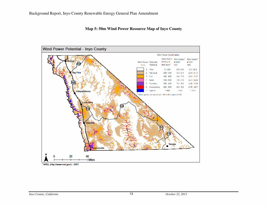
Criteria for REDAs: Wind Potential Maps and Evaluations 15.Wind energy generation potential in Inyo County is not as remarkable as solar, there is, however,
still real potential. The 50m Wind Power Resource Map of California, produced by DOE/NREL,
illustrates wind power potential across the state (Map 4: Wind Power Resource Map of
California). This map was developed with information from the wind resource assessment of the
US. It was created for DOE in 1986 by the Pacific Northwest Laboratory. The wind resource
assessment is based on surface wind data, coastal marine area data and upper-air data, where
applicable. In data-sparse areas, three qualitative indicators of wind speed or power were used
when applicable, they are: topographic/ meteorological indicators (e.g. gorges, mountain
summits, sheltered valleys); wind deformed vegetation; and eolian landforms (e.g. playas, sand
dunes). The data was evaluated at a regional level to produce 12 regional wind resource
assessments. The regional assessments were then incorporated into the national wind resource
assessment (for more information about this map, please see:
http://www.windpoweringamerica.gov/maps_template.asp?stateab=ca). DOE/NREL, as they do
with the solar data, allows access to the GIS shapefiles, so that the data can be shown varying
scales. The 50m Wind Power Resource Map of Inyo County shows that there are sizable areas in
Inyo County with ‘excellent’ wind power potential and small pockets of area with ‘outstanding’
to ‘superb’ potential (Map 5: 50m Wind Power Resource Map of Inyo County).
Through the DRECP efforts, a scenario for wind energy resources was developed by the
California Wind Energy Association (CalWEA). The CalWEA work evaluates areas within the
DRECP for wind energy development potential. The areas are broken into three categories: Wind
Development Focus Areas (Wind-DFA), these areas have the highest wind resource potential,
are within 10-miles of existing transmission corridors and do not overlap with BLM Areas of
Critical Environmental Concern (ACEC) or Desert Wildlife Management Areas (DWMA);
Neutral Areas, these include areas of lower quality (but still commercially viable) wind resources
and high-quality wind resources located in ACECs and DWMAs, all within 10-miles of existing
transmission corridors; and, Reserve Design Areas that are areas within the DRECP where wind
energy development is basically prohibited. They also categorized these area definitions further
with Phase 1 and Phase 2 distinctions. A map produced by CalWEA shows these areas within the
DRECP boundary (Map 6: CalWEA Priority Wind Resource Areas). The map shows that the
area of Inyo County included in the DRECP does have sections identified as Priority Wind
Resource Areas. These areas are found mostly in the Owens Valley, south of Fish Springs to
Pearsonville (minus Owens Dry Lake), as well as, a small area east of Trona. There are also
Neutral areas that surround the DFAs. This map shows that there is wind energy development
potential in Inyo County and within the confines of the DRECP.

Background Report, Inyo County Renewable Energy General Plan Amendment
Inyo County, California October 22, 2013 12
Map 4: Wind Power Resource Map of California
Background Report, Inyo County Renewable Energy General Plan Amendment
Inyo County, California October 22, 2013 13
Map 5: 50m Wind Power Resource Map of Inyo County

Background Report, Inyo County Renewable Energy General Plan Amendment
Inyo County, California October 22, 2013 14
Map 6: CalWEA Priority Wind Resource Areas

Background Report, Inyo County Renewable Energy General Plan Amendment
Inyo County, California October 22, 2013 15
Criteria for REDAs: Transmission 16.Several planning efforts have been dedicated to the evaluation of the current transmission line
capabilities and necessary upgrades that may be required to carry additional electricity that
would be generated by renewable energy resources based on the State’s RPS. The potential to
develop renewable energy resources in specific areas will be dependent on transmission capacity
as it is pointless to generate energy that cannot be delivered. The County is using these resources
to help identify appropriate areas for renewable energy development (Map 7: Existing Power
Plants & Transmission Lines).
The Renewable Energy Transmission Initiative (RETI) 16.1The RETI was coordinated by a committee that included staff from the California Public Utilities
Commission (CPUC); the CEC, the California Independent System Operator; Northern
California Power Agency; Southern California Public Power Authority; and, the Sacramento
Municipal Utility District. This group, through a series of studies, evaluated transmission
projects that would be needed to accommodate the RPS goals, support future energy policy, and
facilitate transmission corridor designation and transmission and generation (power plant) siting
and permitting. It assessed areas identified as Competitive Renewable Energy Zones (CREZ) in
California. These areas were selected based on their ability to provide significant electricity to
California consumers by the year 2020, while also being cost effective and having low impacts
on the environment. The transmission plans developed by the RETI used the CREZs for
development areas to base their evaluations (Map 8: Proposed Transmission Corridors – Inyo
and Surrounding Counties).
Competitive Renewable Energy Zones (CREZ) areas were identified within the RETI with goals
and criteria including:
• Minimize area needed to collect and transmit energy
• Minimize proximity to protected areas
• Minimize disruption of wildlife and species of special significance
o Significant species frequency
o Wildlife corridors
o Important bird areas
• Maximize utilization of previously disturbed lands
o Disturbed area sites (previously developed, including resource extraction)
• Expected generation capacity and annual energy potential
• Transmission rights of way
• Transmission availability and resource capacity
o Engineering feasibility
The CREZ were also given an economic ranking that was determined based on the value of all
resources located within each CREZ, relative to their size and limitations (Map 8: Proposed
Transmission Corridors – Inyo and Surrounding Counties).

Background Report, Inyo County Renewable Energy General Plan Amendment
Inyo County, California October 22, 2013 16
Map 7: Existing Power Plants & Transmission Lines

Background Report, Inyo County Renewable Energy General Plan Amendment
Inyo County, California October 22, 2013 17
Map 8: Proposed Transmission Corridors – Inyo and Surrounding Counties
Background Report, Inyo County Renewable Energy General Plan Amendment
Inyo County, California October 22, 2013 18
California Transmission Planning Group (CTPG) 16.2The CTPG also studied the State’s current transmission capacity as it relates to renewable
energy. The CTPG evaluated existing transmission for potential additional delivery capacity and
for transmission reliability. Their work focused on the large scale movement of electricity and
did not provide mapped areas, but instead, a list of priority transmission projects. The CTPG did
not identify transmission upgrades in Inyo County as high or medium potential upgrades (these
are based on projects already approved, or in the planning stage, and convenience for large scale
and interstate transmission), although they did identify potential need for additional capacity on
current transmission lines that run through the Owens Valley if additional electricity is imported
from northern California the Pacific North West or Northern Nevada.
Solar Programmatic Environmental Impact Statement (PEIS) 16.3PEIS was an effort by the Bureau of Land Management (BLM) and DOE to study the availability
of BLM land for solar development and transmission projects. The geographic scope of the PEIS
for the BLM includes all BLM-administered lands in a six-state study area: Arizona, California,
Colorado, Nevada, New Mexico, and Utah. The scope of the impact analysis included an
assessment of the potential environmental, social, and economic impacts of utility-scale solar
facilities and the required transmission connections from these facilities to the existing electricity
transmission grid and other associated infrastructure such as roads over an approximately 20-
year time frame (until about 2030). The PEIS also evaluated BLM land for right-of-way (ROW)
access for transmission facilities to make private solar energy development possible on private
land. This work identified some BLM land located in Inyo County as available for solar energy
ROW authorizations.
The BLM’s PEIS work was based on the development of Solar Energy Zones (SEZ). The SEZs
are defined areas where the BLM may prioritize and facilitate utility-scale production of solar
energy and associated transmission infrastructure development. SEZs are relatively large areas
that provide highly suitable locations for utility-scale solar development: locations where solar
development is economically and technically feasible, where there is good potential for
connecting new electricity-generating plants to the transmission distribution system, and where
there is generally low resource conflict. ROWs for utility-scale solar energy development in
SEZs will be given priority over all other ROWs. In the final PEIS BLM identified two SEZs in
California that are located in Imperial and Riverside counties – none were established in Inyo
County. County leaders were disappointed with this result as the County has maintained a high
level of interest in renewable energy development and welcomed SEZs within it boundary. The
County appealed the BLMs decision to exclude SEZ in Inyo County based on arguments that:
• The decision was inconsistent with the need identified in the PEIS to provide for utility
scale solar energy development on public land, provide flexibility to the solar industry to
consider a variety of solar energy projects, optimize existing transmission infrastructure
and corridors, and meet projected demand for solar energy development;
• BLM’s plans were inconsistent with County plans and policies and therefore the results
were detrimental to the citizens of Inyo County; and,
Background Report, Inyo County Renewable Energy General Plan Amendment
Inyo County, California October 22, 2013 19
• Many lands were excluded based on the BLM’s land category of Special Recreation
Management Areas (SMRA) and BLM was not able to provide a satisfactory definition
for the SMRA designation.
BLM contended that their planning efforts did meet the objectives set forth in the PEIS, which
were based on numerous federal orders and mandates and that BLM’s work was consistent with
officially approved or adopted resource-related plans of Indian tribes, other Federal agencies, and
State and local governments to the extent that the resource-related plans agreed with the Federal
Land Policy Management Act of 1976 and other the Federal laws and regulations they were
operating under; and, further explained that a SRMA is an administrative unit where the existing
or proposed recreation opportunities and recreation setting characteristics are recognized for their
unique value, importance, and/or distinctiveness, especially as compared to other areas used for
recreation and were excluded due to their recreational value. The BLM also advised the County
that it could petition BLM for new or expanded solar energy zones in or in proximity to Inyo
County and that future efforts to identify priority areas for solar energy development would be
most appropriately conducted at the state or field office level as an individual land use planning
effort, or as part of an ongoing land use plan revision. The BLM also encouraged the County to
participate in the DRECP work, which it has been doing since the DRECP work began.
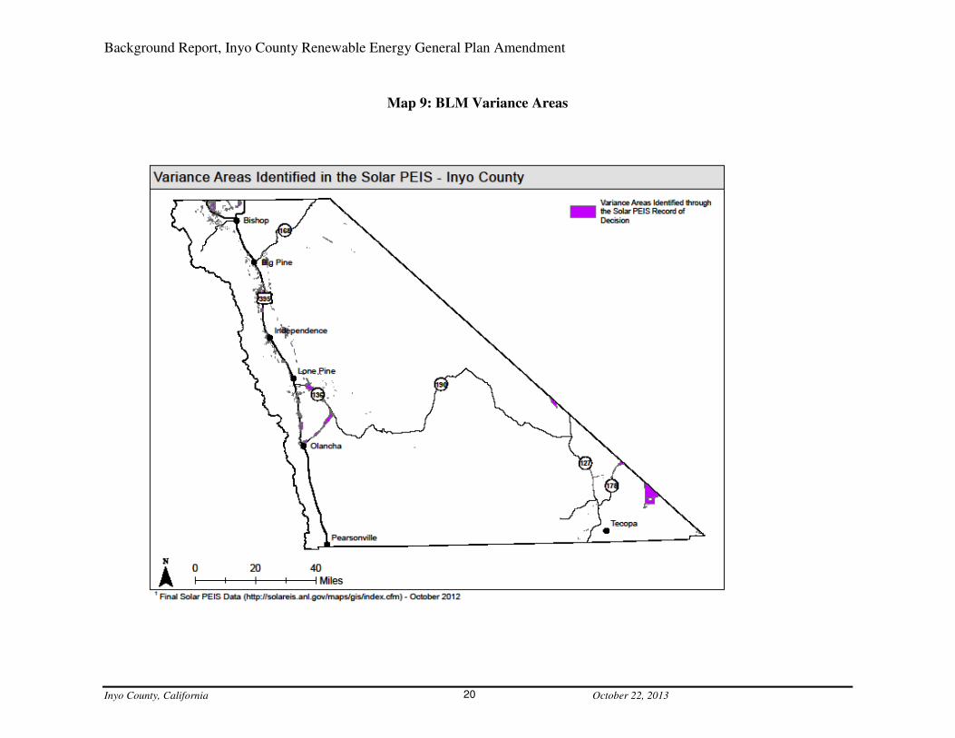
The PEIS identified the lands that were proposed to be excluded from the SEZ and areas that
might have development potential, but would require a variance. Exclusion areas are public lands
to be avoided due to potential resource conflicts; to be reserved for other public uses; and, to
keep lands that are not well suited for utility-scale solar energy development out of the SEZs.
Variance areas are those areas that have been identified as possibly appropriate for development,
but would require a variance from the BLM prior to any construction. The variance areas are the
only areas identified in the PEIS for potential solar energy development in Inyo County. (Map 9:
BLM Variance Areas).
DRECP Transmission Planning 16.4The DRECP is a regional planning effort that focuses on the areas of the Colorado and Mojave
deserts located in California. As part of the DRECP planning process, an analysis of transmission
needs was conducted. This analysis focused on the areas defined in the DRECP process as
Development Focus Areas (DFA) and evaluated what the transmission needs would be to
develop within them. These areas were selected based on their ability to provide high‐quality
renewable energy resources; their access to existing or planned transmission and other
supporting infrastructure; and, where impacts to wildlife and natural communities could be
appropriately managed and mitigated. Six alternatives were examined (five included area within
Inyo County). In each of these five alternatives, the conceptual transmission upgrades likely to
be required to serve the conceptual DFAs, are: a new substation located, roughly, between
Independence and Lone Pine and a new substation located near Ridgecrest, both serving a new
transmission line that extends between them; and, a new transmission line extending from the
new substation located between Independence and Lone Pine to the Keeler area (Map 8:
Proposed Transmission Corridors – Inyo and Surrounding Counties).
Background Report, Inyo County Renewable Energy General Plan Amendment
Inyo County, California October 22, 2013 20
Map 9: BLM Variance Areas

Background Report, Inyo County Renewable Energy General Plan Amendment
Inyo County, California October 22, 2013 21
The West-Wide Energy Corridor Programmatic Environmental Impact 16.5
Statement (WWEC-PEIS) The Bureau of Land Management and the U.S. Departments of Energy, Agriculture, and
Defense, as part of their work to implement Section 368 of the Energy Policy Act of 2005,
prepared a Programmatic Environmental Impact Statement (PEIS) for Energy Corridors in
Eleven Western States. The PEIS identifies energy corridors to facilitate future siting of oil, gas,
and hydrogen pipelines, as well as renewable energy development projects and electricity
transmission and distribution facilities on federal lands in the West to meet the region’s
increasing energy demands while mitigating potential harmful effects to the environment. The
PEIS identified corridors through the Owens and Rose Valleys roughly following existing
transmission lines, as well as along the County’s eastern boundary with Nevada (Map 8:
Proposed Transmission Corridors – Inyo and Surrounding Counties).
California Independent System Operator (CAISO) 16.6CAISO is a nonprofit, public benefit, corporation serving as the independent grid operator that
manages the flow of electricity across the high-voltage, long-distance power lines that make up
80-percent of California’s and a small part of Nevada’s power grid. As part of their responsibility
for power transmission, CAISO develops a yearly transmission plan. These plans are based on
studies of electricity needs in low to high use period scenarios, transmission of electricity from
out-of-state sources and renewable resources. The latest of these plans 2012-2013 identifies the
transmission corridors held by Inyo County’s two electricity providers Southern California
Edison (SCE) and the Los Angeles Department of Water and Power (LADWP). The SCE
transmission line service area that includes Inyo County is referred to as North of Lugo. It spans
south to north serving San Bernardino, Kern, Inyo and Mono Counties and has ties into LADWP
lines. The CAISO modeling identified various reliability concerns on the North of Lugo system.
The proposed fixes are minor and do not include upgrades or increases in capacity to the system.
SCE has no plans or proposals to generate or purchase power from locations that would require
upgrades to the transmission lines that run through Inyo County. SCE also has transmission lines
in the area identified as East of Lugo. This is a major transmission line that connects California,
Nevada and Arizona. Upgrades to a 35-mile section of this line were approved for increased
capacity from Ivanpah to El Dorado. This line also serves as the tie into Valley Electric facilities
between Nevada and California. Although not mentioned in the CAISO plan, this line may
provide the potential in the future for additional transmission to southeast Inyo County.
Nevada Conceptual Transmission Plan 16.7The Nevada transmission plan was developed through a collaboration of utility companies in the
State of Nevada to upgrade the State’s transmission system to serve renewable energy zones
(established through work conducted by Nevada Renewable Energy Transmission Access
Advisory Committee). Nevada’s plan includes a potential western route that could serve as a
transmission section for linking northern and southern California. This conceptual line would run
from northeast California to the Amargosa Valley in southwest Nevada. The expanded
transmission capacity in Nevada would help Nevada energy developers get electricity to
California markets. It might also create potential opportunities for local transmission lines to
branch off of it allowing for renewable energy generated in Inyo County to be delivered to

Background Report, Inyo County Renewable Energy General Plan Amendment
Inyo County, California October 22, 2013 22
southern California and Nevada markets Nevada (Map 8: Proposed Transmission Corridors –
Inyo and Surrounding Counties).
LADWP 16.8LADWP has transmission lines that run along the east side of the Owens Valley, beginning in
the Owens River Gorge and continuing into the San Fernando Valley. According to LADWP’s
Southern Owens Valley Solar Ranch EIR, 2013, LADWP has transmission availability on this
line and has a proposal for a solar project adjacent to it. This solar project will use most of the
rest of the existing capacity on the LADWP line. Recently, LADWP was approved for an
upgrade at its Barren Ridge transfer station that will increase the capability to move electricity
from the Barren Ridge area into southern California, and opens the potential to increase capacity
from the north to Barren Ridge if the lines into the Owens Valley and from the Owens Valley to
Barren Ridge are ever upgraded.
Local Lines 16.9Local lines can be found throughout Inyo County. Although these lines are far from each other
and serve specific, isolated, areas, they have the potential to be upgraded or to have new higher
capacity transmission located in their ROWs that could ultimately serve renewable energy
generation facilities. These lines run from main lines, including but not limited to: Deep Springs,
Panamint, Darwin, Death Valley Junction and Tecopa (Map 7: Existing Power Plants &
Transmission Lines).
Transmission Summary 16.10The County will include the transmission information in identifying the REDAs. It will
incorporate the mapping elements from the RETI, DRECP, the WWEC-PEIS and the Solar
PEIS, as well as the information contained in the other studies and plans that indicated there are
no current plans for upgrading transmission in Inyo County in the near future. The County’s
General Plan also provides direction through policies to consider the visual and environmental
impacts associated with the placement of regional conveyance corridors (including utilities) and
further encourages the co-location of such facilities. Staff will use this policy direction to
identify REDAs close to existing regional transmission lines so that future needs for additional
capacity could be met by co-locating in already established utility ROWs. Staff will also include
areas that could be reached by local transmission lines that are close or convenient, based on
ROW availability with minimal impacts.
Criteria for REDAs: Desert Renewable Energy Conservation Plan 17.
(DRECP) The DRECP is a regional planning effort that focuses on the areas of the Colorado and Mojave
deserts located in California. The DRECP boundary encompasses approximately 35,292 square
miles of the southeast portion of California stretching from the US-Mexico Border up into Inyo
County. Within Inyo County, the DRECP area covers 4,668 square miles of the county or
roughly 46% of the land area. The western flank of the DRECP area includes the Owens Valley
and extends from the southern boundary of Inyo County near Pearsonville to approximately 5-
miles south of Big Pine and is bordered on the west by the Sierra Nevada Mountains and on the

Background Report, Inyo County Renewable Energy General Plan Amendment
Inyo County, California October 22, 2013 23
east by the Inyo Mountains. The
DRECP encompasses portions
of the China Lake Naval
Weapons Center including the
Coso Basin. The middle flank of
the DRECP occupies the
Panamint Valley and extends
from the Inyo County boundary
near Trona to approximately 3-
miles south of Hunter Mountain
and is bordered on the west by
the Argus Range and on the east
by the Panamint Range. The
eastern flank of the DRECP area
covers much of the southeast
portion of Inyo County
including portions of Pahrump Valley, Chicago Valley, and Death Valley. A large portion of the
eastern flank lies within the Death Valley National Park. This portion of the DRECP is bordered
on the west by the Panamint Range and on the east by the Grapevine Mountains. The northern
terminus of this portion ends at the California-Nevada border near Last Chance Canyon
California.
The DRECP was established in reaction to federal and state legislation enacted to promote
renewable energy development, while providing for the conservation and management of plant
and wildlife communities. The DRECP includes the development of solar thermal, utility-scale
solar photovoltaic (PV), wind, and other forms of renewable energy and associated infrastructure
such as electric transmission lines necessary for renewable energy development. It was prepared
by a collaboration of state and federal agencies, with input from local governments,
environmental organizations, industry, and other interested parties.
A Renewable Energy Action Team (REAT) was assembled to be responsible for the
development of the DRECP by a state executive order to streamline permit review and issuance
time for renewable energy projects and to recommend avoidance measures or alternatives when
appropriate. The REAT developed Solar Study Areas that were identified as potential areas for
utility‐scale solar development. These areas were identified based on a number of criteria,
including quality of solar resources, suitable slope, proximity to roads and transmission, acreage,
and the conservation value of the land. Following further study, the areas were further refined to
be available for projects capable of producing 10-megawatts, or more, of electricity for
distribution. When the final DRECP is completed, it is expected to provide binding, long-term
endangered species permit assurances while facilitating the review and approval of compatible
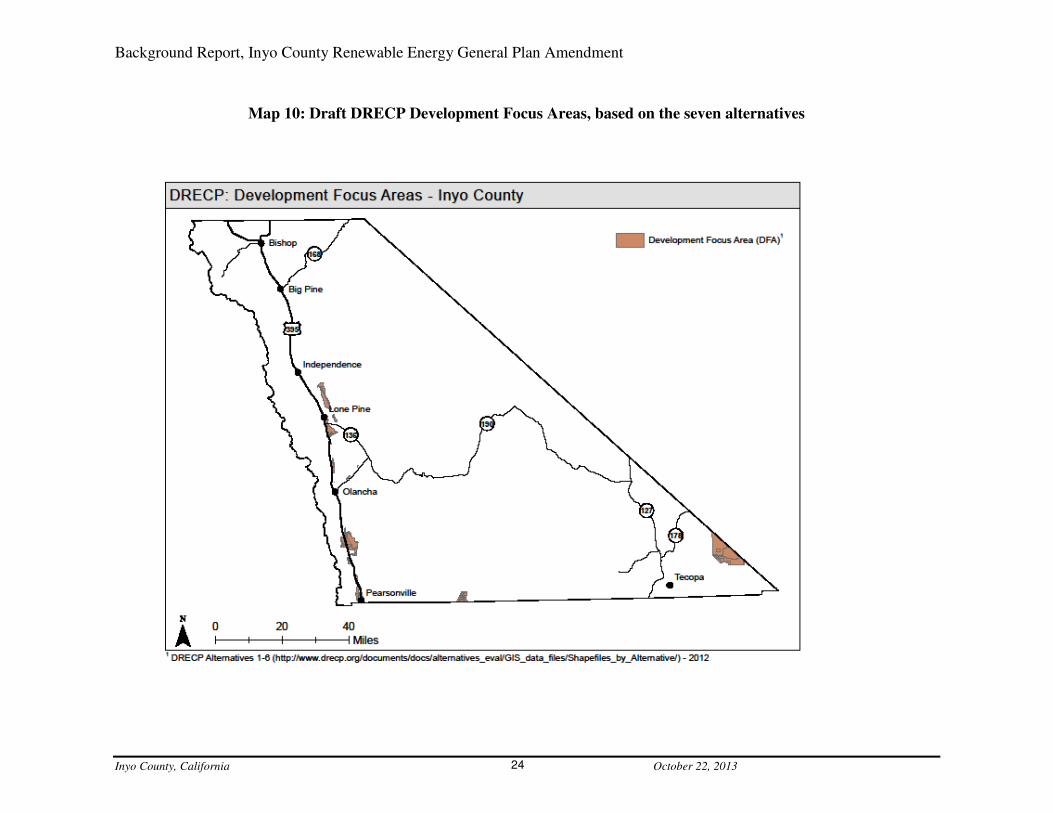
renewable energy projects. Currently the DRECP is in review with seven alternatives being
considered. Staff will include areas identified as appropriate for development with the DRECP
mapping information (Map 10: Draft DRECP Development Focus Areas, based on the seven
alternatives).
DRECP in Inyo County Inyo
Background Report, Inyo County Renewable Energy General Plan Amendment
Inyo County, California October 22, 2013 24
Map 10: Draft DRECP Development Focus Areas, based on the seven alternatives

Background Report, Inyo County Renewable Energy General Plan Amendment
Inyo County, California October 22, 2013 25
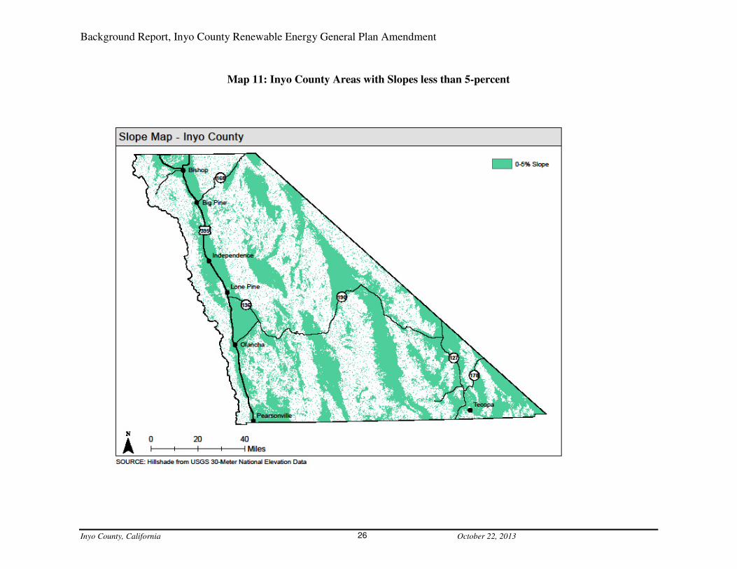
Criteria for REDAs: Slope 18.The placement of solar energy generating facilities requires a relatively flat terrain. Parabolic
trough systems require a terrain with less than 2-percent slope; a 1-percent slope is ideal. Photo
Voltaic panels are best located on terrains with slopes less than five-percent. The requirements
for solar energy generation systems regarding slope optimize the systems’ ability to capture the
sun’s solar radiation at varying angles throughout the day. The BLM used a less than 5-percent
slope in the analysis for the PEIS. County staff repeated the use of less than 5-percent slope for
the REDA criteria (Map 11: Inyo County Areas with Slopes less than 5-percent).
Criteria for REDAs: Degraded Land 19.Degraded land is land that has previously been developed or disturbed in one form or another.
This can include anything from abandoned housing to old mining sites. Degraded land can be a
valuable asset for redevelopment, and depending on the specific conditions of the sites, is
considered throughout many of the studies regarding renewable energy development, as land to
consider for development.
Brownfields 19.1The Rural Desert Southwest Brownfields Coalition (RDSBC) was established in 2011 and is
made up of five counties: four from Nevada, Nye, Esmeralda, Lincoln, and White Pine; and,
Inyo County, in California. The RDSBC Counties’ work focused on opportunities for renewable
energy development, energy efficient technologies, and other “clean economy” projects.
Currently two properties have been identified in Inyo County for potential brownfield
redevelopment and one is potentially appropriate for renewable energy development. It is
approximately100-acres of predominantly vacant land and is located on the west bank of the
Owens Dry Lake, approximately ten-miles south of Lone Pine. Originally, the site was used by
PPG Industries Bartlett Plant (PPG) as a salt extraction facility, until it ceased operation in
1958. Redevelopment ideas for the PPG Plant site have included a renewable energy project
(Map 12: Inyo County Degraded Land). The RDSBC funding includes Phase I and Phase II
assessments of the sites identified. As work with the RDSBC continues, additional sites within
Inyo County may be identified as possible locations for renewable energy development.
Mines 19.2There are numerous abandoned mine sites throughout Inyo County. Many of these sites are on
BLM, National Forest and National Park lands. As the REGPA work continues, staff will further
evaluate abandoned mines and borrow pits sites that might have the potential for renewable
energy redevelopment (Map 12: Inyo County Degraded Land).
Landfills 19.3Landfills within Inyo County were identified during the 2011 REGPA as places that may be
appropriate for renewable energy development. They are located throughout the County and
could be redeveloped as they become full, or in areas that are currently taken out of service.
There are landfills that service, and are located, near each of the County’s communities (Map 12:
Inyo County Degraded Land).
Background Report, Inyo County Renewable Energy General Plan Amendment
Inyo County, California October 22, 2013 26
Map 11: Inyo County Areas with Slopes less than 5-percent

Background Report, Inyo County Renewable Energy General Plan Amendment
Inyo County, California October 22, 2013 27
Map 12: Inyo County Degraded Land

Background Report, Inyo County Renewable Energy General Plan Amendment
Inyo County, California October 22, 2013 28
LADWP - Type-A vegetation management areas and Southern Owens 19.4
Valley Solar Ranch – Area Narrowing Study, Area I As part of the Long Term Water Agreement entered into by Inyo County and the LADWP a
study of vegetation communities was conducted. These vegetation communities were
categorized into five management categories based on plant water use requirements. Type-A
management areas are described under the water agreement as non-groundwater dependent and
were considered as areas to be explored for renewable energy development early in the process.
As LADWP seriously began exploring its properties in the Owens Valley for potential sites for
solar energy development it included areas with Vegetation Type-A criteria and then expanded
its criteria to include many other factors, including but not limited to: sensitive wildlife and plant
communities; sensitive visual and cultural resources; wetland, riparian areas and springs; flood
hazard areas; and, distance to transmission (Map 13: Type-A vegetation management areas and
Southern Owens Valley Solar Ranch – Area Narrowing Study, Area I). This work effectively
eliminated the northern area of the Owens Valley, roughly everything north of Independence.
Owens Dry Lake 19.5The Owens Dry Lake is approximately 110-square-miles in size and, historically, it was the
terminus of the Owens River. The Owens River and other area streams that fed Owens Lake
were diverted by LADWP into the Los Angeles Aqueduct, which was completed in 1913. As a
result of these water diversions, Owens Lake was predominately dry by 1930. The exposed
lakebed became a major source of airborne dust in the Owens Valley. Due to the effects on air
quality from the lake dust, the Great Basin Unified Air Pollution Control District mandated that
the LADWP implement dust control measures. In 2009 the LADWP Board announced that they
would be pursuing a solar demonstration project on a part of the dry lake bed that would also
serve as a dust control measure. The LADWP has completed (2013) a Mitigated Negative
Declaration on the solar demonstration project and plans to proceed with it, although there is
currently no set date for the start of construction (Map 14: Solar Demonstration Project).
Criteria for REDAs: Property Owner Requests 20.During the 2011 REGPA process several people requested that the County include their property
in the Renewable Energy General Plan Overlay. The County also realized that it too, had
property that may be appropriate to be included in the overlay. These additional properties have
been incorporated as part of the 2013 REDA evaluations.
County Property Surrounding Darwin 20.1Inyo County owns land that surrounds the community of Darwin. During the 2011 REGPA
process of identifying Renewable Energy Overlay Areas this property was included as viable for
renewable energy development as it is flat, currently unused, and near local transmission lines
(Map 15: 2011 REGPA Areas to Include).
Chicago Valley, Tecopa, Panamint and Laws 20.2Also during the 2011 REGPA process property owners in the Chicago Valley, Panamint, and
Tecopa areas requested that land they owned be included in the Renewable Energy Overlay

Background Report, Inyo County Renewable Energy General Plan Amendment
Inyo County, California October 22, 2013 29
Map 13: Type-A vegetation management areas and Southern Owens Valley Solar Ranch,
Area Narrowing Study, Area I

Background Report, Inyo County Renewable Energy General Plan Amendment
Inyo County, California October 22, 2013 30
Map 14: Solar Demonstration Project

Background Report, Inyo County Renewable Energy General Plan Amendment
Inyo County, California October 22, 2013 31
Map 15: 2011 REGPA Areas to Include

Background Report, Inyo County Renewable Energy General Plan Amendment
Inyo County, California October 22, 2013 32
with the hope that they could someday develop it. In Laws several areas owned by various
agencies were also identified as being disturbed and subsequently it was suggested to include
them as well (Map 15: 2011 REGPA - Areas to Include).
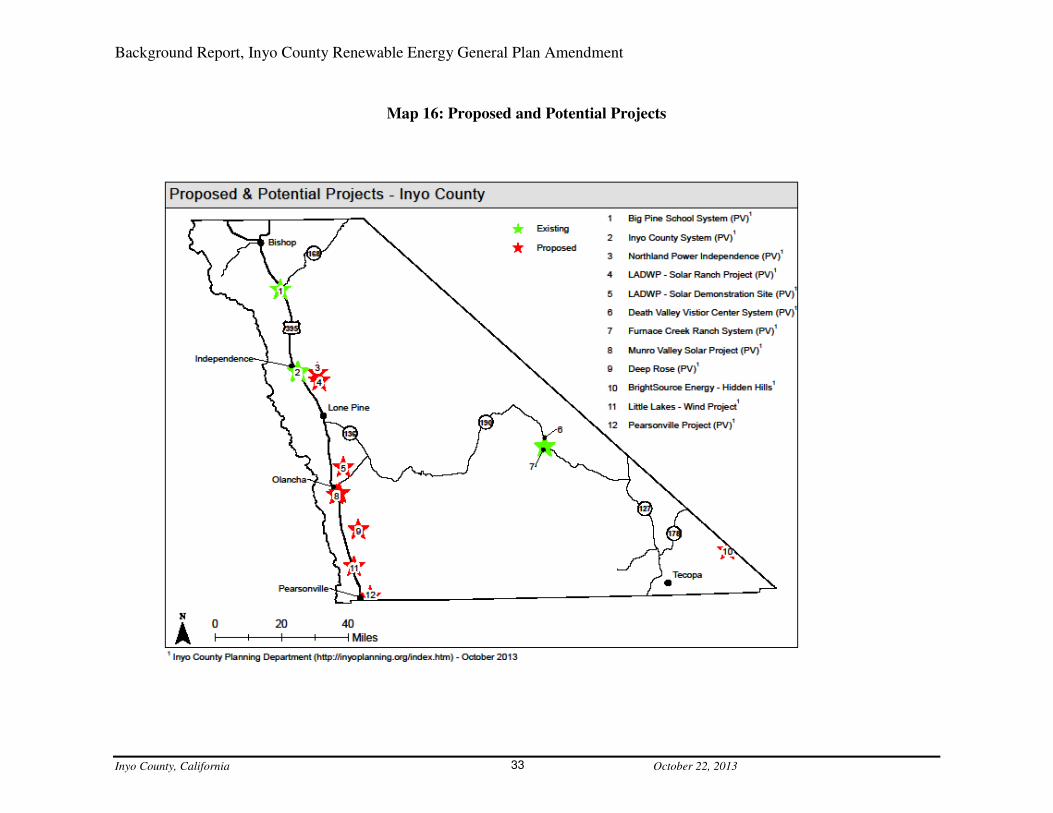
Criteria for REDAs: Proposed and Potential Projects 20.3Currently there are several proposed projects and projects that developers have discussed with
staff, but have not yet submitted applications, as well as, some recently completed projects.
These areas will be considered for inclusion in the REDAs. From north to south, these projects
and proposals include:
• the Big Pine School recently completed a solar rooftop parking structure;
• Inyo County is presently finishing a solar rooftop parking structure at the Annex building
in Independence and a ground mounted photovoltaic system has been completed at the
jail;
• Northland Power, Independence LLC is currently waiting to begin an EIR to develop a
200-megawatt solar photovoltaic facility off Mazourka Canyon Road near Independence;
• LADWP Southern Owens Valley Solar Ranch, a 200-megawatt facility to be located off
Manzanar Reward Road, is currently in EIR review and comment period;
• LADWP Solar Demonstration Project on the Owens Dry Lake, completed the CEQA
process in June 2013;
• Xanterra’s Furnace Creek Resort located in Death Valley installed a Photo Voltaic
system that provides the electricity for all of its facilities, including the historic the Inn at
Furnace Creek, the Ranch at Furnace Creek, Furnace Creek Golf Course, employee
offices and housing;
• Death Valley National Park Visitor Center installed Photo Voltaic for use at all the
park’s facilities;
• Munro Valley Solar LLC applied for a 4-megawatt solar voltaic project in Olancha,
currently staff is working with them on a development agreement;
• Bright Source Energy, Hidden Hills, applied for a 500-megawatt Solar Thermal Power
Plant project on approximately 3,500 acres in Charleston View, the County had come to
an agreement with the applicant to address mitigation measures, but in April 2013 Bright
Source suspended their application with the CEC and with the County in June 2013, the
project is on hold indefinitely;
• Little Lakes North and South, a wind energy developer has erected meteorological towers
to test for the viability of wind energy resources in the area;
• Coso Junction/Deep Rose a solar developer has expressed an interest in property located
near the Deep Rose geothermal exploration area and near Coso Junction; and,
• in Pearsonville, a solar developer has expressed an interest in property located on the east
side of Highway-395 for solar development, no applications for a project have
been submitted (Map 16: Proposed and Potential Projects).
Background Report, Inyo County Renewable Energy General Plan Amendment
Inyo County, California October 22, 2013 33
Map 16: Proposed and Potential Projects
Background Report, Inyo County Renewable Energy General Plan Amendment
Inyo County, California October 22, 2013 34
Areas to be Considered for Exclusion from REDAs 21.There are several current land uses, conditions and/or specific landscape characteristics that will
need to be carefully examined during the REDA development process. Ultimately, some of these
areas will need to be considered for exclusion from the REDAs.
Areas of Critical Environmental Concern (ACEC) and Desert Wildlife 21.1
Management Areas (DWMA) ACECs are areas defined by the BLM as having more than locally significant qualities, which
give it special worth, consequence, meaning, distinctiveness, or cause for concern, especially
compared to any similar resource;
• have qualities or circumstances that make it fragile, sensitive, rare, irreplaceable,
exemplary, unique, endangered, threatened, or vulnerable to adverse change;
• has been recognized as warranting protection in order to satisfy national priority
concerns or to carry out the mandates of Federal Land Management and Practices
Act;
• has qualities which warrant highlighting in order to satisfy public or management
concerns about safety and public welfare; and/or
• poses a significant threat to human life and safety or to property.
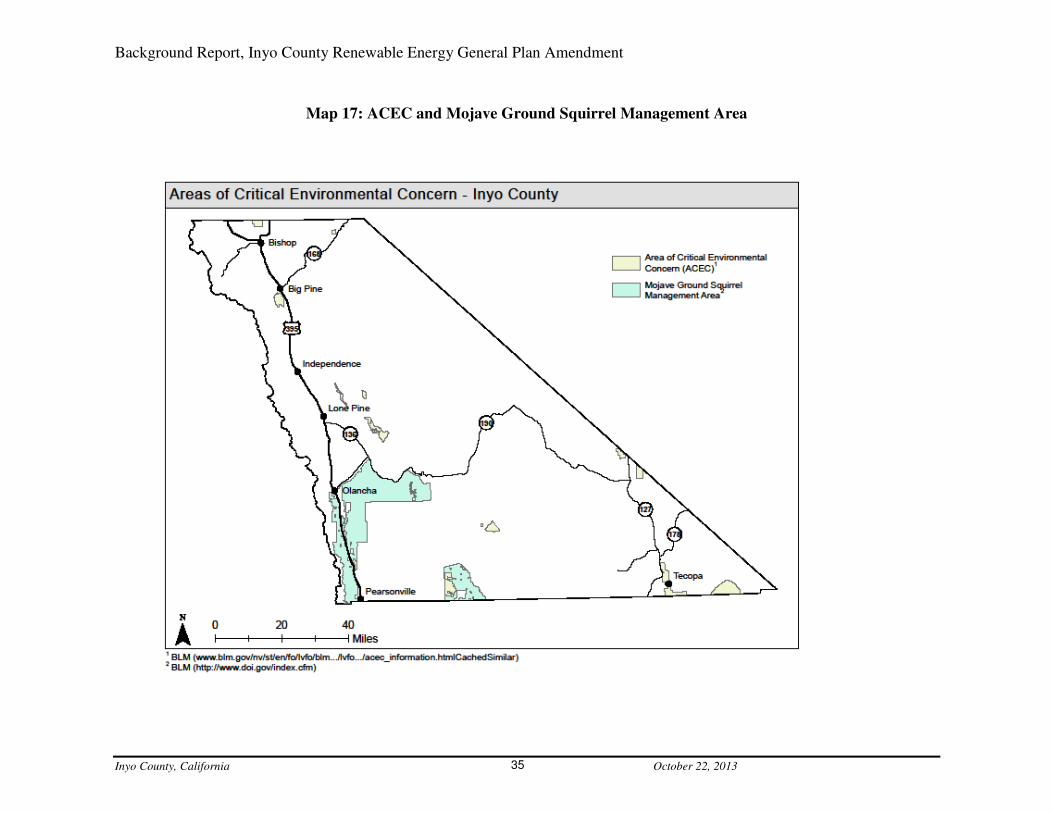
Inyo County has about 20 identified ACECs within its boundary. The BLM has an additional
designation for its lands: the Desert Wildlife Management Areas (DWMA). BLM land located
Inyo County has one DWMA, the Mojave Ground Squirrel Management Area. This DWMA
includes an area in the southwest section of the county from west of Pearsonville north to and
surrounding Haiwee, and east to, and surrounding Darwin, and an area in the south center of the
County that surrounds Homewood Canyon and Valley Wells (Map 17: ACEC and Mojave
Ground Squirrel Management Area).
Wilderness Areas 21.2Four federal agencies administer the US Wilderness areas: the US Forest Service; National Park
Service; BLM and the US Fish and Wildlife Service. Much of the land in Inyo County is
designated as Wilderness Area with an approximate total of 6,278-sq.mi., or approx. 61% of the
County’s total land area (approx. 10,200-sq.mi.) (Map 18: Wilderness Areas).
Sensitive Species 21.3Scattered throughout Inyo County are areas that may accommodate rare, endangered, and
sensitive plant and animal species. The California Department of Fish and Wildlife, Wild Life
and Habitat Program, created and maintains a database of critical species, the California Natural
Diversity Database (CNDDB). CNDDB (2006 database was used for this report) provides data
on Federal and State listed species by category of legal status. Inyo County has several species
identified in the CNDDB as endangered or threatened on both the Federal and State lists. An
Endangered Species is any species that is in danger of extinction throughout all or a significant
portion of its range and a Threatened Species is any species that is likely to become an
endangered species within the foreseeable future throughout all or a significant portion of its
range. The Federal Endangered Species Act of 1973 (Act) describes these two categories as
Background Report, Inyo County Renewable Energy General Plan Amendment
Inyo County, California October 22, 2013 35
Map 17: ACEC and Mojave Ground Squirrel Management Area

Background Report, Inyo County Renewable Energy General Plan Amendment
Inyo County, California October 22, 2013 36
Map 18: Wilderness Areas

Background Report, Inyo County Renewable Energy General Plan Amendment
Inyo County, California October 22, 2013 37
those of declining species of plants and animals that need the Act's protections. The California
definitions mean basically the same thing as the Federal. There are 9 federally listed endangered
and 7 federally listed threatened species and 12 California listed endangered and 7 California
listed threatened species in Inyo County, 8 of the total listed species are found on both the federal
and state lists. Staff plans to leave these areas out of the REDAs (Map 19: Federal and State
Listed Endangered and Threatened Species).
Military interests: China Lake Naval Air Weapons Station (NAWS) and 21.4
Military Flight Zones During the 2011 REGPA planning efforts, staff from the China Lake NAWS, alerted planning
staff to their desire to keep the base out of the Renewable Energy Overlay Areas. They also
informed staff that wind turbines have a disruptive effect on the radar systems that their test
pilots rely on for flying aircraft and the heat from solar thermal power plants can also have a
negative effect on the safety of military test pilots. Due to these factors, staff took China Lake
NAWS out of the Renewable Energy Overlay Areas and made note of height limitations for
wind energy systems and solar thermal facilities. These same factors will be addressed in the
current REDA mapping exercise (Map 20: China Lake and Military Operations Overlay).
Tribal Land 21.5There are five Tribes in Inyo County with Tribal land, they are: Bishop Paiute Tribe, Big Pine
Band of Owens Valley, Fort Independence Community of Paiute, Lone Pine Paiute-Shoshone
and the Timbisha Shoshone. All of the Tribal land is governed by the tribes and the County has
no jurisdiction over it. Any renewable energy development that may occur on tribal land will be
at the tribes’ discretion. As in the 2011 REGPA work, if a tribe wants to have their land included
in the REDAs, they may do so. Otherwise, all tribal land will be left out of the REDAs (Map 1:
Land Ownership Inyo County).
Cultural and Historic Resources 21.6Inyo County has an abundance of cultural and historic resources. The Paiute and Shoshone
people lived in Inyo County and the areas surrounding it, long before Euro-Americas settled
there. Their legacy can be found throughout the County in the form of burial grounds, artifacts
and landscapes with cultural significance. Early Euro-American settlement also left important
historic resources throughout Inyo County, from mining, ranching and railroad artifacts to old
cabins and buildings. Cultural and historic resources are difficult to identify at a large scale.
Once the REDAs are identified they will be further refined with cultural and historic resource
information gathered during the environmental review process. The County’s General Plan
presently includes policies designed to protect its cultural and historic resources. These include
Cultural Resources CUL-1.3 Protection of Cultural Resources: Preserve and protect key
resources that have contributed to the social, political, and economic history and prehistory of the
area, unless overriding circumstances are warranted.
Scenic Resources 21.7Inyo County is a land of scenic beauty. It is hard to find a place in the County without a view of
a dramatic landscape feature. Because of the County’s unparalleled opportunity to scenic beauty

Background Report, Inyo County Renewable Energy General Plan Amendment
Inyo County, California October 22, 2013 38
Map 19: Federal and State Listed Endangered and Threatened Species

Background Report, Inyo County Renewable Energy General Plan Amendment
Inyo County, California October 22, 2013 39
Map 20: China Lake and Military Operations Overlay

Background Report, Inyo County Renewable Energy General Plan Amendment
Inyo County, California October 22, 2013 40
there are several policies and strategies in place to preserve them. The USFS has a program
designed to preserve air quality in areas with scenic, recreational, historic or natural value. This
program, called the Prevention of Significant Deterioration, has an area identified along the
western edge of Inyo County in the John Muir Wilderness. There are also several scenic byway
designations from BLM and the State of California. These designations were created to help
people find the best roads for auto touring and to encourage the preservation of these scenic
resources. During the 2011 REGPA process, staff also eliminated everything west of Highway-
395 and north of the Rock Creek area (south of Lone Pine) from the overlay areas due to public
comment regarding the view shed to the Sierra. Staff plans to leave this area out in the 2013
REGPA REDAs, as well (Map 21: Scenic Vistas and Highways).
Public Input – REDA Criteria 22.This section will be completed after the public and stakeholder meetings
The 2011 REGPA 23.While staff developed the 2011 REGPA, it was determined that small scale wind and solar
energy development for individual homes and businesses are already adequately addressed by
existing County regulations. These include building permit requirements for solar installations
intended primarily for on-site energy consumption and Inyo County Code (ICC) Chapter 18.79
(Regulation of Small Wind Energy Conversion Systems). Staff further determined that General
Plan policies were not necessary for small scale development and 2011 REGPA was written for
commercial scale solar and wind energy development. The 2011 REGPA updated the: Land Use,
Public Services and Facilities, Economic Development, Conservation and Open Space and
Public Safety elements. A review and reevaluation of the 2011 policies will be conducted as part
of the 2013 process. New information collected from the REDA identification, and the
stakeholder/public outreach processes will be used to develop new and/or updated General Plan
policies. The 2011 REGPA General Plan changes included:
• Government Element
No change
• Land Use Element
o New definition:
Solar or Wind Renewable Energy Facility. Any electric transmission line, solar
thermal powerplant, photovoltaic powerplant, or wind energy powerplant to be
constructed in Inyo County. A Facility does not include a “solar energy system,” a small
wind energy conversion system or a windmill that does not generate electricity, or a pilot
or proof of concept powerplant.
o New Land Use policy:
Policy LU-1.17 (Solar and Wind Renewable Energy Development) – The County shall
consider Solar or Wind Energy facilities within areas with a Renewable Energy Land
Use Designation Overlay and in any zoning district under Title 18 of the Inyo County
Code. Based on site-specific studies and appropriate environmental review, the County

Background Report, Inyo County Renewable Energy General Plan Amendment
Inyo County, California October 22, 2013 41
Map 21: Scenic Vistas and Highway
Background Report, Inyo County Renewable Energy General Plan Amendment
Inyo County, California October 22, 2013 42
may process Solar or Wind Renewable Energy Facilities within the Overlay pursuant to
Inyo County Code Title 21. Potential social, economic, and environmental impacts from
Solar or Wind Renewable Energy Facilities must be minimized to the extent feasible.
Appurtenant transmission facilities and related infrastructure may be constructed and
operated within any Land Use Designation and any zoning district under Title 18 of the
Inyo County Code, provided that the facilities they connect operate under valid approval
and are the subject of appropriate environmental review.
o New Land Use Implementation Measures:
1. The County shall coordinate with the Department of Defense to work to site
renewable energy facilities in a manner that does not significantly impact military
readiness. Issues to be addressed in the coordination include radar, light and
glare, heat generation, equipment testing and operations, personnel training, and
flight activities.
2. The County shall consider seeking compensation for the loss of revenues from
potential renewable energy facilities that are not developed due to potential
impacts on military readiness, special status species, and aesthetics, and/or other
barriers to development of appropriate renewable energy facilities. Methods of
compensation include but are not limited to Payment-in-lieu of Taxes (PILT) or
similar programs.
3. The County shall work with utilities and renewable energy developers to
encourage collocation of transmission and intertie facilities.
4. The County shall encourage renewable energy development on disturbed lands.
• Public Services and Facilities Element
o New Public Services and Facilities policy:
Policy PSU-10.5 (Encourage Renewable Energy Development) – The County shall
encourage appropriate development of renewable energy resources, provided that social,
economic, and environmental impacts are minimized.
• Economic Development Element
o New Economic Development policy:
Policy ED-4.4 (Renewable Energy Development Beneficial to the Local Economy) –
Renewable energy development shall provide means to offset costs to the County and lost
economic development potential. If potential economic impacts from renewable energy
development are identified by the County, commensurate mitigation and/or offsets shall
be required.
• Housing Element
No change
• Circulation Element

Background Report, Inyo County Renewable Energy General Plan Amendment
Inyo County, California October 22, 2013 43
• No change
• Conservation/Open Space Element
o Modified existing Agricultural Resources policy:
Policy AG-1.3 (Conversion of Agricultural Land) – Discourage conversions of
productive agricultural lands for urban development, and encourage avoidance of
productive agricultural lands for renewable energy development.
o New Mineral and Energy Resources goal:
Goal MER-1 – Encourage appropriate renewable energy development and minimize
impacts from such development to the social, economic, and environmental resources of
the County.
o New Mineral and Energy Resources policies:
1. Policy MER-2.1 (Large-scale Renewable Energy Development Areas) – The
County shall maintain a Land Use Diagram of areas where Solar or Wind
Renewable Energy Facilities may be appropriate.
2. Policy MER-2.2 (Minimize Impacts) – The County shall work with renewable
energy developers and other agencies to minimize impacts from renewable energy
development.
o New Mineral and Energy Resources Implementation Measures:
1. Review proposals for renewable energy development and work to minimize
potential impacts to the County’s social, economic, and environmental resources,
in cooperation with other local, regional, State, out-of-State, and federal agencies.
2. Collect and disseminate strategies to minimize impacts from Renewable Energy
Facilities.
3. Periodically review, and as necessary update, the Solar and Wind Renewable
Energy Land Use Designation Overlay.
o New Water Resources policy:
Policy WR-3.5 (Sustainable Renewable Energy Development) – The County shall
encourage renewable energy development to incorporate measures to minimize water
consumption and use of potable water.
o New Visual Resources policy:
Policy VIS-1.8 (Renewable Energy Development) – The County shall encourage siting
and screening to minimize significant changes to the visual environment from renewable
energy development, including minimizing light and glare, to the extent possible.
o New Recreation Implementation Measure:
Work with developers and other agencies to minimize impacts to recreational
access from renewable energy development.

Background Report, Inyo County Renewable Energy General Plan Amendment
Inyo County, California October 22, 2013 44
• Public Safety Element
o New Air Quality Implementation Measure:
Support appropriate efforts to combine air quality improvements with other
social, cultural, and environmental goals, including renewable energy
development.
o New Noise Implementation Measure:
Work with developers and other agencies to minimize noise from renewable
energy development.
Summary 24.Inyo County has excellent solar energy generation potential and scattered good-excellent wind
energy generation potential. Due to this high potential there has been increased interest in the
development of these resources in the County over the past several years. In reaction to this
interest the County adopted a Renewable Energy General Plan Amendment in 2011, but
subsequently had to rescind it do to threatened litigation. Along with the remarkable potential for
wind and solar energy generation, comes many variables regarding where the most appropriate
areas for this develop is. As the County revisits a Renewable Energy General Plan Amendment it
will have to take into account:
o the areas with the highest energy generation potential;
o availability of transmission;
o a multitude of studies and plans conducted by other jurisdictions and groups;
o land with the right slope and development characteristics;
o avoiding critical habitats, military concerns, tribal lands, cultural and historic resources;
and scenic resources; and,
o the public’s vision and goals.
The County is still committed to completing a Renewable Energy General Plan Amendment, as
under California State Planning guidance, the General Plan is where a community develops its
visions, goals and policies for land use and development.

Background Report, Inyo County Renewable Energy General Plan Amendment
Inyo County, California October 22, 2013 45
Resources 25.
Bureau of Land Management, Area of Critical Environmental Concern, and Desert Wildlife
Management Area, information available at:
http://webservices.itcs.umich.edu/drupal/recd/?q=node/31
Bureau of Land Management Director’s Protest Resolution Report: Programmatic Land Use Plan
Amendments for Solar Energy Development in Six Southwestern States, available at:
http://solareis.anl.gov/documents/docs/Solar_PEIS_BLM_Protest_Resolution_Report.pdf
Bureau of Land Management, Solar Programmatic Environmental Impact Statement, available
at: http://solareis.anl.gov/
California Department of Fish and Wildlife: California Natural Diversity Data Base, available at:
http://www.dfg.ca.gov/biogeodata/cnddb/
California Independent System Operator – 2012-2013 Transmission Plan, available at:
http://www.caiso.com/planning/Pages/TransmissionPlanning/2012-
2013TransmissionPlanningProcess.aspx
California Transmission Planning Group, information available at:
http://www.ctpg.us/
Clark, Morrison, Radar, Nancy. 2012. Proposed DRECP Scenario for Wind Energy Resources.
The California Wind Energy Association.
County of Inyo and the City of Los Angeles, Long Term Water Agreement, available at:
http://www.inyowater.org/documents/governing-documents/water-agreement/
County of Inyo: Expedited permit process for photovoltaic systems, available at:
http://www.inyoplanning.org/documents/ExpeditedPermitProcessforPhotovoltaicPVSyste
ms.pdf
County of Inyo – Inyo County Code: Chapter 18.79 Regulation of Small Wind Energy Systems,
available at: http://www.qcode.us/codes/inyocounty/
County of Inyo: Renewable Energy General Plan Amendment 2011, available at:
http://www.inyoplanning.org/projects/2011-REGPA.htm
County of Inyo – Inyo County Code: Title 20 Development Agreements, available at:
http://www.qcode.us/codes/inyocounty/
Desert Renewable Energy Conservation Plan: information available at:
http://www.drecp.org/
Background Report, Inyo County Renewable Energy General Plan Amendment
Inyo County, California October 22, 2013 46
Desert Renewable Energy Conservation Plan: Appendix A Transmission Technical Group
Report, available at:
http://www.drecp.org/documents/docs/alternatives_eval/Appendices/Appendix_A_TTG_
Report.pdf
Owens Lake Demonstration Project, information available at:
https://www.ladwp.com/ladwp/faces/wcnav_externalId/a-fr-envirt-repo?_adf.ctrl-
state=18u2iymv4s_4&_afrLoop=302853499764715&_afrWindowMode=0&_afrWindow
Id=o92km4ukt_1#%40%3F_afrWindowId%3Do92km4ukt_1%26_afrLoop%3D3028534
99764715%26_afrWindowMode%3D0%26_adf.ctrl-state%3Do92km4ukt_29
Pacific Northwest Laboratory. 1986. Wind Energy Resource Atlas of the United States.
Perez Et Al. 2002. The State University of New York/Albany Satellite Radiation Model.
Renewable Energy Development Institute, information available at:
http://www.redinet.org/
Renewable Energy Transmission Initiative, information available at:
http://www.energy.ca.gov/reti/documents/
Rural Southwest Brownfields Coalition – Inyo county, information available at:
http://www.rdsbc.org/counties/inyo-county/
Senate Bill 107, available at:
http://www.leginfo.ca.gov/cgi-
bin/postquery?bill_number=sb_107&sess=0506&house=B&author=simitian
Senate Bill 1078, available at:
http://www.leginfo.ca.gov/cgi-
bin/postquery?bill_number=sb_1078&sess=0102&house=B&author=sher
Senate Bill 2, available at:
http://www.leginfo.ca.gov/cgi-
bin/postquery?bill_number=sbx1_2&sess=PREV&house=B&author=simitian
Solar Programmatic Environmental Impact Statement available at:
http://solareis.anl.gov/documents/fpeis/
Southern Owens Valley Solar Ranch Environmental Impact Report, available at:
https://www.ladwp.com/ladwp/faces/wcnav_externalId/a-fr-envirt-repo?_adf.ctrl-
state=18u2iymv4s_4&_afrLoop=302853499764715&_afrWindowMode=0&_afrWindow
Id=o92km4ukt_1#%40%3F_afrWindowId%3Do92km4ukt_1%26_afrLoop%3D3028534
99764715%26_afrWindowMode%3D0%26_adf.ctrl-state%3Do92km4ukt_29

Background Report, Inyo County Renewable Energy General Plan Amendment
Inyo County, California October 22, 2013 47
Southwest Solar Transformation Initiative – Inyo County Road Map, available at:
http://www.solarroadmap.com/national/california/inyo-county-ca/
State of Nevada, Renewable Energy Conceptual Transmission Plan, available at:
https://www.nvenergy.com/company/rates/filings/IRP/NPC_IRP/images/vol_17.pdf
West-Wide Energy Corridor Programmatic Environmental Impact Statement, available
at:http://corridoreis.anl.gov/eis/index.cfm

Background Report, Inyo County Renewable Energy General Plan Amendment
Inyo County, California October 22, 2013 48
Appendices 26.
o Appendix A: Memorandum of Understanding California Energy Commission and
Inyo County.
o Appendix B: Inyo County Title 21, the Inyo County Renewable Energy
Ordinance.

Inyo County, California October 22, 2013
Appendix A


Inyo County, California October 22, 2013
Appendix B

Chapter 21.04 TITLE, AUTHORITY AND PURPOSE
21.04.010 Title.
This title shall be known as the Inyo County Renewable Energy Ordinance. (Ord. 1158 §
3, 2010.)
21.04.020 Authority.
Article XI, Section 7 of the California Constitution empowers Inyo County (“county”) to
make and enforce within its limits all local, police, sanitary and other ordinances and regulations
not in conflict with general laws. The county’s police powers extend to all lands within the
county. The police powers of the county of Inyo include:
A. Protection of the environment of Inyo County, including biological and other
natural resources, aesthetics, recreational attractiveness and availability, traditional social
activities and values of the citizens of the county, housing, public services, utilities, and
economic potential within the county;
B. Traditional authority over the use of land within the county, where such authority
is not preempted by federal or state law;
C. The public trust doctrine under which the county is empowered to exercise its
police power to protect natural resources such as streams, lakes, marshlands, tidelands, wildlife
and other resources. (Ord. 1158 § 3, 2010.)
21.04.030 Purpose.
A. It is in the public interest to support, encourage and regulate the development of
solar and wind resources for the generation and transmission of clean, renewable electric energy.
By this title, the county intends to: (1) support and encourage the responsible development of its
solar and wind resources to generate and transmit clean, renewable electric energy while
protecting the health, safety and welfare of its citizens and its environment, including its public
trust resources, by requiring that the adverse impacts of such development are avoided or
acceptably mitigated; (2) recover the county’s costs of increased services resulting from such
development; and (3) ensure that the citizens of Inyo County equitably share in the benefits
resulting from the use of such resources.
B. To support, encourage and facilitate the responsible utilization of its solar and
wind resources for the generation and transmission of clean, renewable electric energy, the
county encourages potential developers of such resources to work with the county and to enter
into a mutually agreeable renewable energy development agreement in lieu of applying for the
issuance of a renewable energy impact determination or a renewable energy permit. (Ord. 1158 §
3, 2010.)
Chapter 21.08 DEFINITIONS
21.08.010 Environment.
For the purposes of this title, the term “environment” includes the ecological environment
of the county as well as the social, aesthetic and economic environment of the county. Impacts
upon the quality of life within the county are considered environmental impacts. Therefore, the
definition of environment is not limited by and may be broader than environmental
considerations under the California Environmental Quality Act or the National Environmental
Policy Act. (Ord. 1158 § 3, 2010.)
21.08.020 Electric transmission line.
“Electric transmission line” means any electric powerline within Inyo County carrying
power from a photovoltaic, solar thermal or wind energy powerplant located within or outside
Inyo County to a point of junction with an interconnected transmission system. “Electric
transmission line” does not include any replacement on the existing site of existing electric
powerlines with electric powerlines equivalent to such existing electric powerlines or the
placement of new or additional conductors, insulators, or accessories related to such electric
powerlines on supporting structures in existence on the effective date of the ordinance codified in
this title or certified pursuant to this title. (Ord. 1158 § 3, 2010.)
21.08.030 Facility.
“Facility” means any electric transmission line, solar thermal powerplant, photovoltaic
powerplant, or wind energy powerplant to be constructed in Inyo County. A facility does not
include a “solar energy system” or a pilot or proof of concept powerplant. (Ord. 1158 § 3, 2010.)
21.08.040 Mitigation.
“Mitigation” refers to mitigation of adverse environmental impacts and includes:
1. Avoiding the impact altogether by not taking a certain action or parts of an action;
2. Minimizing impacts by limiting the degree or magnitude of the action and its
implementation;
3. Rectifying the impact by repairing, rehabilitating, or restoring the impacted
environment;
4. Reducing or eliminating the impact over time by preservation and maintenance
operations during the life of the action;
5. Compensating for the impact by replacing or providing substitute resources or
environments. (Ord. 1158 § 3, 2010.)
21.08.050 Modification of an existing facility.
“Modification of an existing facility” is an increase in the electric generating capacity of
an existing facility or electric transmission line by ten percent or more. (Ord. 1158 § 3, 2010.)
21.08.060 Person.
“Person” means any natural person and any corporation, partnership, association, public
entity and any other entity with legal existence under California law. “Person” also includes any
city, county, public district or agency, the state or any department or agency thereof, and the
United States and any department or agency thereof. (Ord. 1158 § 3, 2010.)
21.08.070 Photovoltaic powerplant.
“Photovoltaic powerplant” means an electrical generating facility in which the total
energy output is from the direct conversion of solar energy into electricity and which transmits a
portion of the electrical energy off the site of the facility. The definition of a “photovoltaic
powerplant” does not include a “solar energy system.” (Ord. 1158 § 3, 2010.)
21.08.080 Pilot or proof of concept powerplant.
“Pilot or proof of concept powerplant” is a powerplant with a capacity of five megawatts
or less that is designed and constructed to test the feasibility of constructing and operating larger
capacity facilities. (Ord. 1158 § 3, 2010.)
21.08.090 Public trust resources.
“Resources protected by the public trust doctrine” are as defined by statute and the
courts. Such resources include tidelands, navigable bodies of water, tributaries to navigable
bodies of water, wildlife and wildlife habitat. (Ord. 1158 § 3, 2010.)
21.08.100 Renewable energy development agreement.
“Renewable energy development agreement” means an agreement for the development of
a facility entered into by the county and a developer of a facility in lieu of a renewable energy
permit or a renewable energy impact determination. A renewable energy development agreement
shall be processed in the same manner as a development agreement described in Title 20 of this
code except that the county planning commission will not be involved in the consideration,
approval or review of such agreements, nor will the planning commission be the county agency
for the purpose of California Environmental Quality Act review and processing for such projects.
Further, a renewable energy development agreement may be exempted from the annual review
provisions of Title 20, Section 20.08.050 if the renewable energy development agreement
contains the enforcement provisions set forth in Sections 21.24.010 to 21.24.080 of this title. The
county planning director is the point of contact regarding a renewable energy development
agreement. Renewable energy development agreements must include a reclamation plan,
acceptable financial assurances, be consistent with the county general plan, be approved by the
board of supervisors, which will be the review and processing agency for compliance with the

California Environmental Quality Act, and must include provisions acknowledging that the
agreement is enforceable by injunctive relief contractual remedies and other remedies provided
by law and equity. (Ord. 1158 § 3, 2010.
21.08.110 Small wind energy conversion system.
“Small wind energy conversion system” is as defined in Section 18.79.040 of this code.
As defined in that section, a small wind energy conversion system means a facility consisting of
a tower, wind turbine generator with blades, guy wires and anchors, and associated control and
conversion electronic equipment to convert wind movement into electricity, and that is incidental
and subordinate to another use on the same parcel. A facility shall be considered a small wind
energy conversion system if it supplies electrical power solely for on-site use; however, a facility
shall also be considered a small wind energy conversion system if it is located on a parcel that
also receives electrical power supplied by a utility company and any excess electrical power
generated by the small wind energy conversion system not then needed for on-site use, is used by
the utility company in exchange for a reduction in the cost of electrical power supplied by that
company to the parcel for on-site use. No net revenue to the owners shall be produced by such
excess electrical power generation. (Ord. 1158 § 3, 2010.)
21.08.120 Solar energy system.
“Solar energy system” has the same meaning as set forth in paragraphs (1) and (2) of
subdivision (a) of Section 801.5 of the California Civil Code and as used in Section 65850.5 of
the California Government Code. (Ord. 1158 § 3, 2010.)
21.08.130 Solar thermal powerplant.
“Solar thermal powerplant” means an electrical generating facility in which a portion of
the total energy output is from solar energy converted to heat to produce electricity and which
transmits a portion of the electrical energy off the site of the facility. The definition of a solar
thermal powerplant does not include a “solar energy system.” (Ord. 1158 § 3, 2010.)
21.08.140 Wind energy powerplant.
“Wind energy powerplant” means an electrical generating facility that converts wind
energy into electricity which is transmitted off the site of the facility. A wind energy powerplant
does not include a small wind energy conversion system or windmills that do not generate
electricity. (Ord. 1158 § 3, 2010.)
Chapter 21.16 GENERAL PROVISIONS
21.16.010 Renewable energy permit.
Any person who proposes to construct a facility within the county or modify an existing
facility within the county shall, prior to the commencement of construction or modification, first
apply for and obtain from the county planning commission a renewable energy permit, unless

specifically exempted from such requirements by this title or by state or federal law. (Ord. 1158
§ 3, 2010.)
21.16.020 Renewable energy impact determination.
Any person who proposes to construct a facility within the county or modify an existing
facility within the county who is not subject to a renewable energy permit issued by the county
for the facility, shall, prior to the commencement of construction or modification, first apply for
and obtain from the county planning commission, a renewable energy impact determination that
identifies environmental and other impacts expected to result from such project and mitigation
for those impacts. As part of its analysis, the county planning commission shall determine
whether the project is consistent with the county general plan. The goal of the renewable energy
impact determination is to ensure that mitigation measures that would otherwise be addressed in
a renewable energy permit and/or renewable energy development agreement that are identified
pursuant to the renewable energy impact determination are, to the extent possible, incorporated
into any approval of the facility granted by a state or federal agency. (Ord. 1158 § 3, 2010.)
21.16.030 Exemptions.
Any person applying for a renewable energy permit need not apply for a renewable
energy impact determination. Any person who has a renewable energy development agreement
with the county for the construction or modification of a facility need not apply for a renewable
energy impact determination or a renewable energy permit for the facility that is the subject of
the renewable energy development agreement. (Ord. 1158 § 3, 2010.)
21.16.040 Applications.
An application for a renewable energy impact determination or a renewable energy
permit shall be filed and processed in the same manner as land use and conditional use permit
applications submitted to the county as provided in Sections 18.81.160 to 18.81.300 of this code.
(Ord. 1158 § 3, 2010.)
21.16.050 Application fees.
An applicant for a renewable energy impact determination and/or permit shall pay fees
and costs to the county planning department as provided in Chapter 3.60 of this code. The fee for
either a renewable energy impact determination or a renewable energy permit shall be equal to
the fee charged for a conditional use permit. (Ord. 1158 § 3, 2010.)
21.16.060 Application processing procedures.
Upon completion of the county’s environmental review process and the filing of all
required documents, a noticed public hearing will be scheduled and conducted by the county
planning commission to consider issuance of a renewable energy impact determination or to
consider issuance of a renewable energy permit. Such a hearing will be scheduled and conducted
in accordance with this title and Chapter 18.81 of this code. (Ord. 1158 § 3, 2010.)

21.16.070 Appeals.
Appeals of an action by the county planning department or the county planning
commission shall be in conformance with the procedures described in Sections 18.81.270 to
18.81.300 of this code. (Ord. 1158 § 3, 2010.)
Chapter 21.20 MINIMUM REQUIREMENTS FOR RENEWABLE ENERGY IMPACT DETERMINATIONS AND RENEWABLE ENERGY PERMITS
21.20.010 Mitigation measures.
As a condition to the issuance of a renewable energy impact determination or a renewable
energy permit, the county planning commission may, in the case of a renewable energy impact
determination, incorporate, and in the case of a renewable energy permit, impose such reasonable
and feasible mitigation measures as it finds to be necessary to protect the health, safety and
welfare of the county’s citizens, the county’s environment, including its public trust resources,
and to ensure that the county and its citizens do not bear an undue financial burden from the
project. (Ord. 1158 § 3, 2010.)
21.20.020 Development standards.
In lieu of imposing the standards and procedures set forth in Title 18 concerning: (1)
permitted, conditional, and/or accessory uses related to a facility and its accessory uses and
structures; (2) distance between buildings; (3) height, density and intensity; (4) light and glare;
(5) noise; and (6) wireless communications facilities directly related to the facility, with regard to
renewable energy development agreements, the county board of supervisors shall incorporate,
and with regard to renewable energy permits, the county planning commission shall impose,
such standards as are deemed appropriate and may incorporate or impose such other standards
and mitigation measures as are deemed necessary. Except for those exceptions specified in the
preceding sentence, any facility for which a renewable energy development agreement or a
renewable energy permit is required shall, to the extent allowed by law, be governed by the
standards and/or procedures in Title 18. (Ord. 1158 § 3, 2010.)
21.20.030 Reclamation plan.
Any person who submits an application for a renewable energy impact determination or a
renewable energy permit shall, at the time of the submission of the application, submit a plan for
reclamation/revegetation of the site of the facility once the facility is decommissioned or
otherwise ceases to be operational. The reclamation plan shall be based upon the character of the
surrounding area and such characteristics of the property as type of native vegetation, soil type,
habitat, climate, water resources, and the existence of public trust resources. Reclamation plans
issued pursuant to this chapter shall run with the land affected thereby and shall be binding on all
successors, heirs and assigns of the applicant.

In the case of the issuance of a renewable energy impact determination, the county
planning commission shall incorporate into the determination, and in the case of a renewable
energy permit, shall impose as a condition of approval, a plan for the reclamation/revegetation of
the site of the facility at the time that the facility is decommissioned, or otherwise ceases to be
operational, and shall establish site-specific criteria for evaluating and monitoring compliance
with the approved reclamation plan. (Ord. 1158 § 3, 2010.)
21.20.040 Financial assurances.
As a condition to the approval of a renewable energy permit, in order to ensure that
reclamation will proceed and be accomplished in accordance with an approved reclamation plan,
the county planning commission shall require financial assurances from the applicant as provided
herein:
A. Financial assurances may take the form of surety bonds, irrevocable letters of
credit, trust funds or other mechanisms.
B. Public agencies may satisfy financial assurance requirements by using “pledges of
revenue” or “budget set aside” as acceptable financial assurances mechanisms.
C. The financial assurances shall remain in effect for the duration of the operation
and any additional period until reclamation is completed.
D. Financial assurances shall be sufficient to cover the costs of fully implementing
the reclamation plan.
E. The financial assurances shall be made payable to Inyo County and any other
affected public agency. However, if a facility has received approval of its financial assurances
from a public agency other than the county, the county shall deem those financial assurances
adequate for purposes of this section, or shall credit them toward fulfillment of financial
assurances required by this section, if they are made payable to the public agency, the county,
and otherwise meet the requirements of this title.
F. If a permitted facility is sold or ownership is transferred to another person, the
existing financial assurances shall remain in force and shall not be released by the county until
new financial assurances are secured from the new owner and have been approved by the county.
G. The release of financial assurances shall be with the concurrence of all agencies
named on the financial assurance. The criteria for release of financial assurances, or part of the
financial assurances, shall be made part of the reclamation plan. In no case shall the financial
assurance be released until reclamation has been completed.
H. The amount of financial assurances shall be reviewed annually, or as deemed
necessary, by the county planning commission and adjusted, if required, to ensure that the
assurances are sufficient to cover the costs of fully implementing the reclamation plan. (Ord.
1158 § 3, 2010.)
21.20.050 Term of permit.
Each applicant for a renewable energy permit pursuant to this title shall specify in the
application the duration or term of the permit requested. The county planning commission shall
determine the term of the permit if it grants the permit. (Ord. 1158 § 3, 2010.)
21.20.060 Consistency with the Inyo County general plan.
Prior to the issuance of renewable energy impact determination or the granting of a
renewable energy permit, the Inyo County planning commission must find that the proposed
facility is consistent with the Inyo County general plan. Prior to entering into a renewable energy
development agreement, the county board of supervisors must find that the proposed facility is
consistent with the Inyo County general plan. (Ord. 1158 § 3, 2010.)
21.20.070 Health, safety and welfare of the county’s citizens.
Prior to the issuance of a renewable energy impact determination or the granting of a
renewable energy permit, the county planning commission must find that, through the imposition
of mitigation measures, the approval of a reclamation plan, the receipt of adequate financial
assurances, and by other conditions incorporated into the determination or imposed upon the
permit, the health, safety and welfare of the county’s citizens, the county’s environment,
including its public trust resources, and the county’s financial well-being, have been adequately
safeguarded. (Ord. 1158 § 3, 2010.)
Chapter 21.24 ENFORCEMENT
21.24.010 Prohibition.
No person shall construct a facility without first obtaining a renewable energy
development agreement, a renewable energy permit or a renewable energy impact determination
and no person shall operate a facility in violation of a renewable energy permit or renewable
energy development agreement. (Ord. 1158 § 3, 2010.)
21.24.020 Notice.
Where it appears to the county planning department that a facility is in violation of any
condition of a renewable energy development agreement, a renewable energy permit, an
approved reclamation plan or any applicable statute, regulation or ordinance, the planning
department shall serve formal notice to the facility operator and/or owner stating the nature of
the violation and the specified time frame to correct the violation before an order is issued. (Ord.
1158 § 3, 2010.)
21.24.030 Timing of remedy.
The time within which the facility operator and/or owner must commence correction of
the violation shall be sooner than sixty days from the notice of violation. (Ord. 1158 § 3, 2010.)

21.24.040 Order.
An order shall be issued if the facility operator and/or owner fails to comply with the
notice within the specified time limit. Not sooner than thirty days after the date of the order, a
hearing shall be held by the county planning director or designee, for which at least ten days’
written notice has been given to the facility operator and/or owner. The order shall not take effect
until after the hearing. (Ord. 1158 § 3, 2010.)
21.24.050 Failure to comply.
Failure to comply with the order shall be subject to an order setting administrative
penalties and permit modification or revocation. Penalties shall be assessed from the date of
original noncompliance. (Ord. 1158 § 3, 2010.)
21.24.060 Penalty.
In determining the amount of administrative penalty, the county shall take into
consideration the nature, circumstances, extent and gravity of the violation or violations, any
prior history of violations, the degree of culpability, economic savings, if any, resulting from the
violation, and any other matters as justice may require. (Ord. 1158 § 3, 2010.)
21.24.070 Payment of penalty.
Orders setting administrative penalties and revoking or modifying the determination or
permit shall become effective upon issuance thereof. Payment of penalties shall be made to the
planning department unless the affected facility operator and/or owner files an appeal with the
county board of supervisors within ten days of the issuance of such administrative penalties. If
after the hearing, the board affirms an order setting administrative penalties, the facility operator
and/or owner shall pay the administrative penalties set by the board’s order within thirty days of
the service of that order. A permit modification or revocation shall become effective thirty days
after the board’s order. (Ord. 1158 § 3, 2010.)
21.24.080 Enforcement authority.
The provisions of this chapter shall be enforced by the county planning director or
designated appointee. Violations of Section 21.24.010 or other provision of the chapter may be
prosecuted by the Inyo County district attorney. (Ord. 1158 § 3, 2010.)
21.24.090 Additional remedies.
Notwithstanding the foregoing, a violation of this chapter may be enforced by the county
by the use of any legal or equitable remedy available to the county. (Ord. 1158 § 3, 2010.)
Chapter 21.28 SEVERABILITY
21.28.010 Severability.

If any section, subsection, sentence, clause, or phrase of this title, as applied to any
person, is for any reason held to be illegal, invalid, unconstitutional, or outside the jurisdiction
and/or the police powers of the county of Inyo, as determined by any court of competent
jurisdiction, such decision shall not affect the validity of this title as to other persons. If any
section, subsection, sentence, clause, or phrase of this title is for any reason held illegal, invalid
or unconstitutional by the decision of any court of competent jurisdiction, such decision shall not
affect the validity of the remaining portions hereof. This title, and each section, subsection,
sentence, clause or phrase hereof, would have been enacted irrespective of the fact that any one
or more sections, subsections, sentences, clauses, or phrases be declared illegal, invalid,
unconstitutional, or outside the jurisdiction and/or police powers of the county of Inyo as to
certain entities or persons. (Ord. 1158 § 3, 2010.)