course structure outcome based syllabus · 1 course structure & outcome based syllabus under...
TRANSCRIPT
1
Course structure
&
Outcome Based Syllabus
Under Choice Based Credit System (CBCS)
M.Sc. (Applied Geology)
2019-20
DEPARTMENT OF GEOLOGY
ALIGARH MUSLIM UNIVERSITY
ALIGARH
2
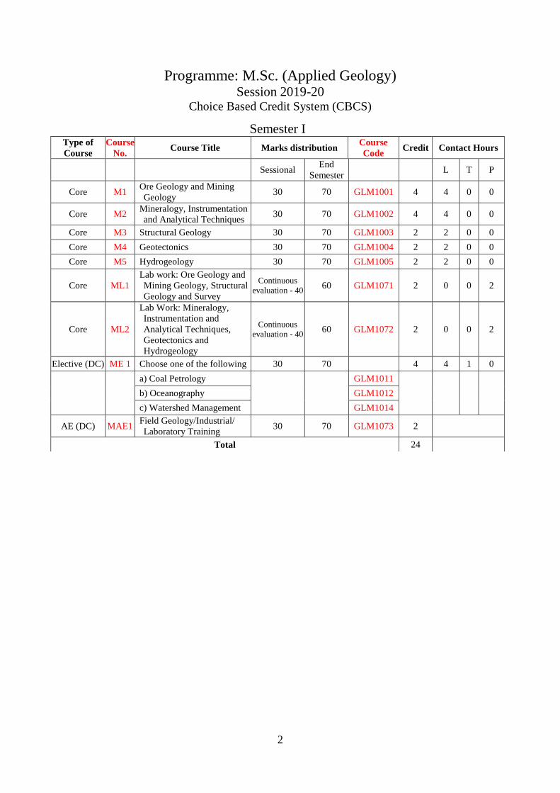
Programme: M.Sc. (Applied Geology) Session 2019-20
Choice Based Credit System (CBCS)
Semester I Type of
Course
Course
No. Course Title Marks distribution
Course
Code Credit Contact Hours
Sessional End
Semester L T P
Core M1 Ore Geology and Mining
Geology 30 70 GLM1001 4 4 0 0
Core M2 Mineralogy, Instrumentation
and Analytical Techniques 30 70 GLM1002 4 4 0 0
Core M3 Structural Geology 30 70 GLM1003 2 2 0 0
Core M4 Geotectonics 30 70 GLM1004 2 2 0 0
Core M5 Hydrogeology 30 70 GLM1005 2 2 0 0
Core ML1
Lab work: Ore Geology and
Mining Geology, Structural
Geology and Survey
Continuous
evaluation - 40 60 GLM1071 2 0 0 2
Core ML2
Lab Work: Mineralogy,
Instrumentation and
Analytical Techniques,
Geotectonics and
Hydrogeology
Continuous
evaluation - 40 60 GLM1072 2 0 0 2
Elective (DC) ME 1 Choose one of the following 30 70 4 4 1 0
a) Coal Petrology
GLM1011
b) Oceanography GLM1012
c) Watershed Management GLM1014
AE (DC) MAE1 Field Geology/Industrial/
Laboratory Training 30 70 GLM1073 2
Total 24
3
Semester II Type of
Course
Course
No. Course Title Marks distribution
Course
Code Credit Contact Hours
Sessional End
Semester L T P
Core M6 Paleobiology and Indian
Stratigraphy 30 70 GLM2001 4 4 0 0
Core M7 Metamorphic Petrology 30 70 GLM2006 2 2 0 0
Core M8 Remote Sensing in
Geosciences 30 70 GLM2003 4 4 0 0
Core M9 Geophysical Exploration 30 70 GLM2004 4 4 0 0
Core M10 Well Hydraulics and Water
Chemistry 30 70 GLM2007 2 2 0 0
Elective (DC) ME2 Choose one of the
following 30 70 4 4 0 0
a) Geodynamic Processes
and Crustal Evolution
GLM2011
b) Global Climate Change GLM2012
c) Quaternary Geology GLM2014
d) Applied Geomorphology GLM2015
AE (DC)
MAE2
Lab work: Paleobiology
and Indian Stratigraphy,
Metamorphic Petrology and
Geophysical Exploration
Continuous
evaluation -40
60
GLM2071
2
0
0
2
AE (DC) MAE3
Lab work: Remote Sensing
in Geosciences, and Well
Hydraulics & Water
Chemistry
Continuous
evaluation -40 60 GLM2072 2 0 0 2
Total 24
4
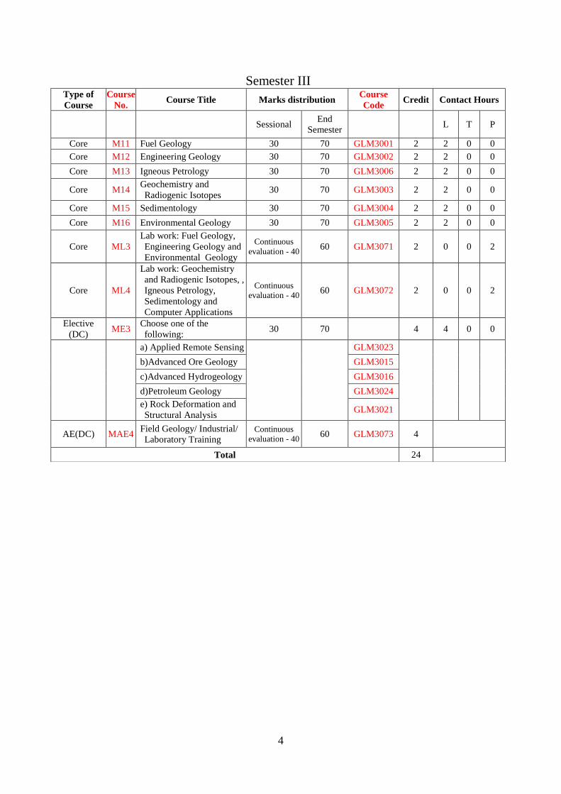
Semester III Type of
Course
Course
No. Course Title Marks distribution
Course
Code Credit Contact Hours
Sessional End
Semester L T P
Core M11 Fuel Geology 30 70 GLM3001 2 2 0 0
Core M12 Engineering Geology 30 70 GLM3002 2 2 0 0
Core M13 Igneous Petrology 30 70 GLM3006 2 2 0 0
Core M14 Geochemistry and
Radiogenic Isotopes 30 70 GLM3003 2 2 0 0
Core M15 Sedimentology 30 70 GLM3004 2 2 0 0
Core M16 Environmental Geology 30 70 GLM3005 2 2 0 0
Core ML3
Lab work: Fuel Geology,
Engineering Geology and
Environmental Geology
Continuous
evaluation - 40 60 GLM3071 2 0 0 2
Core ML4
Lab work: Geochemistry
and Radiogenic Isotopes, ,
Igneous Petrology,
Sedimentology and
Computer Applications
Continuous
evaluation - 40 60 GLM3072 2 0 0 2
Elective
(DC) ME3
Choose one of the
following: 30 70 4 4 0 0
a) Applied Remote Sensing
GLM3023
b)Advanced Ore Geology GLM3015
c)Advanced Hydrogeology GLM3016
d)Petroleum Geology GLM3024
e) Rock Deformation and
Structural Analysis GLM3021
AE(DC) MAE4 Field Geology/ Industrial/
Laboratory Training Continuous
evaluation - 40 60 GLM3073 4
Total 24

5
Semester IV
Type of
course
Course
No. Course Title Marks distribution
Course
Code Credit Contact Hours
Sessional End
Semester L T P
Core M17 Geochemistry and Stable Isotopes 30 70 GLM4001 2 2 0 0
Core M18 Applied Sedimentation 30 70 GLM4002 2 2 0 0
Core M19 Environmental Pollution and Natural
Hazards 30 70 GLM4004 2 2 0 0
Core ML5 Lab work: Geochemistry and Stable
Isotopes, and Computer Applications
Continuous
evaluation -
40
60 GLM4071 2 0 0 2
Core ML6
Lab work: Applied Sedimentation
and Environmental Pollution &
Natural
Continuous
evaluation -
40
60 GLM4072 2 0 0 2
Core
ML7
Project oriented Dissertation on one
of the following subjects
Continuous
evaluation -
40
60
2 0 2 0
1. Applied Remote Sensing GLM4080
2.Advanced Ore Geology GLM4081
3.Advanced Hydrogeology GLM4082
4.Petroleum Geology GLM4083
5.Rock Deformation and Structural
Analysis GLM4084
6.Applied Geochemistry GLM4085
7.Sedimentary Environments and
Sedimentary Basins GLM4086
8. Impact of Geology on
Environment GLM4087
9.Engineering Geology and
Geotechniques GLM4088
10.Glaciology GLM4089
Core ML8 Viva-voce on project dissertation 100 (GLM40V1) 4 0 2 0
Elective
(DC) ME4 Choose one of the following: 30 70 4 4 0 0
a)Exploration Geochemistry GLM4012
b)Sedimentary Environments and
Sedimentary Basins GLM4013
c) Impact of Geology on
Environment GLM4017
d) Engineering Geology and
Geotechniques GLM4020
e)Glaciology GLM4022
Open
Elective OE(AE) Choose one of the following: 30 70 4 4
a) Planetary Geology GLM4093
b) Earth Systems GLM4092
Total 24
L= Lecture period, T= Tutorial, P= Practical Period
6
M.Sc. (Applied Geology)
Semester: I
Course Code: GLM1001 Course: Ore Geology and Mining Geology
Credits: 4 Course No: M1
Course Objective:
1. To impart knowledge of Ore Geology and Mining Geology
2. To train the students to understand the processes of formations of ore deposits and their
exploration.
Course Outcome:
Upon successful completion of course the students would be able to
1. Understand the basic concept of ore genesis, textures and control.
2. Understand fluid inclusions and ore association.
3. Understand the formation of different types of ore deposits and mineralogy, genesis and Indian
distribution of important ore minerals in India.
4. Understand rock mechanics and exploration methods.
UNIT 1:
Modern concepts of ore genesis.
Spatial and temporal distribution of ore deposits – A global perspective.
Comparison between Earth’s evolutionary history and evolutionary trends in ore deposits.
Ore deposits and Plate Tectonics.
Mode of occurrence of ore bodies – morphology and relationship of host rocks.
Textures of ores and their genetic significance.
Ore bearing fluids, their origin and migration. Wall-rock alteration.
Structural, physico-chemical and stratigraphic controls of ore localization.
Petrological Ore associations with Indian examples wherever feasible:
UNIT 2:
Geothermometry of ore deposits. Fluid inclusion in ores: Principles, assumptions, limitations and
applications.
Inversion points, exsolution textures and stable isotopes as indicators of depositional
temperatures. Geochemistry of ores- major, trace elements, REE and isotopic studies
Ores of mafic-ultramafic association- diamonds in kimberlite; REE in carbonatites; Ti-V ores;
chromite and PGE; Ni ores; Cu, Pb-Zn.
Ores of silicic igneous rocks with special reference to disseminated and stock work deposits, porphyry
associations.
7
UNIT 3:
Ores of sedimentary affiliation-chemical and clastic sedimentation, stratiform and stratabound
ore deposits (Mn, Fe, non-ferrous ores), placers and palaeoplacers.
Ores of metamorphic affiliations-metamorphism of ores, Ores related to weathering and
weathered surfaces laterite, bauxite. Contemporary ore-forming systems e.g., black smokers,
mineralized crusts, Mn nodules. Mineralogy, genesis and important Indian distribution of ore
minerals related to: Mn, Au, Sn, W and U.
UNIT 4:
Application of rock mechanics in mining.
Planning, exploration and exploratory mining of surface and underground mineral deposits
involving diamond drilling, shaft sinking, drifting, cross cutting, winzing, stoping, room and
pillaring, top-slicing, sub-level caving and block caving.
Cycles of surface and underground mining operations. Exploration for placer deposits. Open pit
mining. Ocean bottom mining.
Types of drilling methods. Mining hazards: mine inundation, fire and rock burst.
Books Recommended:
1. Ore Microscopy and Ore Petrography – J.R. Craig and D.J. Vauhan, 1994. John Wiley and Sons,
434pp.
2. Ore Geology and Industrial Minerals – A.M. Evans, 2013. John Wiley and Sons, 400pp
3. Metal deposits in relation to plate tectonics – F.J. Sawkins, 2013. Springer Science & Business
Media,461pp.
4. Ore Petrology – R.L. Stanton, 1972. McGraw-Hill, 713pp.
5. Economic Geology and Geotectonics – D.H. Tarling, 1981. John Wiley and Sons, 213pp.
6. Geochemistry of Hydrothermal Ore Deposits – H.L. Barnes (Ed), 1979. John Wiley and Sons,
798pp.
7. Time and Strata Bound Ore Deposits – D.D. Klemm and H.J. Schneider, 2012. Springer
Science & Business Media, 446pp.
8. The Geology of Ore Deposits – J.M. Guilbert and C.F Park, Jr, 2007. Waveland Press, 985pp.
9. Ore genesis – A Holistic Approach – A. Mookherjee, 1999. Allied Publishers, 657pp.
10. Mining Geology II Ed. – H.E. McKinstry, 1962. Asia Publishing House,
11. Elements of Mining 3rd Ed. - R.S. Lewis and G.B. Clarke, 1964. John Wiley and Sons, New
York,
12. Courses in Mining Geology – R.N.P. Arogyaswami, 1973. Oxford and IBH Pub. Co., 916p.
13. Mineral Deposits and Earth Evolution – I. McDonald, et al (Eds), 2005. The Geological
Society, London, 269pp.
14. Hydrothermal Mineral Deposits: Principles and Fundamental Concepts for the Exploration
Geologist – F. Piranjo, 2012. Springer Science & Business Media, 709pp.
8
Course Code: GLM1002 Course: Mineralogy, Instrumentation and
Analytical Techniques
Credits: 4 Course No: M2
Course Objective:
1. To impart comprehensive knowledge of mineral identification techniques, their classification,
association and distribution.
2. To acquaint about the instruments used for structural and geochemical analysis of minerals and
rocks based upon various analytical signals.
Course Outcome:
Upon successful completion of course the students would be able to
1. In-depth knowledge of optical properties and staining methods of mineral identification.
Instrumentation for chemical and structural analysis of minerals.
2. Understand crystal chemistry and mineralogy of silicates.
3. Understand crystal structure and mode of occurrence of non-silicate minerals.
4. Instrumentation for bulk chemical analysis of rocks
UNIT 1:
Indicatrix- concept and application.
Orthoscopy- pleochroisom and absorption schemes, Interference colours, dispersion
Conoscopy- interference figures (uni- and biaxial)
Determinative mineralogy-Refractive index, axiality, optic sign, and optic axial angle (2V) by
microscope
Description and function of microscopic aids- compensation plates and wedges, Universal stage.
Sample-Definition, field samples, sampling methods.Sample preparation for geochemical analysis.
Thin Section Studies-Etching and Staining techniques particularly for feldspars, carbonates,
dolomite, paragonite and quartz
Model analysis and techniques, Polished Sections and determination of micro hardness.
Scanning and Transmission Electron Microscope (SEM & TEM) :Principle, parts, function and
application. Diffraction and imaging
Electron Probe Microanalyser (EPMA):Principle, parts, operation and application
Principles, instruments and geological applications of Cathodo luminescence and
thermoluminescence .
UNIT 2:
Properties associated with bond types (ionic size, radius ratio, coordination principle, coordination
number) Polymorphism, polytypism, pseudomorphism
Atomic structure, mineral chemistry, and mode of occurrence of following mineral groups
(a) Nesosilicates-Garnet, Olivine, (b) Sorosilicates- Epidote (c) Ionosilicates – Pyroxene, Amphibole
(d) Phyllosilicates - Mica, Clay minerals (e) Tectosilicates-Quartz, Feldspar, Feldspathoids, Zeolites,
Spinel.
P.T. stability diagrams and their significance with suitable examples.
9
UNIT 3:
Chemical composition, crystal structure and mode of occurrence of following groups of
non-silicate minerals. Native elements: Gold, Silver, Copper, Platinum, Iron, Sulfides- Cu,
Fe, Pb, and Zn sulfides.
Sulfosalts-Ag, Cu and Pb sulfosalts , Oxides-simple and multiple oxides excluding SiO2
Hydroxides- Brucite, Gibbsite, Goethite, Limonite, Psilomelane, Carbonates-Calcite, Magnesite,
Rhodochrosite, Dolomite, Siderite
Mineral assemblages- Assemblages and phase rule, Assemblages and rock types
Gem and Semi-precious minerals – identification, diagnostic properties, classification, important
deposits of India
UNIT 4:
Powdering methods, tools, contaminations
Concepts in analytical Chemistry-Terms & definitions, Units of measurement, accuracy & precision.
Statistical tests of reliability. Detection limits. Contamination (analytical), Calibration of
Instruments.
X-rays: Nature, generation and spectra of X-ray, Diffraction, Bragg’s law,
X – rays and Crystal structure
X-ray Diffractrometry , X-ray diffractrometer (XRD) :Principle, parts, operation
X-rays and Petrochemistry
XRF (wave length dispersive and Energy Dispersive): Principle, parts and function
Rock digestion through acid treatment, Rock digestion through fusion with alkali salts, Soil samples
digestion, Water samples.
Conventional analytical methods and Instruments:
Classical, Photometric, Flame photometric and Titration (EDTA)
Rapid methods and Instruments:
Determination of ferrous iron, Determination of water & CO2.
Optical spectrometry- Principles, Nature of light, Absorption and emission of light
Instrumentation for optical spectrometry, Monochromaters, optical filter, slits, photon detectors etc
Principles, parts, operation mechanism, advantages and limitations of the following:
Atomic Absorption Spectrometer- Single and double beam (AAS)
Inductively Coupled Plasma - Atomic Emission Spectrometer (ICP-AES)
HPLC (for water analysis)
Mass Spectrometry & Instruments: Principles and Types
Theoretical working knowledge of the following instruments:
(a) ICP-Mass, (b) Thermal Ionization-Mass, (c) Gas Source-Mass
Books Recommended:
1. Deer, W.A., Howie, R.A. and Zussman, J., 1996: The Rock forming Minerals-Longman
2. Klein, C. and Hurlbut, Jr. C.S., 1993: Manual of Mineralogy-John Wiley
3. Putnis, Andrew, 1992: Introduction to Mineral Sciences-Cambridge University Press
4. Spear, F.S. 1993: Mineralogical Phase Equilibria and Pressure-Temperature-Time paths-
Mineralogical 5.Society of America Publ.
5. Phillips, Wm, R. and Griffen, D.T., 1996: Optical Mineralogy-CBS Edition
6. Hutchinson, C.S., 1974: Laboratory Handbook of Petrographic Techniques-John Wiley
10
Course Code: GLM1003 Course: Structural Geology
Credits: 2 Course No: M3
Course objectives:
1. To teach students basic concepts of stress and strain and how they are manifest in rock
microstructure.
2. To teach students to recognize deformation mechanisms in rocks deformed at different
conditions within Earth's lithosphere.
Course outcomes:
Upon successful completion of course the students would be able to:
1. Understand the concept of stress, strain and Mohr’s diagram.
2. Understand aspects of kinematic analysis and parameters used in measuring strain.
3. Perform fold analysis using stereonet. Understand process of buckling, layer parallel shortening
and layer parallel extension.
4. Understand structural geometry developed in extensional, compressional, and strike slip settings.
UNIT 1:
Dynamic analysis. Concept of stress analysis. Computing axial stress. Stress vector and its
computation. Computation of total state of stress. Mohr’s diagram. Role of confining pressure
temperature, time, solutions in rock deformation. Microstructural behavior of rocks.
UNIT 2:
Kinematic analysis. Concept of Kinematic analysis and strain. Ground rules for strain analysis.
Computing changes in line lengths, changes in angles between lines, Shear strain. Strain ellipse and
its calculation. Calculating the variations in strain. The Mohr circle strain diagram. The strain
ellipsoid and its application. Finite and infinitesimal strain.
UNIT 3:
Fold shape classifications and projection techniques of fold orientations. Mechanism of single layer
and multilayer folds and associated structures. Flexure folds and flow folds.
UNIT 4:
Fault and its classifications .Normal fault systems, Thrust systems. Strike slip fault systems. Fault
orientation in relations to stress and strain axes.
Books Recommended:
1. Structural analysis of metamorphic Tectonics-Turner and Weiss.
2. Structural Geology of Rocks and Regions- George H. Davis- 3rd edition.
3. Folding and Fracturing of Rocks-Ramsay.
4. An Outline of Structural Geology-Rubbs, Mears and William.
5. Structural Geology: Haakon Fossen
6. Foundations of structural Geology: R. G. Park
7. Structural geology: fundamentals and modern developments: S.K. Ghosh
11
Course Code: GLM1004 Course: Geotectonics
Credits: 2 Course No: M4
Course outcome:
To impart knowledge of various tectonic features and their evolution.
Course outcome:
Upon successful completion of course the students would be able to
1. Understand the formation of continent and ocean and distribution of volcanoes and earthquakes.
2. Understand the sea- floor spreading processes and ocean ridges using marine magnetic
anomalies.
3. Comprehend the evolutionary processes of ocean associated with continental rift.
4. Apply the concept of plate convergence and crustal building processes.
UNIT 1:
Historical perspective of the theory of plate tectonics: Continental drift, Sea-floor spreading and the
birth of plate tectonics, Impact of plate tectonics. The framework of plate tectonics: plates and plate
margins, Distribution of earthquakes, Relative and absolute plate motions, Hotspots, Polar wander.
UNIT 2:
Sea-floor spreading, Marine magnetic anomalies, geomagnetic reversals, Magnetostratigraphy,
Dating the sea-floor.
Oceanic ridges: Ridge topography, structure of the upper mantle beneath ridges, Heat-flow and
hydrothermal circulation, transform faults and oceanic fracture zones.
UNIT 3:
Continental rifts and rifted margins: general features, rock assemblages, rift development and
volcanic activity along rifts, transition from rift to rifted margin, The Wilson Cycle. Continental
Transform and strike slip faults.
UNIT 4:
Subduction zones: Oceanic trenches, Morphology of island arc systems, rock assemblages, Structure
deciphered from earthquakes, Volcanic and plutonic activity, High pressure Metamorphism, Gravity
anomalies of subduction zones.
Orogenic belts: Ocean-continent convergence, Compressional sedimentary basins, Continent-
Continent collision, arc-continent collision, suture zones.
Books Recommended:
1. Plate tectonics and crustal evolution - K.C.Condie
2. Aspects of Tectonics- K.S.Valdiya
3. Global Tectonics- Kearey and Vine
12
Course Code: GLM1005 Course: Hydrogeology
Credits: 2 Course No: M5
Course objective:
1. To impart knowledge of basic hydrogeology including groundwater origin, occurrence and
distribution.
2. To train students on basics of well hydraulics, method of exploration, water budget and
management.
Course outcome:
Upon successful completion of course the students would be able to
1. Understand hydrologic cycle and its components, hydrologic properties of rock and method of
their measurements.
2. Understand basic concepts of well hydraulics including Darcy’s law and groundwater flow
equations.
3. Understand methods of artificial recharge in varied hydrologic and geologic conditions, methods
of water balance and groundwater management.
4. Uunderstand various surface and sub-surface methods of groundwater exploration including
geologic and geophysical.
UNIT 1:
Hydrologic cycle and its components. Ground water origin, types, importance, occurrence,
renewable and non-renewable ground water resources. Sub surface movement and vertical
distribution of groundwater.
Hydrologic properties of rocks: porosity, permeability, specific yield, specific retention, hydraulic
conductivity, transmissivity, storage coefficient and methods of their measurements. Hydrographs.
Springs and their type. Concept of drainage basins and groundwater basins.
UNIT 2:
Hydraulic properties of aquifer and aquitard and their controlling factors, transmissivity, storavity
and Specific yield, Well Hydraulics, Darcy’s law and its validity, confined, unconfined steady,
unsteady and radial flow. Determination of permeability in the lab and field. Ground water flow
equations.
UNIT 3:
Concepts of water table and potentiometric surfaces; Water table contour maps, hydrostratigraphic
units of India. Artificial recharge of ground water, rain water harvesting. Water balance methods,
water level fluctuations: causative factors and their measurement, Problem of over exploitation.
Conjunctive use of surface and groundwater. Groundwater legislation.
UNIT 4:
Surface and subsurface geophysical and geological methods of ground water exploration. Hydro
geomorphic and lineament mapping using various remote sensing techniques.
13
Surface geophysical methods: resistivity, seismic, gravity and magnetic methods. Well logging for
delineation of aquifers and estimation of water quality, electrical resistivity and SP, radiation
logging, Gamma, Gamma Gamma, Neutron Caliper and temperature logging
Books Recommended:
1. Todd, D.K., 1980: Groundwater Hydrology-John Wiley
2. Davies, S.N. & De Wiest, R.J.M., 1966: Hydrogeology-John Wiley
3. Freeze, R.A. & Cherry, J.A., 1979: Ground Water-Prentice Hall
4. Fetter, C.W., 1990: Applied Hydrogeology-Merill Publishing
5. Raghunath, N.M., 1982: Ground Water-Wiley Eastern
6. Karanth, K.R., 1987: Groundwater Assessment-Development and Management-Tata McGraw
Hall
7. Alley, W.M., 1993: Regional Ground Water Quality-VNR, New York
14
Course Code: GLM1071 Course: Lab work: Ore Geology and Mining
Geology, Structural Geology and Survey
Credits: 2 Course No: ML1
1. Ore Geology and Mining Geology:
Ore Geology:
Preparation of polished blocks of ore minerals.
Handling reflected light type microscope.
Physical and optical properties of common oxide and sulfide ore minerals using reflected light
microscopy.
Systematic identification of ore minerals.
Mining Geology:
Diagrammatic representation of open cast and underground mining.
Exercises on mine sampling and determination of tenor, cut-off grades and ore reserves.
2. Structural Geology:
Preparation and interpretation of geological maps and sections.
Structural problems concerning economic deposits.
Recording and plotting of field data.
Plotting and interpretation petrofabric data and resultant diagrams.
Study of large scale tectonic features of the Earth.
3. Survey:
Survey by using Plane table, Theodolite and GPS.
Surveying of point, line and area features using a handheld GPS.
Georeferencing maps and satellite images.
Use of GPS-based coordinates to find pre-determined locations.
15
Course Code: GLM1072
Course: Lab work: Mineralogy,
Instrumentation and Analytical Techniques,
Geotectonics, Hydrogeology
Credits: 2 Course No: ML2
1. Mineralogy, Instrumentation and Analytical Techniques:
Microscopic study of rock forming minerals using optical accessories. Exercises on thin section and
polished section making, etching and staining.
Exercises in sample dissolution, determination of elemental composition of minerals and rocks by
flame photometer and AAS, sample preparation for powder diffraction by XRD and interpretation of
X- ray diffractograms of common minerals and components of the bulk rocks.
2. Geotectonics:
Understanding and Diagrammatic presentation of the following:
APW paths and their tectonic implications, supercontinent assembly; P-T-t paths in relation to
geodynamics; Calculation of rate and vector of plate motion: absolute and relative motion; Plate
motion on transform and transcurrent faults, types of transform margins; Delineation of modern-day
plate margins and vector of plate motion; Present-day hotspots: oceanic and continental; Different
stages of Wilson cycle; Magnetic anomalies: ocean floor spreading; Mariana and Cordilleran type
margins; Thermal structure and gravity anomaly patterns of shield, MOR, trench, arc, continental
rift; Accretionary orogens, collision orogens: tectonic division of Himalayan collision orogeny
3. Hydrogeology:
Presentation of rainfall data-arithmetic mean, isohytal and Thiessen Polygon methods . Analyses
of hydrograph and estimation of infiltration capacity, Exercises related to porosity, Estimation of
permeability by grain size and laboratory methods, Preparation and interpretation of water table
contour maps, calculation of hydraulic gradient, Three point problem to determine groundwater
movement. Chemical analyses of water.
16
Course Code: GLM1011 Course: Coal Petrology
Credits: 4 Course No: ME1(a)
Course objective:
1. To understand genesis and geological aspects of coal
2. To understand exploration methods for coal deposits.
Course outcome:
Upon successful completion of course the students would be able to
1. Understand the basic concept of formation of coal and its explorations.
2. Understand various petrographic composition of coal and various techniques of rank/quality
assessment.
3. Understand industrial use of coal and associated hydrocarbons.
4. Understanding , environmental impacts of coal and its waste disposal.
UNIT 1:
Coal Petrology- Definition, Formation of coal, varieties of coal.
Coal rank - physico-chemical coalification, processes associated with rank change
Maturation concept: physico-chemical coalification – rank change
Origin and Indian distribution of coal, stratigraphy of coal measures. Methods of coal exploration
UNIT 2:
Petrographic composition of organic matter and types, Proximate analysis, Ultimate analysis
Biochemical coalification : The maceral concept, Mceral groups and sub-groups, Vitrinite group
and sub-groups, Inertinite macerals, Liptinite macerals, Telovitrinite
Detrovitrinite subgroup, Gelovitrinite subgroup, Liptinite group, Sporinite
Chemical affinities of the Liptinite macerals: cutinite , suberinite, resinite , liptodetrinite, alginite,
bituminite, exsudatinite.
The inertinite group: fusinite, semifusinite, inertodetrinite, macrinite, micrinite, funginite,
secretinite, microlithotypes
Organic petrological methods: vitrinite reflectance, optical properties of vitrinite and their influence
on measurements, relationship of reflectance to other optical properties Techniques for measuring
vitrinite reflectance: use of various immersion media, mean maximum reflectance, Random
measurements but with polar, Random reflectance carbonization: mesophase development in
natural bitumen, natural coke. little limestone coal, visean, meta-exsudatinite
UNIT 3:
Industrial application of coal- Coal carbonization, Hydrogenation, Liquification and gasification,
underground coal gasification, Coal bed Methane, coal mining methods
UNIT 4:
Coal hazards and mitigation measures- Environmental impact of coal mining, acid mine drainage,
mine subsidence, groundwater inundation, spontaneous combustion of coal, environmental impact of
coal based power plants, disposal of coal ash, carbon sequestration.
17
Books recommended
1. Taylor, G.H., Teichmuller, M., Davis, A., Diessel, C.F.K., Littke, R. and Robert, P.,
1998: Organic
2. Petrology-Gebruder Borntraeger, Stuttgart
3. Chandra, D., Singh, R.M. and Singh, M.P., 2000: Textbook of Coal (Indian
Context)-Tara Book Agency, Varanasi.
4. Singh, M.P., (Ed.), 1998: Coal and Organic Petrology-Hindustan Publ. Corp., New
Delhi
5. Stach, E., Mackowsky, M.T.H., Taylor, G.H., Chandra, D., Teichmuller, M. and
Teichmuller, R., 1982: 7.Stach’s Text Book of Coal Petrology- Gebruder Borntraeger,
Stuttgart
18
Course Code: GLM1012 Course: Oceanography
Credits: 4 Course No: ME1(b)
Course objective:
1. To impart basic knowledge about the oceans and oceanic currents, their behaviour in the
northern and southern hemisphere.
2. To train the students to understand the atmospheric conditions and climate change.
Course outcome:
1. To understand the basic concepts of oceanography to distinguish different climates.
2. To understand ocean current generation, evolution and classification of climate.
UNIT 1:
Topography of the ocean floor. Sea-floor features: Shelf, slope, rise, basin, oceanic ridges,
seamounts, trenches and island arcs.
Physical and chemical properties of sea-water and their spatial variations.
Residence time of elements in sea-water. Major water masses of the world’s oceans.
Ocean currents, waves and tides. Important current systems.
UNIT 2:
Thermohaline circulation and the oceanic conveyor belt.
Structure and chemical composition of the atmosphere, lapse rate and stability, scale height,
geopotential height, greenhouse gases and global warming.
Waves in atmospheric and oceanic systems. Ocean-atmosphere coupling.
UNIT 3:
Atmospheric turbulence and boundary layer.
Clouds: types, formation and development of clouds
Precipitation: forms of precipitation & precipitation processes (Collision-Coalescence and Bergeron
process).
Insolation and controlling factors. Heat budget and radiation balance.
Coriolis force and Pressure gradient force.
General circulation of the atmosphere: Single cell and three cell model.
General circulation of the ocean: Surface, sub-surface and deep ocean currents.
UNIT 4:
El Nino Southern Oscillation (ENSO) in Pacific Ocean and concept of Indian Ocean dipole.
General weather systems of India. Concept of Indian Monsoon system, factors controlling Indian
Monsoon and distribution of precipitation over India.
Marine and atmospheric pollution and their controlling factors. Ozone depletion.
Biological productivity in the oceans.
19
Books Recommended:
1. Robert H. Stewart (2008). Introduction to Physical Oceanography. Texas A & M University.
345p.
2. Tom Garrison (2012). Essentials of Oceanography, Sixth Edition. Brooks/Cole Publishers,
Belmont. 435p.
3. John H. Steele, Steve A. Thorpe and Karl K. Turekian (Eds) (2009). Elements of Physical
Oceanography. Elsevier, Heidelberg. 647p.
4. Garrison, T.S. (1999). Essentials of Oceanography. Wadsworth Publishing Co., California.
5. Pinet, P.R. (1992). Oceanography – An Introduction to the Planet Oceanus. West Publishing
Co., Minnesota.
6. Pipkin, B.W and Trent D.D. (2000). Geology and the Environment. Brooks/Cole Publishers,
California.
20
Course Code: GLM1014 Course: Watershed Management
Credits: 4 Course No: ME1(c)
Course objective:
To impart knowledge of characteristics of watershed and its implications in geosciences.
Course outcome:
On successful completion of the course, the students would be able:
1. To develop concepts of watershed, morphometry and their implications in geosciences.
2. To understand hydrologic components and art of prioritization.
3. To understand use of remote sensing in watershed management.
UNIT 1:
Concept of watershed and water divide. Watershed characteristics- climatic and physiographic.
Strategies for watershed management. Major Indian river basins- surface and groundwater resource
potential. Terrain Parameters of watersheds and their role in water resources. Watershed delineation
using DEM. Morphometric analysis of watersheds: linear, shape, relief and areal parameters.
UNIT 2:
Soil erosion and its treatment in watershed. Management of natural drainage in watershed.
Management of arable and non-arable lands. Hydrologic components of watershed- precipitation,
infiltration, evapotranspiration, run off. Sediment yield index-assessment methods Watershed
characterisation and prioritization based on morphometric parameters. Case studies and examples
from India.
UNIT 3:
Flood damage monitoring and mitigation. Ridge to valley approach. Participatory rural appraisal
(PRA) in watershed management. Integrated watershed management programmes- national and
regional. Case studies and examples. Remote sensing and GIS applications in monitoring, evaluation
and assessment of watershed resources.
UNIT 4:
Water harvesting structures. Techniques of water harvesting- indigenous and engineering methods.
Interlinking of rivers-prospects and challenges. Location and planning of water harvesting structures
in watersheds using remote sensing and GIS. Case studies and examples from India.
Suggested Books:
1. Watershed management: Madan Mohan Das and Mimi Das Saikia, PHI publications.
2. Watershed management guidebook
www.ierstahoe.com/pdf/research/watershed_management_guidebook.pdf
3. Watershed management: JVS Murty, New Age international
4. Watershed management – balancing sustainability and environmental change: Robert J Naiman,
Springer Publications.

21
Course Code: GLM1073 Course: Field Geology / Industrial /
Laboratory training
Credits: 2 Course No: MAE1
Field visit to places of geological interest. Geological and structural mapping.
22
Semester: II
Course Code: GLM2001 Course: Paleobiology and Indian
Stratigraphy
Credits: 4 Course No: M6
Course Objective:
1. To impart basic knowledge about advanced Paleobiology and Indian Stratigraphy
2. To train the students to understand the processes of formations of different sedimentary basins
and significance of fossils
Course Outcome:
Upon successful completion of course the students would be able to
1. Understand the advanced concepts in paleontology and Indian stratigraphy.
2. Understand fossil record through time and major events in the history of life.
3. Understand Precambrian Stratigraphy of India and crustal evolution.
4. Understand different geological boundary problems in Indian subcontinent.
UNIT 1:
Origin of life, Pre-Cambrian fossil record and major events in the history of life.
Organic evolution: evidence, causes, mechanism, and patterns; determining phylogenetic
relationship.Species concept in palaeontology: definition, origin, biologic and palaeontologic
methods of species determination species problem in palaeontology.
Ontogeny and growth of organisms: types of growth, isometric and anisometric growth, rates and
causes, interpretation of growth curves.Functional morphology: methods of functional morphologic
analysis with examples from the fossil record
Taphonomy: taphonomic processes, types of fossil assemblages and their application.
UNIT 2:
Application of fossils in palaeoclimatic interpretations, climatic bioindicators, use of stable isotopes
in palaeoclimatic studies.
Major groups of microfossils with special reference to morphology and geological applications of
foraminifera.
Origin and evolution of early vertebrates: fishes and amphibians, major groups, general characters
and geological distribution.
Reptiles: general characters, major groups, their geological distribution, evolution and extinction of
dinosaurs.
Aves and mammals: evolution, general features and geological distribution, adaptive radiation of
Cenozoic mammals.
Evolutionary histories of Proboscideans and Homonidae.
23
UNIT 3:
Precambrian stratigraphy of India.
Crustal evolution and cratonizing history of Aravalli craton: lithostratigraphy and geochronology of
TTG gneisses and granitoids. Contrasts between BGC-I and BGC-II.
Aravalli Supergroup: basement, age and lithostratigraphy.
North Delhi Fold Belt and South Delhi Fold Belt: Contrasts, age and lithostratigraphy.
Bundelkhand craton : lithology and radiometric ages of TTG gneisses, granitoids and mafic dyke
swarms.
Singhbhum craton : Older Metamorphic Group, Iron Ore group, Singhbhum Granite, Newer
Dolerite, Chhotonagpur terrain.
Bastar craton : Gneisses and granitoids, Spracrustal sequences, Mafic dyke swarms.
Dharwar Craton: lithological and age contrasts between Western Dharwar Craton and Eastern
Dharwar Craton, Gnreenstone belts, Closepet granite.
Mobile belts : Eastern Ghat Mobile Belt, Central Indian Tectonic Zone.
UNIT 4:
Basin configuration, stratigraphy and sedimentary evolution of the following basins. Vindhyan,
Chattisgarh and Cuddappah.
Paleogeographic and paleoclimatic conditions prevailing in Indian subcontinent during Paleozoic,
Mesozoic and Cenozoic eras. Igneous activity in Indian subcontinent in relation to break up of
Gondwanaland. Mountain building activities in Indian subcontinent during Cenozoic Era.
Archean-Proterozoic; Proterozoic-Cambrian,
Permian- Triassic and Cretaceous-Tertiary boundary problems in Indian subcontinent.
Books Recommended:
1.Clarkson, E.N.K., 1998: Invertebrate Palaeontology and Evolution.IV Ed.-Blackwell
2.Stearn, C.W. & Carroll, R.L, 1989: Palaeontology-the Record of Life-John Wiley
3. Principles of Paleontology by David M. Raup and Steven M. Stanley. CBS Publishers and
Distributers.
4. Evolution of Vertebrates by E.H. Colbert. Wiely Eastern Ltd.
5.Pomerol, C., 1982: The Cenozoic Era: Tertiary and Quaternary-Ellis Harwood Ltd.
24
Course Code: GLM2006 Course: Metamorphic Petrology
Credits: 2 Course No: M7
Course Objective:
1. To understand the processes involved in formation of metamorphic rocks
2. To understand implications of various physic-chemical parameters in formulating metamorphic
history of rocks.
Course outcome: Upon successful completion of the syllabus the students would be able to
1. Mineralogical phase rule, factor and fabric of metamorphism.
2. Types of metamorphic facies.
3. Condition of the metamorphism and graphical representation of the metamorphic reactions.
4. To understand the P-T-t path that associated with metamorphism and tectonic chemical zoning.
UNIT 1:
Mineralogical Phase rule of closed and open systems.
Factors and processes of matamorphism, diffusion, nucleation.
Fabric of metamorphic rocks, mylonite.
Metasonatism-types, principle of polarity.
UNIT 2:
Metamorphic facies, detailed description of each facies of low pressure, medium to high pressures
and very high pressure with special reference to characteristic metamorphic zones and subfacies:
albite-epidote hornfels, hornblende - hornfels, pyroxene hornfels, sanidinite, greenschist,
amphibolite, granulite, prehenite - pumpellite, glaucophane-lawsonite (blueschist), eclogite.
UNIT 3:
Nature of metamorphic reactions and pressure-temperature.
Conditions of metamorphism.
Isoreaction grade, Schreinmakers rule and construction of petrogenetic grids. Graphical
representation: ACF, AKF, AFM.
Metamorphic differentiation.
Anatexis and origin of migmatites.
Regional metamorphism and paired metamorphic belts.
UNIT 4:
Metamorphism and Tectonics. Metamorphic facies series.
P-T-t paths and their implications.
Ultra high temperature, ultra-high pressure and ocean-floor metamorphism.
Partial melting during granulite metamorphism.
Chemical zoning and its relation to tectonism.

25
Books Recommended:
1. Turner, F.J., 1990: Metamorphic Petrology, McGraw Hill, New York.
2. Yardley, B.W. 1989: An Introduction to Metamorphic Petrology-Longman,
3. Bucher, K. and Frey, M.1994: Petrogenesis of Metamorphic Rocks-Springer Verlag
4. Philipotts, A., 1992: Igneous and Metamorphic Petrology-Prentice Hall
5. Best, M.G., 1986: Igneous Petrology-CBS Publ.
6. Kretz, R., 1994: Metamorphic Crystallization-John Wiley
7. Bose, M.K., 1997: Igneous Petrology-World Press
8. Perchuk, L.L. and Kushiro, I.1991: Physical Chemistry of Magmas-Springer Verlag
26
Course Code: GLM2003 Course: Remote Sensing in Geosciences
Credits: 4 Course No: M8
Course Objective: To impart knowledge and applications of remote sensing and GIS in Geology.
Course outcome:
Upon successful completion of course the students would be able to:
1. To understand the concepts of sensors and satellites.
2. To understand the concepts of aerial photography and its applications in geosciences.
3. To develop elementary idea about remote sensing technique.
4. To develop concepts of maps and GIS.
UNIT 1:
Spectral Characteristics of solar radiation. Transmittance of the atmosphere. Spectral reflectance of
land covers: soil, water and vegetation. RS Satellite characteristics-orbits and swaths. Sensors used in
remote sensing. Components and stages of remote sensing. Indian and Foreign remote sensing
missions: IRS, Landsat, SPOT, NOAA, ASTER, SRTM.
UNIT 2:
Photogrammetry: Applications and recent advances. Aerial photographs and their geometry. Errors
in aerial photographs and their correction, swing, tilt, pitch, yaw. Ortho photographs. Classification
of aerial photographs and aerial mosaics. Types of Photomosaic. Stereoscopes: mirror and pocket
stereoscope. Photogrammetric techniques. Concept of digital photography. Parallaxes: parallax bar,
Parallax formula, height and slope determination. Scale determination of aerial photographs on
uniform and variable terrain.
UNIT 3:
Elements of image interpretation (photographic and geotechnical). Characteristics of common
igneous, sedimentary, and metamorphic rocks on aerial photographs and satellite images.
Geomorphic processes and resulting landforms. Characteristics of common landforms on satellite
images and aerial photographs Principles of GIS: functions, data structure and formats. Integration of
spatial and non-spatial data in GIS. Applications of GIS in geosciences. Concept of Digital Elevation
Model (DEM) and its applications in morphometric analysis.
UNIT 4:
Digital image processing techniques: radiometric and geometric corrections. Image registration and
correction, basic concept of geocoding, digital image classification and image enhancement, spatial
filtering, band ratioing, FCCs, principal component analysis, IHS and NDVI images. Supervised and
unsupervised classification and its utility in land-cover mapping. Application of GIS and RS in
geohazards monitoring (landslides, floods, droughts, cyclones, earthquakes). Examples and case
studies from India.
27
Books Recommended:
1. Millor, V.C., 1961 Photogeology. Mc Graw Hill
2. Sabbins, F.F.,1985 Remote Sensing-Principles and Applications. Freeman
3. Moffitt, F.H. and Mikhail, E.M., 1980 Photogrammetry-Harper and Row
4. Lillesand, T.M. and Kieffer, R.W., 1987: Remote Sensing and Image Interpretation-John wiley
5. Pandey, S.N., 1987: Principles and Applications of Photogeology-Wiley Eastern
6. Thornbury, W.D. Principles of Geomorphology
7. Fundamentals of GIS – M. Demers
8. Remote Sensing of Environment by A.R. Jensen
9. Fundamentals of Remote Sensing by George Joseph
10. www.isro.org, www.nrsc.gov.in
28
Course Code: GLM2004 Course: Geophysical Exploration
Credits: 4 Course No: M9
Course Objective:
1. To impart knowledge of Geophysics and applications of physics in geology
2. To enhance knowledge and applications of geophysics in exploration of earth resources.
Course Outcome:
Upon successful completion of course the students would be able to
1. Understand the basic concept of gravity, gravity corrections and interpretation of gravity data for
mineral exploration.
2. Understand concepts of magnetism related to genesis and exploration.
3. Understand fundamentals resistivity and its applications in geology.
4. Understand basic principles of seismic survey.
UNIT 1:
Concept of gravity and gravitational field.
Variations of gravity over the earth’s surface.
Measuring gravity, Gravimeters: types and working principles and concept of Instrumental drift.
Gravity survey practice. Reduction of gravity data: Drift correction, Latitude correction, Elevation
correction (Free-air, Bouger and terrain corrections), Eötvös correction.
Interpretation of gravity maps. Gravity signatures of mineral deposits.
Density of common rocks and minerals.
UNIT 2:
The geomagnetic field and its variations. Short term variations, secular variations and Magnetic
reversal. Concept of magnetic declination and magnetic inclination.
Magnetic surveying instruments: Fluxgate magnetometer, Proton magnetometer, Optically pumped
magnetometer, Magnetic gradiometers.
Magnetic survey in practice: Ground and airborne surveys, Criteria for selecting reference station
and survey pattern.
Reduction of Magnetic data: Temporal & regional variations, Elevation & terrain effects.
Rock magnetism and Interpretation of magnetic anomalies.
Applications of magnetic surveying in Geosciences.
UNIT 3:
Resistivity methods: Basic principles, various types of electrode configurations.
Field procedures: Profiling and Sounding.
Applications of electrical methods in groundwater prospecting and civil engineering problems.
Description of borehole environment, Brief outline of various well-logging techniques.
Principles of electrical logging and its applications in petroleum, groundwater and mineral
exploration.
29
UNIT 4:
Seismic methods: Fundamental principles of wave propagation, Refraction and reflection surveys of
single interface, Horizontal and dipping cases.
Concept of seismic channel and multi-channel recording of seismic data, End-on and split spread
shooting techniques, CDP method of data acquisition, soring, gather stacking and record section.
Books Recommended:
1. Lowrie, W. (2007). Fundamentals of Geophysics (Second Ed.) Cambridge University Press,
381p.
2. Keary, P., Brooks, M. and Hill, I. (2002). An introduction to Geophysical Exploration (Third
Ed.), Balckwell Science, Oxford. 262p.
3. Lowe, C. Thomas, M.D. and Morris, W.A. (Eds.) (1999). Geophysics in Mineral Exploration:
Fundamentals and Case Histories. Geological Association of Canada, Ontario. 175p.
4. Dentith, M. and Mudge, S. (2014). Geophysics for the Mineral Exploration Geoscientist.
Cambridge University Press, New York. 438p.
30
Course Code: GLM2007 Course: Well Hydraulics and Water
Chemistry
Credits: 2 Course No: M10
Course objective
1. To impart knowledge about pumping test and application of various well hydraulics equations
for analyses of pumping test data.
2. To impart knowledge about water chemistry and analysis of hydrochemical and isotopic data
and water quality classification for various uses.
Course outcome
Upon successful completion of course the students would be able to
1. Understand methods of pumping test and analysis of test data by using steady and non-steady
equations.
2. Understand drilling methods for water wells and their construction and development.
Understand analog and mathematical groundwater modeling.
3. Understand chemistry of natural water and identification of hydrochemical facies, isotope
hydrology including oxygen and hydrogen and radio carbon dating of groundwater.
4. Understand representation of hydrochemical data on various diagrams and indices used for
drinking, irrigation and industrial uses. Understand evaluation of pollution potential and monitoring
of groundwater quality.
UNIT 1:
Methods of pumping test and analysis of test data. Evaluation of aquifer parameters using Theim,
Theis, Jacob’s and Walton equations. Flow Net Analyses.Interpretation of pumping test data for
hydrogeologic boundaries : positive and negative boundaries
UNIT 2:
Water well technology, well types drilling methods, (cable tool, direct rotary, and reverse rotary),
yield tests, construction and design, development and maintenance of wells. Salt water intrusion in
coastal aquifers and their remedial measures.Electrical and Mathematical modeling, data requirement
and application of model; Finite difference and finite element method.
UNIT 3:
Chemistry of natural water. Mineral stability in Eh-pH diagram. Types of chemical reaction in
water, chemical activities, carbonate equilibrium, oxidation potential, SAR, CEC, major ionic
species, hydrochemical facies, major constituents, minor constituents, trace elements of natural
waters.
Isotope hydrology: tritium, radio carbon dating of ground water.
REE in sea and river water.
Ground Water quality, estimation and methods of treatment for various uses.
31
UNIT 4:
Representations of hydrochemical data, Piper Trilinear diagram, Ground water facies analysisquality
criteria for different uses, drinking, irrigation and industrial uses, Use of Water quality in mineral
assessment. Ground Water contaminants and pollutants. Dispersion of pollutants.Evaluation of
pollution potential and monitoring of ground water quality.
Hydrochemical provinces of India.
Problem of arsenic and fluoride, radioisotopes in hydrogeological studies.
Books Recommended:
1. Todd, D.K., 1980: Groundwater Hydrology-John Wiley
2. Davies, S.N. & De Wiest, R.J.M., 1966: Hydrogeology-John Wiley
3. Freeze, R.A. & Cherry, J.A., 1979: Ground Water-Prentice Hall
4. Fetter, C.W., 1990: Applied Hydrogeology-Merill Publishing
5. Raghunath, N.M., 1982: Ground Water-Wiley Eastern
6. Karanth, K.R., 1987: Groundwater Assessment-Development and Management-Tata McGraw
Hall
7. Alley, W.M., 1993: Regional Ground Water Quality-VNR, New York
8. Subramaniam, V., 2000: Water-Kingston Publ. London.
32
Course Code: GLM2011 Course: Geodynamic Processes and Crustal
Evolution
Credits: 4 Course No: ME2(a)
Course Objective:
1. To impart knowledge about Geodynamic Processes
2. To train the students about the Crustal evolution
Course Outcome:
Upon successful completion of course the students would be able to
1. Understand the origin and evolution of early earth systems.
2. Understand differentiation processes.
3. Understand origin and evolution of continental crust.
4. Understand the origin and evolution of atmosphere.
UNIT 1:
Condensation of the Solar System: Evidence from astronomical observations, Cosmochemistry,
meteorites. Chondrites and achondrites, Early Earth Systems, Nature of early Geological records,
Archaean geological records, Geodynamic processes of Archaean Greenstone belts, Archaean
granitegneiss terrains, oldest terrestrial material.
UNIT 2:
Earth differentiation-the first earth system. Constraints on core formation: thermal constraints,
geochemical constrants. Accretion history of the Earth. Evolution of the Earth’s mantle: evidence
from seismology, mantle xenoliths. Mantle convection, mantle plumes. Archaean mantle models:
evidence from Archaean basalts, komatiites, boninites.
UNIT 3:
Origin of the continental crust: Crustal growth at destructive plate boundaries, arc magma sources,
Conditions of slab melting processes. Crustal growth through intraplate magmatism, Crustal growth
through time. Geochemical evidence for the secular evolution of the continental crust. Formation of
TTGs, adakites, sanukitoids. Accretionary orogens.
UNIT 4:
Origin of Earth’s atmosphere and oceans. The rise of atmospheric oxygen: evidence from redox-
sensitive detrital sediments, Fe-mobility in paleosols. Geological evidence for an early Co2-rich
atmosphere: Archaean weathering profiles. Controls on CO2 drawdown. Proxies for the nature of
early oceans: Archaean limestones, BIF.
Books Recommended:
1. Plate Tectonics and Crustal evaluation-Condie.
2. Aspects of Tectonics-Valdiya.
3. Global Tectonics-Kearey and Vine.
33
Course Code: GLM2012 Course: Global Climate Change
Credits: 4 Course No: ME2(b)
Course Objective:
To impart knowledge about global climate changes and their impacts.
Course Outcome:
Upon successful completion of course the students would be able to:
1. Understand various components of the Earth and their interrelations.
2. Understand ongoing dynamic processes within atmosphere resulting adverse impacts on global
climate.
3. Understand global policies for managing global climate change.
UNIT 1:
Components of Earth Systems – Atmosphere, hydrosphere, lithosphere and biosphere. Parameters of
climate regime. Arid, semi-arid, polar, humid and sub-humid climatic regimes. Thronwaite system of
climate classification.
UNIT 2:
Composition and structure of the atmosphere, Importance of atmosphere to human life, Change in
atmospheric composition in the recent time. Burning of fossil fuel, deforestation, global land
use/land cover changes. Green house gases and their effects.
UNIT 3:
Earth’s climate and its components. Change of climatic regimes in the earth’s history. Global
climatic changes- causes, effects and adaptation measures. Impact of climate change on water
resources, agriculture, forests and land use/land cover. Case studies and examples.
UNIT 4:
Sea level rise- causes, impacts and adaptation measures. UNFCCC-role, summits, declarations, and
protocols on climate change and its mitigation. Role of IPCC in policy making. CoP summits and
accords. Policy changes at international level.
Suggested books:
1. Kent Condie-Earth as an Evolving Planetary System-Academic Press (2004).
2. Lee R. Kump,James F. Kasting,Robert G. Crane-The Earth System-Pearson (2009).
3. Trewartha, G.T. , & Horn, L.A. , Introduction to climate, International Studies, 1990.
4. Hussain, Majid., Fundamentals of Physical Geography, Rawat Pub., Jaipur, 2001.
34
Course Code: GLM2014 Course: Quaternary Geology
Credits: 4 Course No: ME2(c)
Course Objective:
To provide comprehensive knowledge about the geological activities during Quaternary period.
Course Outcome:
The course helps the students to understand about the
1. Significance of Quaternary period in the evolutionary history of the Earth and an overview of
Quaternary events.
2. Methods employed for dating Quaternary events.
3. Characteristics of Quaternary sediment deposits
4. Climatic oscillations during Quaternary period and their significance in modern perspective.
Unit 1
Definition, characteristics and duration of Quaternary Period.
Chronostratigraphic status of Quaternary Period, its divisions and their climatic significance,
Standard global stratotype sections and points, Neogene- Quaternary boundary problem.
Quaternary Stratigraphy- Oxygen isotope stratigraphy, biostratigraphy and magnetostratigraphy.
Unit 2
Quaternary dating methods: Radiocarbon, Uranium series Luminescence, OSL, AMS, Amino Acid,
Relative dating methods.
Application of pollen, spores and phytoliths in Quaternary stratigraphy.
Unit 3
Sedimentation pattern / records during Plieostocene and Holocene (Fluvial, Glacial, Slope and cave
sediments, Coastal sediments – storm, tsunami/paleotsunami ). Eustatic changes during Quaternary
(long / short term), Marine records, continental - marine correlation of Quaternary record in India.
Unit 4
Climatic transect across Cenozoic to Pleistocene: Facts and controversies
Plate tectonics and climate change.
Milankovitch cycles.
Pleistocene Glacial-Interglacial cycles. Plant and animal life in relation to glacial and interglacial
cycles during Quaternary.
Recommended Books
1..Ravindrakumar: - Historical Geology
2. .Dunbar and Rogers: - Principles of Stratigraphy
3. Pomerol, C.: -The Cenozoic Era: Tertiary and Quaternary
4 Alastair G. Dawson- Ice Age Earth: Late Quaternary Geology and Climate
5. Bell, M. & Walker, M.J.C.1992. Late Quaternary Environmental Change. Longman Scientific and
Technical, New York.
35
6. Geological Society of India: Quaternary of India
7. Lowe, J.J. & Walker, M.J.C., 1997: Reconstructing Quaternary Environments Longman. ISBN 0-
582- 100166-2.
8. Ruddiman: “Earth‟s Climate, Past and Future”
9. Armstrong, H. and Brasier, M.D., 2005. Microfossils. Blackwell Publishing.
10.Arnold (2002) Quaternary Environmental Micropaleontology (Ed. Simon K. Haslett), Oxford
University Press, New York.
11. Bergland, B.E. (1986) Handbook of Holocene paleoecology and paleohydrology, John Wiley,
12. Haq, B.U. and Boersma, A., 1998. Introduction to Marine Micropaleontology. Elsevier. 13.
Martin, R.E. 2000. Environmental Micropaleontology. Springer.
14. Dullers, GAT 2008 Luniscence Dating: Guidelines on using luminescence dating in archaeology.
Swinder; English Heritage
36
Course Code: GLM2015 Course: Applied Geomorphology
Credits: 4 Course No: ME2(d)
Course Objective:
1. To built concepts of geomorphology and its applications in geological studies.
2. To understand landforms and their evolution
Course Outcome:
At the end of the course, the student should be able to appreciate and understand:
1. Geomorphic features and their evolution.
2. Geomorphic indices and their applications in geosciences.
3. Landforms associated with fluvial, eolian, glacial and coastal environment.
UNIT 1:
Fundamental Geomorphic concepts, landscape evolution, relationship between form and process,
geomorphic features produced by faulting, tectonic geomorphology, tectonic geomorphology and
faulting, landforms of strike-slip, normal and reverse faulting. Endogenic and exogenic processes.
Weathering-Types and associated landforms. Soil- factors in soil formation, soil profile, major soil
types/groups of India. Mass wasting and its geomorphic significance. Major geomorphic units of
India.
UNIT 2:
Introduction, Hypsometric Curve and Hypsometric Integral, drainage basin asymmetry, stream
length-gradient index (SL), mountain-front sinuosity (Smf), ratio of valley-floor width to valley
height (Vf), alluvial fans and tectonic activity at mountain fronts. Introduction, bedrock rivers,
alluvial rivers, and river grade, coseismic modification of river systems, fluvial responses to tectonic
modification, aggradation and degradation, changes in drainage and stream pattern, responses of
bedrock channels, changes in longitudinal profile, fluvial terraces, other responses to longitudinal
deformation, responses to lateral tilting, models of tectonic adjustment
UNIT 3:
Fluvial geomorphic cycle. Characteristics of various Stream types. Drainage patterns and their
significance. Linear, areal and relief parameters of a drainage basin. Landforms formed by rivers-
terraces, alluvial fans, flood plains, natural levees, point/channel bars, ox bow lakes, paleaochannels,
cut off meanders etc. Identification of landforms on satellite images Drainage development in
deserts. Hydro-geomorphic mapping and its significance.
UNIT 4:
Arid geomorphologic cycle. Characteristics of arid and semi arid regions. Landforms formed by
wind- pedestal rock, dunes, loess, bajada, salina, blow holes, pediments, inselberg, ruware, yardang,
ventifacts etc. Landforms formed in sedimentary and igneous rocks. Glacial landforms- arte, cirque,
moraines, hanging valleys, drumlins, etc. Coastal processes and resulting landforms. Applied
geomorphology: civil engineering, environmental studies, groundwater targeting etc.
37
Books Recommended:
1. Principles of Geomorphology by Willium D Thornbury, CBS Publishers and distributers
2. Geomorphology by Arthur L Bloom, PHI Publishers
3. Burbank D. W. and Anderson R. S. (2011). Tectonic Geomorphology, Blackwell Publishing,
Oxford, 274 p.
4. Gardiner V. (1990). Drainage basin morphometry. In: Goudie AS (ed) Geomorphological
techniques. Unwin Hyman, London, pp 71–81.
5. Keller E. (1986). Investigation of active tectonics: use of surficial earth processes. In: Wallace,
R.E. (Ed.), Active Tectonics. Studies in Geophysics. Nat. Acad. Press, Washington, DC, p136-147.
6. Keller E. and Pinter N. (2000). Active Tectonics: Earthquakes, Uplift and Landscape, Prentice
Hall, New Jersey.
7. Valdiya, K.S. (2010). The Making of India-Geodynamic Evolution. Macmillan Publishers India
Ltd., New Delhi, p 816.
8. Wohl, E. (2013). Mountain Rivers Revisited. American Geophysical Union. ISBN: 978-0-
87590-323-1.
9 Ron Cook, Andrew Warren and Andrew Goudie (1993): Desert Geomorphology. University
College London Press. ISBN: 81-7314-003-0
38
Course Code: GLM2071 Course: Lab work: Paleobiology and Indian
Stratigraphy and Metamorphic Petrology
Credits: 2 Course No: MAE2
1. Paleobiology & Indian Stratigraphy:
Recognition of fossil groups in an assorted assemblage and identification of their classes. Study of
important fossils from Indian stratigraphic horizons. Measurement of dimensional parameters and
preparation of elementary growth-curves and scatter-plots. Exercises on stratigraphic classification
and correlation. Exercises on interpretation of seismic records for stratigraphy study of
palaeogeographic maps of all geological periods
2. Metamorphic Petrology:
Megascopic and microscopic study of metamorphic rocks of different facies. Time relationship
between deformation and recrystallisation. Graphic construction of ACF, AKF and AFM diagrams.
Estimation of pressure and temperature from important models of geothermobarometry.
Interpretation of reaction textures.
39
Course Code: GLM2072
Course: Lab work: Remote Sensing in
Geosciences, Geophysical Exploration and
Well Hydraulics and Water Chemistry
Credits: 2 Course No: MAE3
1. Remote Sensing in Geosciences:
Delineation of drainage pattern. Interpretation and identification of common rock types on aerial
photographs. Morphometric analysis using aerial photographs based on watershed and water divide.
Scene identification of IRS and Landsat data using NRSA website. Cultural details on images, land
use and land cover mapping using IRS data. Mapping of geomorphological landforms on remote
sensing data.
Display and inspection of multispectral data in individual bands and various FCCs. Calculating
image statistics. Subsetting image data. Querying spectral reflectance and geographic coordinates of
pixels in georeferenced images. Image enhancement for increased interpretability of land cover
features-linear contrast stretch. Classifying imagery using supervised and unsupervised methods.
Viewing satellite imagery in 3D. Mapping structural, geological and geomorphological features
using satellite imagery.
2. Geophysical Exploration:
Study of gravimeter, magnetometer and seismographs. Resistivity survey. Interpretation of
underground structure on the basis of seismic data.
3. Well Hydraulics and Water Chemistry:
Pumping test: time-drawn down and time-recovery tests and evaluation of aquifer parameters. Step
drawn down tests, Electric resistivity sounding for delineation of fresh and saline aquifers. Study of
geophysical well logs resistivity and SP logs. Estimation of TDS. Exercises on groundwater
exploration using remote sensing techniques.
40
Semester: III
Course Code: GLM3001 Course: Fuel Geology
Credits: 2 Course No: M11
Course Objective:
1. To impart knowledge of formation and utilization of conventional, non-conventional and
radioactive resources
2. To train the students to understand the processes of formations and exploration of hydrocarbon
reserves.
Course Outcome:
Upon successful completion of course the students would be able to
1. Understand the basic concept of occurrences, distribution and exploration of coal deposits.
2. Understand formation and exploration of hydrocarbon reserves.
3. Understand the methods used in the formation evaluation for hydrocarbon reserves.
4. Understand the mode of occurrences of radioactive deposits.
UNIT 1:
Definition, origin, rank, and types of coal. Classification: Indian and International. Physical and
petrographic characters: concept of Lithotypes, microlithotypes, and macerals. Chemical
characterization: proximate and ultimate analyses. Utilization of coal: preparation of coal,
carbonization, gasification and hydrogenation. Application of coal petrology in solving geological
problems and in hydrocarbon exploration. Sedimentology of coal bearing strata, coal forming epochs
in geological past, coal deposits of India and their distribution Case study of some coal fields of
India, prospecting and reserves estimation, and production Coalbed Methane: generation and
exploration, coal as reservoir of methane.
UNIT 2:
Nature of petroleum: chemical composition and physical properties of organic matters and
hydrocarbon. Origin of petroleum: organic and inorganic theories. Migration of oil and gas: evidence
of migration, primary and secondary migration. Transformation of organic matter into Kerogen,
organic maturation, thermal cracking of kerogen. Diagenesis, ketagenesis and metagenesis.
Formation of petroleum in relation to geological processes: temperature, time, and pressure. Timing
of oil and gas generation. Petroleum exploration- surface indication of oil and gas, sequence of
exploratory steps, wellsite geology. Role of sedimentology in oil exploration, subsurface
interpretation of sedimentary environments from curves, cutting and well log.
UNIT 3:
Methods of subsurface geological mapping. Reservoir rocks: sandstone reservoirs, carbonate
reservoirs and fractured reservoirs. Trapping mechanism for oil and gas, characteristic of structural,
stratigraphic and combination traps. Oil fields- water, oil and gas occurrence. Formation evaluation:
well-logging, types of well logs, interpretation of lithology, quality and quantity of formation fluids
from well logs. Sedimentary basins: mechanism of sedimentary basin formation, oil bearing basins
41
of India and the world. Geology of productive oil fields of India, position of oil and gas in India,
future prospects and the economic scenario.
UNIT 4:
Physico-chemical behaviour of U and Th, classification of radioactive minerals. Mode of occurrence
and association of atomic minerals in nature, atomic minerals as source of energy. Methods of
prospecting and productive geological horizons of India. Geology, geochemistry and origin of
hydrothermal, syngenetic, pegmatitic and carbonatitic deposits of U and Th, Placer deposits of Th:
origin and distribution. Nuclear power stations of the country and future prospects.
Books Recommended:
1. Taylor, G.H., Teichmuller, M., Davis, A., Diessel, C.F.K., Littke, R. and Robert, P., 1998:
2. Organic Petrology-Gebruder Borntraeger, Stuttgart
3. Chandra, D., Singh, R.M. and Singh, M.P., 2000: Textbook of Coal (Indian Context)-Tara Book
Agency, Varanasi.
4. Singh, M.P., (Ed.), 1998: Coal and Organic Petrology-Hindustan Publ. Corp., New Delhi
5. Stach, E., Mackowsky, M.T.H., Taylor, G.H., Chandra, D., Teichmuller, M. and Teichmuller,
R., 1982: Stach’s Text Book of Coal Petrology- Gebruder Borntraeger, Stuttgart
6. Holson, G.D. and Tiratsoo, E.N., 1985: Introduction to Petroleum Geology-Gulf Publ. Houston,
Texas
7. Tissot, B.P. and Welte, D.H., 1984: Petroleum Formation and Occurrence-Springer Verlag
8. Selley, R.C., 1998: Elements of Petroleum Geology-Academic Press
9. Durrance, E.M., 1986: Radioactivity in Geology. Principles and Application-Ellis Hoorwool
10. Dahlkamp, F.J., 1993: Uranium Ore Depostis-Springer Verlag
11. Boyle, R.W., 1982: Geochemical Prospecting for Thorium and Uranium Deposits-Elsevier
42
Course Code: GLM3002 Course: Engineering Geology
Credits: 2 Course No: M12
Course Objective:
To develop concept and applied aspect of geology in various civil or geoengineering projects.
Course Outcome:
1. To develop understanding of site selection by applying concepts of geology and geophysics.
2. To develop basic concepts of rock and soil mechanics and to built scientific understanding of
geotechnical problems.
3. To develop understanding of various geoengineering projects and to develop geotechnical skills
of the students.
Detailed topics taught in each unit are as follows:
UNIT 1:
Development of Engineering Geology, Important Geo-engineering failures. Engineering Geology vs
Geology, Role of engineering geology in civil construction and mining industry, various stages of
engineering geological investigation for civil engineering projects. Surface and sub-surface
investigations for site selection. Geological causes for mishaps and failures of engineering structures.
UNIT 2:
Engineering properties of rocks, rock discontinuities and Rock Quality Designation (RQD).
Concept of rock mass classification: Terzaghi’s classification, Geomechanics classification, Q-
system, Geological Strength Index, Slope mass rating and Q-Slope method.
Structurally controlled failures: Planar, Toppling and Wedge failure.
Improvements of properties of rock mass: grouting, gnuting, rock bolting, cable anchorage.
UNIT 3:
Engineering properties of soils, Atterberg limits, cohesive and non-cohesive soils.
Soil classification: textural classification, unified soil classification systems, American Association
of State Highway and Transport Officials (AASHTO) classification system.
Quick clay, Quick sand, and Soil liquefaction.
Physical characters of building stones and aggregates: Size and gradation, shape, surface features and
coating of aggregates. Alkali aggregate reactions, Artificial aggregate.
UNIT 4:
Mass movements with special emphasis on landslides and rockfalls. Slope stabilization and
protection measures.
Geological consideration for evaluation of dams and reservoir sites. Reservoir siltation.
Geotechnical evaluation of tunnel alignments and transportation routes, methods of tunneling,
classification of ground for tunneling purposes, various types of support.
Geotechnical investigations for bridges and coastal barriers.
Case history of the following engineering projects: (a) Sardar Sarovar hydroelectric project;
(b) Tehri hydroelectric project
43
Books /Articles Recommended:
1. Sharma, P.V. (1986)-Geophysical Methods in Geology-Elsevier
2. Sharma, P.V. (1997)-Environmental and Engineering Geophysics-Cambridge University Press.
3. Vogelsang, D. (1995)-Environmental Geophysics-A Practical Guide-Springer Verlag.
4. Dobrin, M.B. (1976)-Introduction to Geophysical Prospecting-McGraw Hill
5. Parasnis, D.S. (1975)-Principles of Applied Geophysics-Chapman and Hall
6. Stanislave, M. (1984)-Introduction to Applied Geophysics-Reidel Publ.
7. Krynine, D.H. and Judd. W.R. (1998)-Principles of Engineering Geology-CBS Edition
8. Singh, B and Goel, R.K. (2011)-Engineering Rock Mass Classification: Tunneling, Foundations,
and Landslides-Elsevier.
9. Schroeder, W.L., Dickenson, S.E., Warrington, D.C. (1984)-Soils in construction-John Wiley and
Sons.
10. Wyllie, Duncan C. (2018)-Rock Slope Engineering: Civil Applications-CRC Press, Taylor and
Francis Group.
11. S.P. Pradhan, V. Vishal, T.N. Singh (2019) Landslides: Theory, Practice and Modelling,
Springer.
12. N.C. Kesavulu (2009) Textbook of Engineering Geology. Macmillan Publishers India Ltd.
13. Bell, F.G. (2007)-Engineering Geology-Elsevier.
14. International Society of Rock Mechanics (1978) Standardization of Laboratory and Field Tests:
Suggested methods for the quantitative description of discontinuities in rock masses, International
journal of rock mechanics and mining sciences & geomechanics abstracts-Pergamon Press Ltd.
44
Course Code: GLM3006 Course: Igneous Petrology
Credits: 2 Course No: M13
Course objective:
To understand characteristics and genesis of Igneous rocks
Course outcome:
Upon successful completion of the syllabus the students would be able to
1. Mantle geochemistry of the Earth and physical properties of magma.
2. Classification of the igneous rocks and their textures.
3. Application of the silicate phase equilibrium to understand magma genesis and crystallization.
4. Origin of volcanic and plutonic rock
UNIT 1
Mineralogy and chemistry of earth’s mantle; Mantle components. Physics of magma generation in
the mantle, their nature. Physical properties of magma: temperature, density, viscosity, volatile
components their nature, Factors affecting magma and evolution of magma. Norms - CIPW
UNIT 2
Criteria for classification of igneous rocks and IUGS classification. Introduction to igneous rock
series. Magmatism in relation to plate tectonics. Mantle plumes and associated magmatism. Physico-
chemical interpretation of igneous textures including spinifex, rapakivi, intergrowths, reaction rims.
UNIT 3
Phase equilibrium of the following silicate systems, its relation to magma genesis and crystallization
in the light of modern experimental work: Ternary Systems: Nepheline – Kalsilite - Silica, Forsterite
– Anorthite - Silica, Diopside- Forsterite - Silica. Quaternary system: Diopside- Nepheline-Forsterite
– Silica.
UNIT 4
Petrogenesis of the following igneous rock types: Ultramafic (Peridotite and Picrite, Komatiite),
Basalts, Andesites, Granites, Syenite, Carbonatite, Anorthosite.
Books Recommended:
1. Philipotts, A., 1992: Igneous and Metamorphic Petrology-Prentice Hall
2. Best, M.G., 1986: Igneous Petrology-CBS Publ.
3. McBirney, A.R., 1993: Igneous Petrology-John &Bartlet Publ.
4. Bose, M.K., 1997: Igneous Petrology-World Press
5. Perchuk, L.L. and Kushiro, I.1991: Physical Chemistry of Magmas-Springer Verlag
45
Course Code: GLM3003 Course: Geochemistry and Radiogenic
isotopes
Credits: 2 Course No: M14
Course Objective:
1. To impart training about the abundance and distribution of elements.
2. To date different geological events by employing radioactive isotope techniques.
Course Outcome:
Upon successful completion of course the students would be able to
1. Understand the abundance and distribution of elements and classification of elements.
2. Understand how to unravel geological processes using element behaviour.
3. Understand how radiogenic ages are determined.
UNIT 1:
Cosmic abundances of elements, nucleosynthesis, meteorites.
Periodic Table: Atomic structure, physical and chemical properties of different element groups.
Geochemical classification of elements: major elements, trace elements, transition elements,
Compatible and incompatible elements, HFSE, LILE, LFSE, PGE, REE.
Special properties of alkali elements (AE), alkaline earth (AEE), transition (TE) and rare earth
elements (REE).
UNIT 2:
Behaviour of trace elements including REE in igneous, metamorphic and sedimentary rocks.
Distribution of elements during crystallization of magma.
Partition coefficient : general principle and determination in natural and experimental systems.
Trace elements modeling of partial melting, crystal fractionation.
UNIT 3:
Radioactive decay law, radiogenic isotopes.
Radioactive decay schemes of U-Th-Pb.
Geochemistry of U and Th, their decay series, growth of daughter isotopes U, Th, Pb methods of
dating, U-Pb concordia, analytical methods of zircon dating, dating of individual zircons.
Decay scheme of Sm-Nd, growth of daughter isotopes, geochemistry of Sm and Nd, age
determination, CHUR, epsilon and model dates.
UNIT 4:
Geochemistry of Rb, Sr, decay scheme and growth of daughter isotopes.
Dating of minerals and whole rock, isochron dates, errorchrons, initial ratio.
Principles and methodology of K-Ar dating.

46
Books Recommended:
1. Mason, B. and Moore, C.B., 1991: Introduction to Geochemistry-Wiley Eastern
2. Krauskopf, K.B., 1967: Introduction to Geochemistry-McGraw Hill
3. Faure, G., 1986: Principles of Isotope Geology-John Wiley
4. Hoefs, J., 1980: Stable isotope Geochemistry –Springer Verlag
5. Marshal, C.P. and Fairbridge, R.W., 1999: Encyclopaedia of Geochemistry-Kluwer Academic
6. Govett, G.J.S. (Ed.), 1983: Handbook of Exploration Geochemistry-Elsevier
7. Nordstrorm, D.K. and Munoz, J.L., 1986: Geochemical Thermodynamics-Blackwell
8. Henderson, P., 1987: Inorganic Geochemistry-Pergamon Press.
47
Course Code: GLM3004 Course: Sedimentology
Credits: 2 Course No: M15
Course Objective:
1. To impart knowledge of hydrodynamic conditions, mode of transport and depositional
conditions for the clastic sediments.
2. To train the students to understand the processes of formation of clastic and carbonate rocks.
Course Outcome:
Upon successful completion of course the students would be able to
1. Understand the hydrodynamic conditions for deposition of clastic sediments.
2. Understand the processes of generation of sedimentary structures and lithofacies analysis in
reconstruction of depositional environment.
3. Understand the classification of different types of depositional environments.
4. Understand the origin, classification and distribution non clastic sediments.
UNIT 1:
Earth surface systems: Liberation and flux of sediments. Fundamentals of fluids laminar and
turbulent flow.
Reynodls number, Froude number, velocity profiles and bed roughness.
Flow regimes- Idealized sequence of structures in lower and upper flow regimes. Hyulstroms
diagram.
Particle transport by sediment gravity flow. Boumas ideal sequence.
UNIT 2:
Processes of transport and generation of sedimentary structures,
Controls on the sedimentary rock records, Geometry and significance of sedimentary bodies.
Facies definition, Facies association, Walther’s law of Facies and Application.
Sedimentary cycles and cyclotherms
UNIT 3:
Classification of sedimentary environments.
Facies Models of alluvial-fluvial, lacustrine, desert-aeolian and glacial sedimentary systems.
Shallow coastal clastics, Marine and continental evaporates
UNIT 4:
Deep sea basins.
Modern carbonate sediments- shallow water carbonates, deep sea carbonates, fresh water carbonates,
evaporitic carbonates, Eolian carbonates, Mineralogy and chemical composition of carbonate
minerals.
Genetic concept of classification of limestone. Petrography and genesis of carbonate rocks.
Dolomite: mineralogy, occurrence and mechanism of formation.
Limestone Facies: stromatolitic (Tidal Flat), biohermal, cross-bedded winnowed shelf, nodular
limestone, chalk (Pelagic) and evaporitic carbonatic facies.
48
Books Recommended:
1. Allen, J.R.L., 1985: Principles of Physical Sedimentation-George Allen & Unwin
2. Allen, P., 1997: Earth Surface Processes-Blackwell
3. Nichols, G., 1999: Sedimentology and Stratigraphy-Blackwell
4. Reading, H.G., 1996: Sedimentary Environment-Blackwell
5. Davis, R.A. Jr., 1992: Depositional System-Prentice Hall
6. Einsele, G., 1992: Sedimentary Basins-Springer Verlag
7. Relneck, H.E. and Singh, I.B., 1980: Depositional Sedimentary Environments-Springer Verlag
8. Miall , A.D., 2000: Principles of Sedimentary Basin Analysis-Springer Verlag
9. Pettijohn, F.J., Potter, P.E. and Siever, R., 1990: Sand and Sandstone-Springer Verlag
10. Bhattacharya, A. and Chakraborti, C., 2000: Analysis of Sedimentary Successions-Oxford-IBH
11. Boggs Sam Jr., 1995: Principles of Sedimentary and Stratigraphy-Prentice Hall
49
Course Code: GLM3005 Course: Environmental Geology
Credits: 2 Course No: M16
Course objective
1. To impart the knowledge about basics of environmental geology.
2. To train students about the basic fundamental aspects of atmosphere, its composition vis a vis
the recent global climate change and their effects.
Course outcome
Upon successful completion of course the students would be able to
1. Understand basics of environmental geology and global changes in earth system and climate.
2. Understand air quality pollutants and environmental impact, oceanic and atmospheric circulation
and its impact on climate.
3. Understand the structure and chemical evaluation of atmosphere; understand the causes, impacts
and adaptation in context of climate change.
4. Understand the systematic/nonsystematic changes in climate and its impact on human evolution.
UNIT 1:
Spectrum of environmental geology, global changes in the Earth system and climate Anthropogenic
impacts on the atmosphere, local impacts changing the landscape, role of geology in understanding
atmospheric changes
UNIT 2:
Thermal inversion, suspended particulate matter, heavy metals, carbon mono oxide, sulfurdioxide,
nitrogen oxide, volatile organic compounds, ground level ozone, natural sources, smog and
tropospheric ozone.
Impact of circulation in atmosphere and oceans on climate, rainfall and agriculture, wind
system,global circulation, Coriolis effect.
Thermal interactions between oceans and atmosphere, advective and convective processess, Heat
budget of ocean, ocean ecosystem, ocean currents, general pattern of oceanic circulation.
UNIT 3:
Structure and evolution of atmosphere, chemical evolution of atmosphere. Role of volcanism in
recent atmospheric changes. Recent major volcanic eruptions and their effects on the atmosphere.
Global warming : causes and effects. Global climatic changes: causes, impacts, assessment and
adaptation measures. UNFCCC: role and mandate. Climate change impacts on water resources,
agriculture and land use /land cover. Examples and case studies. GIS applications in climate change
studies.
UNIT 4:
Nitrogen oxide and ozone layer, cycling of carbon, records of paleotemperature in ice cores of
glaciers, palaeo-temperature changes during the glacial ages, glacial ages, last ice age, causes of
glaciation, Limestone deposits and climate change.
Cenozoic climate extremes, evolution of life especially the impact on human evolution.

50
Books Recommended:
1. Valdiya, K.S., 1987: Environmental Geology-Indian Context-Tata McGraw Hill
2. Keller, E.A., 1978: Environmental Geology-Bell and Howell, USA
3. Bryant, E., 1985: Natural Hazards-Cambridge University Press
4. Patwardhan, A.M., 1999: The Dynamic Earth System-Prentice Hall
5. Subramaniam, V., 2001: Textbook in Environmental Science-Narosa International
6. Bell, F.G., 1999: Geological Hazards-Routledge, London
7. Smith, K., 1992: Environmental Hazards-Routledge, London
51
Course Code: GLM3071
Course: Lab work: Fuel Geology,
Engineering Geology and Environmental
Geology
Credits: 2 Course No: ML3
1. Fuel Geology:
Maps and exercises related to coal geology, Study of geological maps and sections of important
oilfields of India, Exercises and maps related to petroleum geology, Study of geological sections of
U-Th bearing rocks of the country, Megascopic study of some uranium and thorium bearing minerals
and rocks.
2. Engineering Geology:
Exercises related with geomechanical and physical characteristics of rocks and soils.
Exercises related with landslide and slope stability studies.
RQD and Rock mass classification (Rock mass rating, Slope mass rating and geological strength
index etc.)
Study of maps and models of important engineering structures as dam sites and tunnels.
3. Environmental Geology:
Study of seismic and flood-prone areas in India. Analyses for alkalinity, acidity, pH and
conductivity (electrical) in water samples. Classification of ground water for use in drinking,
irrigation and industrial purposes. Presentation of chemical analyses data and plotting chemical
classification diagram.
52
Course Code: GLM3072
Course: Lab work: Geochemistry and
Radiogenic isotopes, Igneous Petrology,
Sedimentology and Computer Applications
Credits: 2 Course No: ML4
1. Geochemistry and Radiogenic Isotopes:
Rock/Soil/sediments/water analysis. Calculation of mineral formulae from concentration of various
oxides in minerals.
2. Igneous Petrology:
Study of hand specimen of different types of extrusive and intrusive igneous rocks. Microscopic
study of igneous textures, mineralogy and petrogenetic features of igneous rocks.
3. Sedimentology:
Study of primary, secondary and biogenic sedimentary structures in hand specimens, in photographic
atlases, field photographs and wherever possible on the outcrops. Exercises related to palaeocurrent
data from different environments. Tilt corrections of palaeocurrent data.
4. Computer Applications:
Computer applications in geological and environmental studies using satellite imageries, digital
elevation data, virtual globes and different software packages:
i. Land cover change detection using GIS and reflectance imageries.
ii. Mapping urban sprawl around a moderately sized urban agglomeration and assessing its
implications.
iii. Preparing landslide inventory maps using Virtual Globes.
iv. Geological mapping using reflectance imagery as a base map.
53
Course Code: GLM3023 Course: Applied Remote Sensing
Credits: 4 Course No: ME3(a)
Course Objective:
To develop concepts and applications of remote sensing and GIS in Geology.
Course outcome:
Upon successful completion of course the students would be able to:
1. To understand the characteristics of various sensors and satellite missions.
2. To understand the role of remote sensing and GIS in agricultural and hydro-meteorological
studies.
3. To develop concepts of digital elevation model and hyperspectral remote sensing.
4. To develop concepts of maps and GIS.
UNIT 1:
Microwave remote sensing: EMR and spectrum. SAR, LIDAR, RADARSAT, SEASAT, MEOSAT,
SIR missions. Thermal and infrared remote sensing and their applications in forest and coal mine
fires, volcanic eruptions and urban heat island.
UNIT 2:
Application of remote sensing in drought monitoring and assessment- hydrological drought,
agricultural drought and meteorological drought. CAPE and CADA missions of Indian government.
Sediment yield index- role of remote sensing and GIS. Case studies and examples. RS and GIS
applications for site selection of dams, water harvesting structures and waste disposal. Examples and
case studies.
UNIT 3:
Digital elevation models, Types of DEMs, Methods for obtaining elevation data used to create
DEMs, Use of DEMs in topographic and geologic mapping, mineral exploration, morphometric
analysis, Floodplain mapping and analysis, Watershed management, Erosion control, Commercial
applications of DEMs, Availability of global elevation data. Hydrogeomorphic mapping for ground
water potential zones.
UNIT 4:
Hyperspectral remote sensing-Imaging spectrometry, Characteristics of hyperspectral data, reflection
and absorption processes, causes of absorption, spectral signatures and spectral libraries, atmospheric
corrections applied to hyperspectral data, Data analysis software, Methodology, Availability of data,
Application of hyperspectral remote sensing for geological mapping and exploration.
Books Recommended:
1. Sabbins, F.F.,1985 Remote Sensing-Principles and Applications. Freeman
2. Lillesand, T.M. and Kieffer, R.W., 1987: Remote Sensing and Image Interpretation- John wiley
3. Fundamentals of GIS – M. Demers
4. Encyclopedia of Applied Geology – Finkiel
54
5. Remote Sensing and Geographical Information System-M.Anji Reddy.
6. Remote sensing and Geographic Information System by A.M. Chandra
7. Remote Sensing of Environment by A.R. Jensen
8. Fundamentals of Remote Sensing by George Joseph
55
Course Code: GLM3015 Course: Advanced Ore Geology
Credits: 4 Course No: ME3(b)
Course Objective:
1. To impart knowledge of Advanced Ore Geology.
2. To train the students to understand the processes of formations of different ore deposits,
textures, global tectonics, metallogeny and Mineral deposits at terrestrial impact structures.
.
Course Outcome:
Upon successful completion of course the students would be able to
1. Understand the basic concept of ore deposits related to various geological processes.
2. Understand the description of various ore deposits.
3. Understand fundamentals of textures of ore minerals and their significance.
4. Understand global tectonics, metallogeny and Mineral deposits at terrestrial impact structures.
UNIT 1:
Ore deposits related to chemical sedimentation: Sedimentary base-metal deposits and other
chemical precipitates, Sedimentary iron deposits, Sedimentary manganese deposits, Phosphate
deposits, Evaporites, Manganese nodules.
Ore deposits related to clastic sedimentation: Placer deposits.
Ore deposits related to weathering: Nickel laterite deposits, Manganese deposits, Bauxite
deposits, Supergene sulfide enrichment.
UNIT 2:
Ore deposit types and their primary expressions:
Dispersion around magmatic deposits, contact metasomatic (skarn) deposits, hydrothermal
deposits, exhalative deposits, marine-sedimentary deposits, metamorphic deposits, residual &
supergene deposits and placer deposits
UNIT 3:
Paragenesis and zoning of ores and their significance.
Textures of ore minerals and their significance.
Textures formed due to deposition in open spaces.
Textures formed due to crystallization from melts.
Textures formed due to replacement.
Textures formed due to exsolution.
Textures formed due to precipitation from colloids.
Textures formed due to deformation.
UNIT 4:
Ore deposits in a global tectonic context: Patterns in the distribution of mineral deposits, Continental
growth rates, Crustal evolution and metallogenesis, Metallogeny through time, Plate tectonics and ore
deposits. Mineralization through Geological time. Mineral deposits at terrestrial impact structures.
56
Books Recommended:
1. Introduction to Ore Forming Processes – Lawrence Robb, 2005, Blackwell Publishing
Company, Victoria, 373pp.
2. Mineral Deposits and Earth Evolution – I. McDonald, A.J. Boyce, I.B. Butler, R.J.
Herrington and D.A. Polys (Eds), 2005, The Geological Society of London. 269pp.
3. Metals and Society – An Introduction to Economic Geology - Nicholas Arndt and
Clément Ganino, 2012, Springer, Heidelberg, 160pp.
4. Ore Deposit Types and their Primary Expressions – K K.G. McQueen, CRC LEME,
Australian National University, Canberra, ACT 0200 and School of REHS, University of
Canberra, ACT 2601. 14p.
5. The Geology of Ore Deposits – John M. Guilbert and Charles F. Park, Jr., 2007, Waveland
Press Inc., Illinois, 984pp.
6. Ore Microscopy and Ore Petrography – J.R. Craig and D.J. Vauhan, 1994. John Wiley and Sons,
434pp.
7. Metal deposits in relation to plate tectonics – F.J. Sawkins, 2013. Springer Science & Business
Media, 461pp.
8. Ore Petrology – R.L. Stanton, 1972. McGraw-Hill, 713pp.
9. Economic Geology and Geotectonics – D.H. Tarling, 1981. John Wiley and Sons, 213pp.
10. Ore genesis – A Holistic Approach – A. Mookherjee, 1999. Allied Publishers, 657pp.
11. Hydrothermal Mineral Deposits: Principles and Fundamental Concepts for the
Exploration Geologist – F. Piranjo, 2012. Springer Science & Business Media, 709pp.
57
Course Code: GLM3016 Course: Advanced Hydrogeology
Credits: 4 Course No: ME3(c)
Course objective
1. To impart knowledge about groundwater resources evaluation by using empirical methods and
groundwater flow modeling.
2. To train students on groundwater contamination monitoring and assessment, role of stable
isotopes in quality and recharge evaluation.
Course outcome
Upon successful completion of course the students would be able to
1. Understand hydrograph and its components, gaining and losing streams. Spring and its type.
Understand methods of groundwater resource evaluation.
2. Understand principle of groundwater flow and forces acting on it, pumping test methods
including (SDT) and (APT) and analysis of test data.
3. Understand sources of groundwater contamination and method of water analysis. Understand
role of stable isotope of oxygen and hydrogen in hydrogeology and method of groundwater dating.
4. Understand groundwater modeling type. Numerical modeling for groundwater flow and
contamination.
UNIT 1:
Hydrographic analyses: hydrograph separation, baseflow recession, storm hydrograph. Gaining and
losing streams. Water balance: groundwater recharge, discharge and balance, estimation of recharge
components, estimation of groundwater discharge, water balance-case histories. Occurrence of
groundwater in various geological formations. Spring (including thermal): type, origin and
movement of water.
UNIT 2:
Principle of groundwater flow: mechanical energy, hydraulic head, force potential and hydraulic
head, Darcy Law in terms of force potential.
Step draw down test (SDT) and its application in evaluation of well performance. Aquifer
performance test (APT), determination of aquifer parameters using Theis recovery, Boultons and
distance draw down methods. Hydrogeological boundaries; recharge boundary condition and barrier
boundary. Determination of aquifer boundaries.
UNIT 3:
Groundwater contamination: septic tank and cesspools, landfills, chemical spills and leaking
underground tanks, mining and other sources of groundwater contamination. Bacteriological
analyses of drinking water: faecal coliform bacteria. Trace elements: source, trace element and health
hazards. Isotope hydrology: tritium, radiocarbon dating of groundwater, stable isotope of oxygen and
hydrogen and other isotope. Fossil water and its significance.
58
UNIT 4:
Groundwater modelling: Physical scale model, analog models; their principal characteristic
application and limitations. R-C analog model. Mathematical models: analytical and numerical
approaches. Numerical model: finite difference and finite element models. Conceptualization
including defining the aquifer system and its boundaries. Discritization and data requirement.
Groundwater contamination modelling: Principles and concepts. Classification of groundwater
contamination models.
Books Recommended:
1. Chow, V.T., 1988: Advances in Hydroscience-McGraw Hill
2. Walton, W.C., 1988: Ground Water Resource Evolution-McGraw Hill
3. Black, W. and Others (Ed.), 1989: Hydrogeology-Geol. Soc. Of America Publ.
4. Mahajan, G., 1990: Evolution and Development of Ground Water-D.K. Publisher
5. Singhal, B.B.S., 1986: Engineering Geosciences-Savita Prakashan
59
Course Code: GLM3024 Course: Petroleum Geology
Credits: 4 Course No: ME3(d)
Course Objective:
1. To impart knowledge of occurrence and exploration of conventional, non-conventional and
radioactive resources.
2. To train the students to understand the processes of formations, prospecting and evaluation and
exploration of hydrocarbon reserves.
Course Outcome:
Upon successful completion of course the students would be able to
1. Know about the origin and migration hydrocarbon to form a commercial pool.
2. Understand the methods used for the exploration of hydrocarbon.
3. Understand the application of different logs and microfossils in the evaluation of hydrocarbon
bearing formations.
4. Understand the different methods used for hydrocarbon exploration and non-conventional
resources for future prospects.
UNIT 1:
Origin of Petroleum: Organic and Inorganic, Production and preservation of organic matter and
formation of Kerogen, Petroleum migration, Petroleum System and Basin Modeling, Physical and
chemical properties of petroleum
UNIT 2:
Geophysical methods of petroleum exploration: Magnetic, Gravity, and Seismic surveys, 4-D
Seismic survey.
Application of remote sensing in petroleum exploration.
Reservoirs: Types and characters, Reservoir continuity, Traps and seals: Structural, Stratigraphic,
diapric.
UNIT 3:
Application of microfossils in Petroleum Exploration, Sampling procedures and processing of
microfossils in commercial laboratories, Biosteering: method and application, Types and
hydrocarbon potential of organic reefs.
Application of logs in petrophysics and facies analysis.
UNIT 4:
Drilling rigs and their components, Types of drilling: Cabe tool, Rotary, Directional, Horizontal,
Hydrocarbon reserve calculation and production methods, Enhanced Recovery methods.
Non-conventional Petroleum Resources; Tar Sand, Oil Shale, Shale Gas, CBM, Gas Hydrate,
Prospects and probabilities of hydrocarbon, Prospect Appraisal: Geologic and Economic aspects,
assessment of Basin and Global reserves

60
Books Recommended
1. Richard C. Selly: Elements of Petroleum Geology. 2nd Edition. Academic Press
2. F. K. North: Petroleum Geology. Allen and Unwin
B. P. Tissot and D. H. Welte: Petroleum Formation and Occurrence. 2nd Revised and Enlarged
Edition. Springer-Verlag.
61
Course Code: GLM3021 Course: Rock Deformation and Structural
Analysis
Credits: 4 Course No: ME3(e)
Course Objective: The course is designed for the students who willing to take structural geology or
rock mechanics in their research.
Course outcomes:
Upon successful completion of course the students would be able to
1. Understand concept of stress and strain. Practical aspects of rock deformation.
2. Understand mechanics of folding and buckling.
3. Understand rock failure criteria and be able to perform structural analysis and interpret various
deformational structures.
4. Understand linear and planar fabrics (L-S Tectonites) and their relation to major geological
structures.
UNIT 1:
Stress strain relationship. Two and three dimensional strain and stress analysis and its application in
deformed rocks. Brittle failure and ductile deformation. Analog modeling of deformational
structures and its geological importance.
UNIT 2:
Folding mechanism and fold geometry. Classification of folds based on layer shape. Buckling,
oblique shear and flow folding. Kinking and formation of chevron folds.
UNIT 3:
Study of various types of fractures. Application of fracture analysis. Brittle and ductile shear zones,
geometry and products of shear zones; Mylonites and cataclasites;. Palaeostress analysis using fault-
slip data. Determination fabrics in deformed rocks and interpretation.
UNIT 4:
Types of cleavage and lineation. Geometric relationship of cleavage to folding. Strain significance of
cleavage. Tectonites and their significance. Descriptive and geometric analysis of tectonites.
Books Recommended:
1. Structural analysis of metamorphic Tectonics-Turner and Weiss
2. Structural Geology of Rocks and Regions- George H. Davis- 3rd edition
3. Folding and Fracturing of Rocks-Ramsay
4. An Outline of Structural Geology-Rubbs, Mears and William
5. Structural Geology: Haakon Fossen
6. Foundations of structural Geology: R. G. Park
7. Structural geology: fundamentals and modern developments: S.K. Ghosh

62
Course Code: GLM3073 Course: Field Geology / Industrial /
Laboratory Training
Credits: 4 Course No: MAE4
Visit to areas of geological interest, Visit to important underground and open cast mines.
63
Semester IV
Course Code: GLM4001 Course: Geochemistry and Stable Isotopes
Credits: 2 Course No: M17
Course Objective:
1. To impart knowledge about geochemical characteristics of different earth systems
2. To train the students about the stable isotopes and its applications
Course Outcome:
Upon successful completion of course the students would be able to
1. Understand the isotopic characteristics of different mantle components.
2. Understand how stable isotopes are employed to unravel different earth processes.
3. Understand how thermodynamic principles are applied to understand low temperature
geochemical behaviors.
UNIT 1:
Geochemical characteristics of different mantle geochemical components: HIMU, EM – 1, EM- 2,
PREMA and DUPAL. Isotopes as petrogenetic indicators.
Stable isotopes: nature, abundance and fractionation.
Oxygen and hydrogen isotopes in water and water vapour, SMOW.
UNIT 2:
Carbon isotopes in modern biosphere and in sediments, fossil fuels, marine and non-marine
carbonates.
Nitrogen-isotopic fractionation, nitrogen isotopes of igneous, meteorite and lunar rocks, nitrogen on
the surface of the earth, fossil fuels.
Sulfur-biogenic fractionation, sulfur isotopes in recent sediments, petroleum and coal.
UNIT 3:
Laws of thermodynamics, concept of free energy, activity, fugacity and equilibrium constant,
thermodynamics of ideal, non-ideal and dilute solutions. Principles of ionic, substitution in minerals,
element partitioning in mineral/rock formation.
Concept of simple distribution co-efficient and exchange reaction distribution coefficients.
Elements partitioning in mineral assemblages and its use in P-T estimation.
UNIT 4:
Rock weathering and soil formation. Elementary mobility in surface environment.
Soil geochemistry, sediment geochemistry.
Concept of geochemical-biogeochemical cycling and global climate.
Identification and evaluation of geochemical anomalies.
Atmosphere composition, evolution of atmosphere and differentiation of elements through
geological times.
64
Books Recommended:
1. Mason, B. and Moore, C.B., 1991: Introduction to Geochemistry-Wiley Eastern
2. Krauskopf, K.B., 1967: Introduction to Geochemistry-McGraw Hill
3. Faure, G., 1986: Principles of Isotope Geology-John Wiley
4. Hoefs, J., 1980: Stable isotope Geochemistry –Springer Verlag
5. Marshal, C.P. and Fairbridge, R.W., 1999: Encyclopaedia of Geochemistry-Kluwer Academic
6. Govett, G.J.S. (Ed.), 1983: Handbook of Exploration Geochemistry-Elsevier
7. Nordstrorm, D.K. and Munoz, J.L., 1986: Geochemical Thermodynamics-Blackwell
8. Henderson, P., 1987: Inorganic Geochemistry-Pergamon Press
65
Course Code: GLM4002 Course: Applied Sedimentation
Credits: 2 Course No: M18
Course Objective:
1. To impart knowledge of origin and classification of clastic rocks
2. To train the students to understand the processes of formations primary sedimentary structures in
determination of palaeoenvironment.
Course Outcome:
Upon successful completion of course the students would be able to
1. Understand the basic concept of textural and mineralogical maturity of clastic rocks.
2. Understand formation of sedimentary basins in relation to plate tectonics.
3. Understand the proxies of paleoclimate and paleoenvironment.
4. Understand the criterion used in basin analysis.
UNIT 1:
Textural and mineralogical maturity of clastic rocks.
Sandstone classification.Volcaniclastic: on-land and marine.
Diagenesis and fluid flow: diagenesis of mudstones, sandstones and carbonate rocks: changes in
mineralogy, fabric and chemistry. Classification of conglomerate. Chert: occurrence and
petrographic characteristics.
UNIT 2:
Evaluation of sedimentary basins: tectonics and sedimentation; craton facies, geosyncline and related
facies.Sedimentary basins and plate tectonics: intraplate basins, divergent margin basins, Rifts, failed
rifts aulacogens, convergent margin basins, trench, subduction complex, fore arc, back arc, and inter
arc basins
UNIT 3:
Clastic petrofacies: paleoclimate and paleoenvironment analysis.
Application of trace element, rare earth element and stable isotope geochemistry to sedimentological
problem.Field and laboratory techniques in sedimentology: recording of sedimentary structures,
preparation of lithologs, rocks and thin section staining, cathodoluminescence
UNIT 4:
Paleocurrent and basin analysis: use of various sedimentary structures like ripple marks, cross
bedding, sole marks in reconstruction of paleocurrents, Impact of paleocurrents on size shape,
roundness, fabric and bed thickness, Distribution of paleocurrents in space and time and usefulness
in paleogeographic reconstruction and basin analysis.
Books Recommended:
1. Allen, J.R.L., 1985: Principles of Physical Sedimentation-George Allen & Unwin
2. Allen, P., 1997: Earth Surface Processes-Blackwell
3. Nichols, G., 1999: Sedimentology and Stratigraphy-Blackwell
66
4. Reading, H.G., 1996: Sedimentary Environment-Blackwell
5. Davis, R.A. Jr., 1992: Depositional System-Prentice Hall
6. Einsele, G., 1992: Sedimentary Basins-Springer Verlag
7. Relneck, H.E. and Singh, I.B., 1980: Depositional Sedimentary Environments-Springer Verlag
8. Prothero, D.R. and Schwab, F., 1996: Sedimentary Geology-Freeman
9. Miall , A.D., 2000: Principles of Sedimentary Basin Analysis-Springer Verlag
10. Pettijohn, F.J., Potter, P.E. and Siever, R., 1990: Sand and Sandstone-Springer Verlag
11. Biatt, H., Murray, G.V. and Middleton, R.C., 1980: Origin of Sedimentary rocks
12. Bhattacharya, A. and Chakraborti, C., 2000: Analysis of Sedimentary Successions- Oxford-IBH
13. Boggs Sam Jr., 1995: Principles of Sedimentary and Stratigraphy-Prentice Hall
14. Sengupta, S., 1997: Introduction to Sedimentology-Oxford-IBH
67
Course Code: GLM4004 Course: Environmental Pollution and
Natural Hazards
Credits: 2 Course No: M19
Course objective
1. To impart knowledge of nature of groundwater and soil pollutants
2. To train the students to understand impact of the natural/anthropogenic hazards on
environment and their monitoring and mitigations.
Course outcome
Upon successful completion of course the students would be able to
1. Understand behavior of contaminants in environment and their impact on surface and
groundwater
2. Understand causes of water logging and its impact, causes of floods, flood hazards and its
management
3. Understand about soil formation, classification and deterioration of soil due to engineering and
agricultural practices.
4. Understand the seismic distribution of India, understand the causes, impacts and assessment of
sea level rise and desertification.
UNIT 1:
Pollutants and contaminants. Behaviour of contaminants in environment. Point and non-point
sources. Assessment and impact of contamination for surface and ground water quality due to
industrialization and urbanization. Induced pollution, water quality criteria for different uses.
UNIT 2:
Water logging, problems of water logging due to indiscrete construction of canals, reservoirs, dams,
water logging problem in India, Floods, causes of floods, flood hazarad, management of floods
UNIT 3:
Soil formation and their classification, soil nature, soil profile, soil types of India, soil erosion by
running water, wind, soil deterioration by agricultural and engineering practices. Soil pollution and
soil amendments, effects of fertilizers, pesticides and insecticides
UNIT 4:
Natural hazards: Concepts of environmental security. Neotectonics and seismic hazards assessment.
Seismicity in India. Significance of seismic hazard maps. Major earthquakes in India and their
impacts. Sea level rise: causes, impacts, risk and assessment. Desertification: causes, impact,
monitoring and assessment. Wasteland classification: mapping, identification and reclamation.
Application of remote sensing & GIS in natural hazards. Examples & case studies.
Books Recommended:
1. Valdiya, K.S., 1987: Environmental Geology-Indian Context-Tata McGraw Hill
2. Keller, E.A., 1978: Environmental Geology-Bell and Howell, USA
68
3. Bryant, E., 1985: Natural Hazards-Cambridge University Press
4. Patwardhan, A.M., 1999: The Dynamic Earth System-Prentice Hall
5. Subramaniam, V., 2001: Textbook in Environmental Science-Narosa International
6. Bell, F.G., 1999: Geological Hazards-Routledge, London
7. Smith, K., 1992: Environmental Hazards-Routledge, London
Vulnerability, threats and analysis-Case Studies from India, TERI, The Energy &
Resources Institute, New Delhi.
69
Course Code: GLM4071 Course: Lab work: Geochemistry and
Stable Isotopes and Computer Applications
Credits: 2 Course No: ML5
1. Geochemistry and Stable Isotopes:
Calculation of weathering indices in soil and sediments .Presentation of analytical data.
2. Computer Applications:
Exercises in basin morphometry using digital elevation data and GIS software. Calculation of Relief
Ratio (Rr), Channel sinuosity (Cs), Bifurcation Ratio (Rb), Asymmetry factor (Af), Drainage density
(Dd), Basin elongation ratio (Re), Basin Shape (Bs), Hypsometric integral (HI), Valley floor width-to-
height ratio (Vf), Stream-length gradient index (SL)
70
Course Code: GLM4072
Course: Lab work: Applied Sedimentation
and Environmental Pollution and Natural
Hazards
Credits: 2 Course No: ML6
1. Applied Sedimentation:
Exercises related to analysis and interpretation of depositional sedimentary environments using
actual case histories from the Indian stratigraphic records. Determination of porosity in clastic and
carbonate rock. Staining and mineral identification in carbonate rocks. Petrography of clastic and
chemical sedimentary rocks. Detailed study of diagenetic features in thin sections. Microscopic study
of heavy minerals. Exercises on mineralogical and geochemical data plots for environmental
interpretations.
2. Environmental Pollution and Natural Hazards:
Evaluation of environmental impact of air pollution groundwater, landslides, deforestation,
cultivation and building construction in specified areas.
71
Course Code: GLM Course: Project oriented Dissertation
Credits: 2 Course No: ML7
Project dissertation on the assigned topic and preparation of report.
Course Code: GLM40V1 Course: Viva-voce on project Dissertation
Credits: 4 Course No: ML8
Presentation cum Viva-voce on the project dissertation.
72
Course Code: GLM4012 Course: Exploration Geochemistry
Credits: 4 Course No: ME4(a)
Course objective:
To develop understanding of geochemical data and its use in geological studies.
Course outcome:
Upon successful completion of course the students would be able to
1. Explain element fractionation and geochemical data analysis to understand geochemical
processes.
2. Explain geochemical exploration method to understand distribution of metallic and hydrocarbon
deposits.
3. Understand dating technique like OSL, fission tract plateau and Radon to determine age of
rocks.
4. Explain cosmogenic radionuclides to understand evolution of the early Earth from proto-
planetary material and its differentiation to present day state
UNIT 1:
Geochemical data analysis- evaluation of quality of data,
Precision and accuracy, presentation and statistical treatment of data.
Interpretation of data
Distribution of elements, primary dispersion, secondary dispersion.
Abundance, distribution, and migration of ore forming elements
Use of isotopes in geochemical exploration
UNIT 2:
Evolution and geochemical characteristics of the regolith,
Factors controlling the mobility and form of elements in various environments
Selection of appropriate sampling and analytical method.
Geochemical exploration methods-lithogeochemical, hydrogeochemical,
atmogeochemistry.
Soil survey, pedochemical methods, overburden geochemistry.
Drainage survey, stream sediment survey-bed sediments, flood plain geochemistry, lake
sediments.
Geobotanical survey, biogeochemical survey.
UNIT 3:
Geochemical prospecting
Radon as a geochemical exploration tool-generation, migration, radon measuring
methods, applications in exploration
Quaternary dating methods
Fission tract plateau dating
Thermoluminiscence/OSL dating
Marine and Lacsturine sediments dating with 210
Pb
73
UNIT 4:
Geochemical background survey
Causes of geochemical anomalies
Radionuclides and their use in geochemical exploration
Cosmogenic radionuclides in ground water
Production of 10
Be, 26
Al, Residence times in ocean, Dating sediments with cosmogenic
radionuclides: marine sediments, Mn nodules, biogenic silica, continental sediments and
soils.
Books Recommended:
1. Pacal, Z. (ed), 1977: Geochemical Prospecting Methods-Ustrendi
2. Brooks, A.R., 1972 : Geobotany and Biogeochemistry in Mineral Exploration-
Harper & Row
3. Rose, A.W., Hawkes, H.E. and Webb, J.A. 1979: Geochemistry in Mineral
Exploration-Academic Press
74
Course Code: GLM4013 Course: Sedimentary Environments and
Sedimentary Basins
Credits: 4 Course No: ME4(b)
Course Objective:
1. To impart knowledge of different depositional facies and its economic significance
2. To train the students to understand about the sedimentation pattern and deposition environment.
Course Outcome:
Upon successful completion of course the students would be able to
1. Understand the basic concept of different depositional facies.
2. Understand sedimentation pattern and depositional environment of various sedimentary basins.
3. Understand the sequence stratigraphy and its applications.
4. Understand about trace fossils and its significances.
UNIT 1:
Sedimentary cycles, rythms and cyclothems. Analysis of sedimentary facies and preparation of facies
maps. Lithofacies, biofacies, dynamics and primary structures associated with the environments-
alluvial fan, river plains, glaciers, deltas and estuaries.
UNIT 2:
Sedimentation pattern and depositional environment of selected undeformed sedimentary basins of
India representing Precambrian, Phenerozoic and contemporary basins. Volacniclastics- formation
and general characteristics, types of pyroclastics.
UNIT 3:
Sequence stratigraphy-historical perspective, concepts and principles, sequence stratigraphic tools,
application to depositional system. Clay deposits-physical properties, mineralogy, chemistry and
genesis. Evaporites-mineralogy, physico-chemical controls on precipitation and dissolution.
Phosphorites- mineralogy, occurrence. origin of various types of cement.
UNIT 4:
Trace fossils- occurrence, association and petrographic characteristics, use of trace fossils,
stromatolites,thrombolites and related structures in paleoenvironment analysis.
Books Recommended:
1. Allen, J.R.L., 1985: Principles of Physical Sedimentation-George Allen & Unwin
2. Allen, P., 1997: Earth Surface Processes-Blackwell
3. Nichols, G., 1999: Sedimentology and Stratigraphy-Blackwell
4. Reading, H.G., 1996: Sedimentary Environment-Blackwell
5. Davis, R.A. Jr., 1992: Depositional System-Prentice Hall
6. Einsele, G., 1992: Sedimentary Basins-Springer Verlag
7. Reineck, H.E. and Singh, I.B., 1980: Depositional Sedimentary Environments-Springer Verlag
Miall , A.D., 2000: Principles of Sedimentary Basin Analysis-Springer Verlag
75
Course Code: GLM4017 Course: Impact of Geology on Environment
Credits: 4 Course No: ME4(c)
Course objective:
1. To impart knowledge on ecological perspective of environment, biodiversity, sustainable
development and environmental priorities and environmental law in India.
2. To impart knowledge about environmental impact assessment caused by natural and
anthropogenic activities.
Course outcome:
Upon successful completion of course the students would be able to
1. Understand ecological prospective of environment, biodiversity, and environmental priorities in
India, sustainable development.
2. Understand the environmental implications of road, canal, dams and reservoir construction,
Natural hazards and their mitigation.
3. Understand the environmental impact of mineral development, mining activities, and hazardous
waste disposal impact and their management.
4. Understand environmental laws and their implementation. Environmental education and
awareness.
UNIT 1:
Concept of Ecosystem; Ecology, Ecological perspective of Environment, Biotic communities,
Biological Diversity. Values of Indian Biodiversity, Indian Biodiversity under serious threat.
Concept of sustainable development- sustainable living and non-living resources.
Environmental priorities in India and sustainable development. The nature of earth resources.
UNIT 2:
Geotechnical consideration and Environmental implication of Roads and Canal construction, Dams
and Reservoirs. Landslides and related phenomeno. Coastal hazards, Hazards on Indian coasts,
Cyclones and their mitigation methods. Renewable and non renewable resources, alternative sources
of energy. Energy from solar radiation, geothermal energy, tapping geothermal energy, Energy from
Biomass, Alternative fuel, Nuclear energy options.
UNIT 3:
Environmental impact on mineral development, remedial measures. Impacts of mining activities on
the Environment and remedial measures. Dumping of ore, fly ash and mine waste, source of
hazardous waste, waste disposal, radioactive waste management. Sediment pollution, siltation,
contamination of sediment, sources of contamination of water, ground water contamination, pattern
of marine water, urbanization and climate of cities, disposal of solid wastes.
UNIT 4:
Environmental laws, implementing the Environmental Laws. Indian Laws, Environmental Policy
matters, pollution prevention and control. Environmental Impact Assessment. Hazardous substances
management. Environment Education, Information and awareness.

76
Books Recommended:
1. Valdiya, K.S., 1987: Environmental Geology-Indian Context-Tata McGraw Hill
2. Keller, E.A., 1978: Environmental Geology-Bell and Howell, USA
3. Bryant, E., 1985: Natural Hazards-Cambridge University Press
4. Patwardhan, A.M., 1999: The Dynamic Earth System-Prentice Hall
5. Subramaniam, V., 2001: Textbook in Environmental Science-Narosa International
6. Bell, F.G., 1999: Geological Hazards-Routledge, London
7. Smith, K., 1992: Environmental Hazards-Routledge, London
77
Course Code: GLM4020 Course: Engineering Geology and
Geotechniques
Credits: 4 Course No: ME4(d)
Course Objective:
To develop research skills in the field of geotechnical engineering. The course content has great
societal impacts particularly in development of hilly regions.
Course Outcome: On successful completion of the course, students would be able to:
1. Understand a detailed insight of geoengineering properties and behaviour of rocks.
2. Develop understanding of rock quality parameters and characterization of rock mass
3. Understand the concepts of soil mechanics and foundations
4. Manage geological issues related with landslides and various geoengineering projects like dams,
tunnels, bridges, coastline
UNIT 1:
Concept of Intact rock, discontinuities and rock mass. Scale effects and rock strength.
Index properties of intact rock and their correlations: Porosity, Density, Point load Index, Schmidt
Hammer Rebound test, Compressive, shear & tensile strength, Slake Durability test, Poisson’s ratio.
Discontinuities: Types, Orientation, Spacing, RQD by direct and indirect methods, Block size,
Persistence, Roughness, Aperture, Filling, Matching.
UNIT 2:
Rock mass classification and their correlations: Rock mass rating, Q-system, Rock mass index,
Geological strength index, Slope mass rating, Continuous Slope mass rating, Chinese slope mass
rating, Slope stability rating, Q-slope, Concept of Rockfall hazard rating system.
Slope failures: Plane, wedge, toppling and circular failures. Rock mass reinforcement and protection
measures.
UNIT 3:
Engineering soil: Specific gravity, Geotechnical characteristics of clay minerals in soil, Soil
gradation, Consistency limits and their measurements, Plasticity index, Liquidity index, Activity.
Classification of soil: Textural, AASHTO and Unified soil classification.
Shear strength of soil: Basic principles of Direct shear and triaxial test.
Foundations: Types, Stress distribution and bearing capacity.
UNIT 4:
Landslides: Classification, Causes, Monitoring, Reporting landslides, Remedial measures
Dams: Parts, Geological and Geotechnical requirements, Forces on dam site.
Reservoirs: Geotechnical investigations and rim stability, leakage, Capacity and siltation. Remedial
measures to control siltation, Reservoir induced seismicity.
Tunnels: Parts, Classification, Payline, Lining and overbreak, Stand-up time, Geological and
geotechnical consideration, Problems and treatment of soft and hard ground during tunnelling.
Geological and geotechnical investigations for Coastlines and Bridges.
78
Book Recommended:
1. Lianyang Zhang (2017) Engineering Properties of Rocks. Elsevier.
2. D.P. Krynine and W.R. Judd (2005) Principles of Engineering Geology and Geotechnics. CBS.
3. B. Singh and R.K. Goel (2011) Engineering Rock Mass Classification: Tunneling, Foundations,
and Landslides-Elsevier.
4. Wyllie, Duncan C. (2018)-Rock Slope Engineering: Civil Applications-CRC Press, Taylor and
Francis Group.
5. International Society of Rock Mechanics (1978) Standardization of Laboratory and Field Tests:
Suggested methods for the quantitative description of discontinuities in rock masses, International
journal of rock mechanics and mining sciences & geomechanics abstracts-Pergamon Press Ltd.
6. S.P. Pradhan, V. Vishal, T.N. Singh (2019) Landslides: Theory, Practice and Modelling,
Springer.
7. N.C. Kesavulu (2009) Textbook of Engineering Geology. Macmillan Publishers India Ltd.
8. G.J. Hearn (2011) Slope Engineering for Mountain Roads. Geological Society, London,
Engineering Geology, Special Publications, 24.
9. Schroeder, W.L., Dickenson, S.E., Warrington, D.C. (1984)-Soils in construction-John Wiley
and Sons.
10. Braja M Das (2006) Principles of Geotechnical Engineering. Cengage Learning.
79
Course Code: GLM4022 Course: Glaciology
Credits: 4 Course No: ME4(e)
Course Objective:
1. To impart knowledge of Glaciological studies
2. To train the students to use various techniques in investigating the characteristics of glaciers in a
region.
Course Outcome:
Upon successful completion of course the students would be able to
1. Understand the linkage between climate change and glaciers variations.
2. Understand the different techniques use in glaciological studies.
3. Use the GIS and GPS techniques in glaciological investigations.
4. Understand the hydrological and hydrochemical characteristics of the streams draining from
glaciers.
UNIT 1: Glacier variations and Climate: Response to Climate Changes; Mass Balance study of
glaciers, Glacier Advance and Retreat, Linear- Systems Model for a Glacier, Surging glacier. Impact
of Climate change on Himalayan glaciers: The records of glacier retreat and advancement in
centuries with spatial distribution
UNIT 2: Glaciological Techniques: Reconstructing Pleistocene climate based on landforms, glacier
mass balance determination, Glacier runoff measurements, Glacier ice core studies, palynology,
Lichenometry, Tree rings studies, optically stimulated luminescence (OSL) use in glacier dating,
GPR (Ground Penetrating Radar) for thickness determination.
UNIT 3: Application of Remote sensing and GIS and GPS in Himalayan Glaciology: Snow cover
evolution, Inventory and mapping of glaciers, glacier evolution, velocity, Snow/ice differentiation,
Determination of TSL and ELA on glacier surface, Mass balance and snowmelt runoff, Temporal
change in glacier DEMs and climate change, LIDAR, and SAR technology and glacier study.
UNIT 4: Glacial Hydrolology and Hydrochemistry: Glacial hydrological system, meltwater process,
mechanism of water discharge, characterstics of glacier runoff, diurnal and annual cycle, longterm
variation, process of solute acquisition two component mixining model, chemical weathering
process, meltwater character of Himalayan glacier, Application of isotopes in cryosphere studies.
Books Recommended:
1. Field Techniques in Glaciology and Glacial Geomorphology by Bryn Hubbard and Neil F.
Glasser, Wiley International.
2. The Physics of Glaciers, Fourth Edition Hardcover, 2010, Kurt M. Cuffey and W. S. B. Paterson
3. Holmes' Principles of Physical Geology Paperback 1993, P. McL. D. Duff and Arthur Holmes
4. Himalayan Glaciers, 1999, Syed Iqbal Hasnain, Allied Publishers Himalayan
5. Snow and Glacier Hydrology, 2000, P. Singh, Vijay P. Singh
80
Course Code: GLM4093 Course: Planetary Geology
Credits: 4 Course No: OE (AE) a
Course Objective:
To impart basic knowledge of Solar system with geologic perspective to the students pursing Post
Graduate courses in other disciplines of science.
Course Outcome:
The course helps the students to understand about the:
1. Origin of Solar system and its celestial constituents
2. Means and tools to used in the study of Celestial bodies.
3. Evolutionary processes of Celestial bodies
4. Non terrestrial material and planets
UNIT 1:
General characteristics and origin of the Universe, Solar System and its planets. The terrestrial and
Jovian planets. Earth in the solar system, Observation and exploration of the terrestrial planets –
Mercury, Venus, Earth and Mars. Basic planetary data of Terrestrial planets – Atmospheres, surfaces
and interiors, magnetic fields and magnetospheres.
UNIT 2:
Tools and techniques of planetary geology – Telescopes, spectroscopy, computer modeling.
Observation and exploration of the Jovian planets – Jupiter, Saturn, Uranus and Neptune .Basic
planetary data of Jovian planets – Atmospheres, surfaces and interiors; magnetic fields and
magnetospheres;
UNIT 3:
Geological processes affecting the solid surfaces of planets – Meteorite Impacts, Magmatism,
Tectonics and Gradation.Small bodies of the inner solar system: Asteroids and meteorites. Asteroid
types, Orbital groupings of asteroids, Geological processes on asteroids, Zonation of asteroid belt,
Evolution of asteroids, Types of meteorites.
UNIT 4:
The Kuiper Belt and dwarf planets – Basic astronomical data; Atmospheres, surfaces and interiors of
Pluto, Eris and Ceres. Comets and the Oort Cloud, Structure, Composition, Orbits and exploration of
Comets.
Books Recommended:
1. New Views of the Solar System. Compton’s by Britanica, Encyclopædia Britannica, Inc. (2013)
ISBN: 978-1-62513-039-6
2. Introduction to planetary science: The geological perspective. Gunter, F. and Teresa, M. M.
Springer, the Netherlands (2007). ISBN: 13 978-1-4020-5544-7.
3. Earth as an Evolving Planetary System. Kondi, K.C. Elsevier, Amsterdam. 2016. ISBN: 978-0-
12-803689-1.
81
4. Planetary Tectonics. Watters, T.R. and Schultz, R.A. Cambridge University Press. 2010. ISBN
978-0-521-76573-2.
5. Planetary Surface Processes. Melosh, S.J. Cambridge University Press. 2011. ISBN: 978-0-521-
51418-7.
6. Advances in Geosciences: Planetaty Science (Volume 3). Bhardwaj A. (Ed). 2006. World
Scientific Publishing C. Pte. Ltd. Singapore. ISBN: 981-256-983-8.
7. Interiors of Planets. Cook, A.H. Cambridge University Press, London. 1980. ISBN: 978-0-521-
23214-2.
8. Dynamics of Small Bodies of the Solar System. Steves, B.A. and Roy, A.E. Springer-Science +
Business Media, B.V. ISBN: 978-90-481-5133-2.
9. The Origin and Evolution of the Solar System. Woolfson, M.M. Institute of Physics Publishing,
Bristol. 2000. ISBN: 0 7503 0457 X.
10. New Frontiers in the Solar System - An Integrated Exploration Strategy. Space Studies Board
(Division of Engineering and Physical Sciences), The National Academies Press, Washington, D.C.
2003. ISBN: 0-309-08495-4.
The four major categories of geological processes that shape the solid-surface planets. Dawes, R.
https://commons.wvc.edu/rdawes/ASTR217/Plan_Geol_Lecture.htm Accessed 15.08.2018.
82
Course Code: GLM4092 Course: Earth Systems
Credits: 4 Course No: OE (AE) b
Course Objective:
To impart basic knowledge of processes about the evolution of Earth and their societal impact and
its resources to the students pursing Post Graduate courses in other disciplines of science.
Course Outcome:
The course helps the students to understand about the
1. Origin and evolution of Earth in respect in tandem with Solar system
2. Physical and chemical properties of Earth and their controlling / modification factors and
processes
3. Economic resources
4. Social impact of orogenic processes of Earth
UNIT 1:
Origin of earth, Formation of solar system, Cosmic abundance and neucleosynthesis, Meteorites,
Interior of earth (major divisions and discontinuities), Movements of earth (Plate tectonic theory,
Isostasy, Sea floor spreading). Supercontinents and Continental drift theory, Fossils: Important
landmarks of evolution of life, Major extinction events and their causes
UNIT 2:
Physical processes inside the earth, magmatism: mechanism and causes, Earthquakes at plate
margins, Stable Continental Region (SCR) Earthquakes, Mountain building activities, gravity and
magnetic properties of earth. Magnetic polarity reversals.
Radioisotopes and age determination, Formation of various rock types (Igneous, sedimentary and
Metamorphic)
UNIT 3:
Economic resources of earth, mineral deposits and exploration, ore forming processes, Geophysical
techniques and prospecting (Well Logging instrument and techniques), Geology of fuels (Coal and
Petroleum), Hydrocarbons, Radioactive minerals
UNIT 4:
Natural Hazards (floods, landslides, earthquakes, tsunami)- Preventive/ precautionary measures.
Nuclear waste disposal, Environment protection- legislative measures, Ground water chemistry,
problems and management. Glacial and inter-glacial periods. MajorOcean currents and their effects.
Composition and structure of atmosphere.
Books Recommended:
1. Physical Geology-S.Judson, M.E.Kauffman and L.D.Leet.
2. Physical Geology-Arthur Holmes.
3. Basic Concepts of Historical Geology-E.H. Spencer.
4. Structural Geology-M.P. Billings.
83
5. Fundamentals of Historical Geology and Stratigraphy of India-Ravindra Kumar.
6. Rutley’s Elements of Mineralogy-H.H. Read.
7. Igneous and Metamorphic petrology-Best.
8. Sedimentary Rocks-Pettijohn.
9. Metamorphic Petrology-Turner.
10. Coal Petrology-Gebruder Borntraeger, Stuttgart.
11. Petroleum formation and occurrence-Tisot and Welte.
12. Radioactivity in Geology-Principles and Application-Durrance.
13. Mineral Economics-Husain.
14. Mineral Economics-Chatterjee.