course structure outcome based syllabus · 2020-01-13 · a) geological field & lab techniques...
TRANSCRIPT
i
Course structure
&
Outcome Based Syllabus
Under Choice Based Credit System (CBCS)
B.Sc. (Hons.) Geology
2019-20
DEPARTMENT OF GEOLOGY
ALIGARH MUSLIM UNIVERSITY
ALIGARH
ii
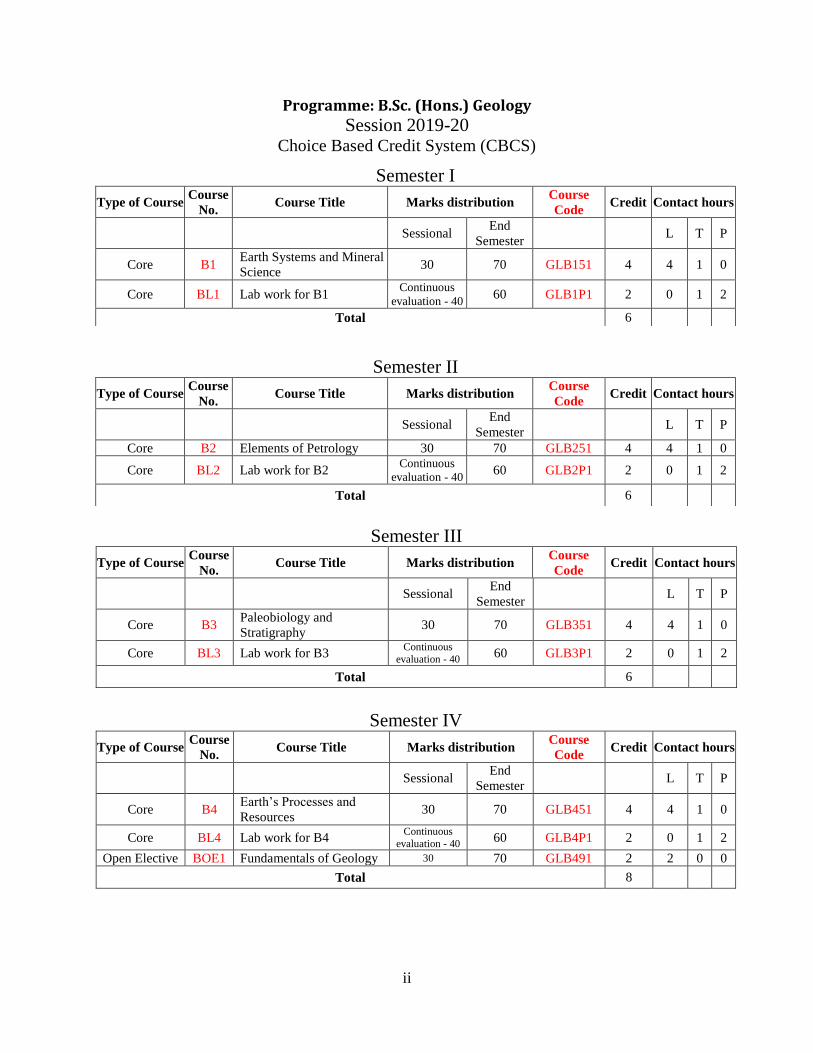
Programme: B.Sc. (Hons.) Geology
Session 2019-20 Choice Based Credit System (CBCS)
Semester III
Type of Course Course
No. Course Title Marks distribution
Course
Code Credit Contact hours
Sessional End
Semester L T P
Core B3 Paleobiology and
Stratigraphy 30 70 GLB351 4 4 1 0
Core BL3 Lab work for B3 Continuous
evaluation - 40 60 GLB3P1 2 0 1 2
Total 6
Semester IV
Type of Course Course
No. Course Title Marks distribution
Course
Code Credit Contact hours
Sessional End
Semester L T P
Core B4 Earth’s Processes and
Resources 30 70 GLB451 4 4 1 0
Core BL4 Lab work for B4 Continuous
evaluation - 40 60 GLB4P1 2 0 1 2
Open Elective BOE1 Fundamentals of Geology 30 70 GLB491 2 2 0 0
Total 8
Semester I
Type of Course Course
No. Course Title Marks distribution
Course
Code Credit Contact hours
Sessional End
Semester L T P
Core B1 Earth Systems and Mineral
Science 30 70 GLB151 4 4 1 0
Core BL1 Lab work for B1 Continuous
evaluation - 40 60 GLB1P1 2 0 1 2
Total 6
Semester II
Type of Course Course
No. Course Title Marks distribution
Course
Code Credit Contact hours
Sessional End
Semester L T P
Core B2 Elements of Petrology 30 70 GLB251 4 4 1 0
Core BL2 Lab work for B2 Continuous
evaluation - 40 60 GLB2P1 2 0 1 2
Total 6
iii
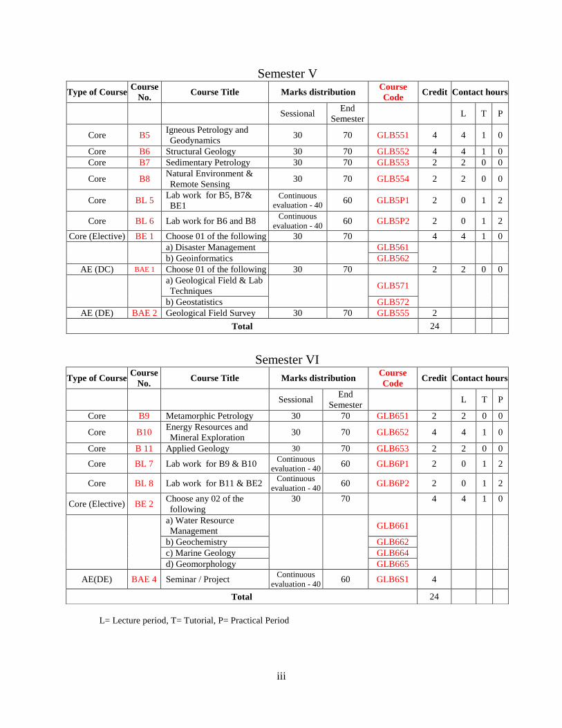
Semester V
Type of Course Course
No. Course Title Marks distribution
Course
Code Credit Contact hours
Sessional End
Semester L T P
Core B5 Igneous Petrology and
Geodynamics 30 70 GLB551 4 4 1 0
Core B6 Structural Geology 30 70 GLB552 4 4 1 0
Core B7 Sedimentary Petrology 30 70 GLB553 2 2 0 0
Core B8 Natural Environment &
Remote Sensing 30 70 GLB554 2 2 0 0
Core BL 5 Lab work for B5, B7&
BE1 Continuous
evaluation - 40 60 GLB5P1 2 0 1 2
Core BL 6 Lab work for B6 and B8 Continuous
evaluation - 40 60 GLB5P2 2 0 1 2
Core (Elective) BE 1 Choose 01 of the following 30 70 4 4 1 0
a) Disaster Management
GLB561
b) Geoinformatics GLB562
AE (DC) BAE 1 Choose 01 of the following 30 70 2 2 0 0
a) Geological Field & Lab
Techniques GLB571
b) Geostatistics GLB572
AE (DE) BAE 2 Geological Field Survey 30 70 GLB555 2
Total 24
L= Lecture period, T= Tutorial, P= Practical Period
Semester VI
Type of Course Course
No. Course Title Marks distribution
Course
Code Credit Contact hours
Sessional End
Semester L T P
Core B9 Metamorphic Petrology 30 70 GLB651 2 2 0 0
Core B10 Energy Resources and
Mineral Exploration 30 70 GLB652 4 4 1 0
Core B 11 Applied Geology 30 70 GLB653 2 2 0 0
Core BL 7 Lab work for B9 & B10 Continuous
evaluation - 40 60 GLB6P1 2 0 1 2
Core BL 8 Lab work for B11 & BE2 Continuous
evaluation - 40 60 GLB6P2 2 0 1 2
Core (Elective) BE 2 Choose any 02 of the
following
30 70 4 4 1 0
a) Water Resource
Management
GLB661
b) Geochemistry GLB662
c) Marine Geology GLB664
d) Geomorphology GLB665
AE(DE) BAE 4 Seminar / Project Continuous
evaluation - 40 60 GLB6S1 4
Total 24

4
B.Sc. (Hons.) Geology
Semester: I
Course code: GLB151 Course title: Earth Systems and Mineral
Science
Credits: 4 Course No: B1
Course Objective:
1. Preliminary acquaintance about Geology.
2. Introductory knowledge of Earth. Its inorganic and organic constituent and landscaping processes
and the manifested elements.
Course Outcome:
The course helps the students to understand
1. About the origin of Solar system in particular Earth, its internal and external features
2. Geological time scale, origin of landscapes. Stress induced features and fossils.
3. Crystals, their symmetry elements and notation systems
4. Minerals and their identification properties
UNIT 1:
General characteristics and origin of the Universe. Solar System and its planets
Earth’s origin and internal structure. The geomagnetic field
Concept of sea-floor spreading and plate tectonics
Geotectonic units of the Earth – Shields, Cratons, Platforms, Orogenic belts, Mid Oceanic
Ridges, Transform faults, Island arcs and Deep-sea trenches.
Seismicity and Volcanism
UNIT 2:
Concept of time in geological studies – Standard stratigraphic time scale.
Concept weathering, erosion and denudation
Erosional and depositional landforms related to the action of wind, running water and glacier.
Structural Geology and its attributes
Folds, faults and their geometrical orientation
Paleontology – scope, elements and ambit
Fossils, types and their significance
UNIT 3:
Crystal: definition and its morphological elements (crystallographic axes and axial angles).
Laws of crystallography. Concept of lattice: planar, space
Symmetry, symmetry elements and operations
Crystallographic notations for planes: Miller indices, crystal forms and their nomenclature
Point group symmetry and derivation of 27 classes
Herman-Maugin system of symmetry
Classification of crystals into systems and description of symmetry elements of normal classes.

5
UNIT 4:
Mineral and Mineral Science
Physical properties:
Properties based on interaction with light (color, luster, streak, play of colors, Chatoyancy and
Asterism, Luminescence)
Mechanical Properties (cleavage, parting, fracture, hardness, tenacity)
Mass related properties (density and specific gravity)
Miscellaneous properties (magnetism, radioactivity, piezoelectricity, proeclectricity)
Rock forming silicate minerals and structures
Petrological microscope: parts and function
Optical properties of minerals (color, pleochroism, refractive index, relief, twinkling, birefringence,
isotropism / anisotropism, interference colors, extinction angle, twinning)
Books Recommended:
1. The Blue Planet: An Introduction to Earth System Science – B.J. Skinner and S.C. Porter. 1995,
John Wiley & Sons, Inc. 493p.
2. Introduction to Physical Geology – G.R. Thompson and J. Turk. 1998, Saunders College
Publishers, Fort Worth. 371p.
3. Processes that Shape the Earth – D.M. Thompson. 2007, Infobase Publishing, NY. 116p.
4. Physical Geology – L.D. Leet, S. Judson and M.E. Kauffman, (1982). Prentice-Hall Inc. 629p.
5. Holme’s Principles of Physical Geology – P.MvL.D. Duff, Fourth Edition (1993). Stanley
Thornes (Publishers) Ltd.
6. Rutley’s Elements of Mineralogy – H.H. Read, 26th
Edition, (1970). Thomas Murby and
Company, London. 559p.
7. Mineralogy, Concepts, Descriptions, Determinations – L.G. Berry, B.H. Mason and R.V.
Dietrich, 1983. Freeman, 561p.
8. Danas Manual of Mineralogy – C.S. Hurlbut Jr., 18th
Edition , (1971). John Wiley and Sons,
New York.
9. Fundamentals of optical, spectroscopic & X-ray Mineralogy – S. Mitra 2nd
Edition, New Age
International Publishers, Delhi, 337p.
10. Structural Geology – M.P. Billings, 3rd
Edition, 2008. Prentice Hall of India Pvt. Ltd., Delhi,
606p.
11. Earth Materials – K. Hefferan and J. O'Brien, (2010). Wiley-Blackwell, UK. 608p.

6
Course code: GLB1P1 Course title: Lab work for Earth Systems
and Mineral Science
Credits: 2 Course No: BL1
Earth Systems and Mineral Science:
1. Reading topographic maps and exercises related to contour maps
2. Laboratory exercise on structural geology problems: Completion of outcrops, drawing and
interpretation of cross-sections through elementary representative geological structures.
3. Study of symmetry elements of at least one representative crystal from normal classes of seven
crystal systems.
4. Study of physical properties of minerals in hand specimen
5. Identification of fossils and diagrammatic accounts of their external and internal views.

7
Semester: II
Course code: GLB251 Course title: Elements of Petrology
Credits: 4 Course No: B2
Course Objective:
1. To impart knowledge of basic elements of Petrology
2. To train the students to understand the processes of formations of different rock groups
Course Outcome:
Upon successful completion of course the students would be able to
1. Understand the basic concept of petrology and understand formation and types of mineral
deposits associated with rocks.
2. Understand magma generation and evolution, and classify igneous rocks.
3. Understand fundamentals of sedimentary processes and stratigraphic correlation.
4. Understand factors of metamorphism, and to classify metamorphic rocks.
UNIT 1:
Petrology: definition and scope. Introduction to common rock forming: silicates and non-silicates,
ore forming and industrial minerals. Radioactive minerals, Fuel minerals
Formation and types of mineral deposits, rock association.
Mineral deposits associated with igneous rocks, sedimentary rocks and metamorphic rocks.
UNIT 2:
Magma: Definition, physical properties and chemical composition, origin. Crystallization of magma:
Bowen’s reaction series, magmatic differentiation and assismilation.
Forms and structures of extrusive and intrusive igneous rocks.
Igneous textures: crystallinity, grain shape, size and mutual relationship of grains.
Bases of classification and types of igneous rocks.
UNIT 3:
Sediments: origin, transportation, deposition and lithofication.
Fabric and texture of sedimentary rocks.
Roundness of particles and its geological significance.
Classification of sedimentary rocks: terrigenous and chemical sedimentary rocks.
Important primary sedimentary structure-bedding, ripple marks, cross bedding and mud cracks.
Different methods of stratigraphic correlation. Principles of nomenclature and classification of
lithostratigraphic, chronostratigraphic, biostratigraphic and Tectonic/genetic facies.
UNIT 4:
Introduction to Metamorphic rock and their significance.
Factors of metamorphism. Classification of Metamorphic rocks.
Basic concepts of types of metamorphism.
Concepts of isograds and zones of metamorphism.

8
Relationship between matamorphism and deformation.
Texture of Metamorphic rocks.
Books Recommended:
1. Magma and Magmatic Rocks-Middlemost.
2. Igneous and Metamorphic petrology-Best.
3. Sedimentary Rocks-Pettijohn.
4. Fundamentals of Historical Geology and Stratigraphy of India-Ravindra Kumar.

9
Course code: GLB2P1 Course title: Lab work for Elements of
Petrology
Credits: 2 Course No: BL2
Elements of Petrology:
1. Handling optical microscope
2. Optical properties and identification of common rock forming minerals (Quartz, Plagioclase,
Microcline, Biotite, Muscovite and Garnet).
3. Identification of some common Igneous, Sedimentary and Metamorphic rocks under hand
specimen with particular emphasis on texture and structures.
Igneous rocks: Granite, Rhyolite, Basalt, Dolerite, Gabbro, Diorite etc.
Sedimentary rocks: Sandstone, Limestone, Shale, Conglomerate, Breccia etc.
Metamorphic rocks: Slate, Phyllite, Schist, Gneiss, Marble, Quartzite etc.

10
Semester-III
Course code: GLB 351 Course title: Paleobiology and Stratigraphy
Credits: 4 Course No: B3
Course Objective:
1. To impart basic knowledge about Paleobiology and Stratigraphy.
2. To train the students to understand the processes of formations of different sedimentary basins
and significance of fossils.
Course Outcome:
Upon successful completion of course the students would be able to
1. Understand the basic concept of paleontology and stratigraphy.
2. Understand fossil identification and description and application of fossils in organic evolution.
3. Understand fundamentals of stratigraphy and its branches.
4. Understand stratigraphy and sedimentation history of different sedimentary basins of India.
UNIT 1:
Methods of fossil identification, description and illustration. Application of palaentologic studies in
organic evolution, biostratigraphy, palaecology, palaeogeography and palaeoclimatology.
Microfossils: Definition, significance and a brief account of important groups.
Brachiopioda: Morphology and geological distribution.
Echinoidea: Morphology and geological distribution.
Trilobite: Morphology and geological distribution.
UNIT 2:
Pelecypoda: Morphology and geological distribution.
Gastropoda: Morphology and geological distribution.
Cephalopoda: Morphology and geological distribution of Nautiloidea and Ammonoidea.
Origin of vertebrates and landmarks in vertebrate evolution.
Evolutionary history of Equidae.
Palaebotany: Broad classification of plant kingdom and application of palaeobotanical studies.
Morphology, classification and geological range of important Lower and Upper Gondwana flora.
UNIT 3:
Stratigraphy and its branches.
Stratigraphic correlation, stratigraphic classifications.
Stratigraphic succession, essential lithology and economic significance of the following
Precambrian Cratons of India:
Dharwar, Singhbhum, Bundelkhand, Aravalli.
UNIT 4:
Stratigraphy and brief sedimentation history of the following Sedimentary Basins of India:
Proterozoic: Delhi, Vindhyan Supergroups
Phanerozoic Stratigraphy of India: Gondwana Supergroup.

11
Triassic of Spiti, Jurassic of Kutch,
Cretaceous of south east coast of India,
Books Recommended:
1. Invertebrate Palaentology- Woods.
2. The Elements of Palacontology- Black.
3. Introduction to Paleobotany-Arnold.
4. Essential of Paleobotany-Shukla and Mishra.
5. Geology of India and Burma-Krishnan.
6. Fundamentals of Historicals geology and Stratigraphy of India-Ravindra Kumar
7. Precambrian Geology of India-Naqvi and Rogers.
8. Geology of India by M.Ramakrishnan & R.Vaidyanadhan Vol.I & Vol.II, Geological Society of
India, Bangalore,2008/2010.

12
Course code: GLB3P1 Course title: Lab work for Paleobiology and
Stratigraphy
Credits: 2 Course No: BL3
Palaeobiology and Stratigraphy:
1. Study of morphological characters of important fossil phyla designated in theory paper.
2. Exercises related to major stratigraphic and lithotectonic units on the map of India.

13
Semester: IV
Course code: GLB 451 Course title: Earth’s Processes and Resources
Credits: 4 Course No: B4
Course Objective:
1. To impart knowledge of basic concepts of Earth Processes and Resources
2. To train the students to understand the processes of formations of different ore deposits, energy
resources and non-metallic mineral deposits.
Course Outcome:
Upon successful completion of course the students would be able to
1. Understand the basic concept of Renewable and non-renewable energy resources.
2. Understand physical properties and composition of silicates, carbonates, oxides and sulfides.
Geological setting, mineralogical characteristics and Indian distribution of metallic mineral deposits
3. Understand process of formation of different types of ore deposits.
4. Understand geological setting, mineralogical characteristics and Indian distribution of non-metallic
mineral deposits and building materials
UNIT 1:
Renewable and non-renewable energy resources.
Hydroelectric power. Energy from the sun, wind, hot springs and sea waves.
Use of conventional and non-conventional sources of energy. Energy efficiency and conservation.
Distribution of mineral deposits in space and time.
Physiographic, mineralogical, stratigraphic, lithologic and structural guides to ore.
UNIT 2:
Systematic classification of minerals. Physical properties and chemical composition of the following
classes of minerals:
Silicates: (a) Nesosilicates – Olivine and Garnet groups; (b) Inosilicates – Pyroxene and Amphibole
groups,
(c) Tectosilicates – Quartz and Feldspar groups.
Carbonates: Calcite, Aragonite and Dolomite groups.
Oxides: Simple and multiple oxides.
Sulfides: Copper, Iron, Lead and Zinc sulfides.
Geological setting, mineralogical characteristics and Indian distribution of metallic mineral deposits
of iron, manganese, chromium, copper, gold, aluminum, lead and zinc.
UNIT 3:
Ore forming minerals: metallic and non-metallic minerals. Processes of ore formation.
Ore deposits related to magmatic activity.
Hydrothermal and skarn deposits – Role of replacement and colloidal deposition.
Ore deposits formed by sedimentation. Weathering products and Residual deposits.
Ore deposits formed by oxidation & supergene enrichment.
14
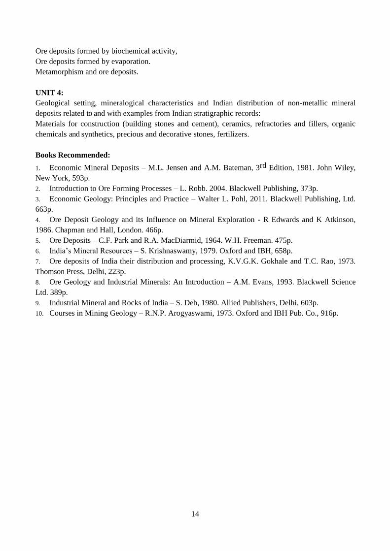
Ore deposits formed by biochemical activity,
Ore deposits formed by evaporation.
Metamorphism and ore deposits.
UNIT 4:
Geological setting, mineralogical characteristics and Indian distribution of non-metallic mineral
deposits related to and with examples from Indian stratigraphic records:
Materials for construction (building stones and cement), ceramics, refractories and fillers, organic
chemicals and synthetics, precious and decorative stones, fertilizers.
Books Recommended:
1. Economic Mineral Deposits – M.L. Jensen and A.M. Bateman, 3rd Edition, 1981. John Wiley,
New York, 593p.
2. Introduction to Ore Forming Processes – L. Robb. 2004. Blackwell Publishing, 373p.
3. Economic Geology: Principles and Practice – Walter L. Pohl, 2011. Blackwell Publishing, Ltd.
663p.
4. Ore Deposit Geology and its Influence on Mineral Exploration - R Edwards and K Atkinson,
1986. Chapman and Hall, London. 466p.
5. Ore Deposits – C.F. Park and R.A. MacDiarmid, 1964. W.H. Freeman. 475p.
6. India’s Mineral Resources – S. Krishnaswamy, 1979. Oxford and IBH, 658p.
7. Ore deposits of India their distribution and processing, K.V.G.K. Gokhale and T.C. Rao, 1973.
Thomson Press, Delhi, 223p.
8. Ore Geology and Industrial Minerals: An Introduction – A.M. Evans, 1993. Blackwell Science
Ltd. 389p.
9. Industrial Mineral and Rocks of India – S. Deb, 1980. Allied Publishers, Delhi, 603p.
10. Courses in Mining Geology – R.N.P. Arogyaswami, 1973. Oxford and IBH Pub. Co., 916p.

15
Course code: GLB4P1 Course title: Lab work for Earth’s Processes
and Resources
Credits: 2 Course No: BL4
Earth’s Processes and Resources:
1. Study of physical and optical properties of metallic and non-metallic minerals/resources.
2. Hand specimen study of different types of coal.
3. Preparation of maps showing distribution of important ores and other economic minerals of
India. Study of metallogenetic maps.

16
Course Code: GLB491 Course: Fundamentals of Geology
Credits: 2 Course No: BOE1
Course Objective:
1. To impart basic understanding of geology to students having no background in earth sciences
2. To impart awareness of the dynamics of the earth systems and its implications for natural
resources
Course Outcome:
Upon successful completion of the course, the students should be able to:
1. Understand the earth systems and how they interact?
2. Understand the dynamics of the earth’s interiors, plate tectonic processes, seismicity, and
volcanism
3. Understand the origin and occurrence of minerals and rocks
4. Understand the energy and mineral resources on earth
UNIT 1:
Introduction and scope of geology.
The solar system – Planets, asteroids and meteorites.
Origin of the Earth – its position in the solar system.
Geological time scale. Internal structure and constitution of the Earth – Physical and chemical
layering.
The hydrosphere, atmosphere and biosphere.
Interacting Earth systems.
Sea-floor spreading and theory of plate tectonics. Mechanisms of plate motions, Types of plate
boundaries – Divergent, convergent and transform.
UNIT 2:
Earthquakes – their mechanism and distribution
Volcanoes – their types and distribution
Minerals and their formation. Physical and optical properties of minerals. Classification of minerals.
Uses of minerals.
Formation of igneous rocks, Origin of magmas, Intrusive and extrusive igneous rocks, Classification
of igneous rocks.
UNIT 3:
Formation of sedimentary rocks – Weathering, erosion and transportation
Classification of sedimentary rocks – Clastic, chemical and biochemical.
Primary and secondary sedimentary structures.
Landforms and their origin. Fossils and the process of fossilization.
Formation of metamorphic rocks, heat and pressure
Types of metamorphism – Contact and regional metamorphism
Foliated and non-foliated metamorphic rocks.
Metamorphic rock textures.

17
UNIT 4:
Introduction of folds, faults, joints, cleavage, foliation, lineation and unconformities. Isostasy;
Introduction to plate tectonics, mountain building processes.
Mineral and energy resources from the Earth
Mineral resources: Origin of mineral deposits. Magmatic, hydrothermal, sedimentary, placer and
residual deposits.
Non-renewable energy resources – Coal, petroleum & natural gas, nuclear fuel materials
Renewable energy resources – Solar, Wind, wave, Tidal, Hydroelectric, Geothermal and Biomass
Surface and groundwater resources
Books Recommended:
1. Bridge, J and Demicco, R. (2008). Earth Surface Processes, Landforms and Sediment Deposits.
Cambridge University Press. 815p.
2. Leeder, M. and Perez-Arlucea, M. (2006). Physical Processes in Earth and Environmental
Sciences. Blackwell Publishing. 321p.
3. Smith, Z.A. and Taylor, K.D. (2008). Renewable and Alternative Energy Resources.
Contemporary World Issues. 322p.
Ozima, M., Korenaga, J. and Yin, Q. (2012). The Earth: Its Birth and Growth. Cambridge University
Press. 150p.

18
Semester: V
Course Code: GLB551 Course: Igneous Petrology and
Geodynamics
Credits: 4 Course No: B5
Course Objective:
1. To impart knowledge about the magmatic systems
2. To train the students about the dynamism of the earth
Course Outcome:
Upon successful completion of course the students would be able to
1. Understand the mantle system and magmatic processes with special reference to Precambrian
rock association.
2. Understand basic principles of equilibrium thermodynamics, binary and ternary systems and
origin of different igneous rocks.
3. Understand internal structure and layers of the Earth and plate tectonics.
4. Understand different earth processes in relation to plate tectonics.
UNIT 1:
Mantle petrology: Mineralogy and Chemistry.
Primary and parental magma: Physical and Chemical properties, volatile contents.
Magmatic differentiation: Fractional crystallization, magma mixing, crystal settling, liquid
immiscibility, assimilation.
Major and trace elements in magmas; application of trace elements in igneous petrogenesis.
Classification of igneous rocks, bases of classification, IUGS classification.
Igneous rock associations in space and time; Mineralogy and chemical characteristics of the
following Precambrian igneous rock assemblages: (a) Komatiites (b) Anorthosites and (c) Tonalite-
trondhjemite-granodiorite (TTG).
UNIT 2:
Basic principles of equilibrium thermodynamics;
Concept of system, phase and component; Chemical potential and phase rule.
Phase equilibria of the two and three component silicate systems:
Binary System- Albite-Anorthite, Diopside-Anorthite, Nepheline-silica, Forsterite-silica,
Diopside-Anorthite-Albite, Nepheline-Kalsilite-Silica ternary systems.
Basaltic magmatism in relation to plate tectonics. Concept of igneous rock series.
Mineralogical Characteristics and origin of the following rock types:
(i) Granite, Granodiorite, Diorite, Rhyolite (ii) Basalt, Dolerite, gabbro (iii) Syenites, nepheline-
syenite, trachyte (iv) Preidotites

19
UNIT 3:
Internal structure of the earth.
Geophysical conditions of the earth: gravity, magnetism, heat flow.
Concept and theories of isostacy.
Plate tectonic theory: the mechanism of the plate tectonics.
Nature and types of plate margins.
Geometry and driving mechanism of plate motion.
UNIT 4:
Plate tectonics with time, Evolution of continents and oceans.
Magnetic anomaly patterns in the ocean basins and sea-floor spreading.
Origin, Significance and distribution of divergent margins, mid oceanic ridges.
Origin, Significance and distribution of subduction zones, Islands arcs and trenches.
Tectonics of continental rifts, continental margins, shelves, marginal basins and intracratonic basins.
Plate Tectonics and magmatism.
Neotectonics: Active fault system.
Indicators of recent tectonic activity.
Books Recommended:
1. Principles of igneous and metamorphic petrology-Philpots
2. Magma and magmatic rocks- Middlemost
3. Igneous and metamorphic petrology- Best
4. Plate tectonics and crustal evolution- Condie
5. Aspects of Tectonics- Valdiya
6. Global Tectonics- Kearey and Vine
7. Igneous petrology- M.K.Bose
8. Igneous petrogenesis- M.Wilson
9. Igneous Rocks and Processes- A practical guide- Robin Gill
10. Igneous Petrology – Alexander R. McBirney

20
Course Code: GLB552 Course: Structural Geology
Credits: 4 Course No: B6
Course objectives:
1. To educate the students about the concept rock deformation.
2. To understand qualitative aspects of brittle and ductile deformation processes, and descriptive
analysis.
Course outcomes:
Upon successful completion of course the students would be able to
1. Understand significance of ductile deformation. Various types of folds and their mechanics.
2. Understand formation of various types of unconformities and be able to recognise on geological
maps.
3. Understand significance of brittle deformation. Various types of faults and their mechanics.
4. Understand rock fabrics and types of planar and linear fabrics produced during tectonic
deformation.
UNIT 1:
Description and nomenclature of folds. Geometric and genetic classification of folds. Recognition
and interpretation of folds in field and geological maps.
UNIT 2:
Unconformities, their types and recognition in the fields and on geological maps. Geological
significance of unconformities. Criteria for distinguishing faults from unconformities. Geological
criteria for determination of stratigraphic superposition, on the basis of biostratigraphy, fossil
disposition, volcanogenic structures, cleavage bedding relationship and external form and internal
organization of sediments. Joints, their classification and significance.
UNIT 3:
Description and classification of faults. Geometric and Genetic Classification of fault. Criteria for
recognition of faults, in the field and on geological maps.
UNIT 4:
Planar and linear structures, their identification and description. Type of cleavage and schistosity and
their origin.Relation of cleavage and schistosity to major structures. Types of lineations, their origin
and their relation to major structures.
Books Recommended:
1. Structural Geology of Rocks and Regions- George H. Davis- 3rd edition.
2. .Folding and Fracturing of Rocks-Ramsay.
3. An outline of Structural Goelogy-Rubbs, Mears and William.
4. Structural Geology – M.P. Billings

21
Course Code: GLB553 Course: Sedimentary Petrology
Credits: 2 Course No: B7
Course Objective:
1. To impart knowledge of formation of sedimentary rocks.
2. To train the students to understand the mode of formations, transportation and deposition of the
sediments and also about the processes modifying the sediments after their burial.
Course Outcome:
Upon successful completion of course the students would be able to:
1. Understand the concept of grain size and lithofacies analysis in evaluating the hydrodynamic
conditions, depositional environments and palaeoclimatic conditions.
2. Understand generation of primary and biogenic sedimentary structures and their significance.
3. Understand the processes of deposition of sediments and their diagenetic modifications.
4. Understand origin and classification of siliciclastics and carbonates.
UNIT 1:
Particle size of detrital rocks–grade scales in Phi and mm. Significance of grain size in
sedimentological investigations.
Shape and sphericity of clastic particles. Zingg’s and Folk’s shape classes.
Chemistry of weathering processes.
Concept of sedimentary facies. Basic principles of paleoenvironment and paleoclimate analysis.
UNIT 2:
Basic ideas about depositional environments and their classification. Reynold number and Froude
number. Laminar and turbulent flows and flow regimes.
Morphology of important primary sedimentary structures and their significance.
Biogenic structures and ichnofossils and their significance.
UNIT 3:
Processes of sediment deposition: aqueous, Aeolian, glacial and gravitational (turbidity, mud and
debris flows).
Diagenesis of terrigenous and chemical sediments.
Heavy minerals and their geological significance.
Conglomerates: origin and classification.
Petrography and geological significance of diamictites and tillites.
UNIT 4:
Sandstone: classification and origin. Petrography and geological significance of quartz arenite,
arkose and greywacke.
Concept of maturity – mineralogical and textural.
Shale: types, mineralogy and their bedding characteristics.
Origin and classification of carbonates with special reference to Folk’s classification.
Tectonics and sedimentation. Geosynclinal basins and facies. Krynine’s cycle.

22
Books Recommended:
1. Sedimentary Rocks – Pettijohn, F.J. (1975)
2. Origin of Sedimentary Rocks – Blatt, H., Middleton, G.V., Murry, R.C. (1980)
3. Paleocurrents and Basin Analysis – Potter, P.E. and Pettijohn, F.J. (1977)
4. Sedimentology and Stratigraphy – Nichols, Gary (1999).
5. Sedimentary Geology – Prothero, Donald, R. & Schwab, Fred (1996)

23
Course Code: GLB554 Course: Natural Environment and Remote
Sensing
Credits: 2 Course No: B8
Course Objective: To impart knowledge of environmental geology, natural hazards and basic
concepts of remote sensing and GIS.
Course outcome:
Upon successful completion of course the students would be able to:
1. To understand the Earth’s ecosystem and interrelations of various components of the Earth.
2. To understand geological aspects of various natural hazards and geoengineering projects.
3. To develop elementary idea about remote sensing technique.
4. To develop concepts of maps and GIS.
UNIT 1:
Environmental Geology: Concept and interdisciplinary approach. Earth as closed system,
understanding hazardous earth processes. Natural ecosystems on the earth and their interactions
(atmosphere, hydrosphere, lithosphere and biosphere): Cycles in earth system: carbon energy cycle,
biogeochemical cycle, rock cycle, geochemical cycle
UNIT 2:
Soil: formation, classification, and degradation. Landslides: slope stability, causes of landslides,
prevention and mitigation. Floods: causes, impact and mitigation. Earthquakes: causes, impact and
mitigation. Environmental and Geological consideration in site selection of dams, and tunnels.
Dams: foundation materials, structures causes of failure, seismicity. Tunnels: geology, structures,
role of water table and seismicity.
UNIT 3:
Types of satellites and images. Concept of photo-geology and photogrammetry. Types of aerial
photographs. Basics of remote sensing, EMR, platforms, sensors., Framing and scanning systems..
Spatial, spectral and temporal resolution. Sensors and their characteristics on board IRS, Landsat
and SPOT satellites. EMR interaction with atmosphere and earth surface. Elements of image
interpretation (photographic and geotechnical). Basic drainage pattern and their characteristics.
Spectral signatures of soil, water and vegetation.
UNIT 4:
Maps: elements, scale, base and reference map. Thematic maps. Map projections: Conical
Cylindrical and Azimuthal. Concept of Datum and coordinate systems. Basics of GIS: data formats,
data structure, relational and hierarchical . Data integration and overlay analysis in GIS. Functions of
GIS. Digitization, editing and topology building in GIS. Concept of Digital Elevation Model (DEM).
GPS satellite constellations, GPS segments: space, control, user, signals & codes. GPS receivers.
Operating principle, functions and applications of GPS in various fields. Application of remote
sensing and GIS in natural hazards. Examples from India.

24
Books Recommended:
1. Environmental Geology-Keller
2. Principles of Engg. Geology and Geotectonics-Krynine and Judd.
3. Engineering Geology-Kesavulu.
4. Remote Sensing-Principles and Interpretation-Sabins.
5. Environmental Geology-Montgomery.
6. Remote Sensing and image interpretation – Lillesand and Keifer
7. Fundamentals of Remote Sensing by George Joseph
8. Remote Sensing of Environment by A.R. Jensen
9. Remote Sensing and Geographical Information System by Anji Reddy

25
Course Code: GLB5P1 Course: Lab work for B5, B7 and BE1
Credits: 2 Course No: BL6
1. Igneous Petrology & Geodynamics:
Hand specimen study of different types of extrusive and intrusive igneous rocks, Microscopic study
of igneous textures, mineralogy and petrogenetic features of igneous rocks.
2. Sedimentary Petrology:
Hand specimen study of different types of clastic and chemical sedimentary rocks, Study of Primary
sedimentary structures in hand specimens. Microscopic study of textures, mineralogy and diagenetic
features of sedimentary rocks.
3. Disaster Management:
Study and analysis of vulnerable regions of India. Exercises on various disasters in India. Disaster
vulnerability Index and its relevance. Exercises related to drought assessment and flood prone
regions.
4. Geoinformatics:
Accessing, searching and extracting metadata, Spatial data infrastructure of Census of India, DST,
Ministry of Environment and Forest, Climate Change, CPCB, Ministry of Water resources. Exercises
related to spatial data analysis, overlay and composite analysis.
26
Course Code: GLB5P2 Course: Lab work for B6 and B8
Credits: 2 Course No: BL5
1. Structural Geology:
Exercises on structural geology problems. Stereographic projections of structural data. Geometrical
problems on folds and faults. Drawing and interpretation of profile sections across geological maps.
2. Natural Environment & Remote Sensing:
Morphometric analysis using sample watersheds. Scale determination and conversion. Spatial
analysis using multiple data sets. Classification of data using various methods. Exercise on land
degradation and resource depletion. Arial photographs and Satellite images- feature identification.
Exercises related to water availability in river basins of India.
27
Course Code: GLB561 Course: Disaster Management
Credits: 4 Course No: BE1(a)
Course Objective:
To impart knowledge of natural hazards and their management.
Course Outcome:
1. To understand the basic of natural disasters.
2. To understand geological aspects of various natural disasters.
3. To develop skills for managing natural disasters.
UNIT 1:
Natural disasters: Concept and Definition. Types of disasters and their effects. Participatory approach
in disaster management. Earthquakes: occurrence, distribution, mapping and management of
earthquake prone areas. Damage assessment, rehabilitation and resettlement. Tsunami: origin,
causes, effects. Tsunami monitoring and warning system in the Asia Pacific region.
UNIT 2:
Cyclones: occurrence, distribution, monitoring and management. Major cyclones in the Bay of
Bengal and their impacts. Forewarning and forecasting using ICT: role of IMD. Government policies
and programmes for rehabilitation. Volcanic eruptions: causes, monitoring, remedies and
rehabilitation.
UNIT 3:
Floods: Occurrence, distribution, forecasting, forewarning, monitoring, mitigation and management.
Damage assessment, rehabilitation relief and rescue operations. Flood zone mapping. Modern tools
in flood forecasting. Vulnerable states in India. Flash floods: causes and remedies. Glacial lake
outburst floods.
UNIT 4:
Landslides: causes and effects. Landslide monitoring, mapping and risk assessment. Landslide-prone
states and regions. Forest fires: prevention, monitoring and managing wildfires. National disaster
management Authority (NDMA): functions, role, objectives and responsibilities in disaster
management. Role of NGO’s in disaster management.
Books Recommended:
1. Disaster Management by Mukesh Kapoor
2. Disaster Management : Future challenges and opportunities by Jagbir Singh
3. Disaster Management: Edited by H K Gupta, Universities Press, Hyderabad
4. Disaster Management by Mirinalini Panday, (2014). Wiley India, ISBN:9788126549245
5. Disaster Education and Management – R.K. Bhandari (2014). Springer, New Delhi,
6. www.nidm.gov.in, www.ndma.gov.in, www.dmibhopal.nic.in

28
Course Code: GLB562 Course: Geoinformatics
Credits: 4 Course No: BE1(b)
Course Objective: To impart knowledge of geoinformatics, geo-data and effective management and
use of data.
Course outcome:
Upon successful completion of course the students would be able to:
1. To understand the basic concepts of geoinformatics and its implications.
2. To understand the concept and applications of GIS, spatial and non-spatial data.
3. To develop skills in handling and managing database.
4. To develop concepts of maps and GIS along with their applications in Geosciences.
UNIT 1:
Geoinformatics: definition and concept. Early geoinformation technology and its expression.
Contemporary geoinformation technology and future trends. Pathways and innovation drives in
geoinformation evolution. Concept of meta data. Need for geo data in the national perspective.
Raster and vector data formats. Concept of Geocoding. Datum and reference systems. Earth’s
ellipsoid and spheroid.
UNIT 2:
Spatial and non-spatial data. Data representation on maps, Aerial photographs and satellite images.
Concept of vector and raster GIS. Digitization of spatial data at state and national level: land records,
industries, urban centres. Geo-data in census operations: collection, editing, compilation,
representation, update and analysis. GIS applications in census data. GIS and e-governance. Digital
India concept. Sources of geodata. Geoinformatics in spatial and temporal analysis of earth
resources.
UNIT 3:
Data, Databases and Information, Overview of Database Management Systems (DBMS).Introduction
to data structures. Types of Database Management Systems. Objectives of DBMS - Data availability,
Data integrity, Data security, Data independence. File-based information systems and their
limitations. Advantages of DBMS - Centralized data management, Data independence, Data
inconsistency. National Spatial Data Infrastructure (NSDI) and its utility.
UNIT 4:
Georeferencing of maps and images. Open source vs commercial software in GIS and remote
sensing. Overview of ArcGIS, ENVI and ERDAS software. Basic components of GPS. Using GPS
in GIS data collection and capture. Information extraction from satellite images and thematic
mapping. Applications of GIS in geosciences.

29
Books Recommended:
1. Fundamentals of GIS by Micheal Demers
2. Remote Sensing and Geographic Information System by Anji Reddy
3. Remote Sensing and Geographic Information System by A.M. Chandra
4. Concepts and Techniques of Geographic Information System by Lo and Yeung.
5. www.GISdevelopment.net
30
Course Code: GLB571 Course: Geological Field Techniques
Credits: 2 Course No: BAE1(a)
Course Objective:
1. To impart knowledge of geological field survey.
2. To train the students to understand functioning of necessary instruments required during
geological field survey.
Course Outcome:
Upon successful completion of course the students would be able to:
1. Understand the basic concept of geological field work and various instruments used in field
work
2. Understand various geological structures found at outcrops.
3. Understand fundamentals of geological processes and stratigraphic correlation.
4. Understanding observations and recording of important filed information and to classify various
types of features procured from field study.
UNIT 1:
Introduction to field geology, Objectives of field work, deciding where to do the fieldwork.
Importance of field safety.
The Field Notebook: Purpose of Field Notes, Field Notebook Layout, Field Sketches.
Written Notes: Recording Data. Field report writing.
Scale of observation: Regional context, Whole exposure, Hand specimens.
Instruments used in field: GPS, Brunton compass, Geological Hammer & altimeter.
Parts, functions and use of Brunton compass, GPS.
Preparedness for field survey: Base map, Geological maps, toposheets and Indian numbering system,
Reading toposheets, interpretation of contour patterns.
UNIT 2:
Concept of dip and strike, Recording orientation of planar and linear features.
Reporting orientation data: Azimuth, Quadrant reading.
Stereographic projections of geological structures.
Cross-Sections and 3D Illustrations: Cross-Sections, Down-Plunge Projection Method, Columnar
Sections, Block Diagrams.
Establishment of relative ages: cross-cut relations, xenoliths.
Recognition of folds, faults and unconformities in the field.
Measuring thickness of inclined strata.
Locating position on toposheet and concept of forward bearing and backward bearing.

31
UNIT 3:
Observations and Recording of important field information.
Recording features of sedimentary: Recording sedimentary lithology, Recording sedimentary
structures, Graphic logs.
Recording Features of Igneous Rocks: Relationships with surrounding rocks, Internal architecture:
Joints, veins, and other exposure-scale fabrics. Mineralogy and small-scale textures of igneous rocks.
Recording Features of Metamorphic Rocks: Field relations and context, Textures, Identifying
common metamorphic minerals. Pre-kinematic features, Syn-kinematic features, Post-kinematic
features.
UNIT 4:
Importance of field photographs.
Sampling: Selecting and labelling samples, Samples for thin-sections, oriented samples.
Samples for geochemical analysis.
Recording Palaeontological information: Sampling Strategies & Estimating abundance.
Mapping techniques: traverse mapping, contact mapping, exposure mapping. Map symbols.
Structural measurements and notations, Brittle structures: Faults, joints and veins, Ductile structures:
Shear zones, foliations and folds.
Books Recommended:
1. Klein, C. and Hurlbut, Jr. C.S., 1993: Manual of Mineralogy-John Wiley
2. Putnis, Andrew, 1992: Introduction to Mineral Sciences-Cambridge University Press
3. Phillips, Wm, R. and Griffen, D.T., 1996: Optical Mineralogy-CBS Edition
4. Hutchinson, C.S., 1974: Laboratory Handbook of Petrographic Techniques-John Wiley
5. McClay, K.R. 2013. Mapping of Geological Structures (Geological Society of London
Handbook). John Wiley and Sons, 168p.
6. Angela L. Coe, Tom W. Argles, David A. Rothery, Robert A. Spicer, 2010.Geological Field
Techniques, Edited by Angela L. Coe.A John Wiley & Sons, Ltd., Publication
7. Roger Marjoribanks, 2010. Geological Methods in Mineral Exploration and Mining, Springer
Verlag, Hiedelberg. 238pp.

32
Course Code: GLB572 Course: Geostatistics
Credits: 2 Course No: BAE1(b)
Course Objective:
Description of statistical parameters employed to analyse / synthesize geological data for accurate
and authentic interpretation / resolution of any geological event / riddle.
Course Outcome:
The course helps the students to understand
1. Primary idea about various laws of statistical distribution
2. Primary attributes (indices) to characterize a geological data
3. Primary dispersion ideologues of
4. Primary statistical discrepancy measures
UNIT 1:
Characteristics of geological information, Scales of measuring and deviations. Laws and
randomness. Main statistical laws of distribution used in geology: Normal law of distribution.
Transformation of Fisher. Standard normal law of distribution. Function of error of Laplace and its
table. Logarythmically normal law of distribution. Binomial law of distribution. Poisson’s law of
distribution.
UNIT 2:
Elements of Theory of Probabilities: Events. Frequency and probability. Distribution function:
Representation of quantitative geological information (tables, analytical and graphic representation).
Definition of the law of distribution. Characteristics of random values: Numerical characteristics of
dislocation and dispersion, Mathematical prognosis, mode, median. Dispersion, standard, coefficient
of variation. Range. Quantiles and interquantile latitudes. Coefficients of asymmetry and excess.
Cases of grouped and ungrouped data. Dispersions of asymmetry and excess and validation of
hypothesis of normal distribution.
UNIT 3:
Hypotheses and statistical refinement: scheme of statistical refinement. Null and alternative
hypotheses, statistics and its distribution. Distribution xi-square and critical values for set trust
probability. Criteria of accordance for continuous functional distributions (Kolmogorov-Smirmov).
Comparison of two geological objects: criterion of Velch for averages. Non-parametric criterion of
Wilcoxon. Fisher’s criterion for dispersions. Non-parametric criterion of Seadgel-Tuckie. Xi-square
criterion for frequencies. Coefficient of correlation: correlation coefficient for quantitative data and
its properties. Correlation coefficient for qualitative data.
UNIT 4:
Linear regressive mode: Properties, equations and geometric interpretation. Evaluation of qualitative
linear model on the basis of dispersions comparison. Non-linear regression: Types of non-linear
regression. Parabolic, hyperbolic, exponential, logarithmic regression. Interpolation, extrapolation,
fitting. Coefficient of multiple correlation for discrepancy analysis with observation data. Random

33
functions and analysis of diagrams: models of random fields in space and time, mathematical
prognosis, dispersion, correlation function.
Books Recommended:
1. Pitman, J. (1993) Probability, Springer Verblag, (also Narosa Publishers).
2. Creighton, J.H.G. (1994) First course in probability models and statistical inference, Springer
Verlag.
3. Davis, J.G. (1986) Statistics and data anaylsis in geology, John Wiley.
4. Walpole, R.E. and Myers, R.H. (1982) Applied multivariate statistical analysis, Prentice Hall
Inc., New Jersey.
5. Cooley, W.W. and Lohnes, P.R. (1971) Multivariate data analysis, John Wiley and Sons.
6. Morrison, D.f. (1967) Multivariate statistical methods, Me Graw-Hill. Pandalai,
7. Hindusthan Publishing Corporation (India), New Delhi Spiegel, M.r. (1982) Probability and
Statistics, Schaums Qutline Series, McGraw-Hill Int., Singapore, Asian Students Edn.
8. Kubackova, L., Kubacek, L. and Kukuca, J. (1987) Probability and Statistics in Geology and
Geophysics, Elsevier.
9. Journel, A.g. and Huijbregts, Ch. (1978) Mining Geostatistics, Academic Press,
10. Armstrong, M. (1998) Basic Linear geostastics, Springer Verlag, Berlin.
11. Saals. E/A/ amd Srovastav. R.M. (1990) An Introduction to Geostatistics, Oxford University
Press.
12. Journel, A.g. and Huijbregts, C. (1978) Mining Geostatistics, Academic Press, London.
Chiles, J.P. and Delfiner, P. (1990) Geostatistics: Modeling Spatial Uncertainity, John Wiley &
Sons, New York.

34
Course Code: GLB555 Course: Geological Field Survey
Credits: 2 Course No: BAE2
Geological Field Survey:
Field work including geological and structural mapping.
Preparation of field report based on the recorded data, mapping data as well as laboratory work on
the rock samples collected during the field work.

35
Semester: VI
Course Code: GLB651 Course: Metamorphic Petrology
Credits: 2 Course No: B9
Course Objective:
1. To impart knowledge about Metamorphism and metasomatism of rocks.
2. To train the students to understand the different processes of formations of metamorphic rocks
and their significance.
Course Outcome:
Upon successful completion of course the students would be able to
1. Understand the factors and agents of metamorphism.
2. Understand the textures and different zones of metamorphism.
3. Understand the processes of metasomatism and their types.
4. Understand the representation of mineral paragenesis of metamorphic rocks & graphical
representation.
UNIT 1:
Metamorphic processes and a detailed account of agents and their role in metamorphism. Texture
and structures of metamorphic rocks and their significance. Types of metamorphism: Contact,
regional, cataclastic and metasomatism. Cataclastic metamorphic and its products.
UNIT 2:
Barrovian zone of regional metamorphism and principles of isograd mapping. Rosenbusch’s zones of
thermal metamorphism, contact aureole. Contact metamorphism of carbonate rocks. Regional
metamorphism of pelitic rocks. Metamorphism in relation to plate tectonic. Paired metamorphic
belts.
UNIT 3:
Metasomatism: types, mass transfer and products, anatexis and granitisation. Depth zone in
metamorphic rocks. Nucleation. Chemical equilibrium in metamorphic rocks - crystallization &
recrystallization in metamorphic rocks. Concept of metamorphic facies and facies series. Low
pressure and medium to high pressure facies (field relation and mineralogy).
UNIT 4:
P-T-t diagrams and projective analysis. Graphic representation and nomenclature of metamorphic
facies. Principle chemical classes. Representation of mineral paragenesis of metamorphic rocks.
Classification and nomenclature of metamorphic rocks.
Books Recommended:
1. Metamorphic Petrology-Turner.
2. Petrology of Metamorphic Rocks-Mason.
3. Principles of Igneous and Metamorphic Petrology-Philpots.
36
Course Code: GLB652 Course: Energy Resources and Mineral
Exploration
Credits: 4 Course No: B10
Course Objective:
1. To impart knowledge of Energy Resources and Mineral Exploration.
2. To train the students to understand the energy resources, methods of exploration and mineral
economics.
Course Outcome:
Upon successful completion of course the students would be able to:
1. Understand the basic concept of coal and petroleum formation and classification.
2. Understand the origin, exploration and distribution of gas hydrates and nuclear waste.
3. Understand fundamentals of the geophysical methods of mineral exploration.
4. Understand the principles of mineral economics and bore hole logging.
UNIT 1:
Classification of coal: Peat, lignite, bituminous and anthracite coal. Petrology of coal:
lithotypes and macerals. Major Gondwana and Tertiary coalfields of India.
Origin, migration and accumulation of hydrocarbons. Source and reservoir rocks. Structural,
stratigraphic and mixed oil traps. Hydrocarbon exploration techniques-geological and
geophysical methods. Onshore and off-shore distribution of petroliferous basins in India.
UNIT 2:
Gas hydrates – Origin, distribution and economic potential. Geothermal energy provinces in
India. Radioactive minerals: mineralogy, geochemistry, origin and distribution of uranium and
thorium deposits in India. Detection and measurement of radioactivity. Methods of prospecting
for radioactive minerals.
Nuclear waste disposal: problems and solutions. Surface and subsurface methods of
mineral exploration. Application of remote sensing techniques in mineral exploration.
UNIT 3:
Geophysical methods of mineral exploration-airborne versus ground surveys. Gravity,
electrical, magnetic and seismic methods. Prospecting for economic minerals. Methods of
drilling, sampling, assaying and reserve estimation. Various methods of well logging.
Fundamentals of geobotanical and Geochemical methods of exploration.
UNIT 4:
Principles of mineral economics. Bore-hole logging and deviation testing.
Strategic, critical and essential minerals. Mineral production in India.
Changing pattern of mineral consumption. National mineral policy of India
Mineral concession rules. Mineral resources of the sea and law of sea. Open source licensing in mineral
exploration.

37
Books Recommended:
1. Stach’s Textbook of Coal Petrology. 3rd Edition. Gebrüder Borntraeger, 1982. Stuttgart,
Germany, 534p.
2. Text Book of Coal – Chandra, Singh and Singh.
3. Petroleum formation and occurrence –B.P. Tissot and D.H. Welte, 2013. Springer-Verlag,
Berlin, 700p.
4. Economic Geology of Natural Gas Hydrate – M. Max, A.H. Johnson and W.P.
Dillon, Springer, The Netherlands, 342p.
5. Radioactivity in geology: principles and applications – E.M. Durrance, 1987. Prentice Hall,
441p.
6. Field Geophysics: The Geological Field Guide Series – John Milsom, 2003. John Wiley
and Sons, England, 232p.
7. Courses in Mining Geology – R.N.P. Arogyaswami, 1973. Oxford and IBH Pub. Co., 916p.
8. The economics and economic geology of the mineral industries – A.M. Hussain, 1985. Allied
Publishers, 358p.
9. An Introduction to Mineral Economics – K.K. Chatterjee, 1993. New Age International Pub (P)
Ltd., 353p.
10. Techniques in Mineral exploration – J.H. Readman, 1979. Applied Science Publishers, 541p.
11. Geology of Petroleum – A.I. Leverson, 2006. CBS Publishers & Distributors, 260p.

38
Course Code: GLB653 Course: Applied Geology
Credits: 2 Course No: B11
Course objective:
1. To impart knowledge of application of geology in various applied fields.
2. To train students on role of geology in urban planning, medical geology and gemology.
Course outcome:
Upon successful completion of course the students would be able to
1. Understand role of geology and hydrogeology in urban planning and impact of urban waste
disposal on environment and its management.
2. Understand the role of geologic environment including impacts of trace elements on human
health.
3. Understand the basic concept of hydrogeology, rock properties affecting the occurrence and
movement of groundwater and its quality.
4. Understand the types of geochemical sampling, methods of analysis and knowledge of common
instruments.
UNIT 1:
Urban geology: scope and dimensions, geohydrogeological constrains in urban planning. Collection
of urban geo-data (Borehole logs, geophysical record, soil and rock properties) their interpretation,
storage, retrieval and presentation. Foundation problems, Impact of urbanization on land use.
Impact of urban waste disposal, liquid waste disposal their management and control. Environmental
legislation in India.
UNIT 2:
Medical geology: its present and future prospective: geological factors of environmental health.
Trace elements and human health, chronic diseases and geologic environment. Trace elements
associated vector and carcinogenic diseases. Exposure of human (active/passive) to trace metal borne
health hazard (occupational and dietary).
Water borne diseases-cause and remedies. Ores and rock processing industries and their impact on
human health.
UNIT 3:
Introduction to hydrogeology: Hydrologic cycle and its component. Rock properties affecting
groundwater. Vertical distribution of groundwater. Classification of aquifers. Darcy’s Law and its
validity. Permeability and method of its measurement. Groundwater pollution in relation to water
use. Sources and causes of groundwater pollution.
UNIT 4:
Geochemical sampling: types and techniques. Biogeochemical sampling. Geochemical analysis
techniques. Introductory knowledge about common analytical instrument; flame photometer,
spectrophotometer, AAS, XRF, XRD and ICP. Study of minerals as gem identification parameters

39
important qualities, association and occurrence. Synthetic gems and their manufacturing. Mineral
processing and beneficiation: method and size reduction and screening.
Books Recommended:
1. Environmental Geology-Montgomery.
2. Environmental Sciences-Miller.
3. Manual on environmental and Urban Geology of fast growing cities-ESCAE, United Nations
Publications.
4. Techniques in Mineral Exploration-Read man.
5. Geochemical Exploration-Bjorklund.

40
Course Code: GLB6P1 Course: Lab work on B9 and B10
Credits: 2 Course No: BL7
1. Metamorphic Petrology:
Identification of common foliated and non-foliated metamorphic rocks. Microscopic study of
mineralogy and textures of metamorphic rocks. Laboratory exercises on graphic plots for
petrochemistry and interpretation of paragenetic diagrams.
2. Energy Resources & Mineral Exploration:
Exercises in showing the distribution of important economic minerals – coal, hydrocarbons and
atomic mineral resources in maps of India. Exercises aimed at promoting investigation, discussion,
critical thinking, and balanced use of various sources of energy viz., biomass, coal, geothermal,
hydropower, natural gas, petroleum, solar, wind and atomic.
41
Course Code: GLB6P2 Course: Lab work on B11 and BE2
Credits: 2 Course No: BL8
1. Applied Geology:
Preparation of depth to water table maps, Preparation and interpretation of water table maps.
Representation of chemical analyses data. Identification and classification of water on the basis of
quality (drinking, irrigation and industrial purpose).
2. Water resource management:
Components of hydrogeological cycle. Presentation of rainfall data-arithmetic mean, isohytal map,
exercises on porosity, grain size, analysis for evaluation of permeability,
3. Geochemistry:
i) Calculation of petrologic indices
ii) Calculation of norms
iii) Exercises on igneous rock classification
4. Marine Geology:
Mapping of major geological features of the world's oceans: Understanding and mapping continental
shelves. Mapping active and passive continental margins. Mapping lithospheric plate boundaries.
Mapping seafloor massive sulfide deposits. Study of sea surface temperature and salinity maps and
their importance in understanding global environment.
5. Geomorphology:
Identification of some common landforms on topographic maps and satellite images.
Quantitative analysis of landforms using topographic maps.
42
Course Code: GLB661 Course: Water Resource Management
Credits: 4 Course No: BE2(a)
Course objective:
1. To impart knowledge of global and national scenario of water resources and associated
challenges.
2. To familiarize about occurrence and movement of sub-surface water. Also to train students about
various groundwater management techniques
Course outcome:
Upon successful completion of course the students would be able to
1. Understand global and national scenario of water resources, understand hydrologic cycle and its
various components.
2. Understand hydrogeological classification of geologic formation and occurrence of groundwater
in various formations.
3. Understand the method of groundwater resource evaluation and management potential of aquifer
4. Understand management of coastal aquifers including causes of saline water intrusion and their
control, water logging causes and its impact and protection of water quality in aquifers.
UNIT 1:
Global scenario of water resources – Key challenges and needs. Water resources scenario in
India.Surface water and groundwater resources.Hydrological cycle, components of hydrologic cycle
– Precipitation, evapotranspiration, infiltration, runoff and their measurements.Water resources in
some states.Role of National Water Development Agency (NWDA).
UNIT 2:
Hydrological classification of geological formations; aquifer, aquitard, aquiclude and
aquifuge.Geological controls on formations of aquifer; sedimentary formations, hard rock
formation.Aquifer types and their hydraulic properties; Porosity, Permeability and storage
coefficient.Darcy’s law and its validity.Hydrological provinces of India.
UNIT 3:
Groundwater development and management.Dynamic equilibrium in natural aquifers groundwater
budgets.Management potential of aquifers, paradox for safe yield.Artificial recharge of aquifers.
Method of artificial recharge.Conjunctive use of surface and groundwater’s.Concept of watershed
management, Basin planning; Inter-basin transfer of water.
UNIT 4:
Management of coastal aquifers: Fresh water saline water relations, causes of saline-water intrusions
in coastal aquifer and their remedial measures. Water logging; causes, impacts and its remedial
measures, Development of alkalinity- salinity in soils.Extent of water logging in India, Water quality
for various uses.Protection of water quality in aquifers.Groundwater legislation.

43
Books Recommended:
1. Fetter, C.W., 1990: Applied Hydrogeology-Merill Publishing
1. 2.Todd, D.K., 1980: Groundwater Hydrology-John Wiley
2. Freeze, R.A. & Cherry, J.A., 1979: Ground Water-Prentice Hall
3. Raghunath, N.M., 1982: Ground Water-Wiley Eastern
4. Karanth, K.R., 1987: Groundwater Assessment-Development and Management-Tata McGraw
Hall
44
Course Code: GLB662 Course: Geochemistry
Credits: 4 Course No: BE2(b)
Course objective
1. To impart basic knowledge of elemental and isotopic concentrations, classification and
behaviour of elements in the crust, continental lithospheric mantle and mantle.
2. To train the students to understand the behaviour of geochemical elements in different igneous
rock types.
Course outcome:
1. To understand the basic concepts of geochemistry to distinguish igneous, sedimentary and
metamorphic rocks and their differentiations.
2. To understand magma generation, evolutionary trend and classification of igneous rocks.
UNIT 1:
Geochemical data: major elements, trace elements, radiogenic isotopes, stable isotopes. Geological
processes and their geochemical signatures: igneous, sedimentary and metamorphic processes.
UNIT 2:
Classification of trace elements: trace element groupings in periodic table, trace element behavior in
magmatic system: compatible elements, incompatible elements, high field strength (HFS), large ion
lithophile (LILE), elements, Raoult’s law, Henry’s Law. Partition co-efficient.
UNIT 3:
Geological control on the distribution of trace elements. Element mobility, partial melting, crystal
fractionation, Rare earth elements (REE), chemistry of REE, Presentation of REE data. Eu-anomaly.
Interpreting REE patterns. Bivariate plots.
UNIT 4:
Rock classification using geochemical data. Discrimination between alkaline and sub-alkaline rocks
using TAS, subdivision of the subalkaline series. Classification based on norm: basalt classification,
granite classification. AFM plot.
Books Recommended:
1. Mason, B. and Moore, C.B., 1991: Introduction to Geochemistry-Wiley Eastern
2. Krauskopf, K.B., 1967: Introduction to Geochemistry-McGraw Hill
3. Marshal, C.P. and Fairbridge, R.W., 1999: Encyclopaedia of Geochemistry-Kluwer Academic
4. Nordstrorm, D.K. and Munoz, J.L., 1986: Geochemical Thermodynamics-Blackwell
5. Henderson, P., 1987: Inorganic Geochemistry-Pergamon Press

45
Course Code: GLB664 Course: Marine Geology
Credits: 4 Course No: BE2(c)
Course objective:
1. To impart basic knowledge of morphological and structural features, and operating processes in
sea and ocean basins.
2. To train the students to in understanding the marine economic resources.
Course outcome:
1. To understand the basic concepts of geochemistry to distinguish different types of rocks.
2. To understand magma generation evolution and classification of igneous rocks.
UNIT 1:
Origin of the Oceans. The Universal sea. The Iapetus Sea. The Panthalassa Sea. The Tethys Sea. The
Atlantic.
Exploring the ocean floor: Surveying the seabed, Geological observations of the sea-floor.
Ocean drilling, Magnetic surveys and satellite mapping of the sea-floor.
Coastal morphology and sea-level fluctuations.
UNIT 2:
Dynamics of the sea-floor - The oceanic crust. Lithospheric plates. Ocean basins. Submarine
canyons. Microplates and terrains, Mid-oceanic ridges. The heat engine. Sea-floor spreading.
Morphology of mid-oceanic ridges. Circum-Pacific belt. Deep-sea trenches and their morphology.
Fracture patterns in the sea-floor and transform faults.
UNIT 3:
Origin and morphology of ocean margins.
General features: Active and passive margins. Continental shelf, slope and rise, The rising magma,
Island arcs, Guyots and seamounts, Volcanic activity, Rift volcanoes, Hot-spot volcanoes.
Sources of marine sediments. The sediment cycle. Sediments and sea-water composition.
Major sediment types: Lithogenous, biogenous and hydrogenous sediments. Sedimentation rates.
UNIT 4:
Marine resources: Petroleum - Origin and distribution. Gas hydrates – Origin and distribution.
Resources in the continental shelves - Phosphorites, Shell and placer deposits, sand and gravel.
Heavy metals on the deep sea-floor. Origin and nature of manganese deposits. Metallic deposits
along oceanic ridges. Law of the Sea. Marine pollution.
Books Recommended:
1. Erickson, J. (2003). Marine Geology: Exploring the New Frontiers of the Ocean. Facts on File,
Inc. 317p.
2. Seibold, E. and Berger, W.H. (1993). The Sea Floor: An Introduction to Marine Geology.
Springer-Verlag, Heidelberg. 356p.

46
Course Code: GLB665 Course: Geomorphology
Credits: 4 Course No: BE2(d)
Course Objective: To understand landforms and their evolution
Course Outcome: At the end of the course, the student should be able to appreciate and understand:
1. The diversity of landforms present on planet earth
2. The processes that carve the surface of earth
3. How the landscapes evolve with time?
4. How humans have modified the natural landscapes?
UNIT 1:
Geomorphology and its branches. Energy sources for geomorphic work. Geomorphic processes and
forms. Tectonism vs Denudation. Erosion and Isostatic balance. Tectonic Denudation. Models of
landscape evolution: Davis, Penck, & Hack. Concept of System, Equilibrium, Threshold, Feedback,
Reaction and Relaxation in geomorphology. Frequency-Magnitude relationship. Concept of
Geoheritage, Geosites & Geomorphosites, Geoparks.
UNIT 2:
Global Hypsometry. Large scale landforms related to plate margins and plate interiors: Fold
Mountain, Great Escarpment, Rift Valley, Plateaus & Plains. Landforms related to active folding and
faulting: Graben, Half-Graben, Horst, Fault Scarp, Sag Pond, Shutter Ridge, Wineglass Valley,
Truncated Spur, Offset Drainage. Structurally controlled landforms: Fault Line Scarp, Mesa, Cuesta,
Hogback, Flatiron, Butte, Pinnacle. Volcanic Landforms: Volcanic Cone, Caldera. Impact Crater.
Tectonics and Drainage: Drainage Discordance - Antecedence & Superposition, Stream Piracy.
UNIT 3:
Weathering processes and associated features: Soil Profile, Saprolite, Corestone, Regolith, Duricrust,
Talus, Tor & Inselberg, Tafoni. Karst landscape: Karren, Clint & Grike, Solution Pipe & Channel,
Sinkhole, Doline, Uvala, Polje, Blind Valley, Underground Cavern, Speleogens, Speleothems,
Dripstone forms. Tower Karst & Cockpit Karst. Slope processes and forms: supply & transport
limited slopes, slope aspect, slope elements, Hillslope Evolution. Fluvial processes and landforms:
Flow Dynamics, Drainage Basin, Channel Network, Canyon, Gorge, River Channel (Long Profile,
Knick Zone, Base Level, Grade, Hydraulic Geometry, Classification based on planform & substrate),
Alluvial Fan, Pediment, Floodplain, River Terrace. Aeolian processes and forms: Wind Dynamics,
Ventifact, Stone Pavement, Deflation Hollow, Yardang, Zeugen, Sand Dune (types), Sand Sea,
Loess.
UNIT 4:
Glacial and Periglacial processes and landforms: Horn, Arête, Col, Cirque, Nunatak, Groove &
Striation, Roche Moutonnée & Flyggbergs, Crag & Tail forms, Glacial Trough, Fiord, Hanging
Valley, Moraines, Drumlin, Esker, Kame, Outwash Plain, Kettle, Scabland topography, Permafrost,
Talik, Ice Wedge, Pingo, Thermokarst, Patterned Ground, Solifluction Lobe & Terrace, Rock
Glacier, Cryoplanation Terrace & Cryopediment. Coastal processes and landforms: Wave Dynamics,

47
Tides, Coastal Cliff, Wave-Cut Notch, Cave, Arch, Stack, Shore Platform, Beach, Barrier Bar &
Island, Spit, Tombolo, Beach Ridge & Chenier, Lagoon, Coastal Dune, Delta (types), Estuary, Tidal
Flat & Salt Marsh, Coral Reef & Atoll. Anthropogenic alteration of landscapes.
Books Recommended:
1. Hugget, R.J. (2017) Fundamentals of Geomorphology (4ed.) [Routledge]
2. Summerefield, M.A. (2013) Global Geomorphology - An Introduction to the Study of
Landforms [Routledge]
3. Bloom, A.L. (1992) Geomorphology – A systematic Analysis of Late Cenozoic Landforms
(2ed.) [PHI]
4. Bierman, P.R. & Montgomery, D.R. (2013) Key Concepts in Geomorphology [W. H. Freeman
& Company]
5. Kale, V.S. & Gupta, A. (2010) Introduction to Geomorphology [Universities Press]
6. Anderson, R.S. & Anderson, S.P. (2010) Geomorphology - The Mechanics and Chemistry of
Landscapes [Cambridge University Press]
7. Sharma, V.K. (2010) Introduction to Process Geomorphology - [CRC]
8. Gregory, K.J. (2010) The Earth′s Land Surface - Landforms and Processes in Geomorphology
[SAGE]
9. Goudie, A. (2001) The Nature of the Environment, (4ed.) [Wiley-Blackwell]

48
Course Code: GLB6S1 Course: Seminar/Project
Credits: Course No: BAE4
Seminar/Project: Seminar/Project, Assessment based on in-depth knowledge of Geology.