coursework handbook - gce guide
TRANSCRIPT

Version 1
Coursework Handbook
Cambridge O Level Geography 2217
For examination from 2020

In order to help us develop the highest quality resources, we are undertaking a continuous programme of review; not only to measure the success of our resources but also to highlight areas for improvement and to identify new development needs. We invite you to complete our survey by visiting the website below. Your comments on the quality and relevance of our resources are very important to us. www.surveymonkey.co.uk/r/GL6ZNJB
Would you like to become a Cambridge International consultant and help us develop support materials? Please follow the link below to register your interest. www.cambridgeinternational.org/cambridge-for/teachers/teacherconsultants/
Copyright © UCLES 2018 Cambridge Assessment International Education is part of the Cambridge Assessment Group. Cambridge Assessment is the brand name of the University of Cambridge Local Examinations Syndicate (UCLES), which itself is a department of the University of Cambridge. UCLES retains the copyright on all its publications. Registered Centres are permitted to copy material from this booklet for their own internal use. However, we cannot give permission to Centres to photocopy any material that is acknowledged to a third party, even for internal use within a Centre.

Contents
Introduction ........................................................................................................................................................ 4
Section 1: Requirements of the syllabus ........................................................................................................... 5
1.1 Levels of achievement
1.2 Principles to consider
1.3 Choice of assignment topics
1.4 Setting up the coursework
1.5 The role of Cambridge International
Section 2: Delivering the coursework .............................................................................................................. 12
2.1 Practical guidelines for delivering the coursework
2.2 Health and safety issues with coursework
2.3 Guidance to learners
Section 3: Assessing the coursework .............................................................................................................. 15
3.1 Assessment of coursework
3.2 Using the mark schemes
3.3 Annotation
3.4 Coursework assessment criteria
3.5 About marked examples of coursework
Section 4: Coursework administration ............................................................................................................. 18
4.1 Internal standardisation and moderation
4.2 The internal moderation meeting
4.3 The external moderation meeting
Appendices ...................................................................................................................................................... 20

Coursework Handbook
4 Cambridge O Level Geography 2217
Introduction This handbook is a guide to the coursework component of the Cambridge O Level Geography 2217 syllabus.
The purpose of this handbook is to: • offer advice on the requirements of the coursework • provide examples of learners’ work • offer guidance on course planning.
How to use this handbook
• Section 1 outlines the requirements of the coursework component. • Section 2 gives advice on delivering the coursework. It includes advice on timing, topics and guidance
to give to learners. • Section 3 explains the mark scheme and how to apply it. • Section 4 advice on internal standardisation and moderation and explains the administrative
procedures. • The appendices include marked assignments with examiner comments.
Resources available from Cambridge School Support Hub This is our secure online support platform for Cambridge teachers. You can obtain a password and username to access it from your Examinations Officer. There are many resources on this site including the latest syllabuses, example learner responses, schemes of work, past papers and suggested textbooks. www.cambridgeinternational.org/support Training Cambridge regularly offers training for O Level Geography, both in the UK and in other parts of the world. Details of future training can be found via www.cambridgeinternational.org/events. Moderators’ reports For each examination series moderators produce two types of report.
(1) An individual report to each Centre about their learners’ coursework and the Centre’s marking. (2) A general report to all Centres. This describes good practice and offers general advice to Centres.

Coursework Handbook
Cambridge O Level Geography 2217 5
Section 1: Requirements of the syllabus The coursework requirements are outlined in the syllabus and repeated below:
• learners must submit one coursework assignment, which is set by the centre • assignments can be based on any of the themes, or a combination of them, from the content of the
syllabus • the length of the assignment should be up to 2000 words.
1.1. Levels of achievement Marks for each assignment are allocated according to the mark scheme published in the syllabus. The indicators of each level are emboldened in the syllabus, and are used as the standard for all coursework assignments. 1.2 Principles to consider Positive achievement Each assignment should be designed to give all learners with the opportunity to show what they know, understand and can complete. This requires tasks that encourage all learners, whatever their ability, to attempt. Differentiation Your learners can undertake a common assignment following your instructions. However it is essential to be able to differentiate between them. This can be achieved by developing tasks which allow different levels of response or which have different levels of demand. Teacher guidance You are required to set the coursework tasks for all of your learners, therefore appropriate guidance is an essential component of coursework. Appropriate guidance includes:
• outlining the purpose and aims of the assignment • teaching the relevant geographical concepts and possible data presentation techniques • discussion and instruction of the data collection methods • ensuring a clear understanding of the structure of assignment.
The extent of your guidance may vary between assignments and some learners may require more specific support. The outline proposal submitted to Cambridge International often makes an excellent basis for this guidance. Learner initiative Learners need the opportunity to show initiative and individual choice. The most able learners are expected to demonstrate initiative and collect information beyond the common tasks set by their teachers. This can often be achieved by suggesting a number of hypotheses from which all learners select one or two. Learners can then be allowed to devise a further hypothesis of their own. This is explained in further detail in the rest of this section. Assignment structure All assignments should follow ‘the route to enquiry’ framework. This provides a structure to enable your learners to fulfil all the assessment criteria and understand the mark allocation.

Coursework Handbook
6 Cambridge O Level Geography 2217
1.3 Choice of assignment topics One of the advantages of coursework is that it provides the opportunity for your learners to reinforce their understanding of geographical concepts. Therefore the choice of topic should aim to provide a case study and detailed information about a specific part or parts of the syllabus. The topic you choose must depend upon available locations. The assignment should be realistic in terms of the number and complexity of tasks and the amount of data collected. The most successful investigations are based on one of the following:
• an issue or problem which has a geographical dimension, in that it affects people and the environment e.g. ‘the impact of the expansion of an airport’
• an assertion which can be applied to a real situation, e.g. ‘national weather charts are of limited value when applied to local weather conditions’
• a theoretical geographical statement which can be investigated in a real situation, e.g. ‘the CBD of town X has typical characteristics or ‘the characteristics of the bedload of river Y changes downstream’.
These broad titles should then be broken down into specific and focused key questions or hypotheses. You may provide your learners with a set of statements to select from. By discussing in groups or working individually, they should devise one further question or hypothesis of their own. 1.4 Setting up the coursework Every assignment requires a structure to enable your learners to complete the coursework successfully. The accepted framework is outlined as ‘the route to enquiry’ which is given in the syllabus and on the following page with additional comments.

Coursework Handbook
Cambridge O Level Geography 2217 7
The route to geographical enquiry Additional comments
1 Identification of issue, question, problem
A topic for investigation is recognised through observation, discussion, reading or previous study. The design of hypotheses to test the issue, question or problem.
Topic usually chosen by teachers. At all stages there should be opportunities for learners to show initiative.
2 Objectives of the study are defined
The objectives of the study are defined in specific terms. Decisions are made concerning:
a) what data is relevant to the study b) how the data can be collected.
A set of suitable questions or hypotheses is produced by teachers. Learners select from these and suggest a further question devised by themselves.
3 Collection of data
Learners carry out a group or individual set of tasks which may include fieldwork to collect primary data such as undertaking questionnaires, mapping or sketching observation, recording counts or measurements. It may also involve gathering data from secondary sources such as from Census information, the internet, published maps, books, newspapers or magazines.
As a general rule, one source of data collection does not provide sufficient variety to achieve Level 3 quality.
4 Selection and collation of data
You may collate data for class use. Learners select data to develop the aims or hypotheses for the topic.
Further secondary data may be added to support data collected.
5 Presentation and recording of the results
Learners individually record results and represent findings in an appropriate form using a variety of maps, graphs, etc.
It can be limiting if just one or two techniques are used. Simple statistical tests may be used.
6. Analysis and interpretation
Learners individually analyse and interpret their findings in response to the issue / question / problem with reference to relevant geographical concepts.
Analysis and interpretation may include patterns, trends, anomalies or identification of points not immediately obvious from the results. It is good practice for learners to integrate their data analysis and interpretations of the data with the presentation of their results.
7 Making effective conclusions, evaluation and suggestions for further work
Learners individually draw conclusions from their findings and make evaluations related to the original objectives. If appropriate, comments may be made on the limitations of the data and possibilities for further study.
Conclusions summarise findings and key evidence in support. Evaluation may include comments with the benefit of hindsight, identification of people or groups who would find the results useful or suggestions for further lines of enquiry.
Once a decision has been made about the topic for investigation (and a suitable location found) the hypotheses should be devised. These are specific statements that can be investigated by your learners using primary or, but not exclusively, secondary data. Decisions also need to be made about:
• data collection methods • sampling procedures • practical considerations of undertaking the coursework.
The extent of involvement of learners in this decision-making varies between schools but the most successful coursework often involves some judgements by them. However you must make sure that sufficient and appropriate data is collected. More questionnaires for instance can usually be collected as part of an organised collaborative effort by your learners. This not only means that there is more data to represent graphically, but also greater validity should it be decided that statistical testing is appropriate.

Coursework Handbook
8 Cambridge O Level Geography 2217
Below are some examples of appropriate assignments by way of illustration.
Assignment Example 1: An issue
Chosen topic for investigation ‘The impact of cruise ships on town X’ Knowledge with understanding Possible hypotheses of varying complexity
• ‘The cruise ships increase the litter in the CBD’ • ‘The cruise ships increase the number of people in the CBD’ • ‘The number of people decreases with distance from the harbour’ • ‘The cruise ships have an adverse effect on the CBD environment’
Learners will select one or more of the hypotheses and should devise an additional statement. Primary data collection This will take place on two occasions when different numbers of cruise ships are visiting the town. Data collection methods include an environmental survey using a scoring system with a range of variables, several pedestrian counts and possibly a questionnaire to residents. Secondary supporting data should include information about cruise ships, population statistics, CBD characteristics and the growth of tourism. More able learners could make decisions on variables with the environmental survey, design the questionnaire (or at least one or two questions), make additional observations and devise a different hypothesis. Data presentation A range of data presentation techniques will be used including simple bar graphs, rose diagrams of environmental quality plotted on a map, pictographs, flow diagrams and isoline maps. Annotated photographs will also be encouraged. More able learners will be expected to show initiative and individual flair in their presentation techniques. Data analysis and interpretation The analysis of each graph will describe the pattern shown by the data and attempt to explain their findings. Conclusions and evaluation The conclusion will link the data evidence to the hypotheses and an evaluation of the data collection methods will be included. This may incorporate improvements to the investigation and possible solutions to the effects of the cruise ships.

Coursework Handbook
Cambridge O Level Geography 2217 9
Assignment Example 2: An assertion
Chosen topic for investigation ‘The river Y varies in depth, velocity and bedload with distance from the source’ Knowledge with understanding Background of river Y drainage basin, land use of the area. Geographical concepts of hydrology concerned with depth, velocity and bedload. Choice and explanation of the hypotheses for example:
• ‘The velocity increases between Site 1 and 6’ • ‘The cross sectional area increase from Site 1 to 6’ • ‘The bedload becomes rounder and smaller from Site 1 to Site 6’ • ‘The higher velocities are found in areas of deeper water’
Other statements could link the changes in size or shape of bedload with river depth or velocity. Primary data collection At least 6 sites (given the constraints of safety) will be sampled at differing distances from the source. There should be sufficient variation in depth and velocity. At each site the depth of the river is measured at intervals across the width. The speed is calculated using a floating object. The bedload is sampled. More able learners could make observations of the land use or river features or valley slope angle depending upon their choice of hypotheses. Data presentation Cross sections should be drawn for each site and also graphs to show the changing velocity and bedload size or shape. Scatter graphs and flow graphs could be represented on maps of the area. More able learners will be expected to show initiative and individual flair in their presentation techniques. Data analysis and interpretation Learners will describe the patterns shown in the data clearly and concisely and attempt to explain them using their geographical understanding. Statistical analysis using Spearman’s rank correlation could be carried out. Conclusions and evaluation Learners will link their findings to the hypothesis statements quoting data evidence to support their decisions. The data collection methods should be critiqued and the limitations of the data noted with possible improvements to the investigation if it were repeated.

Coursework Handbook
10 Cambridge O Level Geography 2217
Assignment Example 3: An geographical statement
Chosen topic for investigation ‘There is a shopping hierarchy in Town Z’ Knowledge with understanding Learners should include background information on the location of the town and the shopping areas selected. This should include explanations of hierarchy, sphere of influence, range, convenience and comparison goods and their understanding of the hypotheses.
• ‘There are more convenience shops at shopping centre A than B’ • ‘The sphere of influence is larger at shopping centre B than A’ • ‘More shoppers will travel by car and buy high order goods at centre B than A’
Learners may select one or two hypotheses, and devise one of their own statements. Primary data collection A number of different methods could be used including a land use survey and questionnaires. Other possible tasks are a pedestrian count, car parking survey, traffic count or variations in prices of selected items. Data presentation A range of opportunities for different methods including bar and divided circle graphs, pictographs, land use maps and sphere of influence maps. More able learners will be expected to show initiative and individual flair in their presentation techniques. Data analysis and interpretation The depth of analysis will depend upon the complexity of the chosen hypotheses. Consideration should also be made to the time of day and day of the week of the data collection. Statistical testing of the questionnaire data could be considered. Conclusions and evaluation The concluding comments should include reference to the hypotheses using data evidence to support any decisions made. Learners should critically evaluate the data collection methods of the investigation and suggest ways to improve future tasks. The learners may also like to consider the best location for a specific shop/service and justify their decision the light of their findings. 1.5 The role of Cambridge International Advice on specific coursework assignments is readily available from Cambridge International. It is a requirement of the syllabus that schools submit their coursework proposals for consideration ([email protected]). This ensures an appropriate route to enquiry is followed and that the topic is suitable. A coursework assignment proposal should include:
• a title for the investigation, the broad aim and examples of specific hypotheses / key questions to be investigated
• the specific types of primary data to be collected by your learners and details concerning the methods of collection. Estimates of the number of sites e.g. for river studies or the amount of data e.g. for questionnaires, should be included. Opportunities for differentiation in data collection should be outlined. Types and sources of secondary data should also be included
• other information concerning the nature of the investigation, sources of additional information or practical details of the assignment.
An example of a coursework proposal is given on the following page.

Coursework Handbook
Cambridge O Level Geography 2217 11
Example of a coursework proposal
An investigation related to syllabus theme 1.2 Settlement: ‘Is there a pattern to the distribution of rural settlements in Area X and the types of services they offer?’ 1. Identification of the problem. Definition of the area to be studied Relationship to concepts studied for 1.2 of the syllabus - in particular, site, situation and functions of small settlements and services in relation to settlements, e.g. threshold, range of a service. Learners will select hypotheses from the following list and devise one additional statement:
• ‘Larger settlements will have a higher number of services’ • ‘Residents travel further to obtain high level goods’ • ‘Services in smaller settlements serve the local community’ • ‘The number of services in smaller settlements has decreased recently’
2. Objectives of the study are defined The characteristics of each settlement – its site, situation, size, population, shops and other services, sphere of influence. How may each of these characteristics will be investigated? What data collection methods are appropriate? The role of map study, counts, observations, questionnaire layout and sampling techniques are discussed as a group and decisions made. 3. Fieldwork procedure – the methods of field investigation are outlined and carried out. The site and situation of the settlements are described by combining visual evidence recorded at each location with mapwork using a large-scale topographical map. The size of each settlement – a count of the number of inhabited and uninhabited houses. The population of each settlement calculated using an average head per household figure or secondary data found. Recordings are made of the numbers and types of services found in each settlement – shops, telephone boxes, post boxes, bus stops, etc. Learners encouraged to make individual, additional observations and to take photographs. Questionnaires for residents to identify spheres of influence. More able learners will devise three questions of their own to include in the group questionnaire. Estimated number of questionnaires will depend on size of each settlement; minimum 10 for smaller settlements, 30+ for larger ones. 4. Selection and collation of data Data produced in the field to be collated by the teacher but learners will select the data related to their chosen hypotheses. 5. Representation of results Drawing of maps to show settlement distribution, desire lines for certain services, graphs, etc. Learners will select appropriate graphs to present their results. 6. Analysis and conclusion This will be completed by learners individually following a suggested framework for each criterion and linking closely to the relevant geographical concepts and the stated original hypotheses.

Coursework Handbook
12 Cambridge O Level Geography 2217
Section 2: Delivering the coursework 2.1 Practical guidelines for delivering the coursework When? The length of the school day, organisation of the school year and practical considerations vary between schools, so you must decide when the assignment should be undertaken. There are advantages in completing coursework at the same time as teaching the relevant syllabus content in the classroom but this is not essential. Some schools complete a residential course, most use local opportunities near to the school. How much time? Time should be allocated for coursework preparation, data collection and follow up lessons to give learners sufficient supervised time and access to appropriate guidance from you. It is important for the time allocated for coursework to reflect the 27.5 per cent of total marks for the assignment. How? The common nature of the coursework tasks allows your learners to work in groups for data collection, although you should constantly encourage your most able learners to show their initiative beyond the set tasks. Any individual contributions need to be clearly stated in the learner’s written report to allow credit to be awarded. You can produce the data collection recording sheets, questionnaires or environmental survey sheets following a group discussion with your learners. Successful data presentation relies on your learners being familiar with a range of appropriate techniques. If a range of appropriate methods are suggested then the choice is more individual and higher marks can be scored for individual flair. The analysis, interpretation, conclusion and evaluation should be completed individually following initial essential guidance. 2.2 Health and safety issues with coursework You need to be aware constantly of health and safety issues when undertaking coursework tasks. This should include conscious risk assessment of the data collection locations, weather conditions and potential river and coastal hazards. Urban fieldwork presents different risks which require identification by the teacher in charge. A preliminary visit to the data collection site is essential in assessing safety issues and practical arrangements should be clearly stated to all participating learners. 2.3 Guidance to learners Each learner must be aware of the ‘route to enquiry’ framework to ensure they meet all of the assessment criteria. Your initial guidance needs to include the details of the overall aim of the assignment and the hypotheses to be tested. A reminder of the relevant geographical concepts is useful to enable the assignment to be placed in the context of the classroom teaching. Some less able learners may need more individual guidance in their choice of graphs, analytical comments or conclusions. This is appropriate although the extent of your guidance should be reflected in the level of marks awarded. Initially these less able learners may respond to a series of questions to analyse their graphs, for example:
• What does this graph show? • Which was the most popular mode of transport? • Which was the least popular mode of transport? • Why do you think most people came by car?

Coursework Handbook
Cambridge O Level Geography 2217 13
Similar questions could be asked to help your learners to structure their responses for the conclusion and evaluation. More able learners will require different levels of guidance to gain the highest marks. These learners will need to be very aware of the level three indicators in the assessment criteria. To achieve marks at Level 3 learners need to:
• show initiative in data collection • show individual flair in data presentation • give enough detail in their introductions to set the investigation in its broader context • use secondary information where relevant • explain the hypotheses clearly using geographical terminology.
The writing up of the coursework It is acceptable for you to prepare a written outline structure for each assignment for your learners to consult during the writing of their coursework assignment. The setting of deadline dates encourages continual progress. The route to enquiry framework helps the initial planning of the coursework report. You may annotate early drafts submitted for advice, but whether the advice is taken is the responsibility of the individual learner. 2.4 Plagiarism Plagiarism is the act of presenting someone else’s work or ideas as one’s own. This might happen in a number of different ways:
• failing to acknowledge quotations and concepts • using particular graphs, phrases or sentences from another author without giving them credit via
inverted commas and a footnote • writing something that is only very slightly different by altering a few words of another author’s work • buying a project from an internet site and presenting it as one’s own • downloading and pasting text or images from an internet site without acknowledgement • getting somebody else to write all or part of one’s own work.
It is the centre’s responsibility to make sure all coursework is the original work of learners. You need to make clear the consequences of plagiarism, both at the outset of the course and at intervals thereafter. Detection is normally easy since the language of a copied assignment will in general be more complex than that of the learner’s own writing. It is also sometimes easy to use the internet to search for particular phrases to see whether they come from a website. Be aware that some learners may ‘borrow’ assignments from older siblings or friends. There may, for example, be a lifted paragraph which sits oddly with the writing before and after it. Perhaps there is some uncharacteristically ambitious phrasing; a simple enquiry about the meaning of the phrase will settle doubts one way or the other. To help prevent plagiarism, some of each assignment should be carried out in the classroom. If the first draft differs greatly from the plan, suspicion may be aroused. The writing of the first draft in the classroom might be the most secure form of supervision. Your role in detecting plagiarism is crucial. If you have doubts about the authenticity of an assignment, it should not be submitted. The policy on dealing with malpractice can be found in the Cambridge Handbook for Centres.

Coursework Handbook
14 Cambridge O Level Geography 2217
2.5 Frequently Asked Questions about coursework
Question English is not the first language of several learners – will they be penalised for spelling and grammatical errors? Answer We are assessing learners’ geographical ability and therefore must make an assessment according to the assessment criteria. If a learner is unable to express arguments clearly, it may be possible to convey ideas by using diagrams, graphs or photographs. Teachers and moderators should reward positive achievement however expressed. Question What happens if a learner exceeds the word target for an assignment? Answer No mark penalty will be incurred. A reminder to stay within the recommended limit will be given. The word target is a guide and should encourage concise, analytical comment of relevant information. Learners who exceed this often over complicate their work which negatively affects their marks. Thinking how to be concise often improves clarity. Learners can be encouraged to annotate graphs to indicate the main patterns and to use sketches to show collection methods rather than writing descriptive prose. Conversely, if an assignment is too brief, then it is unlikely to give your learners adequate opportunity to demonstrate their full ability. Learners may be encouraged to write up their data collection methods in tabular form, but this still counts towards the word limit. Question Should teachers make allowances for the maturity of the learners? Answer No, the assignment must be marked according to the assessment criteria, with no allowances for learner maturity. Question Can all graphs and writing be completed using ICT skills? Answer Almost all learners now use computers to present the whole of their assignment. Although computers tend to improve the quality of presentations, it should be recognised that certain higher geographical techniques and graphs cannot easily be produced using software packages, e.g. choropleth maps, isoline maps or cartographic methods. Therefore ICT is not always the most appropriate method of presenting all parts of coursework assignments. However, appropriate and effective use of ICT can be rewarded.

Coursework Handbook
Cambridge O Level Geography 2217 15
Section 3: Assessing the coursework 3.1 Assessment of coursework One of the features of O Level Geography assessment is to reward positive achievement rather than penalising errors i.e. to assess what learners know, understand and can do. A learner’s assignment is worth 27.5% of the Cambridge O Level Geography examination. It is therefore essential for teachers to design assignments which enable each learner to access the full range of marks in each assessment objective. The teacher assesses the assignment out of 60 marks and the allocation of marks reflects the weighting of the syllabus assessment objectives.
Assessment criterion Marks allocated Weighting
AO1: Knowledge with understanding 12 20%
AO2: Skills and analysis
Observation and collection of data 12 20% Organisation and presentation of data 12 20% Analysis 12 20%
AO3: Judgement and decision making (conclusion and evaluation) 12 20% Total: 60 marks
3.2 Using the mark schemes You must mark the work of each learner from a total of 60 marks with 12 marks allocated for each assessment criterion. The coursework assessment criteria can be found on pages 17 and 18. The key characteristics for each criterion and each level of achievement have been emboldened. The mark schemes are arranged in three levels, these are arranged in ascending order so that each level describes a more assured performance than the one before it. Read and annotate the work and then make a ‘best fit’ judgement as to which level to place it in. Very often you may see qualities that fit more than one level, so always use two levels at least and come to a decision between them. You can trade off the strengths and weaknesses in the work against the criteria in the different levels. Lastly give a specific mark from your chosen level. If all the criteria in a level fit your judgement, award the highest mark and check the level above, just in case. If most of the criteria fit your judgement, award a mark nearer the bottom and check the level below, just in case. When you assess all of your own centre’s coursework assignments, place them in rank order, and award the marks accordingly, paying special attention to the borderlines. Try to differentiate between assignments that lie within the same level. Be careful not to crowd too many of your learners on to a single mark, particularly the bottom mark of a level. The graph of your distribution of marks should be smooth rather than have points. Where a high number of learners are placed on one mark, an external moderator will rarely agree that the work of each is of the same quality. You should complete an Individual Learner Record Card (ICRC) for each learner to show the breakdown of marks. Where internal moderation has been required, evidence of amended marking and any scaling (explained below) should be shown on the form. All learner marks must be recorded on the Coursework Assessment Summary Form (CAS) for submission to Cambridge. These forms and information relating to deadlines and the selection of the moderation sample are available on the Cambridge Samples Database at www.cambridgeinternational.org/samples. Simply enter your Centre number and the syllabus code to access all information.

Coursework Handbook
16 Cambridge O Level Geography 2217
3.3 Annotation It is essential that there is proof of your judgement on every assignment. There should be a comment on the strengths and weaknesses at the end of each piece or section, and errors should be annotated in the body of the work or in the margin. This annotation is very important for the external moderation process because it helps to explain the mark that you have given. Annotation should clearly relate to the assessment criteria and should use phrases from the mark scheme. In addition, the Individual Learner Record Card has a space for a comment justifying the marks given for the complete portfolio. Please note that knowledge with understanding should be assessed over the whole study and not just on the introduction. 3.4 Coursework assessment criteria Generic mark scheme for Coursework assessment
Assessment criterion **Level 1 1-4 marks
Level 2 5-8 marks
Level 3 9-12 marks
Knowledge with understanding (within the context of teaching and guidance) (max 12 marks)
Describes information in simple geographical terms and shows a tentative grasp of the aims.
Outlines relevant information using appropriate geographical terms and develops a clear link between the aims and geographical ideas.
Provides comprehensive information with a careful use of appropriate geographical terms and the aims are clearly related to relevant key geographical ideas.
Skills and analysis • Observation and
collection of data (max 12 marks)
Shows evidence of some ability to collect and record basic information from limited sources and shows evidence of simple planning.
Collects and records relevant information from valid sources with evidence of sound planning.
Collects and records detailed data from a range of valid sources within a clear planning design.
• Organisation and presentation (max 12 marks)
The presentation is loosely ordered and uses one simple presentation technique appropriately.
The presentation is logically ordered using two or more presentation techniques appropriately and effectively.
A coherent presentation using a range of appropriate techniques with accuracy and clear relevance to the aims.
• Analysis and interpretation (max 12 marks)
Makes descriptive and simple comments about the information.
Makes a number of valid statements about the data with some explanations attempted.
A thorough interpretation of the data with reasoned explanations and comments.
• Conclusion and evaluation (max 12 marks)
States superficial conclusions showing tenuous links to the original aims. Simple evaluation showing little awareness of any shortcomings.
States tentative conclusions linked to the original aims. Some judgements linked to information collected. Some evaluation of a limited range of weaknesses.
States clear conclusions in the light of the aims, clearly related to the evidence collected. Makes a sound evaluation identifying weaknesses and suggesting improvement.
** Level 0 (0 marks) is awarded for a criterion where there is no credit-worthy material. Bold words are level indicators.

Coursework Handbook
Cambridge O Level Geography 2217 17
3.5 About marked examples of coursework Three annotated assignments are included in this handbook in the appendices to help indicate the appropriate application of the assessment criteria. They were written by different learners from different schools. It is suggested that you read through each assignment and familiarise yourself with the key level indicators of the mark scheme. The marks awarded for each assignment are outlined below.
Assignment 1 Investigating microclimatic variations around the global education city, Jeju Island, South Korea.
Assignment 2 How does the Lyne Water channel change with distance downstream?
Assignment 3 A study of Luxembourg city
Assessment of sample assignments Assessment criterion Assignment 1 Assignment 2 Assignment 3
Knowledge with understanding 11 8 8
Observation and the collection of data 11 11 8
Organisation and presentation 12 11 10
Analysis 12 8 9
Conclusions and evaluation 12 9 6
Total 58 47 41

Coursework Handbook
18 Cambridge O Level Geography 2217
Section 4: Coursework administration 4.1 Internal standardisation and moderation If there is more than one teacher in your centre, it is important that you hold a standardisation meeting at the earliest opportunity. During this time all of the teachers in your centre should agree on the quality of specimens of work. The aim of this meeting is to check that all teachers are marking to the same standard before they go on and mark the remainder of the work. At such a meeting there should be consideration of:
• the mark schemes • three pieces of work that illustrate three different mark levels.
At the meeting there should be a discussion of the quality of the work. Each example should be assigned to a mark level and lastly, a mark should be decided. Exact agreement on the mark is unlikely, but there should be general agreement. It is most important that there should be agreement on the rank order of the work considered at the meeting. It is very beneficial to hold similar meetings at intervals during the course. This saves time when the final internal moderation takes place. 4.2 The internal moderation meeting This meeting is essential if there are two or more teaching sets entering learners from the centre and they have a different teacher. The function of the meeting is to establish a single, reliable rank order for all learners in the centre and it must be held just before the marks are submitted to Cambridge International. While it is possible for all teachers involved to meet for this purpose, it takes up a lot of staff time, and the process takes longer because different teachers have to see large numbers of coursework assignments and agree on the marks, which can take a great deal of discussion. Your centre may therefore choose two teachers who are known to be reliable assessors, to meet to assess the marking of each set in turn. They must first of all agree on the marking of each other’s learners. They examine a sample from each of the other sets in turn. There should be ten coursework submissions in each sample, covering the range from the highest to the lowest mark. The marks may be approved, or judged to be consistently severely or generously marked, in which case the marks should be appropriately amended. It may be decided that marks only need to be amended in a particular range of the marking, for example the bottom third. Consistent marking allows moderators to amend severe or generous marking traits across all of a teacher’s marking based on their judgement of a sample of the work, this is called ‘scaling’. If the moderating teachers are not sure how to adjust marks, they may ask to see more folders from a teaching set. Where the marking is inconsistent, they should try to work out why this has occurred and ask the teacher concerned to submit a new rank order. Where marking is inconsistent, it is usually because one of the criteria in the mark schemes has been considered more important than the rest. Another common issue is when an unduly large number of learners have been given the same mark and it is impossible to agree that the work is of the same quality. This can usually be resolved by asking the teacher to redistribute the learners over a three or even four- mark range.

Coursework Handbook
Cambridge O Level Geography 2217 19
When the process is at an end, the Internal Moderator should make sure that all the amendments to the marks are recorded on the Coursework Assessment Summary (CAS) Form and that these are the final marks to be submitted to Cambridge International and to be recorded on the individual coursework submissions and the mark sheets. 4.3 The external moderation sample External moderation is undertaken by Cambridge International to ensure the same standard is applied by all teachers in the assessment of coursework assignments. Each school must select a representative sample of assignments and send these by the date specified in the Cambridge Handbook. The sample should include the coursework submissions with the highest and the lowest marks and there should be an even distribution of marks across the whole range. Unless instructed otherwise, try to avoid sending too many submissions that have the same mark. Each submission should be securely fixed together and there should be an Individual Candidate Record Card, filled in with all the details, on the front. The sample should be accompanied by the Internal Moderator’s copy of the Mark Sheet (MS1), the centre’s Coursework Assessment Summary Form and the Individual Candidate Record Card(s). All forms are available from the Cambridge Samples Database at www.cie.org.uk/samples. Simply enter your Centre number and the syllabus code and the database will provide a link to an electronic version of the forms, as well as information on the selection of moderation samples and any deadlines. Your External Moderator will seek to approve your marks. Where your marks are amended, this will be to bring your marking into line with all centres entering the component. Please check all details, deadlines and arrangements in the Cambridge Handbook.

Coursework Handbook
20 Cambridge O Level Geography 2217
Appendices Example Assignment 1 Example Assignment 2 Example Assignment 3

Coursework Handbook
Cambridge O Level Geography 2217 21
Example Assignment 1

Coursework Handbook
22 Cambridge O Level Geography 2217
Comments
Accurate table of contents. Contributes to organisation and presentation.

Coursework Handbook
Cambridge O Level Geography 2217 23
Comments
Aims clearly stated.

Coursework Handbook
24 Cambridge O Level Geography 2217
Comments
The study area is clearly located, although maps do not have a scale. Despite this the learner is showing good use of IT by labelling the maps well.

Coursework Handbook
Cambridge O Level Geography 2217 25
Comments
Concise background and site information. There is some justification for the choice of sites.

Coursework Handbook
26 Cambridge O Level Geography 2217
Comments
Appropriate geographical terms are used to concisely explain relevant geographical theory. Good use of examples to develop key points.

Coursework Handbook
Cambridge O Level Geography 2217 27
Comments
Further theory is provided which indicates a high level of understanding. A range of secondary sources are used to provide information on geographical concepts and details of the location.

Coursework Handbook
28 Cambridge O Level Geography 2217
Comments
Clearly stated hypotheses which naturally follow from previously stated theory. Knowledge and understanding would be awarded low Level 3 at present. To improve this the learner could make more links to the actual study area.

Coursework Handbook
Cambridge O Level Geography 2217 29
Comments
Although the methodology is concise the learner makes the points needed and this helps them to avoid exceeding the word limit. Photographic evidence contributes to the clarity.
The design of the data collection has been clearly planned. The sections which follow indicate how detailed the data collection was.

Coursework Handbook
30 Cambridge O Level Geography 2217
Coursework Handbook
Cambridge O Level Geography 2217 31

Coursework Handbook
32 Cambridge O Level Geography 2217
Comments
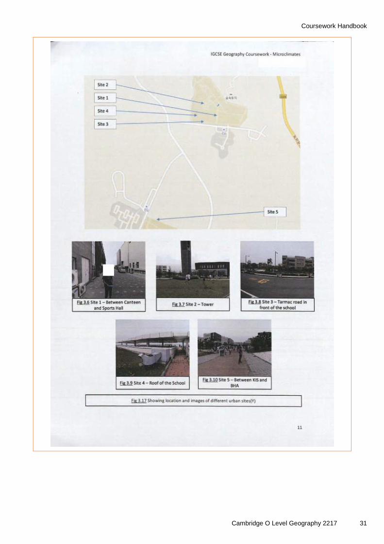
Sites are clearly located. Photographic evidence is very useful to show the nature of each site. This section is very well organised, but there could be some justification of why each site was selected.
This is a complex method of data presentation which allows immediate comparisons between sites to be made.

Coursework Handbook
Cambridge O Level Geography 2217 33
Comments
Simple bar charts compliment the previous heat island maps. By having similar vertical scales the learner has aided comparison between sites. This counts as a second method of presentation and includes table of data.

Coursework Handbook
34 Cambridge O Level Geography 2217

Coursework Handbook
Cambridge O Level Geography 2217 35
Comments
Well annotated photographs represent the third method of presentation of the data. This means the learner can be awarded Level 3 for presentation. The organisation is clearly logical.
Annotations identify both causes and effects of temperature changes. This demonstrates a high level of understanding.

Coursework Handbook
36 Cambridge O Level Geography 2217
Comments
Description of data.
Clear explanation of observed patterns.
Further reasoned explanation.
Identifies and explains anomalies. Good use of geographical terminology.

Coursework Handbook
Cambridge O Level Geography 2217 37
Comments
The flow lines are a fourth presentation technique. The learner has given a clear key.

Coursework Handbook
38 Cambridge O Level Geography 2217
Comments
This is a useful bar chart which has been used to compare sites. This raises observation and collection of data well into Level 3 with regards to observations and collection of data.

Coursework Handbook
Cambridge O Level Geography 2217 39
Comments
The rose diagrams demonstrate another complex technique. They are well executed, and help to make comparison between sites easy. This work is clearly high Level 3.

Coursework Handbook
40 Cambridge O Level Geography 2217

Coursework Handbook
Cambridge O Level Geography 2217 41
Comments
Annotated photographs support the learner’s explanation of their data.

Coursework Handbook
42 Cambridge O Level Geography 2217
Comments
Further reasoned explanation with reference to theory. This contributes to a thorough interpretation of the data and is awarded high Level 3.
This is an eloquent piece of written work despite some issues with grammar at times. As the grammatical issues do not detract from the reader's understanding they must not be penalised.

Coursework Handbook
Cambridge O Level Geography 2217 43
Comments
Clear conclusions are stated in light of the aims and key data is used to answer the hypotheses.
This is further evidence of data collection which reinforces the high Level 3 awarded for observation and collection of data.

Coursework Handbook
44 Cambridge O Level Geography 2217
Comments
The learner has written a sound evaluation referring to both strengths and weaknesses in their work. Improvements are suggested. This and the conclusion are clearly Level 3.

Coursework Handbook
Cambridge O Level Geography 2217 45
Comments
The comprehensive bibliography is further evidence of high levels of organisation.

Coursework Handbook
46 Cambridge O Level Geography 2217
Example Assignment 2

Coursework Handbook
Cambridge O Level Geography 2217 47
Comments
Clear hypotheses are stated.
The learner describes the location of the River Lyne. They give some justification of why it was chosen.
There is reference to theory which links to at least two of the three hypotheses.

Coursework Handbook
48 Cambridge O Level Geography 2217
Comments
The learner has made some good use of geographical terms. However, this is not always well linked to the aims / hypotheses. They have not demonstrated any depth of understanding at this stage, so currently their knowledge and understanding would be awarded a low Level 2.
Gives a logical order of the sequence of events.
Definitions are helpful.

Coursework Handbook
Cambridge O Level Geography 2217 49

Coursework Handbook
50 Cambridge O Level Geography 2217

Coursework Handbook
Cambridge O Level Geography 2217 51
Comments
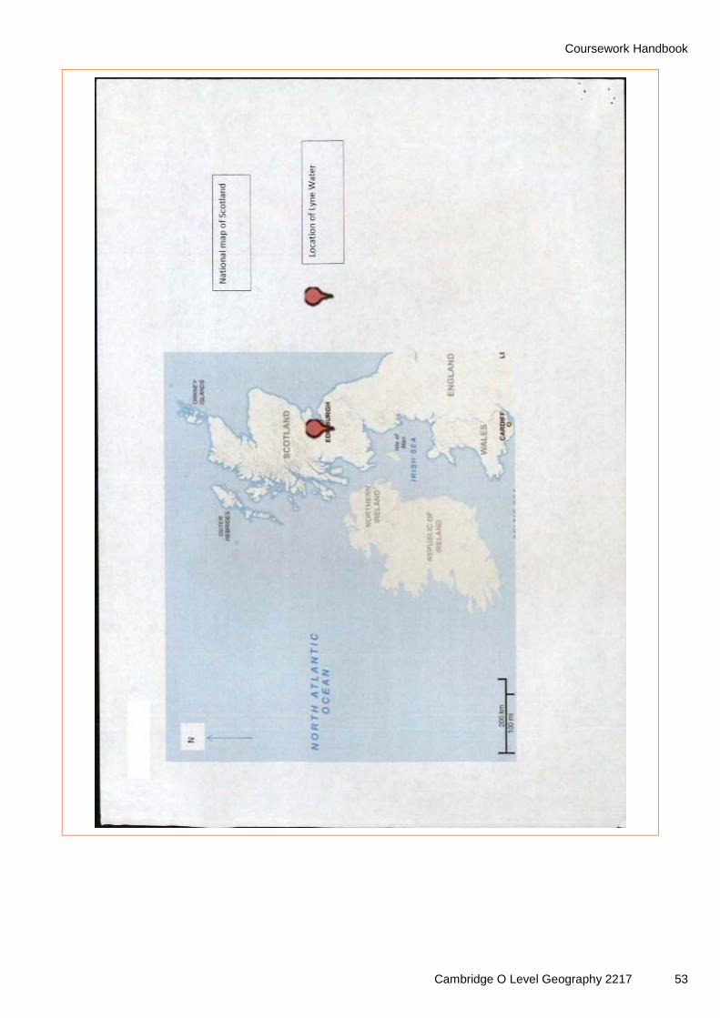
The sites used in the investigation are well located, although these might have been more effectively shown on one map. All maps used have a scale.

Coursework Handbook
52 Cambridge O Level Geography 2217
Coursework Handbook
Cambridge O Level Geography 2217 53

Coursework Handbook
54 Cambridge O Level Geography 2217
Comments
A range of primary data has been collected which is all linked to the hypotheses. This shows that the learner has undertaking sound planning.
Coursework Handbook
Cambridge O Level Geography 2217 55

Coursework Handbook
56 Cambridge O Level Geography 2217

Coursework Handbook
Cambridge O Level Geography 2217 57
Comments
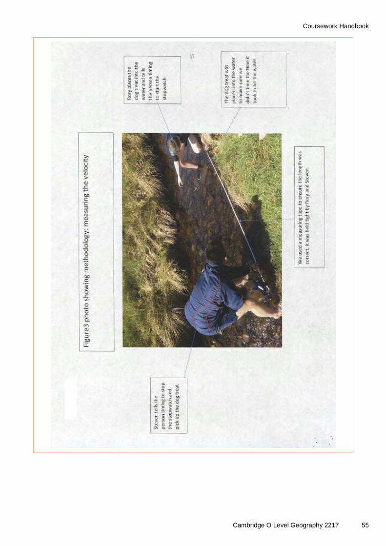
Annotated photos help give further detail on data collection methods.

Coursework Handbook
58 Cambridge O Level Geography 2217
Comments
Data table indicates of clear organisation and detailed data collection. The fact that samples have been taken at 10 sites gives the data greater validity. This element of the assignment can be awarded Level 3. They could have improved this further by justifying the selection of each site.

Coursework Handbook
Cambridge O Level Geography 2217 59
Comments
The learner has made appropriate reference to theory.
Highlighting the anomaly adds some complexity to a basic technique.
Another anomaly is identified but the explanation is weak.
The bar chart shows the same data as the scatter graph so does not add to the explanation underneath.

Coursework Handbook
60 Cambridge O Level Geography 2217
Comments
The located data is a more complex way of displaying the information. Once again though the explanation for the observations is poor. However, they are able to describe what they would expect to observe according to theory.

Coursework Handbook
Cambridge O Level Geography 2217 61
Comments
This is a similar technique to the one used for the presentation of the data linked to hypothesis 1. This scatter graph can be counted as an additional data presentation technique as the same data for hypothesis 1 was shown as a bar chart. Therefore this learner has used three types of graph. Two of these show added complexity which means Level 3 can be awarded for organisation and presentation.
Once again the learner demonstrates clear knowledge of theory, although the scatter graph does not show distance downstream. They have given some valid explanation. The analysis is Level 2 since it lacks the detail to be termed thorough.
The lack of understanding shown also means Level 2 is awarded for knowledge and understanding.

Coursework Handbook
62 Cambridge O Level Geography 2217

Coursework Handbook
Cambridge O Level Geography 2217 63
Comments
Comments
The evaluation identifies weaknesses and suggests some valid solutions. Together with the conclusion section, this allows low Level 3 to be awarded.

Coursework Handbook
64 Cambridge O Level Geography 2217
Comments
Comments
This is a successful method of presentation using located bars. However, it is not referred to at all in the coursework.

Coursework Handbook
Cambridge O Level Geography 2217 65
Example Assignment 3

Coursework Handbook
66 Cambridge O Level Geography 2217
Comments
An accurate index of contents contributes to the organisation of the study.

Coursework Handbook
Cambridge O Level Geography 2217 67
Comments
Some useful background information has been provided. The map used has a scale.
The learner has defined some key terms. They have demonstrated some knowledge, but limited understanding at this point.

Coursework Handbook
68 Cambridge O Level Geography 2217
Comments
These are clear hypotheses, but there is little in the way of justification. Limited understanding demonstrated to this point, so currently the top of Level 1 for knowledge and understanding would be awarded.

Coursework Handbook
Cambridge O Level Geography 2217 69
Comments
The learner has located the sites at which traffic and pedestrian counts will be carried out. The maps used have no scale.

Coursework Handbook
70 Cambridge O Level Geography 2217
Comments
They have defined random sampling.
This is the first data presentation technique which can be awarded.
They have been able to give an accurate description followed by reasoned explanation.

Coursework Handbook
Cambridge O Level Geography 2217 71
Comments
There is some reference to methodology, although no justification of the times selected to take the samples.
Second appropriate method of presentation.
The learner quotes some key data. They have given reasoned explanations for peak times and have made some reference to their hypothesis.

Coursework Handbook
72 Cambridge O Level Geography 2217

Coursework Handbook
Cambridge O Level Geography 2217 73
Comments
This is the third presentation technique used. It demonstrates some complexity as it uses layers of information and is an effective way to present this type of data. This takes presentation into Level 3.
The more reasoned explanation given here takes the analysis into Level 3. However, the description could be more detailed and so the awarded mark remains at low Level 3.

Coursework Handbook
74 Cambridge O Level Geography 2217
Comments
Here the learner justifies the locations for their pedestrian counts.
A further choropleth map is used, but this does not advance the response any further into Level 3 as it is the repetition of a presentation technique already used.

Coursework Handbook
Cambridge O Level Geography 2217 75
Comments
Here the learner makes more reference to their methodology, but the last sentence is vague.
The addition of the restaurant locations onto the choropleth map is effective and adds to the presentation (Level 3).
There is reference to methodology, but the account is not well co-ordinated within the study. Tables of data would have helped. Relevant information from a variety of sources was clearly collected and there is evidence in the presentation and use of data of sound planning. This places the study at the top of Level 2 for observation and collection of data.

Coursework Handbook
76 Cambridge O Level Geography 2217
Comments
This is another reasoned explanation, which includes an anomaly. Overall, the understanding demonstrated in the analysis takes the mark for knowledge and understanding to the top of Level 2. It cannot go further since only some use of geographical terms and limited reference to theory has been used.

Coursework Handbook
Cambridge O Level Geography 2217 77
Comments
The learner has not included a specific section on conclusions. There are some conclusions in the analysis. They have not stated whether the hypotheses are confirmed or rejected. The evaluation does refer to a range of weaknesses with some creditable solutions. This takes this element of the coursework into Level 2.
The fact that there is a lack of a defined methodology and conclusion prevent the organisation and presentation mark being higher than mid Level 3. The maps of the CBD of Luxembourg need a scale.
This is a good example of a study which needs to be read through first before any judgements are made on each of the criteria.
It is important that such studies are marked positively, crediting what the learner has done rather than penalising based on what could have been done.

Cambridge Assessment International Education The Triangle Building, Shaftesbury Road Cambridge, CB2 8EA, United Kingdom t: +44 1223 553554 f: +44 1223 553558 e: [email protected] www.cambridgeinternational.org ® IGCSE is a registered trademark. Copyright © UCLES March 2018