craven local plan (draft 22/9/14) consultation settlement ... · br010 and part of br012. site...
TRANSCRIPT
Craven Local Plan (Draft 22/9/14) Consultation
Settlement Response Summaries
Jump to a settlement by clicking on its nameJump back to previous pages by pressing the "Alt" and "←" keys togetherOr navigate the document using the PDF bookmarks feature
Bradley
Burton-in-Lonsdale
Carleton
Cononley
Cowling
Embsay
Gargrave
Giggleswick
Glusburn and Cross Hills
Hellifield
High Bentham
Ingleton
Low Bentham
Rathmell
Settle
Skipton
Sutton-in-Craven
1
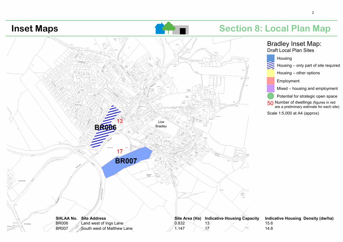
Section 8: Local Plan Map Inset Maps
Bradley Inset Map: Draft Local Plan Sites
Housing
Housing – only part of site required
Housing – other options
Employment
Mixed – housing and employment
Potential for strategic open space
50 Number of dwellings (figures in redare a preliminary estimate for each site)
Scale 1:5,000 at A4 (approx)
SHLAA No. Site Address Site Area (Ha) Indicative Housing Capacity Indicative Housing Density (dw/ha)
BR006 Land west of Ings Lane 0.832 13 15.6 BR007 South west of Matthew Lane 1.147 17 14.8
2
Settlement: Bradley Object: 37 Support: 4 General: 2 Site id: BR006 • Specific area of development should be defined. Northern part of site
should be developed, nearest to the mill.• South of the site is prone to flooding as it falls within flood zone 3a.
Drainage system is inadequate and often blocked with leaves etc.• This site should not be considered as a housing allocation as it was
subject to many objections during the engagement events in 2013.Sites BA001, BA002 & BA012 are considered better alternatives as theywould provide access to Skipton without increasing traffic on Ings Laneand a children’s play area could be provided on site.
• Additional alternative sites include BR014, BR001, BR002, BR016,BR010 and part of BR012. Site other side of canal bridge, adjacent toA629 where all 30 houses could be accommodated (no land availabilityinfo provided, not a SHLAA site). Sites behind Aire Valley Road aremore appropriate with good access. Infill development is preferred onsmaller sites e.g, BR015 as this would limit environmental and visualimpact.
• This site is the obvious place for new housing in Bradley, as it wouldminimise traffic in the village centre and on Skipton Road by theschool.
• Development of this site would offer little or no impact on nearbyresidents and is very close to the village centre.
• Development of this site would result in the loss of existing open viewto Mill on the entrance to the village and erode the impact of CrossLane Mill. This open entrance to the village was upper most in themind of the late mill owners Mr & Mrs Green who gave the playingfields to the village.
• Allowing residential development on this site would not meetObjective PO1 of the draft plan as it would not enhance theenvironment or landscape, would overwhelm the sympatheticdevelopment of The Mill conversion and detract from the rural beautyof the village entrance.
• The proposal for 13 houses on this site is too many. The numbershould be reduced. An opportunity exists for a pedestrian/green areaat the lower end of site so that the pleasant entrance to the village isretained.
• In the assessment of sites there seems to be too much emphasis onproximity to the children’s play space. The playground is easilyaccessed from all parts of the village.
• The Bradley Village Plan 2012 and the Bradley Parish Profile notes thissite as an important open space in the village. The meadow is acherished asset. The loss of this important site as setting for theVictorian textile mill would not be balanced by any benefit in improvedfoot access along the road into the village.
• Concern that residential development on this site would result onextra traffic on the minor roads in Bradley. Ings Lane need widening tothe canal bridge.
• Canal bridge is often broken in spring/summer months resulting in
September 2014 consultation
Settlement Response Summary for Bradley 3

increased traffic congestion. Development of this site would exacerbate this situation.
• Development would exacerbate the existing poor pedestrian accessacross the A629 to access the bus service to Skipton, vehicular accesswhen entering the village from Keighley and turning right out of thevillage towards Skipton. The problems with this junction results invehicles using The Heath Road to Snaygill.
• Development of this site would have adverse impact on existingsurrounding residents in terms of overlooking, loss of privacy, light,views and would have a negative effect on the value of existinghouses. It would cause an increase in noise and light pollution anddisturb the existing wildlife corridor and extensive landscapes.
• The site lies within the Low Bradley Conservation Area and makes animportant contribution to the setting of Cross Lane Mill, an importantelement in the approach to the village and one of the key buildings ofthe Conservation Area. The loss of this open area and its subsequentdevelopment, therefore, would be likely to result in harm to one of theelements which contribute to the significance of this designated area.Before allocating this site for development an assessment ofimpact on the Conservation Area is required. (English Heritagecomment).
• Site contains grade 3 agricultural land, which should not be lost.• Development of this site would only be acceptable if the part nearest
to the canal is given to the village as a public garden/picnic site.BR007 • Site is within flood zone 3a (Note: Environment Agency flood zone
information shows that this site is located within flood zone 1). Southwest portion of site floods. Drainage system is inadequate and oftenblocked with leaves etc.
• Development of 17 houses on this site is too many.• Sites BR006 & BR007 are supported as they would provide the houses
needed on two larger sites rather than on smaller sites that wouldresult in the loss of small existing open spaces in the village. The sitesbenefit from being away from the existing congested centre of thevillage. They are on the edge of the village but would not extend theboundary of the settled area further up the valley sides, as would bethe case with BR010, BR016, BR001 & BR004. BR006 is adjacent toexisting housing estates and would not be out of keeping. Onlydeveloping part of BR007 (nearest to road) might be a better option soas not to encroach to the edge of the canal.
• Development of this site would have adverse impact on existingsurrounding residents in terms of overlooking, loss of privacy, light,views and would have a negative effect on the value of existinghouses. It would cause an increase in noise and light pollution anddisturb the existing wildlife corridor and extensive landscapes.
• Development would set an unwanted precedent.• Visual impact would be significant is this site was developed.• Development is this site would take away the open space feel of the
playing field by making it feel enclosed.• Development of this site would offer little or no impact on nearby
residents and is very close to the village centre.
4

• This site is the breeding and feeding ground for a family of swans.• This site lies within the Low Bradley Conservation Area. This field
provides views out of the Conservation Area towards the rising landaround Cononley and, as such, contributes to the character of this partof the designated area. The extent of this site would also result in aform of development poorly related to the character and landscapesetting of the village. The loss of this site, and its subsequentdevelopment, therefore, would be likely to harm elements whichcontribute to the significance of the Conservation Area. Beforeallocating this site for development an assessment of impact onthe Conservation Area is required. (English Heritage comment).
• Site is small, it would not be able to take all 30 dwellings.• Planning permission was refused on this site in 2005 (11/2005/5319).
Planning officer stated that works necessary to satisfy the localhighway authority, which include the widening of Matthew Lane mayhave a detrimental effect on the Conservation Area.
• Alternatives to this site include BR015, BR001, BR002, BR010 and partof BR012 as these sites can be accessed from Ings Lane, Matthew Laneand Skipton Road down to Snaygill roundabouts without increasingtraffic in the village.
• Matthew Lane would need widening by taking land from the playingfields.
• It is unclear why this site is now deemed preferable since the 2013engagement when BR006 (part), BR001, BR002 & BR012 werepreferable. Access is also better on these sites.
• Would favour small developments on above alternative sites overlarge scale development.
• Put all new housing on BR016, which does not require access throughthe village and would add balance to the village.
BR004 • Is a large site outside existing development limits and features awatercourse that floods after heavy rain.
• Access to the site through the existing Methodist Church car park andincreased traffic would add to the already congested junction with IngsLane. The junction of Mill Lane and Heath Crescent is a very busy one.Development of this site would have a negative impact on thisjunction.
BR005 • Lidget Lane is very narrow with limited pavement provision. A junctionhere to access this site would be dangerous.
BR001 • Development of this site would have less impact on the aesthetics ofthe village as it would be unobtrusive.
• Existing access to the site is good and there is an opportunity to widenSkipton Road at this site.
• Development of this site would keep any increased traffic out of thealready congested village centre.
BR012 • Development of this site, which rises beyond the existing estate wouldresult in a visually unacceptable extension of the village whenapproaching not only from the A629 but also from across the valleyand hills to the south.
BR016 • This site is preferred as it is large enough to take all the housingrequirement, it would be a natural extension to the existing buildings,
5
traffic generated from this site would have direct access to primary routes via Snaygill and it contains a spring which would be suitable for an allotment. There has been a request for allotments in the village for some years, which could be achieved through a Section 106 Agreement or CIL.
General comments • Water supply - Local mains reinforcement may be required. Wastewater – level of development proposed would result in small increasein domestic foul water which can be accommodated in the existingsewer network. No issues with the receiving waste water treatmentworks. (Yorkshire Water Comment)
• There has been insufficient local consultation.• School does not have the capacity to take more children i.e., from
development of 30 houses over 15 years.• Bradley needs to retain its village feel. Development of smaller sites is
favoured.• Wherever new housing is located, access to the village needs to be
improved via widening of the road over The Heath to Snaygill and viaprovision of an island on the A629.
• Development of 30 houses in Bradley would not “ensure developmentis in harmony with the openness, scenic beauty, heritage and vitality ofthe countryside (Draft Local Plan pg 33, section 4)
• Any improvement to the already well used back road to Skipton wouldbenefit the village and wider community.
• It would be lovely to keep Bradley as an upmarket village by building asmaller amount of luxury homes to accommodate larger families.Smaller houses could then be dotted around the village on smallerplots of land.
• A large mass of affordable housing would be a blot on the landscape ofBradley.
• Need to assess any future housing development in terms of visualimpact it will have on the settlement.
• If infrastructure of the village is considered inadequate why extend atall?
• Way to improve infrastructure in village:o Access to A629 from and into lngs Roado Improve pedestrian access to bus stop across A629o Provide safe and aesthetic route via the Skipton Road in the
direction of Skipton, which is also a school bus route. It couldenhance the village and ease the congestion when the villageis frequently used as a 'Rat Run' or diversion.
o Improve drainage and Sewage systems.o Improve the infrastructure NW of the village, providing safe
vehicular and pedestrian access to Skipton, opening upalternative, additional, possibly smaller sites for developmentand fulfil the requirement of "2 houses a year" and benefit thecommunity in general.
• Bradley has the following attributes/issues that should be addressedby the objectives and policies in the local plan:
o Services and Amenities: The services for Bradley are alreadylacking. The bus service is infrequent, howbeit better than ayear ago, unfortunately it is scarcely adequate. Skipton has a
6
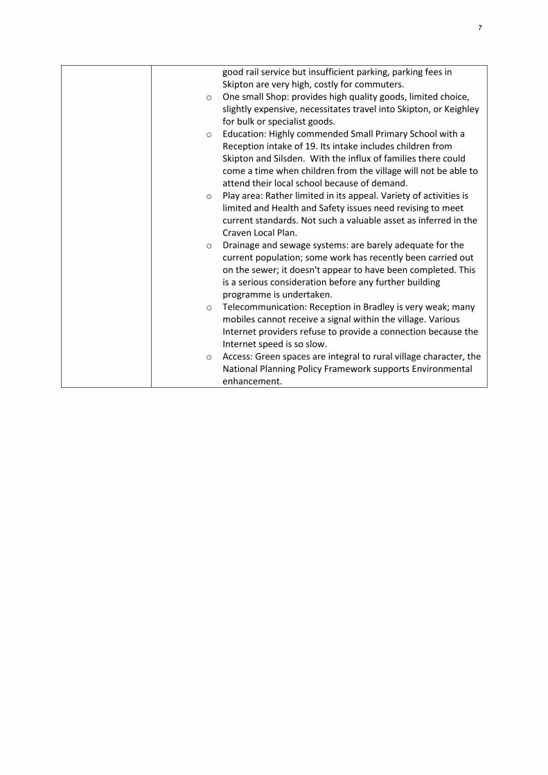
good rail service but insufficient parking, parking fees in Skipton are very high, costly for commuters.
o One small Shop: provides high quality goods, limited choice,slightly expensive, necessitates travel into Skipton, or Keighleyfor bulk or specialist goods.
o Education: Highly commended Small Primary School with aReception intake of 19. Its intake includes children fromSkipton and Silsden. With the influx of families there couldcome a time when children from the village will not be able toattend their local school because of demand.
o Play area: Rather limited in its appeal. Variety of activities islimited and Health and Safety issues need revising to meetcurrent standards. Not such a valuable asset as inferred in theCraven Local Plan.
o Drainage and sewage systems: are barely adequate for thecurrent population; some work has recently been carried outon the sewer; it doesn't appear to have been completed. Thisis a serious consideration before any further buildingprogramme is undertaken.
o Telecommunication: Reception in Bradley is very weak; manymobiles cannot receive a signal within the village. VariousInternet providers refuse to provide a connection because theInternet speed is so slow.
o Access: Green spaces are integral to rural village character, theNational Planning Policy Framework supports Environmentalenhancement.
7

Section 8: Local Plan Map Inset Maps
Burton in Lonsdale Inset Map: Draft Local Plan Sites
Housing
Housing – only part of site required
Housing – other options
Employment
Mixed – housing and employment
Potential for strategic open space
50 Number of dwellings (figures in redare a preliminary estimate for each site)
Scale 1:5,000 at A4 (approx)
SHLAA No. Site Address
Site Area
(Ha)
Indicative Housing
Capacity
Indicative Housing
Density (dw/ha)
BU001 West of Ireby Road 2.207 22 10.0 BU008 Land between Ireby Road & Mill Wood 1.805 5 2.8 BU009 Land to the east of Burton Hill 2.877 18 6.3
8
September 2014 Consultation
Settlement Response Summary for Burton in Lonsdale
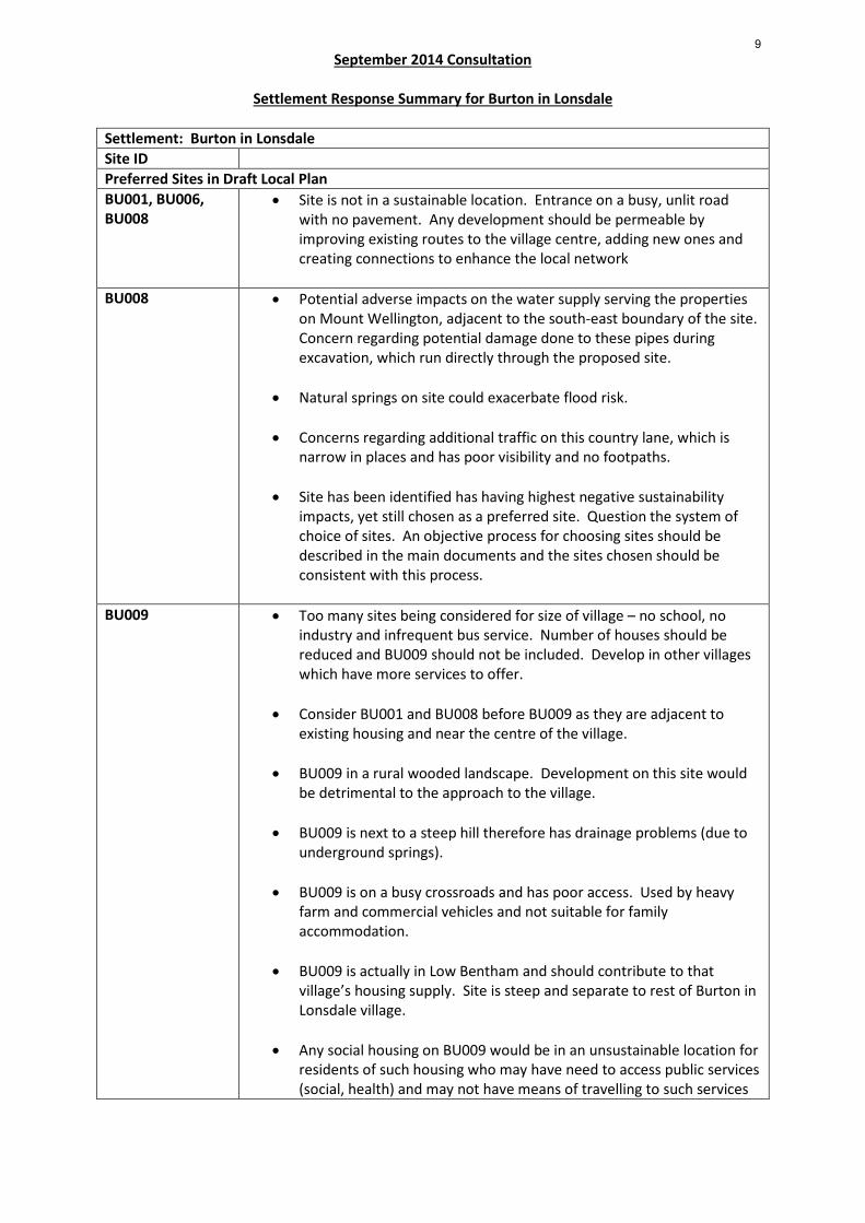
Settlement: Burton in Lonsdale Site ID Preferred Sites in Draft Local Plan BU001, BU006, BU008
• Site is not in a sustainable location. Entrance on a busy, unlit roadwith no pavement. Any development should be permeable byimproving existing routes to the village centre, adding new ones andcreating connections to enhance the local network
BU008 • Potential adverse impacts on the water supply serving the propertieson Mount Wellington, adjacent to the south-east boundary of the site.Concern regarding potential damage done to these pipes duringexcavation, which run directly through the proposed site.
• Natural springs on site could exacerbate flood risk.
• Concerns regarding additional traffic on this country lane, which isnarrow in places and has poor visibility and no footpaths.
• Site has been identified has having highest negative sustainabilityimpacts, yet still chosen as a preferred site. Question the system ofchoice of sites. An objective process for choosing sites should bedescribed in the main documents and the sites chosen should beconsistent with this process.
BU009 • Too many sites being considered for size of village – no school, noindustry and infrequent bus service. Number of houses should bereduced and BU009 should not be included. Develop in other villageswhich have more services to offer.
• Consider BU001 and BU008 before BU009 as they are adjacent toexisting housing and near the centre of the village.
• BU009 in a rural wooded landscape. Development on this site wouldbe detrimental to the approach to the village.
• BU009 is next to a steep hill therefore has drainage problems (due tounderground springs).
• BU009 is on a busy crossroads and has poor access. Used by heavyfarm and commercial vehicles and not suitable for familyaccommodation.
• BU009 is actually in Low Bentham and should contribute to thatvillage’s housing supply. Site is steep and separate to rest of Burton inLonsdale village.
• Any social housing on BU009 would be in an unsustainable location forresidents of such housing who may have need to access public services(social, health) and may not have means of travelling to such services
9

September 2014 Consultation
Settlement Response Summary for Burton in Lonsdale
given their economic position.
Sites Not Preferred in Draft Local Plan BU010 • Question as to why this site has not been included in the plan.
General comments • 3 houses per year = 45 over 15 years. Water supply – Local mainsreinforcement may be required.
• If approved, the number of houses built on the site of the formerschool should be deducted from the Local Plan target and not treatedas a windfall in addition to the target.
10

Section 8: Local Plan Map Inset Maps
Carleton Inset Map: Draft Local Plan Sites
Housing
Housing – only part of site required
Housing – other options
Employment
Mixed – housing and employment
Potential for strategic open space
50 Number of dwellings (figures in redare a preliminary estimate for each site)
Scale 1:5,000 at A4 (approx)
SHLAA No. Site Address Site Area (Ha) Indicative Housing Capacity Indicative Housing Density (dw/ha)
CA012 Grundy Farm, east of Park Lane Terrace 1.106 28 25.3 CA014 North of Dale Crescent, west of Beckside Farm 0.918 17 18.5
11

September 2014 Consultation
Settlement Response Summary for Carleton
Settlement: Carleton Site ID Preferred Sites in Draft Local Plan CA012 • The northern part of the site lies within the Carleton Conservation
Area and the site also includes the Grade II listed building GrundyFarmhouse. The rising farmland contributes to the setting of boththese designated heritage assets and the loss of this area and itssubsequent development would be likely to farm elements whichcontribute to their significance. Before allocating this site fordevelopment an assessment of impact on the Conservation Area andlisted building is required. (English Heritage comment).
• Appropriate for most types of dwellings except those used by theelderly as it will be a long walk to village amenities and shops
CA014 • The area nearest the village centre needs to be used for elderlydwellings as it will be near to village amenities and shops
General comments • 3 houses per year = 45 over 15 years. Water supply – Local mainsreinforcement may be required.
Waste Water – this level of development will result in a small increasein domestic foul water (less than 1 litre per second) which can beaccommodated in the existing sewer network. There are no issueswith the receiving waste water treatment works.
• The Local Plan needs to specify the housing type requirements and notleave it to developers to decide what they would like to build. Whenplans are submitted it is generally too late to make changes. Carleton-in-Craven has an acute shortage of dwellings suitable for elderlypeople.
12
Section 8: Local Plan Map Inset Maps
Cononley Inset Map: Draft Local Plan Sites
Housing
Housing – only part of site required
Housing – other options
Employment
Mixed – housing and employment
Potential for strategic open space
50 Number of dwellings (figures in redare a preliminary estimate for each site)
Scale 1:5,000 at A4 (approx)
SHLAA No. Site Address Site Area (Ha) Indicative Housing Capacity Indicative Housing Density (dw/ha)
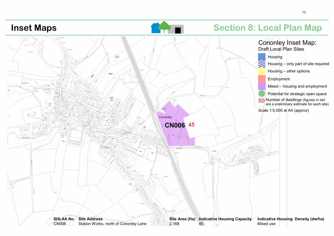
CN006 Station Works, north of Cononley Lane 2.168 45 Mixed use
13
September 2014 Consultation
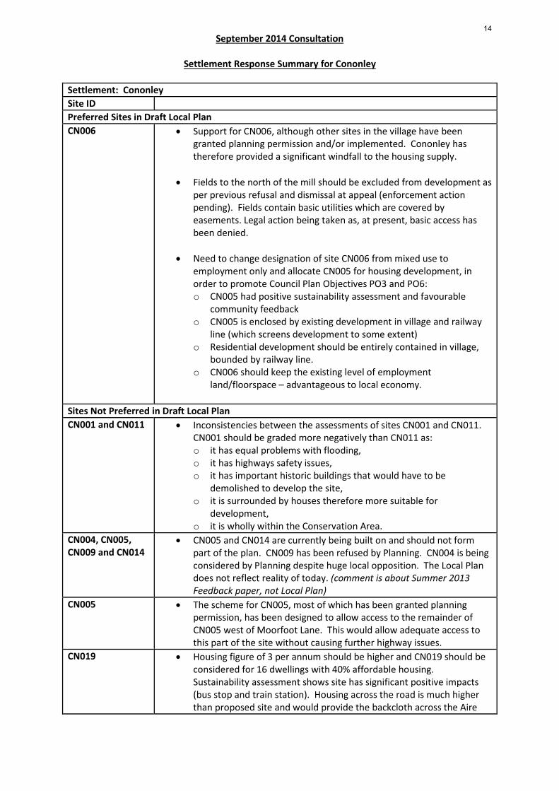
Settlement Response Summary for Cononley Settlement: Cononley Site ID Preferred Sites in Draft Local Plan CN006 • Support for CN006, although other sites in the village have been
granted planning permission and/or implemented. Cononley has therefore provided a significant windfall to the housing supply.
• Fields to the north of the mill should be excluded from development as
per previous refusal and dismissal at appeal (enforcement action pending). Fields contain basic utilities which are covered by easements. Legal action being taken as, at present, basic access has been denied.
• Need to change designation of site CN006 from mixed use to employment only and allocate CN005 for housing development, in order to promote Council Plan Objectives PO3 and PO6: o CN005 had positive sustainability assessment and favourable
community feedback o CN005 is enclosed by existing development in village and railway
line (which screens development to some extent) o Residential development should be entirely contained in village,
bounded by railway line. o CN006 should keep the existing level of employment
land/floorspace – advantageous to local economy.
Sites Not Preferred in Draft Local Plan CN001 and CN011 • Inconsistencies between the assessments of sites CN001 and CN011.
CN001 should be graded more negatively than CN011 as: o it has equal problems with flooding, o it has highways safety issues, o it has important historic buildings that would have to be
demolished to develop the site, o it is surrounded by houses therefore more suitable for
development, o it is wholly within the Conservation Area.
CN004, CN005, CN009 and CN014
• CN005 and CN014 are currently being built on and should not form part of the plan. CN009 has been refused by Planning. CN004 is being considered by Planning despite huge local opposition. The Local Plan does not reflect reality of today. (comment is about Summer 2013 Feedback paper, not Local Plan)
CN005 • The scheme for CN005, most of which has been granted planning permission, has been designed to allow access to the remainder of CN005 west of Moorfoot Lane. This would allow adequate access to this part of the site without causing further highway issues.
CN019 • Housing figure of 3 per annum should be higher and CN019 should be considered for 16 dwellings with 40% affordable housing. Sustainability assessment shows site has significant positive impacts (bus stop and train station). Housing across the road is much higher than proposed site and would provide the backcloth across the Aire
14

September 2014 Consultation
Settlement Response Summary for Cononley
Valley, for any new development on site. Minimum housing figure of 2400 will likely by challenged and Cononley, as a sustainable settlement, will be well placed to make a contribution to any additional homes that may be required.
General comments • 3 houses per year = 45 over 15 years. Water supply – Local mains reinforcement may be required. Waste Water – this level of development will result in a small increase in domestic foul water (less than 1 litre per second) which can be accommodated in the existing sewer network. There are no issues with the receiving waste water treatment works.
• The Summer 2013 Feedback for Cononley is now out of date. There
needs to be an update.
15
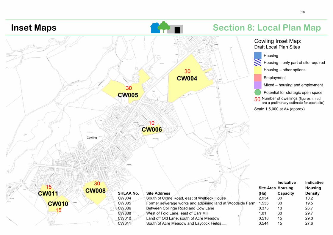
Section 8: Local Plan Map Inset Maps
Cowling Inset Map: Draft Local Plan Sites
Housing
Housing – only part of site required
Housing – other options
Employment
Mixed – housing and employment
Potential for strategic open space
50 Number of dwellings (figures in redare a preliminary estimate for each site)
Scale 1:5,000 at A4 (approx)
SHLAA No. Site Address
Site Area
(Ha)
Indicative
Housing
Capacity
Indicative
Housing
Density
CW004 South of Colne Road, east of Welbeck House 2.934 30 10.2 CW005 Former sewerage works and adjoining land at Woodside Farm 1.535 30 19.5 CW006 Between Collinge Road and Cow Lane 0.375 10 26.7 CW008 West of Fold Lane, east of Carr Mill 1.01 30 29.7 CW010 Land off Old Lane, south of Acre Meadow 0.518 15 29.0 CW011 South of Acre Meadow and Laycock Fields 0.544 15 27.6
16
September 2014 Consultation
Settlement Response Summary for Cowling
Settlement: Cowling Site ID Preferred Sites in Draft Local Plan CW004 • This site lies within the Cowling Conservation Area. This is an
important open space which separates the main built-up area of the village from Lane Ends and provides views out from the Conservation Area to the rising land to the south and Wainman’s Pinnacle. The loss of this open area and its subsequent development, therefore, would be likely to harm elements which contribute to the significance of the Conservation Area. Before allocating Site CW004 for development an assessment of impact on the Conservation Area is required. (English Heritage comment).
CW005 • This site lies within the Cowling Conservation Area. When originally designated, it is presumed that the open areas of this site were considered to make an important contribution to the character or appearance of the Conservation Area. Therefore, one might assume that their loss and subsequent development would result in harm to that part of the designated area. However, there appears to be no evidence of any assessment being undertaken of the potential impact which the loss of this open area and its subsequent development might have upon the character or setting of the Conservation Area. Before allocating Site CW005 for development an assessment of impact on the Conservation Area is required. (English Heritage comment).
CW006 • This site adjoins the boundary of the Cowling Conservation Area. The Local Plan should make it clear that any redevelopment proposals for this area would need to safeguard those elements which contribute to the significance of that part of the Conservation Area which lies adjacent to this site. (English Heritage)
CW008, CW010 and CW011
• In the 25 years since the Conservation Area was designated, this part of Cowling has changed substantially and it may well be the case that this area no longer warrants being included within the designated area. In order to demonstrate that the allocation of this area is not incompatible with the statutory duty placed upon the Council under the provisions of the 1990 Act, as part of the Evidence Base underpinning the Plan there needs to be an assessment of what contribution this currently undeveloped area makes to those elements which contribute to the character or appearance of the Conservation Area and what effect the loss of this site and its subsequent development might have upon the designated area. If it is likely to result in harm, the plan needs to set out the means by which that harm will be minimised in any eventual development proposals that may come forward. (English Heritage comment)
17

September 2014 Consultation
Settlement Response Summary for Cowling
General comments • 2 houses per year= 30 over 15 years Water supply- Local mains
reinforcement may be required. • Waste water- The sites would drain via the Aire Valley trunk sewer. We
are currently developing our Aire Valley Strategy and Drainage Area Plan (DAP) outputs will be a key part of our future scenario planning. It is intended that as Local plans are finalised for Craven and Bradford Districts (the sewer serves settlements in both) new development scenarios in the DAP will be revised and further feasibility undertaken. It is proposed that we will consider short, medium and long term responses to the supply demand challenges. We would therefore seek to ensure that new development is suitably phased to allow Yorkshire Water to provide adequate capacity in the network to serve growth in both districts. (Yorkshire Water comment)
• Public consultation of areas was not advertised and did not allow for full public consultation. Areas should be reviewed with the local population prior to formal publication of the final document so it reflects local opinion and not that of the developers.
18

Section 8: Local Plan Map Inset Maps
Embsay Inset Map: Draft Local Plan Sites
Housing
Housing – only part of site required
Housing – other options
Employment
Mixed – housing and employment
Potential for strategic open space
50 Number of dwellings (figures in redare a preliminary estimate for each site)
Scale 1:5,000 at A4 (approx)
SHLAA No. Site Address Site Area (Ha) Indicative Housing Capacity Indicative Housing Density (dw/ha)
EM013 Land bounded by Shires Lane and Low Lane 1.298 15 11.6 EM016 Land to the south of Shires Lane 2.157 30 13.9
19
September 2014 consultation
Settlement Response Summary for Embsay
Settlement: Embsay Objections 6 Support 3 General comment 1 Site ID: EM001 • Review the assessment of this site as it should be included in the Local
Plan. EM010 & EM012 • These sites should not be excluded from the Local Plan as they both
performed well during the summer 2013 consultation. • Potential exists to the south of EM012 and the north of EM010. • The planning application proposals have been revised and reduced in
scale to take account of environmental evaluation and comments received during the 2013 consultation.
• Full and up to date Sustainability Appraisal, which assesses the policies and sites against a full and clear set of criteria is required. Discounting of these sites has occurred within this full Sustainability Appraisal.
• Further sites will need to be identified in a number of the second tier growth settlements and these sites are well placed to make such a contribution.
EM013 • Reduce the number of houses to a small spacious cul-de-sac development at the end of the field nearest the cricket field and water pumping station.
• Any new houses on this site should be extensively screened to rescue their impact on both Low Lane and Shires Lane.
• Development of this site would represent urban sprawl and would be highly visible from anyone approaching the village along Low Lane from Halton East.
• This site should not be used as the village should be kept rural. • There is enough development in the outline planning approval for the
other site on Shires Lane. • This site is probably the least bad option due to the fact that it would
have less impact on traffic and highway safety within the middle of Embsay when compared to other options considered, has relatively easy access to the limited public transport, it is outside of the Conservation Area and would have little impact on the historic core of the village. The site is of a sufficient size to provide new homes and an area of open space to complement the nearby sports facilities.
• No consideration has been given to the fact that part of the site is at high risk of flooding.
• Development of this site would result in residential development on both sides of Shires Lane, which would provide a residential feel to the area.
• Development of this site would prevent access to the adjoining fields across the site.
EM013 & EM016 • Development of these sites would remove much of the open aspects from the village cricket ground and allotments.
• Support for the Local Plan for Embsay/Eastby as the preferred sites have been sympathetically chosen to provide the least impact in terms of traffic, wildlife and impact on the fabric of the villages.
20
September 2014 consultation
Settlement Response Summary for Embsay
EM016 • The land which forms an extension to site EM016 (which has outline
consent for residential development) is supported for allocation in the Local Plan as this site would mean that all 45 houses can be delivered on one single site without the need for the release of any other site within the village.
• Development of an extension to site EM016 would not result in a discordant development and would be seen as a logical infill between the football field and allotment area.
General comments • Water supply - Local mains reinforcement may be required. Waste water – The increase in foul flows can be accommodated in the sewer network and there are not issues with the receiving waste water treatment works.
• Support the approach that there is no new development proposed in and around Eastby. Eastby is little more than a hamlet and has no services and facilities.
• Support the lack of any proposed new development in the existing gap between Embsay and Eastby. They are two distinct settlements with their own identity. Their physical separation is vital to their identities and characters and must be maintained. Any infill between the two villages is strongly opposed as this would destroy the balance of the two distinct villages.
• Support the lack of proposed allocations for new housing on the existing open spaces within Embsay. These areas of land contribute positively to the character and appearance of the Conservation Area and also provide an historical reference to the earlier ‘Dales village’. The Local Planning Authority has a statutory duty to have regard to the desirability of maintaining the existing character and appearance. Safe and convenient access to these areas of open space within the village would also be difficult to achieve.
• As there have been continuing delays in producing a Craven Local Plan, to the detriment of the parish, there is now a pressing need for the district council to finalise the completion of the Local Plan as quickly as possible.
21

Section 8: Local Plan Map Inset Maps
Gargrave Inset Map: Draft Local Plan Sites
Housing
Housing – only part of site required
Housing – other options
Employment
Mixed – housing and employment
Employment— opportunity for enhancement (new light employment and commercial opportuni-ties related to tourism)
Potential for strategic open space
50 Number of dwellings (figures in red are a preliminary estimate for each site)
Scale 1:7,500 at A4 (approx)
SHLAA
No. Site Address
Site Area
(Ha)
Indicative Housing
Capacity
Indicative Housing
Density (dw/ha)
GA012 Caravan Park and warehousing, Eshton Road 1.037 Employment N/A GA025 Land north of Skipton Road, to east of cricket and football grounds 2.083 25 Mixed use GA028 Land between Chew lane and Canal, adjoining Higher - land Bridge 1.313 28 21.3 GA029 Land between Chew lane and Canal, adjoining Eshton Road 2.056 22 Mixed use
22
September 2014 Consultation
Settlement Response Summary for Gargrave
Settlement: Gargrave Site ID Preferred Sites in Draft Local Plan GA012 • Some support for careful development of GA012 for employment
purposes as it is already in this use. Should be in keeping with the surrounding area and protect setting of the nearby national park.
• The meaning of "enhanced" development should be made clear and be acceptable to residents.
• Concerns regarding access to site. Bridge may not be adequate to support an increase in HGVs.
• Development of this site should relate to employment in tourism only; industrial, retail, warehouse and/ or distribution centre uses should not be permitted (i.e. uses that could harm the existing village retail offer should not be allowed).
• The existing caravan park is promoting tourism which is of benefit to the local economy - it should remain in its current form and should not be further developed.
• Existing empty units on site therefore should not be further developed for employment until these units are filled.
• Concern that development of this site could encourage further development of surrounding area.
• English Heritage comment that any redevelopment proposals for this area would need to safeguard those elements which contribute to the significance of the adjacent Conservation Area and Listed Building.
• Further development of this site could lead to easy and convenient access to GA009 and its development.
• There should be strict controls on the scale and height (maximum 2 stories) of any development.
• Support expressed for site as it does not extend village significantly. • Concern regarding increase of traffic on already busy road (dangerous
for pedestrians). • Further development could exacerbate flood risk issues in area and
further downstream. GA025 • Opinion is divided for development of GA025 in the Parish Council
survey. Comments regarding this site generally did not support employment development even if they were supportive of residential development in this location. However opposing view was expressed that site should be all employment due to good access from main road (potential for canal side and leisure facility) This view thought that the site was too detached from the village for residential use.
• View that site should be solely residential because: employment use on elongated site would compromise residential amenity and market attractiveness; existing employment in northern end of village – need for more?; flood attenuation would take up part of land, leaving less room for employment uses; employment use would have no road frontage. Full residential use should be medium density, incorporate some social housing and reflect the rural nature of the area (particularly taking into account it’s proximity to the national park).
23

September 2014 Consultation
Settlement Response Summary for Gargrave
• Support for mixed use qualified by need for confirmation on type and
scale of employment use. Support for low rise, low density with lots of greenery to minimise the environmental impact (i.e. no large metal sheds as site is at the entrance to the village).
• Support expressed for site as it does not extend village significantly. However opposing view also expressed that development of the site would be a significant spread of the village (sprawl outside existing village limits), and would ‘bookend’ the village once development on GA020 is complete.
• Development of the site would remove the open aspect from the village's football and cricket grounds. Concern also that the next phase of development could potentially be in the cricket grounds.
• Several comments that the cricket club would be affected from an insurance point of view. Properties built on the other side of the cricket pitch would be at greater and more frequent risk of damage, potentially resulting in more claims against the club.
• This site would have less impact on existing residents; however, speed limits entering Gargrave will need to be changed to accommodate this site.
• This site which is near to the A65 is preferable for development than other preferred sites which are near to the national park.
• Plan for site should identify which part would be used for dwellings and which part would be used for employment. The number of dwellings should be strictly limited, preferably to a lower number than stated in the draft plan.
• Access issues affect site: as currently proposed this site would not be able to achieve an acceptable road access arrangement onto the A65. This would have implications for the Systagenix factory opposite, whose existing access would be severely compromised. A more suitable access could be provided either by installing a roundabout on the A65 to serve both Systagenix and site GA025, or from Ray Bridge Lane via land to the east of GA025 (although there are concerns raised regarding poor access from Ray Bridge Lane which is narrow). Potential for an access into existing play area at top of Airedale Avenue?
• Concern raised regarding potential flooding issues on site. • Concern raised as this is the only site away from overhead cables
where the Air Ambulance is able to land. • Concern over loss of grade 3 agricultural land. • Site should be reserved for possible expansion of playing fields.
GA028 and GA029 (same comments received for both sites)
• Strong opposition expressed by a number of residents to any development on GA028 and GA029.
• This area around the canal and Chew Lane is seen as valuable for its amenity to both residents and tourists. The Pennine Way, the National Sustrans Cycle Way, the Canal, the river and greens, and the proximity to the National Park are seen as "pull factors" encouraging tourists to visit as are the generally rural and agricultural feel of the village.
• Support expressed for site as it does not extend village significantly and does not provide ribbon development along A65.
24
September 2014 Consultation
Settlement Response Summary for Gargrave
• Concern regarding increase of traffic on already busy road (dangerous
for pedestrians). Although opposing view also expressed that this road is quiet and could potentially take more traffic.
• Further development could exacerbate flood risk issues in area and further downstream. Concern regarding existing surface water flooding down Mark House Lane which would be exacerbated by development. Sequential test, as set out in NPPF, should apply. Other sites in Gargrave are less likely to flood.
• Concern regarding loss of good agricultural land. Grass cut for silage 4 times a year.
• Concern regarding difficult vehicular access to site. • Concern that overdevelopment of site would exceed Local Plan
housing targets. • Concern regarding effect of development on nearby listed bridge and
lock. • This site lies within the Gargrave Conservation Area. In addition, the
Canal Bridge Number 170 and its integral lock, at the south-western corner of this area, is a Grade II Listed Building. Before allocating GA028 or GA029 for development an assessment of impact on the Conservation Area and on the nearby listed buildings is required. (English Heritage comment).
• Need to protect the 15m wide strip of mature trees running the length of GA028/GA029 along the canal.
• View that other sites should be looked at first, however if need to build on this site, should be low density and well landscaped with big gardens.
• View that summer 2013 engagement with residents of Gargrave was not adequate to give a true picture of support / objection to this site. Support for cite may have come from landowners or from residents on other side of village. The Parish Council’s consultation on the sites via the Neighbourhood Planning process provides a different, less supportive view of this site.
• Concern over negative impact on existing wildlife in area (i.e. herons, kingfishers, rare black rabbits, trees, hedgerows, wildflowers etc)
• These sites are not suitable for retirement homes (downsize homes), which are needed in village, as they are ½ mile away from village centre services, station and church.
GA028 (comments particular to this site)
• The site checklist describes access via Mark House Lane/Chew Lane. Access is actually via West Street, not Mark House Lane, and this is a narrow road with no pavement and resident car parking, which leads to a tight junction with Old Hall Croft.
• View that only medium density housing should be allowed on this site, with emphasis on green space to compliment and reflect the rural nature of the area, the close proximity of the National Park and the housing already available in Gargrave. There should be no need for affordable homes on this site, this need being satisfied by Sites GA029 and GA025.
GA029 (comments particular to this
• This site should not include any employment. Employment use should be located elsewhere (i.e. GA001, GA012)
25

September 2014 Consultation
Settlement Response Summary for Gargrave
site) • Suggestion that this site should benefit from the same ‘minor negative
impacts’ on the sustainability check that GA028 and GA012 received, rather than the ‘potential significant negative impacts’ result that it achieved.
Sites Not Preferred in Draft Local Plan GA001 • This site received an equal number of opposing and supporting votes
in the Parish Council survey. • Since this site has been identified as having economic development
potential, is a brownfield site and is already partially developed for employment, it should be classified as having a negative effect for housing and positive for employment land.
GA003 • Support for site as it provides extension of the popular houses on St Robert Close.
GA004 • This site is ideal for development for housing, but not for employment land. It has minimal flood risk and is in close proximity to school and play area. Whilst it is currently occupied by a residential home for the elderly it is understood that NYCC has plans to relocate the home to GA009/GA022.
GA005 • the size of the site would limit the amount of development and would not destroy the tranquillity of St Andrews. New development would not be any closer to the church than existing properties in the area.
• This smaller infill site would be developed with off-street parking to further avoid on-street parking.
• New homes built on site would be at the higher end of the housing market and thus deter second home buyers; therefore the site should not be marked negatively for this in the sustainability assessment.
GA014 • New homes built on site would be at the higher end of the housing market and thus deter second home buyers; therefore the site should not be marked negatively for this in the sustainability assessment.
• Access is a problem, unless the adjacent GA023 site is also developed for housing.
• This site is well placed for sewerage and electricity access. GA017 • This is a reasonably sized plot but it would be problematic to develop
because of the weight of traffic up and down Church Lane. GA019 • Support for site as it is on edge of village and is beside the River Aire
and could offer pleasant views over the river and fields, provided flood defences were confirmed.
GA020 • Site received support in Parish Council survey. This site, (next to the canal and school) has already received planning permission for residential development.
• This site which is near to the A65 is preferable for development than existing preferred sites which are near to the national park.
• The number of houses to be built here should be deducted from the 75 required for the village over the next five years. This has happened in Embsay where a site with recent outline planning permission has formed part of the 45 that village needs over the plan period. (Note: the draft plan is planning for 75 houses in Gargrave over the next 15 years)
26

September 2014 Consultation
Settlement Response Summary for Gargrave
GA022 • Support for site as it is on edge of village. GA023 • Site has been classified as negative in sustainability check due to flood
risk. However, whilst it is true that a field two away (south) from this site appears on the EA flood risk assessment, this site does not. It is also in an elevated position (compared to the flood risk area) and runs next to and to the north of existing mature houses. Other negative effects can be mitigated by the number and type of housing built.
• This site is well placed for sewerage and electricity access. GA024 • Support for site as it is beside the river with pleasant views and near to
Low Green, an open play area. GA030 • This site received a strong negative response to the Parish Council
survey is as it was thought to be too large a development area on the outskirts of the village which would have a negative impact on the overall character of Gargrave.
• Development of site would adversely affect amenity of the area (directly on the Pennine Way), existing wildlife and agricultural value of land.
• Site has surface water flooding issues. GA031 • This site received a majority of support for development in the Parish
Council survey, although it also received 26 opposing "votes". • Support for site as new housing would be an extension of Walton
Close which is part of a housing association (12 low cost homes on site already). New housing would have pleasant views and relatively good access to Church Street, the railway station, A65 and A59, and High Green, a nearby open play area. The existing entrance to the site could be used and all services can be taken from Walton Close (i.e. the main sewer is already installed within the site).
• Opposition to the site based on the impact an increase in traffic would have on an already narrow, dangerous, busy road (which has been further exacerbated by development of holiday chalets on GA019 further up the road). There is also surface water flooding on road.
General comments • 5 houses per year= 75 over 15 years Water supply- Local mains reinforcement may be required. Waste water- The increase in foul flows can be accommodated in the sewer network and there are no issues with the receiving waste water treatment works. (Yorkshire Water comment).
• Gargrave Parish Council conducted a survey with residents’ on their Neighbourhood Plan which included questions about SHLAA sites in the village. Opposition for development (704 votes) on various sites (i.e. GA005; GA009; GA014; GA017; GA022; GA023; GA027; GA028; GA029; GA030) was greater than votes supporting development (345 votes) (i.e. GA020; GA031): Those supporting development often expressed the view that development should not cover the entire site.
• Support and opposition for different types of development, i.e. for "infill" development of existing small sites within Gargrave, and for development to take place at a distance from the centre of Gargrave on the outskirts of the village. Particular support expressed for development at infill/already partially developed/under-utilised land which is spread out around the village such as GA001, GA002, GA003,
27
September 2014 Consultation
Settlement Response Summary for Gargrave
GA004, GA005, GA020 and GA021.
• Brownfield sites much preferred over greenfield sites. Employment development is not supported in greenfield sites but has more support on brownfield sites. Possibility of using the existing Systagenix site for the development of a small business park.
• Clarification is required from CDC as to what "employment" and "mixed-residential and employment" are likely to consist of and importantly size/ numbers proposed.
• Type and quality of development is important. High quality low density development is preferred whether this is for affordable or for higher priced houses.
• Need houses for people who wish to downsize, i.e. smaller bungalows. The smaller infill sites in the plan are ideal for this type of development as they are within walking distance of all the facilities.
• Smaller infill sites could accommodate off street parking, which at present is an issue in the village that has not been addressed by the draft plan.
• Focus on existing businesses, particularly on the High Street where there are empty business premises, rather than building business units elsewhere. Empty units on the industrial estate and Eshton Wharf are also a concern. Neighbourhood Plan could be a big influence.
• Preventing unnecessary sprawl is an important issue as is addressing infrastructure concerns. The size of the proposed sites has prompted fears of overdevelopment and development "creep" into surrounding areas.
• Hard to comment as difficult to know what is being proposed. • The ability of the sewage system and roads to cope with new
development needs assessing. • The lack of good transport connections is an issue many would like to
see addressed, in particular bus and train services. • The environment and amenity value of the sites is an important
concern and it featured strongly in suggestions as to issues a Neighbourhood Plan would address.
• Desire to protect existing leisure sites such as the cricket and football grounds, the greens and the tennis club.
• View that the Gargrave Neighbourhood Plan Working Group should consult on sites for Gargrave and Craven DC should only consult on strategy.
• Regarding the Employment Land (EL) allocation for Gargrave – all possible sites have access problems because apart from the A65 all access roads are narrow village streets. The prospect of adding in commercial traffic grates with most people’s concept of sustainability. Gargrave already has a significant amount of mature EL, more in comparison with other village settlements, and the allocation is at least twice the pro rata allocation in terms of the housing allocation (basis for estimating the total EL requirement for South Craven Division). On that basis only up to 1 hectare of EL land would be allocated to Gargrave, about the size of the GA012 site. Systagenix could provide needed EL as it has redundant buildings and land which
28

September 2014 Consultation
Settlement Response Summary for Gargrave
the company might make available or rented out for commercial purposes. The site has a private road to the A65.
• The recreational/play areas in Gargrave are mainly the upper, middle and lower greens adjacent to the River Aire. Consequently most sites proposed, like those already developed, are some distance away. This can only be ‘fixed’ by planning constraints which require the situation to be addressed on a site-specific basis or by provision in the emerging Gargrave Neighbourhood Plan. No need to keep repeating the point for every site assessment.
• The 2nd homes argument can be made for almost anywhere in the country, village or town and is overused. It needs to be used sparingly where there is a significant risk of developers being able to market properties in relation to benefits on a specific site at the expense of sustainability of housing developments as part of the strategic objective of the LP. Homes for rent could be substituted for the 2nd homes argument and would have a positive effect on sustainability.
29
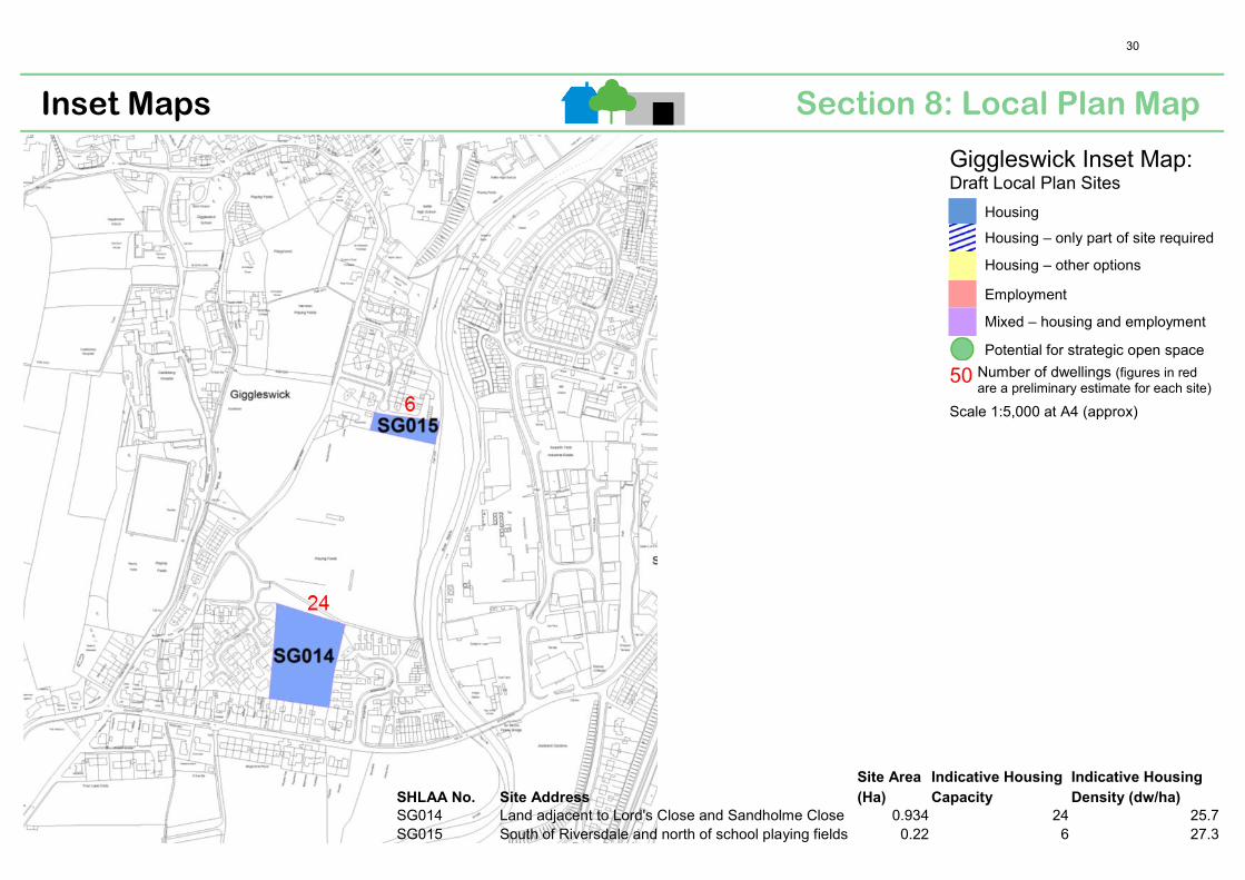
Section 8: Local Plan Map Inset Maps
Giggleswick Inset Map: Draft Local Plan Sites
Housing
Housing – only part of site required
Housing – other options
Employment
Mixed – housing and employment
Potential for strategic open space
50 Number of dwellings (figures in redare a preliminary estimate for each site)
Scale 1:5,000 at A4 (approx)
SHLAA No. Site Address
Site Area
(Ha)
Indicative Housing
Capacity
Indicative Housing
Density (dw/ha)
SG014 Land adjacent to Lord's Close and Sandholme Close 0.934 24 25.7 SG015 South of Riversdale and north of school playing fields 0.22 6 27.3
30
September 2014 consultation
Settlement Response Summary for Giggleswick
Settlement: Giggleswick Site ID Preferred Sites in the Draft Local Plan SG014 • Development of this site in addition to the relatively new development
& residential planning permission on Lords Close will result in approx. 140 new cars accessing what was a quiet road over a tight bridge/junction.
• The provision of a small playground does in no way make up for the loss of open green space for local children to play on.
• The vast numbers of housing currently or built in Giggleswick should be taken into account when considering the next planning application on land sold by Giggleswick School.
• It is hoped that the new Local Plan will have fully assessed the impact on proposed developments on the existing services of Settle and Giggleswick, which already seem to be operating at full capacity.
• There’s a willing landowner to make money from land assets and a Local Council pressured to build more housing. I don’t believe anyone’s comments will make a difference to the planning outcome.
• The Council should consider reducing the new housing targets in Giggleswick and should stop approving housing on sports fields.
• This site is suitable for residential development as it is entirely within flood zone 1, is accessible from an access road that runs between Bankwell Road and Lord’s Close and has no known utility issues, therefore it is readily capable of being implemented into the existing infrastructure network.
• The site would represent a logical rounding off of the existing residential development in this location, and a suitable and sustainable sites for development, which was the conclusion reached by CDC’s SHLAA.
• The loss of an element of school playing fields could be mitigated by investment being made south of Eshton’s playing fields through improvement to the qualitative value of the facility, such as through the provision of an all-weather sports pitch to be used by the local community. The eastern margins of Lord’s playing field (previously used as a playing field) could be brought back into use and upgraded.
SG015 • This is an undeveloped site, which includes a small number of trees. An arboriculture assessment together with an illustrative layout was submitted to CDC in 2014, which show that the site could be developed whilst retaining the most valuable trees.
• CDC controls a small area of this site. CDC and the landowner will therefore need to work together to promote and dispose of the site. Further discussions with CDC would be appreciated.
• There are no known utility or infrastructure capacity issues in the area that would pose an obstacle to the early delivery of this site, which is small scale and can be readily accommodated within the existing infrastructure network.
• Any perceived loss of recreation/amenity space can be mitigated through investment works to other existing spaces. (see proposals to improve existing playing fields detailed at site SG014 above)
31

September 2014 consultation
Settlement Response Summary for Giggleswick
Sites Not Preferred in the Draft Local Plan SG004 • This site (Glebe Field) should be included as a preferred site in the local
plan. Craven DC state that the site has not been preferred due to “…several minor negatives for quality, flood risk, biodiversity and townscape, plus an uncertain outcome for heritage assets…” as quotes by the Sites Preferred and Not Preferred For Consultation document (Sept 2014). This site is entirely within flood zone 1 and therefore not at risk of fluvial flooding. Whilst Tems Beck is located in close proximity to the western boundary of the site it is not considered to be an obstacle to development and has not prevented the delivery of other dwellings close to the Beck. The site is not known to be of high value in ecological terms and would be appropriate for low density development (8-10 dwellings), is sustainable and would not have an adverse impact on the existing character of Giggleswick. Further work will be done by the respondent on the suitability of this site, with the request that it is discussed with CDC.
General comments • Water supply - Local mains reinforcement may be required. (Yorkshire Water Comment)
• Land south west of Fourlane Ends and north of Brackenber Lane should be considered for housing development.
32
Section 8: Local Plan Map Inset Maps
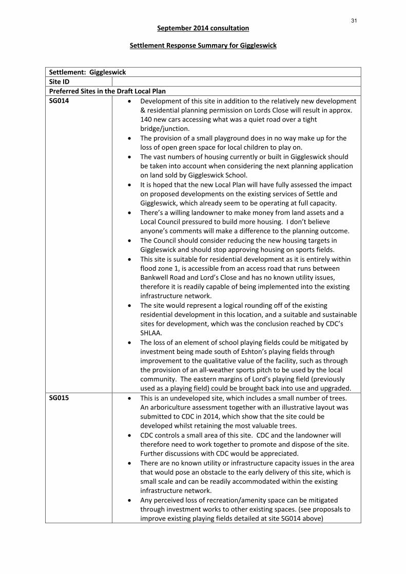
Cross Hills & Glusburn Inset Map: Draft Local Plan Sites
Housing
Housing – only part of site required
Housing – other options
Employment
Mixed – housing and employment
Housing—potential in the long term
Potential for strategic open space
50 Number of dwellings (figures in red are a preliminary estimate for each site)
Scale 1:7,500 at A4 (approx)
SHLAA No. Site Address Site Area (Ha) Indicative Housing Capacity Indicative Housing Density (dw/ha)
SC014 South and east of Hayfield Mills, Colne Road 1.882 30 15.9 SC016 West of Beanlands Drive and east of Sunny Bank Road 0.85 25 29.4 SC082 Hayfield Mills, Colne Road 2.542 50 19.7
33

September 2014 consultation
Settlement Response Summary for Glusburn and Cross Hills
Settlement: Glusburn and Cross Hills Site ID Preferred Sites in the Draft Local Plan SC014 & SC082 • The plan need to be changed to increase the number of dwellings
anticipated to come forward on these sites, in order to reflect itsgenuine and realistic capacity. Indicative site layout submitted for siteSC014 during the consultation period showing a mix of houses andapartments and area of open space suggesting that the yield from thissite should be increased to between 65-70.
• Site SC082 is likely to come forward later in the plan period, however itis considered that this site could accommodate more than 50dwellings, as indicated in the draft plan. This site has potential toaccommodate a significant number of apartments through conversionof the traditional buildings that front the site.
• Site SC014 in particular should take preference over any greenfieldalternatives (SC016), as it is sequentially preferable.
• The plan should encourage both sites to come forward before SC016and site SCO14 within the first five years of the plan.
• The plan needs to be changed to ensure it reflects the genuinecapacity of Glusburn for future housing development, as it has greatercapacity than is currently indicated in the draft plan. All of therequirement for Glusburn could be achieved on sites SC014 & SC082.Alternatively the requirement could be increased with increaseddevelopment on these sites in addition to retaining the allocation ofsite SC016.
Sites Not Preferred in the Draft Local Plan General comments • Water supply - Local mains reinforcement may be required. Waste
water – The sites would drain via the Aire Valley Trunk Sewer.Yorkshire Water are currently developing our Aire Valley Strategy andDrainage Area Plan (DAP) outputs will be a key part of our futurescenario planning. It is intended that as Local Plans are finalised forCraven and Bradford Districts (the sewer serves settlements in both)new development scenarios in the DAP will be revised and furtherfeasibility undertaken. It is proposed that we will consider short,medium and long term responses to the supply demand challenges.Yorkshire Water would therefore seek to ensure that newdevelopment is suitably phased to allow Yorkshire Water to provideadequate capacity in the network to serve growth in both districts.
• The local plan map for Glusburn and Cross Hills does not take intoaccount Green Lane, Malsis School and Ashfield Farm sites, thereforecomplete revision of the map is required.
New Sites • SC083 put forward for consideration during the consultation period.
34
Section 8: Local Plan Map Inset Maps
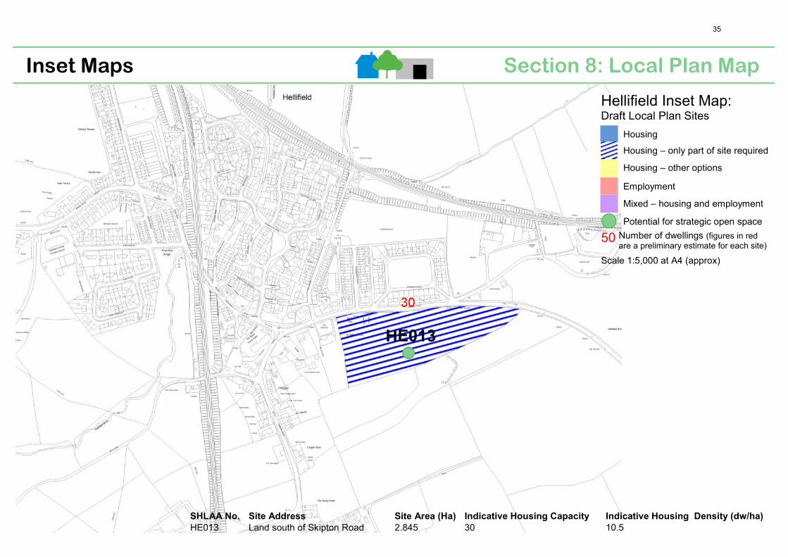
Hellifield Inset Map: Draft Local Plan Sites
Housing
Housing – only part of site required
Housing – other options
Employment
Mixed – housing and employment
Potential for strategic open space
50 Number of dwellings (figures in redare a preliminary estimate for each site)
Scale 1:5,000 at A4 (approx)
SHLAA No. Site Address Site Area (Ha) Indicative Housing Capacity Indicative Housing Density (dw/ha)
HE013 Land south of Skipton Road 2.845 30 10.5
35
September 2014 consultation
Settlement Response Summary for Hellifield
Settlement: Hellifield Site ID Preferred Sites in the Draft Local Plan HE013 • This site is owned by The Gargrave Poor’s Land Charity
• The Parish Profile exercise and consultation process for Hellifield have made it clear that any further development in the village is only acceptable in small infill sites and to be spaced over the 15 year period. There is no indication that this has been listened too. The preferred site HE013 only appeared at the parish consultation event stage of the process and proposes to build the entire allocation on a greenfield site. There is concern that the implications of this decision will probably result in the entire site being fully developed within the plan period. Development of this site would detract from the character and appearance of the village by masking the church and the views towards the listed Hellifield Peel.
• Concerns regarding the pressure from future development on utility services have not been fully noted.
• There is no indication in the draft plan of the phasing of development to meet the requirements of the Hellifield Village Plan.
• No development is necessary in Hellifield as the village has had housing growth of 70% as opposed to the overage of 20% for the region. Previously other more suitable sites were proposed (Section 53 of the original Craven Plan), which are “small, physically & visually well related to the settlement & not exceeding local need”. Two smaller sites should be chosen, one for market housing and one for affordable housing.
• The site boundary should be reduced to provide uncertainty in terms of whether the entire site would be developed or not, and to provide a gap between the preferred site and the church. This site was the preferred site of the Parish Council, providing the boundary can be clarified and the development can be phased to the latter part of the plan period.
• This site is earmarked for 30 dwellings, however it has capacity for more. Does this mean that the number of 30 dwellings will be fixed as a maximum? Will the site will be developed beyond 2030? Will all 30 dwellings be built in a single phase? The site is also identified as having potential for strategic open space. Will this occupy all the remaining land and will it be safeguarded?
• This site should not be considered for housing due to access and egress issues onto the busy A65, its proximity to the listed church buildings, significant development has taken place in Hellifield in recent years, which has an impact on schools and other services, the lack of local employment opportunities would mean that new residents would have to travel by car to work meaning that the new home owners would need a minimum of two cards per household.
• Why is new housing development being considered on this site when a recent planning application on Gisburn Road has been rejected due to it being close to the Grade II listed Church? How much are people being given by builders for the planning permission? Why do Parish
36

September 2014 consultation
Settlement Response Summary for Hellifield
Councillors have their needs adhered to when the image of the village is being ruined by a building site in the main road in a dangerous position? New housing, including affordable housing should be added to existing developments e.g., off Gisburn Rd.
• If two houses per year are to be built then a large site is not needed. Are two houses allowed to be built on a site at a time? CDC have recently given permission for two houses on Thorndale Street, which is the limit for next year.
• Consideration should be given to the original sites proposed as HE013 is totally unsuitable given its close proximity to the Grade II listed church.
• Presumably affordable housing could not be achieved on this site due to the standards required to fit with the setting of the listed church building.
• Services in Hellifield are limited and reducing e.g., the Auction Mart are closing the only post office.
• New housing creates jobs for builders not living in the area, it takes away fields, cuts jobs and put farmers out of business.
• Where are the jobs going to be for those living in the affordable housing? Trains and buses are rare and it is impossible to work for a living without a vehicle. Are those living in the affordable housing going to be given a vehicle?
• Are the householders in Hellifield to be given compensation for 10 years of major road works and loss of value on the homes overlooking the site?
• Are the business interests of local/Craven councillors to be taken into account? Are they putting forward areas for housebuilding not near to their properties?
• There are quite a few affordable houses currently for sale in Hellifield. If this site is developed then there would be more available properties in Hellifield for sale. There is no housing or affordable housing shortage.
• Affordable housing does not need to have view of fields and does not need to be built on fields.
• Is it the intention to build large expensive houses that only rich people can buy?
• Alternative site currently with garages on near the clothes shop would be better.
• How can people who cannot afford to buy a house live in Hellifield when a lot of money needs to be spent on transport to work?
• This site contributes to the setting of the Grade II Listed St Aidan’s Church, which is seen across this open farmland as one travels towards the village from the A65. There us a requirement in the 1990 Act that “special regard” should be had to the desirability of preserving Listed Buildings or their setting or any features of special architectural or historic interest which they possess. Before allocating this site for development an assessment of impact on the listed building is required. (English Heritage comment).
37

September 2014 consultation
Settlement Response Summary for Hellifield
Sites Not Preferred in the Draft Local Plan HE001 • This site is owned by CDC HE004, HE007, HE008, HE009 & HE011
• These sites are owned by Craven Cattle Marts Ltd
HE008 • The Parish Council does not support development/allocation of this site. There is a current planning application on this site, which is located in updated EA flood zone 3. This updated information on flood risk should be incorporated into future Local Plan work.
• The “Sites Preferred and Not Preferred for Consultation” document states that feedback from public consultation in summer 2013 for this site was neutral. The Parish Council disagrees with this as many people have fed back to them that they feel strongly about the site being developed. Many people left the summer consultation event having only given verbal rather than written feedback. Hellifield Parish Council do not see why verbal feedback cannot be taken into account.
HE009 • This could be an alternative site to HE013 so long as the updated flood risk information from the EA does not affect the categorisation of the site. Initial sustainability appraisal of this site highlighted potential for employment use due to its proximity to an A road.
General comments • Water supply - Local mains reinforcement may be required. • Policy SP12: Housing – Number of sites put forward for development
by landowners has resulted in a virtual “shopping list” for potential developers, prompting numerous planning applications being submitted prior to the local plan being finalised. There is nothing in the draft plan to confirm whether these dwellings would be removed from the maximum numbers stated in the draft local plan. There is also no indication that other sites with planning permission (e.g., land off Back Lane), but not started, will be counted in the numbers recommended for each parish. The draft local plan should make it very clear what the situation is regarding pre local plan housing numbers.
• Any future housing development in Hellifield should be limited to small infill sites.
• The station is at the moment owned by the railway company but most of the building and land to the west is owned by the West Coast Railway. This land would make an ideal car park and the road to nowhere a good entrance. Given that this station is a major junction both into Leeds and Lancashire there is potential for commuters into Lancashire and also to bring tourists into Craven. However the line needs opening up to passenger services. This land also has the potential for small businesses - jobs need to be brought into Craven to avoid retirement settlements.
• The plan should specifically identify and include sites of high biodiversity value with Craven, such as Hellifield Flashes which is species-rich, and act to fully protect these sites.
• No employment site is indicated on the plan. When the plan is adopted what will be the status of the area bounded by the A65, Waterside Lane and Station Road, which was previously earmarked as
38

September 2014 consultation
Settlement Response Summary for Hellifield
a development site? Will it be removed as a development site or modified to reduce its potential impact on the community and countryside?
• Hellifield village is surrounded by land owned by businesses and organisations outside the community. As such it could be subject to speculative planning applications such as the current one off Back Lane. What safeguards will the local plan have to prevent such development during the plan lifetime?
• Affordable housing is an essential element of the draft plan. In relation to Hellifield will such housing be prioritised to existing, established Hellifield families rather than open to all corners; be actually affordable? The last affordable housing development, Station Court, included houses for sale, which were at the time offered at some £40,000 above the asking price for some existing housing stock.
• The County Council have expressed an interest in building extra care housing in Hellifield as this would meet the needs of the wider population of Settle and Gargrave. Joined up thinking is needed as Hellifield would not be suitable for such a plan if the current replacement bus service was taken away.
• There does not need to be anymore housing in Hellifield. Building on farmers fields is not the way forward. Building on farmers fields cut jobs. People who are poor cannot afford to live where there are no jobs or enough cheap transport. Building needs to be done in towns where there are jobs, schools and public transport easy to access. Giving money/planning permission to builders building big homes for rich people is not something a council should do. It leaves Craven Council open to allegations of taking bribes. Homes that are affordable should be built by the council in places where work is available
39

Section 8: Local Plan Map Inset Maps
SHLAA No. Site Address Site Area (Ha) Indicative Housing Capacity Indicative Housing Density (dw/ha)
HB011 Primary school, east of Robin Lane, west of Lowcroft 0.962 28 29.1 HB017 West of Station Road, south of railway station 1.153 14 Mixed use HB023 North of Low Bentham Road, rear of Furness Drive 3.143 80 25.5 HB027 Mount Pleasant 0.952 Employment N/A HB028 East of Station Road and south-west of Pye Busk 11.169 73 6.5 HB030 Land off Duke Street 6.287 73 11.6
High Bentham Inset Map: Draft Local Plan Sites
Housing
Housing – only part of site required
Housing – other options
Employment
Mixed – housing and employment
Potential for strategic open space
50 Number of dwellings (figures in redare a preliminary estimate for each site)
Scale 1:6,000 at A4 (approx)
40

September 2014 consultation
Settlement Response Summary for High Bentham
Settlement: High Bentham Site ID Preferred Sites in the Draft Local Plan HB011 • Site should be ring fenced for “Extra Care” housing as lack of
residential facilities for older people. Easy access to town centre. • Potential problem with access on Low Croft which is too narrow for
both construction vehicles and general traffic. No proper footpath. Better access would be from Robin Lane.
HB017 • Thought to be a good site for mixed use (housing and commercial). • Opposite view point stated that site should be fully developed for
employment use rather than mixed use. It is an established industrial area and is more suited to employment use. HB027 could take this site’s housing allocation as it is more suitable for housing than HB017.
HB023 • Field with footpaths running through should not be used for housing development, rather they should remain the responsibility of the landowner. This would break up areas of housing and leave the fields in their existing natural state (i.e. footpath provision at recently developed Bargh’s Meadow was poor, i.e. narrow path between tall fence and untrimmed edge, overlaid with large limestone chippings – attracts rubbish, feels unnatural and does not feel anything like the path across a flowering meadow that preceded it). If HB023 developed footpath should be diverted through HB022, which then should not be developed at later stage.
• Most easterly field in HB023 should not be developed. • Concern about serious flooding problems in south-western part of site
(behind Moonsacre), and around the beck that flows west of the Telephone Exchange. Plan for new development should also consider the impact on water levels and flooding on Furness Drive and south of Low Bentham Road.
• Access on to B6480 is at bottom end of a blind hill and blind bend and traffic is already too fast along this road. Serious safety issues for both people and animals. Previous refusal on site due to access.
• A new safe pedestrian route for primary and nursery children to use from High Bentham to the new school has been designated on north side of B6480. The proposed access for HB023 compromises the safety of children travelling to new school.
• Site is on a green wedge area. Concern that the need for new housing does not outweigh the green wedge designation. Green wedges should be protected to help integrate Bentham into the countryside.
• Brownfield sites should be utilised before this large greenfield sites which attracts a lot of wildlife.
• Site steep for development. • Proposed housing is too dense for size of site. • Site abuts recently developed Bargh’s Meadow. Danger that
additional development on HB023 would lead to a huge area of low-cost / social housing development which would alter the existing well-balanced feel of this small market town of Bentham.
• Tranquillity, which is already compromised in the area due to new
41

September 2014 consultation
Settlement Response Summary for High Bentham
school, would be further compromised with proposed new housing development.
• Subsistence issues for homes along B6480 if housing built behind them (i.e. trees already fallen over in gardens due to waterlogging issues and poor drainage)
• Infrastructure issues such as impact of health care system, impact on sewers and drains (viability cost to increase sewerage which is already working to full capacity).
• Development of this site, coupled with HB030 would result in overdevelopment in this area of the town, resulting in loss of the location’s rural agricultural history and character and additional strain on infrastructure in this area.
HB027 • Should be considered for housing, not employment as: o It is currently surrounded by housing o It does not present a flood risk (issues with incorrect outcomes
for flood risk cited in Council’s sustainability check). o The land is not suitable for agriculture due to size and steep
topography. o The land has no employment potential.
• HB027 is a filled in quarry and may not be suitable for development. HB028 • Development is too large scale and would result in the loss of too
many greenfields. • Flood risk issues around Church Beck. • Should be partially development for employment use, rather than
HB027 which is more suitable to housing. • HB028 edges the town’s gateway from Slaidburn and from the railway,
giving visitors their first impression of the town. As such it requires protection as open space.
• If HB028 is developed the Cattle/Sheep market would be put at risk. The Auction Mart would lose fields for grazing and would potentially become less viable. The Auction Mart and the activities that go on there (i.e. thousands of sheep enclosed in fields) also communicates to residents and visitors what Bentham is about. The noises, smells, vehicle loading and road congestion that are created by the Auction Mart are an important part of community life and the benefits far outweigh the problems they pose. Farmers also use the banks, shops, doctor’s surgery in Bentham that are easily accessible from the free parking at the Auction Mart. This is a hard to reach group in the community and should be supported (i.e. the surgery has set up mini-clinics at the Auction Mart to target specific issues in the farming community).
• New park should be sited on the field north (and in sight of the) of the railway line and east of the station entrance (i.e. west end of HB028). This field is ideally placed, attractive, within easy reach of the town centre and seen by rail passengers as they come into Bentham. New park should not be made ‘low maintenance’ with too much decking, paving and gravel. Rather it should be a wildlife haven ((wildflower meadows, bee friendly plants, an apiary, bat boxes, bird boxes, a pond, trees, organic vegetables & fruit trees).
42
September 2014 consultation
Settlement Response Summary for High Bentham
• If one of the reasons for developing the whole area of HB028 is to
make it possible to build a road suitable for lorries to get to Station Road/ Angus Fire, it would need to cut across the field where a park could potentially be sited. This would create a very different and less attractive atmosphere and would push any potential park even further away from the town centre. Need to ensure that we don’t embark on unnecessary, expensive, major road building operations which will change the town completely, i.e. look at all alternatives, including using the railway.
• Housing development on HB028 would add to congestion on Station Road and at the junction with Main Street. Access may be better via HB027 onto Springfield Road.
• Need to retain green spaces and footpaths and heritage trails through site which are vital for drawing walkers to the area and vital to the health and wellbeing of residents who use them. Housing development should be surrounded by greenspace.
• Allotments should be included on this site. • A community renewable energy generation project to provide power
for the new houses and for existing dwellings would be a good idea • Need more detail as to where housing would be sited and where green
space would be retained. HB030 • Development of this site, coupled with HB023 would result in
overdevelopment in this area of the town, resulting in loss of the location’s rural agricultural history and character and additional strain on infrastructure in this area.
• This site should be used as open parkland, which would maintain the area’s rural roots and make it an attractive place for people to both live and visit, which in turn would encourage more tourism and business into the area.
• Should be partially development for employment use, rather than HB027 which is more suitable to housing.
• Need more detail as to where housing would be sited and where green space would be retained.
Sites Not Preferred in the Draft Local Plan HB026, HB033, HB035, HB038
• Infill sites would be preferable to large sites as they would be less intrusive and encourage newcomers to integrate with the existing community (i.e. HB026, HB033, HB035 and remains of HB038). Addition of more, smaller sites, but with the reduction of numbers on each site.
HB035, HB038 • HB035 (Felsteads) is not included as a preferred site and yet has outline planning consent. This development should be combined with development of school on half of HB038, and them the remainder of HB038 should also be developed for housing.
General comments • Need more smaller sites in High Bentham (as opposed to giant proposed sites) to preserve the character of the town, i.e.
o field north of Springfield Crescent which has road access, o on sites between Low and High Bentham, close to the
proposed new school (taking care not to obstruct views to the south), so that parents could walk their kids to school and
43

September 2014 consultation
Settlement Response Summary for High Bentham
avoid car journeys which would further congest the town,
o near Felstead, o field to west of Naylor Myers timber yard, o land next to Ford House, Low Bentham Road o any part of HB011 not needed for extra care o Campbell Hatcheries
• The east of Bentham should be considered as well to help spread the impact of new development on the town.
• Information in the ‘Retail and Town Centres’ section of the Local Plan is incorrect. Need more accuracy about the reality of markets in Bentham and need to support them to ensure viability of town centre (i.e. Bentham only has a small weekly market - veg stall and fish stall on Wed and Sat, and there is no monthly farmers market).
• The transport infrastructure in Bentham is very stretched and whilst the town wishes to grow it cannot do so successfully without notice being taken of the need for improvements to the transport links, both in terms of train / bus timetables and the roads themselves. The B6480 / Station Road junction in High Bentham is a major bottle neck in the town which needs addressing, particularly if significantly more traffic is expected to use it with developments on the Station Road end of site HB028 and site HB017. Improved transport infrastructure would enable businesses to invest in facilities in Bentham for future growth and encourage more people to live in this very pleasant small town.
• Looking outside of the limits, the access roads to both Low and High Bentham are poor and mostly unsuitable for HGVs and coaches as they are narrow and have low bridges. Bentham needs a direct road to the A65 suitable for all traffic and improvements westwards to the A682.
• Need clarity on difference between blue and yellow sites in plan. • Plan should also include new housing and other development that has
recently been built in Bentham (i.e. at Bargh’s Meadow, new school). • (Low and High Bentham) 15 houses per year= 225 over 15 years Water
supply- Local mains reinforcement may be required (Yorkshire Water comment).
• Antisocial parking is a real problem within both settlements where many properties were built without off street parking. Future developments should not be allowed in either High or Low Bentham without the provision of parking spaces.
44

Section 8: Local Plan Map Inset Maps
SHLAA
No. Site Address
Site Area
(Ha)
Indicative Housing
Capacity
Indicative Housing
Density (dw/ha)
IN009 North of Reid House, Low Demesne Close 0.3 15 50.0 IN022 Adjacent to southern edge of industrial estate, off New Road 3.004 Employment N/A IN028 Between Ingleborough Park Drive and Low Demesne 6.4 55 8.6 IN033 Rear of Bower Cottages and Panwell, Back Gate 0.223 5 22.4 IN035 Between industrial estate off New Road & Tatterthorn Lane 1.994 Employment N/A
Ingleton Inset Map: Draft Local Plan Sites
Housing
Housing – only part of site required
Housing – other options
Employment
Mixed – housing and employment
Potential for strategic open space
50 Number of dwellings (figures in redare a preliminary estimate for each site)
Scale 1:6,000 at A4 (approx)
45
September 2014 consultation
Settlement Response Summary for Ingleton
Settlement: Ingleton Site ID Preferred Sites in the Draft Local Plan IN009 • Development of this site for social housing is underway and should not
be used in these calculations. IN033 & IN028 • Numbers to increase by a minimum of 15 IN028 • The extent of this potential housing site appears to have taken no
account of either the topography of the area or the historic field boundaries. Consequently, it appears likely that the development of this site would result in a form of development which relates poorly to both the character of the settlement and its landscape setting. Whilst there may be some potential for limited development of this site, on the basis of the current extent of this proposed allocation, this proposal seems likely to result in a form of development which would harm the character and setting of Ingleton Conservation Area.
• Before allocating Site IN028 for development:- (1) An assessment needs to be undertaken of the contribution which this site makes to the elements which contribute towards the significance of the Ingleton Conservation Area and what impact the loss of this undeveloped site and its subsequent development might have upon those significances. (2) If it is considered that the development of this site would harm elements which contribute to the significance of the Conservation Area, then the plan needs to set out how that harm might be removed or reduced. (3) If, at the end of the process, it is concluded that the development would still be likely to harm elements which contribute to the significance of the Conservation Area, then this site should not be allocated unless there are clear public benefits that outweigh the harm (as is required by NPPF, Paragraph 133 or 134).
Sites Not Preferred in the Draft Local Plan IN031 • This site should not be developed. The outstanding beauty of this
area, including trees with TPOs should be preserved for visitors to the area.
General comments • The County Council is about to conduct a procurement exercise to secure a partner to develop extra care housing in Craven on sites in the council's ownership in High Bentham and lngleton. The former playing fields at Ingleton Middle School are being considered for extra care housing and public leisure use.
• Water supply- Local mains reinforcement may be required. • Increase numbers from 5 properties a year to 10 for Ingleton. • Concerns about proposed major developments in close proximity in
Lancashire and Cumbria, which could impact on the future of Ingleton. • Suggest Ingleton is allowed to grow without any more restrictions
being put in place.
46

Section 8: Local Plan Map Inset Maps
SHLAA No. Site Address Site Area (Ha) Indicative Housing Capacity Indicative Housing Density (dw/ha)
LB010 West of Greenfoot Lane 0.367 7 19.1 LB015 North of Harley Close 0.547 17 31.1 LB021 Land between Hillside Road and Ellergill 0.494 6 12.1 LB024 Recreation ground adjacent to Burton Road 0.195 5 25 LB025 Low Bentham Primary School and land to the north 0.208 5 24
5
5
Low Bentham Inset Map: Draft Local Plan Sites
Housing
Housing – only part of site required
Housing – other options
Employment
Mixed – housing and employment
Potential for strategic open space
50 Number of dwellings (figures in redare a preliminary estimate for each site)
Scale 1:3,500 at A4 (approx)
47

September 2014 consultation
Settlement Response Summary for Low Bentham
Settlement: Low Bentham Site ID Preferred Sites in the Draft Local Plan LB010 • This site should not be developed for housing as it is both a visual
amenity with its extensive views to the south and west from Greenfoot Lane, Cross Lane, and 'Westend Lane'; and a rare village asset because it brings tangible (i.e. not hidden behind housing) countryside to the edge of the settlement.
• Opposite view point that LB010 should be considered as it is more in keeping with a small rural village.
LB015 • Acceptable site for housing providing Planning enforce strict conditions to the site to prevent a repeat of the disastrous 15-27 Harley Close development.
• Need to take account of a right of way into the 'play' area and accessible green infrastructure to Ellergill Beck.
• Access is an issue from LB015 onto the B6480 in terms of visibility; this area will require some form of traffic calming.
LB021 • Access is an issue for LB021 if using Hillside Road where emergency vehicles already struggle because of on-street parking. Also safety concerns for children playing in this area.
• This site includes one side of an avenue of lime trees, which are subject to tree preservation orders. There are also other mature trees on the site worthy of protection. Other heritage assets include the old kitchen garden wall, which should not be removed. As such LB021 should be removed in full or in part.
• The area between the 6 planned houses (as shown on concept scheme for site) and the private drive into Ellergill is protected woodland. LB021 should be amended to exclude this area of protected woodland which is well-used and well loved by Low Bentham residents.
• Any increase in traffic along the private drive (which serves 8 existing houses) resulting from increased housing would be detrimental to present residents. Need to ensure that none of the proposed new houses are accessed by privately owned Ellergill Drive.
• Concept statement shows 8 proposed houses, rather than the 6 proposed in draft Plan.
• The sustainability check for LB021 mentions that even though the site is grade 3 agricultural land, this land is no longer used as such. However, LB021 supports sheep year round and includes a small shelter for them in bad weather. Development of LB021 would result in the loss of important agricultural land which runs into the heart of the village.
• Even though the concept statement suggests this site will provide ‘natural infill’, this is not the case. This site will be overlooked by over 30 existing houses and any new development would have a great environmental impact on them. Development would go against the draft Plan’s Strategic Objective of “allowing the countryside to permeate built-up areas”.
• Concerns raised about access to school playing fields. NYCC has bought the land providing access to the field from Doctor’s Hill and has
48

September 2014 consultation
Settlement Response Summary for Low Bentham
granted Bentham Town Council right of access in perpetuity. This is not the developer’s ‘gift’ as suggested in concept statement.
• Query as to whether 6 new houses would actually ‘adequately addresses preservation of the setting of a nearby listed building’ (i.e. Ellergill House), as suggested in sustainability check. They would certainly not ‘enhance’ or ‘preserve’ its setting as was originally set out in the Plan (wording changed in draft plan at property owner’s request). English Heritage report confirms that ‘insufficient work has been done in assessing the impact of development and any consequent mitigation for individual heritage assets’.
• Sustainability check suggests that site is less than 400m from playspace and is positively marked as such. However the park does not offer any play equipment and has a dangerous access for children.
• The site has been refused planning permission in the past on the grounds that it is outside development limits; there is already sufficient existing housing in the area; there are poor access arrangements; and the adverse impact on nearby mature trees.
• Development of site poses a threat to the biodiversity of the area (i.e. tawny owls, bat roosts, amphibians from Ellerbeck including frogs, toads and newts, hawks, small mammals including hedgehogs, large mammals including deer).
• Development of LB021 would pose a threat to ‘dark skies’ which is currently enjoyed by residents of Ellergill Lodge, and would be contrary to draft Plans claim to “promote the understanding, appreciation and enjoyment of dark skies and support proposals that help to secure the benefit of dark skies”.
• LB021 should be restricted to sheltered elderly accommodation on a third of the site (i.e. retirement bungalows in line with the style adjacent to the site). The remainder of the site should be one third woodland and one third left as a walled garden to Ellergill Farm.
• Ellergill House, immediately to the east of this area, is a Grade II Listed Building. There is a requirement in the 1990 Act that “special regard” should be had to the desirability of preserving Listed Buildings or their setting or any features of special architectural or historic interest which they possess. Before allocating this site for development an assessment of impact on the listed building is required. (English Heritage comment).
• Access through numbers 22 and 20 Hillside Road (bungalows designed for elderly people) will produce a great deal of extra noise and pollution, which is bound to be deeply disturbing. Query as to whether this proposed access to the field is owned by Sanctuary North. Have CDC clarified the legal situation?
• Query as to the kind of houses proposed on LB021. Private houses at normal commercial prices are not in shortage in Low Bentham. Low-cost social housing for rent may not be suitable unless there is going to be substantial investment in physical and social infrastructure (e.g. there are no shops or medical services available in the village, and public transport is minimal).
• Development of the site should be reconsidered in light of local needs
49
September 2014 consultation
Settlement Response Summary for Low Bentham
e.g. parking and number of vacant properties in the area
LB024 • LB024 should not become available for building and should remain a play area. There should be investment in play equipment. Low Bentham is one of only villages of that size in Craven without any play equipment for children.
• This field was given to the people of Bentham by a local Quaker, Philip Harvey, to be a recreation area. Need to check the terms of this bequest to see if it is legal to use this gift for another purpose.
• Opposite view point stated that should use this existing play area for housing, but only if LB025 is kept as a play area. Loss of both play areas to housing is unacceptable.
• There is a problem with on-street parking on Burton Road and the lack of any safe pedestrian pavement, especially dangerous for children The Council should therefore build in traffic calming measures, provide pavements/walkways and create car parking spaces for current residents on Burton Road and also visitors to the new proposed houses (comment also applies to LB021)
LB025 • LB025 should be kept and developed as a play area, particularly if LB024 is to be developed for housing.
Sites Not Preferred in the Draft Local Plan LB014 • Proposed site too large. Reduce the proposed site to one field include
parking arrangements for Hillside Terrace. LB017 • Should remain as green space or changed to residential land for a
small single storey dwelling. General comments • A S106 or Community Levy for play equipment (as approved by the
Parks Dept) in the empty playground would be useful to a village absent of play facilities.
• Concern raised about lack of information on sites to be able to make informed representations (i.e. concept schemes were not made public, except via a Freedom of Information request)
• Looking outside of the limits, the access roads to both Low and High Bentham are poor and mostly unsuitable for HGVs and coaches as they are narrow and have low bridges. Bentham needs a direct road to the A65 suitable for all traffic and improvements westwards to the A682.
• Antisocial parking is a real problem within both settlements where many properties were built without off street parking. Future developments should not be allowed in either High or Low Bentham without the provision of parking spaces
• Prior to any new development, safe footpaths must be provided on Doctors Hill as well as crossings on Bentham Road.
50
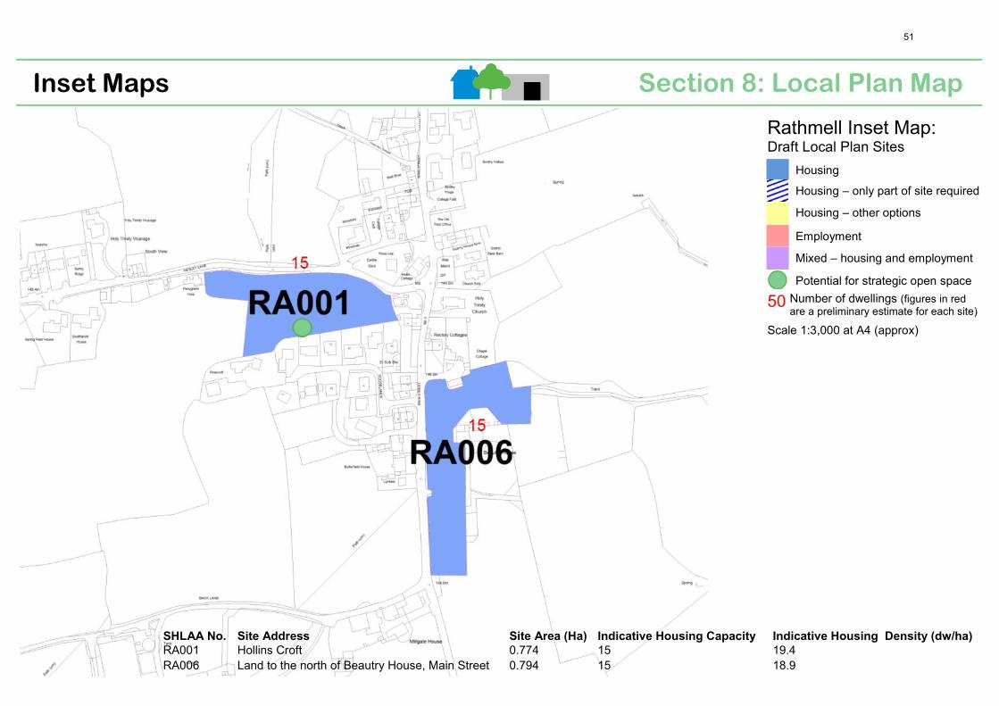
Section 8: Local Plan Map Inset Maps
Rathmell Inset Map: Draft Local Plan Sites
Housing
Housing – only part of site required
Housing – other options
Employment
Mixed – housing and employment
Potential for strategic open space
50 Number of dwellings (figures in redare a preliminary estimate for each site)
Scale 1:3,000 at A4 (approx)
SHLAA No. Site Address Site Area (Ha) Indicative Housing Capacity Indicative Housing Density (dw/ha)
RA001 Hollins Croft 0.774 15 19.4 RA006 Land to the north of Beautry House, Main Street 0.794 15 18.9
51

September 2014 consultation
Settlement Response Summary for Rathmell
Settlement: Rathmell Site ID Preferred Sites in the Draft Local Plan RA001 • RA001 cannot be both housing and open space. There is a robust sense
of community in Rathmell. Open space for recreation for children andadults would add to the well-being of the population, however need togive a very clear definition of the "open space" particularly ifcommunity use is implied.
• There is a very large and important barn on the roadside and that mustnot be compromised by unsympathetic development of site ordemolition/modern rebuild. A brief on the whole designated area issuggested.
• The site is good agricultural land. It is prone to flooding which doesnot interfere with agricultural use but which would surely bedetrimental to housing.
• Access via Hesley Lane is poor. The Junction of Hesley Lane with MainStreet Rathmell is narrow with poor sight lines and so steep a gradientthat already it requires frequent repair. The Lane has many bends andis so narrow that in many places; especially adjoining the proposedsite, vehicles from opposite directions cannot safely pass. This createsa hazard for pedestrians for whom there is no escape because of lackof a footway. Access/egress for houses on the proposed site wouldincrease this hazard. If there is to be housing alongside it, Hesley Laneshould be widened (especially at its junction with Main Street), andprovided with a footpath.
RA006 • Given its edge of village position, we would suggest an archaeologicalwatching brief on those parts that have not been built on before.
• Beautry Farmhouse is a Grade II Listed Building. There is a requirementin the 1990 Act that“special regard” should be had to the desirabilityof preserving Listed Buildings or their setting or any features of specialarchitectural or historic interest which they possess. The Local Planshould make it clear that any redevelopment proposals for this areashould safeguard those elements which contribute to the significanceof this building. Amend accordingly (English Heritage comment).
General comments • 2 houses per year= 30 over 15 years Water supply- Local mainsreinforcement may be required (Yorkshire Water comment).
• More clarity is required on the definition of "potential for strategicopen space".
• Any houses within the Rathmell planning area should be built with dueconsideration to the "country" nature of the village which gives it itsunique character and which attracts tourists/visitors to enjoy "the"beautiful landscape of upland pasture and moorland" quoted.Excessive development would be detrimental to the latter.
52

Section 8: Local Plan Map Inset Maps
Settle Inset Map: Draft Local Plan Sites
Housing
Housing – only part of site required
Housing – other options
Employment
Mixed – housing and employment
Potential for strategic open space
50 Number of dwellings (figures in redare a preliminary estimate for each site)
Scale 1:6,000 at A4 (approx)
SHLAA
No. Site Address
Site Area
(Ha)
Indicative
Housing
Capacity
Indicative Housing
Density (dw/ha)
SG018 NYCC Depot, north of King's Mill 0.526 26 49.4 SG025 Land to the south of Ingfield Lane 10.273 97 Mixed use SG027 South of Ingfield Lane, east of Brockhole View 0.89 20 22.5 SG029 CDC garaging and car parking, Ingfield Lane 0.17 5 29.4 SG032 Car park, off Lower Greenfoot and Commercial Street 0.165 5 30.3 SG035 West Yorkshire Garage, Duke Street 0.16 12 75.0 SG042 NYCC Depot, Kirkgate 0.22 5 22.7 SG053 Site of Settle Social Club, Undercliffe 0.239 13 54.4 SG065 Gas Works House, Station Road 0.212 5 23.6 SG068 Land to the west of Brockhole Lane 2.102 34 16.2 SG074 Land to southern end of Sowarth Field Industrial Estate 0.173 18 Mixed use
53

September 2014 Consultation
Settlement Response Summary for Settle
Settlement: Settle Site ID Preferred Sites in the Draft Local Plan SG018 • King’s Mill is a Grade II Listed Building. There is a requirement in the
1990 Act that “special regard” should be had to the desirability of preserving Listed Buildings or their setting or any features of special architectural or historic interest which they possess. The Local Plan should make it clear that any redevelopment proposals for this area will be required to safeguard those elements which contribute to the significance of this building. Amend accordingly (English Heritage comment)
• No objection to SG018, SG029, SG042, SG065 and SG074, all of which are brownfield sites whose current appearance detracts from Settle's character and attractiveness. In total, these areas would account for 59 of the stated requirement of 240 houses over the next 15 years.
• SG018 may need minor offsite reinforcement (Yorkshire Water comment).
SG025 • Strong objection to any new development within SG025 which would also be totally at odds with Policy SP12. It would be an unacceptable intrusion into valuable green space beyond the southern edge of Settle and would no doubt in the course of time be the beginning of ribbon development southwards.
• Brockholes and Watery Lanes must be protected as they are much used and much valued public rights of way offering peace, wonderful views southwards and wildlife. Development here would be a serious detractor from these key values.
• Development of the site would ignore the historic meaning of that area, as these fields are part of the fabric of the medieval settlements of Settle, Anley and Runley.
• Objection on flooding and drainage grounds: o The area is wet and was part of medieval Settle's ings. Ings
were water meadows, deliberately allowed to flood during the winter to enrich the grass with silt (i.e. floodplains). Keepmoat had problems building Limestone View which is at a higher elevation than SG025: they had to sink many steel piles because the ground is so wet and boggy.
o This site is known to flood, hence the proposed flood meadow to deal with surface water drainage from phase 1 & 2 of the Ingfield Lane development.
o The culverted water course that bisects SG025 is a stream powerful enough to enable Runley Water Mill (corn and later cotton) to function. It floods downstream of the culverted area; the Victorian culvert that carries its waters under the railway embankment backs up and floods SG025 (even in recent dry spell). The other streams that make up this floodplain - Dog Kennel Beck and Lodge Beck - also flood.
o Problems with flash-flooding due large catchment area draining to this site. Site has a high water table.
o Foul water drainage is poor. The current proposal is to pump
54
September 2014 Consultation
Settlement Response Summary for Settle
sewage into the existing foul water system, which has shown signs of overload during the past year, causing sewage to flood into gardens and the road on Cammack Lane.
o The proposed lagoon as a feature to hold run off water seems sensible but a rise in the water table is not.
• Objection regarding access arrangements: o Access is proposed from SG025 at southern end, near where
the filling station and coach depot used to stand (B6480). Skipton Properties propose traffic lights there, however permanent traffic lights would equate to over-urbanisation. The sight line southwards is severely restricted by the railway bridge and traffic backing up under the narrow and height-restricted bridge will cause mayhem (including HGVs needing to travel in the middle of the road).
o The access onto lngfield Lane is insufficient for the large scale development proposed
o The number of daily vehicle movements onto and out of SG025 onto Ingfield Lane and at the Falcon Manor cross-roads will place an impossible strain on that narrow road's traffic-handling capacity, as well as substantially increasing noise levels in what has been a quiet residential area.
o Needs Highways Authority consultation. • Objection due to lack of following infrastructure:
o Dental and doctors surgeries are at capacity, o School nearing capacity, o Car parking spaces in town will be strained as site is too far for
many people to walk into town and will necessitate car journeys.
• Concern regarding jobs for new residents. Fear that Settle will become a long distance commuter suburb, with no plans for improvements to the public transport network. These commuters may choose retail offer in other places (i.e. large supermarkets in the places that they commute to).
• Objection to using part of SG025 as light commercial as there are already 2 separate industrial estates in town. Better to join uses on existing industrial estates together and relocate them to one large industrial estate near the bypass (see general comments below). Employment use at this site would have no road frontage.
• Concern that elderly accommodation would never be built on SG025 (current information is a bit vague). Even if it was it would be too far from the town with poor access, and would be subject to flash flooding, being at the lowest level of the site. Also, should be bungalows. Already a lack of care workers in area.
• Concern regarding threat to wildlife should SG025 be developed (i.e. deer, bats, badgers and birdlife).
• Concern regarding light pollution generated from increase in cars/vans if site if developed.
• The western boundary of this site adjoins that of the Settle-Carlisle Conservation Area and development of this area could also impact
55

September 2014 Consultation
Settlement Response Summary for Settle
upon the Settle Conservation Area. In addition, this site abuts the curtilage of the Falcon Manor Hotel which is a Grade II Listed Building. There appears to be no evidence of any assessment having been undertaken of the potential impact which the loss of this open area and its eventual development might have upon either the setting of the Grade II Hotel or the character of the nearby Conservation Areas. This is a very large site whose loss and eventual development is likely to affect the significance of not just the adjacent Settle-Carlisle Conservation Area but also, potentially, elements which contribute to the character of the Settle Conservation Area (such as views out of the designated area from Ingfield Lane). It is also likely to affect the rural setting of the Grade II Falcon Manor Hotel which is backdropped by the fields of this site and the rising land at the edge of the National Park. Before allocating this site for development an assessment of impact on the Conservation Area and listed building is required. (English Heritage comment).
• Objection to size of development. Don’t want big housing estate at entrance to Settle. No need for so many new houses (particularly as houses already being built in vicinity). Development should be much smaller to keep the character of the town, and should not have too much impact on local facilities (see above comment on infrastructure).
• Objection to planning process for SG025. Need consultation meetings for developments to be widely advertised (i.e. in Craven Herald with large heading for articles, not just leaflets through doors) where we can discuss traffic flow, drainage, sewage demands and education and medical facilities. Developers should not be solely represented on their proposed schemes at a consultation event. Council employees should be at consultation meetings to answer their questions. Proposed developments should be frozen until Craven Local Plan is adopted.
• SG025 should include a shop which could possibly double as a meeting place for the community i.e. toddler group.
• The sustainable surface water drainage proposals for the site will only be attractive to the people housed on the scheme.
• Development of SG025 will necessitate a bus-stop on the Skipton Rd for people who do not drive and cannot walk in to town.
• No need to identify SGO25 and SGO68 as potential major housing development sites. Should exclude these sites and take the other identified sites in the Draft Plan, along with other sites not in the Plan but which have existing planning approval for housing not yet built. Collectively these go a long way to delivering the projected needs of the area for many years to come.
• Development on SG025 would be contrary to local plan which states that “the number of new homes built on individual sites will be in scale with the settlement, so that growth feels steady and natural”. It would be a considerable overdevelopment of Settle on this site. Proposal for 150 homes plus a care home which will increase Settle’s population by 20%-25%.
• Query as to why the site is not still designated as Special Landscape Area (as set out in old Local Plan).
56

September 2014 Consultation
Settlement Response Summary for Settle
• Concern regarding the decrease in the stock of agricultural and green
land. • Development of SG025 would threaten the ‘dark skies’ policy in the
plan, especially when viewed alongside existing housing development in the area and that potentially planned at SG068.
• SG025 will require off- site reinforcement (the nearest existing water main to connect to is in Ingfield Lane). (Yorkshire Water comment)
• The use of concrete raft roofings for buildings will increase the need for "build up" as the work continues to the south (from Ingfield Lane – road already started from existing housing site to SG025).
• A smaller development at this site to maximise integration and limit the feeling of a big estate, possibly reducing SGO25 and SG068 to "round off" the boundary of the town.
SG027 • No objections to housing development on SG027 which is in reality a fairly minor extension to current building in the area by Skipton Properties (Ingfield Lane) and a local land owner. These current building projects should be included in the areas designated for housing over the next 15 years.
• SG027 is elevated, and more deliverable for housing than some of the larger, flood prone sites.
• SG027 will require off- site reinforcement (the nearest existing water main to connect to is in Ingfield Lane). (Yorkshire Water comment)
• This site is visible from Ingfield Lane and, therefore, could impact upon the significance of the Settle Conservation Area. Before allocating this site for development an assessment of impact on the Conservation Area and listed building is required. (English Heritage comment)
SG027 & SG028 (no site no28 do they mean SG068?) & Field south of Penny Green, to rear of ambulance station (Settle)
• These sites are more elevated and more deliverable for housing
SG032 • Strong objection to SG032, due to loss of large part of Greenfoot car park plus valuable and attractive and bird-rich green space around it. This is totally at odds with Policy SP12 which states new build will "fit in with the look and feel of .. its landscape setting and won't take up green space that's valued by the local community". Car park is also essential to tourism.
• SG032 is not the re use of a brownfield site and, like SG053, is a most valuable car park site which will not be available elsewhere should it be developed.
• This site lies within the Settle Conservation Area. The Local Plan should make it clear that any redevelopment proposals for this area will be required to safeguard those elements which contribute to the significance of this part of the Conservation Area. Amend accordingly. (English Heritage comment)
57

September 2014 Consultation
Settlement Response Summary for Settle
• Objection due to impact on nearby National Park.
SG035 • Query as to whether SG035, the garage of FH Ellis should be a preferred site as the owners say they have no knowledge of any proposals to build on their business.
• Query as to why SG035, which is the only garage between Hellifield and Bentham employing mechanics, is seen as a site fit for development.
• This site lies within the Settle Conservation Area. The Local Plan should make it clear that any redevelopment proposals for this area will be required to safeguard those elements which contribute to the significance of this part of the Conservation Area. Amend accordingly. (English Heritage comment)
SG042 • No objection to SG018, SG029, SG042, SG065 and SG074, all of which are brownfield sites whose current appearance detracts from Settle's character and attractiveness. In total, these areas would account for 59 of the stated requirement of 240 houses over the next 15 years.
• This site lies within the Settle Conservation Area and its access runs between two Grade II Listed Buildings (Bond End and The Victoria Hall). The Local Plan should make it clear that any redevelopment proposals for this area should safeguard those elements which contribute to the significance of this part of the Conservation Area and the two Listed Buildings. Amend accordingly. (English Heritage comment)
SG053 • Query as to whether owners of SG053, Settle Social Club have any knowledge that the club and nearby Ashfield House are to be (presumably) demolished for housing.
• Settle social club should be converted, not knocked down. Whilst not a listed building (building is in fact listed), it is part of the character of the town centre and part of the local heritage.
• Building is listed. It should be removed from the development plan. • This site lies within the Settle Conservation Area and includes the
Grade II Listed Settle Social Club Building. The Local Plan should make it clear that any redevelopment proposals for this area should safeguard those elements which contribute to the significance of this part of the Conservation Area and the two Listed Buildings. Amend accordingly. (English Heritage comment)
SG065 • No objection to SG018, SG029, SG042, SG065 and SG074, all of which are brownfield sites whose current appearance detracts from Settle's character and attractiveness. In total, these areas would account for 59 of the stated requirement of 240 houses over the next 15 years.
• Opposite view point states that this is not an appropriate location for housing but one for business/industrial use.
SG068 • Strong objection to any new development within SG068 which would also be totally at odds with Policy SP12. It would be an unacceptable intrusion into valuable green space beyond the southern edge of Settle and would no doubt in the course of time be the beginning of ribbon development southwards.
• Brockholes and Watery Lanes must be protected as they are much used and much valued public rights of way offering peace, wonderful
58

September 2014 Consultation
Settlement Response Summary for Settle
views southwards and wildlife. Development here would be a serious detractor from these key values.
• Development of the site would ignore the historic meaning of that area, as these fields are part of the fabric of the medieval settlements of Settle, Anley and Runley.
• No need to identify SGO25 and SGO68 as potential major housing development sites. Should exclude these sites and take the other identified sites in the Draft Plan, along with other sites not in the Plan but which have existing planning approval for housing not yet built. Collectively these go a long way to delivering the projected needs of the area for many years to come.
• Objection due to major impact on adjacent National Park. • Concern over loss of good agricultural land. • Concern over potential flood risk on site. • Development of SG068 would threaten the ‘dark skies’ policy in the
plan, especially when viewed alongside existing housing development in the area and that potentially planned at SG025.
• A smaller development at this site to maximise integration and limit the feeling of a big estate, possibly reducing SGO68 and SG025 to "round off" the boundary of the town.
• SG068 will require off- site reinforcement (the nearest existing water main to connect to is in Ingfield Lane). (Yorkshire Water comment)
• This site is likely to be visible from Ingfield Lane and, therefore, could impact upon the significance of the Settle Conservation Area. Because of the size of the allocation, it may also affect the rural setting of the Grade II Listed Falcon Manor Hotel. There appears to be no evidence of any assessment having been undertaken of the potential impact which the loss of this open area and its eventual development might have upon the character or appearance of the adjacent Conservation Area or the setting of the Listed Building. In order to demonstrate that the allocation of this area is not incompatible with the statutory duty placed upon the Council under the provisions of the 1990 Act, as part of the Evidence Base underpinning the Plan there needs to be an assessment of what contribution this currently undeveloped area makes to those elements which contribute to the character or appearance of the Conservation Area and the Falcon Manor Hotel and what effect the loss of this site and its subsequent development might have upon these designated assets. If it is likely to result in harm, the plan needs to set out the means by which that harm will be minimised in any eventual development proposals that may come forward. (English Heritage comment)
SG074 • No objection to SG018, SG029, SG042, SG065 and SG074, all of which
are brownfield sites whose current appearance detracts from Settle's character and attractiveness. In total, these areas would account for 59 of the stated requirement of 240 houses over the next 15 years.
Sites Not Preferred in the Draft Local Plan SG014 • SG014 is "land locked" so depending on where the site access road is,
off-site reinforcement may be required (Yorkshire Water comment).
59

September 2014 Consultation
Settlement Response Summary for Settle
SG017 • This site should be brought back into the provision of sites available. SG028 • SG028 is elevated, and more deliverable for housing than some of the
larger, flood prone sites. SG051 • This site should be brought back into the provision of sites available. General comments • 16 houses per year= 240 over 15 years. Water supply- there are some
areas of Settle where the network would be insufficient and local reinforcement will be required (see individual site comments) (Yorkshire Water comment).
• Instead of building housing on greenfields a long-term solution would be to relocate Settle's industrial functions (business/retail/industrial) out of town, specifically alongside the bypass in the general area between the Rathmell turn-off and Giggleswick Railway Station (which although a green area now, does not seem to meet the criteria of being beautiful or special as it is already devalued scenically by the railway and the A65). This would:
o free up Sowarth Field for housing development, o take most of the HGVs out of Settle's town centre and off
residential Station Road, o give businesses more room to expand, o increase business’ profile by being sited adjacent to a major
east-west route, o attract more businesses to the area thus improving economy
and the vitality and viability of our settlement. • The plans regarding business growth and development need to ensure
that they meet local needs and support the local area rather than destroying it.
• Proposed number of houses for Settle over 15 years is too high and no large scale development should be contemplated (i.e. SG025) because they would be detrimental to the attractiveness of this small town. Only relatively small scale housing developments should be permitted, as close to the centre of Settle as possible either on windfall or brown sites to preserve the character of the town and for ease of access for the increasing number of elderly residents envisaged.
• The draft plan has concluded that the growth section of the population is thought to be the 65 plus group. They will not want to live in towns that have large estate type housing developments. Also, given the age of this group on arrival in Settle, it is likely that because of life expectancy, during the lifetime of the Plan some new houses will fall vacant, thus calling into question the supposed need to build such a large cumulative total.
• There are several sites available in Giggleswick which would have much better access for development both for housing and commercial use, with much better road access (i.e. land south-west of Fourlane Ends, and north of Brackenber Lane).
• The Draft Plan indicates that “Craven’s labour force is not anticipated to grow over the next 15 years”. During this period we will probably continue to see the trend of the younger members of our communities moving out due to the lack of employment opportunities and affordable housing, and an increasing elderly population attracted by
60
September 2014 Consultation
Settlement Response Summary for Settle
the location and way of life. In the meantime our communities become increasingly unbalanced and lose local facilities eg. Schools, and which will present increasingly more problems eg. Care of the elderly. The Draft Plan needs to be more proactive in addressing some of these issues.
• Plan needs to ensure that the areas freed up for housing development in the centre of Settle contain affordable housing, 1-2 bedroomed houses that meet the needs of younger people, the elderly and the disabled. Is there any need for more 3-4 bedroomed houses?
• Comment that urges planners to hold onto the current thinking in the draft local plan, i.e. “growth that brings benefits for ALL sectors of the community, not growth that is for its own sake”. Need to be mindful of the Government’s recent declaration to protect our greenbelt land from unnecessary development.
• Field south of Penny Green and behind the ambulance station (not listed in plan) is elevated, and more deliverable for housing than some of the larger, flood prone sites.
• Plan needs to address the needs of children and young people in/on the expanding housing developments. Earlier (i.e. 1940's) maps show a playground and tennis courts on the site which is now Booth's Supermarket.
• Car parking and light traffic flow are essential elements of the Tourist trade. Tourism is a most successful business in the district and in the adjacent National Park. Settle, Clapham and Ingleton are, with Skipton, the keys so this business and their needs should be an element in planning decisions.
• Need to encourage planning permissions in used buildings or brownfield land in town. Regeneration from within gives the whole town a better look / feel to visitors.
• Need to construct small starter business units (industrial/office type) at the edge of town, say at Ingfield
• Need to encourage development of affordable rented or intermediate affordable housing and smaller homes for new households, to encourage younger people to stay or move to Settle. The current plan has too much emphasis on housing which currently looks to be of the wrong to benefit the community in the long term
• Alternative housing site to larger southern sites could be the infill site on the other side of the railway line (between station road and the river). This site offers:
o better drainage for surface run off to the river, o better access (wide splay with good vision) off the existing
wide road (station road), o a better chance of integration due to the wide range of
building styles already in place, o less disruption to dark skies due to street lighting already
being in place along station road and cars using the bypass, o access to Giggleswick station to allow walking to both railway
stations.
61

Section 8: Local Plan Map Inset Maps
Skipton Inset Map: Draft Local Plan Sites
Housing
Housing – only part of site required
Housing – other options
Employment
Mixed – housing and employment
Employment— opportunity for enhancement (a broader range of commercial uses; improvements to car parking and pedestrian/cycling permeability)
Potential for strategic open space
50 Number of dwellings (figures in red are a preliminary estimate for each site)
Scale 1:16,000 at A4 (approx)
62
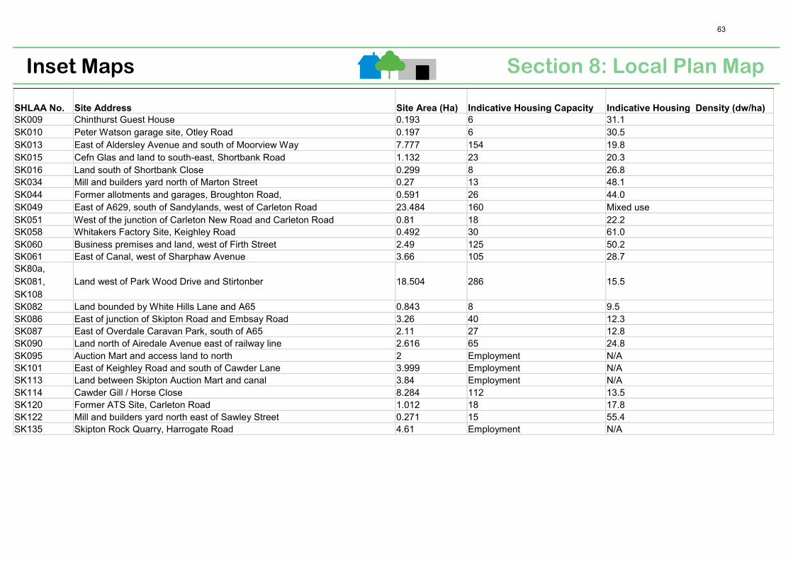
SHLAA No. Site Address Site Area (Ha) Indicative Housing Capacity Indicative Housing Density (dw/ha)
SK009 Chinthurst Guest House 0.193 6 31.1 SK010 Peter Watson garage site, Otley Road 0.197 6 30.5 SK013 East of Aldersley Avenue and south of Moorview Way 7.777 154 19.8 SK015 Cefn Glas and land to south-east, Shortbank Road 1.132 23 20.3 SK016 Land south of Shortbank Close 0.299 8 26.8 SK034 Mill and builders yard north of Marton Street 0.27 13 48.1 SK044 Former allotments and garages, Broughton Road, 0.591 26 44.0 SK049 East of A629, south of Sandylands, west of Carleton Road 23.484 160 Mixed use SK051 West of the junction of Carleton New Road and Carleton Road 0.81 18 22.2 SK058 Whitakers Factory Site, Keighley Road 0.492 30 61.0 SK060 Business premises and land, west of Firth Street 2.49 125 50.2 SK061 East of Canal, west of Sharphaw Avenue 3.66 105 28.7 SK80a, SK081, SK108
Land west of Park Wood Drive and Stirtonber 18.504 286 15.5
SK082 Land bounded by White Hills Lane and A65 0.843 8 9.5 SK086 East of junction of Skipton Road and Embsay Road 3.26 40 12.3 SK087 East of Overdale Caravan Park, south of A65 2.11 27 12.8 SK090 Land north of Airedale Avenue east of railway line 2.616 65 24.8 SK095 Auction Mart and access land to north 2 Employment N/A SK101 East of Keighley Road and south of Cawder Lane 3.999 Employment N/A SK113 Land between Skipton Auction Mart and canal 3.84 Employment N/A SK114 Cawder Gill / Horse Close 8.284 112 13.5 SK120 Former ATS Site, Carleton Road 1.012 18 17.8 SK122 Mill and builders yard north east of Sawley Street 0.271 15 55.4 SK135 Skipton Rock Quarry, Harrogate Road 4.61 Employment N/A
Section 8: Local Plan Map Inset Maps
63
September 2014 consultation
Settlement Response Summary for Skipton
Settlement: Skipton Site ID Preferred Sites in the Draft Local Plan SK009 • New build development would have a negative visual impact on the
character and setting of Chinthurst (formally Sunny Bank) and Springfield (next to the Chinthurst), which are two important Victorian suburban detached houses with group value.
• This site has dangerous access, egress and limited visibility onto Otley Road.
• This site lies within the Skipton Conservation Area and adjacent Grade II Listed Springfield. There is a requirement in the 1990 Act that “special regard” should be had to the desirability of preserving Listed Buildings or their setting or any features of special architectural or historic interest which they possess. In addition the Council has a statutory duty to pay “special attention” to “ the desirability of preserving or enhancing the character or appearance” of its Conservation Areas and the NPPF makes it clear that the loss of a building which makes a positive contribution to the significance of a Conservation Area should be regarded as resulting in substantial harm to that area. If allocated the Local Plan should firstly identify which buildings make a positive contribution to the Conservation Area and therefore should be retained, and secondly make it clear that development proposals for this area would need to ensure that any elements which contribute to the significance of the adjacent Listed Buildings or remainder of the Conservation Area are not harmed. (English Heritage Comment).
SK010 • This brownfield site should be retained for employment use and not re-designated for housing. I understand that the owner wishes to retain and expand the business.
• This site includes an early car showroom designed by Studdards & Alderson of Skipton for motoring pioneer Charles Mawson in 1921. This locally significant building, with large display windows should be recorded prior to any demolition and ideally retained.
• Site lies within Skipton Conservation Area. The Council has a statutory duty under the provisions of the Planning (Listed Building and Conservation Areas) Act 1990 to pay special attention to the desirability of preserving or enhancing the character of appearance of its Conservation Areas. The Local Plan should make it clear that any redevelopment proposals for this area will be required to safeguard those elements which contribute to the significance of this part of the Conservation Area. (English Heritage Comment).
SK013 • Site constraints include lack of water supply and an increase in vehicles using Shortbank Road & Newmarket Street. Outcome of Cumulative Highways Study may recommend changes to the roundabout junctions.
• This greenfield site appears to be supported by the landowner, but opposed by many of the nearby residents. Reasons cited opposition reiterate the earlier objections raised fir the Elsey Croft site.
• Partial development of this site is acceptable, but housing should be
64

September 2014 consultation
Settlement Response Summary for Skipton
limited to ensure retention of the existing green corridor between lower reaches of Rumbolds Moor and Shortbank Road.
• This site includes site of former open air swimming pool (currently children’s play area), which was fed by natural streams. This site is boggy, has poor drainage and floods, despite past works carried out by NYCC Highways to prevent flooding. The site still floods. Building more houses would compound this.
• Two previous planning applications refused due to insufficient water pressure and sewerage drainage. Installation of a pumping station, sewerage farm or fermentation tanks would be required.
• If Elsey Croft is added to the plan then could SK013 be spared? If this site is added to the next plan period (beyond 15 years) it will enable serious thought to be given to alternative access routes and be more bearable to residents and make more sense.
• Development of this site would open up the estate to crime. Currently the estate is not a through estate which provides a feeling of security and should not be lost.
• Some residents not aware that this site is being considered again for housing.
• Current properties enjoy a public footpath used by children and adults to all properties to access Shortbank Road playground (Gully Park) and as a means of pedestrian access to Shortbank Road and the town centre.
• This site would yield more than 154 dwellings, given its size. Please advise whether the current plan for these 154 homes will include or exclude windfall.
• This site should be withdrawn from the Local Plan. SK015 • The boundary of this site needs to be confirmed as the site specific
plan dated Dec 2011 differs from the site shown on pg 87 of the Draft Local Plan.
• This brownfield site appears to be supported by the current landowner/resident of the property but I am unsure whether the site will be deliverable within the timespan of the 2014 draft Local Plan.
• Although an existing reservoir is adjacent to the site, I am unsure whether it is available for local water supply purposes. Additional/extended new water supply and sewerage disposal infrastructure on the outskirts of the town would be expensive to commission and maintain.
• Any archaeological significance to be assessed in light of the industrial use of the site in the 19th century.
SK016 • This site should be deleted as a housing allocation as it is undeliverable being alongside existing sheltered housing, now owned and managed by Yorkshire Housing Group.
• The cul –de-sac is the only vehicular acces available to Skipton Town Council who own, manage and maintain the recreation ground.
• The grass verge and ditch have been modelled to allow runoff from the adjacent moorland (SK013) to overflow past the bungalows towards Shortbank Road.
• This site provides an important green corridor into the town, which
65

September 2014 consultation
Settlement Response Summary for Skipton
should be protected. Development would have a negative environmental impact.
SK034 • Part of this site is suitable for housing development. • Marton Mills, formally Broughton Road shed was a large weaving shed
designed by W H Atkinson of Colne for Skipton Room & Power Co in 1897 and is the last north light roof in Skipton, last remaining engine house for a horizontal steam engine and last remaining textile chimney (imcomplete), which is a landmark on the canal and in the town. These heritage features should be retained. Site has potential for residential conversion or linked to heritage and tourism aspirations with a working class emphasis. Potential for an industrial heritage trail linked to site SK060.
• This site lies within the Skipton Conservation Area. The Council has a statutory duty to pay “special attention” to “ the desirability of preserving or enhancing the character or appearance” of its Conservation Areas and the NPPF makes it clear that the loss of a building which makes a positive contribution to the significance of a Conservation Area should be regarded as resulting in substantial harm to that area. If allocated the Local Plan should firstly identify which buildings make a positive contribution to the Conservation Area and therefore should be retained, and secondly make it clear that development proposals for this area would need to ensure that any elements which contribute to the significance of the adjacent Listed Buildings or remainder of the Conservation Area are not harmed. (English Heritage Comment).
SK044 • This site is suitable for housing as it would continue the density of housing in an establish residential area, is in a sustainable location and within the District’s principle settlement. Adequate amenity space and services should be provided.
SK049 • Site is suitable partially for employment but not housing. Two fields forming the northern boundary of the site to be developed with access from Engine Shed Lane, if flooding can be avoided. Buildings should be kept low and a wide green belt/buffer created to shield the cemetery and maintain the tranquillity.
• No development in south or west of the site as this would have a negative impact on the cemetery. Land south of Waltonwrays should be removed from the Plan.
• The allocation of additional land for burials is also required to protect the future of the cemetery.
• Concern that lack of access from the by-pass will result in unacceptable intensification of traffic use in the town at Carleton Road.
• This site surrounds the cemetery which was added to the Skipton Conservation Area in its last review in 2008. The Council has a statutory duty to pay “special attention” to “ the desirability of preserving or enhancing the character or appearance” of its Conservation Areas. There needs to be an assessment of what contribution this currently undeveloped area makes to those elements which contribute to the character or appearance of the Conservation
66

September 2014 consultation
Settlement Response Summary for Skipton
Area and what effect the loss of this site and its subsequent development might have upon the designated area (English Heritage comment).
• Support allocation of SK051 together with sites SK049 & SK051, which could deliver 240 dwellings.
• This site owned by HBD (Henry Boot), who would fully support the allocation of this site & site SK051. Henry Boot seeks to promote both housing sites together with strategic employment site SK17 (unsure of location) as a comprehensive mixed use development.
• Sites SK049 & SK051 are identified as having an indicative dwelling capacity of 178 dwellings. Not all of site SK049 is considered available for housing as 9.5ha of the 16.4ha total is identified for employment uses under Policy SP17 and the inset map suggests there is potential for strategic open space (location and extent yet to be defined).
• Actual site of site SK049 is 24ha. The Council has excluded area of the site lying within flood zones 2 & 3 to calculate a developable area of 16.4ha. The entire sites can now be considered available for development in the medium term following the granting of planning permission by NYCC (2nd Sept 2014) for a range of flood alleviation/defence works within and to the north of the town. The Environment Agency expects contractors to start on site in Spring 2015.
• A concept scheme has been submitted showing the combined sites (SK049, SK051 & SP17) could potentially deliver the 9.6ha of employment land, 8.3ha of residential land and 7.1ha of roads/strategic open space/landscaping/balancing pond.
• On the basis of an average housing density of 30dph it is anticipated that sites SK049 & SK051 could collectively deliver approximately 240 dwellings, all within flood zone 1.
• Submitted concept scheme shows location of employment uses adjacent to A629 and to the north western end of the site, the open space around the site entrance and cemetery, providing an attractive gateway to the site and ensuring protection of the setting of the cemetery and Conservation Area.
• There are significant ground works and infrastructure costs associated with this site. Employment development in isolation would simply not be viable. Assuming a viable mixed use scheme can be agreed the site will be capable of meeting a large proportion of both the District’s future employment and housing land requirements and needs in a sustainable location adjacent to the built up area of Skipton and the main arterial road through the Dale. It will also provide the opportunity to address existing access problems in the town through the establishment of a new road link to Engine Shed Lane.
• Development of this site is dependent on the Skipton Flood Alleviation Scheme (FAS) being built. Only once this has been completed can the development commence. The Skipton FAS will remove the area of the site which currently lies with Eller Beck’s functional floodplain from this high risk zone.
• This site should be expected to deliver new formal playing pitch for the
67
September 2014 consultation
Settlement Response Summary for Skipton
town. It is located adjacent to Sandylands and provides an opportunity to enhance provision where it is currently most needed. There is a good opportunity to provide playing pitches in the north east corner of the site, which is low lying and subject to flooding and adjacent to existing adult pitches at Sandylands.
SK051 • This site is owned by Woolers Ltd • This site lies partially within Eller Beck’s functional floodplain, but will
be removed from this area of floodplain once the Skipton FAS has been completed. If this allocation is allowed it should be done so on the condition that the area of functional floodplain is left as green space until such a time as the Skipton FAS has been completed. (EA comment)
• Site is not suited to housing being adjacent to the river and with a constrained access. It is situated near the existing junior playing pitch provision at Sandylands and could be utilised for new junior pitch provision with some land levelling and a small pedestrian bridge. It should be reallocated for formal recreational use.
• This site should not be included in the Local Plan as the negative impact it would have on the setting of the Victorian villa and terraces on Carleton Road, which is part of the conservation area. The unique characteristic of this part of the town is its open fields on the urban fringe with open views, which should be retained.
• This site lies within the Skipton Conservation Area. The Council has a statutory duty to pay “special attention” to “ the desirability of preserving or enhancing the character or appearance” of its Conservation Areas. Before allocating Site SK051 for development an assessment needs to be undertaken of the contribution which this site makes to the elements which contribute towards the significance of the Skipton Conservation Area and what impact the loss of this undeveloped site and its subsequent development might have upon those significances. (English Heritage comment).
SK058 • Support this site as a future housing allocation. Existing Victorian houses (Prospect Villas) and gardens should be retained and integrated into any scheme as they make an important contribution to the urban landscape. Only the factory site should be built on.
• This site lies within the Skipton Conservation Area. The Council has a statutory duty to pay “special attention” to “ the desirability of preserving or enhancing the character or appearance” of its Conservation Areas. If allocated the Local Plan should firstly identify which buildings make a positive contribution to the Conservation Area and therefore should be retained and, secondly make it clear that development proposals for this area would need to ensure that any other elements which contribute to the character of the Conservation Area are not harmed. (English Heritage comment).
SK060 • Development of housing on this site would displace commercial activities from here to the edge of the town, or business(es) services might disappear from the town, which are to be avoided.
• Support this site as a future housing allocation. Site contains the last almost complete textile mill site in the town. Retain the industrial
68

September 2014 consultation
Settlement Response Summary for Skipton
buildings and incorporate high quality new build into this important canal side site.
• Mill is important for its juxtaposition with Middletown which is a quintessential textile colony. Future of the building should be linked to heritage and tourism aspirations with a working class emphasis. Potential for an industrial heritage trail linked to site SK034.
• This site lies within the Skipton Conservation Area. The Council has a statutory duty to pay “special attention” to “ the desirability of preserving or enhancing the character or appearance” of its Conservation Areas. If allocated the Local Plan should firstly identify which buildings make a positive contribution to the Conservation Area and therefore should be retained and, secondly make it clear that development proposals for this area would need to ensure that any other elements which contribute to the character of the Conservation Area are not harmed. (English Heritage comment).
• This is a potential brownfield site with potential contamination. SK061 • Support the site as a future housing allocation. It is one of the canal
gateways to the town. Any development should consider the rural vista. Housing should be set back from the canal (the length of which is included within the Conservation Area).
• This site lies opposite the Skipton Conservation Area. The Local Plan should make it clear that any redevelopment proposals for this area should safeguard those elements which contribute to the significance of this part of the Conservation Area. (English Heritage comment).
• This proposed housing development is in the wrong area given there is no adequate traffic infrastructure in place at present. Any housing built by the canal side will use the nearest exist onto Keighley Road via the single lane humped back bridge over the canal, which has no pedestrian access provides limited visibility onto Keighley Road.
• This area already has outline approval and was given the go ahead for accent to build housing.
SK080a • This site adjoins part of the boundary of the Skipton Conservation Area. The Council has a statutory duty to pay “special attention” to “ the desirability of preserving or enhancing the character or appearance” of its Conservation Areas. Before allocating this site for development an assessment needs to be undertaken of the contribution which this site makes to the elements which contribute towards the significance of the Skipton Conservation Area and what impact the loss of this undeveloped site and its subsequent development might have upon those significances. (English Heritage comment).
SK080a SK081, SK082 & SK108
• It is essential that formal playing pitch provision is incorporated into the allocation requirements, specifying a minimum level of provision. There is also an opportunity to link with the exiting recreation provision at Whitehills.
• Agricultural fields should not be used for housing. There was not favourable support for these sites from the community engagement feedback carried out in 2013. Infill housing up to the bypass should
69
September 2014 consultation
Settlement Response Summary for Skipton
not be allowed because it will turn Skipton into a town like any other in the industrial north.
• Development of sites SK080a, SK081 & SK108 would have a negative impact on existing schools, local services such as doctors and dentists, gas and electricity supplies, water and sewerage services. There would be potential safety issues due to increased vehicular activity along Gargrave Road & Rockwood Drive. There is no need for further housing in Skipton as there is already housing planned on Moorview Way together with an abundance of houses for sale in Skipton. Development in the open countryside would result in a loss of natural habitat. There will be additional costs for the local authority to maintain the prevention of flooding from surface water runoff.
• Any development along Gargrave Road would result in the loss of “one of the most attractive entrances to the town” as safeguarded under saved Local Plan policy BE2.
• The A629/A65/A59 roundabout is dreadful at rush hours, which will get worse if more housing is developed on these sites.
• The planning decision to allow the Home Loan Management buildings should not be taken as a precedent for infilling further along Gargrave Road with inappropriate linear development.
• A new vehicular access into these sites would have poor visibility onto Gargrave Road and the access itself would be a steep gradient.
• Any housing development would be contrary to saved Local Plan Policies BE2 &ENV10.
• Aireville Grange and woods should be designated as a Conservation Area.
• Housing numbers should be reduced on this site with strategic open space developed by the Council to link a pathway to Skipton Woods as agreed after Arup report on Gargrave Road.
SK081 • There is potential for development but not on entire site. Potential to form a natural extension of Aireville Park and a green route through to White Hills. Grouping of trees running from Park View to Aireville Grange in addition to copse to the north of the site. Both require safeguarding.
• Tree lined approach into the town should be retained, allowing no access from Gargrave Road. Existing pedestrian route following the beck should be retained and included in the suggested industrial heritage trail.
• Any residential development on this site would be seriously detrimental to the visual amenities of the landscape in the area.
• The southern and western boundaries of this site adjoin the edge of the 2008 extension to the Skipton Conservation Area. The Council has a statutory duty to pay “special attention” to “ the desirability of preserving or enhancing the character or appearance” of its Conservation Areas. Before allocating this site for development an assessment needs to be undertaken of the contribution which this site makes to the elements which contribute towards the significance of the Skipton Conservation Area and what impact
70

September 2014 consultation
Settlement Response Summary for Skipton
the loss of this undeveloped site and its subsequent development might have upon those significances. (English Heritage comment).
SK082 • The site continues from 108. A green corridor should be maintained to the ring road and to White Hills. Any housing should be limited to an extension of the development of SK108.
SK080 • This site is on the boundary with the SINC. Yorkshire Wildlife Trust recommends that there is a buffer around the SINC in which there is no development and that any development just outside that buffer is carefully assessed to ensure that no damage is done to the biodiversity of the site.
SK80a • This site adjoins part of the boundary of the Skipton Conservation Area. The Council has a statutory duty to pay “special attention” to “ the desirability of preserving or enhancing the character or appearance” of its Conservation Areas. Before allocating this site for development an assessment needs to be undertaken of the contribution which this site makes to the elements which contribute towards the significance of the Skipton Conservation Area and what impact the loss of this undeveloped site and its subsequent development might have upon those significances. (English Heritage comment).
SK086 • If this site was not suggested for housing with strategic open space, re-designation as an “Employment opportunity for enhancement” site would be welcomed. This could be a privately owned and managed underground decked car park, suitably screened and landscape. The lack of current visitor and commuter car parking in Skipton could be alleviated on the edge of the town centre.
• Development should not be allowed on this site as it forms part of the distinctive landscape at the approach to the town and castle. Development would impact on views into the town, the ancient woodland, the castle woods and the parkland surrounding.
• This site lies within the Skipton Conservation Area. The Council has a statutory duty to pay “special attention” to “ the desirability of preserving or enhancing the character or appearance” of its Conservation Areas. Before allocating site SK086 for development and assessment needs to be undertaken of the contribution which this site makes to the elements which contribute towards the significance f the Skipton Conservation Area and what impact the loss of this undeveloped site and its subsequent development might have upon those significances. (English Heritage comment).
SK086 & SK087 • Support for housing development on these sites as they would be infill areas with little current usage. They are close to the town centre and therefore accessible to services.
• Similar houses to those at Cross Banks and the Overdales should be built to attract middle income, wealthy professionals with disposable incomes to live in Skipton, which would be good for the local economy.
• Do we really want to see open space built up with houses and spoil the “entrance to Skipton”?
71

September 2014 consultation
Settlement Response Summary for Skipton
• The junction A6131 onto the A65 is dreadful at rush house and
additional houses will make the situation worse. • There must be more appropriate sites available.
SK087 • Part of the northern corner is now a 5 pitch touring caravan sites, which may reduce the area available for housing/open space provision.
• Development should be avoided so far out from the town centre and affecting the park homes.
• This is an archaeological site relating to early quarrying. • This site is owned by Lafarge Tarmac. • Support of this site as a housing allocation as it is vital to ensure that
the targets for housebuilding set out in the draft Local Plan are met. • This is a sensitive site in the already overdeveloped approach to the
town from the north east. Setting of the adjacent ancient woodland would be damaged by the proposed development with detrimental consequences for tourism.
• A previous planning application for housing on this site was rejected after an enquiry.
SK090 • This site should be withdrawn from the Local Plan. • This site has flooding issues. The existing sewerage network does not
have the capacity to deal with sewerage from any additional houses. The existing road network (many of which are cul de sacs) where not built to take an increase in traffic, which would occur from vehicles accessing this site.
• The layout and boundaries of the site need clarification. Recent housing development at the south east corner has provided an additional short length of new highway and 5 homes. The site does not extend to the south west corner, which I understand is in CDCs ownership, along with the rest of the site.
• This site is undeliverable. It was proposed prior to the last Local Plan but not pursued because of an existing sewer and the informal but adopted footpath between Airedale Avenue and the railway underpass. It should be deleted as a potential housing allocation.
• There are fears that Elsey Croft, which abuts the south east corner of this site will be the catalyst for a Skipton east bypass, along which the vehicles from those 107 houses would reach Otley Rd via the Quarry Line railway underpass.
• Allocation of this site for housing is supported; however access to the site needs to be clarified.
• The draft Local Plan provides little detail on the proposed sites and therefore it is difficult to state how the plan could be changed.
• Concern relating to how this site would be made accessible to Otley Road and how development would affect existing wildlife.
SK095 • Inclusion of this site in the Local Plan is supported. • This site adjoins the boundary of the Skipton Conservation Area. The
Local Plan should make it clear that any development proposals for this area would need to safeguard those elements which contribute to the significance of the adjacent Conservation Area. (English Heritage
72

September 2014 consultation
Settlement Response Summary for Skipton
comment).
SK101 • Objection to inclusion of this site in the Local Plan as it provides important open views over farmland, access would be difficult to achieve and it is an important part of the town’s settlement character.
SK108 • This site include part of the Skipton Conservation Area. The Council has a statutory duty to pay “special attention” to “ the desirability of preserving or enhancing the character or appearance” of its Conservation Areas. Before allocating this site for development an assessment needs to be undertaken of the contribution which this site makes to the elements which contribute towards the significance of the Skipton Conservation Area and what impact the loss of this undeveloped site and its subsequent development might have upon those significances. (English Heritage comment).
SK113 • Objection to inclusion of this site as it is a vital approach to the town. There is a need to retain the open character and views of this area.
• This site adjoins the boundary of the Skipton Conservation Area. The Local Plan should make it clear that any redevelopment proposals for this area would need to safeguard those elements which contribute to the significance of this part of the Conservation Area. (English Heritage comment).
SK114 • This site already has planning permission granted on part of it and work should be commencing this year.
• Support for the inclusion of this site in the Local Plan. The archaeological interest of the site should be investigated and the important existing water course should be preserved.
• To the south east of this area there is a series of Scheduled Monuments. The nearest, a cup-marked roack, lies 140 metres or so from the south eastern edge of the site. Before allocating site SK114 for development an assessment needs to be undertaken of the contribution which this site makes to the setting of the Scheduled Monuments to the southeast and what impact the loss of the open area and subsequent development might have upon their significance.
SK120 • Object to the inclusion of this site in the Local Plan. It should be returned to natural environment as it is importance to the tranquil setting of Waltonwrays.
SK122 • Support inclusion of this site in the Local Plan; however some open space should be provided as part of any development.
• This site adjoins the boundary of the Skipton Conservation Area. The Local Plan should make it clear that any redevelopment proposals for this area would need to safeguard those elements which contribute to the significance of this part of the Conservation Area. (English Heritage comment).
SK135 • This site is on the boundary with the SINC. Yorkshire Wildlife Trust recommends that there is a buffer around the SINC in which there is no development and that any development just outside that buffer is carefully assessed to ensure that no damage is done to the biodiversity of the site.
73
September 2014 consultation
Settlement Response Summary for Skipton
• Support inclusion of this site in the Local Plan for housing.
Development should not impinge on the present visual, recreational and amenity area immediately to the west. The two existing Rights of Way should be preserved and incorporated into any development.
Sites Not Preferred in the Draft Local Plan SK088 • Representation received in response to the Council’s decision not to
include the site as a Draft Preferred Site For Consultation on the emerging Craven Local Plan. (Planning statement submitted)
SK103: Land adjacent to Broughton Rd
• This land was not considered under the SHLAA as the site already has planning permission for an access road to the site and two dwellings.
• A location plan, Land Availability Questionnaire and information relating to the Part Two Check of sites has been submitted to the Council to provide basic background information.
General comments • Water supply – The infrastructure feeding Skipton would support these properties however the location of these developments may require off – site reinforcement of the mains network to support this growth.
• Waste water – The various developments should be phased over the Plan period to ensure that adequate capacity can be provided at the receiving waste water treatment works (note there are no immediate issues).
• It is unclear how sites with consent will impact on Skipton. These sites should be included on a map to show overall land supply.
• Sites should be colour coded on the map to show how the sites will be phased.
• There is land within the main boundary of Skipton that is not identified on the map, which could be developed.
• Sites SK013, SK090, SK015 & SK016 (sites off Shortbank Road) – Skipton does not have the necessary infrastructure to support such a massive development. Development of these sites would cause additional problems with flooding and would result in additional congestion on the road network. The proposal to create access from Otley Road onto Moorview Way would result in Moorview Way and Hurrs Road becoming a short cut for drivers wishing to avoid Otley Road roundabout congestions. Traffic congestion would become much worse due to the fact that secondary schools, supermarkets, recreational facilities are all located on the other side of Skipton.
• Concern that there is a need for such a large number of houses around the Shortbank Road area when other recent development (Belle Vue Mills) are standing empty, proving there is no great demand for extra residential properties locally.
• A specific chapter should be introduced into the Local Plan to deal with the need for new formal playing pitch provision in Skipton. Specific locations should be identified as part of proposed development allocations so that the delivery of new formal playing pitches is directly linked to increase demand arising from new development proposals.
• Yorkshire Wildlife Trust is pleased to see that there are a number of policies in the draft Local Plan which will protect and enhance wildlife and habitat in the area. There are also a number of preferred sites
74
September 2014 consultation
Settlement Response Summary for Skipton
which fall within Living Landscapes and must be carefully considered to ensure that the developments are not causing any damage to current ecological networks or wildlife corridors within the area that any development contribute to increasing the overall biodiversity and connectivity of the area.
• Road safety for pedestrians is an issue for the residents of Stirton and Thorlby, placing increased emphasis on the car. White Hills Lane is an important leisure and amenity link for the people of Skipton and visitors alike to access the countryside, YDNP and canal towpath network through our lanes. The villages also represent important wildlife habitats for a range of animals e.g., bats, nesting farmland birds etc. The village has an active wildlife group. If the suburban area is enlarged then access to the countryside from the centre of Skipton will be harder to achieve. If development much go ahead there should be cycling, wildlife and pedestrian corridors and large areas of green space within the site.
• Sites SK114, SK013 & SK015 directly conflict with SP6 (Good Design). • Whilst it is clear that Craven DC is under pressure to meet central
targets on housing growth, and that there is a demand for housing, particularly affordable housing in the town, trying to fulfil this with high density developments on elevated sites will be damaging. Lower density developments on smaller sites would be more acceptable.
• The location of Aireville Park, and other key Green Infrastructure corridors and hubs such as the Leeds-Liverpool Canal (including the Springs Branch), Gawflat Meadow, The Wilderness and Skipton Woods should be identified on the Skipton Insert Map.
75

Section 8: Local Plan Map Inset Maps
Sutton in Craven Inset Map: Draft Local Plan Sites
Housing
Housing – only part of site required
Housing – other options
Employment
Mixed – housing and employment
Potential for strategic open space
50 Number of dwellings (figures in redare a preliminary estimate for each site)
Scale 1:5,000 at A4 (approx)
SHLAA No. Site Address Site Area (Ha) Indicative Housing Capacity Indicative Housing Density (dw/ha)
SC030 Works and land at Low Fold, Manor Way 0.348 10 28.7 SC040 Land south of Sutton Lane 3.486 65 18.6
76

September 2014 consultation
Settlement Response Summary for Sutton in Craven
Settlement: Sutton in Craven Site ID Preferred Sites in the Draft Local Plan SC030 • Site should accommodate no more than 10 properties due to
impact of traffic on narrow restricted road (issues for emergencyvehicles and local transport). Parking issues already exist in area.
• Proposed properties should be 2 stories maximum due to impacton residents.
• Flood issues in the area (i.e. North Road). Development wouldresult in more destruction of natural drainage in area.
• Concern over loss of green space. Should not infill every space.• This site adjoins the boundary of the Sutton-in-Craven
Conservation Area. The Local Plan should make it clear that anyredevelopment proposals for this area would need to safeguardthose elements which contribute to the significance of theadjacent part of the Conservation Area. Amendaccordingly. (English Heritage comment)
• Proposed development would be detrimental to the character ofthe village.
• Infrastructure concerns, i.e. local schools and health care providersare already over-subscribed.
• Support expressed for development on this site as within existingdevelopment limits, mostly previously developed land, currentlyemployment use, and within built up area
• Traffic problems in this area would be exacerbated bydevelopment of this site.
SC040 • Site should not have been selected based on response on thesummer 2013 engagement event as the support expressed for thesite was not representative of the wider community. Objections(224) to recent planning application on site were much more wide-spread and should carry more weight when deciding whether ornot the site should be preferred than the 4 post-it notes thatsupported the site at the summer 2013 engagement. Summer2013 engagement event was misleading as it was not made clearat the time that the community should be expressing support orobjection to sites and that these views would hold weight whenplanners came to decide on preferred sites. We would haveobjected strongly to this site (as would have many others) at thatpoint if we had known.
• Parish Profiles should be used as part of the consultation to helpensure that “Sutton maintains its distinct rural identity withGreenfields both in and around the village. SC040 Residentialdevelopment would be especially prominent and the attractivenature of the countryside here would render that prominenceespecially damaging. The identity and character of the villagewould be destroyed, including the visual landscape of mill houses,stone walls, hedgerows and traditional cottages. New residentswould be a separate enclave and may not use the services andbusinesses in the village.
77
September 2014 consultation
Settlement Response Summary for Sutton in Craven
• Need to maintain the gap between the villages of Sutton and
Eastburn. This is a crucial point in protecting village identity. SC040 is the most important gap as not only does it separate Sutton’s identity from Eastburn but it separates Bradford Met from Craven.
• This is a large site at the edge of the settlement and should not be developed prior to brownfield sites suggested by Parish Council, i.e. Yeadon House. Sites that have just received planning permission, i.e. at West Lane, plus Yeadon House and other sites put forward by the Parish Council should all be shown on local plan maps and contribute to target for Sutton.
• Development should not be permitted on a greenfield site save in exceptional circumstances. This site has real visual and agricultural value and is in current agricultural use.
• The site falls outside the existing development limit for Sutton and development of it would expand the village towards Eastburn.
• Road issues: Sutton Lane is a narrow and winding road and is not equipped to deal with all the extra traffic generated by development of this site. Nor is Main St, which is already regularly clogged up (Sutton acts as a rat run to avoid congestion in Cross Hills). Visibility along Sutton Lane from a point to the west of the development is poor. Addressing this by road widening and straightening would destroy the character of this end of Sutton even further as it would have the look of a suburban estate. The stone wall along the edge of the fields would disappear, together with an ancient well. Further, the process of road widening and straightening would create unacceptable difficulties for local residents. Clearly, this would necessitate closure of half of the width of the road, with traffic lights and contraflow for a lengthy period of time, making it extremely difficult for the residents of Garden Place and Crofter’s Mill to access the roads beyond. Pedestrian safety is also a clear issue. Poor lighting is an issue along this road.
• Drainage and flooding issues: if the fields are concreted over then water draining off the site could pour down the hillside and across the road and into Garden Place, onto Ravestone Gardens and into Wilson Street. Surface water run off would damage road surfaces and create icy conditions in the winter. Natural drainage would be damaged (i.e. underground springs) – this big site is needed for absorption of water from surrounding hillsides. Flooding would create problems on cricket field. Flooding would also create additional pressures on Aire Valley Trunk Sewer.
• Infrastructure issues: area already struggling to cope with health care provision; existing narrow roads in village could not cope with extra cars (approx. 150) – they are already at capacity esp at rush hour and increase in cars in area is not conducive to need to reduce travel by private car; pressure on existing water supply; sewer already at capacity for both surface water and sewage; need for footpath near site; additional school places will be needed at
78

September 2014 consultation
Settlement Response Summary for Sutton in Craven
primary schools and secondary school in the area; trains are already too busy at rush hour.
• Environmental impact of on local wildlife and habitats is unacceptable. Noise and disturbance to badgers, hedgehogs, bats, curlews, pheasants, rabbits, herons, kestrals and owls.
• No need for this level of new housing as new housing built recently in village are up for sale and not selling.
• Village has already provided fair share of affordable housing over the past few years, with the 3 mill developments (approx. 320 houses)
• Use Alvic field instead – houses would tidy up this field which is currently only used by dog walkers. Development here could incorporate a more usable footpath.
• Concern expressed that planned footpath between Sutton and Eastburn would not go ahead should SC040 be developed.
• Objection due to loss of prime agricultural land for grazing and growing fodder.
• Need to bring back empty home into use across the district before destroying green fields for housing.
• Parish profile, produced jointly between District and Parish Council and residents of Sutton identified village development limits, and this site is beyond those limits. The profile highlighted need to protect land beyond the development limits.
• Saved local plan policy ENV1 applies to SC040 as it seeks to protect the character of the open countryside from being spoilt by sporadic development and restricts development to small scale proposals appropriate for the enjoyment of the scenic qualities of the countryside and other appropriate small-scale development having a rural character and where the proposal clearly benefits the rural economy, helps to maintain or enhance landscape character; is essential for efficient operation of agriculture or forestry; or is essential to the needs of the community. SC040 does none of the above.
• SC040 defined in Landscape Character Assessment 2002 as ‘Pasture with Wooded Gills and Woodland’ and should be preserved as such. Woodlands as especially considered to be under threat and should be preserved.
• NPPF emphasises need for good design which goes beyond aesthetic considerations and the visual appearance and architecture of individual buildings. Decisions should also address the connections between people and place and the integration of the new development in to the natural and built environment. SC040, which is on a rising slope does not integrate development with natural environment. It would be too prominent.
• Concern over loss of opposing gable ends of the stone terraced cottages of Wilson Street and Harker street, which currently serve as a gateway to the village.
• Concern over loss of privacy and overlooking onto Wilson Street, Garden Place and Ravenstone Gardens.
79

September 2014 consultation
Settlement Response Summary for Sutton in Craven
• Should be protected as a green wedge, rather than being
developed. • Glusburn allotment site would be a better alternative to
development on SC040. Sites Not Preferred in the Draft Local Plan SC025 • This site received support at the summer 2013 engagement event. It
also had support from the Parish Council. Why was it omitted from preferred sites?
SC037 • Support expressed at the summer 2013 engagement event for site SC037 on the grounds that it could provide housing over a long period for both Sutton and Glusburn & Cross Hills; it may be of a sufficient scale to enable improvement of the railway crossing; it would benefit from easier access to the trunk road; and it would avoid already congested parts of each village. Site should be included as a preferred site.
SC042 • Support expressed for omission of this site as a preferred sites. Although the site received some support from the 2013 summer engagement event, the Parish Council did not support it.
SC046 • Support expressed for site to be included in the local plan. Site received a significant positive outcome on the sustainability check and other Council checks. Sutton is in a sustainable location and there is a need for growth in the south sub area (with Sutton identified as a focus for secondary growth), which has services and facilities available to match demand (i.e. shops, schools, doctors, good transport links to Leeds, Bradford, Manchester etc). Not enough brownfield land in the area to meet demand, therefore need to build on greenfield land over the plan period. These sites have a greater ability to attract funding for affordable housing and supportive infrastructure, and flood risk areas can be avoided during the build.
• This site would help boost housing supply in Sutton. The housing figure for Sutton is considered too low for the following reasons: a) The overall requirement figure represents a minimum and there should be increased flexibility built into this calculation to enable the best sites with development potential to be identified within the Local Plan. b) Policy SP12 (New Homes) acknowledges that additional housing over and above the requirement figure will be achieved on windfall sites. Whilst it is not disputed that windfall sites can make a useful contribution to housing supply, it would be more appropriate to include an element of flexibility within the overall housing land figure identified by including further housing allocations such as this site within the plan at this stage, so that a 5 year supply of housing land is readily available at all times. It is understood at the current time that the Council does not have an available 5 year housing land supply.
• Allocation of the site for housing development would meet the Local Plan Strategic Policy Objectives and would be consistent with all policy considerations as set out within the Local Plan.
• Since the submission of the earlier representations the following additional work has been carried out in relation to the site:
80
September 2014 consultation
Settlement Response Summary for Sutton in Craven
a) Initial site access appraisal – the conclusions of this exercise are that access to the site could be provided in several locations with the two preferred access locations from Crag Lane (1) or Crag Close (2) as shown on the adopted highway plan attached. There also exists a further access option via Willow Way (3). The availability of a single point of access would be acceptable to accommodate up to 50 dwellings. Any increase over this number would more than likely require an emergency / secondary access which could be provided given the various access alternatives that exist. b) Initial site layout – based upon the initial site access appraisal together with market detail received from local residential agents an initial indicative layout has been prepared which demonstrates that the site could accommodate circa 53 dwellings with a mix of dwelling types. Clearly this is essentially a capacity exercise at this stage and it would be subject to detailed discussion with Council and consultees at the time of any planning application submission to establish the appropriate number of dwellings and a corresponding supportive layout. c) Land ownership – adjacent to the site land and existing dwellings are vested within the ownership of two housing associations; Yorkshire Housing Association and Muir Housing Association. The site is also adjoined by general market properties. As such the site has the opportunity to genuinely provide a mix of housing provision including both general market and affordable housing properties. Discussions with both housing associations together with the District Council would take place to ensure that the site, if considered appropriate for allocation, would ensure the delivery of an appropriate mix of both general market and affordable housing provision as part of an overall scheme for the site.
SC073 • No objection to this site. SC075 • No objection to this site. SC076 • No objection to this site. General comments • 5 houses per year= 75 over 15 years Water supply- Local mains
reinforcement may be required. Waste water- The sites would drain via the Aire Valley trunk sewer. We are currently developing our Aire Valley Strategy and Drainage Area Plan (DAP) outputs will be a key part of our future scenario planning. It is intended that as local plans are finalised for Craven and Bradford Districts (the sewer serves settlements in both) new development scenarios in the DAP will be revised and further feasibility undertaken. It is proposed that we will consider short, medium and long term responses to the supply demand challenges. We would therefore seek to ensure that new development is suitably phased to allow Yorkshire Water to provide adequate capacity in the network to serve growth in both districts (Yorkshire Water comment).
• There appears to be an inconsistent approach as to how land was
81

September 2014 consultation
Settlement Response Summary for Sutton in Craven
selected to be included or not.
• Developers should consult communities before submitting certain planning applications, to further strengthen the role of local communities in planning.
• Need more awareness of local plan and consultation exercises. People need to be made more aware that this is their opportunity to comment and how significant the local plan is for Craven (article in Craven Herald not sufficient).
• Comments made by the people of Craven should be made publicly available after the consultation is finished. Comments should also be fully taken into account when developing the local plan.
• Brownfield sites should be developed instead of sites preferred. These include land and premises south of Bridge Road; Land between 11 and 13 Harper Grove; Old Yeadon House site; Low Fold; Manor Way. Also brownfield sites in larger surrounding cities such as Leeds and Bradford.
• Planning should be about protecting people and places that already reside in area.
• Even though there is no official green belt within Craven, green fields surrounding villages should be afforded the same protection in order to preserve the village’s individuality.
• Concern that decisions made in draft local plan will go through without proper consultation with the public (decisions already seem to be made). Faith and confidence in Local Plan is low.
• Need to give the community more time to comment as not everyone is on the internet. Put back deadline for comments.
• Parish Councillors should have more say in decision making. • Local Plan should have been sent to all households, rather than just
placed in library. • Traffic management plans for village need to be shared.
82