creating a virtual organization (vo) for digital earth research by dr. ming-hsiang (ming) tsou...
Post on 21-Dec-2015
216 views
TRANSCRIPT

Creating a Virtual Organization Creating a Virtual Organization (VO) (VO) for Digital Earth Researchfor Digital Earth Research
by Dr. Ming-Hsiang (Ming) TsouAssociate Professor
E-mail: [email protected]
The Department of Geography, San Diego State University
2009 AAG Annual Meeting, 2009 AAG Annual Meeting, Las VegasLas Vegas
March 25, 2009 March 25, 2009

What is a Virtual Organization?What is a Virtual Organization?
• Virtual Organization (a fundamental to modern computing): “enable disparate groups of organizations and/or individuals to share resources in a controlled fashion, so that members may collaborate to achieve a shared goal. ( Foster et al., The Anatomy of the Grid, Enabling Scalable Virtual
Organizations, Intl. J. Supercomputer Applications, 2001, p. 5.).
• Grid computing Grid computing will facilitate the establishment of VOs.
• Virtual Organization is utilizing Cyberinfrastructure Cyberinfrastructure to perform tasks.
• VOs have the potential to change dramatically the way we use computers to solve problemssolve problems. (similar to the web for exchanging information).

A GIS spatial analyst, Ming, need to create a wildfire spread model in San Diego for emergency evacuation. He needs to obtain related map information and perform a GIS model for this task.
Data conversion
Traffic Model / Evacuation plan
Overlay analysis
Ming : GIS analyst
Ron: GIS data provider
Wildfire Spread Model
Matt:GIS programmer
Scenario: Wildfire Spread ModelScenario: Wildfire Spread Model(for Emergency Evacuation)(for Emergency Evacuation)
GIS node: Matt-GIS. com
GIS node: San Diego-Planning.gov
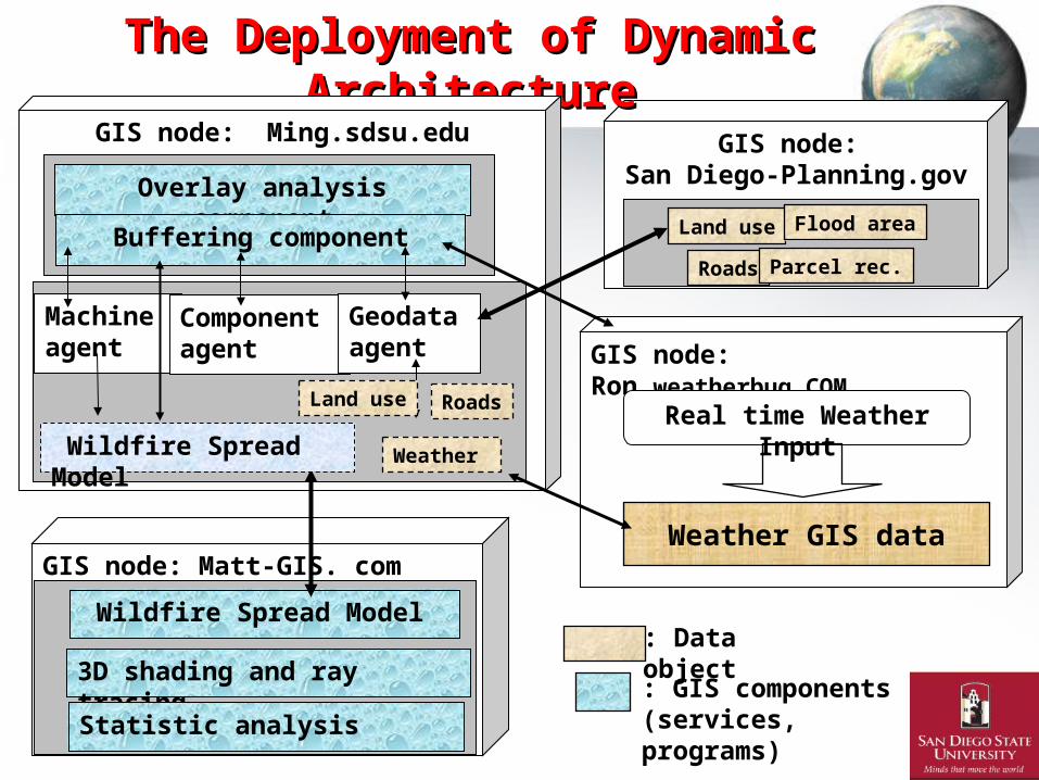
The Deployment of Dynamic ArchitectureThe Deployment of Dynamic Architecture
Wildfire Spread Model
: GIS components(services, programs)
GIS node: Ming.sdsu.edu
GIS node: Ron.weatherbug.COM
Real time Weather Input
Overlay analysis component
Buffering component
Machine agent
Component agent
Geodataagent
: Data object3D shading and ray tracing
Statistic analysis
Wildfire Spread Model
Land use
Roads
Flood area
Parcel rec.
Land use Roads
Weather GIS data
Weather

““Scalable Virtual Organization” Scalable Virtual Organization” for Digital Earth Research for Digital Earth Research (sharing data and services)(sharing data and services)
Local Network
Geography Dept. Intranet
GIS NodeGIS Node: Doug
GIS Node GIS NodeGIS Node: Ming
GIS Node:Mike
GIS Node:Eva
GIS Node:Tina
GIS Node
Digital Earth Research
GIS Node:SDSU
GIS Node:UCSB
GIS Node:SUNY
GIS Node:FGDC

Why Digital Earth (DE) Research Why Digital Earth (DE) Research need Virtual Organizations ?need Virtual Organizations ?
• The Grand Challenge of GIScience (Goodchild. 2008).
• Many DE research problems can not be solved by can not be solved by a single person or a single organizationa single person or a single organization.– Dynamic Visualization of Climate Changes.– GIS Simulation for population changes.– Disaster responses and recovery.

Virtual Organization Virtual Organization from a from a computer science perspectivecomputer science perspective
• Flexible networks of independent, globally distributed entities (individuals or institutions) that share knowledge and resources and work toward a common goal. (Ripeanu, et al., 2008, IEEE Internet Computing March/April).
• A VO aggregates services and computing resources computing resources to meet the needs of a distributed user community. (shared goal) (Qi et al., 2008 IEEE Internet Computing).
• Dynamic InstantiationInstantiation of Community Services (Qi et al. 2008)• A containercontainer in a Web service-based system must support on-demand
provisioning. (Qi et al. 2008)

VO Example: NSF TeraGridNSF TeraGrid

Virtual Organization Virtual Organization from a from a business perspective business perspective (contract)(contract)
• VOs as coordinated collaborations among business entities that share common goals. Upon join the “enterprise network”, organizations must agree to a series of terms and conditions. (Aernas, et al., 2008, IEEE Internet Computing March/April)
• VO can pull together sufficient resources to exploit opportunities that no organization could tackle alone.
• Trust among VO members can be supported if each is transparently aware of the others’ obligations and performance.
• Legal contracts. - reduce the risks of collaboration.Legal contracts. - reduce the risks of collaboration.

Example of VO: NSF Project –National Geospatial Technology Center National Geospatial Technology Center (GeoTech Center) (semi-VO?)
Adobe® Acrobat® Connect™ Pro Meeting
GeoTech Center 13 Partners

Virtual Organization Criteria:Virtual Organization Criteria:
• Dynamic formalizeformalize the relationships among partners (contracts).
• Resource aggregation (computing resources)• Tool integration (models, functions, services)• Dynamic creation and termination of VO• Reliable performance (Quality of Services)• Dynamic sharing relationship (a client can
become a server, a server can become a client).• Discovering the relationships that exist at a
particular point in time.
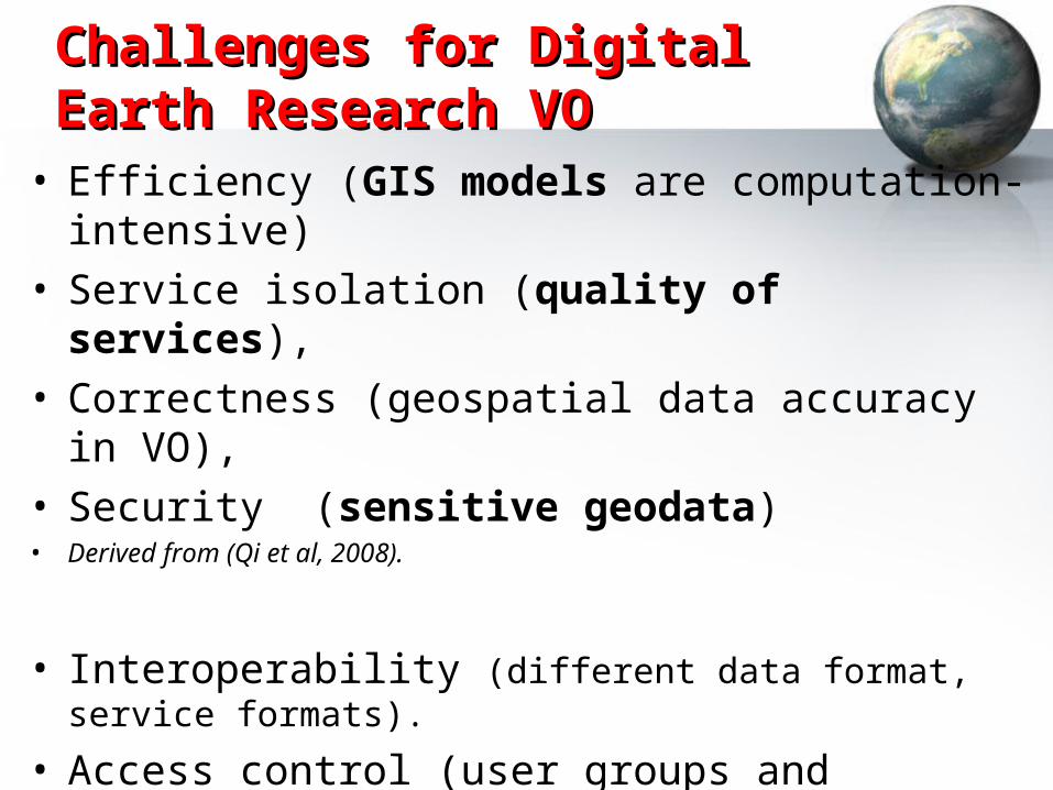
Challenges for Digital Earth Challenges for Digital Earth Research VOResearch VO
• Efficiency (GIS models are computation-intensive)• Service isolation (quality of services),• Correctness (geospatial data accuracy in VO), • Security (sensitive geodata)• Derived from (Qi et al, 2008).
• Interoperability (different data format, service formats).
• Access control (user groups and privileges)• Scalability (How many participants for each VO?)• Ease of use and management (interface design)• (Coppola et al, 2008).

The uniqueness of a geospatial The uniqueness of a geospatial Virtual OrganizationVirtual Organization
• From the perspective of a geospatial Virtual Organization, the grid-enabled GIServices will support highly scalable operations like efficient query of geospatial resources, fast and interoperable geospatial data transfer, geospatially oriented parallel processing and powerful fault-tolerance capabilities. (Armstrong et al. 2008).

Creating VO based on today’s Creating VO based on today’s papers.papers.
• Virtual Geographic Environment for Pearl River Delta Air pollution Simulation (Hui Lin)
• Map Impervious Surface Globally (Benjamin Tuttle)
• Three Dimensional Mapping Tools (Joshua)
• Water and Energy Cycle EOS House (Zhenlong Li)
VOs have the potential to change dramatically VOs have the potential to change dramatically the way we use computers to solve problems. the way we use computers to solve problems.

The Future of Geospatial CyberinfrastructureThe Future of Geospatial Cyberinfrastructure
(creating multiple virtual organizations)(creating multiple virtual organizations)
Virtual Virtual OrganizationsOrganizations
High speed InternetHigh speed Internet
Data ServicesData ServicesData ServicesData Services
Collaboration Collaboration
Map ServicesMap ServicesMap ServicesMap Services
Analysis ServicesAnalysis ServicesAnalysis ServicesAnalysis Services
High performance grid computing: visualization, and storage resources

Some Suggestions for Digital Earth Some Suggestions for Digital Earth Research:Research:
• Business community and computer science community provide a good guidance for developing VO for Digital Earth and GIScience.
• Many detail implementation issues need to be solved (GIS containers, operational metadata, interoperability, etc). Some problems are “unique” for GIS and geodata.
• Volunteer Geographic Information (VGI) might need to form VO with more concrete “contracts” and legal bindings for the “volunteers” to control the quality of information in VGI.
• Digital Earth Research needs two types of VO Digital Earth Research needs two types of VO –• Task-oriented VO (actual collaboration on tasks and projects)• Social networking (just sharing information)

Facebook – Facebook – (from a (from a socialsocial networknetwork to a to a scientific communication scientific communication network) network)
?(or The Second Life ? Playstation-3 HOME ?)
