creating contours using global mapper · pdf filethis tutorial explains how to derive contours...
TRANSCRIPT

Digital elevation models (DEMs) are geospatial datasets that contain elevation values sampled according to a regularly spaced rectangular grid. They can be used in terrain analysis, 3D visualizations, and hydrological modelling, among other applications. DEMs can be stored in several different formats; however, conversion into a raster dataset is often required for many processes. This tutorial explains how to derive contours from DEMs using Global Mapper 16. To download a DEM file from www.geogratis.ca, as was done in this tutorial, follow this guide: http://mdl.library.utoronto.ca/guides-help/how-to-search-geogratis
Creating contours using Global Mapper Step 1 Open your DEM file. This example uses a representation of elevation in the Calgary area.
Step 2 Raster files, such as DEMs, are not projected when added to Global Mapper, so you can change the coordinate system by going to: Tools -> Configure -> Projection -> then choose your projection, zone, datum, and planar units (if relevant). Most DEMs will have metadata that tells you which coordinate system to use (go to Step 6, for a tip on finding metadata using Global Mapper). The GeoGratis website outputs in NAD 1983 CSRS. Under the Vertical Options tab in Configuration, you can also change how the DEM is displayed. This example is “Atlas Shader” with “Hill Shading” enabled.

Step 3 To create contours in Global Mapper, look under Analysis on the menu bar. You must select Generate Contours (from Terrain Grid) because the TIN Areas option will not work when using a DEM.
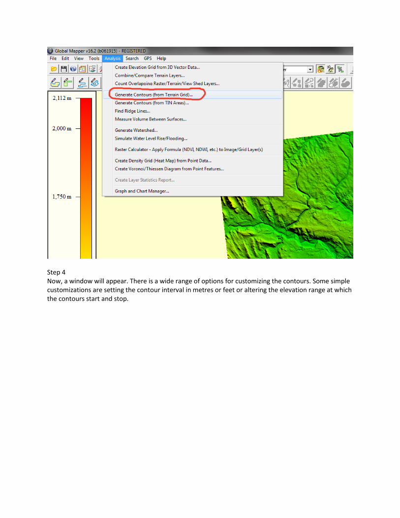
Step 4 Now, a window will appear. There is a wide range of options for customizing the contours. Some simple customizations are setting the contour interval in metres or feet or altering the elevation range at which the contours start and stop.

Step 5 The contours are automatically overlaid on the DEM and labelled at the chosen contour interval so, in this case, every 50m.

Step 6 (Optional) If you wish to turn off the DEM and display only the contour lines, go to Tools -> Control Center -> and select or deselect any overlay you want to show or hide. Also, the Metadata button at the bottom of the Control Center will display information about the selected overlay, as long as information is available. This metadata may prove useful when choosing a projection for your DEM.

Step 7 (Optional) If you want a 3D view of the DEM and the contours, click the Show 3D View button between the two drop down menus.

Step 8 Depending on the purpose for the contours, you may wish to open the file in another program or convert it into a publishable format. To do this, navigate to File -> Export -> Export Vector/Lidar Format. Then a window will pop up with a drop down menu that lists all of the formats that the DEM and contours can exported as, including Shapefile for ArcMap and DWG for AutoCAD.
