crossroads connections - cppm.uic.edu · crossroads connections & ... sustainable chicago 2015...
TRANSCRIPT
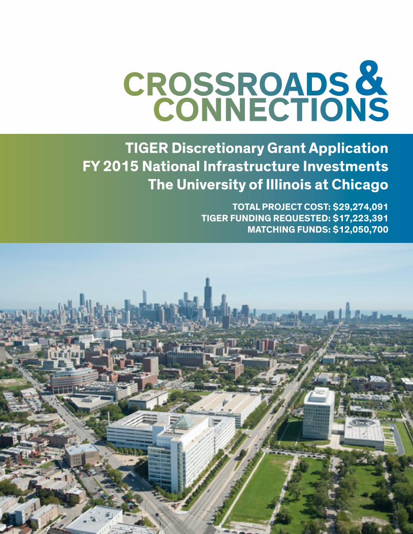
CROSSROADSCONNECTIONS
&TIGER Discretionary Grant Application
FY 2015 National Infrastructure InvestmentsThe University of Illinois at Chicago
TOTAL PROJECT COST: $29,274,091TIGER FUNDING REQUESTED: $17,223,391
MATCHING FUNDS: $12,050,700

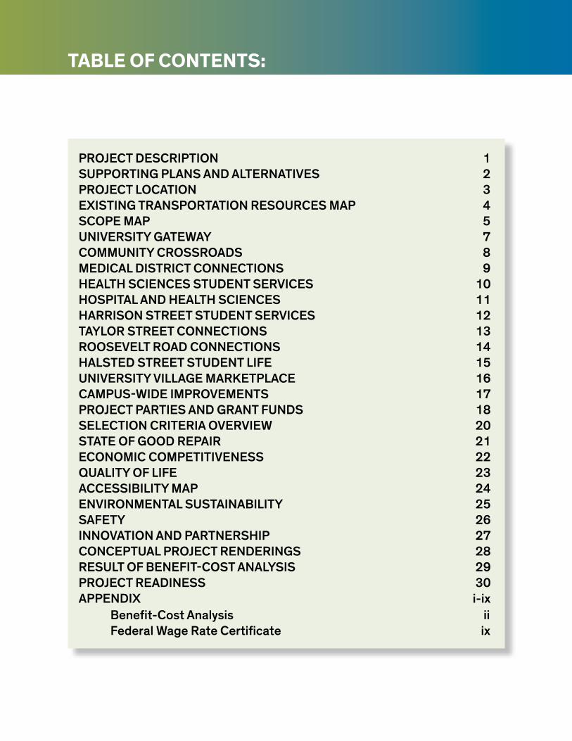
TABLE OF CONTENTS:
PROJECT DESCRIPTION 1SUPPORTING PLANS AND ALTERNATIVES 2PROJECT LOCATION 3EXISTING TRANSPORTATION RESOURCES MAP 4SCOPE MAP 5UNIVERSITY GATEWAY 7COMMUNITY CROSSROADS 8MEDICAL DISTRICT CONNECTIONS 9HEALTH SCIENCES STUDENT SERVICES 10HOSPITAL AND HEALTH SCIENCES 11HARRISON STREET STUDENT SERVICES 12TAYLOR STREET CONNECTIONS 13ROOSEVELT ROAD CONNECTIONS 14HALSTED STREET STUDENT LIFE 15UNIVERSITY VILLAGE MARKETPLACE 16CAMPUS-WIDE IMPROVEMENTS 17PROJECT PARTIES AND GRANT FUNDS 18SELECTION CRITERIA OVERVIEW 20STATE OF GOOD REPAIR 21ECONOMIC COMPETITIVENESS 22QUALITY OF LIFE 23ACCESSIBILITY MAP 24ENVIRONMENTAL SUSTAINABILITY 25SAFETY 26INNOVATION AND PARTNERSHIP 27CONCEPTUAL PROJECT RENDERINGS 28RESULT OF BENEFIT-COST ANALYSIS 29PROJECT READINESS 30APPENDIX i-ix
Benefit-Cost Analysis iiFederal Wage Rate Certificate ix
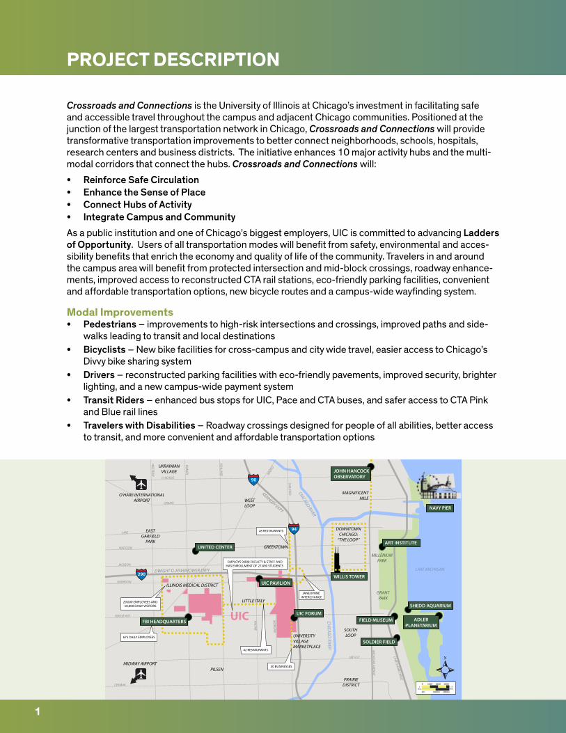
PROJECT DESCRIPTION
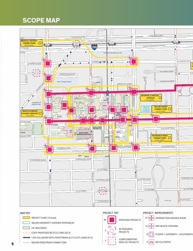
Crossroads and Connections is the University of Illinois at Chicago’s investment in facilitating safe and accessible travel throughout the campus and adjacent Chicago communities. Positioned at the junction of the largest transportation network in Chicago, Crossroads and Connections will provide transformative transportation improvements to better connect neighborhoods, schools, hospitals, research centers and business districts. The initiative enhances 10 major activity hubs and the multi-modal corridors that connect the hubs. Crossroads and Connections will:
• Reinforce Safe Circulation• Enhance the Sense of Place• Connect Hubs of Activity• Integrate Campus and Community
As a public institution and one of Chicago’s biggest employers, UIC is committed to advancing Ladders of Opportunity. Users of all transportation modes will benefit from safety, environmental and acces-sibility benefits that enrich the economy and quality of life of the community. Travelers in and around the campus area will benefit from protected intersection and mid-block crossings, roadway enhance-ments, improved access to reconstructed CTA rail stations, eco-friendly parking facilities, convenient and affordable transportation options, new bicycle routes and a campus-wide wayfinding system.
Modal Improvements• Pedestrians – improvements to high-risk intersections and crossings, improved paths and side-
walks leading to transit and local destinations• Bicyclists – New bike facilities for cross-campus and city wide travel, easier access to Chicago’s
Divvy bike sharing system• Drivers – reconstructed parking facilities with eco-friendly pavements, improved security, brighter
lighting, and a new campus-wide payment system• Transit Riders – enhanced bus stops for UIC, Pace and CTA buses, and safer access to CTA Pink
and Blue rail lines• Travelers with Disabilities – Roadway crossings designed for people of all abilities, better access
to transit, and more convenient and affordable transportation options
MILLENIUMPARK
GRANTPARK
CHICAG
O RIVER
CHICAGO RIVER
LAKE MICHIGAN
HARRISON
HALSTED
ROOSEVELT
CERMAK
JACKSON
MADISON
LAKE
GRAND
CHICAGO
WESTERN
DAM
EN
ASHLAN
D
18TH ST
MICH
IGAN
AVENU
E
RACINE
MO
RGAN
LAKE SHORE D
RIVE
OGDEN
UIC
O’HARE INTERNATIONALAIRPORT
MIDWAY AIRPORT
290
94
90
DWIGHT D. EISENHOWER EXPY
KENNEDY EXPY
DOWNTOWNCHICAGO:
“THE LOOP”
MAGNIFICENTMILE
ILLINOIS MEDICAL DISTRICT
LITTLE ITALY
UNIVERSITYVILLAGEMARKETPLACE
GREEKTOWN
PILSEN
SOUTHLOOP
WESTLOOP
UKRAINIANVILLAGE
EASTGARFIELD
PARK
PRAIRIEDISTRICT
42 RESTAURANTS
30 BUSINESSES
675 DAILY EMPLOYEES
29,000 EMPLOYEES AND50,000 DAILY VISITORS
EMPLOYS 9,898 FACULTY & STAFF ANDHAS ENROLLMENT OF 27,890 STUDENTS
28 RESTAURANTS
JANE BYRNE INTERCHANGE
NAVY PIER
WILLIS TOWER
ART INSTITUTEUNITED CENTER
FBI HEADQUARTERS
UIC PAVILION
UIC FORUM
JOHN HANCOCKOBSERVATORY
FIELD MUSEUM ADLERPLANETARIUM
SOLDIER FIELD
SHEDD AQUARIUM
0m 1000m 2000m
0MILE
1.25MILE
0’ 2000’ 4000’ 6000’
1
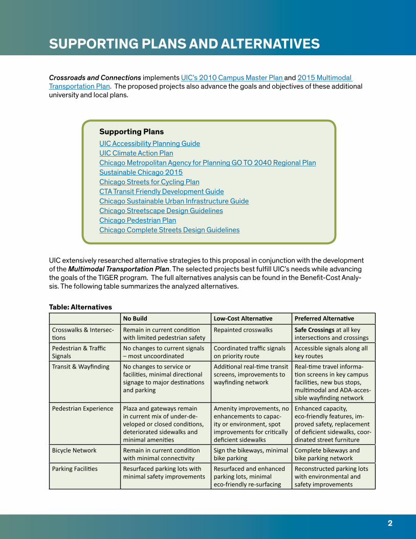
SUPPORTING PLANS AND ALTERNATIVES
Crossroads and Connections implements UIC’s 2010 Campus Master Plan and 2015 Multimodal Transportation Plan. The proposed projects also advance the goals and objectives of these additional university and local plans.
Supporting PlansUIC Accessibility Planning GuideUIC Climate Action PlanChicago Metropolitan Agency for Planning GO TO 2040 Regional PlanSustainable Chicago 2015Chicago Streets for Cycling PlanCTA Transit Friendly Development GuideChicago Sustainable Urban Infrastructure GuideChicago Streetscape Design GuidelinesChicago Pedestrian PlanChicago Complete Streets Design Guidelines
UIC extensively researched alternative strategies to this proposal in conjunction with the development of the Multimodal Transportation Plan. The selected projects best fulfill UIC’s needs while advancing the goals of the TIGER program. The full alternatives analysis can be found in the Benefit-Cost Analy-sis. The following table summarizes the analyzed alternatives.
Table: AlternativesNo Build Low-Cost Alternative Preferred Alternative
Crosswalks & Intersec-tions
Remain in current condition with limited pedestrian safety
Repainted crosswalks Safe Crossings at all key intersections and crossings
Pedestrian & Traffic Signals
No changes to current signals – most uncoordinated
Coordinated traffic signals on priority route
Accessible signals along all key routes
Transit & Wayfinding No changes to service or facilities, minimal directional signage to major destinations and parking
Additional real-time transit screens, improvements to wayfinding network
Real-time travel informa-tion screens in key campus facilities, new bus stops, multimodal and ADA-acces-sible wayfinding network
Pedestrian Experience Plaza and gateways remain in current mix of under-de-veloped or closed conditions, deteriorated sidewalks and minimal amenities
Amenity improvements, no enhancements to capac-ity or environment, spot improvements for critically deficient sidewalks
Enhanced capacity, eco-friendly features, im-proved safety, replacement of deficient sidewalks, coor-dinated street furniture
Bicycle Network Remain in current condition with minimal connectivity
Sign the bikeways, minimal bike parking
Complete bikeways and bike parking network
Parking Facilities Resurfaced parking lots with minimal safety improvements
Resurfaced and enhanced parking lots, minimal eco-friendly re-surfacing
Reconstructed parking lots with environmental and safety improvements
2
PROJECT LOCATION
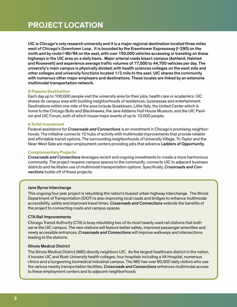
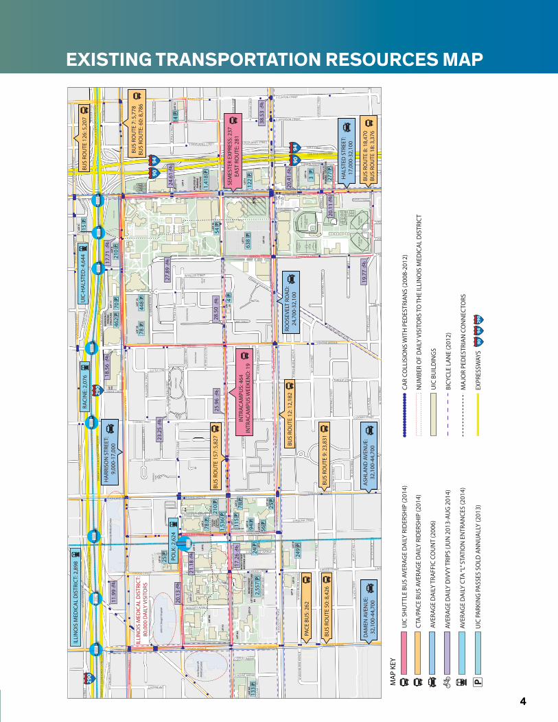
UIC is Chicago’s only research university and it is a major regional destination located three miles west of Chicago’s Downtown Loop. It is bounded by the Eisenhower Expressway (I-290) on the north and by route I-90/94 on the east, with over 150,000 vehicles accessing or traveling on these highways in the UIC area on a daily basis. Major arterial roads bisect campus (Ashland, Halsted and Roosevelt) and experience average traffic volumes of 17,000 to 44,700 vehicles per day. The university’s main campus is physically divided; with health sciences colleges on the west side and other colleges and university functions located 1/2 mile to the east. UIC shares the community with numerous other major employers and destinations. These locales are linked by an extensive multimodal transportation network.
A Popular DestinationEach day up to 100,000 people visit the university area for their jobs, health care or academics. UIC shares its campus area with bustling neighborhoods of residences, businesses and entertainment. Destinations within one mile of the area include Greektown, Little Italy, the United Center which is home to the Chicago Bulls and Blackhawks, the Jane Addams Hull House Museum, and the UIC Pavil-ion and UIC Forum, both of which house major events of up to 10,000 people.
A Solid InvestmentFederal assistance for Crossroads and Connections is an investment in Chicago’s promising neighbor-hoods. The initiative connects 10 hubs of activity with multimodal improvements that provide reliable and affordable transit options. The surrounding neighborhoods of University Village, Tri-Taylor and the Near-West Side are major employment centers providing jobs that advance Ladders of Opportunity.
Complementary ProjectsCrossroads and Connections leverages recent and ongoing investments to create a more harmonious community. The project reopens campus spaces to the community, connects UIC to adjacent business districts and facilitates use of multimodal transportation options. Specifically, Crossroads and Con-nections builds off of these projects:
Jane Byrne Interchange This ongoing four year project is rebuilding the nation’s busiest urban highway interchange. The Illinois Department of Transportation (IDOT) is also improving local roads and bridges to enhance multimodal accessibility, safety and improved travel times. Crossroads and Connections extends the benefits of the project to connecting roads and campus spaces.
CTA Rail ImprovementsChicago Transit Authority (CTA) is busy rebuilding two of its most heavily used rail stations that both serve the UIC campus. The new stations will feature better safety, improved passenger amenities and newly accessible entrances. Crossroads and Connections will improve walkways and intersections leading to the stations.
Illinois Medical DistrictThe Illinois Medical District (IMD) directly neighbors UIC. As the largest healthcare district in the nation, it houses UIC and Rush University health colleges, four hospitals including a VA Hospital, numerous clinics and a burgeoning biomedical industrial campus. The IMD has over 80,000 daily visitors who use the various nearby transportation facilities. Crossroads and Connections enhances multimodal access to these employment centers and to adjacent neighborhoods
3
ADD
AMS
PARK
FOSC
O P
ARK
LIVI
NG
STO
NFI
ELD
PAR
KAR
RIG
O P
ARK
VERN
ON
PAR
K
GAR
IBAL
DI
PARK
SHER
IDAN
PAR
K
MIL
LER
PARK
WO
OD
STR
EET
PARK
ING
STR
UCT
URE
LOT
B4
WO
OD
STR
EET
MET
ERED
LO
T
LOT
E4
LOT
E
LOT
E1
LOT
N1
LOT
F
LOT
G
LOT
M
LOT
G4
LOT
K
LOT
J
UIC METER LOT LOT
H
LOT
F4
LOT
C4
LOT L
LOT
A3
LOT
B2
LOT
A4
LOT
W5
PAU
LIN
AST
REET
PARK
ING
ST
RUCT
URE
LOT
C1
C1
LOT
OLO
T O
MA
B
LOT
18A
HA
RRIS
ON
ST.
PARK
ING
STRU
CTU
RELO
T 9
LOT
8
LOT
1BLO
T 1A
LOT
10
LOT
5
LOT
5C
LOT
6
HA
LSTE
D S
TPA
RKIN
GST
RUCT
URE
LOT
4
MA
XW
ELL
ST.
PARK
ING
STR
UCT
URE
LOT
11
LOT
14
LOT
20
LOT
12
ACT
B(F
UTU
RE C
ON
STRU
CTIO
N)
RECR
EATI
ON
FIEL
DRE
CREA
TIO
NFI
ELD
SOFT
BALL
LES
MIL
LER
FIEL
D
CURT
IS G
RAN
DER
SON
STA
DIU
M
SOCC
ER
SKYS
PACE
EARL
NEA
LPL
AZA
TEN
NIS
&BA
SKET
BALL
FLA
MES
TEN
NIS
FAC
ILIT
Y
CHIC
AGO
CIR
CLE
MEM
ORI
AL
GRO
VE
THE
QU
AD
THE PARK LIVINGSTON HEALTH WALK
ATKI
NS
GA
RDEN
COLL
EGE
OF
MED
ICIN
ECO
URT
YARD
MED
ICA
L SC
IEN
CES
COU
RTYA
RD
HA
RRIS
ON
FIE
LD
W H
ARR
ISO
N S
TREE
T
W V
ERN
ON
PA
RK P
LACE
W R
OO
SEVE
LT R
OA
D
ROCH
FORD
STR
EET
W M
AXW
ELL
STRE
ET
W L
IBER
TY S
TREE
T
W 1
4TH
PLA
CE
W P
OLK
STR
EET
S PEORIA STREET
S HALSTED STREETS HALSTED STREET
S MORGAN STREET
W C
ON
GRE
SS P
ARK
WAY
S RACINE AVENUE
S CAMPUS PARKWAY
S UNION AVENUE
S NEWBERRY AVENUE
S MORGAN STREET
S GR
EEN S
TREE
T
S TI
LDEN
STR
EET
W 1
4TH
STR
EET S EMERALD AVENUE
S BLUE ISLAND AVENUE
S THROOP STREET
W C
ON
GRE
SS P
ARK
WAY
W T
ILD
EN S
TREE
T
W 1
5TH
STR
EET
W M
AXW
ELL
STRE
ET
W G
REN
SHAW
STR
EET
W D
E KO
VEN
STR
EET
W C
ABR
INI S
TREE
T
W P
OLK
STR
EET
W L
EXIN
GTO
N S
TREE
T
W V
ERN
ON
PA
RK P
LACE
W H
ARR
ISO
N S
TREE
T
W 1
4TH
STR
EET
W 1
4TH
PLA
CE
W 1
5TH
PLA
CE
S PEORIA STREET
S SANGAMON STREET
W 1
5TH
STR
EET
W 1
4TH
PLA
CE
W 1
4TH
STR
EET
S ABERDEEN STREET
S RACINE AVENUE
W M
AXW
ELL
STRE
ET
RUBLE STREET
W W
ASH
BURN
E AV
ENU
E
W 1
4TH
STR
EET
W 1
4TH
STR
EET
S THROOP STREET
S LOOMIS STREETS LOOMIS STREET
S LOOMIS STREET
S THROOP STREET
W H
AST
ING
S ST
REET
W H
AST
ING
S ST
REET
W 1
3TH
STR
EET
W C
ON
GRE
SS P
ARK
WAY
W H
ARR
ISO
N S
TREE
T
W F
LOU
RNO
Y ST
REET
W P
OLK
STR
EET
W R
OO
SEVE
LT R
OA
D
W G
REN
SHAW
STR
EET
S W
INCH
ESTE
R AV
ENU
E
S HOYNE AVE.
S DAMEN AVENUE
S HERMITAGE AVENUE
W F
LOU
RNO
Y ST
W F
ILLM
ORE
STR
EET
S WOLCOTT AVENUE
S WOOD STREET
S PAULINA STREET
S MARSHFIELD AVENUE
S ASHLAND AVENUE
S HAMILTON AVENUE
S HOYNE AVENUE
W BOWLER STREET
S SEELEY AVENUE
W F
ILLM
ORE
STR
EET
W G
REN
SHAW
STR
EET
S LYTLE STREET
W C
ABR
INI S
TREE
T
W A
RTH
ING
TON
STR
EET
S MAY STREET
W P
OLK
STR
EET
W C
ABR
INI S
TREE
T
W L
EXIN
GTO
N S
TREE
T
W F
LOU
RNO
Y ST
REET
S LYTLE STREET
W R
OO
SEVE
LT R
OA
DW MILLER STREET
W V
AN
BU
REN
STR
EET
W TA
YLO
R ST
REET
W F
LOU
RNO
Y ST
REET
S LAFLIN STREET
S LAFLIN STREET
S JEFFERSON STREET
S CLINTON STREET
S CANAL STREET
S CLINTON STREET
S DESPLAINES STREET
S ASHLAND AVENUE
S ASHLAND AVENUE
W TA
YLO
R ST
REET
S PAULINA STREET
S PAULINA STREET
W H
ARR
ISO
N S
TREE
TW
HA
RRIS
ON
STR
EET
S WOOD STREETS WOOD STREET
W 1
4TH
PLA
CE
W 1
5TH
STR
EET
W 1
5TH
STR
EET
W 1
5TH
STR
EETW
RO
OSE
VELT
RO
AD
W R
OO
SEVE
LT R
OA
DW
RO
OSE
VELT
RO
AD
W W
ASH
BURN
E AV
ENU
E
W 1
3TH
STR
EET
W 1
4TH
PLA
CE
W 1
4TH
STR
EET
W W
ASH
BURN
E AV
ENU
E
W P
OLK
STR
EET
W P
OLK
STR
EET
W P
OLK
STR
EET
W L
EXIN
GTO
N S
TREE
T
W OGDEN AVENUE
W TA
YLO
R ST
REET
W TA
YLO
R ST
REET
W TA
YLO
R ST
REET
S LEAVITT STREET
S DAMEN AVENUES DAMEN AVENUE
S DAMEN AVENUE
W R
OO
SEVE
LT R
OA
D
W 1
4TH
STR
EET
W H
AST
ING
S ST
REET
W 1
5TH
STR
EET
W 1
4TH
PLA
CE
W G
REN
SHAW
STR
EET
S HERMITAGE AVENUE
S WOOD STREETS WOOD STREET
S HALSTED STREETS HALSTED STREET
S MORGAN STREETS MORGAN STREET
S BLUE ISLAND AVENUE
S DESPLAINES STREET
W V
AN
BU
REN
STR
EET
W V
AN
BU
REN
STR
EET
W V
AN
BU
REN
STR
EET
W V
AN
BU
REN
STR
EET
W V
AN
BU
REN
STR
EET
W H
ARR
ISO
N S
TREE
T
DW
IGH
T D
. EIS
ENH
OW
ER E
XPRE
SSW
AYD
WIG
HT
D. E
ISEN
HO
WER
EXP
RESS
WAY
DW
IGH
T D
. EIS
ENH
OW
ER E
XPRE
SSW
AY
DW
IGH
T D
. EIS
ENH
OW
ER E
XPRE
SSW
AY
DW
IGH
T D
. EIS
ENH
OW
ER E
XPRE
SSW
AY
DAN RYAN EXPRESSWAYDAN RYAN EXPRESSWAY
DAN RYAN EXPRESSWAY
ILLI
NO
IS M
EDIC
AL
DIS
TRIC
T C
TA S
TATI
ON
DA
MEN
AVE
.C
TA S
TATI
ON
RACI
NE
AVE.
CTA
STA
TIO
N
UIC
/HA
LSTE
DC
TA S
TATI
ON
UIC
/HA
LSTE
DC
TA S
TATI
ON
UIC
/HA
LSTE
DC
TA S
TATI
ON
78P
448
P
78P
56P
94P
249
P
78P
25P
115
P
133
P
25P
210
P1,
536
P
2,55
7P
24P
638
P
54P
70P
462
P
122
P
1,41
8P
277
P
14P
3P
4P
210
P
15P
HA
LSTE
D S
TREE
T:17
,000
-32,
100
ROO
SEVE
LT R
OA
D:
24,7
00-3
2,10
0
DA
MEN
AVE
NU
E:32
,100
-44,
700
HA
RRIS
ON
STR
EET:
9,
000-
17,0
00
ASH
LAN
D A
VEN
UE:
32,1
00-4
4,70
0
BUS
ROU
TE 5
0: 8
,426
BUS
ROU
TE 9
: 23,
831
BUS
ROU
TE 8
: 18,
470
BUS
ROU
TE 1
8: 3
,376
BUS
ROU
TE 7
: 5,7
78BU
S RO
UTE
: 60:
8,7
86
BUS
ROU
TE 1
57: 5
,827
BUS
ROU
TE 1
2: 1
2,18
2
BUS
ROU
TE 1
26: 5
,207
INTR
ACA
MPU
S: 4
64IN
TRAC
AM
PUS
WEE
KEN
D: 1
9
SEM
ESTE
R EX
PRES
S: 2
37EA
ST R
OU
TE: 2
81
PACE
BU
S: 2
62
Jess
e Br
own
VAM
edic
al C
ente
r
John
H. S
trog
er H
ospi
tal
Rush
Uni
vers
ity M
edic
al C
ente
r
UIC
-HA
LSTE
D: 4
,644
RACI
NE:
2,0
76
POLK
STR
EET
CTA
STA
TIO
N
ILLI
NO
IS M
EDIC
AL
DIS
TRIC
T: 2
,898
POLK
: 2,6
24
19.7
7
20.1
1
17.7
1
38.5
3
28.5
0
18.5
6
17.2
6
11.9
9
20.1
3 24
.61
21.1
8
20.4
1
23.2
5
25.9
6
27.8
9
ILLI
NO
IS M
EDIC
AL
DIS
TRIC
T:
80,0
00 D
AIL
Y VI
SITO
RS
9490
9490
9429
090
290
290
P
AVER
AGE
DA
ILY
CTA
“L” S
TATI
ON
EN
TRA
NCE
S (2
014)
BICY
CLE
LAN
E (2
012)
CAR
COLL
ISIO
NS
WIT
H P
EDES
TRIA
NS
(200
8-20
12)
NU
MBE
R O
F D
AIL
Y VI
SITO
RS T
O T
HE
ILLI
NO
IS M
EDIC
AL
DIS
TRIC
T
UIC
PA
RKIN
G P
ASS
ES S
OLD
AN
NU
ALL
Y (2
013)
UIC
BU
ILD
ING
S
MA
JOR
PED
ESTR
IAN
CO
NN
ECTO
RS
EXPR
ESSW
AYS
AVER
AGE
DA
ILY
TRA
FFIC
CO
UN
T (2
006)
CTA
/PAC
E BU
S AV
ERAG
E D
AIL
Y RI
DER
SHIP
(201
4)
UIC
SH
UTT
LE B
US
AVER
AGE
DA
ILY
RID
ERSH
IP (2
014)
AVER
AGE
DA
ILY
DIV
VY T
RIPS
(JU
N 2
013-
AUG
201
4)
MA
P KE
Y
UIC
| 20
15
TIG
EREx
istin
g Tr
ansp
orta
tion
Infr
astr
uctu
re
ILLI
NO
IS M
EDIC
AL
DIS
TRIC
T C
TA S
TATI
ON
DA
MEN
AVE
.EN
TRA
NCE
RACI
NE
AVE.
CTA
STA
TIO
N
PEO
RIA
ST.
ENTR
AN
CEM
ORG
AN
ST.
ENTR
AN
CE
UIC
/HA
LSTE
DC
TA S
TATI
ON
PAU
LIN
A S
T.EN
TRA
NCE
LOO
MIS
ST.
ENTR
AN
CE
EXISTING TRANSPORTATION RESOURCES MAP
4
ADDAMS PARK
FOSCO PARK
LIVINGSTONFIELD PARK
ARRIGO PARK
VERNON PARK
GARIBALDIPARK
SHERIDAN PARK
MILLERPARK
WOOD STREETPARKING STRUCTURE
LOTB4
WOOD STREETMETERED LOT
LOT E4
LOT E
LOT E1
LOT N1
LOT F
LOT G
LOT M
LOT G4
LOT K
LOT J
UIC
MET
ER L
OT
LOT H
LOT F4
LOTC4
LOT
LLOT A3
LOT B2
LOT A4
LOT W5
PAULINASTREET
PARKING STRUCTURE
LOT C1
C1
LOT OLOT O
MAB
LOT18A
HARRISON ST.PARKING
STRUCTURELOT 9
LOT 8
LOT 1B LOT 1A
LOT 10
LOT 5
LOT 5C
LOT 6
HALSTED STPARKING
STRUCTURE
LOT 4
MAXWELL ST.PARKING
STRUCTURE
LOT 11
LOT 14
LOT20
LOT 12
ACTB(FUTURE CONSTRUCTION)
RECREATIONFIELD
RECREATIONFIELD
SOFTBALL
LES MILLER FIELD
CURTIS GRANDERSONSTADIUM
SOCCER
SKYSPACE
EARL NEALPLAZA
TENNIS &BASKETBALL
FLAMES TENNIS FACILITY
CHICAGO CIRCLEMEMORIAL GROVE
THE QUAD
THE PA
RK LIVING
STON
HEA
LTH W
ALK
ATKINSGARDEN
COLLEGE OF MEDICINECOURTYARD
MEDICAL SCIENCESCOURTYARD
HARRISON FIELD
W HARRISON STREET
W VERNON PARK PLACE
W ROOSEVELT ROAD
ROCHFORD STREET
W MAXWELL STREET
W LIBERTY STREET
W 14TH PLACE
W POLK STREET
S PEORIA
STREET
S HA
LSTED STREET
S HA
LSTED STREETS M
ORG
AN
STREET
W CONGRESS PARKWAY
S RACINE AVEN
UE
S CAM
PUS PA
RKWAY
S UN
ION
AVENU
E
S N
EWBE
RRY
AVEN
UE
S MO
RGA
N STREET
S GREEN STREET
S TILDEN STREET
W 14TH STREET
S EMERA
LD AVEN
UE
S BLU
E ISL
AND AVE
NUE
S THRO
OP STREET
W CONGRESS PARKWAY
W TILDEN STREET
W 15TH STREET
W MAXWELL STREET
W GRENSHAW STREET
W DE KOVEN STREET
W CABRINI STREET
W POLK STREET
W LEXINGTON STREET
W VERNON PARK PLACE
W HARRISON STREET
W 14TH STREET
W 14TH PLACE
W 15TH PLACE
S PEORIA
STREET
S SAN
GA
MO
N STREET
W 15TH STREET
W 14TH PLACE
W 14TH STREET
S ABERD
EEN STREET
S RACINE AVEN
UE
W MAXWELL STREET
RUBLE STREET
W WASHBURNE AVENUE
W 14TH STREETW 14TH STREET
S THRO
OP STREET
S LOO
MIS STREET
S LOO
MIS STREET
S LOO
MIS STREET
S THRO
OP STREET
W HASTINGS STREETW HASTINGS STREET
W 13TH STREET
W CONGRESS PARKWAY
W HARRISON STREET
W FLOURNOY STREET
W POLK STREET
W ROOSEVELT ROAD
W GRENSHAW STREET
S WINCHESTER AVENUE
W O
GDEN AVENUE
S LEAVITT STREET
S HO
YNE AVE.
S DA
MEN
AVENU
E
S HERM
ITAGE AVEN
UE
W FLOURNOY ST
W FILLMORE STREET
S WO
LCOTT AVEN
UE
S WO
OD
STREET
S PAULIN
A STREET
S MA
RSHFIELD
AVENU
E
S ASH
LAN
D AVEN
UE
W CAMPBELL PARK DRIVE
S HA
MILTO
N AVEN
UE
S HO
YNE AVEN
UE
W BOW
LER STREET
S SEELEY AVENU
E
S LEAVITT STREET
W WASHBURNE AVENUE
W FILLMORE STREET
W GRENSHAW STREET
S LYTLE STREET
W CABRINI STREET
W ARTHINGTON STREET
S MAY STREET
W POLK STREET
W CABRINI STREET
W LEXINGTON STREET
W FLOURNOY STREET
S LYTLE STREET
W ROOSEVELT ROAD
W M
ILLER STREET
W VAN BUREN STREET
W TAYLOR STREET
W FLOURNOY STREETS LAFLIN
STREET
S LAFLIN
STREET
S JEFFERSON
STREET
S CLINTO
N STREET
S CAN
AL STREET
S CLINTO
N STREET
S DESPLA
INES STREET
S ASH
LAN
D AVEN
UE
S ASH
LAN
D AVEN
UE
W TAYLOR STREET
S PAULIN
A STREET
S PAULIN
A STREET
W HARRISON STREETW HARRISON STREET
S WO
OD
STREETS W
OO
D STREET
W 14TH PLACE
W 15TH STREETW 15TH STREET W 15TH STREET
W ROOSEVELT ROADW ROOSEVELT ROAD
W ROOSEVELT ROAD
W ROOSEVELT ROAD
W WASHBURNE AVENUE
W 13TH STREET
W 14TH PLACE
W 14TH STREET
W WASHBURNE AVENUE
W POLK STREETW POLK STREET
W POLK STREET
W LEXINGTON STREET
W O
GDEN AVENUE
W TAYLOR STREET
W TAYLOR STREETW TAYLOR STREET
S LEAVITT STREET
S DA
MEN
AVENU
ES D
AM
EN AVEN
UE
S DA
MEN
AVENU
EW ROOSEVELT ROAD
W 14TH STREET
W HASTINGS STREET
W 15TH STREET
W 14TH PLACE
W GRENSHAW STREET
S HERM
ITAGE AVEN
UE
S WO
OD
STREETS W
OO
D STREET
S HA
LSTED STREET
S HA
LSTED STREET
S MO
RGA
N STREET
S MO
RGA
N STREET
S BLU
E ISL
AND AVE
NUE
S DESPLA
INES STREET
W VAN BUREN STREETW VAN BUREN STREET
W VAN BUREN STREETW VAN BUREN STREET
W VAN BUREN STREET
W HARRISON STREET
DWIGHT D. EISENHOWER EXPRESSWAY DWIGHT D. EISENHOWER EXPRESSWAY
DWIGHT D. EISENHOWER EXPRESSWAY
DWIGHT D. EISENHOWER EXPRESSWAY
DWIGHT D. EISENHOWER EXPRESSWAY
DA
N RYA
N EXPRESSW
AYD
AN
RYAN
EXPRESSWAY
DA
N RYA
N EXPRESSW
AY
ILLINOIS MEDICAL DISTRICT
CTA STATIONDAMEN AVE.CTA STATION
RACINE AVE.CTA STATION
UIC/HALSTEDCTA STATION
UIC/HALSTEDCTA STATION
UIC/HALSTEDCTA STATION
Jesse Brown VAMedical Center
John H. Stroger Hospital
Rush University Medical Center
TO CANAL ST.
INTERSECTION MODIFICATIONPROPOSED PROJECTS
PROJECT KEY PROJECT IMPROVEMENTS MAP KEY
4627
16
4
8
2 IN-PROGRESSPROJECTS
MID-BLOCK CROSSING
BICYCLE PATHS
PLAZAS + GATEWAYS + ACCESSWAYS
PARKING PROJECTS
5 COMPLEMENTARYNON-UIC PROJECTS
CDOT PROPOSED BICYCLE LANE (2012)
CAR COLLISIONS WITH PEDESTRIANS & CYCLISTS (2008-2012)
MAJOR PEDESTRIAN CONNECTORS
PROJECT HUBS (10 total)
MAJOR UNIVERSITY GATEWAY ENTRANCES
UIC BUILDINGSTIGER PROPOSED BIKE LANES
UIC | 2015TIGER Scope Map | Overview
ILLINOIS MEDICAL DISTRICT
CTA STATIONDAMEN AVE.ENTRANCE
RACINE AVE.CTA STATION
PEORIA ST.ENTRANCE
MORGAN ST.ENTRANCE
UIC/HALSTEDCTA STATION
PAULINA ST.ENTRANCE
LOOMIS ST.ENTRANCE
POLK STREETCTA STATION
HEALTH SCIENCESSTUDENT SERVICES
7 COLLISIONS
MEDICAL DISTRICTCONNECTIONS
49 COLLISIONS
HARRISON STREETSTUDENT SERVICES
7 COLLISIONS
HALSTED STREETSTUDENT LIFE
11 COLLISIONS
UNIVERSITY VILLAGEMARKET PLACE
10 COLLISIONS
HOSPITAL & HEALTH SCIENCES
31 COLLISIONS
TAYLOR STREETCONNECTIONS
42 COLLISIONS
COMMUNITYCROSSROADS
ROOSEVELT ROADCONNECTIONS
85 COLLISIONS
UNIVERSITYGATEWAY4 COLLISIONS
UNIVERSITY GATEWAY
COMMUNITYPLAZA
GATEWAY
CITYGATEWAY
HEALTHSCIENCESGATEWAY
290
90
90 94
94
290
SCOPE MAP
5
ADDAMS PARK
FOSCO PARK
LIVINGSTONFIELD PARK
ARRIGO PARK
VERNON PARK
GARIBALDIPARK
SHERIDAN PARK
MILLERPARK
WOOD STREETPARKING STRUCTURE
LOTB4
WOOD STREETMETERED LOT
LOT E4
LOT E
LOT E1
LOT N1
LOT F
LOT G
LOT M
LOT G4
LOT K
LOT J
UIC
MET
ER L
OT
LOT H
LOT F4
LOTC4
LOT
LLOT A3
LOT B2
LOT A4
LOT W5
PAULINASTREET
PARKING STRUCTURE
LOT C1
C1
LOT OLOT O
MAB
LOT18A
HARRISON ST.PARKING
STRUCTURELOT 9
LOT 8
LOT 1B LOT 1A
LOT 10
LOT 5
LOT 5C
LOT 6
HALSTED STPARKING
STRUCTURE
LOT 4
MAXWELL ST.PARKING
STRUCTURE
LOT 11
LOT 14
LOT20
LOT 12
ACTB(FUTURE CONSTRUCTION)
RECREATIONFIELD
RECREATIONFIELD
SOFTBALL
LES MILLER FIELD
CURTIS GRANDERSONSTADIUM
SOCCER
SKYSPACE
EARL NEALPLAZA
TENNIS &BASKETBALL
FLAMES TENNIS FACILITY
CHICAGO CIRCLEMEMORIAL GROVE
THE QUAD
THE PA
RK LIVING
STON
HEA
LTH W
ALK
ATKINSGARDEN
COLLEGE OF MEDICINECOURTYARD
MEDICAL SCIENCESCOURTYARD
HARRISON FIELD
W HARRISON STREET
W VERNON PARK PLACE
W ROOSEVELT ROAD
ROCHFORD STREET
W MAXWELL STREET
W LIBERTY STREET
W 14TH PLACE
W POLK STREET
S PEORIA
STREET
S HA
LSTED STREET
S HA
LSTED STREETS M
ORG
AN
STREET
W CONGRESS PARKWAY
S RACINE AVEN
UE
S CAM
PUS PA
RKWAY
S UN
ION
AVENU
E
S N
EWBE
RRY
AVEN
UE
S MO
RGA
N STREET
S GREEN STREET
S TILDEN STREET
W 14TH STREET
S EMERA
LD AVEN
UE
S BLU
E ISL
AND AVE
NUE
S THRO
OP STREET
W CONGRESS PARKWAY
W TILDEN STREET
W 15TH STREET
W MAXWELL STREET
W GRENSHAW STREET
W DE KOVEN STREET
W CABRINI STREET
W POLK STREET
W LEXINGTON STREET
W VERNON PARK PLACE
W HARRISON STREET
W 14TH STREET
W 14TH PLACE
W 15TH PLACE
S PEORIA
STREET
S SAN
GA
MO
N STREET
W 15TH STREET
W 14TH PLACE
W 14TH STREET
S ABERD
EEN STREET
S RACINE AVEN
UE
W MAXWELL STREET
RUBLE STREET
W WASHBURNE AVENUE
W 14TH STREETW 14TH STREET
S THRO
OP STREET
S LOO
MIS STREET
S LOO
MIS STREET
S LOO
MIS STREET
S THRO
OP STREET
W HASTINGS STREETW HASTINGS STREET
W 13TH STREET
W CONGRESS PARKWAY
W HARRISON STREET
W FLOURNOY STREET
W POLK STREET
W ROOSEVELT ROAD
W GRENSHAW STREET
S WINCHESTER AVENUE
W O
GDEN AVENUE
S LEAVITT STREET
S HO
YNE AVE.
S DA
MEN
AVENU
E
S HERM
ITAGE AVEN
UE
W FLOURNOY ST
W FILLMORE STREET
S WO
LCOTT AVEN
UE
S WO
OD
STREET
S PAULIN
A STREET
S MA
RSHFIELD
AVENU
E
S ASH
LAN
D AVEN
UE
W CAMPBELL PARK DRIVE
S HA
MILTO
N AVEN
UE
S HO
YNE AVEN
UE
W BOW
LER STREET
S SEELEY AVENU
E
S LEAVITT STREET
W WASHBURNE AVENUE
W FILLMORE STREET
W GRENSHAW STREET
S LYTLE STREET
W CABRINI STREET
W ARTHINGTON STREET
S MAY STREET
W POLK STREET
W CABRINI STREET
W LEXINGTON STREET
W FLOURNOY STREET
S LYTLE STREET
W ROOSEVELT ROAD
W M
ILLER STREET
W VAN BUREN STREET
W TAYLOR STREET
W FLOURNOY STREETS LAFLIN
STREET
S LAFLIN
STREET
S JEFFERSON
STREET
S CLINTO
N STREET
S CAN
AL STREET
S CLINTO
N STREET
S DESPLA
INES STREET
S ASH
LAN
D AVEN
UE
S ASH
LAN
D AVEN
UE
W TAYLOR STREET
S PAULIN
A STREET
S PAULIN
A STREET
W HARRISON STREETW HARRISON STREET
S WO
OD
STREETS W
OO
D STREET
W 14TH PLACE
W 15TH STREETW 15TH STREET W 15TH STREET
W ROOSEVELT ROADW ROOSEVELT ROAD
W ROOSEVELT ROAD
W ROOSEVELT ROAD
W WASHBURNE AVENUE
W 13TH STREET
W 14TH PLACE
W 14TH STREET
W WASHBURNE AVENUE
W POLK STREETW POLK STREET
W POLK STREET
W LEXINGTON STREET
W O
GDEN AVENUE
W TAYLOR STREET
W TAYLOR STREETW TAYLOR STREET
S LEAVITT STREET
S DA
MEN
AVENU
ES D
AM
EN AVEN
UE
S DA
MEN
AVENU
E
W ROOSEVELT ROAD
W 14TH STREET
W HASTINGS STREET
W 15TH STREET
W 14TH PLACE
W GRENSHAW STREET
S HERM
ITAGE AVEN
UE
S WO
OD
STREETS W
OO
D STREET
S HA
LSTED STREET
S HA
LSTED STREET
S MO
RGA
N STREET
S MO
RGA
N STREET
S BLU
E ISL
AND AVE
NUE
S DESPLA
INES STREET
W VAN BUREN STREETW VAN BUREN STREET
W VAN BUREN STREETW VAN BUREN STREET
W VAN BUREN STREET
W HARRISON STREET
DWIGHT D. EISENHOWER EXPRESSWAY DWIGHT D. EISENHOWER EXPRESSWAY
DWIGHT D. EISENHOWER EXPRESSWAY
DWIGHT D. EISENHOWER EXPRESSWAY
DWIGHT D. EISENHOWER EXPRESSWAY
DA
N RYA
N EXPRESSW
AYD
AN
RYAN
EXPRESSWAY
DA
N RYA
N EXPRESSW
AY
ILLINOIS MEDICAL DISTRICT
CTA STATIONDAMEN AVE.CTA STATION
RACINE AVE.CTA STATION
UIC/HALSTEDCTA STATION
UIC/HALSTEDCTA STATION
UIC/HALSTEDCTA STATION
Jesse Brown VAMedical Center
John H. Stroger Hospital
Rush University Medical Center
TO CANAL ST.
INTERSECTION MODIFICATIONPROPOSED PROJECTS
PROJECT KEY PROJECT IMPROVEMENTS MAP KEY
4627
16
4
8
2 IN-PROGRESSPROJECTS
MID-BLOCK CROSSING
BICYCLE PATHS
PLAZAS + GATEWAYS + ACCESSWAYS
PARKING PROJECTS
5 COMPLEMENTARYNON-UIC PROJECTS
CDOT PROPOSED BICYCLE LANE (2012)
CAR COLLISIONS WITH PEDESTRIANS & CYCLISTS (2008-2012)
MAJOR PEDESTRIAN CONNECTORS
PROJECT HUBS (10 total)
MAJOR UNIVERSITY GATEWAY ENTRANCES
UIC BUILDINGSTIGER PROPOSED BIKE LANES
UIC | 2015TIGER Scope Map | Overview
ILLINOIS MEDICAL DISTRICT
CTA STATIONDAMEN AVE.ENTRANCE
RACINE AVE.CTA STATION
PEORIA ST.ENTRANCE
MORGAN ST.ENTRANCE
UIC/HALSTEDCTA STATION
PAULINA ST.ENTRANCE
LOOMIS ST.ENTRANCE
POLK STREETCTA STATION
HEALTH SCIENCESSTUDENT SERVICES
7 COLLISIONS
MEDICAL DISTRICTCONNECTIONS
49 COLLISIONS
HARRISON STREETSTUDENT SERVICES
7 COLLISIONS
HALSTED STREETSTUDENT LIFE
11 COLLISIONS
UNIVERSITY VILLAGEMARKET PLACE
10 COLLISIONS
HOSPITAL & HEALTH SCIENCES
31 COLLISIONS
TAYLOR STREETCONNECTIONS
42 COLLISIONS
COMMUNITYCROSSROADS
ROOSEVELT ROADCONNECTIONS
85 COLLISIONS
UNIVERSITYGATEWAY4 COLLISIONS
UNIVERSITY GATEWAY
COMMUNITYPLAZA
GATEWAY
CITYGATEWAY
HEALTHSCIENCESGATEWAY
290
90
90 94
94
290
6
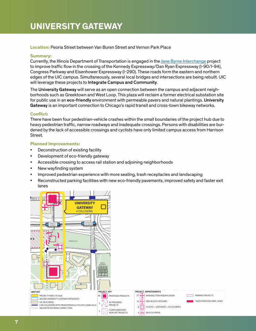
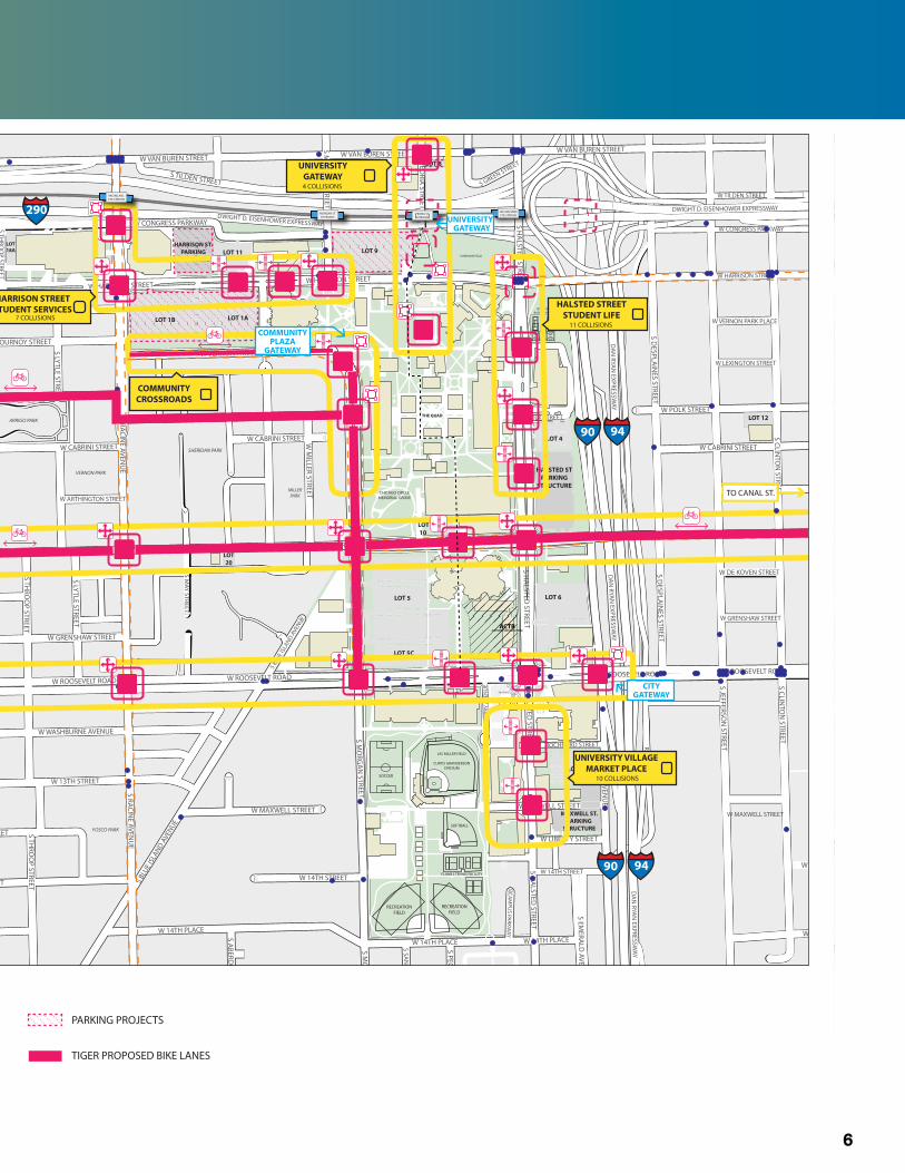
UNIVERSITY GATEWAY
Location: Peoria Street between Van Buren Street and Vernon Park Place
Summary:Currently, the Illinois Department of Transportation is engaged in the Jane Byrne Interchange project to improve traffic flow in the crossing of the Kennedy Expressway/Dan Ryan Expressway (I-90/I-94), Congress Parkway and Eisenhower Expressway (I-290). These roads form the eastern and northern edges of the UIC campus. Simultaneously, several local bridges and intersections are being rebuilt. UIC will leverage these projects to Integrate Campus and Community.
The University Gateway will serve as an open connection between the campus and adjacent neigh-borhoods such as Greektown and West Loop. This plaza will reclaim a former electrical substation site for public use in an eco-friendly environment with permeable pavers and natural plantings. University Gateway is an important connection to Chicago’s rapid transit and cross-town bikeway networks.
Conflict:There have been four pedestrian-vehicle crashes within the small boundaries of the project hub due to heavy pedestrian traffic, narrow roadways and inadequate crossings. Persons with disabilities are bur-dened by the lack of accessible crossings and cyclists have only limited campus access from Harrison Street.
Planned Improvements:• Deconstruction of existing facility• Development of eco-friendly gateway• Accessible crossing to access rail station and adjoining neighborhoods• New wayfinding system • Improved pedestrian experience with more seating, trash receptacles and landscaping• Reconstructed parking facilities with new eco-friendly pavements, improved safety and faster exit
lanes
LOT 9
LOT 8
TENNIS &BASKETBALL
HARRISON FIELD
S PEORIA
STREET
S HA
LSTED STREET
S GREEN STREET
W VAN BUREN STREETW VAN BUREN STREET
W HARRISON STREET
UIC/HALSTEDCTA STATION
UIC/HALSTEDCTA STATIONPEORIA ST.
ENTRANCE
UIC/HALSTEDCTA STATION
UNIVERSITYGATEWAY4 COLLISIONS
S LAFLIN
STREET
S WO
OD
STREET
W 15TH STREETW 15TH STREET
W 15TH STREET
INTERSECTION MODIFICATIONPROPOSED PROJECTS
PROJECT KEY PROJECT IMPROVEMENTS MAP KEY
46 27
16
4
8
2 IN-PROGRESSPROJECTS
MID-BLOCK CROSSING
BICYCLE PATHS
PLAZAS + GATEWAYS + ACCESSWAYS
PARKING PROJECTS
5 COMPLEMENTARYNON-UIC PROJECTS
CAR COLLISIONS WITH PEDESTRIANS & CYCLISTS (2008-2012)MAJOR PEDESTRIAN CONNECTORS
PROJECT HUBS (10 total) MAJOR UNIVERSITY GATEWAY ENTRANCESUIC BUILDINGS TIGER PROPOSED BIKE LANES
7
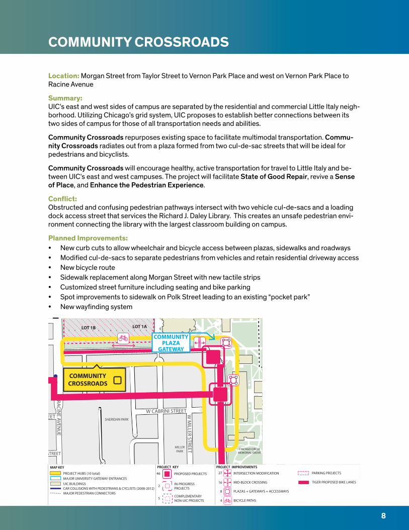
COMMUNITY CROSSROADS
Location: Morgan Street from Taylor Street to Vernon Park Place and west on Vernon Park Place to Racine Avenue
Summary:UIC’s east and west sides of campus are separated by the residential and commercial Little Italy neigh-borhood. Utilizing Chicago’s grid system, UIC proposes to establish better connections between its two sides of campus for those of all transportation needs and abilities.
Community Crossroads repurposes existing space to facilitate multimodal transportation. Commu-nity Crossroads radiates out from a plaza formed from two cul-de-sac streets that will be ideal for pedestrians and bicyclists.
Community Crossroads will encourage healthy, active transportation for travel to Little Italy and be-tween UIC’s east and west campuses. The project will facilitate State of Good Repair, revive a Sense of Place, and Enhance the Pedestrian Experience.
Conflict:Obstructed and confusing pedestrian pathways intersect with two vehicle cul-de-sacs and a loading dock access street that services the Richard J. Daley Library. This creates an unsafe pedestrian envi-ronment connecting the library with the largest classroom building on campus.
Planned Improvements:• New curb cuts to allow wheelchair and bicycle access between plazas, sidewalks and roadways• Modified cul-de-sacs to separate pedestrians from vehicles and retain residential driveway access• New bicycle route• Sidewalk replacement along Morgan Street with new tactile strips• Customized street furniture including seating and bike parking• Spot improvements to sidewalk on Polk Street leading to an existing “pocket park”• New wayfinding system
VERNON PARK
SHERIDAN PARK
MILLERPARK
LOT 1B LOT 1A
CHICAGO CIRCLEMEMORIAL GROVE
W VERNON PARK PLACES RACIN
E AVENU
E
W CABRINI STREET
W ARTHINGTON STREET
W POLK STREET
W CABRINI STREET W M
ILLER STREET
COMMUNITYCROSSROADS
COMMUNITYPLAZA
GATEWAY
S LAFLIN
STREET
S WO
OD
STREET
W 15TH STREETW 15TH STREET
W 15TH STREET
INTERSECTION MODIFICATIONPROPOSED PROJECTS
PROJECT KEY PROJECT IMPROVEMENTS MAP KEY
46 27
16
4
8
2 IN-PROGRESSPROJECTS
MID-BLOCK CROSSING
BICYCLE PATHS
PLAZAS + GATEWAYS + ACCESSWAYS
PARKING PROJECTS
5 COMPLEMENTARYNON-UIC PROJECTS
CAR COLLISIONS WITH PEDESTRIANS & CYCLISTS (2008-2012)MAJOR PEDESTRIAN CONNECTORS
PROJECT HUBS (10 total) MAJOR UNIVERSITY GATEWAY ENTRANCESUIC BUILDINGS TIGER PROPOSED BIKE LANES
8
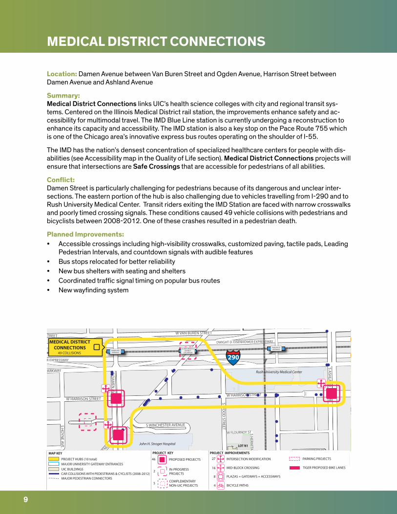
MEDICAL DISTRICT CONNECTIONS
Location: Damen Avenue between Van Buren Street and Ogden Avenue, Harrison Street between Damen Avenue and Ashland Avenue
Summary:Medical District Connections links UIC’s health science colleges with city and regional transit sys-tems. Centered on the Illinois Medical District rail station, the improvements enhance safety and ac-cessibility for multimodal travel. The IMD Blue Line station is currently undergoing a reconstruction to enhance its capacity and accessibility. The IMD station is also a key stop on the Pace Route 755 which is one of the Chicago area’s innovative express bus routes operating on the shoulder of I-55.
The IMD has the nation’s densest concentration of specialized healthcare centers for people with dis-abilities (see Accessibility map in the Quality of Life section). Medical District Connections projects will ensure that intersections are Safe Crossings that are accessible for pedestrians of all abilities.
Conflict:Damen Street is particularly challenging for pedestrians because of its dangerous and unclear inter-sections. The eastern portion of the hub is also challenging due to vehicles travelling from I-290 and to Rush University Medical Center. Transit riders exiting the IMD Station are faced with narrow crosswalks and poorly timed crossing signals. These conditions caused 49 vehicle collisions with pedestrians and bicyclists between 2008-2012. One of these crashes resulted in a pedestrian death.
Planned Improvements:• Accessible crossings including high-visibility crosswalks, customized paving, tactile pads, Leading
Pedestrian Intervals, and countdown signals with audible features• Bus stops relocated for better reliability• New bus shelters with seating and shelters• Coordinated traffic signal timing on popular bus routes• New wayfinding system
LOT N1
W CONGRESS PARKWAY
W HARRISON STREET
W FLOURNOY STREETS WINCHESTER AVENUE
W O
GDEN AVENUE
S HO
YNE AVE.
S HERM
ITAGE AVEN
UE
W FLOURNOY ST
W VAN BUREN STREET
S ASH
LAN
D AVEN
UE
W HARRISON STREET
S DA
MEN
AVENU
E S WO
OD
STREET
W VAN BUREN STREET
DWIGHT D. EISENHOWER EXPRESSWAY
DWIGHT D. EISENHOWER EXPRESSWAY
ILLINOIS MEDICAL DISTRICT
CTA STATIONDAMEN AVE.CTA STATION
John H. Stroger Hospital
Rush University Medical Center
ILLINOIS MEDICAL DISTRICT
CTA STATIONDAMEN AVE.ENTRANCE
PAULINA ST.ENTRANCE
MEDICAL DISTRICTCONNECTIONS
49 COLLISIONS 290
S LAFLIN
STREET
S WO
OD
STREET
W 15TH STREETW 15TH STREET
W 15TH STREET
INTERSECTION MODIFICATIONPROPOSED PROJECTS
PROJECT KEY PROJECT IMPROVEMENTS MAP KEY
46 27
16
4
8
2 IN-PROGRESSPROJECTS
MID-BLOCK CROSSING
BICYCLE PATHS
PLAZAS + GATEWAYS + ACCESSWAYS
PARKING PROJECTS
5 COMPLEMENTARYNON-UIC PROJECTS
CAR COLLISIONS WITH PEDESTRIANS & CYCLISTS (2008-2012)MAJOR PEDESTRIAN CONNECTORS
PROJECT HUBS (10 total) MAJOR UNIVERSITY GATEWAY ENTRANCESUIC BUILDINGS TIGER PROPOSED BIKE LANES
9
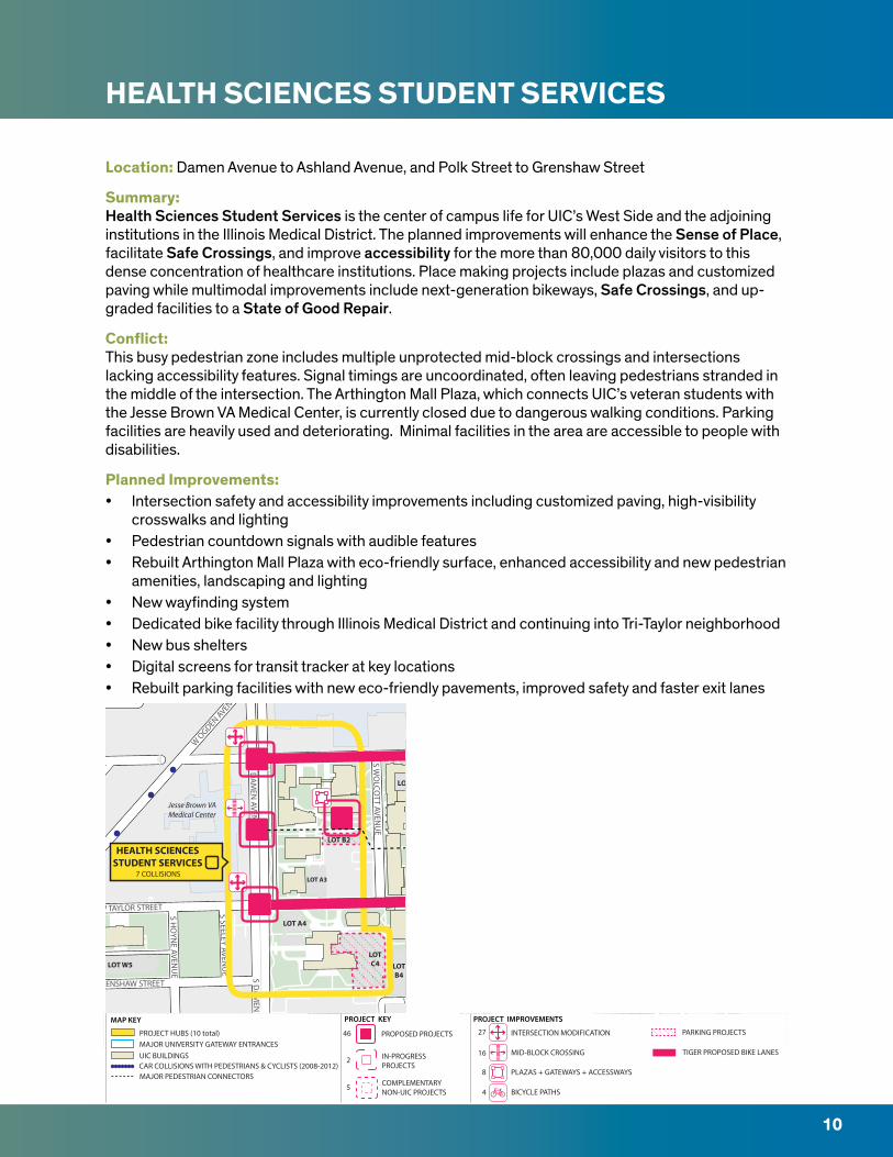
HEALTH SCIENCES STUDENT SERVICES
Location: Damen Avenue to Ashland Avenue, and Polk Street to Grenshaw Street
Summary:Health Sciences Student Services is the center of campus life for UIC’s West Side and the adjoining institutions in the Illinois Medical District. The planned improvements will enhance the Sense of Place, facilitate Safe Crossings, and improve accessibility for the more than 80,000 daily visitors to this dense concentration of healthcare institutions. Place making projects include plazas and customized paving while multimodal improvements include next-generation bikeways, Safe Crossings, and up-graded facilities to a State of Good Repair.
Conflict:This busy pedestrian zone includes multiple unprotected mid-block crossings and intersections lacking accessibility features. Signal timings are uncoordinated, often leaving pedestrians stranded in the middle of the intersection. The Arthington Mall Plaza, which connects UIC’s veteran students with the Jesse Brown VA Medical Center, is currently closed due to dangerous walking conditions. Parking facilities are heavily used and deteriorating. Minimal facilities in the area are accessible to people with disabilities.
Planned Improvements:• Intersection safety and accessibility improvements including customized paving, high-visibility
crosswalks and lighting• Pedestrian countdown signals with audible features • Rebuilt Arthington Mall Plaza with eco-friendly surface, enhanced accessibility and new pedestrian
amenities, landscaping and lighting• New wayfinding system • Dedicated bike facility through Illinois Medical District and continuing into Tri-Taylor neighborhood• New bus shelters• Digital screens for transit tracker at key locations• Rebuilt parking facilities with new eco-friendly pavements, improved safety and faster exit lanes
LOTB4
LOTC4
LOT A3
LOT B2
LOT A4
LOT W5
LOT C1
W POLK STREET
W GRENSHAW STREET
W O
GDEN AVENUE
S HO
YNE AVE.
S DA
MEN
AVENU
E
S WO
LCOTT AVEN
UE
S HO
YNE AVEN
UE
S SEELEY AVENU
E
W TAYLOR STREET
S DA
MEN
AVENU
E
W GRENSHAW STREET
Jesse Brown VAMedical Center
HEALTH SCIENCESSTUDENT SERVICES
7 COLLISIONS
S LAFLIN
STREET
S WO
OD
STREET
W 15TH STREETW 15TH STREET
W 15TH STREET
INTERSECTION MODIFICATIONPROPOSED PROJECTS
PROJECT KEY PROJECT IMPROVEMENTS MAP KEY
46 27
16
4
8
2 IN-PROGRESSPROJECTS
MID-BLOCK CROSSING
BICYCLE PATHS
PLAZAS + GATEWAYS + ACCESSWAYS
PARKING PROJECTS
5 COMPLEMENTARYNON-UIC PROJECTS
CAR COLLISIONS WITH PEDESTRIANS & CYCLISTS (2008-2012)MAJOR PEDESTRIAN CONNECTORS
PROJECT HUBS (10 total) MAJOR UNIVERSITY GATEWAY ENTRANCESUIC BUILDINGS TIGER PROPOSED BIKE LANES
10
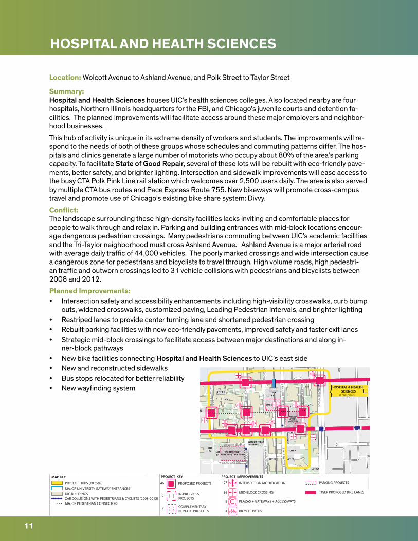
HOSPITAL AND HEALTH SCIENCES
Location: Wolcott Avenue to Ashland Avenue, and Polk Street to Taylor Street
Summary:Hospital and Health Sciences houses UIC’s health sciences colleges. Also located nearby are four hospitals, Northern Illinois headquarters for the FBI, and Chicago’s juvenile courts and detention fa-cilities. The planned improvements will facilitate access around these major employers and neighbor-hood businesses.
This hub of activity is unique in its extreme density of workers and students. The improvements will re-spond to the needs of both of these groups whose schedules and commuting patterns differ. The hos-pitals and clinics generate a large number of motorists who occupy about 80% of the area’s parking capacity. To facilitate State of Good Repair, several of these lots will be rebuilt with eco-friendly pave-ments, better safety, and brighter lighting. Intersection and sidewalk improvements will ease access to the busy CTA Polk Pink Line rail station which welcomes over 2,500 users daily. The area is also served by multiple CTA bus routes and Pace Express Route 755. New bikeways will promote cross-campus travel and promote use of Chicago’s existing bike share system: Divvy.
Conflict:The landscape surrounding these high-density facilities lacks inviting and comfortable places for people to walk through and relax in. Parking and building entrances with mid-block locations encour-age dangerous pedestrian crossings. Many pedestrians commuting between UIC’s academic facilities and the Tri-Taylor neighborhood must cross Ashland Avenue. Ashland Avenue is a major arterial road with average daily traffic of 44,000 vehicles. The poorly marked crossings and wide intersection cause a dangerous zone for pedestrians and bicyclists to travel through. High volume roads, high pedestri-an traffic and outworn crossings led to 31 vehicle collisions with pedestrians and bicyclists between 2008 and 2012.
Planned Improvements:• Intersection safety and accessibility enhancements including high-visibility crosswalks, curb bump
outs, widened crosswalks, customized paving, Leading Pedestrian Intervals, and brighter lighting• Restriped lanes to provide center turning lane and shortened pedestrian crossing• Rebuilt parking facilities with new eco-friendly pavements, improved safety and faster exit lanes • Strategic mid-block crossings to facilitate access between major destinations and along in-
ner-block pathways• New bike facilities connecting Hospital and Health Sciences to UIC’s east side• New and reconstructed sidewalks• Bus stops relocated for better reliability• New wayfinding system
WOOD STREETPARKING STRUCTURE
LOTB4
WOOD STREETMETERED LOT
LOT E4
LOT E
LOT E1
LOT F
LOT G
LOT G4
LOT K
LOT J
UIC
MET
ER L
OT
LOT H
LOT F4
LOTC4
LOT
L
LOT B2
PAULINASTREET
PARKING STRUCTURE
LOT C1
C1
MAB
THE PA
RK LIVING
STON
HEA
LTH W
ALK
ATKINSGARDEN
COLLEGE OF MEDICINECOURTYARD
MEDICAL SCIENCESCOURTYARD
W POLK STREET
W GRENSHAW STREET
S HERM
ITAGE AVEN
UE
W FILLMORE STREET
S WO
LCOTT AVEN
UE
S WO
OD
STREET
S PAULIN
A STREET
S MA
RSHFIELD
AVENU
E
S ASH
LAN
D AVEN
UE
W FILLMORE STREET
W ROOSEVELT ROAD
W TAYLOR STREET
S PAULIN
A STREET
S WO
OD
STREET
W POLK STREETW POLK STREET
S HERM
ITAGE AVEN
UE
POLK STREETCTA STATION
HOSPITAL & HEALTH SCIENCES
31 COLLISIONS
S LAFLIN
STREET
S WO
OD
STREET
W 15TH STREETW 15TH STREET
W 15TH STREET
INTERSECTION MODIFICATIONPROPOSED PROJECTS
PROJECT KEY PROJECT IMPROVEMENTS MAP KEY
46 27
16
4
8
2 IN-PROGRESSPROJECTS
MID-BLOCK CROSSING
BICYCLE PATHS
PLAZAS + GATEWAYS + ACCESSWAYS
PARKING PROJECTS
5 COMPLEMENTARYNON-UIC PROJECTS
CAR COLLISIONS WITH PEDESTRIANS & CYCLISTS (2008-2012)MAJOR PEDESTRIAN CONNECTORS
PROJECT HUBS (10 total) MAJOR UNIVERSITY GATEWAY ENTRANCESUIC BUILDINGS TIGER PROPOSED BIKE LANES
11
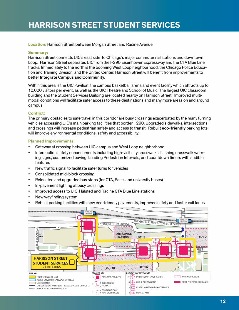
HARRISON STREET STUDENT SERVICES
Location: Harrison Street between Morgan Street and Racine Avenue
Summary:Harrison Street connects UIC’s east side to Chicago’s major commuter rail stations and downtown Loop. Harrison Street separates UIC from the I-290 Eisenhower Expressway and the CTA Blue Line tracks. Immediately to the north is the booming West Loop neighborhood, the Chicago Police Educa-tion and Training Division, and the United Center. Harrison Street will benefit from improvements to better Integrate Campus and Community.
Within this area is the UIC Pavilion: the campus basketball arena and event facility which attracts up to 10,000 visitors per event, as well as the UIC Theatre and School of Music. The largest UIC classroom building and the Student Services Building are located nearby on Harrison Street. Improved multi-modal conditions will facilitate safer access to these destinations and many more areas on and around campus
Conflict:The primary obstacles to safe travel in this corridor are busy crossings exacerbated by the many turning vehicles accessing UIC’s main parking facilities that border I-290. Upgraded sidewalks, intersections and crossings will increase pedestrian safety and access to transit. Rebuilt eco-friendly parking lots will improve environmental conditions, safety and accessibility.
Planned Improvements:• Gateway at crossing between UIC campus and West Loop neighborhood• Intersection safety enhancements including high-visibility crosswalks, flashing crosswalk warn-
ing signs, customized paving, Leading Pedestrian Intervals, and countdown timers with audible features
• New traffic signal to facilitate safer turns for vehicles• Consolidated mid-block crossing• Relocated and upgraded bus stops (for CTA, Pace, and university buses)• In-pavement lighting at busy crossings • Improved access to UIC-Halsted and Racine CTA Blue Line stations• New wayfinding system• Rebuilt parking facilities with new eco-friendly pavements, improved safety and faster exit lanes
LOT18A
HARRISON ST.PARKING
STRUCTURELOT 9
LOT 1B LOT 1A
LOT 11
W HARRISON STREET
W CONGRESS PARKWAY
S MO
RGA
N STREET
S TILDEN STREETS TH
ROO
P STREET
W HARRISON STREETW HARRISON STREET
DWIGHT D. EISENHOWER EXPRESSWAY
RACINE AVE.CTA STATION
UIC/HALSTEDCTA STATION
RACINE AVE.CTA STATION
MORGAN ST.ENTRANCE
HARRISON STREETSTUDENT SERVICES
7 COLLISIONS
S LAFLIN
STREET
S WO
OD
STREET
W 15TH STREETW 15TH STREET
W 15TH STREET
INTERSECTION MODIFICATIONPROPOSED PROJECTS
PROJECT KEY PROJECT IMPROVEMENTS MAP KEY
46 27
16
4
8
2 IN-PROGRESSPROJECTS
MID-BLOCK CROSSING
BICYCLE PATHS
PLAZAS + GATEWAYS + ACCESSWAYS
PARKING PROJECTS
5 COMPLEMENTARYNON-UIC PROJECTS
CAR COLLISIONS WITH PEDESTRIANS & CYCLISTS (2008-2012)MAJOR PEDESTRIAN CONNECTORS
PROJECT HUBS (10 total) MAJOR UNIVERSITY GATEWAY ENTRANCESUIC BUILDINGS TIGER PROPOSED BIKE LANES
12
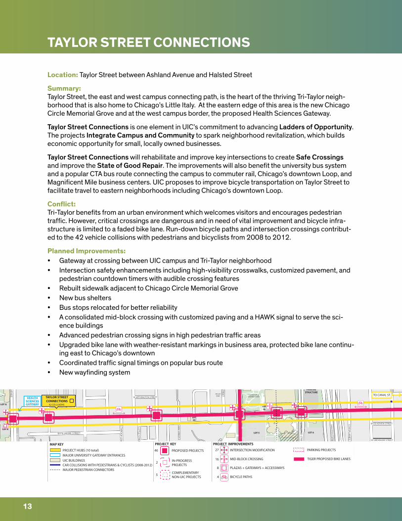
TAYLOR STREET CONNECTIONS
Location: Taylor Street between Ashland Avenue and Halsted Street
Summary:Taylor Street, the east and west campus connecting path, is the heart of the thriving Tri-Taylor neigh-borhood that is also home to Chicago’s Little Italy. At the eastern edge of this area is the new Chicago Circle Memorial Grove and at the west campus border, the proposed Health Sciences Gateway.
Taylor Street Connections is one element in UIC’s commitment to advancing Ladders of Opportunity. The projects Integrate Campus and Community to spark neighborhood revitalization, which builds economic opportunity for small, locally owned businesses.
Taylor Street Connections will rehabilitate and improve key intersections to create Safe Crossings and improve the State of Good Repair. The improvements will also benefit the university bus system and a popular CTA bus route connecting the campus to commuter rail, Chicago’s downtown Loop, and Magnificent Mile business centers. UIC proposes to improve bicycle transportation on Taylor Street to facilitate travel to eastern neighborhoods including Chicago’s downtown Loop.
Conflict: Tri-Taylor benefits from an urban environment which welcomes visitors and encourages pedestrian traffic. However, critical crossings are dangerous and in need of vital improvement and bicycle infra-structure is limited to a faded bike lane. Run-down bicycle paths and intersection crossings contribut-ed to the 42 vehicle collisions with pedestrians and bicyclists from 2008 to 2012.
Planned Improvements:• Gateway at crossing between UIC campus and Tri-Taylor neighborhood• Intersection safety enhancements including high-visibility crosswalks, customized pavement, and
pedestrian countdown timers with audible crossing features• Rebuilt sidewalk adjacent to Chicago Circle Memorial Grove • New bus shelters• Bus stops relocated for better reliability• A consolidated mid-block crossing with customized paving and a HAWK signal to serve the sci-
ence buildings • Advanced pedestrian crossing signs in high pedestrian traffic areas• Upgraded bike lane with weather-resistant markings in business area, protected bike lane continu-
ing east to Chicago’s downtown• Coordinated traffic signal timings on popular bus route• New wayfinding system
VERNON PARK
MILLERPARK
LOT G
LOT K
LOT 10
LOT 5 LOT 6
HALSTED STPARKING
STRUCTURE
LOT20
ACTB
CHICAGO CIRCLEMEMORIAL GROVE
S RACINE AVEN
UE
S BLU
E ISL
AND AVE
NUE W GRENSHAW STREET
W DE KOVEN STREETS THRO
OP STREET
S LOO
MIS STREET
S ASH
LAN
D AVEN
UE
W FILLMORE STREET
S LYTLE STREET
W ARTHINGTON STREET
S MAY STREET
W M
ILLER STREET
W TAYLOR STREET
S CLINTO
N STREET
W TAYLOR STREET W TAYLOR STREETW TAYLOR STREET
S HA
LSTED STREET
S MO
RGA
N STREET
S DESPLA
INES STREET
DA
N RYA
N EXPRESSW
AY
TO CANAL ST.TAYLOR STREETCONNECTIONS
42 COLLISIONS
HEALTHSCIENCESGATEWAY
S LAFLIN
STREET
S WO
OD
STREET
W 15TH STREETW 15TH STREET
W 15TH STREET
INTERSECTION MODIFICATIONPROPOSED PROJECTS
PROJECT KEY PROJECT IMPROVEMENTS MAP KEY
46 27
16
4
8
2 IN-PROGRESSPROJECTS
MID-BLOCK CROSSING
BICYCLE PATHS
PLAZAS + GATEWAYS + ACCESSWAYS
PARKING PROJECTS
5 COMPLEMENTARYNON-UIC PROJECTS
CAR COLLISIONS WITH PEDESTRIANS & CYCLISTS (2008-2012)MAJOR PEDESTRIAN CONNECTORS
PROJECT HUBS (10 total) MAJOR UNIVERSITY GATEWAY ENTRANCESUIC BUILDINGS TIGER PROPOSED BIKE LANES
13
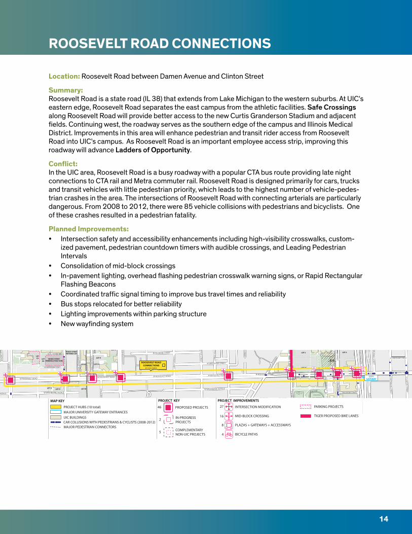
ROOSEVELT ROAD CONNECTIONS
Location: Roosevelt Road between Damen Avenue and Clinton Street
Summary:Roosevelt Road is a state road (IL 38) that extends from Lake Michigan to the western suburbs. At UIC’s eastern edge, Roosevelt Road separates the east campus from the athletic facilities. Safe Crossings along Roosevelt Road will provide better access to the new Curtis Granderson Stadium and adjacent fields. Continuing west, the roadway serves as the southern edge of the campus and Illinois Medical District. Improvements in this area will enhance pedestrian and transit rider access from Roosevelt Road into UIC’s campus. As Roosevelt Road is an important employee access strip, improving this roadway will advance Ladders of Opportunity.
Conflict:In the UIC area, Roosevelt Road is a busy roadway with a popular CTA bus route providing late night connections to CTA rail and Metra commuter rail. Roosevelt Road is designed primarily for cars, trucks and transit vehicles with little pedestrian priority, which leads to the highest number of vehicle-pedes-trian crashes in the area. The intersections of Roosevelt Road with connecting arterials are particularly dangerous. From 2008 to 2012, there were 85 vehicle collisions with pedestrians and bicyclists. One of these crashes resulted in a pedestrian fatality.
Planned Improvements:• Intersection safety and accessibility enhancements including high-visibility crosswalks, custom-
ized pavement, pedestrian countdown timers with audible crossings, and Leading Pedestrian Intervals
• Consolidation of mid-block crossings• In-pavement lighting, overhead flashing pedestrian crosswalk warning signs, or Rapid Rectangular
Flashing Beacons• Coordinated traffic signal timing to improve bus travel times and reliability• Bus stops relocated for better reliability• Lighting improvements within parking structure• New wayfinding system
WOOD STREETPARKING STRUCTURE
LOTB4
WOOD STREETMETERED LOT
LOT E4
LOT M
LOT G4
LOT K
UIC
MET
ER L
OT
LOT H
LOT F4
LOTC4
LOT OLOT O
LOT 5
LOT 5C
LOT 6
LOT 14
ACTB(FUTURE CONSTRUCTION)
LES MILLER FIELD
CURTIS GRANDERSONSTADIUM
SKYSPACE
EARL NEALPLAZA
W ROOSEVELT ROAD
ROCHFORD STREET
S HA
LSTED STREETS M
ORG
AN
STREET
S UN
ION
AVENU
E
S N
EWBE
RRY
AVEN
UE
S BLU
E ISL
AND AVE
NUE W GRENSHAW STREET
RUBLE STREET
W WASHBURNE AVENUE
S THRO
OP STREET
S LOO
MIS STREET
W ROOSEVELT ROAD
W GRENSHAW STREET
W FILLMORE STREET
S SEELEY AVENU
E
W FILLMORE STREET
W GRENSHAW STREET
S LYTLE STREET
S MAY STREET
W ROOSEVELT ROAD S JEFFERSON
STREET
S CLINTO
N STREET
S PAULIN
A STREET
S PAULIN
A STREET
S WO
OD
STREET
W ROOSEVELT ROADW ROOSEVELT ROAD
W ROOSEVELT ROAD
W WASHBURNE AVENUE
W WASHBURNE AVENUE
S DA
MEN
AVENU
E W ROOSEVELT ROAD
S HERM
ITAGE AVEN
UE
S HA
LSTED STREET
S MO
RGA
N STREET
S DESPLA
INES STREET
DA
N RYA
N EXPRESSW
AYROOSEVELT ROADCONNECTIONS
85 COLLISIONS
CITYGATEWAY
S LAFLIN
STREET
S WO
OD
STREET
W 15TH STREETW 15TH STREET
W 15TH STREET
INTERSECTION MODIFICATIONPROPOSED PROJECTS
PROJECT KEY PROJECT IMPROVEMENTS MAP KEY
46 27
16
4
8
2 IN-PROGRESSPROJECTS
MID-BLOCK CROSSING
BICYCLE PATHS
PLAZAS + GATEWAYS + ACCESSWAYS
PARKING PROJECTS
5 COMPLEMENTARYNON-UIC PROJECTS
CAR COLLISIONS WITH PEDESTRIANS & CYCLISTS (2008-2012)MAJOR PEDESTRIAN CONNECTORS
PROJECT HUBS (10 total) MAJOR UNIVERSITY GATEWAY ENTRANCESUIC BUILDINGS TIGER PROPOSED BIKE LANES
14
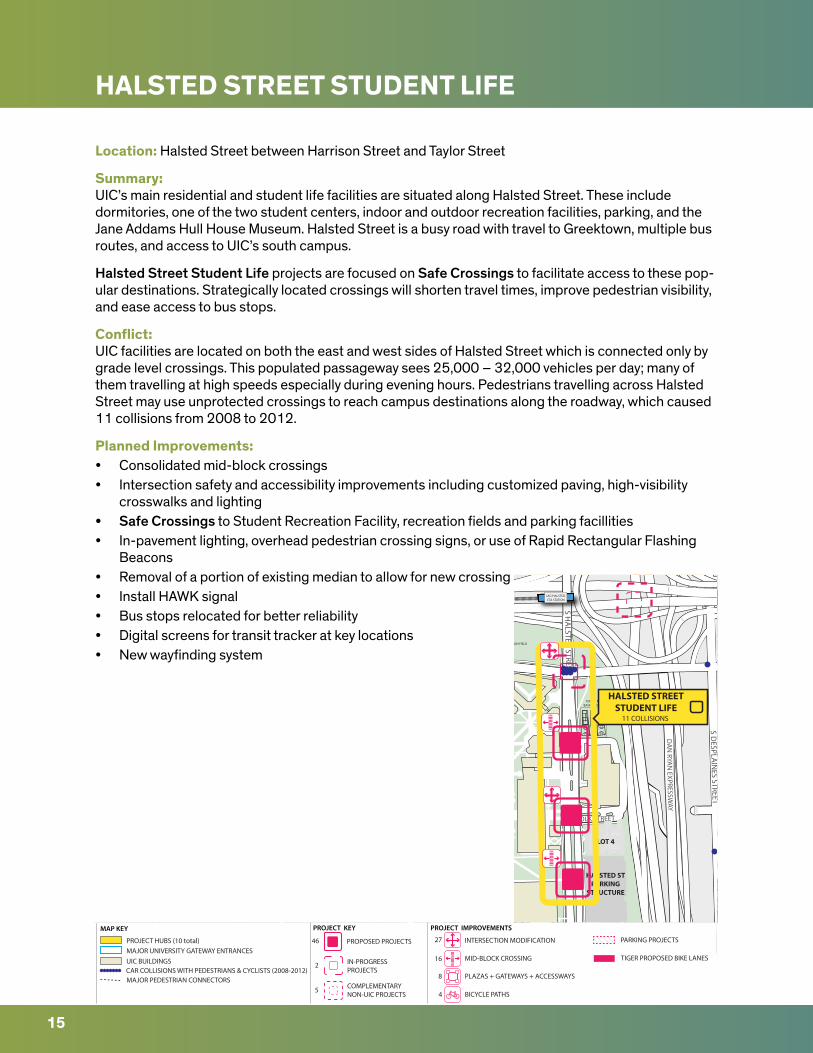
HALSTED STREET STUDENT LIFE
Location: Halsted Street between Harrison Street and Taylor Street
Summary:UIC’s main residential and student life facilities are situated along Halsted Street. These include dormitories, one of the two student centers, indoor and outdoor recreation facilities, parking, and the Jane Addams Hull House Museum. Halsted Street is a busy road with travel to Greektown, multiple bus routes, and access to UIC’s south campus.
Halsted Street Student Life projects are focused on Safe Crossings to facilitate access to these pop-ular destinations. Strategically located crossings will shorten travel times, improve pedestrian visibility, and ease access to bus stops.
Conflict:UIC facilities are located on both the east and west sides of Halsted Street which is connected only by grade level crossings. This populated passageway sees 25,000 – 32,000 vehicles per day; many of them travelling at high speeds especially during evening hours. Pedestrians travelling across Halsted Street may use unprotected crossings to reach campus destinations along the roadway, which caused 11 collisions from 2008 to 2012.
Planned Improvements:• Consolidated mid-block crossings• Intersection safety and accessibility improvements including customized paving, high-visibility
crosswalks and lighting• Safe Crossings to Student Recreation Facility, recreation fields and parking facillities• In-pavement lighting, overhead pedestrian crossing signs, or use of Rapid Rectangular Flashing
Beacons• Removal of a portion of existing median to allow for new crossing• Install HAWK signal• Bus stops relocated for better reliability• Digital screens for transit tracker at key locations• New wayfinding system
HALSTED STPARKING
STRUCTURE
LOT 4
TENNIS &BASKETBALL
HARRISON FIELD
W POLK STREET
S HA
LSTED STREET
S DESPLA
INES STREET
DA
N RYA
N EXPRESSW
AY
UIC/HALSTEDCTA STATIONUIC/HALSTEDCTA STATION
HALSTED STREETSTUDENT LIFE
11 COLLISIONS
S LAFLIN
STREET
S WO
OD
STREET
W 15TH STREETW 15TH STREET
W 15TH STREET
INTERSECTION MODIFICATIONPROPOSED PROJECTS
PROJECT KEY PROJECT IMPROVEMENTS MAP KEY
46 27
16
4
8
2 IN-PROGRESSPROJECTS
MID-BLOCK CROSSING
BICYCLE PATHS
PLAZAS + GATEWAYS + ACCESSWAYS
PARKING PROJECTS
5 COMPLEMENTARYNON-UIC PROJECTS
CAR COLLISIONS WITH PEDESTRIANS & CYCLISTS (2008-2012)MAJOR PEDESTRIAN CONNECTORS
PROJECT HUBS (10 total) MAJOR UNIVERSITY GATEWAY ENTRANCESUIC BUILDINGS TIGER PROPOSED BIKE LANES
15
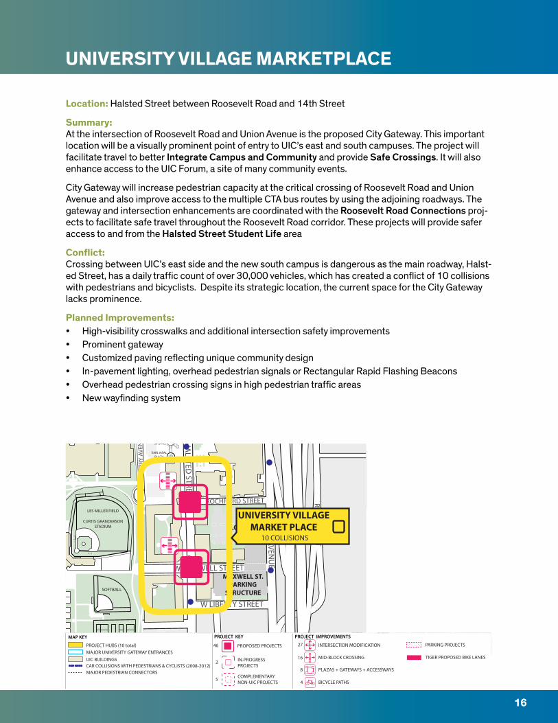
UNIVERSITY VILLAGE MARKETPLACE
Location: Halsted Street between Roosevelt Road and 14th Street
Summary:At the intersection of Roosevelt Road and Union Avenue is the proposed City Gateway. This important location will be a visually prominent point of entry to UIC’s east and south campuses. The project will facilitate travel to better Integrate Campus and Community and provide Safe Crossings. It will also enhance access to the UIC Forum, a site of many community events.
City Gateway will increase pedestrian capacity at the critical crossing of Roosevelt Road and Union Avenue and also improve access to the multiple CTA bus routes by using the adjoining roadways. The gateway and intersection enhancements are coordinated with the Roosevelt Road Connections proj-ects to facilitate safe travel throughout the Roosevelt Road corridor. These projects will provide safer access to and from the Halsted Street Student Life area
Conflict:Crossing between UIC’s east side and the new south campus is dangerous as the main roadway, Halst-ed Street, has a daily traffic count of over 30,000 vehicles, which has created a conflict of 10 collisions with pedestrians and bicyclists. Despite its strategic location, the current space for the City Gateway lacks prominence.
Planned Improvements:• High-visibility crosswalks and additional intersection safety improvements• Prominent gateway• Customized paving reflecting unique community design• In-pavement lighting, overhead pedestrian signals or Rectangular Rapid Flashing Beacons• Overhead pedestrian crossing signs in high pedestrian traffic areas• New wayfinding system
MAXWELL ST.PARKING
STRUCTURE
LOT 14
SOFTBALL
LES MILLER FIELD
CURTIS GRANDERSONSTADIUM
SKYSPACE
EARL NEALPLAZA
ROCHFORD STREET
W MAXWELL STREET
W LIBERTY STREET
S HA
LSTED STREET
S UN
ION
AVENU
E
S N
EWBE
RRY
AVEN
UE
RUBLE STREET
UNIVERSITY VILLAGEMARKET PLACE
10 COLLISIONS
S LAFLIN
STREET
S WO
OD
STREET
W 15TH STREETW 15TH STREET
W 15TH STREET
INTERSECTION MODIFICATIONPROPOSED PROJECTS
PROJECT KEY PROJECT IMPROVEMENTS MAP KEY
46 27
16
4
8
2 IN-PROGRESSPROJECTS
MID-BLOCK CROSSING
BICYCLE PATHS
PLAZAS + GATEWAYS + ACCESSWAYS
PARKING PROJECTS
5 COMPLEMENTARYNON-UIC PROJECTS
CAR COLLISIONS WITH PEDESTRIANS & CYCLISTS (2008-2012)MAJOR PEDESTRIAN CONNECTORS
PROJECT HUBS (10 total) MAJOR UNIVERSITY GATEWAY ENTRANCESUIC BUILDINGS TIGER PROPOSED BIKE LANES
16

CAMPUS-WIDE IMPROVEMENTS
17
Transit The UIC community area is well served by public transit. Over 13 bus routes, including the UIC shut-tle, CTA buses, and Pace (an express regional service route), and two CTA train lines run through the campus and surrounding neighborhoods. One challenge for transit riders is the lack of information on real-time arrivals. To remedy this, UIC will install digital screens displaying transit information in key campus locations. Additionally, survey feedback provided in the Multimodal Transportation Plan revealed that many users feel unsafe or uncomfortable riding transit because of the lack of bus shelters and benches. Crossroads and Connections will provide new shelters with benches at key locations resulting in safer and more desirable transit facilities.
Wayfinding Successful navigation is a result of a well-planned sign system. The current UIC wayfinding is limited in scope, lacks distance information and does not conform to building and ADA accessibility codes. Crossroads and Connections will develop a campus-wide wayfinding program that will address accessibility and public safety while promoting student, pedestrian and business productivity through more efficient time saving travel routes around campus and to existing transportation facilities and major community destinations. This unified, ADA-compliant sign program will benefit users of all trans-portation modes by clearly and consistently conveying location information throughout the campus. It will allow users to easily travel the most direct and safe route to their destination. The project scope will consist of three gateway entrance markers and approximately 135 building entrance signs, 39 parking and garage signs, 30 pedestrian signs as well as 23 “You Are Here” pedestal maps.
ParkingCrossroads and Connections will rehabilitate popular yet critically deficient parking areas (indicated in the individual hub descriptions). Strategic locations will receive new eco-friendly and durable pave-ment. Parking areas with inadequate or energy-inefficient lighting will receive upgrades. New security cameras will be installed in critical locations and campus parking lots will receive new payment sys-tems to ensure better reliability and speedier exit lanes, thus increasing capacity. As part of its environ-mental commitment, UIC will not increase the number of parking spaces. Capacity management will be achieved through faster exit lanes, fewer areas blocked off because of poor surfaces, better snow control, and promotion of active transportation.
Bicycle NetworkUIC lacks a campus-wide bicycle network, so bicyclists are forced to use undesignated routes to travel through campus. This has led to hazardous conflict zones with pedestrians and vehicles resulting in collisions. The new bikeway network will include multiple designated safe routes for bicyclists of all ages and abilities. The network will be integrated with City of Chicago’s bikeways and Divvy stations, Chicago’s public bike share system. UIC will also significantly expand bike parking at key locations.
PROJECT PARTIES AND GRANT FUNDS
18
PROJECT PARTIES
UIC is the sole applicant of Crossroads and Connections. While this is not a joint application, the basis of this project originates from the collaboration of many organizations. Please see page 27 for more details about the partnership of this project.
GRANT FUNDSCrossroads and Connections will create long-term improvements to UIC’s and the greater Chicago transportation network. The project will receive a 41% project match by UIC Parking Services. The project match will fund all parking facility improvements including rehabilitation of existing lots and structures, sustainable pavement and lighting systems, security camera retrofits, sustainable land-scaping and a new state of the art campus-wide payment system. 59% of the total project cost will be requested of TIGER funding. Requested TIGER funds will be used to increase safety for pedestrians and bicyclists, maximize access to UIC parking facilities and Chicago public transportation services, increase easy pedestrian access throughout the project area, add routes to the city’s bicycle network, and provide more feasible transportation options.
TIGER funds will complete the overall funding package to improve the network of transportation sur-rounding UIC and nearby neighborhoods, hospitals, and business districts. Project fund distribution has changed since the 2015 TIGER pre-application due to a change in indirect costs. Project funds will be used to complete both pre-construction and construction activities. TIGER funds will be obligated by September 30, 2017. No TIGER funds will be expended after September 30, 2022. The full budget and commitment of this project match can be found in the appendix. This is UIC’s first request for Fed-eral funding for Crossroads and Connections.
PROJECT PARTIES AND GRANT FUNDS
19
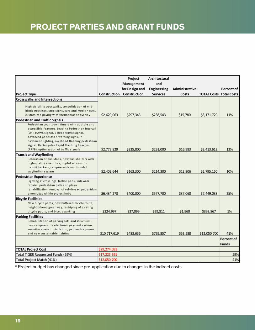
Project Type Construction
Project Management for Design and Construction
Architectural and
Engineering Services
Administrative Costs TOTAL Costs
Percent of Total Costs
Crosswalks and Intersections
High vis ibi l i ty crosswalks , consol idation of mid-block cross ings , s top s igns , curb and median cuts , customized paving with thermoplastic overlay
Pedestrian and Traffic SignalsPedestrian countdown timers with audible and access ible features , Leading Pedestrian Interva l (LPI), HAWK s ignal , 5-head traffic s ignal , advanced pedestrian warning s igns , in-pavement l ighting, overhead flashing pedestrian s ignal , Rectangular Rapid Flashing Beacons (RRFB), optimization of traffic s ignals
Transit and WayfindingRelocation of bus s tops , new bus shel ters with high-qual i ty amenities , digi ta l screens for trans i t trackers , campus-wide multimodal wayfinding system
Pedestrian ExperienceLighting at cross ings , tacti le pads , s idewalk repairs , pedestrian path and plaza rehabi l i tation, removal of cul -de-sac, pedestrian ameniti tes within project hubs
Bicycle FacilitiesNew bicycle paths , new buffered bicycle route, neighborhood greenway, restriping of exis ting bicycle paths , and bicycle parking
Parking FacilitiesRehabi l i tation of parking lots and s tructures , new campus-wide electronic payment system, securi ty camera insta l lation, permeable pavers and new susta inable l ighting
Percent of Funds
TOTAL Project CostTotal TIGER Requested Funds (59%) 59%Total Project Match (41%) 41%
41%
11%
12%
10%
25%
1%
$2,620,063 $297,343 $238,543 $15,780 $3,171,729
$13,906$2,403,644 $163,300 $214,300 $2,795,150
$2,779,829 $325,800 $291,000 $16,983 $3,413,612
$324,997 $37,099 $29,811 $1,960 $393,867
$6,434,273 $400,000 $577,700 $37,060 $7,449,033
$29,274,091$17,223,391$12,050,700
$10,717,619 $483,636 $795,857 $53,588 $12,050,700
* Project budget has changed since pre-application due to changes in the indirect costs
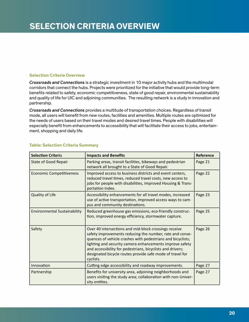
SELECTION CRITERIA OVERVIEW
Selection Criteria Overview Crossroads and Connections is a strategic investment in 10 major activity hubs and the multimodal corridors that connect the hubs. Projects were prioritized for the initiative that would provide long-term benefits related to safety, economic competitiveness, state of good repair, environmental sustainability and quality of life for UIC and adjoining communities. The resulting network is a study in innovation and partnership.
Crossroads and Connections provides a multitude of transportation choices. Regardless of transit mode, all users will benefit from new routes, facilities and amenities. Multiple routes are optimized for the needs of users based on their travel modes and desired travel times. People with disabilities will especially benefit from enhancements to accessibility that will facilitate their access to jobs, entertain-ment, shopping and daily life.
Table: Selection Criteria Summary
Selection Criteria Impacts and Benefits ReferenceState of Good Repair Parking areas, transit facilities, bikeways and pedestrian
network all brought to a State of Good Repair. Page 21
Economic Competitiveness Improved access to business districts and event centers, reduced travel times, reduced travel costs, new access to jobs for people with disabilities, improved Housing & Trans-portation Index.
Page 22
Quality of Life Accessibility enhancements for all travel modes, increased use of active transportation, improved access ways to cam-pus and community destinations.
Page 23
Environmental Sustainability Reduced greenhouse gas emissions, eco-friendly construc-tion, improved energy efficiency, stormwater capture.
Page 25
Safety Over 40 intersections and mid-block crossings receive safety improvements reducing the number, rate and conse-quences of vehicle crashes with pedestrians and bicyclists; lighting and security camera enhancements improve safety and accessibility for pedestrians, bicyclists and drivers; designated bicycle routes provide safe mode of travel for cyclists.
Page 26
Innovation Cutting edge accessibility and roadway improvements. Page 27Partnership Benefits for university area, adjoining neighborhoods and
users visiting the study area; collaboration with non-Univer-sity entities.
Page 27
20
Project Type Construction
Project Management for Design and Construction
Architectural and
Engineering Services
Administrative Costs TOTAL Costs
Percent of Total Costs
Crosswalks and Intersections
High vis ibi l i ty crosswalks , consol idation of mid-block cross ings , s top s igns , curb and median cuts , customized paving with thermoplastic overlay
Pedestrian and Traffic SignalsPedestrian countdown timers with audible and access ible features , Leading Pedestrian Interva l (LPI), HAWK s ignal , 5-head traffic s ignal , advanced pedestrian warning s igns , in-pavement l ighting, overhead flashing pedestrian s ignal , Rectangular Rapid Flashing Beacons (RRFB), optimization of traffic s ignals
Transit and WayfindingRelocation of bus s tops , new bus shel ters with high-qual i ty amenities , digi ta l screens for trans i t trackers , campus-wide multimodal wayfinding system
Pedestrian ExperienceLighting at cross ings , tacti le pads , s idewalk repairs , pedestrian path and plaza rehabi l i tation, removal of cul -de-sac, pedestrian ameniti tes within project hubs
Bicycle FacilitiesNew bicycle paths , new buffered bicycle route, neighborhood greenway, restriping of exis ting bicycle paths , and bicycle parking
Parking FacilitiesRehabi l i tation of parking lots and s tructures , new campus-wide electronic payment system, securi ty camera insta l lation, permeable pavers and new susta inable l ighting
Percent of Funds
TOTAL Project CostTotal TIGER Requested Funds (59%) 59%Total Project Match (41%) 41%
41%
11%
12%
10%
25%
1%
$2,620,063 $297,343 $238,543 $15,780 $3,171,729
$13,906$2,403,644 $163,300 $214,300 $2,795,150
$2,779,829 $325,800 $291,000 $16,983 $3,413,612
$324,997 $37,099 $29,811 $1,960 $393,867
$6,434,273 $400,000 $577,700 $37,060 $7,449,033
$29,274,091$17,223,391$12,050,700
$10,717,619 $483,636 $795,857 $53,588 $12,050,700
STATE OF GOOD REPAIR
21
The UIC campus is situated in a dense environment within Chicago’s grid network of streets. The UIC community extensively uses public roadways to travel within and beyond the campus. The projects included in Crossroads and Connections were carefully selected to leverage existing transportation assets and fill in gaps in the existing network. The program rebuilds heavily used but decaying trans-portation assets. Achieving a State of Good Repair for these assets is a sound investment in both UIC and the City of Chicago.
Parking SystemThe strategic improvements to parking facilities will improve their efficiency, capacity and lifetime without increasing space allocated to parking. Parking lots will receive new eco-friendly, long lasting pavement, upgrades to security and energy efficient lighting improvements. Upgrades will result in a longer life expectancy for parking facilities.
MotoristsMotorists will benefit from intersection improvements that facilitate smoother traffic flow. Key in-tersections will have their traffic signals upgraded and pavement rehabilitated. The consolidation of mid-block crossings will also improve conditions for vehicles. IDOT is currently improving roads and expressways in the UIC area through the Jane Byrne Interchange Project. Crossroads and Connec-tions leverages these investments and extends their benefits.
Bicycling NetworkCrossroads and Connections utilizes Chicago’s street grid to create multiple bike routes appropriate for people of all abilities. Street upgrades in Community Crossroads and other next-generation bike facilities advance US DOT’s Safer People, Safer Streets objectives.
Pedestrian NetworkSidewalks that need improvements were strategically selected. Sidewalks leading to transit and parking transportation facilities were prioritized in alignment with the US DOT Road Safety for Transit Patrons initiative. Sidewalk segments with accessibility problems were also prioritized. These seg-ments were then accessed with the PAVER rating system with those receiving failing scores selected for improvement. Plazas are also included in the project due to their critical role on UIC’s campus in helping to facilitate the high levels of pedestrian traffic. One of the existing plazas is currently closed, , and will benefit from new paving, access ways, and pedestrian amenities.
TransitCrossroads and Connections leverages CTA and IDOT’s ongoing investments in CTA rail stations serv-ing the UIC campus. Intersection improvements along bus routes will enhance reliability and comfort of these services.
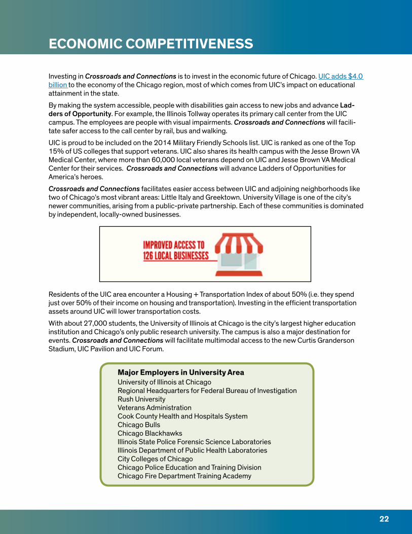
ECONOMIC COMPETITIVENESS
Investing in Crossroads and Connections is to invest in the economic future of Chicago. UIC adds $4.0 billion to the economy of the Chicago region, most of which comes from UIC’s impact on educational attainment in the state.
By making the system accessible, people with disabilities gain access to new jobs and advance Lad-ders of Opportunity. For example, the Illinois Tollway operates its primary call center from the UIC campus. The employees are people with visual impairments. Crossroads and Connections will facili-tate safer access to the call center by rail, bus and walking.
UIC is proud to be included on the 2014 Military Friendly Schools list. UIC is ranked as one of the Top 15% of US colleges that support veterans. UIC also shares its health campus with the Jesse Brown VA Medical Center, where more than 60,000 local veterans depend on UIC and Jesse Brown VA Medical Center for their services. Crossroads and Connections will advance Ladders of Opportunities for America’s heroes.
Crossroads and Connections facilitates easier access between UIC and adjoining neighborhoods like two of Chicago’s most vibrant areas: Little Italy and Greektown. University Village is one of the city’s newer communities, arising from a public-private partnership. Each of these communities is dominated by independent, locally-owned businesses.
Residents of the UIC area encounter a Housing + Transportation Index of about 50% (i.e. they spend just over 50% of their income on housing and transportation). Investing in the efficient transportation assets around UIC will lower transportation costs.
With about 27,000 students, the University of Illinois at Chicago is the city’s largest higher education institution and Chicago’s only public research university. The campus is also a major destination for events. Crossroads and Connections will facilitate multimodal access to the new Curtis Granderson Stadium, UIC Pavilion and UIC Forum.
Major Employers in University Area University of Illinois at ChicagoRegional Headquarters for Federal Bureau of InvestigationRush UniversityVeterans AdministrationCook County Health and Hospitals SystemChicago BullsChicago BlackhawksIllinois State Police Forensic Science LaboratoriesIllinois Department of Public Health LaboratoriesCity Colleges of Chicago Chicago Police Education and Training DivisionChicago Fire Department Training Academy
22
QUALITY OF LIFE
23
UIC strives to offer a unique and superb quality of life. With its location in the heart of Chicago, UIC boasts of unparalleled connections to the city, region and beyond. Crossroads and Connections enhances the links between UIC and the surrounding community.
A Multimodal NetworkCrossroads and Connections will develop a complete multimodal transportation network serving UIC and adjacent neighborhoods. This network is integrated into the City of Chicago’s award winning bicy-cling and pedestrian system. Students, employees and visitors will travel along fully accessible pedes-trian ways, new bike facilities, frequent transit routes, or the brand-new Jane Byrne Interchange flyover. Upon reaching their destination they will park in rebuilt eco-friendly lots or the new campus-wide bike-parking network.
AccessibilityUIC‘s health sciences colleges and hospital share the Illinois Medical District with three other hospitals and numerous facilities serving people with disabilities. Crossroads and Connections ensures that all routes leading to these destinations are accessible to everyone. Intersections with audible features and illuminated pavement transform hazards to assets. Pedestrian amenities at strategic locations (including new plazas) provide accommodation for those who need a break. These routes in turn lead to UIC’s extensive collection of accessible buildings and transit facilities that are newly practicable for persons of all abilities. The accessible network will greatly expand Ladders of Opportunity for people with disabilities.
Access to Campus SpacesUIC features an urban campus that is increasingly open to the public. The new Chicago Circle Memorial Grove removed previous fences to allow uninhibited access to this open space. Crossroads and Con-nections will open new plazas to the public and reopen an existing closed plaza. New Safe Crossings will allow better access to UIC’s athletic facilities including the new Curtis Granderson Stadium.
Being a Good NeighborThe new wayfinding system will help people in the UIC community explore adjacent neighborhoods (Little Italy, University Village, Greektown, Pilsen). Safe Crossings provide access to these important business districts. Travel along the commercial corridors is facilitated by better transit and enhanced intersections.
UIC doesn’t rest on its laurels. We are proud to be a Bronze Level Bicycle Friendly University, certified Tree Campus USA institution and recipient of the Governor’s Sustainability Award. Crossroads and Connections will enhance our ability to be a good neighbor, environmental steward and resource for innovation in transportation.
ADD
AMS
PARK
FOSC
O P
ARK
LIVI
NG
STO
NFI
ELD
PAR
KAR
RIG
O P
ARK
VERN
ON
PAR
K
GAR
IBAL
DI
PARK
SHER
IDAN
PAR
K
MIL
LER
PARK
WO
OD
STR
EET
PARK
ING
STR
UCT
URE
LOT
B4
WO
OD
STR
EET
MET
ERED
LO
T
LOT
E4
LOT
E
LOT
E1
LOT
N1
LOT
F
LOT
G
LOT
M
LOT
G4
LOT
K
LOT
J
UIC METER LOT LOT
H
LOT
F4
LOT
C4
LOT L
LOT
A3
LOT
B2
LOT
A4
LOT
W5
PAU
LIN
AST
REET
PARK
ING
ST
RUCT
URE
LOT
C1
C1
LOT
OLO
T O
SCWSR
H
NU
RS
SFC
SSR
PSRH
BGRC
AH
SB
LIER
IEE
I
OCC
NPI
UIH
PHA
RMAO
BO
TMCM
WT
CMW
CMET
MSB CO
MRB
BRL
MCA
CSN
NM
RLCS
B
PSB
EHSO
DH
SPSPH
PI
CFSB
DEN
TM
BRB
LHS
HRB
SPH
W
WRO
B
LWB
MSH
C
OCC
ILF2242
MA
B
LOT
18A
HA
RRIS
ON
ST.
PARK
ING
STRU
CTU
RELO
T 9
LOT
8
LOT
1BLO
T 1A
LOT
10
LOT
5
LOT
5C
LOT
6
HA
LSTE
D S
TPA
RKIN
GST
RUCT
URE
LOT
4 MA
XW
ELL
ST.
PARK
ING
STRU
CTU
RE
LOT
11
LOT
14
LOT
20
LOT
12
ACT
B(F
UTU
RE C
ON
STRU
CTIO
N)
AD
S
SRCC SCRS
SRCN
SRF
SCET
SCE
BSB
UH
HH
JHSR
CW
GH
DH
LH LCB
LCE
LCC
LCD
LCA
LCF
LIBSH
TH
BHA
HSE
O
SELW
SELE ER
F
SES
PRL
RRB
FORU
M
JJST
TBH
MRH
PEB
FAC
1333
SH
722W
M
1253
SH
1309
SH
UTB
PPB
CGF
SSB
PAV
ETM
SW
UIC
T
AEH
CUPP
AH
JAH
JAH
D
TFPS
CEB
TSB
RECR
EATI
ON
FIEL
DRE
CREA
TIO
NFI
ELD
SOFT
BALL
LES
MIL
LER
FIEL
D
CURT
IS G
RAN
DER
SON
STA
DIU
M
SOCC
ER
SKYS
PACE
EARL
NEA
LPL
AZA
TEN
NIS
&BA
SKET
BALL
FLA
MES
TEN
NIS
FAC
ILIT
Y
CHIC
AGO
CIR
CLE
MEM
ORI
AL
GRO
VE
THE
QU
AD
THE PARK LIVINGSTON HEALTH WALK
ATKI
NS
GA
RDEN
COLL
EGE
OF
MED
ICIN
ECO
URT
YARD
MED
ICA
L SC
IEN
CES
COU
RTYA
RD
HA
RRIS
ON
FIE
LD
W H
ARR
ISO
N S
TREE
T
W V
ERN
ON
PA
RK P
LACE
W R
OO
SEVE
LT R
OA
D
ROCH
FORD
STR
EET
W M
AXW
ELL
STRE
ET
W L
IBER
TY S
TREE
T
W 1
4TH
PLA
CE
W P
OLK
STR
EET
S PEORIA STREET
S HALSTED STREETS HALSTED STREET
S MORGAN STREET
W C
ON
GRE
SS P
ARK
WAY
S RACINE AVENUE
S CAMPUS PARKWAY
S UNION AVENUE
S NEWBERRY AVENUE
S MORGAN STREET
S GR
EEN S
TREE
T
S TI
LDEN
STR
EET
W 1
4TH
STR
EET S EMERALD AVENUE
S BLUE ISLAND AVENUE
S THROOP STREET
W C
ON
GRE
SS P
ARK
WAY
W T
ILD
EN S
TREE
T
W 1
5TH
STR
EET
W M
AXW
ELL
STRE
ET
W G
REN
SHAW
STR
EET
W D
E KO
VEN
STR
EET
W C
ABR
INI S
TREE
T
W P
OLK
STR
EET
W L
EXIN
GTO
N S
TREE
T
W V
ERN
ON
PA
RK P
LACE
W H
ARR
ISO
N S
TREE
T
W 1
4TH
STR
EET
W 1
4TH
PLA
CE
W 1
5TH
PLA
CE
S PEORIA STREET
S SANGAMON STREET
W 1
5TH
STR
EET
W 1
4TH
PLA
CE
W 1
4TH
STR
EET
S ABERDEEN STREET
S RACINE AVENUEW
MAX
WEL
L ST
REET
RUBLE STREET
W W
ASH
BURN
E AV
ENU
E
W 1
4TH
STR
EET
W 1
4TH
STR
EET
S THROOP STREET
S LOOMIS STREETS LOOMIS STREET
S LOOMIS STREET
S THROOP STREET
W H
AST
ING
S ST
REET
W H
AST
ING
S ST
REET
W 1
3TH
STR
EET
W C
ON
GRE
SS P
ARK
WAY
W H
ARR
ISO
N S
TREE
T
W F
LOU
RNO
Y ST
REET
W P
OLK
STR
EET
W R
OO
SEVE
LT R
OA
D
W G
REN
SHAW
STR
EET
S W
INCH
ESTE
R AV
ENU
E
W OGDEN AVENUE
S HOYNE AVE.
S DAMEN AVENUE
S HERMITAGE AVENUE
W F
LOU
RNO
Y ST
W F
ILLM
ORE
STR
EET
S WOLCOTT AVENUE
S WOOD STREET
S PAULINA STREET
S MARSHFIELD AVENUE
S ASHLAND AVENUE
S HAMILTON AVENUE
S HOYNE AVENUE
W BOWLER STREET
S SEELEY AVENUE
W F
ILLM
ORE
STR
EET
W G
REN
SHAW
STR
EET
S LYTLE STREET
W C
ABR
INI S
TREE
T
W A
RTH
ING
TON
STR
EET
S MAY STREET
W P
OLK
STR
EET
W C
ABR
INI S
TREE
T
W L
EXIN
GTO
N S
TREE
T
W F
LOU
RNO
Y ST
REET
S LYTLE STREET
W R
OO
SEVE
LT R
OA
D
W MILLER STREET
W V
AN
BU
REN
STR
EET
W TA
YLO
R ST
REET
W F
LOU
RNO
Y ST
REET
S LAFLIN STREET
S LAFLIN STREET
S JEFFERSON STREET
S CLINTON STREET
S CANAL STREET
S CLINTON STREET
S DESPLAINES STREET
S ASHLAND AVENUE
S ASHLAND AVENUE
W TA
YLO
R ST
REET
S PAULINA STREET
S PAULINA STREET
W H
ARR
ISO
N S
TREE
TW
HA
RRIS
ON
STR
EET
S WOOD STREETS WOOD STREET
W 1
4TH
PLA
CE
W 1
5TH
STR
EET
W 1
5TH
STR
EET
W 1
5TH
STR
EETW
RO
OSE
VELT
RO
AD
W R
OO
SEVE
LT R
OA
DW
RO
OSE
VELT
RO
AD
W W
ASH
BURN
E AV
ENU
E
W 1
3TH
STR
EET
W 1
4TH
PLA
CE
W 1
4TH
STR
EET
W W
ASH
BURN
E AV
ENU
E
W P
OLK
STR
EET
W P
OLK
STR
EET
W P
OLK
STR
EET
W L
EXIN
GTO
N S
TREE
T
W OGDEN AVENUE
W TA
YLO
R ST
REET
W TA
YLO
R ST
REET
W TA
YLO
R ST
REET
S LEAVITT STREET
S DAMEN AVENUES DAMEN AVENUE
S DAMEN AVENUE
W R
OO
SEVE
LT R
OA
D
W 1
4TH
STR
EET
W H
AST
ING
S ST
REET
W 1
5TH
STR
EET
W 1
4TH
PLA
CE
W G
REN
SHAW
STR
EET
S HERMITAGE AVENUE
S WOOD STREETS WOOD STREET
S HALSTED STREETS HALSTED STREET
S MORGAN STREETS MORGAN STREET
S BLUE ISLAND AVENUE
S DESPLAINES STREET
W V
AN
BU
REN
STR
EET
W V
AN
BU
REN
STR
EET
W V
AN
BU
REN
STR
EET
W V
AN
BU
REN
STR
EET
W V
AN
BU
REN
STR
EET
W H
ARR
ISO
N S
TREE
T
DW
IGH
T D
. EIS
ENH
OW
ER E
XPRE
SSW
AYD
WIG
HT
D. E
ISEN
HO
WER
EXP
RESS
WAY
DW
IGH
T D
. EIS
ENH
OW
ER E
XPRE
SSW
AY
DW
IGH
T D
. EIS
ENH
OW
ER E
XPRE
SSW
AY
DW
IGH
T D
. EIS
ENH
OW
ER E
XPRE
SSW
AY
DAN RYAN EXPRESSWAY DAN RYAN EXPRESSWAY
DAN RYAN EXPRESSWAY
ILLI
NO
IS M
EDIC
AL
DIS
TRIC
T C
TA S
TATI
ON
DA
MEN
AVE
.C
TA S
TATI
ON
RACI
NE
AVE.
CTA
STA
TIO
N
UIC
/HA
LSTE
DC
TA S
TATI
ON
UIC
/HA
LSTE
DC
TA S
TATI
ON
UIC
/HA
LSTE
DC
TA S
TATI
ON
Jess
e Br
own
VAM
edic
al C
ente
r
John
H. S
trog
er H
ospi
tal
Rush
Uni
vers
ity M
edic
al C
ente
r
ILLI
NO
IS M
EDIC
AL
DIS
TRIC
T C
TA S
TATI
ON
DA
MEN
AVE
.EN
TRA
NCE
RACI
NE
AVE.
CTA
STA
TIO
N
PEO
RIA
ST.
ENTR
AN
CEM
ORG
AN
ST.
ENTR
AN
CE
UIC
/HA
LSTE
DC
TA S
TATI
ON
PAU
LIN
A S
T.EN
TRA
NCE
LOO
MIS
ST.
ENTR
AN
CE
POLK
STR
EET
CTA
STA
TIO
N
SSB
UIH
OCC
UIC
DIS
ABI
LITY
RES
OU
RCE
CEN
TER
UIC
STU
DEN
T CE
NTE
R EA
ST
ILLI
NO
IS C
ENTE
R FO
RRE
HA
BILI
TATI
ON
& E
DU
CATI
ON
UIC
DIS
ABI
LITY
, HEA
LTH
AN
D S
OCI
AL
POLI
CY B
UIL
DIN
G
MO
NTE
FIO
RE S
PECI
AL
ELEM
ENTA
RY S
CHO
OL
PRO
POSE
D S
ITE
FOR
SPEC
IAL
OLY
MPI
CS C
HIC
AG
O
RUSH
DAY
SCH
OO
LRU
SH U
NIV
ERSI
TY M
EDIC
AL
CEN
TER
JOH
N H
. STR
OG
ER H
OSP
ITA
L
JESS
E BR
OW
N
VA M
EDIC
AL
CEN
TER
EAST
ER S
EALS
TH
ERA
PEU
TIC
SCH
OO
L
ILLI
NO
IS C
ENTE
R FO
RRE
HA
BILI
TATI
ON
& E
DU
CATI
ON
CHIC
AG
O L
IGH
THO
USE
FO
R PE
OPL
E W
HO
ARE
BLI
ND
OR
VIS
UA
LLY
IMPA
IRED
UIC
UN
IVER
SITY
OF
ILLI
NO
ISH
OSP
ITA
L &
HEA
LTH
SCI
ENCE
S
UIC
EYE
& E
AR
INFI
RMA
RY
HO
LY T
RIN
ITY
SCH
OO
L FO
R TH
E D
EAF
MA
P KE
Y
BUIL
DIN
GS
SERV
ICIN
G IN
DIV
IDU
ALS
WIT
H D
ISA
BILI
TIES
PRO
POSE
D B
UIL
DIN
GS/
SITE
S SE
RVIC
ING
IND
IVID
UA
LS W
ITH
DIS
ABI
LITI
ES
UIC
BU
ILD
ING
S
PERC
ENT
OF
RESI
DEN
TS W
ITH
A D
ISA
BILI
TY B
Y CE
NSU
S TR
ACT
(200
9 - 2
013)
025
UIC
| 20
15
TIG
ERAc
cess
ibilit
y M
ap
5%-8
%
8%-1
1%
18%
-25%
11%
-18%
18%
-25%
3%-5
%
ACCESSIBILITY MAP
24
ENVIRONMENTAL SUSTAINABILITY
25
UIC is committed to being a climate-forward institution. Through smart investments, UIC is protect-ing the environment. Crossroads and Connections strategically invests in eco-friendly transportation assets. Each of the project elements work together to create a successful multimodal transportation network.
UIC benefits from a widespread existing network of multimodal transportation facilities. The univer-sity community uses all of these modes of transportation. Crossroads and Connections will facilitate easier multimodal travel. The resulting network provides safe corridors for travelers of any mode. This will result in more active transportation and only necessary driving. Reductions in VMT will result in preventing the emission of over 55,380 pounds of noxious emissions.
Crossroads and Connections will support the eco-friendly rejuvenation of UIC’s 50-year old campus. Plazas will have more than 50% of their land area covered in permeable materials. Parking lots will be rebuilt with sustainable construction materials. Lighting will be replaced with long lasting LED lights. Native landscaping will be added to all plazas. All roadway projects will be constructed within exist-ing right of way to minimize harmful construction. These projects will result in 81% of stormwater diverted at project sites and 1,237,395 annual kilowatt hours saved.
20%
25%
8%13%
20%
14%
Which mode do you use most often to get to and from campus?
Drive
CTA Bus
Walk
CTA Train
Metra Train
Bicycle

SAFETY
26
ProblemCurrent transportation facilities in the project area have resulted in dangerous vehicle collisions with pedestrians and bicyclists. Many of the surrounding roads have daily traffic volumes of 44,700 vehi-cles, some of which have intersection widths of up to 7 lanes. High vehicle speeds and wide intersec-tions create hazardous environments where pedestrians and bicyclists are left stranded in the cross-ing. Faded, outdated, and poorly lit crosswalks make it difficult for vehicle drivers to see pedestrians and bicyclists in the crosswalks, thus contributing to the crashes. In some cases, scattered mid-block crossings encourage pedestrians to cross the high-traffic roadways in unmarked areas, creating pedestrian crossing danger zones. Outdated pedestrian signals that lack audible and accessibility features, countdown timers and/or Leading Pedestrian Intervals make it impossible for persons with disabilities to safely cross high-traffic intersections and crossings. Absence of pedestrian and bicycle warning features and specified bicycle lanes occur throughout the study area, also causing vehicle collisions with pedestrians and bicyclists.
Vehicle Collisions with Pedestrians and BicyclistsOutmoded and unsafe intersections and mid-block crossings have led to a high number of vehicle col-lisions with pedestrians and bicyclists. Data provided by the Illinois Department of Transportation from 2008-2012 indicates 253 vehicle collisions with pedestrians and bicyclists within the Crossroads and Connections hubs. 177 of vehicle collisions are with pedestrians and 76 are with bicyclists. Of these crashes, the leading cause of collision was failure to yield, totaling 80. During this time there were 3 fatalities within a quarter mile of campus, and 37 high-risk injuries resulting in the victim’s inability to walk, drive or normally perform activities he or she was capable of performing before the crash. All 253 crashes that occurred from 2008-2012 have cost the university and surrounding neighborhoods $57,653,884 in property damage, injuries and death.
Project ImprovementsCrash reduction factors provided by the Federal Highway Administration (FHWA) were used to estimate the expected crashes after roadway improvements. All intersections and crossings in the project area will receive high-visibility striping crossing treatments, which according to the FHWA, will reduce colli-sions by 40%. Cutting edge customized paving, as well as new lighting and tactile pads will be placed at key locations. All major intersections will receive countdown pedestrian signals with audible fea-tures and vibrotactile walk indicators. Countdown pedestrian signals will reduce crashes in the area by an expected 55% according to the FHWA. HAWK pedestrian signals and Leading Pedestrian Interval (LPI) will also be placed at designated locations. Mid-block crossings in high-traffic areas will receive the above-mentioned improvements, as well as advanced pedestrian warning signals, overhead flash-ing pedestrian warning signals, in-pavement lighting, or Rapid Rectangular Flashing Beacons (RRFB). Newly designated bicycle lanes will also provide a safe and specified area of the roadway for bicyclists. All combined intersection and crossing improvements will reduce the total number of vehicle crashes with pedestrians and bicyclists by 62%.
INNOVATION AND PARTNERSHIP
27
INNOVATION
UIC is a premier urban research institution. As such, we invest in innovation. Crossroads and Connections utilizes new and existing infrastructure to create a dynamic transportation system. Innovation is embedded in each of the project’s elements.
Parking Lots It isn’t enough to replace deteriorating assets; so instead we are investing in improvements that extend the life of and enhance the efficiency of our transportation network. Parking lots will receive new security and lighting systems along with new and innovative payment systems that will allow for faster vehicle exits and provide more accurate lot usage data.
Transit Full time UIC students already receive monthly passes for CTA travel through their mandatory student fees. Now we will make transit the preferred option for travel to and within UIC’s campus by adding transit tracker screens with real time arrival information provided by CTA and Pace transit services. These tracker screens will also incorporate UIC’s internal bus systems with the corresponding web based tracker.
SustainabilityAs an academic institution, we are committed to tracking our progress. Project areas will be construct-ed using the very best in water and energy conserving materials. We plan to utilize the existing sustain-ability performance tracking and rating system to monitor our developments.
AccessibilityCrossroads and Connections enhances UIC’s existing accessible transportation network and with in-novative technology improvements, it will create safer crossings and pathways for people with disabil-ities. These efforts will lead to employment and job training which furthers their Ladders of Opportu-nity. Pending design approvals, innovative solutions include accessible pedestrian countdown signals with audible features and vibrotactile walk indicators. Identified mid-block crossings will receive in-pavement lighting to further draw motorists attention to pedestrian crossings. The use of overhead flashing pedestrian warning signals may also be implemented at particular crossings.
PARTNERSHIPCrossroads and Connections is the implementation of the UIC 2010 Master Plan and the 2015 Multimodal Transportation Plan. The Campus Master Plan envisioned a cohesive campus of integrat-ed transportation corridors, buildings and open spaces. It was established using feedback received during seven town hall meetings, in which one hundred and sixty two local organizations were includ-ed. The Multimodal Plan recommended strategic improvements to improve the flow of pedestrians, cyclists and vehicles in and around campus. UIC, Chicago Metropolitan Agency for Planning (CMAP), Chicago Department of Transportation (CDOT), Illinois Department of Transportation (IDOT), and the Chicago Transit Authority (CTA) authored the Multimodal Plan in collaboration. Both plans received a combined 1,499 online survey responses regarding existing transportation conditions in the project area. All of the above organizations have worked in cohesion with one another to provide guidance in developing the recommendations set forth in Crossroads and Connections.
CONCEPTUAL PROJECT RENDERINGSHALSTED S
TREET
HALSTED STREET
ROOSEVELTROAD
WOOD S
TREET
TAYLOR STREET
VERNON PARK PLACE
MORGAN S
TREET
LIBRARY
ROOSEVELT ROAD & HALSTED STREET INTERSECTION
HIGH-VISIBILITYCROSSINGS
CUSTOMIZEDPAVING AT
CROSSWALKS
PEDESTRIANCOUNTDOWN
SIGNALS
LEADINGPEDESTRIAN
INTERVAL
RELOCATEBUS STOP
TAYLOR STREET & WOOD STREET INTERSECTION
HALSTED NORTH OF POLK
MORGAN STREET & VERNON PARK PLACE
HIGH-VISIBILITYCROSSINGS
HIGH-VISIBILITYCROSSINGS
CUSTOMIZEDPAVING AT
CROSSWALKS
RE-STRIP TAYLORPROVIDE LEFT-
TURN LANE
TRAFFIC SIGNAL
PEDESTRIANCOUNTDOWN
SIGNALS
LEADINGPEDESTRIAN
INTERVAL
RELOCATEBUS STOP
CURB BUMP-OUTS
NORTH-SOUTHNEIGHBORHOOD
GREENWAY(BIKE-ROUTE)
PEDESTRIANPLAZA
PERMEABLEPAVERS
LANDSCAPING,BENCHES,
LIGHTING, ETC.
4 CRASH COUNTS
4 CRASH COUNTS
18 CRASH COUNTS
MODIFYCUL-DE-SAC
(RETAIN RESIDENTIALDRIVEWAY ACCESS)
MODIFYCUL-DE-SAC
LIGHTING ATCROSSING
PERMEABLEPAVERS
CUT MEDIAN
IN-PAVEMENTLIGHTING
INSTALL HAWKSIGNALS
CURB CUTHALSTED
28
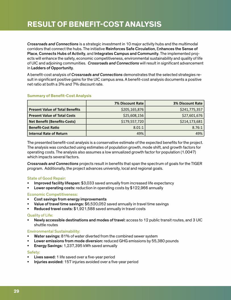
RESULT OF BENEFIT-COST ANALYSIS
Crossroads and Connections is a strategic investment in 10 major activity hubs and the multimodal corridors that connect the hubs. The initiative Reinforces Safe Circulation, Enhances the Sense of Place, Connects Hubs of Activity, and Integrates Campus and Community. The implemented proj-ects will enhance the safety, economic competitiveness, environmental sustainability and quality of life of UIC and adjoining communities. Crossroads and Connections will result in significant advancement in Ladders of Opportunity.
A benefit-cost analysis of Crossroads and Connections demonstrates that the selected strategies re-sult in significant positive gains for the UIC campus area. A benefit-cost analysis documents a positive net ratio at both a 3% and 7% discount rate.
Summary of Benefit-Cost Analysis
The presented benefit-cost analysis is a conservative estimate of the expected benefits for the project. The analysis was conducted using estimates of population growth, mode shift, and growth factors for operating costs. The analysis also assumes a low annualized growth factor for population (1.0047) which impacts several factors.
Crossroads and Connections projects result in benefits that span the spectrum of goals for the TIGER program. Additionally, the project advances university, local and regional goals.
State of Good Repair:• Improved facility lifespan: $3,033 saved annually from increased life expectancy• Lower operating costs: reduction in operating costs by $122,966 annually
Economic Competitiveness:• Cost savings from energy improvements• Value of travel time savings: $6,520,052 saved annually in travel time savings• Reduced travel costs: $1,921,588 saved annually in travel costs
Quality of Life:• Newly accessible destinations and modes of travel: access to 12 public transit routes, and 3 UIC
shuttle routes
Environmental Sustainability:• Water savings: 81% of water diverted from the combined sewer system• Lower emissions from mode diversion: reduced GHG emissions by 55,380 pounds• Energy Savings: 1,237,395 kWh saved annually
Safety:• Lives saved: 1 life saved over a five-year period• Injuries avoided: 157 injuries avoided over a five-year period
29
7% Discount Rate 3% Discount RatePresent Value of Total Benefits $205,165,876 $241,775,357Present Value of Total Costs $25,608,156 $27,601,676Net Benefit (Benefits-Costs) $179,557,720 $214,173,681Benefit-Cost Ratio 8.01:1 8.76:1Internal Rate of Return 49% 49%
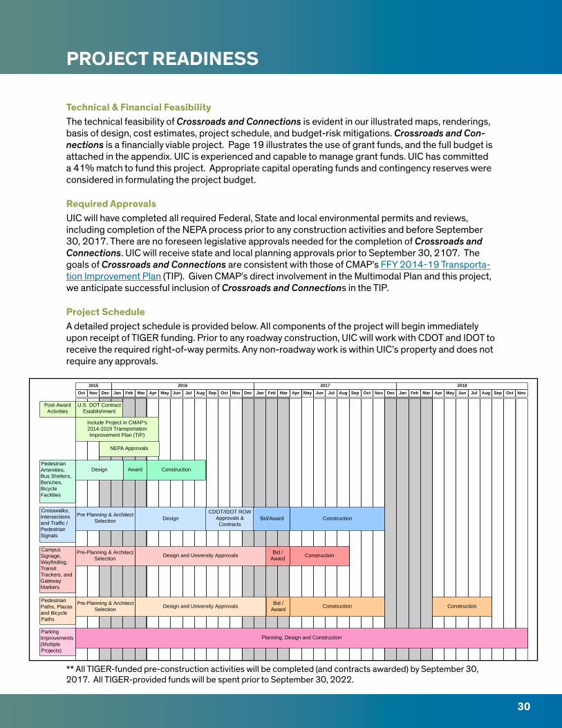
PROJECT READINESS
30
** All TIGER-funded pre-construction activities will be completed (and contracts awarded) by September 30, 2017. All TIGER-provided funds will be spent prior to September 30, 2022.
Technical & Financial FeasibilityThe technical feasibility of Crossroads and Connections is evident in our illustrated maps, renderings, basis of design, cost estimates, project schedule, and budget-risk mitigations. Crossroads and Con-nections is a financially viable project. Page 19 illustrates the use of grant funds, and the full budget is attached in the appendix. UIC is experienced and capable to manage grant funds. UIC has committed a 41% match to fund this project. Appropriate capital operating funds and contingency reserves were considered in formulating the project budget.
Required ApprovalsUIC will have completed all required Federal, State and local environmental permits and reviews, including completion of the NEPA process prior to any construction activities and before September 30, 2017. There are no foreseen legislative approvals needed for the completion of Crossroads and Connections. UIC will receive state and local planning approvals prior to September 30, 2107. The goals of Crossroads and Connections are consistent with those of CMAP’s FFY 2014-19 Transporta-tion Improvement Plan (TIP). Given CMAP’s direct involvement in the Multimodal Plan and this project, we anticipate successful inclusion of Crossroads and Connections in the TIP.
Project ScheduleA detailed project schedule is provided below. All components of the project will begin immediately upon receipt of TIGER funding. Prior to any roadway construction, UIC will work with CDOT and IDOT to receive the required right-of-way permits. Any non-roadway work is within UIC’s property and does not require any approvals.

APPENDIX
i
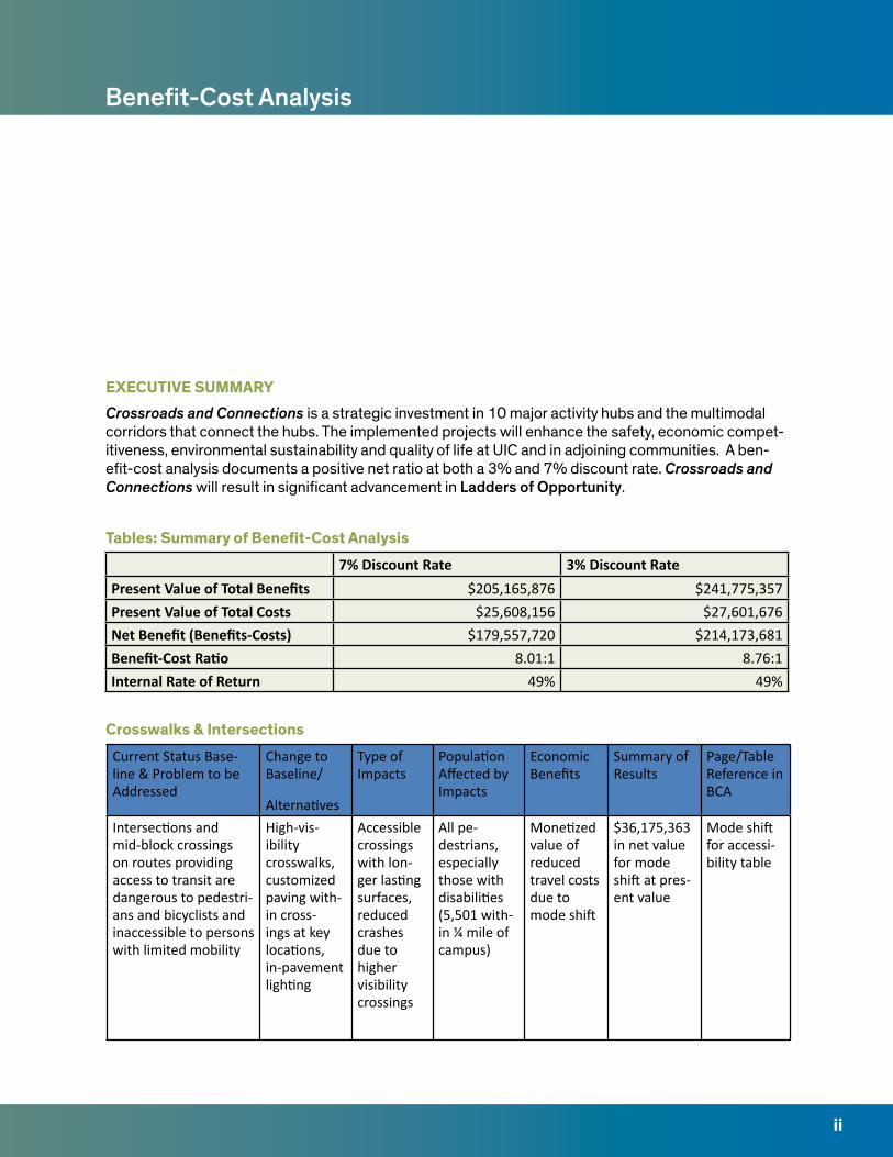
7% Discount Rate 3% Discount RatePresent Value of Total Benefits $205,165,876 $241,775,357Present Value of Total Costs $25,608,156 $27,601,676Net Benefit (Benefits-Costs) $179,557,720 $214,173,681Benefit-Cost Ratio 8.01:1 8.76:1Internal Rate of Return 49% 49%
ii
Benefit-Cost Analysis
EXECUTIVE SUMMARYCrossroads and Connections is a strategic investment in 10 major activity hubs and the multimodal corridors that connect the hubs. The implemented projects will enhance the safety, economic compet-itiveness, environmental sustainability and quality of life at UIC and in adjoining communities. A ben-efit-cost analysis documents a positive net ratio at both a 3% and 7% discount rate. Crossroads and Connections will result in significant advancement in Ladders of Opportunity.
Tables: Summary of Benefit-Cost Analysis
Crosswalks & Intersections
Current Status Base-line & Problem to be Addressed
Change to Baseline/
Alternatives
Type of Impacts
Population Affected by Impacts
Economic Benefits
Summary of Results
Page/Table Reference in BCA
Intersections and mid-block crossings on routes providing access to transit are dangerous to pedestri-ans and bicyclists and inaccessible to persons with limited mobility
High-vis-ibility crosswalks, customized paving with-in cross-ings at key locations, in-pavement lighting
Accessible crossings with lon-ger lasting surfaces, reduced crashes due to higher visibility crossings
All pe-destrians, especially those with disabilities (5,501 with-in ¼ mile of campus)
Monetized value of reduced travel costs due to mode shift
$36,175,363 in net value for mode shift at pres-ent value
Mode shift for accessi-bility table
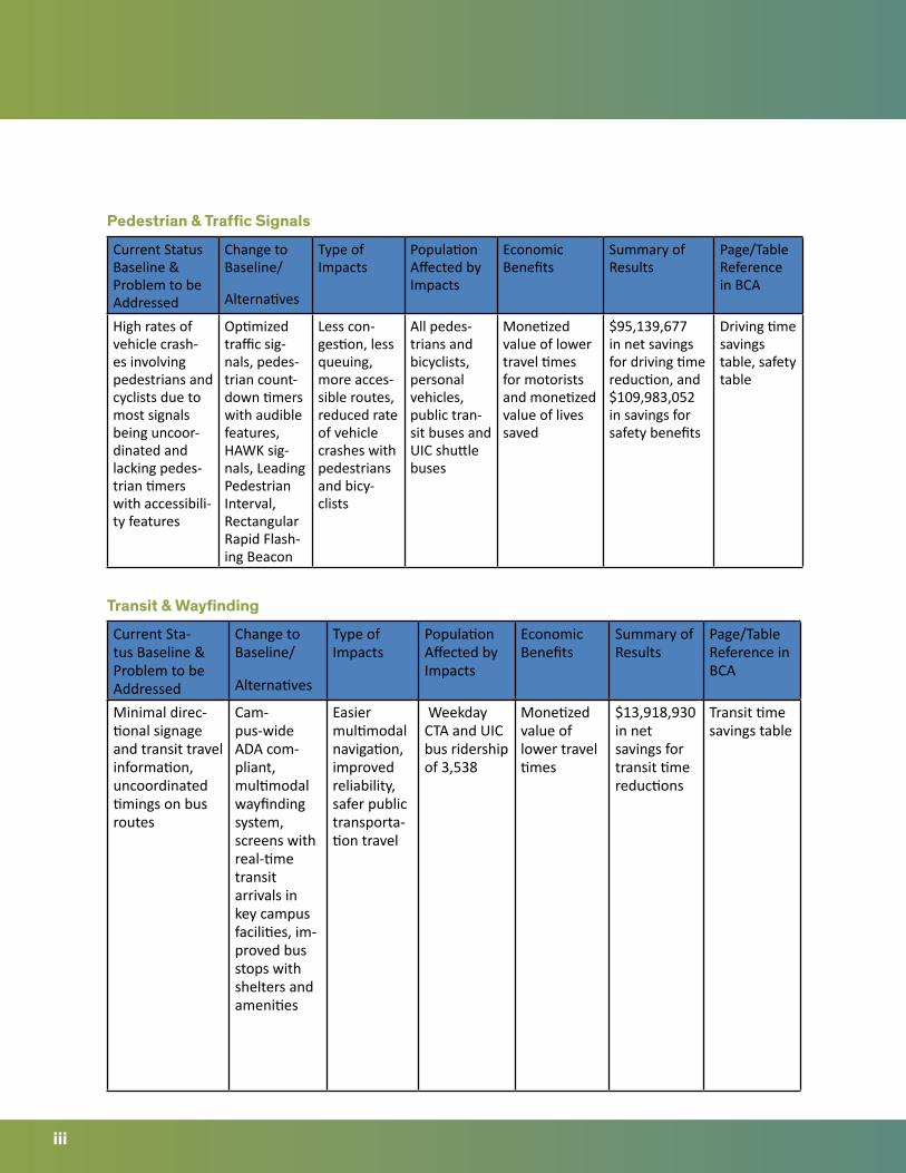
iii
Pedestrian & Traffic Signals
Transit & Wayfinding
Current Status Baseline & Problem to be Addressed
Change to Baseline/
Alternatives
Type of Impacts
Population Affected by Impacts
Economic Benefits
Summary of Results
Page/Table Reference in BCA
High rates of vehicle crash-es involving pedestrians and cyclists due to most signals being uncoor-dinated and lacking pedes-trian timers with accessibili-ty features
Optimized traffic sig-nals, pedes-trian count-down timers with audible features, HAWK sig-nals, Leading Pedestrian Interval, Rectangular Rapid Flash-ing Beacon
Less con-gestion, less queuing, more acces-sible routes, reduced rate of vehicle crashes with pedestrians and bicy-clists
All pedes-trians and bicyclists, personal vehicles, public tran-sit buses and UIC shuttle buses
Monetized value of lower travel times for motorists and monetized value of lives saved
$95,139,677 in net savings for driving time reduction, and $109,983,052 in savings for safety benefits
Driving time savings table, safety table
Current Sta-tus Baseline & Problem to be Addressed
Change to Baseline/
Alternatives
Type of Impacts
Population Affected by Impacts
Economic Benefits
Summary of Results
Page/Table Reference in BCA
Minimal direc-tional signage and transit travel information, uncoordinated timings on bus routes
Cam-pus-wide ADA com-pliant, multimodal wayfinding system, screens with real-time transit arrivals in key campus facilities, im-proved bus stops with shelters and amenities
Easier multimodal navigation, improved reliability, safer public transporta-tion travel
Weekday CTA and UIC bus ridership of 3,538
Monetized value of lower travel times
$13,918,930 in net savings for transit time reductions
Transit time savings table
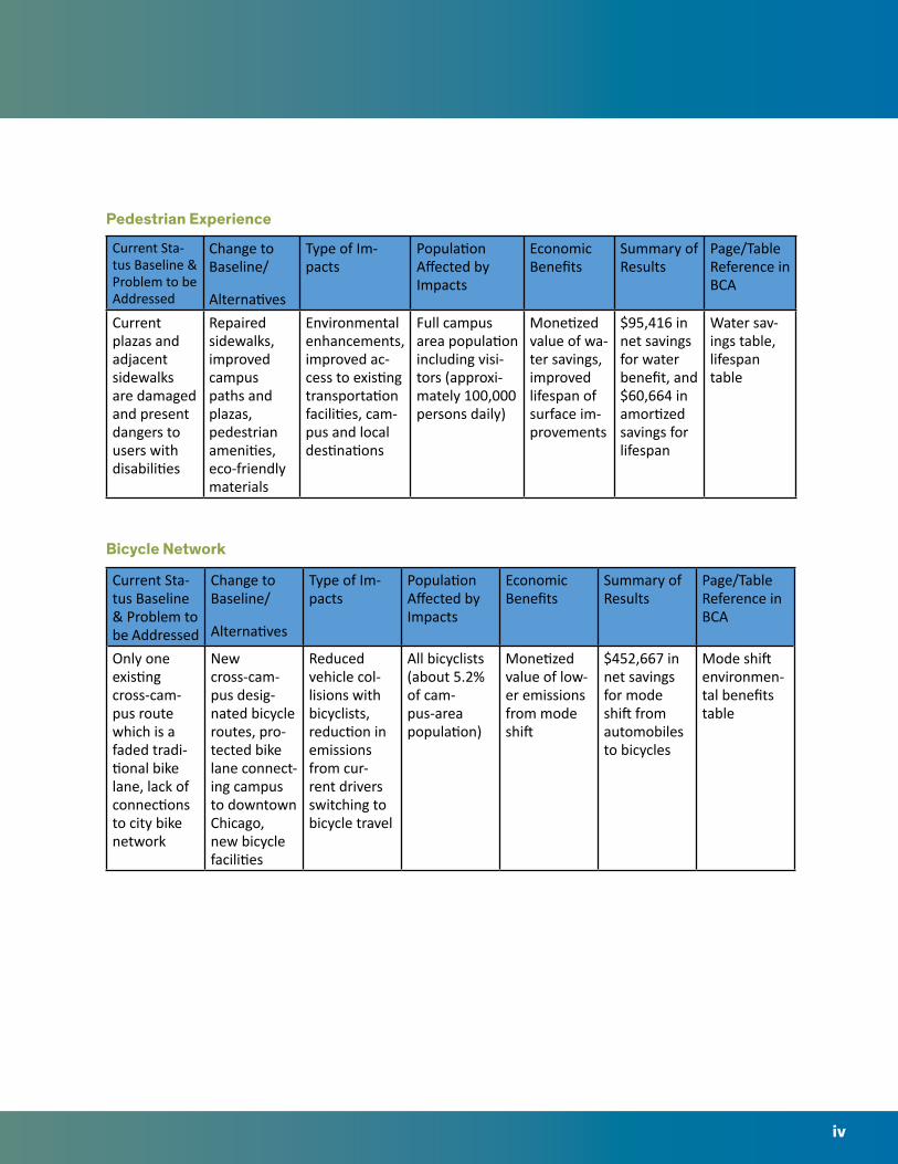
iv
Pedestrian Experience
Bicycle Network
Current Sta-tus Baseline & Problem to be Addressed
Change to Baseline/
Alternatives
Type of Im-pacts
Population Affected by Impacts
Economic Benefits
Summary of Results
Page/Table Reference in BCA
Current plazas and adjacent sidewalks are damaged and present dangers to users with disabilities
Repaired sidewalks, improved campus paths and plazas, pedestrian amenities, eco-friendly materials
Environmental enhancements, improved ac-cess to existing transportation facilities, cam-pus and local destinations
Full campus area population including visi-tors (approxi-mately 100,000 persons daily)
Monetized value of wa-ter savings, improved lifespan of surface im-provements
$95,416 in net savings for water benefit, and $60,664 in amortized savings for lifespan
Water sav-ings table, lifespan table
Current Sta-tus Baseline & Problem to be Addressed
Change to Baseline/
Alternatives
Type of Im-pacts
Population Affected by Impacts
Economic Benefits
Summary of Results
Page/Table Reference in BCA
Only one existing cross-cam-pus route which is a faded tradi-tional bike lane, lack of connections to city bike network
New cross-cam-pus desig-nated bicycle routes, pro-tected bike lane connect-ing campus to downtown Chicago, new bicycle facilities
Reduced vehicle col-lisions with bicyclists, reduction in emissions from cur-rent drivers switching to bicycle travel
All bicyclists (about 5.2% of cam-pus-area population)
Monetized value of low-er emissions from mode shift
$452,667 in net savings for mode shift from automobiles to bicycles
Mode shift environmen-tal benefits table
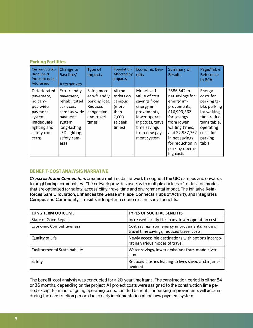
v
Parking Facilities
BENEFIT-COST ANALYSIS NARRATIVECrossroads and Connections creates a multimodal network throughout the UIC campus and onwards to neighboring communities. The network provides users with multiple choices of routes and modes that are optimized for safety, accessibility, travel time and environmental impact. The initiative Rein-forces Safe Circulation, Enhances the Sense of Place, Connects Hubs of Activity, and Integrates Campus and Community. It results in long-term economic and social benefits.
The benefit-cost analysis was conducted for a 20-year timeframe. The construction period is either 24 or 36 months, depending on the project. All project costs were assigned to the construction time pe-riod except for minor ongoing operating costs. Limited benefits for parking improvements will accrue during the construction period due to early implementation of the new payment system.
LONG TERM OUTCOME TYPES OF SOCIETAL BENEFITSState of Good Repair Increased facility life spans, lower operation costsEconomic Competitiveness Cost savings from energy improvements, value of
travel time savings, reduced travel costsQuality of Life Newly accessible destinations with options incorpo-
rating various modes of travelEnvironmental Sustainability Water savings, lower emissions from mode diver-
sionSafety Reduced crashes leading to lives saved and injuries
avoided
Current Status Baseline & Problem to be Addressed
Change to Baseline/
Alternatives
Type of Impacts
Population Affected by Impacts
Economic Ben-efits
Summary of Results
Page/Table Reference in BCA
Deteriorated pavement, no cam-pus-wide payment system, inadequate lighting and safety con-cerns
Eco-friendly pavement, rehabilitated surfaces, campus-wide payment system, long-lasting LED lighting, safety cam-eras
Safer, more eco-friendly parking lots, Reduced congestion and travel times
All mo-torists on campus (more than 7,000 at peak times)
Monetized value of cost savings from energy im-provements, lower operat-ing costs, travel time savings from new pay-ment system
$686,842 in net savings for energy im-provements, $16,999,862 for savings from lower waiting times, and $2,987,762 in net savings for reduction in parking operat-ing costs
Energy costs for parking ta-ble, parking lot waiting time reduc-tions table, operating costs for parking table
vi
PROJECT COSTSThe project costs include construction labor and materials. “Hard” and “soft” construction costs have all been monetized and incorporated into the relevant years of the analysis. Operating costs were included only for the individual factors that result in changes in operating costs.
The construction activities should pose minimal impact on adjacent communities. Roadway improve-ments are to be conducted within current right-of-way and the work can be completed with only minimal lane closures. Parking lot and structure improvements have been scheduled for nonpeak times during the campus summer session. Plaza construction will require some temporary closures to account for public safety but construction impact is sufficiently minimal therefore no calculations were made at this time.
PROJECT BENEFITSThe project benefits are evident in each of the primary TIGER selection criteria and benefits for all projects were considered with the “no-build” alternative. The included tables demonstrate the differ-ence in the monetized values that represent the benefits. The analysis was conducted using conser-vative estimates for population growth, mode shift, and growth factors for operating costs. Population growth factors were determined using CMAP’s GO TO 2040 population projections. The annualized growth factor for population is 1.0047. Growth factors used for operating costs were obtained using regional electricity rate information. Conservative assumptions were also used for elements specific to the individual benefits calculations.
The project locations and project elements were selected to ensure maximum value for people of all abilities travelling via many modes of transportation. The project improvements result in significant changes that will enhance state of good repair, foster environmental sustainability, enrich quality of life, and promote economic competiveness.
The benefit-cost analysis does not include any transfers or economic impacts. We do expect that the project will have positive economic impact from improved access to local businesses, events and em-ployment. The analysis only includes societal benefits.
References for assumed benefit and cost calculations are included in the individual tables. Data limita-tions and assumptions for individual calculations are also included in the attached tables.
State of Good RepairThe Lifespans and Energy Savings tables outline project features with amortized capital costs. Chang-es in operating costs were included before calculating the net annual savings. The build cost is the expected costs for the planned improvements. The cost foregone is the expected cost that would have been incurred for the baseline alternative. The benefits included are the net benefits after accounting for the amortized capital costs.
Crossroads and Connections project results in two primary State of Good Repair benefits:
•Improvedfacilitylifespan•Loweroperatingcosts
vii
Economic CompetitivenessCrossroads and Connections improves numerous intersections by optimizing traffic signals. The routes were selected to benefit the busiest university, local and regional bus lines. The improved in-tersections will result in more reliable and faster travel times. The benefit-cost analysis, which utilizes conservative ridership estimates, includes the impact on UIC, CTA and Pace bus riders. For CTA riders, the ridership is based on the number of weekday boardings in each respective activity hub. It does not include riders already onboard before the bus enters the area, nor weekend riders. Pace and UIC rider-ship was measured by the number of onboard customers and was limited to weekday riders. Motorists also benefit from optimized traffic signals resulting in shorter travel times. Average daily traffic counts were used to estimate number of motorists affected. The value for freight traffic was not monetized due to insufficient data. Two of the optimized corridors are primary truck routes.
Three parking structures will receive full lighting retrofits. All structures currently have high-pressure sodium lamps that are inefficient and need to be replaced every three years. All lamps will be replaced with energy efficient LED bulbs that will save energy, electricity costs and provide a longer life span. Parking facilities will receive a new payment system that reduces waiting time and increases capacity. The payment system also allows for a significant decrease in operating costs.
The economic competiveness of Crossroads and Connections can be established by:• Costsavingsfromenergyimprovements• Valueoftraveltimesavings• Reducedtravelcosts
Quality of Life Crossroads and Connections Integrates Campus and Community. By rehabilitating sidewalks and paths, providing new bicycle routes, and accessible intersection and mid-block crossings, the project opens up campus spaces to visitors and area residents. It provides the university community easier access to neighborhood amenities including parks, business districts, schools and museums. The enhanced access cannot be easily monetized, but is certainly significant.
The human experience is significantly enhanced by this initiative. The campus community gains access to new plazas, seating, accessible pedestrian paths, landscaping and wayfinding. These elements can-not be monetized on their own, but they result in a fully integrated campus and community.
People with disabilities are burdened by poor sidewalks, inaccessible intersection signals and facilities, wayfinding that lacks ADA compliance, and busy roadways. Crossroads and Connections ensures that all key routes leading to transit are accessible. This opens up a wider set of travel modes and desti-nations to people with disabilities. There are 5,501 persons with disabilities currently living within ¼ mile of the UIC campus. The total daily campus area disability population is significantly higher due to uncounted transient population at the four area hospitals (i.e. people with disabilities going to medical appointments) and UIC lacking a campus-wide tally of students and employees with disabilities.
The Accessibility table outlines the expected benefits for elderly and people with disabilities in gaining safe access to transit. The National Household Travel Survey figures were used to estimate travel pat-terns for the population of elderly and persons with disabilities near UIC. This population will shift mode of travel from personal vehicle to transit when roadway improvements, identical to those proposed in Crossroads and Connections, are implemented. The calculations assume a conservative 2% shift of travel by the subpopulation to transit, and results in significant reductions in travel expenses.The Quali-ty of Life in the university area is enhanced by:
• Newly accessible destinations and modes of travel
viii
Environmental Sustainability UIC is committed to being a climate-forward institution. Two parking lots and three plazas will receive porous concrete or permeable pavers. Water benefits accrue from the replacement of concrete and asphalt with porous material. This results in the significant savings of more than 1.7 million gallons of water per year. Due to the efficient Chicago-area water treatment system, the monetized costs are minor. Water savings monetization was conducted using marginal costs assuming that the quantity of water diverted was small enough to not require the use of full costs. The amount of heat emitted from parking areas and plazas will be reduced with the use of eco-friendly surfaces. However, we could not find an accurate estimate of the climate impact of this improvement.
Crossroads and Connections encourages people to use active transportation for trips within the uni-versity campus and to adjoining neighborhoods. The Multimodal Transportation Plan: Existing Condi-tions Report included a survey in which 28% of respondents revealed that they did not feel safe riding a bicycle on campus. Crossroads and Connections will address this issue by providing next-genera-tion bicycle facilities and intersections optimized for safety. The Multimodal Transportation Plan doc-umented that 14% of campus users drive a personal vehicle to and from campus. We assume that at most 28% of the 14% (=28% of 14%= 3.92%) of current drivers may switch from personal vehicle to bicycle after project improvements are completed. In efforts to calculate conservatively, we conduct-ed the benefit-cost analysis assuming only 1.96% of drivers will switch from car to bicycle (½ of the 3.92% high factor). The mode shift from driving to cycling results in savings from lower greenhouse gas emissions.
Crossroads and Connections projects result in these monetized environmental benefits:• Watersavings• Loweremissionsfrommodaldiversion
SafetyAt a monetized value, safety improvements account for the largest share of benefits resulting from Crossroads and Connections. Over 40 intersections and mid-block crossings will receive specific improvements to better pedestrian safety. High risk intersections and crossings were chosen after receiving vehicle crash data from 2008-2012 from the Illinois Department of Transportation (IDOT). Vehicle crashes with pedestrians and bicyclists were mapped and analyzed based on crash type, injury severity and cause of crash. After converting these crashes from KABCO format to Abbreviated Injury Scale (AIS), crash reduction factors from the Federal Highway Administration were used to determine the expected percent reduction in crashes. It is calculated that all of the proposed improvements will reduce vehicle crashes with pedestrians and bicyclists by 62%. The reduced crashes were then mone-tized using TIGER guidance based on injury severity and property damage. The attached spreadsheets illustrate the KABCO to AIS conversion, crash reduction factors and the value of crash savings.
The safety calculations are conservative in that they only include crashes involving pedestrians and bicyclists. It is likely that some additional crashes will also be avoided on the streets receiving new roadway improvements.
Safety enhancements result in these monetized benefits:• Livessaved• Injuriesavoided
ix
Letters of SupportPlease find evidence of community support and commitment of matching funds for Crossroads and Connections by visiting our TIGER website.
Federal Wage Rate Certificate