croydon local plan · • all existing sites of nature conservation importance ... a new leisure...
TRANSCRIPT

Croydon Local PlanProposed Submission
Summary of Proposals
September 2016

Croydon Local Plan: (Proposed Submission draft)
A Development Plan forming part of the Croydon Local PlanPublication in accordance with Regulation 19 of the Town and Country Planning (Local Planning) (England) Regulations 2012
5 September – 17 October 2016
Published by Spatial Planning service London Borough of Croydon Bernard Weatherill House 8 Mint Walk Croydon CR0 1EA
www.croydon.gov.uk/localplanone www.croydon.gov.uk/localplantwo [email protected] 020 8407 1385
All maps in this document reproduced by permission of Ordnance Survey On behalf of HMSO. © Crown copyright and Database right 2016. Ordnance Survey Licence Number 100019257
0302

IntroductionCroydon is a growing borough. It is already the most populous borough in London and aims to be London’s most enterprising borough. Planning is critical to ensuring that Croydon meets the needs of its residents, business community and visitors. The Croydon Local Plan sets out the strategy, sites and planning policies necessary to meet these needs.
The Croydon Local Plan is split into two documents, the Strategic Policies (formerly known as the Core Strategy) which was subject to independent examination by a planning inspector in September 2012 and adopted on 23 April 2013; and this document, the Croydon Local Plan: Detailed Policies and Proposals. Added to these two plans is the South London Waste Plan adopted in 2012 which provides detailed policies for determining applications for waste facilities.
The Croydon Local Plan
The Croydon Local Plan: Strategic Policies sets out the issues that the Plan as a whole is addressing and the strategic policy framework. A partial review of the Croydon Local Plan: Strategic Policies is being prepared alongside the Detailed Policies and Proposals to extend the period the Local Plan covers so that it expires in 2036 and not 2031. The partial review will also update the borough’s housing targets in the light of changes to the London Plan that were adopted in Spring 2015 and also an updated assessment of Croydon’s need for new homes.
Detailed planning policies that will help put the strategic policy framework into practice when determining planning applications will be set out in the Croydon Local Plan: Detailed Policies and Proposals. In addition, the Croydon Local Plan: Detailed Policies and Proposals allocates specific sites for development up to 2036 to meet the requirements of the Strategic Policies.
The Croydon Local Plan: Detailed Policies and Proposals will assist the regeneration of the borough through the setting of firm planning framework that will provide certainty to the community and developers.
South London Waste Plan (adopted January 2012)
Croydon Local Plan: Detailed Policies and Proposals
Croydon Local Plan: Strategic Policies
(adopted April 2013 with Partial Review now underway)
0302

What the Croydon Local Plan means in your PlaceThroughout the borough most designations are largely unchanged from how they were designated in the Replacement Unitary Development Plan including:
• Most Employment Area designations are unchanged (Policy SP3);
• Conservation Areas, Registered Historic Parks & Gardens and Scheduled Monuments (as these are not designated by the Local Plan) (Policy SP4);
• All but one of the borough’s Local List of Historic Parks and Gardens (Promenade de Verdun is now a Registered Historic Park and Garden) (Policy SP4);
• Many Local Designated Views and Local Designated Landmarks (Policy SP4);
• The majority of the borough’s Metropolitan Green Belt (Policy SP7);
• Almost all the borough’s Metropolitan Open Land (Policy SP7);
• The majority of boundaries and designated frontages in the borough’s District and Local Centres (Policy DM5);
• Most Shopping Parades are unchanged (Policy DM7); and
• All existing Sites of Nature Conservation Importance (Policy DM28).
0504

This section details the key changes proposed in the Croydon Local Plan in each Place. The key changes are summarised below (not all of which apply to every Place):
• Changes to the approach to delivering affordable housing on major residential developments (Policy SP2);
• There are some changes to Employment designations (Policy SP3);
• Local Heritage Areas replace Local Areas of Special Character (Policy SP4);
• Many new Croydon Panoramas, Local Designated Views and Local Designated Landmarks (Policy SP4);
• Some minor additions to Metropolitan Green Belt (Policy SP7);
• Limited re-designation of Metropolitan Green Belt to Metropolitan Open Land or Local Green Space and Metropolitan Open Land to Local Green Space where the area does not meet the national criteria for designation as Metropolitan Green Belt or the London Plan criteria for designation as Metropolitan Open Land (Policies SP7 and DM27);
• Limited de-designation of Metropolitan Open Land where the area does not meet the criteria the London Plan criteria for designation as Metropolitan Open Land or the local criteria for designation as Local Green Space;
• Some changes to boundaries and frontages in Croydon Metropolitan Centre and some of the District and Local Centres (Policy DM5);
• New Neighbourhood Centre designations (Policy DM6);
• Some new and amended Shopping Parades and some de-designations of Shopping Parades which no longer have a local retail function (Policy DM7);
• A new Restaurant Quarter Parade in the Croydon Opportunity Area (Policy DM8);
• New policy on promoting healthy communities (Policy DM17);
• Local Green Spaces replace Local Open Land providing greater protection to the most important local open spaces in the borough (Policy DM27);
• Nine new Sites of Nature Conservation Importance (Policy DM28);
• Place-specific development management policies for most Places; and
• Detailed Proposals for 139 sites in the borough to deliver between 8,335 and 20,279 new homes, schools, health care facilities and jobs.
0504

18 additions to Metropolitan Green Belt and Metropolitan Open
Land across the borough, 3 re-designations and one area
of Metropolitan Open Land de-designated (Policy SP7)
New office retention area around East Croydon station to protect the
office core of the borough (Policy SP3)
Borough as a whole 25 new Local Heritage Areas protecting areas which have local
historic significance (Policy SP4)
Amendments to boundaries and designation of Gloucester Road
industrial area(Policy SP3)
27 new Panoramas, Views and Landmarks across the borough
(Policy SP4)
31,850 new homes across borough with minimum requirement of 30%
of all new homes on larger sites to be affordable (Policy SP2)
1 new Local Centre,
18 new Neighbourhood Centres,
10 new Shopping Parades and 5 de-designated Shopping
Parades to meet the needs for local shops, services and community facilities
(Policies DM5 – DM7)
85 new Local Green Spaces across the borough to provide the same
protection to important local open spaces as applies to Green
Belt and Metropolitan Open Land (Policy DM27)
9 new Sites of Nature Conservation Importance
(Policy DM28)
5 areas of focussed intensification in places with existing services and
access to public transport (Policy DM35.4)
139 sites allocated across all 16 Places for residential development,
new schools, healthcare facilities and other mixed use developments to help meet the need for homes and social
infrastructure in Croydon (Policies DM36 – DM51)
29 Place-specific policies in locations across the borough
to guide the design of new developments in to ensure an
improvement to local character (Policies DM36 – DM51)
Sustainable growth of the suburbs across Croydon using local character
to inform how new development can be accommodated to help
meet housing need without loss of open spaces or destruction
of local character (Policy DM35)
0706

AddingtonPlace-specific policies for New
Addington District Centre(Policy DM36)
New Croydon Panorama designated from North Down Crescent of
Addington Palace and Shirley Hills (Policy SP4)
Some minor extensions of Metropolitan Green Belt including
Addington Vale and Milne Park (Policy SP7)
New Neighbourhood Centre at Fieldway
(Policy DM6)
Amendment to Headley Drive Shopping Parade (Policy DM7)
New Local Green Space at Castle Hill Avenue providing the same level of
protection as applies to Green Belt to this important open space
(Policy DM27)
3 sites proposed for development for between 124 and 488 homes, a new leisure centre, retailing and
community facilities at Central Parade West, and a new Secondary School on land west of Timebridge
Community Centre to help meet the need for school places in the borough
(Policy DM36)
0706

Area of focussed intensification proposed around Shirley Road
Shopping Parade (Policy DM35)
AddiscombeNew Local Heritage Areas at
Addiscombe College Estate and Bingham Road (Policy SP4)
New Local Designated View from Sandilands of No.1 Croydon
(Policy SP4)
Amendments to boundaries and frontages in the District Centre, removing some fringe areas and extending frontages
(Policy DM5)
New Neighbourhood Centres at Ashburton Park and
Lower Addiscombe Road/ Cherry Orchard Road
(Policy DM6)
Place-specific policies for Addiscombe District Centre and the Area between Addiscombe Railway
Park & Lower Addiscombe Road (section between Leslie Park Road &
Grant Road) (Policy DM37)
3 sites proposed for development for between 33 and 133 homes and
a new Secondary School on Morland Road (Policy DM37)
New Site of Nature Conservation Importance at Whitgift Pond
(Policy DM28)
New Local Green Spaces at Addiscombe Railway Park,
Addiscombe Recreation Ground, Ashburton Park, Darnell Road Recreation Ground, Little Road Playground and Whitgift Pond
(Policy DM27)
New Shopping Parade at Lower Addiscombe Road/Davidson Road,
and Shirley Road/Bingham Road and de-designation of Morland Road
Shopping Parade (Policy DM7)
0908

Broad Green and Selhurst New Shopping Parade at London Road/Fairholme Road and London
Road/Nova Place and amendment to Whitehorse Road Shopping Parade
(Policy DM7)
Amendments to boundaries and designation of Gloucester Road
industrial area (Policy SP3)
New Local Heritage Areas at Henderson Road and London Road
(Policy SP4)
Amendments to boundaries and frontages in Broad Green Local Centre, removing some fringe areas and extending frontages
(Policy DM5)
New Neighbourhood Centres at Selhurst Road and London Road/
Kidderminster Road (Policy DM6)
Place-specific policies for Broad Green Local Centre, Valley Park,
the Area of Lombard Roundabout, the area north of Broad Green
Local Centre and the area of the junction of Windmill Road and
Whitehorse Road (Policy DM38)
New Local Green Spaces at Boulogne Road Playground, Canterbury Road Recreation
Ground, King George’s Field, Queen’s Road Cemetery, Whitehorse Road
Recreation Ground and Wilford Road Playground
(Policy DM27)
13 sites proposed for development for between 596 and 1,885 homes, new Primary Schools near Croydon
AFC stadium and at Canterbury Mills and mixed use developments in the
Purley Way area (Policy DM38)
0908

Coulsdon
A minor extension of Metropolitan Green Belt to include the Coulsdon
Iron Railway Embankment (Policy SP7)
New Local Heritage Areas at Chipstead Valley Road (St. Dunstan’s
Cottages), Station Approach (Coulsdon), Stoats Nest Village and
The Dutch Village(Policy SP4)
New Local Designated View from Woodcote Grove Road of Cane Hill
and St Andrew’s Church and two de-designated views from Brighton Road of Cane Hill and from Portnallls Road
of St Andrew’s Church (Policy SP4)
Cane Hill Water Tower and St. Andrew’s Church are designated Landmarks
(Policy SP4)
New Local Green Spaces at Chaldon Way Gardens, Coulsdon Coppice
(North), Coulsdon Memorial Ground,Land rear of Hilliars Heath
Road and Scrub Shaw (Policy DM27)
4 sites proposed for development for between 705 and 740 homes and a new Secondary School on Portnalls Road, mixed use development and car parking at Lion Green Road car park and continuing support for the
development at Cane Hill (Policy DM39)
1110
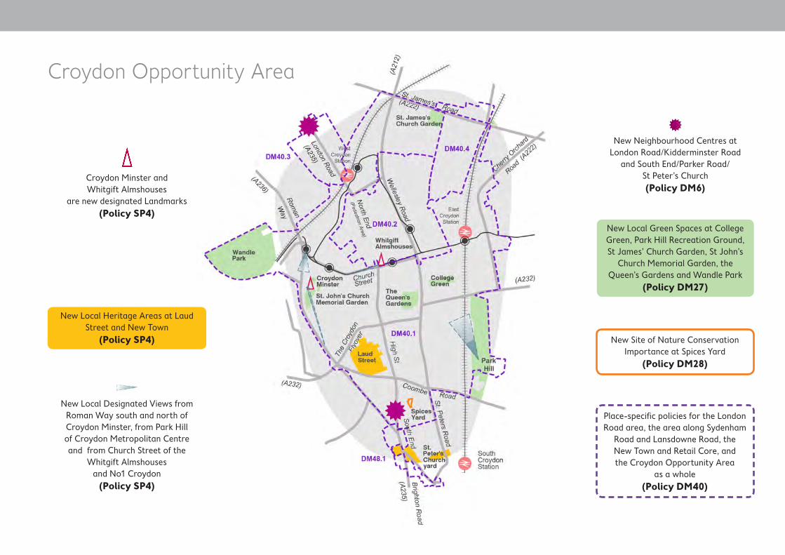
Croydon Opportunity Area
New Local Heritage Areas at Laud Street and New Town
(Policy SP4)
New Local Designated Views from Roman Way south and north of Croydon Minster, from Park Hill of Croydon Metropolitan Centre and from Church Street of the
Whitgift Almshouses and No1 Croydon
(Policy SP4)
Croydon Minster and Whitgift Almshouses
are new designated Landmarks (Policy SP4)
New Neighbourhood Centres at London Road/Kidderminster Road
and South End/Parker Road/ St Peter’s Church (Policy DM6)
New Local Green Spaces at College Green, Park Hill Recreation Ground, St James’ Church Garden, St John’s
Church Memorial Garden, the Queen’s Gardens and Wandle Park
(Policy DM27)
New Site of Nature Conservation Importance at Spices Yard
(Policy DM28)
Place-specific policies for the London Road area, the area along Sydenham
Road and Lansdowne Road, the New Town and Retail Core, and the Croydon Opportunity Area
as a whole (Policy DM40)
1110

Croydon Opportunity Area
New Office Retention Area around East Croydon station and New Town
(Policy SP3)
Amendments to boundaries and frontages in the Metropolitan Centre,
extending the retail core area to as far as Wellesley Road and along
George Street towards East Croydon station
(Policy DM5)
New Restaurant Quarter Parade in South End
(Policy DM8)
New Shopping Parade at London Road/Mead Place (Policy DM7)
Multiple sites proposed for development across the Opportunity
Area for between 5,031 and 11,122 homes, retail development,
healthcare facilities, offices and new primary schools (Policy DM40)
1312

Crystal Palace and Upper Norwood
New Local Heritage Area at Auckland Road (Policy SP4)
Amendments to boundaries and frontages in the District Centre,
extending the retail area and frontages to cover all three sides
of the triangle (Policy DM5)
New Neighbourhood Centre at South Norwood Hill
(Policy DM6)
New Local Green Spaces All Saints with St Margaret’s Churchyard,
Beaulieu Heights, Beulah Hill Pond, Convent Wood, Stambourne Woodland Walk, The Lawns, Upper
Norwood Recreation Ground and Westow Park (Policy DM27)
5 sites proposed for development for between 98 and 338 homes, retail
and a creative and cultural industries enterprise centre (Policy DM41)
1312

Kenley and Old Coulsdon
New Croydon Panoramas from Riddlesdown of Kenley and from Kenley Common of Riddlesdown
(Policy SP4)
Some minor extensions of Green Belt including Bradmore Green; land at Rogers Close; land in Tollers Lane; land on Riddlesdown Road; land
to the rear of Goodenough Close, Middle Close & Weston Close; and St
John the Evangelist’s churchyard (Policy SP7)
New Neighbourhood Centres at Coulsdon Road/Court Avenue and
Kenley (Godstone Road) (Policy DM6)
Amendments to the Shopping Parade at The Parade, Coulsdon Road and de-designation of Old Lodge Lane
Shopping Parade (Policy DM7)
New Local Green Spaces at Bourne Park, Coulsdon Coppice (Bleakfield
Shaw), Coulsdon Coppice (Stoneyfield Shaw), the former Godstone
Road allotments, Foxley Wood & Sherwood Oaks and Higher Drive
Recreation Ground (Policy DM27)
Area of focussed intensification proposed in the area between Kenley
station and Godstone Road (Policy DM35)
1 site proposed for development for 12 homes
(Policy DM42)
1514

Norbury
New Local Heritage Areas at Beatrice Avenue, London Road (Norbury), and
Pollards Hill South (Policy SP4)
Amendments to boundaries and frontages in Norbury District Centre,
removing some fringe areas (Policy DM5)
Amendments to boundaries and frontages in Pollards Hill Local
Centre, removing some fringe areas (Policy DM5)
New Neighbourhood Centre at Green Lane/Northwood Road
(Policy DM6)
New Local Green Spaces at Biggin Wood, Green Lane Sports Ground, Norbury Hall, Norbury Park and
Pollards Hill (Policy DM27)
Place-specific policies for Norbury District Centre and Pollards Hill
Local Centre (Policy DM43)
3 sites proposed for development for between 12 and 38 homes
(Policy DM43)
1514

Purley Downs Golf Course re-designated as Metropolitan Open
Land with some minor extensions but no change in level of protection
(Policy SP7)
Purley
New Local Heritage Area (Brighton Road (Purley) in the town centre
(Policy SP4)
Amendments to boundaries and frontages in the District Centre,
removing some fringe areas (Policy DM5)
New Neighbourhood Centre at Brighton Road/Downlands Road
(Policy DM6)
New Shopping Parade at Brighton Road/Biddulph Road, amendment to Grovelands Shopping Parade
and de-designation of Royal Oak Shopping Parade (Policy DM7)
New Local Green Spaces at Copse Hill Spinney, Foxley Wood &
Sherwood Oaks, Promenade de Verdun, Roke Playspace, Rotary
Field and Woodcote Village Green (Policy DM27)
New Site of Nature Conservation Importance at Copse Hill Spinney
(Policy DM28)
15 sites proposed for development for between 462 and 1,994 homes, a new Primary School on Brighton Road, a replacement swimming pool in the District Centre and a Gypsy and
Traveller site at Purley Oaks depot (Policy DM44)
Area of focused intensification propsed around Brighton Road
(Sanderstead Road) Local Centre (Policy DM35)
Place-specific policies for Purley District Centre & its environs, the environs of Reedham station and
the area of the junction of Brighton Road & Purley Downs Road
(Policy DM44)
1716

Purley Downs Golf Course re-designated as Metropolitan Open
Land with some minor extensions but no change in level of protection
(Policy SP7)
Sanderstead
New Local Designated View from Limpsfield Road, near Wentworth
Way, of All Saints’ Church (Policy SP4)
All Saints’ Church is a new designated Landmark
(Policy SP4)
A minor extension of Green Belt to include the Sanderstead
Recreation Ground (Policy SP7)
Other new Local Green Spaces at All Saint’s Churchyard and Graveyard,
Lower Barn Road Green, Purley Beeches and Wettern Tree Garden
(Policy DM27)
New Site of Nature Conservation Importance at Hamsey Green Pond
(Policy DM28)
Place-specific policies for Sanderstead Local Centre and Hamsey Green Local Centre
(Policy DM45)
2 sites proposed for development for between 18 and 46 homes and retail
use (Policy DM45)
Croham Hurst re-designated as Metropolitan Open Land with some minor extensions but no change in
level of protection (Policy SP7)
Sanderstead Plantation re-designated as Local Green Space but with no
change in level of protection (Policy DM27)
Area of focussed intensification proposed around Sanderstead
Local Centre (Policy DM35)
1716

Selsdon Place-specific policy for Selsdon District Centre
(Policy DM46)
Some minor extensions of Green Belt to include the Courtwood Playground,
land between The Bridle Way and Selsdon, and Land between Vale
Border and Selsdon (Policy SP7)
Amendments to boundaries and frontages in the District Centre,
removing some fringe areas and frontages
(Policy DM5)
New Neighbourhood Centre at Selsdon Park Road/ Featherbed Lane
(Policy DM6)
1 site proposed for development for 11 homes and retail use
(Policy DM46)
Area of focussed intensification proposed around Selsdon Park Road/
Featherbed Lane (Policy DM35)
New Sites of Nature Conservation Importance at Falconwood Meadow,
Grounds of Heathfield House and Ladygrove
(Policy DM28)
New Local Designated View from Heathfield of Selsdon and
New Addington (Policy SP4)
Croham Hurst re-designated as Metropolitan Open Land with some minor extensions but no change in
level of protection (Policy SP7)
Sanderstead Plantation re-designated as Local Green Space but with no
change in level of protection (Policy DM27)
Other new Local Green Spaces at Ashen Grove, Selsdon Recreation
Ground and The Ruffet (Policy DM27)
1918
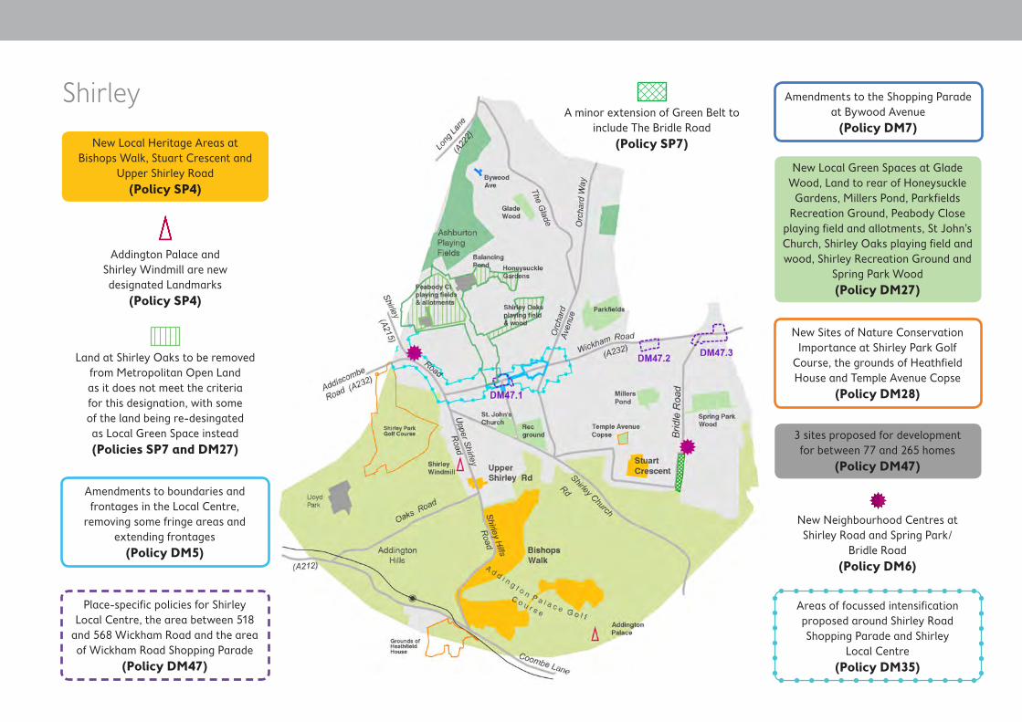
Shirley
New Local Heritage Areas at Bishops Walk, Stuart Crescent and
Upper Shirley Road(Policy SP4)
Addington Palace and Shirley Windmill are new designated Landmarks
(Policy SP4)
Land at Shirley Oaks to be removed from Metropolitan Open Land as it does not meet the criteria for this designation, with some of the land being re-desingated as Local Green Space instead (Policies SP7 and DM27)
A minor extension of Green Belt to include The Bridle Road
(Policy SP7)
Amendments to boundaries and frontages in the Local Centre,
removing some fringe areas and extending frontages
(Policy DM5)
New Neighbourhood Centres at Shirley Road and Spring Park/
Bridle Road (Policy DM6)
Areas of focussed intensification proposed around Shirley Road Shopping Parade and Shirley
Local Centre(Policy DM35)
Place-specific policies for Shirley Local Centre, the area between 518
and 568 Wickham Road and the area of Wickham Road Shopping Parade
(Policy DM47)
Amendments to the Shopping Parade at Bywood Avenue
(Policy DM7)
New Local Green Spaces at Glade Wood, Land to rear of Honeysuckle Gardens, Millers Pond, Parkfields
Recreation Ground, Peabody Close playing field and allotments, St John’s Church, Shirley Oaks playing field and wood, Shirley Recreation Ground and
Spring Park Wood (Policy DM27)
New Sites of Nature Conservation Importance at Shirley Park Golf
Course, the grounds of Heathfield House and Temple Avenue Copse
(Policy DM28)
3 sites proposed for development for between 77 and 265 homes
(Policy DM47)
1918

South CroydonNew Local Heritage Areas at
Birdhurst Road, St Peter’s Road, South End with Ye Market and Spencer
Road/Campden Road (Policy SP4)
St Peter’s Church is a new designated Landmark
(Policy SP4)
Amendments to boundaries and frontages in Brighton Road
(Selsdon Road) and Brighton Road (Sanderstead Road) Local Centres removing some fringe areas and
extending frontages(Policy DM5)
New Neighbourhood Centre at South End/Parker Road/St Peter’s Church
(Policy DM6)
Place-specific policy for Brighton Road (Selsdon Road) Local Centre
(Policy DM48)
New Shopping Parade at Southbridge Road and amendments to
Brighton Road/ Kingsdown Road Shopping Parade (Policy DM7)
New Local Green Spaces at Allder Way Playground, Haling Grove, Normanton Meadow, St Peter’s Churchyard and South Croydon
Recreation Ground (Policy DM27)
New Croydon Panorama from Croham Hurst looking south west, of
Purley and the Downs (Policy SP4)
Area of focussed intensification proposed around Brighton Road (Sanderstead Road) Local Centre
(Policy DM35)
3 sites proposed for development for between 56 and 80 homes and a new Secondary School at Coombe
Playing Fields (Policy DM48)
New Restaurant Quarter Parade in South End
(Policy DM8)
Croham Hurst re-designated as Metropolitan Open Land with some minor extensions but no change in
level of protection (Policy SP7)
2120

South Norwood and Woodside
New Local Heritage Areas at Ingatestone Road, Market
Parade (Portland Road), Portland Road Terrace and Auckland Road
(Policy SP4)
New Local Designated Views from High Street, south west and north east, and from Oliver Grove of the
Clock Tower in South Norwood; from South Norwood Hill of the
Shirley Windmill (Policy SP4)
Supporting Selhurst Park as the home of Crystal Palace Football Club
(Policy DM21)
The Clock Tower, South Norwood is a new designated Landmark
(Policy SP4)
Place-specific policies for the section of Portland Road between the South Norwood Conservation
Area and Watcombe Road and for the section of Portland Road between Watcombe Road and
Woodside Avenue(Policy DM49)
Amendments to boundaries and frontages in the District Centre,
removing some fringe areas and frontages and extending
some frontages (Policy DM5)
New Neighbourhood Centres at Portland Road/Watcombe Road/
Woodside Road and Woodside Green (Policy DM6)
New Shopping Parade at Portland Road/Sandown Road
(Policy DM7)
New Local Green Spaces at Apsley Road Playground, Brickfields Meadow, Heavers Meadow & allotments, South
Norwood Recreation Ground and Woodside Green (Policy DM27)
3 sites proposed for development for between 41 and 59 homes
(Policy DM49)
2120

Thornton Heath
New Local Heritage Area at Thornton Heath High Street
(Policy SP4)
New Local Designated View from the High Street of the Clock Tower,
Thornton Heath and one de-designated view from High Street,
Thornton Heath to Pumping Station (Policy SP4)
Clock Tower, Thornton Heath is a new designated Landmark
(Policy SP4)
Amendments to boundaries and frontages in Thornton Heath District Centre, removing some fringe areas
and amending frontages (Policy DM5)
Amendments to boundaries and frontages in Thornton Heath Pond
Local Centre, removing some fringe areas and frontages
(Policy DM5)
Place-specific policies for Thornton Heath District Centre and its
environs and for Thornton Heath Pond Local Centre and its environs
(Policy DM50)
New Local Centre at Beulah Road replacing the existing
Shopping Parade (Policy DM5)
New Neighbourhood Centre at Brigstock Road(Policy DM6)
New Shopping Parades at Thornton Road and Whitehorse Lane and
de-designation of Northwood Road Shopping Parade (Policy DM7)
New Local Green Spaces at Grangewood Park, Thornton
Heath Recreation Ground, Trumble Gardens and Whitehorse Meadow
(Policy DM27)
11 sites proposed for development for between 208 and 757 homes and a
new primary school on London Road and improvements to the Croydon
University Hospital (Policy DM50)
2322

Waddon
New Neighbourhood Centre at Waddon Road/Abbey Road
(Policy DM6)
Amendments to Waddon Road Shopping Parade(Policy DM7)
Place-specific policy for Waddon’s potential new Local Centre
at Fiveways(Policy DM51)
12 sites proposed for development for between 851 and 2,961 homes,
retail, a creative and cultural industries enterprise centre and a new Secondary School at Heath Clark on
Stafford Road (Policy DM51)
New Local Green Spaces at Duppas Hill and Waddon Ponds
(Policy DM27)
2322

A quick guide to which policies apply to which types of developmentUse the guide below to find out which policies will probably apply to your proposed development. Note that it is not a definitive list and other policies of the Local Plan may also apply (for example if your proposed development lies within an area at risk of flooding).
Type of development Applicable policies
Household extension Policy DM11: Design and character
Small residential development (up to nine new homes)
Policy SP6: Environment and Climate Change
Policy DM11: Design and character
Policy DM14: Refuse and recycling
Policy DM17: Promoting Healthy Communities
Policy DM24: Sustainable Design and Construction
Policy DM25: Land contamination
Policy DM26: Sustainable Drainage Systems and Reducing Flood Risk
Policy DM30: Promoting sustainable travel and reducing congestion
Policy DM31: Car and cycle parking in new development
Any applicable Place-Specific policy
2524

Type of development Applicable policies
Large residential development (ten or more new homes)
Policy SP2: Homes
Policy SP6: Environment and Climate Change
Policy DM1: Housing choice for sustainable communities
Policy DM4: Vacant building credit
Policy DM11: Design and character
Policy DM14: Refuse and recycling
Policy DM15: Public art
Policy DM16: Tall and large buildings
Policy DM17: Promoting Healthy Communities
Policy DM24: Sustainable Design and Construction
Policy DM25: Land contamination
Policy DM26: Sustainable Drainage Systems and Reducing Flood Risk
Policy DM30: Promoting sustainable travel and reducing congestion
Policy DM31: Car and cycle parking in new development
Any applicable Place-Specific policy
Change of use of a retail unit to a flat Policy DM5: Development in Croydon Metropolitan Centre, District and Local Centres
Policy DM7: Development in Shopping Parades
Policy DM11: Design and character
Policy DM12: Shop front design and security
Policy DM14: Refuse and recycling
Any applicable Place-Specific policy
2524

Type of development Applicable policies
A new retail unit (change of use) Policy DM5: Development in Croydon Metropolitan Centre, District and Local Centres
Policy DM6: Development in Neighbourhood Centres
Policy DM7: Development in Shopping Parades
Policy DM9: Development in edge of centre and out of centre locations
Policy DM12: Shop front design and security
Any applicable Place-Specific policy
A new build retail unit (any size) Policy DM5: Development in Croydon Metropolitan Centre, District and Local Centres
Policy DM6: Development in Neighbourhood Centres
Policy DM7: Development in Shopping Parades
Policy DM9: Development in edge of centre and out of centre locations
Policy DM12: Shop front design and security
Policy DM17: Promoting Healthy Communities
Policy DM24: Sustainable Design and Construction
Policy DM25: Land contamination
Policy DM26: Sustainable Drainage Systems and Reducing Flood Risk
Policy DM30: Promoting sustainable travel and reducing congestion
Policy DM31: Car and cycle parking in new development
Any applicable Place-Specific policy
2726

Type of development Applicable policies
New office or leisure use Policy DM5: Development in Croydon Metropolitan Centre, District and Local Centres
Policy DM6: Development in Neighbourhood Centres
Policy DM7: Development in Shopping Parades
Policy DM9: Development in edge of centre and out of centre locations
Policy DM24: Sustainable Design and Construction
Policy DM25: Land contamination
Policy DM26: Sustainable Drainage Systems and Reducing Flood Risk
Policy DM30: Promoting sustainable travel and reducing congestion
Policy DM31: Car and cycle parking in new development
Any applicable Place-Specific policy
Loss of an existing or former employment use (including offices and changes of use) to residential
Policy SP3: Employment
Loss of an existing or former community use to any other use
Policy SP5: Community Facilities and Education
Policy DM20: Providing and protecting community facilities
Change of use of a public house Policy SP5: Community Facilities and Education
Policy DM22: Protecting Public Houses
Proposed development in a garden Policy DM2: Protecting back garden land
Policy DM11: Design and character
Policy DM14: Refuse and recycling
Policy DM28: Protecting and enhancing our biodiversity
Policy DM29: Trees
Any applicable Place-Specific policy
Proposed development in Green Belt, on Metropolitan Open Land or on Local Green Space
Policy SP7: Green Grid
Policy DM27: Metropolitan Green Belt, Metropolitan Open Land and Local Green Spaces
Proposed development affecting a heritage asset (such as Listed Building or Conservation Area)
Policy SP4: Urban Design and Local Character
Policy DM19: Heritage assets and conservation
2726

Commenting on this documentThe Croydon Local Plan: (Proposed Submission) is being published for a six week period. During this time the Council is inviting comments on the draft policies and proposals that are presented in this document.
All duly made comments received will be forwarded to the Planning Inspectorate for consideration. To be duly made the comments must:
a. Be received by the Council on or before the 17th October 2016;
b. Include a name and either an e-mail or postal address all of which must be legible;
c. Not contain offensive or racist language; and
d. Be related to the draft Policies and Proposals or a tracked change in the Strategic Policies — Partial Review.
The publication is not a consultation as the Council is not allowed under the Local Plan regulations to make changes to the Local Plan prior to examination. Only the independent planning inspector can make changes to the Local Plan after publication.
In particular the comments should focus on the legal compliance and the four tests of soundness below.
Key Questions
a. Do you think that the draft policies and proposals meet the objectively assessed development and infrastructure requirements of Croydon (and the unmet need of neighbouring authorities) as far as it is sustainable and reasonable to do so?
b. Do you think that the draft policies and proposals are the most appropriate for Croydon to help us meet our Strategic Objectives set out in section 3?
c. Do you think that the draft policies and proposals are deliverable?
d. Do you think that the draft policies and proposals enable the delivery of sustainable development in accordance with the policies of the National Planning Policy Framework?
e. Do you think that the draft policies and proposals have been prepared in compliance with the relevant legislation and regulations?
Any comments should be received by the Council on or before 17 October 2016. Comments may be made by e-mail or in writing and must be sent to the addresses below:
Email: [email protected]
Post: Croydon Local Plan: (Proposed Submission) Spatial Planning Bernard Weatherill House 8 Mint Walk Croydon CR0 1EA
The Council cannot guarantee that comments sent to any address other than those above will be received in the prescribed period in order to be considered duly made. The date of the representation will be determined based on when it is received at [email protected] or by the receipted date stamp.
PB28