cultural heritage assessment report cultural …cultural heritage assessment report page built...
TRANSCRIPT
CULTURAL HERITAGE ASSESSMENT REPORT CULTURAL HERITAGE LANDSCAPES &
BUILT HERITAGE RESOURCES
EGLINTON CROSSTOWN LRT WEST SECTION JANE STATION TO KEELE STREET
CITY OF TORONTO, ONTARIO
May 2013
Prepared for: McCormick Rankin | A member of MMM Group
Prepared by:

CULTURAL HERITAGE ASSESSMENT REPORT CULTURAL HERITAGE LANDSCAPES &
BUILT HERITAGE RESOURCES
EGLINTON CROSSTOWN LRT WEST SECTION JANE STATION TO KEELE STREET
CITY OF TORONTO, ONTARIO
May 2013
Prepared for: McCormick Rankin | A member of MMM Group
2655 North Sheridan Way Mississauga, Ontario
L5K 2P8
Prepared by: Unterman McPhail Associates
Heritage Resource Management Consultants 540 Runnymede Road Toronto, ON, M6S 2Z7
Tel: 416-766-7333
TABLE OF CONTENTS
Page 1.0 INTRODUCTION 1 1.1 Purpose of Report 1 1.2 Study Background – 2010 Environmental Project Report 1 1.2.1 Current Study - 2013 Environmental Project Report Addendum 3 2.0 ENVIRONMENTAL ASSESSMENT & CULTURAL HERITAGE RESOURCES 4 2.1 Environmental Assessment Act (EAA) 4
2.1.1 Ontario Regulation 231/08 of EAA 5 2.2 Ontario Heritage Act (OHA) and the Standards and Guidelines for the Conservation of Provincial Heritage Properties 7 2.3 Ministry of Tourism, Culture and Sport (MTCS) 5 3.0 ASSESSMENT METHODOLOGY 8 3.1 Introduction 8 3.2 Public Consultation and Recognition 8 4.0 HISTORICAL SUMMARY 9 5.0 DESCRIPTION OF CULTURAL HERITAGE LANDSCAPES & BUILT HERITAGE RESOURCES 12 5.1 Introduction 12 5.2 Description of the Existing Environment 12 5.3 Description of Identified Cultural Heritage Resources 13 6.0 IMPACTS OF UNDERTAKING ON CULTURAL HERITAGE RESOURCES AND MITIGATION RECOMMENDATIONS 23 6.1 Introduction 23 6.2 Potential Impacts 23 6.3 Mitigation Recommendations 23
SOURCES APPENDIX: Historical Maps
LIST OF TABLES
Page
Table 1. Identified Built Heritage Resources (BHR) & Cultural Heritage Landscapes (CHL) Within and Adjacent to Eglinton Avenue West from Jane Station to Keele Street.
15
Table 2. Impacts & Mitigation Recommendations for Built Heritage Resources (BHR) & Cultural Heritage Landscapes (CHL) within and adjacent to Eglinton Avenue west from Jane Street to Keele Street.
25
LIST OF FIGURES
Page
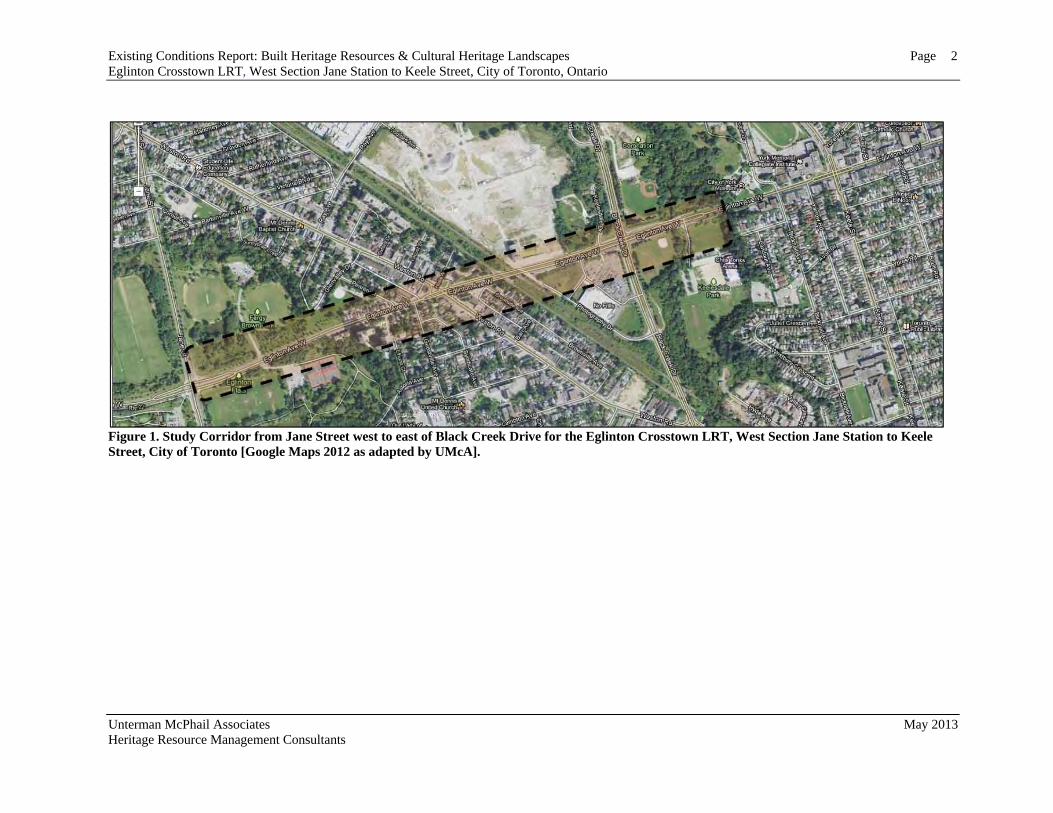
Figure 1. Study Corridor from Jane Street west to east of Black Creek Drive for the Eglinton Crosstown LRT, West Section Jane Station to Keele Street, City of Toronto.
2
Existing Conditions Report: Built Heritage Resources & Cultural Heritage Landscapes PageEglinton Crosstown LRT, West Section Jane Station to Keele Street, City of Toronto, Ontario
Unterman McPhail Associates May 2013 Heritage Resource Management Consultants
1
1.0 INTRODUCTION 1.1 Project Description McCormick Rankin, a member of MMM Group, on behalf of Metrolinx, retained Unterman McPhail Associates, Heritage Resource Management Consultants, to complete a Cultural Heritage Assessment Report (CHAR) with regard to cultural heritage landscapes and built heritage resources for the Eglinton Crosstown Light Rail Transit (LRT), West Section Jane Street to Keele Street in the City of Toronto, Ontario (Figure 1). An Existing Conditions Report (ECR) and Impact Assessment and Mitigation Recommendations were completed in December 2012. The principal objectives of this Cultural Heritage Assessment Report are:
o to prepare an historical summary of the development of the study area and the Eglinton Crosstown LRT study corridor through the review of both primary and secondary sources as well as historical mapping;
o to conduct a survey of Eglinton Crosstown LRT study corridor and its associated cultural heritage landscapes and built heritage resources found within the study area;
o to identify sensitivities for change; and, o to make general mitigation recommendations respecting the proposed endeavour.
1.2 Study Background – 2010 Environmental Project Report In 2008, a Provincial Environmental Assessment under Ontario Regulation (O. Reg.) 231/08, the “Transit Project Assessment Process” Regulation, was initiated for a 33-km light rail transit (LRT) project in the Eglinton Avenue corridor in the City of Toronto. The project, named the Eglinton Crosstown LRT, linked Pearson International Airport in the west to Kennedy Station in the east. It included:
o a surface LRT section primarily in the centre of Eglinton Avenue between Pearson International Airport and east of Black Creek Drive
o an underground LRT section below Eglinton Avenue from east of Black Creek Drive to east of Brentcliffe Road
o a surface LRT section in the centre of Eglinton Avenue between east of Brentcliffe Road and Don Mills Road
o a short underground LRT section below Eglinton Avenue at Don Mills Road o a surface LRT section from Don Mills Road to Kennedy Road.
In Spring 2009, during the planning phase of the Project, the Province of Ontario announced an investment of $8.15B ($2008) for the Eglinton Crosstown LRT and three other LRT lines: Scarborough RT Conversion/Extension, Finch West LRT and Sheppard East LRT. These projects were part of a wider municipal plan initially known as Transit City, and identified as part of the Top 15 priority projects in the Metrolinx Big Move.
Existing Conditions Report: Built Heritage Resources & Cultural Heritage Landscapes Page Eglinton Crosstown LRT, West Section Jane Station to Keele Street, City of Toronto, Ontario
Unterman McPhail Associates May 2013 Heritage Resource Management Consultants
2
Figure 1. Study Corridor from Jane Street west to east of Black Creek Drive for the Eglinton Crosstown LRT, West Section Jane Station to Keele Street, City of Toronto [Google Maps 2012 as adapted by UMcA].
Cultural Heritage Assessment Report Page Built Heritage Resources & Cultural Heritage Landscapes Eglinton Crosstown LRT, West Section Jane Station to Keele Street, City of Toronto, Ontario
Unterman McPhail Associates May 2013 Heritage Resource Management Consultants
3
An Environmental Project Report (EPR) was completed in March 2010 under O. Reg. 231/08 and was approved by the Ontario Ministry of the Environment in May of 2010. Around the same time as the approval of the EPR, Metrolinx, the Provincial agency providing funding for the project, had indicated the project would be divided into two phases at Jane Street due to funding limitations. As a result, the 19-km section from Jane Street to Kennedy Station would receive funding immediately and undergo implementation, while the 14-km section from Jane Street to Pearson International Airport would be deferred. Work has progressed on the first phase of the Project, including commencement in the summer of 2011 of constructing the launch site in which tunnel boring machines will be deployed to build the underground section.
1.2.1 Current Study - 2013 Environmental Project Report Addendum
While undertaking subsequent preliminary design, recommended changes to the initial project have been identified and are being reviewed under O.Reg. 231/08. There are two changes to the project description that require completion of an EPR Addendum. They are:
1. Change in alignment between the tunnel portal location east of Black Creek Drive and Jane Street; and
2. A new Maintenance and Storage Facility north of Eglinton Avenue and west of Black Creek Drive.
Key changes for the West study area between the tunnel portal location east of Black Creek Drive and Jane Street and the addition of a Maintenance and Storage Facility (MSF) north of Eglinton Avenue and west of Black Creek Drive. Key changes include:
o Addition of the MSF; o Shift of the LRT alignment from the centre median of Eglinton Avenue West to
the north side of Eglinton Avenue West right-of-way; o New elevated LRT structure over Black Creek and Black Creek Drive; o Removal of the previously proposed Black Creek Stop; o New Mount Dennis Station located underground at the railway corridor which
consolidates the previously proposed Black Creek Drive and Weston Road stations;
o Surface bus terminal located on the former Kodak Lands; o Revised connecting track configuration between the LRT mainline and the
proposed MSF; and o Extended underground LRT between Mount Dennis Station and a new LRT portal
within the centre median of Eglinton Avenue West, just east of Jane Street.
Note: The assessment of built heritage resources and cultural heritage landscapes associated with the former Kodak lands has been completed by another consultant through separate reporting which is on file at Metrolinx.

Cultural Heritage Assessment Report Page Built Heritage Resources & Cultural Heritage Landscapes Eglinton Crosstown LRT, West Section Jane Station to Keele Street, City of Toronto, Ontario
Unterman McPhail Associates May 2013 Heritage Resource Management Consultants
4
2.0 ENVIRONMENTAL ASSESSMENT & CULTURAL HERITAGE RESOURCES The need for the identification, evaluation, management and conservation of Ontario's heritage is acknowledged as an essential component of environmental assessment and municipal planning in Ontario. For the most part, the analysis of cultural heritage resources in the study area addresses those above-ground, person-made heritage resources 40 years of age and old. The application of this rolling forty-year principle is an accepted federal and provincial practice for the preliminary identification of cultural heritage resources that may be of heritage interest or value. Its application does not imply however that all built heritage resources or cultural heritage landscapes that are over 40 years old are worthy of the same levels of protection or preservation. 2.1 Environmental Assessment Act (EAA) Environmental assessments are undertaken under the Environmental Assessment Act (EAA). The EAA provides for the protection, conservation and wise management of Ontario’s environment. The legislation defines environment in a broad sense that includes natural, social, cultural, economic and built environments. This broad definition of the environment makes the assessment of the impact of the undertaking on cultural heritage resources part of the standard environmental assessment process in Ontario. Environmental assessments made under the EAA therefore assess and address the impact of the undertaking on cultural heritage resources. The analysis throughout the study process addresses that part of the Environmental Assessment Act, subsection 1(c), which defines “environment” to include:
“...cultural conditions that influence the life of humans or a community”; as well as,
“any building, structure, machine or other device or thing made by humans”. Infrastructure undertakings may potentially affect cultural heritage resources in a number of ways. The effects may include displacement through removal or demolition and/or disruption by the introduction of physical, visual, audible or atmospheric elements that are not in keeping with the character of the cultural heritage resources and, or their setting. 2.1.1 Ontario Regulation 231/08 of EAA The EAA, Ontario Regulation 231/08 sets out the transit project assessment process that is applicable to selected transit projects as listed in the present Regulation. This process requires public sector proponents to:
Cultural Heritage Assessment Report Page Built Heritage Resources & Cultural Heritage Landscapes Eglinton Crosstown LRT, West Section Jane Station to Keele Street, City of Toronto, Ontario
Unterman McPhail Associates May 2013 Heritage Resource Management Consultants
5
1) assess negative impacts of their transit project; 2) identify measures to lessen the environmental impact; and 3) consult with the public.
Transit projects are categorized as follows: 1) Exempt – projects expected to have minimal environmental effects are not subject to the Environmental Assessment Act; and 2) Exempt, but must complete a Transit Project Assessment Process (TPAP) and exempt if a TPAP is successfully completed.
Impacts to cultural heritage are considered under a TPAP. The Eglinton Crosstown LRT is being assessed under the TPAP. 2.2 Ontario Heritage Act (OHA) and the Standards and Guidelines for the
Conservation of Provincial Heritage Properties The Ontario Heritage Act (OHA) provides the framework for provincial and municipal responsibilities and powers in the conservation of cultural heritage resources. The OHA gives the Ontario Ministry of Culture, now the Ministry of Tourism, Culture and Sport (MTCS), the responsibility for the conservation, protection and preservation of Ontario’s culture heritage resources. Section 2 of the Ontario Heritage Act charges the Minister with the responsibility to,
“...determine policies, priorities and programs for the conservation, protection and preservation of the heritage of Ontario”.
MTCS describes heritage buildings and structures, cultural heritage landscapes and archaeological resources as cultural heritage resources. Since cultural heritage resources may be impacted adversely by both public and private land development, it is incumbent upon planning and approval authorities to consider heritage resources when making planning decisions. Heritage attributes, in relation to a property, are defined in the OHA as the attributes of the property that cause it to have cultural heritage value or interest. Individual properties may be designated of cultural heritage value under Part IV of the OHA by a municipality or the Minister of Tourism, Culture and Sport. In addition municipalities may designate Heritage Conservation Districts under Part V of the legislation. As laid out in subsections 27 (1) and 39.2 (1) of the OHA, the municipal clerk is required to keep a current register of properties of cultural heritage value or interest located in the municipality. The municipal register must include all properties designated under Parts IV and V of the OHA by the municipality or under Part IV by the Minister of Culture. Designation of heritage resources publicly recognizes and promotes awareness of heritage properties, provides a process for ensuring that changes to a heritage property are appropriately managed and that these changes respect the property’s heritage value. This includes protection from demolition.

Cultural Heritage Assessment Report Page Built Heritage Resources & Cultural Heritage Landscapes Eglinton Crosstown LRT, West Section Jane Station to Keele Street, City of Toronto, Ontario
Unterman McPhail Associates May 2013 Heritage Resource Management Consultants
6
The OHA subsection 27(2) also allows a property that is not designated, but considered to be of cultural heritage interest or value by the municipal council, to be placed on the register. This is commonly referred to as “listing”. In many cases, listed (non-designated properties) are candidates for protection under section 29 of the OHA. Although listing of non-designated properties does not offer any specific protection under the OHA, section 2 of the Provincial Policy Statement of the Planning Act acknowledges listed properties. Provincial heritage properties are not subject to designation by municipalities or the Minister. The amendments to the Act gave the Minister of MTCS the authority to develop standards and guidelines for the conservation of provincial heritage properties. As a result, the province now has the responsibility to establish a comparable standard of identification, protection and care for provincial heritage properties as already exists for private property. Part III.1 of the Act enables the Minister of MTCS, in consultation with the ministries and public bodies affected, to prepare standards and guidelines that set out the criteria and process for identifying provincial heritage properties and to set standards for their protection, maintenance, use, and disposal. In the development of the Standards and Guidelines for Conservation of Provincial Heritage Properties (April 28, 2010), MTCS drew from existing standards, policies, and best practices currently in use by the Government of Ontario, the federal government, and leading international jurisdictions and consulted with affected ministries, public bodies and the Ontario Heritage Trust. The Standards and Guidelines apply to properties owned or controlled by the Government of Ontario that have cultural heritage value or interest, i.e., provincial heritage properties. They are issued under the authority of section 25.2 of the Ontario Heritage Act (the Act) and came into effect on July 1, 2010. They are mandatory for ministries and prescribed public bodies and have the authority of a Management Board of Cabinet directive. All Ontario government ministries and prescribed public bodies must comply with the Standards and Guidelines in the management of properties in their ownership or under their control. The Standards and Guidelines define provincial heritage property as,
…real property, including buildings and structures on the property, that has cultural heritage value or interest and that is owned by the Crown in right of Ontario or by a prescribed public body; or that is occupied by a ministry or a prescribed public body if the terms of the occupancy agreement are such that the ministry or public body is entitled to make the alterations to the property that may be required under these heritage standards and guidelines.
Section B: Identification and Evaluation, subsection B.2, of the Standards and Guidelines states an evaluation process to identify provincial heritage properties will consist of a description of the property, historical information, a determination of the cultural heritage value or interest, including potential provincial significance, based on the advice of
Cultural Heritage Assessment Report Page Built Heritage Resources & Cultural Heritage Landscapes Eglinton Crosstown LRT, West Section Jane Station to Keele Street, City of Toronto, Ontario
Unterman McPhail Associates May 2013 Heritage Resource Management Consultants
7
qualified persons and with appropriate community input; a report outlining the historical research and evaluation process; and a Statement of Cultural Heritage Value with a description of its heritage attributes. This cultural heritage evaluation report shall be submitted to the MTCS for review and approval. The Standards and Guidelines of the Conservation of Provincial Heritage Properties state Ministries and prescribed public bodies shall apply the Criteria for “Determining Cultural Heritage Value” set out in the Ontario Regulation 9/06 under the Ontario Heritage Act to determine the cultural heritage value or interest of a property. If the property meets the criteria in Ontario Regulation 9/06, it is a provincial heritage property. If deemed to be a provincial heritage property the “Criteria for Determining Cultural Heritage Value of Provincial Significance” set out in Ontario Regulation 10/06 to determine whether or not a property is of provincial significance are to be applied. If the property meets the criteria in Ontario Regulation 10/06, it is a provincial heritage property of provincial significance. The Standards and Guidelines define provincial heritage property of provincial significance as,
…provincial heritage property that has been evaluated using the criteria found in Ontario Heritage Act O.Reg. 10/06 and has been found to have cultural heritage value or interest of provincial significance.
The Standards and Guidelines also provide advice on the conservation of provincial heritage properties and provincial heritage properties of provincial importance. 2.3 Ministry of Tourism, Culture and Sport The Ministry of Tourism, Culture and Sport (MTCS), formerly the Ministry of Culture, is responsible for the administration of the Ontario Heritage Act and is responsible for determining policies, priorities and programs for the conservation, protection and preservation of Ontario’s heritage, which includes cultural heritage landscapes, built heritage and archaeological resources. MTCS guidelines assist in the assessment of cultural heritage resources as part of an environmental assessment. They are, Guideline for Preparing the Cultural Heritage Resource Component of Environmental Assessments (October 1992), and, Guidelines on the Man-Made Heritage Component of Environmental Assessments (1980). The Guidelines on the Man-Made Heritage Component of Environmental Assessments state:
“When speaking of man-made heritage we are concerned with works of man and the effects of his activities in the environment rather than with moveable human artifacts or those environments that are natural and completely undisturbed by man.”
Cultural Heritage Assessment Report Page Built Heritage Resources & Cultural Heritage Landscapes Eglinton Crosstown LRT, West Section Jane Station to Keele Street, City of Toronto, Ontario
Unterman McPhail Associates May 2013 Heritage Resource Management Consultants
8
The guidelines state one may distinguish broadly between two basic ways of visually experiencing cultural heritage resources in the environment, that is, as cultural heritage landscapes and as built heritage. Cultural heritage landscapes are a geographical area perceived as a collection of individual person-made built heritage resources set into a whole such as historical settlements, farm complexes, waterscapes, roadscapes, railways, etc. They emphasize the interrelationship of people and the natural environment and convey information about the processes and activities that have shaped a community. Cultural heritage landscapes may be organically evolved landscapes as opposed to designed landscapes. Some are ‘continuing landscapes’, which maintain the historic use and continue to evolve, while others are ‘relict landscapes’ where the evolutionary process has come to an end but important landscape or built heritage resources from its historic use are still visible. Built heritage comprises individual, person-made or modified, parts of a cultural heritage landscape such as buildings or structures of various types including, but not limited to, cemeteries, planting and landscaping structures, etc. The guidelines also describe the attributes necessary for the identification and evaluation of any discrete aggregation of person-made features or cultural heritage landscapes and the attributes necessary for the identification and evaluation of built heritage resources. 3.0 ASSESSMENT METHODOLOGY 3.1 Introduction For the purposes of this built heritage resource and cultural heritage landscape assessment Unterman McPhail Associates undertook the following tasks:
o the identification of major historical themes and activities of the study area in the former Township of York, now within the boundaries of the City of Toronto through historical research and a review of topographical and historic mapping;
o the identification of associated cultural heritage landscapes and built heritage resources within the study area through major historical themes and activities and historic mapping;
o the identification of impacts to built heritage resources and cultural heritage landscapes; and
o mitigation recommendations for impacts as a result of the undertaking to built heritage resources and cultural heritage landscapes.
3.2 Heritage Recognition The City of Toronto Inventory of Heritage Properties, which serves as the City’s municipal register under the OHA, was consulted with regard to municipal listing or designation under the OHA. There are currently no listed or designated properties on the City of Toronto Inventory of Heritage Properties within the study corridor. City of
Cultural Heritage Assessment Report Page Built Heritage Resources & Cultural Heritage Landscapes Eglinton Crosstown LRT, West Section Jane Station to Keele Street, City of Toronto, Ontario
Unterman McPhail Associates May 2013 Heritage Resource Management Consultants
9
Toronto Staff had recommended No. 3500 Eglinton Avenue West, Kodak Building #9, for listing and municipal designation in May 2006.1 The property was subsequently purchased by Metrolinx, and as a Crown Agency, it is exempt from municipal listing and designation under the Ontario Heritage Act. Taylor Hazell Architects Ltd. prepared a Cultural Heritage Evaluation Report to determine whether or not Kodak Building #9 had cultural significance as a provincial property of provincial heritage interest under the Standards and Guidelines for Conservation of Provincial Heritage Properties, which were prepared by MTCS (2012). This report evaluated the property under Reg. 9/06 and 10/06 of the OHA and concluded that it has cultural significance under 9/06, but is not considered to be a provincial property of provincial heritage significance under 10/06.2 4.0 HISTORICAL SUMMARY The following is a synopsis of the history of the study corridor for the Eglinton Crosstown LRT project that runs along Eglinton Avenue from Jane Street to Keele Street. Historically, this area was located within the geographic township of York Township, County of York. In 1788, Lord Dorchester, Governor of Canada divided the western part of the old province of Quebec into four administrative districts, Lunenburg, Mecklenburg, Nassau and Hesse. A judge and sheriff were appointed for each one. Quebec was subsequently split into Upper and Lower Canada in 1791. When John Graves Simcoe became the Lieutenant-Governor of Upper Canada he subdivided the four districts into 19 counties, including the County of York organized in 1792, for the purpose of parliamentary representation and military organization. In 1791, a row of eleven townships was laid out along the shores of Lake Ontario in a westerly direction from the Trent River. The future York Township was one of three most westerly townships. Augustus Jones, Deputy Provincial Surveyor, undertook the initial survey along the fronts in 1791 and additional work was carried out in subsequent years to complete the survey. A significant impetus to growth in the region came in 1796 with Simcoe’s selection of York as the new capital of Upper Canada. Simcoe erected the defences at Fort York, laid out a nearby town site, built a sawmill on the Humber River and undertook the construction of Yonge Street from York to Lake Simcoe for military purposes. In 1793, Simcoe created York Township in the County of York of the new Home District, formerly the Nassau District. Originally it encompassed all of the land between
1 Toronto Staff Report to Toronto Preservation Board, Etobicoke York Community Council, From the Director, Policy & Research, City Planning Department, Subject: 3500 Eglinton Avenue West (Employees’ Building, Canadian Kodak Building) Inclusion on the City of Toronto Inventory of Heritage Properties and Intention to Designate under Part IV of the Ontario Heritage Act, York South-Weston-Ward 12, May 24, 2006. 2 Taylor Hazell Architects Ltd., Kodak Building #9, Cultural Heritage Evaluation Report (July 2012).
Cultural Heritage Assessment Report Page Built Heritage Resources & Cultural Heritage Landscapes Eglinton Crosstown LRT, West Section Jane Station to Keele Street, City of Toronto, Ontario
Unterman McPhail Associates May 2013 Heritage Resource Management Consultants
10
Victoria Park Avenue to the east, the Humber River to the west, Lake Ontario to the south and Steeles Avenue to the north. Three southern concessions were surveyed parallel to Humber Bay in 1793. An area of land for a townsite was removed from the township on the lakefront to the west of the Don River for the Town of York, the new capital of Upper Canada. The rest of the township was surveyed with concessions set 1-¼ miles apart, extending east to west. Yonge Street formed the centre north-south concession line within the township and concessions were numbered east and west from Yonge Street. Road allowances were provided between concessions at every fifth lot. Yonge Street was opened as far as Sheppard Avenue by May 1794 and completed to Lake Simcoe by February 1796. Lots laid out on either side of Yonge Street were offered as free land grants to potential settlers providing the specified settlement duties were met. Generally settled in the early1800s, York Township was transformed by mid century into an agricultural landscape with small hamlets and villages and a basic road network. Early settlement focused on Yonge Street within the Township of York. With the outbreak of the War of 1812, Yonge Street was quickly improved to facilitate the movement of troop supplies. After the war, land was taken up throughout York Township. By the mid 1820s, stagecoaches travelled up and down Yonge Street, the centre north-south concession line within York Township, on a regular basis. Eglinton Avenue, or the Base Line, ran east and west across the township between the 3rd and 4th concessions. In 1846, Smith’s Canadian Gazetteer described York Township as being well settled with many good farms, numerous gristmills and sawmills. The City of Toronto was incorporated in 1834 in the south of the township. Rottenburg’s map (c1850) and the Browne & Ellis map of York Township (1851) both show that Eglinton Avenue, or the Base Line, was largely unsettled in the west part. Essentially, it was a wagon trail west of Dufferin Street to Dennison's Mill on the Humber River. The route then picked up on the west side of the Humber River in Etobicoke Township and ran to Toronto Township in Peel County. Tremaine’s map (1860) also depicts an agricultural landscape with a network of local roads, numerous farmsteads, scattered villages and hamlets with mills, schoolhouses and churches. The Grand Trunk Railway (1856) followed by the Toronto Grey and Bruce Railway (1869) provided rail service to this area. The township map in the Illustrated Historical Atlas of the County of York (1878) continues to show a rural agricultural landscape in the northern part of the township on Eglinton Avenue from Keele Street west to the Humber River. The Grand Trunk Toronto Grey Bruce Railways line through the Mount Dennis area is shown on the map. The township population had reached 8,502 people by the 1871 Census, and ten years later, the 1881 Census records a population of 13,748 people.3 The growth of the City of Toronto contributed to this sharp increase in the township population due to suburban land development within the township from an overflow of the city population.
3 Charles Mulvany, Charles Pelham et al., History of Toronto and County of York, Ontario, Volume II, Part III, 80.
Cultural Heritage Assessment Report Page Built Heritage Resources & Cultural Heritage Landscapes Eglinton Crosstown LRT, West Section Jane Station to Keele Street, City of Toronto, Ontario
Unterman McPhail Associates May 2013 Heritage Resource Management Consultants
11
By the early 20th century, numerous incorporations within the township had reduced its area substantially. In the western section, and north of Eglinton Avenue from Dufferin Street to Humber River, the land use remained largely agricultural. Mount Dennis, named after the Dennis family, had developed at Eglinton Avenue and Weston Road in the early 19th century around a sawmill and woollen factory. Towards the end of the 19th century, the settlement included several brickyards, gravel pits, and market gardens on the Eglinton Flats as well as a school, post office and general stores on Weston Road. In 1899, the township side roads through to Weston Road at Mount Dennis were officially named. The Mount Dennis Anglican Church of the Good Shepherd was opened in 1915 on the southeast corner of Weston Road and Eglinton Avenue West. In 1916, Mount Dennis received an economic boost with the arrival of the Kodak plant on Eglinton Avenue next to the Grand Trunk Railway line, now the CN line. A branch of the Eastman Kodak Company of Rochester, New York, was established in downtown Toronto in 1899. Within three years, Kodak had moved to a larger site on King Street. Between 1912 and 1914, the company assembled a land on Eglinton Avenue for a new industrial plant to the east of Mount Dennis that opened in 1916. Due its location on a high piece of ground, the plant became known as “Kodak Heights”. Building No. 9 was designed in 1938-39 by Gray and Wells and completed in 1940. Known as the Employees’ Building, it was built to serve the recreational needs of Kodak’s employees. Housing for Kodak workers was built in Mount Dennis. In 1921, a fire hall, now Mount Dennis Community Hall, was built on Hollis Street just north of Eglinton Avenue at Weston Road. To the east of Mount Dennis at Eglinton Avenue and Keele Street, land subdivision for residential estates increased in the 1920s. This contributed to some development occurring at the intersection of Keele Street and Eglinton Avenue West. In the rural landscape on the north side of Eglinton Avenue West to the west of Keele Street, construction for York Memorial Collegiate Institute began in 1929. The school was opened in 1930, and its name was a tribute to former local students who had died as soldiers during the WWI. Although Eglinton Avenue had been improved in 1916 between Dufferin Street and the Kodak Company due to the construction of the Kodak plant, the road continued to be rural in character until after WWII. Eglinton Avenue underwent a dramatic change after WWII. Topographic maps clearly depict the rapid urbanization of the land for residential and commercial use as a result of the return of service personal and an influx of new immigrants to the Toronto area. As young families embraced the suburbs, local governments planned aggressively for businesses and industries to balance the growing residential tax base. On April 15, 1953, The Municipality of Metropolitan Toronto was incorporated, uniting York with other municipalities under a common government that assist in planning infrastructure for the Toronto area. Metro Toronto undertook infrastructure improvements on Eglinton Avenue West in the 1950s and 1960s that included the extension of the road over the Humber River into
Cultural Heritage Assessment Report Page Built Heritage Resources & Cultural Heritage Landscapes Eglinton Crosstown LRT, West Section Jane Station to Keele Street, City of Toronto, Ontario
Unterman McPhail Associates May 2013 Heritage Resource Management Consultants
12
Etobicoke in 1956, improvements to the east of Weston Road in the mid 1960s with the replacement of the CN grade separation track with a railway overhead structure and the construction of retaining walls on either side of Eglinton Avenue, a new road bridge over Eglinton Avenue West to provide access to the Kodak Plant, and a new road bridge over Black Creek in 1966. Black Creek Drive was developed in the 1970s as part of the Province’s Highway 400 Extension that was to run south to the Gardiner Expressway. After the project was abandoned, the extension was referred to as the Northwest Arterial Road. When completed in 1982, it was named Black Creek Drive. At Eglinton Avenue and Black Creek, Keelesdale Park and Coronation Park were developed in the 1950s as recreational lands. Coronation Park was named to commemorate the coronation of Queen Elizabeth II on June 2, 1953. During the 1950's, Mount Dennis grew from a rural community to an urban neighbourhood. Newer commercial development such as the Bank of Nova Scotia building on the northeast corner of the intersection of Weston Road and Eglinton Avenue West. More apartment buildings were built on the south side of Eglinton Avenue west of Weston Road. Kodak continued as an important local employer. After Hurricane Hazel, Humber River valley lands along Eglinton Avenue to the west of Mount Dennis were acquired by the TRCA, and then the City of Toronto, for recreational land now encompassed by the Eglinton Flats Park and Fergy Brown Park. On January 1, 1967, the municipalities of York and Weston amalgamated to become the Borough of York. In June 10, 1983, York is incorporated as a city. The City of York was amalgamated into the new City of Toronto in 1998. 5.0 DESCRIPTION OF CULTURAL HERITAGE LANDSCAPES & BUILT
HERITAGE RESOURCES 5.1 Introduction For the purposes of cultural heritage landscape and built heritage resource identification, this section provides a brief description of the existing environment of the study area, i.e., Eglinton Avenue West from Keele Street to Jane Street within the West Section study area for the Eglinton Crosstown LRT and the associated principal built heritage resources and cultural heritage landscapes. 5.2 Description of the Existing Environment The survey for this report comprised that part of Eglinton Avenue West from Keele Street to Jane Street within the West Section study area for the Eglinton Crosstown LRT. Eglinton Avenue is a principal east-west arterial road that crosses Toronto uninterrupted in a more or less straight line. Immediately east of Black Creek Drive are the entrance to Keelesdale Park on the south and Coronation Park on the north. At the time of the survey,
Cultural Heritage Assessment Report Page Built Heritage Resources & Cultural Heritage Landscapes Eglinton Crosstown LRT, West Section Jane Station to Keele Street, City of Toronto, Ontario
Unterman McPhail Associates May 2013 Heritage Resource Management Consultants
13
Eglinton Avenue to the east of Black Creek Drive, including the bridge over Black Creek and in front of Keelesdale Park and Coronation Park, was under construction for the LRT tunnel. The former Kodak Company industrial site is located on the north side of Eglinton Avenue West and is generally bounded by Black Creek Drive to the east, Eglinton Avenue West to the south, the CPR rail corridor to the west, and Industry Street and Ray Avenue to the north. Building No. 9, the former administrative office, is the last remaining building from what was a large complex of twelve industrial and office buildings. It sits above Eglinton Avenue West at the railway tracks and Photography Drive. Its setting above Black Creek Drive to the east gives the building a landmark presence. It is also visible from Weston Road. A high retaining wall built in the 1960s separates the building from Eglinton Avenue West. Pedestrian stairways provide access to the site from the road. Since the demolition of the other structures in 2006-2007, the property has become overgrown. The CN rail line spans Eglinton Avenue West to its immediate west. Mount Dennis is located at Eglinton Avenue West and Weston Road. To the east of the intersection, the former Kodak plant site is now vacant with the exception of Building No. 9. At Weston Road, the streetscape includes commercial development north of Eglinton Avenue West with a modernist-style Bank of Nova Scotia building located on the northeast corner intersection. To the south of Eglinton Avenue West, the Good Shepherd Church forms a landmark element at the intersection with Weston Road. To the north of this intersection, Hollis Street consists of early 20th century streetscape of workers housing with gambrel roofs and some post W.W.II bungalows. To the west of the intersection, mixed residential buildings, including apartment buildings, single residential houses and townhouses characterize the area. At Eglinton Avenue West and Jane Street there is public parkland including the Eglinton Flats and Fergy Brown Park. 5.3 Description of Identified Cultural Heritage Resources Unterman McPhail Associates undertook a windshield survey on Eglinton Avenue West from Jane Station to Keele Street (Figure 1) in October and November 2012 to update information from the Cultural Heritage Assessment Report (2010) with regard to built heritage resources and cultural heritage landscapes of 40 years of age and older within and adjacent to the study corridor for the Eglinton Crosstown LRT, West Section. The identified cultural heritage landscapes (CHL) and built heritage resources (BHR) are listed in Table 1, which includes the following information:
o Sites are numbered generally from east to west; o Resources are identified by category: Cultural Heritage Landscape (CHL) or Built
Heritage Resource (BHR) and by type, bridge, residence, church, etc.; o The municipal address, when applicable, locates the identified cultural heritage
resource;

Cultural Heritage Assessment Report Page Built Heritage Resources & Cultural Heritage Landscapes Eglinton Crosstown LRT, West Section Jane Station to Keele Street, City of Toronto, Ontario
Unterman McPhail Associates May 2013 Heritage Resource Management Consultants
14
o A brief description of the cultural heritage resource, e.g., notable landscape features, construction period(s), architectural style is based upon information gained from the public roadway;
o Known heritage value as identified through listing in a local inventory, listing or designation on a municipal register adopted under the Ontario Heritage Act, and/or recognition through a commemorative plaque is included in the description; and
o Digital photographs and/or aerial views for each resource.
Cultural Heritage Assessment Report Page 15 Built Heritage Resources & Cultural Heritage Landscapes Eglinton Crosstown LRT, West Section Jane Station to Keele Street, City of Toronto, Ontario
Unterman McPhail Associates May 2013 Heritage Resource Management Consultants
TABLE 1: IDENTIFIED BUILT HERITAGE RESOURCES (BHR) & CULTURAL HERITAGE LANDSCAPES (CHL) WITHIN AND ADJACENT TO EGLINTON AVENUE WEST FROM JANE STATION TO KEELE STREET
Site #
Resource Type Location Description Heritage Recognition
Digital Photographs /Aerial Views
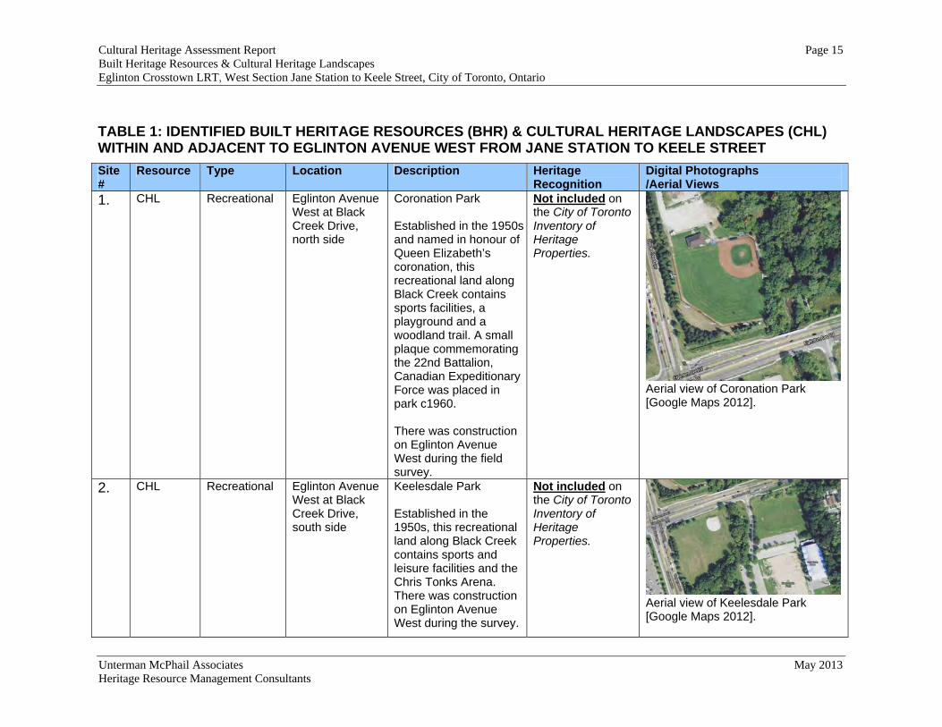
1. CHL Recreational Eglinton Avenue West at Black Creek Drive, north side
Coronation Park Established in the 1950s and named in honour of Queen Elizabeth’s coronation, this recreational land along Black Creek contains sports facilities, a playground and a woodland trail. A small plaque commemorating the 22nd Battalion, Canadian Expeditionary Force was placed in park c1960. There was construction on Eglinton Avenue West during the field survey.
Not included on the City of Toronto Inventory of Heritage Properties.
Aerial view of Coronation Park [Google Maps 2012].
2. CHL Recreational Eglinton Avenue West at Black Creek Drive, south side
Keelesdale Park Established in the 1950s, this recreational land along Black Creek contains sports and leisure facilities and the Chris Tonks Arena. There was construction on Eglinton Avenue West during the survey.
Not included on the City of Toronto Inventory of Heritage Properties.
Aerial view of Keelesdale Park [Google Maps 2012].

Cultural Heritage Assessment Report Page 16 Built Heritage Resources & Cultural Heritage Landscapes Eglinton Crosstown LRT, West Section Jane Station to Keele Street, City of Toronto, Ontario
Unterman McPhail Associates May 2013 Heritage Resource Management Consultants
TABLE 1: IDENTIFIED BUILT HERITAGE RESOURCES (BHR) & CULTURAL HERITAGE LANDSCAPES (CHL) WITHIN AND ADJACENT TO EGLINTON AVENUE WEST FROM JANE STATION TO KEELE STREET
Site #
Resource Type Location Description Heritage Recognition
Digital Photographs /Aerial Views
3. BHR Transportation: Road
Black Creek at Eglinton Avenue West, east of Black Creek Drive.
Black Creek Bridge This bridge was built in 1966 by Metro Toronto and rehabilitated in 2005 by City of Toronto with a new superstructure on original abutments. There was construction on Eglinton Avenue West at the time of the field survey.
Not included on the City of Toronto Inventory of Heritage Properties.
South elevation of the bridge [UMcA 2009].
4. BHR Transportation: Road
Eglinton Avenue West at former Kodak site.
Retaining wall This concrete retaining wall has a plaque noting it was built by Metropolitan Toronto in 1966. Road improvements in this area were carried out as part of a plan for a new expressway that was never completed.
Not included on the City of Toronto Inventory of Heritage Properties.
Metro Toronto Plaque on north retaining wall.
Cultural Heritage Assessment Report Page 17 Built Heritage Resources & Cultural Heritage Landscapes Eglinton Crosstown LRT, West Section Jane Station to Keele Street, City of Toronto, Ontario
Unterman McPhail Associates May 2013 Heritage Resource Management Consultants
TABLE 1: IDENTIFIED BUILT HERITAGE RESOURCES (BHR) & CULTURAL HERITAGE LANDSCAPES (CHL) WITHIN AND ADJACENT TO EGLINTON AVENUE WEST FROM JANE STATION TO KEELE STREET
Site #
Resource Type Location Description Heritage Recognition
Digital Photographs /Aerial Views
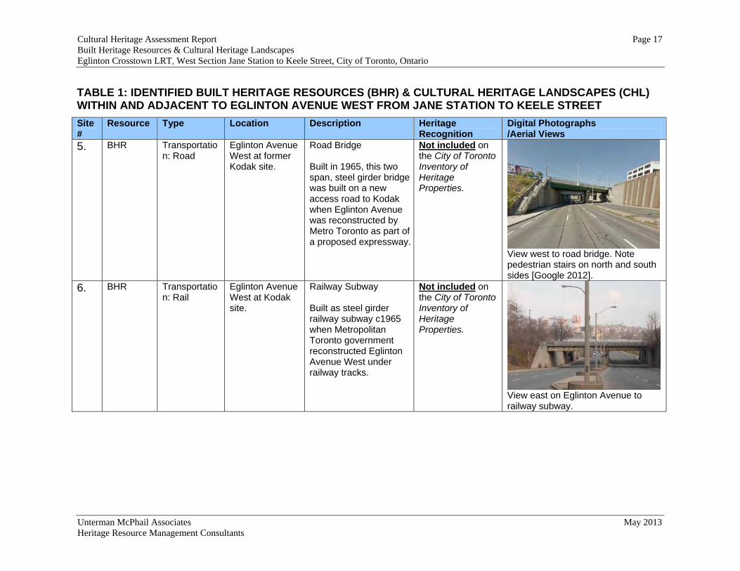
5. BHR Transportation: Road
Eglinton Avenue West at former Kodak site.
Road Bridge Built in 1965, this two span, steel girder bridge was built on a new access road to Kodak when Eglinton Avenue was reconstructed by Metro Toronto as part of a proposed expressway.
Not included on the City of Toronto Inventory of Heritage Properties.
View west to road bridge. Note pedestrian stairs on north and south sides [Google 2012].
6. BHR Transportation: Rail
Eglinton Avenue West at Kodak site.
Railway Subway Built as steel girder railway subway c1965 when Metropolitan Toronto government reconstructed Eglinton Avenue West under railway tracks.
Not included on the City of Toronto Inventory of Heritage Properties.
View east on Eglinton Avenue to railway subway.

Cultural Heritage Assessment Report Page 18 Built Heritage Resources & Cultural Heritage Landscapes Eglinton Crosstown LRT, West Section Jane Station to Keele Street, City of Toronto, Ontario
Unterman McPhail Associates May 2013 Heritage Resource Management Consultants
TABLE 1: IDENTIFIED BUILT HERITAGE RESOURCES (BHR) & CULTURAL HERITAGE LANDSCAPES (CHL) WITHIN AND ADJACENT TO EGLINTON AVENUE WEST FROM JANE STATION TO KEELE STREET
Site #
Resource Type Location Description Heritage Recognition
Digital Photographs /Aerial Views
7. BHR Industrial 3500 Eglinton Avenue West
Kodak Building No. 9 This building, the only one left on-site, was constructed in 1939 and opened 1940 as the Employees’ Building for the Canadian Kodak Company. Kodak Canada moved its factory to a site along the rail line running next to Weston Road during World War I. This industrial complex, known as "Kodak Heights," was a major employer for Mount Dennis' residents until in 2005.
The Cultural Heritage Evaluation Report (CHER) completed in July 2012 under the requirements of the Standards and Guidelines for the conservation of provincial heritage properties (July 2010) determined that Building No. 9 is of heritage value based on Ont. Reg. 9/06 of the OHA; however, it not considered to be of provincial heritage value under Ont. Reg. 10/06 for provincially owned properties.
View northwest to front elevation of the builidng.

Cultural Heritage Assessment Report Page 19 Built Heritage Resources & Cultural Heritage Landscapes Eglinton Crosstown LRT, West Section Jane Station to Keele Street, City of Toronto, Ontario
Unterman McPhail Associates May 2013 Heritage Resource Management Consultants
TABLE 1: IDENTIFIED BUILT HERITAGE RESOURCES (BHR) & CULTURAL HERITAGE LANDSCAPES (CHL) WITHIN AND ADJACENT TO EGLINTON AVENUE WEST FROM JANE STATION TO KEELE STREET
Site #
Resource Type Location Description Heritage Recognition
Digital Photographs /Aerial Views
8. BHR Commercial 1151 Weston Road at Eglinton Avenue West
Bank of Nova Scotia This bank building has a Modern design with a distinctive corporate “Bluenose” carving on front elevation.
Not included on the City of Toronto Inventory of Heritage Properties.
View east to Weston Road elevation of building.
9. CHL Historical Community
Eglinton and Weston Road
Mount Dennis, former hamlet in York Township, developed in the late 19th century and early 20th century. Eglinton Avenue is characterized by residences dating from the 19th and 20th century on both sides of the Eglinton Avenue West, west of Weston Road. On the north side of Eglinton Avenue, Weston Road is characterized by commercial development including a
Mount Dennis buildings not included on the City of Toronto Inventory of Heritage Properties
View west on Eglinton Avenue from Weston Road to row of houses on north side of street.
Cultural Heritage Assessment Report Page 20 Built Heritage Resources & Cultural Heritage Landscapes Eglinton Crosstown LRT, West Section Jane Station to Keele Street, City of Toronto, Ontario
Unterman McPhail Associates May 2013 Heritage Resource Management Consultants
TABLE 1: IDENTIFIED BUILT HERITAGE RESOURCES (BHR) & CULTURAL HERITAGE LANDSCAPES (CHL) WITHIN AND ADJACENT TO EGLINTON AVENUE WEST FROM JANE STATION TO KEELE STREET
Site #
Resource Type Location Description Heritage Recognition
Digital Photographs /Aerial Views
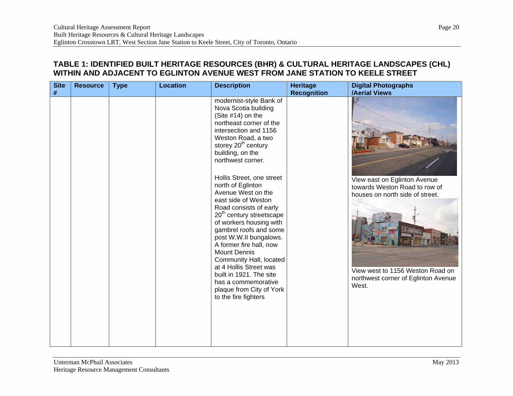
modernist-style Bank of Nova Scotia building (Site #14) on the northeast corner of the intersection and 1156 Weston Road, a two storey 20th century building, on the northwest corner. Hollis Street, one street north of Eglinton Avenue West on the east side of Weston Road consists of early 20th century streetscape of workers housing with gambrel roofs and some post W.W.II bungalows. A former fire hall, now Mount Dennis Community Hall, located at 4 Hollis Street was built in 1921. The site has a commemorative plaque from City of York to the fire fighters
View east on Eglinton Avenue towards Weston Road to row of houses on north side of street.
View west to 1156 Weston Road on northwest corner of Eglinton Avenue West.
Cultural Heritage Assessment Report Page 21 Built Heritage Resources & Cultural Heritage Landscapes Eglinton Crosstown LRT, West Section Jane Station to Keele Street, City of Toronto, Ontario
Unterman McPhail Associates May 2013 Heritage Resource Management Consultants
TABLE 1: IDENTIFIED BUILT HERITAGE RESOURCES (BHR) & CULTURAL HERITAGE LANDSCAPES (CHL) WITHIN AND ADJACENT TO EGLINTON AVENUE WEST FROM JANE STATION TO KEELE STREET
Site #
Resource Type Location Description Heritage Recognition
Digital Photographs /Aerial Views
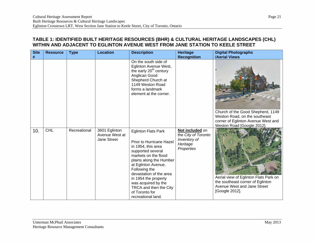
On the south side of Eglinton Avenue West, the early 20th century Anglican Good Shepherd Church at 1149 Weston Road forms a landmark element at the corner.
Church of the Good Shepherd, 1149 Weston Road, on the southeast corner of Eglinton Avenue West and Weston Road [Google 2012].
10. CHL Recreational 3601 Eglinton Avenue West at Jane Street
Eglinton Flats Park Prior to Hurricane Hazel in 1954, this area supported several markets on the flood plains along the Humber at Eglinton Avenue. Following the devastation of the area in 1954 the property was acquired by the TRCA and then the City of Toronto for recreational land.
Not included on the City of Toronto Inventory of Heritage Properties
Aerial view of Eglinton Flats Park on the southeast corner of Eglinton Avenue West and Jane Street [Google 2012].
Cultural Heritage Assessment Report Page 22 Built Heritage Resources & Cultural Heritage Landscapes Eglinton Crosstown LRT, West Section Jane Station to Keele Street, City of Toronto, Ontario
Unterman McPhail Associates May 2013 Heritage Resource Management Consultants
TABLE 1: IDENTIFIED BUILT HERITAGE RESOURCES (BHR) & CULTURAL HERITAGE LANDSCAPES (CHL) WITHIN AND ADJACENT TO EGLINTON AVENUE WEST FROM JANE STATION TO KEELE STREET
Site #
Resource Type Location Description Heritage Recognition
Digital Photographs /Aerial Views
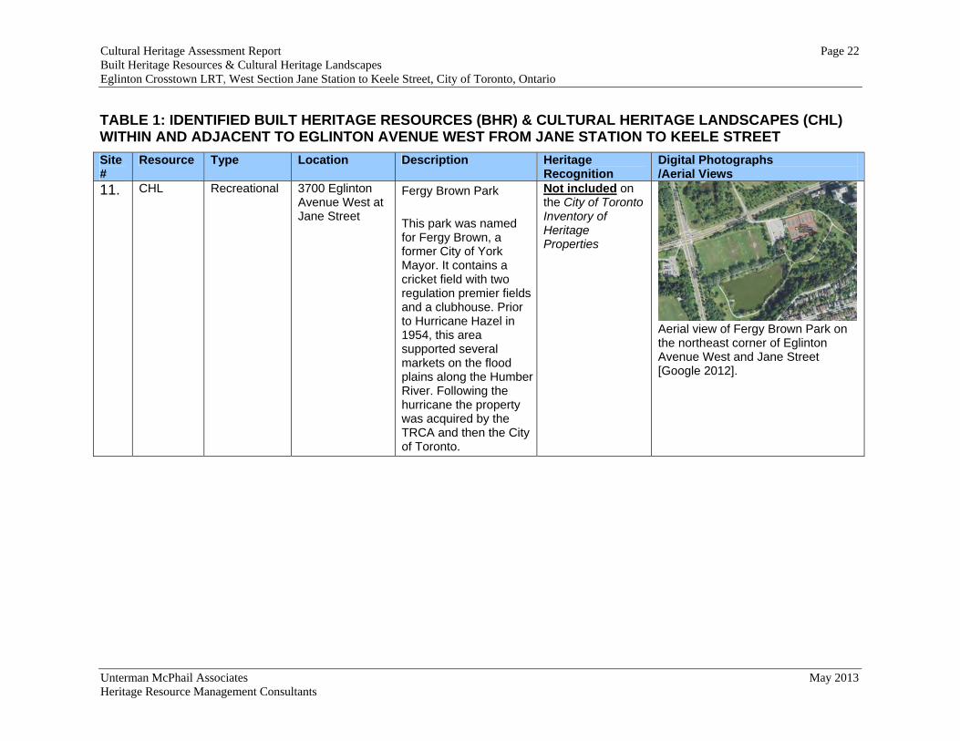
11. CHL Recreational 3700 Eglinton Avenue West at Jane Street
Fergy Brown Park This park was named for Fergy Brown, a former City of York Mayor. It contains a cricket field with two regulation premier fields and a clubhouse. Prior to Hurricane Hazel in 1954, this area supported several markets on the flood plains along the Humber River. Following the hurricane the property was acquired by the TRCA and then the City of Toronto.
Not included on the City of Toronto Inventory of Heritage Properties
Aerial view of Fergy Brown Park on the northeast corner of Eglinton Avenue West and Jane Street [Google 2012].

Cultural Heritage Assessment Report Page 23 Existing Conditions Report: Built Heritage Resources & Cultural Heritage Landscapes Eglinton Crosstown LRT, West Section Jane Station to Keele Street, City of Toronto, Ontario
Unterman McPhail Associates May 2013 Heritage Resource Management Consultants
6.0 IMPACTS OF UNDERTAKING ON CULTURAL HERITAGE RESOURCES AND MITIGATION RECOMMENDATIONS
6.1 Introduction This section provides a preliminary assessment of the potential adverse effects of the undertaking for the Eglinton Crosstown LRT, West Section Jane Station to Keele Street, City of Toronto. The conservation of cultural heritage resources in planning is considered to be a matter of public interest. Generally, changes to a roadway such as widening projects and modifications to interchanges have the potential to adversely affect cultural heritage landscapes and built heritage resources by displacement and/or disruption during, and after construction. Cultural heritage landscapes and/or built heritage resources may experience displacement, i.e., removal, if they are located within the rights-of-way of the undertaking. There may also be potential for disruption, or indirect impacts, to cultural heritage resources by the introduction of physical, visual, audible or atmospheric elements that are not in keeping with their character and, or setting. 6.2 Potential Impacts The potential direct (i.e., displacement) effects primarily relate to the removal or demolition of identified cultural heritage resources. The potential indirect (i.e., disruption) impacts primarily relate to the acquisition of property and modifications to the environment that will alter the setting and character of the cultural heritage resources. For farm complexes ‘Displacement’ is used when buildings will be removed and ‘Disruption’ when land is acquired. In the case of roadways the term, ‘Displacement’ is identified for roadways to be closed while ‘Disruption’ is applied to roads that will remain open. ‘Disruption’ is also applied when the setting of an identified cultural heritage resource will be modified in a significant manner. There are three (3) newly identified direct impacts with regard to built heritage resources and cultural heritage landscapes as a result of the Eglinton Crosstown LRT, West Section Jane Station to Keele Street undertaking. There are four (4) newly identified indirect impacts with regard to built heritage resources and cultural heritage landscapes identified as a result of the Design Plan for the Eglinton Crosstown LRT Jane Station to Keele Street. These are described in Table 2. 6.3 Mitigation Recommendations A proposed undertaking should not adversely affect cultural heritage resources and intervention should be managed in such a way that its impact is sympathetic with the value of the resources. When the nature of the undertaking is such that adverse impacts are unavoidable it may be necessary to implement management or mitigation strategies
Cultural Heritage Assessment Report Page 24 Existing Conditions Report: Built Heritage Resources & Cultural Heritage Landscapes Eglinton Crosstown LRT, West Section Jane Station to Keele Street, City of Toronto, Ontario
Unterman McPhail Associates May 2013 Heritage Resource Management Consultants
that alleviate the deleterious effects to cultural heritage resource. Mitigation is the process of causing lessening or negating anticipated adverse impacts to cultural heritage resources and may include, but are not limited to, such actions as avoidance, monitoring, protection, relocation, remedial landscaping, documentation of the cultural heritage landscape and/or built heritage resource if to be demolished or relocated, salvage of building materials. Mitigation recommendations for identified indirect impacts as a result of the Eglinton Crosstown LRT, West Section Jane Station to Keele Street undertaking are contained in Table 2.

Cultural Heritage Assessment Report Page 25 Existing Conditions Report: Built Heritage Resources & Cultural Heritage Landscapes Eglinton Crosstown LRT, West Section Jane Station to Keele Street, City of Toronto, Ontario
Unterman McPhail Associates May 2013 Heritage Resource Management Consultants
TABLE 2: IMPACTS & MITIGATION RECOMMENDATIONS FOR BUILT HERITAGE RESOURCES (BHR) & CULTURAL HERITAGE LANDSCAPES (CHL) WITHIN AND ADJACENT TO EGLINTON AVENUE WEST FROM JANE STREET TO KEELE STREET
Site #
Resource Type Location Description Heritage Recognition Impact Mitigation4
1. CHL Recreational Eglinton Avenue West at Black Creek Drive
Coronation Park
Not included on the City of Toronto Inventory of Heritage Properties.
Indirect Impact: There will be a visual change to the existing character and setting of the park with the introduction of the elevated LRT structure.
Area is already disturbed due to construction underway for the LRT Tunnel. No mitigation actions required.
2. CHL Recreational Eglinton Avenue West at Black Creek Drive
Keelesdale Park
Not included on the City of Toronto Inventory of Heritage Properties.
Indirect Impact: There will be a visual change to the existing character and setting of the park with the introduction of the elevated LRT structure.
Area is already disturbed due to construction already underway for the LRT Tunnel. No mitigation actions required.
3. BHR Transportation Black Creek at Eglinton Avenue West, east of Black Creek Drive
Black Creek Bridge
Not included on the City of Toronto Inventory of Heritage Properties.
No anticipated direct or indirect impacts.
None
4. BHR Transportation Eglinton Avenue West at former Kodak site
Retaining wall 1966.
Not included on the City of Toronto Inventory of Heritage Properties.
Direct Impact: Displacement, i.e. removal of the retaining wall
Prior to construction a Cultural Heritage Evaluation Report (CHER) will be completed in
4 Vibration related impacts and associated mitigation are identified through the Noise and Vibration Report prepared by Novus Environmental.

Cultural Heritage Assessment Report Page 26 Existing Conditions Report: Built Heritage Resources & Cultural Heritage Landscapes Eglinton Crosstown LRT, West Section Jane Station to Keele Street, City of Toronto, Ontario
Unterman McPhail Associates May 2013 Heritage Resource Management Consultants
TABLE 2: IMPACTS & MITIGATION RECOMMENDATIONS FOR BUILT HERITAGE RESOURCES (BHR) & CULTURAL HERITAGE LANDSCAPES (CHL) WITHIN AND ADJACENT TO EGLINTON AVENUE WEST FROM JANE STREET TO KEELE STREET
Site #
Resource Type Location Description Heritage Recognition Impact Mitigation4
accordance with the Standards and Guidelines for the conservation of provincial heritage properties (July 2010). The CHER will include evaluation of heritage value based on Ont. Reg. 9/06 of the Ontario Heritage Act and provincial heritage value under Ont. Reg. 10/06. In addition, prior to construction a Cultural Heritage Documentation Report (CHDR) of the retaining wall will be completed with photographs of the site context and structure before the change occurs and a brief historical background of the retaining wall.

Cultural Heritage Assessment Report Page 27 Existing Conditions Report: Built Heritage Resources & Cultural Heritage Landscapes Eglinton Crosstown LRT, West Section Jane Station to Keele Street, City of Toronto, Ontario
Unterman McPhail Associates May 2013 Heritage Resource Management Consultants
TABLE 2: IMPACTS & MITIGATION RECOMMENDATIONS FOR BUILT HERITAGE RESOURCES (BHR) & CULTURAL HERITAGE LANDSCAPES (CHL) WITHIN AND ADJACENT TO EGLINTON AVENUE WEST FROM JANE STREET TO KEELE STREET
Site #
Resource Type Location Description Heritage Recognition Impact Mitigation4
5. BHR Transportation Photography Drive over Eglinton Avenue West
Road Bridge, 1965, leading to former Kodak site.
Not included on the City of Toronto Inventory of Heritage Properties.
Direct Impact: Removal of the existing structure and introduction of a new structure adjacent to the alignment of the existing structure.
Prior to construction a Cultural Heritage Evaluation Report (CHER) will be completed in accordance with the Standards and Guidelines for the conservation of provincial heritage properties (July 2010). The CHER will include evaluation of heritage value based on Ont. Reg. 9/06 of the OHA and provincial heritage value under Ont. Reg. 10/06. In addition, prior to construction a Cultural Heritage Documentation Report (CHDR) of the bridge will be completed with photographs of the site context and

Cultural Heritage Assessment Report Page 28 Existing Conditions Report: Built Heritage Resources & Cultural Heritage Landscapes Eglinton Crosstown LRT, West Section Jane Station to Keele Street, City of Toronto, Ontario
Unterman McPhail Associates May 2013 Heritage Resource Management Consultants
TABLE 2: IMPACTS & MITIGATION RECOMMENDATIONS FOR BUILT HERITAGE RESOURCES (BHR) & CULTURAL HERITAGE LANDSCAPES (CHL) WITHIN AND ADJACENT TO EGLINTON AVENUE WEST FROM JANE STREET TO KEELE STREET
Site #
Resource Type Location Description Heritage Recognition Impact Mitigation4
structure before the change occurs and a brief historical background of the bridge.
6. BHR Transportation Eglinton Avenue West at Kodak site
Railway Subway, c1965
Not included on the City of Toronto Inventory of Heritage Properties.
No anticipated direct or indirect impacts. Note: This bridge will be widened as part of the approved Georgetown South Service Expansion.
None
Cultural Heritage Assessment Report Page 29 Existing Conditions Report: Built Heritage Resources & Cultural Heritage Landscapes Eglinton Crosstown LRT, West Section Jane Station to Keele Street, City of Toronto, Ontario
Unterman McPhail Associates May 2013 Heritage Resource Management Consultants
TABLE 2: IMPACTS & MITIGATION RECOMMENDATIONS FOR BUILT HERITAGE RESOURCES (BHR) & CULTURAL HERITAGE LANDSCAPES (CHL) WITHIN AND ADJACENT TO EGLINTON AVENUE WEST FROM JANE STREET TO KEELE STREET
Site #
Resource Type Location Description Heritage Recognition Impact Mitigation4
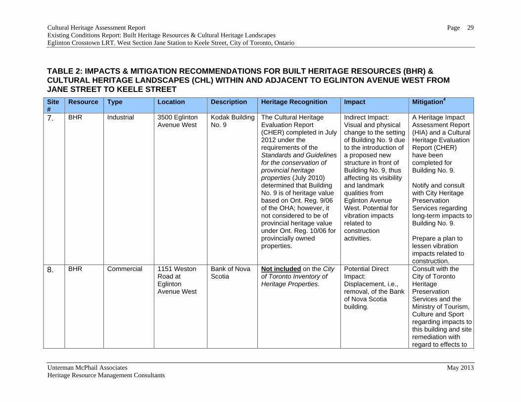
7. BHR Industrial 3500 Eglinton Avenue West
Kodak Building No. 9
The Cultural Heritage Evaluation Report (CHER) completed in July 2012 under the requirements of the Standards and Guidelines for the conservation of provincial heritage properties (July 2010) determined that Building No. 9 is of heritage value based on Ont. Reg. 9/06 of the OHA; however, it not considered to be of provincial heritage value under Ont. Reg. 10/06 for provincially owned properties.
Indirect Impact: Visual and physical change to the setting of Building No. 9 due to the introduction of a proposed new structure in front of Building No. 9, thus affecting its visibility and landmark qualities from Eglinton Avenue West. Potential for vibration impacts related to construction activities.
A Heritage Impact Assessment Report (HIA) and a Cultural Heritage Evaluation Report (CHER) have been completed for Building No. 9. Notify and consult with City Heritage Preservation Services regarding long-term impacts to Building No. 9. Prepare a plan to lessen vibration impacts related to construction.
8. BHR Commercial 1151 Weston Road at Eglinton Avenue West
Bank of Nova Scotia
Not included on the City of Toronto Inventory of Heritage Properties.
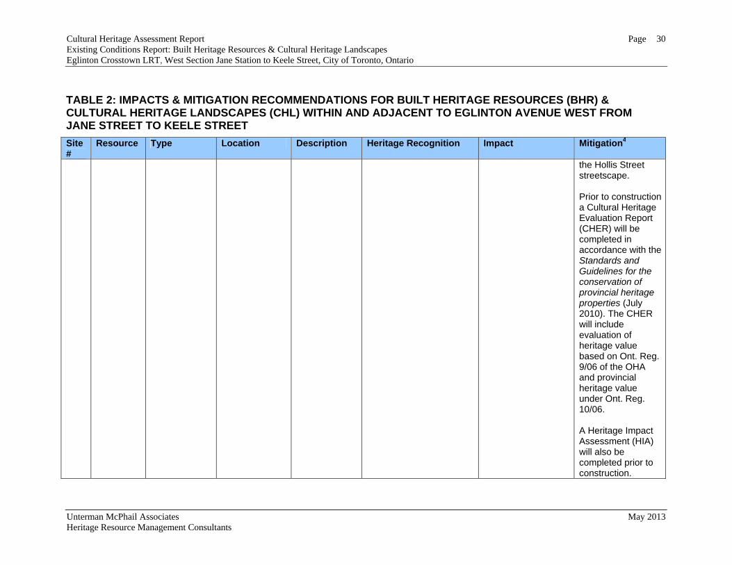
Potential Direct Impact: Displacement, i.e., removal, of the Bank of Nova Scotia building.
Consult with the City of Toronto Heritage Preservation Services and the Ministry of Tourism, Culture and Sport regarding impacts to this building and site remediation with regard to effects to
Cultural Heritage Assessment Report Page 30 Existing Conditions Report: Built Heritage Resources & Cultural Heritage Landscapes Eglinton Crosstown LRT, West Section Jane Station to Keele Street, City of Toronto, Ontario
Unterman McPhail Associates May 2013 Heritage Resource Management Consultants
TABLE 2: IMPACTS & MITIGATION RECOMMENDATIONS FOR BUILT HERITAGE RESOURCES (BHR) & CULTURAL HERITAGE LANDSCAPES (CHL) WITHIN AND ADJACENT TO EGLINTON AVENUE WEST FROM JANE STREET TO KEELE STREET
Site #
Resource Type Location Description Heritage Recognition Impact Mitigation4
the Hollis Street streetscape. Prior to construction a Cultural Heritage Evaluation Report (CHER) will be completed in accordance with the Standards and Guidelines for the conservation of provincial heritage properties (July 2010). The CHER will include evaluation of heritage value based on Ont. Reg. 9/06 of the OHA and provincial heritage value under Ont. Reg. 10/06. A Heritage Impact Assessment (HIA) will also be completed prior to construction.
Cultural Heritage Assessment Report Page 31 Existing Conditions Report: Built Heritage Resources & Cultural Heritage Landscapes Eglinton Crosstown LRT, West Section Jane Station to Keele Street, City of Toronto, Ontario
Unterman McPhail Associates May 2013 Heritage Resource Management Consultants
TABLE 2: IMPACTS & MITIGATION RECOMMENDATIONS FOR BUILT HERITAGE RESOURCES (BHR) & CULTURAL HERITAGE LANDSCAPES (CHL) WITHIN AND ADJACENT TO EGLINTON AVENUE WEST FROM JANE STREET TO KEELE STREET
Site #
Resource Type Location Description Heritage Recognition Impact Mitigation4
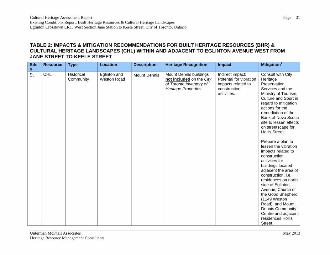
9. CHL Historical Community
Eglinton and Weston Road
Mount Dennis
Mount Dennis buildings not included on the City of Toronto Inventory of Heritage Properties
Indirect impact: Potentai for vibration impacts related to construction activities.
Consult with City Heritage Preservation Services and the Ministry of Tourism, Culture and Sport in regard to mitigation actions for the remediation of the Bank of Nova Scotia site to lessen effects on streetscape for Hollis Street. Prepare a plan to lessen the vibration impacts related to construction activities for buildings located adjacent the area of construction, i.e., residences on north side of Eglinton Avenue, Church of the Good Shepherd (1149 Weston Road), and Mount Dennis Community Centre and adjacent residences Hollis Street.
Cultural Heritage Assessment Report Page 32 Existing Conditions Report: Built Heritage Resources & Cultural Heritage Landscapes Eglinton Crosstown LRT, West Section Jane Station to Keele Street, City of Toronto, Ontario
Unterman McPhail Associates May 2013 Heritage Resource Management Consultants
TABLE 2: IMPACTS & MITIGATION RECOMMENDATIONS FOR BUILT HERITAGE RESOURCES (BHR) & CULTURAL HERITAGE LANDSCAPES (CHL) WITHIN AND ADJACENT TO EGLINTON AVENUE WEST FROM JANE STREET TO KEELE STREET
Site #
Resource Type Location Description Heritage Recognition Impact Mitigation4
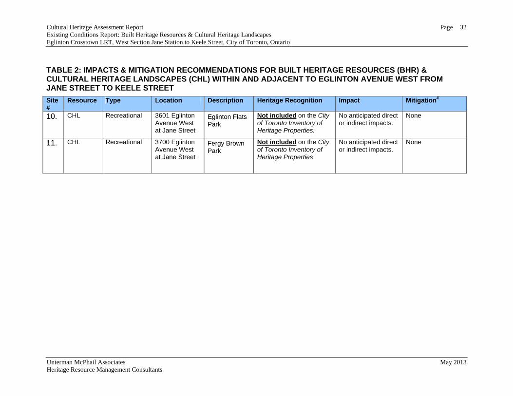
10. CHL Recreational 3601 Eglinton Avenue West at Jane Street
Eglinton Flats Park
Not included on the City of Toronto Inventory of Heritage Properties.
No anticipated direct or indirect impacts.
None
11. CHL Recreational 3700 Eglinton Avenue West at Jane Street
Fergy Brown Park
Not included on the City of Toronto Inventory of Heritage Properties
No anticipated direct or indirect impacts.
None
Cultural Heritage Assessment Report Built Heritage Resources & Cultural Heritage Landscapes Eglinton Crosstown LRT, West Section Jane Station to Keele Street, City of Toronto, Ontario
Unterman McPhail Associates May 2013 Heritage Resource Management Consultants
SOURCES Chapman. L.J. and Putnam, D.F. The Physiography of Southern Ontario. 3rd edition.
Ministry of Natural Resources, 1984. City of York: A Local History. The Board of Education for the City of York, c1981. Environmental Assessment Act RSO 1990, c. E.18. (as am. S.O. 1993, c. 27; 1994, c. 27;
and 1996, c. 27). Gentilcore, R. Louis, and Head, C. Grant. Ontario’s History in Maps. Toronto:
University of Toronto Press, 1984. Golder Associates. Heritage Impact Assessment Former Kodak Employee’s Building
3500 Eglinton. Submitted to Metrolinx. March 2011. Guideline for Preparing the Cultural Heritage Component of Environmental
Assessments. Ontario Ministry of Culture and Communications and Ontario Ministry of the Environment, October 1992.
Hayes, Derek. Historical Atlas of Toronto. Vancouver, BC.: Douglas & MacIntyre Ltd., 2008. Illustrated Historical Atlas of the County of York. Toronto, Ont.: J. H. Beers & Co.,
1878. Mulvany, Charles Pelham et al. History of Toronto and County of York, Ontario,
containing an outline of the history of the Dominion of Canada, a history of the city of Toronto and the county of York, with the townships, towns, villages, churches, schools, general and local statistics, biographical sketches, etc. Volumes 1 and II (1885). Volume 1. Toronto: C. Blackett Robinson, Publisher, 1885.
Ontario Heritage Act Regulation 9/06: Criteria for Determining Cultural Heritage Value
or Interest, January 25, 2006. Ontario Ministry of Culture. Heritage Resources in the Land Use Planning Process,
Queen’s Printer for Ontario, Toronto, 2006. Ontario Heritage Act. RSO 1990. Smith, Wm. H. Smith’s Canadian Gazetteer. Toronto: H. & W. Rowsell, 1846. Taylor Hazell Architects Ltd. Kodak Building #9, Cultural Heritage Evaluation Report.
July 2012.

Cultural Heritage Assessment Report Built Heritage Resources & Cultural Heritage Landscapes Eglinton Crosstown LRT, West Section Jane Station to Keele Street, City of Toronto, Ontario
Unterman McPhail Associates May 2013 Heritage Resource Management Consultants
Thomas, Wilbert G. The legend of York: a survey of the later developments (1920-1950), in York Township. c1996
Toronto Staff Report to Toronto Preservation Board, Etobicoke York Community
Council, From the Director, Policy & Research, City Planning Department, Subject: 3500 Eglinton Avenue West (Employees’ Building, Canadian Kodak Building) Inclusion on the City of Toronto Inventory of Heritage Properties and Intention to Designate under Part IV of the Ontario Heritage Act, York South-Weston-Ward 12, May 24, 2006.
Weiler, John. Guidelines on the Man-Made Heritage Component of Environmental
Assessments. Ontario Ministry of Culture and Recreation, 1980. Web sites City of Toronto Heritage Properties Inventory - Search.
Access:--< http://app.toronto.ca/HeritagePreservation/setup.do?action=init> (November 2012).
Maps, photographs and Drawings Aldgate’s Toronto and Suburbs Map. Toronto: The Map Specialty Co., 1935. Google Maps 2012. J.O. Browne and J. Ellis. Map of York Township in the County of York, Upper Canada,
1851. Lloyd’s Map of Greater Toronto and Suburbs. The Map Co. of Toronto, 1925. Map of the Principal Communications in Canada West complied from the most
authentick sources, actual Surveys, District maps, etc., etc., by Major Baron de Rottenburg, Ast. Quarter Mr Genl 1850? [NMC].
National Topographic Series:
Toronto 30 M/11: 1909, 1918, 1927, 1934, 1950 and 1976. Township of York Map. Illustrated Historical Atlas of the County of York. Toronto,
Ontario: J. H. Beers & Co., 1878. Tremaine’s Map of the County of York, Canada West. G. R. Tremaine & G. R.
Tremaine, 1860. Underwriters’ Survey Bureau, Limited, Toronto and Montreal.
Toronto, Volume 13 (York), January 1963. March 1963.

Cultural Heritage Assessment Report Built Heritage Resources & Cultural Heritage Landscapes Eglinton Crosstown LRT, West Section Jane Station to Keele Street, City of Toronto, Ontario
Unterman McPhail Associates May 2013 Heritage Resource Management Consultants
Contacts Kathryn Anderson, Preservation Services, City of Toronto.

APPENDIX:
HISTORICAL MAPS

Cultural Heritage Assessment Report Appendix Existing Conditions Report: Built Heritage Resources & Cultural Heritage Landscapes Eglinton Crosstown LRT, West Section Jane Station to Keele Street, City of Toronto, Ontario
Unterman McPhail Associates May 2013 Heritage Resource Management Consultants
Map showing Base Line or Eglinton Avenue between Keele Street and Jane Street in 1860 [Tremaine Map of the County of York, Ontario, 1860].
North side of Base Line or Eglinton Avenue between Keele Street and Jane Street [York Township Illustrated Historical Atlas 1878].
South side of Base Line or Eglinton Avenue between Keele Street and Jane Street [South West Part of York Township Illustrated Historical Atlas 1878].
Cultural Heritage Assessment Report Appendix Existing Conditions Report: Built Heritage Resources & Cultural Heritage Landscapes Eglinton Crosstown LRT, West Section Jane Station to Keele Street, City of Toronto, Ontario
Unterman McPhail Associates May 2013 Heritage Resource Management Consultants
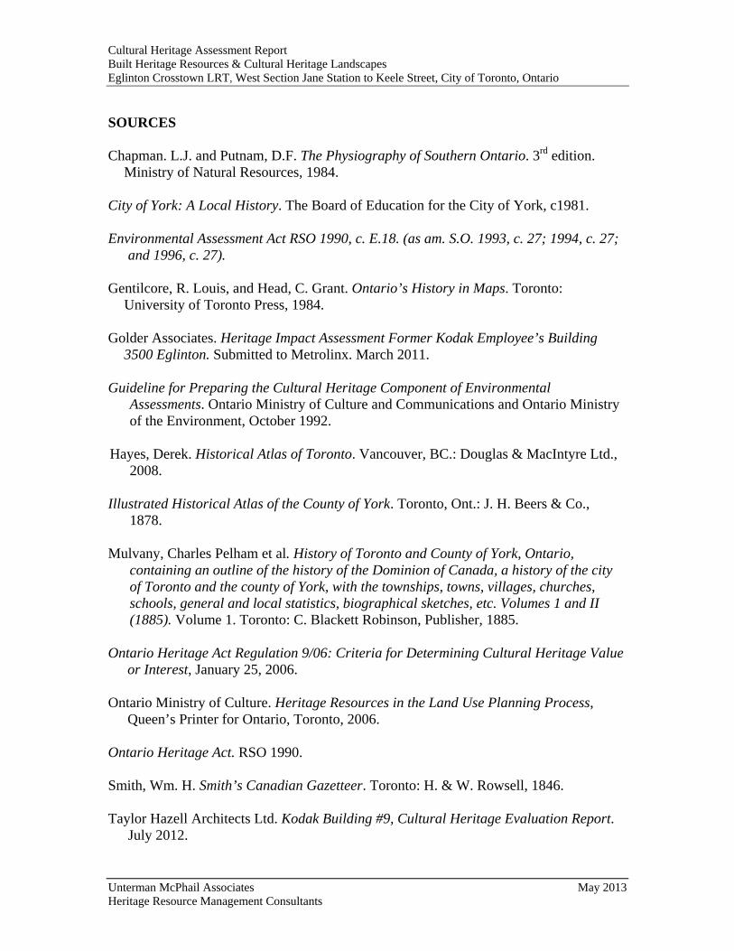
Topographic map of 1909 showing study corridor on Eglinton Avenue between Keele Street and Jane Street [National Topographic Series: Toronto 30 M/11, 1909].
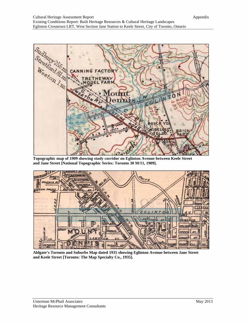
Aldgate’s Toronto and Suburbs Map dated 1935 showing Eglinton Avenue between Jane Street and Keele Street [Toronto: The Map Specialty Co., 1935].
Cultural Heritage Assessment Report Appendix Existing Conditions Report: Built Heritage Resources & Cultural Heritage Landscapes Eglinton Crosstown LRT, West Section Jane Station to Keele Street, City of Toronto, Ontario
Unterman McPhail Associates May 2013 Heritage Resource Management Consultants
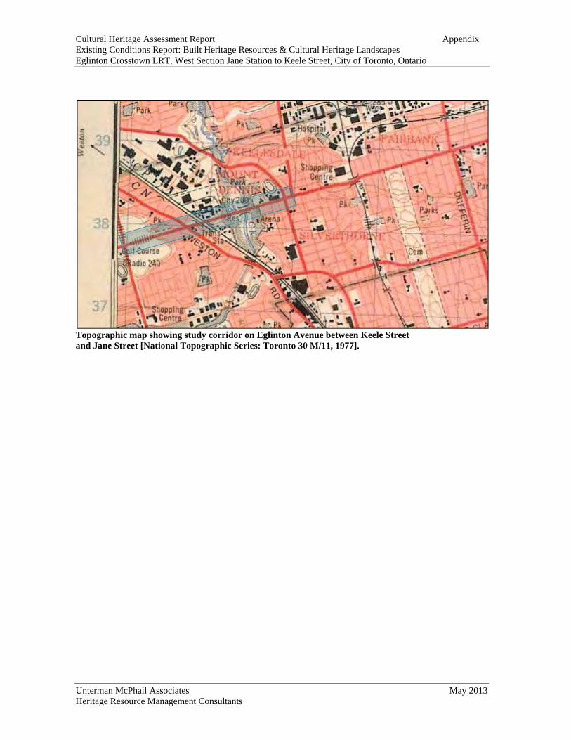
Topographic map showing study corridor on Eglinton Avenue between Keele Street and Jane Street [National Topographic Series: Toronto 30 M/11, 1977].