cultural heritage management plan - growth areas authority
TRANSCRIPT

Cultural Heritage Management Plan
Proposed Residential Subdivision, Greenvale Central, GreenvaleDesktop, Standard and Complex AssessmentsAAV Management Plan Identifier: 11582Date: April 18th 2011
****DRAFT – Standard Assessment****
Sponsor: Growth Areas Authority (ABN: 77 803 352 468)Cultural Heritage Advisor: Maya BarkerAuthor: Maya Barker
PO Box 1289Collingwood VIC 3066
P: 03) 9417 6803F: 03) 9417 7215

ii
Title page
ACTIVITY: Residential SubdivisionLOCATION: GreenvaleSIZE OF ACTIVITY LargeAAV PLAN IDENTIFIER: 11582DATE OF COMPLETION: XXX XXXSPONSOR: Growth Areas Authority
(ABN: 77 803 352 468)CULTURAL HERITAGE ADVISOR: Maya BarkerAUTHOR: Maya Barker
Acknowledgements
Heritage Insight P/L would like to acknowledge and thank the following people fortheir assistance and participation in this study:
The Traditional Owners for their input:
Wurundjeri Tribe Land and Compensation Cultural Heritage Council Inc:Darren Griffin, Cultural Heritage ManagerShane Nicholson, Field RepresentativeNaomi Mullins, Field RepresentativeDanielle Mullins, Field Representative
Heritage Insight Staff:
Lauren Prossor – Background CompilationKatarina Audy – GIS MappingJohn Young – Field Assistance
The Sponsor:
Nat Anson and Fiona McDougall, Growth Areas Authority (GAA).

iii
Disclaimer
The information contained in this CHMP has been compiled from the standardheritage database sources and is accurate as far as the Heritage Insight Pty Ltd isaware. However, within the timeframes available for technical heritage reporting, itis not possible to carry out comprehensive research of all published or unpublishedmanuscripts, journals, maps or oral history which may pertain to the study area. Noresponsibility can be taken for errors or omissions in primary and secondary sourcematerial cited in this report. Any opinions expressed in this report are those of theHeritage Insight Pty Ltd and do not necessarily represent those of the Growth AreasAuthority. The Heritage Insight Pty Ltd have endeavoured to actively consult withrepresentatives of Indigenous community groups who are, to the best of ourknowledge and advice, the legal and proper representatives of the local Indigenouscommunity. The consultants cannot, however, be held responsible for opinions oractions which may be expressed by dissenting persons or organisations. This CHMPhas been prepared to comply with the Approved Form Under Clause 65(a) of theAboriginal Heritage Regulations 2007 “Aboriginal Cultural Heritage ManagementPlan for the Purposes of the Aboriginal Heritage Act 2006”. However, HeritageInsight Pty Ltd cannot be responsible for any changes in policy on the part of theVictorian Government, its agencies or Registered Aboriginal Parties in the periodsince lodging a notification of intent to prepare a CHMP.
Copyright Notice
This report is copyright. Apart from any fair dealing for the purposes of privatestudy, research, criticism or review as permitted under the Copyright Act, no partmay be reproduced, stored in a retrieval system, or transmitted in any form or byany means, electronic, mechanical, photocopying or recording or otherwise withoutprior written permission. Enquiries are to be made to the Growth Areas Authority orHeritage Insight Pty Ltd.

Greenvale Central: CHMP 11582Heritage Insight Pty Ltd
4
The Activity, Location and Level of Assessment
The CHMP is a mandatory plan because the proposed activity is a high impactactivity and the activity occurs within an area of archaeological sensitivity, both ofwhich are triggers for the preparation of a mandatory plan in the Aboriginal HeritageRegulations 2007 .
This CHMP was completed by means of desktop, standard and complex assessments.

Greenvale Central: CHMP 11582Heritage Insight Pty Ltd
5
Table of Contents
Title page ................................................................................................................................................. ii
Acknowledgements ................................................................................................................................. ii
Table of Contents..................................................................................................................................... 5
Part 1 - Assessment.................................................................................................................................. 7
1.0 Introduction ...................................................................................................................................... 7
2.0 Activity Description ......................................................................................................................... 15
2.1 Statement of Potential Impacts.................................................................................................... 15
3.0 Extent of Activity Area Covered by the CHMP ................................................................................. 17
3.1 Description of Existing Conditions in the Activity Area ...................................................................17
4.0 Documentation of Consultation ...................................................................................................... 19
4.1 Consultation in relation to the assessment .................................................................................. 194.2 Participation in the conduct of the assessment ........................................................................... 194.3 Consultation in relation to the recommendations ....................................................................... 204.4 Summary outcomes of consultation............................................................................................. 20
5.0 Report on the Results of the Desktop Assessment ........................................................................... 21
5.1 Methodology for Desktop Assessment......................................................................................... 215.1.1 Search of the Victorian Aboriginal Heritage Register ....................................................................225.1.2 The Geographic Region..................................................................................................................245.1.3 Aboriginal Places in the Geographic Region ..................................................................................255.1.4 Previous work in the Geographic Region.......................................................................................255.1.5 Historical and Ethno-historical accounts in the Geographic Region..............................................285.1.6 Landforms and geomorphology of the Activity Area.....................................................................305.1.7 Land Use History of the Activity Area ............................................................................................325.1.8 Conclusions from the Desktop Assessment...................................................................................32
5.2 Report on the Results of the Standard Assessment .......................................................................... 35
5.2.1 Methodology for Standard Assessment .................................................................................... 355.2.2 Results of Ground Survey .......................................................................................................... 35
Bibliography........................................................................................................................................... 47
Appendix 1: CHMP Notification............................................................................................................. 49
Appendix 2: Response to Elect to Evaluate (Wurundjeri Tribe Land & Compensation CulturalHeritage Council Inc.) ............................................................................................................................. 53
Appendix 3: Glossary ............................................................................................................................. 55
List of Maps
Map 1: Location of Activity Area, Greenvale Central, Greenvale ........................................................... 13Map 2: Development Plan of Activity Area ............................................................................................ 16Map 3: Aerial Map of Activity Area ........................................................................................................ 18Map 4: Previously Recorded Sites within 200m of Activity Area........................................................... 23Map 5: Geographic Region in Relation to the Activity Area ................................................................... 24Map 6: Survey Area and Survey Transects ............................................................................................. 45Map 7: Areas of Low-Moderate Sensitivty ............................................................................................. 46

Greenvale Central: CHMP 11582Heritage Insight Pty Ltd
6
List of Tables
Table 1 – Bonds Lane Property Details Summary.....................................................................................8Table 2 - Brendan Road Property Details Summary ................................................................................. 8Table 3 – Carroll Lane Property Details Summary .................................................................................... 9Table 4 – French Road Property Details Summary ................................................................................... 9Table 5 – Hillview Road Property Details Summary ................................................................................. 9Table 6 – Mickleham Road Property Details Summary .......................................................................... 10Table 7 - Providence Road Property Details Summary........................................................................... 11Table 8 – Section Road Property Details Summary ................................................................................ 11Table 9 – Somerton Road Property Details Summary ............................................................................ 12Table 10: Summary of Previous Reports in the Region .......................................................................... 26Table 11: Summary of Landsystems within the Activity Area ................................................................ 30Table 12 - Bonds Lane Survey - Summary Results .................................................................................. 36Table 13 - Brendan Road Survey – Summary Results ............................................................................. 39Table 14 - Carroll Lane Survey – Summary Results................................................................................. 40Table 15 - French Road Survey – Summary Results................................................................................ 40Table 16 - Hillview Road Survey – Summary Results .............................................................................. 41Table 17 - Mickleham Road Survey – Summary Results......................................................................... 41Table 18 - Providence Road Survey – Summary Results......................................................................... 43Table 19 - Section Road Survey – Summary Results............................................................................... 43Table 20 - Somerton Road Survey – Summary Results........................................................................... 44

Greenvale Central: CHMP 11582Heritage Insight Pty Ltd
7
Part 1 - Assessment
1.0 Introduction
Reasons for Preparing a CHMP
This Cultural Heritage Management Plan (CHMP) is a mandatory CHMPbecause:
Part of the proposed activity occurs in an area of Cultural HeritageSensitivity (Aboriginal Heritage Regulations 2007, Division 1, 6 (a)); and
The proposed activity is a high impact activity (Aboriginal HeritageRegulations 2007, Division1, 6(b)).
A part of the proposed Activity Area occurs within an area of CulturalHeritage Sensitivity because it is situated within 200m of a named watercourse(Aboriginal Heritage Regulations 2007, Part 2, Div 3, r23 (1)).
The proposed activity is a high impact activity because it involves the use ofland for subdivision (Aboriginal Heritage Regulations 2007, Division 5, r46 1 (a)and (b)(xxiii).
Sponsor for the CHMP
The sponsor for this CHMP is the Growth Areas Authority (GAA) (ABN 77 803352 468).
Notice of Intention to Prepare a CHMP
A Notice of Intention to Prepare a CHMP (see Appendix 1: CHMP Notification)was submitted to the Deputy Director of Aboriginal Affairs Victoria and to theWurundjeri Tribe Land and Compensation Cultural Heritage Council Inc,pursuant to Section 54 of the Aboriginal Heritage Act 2006.
Name, Qualifications and Experience of Cultural Heritage Advisor
The Cultural Heritage Advisor who has conducted this CHMP is Dr Maya Barker(BA Hons)/BSc/PhD). Maya has formal archaeological qualifications from bothMonash University and La Trobe University and has had over six yearsexperience working in the field of Indigenous archaeology.

Greenvale Central: CHMP 11582Heritage Insight Pty Ltd
8
Location of the Activity Area and Landowners
The Activity Area is located off Mickleham and Somerton Roads, Greenvale,City of Hume (see Map 1). The Activity Area is situated within the Melbournesuburb of Greenvale, which lies approximately 25km north-west of theMelbourne CBD. The Activity Area covers a stretch of land which is 240ha andencompasses the properties outlined in Tables 1-9 below:
Table 1 – Bonds Lane Property Details Summary
Landowner Address Land Area Lot Cert. of TitleLast Name # Street (ha) # # Vol FolUzuncakmak, S & Z 20 Bonds Lane 2.23 128441 Lot 5 9506 357Davis, FJ 35 Bonds Lane 2.02 37797 Lot 1 8167 220Fazzari, D & L 40 Bonds Lane 2.03 128441 Lot 6 9506 358Childs, GJ 55 Bonds Lane 4.22 3586 Lot 12 2955 863Ali, H & H 60 Bonds Lane 2.02 128441 Lot 7 9506 359Giompapa, M & P 75 Bonds Lane 4.02 3586 Lot 3 4643 431Karagiannis, T & E 90 Bonds Lane 2.03 128441 Lot 8 9506 360Ultimate CorporationPty Ltd 95 Bonds Lane 3.60 3586 Lot 8 2739 613Aurolin Pty Ltd 100 Bonds Lane 2.03 128441 Lot 9 9506 361Nania, A & M 110 Bonds Lane 2.03 128441 Lot 10 9637 199Ali, M & CE 115 Bonds Lane 4.00 3586 Lot 7 2653 464Zeina, D 120 Bonds Lane 2.02 128441 Lot 11 9637 200
Sabatino, G & S 125 Bonds Lane 2.00 3586 Lot 6 5897 243Mangiafico, A & S 130 Bonds Lane 2.09 128441 Lot 12 10803 208Melbourne &Metropolitan Broad ofWorks
140-160 Bonds Lane 0.50 191287 Lot 1 9332 136
Melbourne &Metropolitan Broad ofWorks
140-160 Bonds Lane 0.24 80284 Lot 1 9425 916
Melbourne &Metropolitan Broad ofWorks
140-160 Bonds Lane 0.07 180040 Lot 1 9369 759
Dunn, TC X Bonds Lane 1.99 556632 Lot 2 6828 581
Dunn, TC X Bonds Lane 1.50 556362Lot 3(2pt) 6828 581
Table 2 - Brendan Road Property Details Summary
Address
Land AreaTitle
Search Lot Cert. of TitleLast Name # Street (ha) # # Vol FolSanjeeva PtyLtd 35 Brendan Road 2.02 197473 Lot 1 9056 395

Greenvale Central: CHMP 11582Heritage Insight Pty Ltd
9
Arzenti, R 40 Brendan Road 2.03 53814 Lot 14 8634 673Hasan, H &JA 45 Brendan Road 2.02 53814 Lot 19 8683 625Suhina, J & K 50 Brendan Road 2.03 53814 Lot 15 8666 492Lopianto, V,PJ 65 Brendan Road 2.02 53814 Lot 18 8577 354D'Cunha, CA 70 Brendan Road 2.03 53814 Lot 16 8596 31Nazligul, M &A 75 Brendan Road 2.02 53814 Lot 17 8634 671Lewi, PE & L 80 Brendan Road 3.64 868662 Lot 1 9478 194
Table 3 – Carroll Lane Property Details Summary
Landowner Address Land Area Title Search LotCert.
of Title
Last Name # Street (ha) # # Vol FolPalma, KE 30 Carroll Lane 2.21 115075 Lot 12 9091 170Agostino,HA 35 Carroll Lane 2.05 115075 Lot 5 9091 163Cotsis, J&M 45 Carroll Lane 2.05 115075 Lot 4 9091 162Burton, HR 50 Carroll Lane 2.07 115075 Lot 13 9091 171Bonagan,LG 55 Carroll Lane 2.78 115075 Lot 3 9091 161Montesano,S&M 65 Carroll Lane 2.34 115075 Lot 2 9091 160Adams,G&F 75 Carroll Lane 2.33 115075 Lot 1 9091 159Soderstrom,JP 80 Carroll Lane 2.02 115075 Lot 14 9091 172
Table 4 – French Road Property Details SummaryAddress Land Area Cert. of Title
Last Name # Street (ha) # # Vol FolRobrick PtyLtd 25 French Road 2.02 53814 Lot 25 8472 86Palazzolo,A&S 30 French Road 2.02 53814 Lot 21 8542 983Nzaligul, M,A, C, Y, M,B &A 45 French Road 2.02 53814 Lot 26 8659 569Obliubek, M 50 French Road 2.02 53814 Lot 22 8619 433Holloway -ME, PM,JW, CT; JARobinson 55 French Road 2.02 53814 Lot 27 8577 355Fewchuk,DS & KD 60 French Road 2.02 53814 Lot 23 8502 124Madafferi,AM 75 French Road 2.02 53814 Lot 28 8434 543
Table 5 – Hillview Road Property Details SummaryAddress Land Area Cert. of Title
Last Name # Street (ha) # # Vol Fol

Greenvale Central: CHMP 11582Heritage Insight Pty Ltd
10
Darmanin,F&M 25 Hillview Road 2.07 53814 Lot 29 8577 353Davis, BG& AM 40 Hillview Road 2.03 53814 Lot 24 8542 985Lumicisi, G& GJ 45 Hillview Road 2.03 53814 Lot 30 8596 33Santo, N &PR 65 Hillview Road 2.03 53814 Lot 31 8750 440Bozkurt, M& N 85 Hillview Road 2.03 53814 Lot 32 8434 542
Table 6 – Mickleham Road Property Details SummaryAddress Land Area Cert. of Title
Last Name # Street (ha) # # Vol Fol
Bermic, MF 565MicklehamRoad 2.11 40477 Lot 9 8426 111
Skinner, L 585MicklehamRoad 2.15 40477 Lot 8 8139 40
Direct PlantsPty Ltd 595
MicklehamRoad 2.19 40477 Lot 7 8139 41
Bourchier,MG&C 605
MicklehamRoad 2.20 40477 Lot 6 8139 42
Kuvanci, M&N 615MicklehamRoad 2.18 40477 Lot 5 8164 741
PJ Swift, AJWoods and GWoods 625
MicklehamRoad 2.12 40477 Lot 4 8139 43
Lloyd, GW&DL 645MicklehamRoad 2.06 40477 Lot 3 8139 44
Bultan, M&R 655MicklehamRoad 2.04 40477 Lot 2 8139 39
SantiniSuperannuationInvestmentsPty Ltd 665
MicklehamRoad 2.62 40477 Lot 1 8223 415
Hateley, KD 675MicklehamRoad 2.05 42095 Lot 5 8268 78
Spiteri, RR &SF 685
MicklehamRoad 2.04 42095 Lot 4 8559 3
Hawkins, R L 695MicklehamRoad 2.03 115075 Lot 7 11184 928
Gangelhoff, AH& ME 715
MicklehamRoad 2.05 115075 Lot 8 9091 166
Glogovac, R &M 725
MicklehamRoad 2.16 115075 Lot 9 9091 167
Smallcombe,GE & BK 735
MicklehamRoad 2.03 115075 Lot 10 9091 168
Uluanowski, BR 745MicklehamRoad 2.03 115075 Lot 11 9091 169
Marantelli, EP& I 765
MicklehamRoad 6.26 37797 Lot 2 8589 156
Barca, R & A 805MicklehamRoad 2.50 128441 Lot 4 9506 356
Furina, V & R 815MicklehamRoad 2.45 128441 Lot 3 9506 355
Stapancic, J &S 825
MicklehamRoad 2.41 128441 Lot 2 9637 198

Greenvale Central: CHMP 11582Heritage Insight Pty Ltd
11
Eideh PropertyInvestmentsPty Ltd 835
MicklehamRoad 2.34 128441 Lot 1 9506 354
Uniting ChurchAustralia P/T(Vic) 855
MicklehamRoad 4.05 3600 Lot 21 8831 247
Scodella, P &M 875
MicklehamRoad 1.96 558335 Lot 1 8255 346
Younan, G & S 910MicklehamRoad 1.54 749454 Lot 1 8666 491
Celano, J & M 920MicklehamRoad 2.02 53814 Lot 5 8666 494
Saykao - P &N, B & N, M, C& V; P & VVirathome 940
MicklehamRoad 2.02 53814 Lot 4 8542 986
Dale, KF & BJ 960MicklehamRoad 2.02 53814 Lot 3 8542 984
Sheridan, JH 980MicklehamRoad 2.02 53814 Lot 2 8666 493
Pancella, A, A 990MicklehamRoad 2.03 53814 Lot 1 10645 937
Table 7 - Providence Road Property Details SummaryAddress Land Area Title Search Lot Cert. of Title
Last Name # Street (ha) # # Vol FolUniting ChurchAustralia P/T(Vic) 30
ProvidenceRoad 0.07 16125 Lot 2 10483 533
Uniting ChurchAustralia P/T(Vic) 30
ProvidenceRoad 0.06 16125 Lot 1 10483 532
Gleeson, MA 35ProvidenceRoad 2.08 42095 Lot 3 8535 846
Geddes, AJ &NL 40
ProvidenceRoad 2.20 115075 Lot 6 9091 164
Gangelhoff,ME 45
ProvidenceRoad 2.09 42095 Lot 2 8460 840
Mezo, JH &RM 55
ProvidenceRoad 2.07 65792 Lot 4 8525 627
Gowans, WD& SH 65
ProvidenceRoad 2.07 65792 Lot 3 8525 626
Connelly, HF 70ProvidenceRoad 1.50 857872 Lot 1 10879 860
Simpson, MA 80ProvidenceRoad 1.23 121982 Lot 1 9904 374
Marantelli EP& I , andBurman L & K 90
ProvidenceRoad 2.60 21712 Lot 1 10578 614
Table 8 – Section Road Property Details SummaryAddress Land Area Title Search Cert. of Title
Last Name # Street (ha) # # Vol FolChilds, GJ 110 Section Road 6.06 3586 Lot 2 2465 913Power, N & J 110 Section Road ?

Greenvale Central: CHMP 11582Heritage Insight Pty Ltd
12
Crown Land 140 Section Road 0.05 -CA2C - -
Crown Land 140 Section Road 1.54 -CA3D - -
Hutchinson, JE& WA 150 Section Road 1.22 -
CA2B 4120 995
Acilioglu, M 160 Section Road 0.21 109462 Lot 1 9695 883Melbourne &MetropolitanBroad ofWorks 166 Section Road 0.12 838028 Lot 1 9332 449Melbourne &MetropolitanBroad ofWorks 166 Section Road 0.08 183298 Lot 1 9358 419Startseff 170 Section Road 0.73 201200 Lot 3 9702 195
Pati, JM & SS 180 Section Road 0.66 201200Lot28(pt) 9379 582
Hurry, GJ &AM 190 Section Road 0.43 168862 - 9847 761
Table 9 – Somerton Road Property Details Summary
Address Land AreaTitle
Search Lot Cert. of TitleLast Name # Street (ha) # # Vol FolAustralasianConferenceAssociation Ltd 85
SomertonRoad 0.80 -
CA6A 9968 697
Fedele, D & A 650SomertonRoad 1.98 210950 Lot 1 9457
Vidler, LH &MA 660
SomertonRoad 2.04 53814
Lot12 8502 123
Nazligul, M &A 670
SomertonRoad 2.02 53814
Lot11 8644 931
Sapuppo, A &G 680
SomertonRoad 2.02 97635 Lot 1 9598 894
Sassine, S & G 690SomertonRoad 2.02 53814 Lot 9 8654 416
Kouroulis, J &V 700
SomertonRoad 2.02 53814 Lot 8 8542 982
SelimiyeFoundation Ltd 710
SomertonRoad 2.02 53814 Lot 7 8596 32
Pirani, GR 765SomertonRoad 4.05 3586
Lot10 9047 509
Ali, H & H 785SomertonRoad 3.96 184865 Lot 1 9047 508
Dunn, TC 805SomertonRoad 4.01 556362 Lot 1 6828 581

Greenvale Central: CHMP 11582Heritage Insight Pty Ltd
13
Map 1: Location of Activity Area, Greenvale Central, Greenvale

Greenvale Central: CHMP 11582Heritage Insight Pty Ltd
14
RAP’s with Responsibility for the Activity Area
The RAP with responsibility for the Activity Area is the Wurundjeri Tribe Landand Compensation Cultural Heritage Council Inc. The RAP has providedformal written confirmation that they intend to evaluate this CHMP (seeAppendix 2: Response to Elect to Evaluate (Wurundjeri Tribe Land & CompensationCultural Heritage Council Inc.).

Greenvale Central: CHMP 11582Heritage Insight Pty Ltd
15
2.0 Activity Description
The proposed activity provides plans for a residential subdivision comprisingXXX allotments (see Map 2).
2.1 Statement of Potential Impacts
The activity itself is a phased construction to develop the residentialsubdivision for the purpose outlined above. The sequence of the activities(construction) is as follows:
1. Site preparation will include site clearance, where unwanted rubbish,vegetation, and rocks are moved from the site.
2. Stripping (removing) of the topsoil, utilising heavy machinery, to adepth of 75-100mm including the removal of any basalt floaters. Thetopsoil is stockpiled for later use in topsoiling of the nature strips andallotments.
3. Installation of the sewer pipeline, utilising heavy machinery through theexcavation of open cut trenches only. The top surface of the existingstripped ground 1.0m to either side of the trench may be disturbedduring this work.
4. Installation of the drainage, utilising heavy machinery through theexcavation of open cut trenches only. The top surface of the existingstripped ground 1.0m to either side of the trench may be disturbedduring this work.
5. Excavation for the road pavement, utilizing heavy machinery,including shaping of the nature strips to their final levels. The road itselfis then constructed within this excavation.
6. Installation of services (electricity, telecommunications, gas, water)within the previously disturbed nature strips, utilising heavy machinery.As the trench excavations are relatively shallow and narrow,disturbance either side of the trench is of minimal impact.
7. Once all works involving excavation are complete, the allotments arethen filled (where necessary) and/or shaped in accordance with thedesign levels, ready for when the housing is constructed by thepurchaser.
8. Housing construction will then take place in accordance with thedesign of the individual purchaser.
The activities as described above are both permissible and typical for alldevelopments undertaken under a residential 1 zoning planning permit.

Greenvale Central: CHMP 11582Heritage Insight Pty Ltd
16
A summary of typical trench widths and depths of excavation of eachconstruction activity are provided below:
Activity Width of Trench (m) Depth Range (m)Roads 6.4 – 8.4 0.5 – 1.2Drainage 0.9 – 3.0 1.0 – 4.0Sewer reticulation 0.9 – 2.0 1.0 – 5.0Water reticulation 0.3 – 1.0 0.8 – 1.0Electricity 0.3 – 1.0 0.6 – 0.9Telecommunications 0.3 – 1.0 0.3 – 0.6Gas 0.3 – 1.0 0.6 – 0.9
Landscaping Works
Map 2: Development Plan of Activity Area

Greenvale Central: CHMP 11582Heritage Insight Pty Ltd
17
3.0 Extent of Activity Area Covered by the CHMP
The extent of the Activity Area is shown in Map 3. The Activity Area coversmultiple parcels of land totalling 240 hectares in size and is situated within theMelbourne suburb of Greenvale, which lies approximately 25km north-west ofthe Melbourne CBD.
The northern section of the Activity Area is bounded to the north by vacantland, to the east by Greenvale Reservoir, to the south by Somerton Road andto the west by Mickleham Road. The southern section of the Activity Area isbounded to the north by Somerton Road, to the east by Mickleham Road, tothe south by the Woodlands Historic Park and to the west by semi-ruralproperties.
3.1 Description of Existing Conditions in the Activity Area
The Activity Area comprises multiple parcels of land nearly all of whichcontain residential dwellings. Many of the parcels are occupied by largeresidential properties with manicured gardens while a small number of parcelscontinue to be used for grazing animals. Very little mature native vegetationremains over the Activity Area.

Greenvale Central: CHMP 11582Heritage Insight Pty Ltd
18
Map 3: Aerial Map of Activity Area

Greenvale Central: CHMP 11582Heritage Insight Pty Ltd
19
4.0 Documentation of Consultation
A Notice of intention to prepare a CHMP for Greenvale Central, Greenvale,was submitted to both AAV and the Wurundjeri Tribe Land andCompensation Cultural Heritage Council Inc on January 14th 2011 (seeAppendix 1: CHMP Notification). A notice of acceptance was received fromAAV on January 24th 2011 and this CHMP was allocated the Project Number11582. The Wurundjeri Tribe Land and Compensation Cultural HeritageCouncil Inc provided written confirmation on January 21st 2011 that they haveelected to evaluate the CHMP (see Appendix 2: Response to Elect to Evaluate(Wurundjeri Tribe Land & Compensation Cultural Heritage Council Inc.).
4.1 Consultation in relation to the assessment
Consultation with the Wurundjeri was undertaken from the outset of thisproject in the form of discussions with Darren Griffin, Cultural HeritageManager of the Wurundjeri Tribe Land and Compensation Cultural HeritageCouncil Inc.
An initial project inception meeting was held on February 4th 2011 betweenMaya Barker of Heritage Insight Pty Ltd, Darren Griffin, Cultural HeritageManager of the Wurundjeri and representatives of the Sponsor, Nat Ansonand Fiona McDougall , Growth Areas Authority. The purpose of this meetingwas to discuss the function of the project and to discuss an appropriatemethodology to carry out the field work for the standard assessment. Themethodology for the standard assessment outlined within this CHMP was thatwhich was agreed upon during the meeting.
A second project meeting was held on May XXth 2011 between Maya Barkerof Heritage Insight Pty Ltd, Darren Griffin, Cultural Heritage Manager of theWurundjeri and representatives of the Sponsor, Nat Anson and FionaMcDougall, Growth Areas Authority. The purpose of this meeting was todiscuss the results of the standard assessment and to agree to a methodologyto complete the complex assessment. The methodology for the complexassessment outlined within this CHMP was that which was agreed upon duringthe meeting.
A third project meeting was held on XXXX 2011 between Maya Barker ofHeritage Insight Pty Ltd, Darren Griffin, Cultural Heritage Manager of theWurundjeri and representatives of the Sponsor, Nat Anson and FionaMcDougall, Growth Areas Authority. The purpose of this meeting was todiscuss the results of the complex assessment.
4.2 Participation in the conduct of the assessment
Standard Assessment

Greenvale Central: CHMP 11582Heritage Insight Pty Ltd
20
A standard assessment was undertaken for the project on the 11th and 15th ofMarch, 2011. Participating as field representatives in the conduct of thisassessment were Shane Nicholson, Naomi Mullins and Danielle Mullins.
Complex Assessment
Date Wurundjeri Field Representatives
4.3 Consultation in relation to the recommendations
4.4 Summary outcomes of consultation

Greenvale Central: CHMP 11582Heritage Insight Pty Ltd
21
5.0 Report on the Results of the Desktop Assessment
In accordance with Clause 8, Schedule 2 and Clause 9, Schedule 2 of theAboriginal Heritage Regulations 2007, this section contains the results of thedesktop assessment.
5.1 Methodology for Desktop Assessment
The aim of the desktop assessment was to produce an archaeological siteprediction model, which would assist in the design of the fieldwork, theinterpretation of the fieldwork results, the assessment of cultural significanceand the design of the management recommendations. The desktopassessment involved a review of:
Standard ethnographic sources to identify the likely traditional ownersand a review of any written and oral local history regarding Aboriginalpeople in the area;
Environmental resources available to Aboriginal people within theregion of the activity area;
The site registry at AAV and previous archaeological studies, to identifyany previously registered Aboriginal archaeological sites either withinor surrounding the activity area and the results of previousarchaeological assessments; and
The land-use history of the Activity Area, particularly evidence for theextent and nature of past land disturbance.
The landforms or geomorphology of the Activity Area andidentification and determination of the geographic region of whichthe Activity Area forms a part that is relevant to the Aboriginal culturalheritage that may be present in the Activity Area.
This information was used to produce an archaeological site predictionmodel. The site prediction model assists in determining the type ofarchaeological sites which may potentially occur within the Activity Area, thepossible contents of these sites, the possible past use of the landscape byAboriginal people and the likely extent of ground disturbance toarchaeological sites. The information provided by the site prediction model isused constructively in designing the survey strategy, by, for example, allowingthe field team to target areas which have a high probability of containingarchaeological sites. However, areas or landforms which were assessed ashaving a low probability of containing Aboriginal archaeological sites werealso assessed, in order to test the effectiveness of the site prediction model.

Greenvale Central: CHMP 11582Heritage Insight Pty Ltd
22
5.1.1 Search of the Victorian Aboriginal Heritage Register
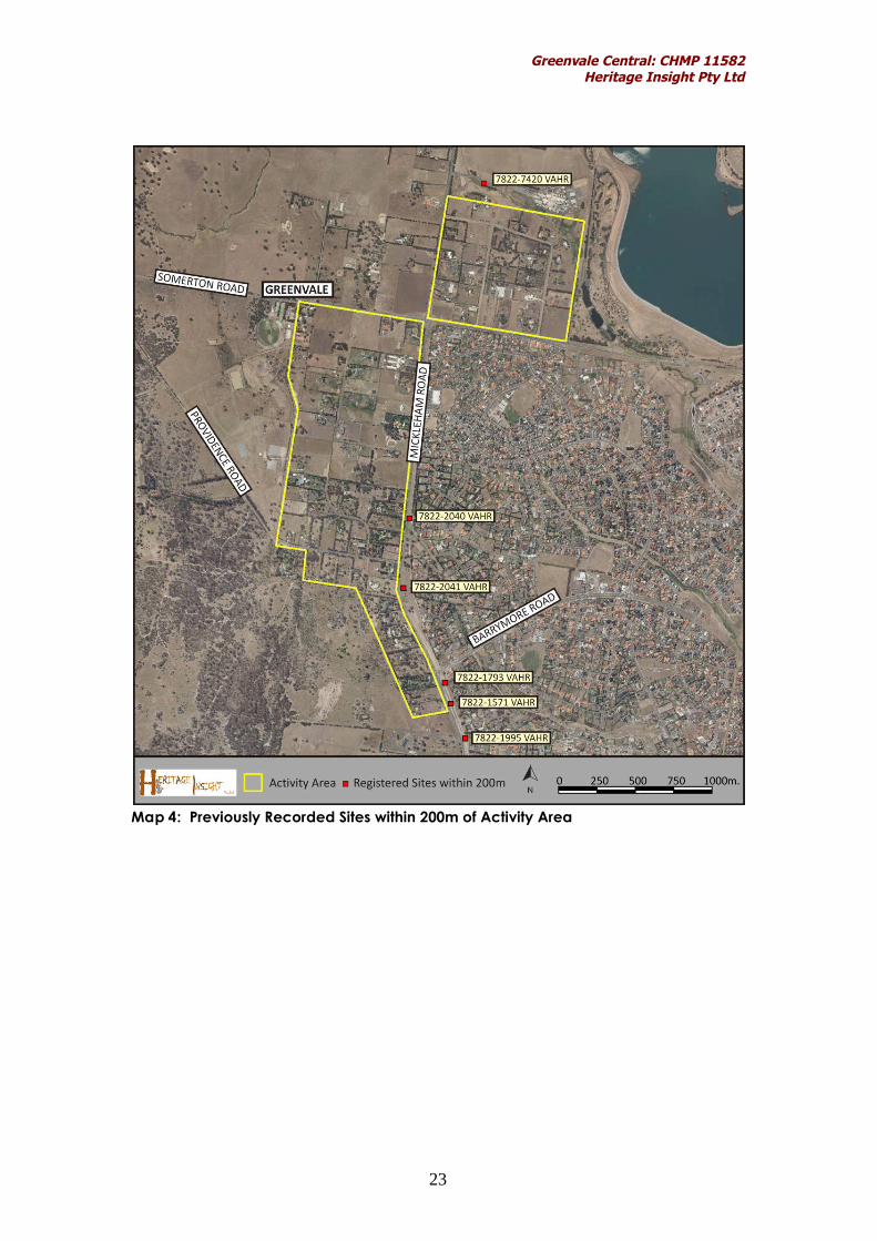
As part of the desktop assessment for this CHMP a search of the VictorianAboriginal Heritage Register [VAHR] was undertaken on 10/01/2011.
The search indicated that there were five previously recorded Aboriginalarchaeological sites within 200m of the Activity Area (see Map 4). These sitescomprise the following:
7822-1571 [VAHR] Mickleham Road AS 1 (Artefact Scatter) 7822-1793 [VAHR] Mickleham 2 (Artefact Scatter) 7822-1995 [VAHR] Mickleham Road AS 2 (Artefact Scatter) 7822-2040 [VAHR] Mickleham Road Duplication 1 (Artefact Scatter) 7822-2041 [VAHR] Mickleham Road Duplication 2 (Artefact Scatter) 7822-2420 [VAHR] Aitken College 1 (Artefact Scatter)
Site 7822-1571 [VAHR] Mickleham Road AS 1 comprises a scatter of foursilcrete flakes. This scatter was located within the road reserve.
Site 7822-1793 [VAHR] Mickleham 2 comprises one pink silcrete flake and onebrown chert flake. These two artefacts were located within the road reservewithin grey sand at a depth of between 24 and 59cm.
Site 7822-1995 [VAHR] Mickleham Road AS 2 comprises a large collection ofsilcrete flakes and tools (approximately 52 in total). This site was located withina road reserve and was uncovered during monitoring works within a thinkgrey silty deposit, overlying clay. The artefacts were recovered at a depth ofbetween 100-200mm.
Site 7822-2040 [VAHR] Mickleham Road Duplication 1 comprises a singlequartz flaked piece. This artefact was located within the road reserve at adepth of 150mm within brown/grey soils.
Site 7822-2041 [VAHR] Mickleham Road Duplication 2 comprises a singlesilcrete flake. This artefact was located within the road reserve at a depth of50-100mm within brown/grey soils.
Site 7822-7420 [VAHR] Aitken College 1 comprises two silcrete flakes. Theseartefact was located on the surface on the banks of Yuroke Creek.
Greenvale Central: CHMP 11582Heritage Insight Pty Ltd
23
Map 4: Previously Recorded Sites within 200m of Activity Area

Greenvale Central: CHMP 11582Heritage Insight Pty Ltd
24
5.1.2 The Geographic Region
The geographic region, in which the Activity Area is located, is defined by thegeomorphic unit the ‘West Victorian Dissected Uplands – Volcanic Plain’.However as this is a vast region the locality boundary of Greenvale has beenselected as a representation of the wider volcanic plains geographic region.The suburb of Greenvale is considered relevant as the geographic region ofthe current investigation as the environmental conditions of Greenvale canbe viewed as a microcosm of the wider area. Map 3 shows the geographicregion in which the Activity Area is located.
Map 5: Geographic Region in Relation to the Activity Area

Greenvale Central: CHMP 11582Heritage Insight Pty Ltd
25
5.1.3 Aboriginal Places in the Geographic Region
The Victorian Aboriginal Heritage Register [VAHR] indicated that there are 58registered Aboriginal archaeological sites within the geographic region ofGreenvale. The majority of these sites consist of artefact scatters (n = 45),followed by scarred trees (n = 9) and earth features (n = 4). The majority ofsites were located within 200m of creeks within the region including MooneePonds Creek, Attwood Creek, Yuroke Creek and Aitken Creek and theirassociated tributaries. Additionally, sites were located on rises within theregion, particularly on Aitken Hill. Some scarred trees were located on theopen plains within what were likely the redgum woodland belts. The sitesalong Mickleham Road were located on the east side of the road, adjacentto the Activity Area.
5.1.4 Previous work in the Geographic Region
A large number of archaeological investigations have been carried out in theregion of the Activity Area, including both regional investigations and morelocalised studies. The localised surveys carried out in the region since theearly 1990s have provided additional information to the Indigenousarchaeological record, further refining our understanding of past Aboriginallifeways in this area prior to European settlement. These surveys havepredominantly been associated with urban development within the westernregion. The majority of previous archaeological work has focused on surfacesurveys with only a small amount of subsurface testing having beenconducted. This has somewhat skewed the results regarding site types so thatthey are largely represented by surface sites.
Regional Studies
A large scale regional investigation has been carried out within the WesternRegion and is known as the Western Region Melbourne Metropolitan AreaArchaeological Survey (du Cros 1989). As a result of this study, a generalisedsite prediction model for Indigenous archaeological sites was developed forthe whole western volcanic plains region, west of Melbourne. The regionalmodel is summarised below:
The most common site types found on the volcanic plains landform aresurface artefact scatters (including isolated artefacts) and scarredtrees
Sites will be located within 100m of major rivers and creeks Surface artefact scatters are likely to occur on eruption points and rises
(areas providing a vantage point) across the volcanic plains Surface artefact scatters (including isolated artefacts) and scarred
trees are likely to occur close to large or permanent swamps and lakeson the volcanic plains
Shell middens are likely to occur along terraces of the major rivers,where no ground disturbance has occurred (including ploughing)
Stone arrangements are possible in areas where little disturbance hasoccurred

Greenvale Central: CHMP 11582Heritage Insight Pty Ltd
26
Sites with extensive sub-surface deposits are likely in areas where nodisturbance has occurred
Contact sites are likely to occur close to old homesteads orprovisioning points.
Localised Studies
There have been numerous previous archaeological surveys undertakenwithin proximity to the current activity area. Overall the studies indicated thatthe primary areas of sensitivity comprised land within proximity towatercourses and rises overlooking watercourses. These studies aresummarised within Table 10 below.
Table 10: Summary of Previous Reports in the Region
Project & AuthorInvestigationType Results
An archaeologicalsurvey of the YurokePump Station andPipeline, Yuroke, Victoria
Ford (2006)
Surface Survey No Indigenous materials located. Two areas ofsensitivity identified. One to the northeast of thecurrent Activity Area where Aitkin Hill rises andone further southeast where the main body ofYuroke Creek is located.
Brindley Park 1170Mickleham RoadGreenvale
Weaver (1999)
Surface Survey Good ground surface visibility. A single isolatedartefact identified (7822-1105)(VAHR) on theslopes of Aitken Hill. Weaver (1999) suggests thatthe lack of material is due to the hill not being afavoured location for camping.
1170 Mickleham Rd,Greenvale;Archaeological andcultural heritageassessment
Light (2006)
Surface Survey Re-survey of areas covered by Weaver (1999). NoIndigenous sites located. Report ignores previoussuggestions by Weaver and suggests that alllandforms should be sampled without any realjustification as to why.
Roxburgh Park EstateArchaeologicalInvestigation.
Du Cros (1991)
Surface Surveyand SubsurfaceTestingInvestigation
Identification of one surface scatter, four isolatedartefacts and two subsurface sites. Majority ofsites located within 50m of both Aitken andMalcolm Creek.
Report onArchaeological Surveyand Sub Surface Testingat the BHP Property atMickleham Road,Greenvale.
Rhodes and Murphy(1994)
Surface Surveyand SubsurfaceTestingInvestigation
Located one artefact scatter on eastern bank ofcreek (7822-0681)(VAHR). Concluded thatfarming activities likely impacted upon the site.
Yuroke Creek ShannonRise Estate:Archaeological
Yuroke Creek Shannon
Surface Surveyand SubsurfaceTestingInvestigation
Survey located four surface artefact scattersalong the banks of Yuroke Creek. Subsurfacetesting investigated banks of creek and risesoverlooking creek. Sites located within 50m ofYuroke Creek. No sites located on rises.

Greenvale Central: CHMP 11582Heritage Insight Pty Ltd
27
Rise Estate Sub-surfaceTesting.
Bell (2003; 2004)Residential LandSubdivision, 1040Mickleham Road,Greenvale, CulturalHeritage ManagementPlan (10415)
Veres (2008)
Desktop,Standard andComplexAssessments
Survey located no sites, but recommendedtesting on rise overlooking creek and bank ofcreek. Subsequent subsurface testing located noIndigenous artefacts.
It was concluded that the thin soils had beensubject to extensive ploughing and cropping andthat erosion had occurred following the removalof native vegetation and basalt boulders.
Greenvale South R3,Residential LandSubdivision – CulturalHeritage ManagementPlan (10648)
Veres (2009)
Desktop,Standard andComplexAssessments
Survey located no sites and no rises orwatercourses which could be consideredsensitive to sites, but recommended testing withinmarked areas of sensitivity. Subsequentsubsurface testing located no Indigenousartefacts.
It was concluded that the thin soils had beensubject to extensive ploughing and cropping andthat erosion had occurred following the removalof native vegetation and basalt boulders. Furtherthe clearance of red gums may also haveattributed to the absence of sites.
Greenvale SewerageServicing Strategy -Cultural HeritageManagement Plan(10980)
Light (2010)
Desktop,Standard andComplexAssessments
Survey identified 2 surface artefact scatters on arise overlooking Yuroke Creek (7822-1559 and7822-1580 [VAHR]). These sites comprisedpredominantly surface artefacts with somesubsurface artefacts included.
Testing indicated that the artefacts were not in-situ but rather were in disturbed soils as defined bythe presence of items such as plastic pipes (Light2010: 55). The management recommendationsincluded collecting the surface artefacts andexcavating within the boundaries of the site inorder to salvage any remaining artefacts.

Greenvale Central: CHMP 11582Heritage Insight Pty Ltd
28
5.1.5 Historical and Ethno-historical accounts in the Geographic Region
Prior to European occupation, the central portion of what is now the State ofVictoria was occupied by Aboriginal people who shared a commonlanguage and political, social, religious and economic affiliations, and whoidentified themselves as Kulin, the label meaning ‘man’ in the dialect spokenin the Melbourne region (Blake 1991:31) The area of land occupied by theKulin people extended as far north as present day Echuca, west as theRichardson River, Mt Avoca, Fiery Creek and Mt Emu Creek, south to theVictorian coastline and east to the Tarwin River and Wilsons Promontory (Blake1991:30; Clark 1990).
Within the Kulin, a number of different but related dialects or wurrung (= lips,speech, mouth) were spoken. Generally speaking, different dialect groupsamong the Kulin were delineated by association with a specific area ofcountry. Thus Taungurong was a Kulin dialect spoken north of the GreatDividing Range and west to the Campaspe River (Blake 1991: 31). Woiworungwas one of the Kulin dialects spoken in the Melbourne region, within the areadrained by the Yarra River and its tributaries (Blake 1991: 45). Bunurong was adialect spoken along the coast from the Werribee River to Wilsons Promontoryand in the country that took in rivers to the east of Melbourne, which drainedfrom the highlands to the coast (Blake 1991: 47).
Amongst the Kulin political, social and economic relationships were shapedby affiliation with the main unit of social organisation (the clan) and affiliationwith one of two groups linked with creation ancestors. A clan was usuallyformed from a number of related families (a lineal descent group), whichclaimed guardianship over a particular tract of land (Howitt 1904: 41, Cotter2001). Kulin clans supposedly traced descent through the male line(patrilineal descent), although this is disputed by some contemporarydescendants of traditional owners.
The study area lies within land which was occupied by clans speaking theWoiworung dialect of the Kulin language.
The Kulin were also divided into two groups (described as moieties1 bywestern anthropologists) linked with creation ancestors. These groups wereWaa (crow (Australian Raven) and Bunjil (the eaglehawk) (Barwick 1984: 105).Affiliation of an individual with either Waa or Bunjil, was determined at birth bythe group/moiety affiliation of the father and the father’s clan (Barwick1984:105; Clark 1990).
In traditional Kulin law, moiety and clan affiliation determined marriage.Individuals were required to marry outside their clan and to a person
1 In anthropological terms, a ‘moiety’ is defined as one of two (or in some AustralianAboriginal societies more than two) unilateral descent groups into which a tribe orother large social group is divided
Greenvale Central: CHMP 11582Heritage Insight Pty Ltd
29
belonging to the opposite moiety. Thus an individual who belonged to theWaa descent group could only marry a person from another clan and fromthe Bunjil descent group. Marriages were often arranged at large ceremoniesinvolving clans from a number of different geographical locations.
Marriage had an extremely important influence on social and economicrelationships, and individuals could acquire considerable status andeconomic power through marriage ties, particularly by men who could affordto support more than one wife. Access to the land and resources of anotherclan was most often gained by a kin relationship formed by marriage (Barwick1984: 106), although geographical proximity of birth or descent could alsoform grounds for access. Marriage also imposed a mutual obligation of eachclan to provide access to some or all of the resources of another, so thatreciprocal sharing of resources was fundamental to land management(Barwick 1984: 106).
Woi wurrung Clans
The Woi wurrung was composed of four clans, occupying the Yarra andMaribyrnong watersheds. The northern boundary was marked by the GreatDividing Range, the western boundary by the Werribee River and thesouthern boundary by Port Phillip Bay. Woi wurrung lands extended from Mt.Baw Baw westward to Mt. William and Mt. Macedon (Barwick 1984; Clark1990:379).
According to Barwick (1984) and Clark (1990), the Wurundjeri balug(Wurundjeri-balluk) clan occupied the region around the Yarra River. Thislarge clan was divided into two patrlines, occupying adjacent localities: theWurundjeri willam on the Yarra from its sources at Mt. Baw Baw to its junctionwith the Saltwater (Maribyrnong) River; and the Baluk willam extending southto Dandenong (Barwick 1984:122). The Wurundjeri willam patriline was furthersubdivided into three groups or ‘mobs’, which were probably family groups,and who had their own clan head (ngurungaeta). Each family group held aspecific area within the larger clan area and belonged to the waa moiety.
Darebin Creek appears to have been a boundary between family groups. Tothe west of the creek was the traditional country of Billibellary’s ‘mob’ while tothe east, Bebejan was custodian. Most notable of the ngurungaeta of theseclans was Bebejan’s heir, William Barak who, after the death of his ‘cousin’Wonga, was the Woi wurrung clanhead. He was also informant to A.W.Howitt. Billibellary (aka Jika Jika or Jacky Jacky) is universally identified as asignatory of Batman’s 1835 Treaty and was custodian of the greenstonequarry at Mt. William, near Lancefield. His eldest son, Simon Wonga, wasngurungaeta until his death in 1874 (Clark 1990: 385).
Oral History relating to the Activity Area
No specific oral history from the Wurundjeri Tribe Land and CompensationCultural Heritage Council Inc has been provided in relation to the ActivityArea.

Greenvale Central: CHMP 11582Heritage Insight Pty Ltd
30
5.1.6 Landforms and geomorphology of the Activity Area
Table 11 summarises the geological, geomorphological and climateinformation for the geographical region. The Activity Area and surroundingsoils comprise two different geological landscapes. The first comprisesQuaternary-aged unnamed sheetflow basalt (Newer volcanics) (DPI Website,2010). These form predominantly flat volcanic plains. Soils on the volcanicplain are calcareous sodic duplex soils (fertile silty clay-loams), with a shallowA horizon, that are used extensively for cropping and grazing (Oates &Taranto 2001).
The overlying soils within this region are typically shallow (<200mm) and areused extensively for grazing. The weathered basalt typically presentthemselves in clusters on the surface where soils have been weathered orploughed. The soil within the Activity Area is likely to consist of a very dark greyto brown hard clayey soil. Indigenous archaeological sites within the activityarea, if they occur, are likely to be situated close to the surface within shallowtopsoils.
The second formation comprises Bulla Granodiorite which is an Igneousintrusive rock. This formation is characterised by a number of the minorlandforms typical of granites such as small boulders (tors), domed outcrops,and gently sloping rock pavements. Outcrops are generally concealed onthe valley floor by alluvium while higher on the eastern valley slope are basaltlava flows from Mt Yuroke.
Table 11: Summary of Landsystems within the Activity Area
LandsystemCode -
Landsystems ofVictoria at 1:
250,000
Landsystem Description
2.1LgP5-4 Geomorphic Unit: West Victorian Dissected Uplands - Midlands
Landform: Low hill (relative relief 30-90m)
Lithology:Granites or gneisses
Soils:Duplex soils with high compaction, pH <5.5.
Pre-1750 EVC’s:EVC 55 Plains Grassy Woodlands across entire survey area,
Climate:Temperate, mean maximum temperature 26.50C (January),mean minimum temperature 5.30C (July), mean annualtemperature 19.70C, mean annual rainfall 537.3mm, highestmean rainfall (February) 200.6mm, lowest mean rainfall(February) 1.0mm.
Water Sources: Broad St Drain
7.2pbQ6-3 Geomorphic Unit: Stony Undulating Plains – Western District
Landform: Plain above flood level (<9m)
Lithology:

Greenvale Central: CHMP 11582Heritage Insight Pty Ltd
31
Soils:Yellow duplex soils with high compaction, pH <5.5.
Pre-1750 EVC’s:EVC 55 Plains Grassy Woodlands across 40% of activity areaEVC 71 Hills Herb-rich Woodland
Climate:Temperate, mean maximum temperature 26.50C (January),mean minimum temperature 5.30C (July), mean annualtemperature 19.70C, mean annual rainfall 537.3mm, highestmean rainfall (February) 200.6mm, lowest mean rainfall(February) 1.0mm.
Water Sources: Brodies Creek
Food Resources and Pre-Contact Vegetation
Typically a hunting and gathering community, the Wurundjeri willam wouldhave traversed the extent of their traditional lands in a well-known ‘seasonalround’, obtaining resources from known locations.
The majority of the Activity Area was covered by Plains Grassy Woodland(EVC 55). Prior to European removal of vegetation, the area would havebeen dominated by an overstorey of River Red Gum (Eucalyptuscamaldulensis) with Black Wattle (Acacia mearnsii) and Blackwood (Acaciamelanoxylon). A variety of grasses would have been present, includingKangaroo Grass (Themeda triandra), as well as a range of lilies; Yellow Rush-lily(Tricoryne elatior), Twining Fringe-lily (Thysanotus patersonii) and Vanilla-lilies(Arthropodium). The bulbs of these lilies were utilised as a source of food byIndigenous people. The yam daisy or murnyong , was also available and isconsidered to have been a widely-used staple food. Plants available formedicinal purposes and for the manufacture of weapons would have beenavailable within the study area.
A portion of the Activity Area also comprised EVC 71 Hills Herb-rich Woodland.This EVC comprised a dry, open eucalypt woodland often with a sparse shrublayer. The understorey was dominated by a carpet of herbs and grasses. Soilsassociated with this EVC are generally shallow but fertile, and outcroppingrock is not uncommon. The landform on which the EVC occurs can vary fromrelatively flat ground to ridge tops on sedimentary sandstones (along seamsof mineral-rich sandstone) to undulating, rounded, granite hill landforms.
It is unlikely that there was any specific fauna used by Indigenous people inthe past that was concentrated within the study area itself that was notequally as abundant within the surrounding areas.
Stone Resources
Stone was often traded or exported from quarries over large distances.Silcrete is a stone material which was commonly used by Aboriginal people inthe past to manufacture stone tools. It is a metamorphic rock formed fromSilurian sediments. Silurian sediments, including silcrete, outcrop in the erodedcreek valleys. Quartz is another stone material which was commonly used byAboriginal people in the past in the manufacture of stone tools. While silcrete
Greenvale Central: CHMP 11582Heritage Insight Pty Ltd
32
outcrops were targeted for quarrying, alluvial quartz pebbles were readilyavailable for collection in the nearby streams, creeks and rivers.
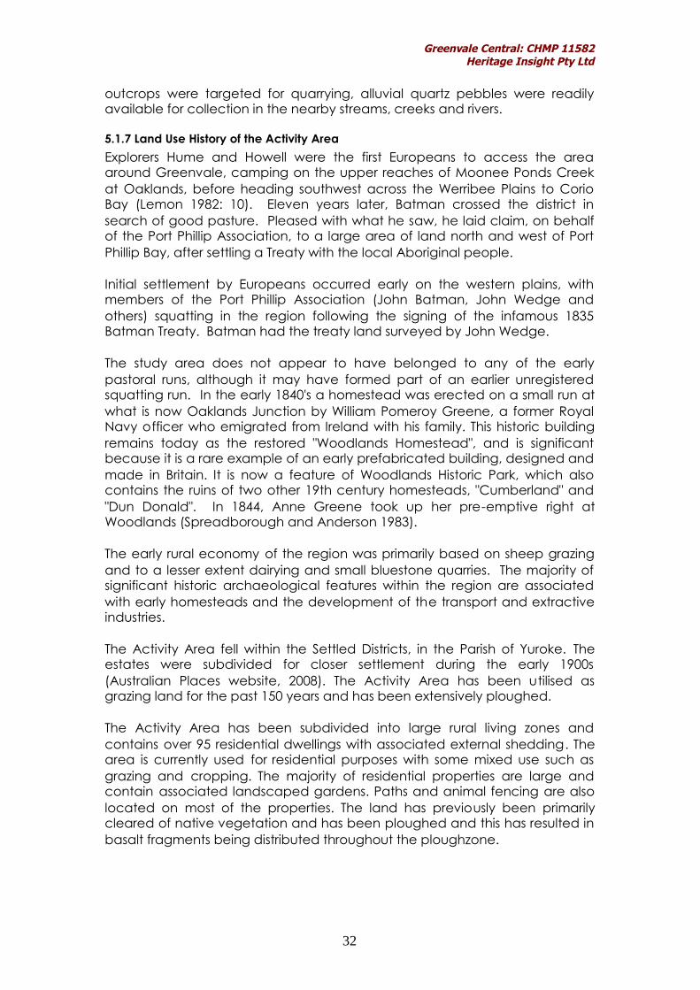
5.1.7 Land Use History of the Activity Area
Explorers Hume and Howell were the first Europeans to access the areaaround Greenvale, camping on the upper reaches of Moonee Ponds Creekat Oaklands, before heading southwest across the Werribee Plains to CorioBay (Lemon 1982: 10). Eleven years later, Batman crossed the district insearch of good pasture. Pleased with what he saw, he laid claim, on behalfof the Port Phillip Association, to a large area of land north and west of PortPhillip Bay, after settling a Treaty with the local Aboriginal people.
Initial settlement by Europeans occurred early on the western plains, withmembers of the Port Phillip Association (John Batman, John Wedge andothers) squatting in the region following the signing of the infamous 1835Batman Treaty. Batman had the treaty land surveyed by John Wedge.
The study area does not appear to have belonged to any of the earlypastoral runs, although it may have formed part of an earlier unregisteredsquatting run. In the early 1840's a homestead was erected on a small run atwhat is now Oaklands Junction by William Pomeroy Greene, a former RoyalNavy officer who emigrated from Ireland with his family. This historic buildingremains today as the restored "Woodlands Homestead", and is significantbecause it is a rare example of an early prefabricated building, designed andmade in Britain. It is now a feature of Woodlands Historic Park, which alsocontains the ruins of two other 19th century homesteads, "Cumberland" and"Dun Donald". In 1844, Anne Greene took up her pre-emptive right atWoodlands (Spreadborough and Anderson 1983).
The early rural economy of the region was primarily based on sheep grazingand to a lesser extent dairying and small bluestone quarries. The majority ofsignificant historic archaeological features within the region are associatedwith early homesteads and the development of the transport and extractiveindustries.
The Activity Area fell within the Settled Districts, in the Parish of Yuroke. Theestates were subdivided for closer settlement during the early 1900s(Australian Places website, 2008). The Activity Area has been utilised asgrazing land for the past 150 years and has been extensively ploughed.
The Activity Area has been subdivided into large rural living zones andcontains over 95 residential dwellings with associated external shedding. Thearea is currently used for residential purposes with some mixed use such asgrazing and cropping. The majority of residential properties are large andcontain associated landscaped gardens. Paths and animal fencing are alsolocated on most of the properties. The land has previously been primarilycleared of native vegetation and has been ploughed and this has resulted inbasalt fragments being distributed throughout the ploughzone.

Greenvale Central: CHMP 11582Heritage Insight Pty Ltd
33
5.1.8 Conclusions from the Desktop Assessment
The desktop assessment of the Activity Area was conducted by Maya Barkerwho considered that given the access which would have been available tonatural resources, such as plants, animals and the source of water whichwould have been available in the nearby creeks, there is some potential forIndigenous archaeological sites to be located within the Activity Area.However, pastoral activities conducted over the past 150 years are likely tohave resulted in extensive disturbance to, or destruction of, any Aboriginalarchaeological sites. Further, much of the Activity Area is located at a greatdistance from any source of water. The desktop assessment concluded thatthe extent of soil disturbance would need to be validated by a field survey ofthe property, as would an assessment for potentially sensitive landforms.
Archaeological Site Prediction Model
A site prediction model is intended to be used as a guideline to designing thefield survey and as an indication of the types of archaeological sites whichmay occur in a given area. The site prediction model is tested against theresults of the field survey.
Prior to European settlement, the study area and surrounding land wouldhave offered a number of resources such as plants and animals that wouldmost definitely have been utilised by traditional Indigenous owners. A smallportion of the study area is within 200m of Broad Street Drain which forms partof Attwood Creek. The creek would have supplied a permanent supply ofpotable water, especially in wetter months. Additionally, there are fivepreviously recorded Indigenous archaeological sites located within 200m ofthe current Activity Area which lie east of the Activity Area boundary andwest of the creek.
There have been a significantly high number (a total of 58) of sites recordedwithin the geographic region which are reflective of Indigenous occupation.Previous archaeological investigations have indicated that surface scatters ofstone artefacts are likely to occur in higher densities closer to watercoursesand particularly on rises overlooking water courses. The southern portion ofthe Activity Area in particular is located within proximity to Attwood Creekand to branches of Moonee Ponds Creek, both of which have yieldedsignificant evidence of Indigenous occupation. Although the majority of theActivity Area is not strictly within 200m of a waterway, the southern half stillforms a narrow corridor between both Moonee Ponds and Attwood Creekand is surrounded by registered Indigenous sites.
In consideration of this information, there is a high probability that Indigenoussites will be located within the southern half of the Activity Area. The northernhalf of the Activity Area may be less representative of Indigenous occupationas this area is further away from either creek. These predictions will need to beverified by means of a surface survey. The survey will also establish any grounddisturbance which may be present within the study area and will provide anopportunity to locate any sensitive landforms which could not be identifiedwithin the desktop assessment.

Greenvale Central: CHMP 11582Heritage Insight Pty Ltd
34
Although there is some probability that Indigenous sites will occur within theActivity Area, there is also some possibility that the existence of culturalheritage may have been adversely affected. This is based on the regionalhistory which suggests that it is likely that past land use activities occurredwithin the Activity Area including clearance of native vegetation, grazing,and ploughing. If these activities have taken place, they would haveadversely impacted on any Indigenous archaeological sites. Further, the soilwithin the Activity Area is shallow and therefore any Indigenous sites are likelyto have been highly disturbed or destroyed by past agricultural land usepractices. This prediction will most likely apply to the northern half of theActivity Area and would need to be verified by means of a surface survey.

Greenvale Central: CHMP 11582Heritage Insight Pty Ltd
35
5.2 Report on the Results of the Standard Assessment
In accordance with Clause 8, Schedule 2 and Clause 9, Schedule 2 of theAboriginal Heritage Regulations 2007, this section contains the results of thestandard assessment.
5.2.1 Methodology for Standard Assessment
A standard assessment is a surface archaeological survey. This may locateevidence of surface sites but will not necessarily find buried archaeologicaldeposits. The methodology for the standard assessment is informed by thedesktop assessment and the site prediction model.
The field survey was carried out by a team of three people over an eight hourperiod. The ground surface covering the entire Activity Area was inspectedduring the survey. The method of inspection involved the field team walkingregularly spaced transects which were 10 metres apart. Areas in which therewas bare ground surface exposure were inspected closely. Areas of highground surface visibility included ground along existing tracks and fences andaround the base of trees. The general percentage (%) of ground surfacevisibility was recorded throughout the Activity Area. All evidence of priorground disturbance was also recorded. An assessment was undertaken ofany existing eucalyptus trees within the area, which were examined for anysigns of scarring. No caves or rock shelters were identified within the ActivityArea. A discussion of the results of the survey took place on site with arepresentative of the Wurundjeri.
5.2.2 Results of Ground Survey
The standard assessment was conducted by Maya Barker(BA(Hons)/BSc/PhD) and John Young (BA Hons) from Heritage Insight Pty Ltdand Shane Nicholson, Danielle Mullins and Naomi Mullins from the Wurundjeri.The Activity Area, as shown in Map 6, was inspected by the field team,walking regularly spaced transects so that the majority of the Activity Areawas covered. In some cases full access was not granted to properties such aswhere high gates were padlocked.
Ground surface visibility varied across the Activity Area, however much of theActivity Area was found to be heavily grassed and contained dense,manicured lawns and gardens. Overall visibility was generally at 10%. Theareas around trees, fences and properties which included horses presentedwith greater ground surface visibility as there was greater track exposurewithin these sections. Effective survey coverage was estimated at 20%.

Greenvale Central: CHMP 11582Heritage Insight Pty Ltd
36
The survey located two new Indigenous cultural heritage sites. Neither of thesites were associated with sensitive landforms. The first was recorded asFrench Rd 1 (VAHR 7822-tba) and was located on the surface of a disturbedroad reserve on French Road. The artefact comprised a single silcrete corefragment. The artefact was clearly not in-situ as it was located on the surfacealong with road base and had likely been moved during the creation of theroad.
The second site was recorded as Bonds Lane 1 (VAHR 7822-tba) and waslocated to the rear of the property known as 135 Bonds Lane. This artefactcomprised a single silcrete flaked piece. The artefact appeared to be in ahighly disturbed context as it was located on the surface within a pink grainysoil which also contained a large amount of debris including ceramics andglass. The pink grainy soils were only located on two other properties withinthe entire Activity Area and seemed to be associated with horse paddocks.
Across the balance of the Activity Area no cultural heritage material wasidentified however this may be due to poor ground surface visibility. Further,only three small areas of archaeological sensitivity were identified – thesecomprised the elevation of the very northeast corner over the creek (theproperties located to the north of Hillview Road); a slight rise in the landlocated at the northwestern end of Somerton Road (corner of Section Road)and the gentle west-east slope of the land at the southern end of the ActivityArea (along Mickleham Road). These areas have been summarised withinMap 7. No in-situ basalt outcrops were located within the Activity Area.
Tables 12 -20 below provide a summary of the landforms for each property.Although brief, the summaries focus on whether a sensitive landform wasidentified on each parcel of land and whether any native vegetation wasidentified. The general disturbance is also noted – such as the presence of aresidential dwelling.
Table 12 - Bonds Lane Survey - Summary ResultsPropertyAddress
Survey Results Photo
20 Bonds Lane Flat landform,single storeydwelling, onedam.
35 Bonds Lane Flat landform,single storeydwelling, graveldriveway,manicuredgardens, noremnantvegetation
40 Bonds Lane Flat landform,well grassed, noremnantvegetation
55 Bonds Lane Flat landform,

Greenvale Central: CHMP 11582Heritage Insight Pty Ltd
37
well grassed, noremnantvegetation, 2dwellings, barn,graveldriveway,extensivefencing,manicuredgardens andlawns.
60 Bonds Lane Flat landform,enormousdwelling,manicuredgardens,substantial brickfence
75 Bonds Lane Flat landform,enormousdwelling,manicuredgardens,substantial brickfence
90 Bonds Lane Flat landform,well grassed,vacantpaddock
95 Bonds Lane Flat landform,enormousdwelling,manicuredgardens,substantial brickfence
100 Bonds Lane Flat landform,enormousdwelling,manicuredgardens,substantial brickfence
110 Bonds Lane Flat landform,single dwelling,two dams, nonativevegetation,orchid at rearof dwelling

Greenvale Central: CHMP 11582Heritage Insight Pty Ltd
38
115 Bonds Lane Flat landform,manicuredgardens, graveldriveway,young nativevegetation andEuropean treespecies,shedding anddwelling
120 Bonds Lane Flat landform,enormous 2storey dwelling,manicuredgardens andponds
125 Bonds Lane Flat landform,single storeydwelling, nativevegetationwhich wasyoung – elderlyhomeownercommentedthat the areawas devoid oftrees 25 yearsago

Greenvale Central: CHMP 11582Heritage Insight Pty Ltd
39
130 Bonds Lane Flat landform,well grassed, nonativevegetation
140-160 BondsLane
Flat landform,well grassed,young nativevegetation
135 Bonds Lane Flat landform,single storeydwelling,associatedshedding, onemature redgumwith no signs ofscarring,isolated silcreteartefact (BondsLane 1 (VAHR7822-tba)located indisturbedsurface soilsalong withceramic,plastic andglass fragments– soils in thisisolated sectionwere red-tinged andappeared tohave beenimported as asurface to thehorse paddock.
Table 13 - Brendan Road Survey – Summary ResultsPropertyAddress
Survey Results
35 BrendanRoad
Flat landform, no native vegetation, large dwelling,manicured gardens, gravel driveway and largebillabong.
40 Brendan Flat landform, immature native vegetation, brick

Greenvale Central: CHMP 11582Heritage Insight Pty Ltd
40
Road dwelling, 4 space carport, shipping containers on land45 BrendanRoad
Flat landform, immature native vegetation, manyEuropean tree species
50 BrendanRoad
Flat landform, immature native vegetation, brickswelling
65 BrendanRoad
Flat landform, no native vegetation, large asphaltdriveways, manicured gardens, large house withassociated gravel areas and several sheds/work areas.
70 BrendanRoad
Slopes very slightly from west to east, single brickdwelling, , immature native vegetation.
75 BrendanRoad
Hillview property, slopes gently from west to easttowards Brendan Road, dwelling, immature nativevegetation.
80 BrendanRoad
Hillview property, slopes gently from west to easttowards Brendan Road, dwelling, European vegetation.
Table 14 - Carroll Lane Survey – Summary Results
PropertyAddress
Survey Results
30 Carroll Lane Flat landform, no native vegetation, brick dwelling,colourbond shedding
35 Carroll Lane Flat landform, several mature redgums which show nosigns of scarring, brick dwelling, cobblestone driveway,manicured gardens and large dam.
45 Carroll Lane Flat landform, no native vegetation, small brick dwelling50 Carroll Lane Flat landform, immature native vegetation, brick
dwelling.55 Carroll Lane Large house, manicured gardens, large asphalt
driveway, raised garden beds with bluestone paving,no mature native vegetation, flat landform.
65 Carroll Lane Flat landform, immature native vegetation, cobblestonedriveway, large dam.
75 Carroll Lane *No access – property is surrounding by enormous glassfence and appears to contain a large dwelling andheavily manicured gardens.
80 Carroll Lane Flat landform, several mature redgums with no scarring,large dwelling with associated shedding, dams andcattery
Table 15 - French Road Survey – Summary ResultsPropertyAddress
Survey Results
25 French Road Flat landform, no native vegetation, gravel driveway,shedding – gate padlocked so full access not granted
30 French Road45 French Road Flat landform, no native vegetation, single brick
dwelling, shedding, dam50 French Road Flat landform, no native vegetation, single brick
dwelling, large dam55 French Road Flat landform, no native vegetation, single brick
dwelling, large dam60 French Road Flat landform, no native vegetation, single brick

Greenvale Central: CHMP 11582Heritage Insight Pty Ltd
41
dwelling.75 French Road Flat landform, no native vegetation, single brick
dwelling.
Table 16 - Hillview Road Survey – Summary ResultsPropertyAddress
Survey Results
25 Hillview Road Large dwelling, devoid of native vegetation, land risesabove watercourse to the north – sloping n-s.
40 Hillview Road Large dwelling, devoid of native vegetation, land risesabove watercourse to the north – sloping n-s.
45 Hillview Road Large dwelling, devoid of native vegetation, land risesabove watercourse to the north – sloping n-s.
65 Hillview Road Large dwelling, devoid of native vegetation, land risesabove watercourse to the north – sloping n-s.
85 Hillview Road Extensively disturbed parcel of land, devoid of nativevegetation, large dwelling, tennis courts, large graveldriveway, although land appears to rise overwatercourse it seems to have been filled as evidencedby the cut in the road – property crowded with trucksand excavators.
Table 17 - Mickleham Road Survey – Summary ResultsPropertyAddress
Survey Results
565 MicklehamRoad
Land slopes gently from west to east, large brickdwelling, manicured garden, no native vegetation
585 MicklehamRoad
Land slopes gently from west to east, large brickdwelling, young native style garden with several maturegums, no scarring
595 MicklehamRoad
Nursery, shop buildings, shedding, extensive drivewaysand parking areas, no natural vegetation
605 MicklehamRoad
Land slopes gently from west to east, vacant landcontaining the slab of a previously demolished houseand shed, native vegetation including very largemature redgum but with no scarring, large dam incentre of property appears to expose natural base leveland may be a natural low point.
615 MicklehamRoad
Gentle slope from west to east, property operates as abus depot and contains a dwelling, extensive sheddingand large asphalted areas and driveways
625 MicklehamRoad
Land slopes gently from west to east, large dwelling withmanicured gardens and asphalt driveway, extensivechicken sheds, no mature native vegetation
645 MicklehamRoad
Land slopes gently from west to east, large dwelling withmanicured gardens and concrete driveway
655 MicklehamRoad
Land slopes gently from west to east, large ornate damsat front of property, large weatherboard dwelling,gravel driveway, manicured gardens, young nativevegetation only
665 MicklehamRoad
Land slopes gently from west to east and undulates,large residence on high point, heavily landscaped andmanicured gardens, several large redgums with no

Greenvale Central: CHMP 11582Heritage Insight Pty Ltd
42
scarring675 MicklehamRoad
Land slopes gently from west to east, large statelydwelling comprised of bluestone, extensive expanses ofheavily manicured gardens, several mature gum trees
685 MicklehamRoad
Flat landform, brick dwelling with associated shedding,large commercial building selling palms, reminder of sitecomprises a nursery, some native revegetation
695 MicklehamRoad
Flat landform, large brick dwelling, tennis courts,swimming pool, no native vegetation
715 MicklehamRoad
Flat landform, large brick dwelling, highly manicuredlawns and gardens, no native vegetation
725 MicklehamRoad
Flat landform, vacant land, young native vegetation,used for grazing horses, some imported red soilsscattered on surface (similar to that located in 135Bonds Lane
735 MicklehamRoad
Flat landform, large brick dwelling, gravel driveway,highly manicured lawns and gardens, dam in front ofhouse, young native vegetation
745 MicklehamRoad
Flat landform, large brick dwelling, gravel driveway,highly manicured lawns and gardens, dam in front ofhouse, young native vegetation
765 MicklehamRoad
Flat landform, large brick dwelling, gravel driveway,highly manicured lawns and gardens, no nativevegetation
805 MicklehamRoad
Flat landform, large brick dwelling, gravel driveway,highly manicured lawns and gardens, no nativevegetation
815 MicklehamRoad
Flat landform, very large brick dwelling, graveldriveway, highly manicured lawns and gardens, nonative vegetation
825 MicklehamRoad
Flat landform, brick dwelling, gravel driveway, highgrassed paddocks, young native vegetation
835 MicklehamRoad
Flat landform, brick dwelling, gravel driveway, grassedlawns, young native vegetation
855 MicklehamRoad
Flat landform, occupied by religion group, contains adam, young native vegetation, extensive driveways,parking areas and several multistorey dwellings
875 MicklehamRoad
Flat landform, gravel driveway, manicured formalgardens and an orchid, no native vegetation
910 MicklehamRoad
Flat landform, two large brick dwellings, extensiveshedding as property operates as a greyhoundbreeding location, no native vegetation
920 MicklehamRoad
Flat landform, well grassed soccer fields, no nativevegetation
940 MicklehamRoad
Flat landform, long gravel driveway, small orchid,manicured gardens, extensive European trees, largebrick dwelling, no native vegetation
960 MicklehamRoad
Flat landform, cleared well grassed paddock, dwelling,landscaped lawns around house, young nativevegetation
980 MicklehamRoad
Flat landform, well grassed, dwelling, gravel driveway,overgrown garden, dense trees, some young nativevegetation
990 MicklehamRoad
Flat landform, well grassed, dwelling and shedding,gravel driveway, overgrown garden, dense trees, no

Greenvale Central: CHMP 11582Heritage Insight Pty Ltd
43
native vegetation
Table 18 - Providence Road Survey – Summary ResultsPropertyAddress
Survey Results
30 ProvidenceRoad
Flat landform large house, immature native vegetation.
35 ProvidenceRoad
Flat landform, large house, immature native vegetationwith some mature redgums, no scarring.
40 ProvidenceRoad
Flat landform, immature native vegetation, twodwellings, extensive lawns, also location of HeritageOverlay church.
45 ProvidenceRoad
Land slopes very gently from south to north, large house,immature native vegetation.
55 ProvidenceRoad
Land slopes very gently from south to north, large house,immature native vegetation.
65 ProvidenceRoad
Land slopes very gently from south to north, large house,immature native vegetation.
70 ProvidenceRoad
Flat landform. Location of Heritage Overlay site‘Prospect Cottage’. Also includes modern brickdwelling, swimming pool and immature nativevegetation
80 ProvidenceRoad
Flat landform, immature native vegetation, brickdwelling
90 ProvidenceRoad
Very slit rise on property, large dwelling and horseshedding, established driveway and manicuredgardens.
Table 19 - Section Road Survey – Summary Results
PropertyAddress
Survey Results
110 SectionRoad
Flat landform, no mature native vegetation, horsegrazing property, colourbond horse stables, large brickdwelling with gravel driveway
140 SectionRoad
Flat landform, no native vegetation, smallweatherboard dwelling with colourbond garage,manicured gardens, large paddock to side of house isdensely packed with pasture grass and young nativetrees.
150 SectionRoad
Flat landform, no native vegetation, single storey brickdwelling, shedding, gravel driveway, well grassed
160 SectionRoad
Newly constructed brick dwelling, swimming pool andgravel driveway – obvious disturbance in front yardcaused by installation of services, rear of property wellgrassed, no native vegetation, flat landform
166 SectionRoad
Vacant block associated with 170 – flat landform, denseand high grass, no native vegetation
170 SectionRoad
Flat landform, Sandstone dwelling with triple sandstonegarage, large gravel driveway, manicured lawns, nonative vegetation
180 SectionRoad
Flat landform, brick dwelling, gravel driveway,manicured lawns, no native vegetation
Greenvale Central: CHMP 11582Heritage Insight Pty Ltd
44
190 SectionRoad
Weatherboard dwelling, road has been cut in andhouse sits above road. Very gentle slope from west toeast, mature redgum, no scarring
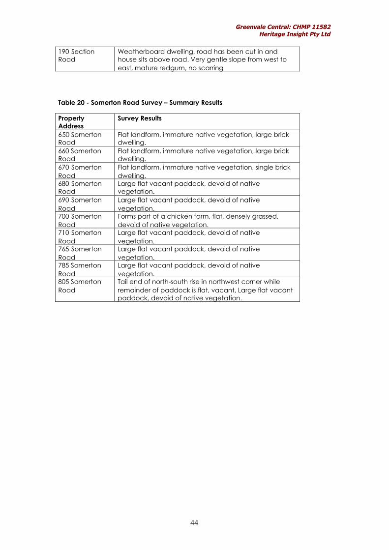
Table 20 - Somerton Road Survey – Summary Results
PropertyAddress
Survey Results
650 SomertonRoad
Flat landform, immature native vegetation, large brickdwelling.
660 SomertonRoad
Flat landform, immature native vegetation, large brickdwelling.
670 SomertonRoad
Flat landform, immature native vegetation, single brickdwelling.
680 SomertonRoad
Large flat vacant paddock, devoid of nativevegetation.
690 SomertonRoad
Large flat vacant paddock, devoid of nativevegetation.
700 SomertonRoad
Forms part of a chicken farm, flat, densely grassed,devoid of native vegetation.
710 SomertonRoad
Large flat vacant paddock, devoid of nativevegetation.
765 SomertonRoad
Large flat vacant paddock, devoid of nativevegetation.
785 SomertonRoad
Large flat vacant paddock, devoid of nativevegetation.
805 SomertonRoad
Tail end of north-south rise in northwest corner whileremainder of paddock is flat, vacant, Large flat vacantpaddock, devoid of native vegetation.

Greenvale Central: CHMP 11582Heritage Insight Pty Ltd
45
5.2.3 Conclusions from the Ground Survey
Overall, the Activity Area contained very little in terms of sensitive landforms,being characterised as flat with only small drainage lines in proximity whichcould be considered as sources of water. Although the topsoils were found tohave been generally disturbed from activities such as the removal of nativevegetation, the construction of residential dwellings and shedding and thecreation of European gardens, it was impossible to conclusively comment onwhether this disturbance had occurred throughout the depth of the soils. Thelocation of the two isolated artefacts was also highly disturbed. Further, noneof the mature redgums within the Activity Area were found to be scarred.Therefore, the overall potential of the Activity Area to contain Indigenousarchaeological sites is considered to be low to moderate. However, thiswould need to be verified by means of a complex assessment which wouldalso confirm whether or not the soils have been disturbed to depth.
Map 6: Survey Area and Survey Transects

Greenvale Central: CHMP 11582Heritage Insight Pty Ltd
46
Map 7: Areas of Low-Moderate Sensitivity

Greenvale Central: CHMP 11582Heritage Insight Pty Ltd
47
Bibliography
Barwick, D.E. 1984 ‘Mapping the Past: an Atlas of Victorian Clans1835-1904. Part 1.’ Aboriginal History: 1-2.
Bell, J. 2003 Yuroke Creek Shannon Rise Estate: ArchaeologicalAssessment. Heritage Insight.
Bell, J. 2004 Yuroke Creek Shannon Rise Estate Sub-surfaceTesting. Heritage Insight.
Blake, B.J. 1991 Woiworung. The Melbourne Language in R.M.WDixon & B.J. Blake The Handbook of AustralianLanguages Vol 4: 31-105. Oxford University Press:Australia.
Clark, I.D. 1990 Aboriginal Languages and Clans: an HistoricalAtlas of Western and Central Victoria. MonashPublications in Geography No. 7.
Cotter, R. 2001 Boon wurrung: People of the Port Phillip District.Lavender Hill Multimedia, Red Hill, Victoria.
du Cros, H. 1989 The Western Region: Melbourne MetropolitanArea. An Archaeological Survey. VAS OccasionalReport No. 27.
du Cros, H. 1991 Roxburgh Park Estate Archaeological Investigation.du Cros and Associates.
Ford, A. 2006 An Archaeological Survey of the Yuroke PumpStation and Pipeline, Yuroke, Victoria. BiosisResearch.
Howitt, A. W. 1904 The Native Tribes of South-East Australia. AboriginalStudies Press: Canberra
Light, A. 2006 1170 Mickleham Road, Greenvale, Archaeologicaland Cultural Heritage Assessment. Andrew Longand Associates.
Low, T. 1991 Wild Food Plants of Australia. Angus & Robertson:Sydney.
Presland, G. 1983 An Archaeological Survey of the MelbourneMetropolitan Area. Victoria Archaeological SurveyOccasional Report Series No. 15. Ministry forPlanning and Environment.

Greenvale Central: CHMP 11582Heritage Insight Pty Ltd
48
Rhodes, D. & Murphy, A. 1994Report on Archaeological Survey and Sub SurfaceTesting at the BHP Property at Mickleham Road,Greenvale. du Cros and Associates.
Spreadborough, R & H. Anderson 1983Victorian Squatters. Red Rooster Press: Ascot Vale.
Veres, M. 2008 Residential Land Subdivision, 1040 MicklehamRoad, Greenvale, Cultural Heritage ManagementPlan. Report to Taylors Development Strategists.
Weaver, F. 1999 Brindley Park, 1170 Mickleham Road, Greenvale.Report to Tract Consultants Pty Ltd. andPeet & Co.
Websites
www.land.vic.gov.au (Planning Schemes Online)www.dse.vic.gov.au (Department of Sustainability and Environment –Interactive Biodiversity Maps)www.dpi.vic.gov.au (Department of Primary Industries –GeoVic Online Maps)

Greenvale Central: CHMP 11582Heritage Insight Pty Ltd
49
Appendix 1: CHMP Notification

Greenvale Central: CHMP 11582Heritage Insight Pty Ltd
50

Greenvale Central: CHMP 11582Heritage Insight Pty Ltd
51

Greenvale Central: CHMP 11582Heritage Insight Pty Ltd
52

Greenvale Central: CHMP 11582Heritage Insight Pty Ltd
53
Appendix 2: Response to Elect to Evaluate (Wurundjeri TribeLand & Compensation Cultural Heritage Council Inc.)

Greenvale Central: CHMP 11582Heritage Insight Pty Ltd
54

Greenvale Central: CHMP 11582Heritage Insight Pty Ltd
55
Appendix 3: Glossary

Greenvale Central: CHMP 11582Heritage Insight Pty Ltd
56
GLOSSARY
Adze A flake with stepped retouch alonglateral margins that can be hafted for useas a tool.
Anvil A flat object on which a core wasplaced to flake material from. Anvils oftenhave a small pit/groove usually in thecentre of the object as a result of thisaction.
Archaeology The study of cultural remainsfrom past cultures and generations.
Artefact Scatter The material remains ofpast Aboriginal people’s activities. Usuallycontain stone artefacts, but other materialmay also be present, including charcoal,animal bone, shell and ochre. An artefactscatter is usually represented by a singlestone flake or a concentration of flakedstone pieces (or fragments).
Assemblage A collection of artefacts thatare derived from the same site.
Backed Blade forms part of the small tooltradition. They and are characterised byunidirectional or bidirectional retouchfound along a lateral margin, thought tobe blunt for hafting (Holdaway & Stern2004: 260).
Basalt A fine grained rock occurring fromlava flows.
Bifacially Flaked Flakes removed from twofaces of an object such as a core.
Blade A flake that is twice as long as it iswide.
Bondi Point an asymmetrical blade with apoint at one end, with backing retouch.Part of the small tool tradition.
Burin A truncated flake formed bysnapping or retouching along one lateralmargin that then forms a platform andsmall flakes are removed forming atriangular scar that acts as a working edge(Holdaway & Stern 2004: 241-243).
Burial Human remains, normally found asconcentrations of human bones or teeth,exposed by erosion or earthworks. Theyare sometimes associated with charcoal orochre, although shell, animal bone andstone tools may also be present. Tend tobe located in soft soils and sand, although
can occur in rock shelters, caves and deadtrees.
Ceramic term used to identify wares madefrom either clay or fusible stone such asstoneware, earthenware, porcelain orterracotta (Davies & Buckley 1987: 186).
Chert compact, fine-grained rock made ofcrypto-crystalline silica and can occur in avariety of colours, usually red, green orblack.
Glaze a coating put over wares fired in akiln. Glazes can come in a variety ofcolours and can also be transparent.
Core a specimen of rock that hasundergone a process of reduction throughthe removal of a number of flakes and as aresult they have negative flake scars.Cores can contain a single platform, havetwo platforms or have had flakes removedin multi-directions.
Cortex the original surface of a mineral orrock that has been subject to weatheringby the elements.
Cultural Material any material remainswhich are produced by human activity.
Debitage Includes cores, flakes, and flakedpieces involved in the reduction process.
Dry stone wall a wall formed of a numberof courses of rock (usually basalt orlimestone) with no bond or bindingcomponent. Walls are usually tapered,have two faces and can have hearting(packing), or plugging.
Earthenware non-vitreous whiteware,porous, usually used for domestictablewares. Most earthenware is glazedand decorated (transfer printed or leftplain) (Davies & Buckley 1987: 186).
Earth Feature Includes mounds, rings,hearths, postholes and ovens. Moundsgenerally appear as raised areas of darkersoil. They are commonly found in thevolcanic plains of western Victoria or onhigher ground near water bodies. Moundsoften contain charcoal, burnt clay or stoneheat retainers from cooking ovens, animalbones, shells, stone tools and sometimes,Aboriginal burials. Earth rings are bankedcircles of soil, often associated with stonearrangements, which had a ceremonialpurpose for Aboriginal people in the past.

Greenvale Central: CHMP 11582Heritage Insight Pty Ltd
57
Excavation A controlled means of soildisturbance (digging) allowing for detailedrecording of the soil profile, features andartefacts exposed.
Flake A stone artefact that containscharacteristics such as a the presence of aplatform, bulb of percussion andtermination which reveal that the stone hasbeen struck from a core and is the result ofstone working (Holdaway & Stern 2004: 5).
Flake core A flake that has subsequentlybeen used as a core and had other flakesremoved from it.
Flaked Piece Small fragments of stone thathave been removed from flakes resulting intool maintenance or tool production(Holdaway & Stern 2004: 17). Flaked piecesdo not display the characteristics evident ina complete flake.
Flint Similar to chert, with a pale cortex,conchoidal fracture, occurring usually inlimestones (Roberts 1998: 65).
Footing the structural base/footprint fromstructures often built from bluestone, brickor wooden posts.
Geometric Microlith part of the small tooltradition and are symmetrical in form,pointed at both ends, can be backedalong a lateral margin (Holdaway & Stern2004: 262).
Greenstone a metamorphic rock derivedfrom basalt containing feldspar and quartzand is made green by chlorite andepidote. Often used for the manufactureof hand axes.
Grindstone A flat slab of rock with centraldepression used to grind, crush or poundseeds, ochre, or sharpen tools etc.Grindstones are usually made onsedimentary rocks, with an abrasivesurface and can be used in conjunctionwith a muller.
Ground edge axes sharpening process –flaking pecking and polishing, usually alonga single lateral margin. The axes aregenerally hafted with the worked edgeforming
Ground surface visibility an assessment ofground disturbance that allows the groundto be seen
Hammerstone a hard rock or mineral usedto flake fragments of stone from a core.(Holdaway & Stern 2004: 4).
Hearth The remains of a fireplacecontaining charcoal and sometimes burntearth, bone stone artefacts or otherorganic material.
In situ An artefact or feature that remains inits original position, or where it was left.
Manuport A stone block that displays noattributes of being either a core or a flake.
Microblade has the same characteristics ofa blade but just of smaller portions(Holdaway & Stern 2004: 17)
Oven Mound Mounds are usually circular oroval in shape and are often situated closeto a water source. They were used to cookin and contain a rich greasy organic mix ofsoil and organic material. A moundcontains charcoal, burnt clay, stone tools,bones, shell and on occasions burials (AAVMini Poster 4).
Ochre earth varying in colour from yellowto red, used as a pigment.
Organic compounds formed from livingorganisms (plants or animals).
Platform the surface from which the flakewas struck off the core – natural flaked orabraded (Holdaway & Stern 2004: 120)
Point a flake that has two edges that forma point and has retouch along one or bothlateral margins (Holdaway & Stern 2004:16).
Porcelain Non-porous ceramic with a glass-like appearance, can be translucent, canbe used for table wares or moredecorative features such as ornaments.
Post-contact after contact betweenAboriginal people and Europeans
Pre-contact before contact betweenAboriginal people and Europeans
Quarry An outcrop of stone or ochre thathas been quarried by Aboriginal people inthe past. Generally associated with a largeamount of broken stone and flakes. Theoutcrop (cores) bear negative scars fromflaking.

Greenvale Central: CHMP 11582Heritage Insight Pty Ltd
58
Quartz a mineral that commonly occurs insedimentary, igneous and metamorphicrocks. Quartz can come in a number offorms including crystal, rose, and smoky.
Quartzite a metamorphic rock, formed bythe re-crystalization of quartz. Quartz isrich in sandstone and limestone (Roberts1998: 109).
Retouch a worked edge, or modification ofa flake formed by removing a number ofsmall flakes along an edge. This can bedone as a form of maintenance or toproduce a tool.
Rock Art Paintings created on the rocksurfaces of caves and rock shelters andengravings in limestone caves. Artworkincludes stencils, prints and drawings. Thepaint consists of ochres, clays andcharcoal mixed with fats.
Scarred Tree A tree, which has had a slabof bark removed, exposing the sapwoodon the trunk or branch of a tree. Aboriginalpeople used the bark to make shelters,containers (coolamons) and canoes.
Scraper a flake with at least one edge thathas continuous retouch. Scraper typesinclude, steep edged, end, side, nosescraper (Holdaway & Stern 2004: 16).
Shell Midden A surface and /or sub-surfacedeposit composed of shell and sometimesstone artefacts, charcoal and bone.Middens are normally found in association.with coastlines, rivers, creeks and swamps –wherever coastal, riverine or estuarineshellfish resources were available andexploited.
Silcrete a fine grained rock derived fromshale or siltstone mixed with silica.
Spit A horizontal unit of soil removed duringexcavation. Spits can be arbitrary (dug toa depth of 5, 10, 20, 30cm, etc.) or can beconfined to a particular soil type orcontext. The excavation of spits allows forgreater understanding, analysis andinterpretation of the soil profile.
Stone Feature Includes cairns, rock wells,stone arrangements, fish traps, stonestructures and grinding grooves. May be anatural feature, which was used ormodified to be used, by Aboriginal peoplein the past (rock well, stone arrangement)or a stone feature which has beendeliberately constructed for a specific
purpose (fish trap, stone structure, cairn) oris the result of a specific activity carried outby Aboriginal people in the past (grindinggrooves).
Stoneware a vitreous (non-porous)ceramic, usually light brown in colour, usedfor drinking containers or used industrially.Often glazed or unglazed (salt glaze or slipapplied) (Davies & Buckley 1987: 186).
Stratification The position of sediments androcks in sequence throughout time.
Sub-surface testing a method ofexcavation that involves ground disturbingworks to identify the potential for culturalmaterial. Can take the form of handexcavation, backhoe scrapes etc.
Survey An inspection of land either by footor by car (windscreen survey) notingconditions on surface visibility and … etc
Termination The shape of the distal end(Holdaway & Stern 2004: 129) – featherhinge step plunge
Terracotta a low fired clay (ceramic)usually orange to red in colour, very porous,often used for plumbing (drainagecomponents) or garden ware.
Tool Modified flakes usually with retouchpresent along an edge – altered shape(Holdaway & Stern 2004: 33)
Transect An excavated stretch of groundcan be of varying lengths in a straight line.
Transfer-Printed a design is traced andengraved onto a copper plate, on whichink and oil is then applied, the design ispressed onto tissue paper and then placedon an object and the paper removed. Theobject is then fired and glazed. Transferprinted ceramics come in a variety ofcolours and patterns and were massproduced.
Trench An area confined by excavationusually in the form of a square (eg. 2x2m) orrectangular (eg. 1.5x1m).
References
AAV Mini Posters (1-7)
Davies, M & K. Buckley (1987) Port ArthurConservation & Development Project:Archaeological Procedures Manual. OccasionalPaper No.13. Department of Lands, Parks andWildlife, Tasmania.

Greenvale Central: CHMP 11582Heritage Insight Pty Ltd
59
Holdaway & Stern (2004) A Record in Stone: TheStudy of Australia’s Flaked Stone Artefacts,Victoria Museum, Melbourne.
Roberts, J.L. (1998) A Photographic Guide toMinerals, Rocks and Fossils, New Holland, London