cultural landscapes of coastal foragers: an .. - esri
TRANSCRIPT
Cultural Landscapes of Coastal Foragers: An Example of GIS and Drainage Catchment Analysis
From Southern California
Journal of GIS in Archaeology, Volume I
ESRI 380 New York St., Redlands, CA 92373-8100, USA • TEL 909-793-2853 • FAX 909-793-5953 • E-MAIL [email protected] • WEB www.esri.com 47
J-9078
Cultural Landscapes of Coastal Foragers: An Example of GIS and Drainage Catchment Analysis From Southern California
Journal of GIS in Archaeology, Volume I Contents Page Acknowledgments................................................................................ 49 Introduction .......................................................................................... 49 The Archaeological Background.......................................................... 50 The GIS Landscape Approach ............................................................. 51 Results .................................................................................................. 52 Conclusion............................................................................................ 57 References ............................................................................................ 58 List of Figures ...................................................................................... 60
Journal of GIS in Archaeology, Volume I—April 2003 48
J-9078
Cultural Landscapes of Coastal Foragers: An Example of GIS and Drainage Catchment Analysis from Southern California by Alice Brewster, Brian F. Byrd, and Seetha N. Reddy
Acknowledgments We would like to thank Mr. Stan Berryman, base archaeologist, Marine Corps Base, Camp Pendleton, for his continued support of the Camp Pendleton GIS and archaeological research. We also thank Mr. John R. Cook, ASM Affiliates, Inc., for his encouragement of our GIS applications to archaeology.
Introduction This paper examines Late Holocene prehistoric hunter–gatherer settlement patterns along the coast of Southern California, a region that has witnessed extensive research on the interrelationship between cultural developments and a dynamic physical landscape (e.g., Erlandson and Jones in press; Glassow 1996; Kennett and Kennett 2000; Raab and Larson 1997). The goal is to use GIS to rigorously examine key organization trends in relationship to specific aspects of the cultural and physical landscape. To do so, we utilize one of the few detailed databases available for the mainland coastline of the Southern California bight. This study builds on our recent multidisciplinary research along the northern San Diego region coastline encompassed by the Camp Pendleton Marine Corps Base, an area largely unexplored until the last decade (Byrd 1998; Byrd and Reddy 1999, in press; Reddy 1999a, in press; Reddy and Brewster 1999). Camp Pendleton falls within the coastal area physiographic province and is characterized by a coastal plain formed of ancient marine terraces and adjacent inland mountain ranges. Streams traverse and incise the coastal marine terraces while draining the northwest trending southern hills of the Santa Margarita Mountains (with the highest peak on Camp Pendleton at an elevation of 972 m above sea level). GIS has been used as an analytical and management tool for cultural resources on Camp Pendleton Marine Corps Base since 1995. The Camp Pendleton archaeology GIS consists of two main databases: archaeological sites and archaeological surveys. This paper utilizes both of these databases along with several related GIS databases (including topography, hydrology, and geomorphology) created with ESRI's ARC/INFO, ArcView, ArcView Spatial Analyst, and ArcView 3D Analyst to examine the cultural and physical landscape of prehistoric, coastal foragers. The relational database contains more than 70 variables that are maintained in a separate application with an easy-to-use data entry form that aids accuracy and consistency. It is region-based and contains all the prehistoric and historic sites on Camp Pendleton (currently in excess of 500). For both management and research purposes, accurate information on site location and site attributes are extremely
Journal of GIS in Archaeology, Volume I—April 2003 49
Cultural Landscapes of Coastal Foragers: An Example of GIS and Drainage Catchment Analysis From Southern California
J-9078
important, and thus the archaeological site database is systematically updated three times per year.
The Archaeological Background
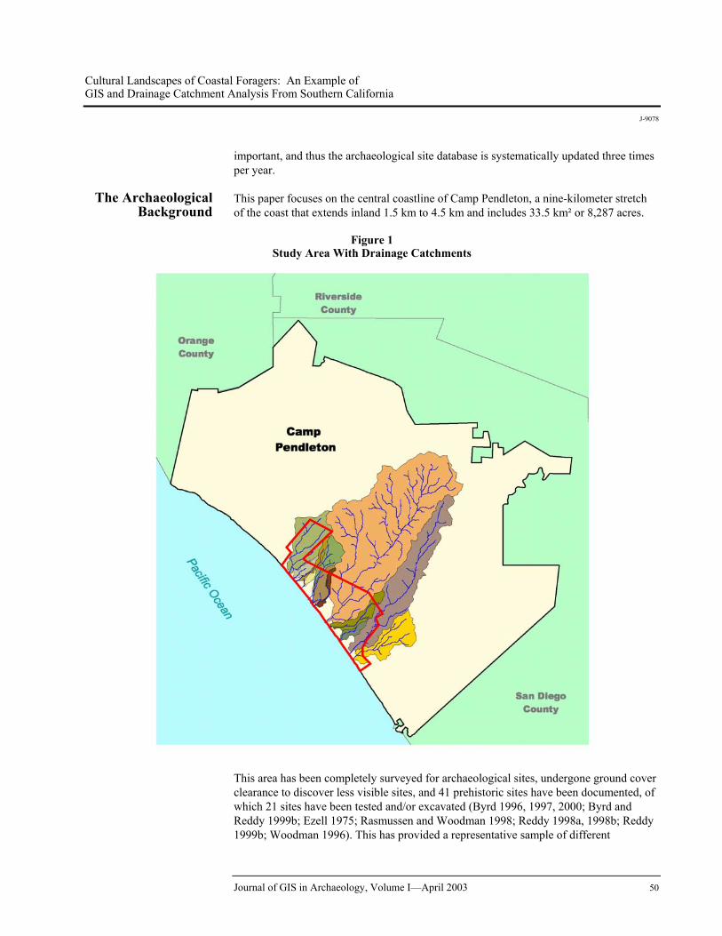
This paper focuses on the central coastline of Camp Pendleton, a nine-kilometer stretch of the coast that extends inland 1.5 km to 4.5 km and includes 33.5 km² or 8,287 acres.
Figure 1 Study Area With Drainage Catchments
This area has been completely surveyed for archaeological sites, undergone ground cover clearance to discover less visible sites, and 41 prehistoric sites have been documented, of which 21 sites have been tested and/or excavated (Byrd 1996, 1997, 2000; Byrd and Reddy 1999b; Ezell 1975; Rasmussen and Woodman 1998; Reddy 1998a, 1998b; Reddy 1999b; Woodman 1996). This has provided a representative sample of different
Journal of GIS in Archaeology, Volume I—April 2003 50
Cultural Landscapes of Coastal Foragers: An Example of GIS and Drainage Catchment Analysis From Southern California
J-9078
topographic settings and site types including large shell middens and small to medium shell scatters. Of the 25 excavated sites, seven are located near Las Flores Creek, five are situated near Aliso Creek, two are within Horno Canyon, and 11 are in the intervening areas. Sixteen of the 25 sites have been dated, and each includes a Late Holocene occupation episode based on 80 radiocarbon assays (Byrd and Reddy 1999, in press). The remaining nine sites are also considered to be Late Holocene in age based on temporally diagnostic attributes. The vast majority (more than 80 percent) of Late Holocene radiocarbon assays postdate cal A.D. 700, the earliest timing estimated for the onset of the Late Prehistoric period, and most (more than 60 percent) of the radiocarbon assays also postdate cal A.D. 1200. Thus, most coastal sites in this locality can be confidently assigned to the region's Late Prehistoric and Post-Contact periods.
Tested sites include shell middens and shell scatters that have been classified into the three settlement types: Major Residential Bases (n=7), Limited Activity Locales (n=8), and Dinner Camps (n=10) (Byrd and Reddy 1999; Reddy 1999b). All the shell middens are Major Residential Bases that were repeatedly occupied for multiple seasons. They are typically characterized by moderate to thick anthropogenic sediments (35–100 cm thick), features, occasional burials, and a diverse range of cultural material that includes substantial assemblages of shellfish, fish and terrestrial faunal remains, archeobotanical remains, ground stone, flaked stone tools, and shell beads. These sites vary greatly in extent, ranging from 4,000 m² to 525,000 m², with the majority classified as large sites (greater than 20,000 m²) and the remainder as medium sites (20,000–2,000 m²).
Shell scatters are the most ubiquitous Late Holocene sites. These are typically small (less than 2,000 m², n=13) or medium (n=5) sized, have little anthropogenic sediment, a restricted range and density of cultural remains, and virtually every site is dominated by bean clam (Donax gouldii) shell, a sandy beach species. Based on these criteria, we argue that the shell scatters document a more limited range of activities and shorter lengths of occupation than the residential camps. Two functional settlement types have been identified within the shell scatters. Sites with sparse shell densities, rare terrestrial faunal remains, no fish remains, and few or no artifacts have been interpreted as specialized shellfish processing and consumption sites and have been termed Limited Activity Locales. The absence of fish remains supports the specialized function of these sites. These Limited Activity Locales all postdate cal A.D. 1400. In contrast, shell scatters with higher shell densities, several artifact types represented, occasional fish remains, and higher frequencies of lithics and terrestrial vertebrate remains are termed Dinner Camps. They seem to indicate a wider range of activities and longer occupation. They postdate cal 1000 B.C., and all but two sites postdate cal A.D. 1200.
The GIS Landscape Approach
For this study, we were interested in exploring the interrelationship between the physical and cultural landscape in which these Late Prehistoric archaeological sites were set to determine whether these different site types could be integrated into a coherent model of coastal hunter–gatherer settlement patterns. The elements of physical landscape that were considered included drainage catchment size and distribution, distance to the modern shoreline, and distance to streambeds. Cultural attributes that were examined included site size (large, medium, and small), settlement types, and foraging ranges. A key aspect of the analyses included how these cultural and natural variables co-varied.
Journal of GIS in Archaeology, Volume I—April 2003 51
Cultural Landscapes of Coastal Foragers: An Example of GIS and Drainage Catchment Analysis From Southern California
J-9078
Initially, we delimited the full extent of the watershed for each drainage (see Figure 1), calculated the total area of all watersheds that extend into the study area, and ranked them by size. Through the use of ArcView GIS 3.2, and the ArcView Spatial Analyst and 3D Analyst extensions, watershed catchment areas were defined for the streams within the study area. The first step involved using topography digitized from the four 7.5' quadrangles covering the study area and the potential watershed areas. The four GIS coverages were converted to shapefiles and combined, removing all incorrect elevation data in the process. Using 3D Analyst, we created a triangulated irregular network (TIN) model from the contour data. Next, using the ArcView Spatial Analyst extension, we produced a digital elevation model (DEM) with a 25 m cell size from the TIN model. Areas of internal drainage or sinks were removed using an iterative process generating a depressionless DEM that was utilized for the remaining analysis. The fifth step involved defining the stream network from the DEM by calculating the flow direction and accumulation (number of cells flowing to a cell) of each cell. Cells with concentrated flow accumulation represent stream channels. Once the stream network was defined and converted to a shapefile, an additional point shapefile was created representing pour points (point at which water flows out of an area) along the coast where the streams flow into the ocean. The watershed for each pour point was then delineated using the ArcView Spatial Analyst extension. The resulting grid was converted to a shapefile and the area and perimeter of each watershed was calculated. Once the watersheds and stream network were delineated, we examined the distribution of site types by catchment and catchment size. Then we used GIS to compile descriptive statistics to characterize two variables: distance to nearest streambed (water) and distance to ocean for each site type. Measurements were taken from the outer edge of each site. Finally, we explored the potential foraging territory for prehistoric populations centered near the coast on the three largest drainages in the study area. We used a 5 km foraging range as a heuristic device because this distance is the generally accepted maximum daily foraging range that hunters and gatherers would travel to procure resources (Kelly 1995). This step entailed selecting a center point at the Major Residential Base in the lower Horno Canyon area, the central point among all Major Residential Bases in the lower Las Flores Creek area, and a location a similar distance from the ocean along Aliso Creek (even though it lacks a Major Residential Base).
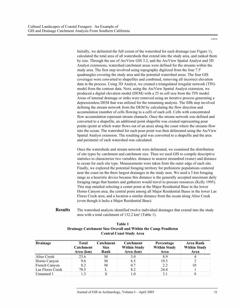
Results The watershed analysis identified twelve individual drainages that extend into the study area with a total catchment of 132.2 km² (Table 1).
Table 1 Drainage Catchment Size Overall and Within the Camp Pendleton
Central Coast Study Area
Drainage Total Catchment Area (km)
Catchment Size
Rank
Catchment Within Study
Area (km)
Percentage Within Study
Area
Area Rank Within Study
Area Aliso Creek 23.6 M 3.0 8.9 4 Horno Canyon 9.6 M 6.5 19.3 2 French Canyon 8.2 M 0.7 2.2 10 Las Flores Creek 70.5 L 8.2 24.4 1 Unnamed 1 1.3 S 1.0 3.1 8
Journal of GIS in Archaeology, Volume I—April 2003 52
Cultural Landscapes of Coastal Foragers: An Example of GIS and Drainage Catchment Analysis From Southern California
J-9078
Drainage Total Catchment Area (km)
Catchment Size
Rank
Catchment Within Study
Area (km)
Percentage Within Study
Area
Area Rank Within Study
Area Unnamed 2 1.4 S 0.4 1.3 13 Unnamed 3 0.6 S 0.6 1.7 11 Unnamed 4 3.4 S 0.5 1.4 12 Unnamed 5 2.4 S 2.2 6.5 6 Unnamed 6 1.0 S 0.9 2.5 9 Unnamed 7 3.4 S 2.7 8.2 5 Unnamed 8 1.2 S 1.2 3.6 7 No watershed 5.7 - 5.7 16.9 3 Total 132.3 33.5 100.0
Only the four largest are named on USGS topographic maps, and they account for 84.6 percent of the total area (see Figure 1). Las Flores Creek, located in the center of the study area, is the largest drainage covering 70.5 km². At the northern end of the study area is the third largest drainage, Horno Canyon, while Aliso Creek, the second largest, and French Canyon, the fourth largest, are located at the southern end of the study area. When only the Central Coast Study area is considered, Horno Canyon covers the second largest area, and a total of 5.7 km² (or 16.9 percent) of the study area is not within a watershed. The latter includes relatively flat coastal terraces near the ocean with modest external drainage. If the contour data had greater resolution, we would have detected more of the external drainage in these areas, thereby increasing the size of the existing watersheds. With respect to site type distribution by drainage catchment, there are significant differences between site types (Table 2, Figure 2).
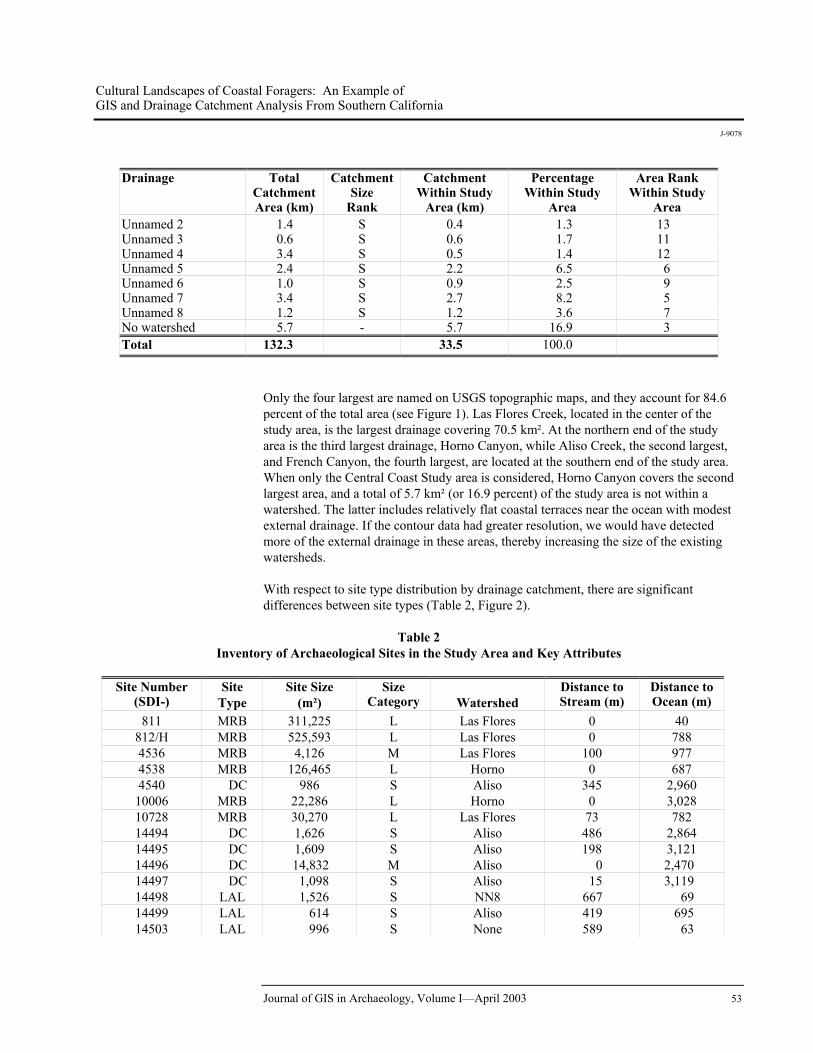
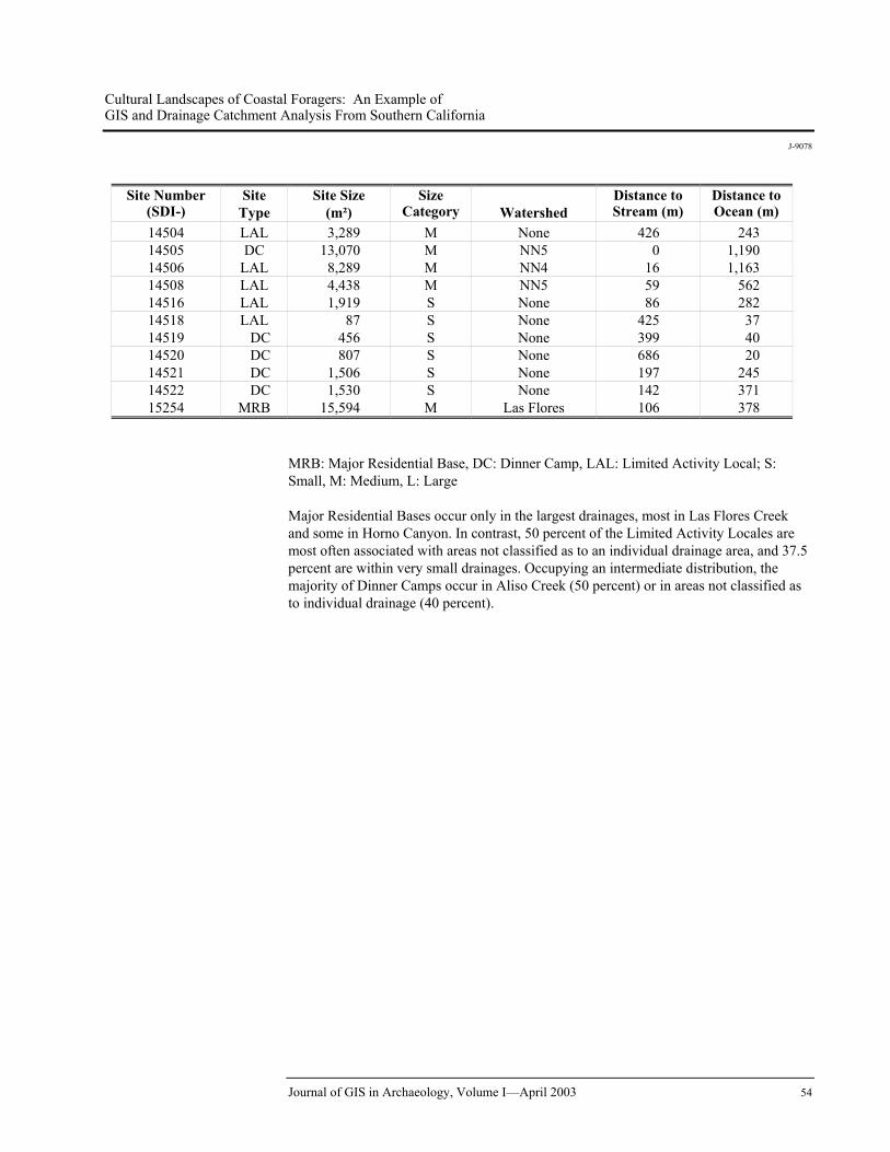
Table 2 Inventory of Archaeological Sites in the Study Area and Key Attributes
Site Number
(SDI-) Site
Type Site Size
(m²) Size
Category
Watershed Distance to Stream (m)
Distance to Ocean (m)
811 MRB 311,225 L Las Flores 0 40 812/H MRB 525,593 L Las Flores 0 788 4536 MRB 4,126 M Las Flores 100 977 4538 MRB 126,465 L Horno 0 687 4540 DC 986 S Aliso 345 2,960
10006 MRB 22,286 L Horno 0 3,028 10728 MRB 30,270 L Las Flores 73 782 14494 DC 1,626 S Aliso 486 2,864 14495 DC 1,609 S Aliso 198 3,121 14496 DC 14,832 M Aliso 0 2,470 14497 DC 1,098 S Aliso 15 3,119 14498 LAL 1,526 S NN8 667 69 14499 LAL 614 S Aliso 419 695 14503 LAL 996 S None 589 63
Journal of GIS in Archaeology, Volume I—April 2003 53
Cultural Landscapes of Coastal Foragers: An Example of GIS and Drainage Catchment Analysis From Southern California
J-9078
Site Number (SDI-)
Site Type
Site Size (m²)
Size Category
Watershed
Distance to Stream (m)
Distance to Ocean (m)
14504 LAL 3,289 M None 426 243 14505 DC 13,070 M NN5 0 1,190 14506 LAL 8,289 M NN4 16 1,163 14508 LAL 4,438 M NN5 59 562 14516 LAL 1,919 S None 86 282 14518 LAL 87 S None 425 37 14519 DC 456 S None 399 40 14520 DC 807 S None 686 20 14521 DC 1,506 S None 197 245 14522 DC 1,530 S None 142 371 15254 MRB 15,594 M Las Flores 106 378
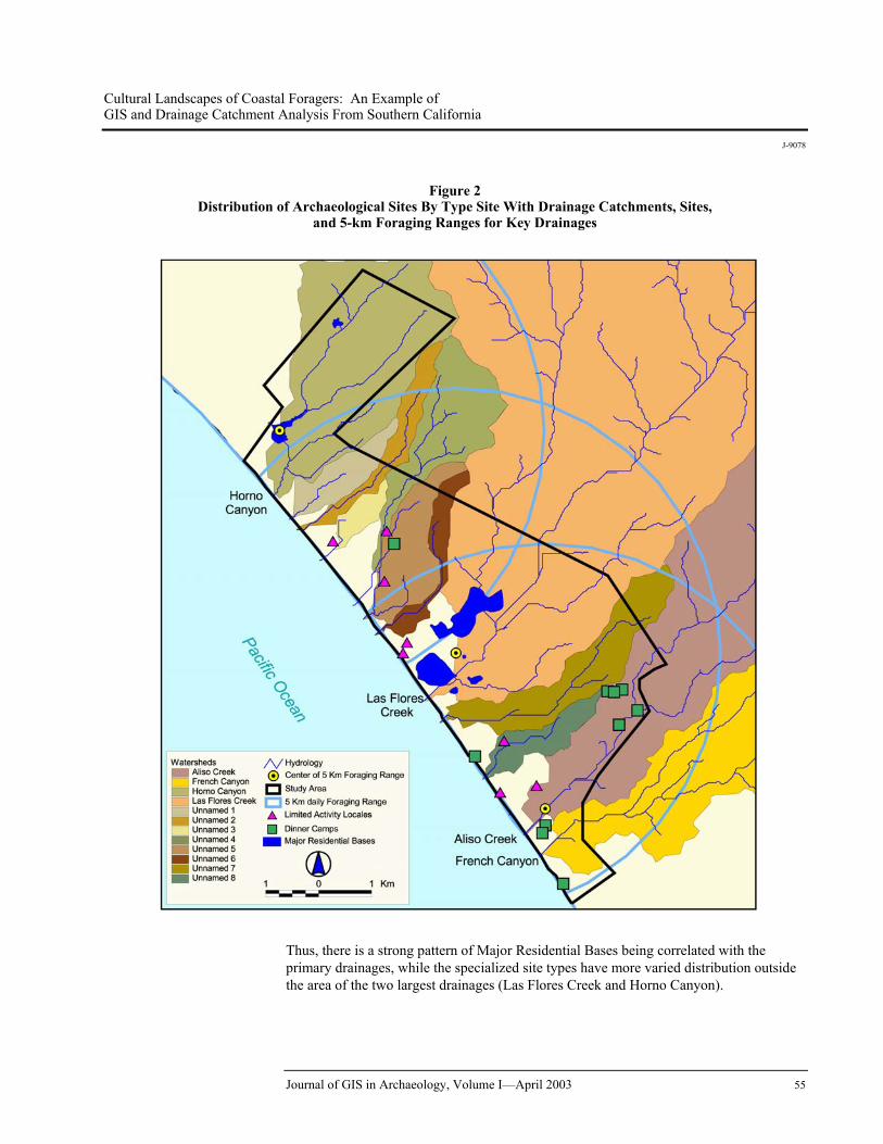
MRB: Major Residential Base, DC: Dinner Camp, LAL: Limited Activity Local; S: Small, M: Medium, L: Large Major Residential Bases occur only in the largest drainages, most in Las Flores Creek and some in Horno Canyon. In contrast, 50 percent of the Limited Activity Locales are most often associated with areas not classified as to an individual drainage area, and 37.5 percent are within very small drainages. Occupying an intermediate distribution, the majority of Dinner Camps occur in Aliso Creek (50 percent) or in areas not classified as to individual drainage (40 percent).
Journal of GIS in Archaeology, Volume I—April 2003 54
Cultural Landscapes of Coastal Foragers: An Example of GIS and Drainage Catchment Analysis From Southern California
J-9078
Figure 2 Distribution of Archaeological Sites By Type Site With Drainage Catchments, Sites,
and 5-km Foraging Ranges for Key Drainages
Thus, there is a strong pattern of Major Residential Bases being correlated with the primary drainages, while the specialized site types have more varied distribution outside the area of the two largest drainages (Las Flores Creek and Horno Canyon).
Journal of GIS in Archaeology, Volume I—April 2003 55
Cultural Landscapes of Coastal Foragers: An Example of GIS and Drainage Catchment Analysis From Southern California
J-9078
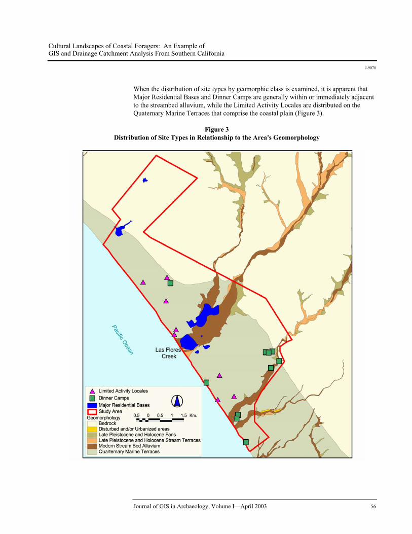
When the distribution of site types by geomorphic class is examined, it is apparent that Major Residential Bases and Dinner Camps are generally within or immediately adjacent to the streambed alluvium, while the Limited Activity Locales are distributed on the Quaternary Marine Terraces that comprise the coastal plain (Figure 3).
Figure 3
Distribution of Site Types in Relationship to the Area's Geomorphology
Journal of GIS in Archaeology, Volume I—April 2003 56
Cultural Landscapes of Coastal Foragers: An Example of GIS and Drainage Catchment Analysis From Southern California
J-9078
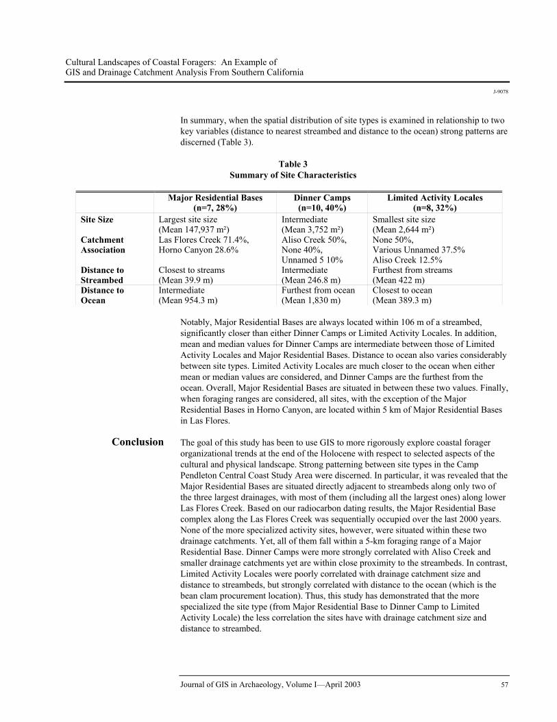
In summary, when the spatial distribution of site types is examined in relationship to two key variables (distance to nearest streambed and distance to the ocean) strong patterns are discerned (Table 3).
Table 3 Summary of Site Characteristics
Major Residential Bases
(n=7, 28%) Dinner Camps (n=10, 40%)
Limited Activity Locales (n=8, 32%)
Site Size Largest site size (Mean 147,937 m²)
Intermediate (Mean 3,752 m²)
Smallest site size (Mean 2,644 m²)
Catchment Association
Las Flores Creek 71.4%, Horno Canyon 28.6%
Aliso Creek 50%, None 40%, Unnamed 5 10%
None 50%, Various Unnamed 37.5% Aliso Creek 12.5%
Distance to Streambed
Closest to streams (Mean 39.9 m)
Intermediate (Mean 246.8 m)
Furthest from streams (Mean 422 m)
Distance to Ocean
Intermediate (Mean 954.3 m)
Furthest from ocean (Mean 1,830 m)
Closest to ocean (Mean 389.3 m)
Notably, Major Residential Bases are always located within 106 m of a streambed, significantly closer than either Dinner Camps or Limited Activity Locales. In addition, mean and median values for Dinner Camps are intermediate between those of Limited Activity Locales and Major Residential Bases. Distance to ocean also varies considerably between site types. Limited Activity Locales are much closer to the ocean when either mean or median values are considered, and Dinner Camps are the furthest from the ocean. Overall, Major Residential Bases are situated in between these two values. Finally, when foraging ranges are considered, all sites, with the exception of the Major Residential Bases in Horno Canyon, are located within 5 km of Major Residential Bases in Las Flores.
Conclusion The goal of this study has been to use GIS to more rigorously explore coastal forager organizational trends at the end of the Holocene with respect to selected aspects of the cultural and physical landscape. Strong patterning between site types in the Camp Pendleton Central Coast Study Area were discerned. In particular, it was revealed that the Major Residential Bases are situated directly adjacent to streambeds along only two of the three largest drainages, with most of them (including all the largest ones) along lower Las Flores Creek. Based on our radiocarbon dating results, the Major Residential Base complex along the Las Flores Creek was sequentially occupied over the last 2000 years. None of the more specialized activity sites, however, were situated within these two drainage catchments. Yet, all of them fall within a 5-km foraging range of a Major Residential Base. Dinner Camps were more strongly correlated with Aliso Creek and smaller drainage catchments yet are within close proximity to the streambeds. In contrast, Limited Activity Locales were poorly correlated with drainage catchment size and distance to streambeds, but strongly correlated with distance to the ocean (which is the bean clam procurement location). Thus, this study has demonstrated that the more specialized the site type (from Major Residential Base to Dinner Camp to Limited Activity Locale) the less correlation the sites have with drainage catchment size and distance to streambed.
Journal of GIS in Archaeology, Volume I—April 2003 57
Cultural Landscapes of Coastal Foragers: An Example of GIS and Drainage Catchment Analysis From Southern California
J-9078
These results, when coupled with our prior studies, suggest a diachronic trajectory beginning around cal A.D. 700 and becoming more highly developed after cal A.D. 1200 (Byrd and Reddy 1999, in press). This included increased site density, a decline in the distance between Major Residential sites, and greater numbers and more varied types of specialized short-term occupation sites within the foraging range of Major Residential Bases. This pattern can be interpreted as representing the emergence of more complex settlement patterns with Major Residential Bases along key drainages and more specialized sites clustered around them in a radiating organizational strategy (Binford 1980). These trends also suggest greater settlement permanence at Major Residential Bases, a decline in the territorial range of these sites, and more thorough exploitation of the littoral zone within foraging ranges. One of the interesting deviations from the general pattern is the absence of Major Residential Bases along the lower portions of Aliso Creek despite it being the second largest drainage catchment in the area. Despite its catchment size, only a series of Dinner Camps are situated along Aliso Creek. We suspect that the absence of Major Residential Bases along Aliso Creek is related to it being within the 5-km foraging range of the Major Residential Bases along Las Flores Creek (in contrast to Horno Canyon that lies just beyond the 5-km range). This pattern further indicates that territorial spacing conditioned the distribution of Major Residential Bases with no contemporaneous base camps closer than 5 km to each other. It is argued that this territorial spacing further influenced the overall distribution of specialized sites. Future spatial studies using GIS will examine the coastal landscape to the south and will include the Santa Margarita River, the largest drainage system on Camp Pendleton.
References Binford, Lewis R. 1980 "Willow Smoke Dogs' Tails: Hunter–Gatherer Settlement Systems and
Archaeological Site Formation." American Antiquity 45:4–20. Byrd, Brian F. 1996 Coastal Archaeology of Las Flores Creek and Horno Canyon, Camp Pendleton,
California. Prepared for Army Corps of Engineers. Report on file at the South Coast Information Center, San Diego State University.
1997 Coastal Archaeology at SDI-10,728, Las Flores Creek, Camp Pendleton, California. Prepared for Army Corps of Engineers. Report on file at the South Coast Information Center, San Diego State University.
1998 "Harvesting the Littoral Landscape During the Late Holocene: New Perspectives From Northern San Diego County." Journal of California and Great Basin Anthropology 20(2):195–218.
2000 Coastal Views of Prehistoric Middens: Archaeological Investigations and Paleoecological Reconstructions along Las Flores Creek, Camp Pendleton, California. Draft Report Prepared for Army Corps of Engineers and Southwest Division, Naval Facilities Engineering Command.
Byrd, B.F., and S.N. Reddy 1999 "Collecting and Residing Near the Shore: The Role of Small and Large Sites in
Settlement Reconstruction." Pacific Coast Archaeological Society Quarterly 35(1):33–56.
Journal of GIS in Archaeology, Volume I—April 2003 58
Cultural Landscapes of Coastal Foragers: An Example of GIS and Drainage Catchment Analysis From Southern California
J-9078
"Late Holocene Adaptations Along the Northern San Diego Coastline: New Perspectives on Old Paradigms." Cultural Complexity on the California Coast: Late Holocene Archaeological and Environmental Records, edited by J. Erlandson and T.L. Jones. UCLA, in press.
Erlandson, J., and T.L. Jones Cultural Complexity on the California Coast: Late Holocene Archaeological
and Environmental Records, UCLA, in press. Ezell, P.H. 1975 The Aboriginal Cemetery at Las Flores Creek, Camp Pendleton. Report on file
at South Coast Information Center, San Diego State University. Glassow, M.A. 1996 Purisimeño Chumash Prehistory: Maritime Adaptations Along the Southern
California Coast. New York, Plenum. Goldberg, P., and B.F. Byrd 1999 "The Interpretive Potential of Micromorphological Analysis at Prehistoric Shell
Midden Sites on Camp Pendleton, California." Pacific Coast Archaeological Society Quarterly 35(3), in press.
Kelly, R.L. 1995 The Foraging Spectrum: Diversity in Hunter-Gatherer Lifeways. Smithsonian
Institution, Washington D.C. Kennett, D.J., and J.P. Kennett 2000 "Competitive and Cooperative Responses to Climatic Instability in Coastal
Southern California." American Antiquity 65(2):379–395. Pearl, Frederic B., and Michael R. Waters 1999 "A Geoarchaeological Assessment of Alluvial Valleys at Camp Pendleton with
an Overview of the Important Natural Site Formation Processes." Pacific Coast Archaeological Society Quarterly 35(1):19–32. In press.
Raab, L.M., and D.O. Larson 1997 "Medieval Climatic Anomaly and Punctuated Cultural Evolution in Coastal
Southern California." American Antiquity 62:319–336. Rasmussen, K., and C. Woodman 1998 3,000 years of Prehistory at the Red Beach Site, CA-SDI-811, Marine Corps
Base, Camp Pendleton, California. Report on file at the South Coast Information Center, San Diego State University.
Reddy, Seetha N. 1998a Prehistoric Landscapes in Coastal Southern California, Archaeological Survey
on Camp Pendleton, San Diego County, California. Prepared for U. S. Army Corps of Engineers, Los Angeles District, California. Report on file, South Coast Information Center, San Diego State University.
Journal of GIS in Archaeology, Volume I—April 2003 59
Cultural Landscapes of Coastal Foragers: An Example of GIS and Drainage Catchment Analysis From Southern California
J-9078
Journal of GIS in Archaeology, Volume I—April 2003 60
1998b Final Letter Report for Archaeological Survey of the Coastal Strip and the 1997 Burns, Camp Pendleton. Prepared for U. S. Army Corps of Engineers, Los Angeles District, California. Report on file, South Coast Information Center, San Diego State University.
1999a "Plant Usage and Prehistoric Diet: Paleoethnobotanical Investigations on Camp
Pendleton, Southern California." Pacific Coast Archaeological Society Quarterly 35(3), in press.
1999b Shellfish on the Menu: Archaeology of Dinner Camps and Limited Activity
Sparse Shell Scatters Along Coastal Camp Pendleton, San Diego County, California. Prepared for U.S. Army Corps of Engineers, Los Angeles District. Report on file, South Coast Information Center, San Diego State University.
Reddy, Seetha N., and Alice Brewster 1999 "Applying GIS to Archaeological Site Prediction on Camp Pendleton, Southern
California." Pacific Coast Archaeological Society Quarterly 35(1):7–18, in press.
Woodman, C. 1996 CA-SDI-812/H Preliminary Results of Test Excavation and a Determination of
NRHP Eligibility. Report on file, South Coast Information Center, San Diego State University.
Waters, Michael R., Brian F. Byrd, and Seetha N. Reddy 1999 "Late Quaternary Geology and Geoarchaeology of Two Streams Along the
Southern California Coast." Geoarchaeology 14(3):289–306.
List of Figures 1. Camp Pendleton showing study area and relevant drainage catchments. 2. Study area showing topography and distribution of tested archaeological sites.