current situation (cala express way) current situation
TRANSCRIPT
2
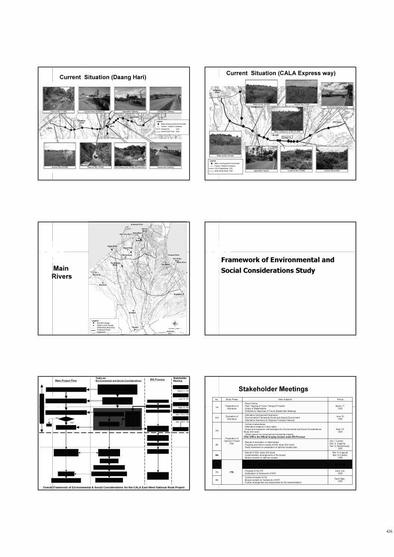
Current Situation (Daang Hari)Current Situation (CALA Express way)
Sta. Rosa
River
Canas River
San Juan RiverImus River
Zapote
River
Tunasan River
San Pedro
RiverBinan River
Legend
Rainfall Gauge
Water Level Gauge
Watershed Boundary
Proposed Road
Alignment
Sanley Point
Amadeo
Arangilan
San Pedro
Balsahan
Alemang
Panaysayan
Ylang-Ylang
Mabolo
Tagayta
y
Ambulon
g
Main
Rivers
Rio Grande
River
Framework of Environmental and
Social Considerations Study
Overall Framework of Environmental & Social Considerations for the CALA East-West National Road Project
Preparation of Alternative Scenarios
Social & Environmental Constraints
- socially vulnerable facilities/areas
- protection and constrained areas
Assessment of Alternative Scenarios-IEE Study for alternatives
-Social Assessment
Formulation of Optimum Project Plan
Feasibility Study
Resettlement Framework EIA Study
-Air
-Noise
etc. Preliminary RAP
Complete RAP
Parcellary survey
-set of cut-off date
Detailed Design
-Finalization of ROW
JIC
A C
AL
A E
-W S
tud
y
Main Project FlowTasks on
Environmental and Social Considerations
Submission of
EIS document
ECC acquisition
Detailed EMMP
Implementation
of EMMP
Preparation of
EIS document
Letter of intent
Scoping session
EIS ProcessStakeholder
Meeting
∆: 1st STM
∆: 3rd STM
Construction
Operation & Maintenance
∆: 8th STM
Land acquisition & resettlement
Preparation of resettlement
Monitoring & evaluation
∆: 2nd STM
Agreed?
End
YES
NO
1st level scoping
(March 17, ’05)
(June 16, ’05)
(Sept. 23, ’05)
(Dec. 7,9,12, ’05)
∆: 4th STM
(Mar. 14&15, ’06)
∆: 5th STM
Early Sept.,2006
- Outline of results of F/S
- Mutual consent on framework of RAP- Further arrangement and requirement for the implementation
8th
Early July,
2006
- Progress of the F/S
- Explanation of framework of RAP7th
Jun.2,2006
- Outline of F/S
- Follow-up of ESC study (EIA level)
- Explanation of resettlement policy
F/S
6th
Mar.14 (Laguna)
Mar.15 (Cavite),
2006
- Results of ESC study (EIA level)
- Implementation arrangements of the project
- Mutual consent on optimum project
5th
Dec.7 (Cavite)
Dec. 8 (Laguna)
Dec.12 (Muntenlupa),2005
- Results of evaluation on alternatives
- Progress and interim results of ESC study (EIA level)- Study framework on preparation of optimum project plan
4th
Sept. 23,
2005
- Outline of alternatives- Alternative measure in zero option
- Scope and evaluation methodologies for Environmental and Social Considerations
Study (EIA level)
- Obtain opinion on concerned environmental impacts
(This STM is the Official Scoping Session under EIS Process)Preparation of
Optimum Project
Plan
3rd
June 16,
2005
- Alternative Development Scenarios
- Environmental Framework-Social and Natural Environment
- Alternative Scenarios for Regional Transport Network
Evaluation of
Scenarios2nd
March 17,
2005
- Study Outline
- Past, Ongoing & Future Transport Projects
- Scope of Stakeholders,
- Schedule & Objectives of Future Stakeholder Meetings
Preparation of
Scenarios1st
PeriodMain SubjectsStudy PhaseNo.
Stakeholder Meetings
426

3
� Environmental Baseline Study
� Social Survey
� Impact Assessment
� Mitigation Measure
� Monitoring Plan
� RAP Framework
Environmental and Social Considerations Study
Preparation of Environmental Impact Statement (EIS) and
Preliminary Resettlement Action Plan (Preliminary RAP)
Previous Topics
Today’s Topics
12. Accidents
11. Waste3. Archaeological and Historical Sites
10. Conflict of interests2. Aesthetics and Visual Effects
9. Inequality between beneficiaries and project-affected people
1. Land Use and Zoning
8. Women and Vulnerable GroupsC. Land Use
7. Culture, Lifestyle and Values2. Freshwater
6. Public Health and Safety1. Terrestrial
5. Infrastructure and Public UtilitiesB. Biological Environment
4. Housing and Social Services4. Noise
3. Labor and Employment3. Air
2. Economic Activities2. Water
1. Population1. Land
D. Socio-Cultural EconomicA. Physical Environment
Environmental Items for EIS
Results of Environmental Impact
Assessment
Environmental Impacts during Construction(1)
Degree of
impactPredicted Environment ImpactItems
MSLoss, disturbance and damage to existing vegetation1. Terrestrial
B. Biological Environment
Local aquatic habitat alteration and temporary
displacement at species
Increase in noise levels
Increase in particulates and gaseous emissions
Changes in river water quality
Slope destabilization at new cuts
Terrain modification, Soil and weathered rock displacement and erosion, Siltation
MS2. Freshwater
MS4. Noise
MS3. Air
S2. Water
MS
S1. Land
A. Physical Environment
Note: S: Significant , MS: Moderately Significant
Major Crossing Point at River/Creek
Sta. Rosa
River
Canas River
San Juan RiverImus River
Zapote River
Tunasan River
San Pedro River
Binan River
Sanley Point
Arangilan
San Pedro
Balsahan
Alemang
Panaysayan
Ylang-Ylang
Mabolo
Legend
Rainfall Gauge
Water Level Gauge
Watershed Boundary
Proposed Road
Alignment
Environmental Impacts during Construction(2)
MSImpact Archaeological and Historical Sites
C. Land
3. Archaeological and
Historical Sites
MSIncrease in employment opportunities3. Labor and Employment
MSIncrease in livelihood and business opportunities
STotal or partial loss of land/farm area,
properties and crops, dislocation and loss of income due to ROW acquisition2. Economic Activities
MSPotential health, sanitation and safety problems
6. Public Health and Safety
Degree of impact
Predicted Environment ImpactItems
D. Socio-Cultural Economic
Increased of solid waste MS11. Waste
Note: S: Significant , MS: Moderately Significant
427

4
Number of Directly Affected Households
6672161585TOTAL
17-17-Tanza
2121--Silang
52-4111Imus
3-3-Gen.Trias
229--229Dasmarinas
345--345Bacoor
TOTALCALA ExpEast-WestNorth-SouthMunicipality
66-66*-Muntinlupa
* estimate
Environmental Impacts during Operation (1)
MSWater inflow at the discharge points of the road storm drains
2. Water
Degree of
impactPredicted Environment ImpactItems
MSChange in landscape2. Aesthetics and Visual
Effects
C. Land
Increase in noise levels
Increase in particulates and gaseous emissions
Erosion at the discharge points of the road storm drains
S4. Noise
S3. Air
MS1. Land
A. Physical Environment
Note: S: Significant , MS: Moderately Significant
Future TSP Level (2015)
y = 0.0012x + 88.906
R2 = 0.7158
0
100
200
300
400
0 50,000 100,000 150,000 200,000
Traffic Volume (PCU)
TS
P C
oncentr
ation (
μg/N
CM
)
TSP standard
230μg/NCM
Future Volume
DH: 65,100PCU
CE: 94,800PCU
NS:111,100PCU
DH:167 μg/NCM, CE:203 μg/NCM, NS:222 μg/NCM
DH CE NS
Environmental Impacts during Operation (2)
SRegional severance4. Housing and Social Services
MSImprovement of access to public
utilities and services
5. Infrastructure and Public
Utilities
MSIncrease in traffic accidents12. Accidents
Degree of impact
Predicted Environment ImpactItems
D. Socio-Cultural Economic
Note: S: Significant , MS: Moderately Significant
Image of Regional Severance
Community
Human Flow
Road Construction Outline of Mitigation Measures
for Negative Impacts
428

5
Mitigation Measures for Negative Impacts
For Directly Affected Households
Preparation of RAP Fair Compensation
Mitigation Measures for Negative Impacts
For Air Pollution and Noise Level Increase
Planting Trees along Roads Regular Cleaning Activities
Mitigation Measures for Negative Impacts
For Regional Severance
Street Crossing Flyover
Outline of Monitoring Plan
Environmental Monitoring Plan
Contractor’s material handling program
Waste
Tree cutting/ballingTerrestrial
TSP,SOx,NOxAirOperation
Construction
Project Phase
Noise LevelNoise
Noise LevelNoise
TSP,SOx,NOxAir
River water qualityWater
DPWH/DENR/M
MT
Erosion and siltation
ContractorSlope profile and signs of
instability
Land
ResponsibilityParameterItems
Framework of Resettlement Action Plan
429

6
SUMMARY OF RELEVANT POLICIES ON
LAND AND RESETTLEMENT
POLICYSUBJECT DESCRIPTION
Eviction and Demolition RA 7279 - UDHA Observance of just and humane
manner in eviction and demolition
Land Valuation and
Compensation
RA 8974 Modes of land acquisition,
Procedures in expropriation and
compensation
Resettlement Options RA 6026 Provides options and assistance to
squatters (informal settlers)
Compensation for lost crops RA 6657
(On Comprehensive
Agrarian Reform Law)
Compensation for lost crops,
Displaced tenants and settlers
Eminent Domain Cir.No. 35 and
RA 7160 of 1990
Allows government to exercise
eminent domain on payment of just
compensation
Community Participation Art.III Sec.10,
(1987 Phil. Constitution)
Participation of Communities in
development initiatives
Gender and Development Mainstreaming gender concerns in
development projects
RA 7192
PROJECT RESETTLEMENT FRAMEWORK
Payment of Land
1. Payment for the land will be given to registered owner of the land
with a Transfer Certificate Title (TCT) as proof of ownership. A tax
declaration receipt is not proof of ownership.
2. Tax declaration may ripen into full ownership upon application for
titling with the DENR, provided the said parcel of land is classified
as alienable and disposal land. Only improvements will be
compensated.
3. All land titles are registered with the concerned government
agencies. The DPWH researchers called ROW agents will verify land
titles subject for compensation. Payment will be done after a
process of verification.
4. The price may be negotiated. The last recourse of DPWH is a court
case in the event the landowner is not amenable to sell his property
at the offered price.
PROJECT RESETTLEMENT FRAMEWORK
Payment of Structure
1. During the feasibility study, the directly affected households and their structures will be identified based on the road alignment. In the
detailed engineering phase, the houses will be photographed, taggedand estimated to determine the right-of-way cost.
2. The structure will be paid based on the replacement value as of the designated cut-off date.
Compensation of Trees and Crops
1. The owners of the trees and crops will be compensated based on thevalues in the provincial and/or municipal assessor’s office.
2. There may be trees that have no listed value in the provincial or municipal assessor’s office. In these cases, the values of trees and
crops in the Department of Agriculture or the Department of Environment and Natural Resources will be the bases of valuation.
PROJECT RESETTLEMENT FRAMEWORK
Partial Effects on Structures and Lands
1. If only one-fifth (20%) of a house will be affected and still be livable andsafe, then, only the affected portion of the house will be compensated. If it is not livable, then the owner will be compensated for the whole
structure.
2. This is also true with partially affected lands. If the properties have
been impaired in any way by the project such that they are no longer livable or economically viable to sustain existing usage, for example, agricultural or commercial activities, then the whole property will be
compensated.
3. Portions of land actually used or impaired because of the project will
be compensated by the project. The original title will be sub-divided to reflect the portions paid by the government and new titles will be
issued in favor of the government and the owner.
PROJECT RESETTLEMENT FRAMEWORK
Relocation
1. Relocation is one of the options of households who own the structures but not the land on which it is built. DPWH will supply the necessary information about the directly affected households to the municipality
based on the data gathered during the various stages of the project.
2. The municipality as part of its counterpart for the project will then
prepare a relocation site based on the actual number of households in their municipality who opted for resettlement in this project.
3. If the directly affected households are not willing to be relocated, their structures will be paid the replacement value and the households will be assisted to transport their families and belongings.
4. Social surveys are conducted to determine the average family size and
income of all directly affected households in order to establish size of lot and their paying capacity.
5. There will be no forced eviction without court order.
PROJECT RESETTLEMENT FRAMEWORK
Relocation
6. The next step will be disclosure activities where dislocated households will be informed about their relocation options and compensation. The objective of this disclosure is to avert the need for forced eviction by
providing acceptable compensation.
7. The foreign funder will not release any amount for the construction
unless DPWH has resolved the ROW issues and has paid the affected owners 100% of the compensation, to be compensated at least a month before actual construction can begin.
Alignment
As a rule, the road alignments proposed by DPWH will try to avoid structures particularly those providing public services such as schools and
hospitals. Proposed road alignments veered away from structures that are very expensive such as main transmission lines for electricity.
430

7
PROJECT RESETTLEMENT FRAMEWORK
Public Hearing
Public hearing and barangay consultations required by the DENR as part of the EIA process were undertaken to inform the affected residents and toelicit the views, concern and issues on the proposed project.
Land Valuation
If the offered price for the properties is perceived to be low and the landowner asks for a better price DPWH will commission an independent appraiser to determine the replacement cost. As a last recourse, DPWH can
file expropriation through the power of eminent domain of the state. However, to prevent this legal eventuality, consultations are being undertaken to thresh out issues and concern of directly affected
households.
PROJECT RESETTLEMENT FRAMEWORK
Compensation of Tenants
1. The legal tenant of the land will be paid based on the
Comprehensive Agrarian Reform Law.
2. In cases wherein the tenant will be dispossessed from the land
that he tills, the prescribed compensation to be given to the
tenant is equivalent to 1 year income from the harvest based on
average of past 3 years. The total amount should not be less than
P15,000 per ha.
Conversion of Agricultural Land to Road Use
This is a road project of DPWH, which entails the construction of a road
passing through land with various uses such as agricultural, residential, commercial and industrial. It is submitted that to build a road in these lands with various uses does not require the usual conversion processes as
enunciated by the Comprehensive Agrarian Reform Law.
PROJECT RESETTLEMENT FRAMEWORK
Inherited Land
DPWH will compensate the heirs with legal proof of land ownership.
Transparency
1. The residents will be given updates during the various stages of
the project. The team, through consultations with possible
affected households will find out the best road alignment.
2. In the detailed engineering stage, the households to be affected
will be positively identified. Before the actual relocation,
consultations and coordination will be done with the affected
parties, barangay, and municipal officials.
3. Disclosure meetings will be held, which will provide detailed
valuation for the land or structure to the directly affected owners.
Consensus Building Process for Implementation of the Proposed Projects - Update
(Issue of Resolutions by LGUs)
Status of Resolutions (Cavite: total 39 brgys)
√-D-Pasong Buaya II
√-D-Malagasang II-C
√-D-Anabu II-E
√-D-Anabu II-D
√--DBuhay na Tubig
√-DDPasong Buaya I
(To follow)
.
√--DAnabu I-GImus
√D-DLangkaan I
√--DSan Agustin II
√--DSan Agustin I
√--DSalitran IV
√--DSalitran III
√--DSalitran II
√--DSalitran I
Discussion with
SB to be
scheduled.
√--DBurol MainDasmariñas
√--DZapote V
√--DTalaba VII
√--DTalaba III
√--DTalaba II
√--DMambog IV
Discussion with
SB to be
scheduled.
√--DMambog IIIBacoorCavite
CALA
ExpresswayE/WN/S
Municipal
Resolution
Barangay
Resolution
Proposed Roads
BarangayMunicipalityProvince
Note: D = directly affected on selected alignment; A = on alternative alignment
Status of Resolutions (Cavite)
(√)-A-Pasong Camachile II
(To follow)D--Tibig
√D--Sabutan
√D--Munting Ilog
√D--Iba
√D--Malaking Tatiao
√D--Biga I
√D--Carmen
√D--Biluso
Discussion with SB
to be scheduled.
√D--BatasSilang
(√)-A-Mulawin
√-D-Bunga
√-D-Santol
√-D-Sanja Mayor
√-D-Biga
√
√-D-Amaya ITanza
√D--San Francisco
√-D-Tapia
√-D-Pinagtipunan
√
√-D-Pasong Camachile IGeneral TriasCavite
CALA
ExpresswayE/WN/S
Municipal
Resolution
Barangay
Resolution
Proposed Roads
BarangayMunicipalityProvince
Note: D = directly affected on selected alignment; A = on alternative alignment
431

8
Status of Resolutions
(Laguna: 3 brgys & Metro Manila: 2 brgys)
Discussion to SB to
be scheduled.√D--Sto. Domingo
(To follow)-D-Poblacion
Presentation to
Infra Cluster done
2/22/2006
√-D-TunasanMuntinlupa
City
Metro
Manila
(To follow)D--Malitlit
√D--Don JoseSanta Rosa CityLaguna
CALA
ExpresswayE/WN/S
Municipal
Resolution
Barangay
Resolution
Proposed Roads
BarangayMunicipalityProvince
Note: D = directly affected on selected alignment; A = on alternative alignment
Next Steps for ESC
� Complementation of EIS
� Further deliberation and improvement of RAP
� Stakeholder Meetings
432

1
JAPAN INTERNATIONAL COOPERATION AGENCY (JICA)JAPAN INTERNATIONAL COOPERATION AGENCY (JICA)
DEPARTMENT OF PUBLIC WORKS AND HIGHWAYS DEPARTMENT OF PUBLIC WORKS AND HIGHWAYS (DPWH)(DPWH)
THE FEASIBILITY STUDY AND IMPLEMENTATION SUPPORT
ON THE CALA EAST-WEST NATIONAL ROAD PROJECT
6th Stakeholders’ Meeting
Session 2
Conceptual Road Design
and Present Issues
2 June 2006
2
Legend
CALA Expressway (CE)
Interchange / Junction (CE)
North-South Road (NS)
Toll Plaza (NS)
Daang Hari (DH)
Flyover / Viaduct (Tentative)
Aguinaldo Highway
Manila-Cavite x
BACOOR
IMUS
DASMARINAS
SILANG
Governers Drive
Salitran Rd.
Aguinaldo Highway
Daang Hari
GENERAL
TRIAS
TANZA
TRECE
MARTIRES
CITY
Noveleta-Naic-Tagaytay Rd.
SLEX
Sta.Rosa-Tagaytay d STA.
ROSA
MUNTINLUPA
CITY
Pala-Pala Rd.
Toll Plaza
Govrs. Drv. Int.
SLEX Jct.
Sta.Rosa-Tagaytay
Rd. Int.
Aguinaldo Hwy.Int.
NS Road Int.
Project Roads
Toll Plaza
3
North-South Road
Aguinaldo Highway
Manila-Cavite x
BACOOR
IMUS
DASMARINAS
SILANG
Governers Drive
Salitran Rd.
Aguinaldo Highway
Daang Hari
GENERAL
TRIAS
TANZA
TRECE
MARTIRES
CITY
Noveleta-Naic-Tagaytay Rd.
SLEX
Sta.Rosa-Tagaytay d STA.
ROSA
MUNTINLUPA
CITY
Pala-Pala Rd.
Legend
Flyover / Viaduct (Tentative)
CALA Expressway (CE)
North-South Road (NS)
Daang Hari (DH)
30000 (用地幅)
3500 3500 3500 3000 750 3500 3500 3500 750 2250 2250
North-South Road (6 Lane)
5000 5000
10000
9000
(2 Lane Service Road)
5000
14000
(1 Lane Service Road)
Length: 26.7 km
Designed Speed: 60 km/h
No. of Lanes: 6
ROW: 30 m
Toll Plaza
Toll Plaza
ROW
4
Toll Plaza
SM Bacoor
Manila
-Cavit
e
Expwy.
Aguin
ald
o H
i-w
ay
NN--S Road S Road (1/5)(1/5)
(Existin
g M
olin
o B
lvd.)
LAS PINAS
BACOOR
IMUS
Project Road
Bridge/Flyover
Toll Plaza
Major Existing Road
St. Dominic Hospital
Tirona Hi-way
Alabang-Zapote Rd.AnibanRd.
5
Ag
uin
ald
o H
i-w
ay
Original
Alignment
Daang Hari
Citta Italia
Citta Italia
NN--S Road S Road (2/5)(2/5)
IMUS
Project Road
Bridge/Flyover
Major Existing Road
SM Molino
Mo
l ino
Bl v
d.
Latest Alignment
Molin
o B
lvd.
BACOOR
Mo
lino
Rd
.
6
Ag
uin
ald
o H
i-w
ay
Daa
ng H
ari
Daang Hari
Salitran-Salawag Rd.
NN--S Road S Road (3/5)(3/5) Toll Plaza
IMUS
DASMARINAS
GENERAL
TRIAS
Project Road
Bridge/Flyover
Toll Plaza
Major Existing Road
SM Molino
Orchard Golf
Course
433