current status of the geocentric datum of malaysia 2000 ... · current status of the geocentric...
TRANSCRIPT

CURRENT STATUS OF THE GEOCENTRIC DATUM OF
MALAYSIA 2000 (GDM2000) Sr Sohaime bin Rasidi,
Director of Geodetic Survey Division,
Department of Survey and Mapping, Malaysia (JUPEM)

OUTLINE
– 1. INTRODUCTION TO GDM2000 – 2. EXECUTION OF MyRTKnet – 3. CURRENT ISSUES OF MyRTKnet SERVICE – 4. SOLUTION ANALYSIS – 5. SOLUTION MEASURES – 6. REVISION OF GDM2000 – 7. CONCLUSION
27/10/2016 Geodetic Survey Division, JUPEM 2

1. INTRODUCTION TO GDM2000 Officially launched on 26th August 2003
Geocentric Datum of Malaysia 2000 (GDM2000) was created over a population of four (4) years of data with ties to eleven (11) IGS station.
27/10/2016 Geodetic Survey Division, JUPEM 3
18 MASS stations was build on 1999;
Labuan: 1 Station
Peninsular : 10 Station Sabah: 3 Station
Sarawak: 4 Station

27/10/2016 Geodetic Survey Division, JUPEM 4
MASS together with passive GPS station PMGSN94 and EMGSN97 created a nationwide GPS control frame.
MASS + Peninsular Malaysia Geodetic Station Network 94
MASS + East Malaysia Geodetic Station Network 97

27/10/2016 Geodetic Survey Division, JUPEM 5
• Phase I of MyRTKnet was developed in 2003 with 27 new stations. • Equipped with the Trimble 5700 and the Zephyr Geodetic antenna. • Operation started in 2004.
2. EXECUTION OF MyRTKnet
25 Stn. In peninsular
1 Stn. in Sabah (UMSS) 1 Stn. in Sarawak (UMAS)
VRS services in Klang Valley, Penang and J. Bahru
•Single Base for other region
•18 MASS stn. kept as control
27/10/2016 Geodetic Survey Division, JUPEM 6
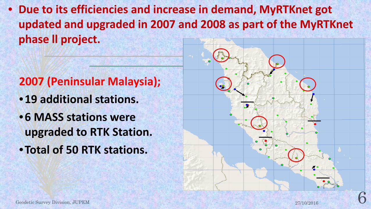
2007 (Peninsular Malaysia); •19 additional stations. •6 MASS stations were
upgraded to RTK Station. •Total of 50 RTK stations.
• Due to its efficiencies and increase in demand, MyRTKnet got updated and upgraded in 2007 and 2008 as part of the MyRTKnet phase ll project.
27/10/2016 Geodetic Survey Division, JUPEM 7
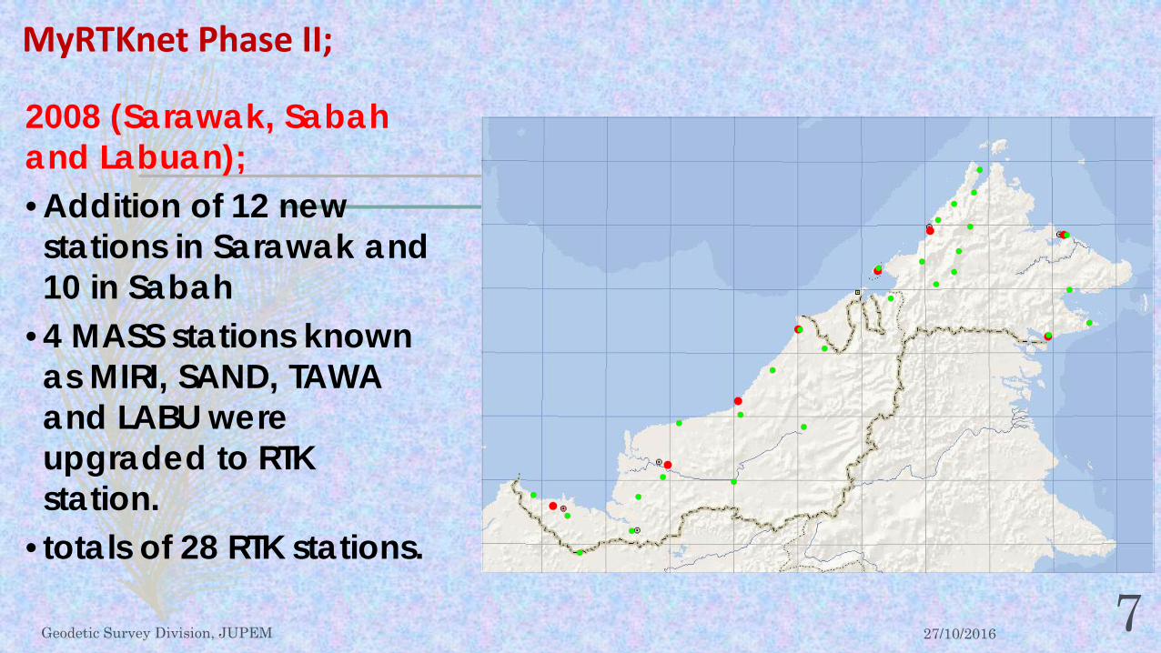
2008 (Sarawak, Sabah and Labuan); • Addition of 12 new stations in Sarawak and 10 in Sabah
• 4 MASS stations known as MIRI, SAND, TAWA and LABU were upgraded to RTK station.
• totals of 28 RTK stations.
MyRTKnet Phase II;

27/10/2016 Geodetic Survey Division, JUPEM 8
50 stations in Peninsular,
14 stations in Sarawak,
13 stations in Sabah,
1 station in W.P. Labuan.
Total of 78 stations.
TOTAL IN 2008 = 78 station
Using Reference Frame GDM2000 revised in 2006 [GDM2000(2006)]
MyRTKnet Phase I and II;

27/10/2016 Geodetic Survey Division, JUPEM 9
Objective 1:
Enhancing the MyRTKnet system by;
– Upgrading the Control Centre and Data Processing.
– Changing Data Processing System from the existing GPSNet system to the SpiderNet system capable of processing data from variation of GNSS receiver including Leica and Trimble.
Objective 2:
Densifying of Continuously Operating Reference Stations (CORS) up to 99 stations nationwide involving;
– 65 Stations in the peninsular,
– 15 Stations in Sarawak,
– 15 Stations in Sabah,
– 1 Station in W. P. Labuan and
– 1 Station each on Pulau Layang-Layang, Pulau Balambangan and Pulau Mataking.
Development of MyRTKnet phase III (2014-2015) :

27/10/2016 Geodetic Survey Division, JUPEM 10
99 stations - (66 in peninsular, 15 in Sarawak, 14 in Sabah, 1 in Labuan and 3 Stations in islands around Sabah)
CONTINUOUSLY OPERATING REFERENCE STATIONS (CORS) STATUS IN 2016
50 Stations – Trimble NetR5, 46 Stations – Leica GR-25 3 Stations – Trimble NetR9
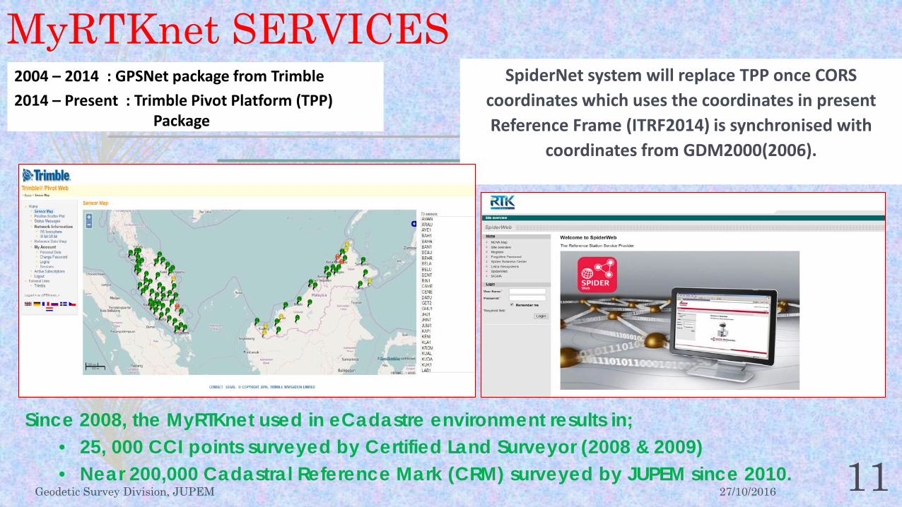
MyRTKnet SERVICES
27/10/2016 Geodetic Survey Division, JUPEM 11
SpiderNet system will replace TPP once CORS coordinates which uses the coordinates in present Reference Frame (ITRF2014) is synchronised with
coordinates from GDM2000(2006).
2004 – 2014 : GPSNet package from Trimble 2014 – Present : Trimble Pivot Platform (TPP)
Package
Since 2008, the MyRTKnet used in eCadastre environment results in; • 25, 000 CCI points surveyed by Certified Land Surveyor (2008 & 2009) • Near 200,000 Cadastral Reference Mark (CRM) surveyed by JUPEM since 2010.
27/10/2016 Geodetic Survey Division, JUPEM 12
– Recent MyRTKnet users, especially those who carry out cadastre works face these problems;
– Fail to initialize or took too much time,
– Fail to acquire fixed station coordinates,
– Difficulty in acquiring Virtual Rinex Service (VRS),
– Difficulty in obtaining Rinex data from nearby CORS,
– Questionable on accuracy of observed coordinates.
3. CURRENT ISSUES OF MyRTKnet SERVICE

27/10/2016 Geodetic Survey Division, JUPEM 13
– The main factor for MyRTKnet service problems appear due to unstable CORS coordinates using GDM2000(2006).
– CORS-based coordinate GDM2000(2006) is no longer reflect the actual position if referred to the recent ITRF.
– CORS movement is caused by the movement of Tectonic Plates that changes the overall CORS position as follows; – The entire stations generally move about 3 cm
per year from its original position towards the East-Southeast;
– Without taking into account the effects of earthquakes, GDM2000(2006) coordinates could have moved about 30 cm in the last 10 years, between 2006 and 2016.
GDM2000(2006) Coordinate Stability for MyRTKnet Stations

27/10/2016 Geodetic Survey Division, JUPEM 14
CORS also detected shift resulting from the "Co-Seismic" movement during several strong earthquakes as in; Earthquake in Bengkulu on September 12, 2007 with a strength of 8.2 Mw
(moment magnitude) caused the displacement between 1-3 cm towards SSW.
An earthquake on the West Coast of North Sumatra on January 10, 2012 with 7.2 Mw power also caused a shift towards SSW.
An earthquake on the West Coast of North Sumatra on April 11, 2012 with strength of 8.6 Mw cause displacement between 1-5 cm towards ENE.
An earthquake on the West Coast of South Sumatra on March 2, 2016 with the power of 7.8 Mw cause displacement between 0-1 cm towards ENE.
GDM2000(2006) Coordinate Stability for MyRTKnet Stations

27/10/2016 Geodetic Survey Division, JUPEM 15
In addition, the CORS also detected shift resulting from the movement of "Post-Seismic" after the earthquake. Studies show that "Post-Seismic" shift after the Sumatra-Andaman
earthquake (Banda Aceh) on 25 December 2014 with a magnitude 9.2 Mw earthquake also in Nias on March 28, 2005 with a magnitude 8.7 Mw still continues today.
Coupled with the "Post-Seismic" effect of the earthquake , another study found that up to 2012, Thailand, Malaysia and Vietnam has moved up to 25 cm in different directions. With Thailand being stretched more than 60 cm towards NE/SW.
GDM2000(2006) Coordinate Stability for MyRTKnet Stations

27/10/2016 Geodetic Survey Division, JUPEM 16
Impl
emen
tatio
n of
G
DM
2000
(200
6) eCadastral
(25, 000 points)
Bengkulu EQ 8.2Mw (12 Sept 07)
North Sumatra EQ 7.2Mw (10 Jan 12)
North Sumatra EQ 8.6Mw (11 Apr 12)
ITRF2014 (21 Jan 16)
South Sumatra EQ 7.8Mw (2 Mac16)
Mapping & Engineering Survey
Cadastral Survey Control Points (CRM) (≈ 200, 000 points)
MAJOR EVENTS SINCE 2006
GDM2000(2006) Coordinate Stability for MyRTKnet Stations

27/10/2016 Geodetic Survey Division, JUPEM 17
Generate new coordinate system based on ITRF2014 Reference Frame named "Malaysian Geodetic Reference Frame 2016 (MGRF2016)" to replace GDM2000 as a base coordinate for MyRTKnet.
Provides a correlation between MGRF2016 with GDM2000 (2006) using seven (7) Transformation Parameters based on analysis of daily data.
Supplying the corrected and transformed coordinates in GDM2000(2006) to the user's.
4. SOLUTION ANALYSIS Short-Term Solution (STS)

27/10/2016 Geodetic Survey Division, JUPEM 18
Using the same method as a short term solution that generates new coordinate system based on the ITRF2014 Reference Frame named "Malaysian Geodetic Reference Frame 2020 (MGRF2020)" to replace GDM2000 (2006) as the basic coordinate for MyRTKnet.
However the relationship between MGRF2020 with GDM2000 (2006) should be provided using 14 Parameter Transformation Model together with Grid Correction or using 14 Parameter Transformation Model together with Post-Seismic Deformation Model.
Those models will be generated based on the analysis of daily data for a longer period, starting from 1999 until now.
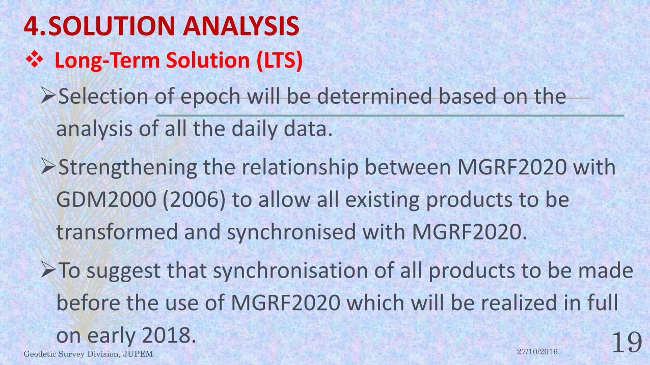
Long-Term Solution (LTS) 4. SOLUTION ANALYSIS
27/10/2016 Geodetic Survey Division, JUPEM 19
Selection of epoch will be determined based on the analysis of all the daily data.
Strengthening the relationship between MGRF2020 with GDM2000 (2006) to allow all existing products to be transformed and synchronised with MGRF2020.
To suggest that synchronisation of all products to be made before the use of MGRF2020 which will be realized in full on early 2018.
Long-Term Solution (LTS) 4. SOLUTION ANALYSIS

27/10/2016 Geodetic Survey Division, JUPEM 20
5. SOLUTION MEASURES Short-Term Solution (STS) Status
1.Study on the stability of observations at MyRTKnet stations was conducted using existing observation data for the period from March 2016 to July 2016.
2.There were two (2) problematic stations, namely in Sri Aman, Sarawak indicating the occurrence of tilting and deposition also a station in Kuala Krai that changes in position due to reconstruction after the flood damage in 2014.
3.The station stability studies were performed to reduce the cause of errors ensuring that the observations were from CORS that are in good shape for the purpose of analysis.

27/10/2016 Geodetic Survey Division, JUPEM 21 62 IGS Stations Including 16 Core ITRF2014 Stations
STS: DATA PROCESSING FOR MGRF2016 Processing is made in correlation with 62 IGS stations where 16 of the stations were Core station for ITRF2014.

27/10/2016 Geodetic Survey Division, JUPEM 22
Date : 01.06.2016 GPS Week : 1899-3 Reference Station : 14 Stesen ITRF2014-CORE Data Filter : 30 Daily Solutions RMS Combination : 2.63, 3.19, 5.98 mm Residuals : < 4 mm & 14 mm
WEEKLY COMBINATION
Date: 29.05.2016 – 04.06.2016 GPS Week: 1899 IGS Data: 62 Stesen MyRTKnet data: 90 Station
STS: DATA PROCESSING FOR MGRF2016
27/10/2016 Geodetic Survey Division, JUPEM 23
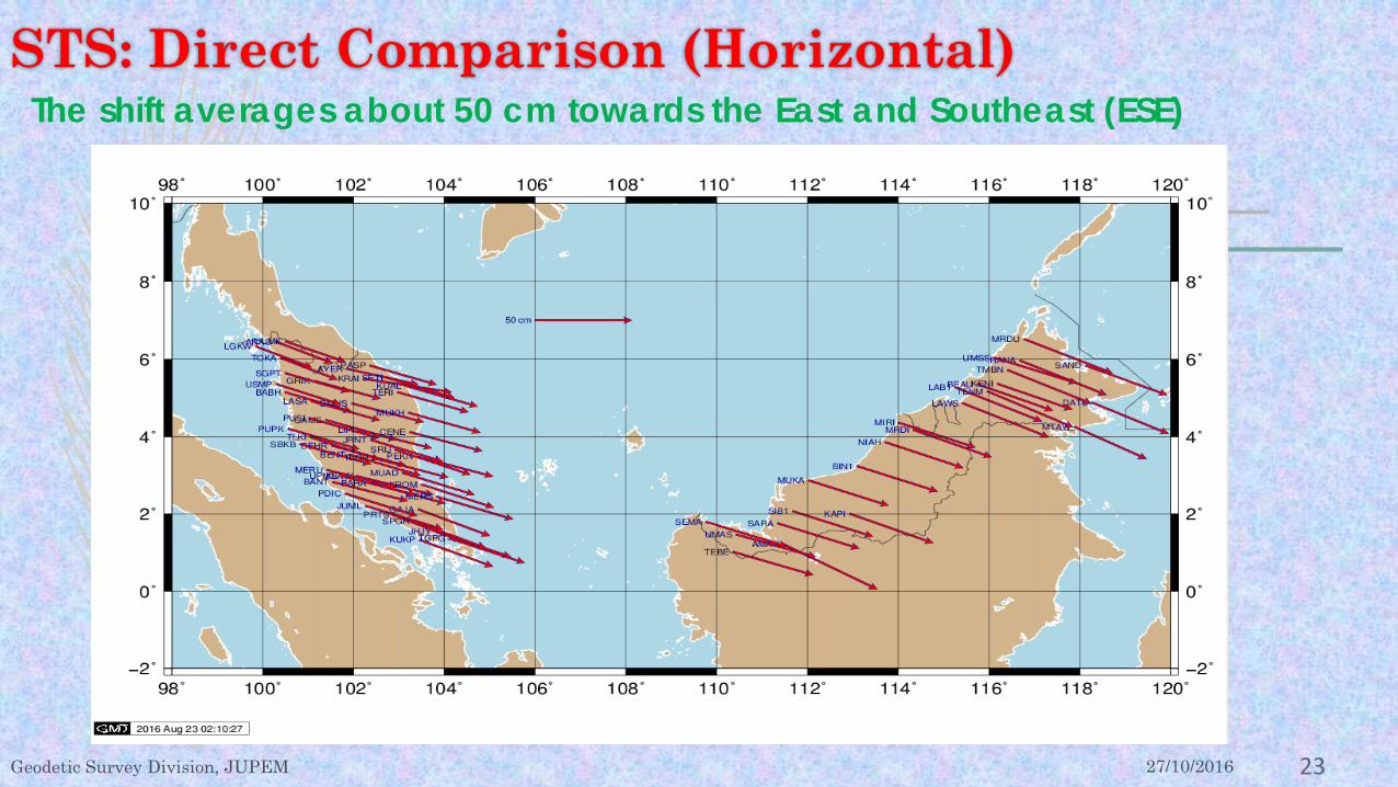
STS: Direct Comparison (Horizontal) The shift averages about 50 cm towards the East and Southeast (ESE)

27/10/2016 Geodetic Survey Division, JUPEM 24
The Magnitude and Direction of the Shift as Shown in Figure.
STS: Direct comparison (Vertical)
-35.00
-30.00
-25.00
-20.00
-15.00
-10.00
-5.00
0.00
5.00
10.00
AMAN ARAU AYER BABH BAHA BANT BEAU BEHR BENT BIN1 CAME CENE DATU GAJA GMUS GRIK JHJY JRNT JUML KAPI KENI KLAW KRAI KROM KUAL KUKP LAB1 LASA LAWS LGKW LIPI MERS MERU MIRI MRDI MRDU MTAW MUAD MUKA MUKH NIAH PASP PDIC PEKN PRTS PUPK PUSI RANA SAND SARA SBKB SEMA SETI SGPT SIB1 SPGR SRIJ TEBE TENM TERI TGPG TLKI TLOH TMBN TOKA UMAS UMSS UPMS USMP UUMK
Perbezaan Ketinggian
27/10/2016 Geodetic Survey Division, JUPEM 25
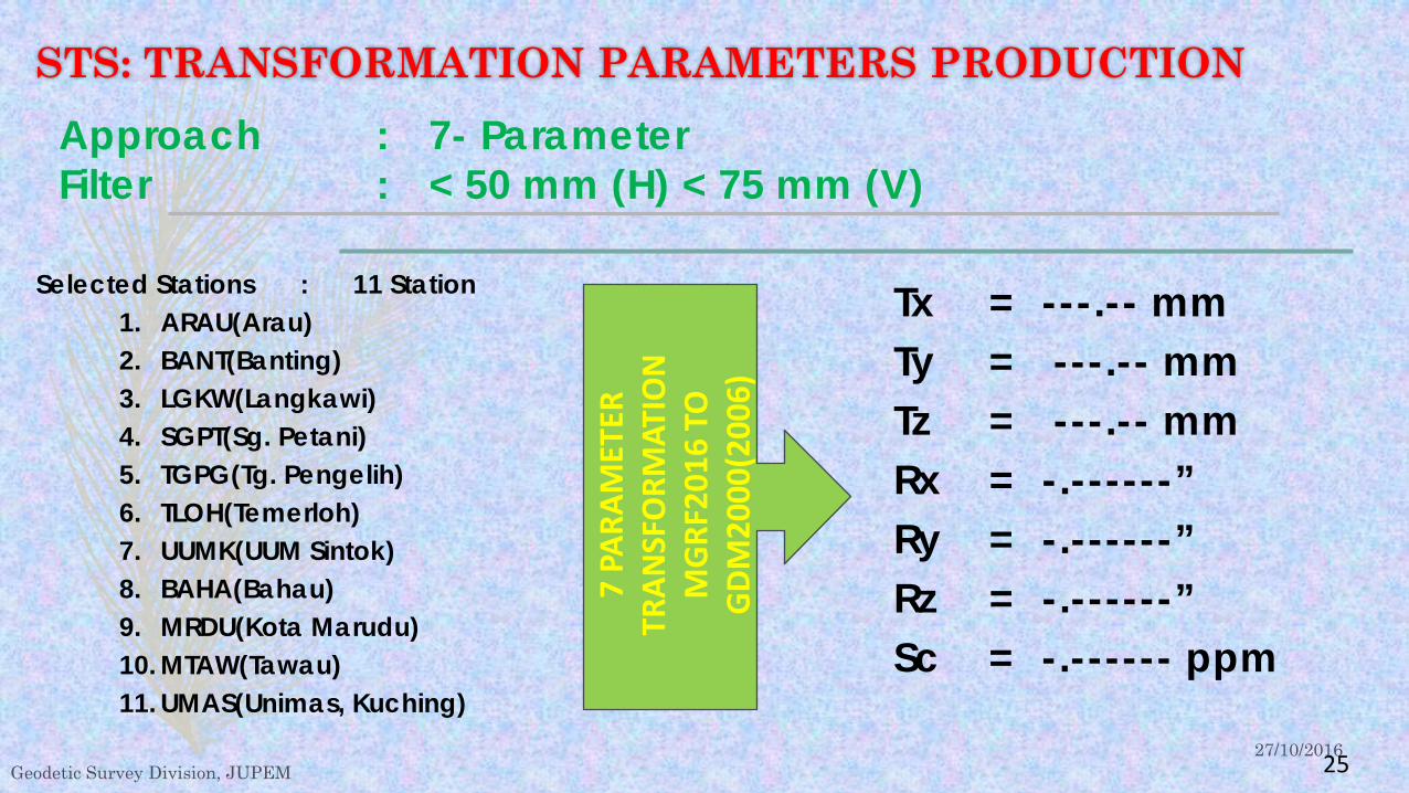
Selected Stations : 11 Station 1. ARAU(Arau) 2. BANT(Banting) 3. LGKW(Langkawi) 4. SGPT(Sg. Petani) 5. TGPG(Tg. Pengelih) 6. TLOH(Temerloh) 7. UUMK(UUM Sintok) 8. BAHA(Bahau) 9. MRDU(Kota Marudu) 10. MTAW(Tawau) 11. UMAS(Unimas, Kuching)
STS: TRANSFORMATION PARAMETERS PRODUCTION Approach : 7- Parameter Filter : < 50 mm (H) < 75 mm (V)
Tx = ---.-- mm Ty = ---.-- mm Tz = ---.-- mm Rx = -.------” Ry = -.------” Rz = -.------” Sc = -.------ ppm
7 PA
RAM
ETER
TR
ANSF
ORM
ATIO
N
MG
RF20
16 T
O
GDM
2000
(200
6)

27/10/2016 Geodetic Survey Division, JUPEM 26
STS: COMPARISON OF TRANSFORMATION – Northing
-120
-100
-80
-60
-40
-20
0
20
40
60
80
100
120AR
AUBA
BHBA
NTBE
HRGM
US GRIK
JHJY
JUM
LKL
AW KUAL
KUKP
LGKW
MER
SM
ERU
PEKN
PUPK
SGPT
TGPG
TLOH
UPM
SUS
MP
UUM
KAY
ERBA
HABE
NTCA
MECE
NEGA
JAJR
NT KRAI
KROM LA
SA LIPI
MUA
DM
UKH
PASP
PDIC
PRTS
PUSI
SBKB SETI
SPGR SR
IJTE
RITL
KITO
KAUM
SSLA
B1TM
BNRA
NAM
RDU
TENM DATU
MTA
WBE
AU KENI
SAND
LAW
SM
RDI
SARA
MUK
ATE
BENI
AHAM
AN BIN1
SEM
ASIB
1KA
PIM
IRIUM
AS
STATION PROBLEM

27/10/2016 Geodetic Survey Division, JUPEM 27 -120
-100
-80
-60
-40
-20
0
20
40
60
80
100
120AR
AUBA
BHBA
NTBE
HRGM
USGR
IKJH
JYJU
ML
KLAW KU
ALKU
KPLG
KWM
ERS
MER
UPE
KNPU
PKSG
PTTG
PGTL
OHUP
MS
USM
PUU
MK
AYER
BAHA
BENT
CAME
CENE
GAJA
JRNT KRAI
KROM LA
SA LIPI
MUA
DM
UKH
PASP
PDIC
PRTS
PUSI
SBKB SETI
SPGR SR
IJTE
RITL
KITO
KAUM
SSLA
B1TM
BNRA
NAM
RDU
TENM
DATU
MTA
WBE
AU KENI
SAND
LAW
SM
RDI
SARA
MUK
ATE
BENI
AHAM
AN BIN1
SEM
ASIB
1KA
PIM
IRIUM
AS
STS: COMPARISON OF TRANSFORMATION – Easting STATION PROBLEM
27/10/2016 Geodetic Survey Division, JUPEM 28 -300
-250
-200
-150
-100
-50
0
50
100
150
200
250
300AR
AUBA
BHBA
NTBE
HRGM
US GRIK
JHJY
JUM
LKL
AW KUAL
KUKP
LGKW
MER
SM
ERU
PEKN
PUPK
SGPT
TGPG
TLOH
UPM
SUS
MP
UUM
KAY
ERBA
HABE
NTCA
MECE
NEGA
JAJR
NT KRAI
KROM LA
SA LIPI
MUA
DM
UKH
PASP
PDIC
PRTS
PUSI
SBKB SETI
SPGR SR
IJTE
RITL
KITO
KAUM
SSLA
B1TM
BNRA
NAM
RDU
TENM DATU
MTA
WBE
AU KENI
SAND
LAW
SM
RDI
SARA
MUK
ATE
BENI
AHAM
AN BIN1
SEM
ASIB
1KA
PIM
IRIUM
AS
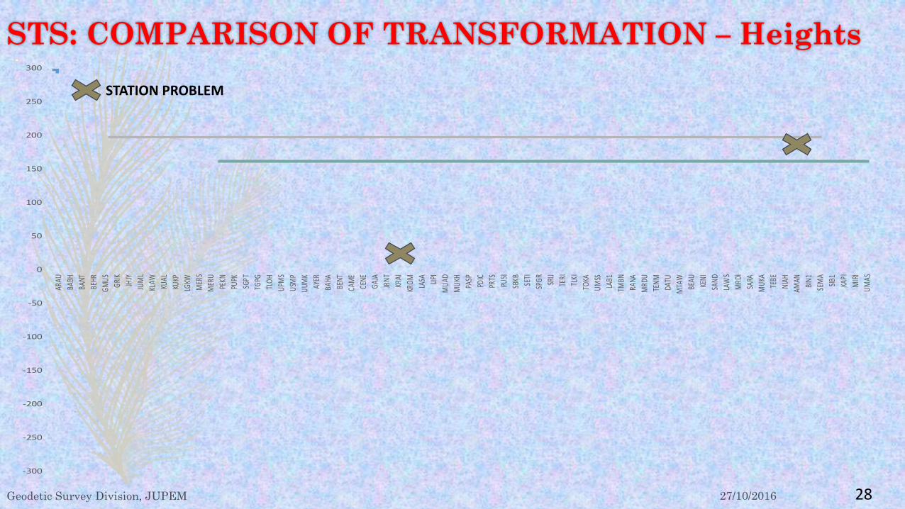
STS: COMPARISON OF TRANSFORMATION – Heights STATION PROBLEM

27/10/2016 Geodetic Survey Division, JUPEM 29
STS: The results of the accuracy test shows that;
i. The use of seven (7) Transformation parameters developed by the Geodetic Survey Division was able to resolve MyRTKnet consumer problems temporarily until all products are made compatible with MGRF2016.
ii.Comparison of the accuracy of coordinate measurements made after the transformation of MGF2016 to GDM2000(2006) compared to the original coordinates in GDM2000(2006) were in acceptable limits of the cadastral survey of +/- 3 cm in most places.
iii.However in some areas the difference is somewhat larger, but not more than +/- 5 cm.
iv.Nevertheless, the relative accuracy between stations in the same area can be maintained within the limits of less than 1ppm.

27/10/2016 Geodetic Survey Division, JUPEM 30
Implementation on MyRTKnet level (Transformation):
Operation coordinate MGRF2016 on MyRTKnet system (Spider)
RTCM 3.x
GPS Corr. Glonas Corr.
Tx Ty Tz Rx Ry Rz Sc
Broadcast
MGRF2016 Coordinate
GDM2000(2006) Coordinate
Consumer
Short-term Solution Implementation After an analysis of the accuracy of the test results, the use of SpiderNet system in MyRTKnet will be open to all users and all transformation parameters will be supplied to the consumer together with the VRS correction. This means that no changes need to be made to the user’s equipment and software provided that the GNSS equipment were integrated with RTCM 3.0 or latest.

27/10/2016 Geodetic Survey Division, JUPEM 31
6. Revision of GDM2000 Long-Term Solution (LTS)
1.Given the supply of transformation parameters to the user in a short term solution can not ensure high accuracy so JUPEM have to take a step forward to convert all the data available from GDM2000 (2006) to MGRF2020 with one of the methods to be implemented, namely the combined transformation model 14 parameter method and grid correction model or 14 parameter transformation model 14 with post-seismic deformation.
2.To provide the stated correction models and obtain the values of transformation parameters to MGRF2020, Geodetic Survey Division is and will perform a more detailed processing and testing of CORS data by using more credible observations data.

27/10/2016 Geodetic Survey Division, JUPEM 32
Long-Term Solution(LTS) Steps for creating MGRF2020 for long-term solutions are being and will be continued as follows;
No.
Action Status
1. Reprocess all the GNSS data of MASS/MyRTKnet on a daily basis since 1999 until 2017.0. 1.1 Setup and use the most recent IGS-type strategy, including the most up to date models. Completed 1.2 Check and consolidate the metadata & log sheets for all the stations following the IGS
standards, including the IGS Core sites (through IGS). Completed
1.3 Establish a catalogue of all earthquakes with their epochs and locations(epicenters)from MET Malaysia & USGS.
Completed
1.4 Careful handling of data time interval at the earthquake events. <30.11.2016 1.5 Study and check the monument stabilities for suspected stations. Completed 1.6 Download and locally archive the IGS Core sites RINEX files since 1999.0 to date. <30.11.2016 1.7 Generate free solution SINEX files: Normal Equations and Variance-Covariance, using
Bernese software V5.2. <30.6.2017
1.8 Optionally: generate the same type of solution using a different software for comparison. <30.6.2017 1.9 Provide 3 years of daily solutions (1999.0 – 2002.0) for analysis by Dr. Zoher Altamimi in
stages. <30.6.2017

27/10/2016 Geodetic Survey Division, JUPEM 33
Long-Term Solution(LTS) Steps for creating MGRF2020 for long-term solutions are being and will be continued as follows;
No. Action Status 2 Data Processing using the most recent version of ifort Fortran and it’s
MKL library for a LINUX machine. 2.1 Analysis of the daily time series using CATREF Software andLINUX Server
(80 processor) <30.8.2017
2.2 Specify the definition of the MGRF2020and its relationship with the ITRF2014.
<30.8.2017
2.3 Produce the coordinates of the CORS stations at the agreed reference epoch (TBD) and expressed in the new MGRF..
<30.9.2017
2.4 Provide Transformation Parameters between MGRF2020 and GDM2000(2006).
<30.9.2017
2.5 Conducting field test and analysing the accuracy of transformation process.
<30.10.2017
2.6 Migrating all product coordinate into MGRF2020 2018 onwards
27/10/2016 Geodetic Survey Division, JUPEM 34
7. CONCLUSION 1.The use of MGRF2016 based on the seven (7) Transformation
Parameters can solve MyRTKnet user problems temporarily until all products are compatible with the new MRGF2020 datum.
2.SpiderNet system developed in MyRTKnet Project Phase III will be fully utilized and is ready to be launched for use by all parties involved by November 2016.
3.Sufficient financial are needed to transform all products coordinates into the environment of new MGRF2020 datum that will be used starting 2018.

27/10/2016 Geodetic Survey Division, JUPEM 35
8. APPRECIATION I extend my gratitude to everyone involved in the success of this study primarily to; YBhg. Datuk Ahmad Fauzi bin Nordin, Ketua pengarah Ukur dan Pemetaan Malaysia, Dato’ Hasan bin Jamil, TKPUP I and , Dato’ Mohd Noor bin Isa, TKPUP II, who contributed a lot of their ideas, advice and guidance. My thanks are also given to the parties directly involved in assessing and proposing methods and solution that can be used.

27/10/2016 Geodetic Survey Division, JUPEM 36
Terima Kasih