customizing arcgis online - conservationgis.org arcgis online.pdf · customizing arcgis online. ......
TRANSCRIPT

1
Customizing ArcGIS OnlineData Basin Project Overview
Redlands, CaliforniaMarch 8th – 9th, 2010
Web Mapping for Conservation Organizations Workshop

Agenda
• Project Goals
• Project Overview
• Technical Overview
• Challenges
• Outcome
• Q&A
2Web Mapping for Conservation Workshop
Data Basin Project Goals for ESRI
• Support the needs of the conservation community by providing infrastructure to store and disseminate spatial data and maps
• Gather requirements and provide feedback to ESRI product development while implementing and testing ArcGIS 10 and ArcGIS Online 2.0.
• Support successful implementation of ArcGIS in a cloud computing environment
3Web Mapping for Conservation Workshop

Team Collaboration
ESRI Product Development
Teams
ESRI Professional
Services Team
CBI Development
Team
4Web Mapping for Conservation Workshop

Data Basin Project Lifecycle
5
Planning & Strategy
Requirements Analysis
Design
Development
Deployment
Operations & Maintenance
Web Mapping for Conservation Workshop

Planning & Strategy
• Core ESRI product considerations
• Alignment with ESRI product development release schedule
• Alignment with CBI Data Basin release schedule
Web Mapping for Conservation Workshop 6
Planning & Strategy
Requirements Analysis
Design
Development
Deployment
Operations & Maintenance

Requirements Analysis
• Joint review of pre-defined Data Basin requirements
• Communicating Data Basin requirements to ESRI product teams
• Gap analysis
Web Mapping for Conservation Workshop 7
Planning & Strategy
Requirements Analysis
Design
Development
Deployment
Operations & Maintenance

Design
• Collaboratively designed specifications for both Data Basin website and GIS Web services
• UI design independently conducted by CBI
Web Mapping for Conservation Workshop 8
Planning & Strategy
Requirements Analysis
Design
Development
Deployment
Operations & Maintenance

Development
• Amazon Cloud development environment (same as ArcGIS Online)
• ESRI – GIS Web services
• CBI – development of front end application and non-GIS components & services
Web Mapping for Conservation Workshop 9
Planning & Strategy
Requirements Analysis
Design
Development
Deployment
Operations & Maintenance

Deployment
• Deployment requirements review
• Performance & scalability testing
• Amazon Cloud environment managed by ESRI Managed Services
Web Mapping for Conservation Workshop 10
Planning & Strategy
Requirements Analysis
Design
Development
Deployment
Operations & Maintenance

Operations & Maintenance
• Technology Transfer Workshop
• Public beta launch - May 1, 2010
• Full Data Basin release target – July 2010
• Data Basin data and application hosting provided by ESRI Managed Services
Web Mapping for Conservation Workshop 11
Planning & Strategy
Requirements Analysis
Design
Development
Deployment
Operations & Maintenance

Project Schedule
12Web Mapping for Conservation Workshop

Overview of Business Requirements
• Easily find and access high-quality conservation-related data (including essential metadata)
• Create and share compelling online maps to support conservation work
• Contribute and publish data and share it publicly or with specified groups of users
• Allow users to contribute information about themselves and the work they do to foster connections between people
• Support development and promotion of conservation-related applications
• Ensure secure access to restricted information
• Provide full control over branding and design to CBI
Web Mapping for Conservation Workshop 13

Overview of Functional Requirements
• User and group management
• Workspace management
• Searching and browsing
• Web mapping including base maps
• Limited GIS analysis
• Web site content management
Web Mapping for Conservation Workshop 14

Overview of Operational Requirements
• Build with scalability in mind – start small and evolve over time– Initial release with approximately 800 – 1000 datasets– Ability to grow number of datasets over time– Handle simultaneous access by large number of users
• Provide reasonable level of availability
• Limit operational cost and hosting cost
Web Mapping for Conservation Workshop 15

Design Considerations and Options
• ArcGIS Online Data Sharing fulfilled 80% of requirements– User and group management– Workspace management– Searching, browsing, and Web mapping capabilities
• Gaps:– Exposing Web mapping capabilities for user contributed content
requires ArcGIS Server infrastructure– Inability to customize the look and feel– Lack of management tools for organizations– Other missing features (sorting of search results, comments and
ratings, spatial search, ability to feature specific content)
Web Mapping for Conservation Workshop 16

ArcGIS Geowarehouse REST API
• RESTful Web services enabling the sharing features of ArcGIS Online
• Simple, easy to use model– Users– Groups– Content items
• Accessible to any registered ArcGISOnline user
• REST Services Directory and API Documentation are disabled
Web Mapping for Conservation Workshop 17

Implementation Approach
• Leverage ArcGIS Geowarehouse REST API using a custom developed Web application
– Provide control over branding and design
• Identify common requirements and use cases and include them in the ArcGIS Online product development cycle
• Utilize and extend the capabilities of the ArcGIS software platform to enable Data Basin specific features and to support an accelerated implementation to meet project schedule
• Employ Amazon Elastic Compute Cloud (Amazon EC2)
Web Mapping for Conservation Workshop 18

Walkthrough: Automatically Publishing Datasets as Map Services
• Problem statement: In order to use the Web mapping feature of ArcGIS Online users need to publish ArcGIS Server map services
– This requirement is impractical considering the target audience of Data Basin
• Solution: Automatically prepare datasets for publishing as map services and publish them on demand
– Requires extending the capabilities of ArcGIS Server
Web Mapping for Conservation Workshop 19
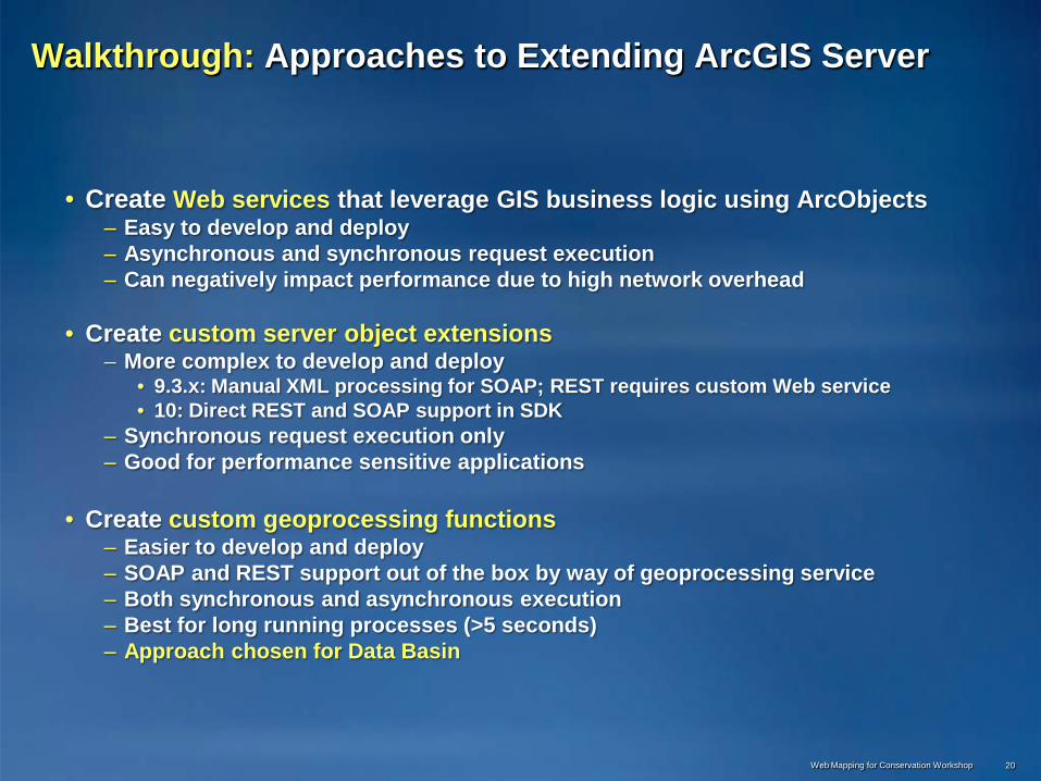
Walkthrough: Approaches to Extending ArcGIS Server
• Create Web services that leverage GIS business logic using ArcObjects– Easy to develop and deploy– Asynchronous and synchronous request execution– Can negatively impact performance due to high network overhead
• Create custom server object extensions– More complex to develop and deploy
• 9.3.x: Manual XML processing for SOAP; REST requires custom Web service• 10: Direct REST and SOAP support in SDK
– Synchronous request execution only– Good for performance sensitive applications
• Create custom geoprocessing functions– Easier to develop and deploy– SOAP and REST support out of the box by way of geoprocessing service– Both synchronous and asynchronous execution– Best for long running processes (>5 seconds)– Approach chosen for Data Basin
Web Mapping for Conservation Workshop 20

Walkthrough: Import Workflow
Web Mapping for Conservation Workshop 21
1User uploads dataset
• ShapefileArchive (.zip)
• Layer Package (.lpk)
• ESRI GRID
3User enters metadata
• Abstract and summary
• Field descriptions
• Custom styling
5Restore map service
4Archive map service
2System creates temp. map service• Create map
document
• Add dataset with default styling
• Publish map service
• Download and extract archive from S3
• Publish map service
• Map service ready for use
• Delete map service
• Archive map document and store archive on Amazon S3
• Create item in ArcGIS Online
Map service does not consume resource when it is not being used

DEMONSTRATION
Web Mapping for Conservation Workshop 22
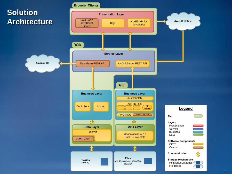
Solution Architecture
23

Technology Stack
ESRI Technology• ArcGIS 10
– ArcGIS Desktop– ArcGIS Server for the Java
Platform
• ArcGIS API for JavaScript 1.6
• ArcGIS Geowarehouse REST API 1.3
• ArcGIS Online Services
Third-party Technology• Java SE Development Kit
(JDK) 6• Python 2.6• Dojo 1.4.1
• Sun GlassFish Enterprise Server 2.1
• MySQL Community Server 5.0.67
• Fedora Linux release 8• Windows Server 2008
Web Mapping for Conservation Workshop 24

Project Challenges
• Developing with ArcGIS 10 beta versions
• Management of joint development activities
• ArcGIS Online integration and alignment with ESRI core development objectives
• Amazon Cloud deployment of ArcGIS
• Integration with ESRI global account system
• Developing strategies for scaling ArcGIS Server
Web Mapping for Conservation Workshop 25

Project Outcomes
• Requirements sharing with ArcGIS Online– Comments and ratings– Sorting search results (by comments, ratings, etc.)– Increase user & community focus
• Testing support for ArcGIS 10– Holistic testing of ArcGIS in an end to end scenario– Defect reporting and suggestions for workarounds
• Testing support for ArcGIS on the Cloud– ArcGIS performance & scalability testing on the cloud– Amazon deployment experience
26Web Mapping for Conservation Workshop

QUESTIONS
Web Mapping for Conservation Workshop 27