czech republic – portraits of regions - univerzita palack©ho v
TRANSCRIPT

Ministry for Regional Development
of the Czech Republic
Czech Republic
Portraits of Regions
Prague 2005

Czech Republic – Portraits of Regions
Published in 2005 by:Ministry for Regional Development of the Czech RepublicStaroměstské náměstí 6110 15 Praha 1
Produced by: Centre for Regional Development Masaryk University in BrnoŽerotínovo náměstí 9601 77 Brno
in cooperation with
Department of Geography Faculty of Natural SciencesPalacký University in Olomouctřída Svobody 26771 46 Olomouc
Authors: Assoc. Prof. Dr. Václav Toušek, CSc.Dr. Irena Smolová, Ph.D.Dr. Miloš Fňukal, Ph.D.Martin Jurek, M.Sc.Pavel Klapka, M.A.
English translation:Pavel Klapka, M.A.Jana Chybová, M.A.Steven Schwartzhoff, M. A.
Maps:Aleš Létal, Ph.D.
Guarantor for the Ministry for Regional Development:Milan Damborský, M.Sc.
Graphic layout: Marie Dašková
Print:Ing. Viktor Hořín – EPAVAChválkovická 5779 00 Olomouc
Edition: 11,000 copies
Closing: October 2005
Not for sale
ISBN 80−239−6346−5

Contens
Introduction . . . . . . . . . . . . . . . . . . . . . . . . . . . . . . . . . . . . . . . . . . . . . . . . . . . . . . . . . . . . . . . 7
Environment . . . . . . . . . . . . . . . . . . . . . . . . . . . . . . . . . . . . . . . . . . . . . . . . . . . . . . . . . . . . . . 9
People . . . . . . . . . . . . . . . . . . . . . . . . . . . . . . . . . . . . . . . . . . . . . . . . . . . . . . . . . . . . . . . . . . 24
Economy . . . . . . . . . . . . . . . . . . . . . . . . . . . . . . . . . . . . . . . . . . . . . . . . . . . . . . . . . . . . . . . . 34
Portraits of Regions
Capital City of Prague . . . . . . . . . . . . . . . . . . . . . . . . . . . . . . . . . . . . . . . . . . . . . . . . . . 50
Středočeský Region . . . . . . . . . . . . . . . . . . . . . . . . . . . . . . . . . . . . . . . . . . . . . . . . . . . 56
Jihočeský Region . . . . . . . . . . . . . . . . . . . . . . . . . . . . . . . . . . . . . . . . . . . . . . . . . . . . . 62
Plzeňský Region . . . . . . . . . . . . . . . . . . . . . . . . . . . . . . . . . . . . . . . . . . . . . . . . . . . . . . 68
Karlovarský Region. . . . . . . . . . . . . . . . . . . . . . . . . . . . . . . . . . . . . . . . . . . . . . . . . . . . 74
Ústecký Region . . . . . . . . . . . . . . . . . . . . . . . . . . . . . . . . . . . . . . . . . . . . . . . . . . . . . . 80
Liberecký Region . . . . . . . . . . . . . . . . . . . . . . . . . . . . . . . . . . . . . . . . . . . . . . . . . . . . . 86
Královéhradecký Region . . . . . . . . . . . . . . . . . . . . . . . . . . . . . . . . . . . . . . . . . . . . . . . 92
Pardubický Region . . . . . . . . . . . . . . . . . . . . . . . . . . . . . . . . . . . . . . . . . . . . . . . . . . . . 98
Vysočina Region . . . . . . . . . . . . . . . . . . . . . . . . . . . . . . . . . . . . . . . . . . . . . . . . . . . . . 104
Jihomoravský Region . . . . . . . . . . . . . . . . . . . . . . . . . . . . . . . . . . . . . . . . . . . . . . . . . 110
Olomoucký Region . . . . . . . . . . . . . . . . . . . . . . . . . . . . . . . . . . . . . . . . . . . . . . . . . . . 116
Zlínský Region . . . . . . . . . . . . . . . . . . . . . . . . . . . . . . . . . . . . . . . . . . . . . . . . . . . . . . 122
Moravskoslezský Region. . . . . . . . . . . . . . . . . . . . . . . . . . . . . . . . . . . . . . . . . . . . . . . 128
Literature and sources . . . . . . . . . . . . . . . . . . . . . . . . . . . . . . . . . . . . . . . . . . . . . . . . . . . . 134


ForewordThe elaboration of this publication was initiated by the Ministry for Regional Development of the Czech Republic. The publication introduces both Czech and foreign readers to topical trends of thesocio−economic development of the regions in the Czech Republic. Apart from general information aboutphysical geography, population and economy of the Czech Republic it also gives a detailed characteri−zation of all its fourteen regions. We believe that the reader will find plenty of valuable information in thisbook.
Authors


7
INTRODUCTIONThe Czech Republic (Czech lands) is a landlocked country located in central Europe, consisting of the
historic provinces of Bohemia, Moravia and a part of Silesia. With a total area of 78,866 sq km and population of 10.2 million it ranks among middle or smaller sized European countries. In the west it borders on Germany (811 km), in the south on Austria (466 km), in the east on Slovakia (252 km), andin the north on Poland (762 km).
The Czech Republic is one of the youngest countries in Europe. It was established only on January1, 1993 as a consequence of a break−up of Czechoslovakia, the common state of the Czechs andSlovaks, into two independent states. The roots of Czech statehood, however, go much deeper into his−tory. The Czech principality was established as early as in the 9th century. During the 10th and 11th cen−turies the principality was consolidated, incorporating Moravia and some other neighbouring territories.The gradual rise in political, economic and cultural importance of the medieval Czech state resulted inits declaration as a kingdom in 1212 and reached its peak during the reign of Charles IV (1346−1378).
In the 15th century the Czech lands were considerably weakened by religious wars between theCatholics and the Hussites, members of a reformational Christian movement following the teaching of thetheologian and reformer Jan Hus (1369−1415). In 1526 the Hapsburgs ascended to the Czech throne andthe state was incorporated into a larger territory – the Austrian monarchy. During the bloody Thirty Years’War (1618−1648) the Czech territory was devastated and the population was re−catholised by force.Religious tolerance and the abandonment of counter−productive feudal economy were brought by eco−nomic reforms of Josef II in 1781. From the end of the 18th century, the Czech lands developed rapidlyand gradually became the economic base of the Austrian monarchy. The economic rise of the Czechlands was accompanied by formation of the modern Czech nation, which was at the same time connectedwith the Czech culture and language revival and later with an effort to gain political independence.
After the defeat of Austria−Hungary in World War I the Czech lands became independent on October28, 1918 and formed an essential part of the newly established Czechoslovakia, whose territory com−prised Slovakia and a part of the present−day Ukraine as well. The first Czechoslovak president TomášGarrigue Masaryk (1850−1937) established a firm democratic foundation for the country. However, theexpansionism of Hitler’s regime in neighbouring Germany proved fatal to the new Czechoslovak democ−racy. In 1938 Czechoslovakia was stripped of its border territories with a German majority, and in March1939 the remaining Czech territory was occupied by the Wehrmacht and the so−called Protectorate ofBohemia and Moravia was created.
The Czechoslovak state was renewed in 1945. In February 1948 the communists seized power, thecountry was transformed into a totalitarian state and became a part of the Soviet bloc. Changes to thepolitical system were brought about by the peaceful “Velvet” revolution on November 17, 1989. After thecollapse of the communist regime the lengthy process of economic, political and moral renewal of theCzech society, externally represented by the president Václav Havel, was started. Changes touched allspheres of life and meant not only economic transformation but also transformation of political institu−tions and practically all aspects of life.
During the first stage of development after 1989 relations between the Czechs and Slovaks within thecommon state and the question of return to the traditionally “pro−western” orientation of the country werethe main issues to be solved. Controversy and latent tension between Czech and Slovak political rep−resentatives lead to the break up of Czechoslovakia. The break−up itself took place peacefully thanks tothe consensus of both parties and relations between both successor states are very good.
A major priority of the foreign policy of the newly created Czech Republic was its integration into Euro−Atlantic security structures and full participation in the European integration. The most important eventssince gaining independence were admission into NATO in March 1999 (together with Poland and Hungary)and the particularly successful negotiating process related to admission into the EU (May 1, 2004).

8
As far as internal changes within the Czech Republic itself are concerned, the accomplishment of theterritorial reorganization of public administration could be ranked as an important event. The conception ofthe reform was fully in concord with the European conception of democracy and it was aimed at the accom−plishment of greater effectiveness within the public administration. In January 1, 2001 fourteen new regionswere established in the Czech Republic. These, as higher territorial self−administration units, represent notonly self−government but are also a part of the state administration. At the end of 2002 district offices weredissolved (they acted on behalf of the state administration) and their function was transferred both to thenew regions and municipalities with extended powers (a total of 205 municipalities). However, on theregional level districts represent NUTS 4 level and the new regions NUTS 3 level. Higher level, NUTS 2, ismade up by areas or association of regions, of which 8 were established in the Czech Republic.
Table 1: Basic characteristics of regions in the Czech Republic (as of January 1, 2005)
Region Area Number of Population Number Administrative(sq km) inhabitants density of centre
(inh. per sq km) municipalities
Capital City of Prague 496 1,170,571 2,360.0 1 PrahaStředočeský 11,015 1,144,071 103.9 1,146 PrahaJihočeský 10,057 625,712 62.2 623 České BudějovicePlzeňský 7,562 549,618 72.7 501 PlzeňKarlovarský 3,315 304,588 91.9 132 Karlovy VaryÚstecký 5,335 822,133 154.1 354 Ústí nad LabemLiberecký 3,163 427,563 135.2 215 LiberecKrálovéhradecký 4,758 547,296 115.0 448 Hradec KrálovéPardubický 4,519 505,285 111.8 452 PardubiceVysočina 6,790 510,114 75.1 704 JihlavaJihomoravský 7,196 1,130,240 157.1 672 BrnoOlomoucký 5,268 639,423 121.4 397 OlomoucZlínský 3,964 590,706 149.0 304 ZlínMoravskoslezský 5,428 1,253,257 230.9 299 OstravaCzech Republic 78,866 10,220,577 129.6 6,248 Praha
Source: Regionální portréty, ČSÚ 2005.
Fig. 1: Administrative division of the Czech Republic

9
ENVIRONMENTThe Czech Republic comprises of three historic provinces – Bohemia, Moravia and the Czech part of
Silesia. The concentric shape of Bohemia is delimited by the Czech Basin and its mountain rim formsalmost an ideal hydrographical unit of the Elbe River drainage basin. The Moravian territory possessestransitive and passable character in Moravian vales, whose axes are formed by important Europeanrivers – in the central and southern part the Morava River, in the northern part the Odra River. EastMoravia is covered by the Western Carpathians, which in comparison to the Czech Highland isa younger geological unit.
GEOLOGICAL COMPOSITION AND DEVELOPMENT
Intense geological processes in the past are reflected in varied landforms on a relatively small terri−tory. There were massive orogeneses; during the Cretaceous Era part of the territory was flooded by thesea, volcanism was active as late as the beginning of the Quaternary Period and the continental glaciertransported erratic boulders from Scandinavia.
The Czech Republic straddles to two large geological units with markedly different development:Bohemia, and the greater part of Moravia and Silesia are a part of the Czech Massive, while the east−ern part of Moravia and Silesia lie on the Outer Carpathians.
The Czech Massive is a relic of a vast mountain range elevated during the Hercynian orogenesis inthe Paleozoicum (devon−carbon) 380−300 millions years ago. Orogenesis was accompanied by rockmetamorphosis and red−hot magma erupted out of the Earth’s depths, which solidified not very deepbelow the surface – this consolidated the Czech Massive by vast plutons into one unit. At that timeCentral Europe was situated in the tropics and depressions among mountain ranges started to overgrowwith lush vegetation. Accumulation of plant remnants which were later covered by younger sedimenta−ry layers gave birth to hard coal deposits.
At the beginning of the Mezosoic Period the northern and eastern parts of the Czech Massive wereflooded by a shallow sea. Vast sea transgression appeared in the Cretaceous Period and the sea grad−ually flooded the whole northern part of the Czech Massive; Cretaceous sediments were deposited inthe basins of southern Bohemia. The transgression lasted for 10 million years. The Czech CretaceousBasin was formed, which is the largest preserved sedimentary basin in the Czech Republic (it present−ly covers an area of almost 15,000 sq km, although the original area was even larger). The basin wasfilled first by freshwater and later by sea sediments. The thickness of deposited layers exceeds 1 km inthe central part. The Czech Cretaceous Basin today represents the most important area of ground wateraccumulation in the Czech Republic.
During the Tertiary Period the Czech Massive remained primarily dry land. While in the south and easthuge Alpine orogenesis took place, the Czech Massive experienced tectonic activity resulting in domaluplift, formation of faults and rifts. In the tectonically most active area of Podkrušnohoří the Ohře Rift wasformed; declines along faults in southern Bohemia renewed accumulation of sediments in lake basins.Fault tectonics influenced not only the formation of depressions but particularly uplift of border mountainranges and revival of volcanic activity. The latter began in the Cretaceous Era, culminating during theTertiary Period, and faded away in the Quaternary Period. It was mainly centred in the Ohře Rift (České

10
středohoří, Doupovské Mts.), along the Elbe fault line (Říp, Bezděz, Ralsko, Kunětická hora) and in NízkýJeseník Mts. (in the surroundings of Bruntál). As a result of tectonic movements the characteristics ofhydrographical system were changed; the contemporary characters were established in the middle ofthe Tertiary Period. By the end of the Miocene the sea ebbed from the Carpathians forefront and the ter−ritory of the Czech Republic became dry land.
While during the older Tertiary Period the territory of the Czech Republic lay in the subtropical belt,during the younger Tertiary the climate gradually got colder. During the Quaternary Period, the youngestgeological era, the climate oscillated – in the Pleistocene glacials and warmer interglacials altered. Whennorthern Europe was glaciated, Bohemia and Moravia were in the cryogenic zone with a thick layer ofpermafrost. The northern rim of the Czech Massive was modelled by the continental glacier and theKrkonoše, Šumava and Hrubý Jeseník Mts. by mountain glaciers.
The Carpathian system is much younger than the Czech Massive. It was formed during the Alpineorogenesis taking place from the Upper Cretaceous Era to the younger Tertiary Period. It touches theCzech territory only at its outer part, which is formed by fold thrusts of the Mezosoic and Tertiary rocks.This so called flysch belt is made from altering layers of sandstone, claystone and pudding stone pushedon the eastern rim of the Czech Massive from south and south−east during the younger Tertiary Period25−15 millions years ago. In front of the fold thrusts a depression was formed, filled mainly with sea andfreshwater sediments and also inside the Carpathian belt a large sedimentary area came into existence(the Vienna Basin). About 15 million years ago the Moravian area was uplifted and the sea graduallyretreated from the central and southern parts. Sea sedimentation carried on for a shorter period in theOstrava and Opava regions in a small bay extending from Poland. By the end of the Miocene the searetreated from these areas as well. The north of the Outer Carpathian depression was modelled by thePleistocene glacier, in non−glaciated areas wind blew fine debris out of fluvial sediments and large cov−ers of loess and sands were formed. In southern Moravia they reach a thickness of up to 35 m.
Tors created by frost weathering on the Žárový vrch. (Photo: Irena Smolová)

11
MINERAL RESOURCES AND THEIR EXTRACTION
The Czech Republic is not a significant producer of raw materials. Mining makes up 1.4% of thecountry’s GDP and in 2004 this branch employed around 50 thousand workers. Raw materials in theCzech Republic are owned by the state and these consist of reserved materials (the so−called“reserve deposits”). Out of more than 1,500 registered localities of reserve deposits most of them (onefifth) consist of building stone deposits and more than one seventh by gravel−sand and sand deposits.Presently 1,005 allotments have been assigned, out of which 603 are active (they take up the area of801 sq km).
Ore extraction has a long tradition in the Czech lands. During the Middle Ages Bohemia was the cen−tre of European gold and silver mining. Ore extraction gave birth to a number of the Czech and Moraviantowns (Kutná Hora, Příbram, Jáchymov, Kašperské Hory, Zlaté Hory). The Czech territory experiencedthe latest ore mining boom during socialist industrialization after 1948, when ore was extensivelyextracted, despite economic losses. After 1989 the ore extraction was gradually slumped and presentlyonly uranium ore is being extracted.
In the past, apart from gold and silver, the extraction of iron, copper and uranium ore was important aswell. Iron ore extraction formed the basis of prosperity of many ironworks and the Czech steel industry.The deposits were, however, noted for their low yield and were relatively soon exhausted. The extractionwas important in the Barrandien area, Příbram region, Krušné Mts. and Šumava Mts. Zlaté Hory miningdistrict in the Jeseníky Mts. foothills was an important area for cooper ore extraction in the past.
From 1945 until the middle of the 1990s, uranium mining was a major part of the Czech economy,and the Czech Republic (before 1993 Czechoslovakia) ranked among the world’s foremost producers ofconcentrated uranium. By 2004 almost 110 thousand tons of uranium had been extracted in the CzechRepublic. During the 1960s the annual production reached 3 thousand tons, presently the only activemine is in Dolní Rožínka (the Vysočina Region) producing less than 150 tons per year and even this mineshould close in the near future.
Fuel production is important for the Czech economy. In addition to uranium, the Czech Republic hasdeposits of brown and hard coal, and limited deposits of natural gas and oil of the highest quality. Themost important as for the amount is the brown and hard coal, which reached its peak during the 1980s.After 1989 a reduction programme was accepted and the extensive extraction has considerablydecreased. Moreover, territorial and volume limits have been set.
The Czech Republic ranks among the ten largest world producers of brown coal and accounts forroughly 5% of world production. The largest Czech brown coal basins are connected with a tectonic riftbelow the Krušné Mts. (the Podkrušnohorský Rift). Brown coal has played an important role in the Czecheconomy. During the latter half of the 20th century brown coal mining experienced dynamic develop−ment, when bulk output was introduced. The highest mining volume was reached in 1986 (93 milliontons). Then the rate of extraction considerably declined, in 1993 63.3 million tons were extracted, in 2004only 44.5 million tons.
The Czech territory has relatively large deposits of hard coal. Mining for hard coal is active only inthe Ostravsko−karvinský mining district, which is a part of the Upper Silesian Basin, one of the richest inhard coal in Central Europe. Approximately 85% of these deposits lie in Poland, the rest in the CzechRepublic. In the past it was extracted in the Kladensko−rakovnický, Rosicko−oslavanský (near Brno) orŽacléřsko−svatoňovický (near Trutnov) mining districts. The largest volume of production in the CzechRepublic was reached in 1980 (28.2 million tons), presently it is 13.3 million tons.
Oil extraction in southern Moravia goes back to the beginning of the 20th century. The deposits areconnected with the Vienna Basin. Although Czech oil produciton is insignificant, compared to the con−

12
sumption of oil, it has been increasing considerably over recent years. Presently about 300,000 tons ofthe top quality oil without sulphur impurity is extracted in the Czech territory. Annual extraction of natural gas approaches 250,000 m3.
The production of most other materials increased after 1993. The extraction of kaolin, buildingstone and gravel−sand increased more significantly. In other cases it was kept on the previous level orincreased slightly. The extraction of building materials causes serious environmental disturbances.Apart from the extraction of gravel−sand, the most controversial is the extraction of limestone, forapproximately one third of this extraction takes place in protected areas (protected landscape areas ornational parks).
Table 2: Development of selected raw materials extraction (1993−2004)
Raw material Total amount Indexof extraction 2004/1993
1993 2004 (%)
Ores – not uncluding uranium (thousand tons) 131 0 0.0– uranium ore (tons) 437 134 30.7
Hard coal (thousand tons) 18,300 13,302 72.7Brown coal and lignite (thousand tons) 63,340 44,498 70.2Oil (thousand tons) 111 305 274.8Natural gas (thousand m3) 244 244 100.0Kaolin (thousand tons) 2,236 3,408 152.4Building stone (thousand m3) 9,609 13,256 138.0Gravel−sands and sands (thousand tons) 12,305 16,289 132.4Brick clay (thousand m3) 10,071 10,396 103.2Limestone (thousand tons) 1,779 2,012 113.1Clay and bentonite (thousand tons) 690 714 103.4
Source: database of the Czech Mining Office and the Mining Union
Significant influence of lime−stone extraction in the landscape.(Photo: Irena Smolová)

13
LANDFORMS
A basic landform classification of the Czech Republic, as well as geological classification, consists oftwo basic units: the Czech Highland formed by the rocks of the Czech Massive, and the Carpathianswith younger landforms mainly in flysch layers. The Czech Highland consists of western and centralparts of the Czech territory with a central system of highlands and uplands and a ring of border moun−tain ranges (Krkonoše Mts, Šumava Mts, Jizerské Mts., Orlické Mts., Jeseníky Mts, Lužické Mts., andother). It is separated from the Carpathian mountain range by a depression along the Znojmo−Ostravaline. The Western Panonian Basin and Central European Lowland reach Czech territory only by theirrims in the Dolnomoravský Vale and Opava surroundings respectively.
The highest peak of the Czech Republic, Sněžka (1602 m a.s.l.) in the Krkonoše Mts., is at the sametime the highest peak of the Hercynian mountains in Europe. A total of 391 peaks in the Czech Republicexceed the altitude of 1000 m above sea level, out of which 180 are in the Šumava Mts., 56 in the HrubýJeseník Mts. and 54 in the Krkonoše Mts.
The lowest point of the Czech territory is usually considered to be the Elbe River at the point where itleaves the Czech Republic towards Germany at Hřensko (115 m a.s.l.). However, taking into accounthuman activity, the lowest point of the Czech Republic is the bottom of a giant open−pit coal mine “ČSA”at Most (30 m a.s.l.). This coal pit recesses 160−200 m below the surrounding surface (230 m a.s.l.).
Karst
Distinctive landforms developed in territories formed by dissoluable rocks (e.g. limestone and limedolomites), which are subject to the process of karsting. Typical forms are created on the surface andbelow ground. The largest and most important karst areas, the Moravian Karst and the Czech Karst, areformed from the Devonian and Silurian limestone, small karst areas can be found in crystalline lime−stone; in the Carpathian area and small islands in the Lusatia and Brno region Jurassic limestone is typ−ical. The most important cave systems were formed during the Tertiary Period and are marked by abun−dant dripstone ornamentation.
From Brno northbound to Sloup and Holštějn there is a 3−5 km wide and 25 km long belt of over−whelmingly Devonian limestone, where the largest karst in the Czech Republic are to be found, theMoravian Karst, developed. It comprises the Amatérská Cave system, the longest karst cave system inthe Czech Republic (almost 35 km of subsurface space), and huge Macocha Abyss (138 m deep). Thesecond largest karst area in the Czech Republic, the Czech Karst, is graced by the well−knownKoněpruské Caves.
Bozkovské Dolomite Caves in Podkrkonoší, the longest cave system in dolomites in the Czech Republic,reach the length of 1,040 m and are characterised by subsurface lakes. Zbrašovské Aragonite Caves forma unique hydrothermal cave system of European importance modelled in limestone by the simultaneousaction of precipitation and warm mineral springs coming from great depths. Unique ornamentation of thesecaves is formed by aragonite, geyser stalagmites and orbicular flowstone coating resembling doughnuts.These are the warmest caves in the Czech Republic with a constant temperature of 14°C.
In the Czech territory there are 13 cave systems open to the public. Sloupsko−šošůvské Caves in theMoravian Karst are the longest, while the Na Špičáku Cave has the longest written historical record andis so far the only cave that is barrier−free. The caves are also used for speleotherapy.
Near the town of Hranice the deepest abyss in the Czech Republic, Hranická Abyss with a currentdepth of 273.5 m (of which 204.5 m are under karst lake surface), can be found. According to experts itmay even be the deepest abyss in Europe. It is of hydrothermal origin and is almost entirely filled withmineralised acidulous water with a temperature of 14−16.5°C.

14
The Czech Republic is also rich in pseudokarst phenomena, mainly in layers of cuboidal sandstoneof rock cities, where ficture, debris and fissure caves and abysses prevail. Pseudokarst was created alsoin the sandstones of the flysch belt of the Western Carpathians and in the vulcanites of the České středohoří. The longest cave system in non−karst rocks is Teplická Cave in Adršpašsko−teplické RockCity, which is also one of the longest in the Central Europe (1,065 m).
Rock cities
Typical rock cities developed in the sandstone of the Czech Cretaceous Basin. Since the end of sed−imentation they have been subject to mechanical weathering and fluvial and eolian action. They aremarked with a great variety of forms and microforms. The height of rock towers is usually between 10−80 m, occasionally more. They represent distinct landscape dominants.
The largest rock city in central Europe, Adršpašsko−teplické Rocks, is protected as a national naturalreserve of 1,772 ha. After the retreat of the Cretaceous sea, the originally solid sandstone table was dis−sected through tectonic activity and erosion into unique rock cities. The Adršpašské Rocks are typical ofa set of 270 isolated towers and pillars, while the Teplické Rocks are characterised by compact, less dis−sected rock faces and deep gullies.
Kokořínsko is typical of lid rocks – hard ferritic or pudding stone rock ledges covering irregular conesof less resistant sandstone. The large area of rock cities north of Máchovo jezero and Břehyně Pondsis referred to as the Polomené Mts. In 1955 the oldest protected landscape area in the formerCzechoslovakia, the Czech Paradise, was established in order to protect rock cities in the JičínskáUpland. One of its parts, the Prachovské Rocks – a rock city of 190 ha – ranks among the oldesttourism destinations in Bohemia. The sandstone Suché Rocks are on the left bank of the Jizera River.
Since 1972 the rock cities in the Děčínská Highland have been part of Labské pískovce ProtectedLandscape Area, whose core became theČeské Švýcarsko National Park in 2000.A wide variety of forms in Cretaceous sand−stones includes gullies, up to 150 m highrock faces, towers, pillars, overhangs,ledges, rock arches and windows. Pravčickábrána, the largest rock arch in Europe, is16 m high and 26.5 m wide.
Dripstone decorations in the Javoříčské jeskyně karst caves, cen−tral Moravia. (Photo: Irena Smolová)

CLIMATE
The Czech Republic lies in the temperate belt and experiences four seasons. Prevailing westerlywinds bring the air masses from the Atlantic. Average monthly air temperatures show a simple coursewith a minimum in January and maximum in July.
Average monthly air temperature differences depend on location, most importantly altitude. Amongthe warmest areas are southern Moravia, the central Polabí area and Prague with average annual tem−peratures around 9°C. Annual averages lower than 6°C can be found only in the mountainous altitudes,and even the highest stations give annual average temperatures above the freezing point (Sněžka0.2°C). Extremely low air temperatures are brought by arctic air masses from the north and the east. Thetemperature record of –42.2°C was registered on February 11, 1929 in Litvínovice near ČeskéBudějovice. The warmest temperatures are connected with warm air masses from the south. The his−torical record for the highest temperature of +40.2°C was recorded at Praha−Uhříněves on July 27, 1983.
Long−term annual mean rainfall on the Czech territory is 686 mm. Among the driest areas are theŽatec and Kladno regions, where yearly rainfalls do not exceed 450 mm. Low rainfalls around 500 mmare typical of southern Moravia. On the contrary, the highest rainfall is in the Jizerské Mts. (yearly rain−falls over 1,700 mm), Šumava Mts., Krkonoše Mts., Hrubý Jeseník Mts., and Moravskoslezské BeskydyMts. (over 1,500 mm).
The greatest percentage of yearly rainfall occurs during the summer season (up to 40%) and thespring season (25%). Summer rainfall often has a torrential character. Historically the greatest CentralEuropean rainfall record of 345.1 mm within a 24−hour period was registered on July 29, 1897 in NováLouka in the Jizerské Mts. A similar extreme was recorded on August 12, 2002 in Cínovec in the KrušnéMts., where 312 mm of precipitation occurred within 24 hours.
The first days with snow cover occur in mountains during October, in the lowlands by the end ofNovember or by the beginning of December. The duration of snow cover ranges from 40 days a year inthe lowlands to more than 150 days in the mountains. Studniční hora in the Krkonoše Mts. has snowpatches till the end of August. Duration of sunshine in the Czech territory varies between 1,300 to 1,800hours per year.
The oldest Czech meteorological station, Prague−Klementinum, has been recording air temperaturesince 1775. This continuous data set, unique in Europe, is often used by foreign specialists when study−ing climatic changes. Since 1962 the Solar and Ozone Observatory of the Czech HydrometeorologicalInstitute in Hradec Králové has been carrying out daily measurements of the total amount of ozone inthe atmosphere, to describe the current state of the ozone layer above Central Europe. It is one of thelongest European data sets of its kind, assessed for its quality as an international standard.
WATERS
The Czech Republic is an important European water source region. Its rivers flow towards three seas– the Baltic, the North and the Black Sea. The main European hydrological divide runs through thecountry. Almost two thirds of the area of the Czech Republic is a part of the Elbe watershed (63%),more than one fourth belongs to the Danube watershed (28%) and almost one tenth to the Odra water−shed (9%). The longest Czech watercourse is the Vltava River, but the Elbe is considered to be his−torically the main waterway of Bohemia. The Morava and the Odra are the most important rivers ofMoravia and Silesia.
Presently the total length of the river system in the Czech Republic is approximately 76,000 km. Thestructure and character of the river system reflect its natural development, but during the last several
15

16
centuries human influence has been increasing: with damming, construction of ponds or canals, streamregulation, stream straightening, irrigation and since the latter half of the 20th century also with the con−struction of large dams. During the last two hundred years the length of the river system has decreasedby 4,500 km. In some places small streams have totally disappeared, and dams regulate the flow of mostlarge rivers. Due to the important function of waterways for the countryside, notable financial resourcesare being invested into the natural regime of water streams revitalization.
Czech rivers and streams are almost totally dependent on precipitation, maximum natural flow ratesare recorded during the spring thaw, and a second maximum during summer intensive precipitation. Thetiming of the spring thaw depends on altitude, coming to the lowlands in February and March, and to themountains during May and June. During the last decade the Czech Republic was repeatedly strickenwith catastrophic floods. In July 1997 sixty people lost their lives and material damage reached CZK63 billion. A year later flash floods struck the Orlické Mts. and their foothills and in August 2002 thelargest historic flood on the Vltava River struck most of Bohemia. It claimed nineteen lives and materialdamage reached CZK 75 billion.
Valuable areas of water resources are defined by a system of special protection. In the Czech territory 18 protected areas of natural water accumulation have been declared, of these 12 areas covering a total of 8,267 sq km are designated for the protection of surface water, and six with a totalarea of 9,900 sq km for ground water. Protected areas for waterways and their drainage basins foraccumulating drinking water from surface water sources cover an area of approximately 2,700 sq km.Another approximately 6,200 sq km have been declared protected territory for drinking water extrac−tion.
Since 1963 the quality of surface water has been monitored by a state network, extended later toinclude ground water monitoring. Presently the system is made of 284 quality control profiles for surfacewater, 140 springs and 328 wells. During the last decade water quality in waterways significantlyimproved mainly due to the construction of waste−treatment plants, the reduction or elimination of pro−duction in some fields of industry, and the reduction of fertilizer usage in agriculture.
Inland water transport has never been of great importance in the Czech Republic. Presently the lengthof navigable waterways is 303 km and includes the Elbe River below the Vltava River inflow, the middlepart of the Elbe River, the lower Vltava River to the Slapy Dam and 1 km at the mouth of the Berounka
Table 3: The longest rivers in the Czech Republic
River Length Watershed Flows into(km) area (sq km)
Vltava 430 28,090 LabeLabe (Elbe) 370 51,392 North SeaDyje 306 13,419 MoravaOhře 300 5,614 LabeMorava 271 24,110 DunajBerounka (–Mže) 1) 246 10,690 VltavaSázava 225 4,349 VltavaJihlava 185 3,117 DyjeSvratka 174 7,119 DyjeJizera 164 2,193 LabeOtava (–Vydra) 2) 113 3,788 VltavaOdra 112 7,217 Baltic Sea
Notes: 1) Berounka together with its longest headwater tributary, the Mže River2) Otava together with its longest headwater tributary, the Vydra River
Source: Vlček, V. (ed.): Vodní toky a nádrže. Zeměpisný lexikon ČSR. Academia, Praha, 1984, 315 s.

17
River. Historically the Vltava River was the main transport route of Bohemia. Goods (timber, salt, stone)were transported on boats and rafts mainly to Prague. This transport route came to a definite end withthe construction of dams forming the so−called “Vltava Cascade”. The Elbe River was used for the trans−port of brown coal from Podkrušnohoří to the Opatovice power station. Originally, the middle Elbe wasto be connected to the Dunaj−Odra Canal, but this plan was never realised.
Lakes
The lakes of the Czech Republic are small and not very numerous when compared to those in theneighbouring states. Thus they are largely protected as outstanding natural formations. The largest nat−ural lake in the Czech Republic, Černé Lake in the Šumava Mts., covers 18.5 ha and has a maximumdepth of almost 40 m. Another category of lakes in the Czech Republic are man−made lakes. These aremostly the products of the mining industry. The largest of these are still to be created as a part of theplanned revitalization of the regions affected by brown coal mining in the Podkrušnohoří area.
Ponds
Since the Middle Ages, the Czech Republic has traditionally been an important European fish farm−ing area. A very dense network of ponds contributes to the landscape character of many regions. TheCzech ponds rank among the oldest in Europe, records of their creation date back as far as the 12th
century. A fish farming boom started under Charles IV, the estimated area covered by ponds duringhis rule (the 14th century) was 78 thousand hectares. A golden age of the Czech fish farming came inthe 16th century particularly in southern Bohemia and Polabí. In the Pardubice region along theOpatovický Canal 230 ponds were constructed. In the Třeboň Basin, in southern Bohemia, the Zlatástoka Canal was constructed to feed a large system of ponds, and on the Lužnice River the largestCzech pond Rožmberk (489 ha) was established. At the end of the 16th century the total area of pondsin the Czech territory reached 180,000 hectares. However, economic forces led to a decrease in thenumber of ponds over the subsequent years. Draining the fish ponds freed land for agriculture. At thesame time, domestic fish production faced competition from imported sea fish, and the costs of dredg−ing ponds and maintaining dikes increased. By 1820 the total area covered by ponds decreased bymore than a half and a hundred years later (1920) to 41,000 hectares. Presently, a number of pondsare protected as technical monuments or as internationally important wetlands and bird reserves.
View of the Pálavské vrchy
over the NovéMlýny dam.
(Photo: Irena Smolová)

18
Dams
The beginnings of dam construction in the Czech lands go back to the end of the 18th century, whenthe development of manufacturing increased the demand for water. In the vicinity of factories earthendams up to 30 m high were constructed and reservoirs resembling large ponds were formed. Some ofthese still exist to the present (e.g. Pilská in the Příbram region). Dams in the modern sense built withcontemporary methods for the purpose of water management have been built only since the end of the19th century. They usually satisfied water supply needs and had a regulative and flood preventing func−tion. The impulse for dam construction was felt after recurrent floods at the end of the 19th century.Floods following extremely heavy precipitation in the Jizerské Mts. in 1897 resulted in heavy losses inboth material damage and lives. This was the reason why seven dams were constructed on the upperreaches of the rivers in the Jizerské Mts. Before the establishment of independent Czechoslovakia in1918, nineteen dams with a total capacity of 38.1 million m3 were constructed in the Czech lands. Thesewere usually small dams at the upper reaches of rivers regulating the outflow from their drainage basins.By 1945 another sixteen dams were constructed.
Increasing demand for water consumption in agricultural irrigation and electricity production con−nected with socialist industrialization led to an intensive increase in dam construction. Between 1945and 1990 eighty dams with the total capacity of 2,893 million m3 were constructed. During the firstphase, water management was the primary intensive in order to secure sufficient drinking water. In the1950s and 1960s the largest dams of the Vltava Cascade were constructed: Lipno, Orlík, Kamýk,Slapy.
During recent years dam construction has declined. After 1990 only four were finished; the construc−tion of all these, however, had begun in the 1980s, and to date no new construction of a dam has beenstarted. Currently the possibility of constructing the Nové Heřminovy Dam on the Opava River is beingdiscussed; this dam would protect the Krnov region from floods.
Table 4: The largest dams in the Czech Republic (according to area)
Dam River Surface area Total capacity Height of Put into (ha) (mil. m3) dam (m) operation
Lipno I Vltava 4,870 306.0 25.0 1958Orlík Vltava 2,732 716.6 99.5 1963Švihov Želivka 1,670 264.0 62.0 1975Nové Mlýny – dolní Dyje 1,668 87.8 9.8 1989Slapy Vltava 1,392 269.3 70.0 1955Nechranice Ohře 1,338 272.4 48.0 1968Nové Mlýny – střední Dyje 1,033 34.0 6.7 1980Rozkoš Úpa, Metuje 1,001 76.2 26.0 1970Slezská Harta Moravice 923 226.6 65.0 1997Vranov Dyje 763 132.7 47.0 1934Jesenice Ondrava 760 52.8 21.0 1961
Source: Vlček, V. (ed.): Vodní toky a nádrže. Zeměpisný lexikon ČSR. Academia, Praha, 1984, 315 s.

SOIL
Soil is a natural part of the national wealth of every country. Over the centuries, the Czech lands havedeveloped both highly fertile and considerably less suitable farmland. Agricultural land accounts foremore than a 50% of the total area of the Czech Republic.
In the driest and warmest areas chernozem developed. This is a type of relic soil originating in theearly phase of the postglacial period under the original steppe and forest−steppe stands. It has a hugedark humus horizon and is the most fertile soil used for growing the most demanding crops (maize,wheat or sugar beat). It is typical of southern Moravia and a part of Polabí. These areas suffer from occa−sional desiccation and need to be irrigated.
Cambisols are typical of the lower upland level. They evolved under the original oak−hornbeamforests. They are valuable agricultural soil and compared to chernozems less prone to desiccation. Theydo well with demanding cereals (wheat, barley) or sugar beet.
In the middle altitudes (250−500 m above sea level) sod−podzols occur. They are of lower agri−cultural quality and to increase their fertility they require amelioration.
The most frequent soil of the Czech Republic is luvisol. Apart from lowlands, luvisols can be found inall types of mountainous terrain. Originally, they were covered with beech, oak and horn beam forests.
In the moist and cold climate of higher altitudes with annual precipitation exceeding 800 mm pod−zols are common. These are formed under coniferous forests, particularly spruce ones. They have lownatural fertility and are used as pastures and mountain meadows. Most areas characterized by suchsoils are currently covered by coniferous forests.
Intensive use of soils for agricultural production and large−area deforestation disturbs natural soilcover by exposing the soil surface to erosion (destructive fluvial and wind action). Erosion leads to theloss of the most fertile layer of soil, and soil replacement takes hundreds of years.
19
Table 5: Potential fluvial soil erosion hazard in the territory of the Czech Republic (as of January 1, 2004)
Level of fluvial Agricultural land areaerosion hazard (ha) (%)Without hazard 180,655 4.2 Soils predisposed 1,192,676 27.9 Soils slightly endangered 1,106,743 25.9 Soils endangered 771,599 18.0 Soils highly endangered 429,891 10.1 The most endangered soils 595,250 13.9 Total 4,276,814 100.0
Source: Výzkumný ústav meliorací a ochrany půdy, Praha 2004.

20
BIOTA
When prehistoric peoples arrived, most of the Czech territory was covered by forests. Floodplainforests and oak groves grew in the lowlands, while in the highlands mixed oak forests prevailed, andthe highlands and mountains were covered by beech forests with some firs. People started to deforestthe landscape converting more and more land for agricultural production and cutting down forests fortimber, fuel, and charcoal. At the end of the Middle Ages the rate of deforestation of the Czech land−scape and increasing demand for timber reached such an extent that reforestation efforts started bythe middle of the 16th century. Original forests rich in species were being replaced by monocultures ofquickly growing spruce, which comprise until today more than half (53.9%) of the forested area in theCzech Republic. From the 13th to the 15th century when people began to colonise the mountainous bor−der regions deforestation spread to hillside areas. As a result, erosion accelerated and the retentionability of landscape was reduced. Episodes of intensive precipitation and spring thaw caused recurrentdevastating floods in the valleys. Already in the 19th century some forest owners realised the impor−tance of forests for the landscape and started to protect valuable parts of forest stands. Thus, the old−est protected areas in the Czech forests include original forests left to natural development, e. g. Žofín−ský Virgin Forest or Hojná Voda. Special protection was granted to individual historically importanttrees.
During the last few decades the biological diversity of forest stands has been developing favourably.The proportion of deciduous forests has been increasing. While in 1950 the deciduous forests share wasonly 12.5%, presently it reaches 22.5%. This positive trend was brought about by attempts to approachthe natural composition of forest complexes. The increase in proportion of deciduous forests, particular−ly oak and beech, is accompanied by a decrease in proportion of coniferous forests made up of spruce,fir, pine. The only conifer with increasing share is larch.
Forests cover approximately one third of the Czech territory. However, there are considerable region−al differences. The lowest level of forestation can be found in fertile areas at lower altitudes, where theywere cut down to provide space for intensive agricultural activities. The lowest share of forests can beseen around Břeclav (16.3%), Přerov (18.8%) and Prostějov (19.3%). On the contrary the highest shareis around Jeseník (59.2%), Vsetín (53.8%) and Šumperk (48.2%).
The ownership structure of forested land has changed considerably as well. As late as in 1990 morethan 95% of forests were owned by the state, the remaining part by agricultural cooperatives and privateowners. Gradual restitutions lead to the decrease in the share of state ownership to 61.5%. Presentlyprivate owners manage 23% of forest area, municipal and regional authorities almost 15%. Church prop−erty is still subject of debate (it includes around 6% of the total forest area in the Czech Republic).
Table 6: Species composition of forests in 1950 and 2004
Species Share in %1950 2004
Spruce 60.0 53.9Fir 2.9 0.9Pine 21.2 17.5Larch 1.5 3.8Other conifers 0.2 0.2Oak 3.6 6.6Beech 4.5 6.3Birch 2.1 3.0Other deciduous 4.0 7.8
Source: Zpráva o stavu lesa a lesního hospodářství ČR. Ministerstvo zemědělství ČR, Praha 2004.

21
ENVIRONMENTAL AND LANDSCAPE PROTECTION
Twenty−five protected landscape areas (PLA) and four national parks (NP) were declared in theCzech Republic up to the present day.
National park is a worldwide category of internationally or nationally important and unique areaswith preserved natural or little affected ecosystems. All activities in national parks should be directdtowards the preservation and improvement of the natural environment and contribute to scientific andeducational functions. The four national parks of the Czech Republic take up 1.5% (1,195 sq km) ofthe state territory. The area of national parks is divided into three zones and public access to thesezones is restricted. National parks have an independent administrative body, the National ParkAdministration, which coordinates and manages all major activities effecting the natural environmentin these areas.
Protected landscape areas (8,683 sq km) are characterised as vast regions with harmonically shapedlandscape, distinct landforms, a significant amount of natural forest ecosystems and permanent grass−land, with ample representation of woods, or with historic monuments. Economic exploitation of theseareas is permitted in accordance with their protected status to the extent that it contributes to andimproves their natural state and assures the preservation of optimal ecological conditions. Recreationaluse is permissible if it does no harm to natural values.
UNESCO biosphere reserves
Biosphere reserves are declared by UNESCO within the programme Man and the Biosphere. TheCzech Republic presently has six biosphere reserves: Bílé Karpaty, Krkonoše, Křivoklátsko, Pálava,Šumava, and Třeboňsko.
A mountainmeadow below
the top of Lysá hora
in the BeskydyPLA.
(Photo: Martin Jurek)

22
Table 8: Protected landscape areas in the Czech Republic (as of September 1, 2005)
PLA Area Year of Characterization(sq km) declaration
Beskydy 1,160 1973 The highest part of the Czech Carpathian rangeBílé Karpaty 715 1980 Carpathian meadows, harmonic cultural landscapeBlaník 40 1981 Preserved cultural landscapeBlanský les 212 1989 Forested mountain massive on the left bank of the
Vltava RiverBroumovsko 410 1991 Sandstone rock cities (largest in central Europe)České středohoří 1,070 1976 Neo−volcanic stubs, canyon Porta BohemicaČeský kras 132 1972 Karst area (Koněpruské Caves)Český les 473 2005 Natural forest complexes, peat bogsČeský ráj 1) 180 1955 Sandstone rock cities, neo−volcanic stubs Jeseníky 745 1969 Periglacial landforms, peat bogsJizerské hory 350 1967 Peat bogs, beech forests, elevated etchplain Kokořínsko 270 1976 Sandstone rock city (rock lids)Křivoklátsko 630 1978 Preserved original species composition of forestLabské pískovce 2) 245 1972 Sandstone rock citiesLitovelské Pomoraví 96 1990 Floodplain forests, Morava River meanders, wetland
biotopesLužické hory 350 1976 Mountain range on Lugicum fault, Naděje Ice Cave Moravský kras 92 1956 The largest karst area in the Czech RepublicOrlické hory 200 1969 Vast forest complexes, peat bogsPálava 86 1976 Jurassic klippe, karst landformsPoodří 82 1991 Floodplain forests, Odra River bends, pondsSlavkovský les 640 1974 Neo−vulcanites, forest complexesŠumava 3) 940 1963 Glacial relics, peat bogsTřeboňsko 700 1979 Ponds, wetlandsŽďárské vrchy 715 1970 Numerous weathering landforms, cryogenic landformsŽelezné hory 380 1991 Wedge block, limestone islands
Notes: 1) enlarged in 2002; 2) part of this area became the České Švýcarsko National Park declared in 2000; 3) enlarged in 1991, Šumava National Park declared on part of PLA
Source: Seznam zvláště chráněných území ČR, Agentura ochrany přírody a krajiny, Praha 2005.
Table 7: National parks in the Czech Republic (as of September 1, 2005)
National Park Area Year of Characterization(sq km) declaration
České Švýcarsko 79 2000 Rock cities with the largest rock arch in the CzechRepublic
Krkonošský 363 1963 The highest Hercynian mountain range in Europe, gla−cial and periglacial landforms, peat bogs, waterfalls,endemic species
Podyjí 63 1991 Deep Dyje River canyon with numerous meanders,cryogenic landforms, vegetation and climatic inversion
Šumava 690 1991 Vast forest complexes, peat bogs and wetlands, glaciallakes, cryogenic landforms
Source: Seznam zvláště chráněných území ČR, Agentura ochrany přírody a krajiny, Praha 2005.

23
Table 9: Internationally important wetlands in the Czech Republic
Locality Area Altitude(ha) (m asl)
Krkonošská Peat Bogs 230 1,300−1,440Šumavská Peat Bogs 6,371 730−1,200Třeboňská Peat Bogs 1,100 470−490Třeboňské Ponds 10,165 420−450Novozámecký and Břehyňský Ponds 1) 923 250−272Lednice Ponds 650 170−175Litovelské Pomoraví 5,122 220−250Poodří 1,500 214−282Lower Dyje Wetlands 11,500 152−180Liběchovka and Pšovka 2) Wetlands 350 175−290
Notes: 1) Doksy surroundings in the Česká Lípa region; 2) Kokořínsko region
Source: Ministerstvo životního prostředí, Praha, 2005.
Natura 2000
Natura 2000 is a system of protected areas with endangered plant and animal species and with valu−able biotopes. The purpose of the system is to preserve biodiversity, to protect valuable plant and ani−mal species and to ensure permanent care of the most valuable natural localities in the European Union.The Czech Republic committed itself to the goals of Natura 2000 when it entered the EU. During the firstphase, bird reserves were declared. The total extent of protected areas in the Czech Republic thus rosefrom 15% to 18.5%. Forty one bird reserves were declared by the date of admission of the CzechRepublic to the EU. Individual areas are distinctive as for their acreage and number of bird species. Thelargest is Šumava (968.4 sq km); Křivoklátsko, Doupovské hory, Labské pískovce, Krkonoše, KrálickýSněžník, Jeseníky, Libavá, Beskydy and Třeboňsko cover an area of more than 300 sq km. On the otherextreme the smallest (under 5 sq km) bird reserves are DehtáY in southern Bohemia and Bohdane Pondin the Pardubice region.
Peat bogs and wetland societies
Peat bogs in the Czech Republic cover 27,000 hectares and contain more than 420 million tons of drymatter. Their present area is much smaller in comparison with the original natural state, large portionswere converted into agricultural land, built up or inundated by ponds. Smaller peat bogs of a total areaof up to tens of hectares prevail. Among the largest in the Czech Republic are Třeboňská andBorkovická Moors in the Třeboňsko region, Mrtvý luh, Rokytecká and Rybárenská Marsh in the Šuma−va Mts., Boží Dar Peat Bog in the Krušné Mts., Dářko Peat Bog in Ždárské vrchy and Rejvíz Peat Bogin the Jeseníky Mts. Marshes are frequent in Polabí, Máchovo jezero surroundings, Hornomoravský andDolnomoravský vales.
In the Czech Republic, peat bogs represent a Quaternary relic. These vulnerable biotopes havea great importance in the landscape as a regulator of outflow and storage of ground water. Peat bogs,marshes and wetlands are protected by law and most of them are small protected areas. Ten localitiesin the Czech Republic are on the list of the Ramsar Convention on Wetland Protection.

24
PEOPLE
The Czech Republic is presently ranked among countries where the birth rate is lower than the deathrate. According to the data of the Czech Statistical Office (ČSÚ) the population decreased from thebeginning of 1993 till the end of 2004 from 10.326 million (51.45% women) to 10.221 million (51.23%women). Social, economic and political living conditions in a totalitarian system led, not only in the CzechRepublic but in other transforming countries of central and east Europe as well, to the formation of demo−graphic behaviour patterns significantly different from the prevailing demographic behaviour of demo−cratic countries with advanced market economies. The Czech Republic was lagging behind in terms ofdecreasing its mortality intensity improvement, and maintained a high marriage rate, as well as a lowaverage age for first marriages and a corresponding young average age of mothers specifically at firstchildbirths and a high induced abortion rate. Less notable variance from the European average is to befound in the divorce rate, in this field the Czech Republic traditionally ranks among the countries with thehighest rate; the birth rate did not differ much from the European average.
The former pattern of demographic behaviour of the population was encouraged by significant statepaternalism, significant social benefits in diverse fields and existence of sometimes even unbearable socialcertainties. The above mentioned situation did not provide sufficient space for personal decision makingand sense of responsibility. Young people would extensively uniformly contract marriage at an early age,only about 5% of women remained single and the pattern of a two−child family was favoured. The transi−tion to a market economy and all its social consequences, but also its new opportunities of self−realisation,led to changes in demographic behaviour. Individuals as well as families have faced a highly competitiveenvironment simultaneously with life style changes, higher incomes, and an improved social status, all ofwhich were inaccessible for a majority of people in the previous era. Due to the current curbing of socialbenefits aimed at families with children, the scope of social security narrowed and unemployment appearedas a new reality, negatively affecting couples considering marriage and potential parents. These new con−ditions for individuals and families were weighed within a free and sensible decision−making process con−cerning family life and the position of children in the family. This new situation was similar to the period ofdemographic behaviour changes, which took place during the 1970s and 1980s in democratic Europeancountries. However, changes of demographic behaviour took place very quickly in the Czech Republic.
At present many more young people study at universities or higher professional schools. The amountof free time made available during their studies allows them to travel and gain experience particularlyafter graduation and prior to starting their first job. Young people face greater demands on the labourmarket, domestic but specifically international experience is valued and significant work flexibility isexpected. Furthermore the endeavour to achieve a higher position, better income and the concurrent riskof not finding or losing one’s job have become important conditions in the decision−making process,whether, when and how to start a family, when to have children and how many. Opportunities for obtain−ing financially affordable housing also play an important role. The Czech Republic has not found, orrather has not yet approved an appropriate conception of housing policy in the market economy. A dras−tic decline in housing construction took place in the 1990s. The construction of easy affordable co−oper−ative flats has been virtually abandoned. Only in the past few years, following the indisputable effect oflong−term housing savings and opportunities for getting low−interest loans for the construction, purchaseor reconstruction of houses, has the situation been improving. However, it will take many more yearsuntil the effect of all these measures will be obvious. Negative consequences are certainly brought aboutby postponing rent deregulation, by flat shortage originating from the conversion of existing flats to com−

25
mercial use, by uncertain range and structure of social housing etc. For some young people their pres−ent, respectively future family housing situation remains a serious issue in their decision−making in termsof child planning. Demographic behaviour is significantly influenced by the situation on the labour mar−ket. A particularly adverse situation can be found in regions with a high unemployment rate. Efforts toimprove this situation have not brought about significant results so far. Therefore, decreasing fertility isalso contributed to by the unemployment of young people and financial difficulties in obtaining housing.
NATURAL POPULATION CHANGE
In 1993 the number of live births exceeded the level of 120 thousand in the Czech Republic. Oneyear later the number of live births decreased to 106.5 thousand; and 1995 was the first year since thebeginning of demographic monitoring to witness less than one hundred thousand births in the CzechRepublic (96.1 thousand). The number of live births was decreasing in the first half of the 1990s despitethe extremely advantageous age structure of potential mothers. Markedly populous years, the genera−tion of 1973−77, were reaching the age of the then maximum fertility rate (21−23 years of age; today thehighest fertility rate is at the age of 26−28). For this reason the fertility rate changed dramatically in theCzech Republic. The period of 1996−2001 was characterized by stability of basic birth indexes withoutany profound changes. The number of births very narrowly exceeded the level of 90 thousand children;in 1999 it even decreased below this level. The total fertility rate was permanently below the level of 1.20and the Czech Republic thus ranked among the countries with the lowest fertility rate in the world. In2002 the number of live births increased to 92.8 thousand and in 2003 to 93.7 thousand. During 2004,a total of 97.7 thousand live babies were born in the Czech Republic, the highest number since 1995.The increase in births was reflected in the increase of fertility to 1.23 children. The average age of moth−ers at the birth of their first child reached 26.3 (in 1993 it was 22.6). Live births outside marriageincreased considerably (in 1993 it was 15.3 thousand, i.e. 12.7% of all babies born; in 2004 it was 29.8thousand, i.e. 30.6% of all babies born). Data available on live births signaled than in 2005 their numberwas going to exceed 100,000 babies and the crude birth rate was going to be more than 10‰ after along time. Fertility rate would approach 1.30 children by the end of the year.
The high abortion rate was one of the characteristics of the reproduction behaviour of the populationin the Czech Republic before 1989. This situation was made possible by the relative affordability of abor−
Renaissance−baroquesquare in the centre
of České Budějovice,southern Bohemia.
(Photo: Irena Smolová)

26
tions, which was made possible by liberal legislation, the low level of reliable contraception use, andeven by considerable tolerance of the general public towards termination of the unwanted pregnanciesby abortion. The highest abortion rate was achieved in 1988, afterwards the number of abortions start−ed to decrease. This trend is characteristic of the whole monitored period, i.e. from 1993 to 2004. Thegreatest decrease in all abortion rates, caused mainly by the rapid reduction of induced abortions, wasexperienced in 1993 and 1994. With its level of induced abortions the Czech Republic already ranksamong the developed European countries. In 2004 the number of terminations in the Czech Republicreached 41.3 thousand (in 1993 it was 85.5 thousand), out of which 27.6 thousand were induced abor−tions. The significant decrease in induced abortions during the last fifteen years was reflected in thedecrease of their proportion in all terminations. “Only” one fifth of pregnancies were terminated in 2004while in 1993 it was more than one third and at the turn of 1980s and 1990s it was even above 40%.
Since the beginning of 1990s, after thirty years of stagnation, the death rate given by the number ofdeaths has witnessed considerable changes. Aspects of mortality began improving quickly: lifeexpectancy at birth was extended, the infant mortality rate decreased. Annual numbers of deathsdecreased despite the fact that the population was getting older, and the resulting increase in the num−ber of older people who are thus subjected to an increased risk of death. As a consequence of theimproved physical condition of the inhabitants of the Czech Republic, life expectancy at birth increasedfor men by 3.3 years to 72.5, for women by 2.6 years to 79.0 between 1993 and 2004. The more signif−icant increase in the case of men is not surprising, for their mortality rate was extremely high in theCzech Republic in the past. The category of women has witnessed significant decrease in the intensityof the total death rate after 1998. The crude death rate in the Czech Republic has been under 11‰ since1996 (minimum 10.5‰ in 2004). In absolute figures the lowest number of deaths was recorded in 2004(107.2 thousand) and the highest on the contrary in 1993 (118.2 thousand).
From the point of view of the death rate development according to the causes of death, the categoryof the circulatory system diseases underwent the most significant changes after 1992. These wereenabled mainly by the improvement of health care, which lay in the rapid spread of modern medicaldevices and pharmaceuticals. Even improvement in people’s life style played its role. The mortality rate
0
20
40
60
80
100
120
140
1993 1994 1995 1996 1997 1998 1999 2000 2001 2002 2003 2004
Live births Deaths
thousands
Fig. 2: Live births and deaths in the Czech Republic (1993−2004)
Source: Vývoj obyvatelstva České republiky v roce 2004. ČSÚ, Praha 2005.

caused by heart and vascular diseases decreased in both sexes very significantly and contributed to thegreatest extent to the total increase in life expectancy. Within this group of death causes the mostfavourable development has been experienced in the case of the acute myocarditis (reduction by half,especially among men) and vascular brain diseases (among both men and women).
Despite a significant improvement in the death rate the Czech Republic still lags behind developedwestern European countries. Czech women and men have a life expectancy by 4−6 years lower thaninhabitants in countries with the lowest mortality rate (Iceland, Switzerland, Sweden, Spain and Italy);with men the difference remains even more distinct. Within new EU members the situation is favourablefor the Czech Republic; only Slovenia has a lower death rate.
Positive development in infant mortality brings evidence of high quality pre−natal and neo−natal careand diagnosis in the Czech Republic. The decrease in the infant mortality rate (number of deaths up toone year of age per 1,000 live births) from 8.5‰ in 1993 to 3.7‰ in 2004 was influenced mainly by thedecrease in the mortality rate in the first days of life. The infant mortality rate in the Czech Republic isone of the lowest in Europe.
The results of analysis of the level and structure of mortality of the inhabitants of the Czech Republicseem in most aspects to be a very promising contribution to future development. The process of changesstarted in the mid 1980s and significantly accelerated due to the political and the social development dur−ing the 1990s, which brought about many positive results. Over the last few years the Czech Republicexceeded other post−communist countries in the trend in the death rate with concurrent life expectancyincrease in all age groups, as some other post−communist countries experienced even deterioration intheir death rates. At the same time, life expectancy in the Czech Republic started to get closer to devel−oped countries, but this process of adjustment will probably take a long time. Keeping the mortality leveldecreasing however requires other impulses such as new financial and ideological investments not onlyinto health care but also into prevention, senior care, traffic safety, work safety and other forms of healthprotection and last but not least to education and life style.
Improving death rates in the Czech Republic are however not sufficient to substitute the decrease inbirths, so a natural decrease in population has continued since 1994 in the Czech Republic. The great−est decrease was recorded in 1996 when it reached 22.3 thousand people, and also in 1995, 1997 and 1999the Czech Republic lost more than 20 thousand people per year through the natural decrease. A consider−able decrease in the loss of inhabitants was experienced in 2004 (only 9.5 thousand) and existing develop−ment of birth and death rates in the Czech Republic showed that in 2005 the loss was going to be lower.
AGE STRUCTURE
In demographically developed countries, i.e. in the countries which finished the shift to the low natal−ity and mortality levels within the process of demographic revolution and to which the Czech Republicbelongs, structural changes of population have much greater importance than the development of itsmere absolute figures. Population structure shifts according to age, sex and family status are becominga more significant factor conditioning their overall economic and social development. As a consequenceof long−term low fertility rate and increasing medium life span the process of demographic ageing is typ−ical of these countries and it will gradually deepen. This process is characteristic of the shift in relativerepresentation of main age groups in the population. The numbers and proportions of children aredecreasing and gradually there will be both an absolute and a relative decrease in the productive agepopulation, the only absolutely increasing population group being the people in older age groups. Therelation between the productive and non−productive part of the population will deteriorate. Populationageing becomes the most topical demographic process in the developed countries. Its consequencestouch upon all the spheres of social and economic development; they will be most seen in the function−ing of contemporary systems of social and health care, for those were established under very differentdemographic conditions.
27

28
At the end of 1992 children aged 0−14 years made up one fifth of the Czech population. Decrease inbirth rate caused the ratio of pre−productive population to drop to 15.0% at the end of 2004. Accordingto the last official population prediction (ČSÚ 2003, medium estimate) the proportion of this populationgroup would drop to only 12.6% in 2030, and to 12.4% in 2050. The opposite trend can be seen in thepost−productive age population group (65+). Though the proportion of seniors in the population of theCzech Republic did not increase significantly during the examined period (from 12.9% at the end of 1992to 14.0% at the end of 2004), in the coming years it will be much more dynamic, by 2030 their propor−tion should reach 22.8% (31.3% in 2050). The ageing of the Czech population during 1992−2004 isexplained also by the average age index. Over the twelve years it has increased from 34.9 to 38.2 yearsof age in the case of men and from 38.3 to 41.3 in the case of women. The population ageing results inthe need for a greater number of social care institutions, first of all retirement homes and boarding hous−es for seniors. The number of spaces in the social care institutions increased during 1993−2003 from57.3 thousand to 77.3 thousand; however this is not enough for the future. In many larger municipalitiesit will be necessary to construct new social care institutions for seniors.
100 80 60 40 20 00 20 40 60 80 100
men women
thousandsSource: Věkové složení obyvatelstva ČR v roce 2004. ČSÚ, Praha 2005.
95
90
85
80
75
70
65
60
55
50
45
40
35
30
25
20
15
10
5
age
Fig. 3: Age structure of population in the Czech Republic (as of December 31, 2004)
Table 10: Population structure according to the main age groups in the CzechRepublic at the end of 1992 and 2004 (thousands and %)
1992 2004Age group
thousands % thousands %0−14 years 2,065 20.0 1,527 15.015−64 years 6,933 67.1 7,259 71.065+ years 1,328 12.9 1,435 14.0Total 10,326 100.0 10,221 100.0
Source: Věkové složení obyvatelstva ČR v roce 2004. ČSÚ, Praha 2005.

29
MIGRATION
The importance of migration in the population development of the Czech Republic during 1990s asopposed to the past has considerably increased. Changes in political orientation in 1989 influenced theforeign migration both qualitatively and quantitatively. The opening of the borders enabled free move−ment of people across the borders and formerly illegal emigration became legal. Despite this fact in 1991the Czech Republic changed from an emigration country to an immigration one. There has been anexponential rise in the number of immigrants compared to the times of the totalitarian regime. Decreasein registered numbers of emigrants, particularly since 1994, shows the imperfection in the registration ofemigrants. The migration balance remains overestimated in the long term, total quantity of foreign migra−tion could be considered underestimated and that is why the image of officially registered foreign migra−tion character development is indisputably distorted. Since 1993 the internal migration between theCzech and Slovak Republic changed to the cross−border migration as a consequence of the break−upof Czechoslovakia. In the overall population statistics the official migration balance mitigated the naturaldecrease in population. It is possible to derive from existing data, despite the imperfection of data onemigrants, that the total increase of inhabitants due to foreign migration was apparent in the 1990s.
During the 1990s the disproportion between the real situation in the foreign migration character andthe official figures gradually widened. The attractiveness of the Czech Republic for migrants graduallyincreased. There was a rise in temporary economic immigrants who were not included in the official sta−tistics of the foreign migration at that time. The Czech Republic changed for certain groups of emigrantsfrom a transit country to a target one; especially at the beginning this was caused rather by the morestrict immigration policy of the European Union than by the needs and opportunities of the Czech econ−omy. There was even a rise in the number of political asylum applicants and the country suffered alsofrom illegal immigration. As a consequence of the increasing number of legal and illegal immigrants andmore strict European Union legislation, changes in the migration legislation were carried out in the CzechRepublic aimed at a more strict and reliable regulation of the foreign migration. These bring Czech leg−islation into accord with the goals agreed to and laws of European Union states.
Since 2001 the methodology of foreign migration monitoring changed, which caused the loss of com−patibility between data on the number of emigrants and immigrants with the preceding years. Since thatyear the figures on foreign migration have included, in addition to persons changing their place of per−
Table 11: Foreign migration in the Czech Republic in 1993−2004
Year Immigrants Emigrants Migration balance1993 12,900 7,424 5,4761994 10,207 265 9,9421995 10,540 541 9,9991996 10,857 728 10,1291997 12,880 805 12,0751998 10,729 1,241 9,4881999 9,910 1,136 8,7742000 7,802 1,263 6,5392001*) 12,918 21,469 –8,5512002*) 44,679 32,389 12,2902003*) 60,015 34,226 25,7892004*) 53,453 34,818 18,635
Note: *) since 2001 a different statistical method has been in useSource: Vývoj obyvatelstva České republiky v roce 2004. ČSÚ, Praha 2005.

30
manent residence, also foreigners who lived in the Czech Republic and whose visas were issued formore than 90 days; if these visas expired and they left the country, they are registered as emigrants. Thenumbers for registered immigrants reflect reality more closely thanks to this adjustment, but in the caseof the Czech citizen emigration the imperfect registration still remains. Since 2001 migration statisticsincluded also persons that were granted asylum; their numbers were, however, very low. In 1993−2004only 1,404 petitions for asylum were granted in the Czech Republic.
According to figures of the Ministry of the Interior, more than 254.3 thousand foreigners with residencepermits lived in the Czech Republic at the end of 2004, out of which 154.8 thousand were holders ofvisas of more than 90 days. The number of foreigners with this kind of stay has become more significantin the last few years. A significant feature, which characterizes the Czech Republic in the foreign migra−tion area, is that after the initial wave of returning emigrants, there was a rise in the attractiveness of theCzech Republic particularly for the citizens of Eastern European countries and Vietnam. Their incentivefor coming is almost indisputably an economic one. The main countries that contributed to the popula−tion increase via foreign migration recently have been the Ukraine (in 2004 positive migration balance11.4 thousand people) and Vietnam (3.7 thousand). The Czech Republic has a positive migration bal−ance, though considerably lower than countries such as Russia, Poland, Germany, Moldova etc.
As a result of economic and social transformations, a rapid decrease in large−scale housing con−struction and a still undeveloped housing market, the level of domestic migration and its regional struc−ture changed radically during the 1990s. The decrease in migration mobility, already noticeable in the70s and the 80s, continued with the decrease in the amount of migration over long distances and inter−nal migration within the “enclosure” of smaller territorial units (core−periphery). Migration attraction ofsmaller settlements (of up to 5,000 inhabitants) increased, on the contrary large and gradually evensmall towns experienced population loss. Deconcentration tendencies connected with the process ofsuburbanization become evident in large cities (mainly the hinterlands of Prague, Brno and Plzeň). Thepopulation tends to move outside the territory of these cities to the surrounding municipalities or tomunicipalities having good access to the centre. Temporary forms of population migration (daily com−mutation from the large periphery and periodical commutation connected with temporary living in rentedflats or hostels in the cities) are becoming important again.
Fig. 4: Ten most frequent citizenships of foreigners with permanent residence permits and temporary stays over 90 days in the Czech Republic
(as of December 31, 2004)
Source: Cizinci v České republice. ČSÚ, Praha 2005.

31
EDUCATION STRUCTURE
Over the past ten year, in addition to the change in the age structure of the population, the level ofeducation, expressed in the highest educational attainment, has also changed considerably. Therewere also changes in the network of basic, secondary and tertiary schools. Decreasing numbers of chil−dren born in the 1980s as opposed to the preceding years led to the reduction in the oversized schoolnetwork (the highest figures for the number of educational institutions were reached in the middle of the1990s). As a result, some underused basic and secondary schools were closed or joined together.Within the framework of the secondary education the situation was somewhat more difficult, sincetogether with the reduction in number of institutions (mainly the secondary vocational schools with tech−nical specialization) they saw an increase in the interests in the study at grammar schools and second−ary schools. The interest in practical education was replaced by the young generation’s interest in gen−eral education with a greater prospective for the future studies at tertiary schools. As a relatively apt formof link between secondary and tertiary education the so called higher professional schools came intoexistence. There was a gradual increase in the proportion of church and private schools within the totalnumber of secondary education institutions. However, the highest increase was experienced by institu−tions of tertiary education. In 1993 twenty−three public universities were active in the Czech Republicwith 127.1 thousand students. In 2004 there were 61 universities: 275.0 thousand people studied at 25public universities, and 19.1 thousand at 36 private universities.
Hand in hand with the greater supply and increased choice of fields of studies in secondary and ter−tiary education, but also thanks to the establishment of many private secondary and tertiary schools,there was also a substantial rise in the education rate of the population of the Czech Republic. This indexwas followed in detail (for small localities) only within the population census, i.e. once in ten years, andthe comparison can be made between the censuses in 1991 and 2001. The rise in the education rate inthe last intercensal period was more prominent in the secondary education: in 1991 the share of the pop−ulation older than 15 years with GCSE reached 22.9%, but ten years later it was already 28.4%. Theportion of population with tertiary education increased from 7.2% to 8.9%. In 2001 the number of people
Fig. 5: Migration balance in 1993−2004
Source: Pohyb obyvatelstva v České republice. ČSÚ, Praha 1994, 1995, …, 2005.
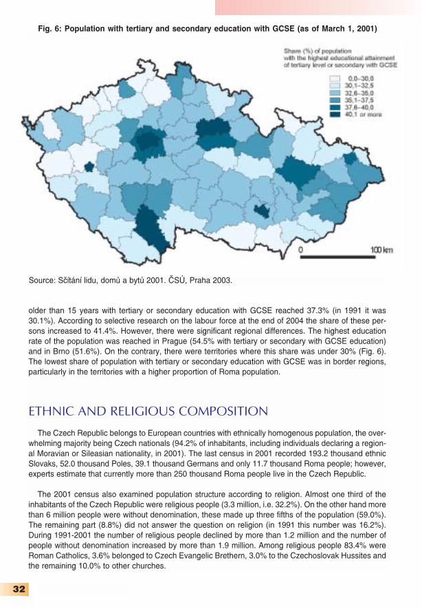
32
older than 15 years with tertiary or secondary education with GCSE reached 37.3% (in 1991 it was30.1%). According to selective research on the labour force at the end of 2004 the share of these per−sons increased to 41.4%. However, there were significant regional differences. The highest educationrate of the population was reached in Prague (54.5% with tertiary or secondary with GCSE education)and in Brno (51.6%). On the contrary, there were territories where this share was under 30% (Fig. 6).The lowest share of population with tertiary or secondary education with GCSE was in border regions,particularly in the territories with a higher proportion of Roma population.
ETHNIC AND RELIGIOUS COMPOSITION
The Czech Republic belongs to European countries with ethnically homogenous population, the over−whelming majority being Czech nationals (94.2% of inhabitants, including individuals declaring a region−al Moravian or Sileasian nationality, in 2001). The last census in 2001 recorded 193.2 thousand ethnicSlovaks, 52.0 thousand Poles, 39.1 thousand Germans and only 11.7 thousand Roma people; however,experts estimate that currently more than 250 thousand Roma people live in the Czech Republic.
The 2001 census also examined population structure according to religion. Almost one third of theinhabitants of the Czech Republic were religious people (3.3 million, i.e. 32.2%). On the other hand morethan 6 million people were without denomination, these made up three fifths of the population (59.0%).The remaining part (8.8%) did not answer the question on religion (in 1991 this number was 16.2%).During 1991−2001 the number of religious people declined by more than 1.2 million and the number ofpeople without denomination increased by more than 1.9 million. Among religious people 83.4% wereRoman Catholics, 3.6% belonged to Czech Evangelic Brethern, 3.0% to the Czechoslovak Hussites andthe remaining 10.0% to other churches.
Fig. 6: Population with tertiary and secondary education with GCSE (as of March 1, 2001)
Source: Sčítání lidu, domů a bytů 2001. ČSÚ, Praha 2003.

33
Velehrad near UherskéHradiště is one of the mostfrequented Christian pilgrimage sites in the Czech Republic.(Photo: Dušan Gavenda)
Velká synagoga (Great synagogue)
in Plzeň, the second largest in Europe.
(Photo: Irena Smolová)

34
ECONOMYIn the Czech Republic the 1990s are connected with the transition from the centrally planned econo−
my to the market one. The integrated synopsis of the economic reform was finished and approved inSeptember 1990, i.e. already in the period of the federal state of the Czechs and Slovaks. The wholeconception of the reformation strategy called for a complex approach, which included a succession ofwide spectrum of measures focused on price deregulation, foreign trade liberalization, introduction ofinternal inner convertibility of the currency, and privatisation. The cornerstone of the economic reformwas the price deregulation. For the first time after several decades the Czech firms had the opportunityto set the prices of their products by themselves. Most prices were deregulated since the beginning of1991 and price regulation was preserved at that time only in monopolized branches. A decision con−cerning the internal convertibility of the Czech crown (CZK) was a very important step in the reform,which was very significant for the foreign trade liberalization. Before the internal convertibility of thecrown was introduced a considerable devaluation had been carried out, which should have preservedthe fixed exchange rate of the crown. By this conscious undervaluation of the crown made the reorien−tation of the country´s foreign trade (with the break up of COMECON) “from the East to the West” waseasier for the wide range of products.
The territorial reorientation of the export had an immense effect on the structure of goods. Each indus−trial branch faced decline (the greatest decline was registered at the traditional export of machines andequipment). In 1991 import and export with planned economies dropped, compared to the previous year,to the half. This decline was only partly compensated by the increase of trade with countries with mar−ket economies. A number of firms, however, re−oriented their export very successfully. The reason fortheir export successes was firstly an advantageous exchange rate and lower labour costs in the CzechRepublic than in developed countries. After basic macroeconomic stability had been achieved one of themain issues of the reform programme was represented by the private sector development, which wasbased on an extensive programme of privatisation of state firms and support of the medium and small−scale enterprises. The Czechoslovak privatisation process was based on the combination of restitutionof assets and property to the previous owners and their heirs, of sale of the assets and property to thedomestic and foreign investors, and of the “handing out” state assets and property to the population viainvestment coupons. The process of privatisation (except for restitutions) was divided into two parts: a“small−scale” privatisation, i.e. privatisation of small−scale enterprises mainly belonging to the servicesector, and a “large−scale” privatisation concerning former state firms (particularly industrial, to a far less−er extent construction, trade, and agricultural firms).
From the point of view of the quality of the owners the means of direct sales of the smaller firms andplants was unproblematic. This method faced difficulties when applied to large firms since new ownerspaid off their share purchase debts from the income of a firm, and sometimes they even put it into theaccounts of the privatised firm. Moreover, not having their own resources they abandoned further devel−opment and the much expected boom of these firms did not occur. The law regulation large−scale pri−vatisation approved a spectrum of privatisation methods, including direct sale, public tenders, sale viacapital markets, or free transfer of property to the towns and villages. Privatisation via investmentcoupons became the most important form of the privatisation of industrial enterprises. It was organizedin two waves (the first was finished in January 1993 and the second one in December 1994). A total of785 industrial enterprises offered shares of their assets in the Czech Republic. In the first privatisationwave there were mainly firms in industrial branches that were characterised by the competitive markets(such as the manufacture of machinery and the production of metal or food products as well as textiles
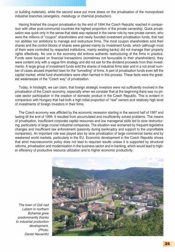
35
or building materials), while the second wave put more stress on the privatisation of the monopolizedindustrial branches (energetics, metallurgy or chemical production).
Having finished the coupon privatisation by the end of 1994 the Czech Republic reached in compar−ison with other post−communist countries the highest proportion of the private ownership. Quick privati−sation was quick only in the sense that state was replaced in the owner role by new private owners, whowere the millions of “coupon” shareholders and newly founded investment privatisation funds, that hadnor abilities nor ambitions to manage and restructure firms. The most coupon shareholders sold theirshares and the control blocks of shares were gained mainly by investment funds, which (although mostof them were controlled by respected institutions, mainly existing banks) did not manage their propertyrights effectively. No one in the economy did enforce authentic restructuring of the firms in practice.Funds were focused on financial transactions (sometimes not favourable to their shareholders), theywere content only with a vague firm strategy and did not ask for the dividend proceeds from their invest−ments. A large group of investment funds sold the shares of industrial firms later and in a not small num−ber of cases abused imperfect laws for the “tunnelling” of firms. A part of privatisation funds even left thecapital market, whilst fund shareholders were often harmed in this process. These facts were the great−est weaknesses of the “Czech way” of privatisation.
Today, in hindsight, we can claim, that foreign strategic investors were not sufficiently involved in theprivatisation of the Czech economy, especially when we consider that at the beginning there was no pri−vate sector participation in the creation of domestic product in the Czech Republic. This is evident incomparison with Hungary that had both a high initial proportion of “real” owners and relatively high levelof investments of foreign investors in their firms.
The Czech economy was afflicted by the economic recession starting in the second half of 1997 andlasting till the end of 1999. It resulted from accumulated and insufficiently solved problems. The meansof privatisation, insufficient corporate capital resources and low managerial skills led to slow restructur−ing, particularly of large crucial industrial companies. The situation was worsened by frequent legislativechanges and insufficient law enforcement (passivity during bankruptcy and support to the unprofitablecompanies). An important role was played also by slow privatization of large commercial banks and byweakened world markets, particularly in the EU. Economic development in the Czech Republic showsthat strict macroeconomic policy does not lead to required results unless it is supported by structuralreforms, privatisation and modernisation in the business sector and in banking, which would lead to high−er efficiency of productive resource utilization and to higher economic productivity.
The town of Ústí nadLabem in northern
Bohemia grew predominantly thanks
to industrial productiondevelopment.
(Photo: Daniel Neuwirth)

36
FOREIGN DIRECT INVESTMENTS
The assessment of the privatisation process in individual countries is often derived from the quality ofdevelopment of several of its largest privatised firms, which consequently can drive the growth of thewhole economy. The fact that important industrial and export firms were not privatised directly into handsof the foreign investors already in the first half of the 1990s can be considered a mistake. The frequent−ly quoted example of Škoda Mladá Boleslav (privatised into the hands of the German firm Volkswagen)was not sufficiently followed by other firms important for the entire economy. During the first half of the1990s in the sector of large companies, with export potential, only the international consortium IOL (com−panies Shell, and Conoco) invested in Česká rafinérská, Procter&Gamble in Rakona Rakovník, andPhilip Morris in Tabák Kutná Hora.
From the beginning of the 1990s till the end of 1997 foreign direct investments in the CzechRepublic reached USD 9.2 billion (annual sum of USD 2 billion was exceeded in 1995 only), which wasless than in Poland (USD 14.6 billion) and Hungary (USD 15.9 billion). At that time the position of theCzech government towards granting concessions to the foreign investors was rather negative. It was notuntil 1998 that a rather extensive system of the investment incentives not only for foreign investors butalso for domestic ones was approved. The system consists of an income tax relief, grants to municipal−ities for building technical infrastructure, job creation grants, training and retraining grants. The invest−ments incentives bear an important regional dimension, for their amount depends on the situation on theregional labour markets.
In 1998 the Czech Republic experienced a sharp increase in the foreign direct investments (FDI)inflow thanks to the incentive system. During last years FDI hovered aroung USD 5 billion. The year2002 was the exception, and according to the preliminary data 2005 as well, when FDI exceeded USD8 billion. On the other hand in 2003 they reached only USD 2.1 billion, the balance was influenced bythe purchase of Eurotel shares from the foreign investor and the sale of foreign shares in ČeskýTelecom to the portfolio investors from the U.S.A. and the U.K. An amount of investment per capita inthe Czech Republic is the highest among all transition economies of Central Europe. Most economistsconsider foreign direct investments to be one of the most effective methods of development especial−ly for regional economies, and the amount of their inflow is one of the basic economic indicators of the
New investmentsflow mainly intodeliberately founded industrialzones. For instance,a large plant ofcar factory TCPAwas built in Ovčáry near Kolín.(Photo: ToyotaPeugeot CitroenAutomobileCzech, s. r. o.)

37
national economies. The positive assessment of the Czech Republic is not unambiguous however, forthere is a dominant position of Prague in the regional distribution of the foreign direct investments.Almost half of investments coming to the Czech Republic were in companies seated in the capital city.From the point of view of the amount of investments the Středočeský Region is important, on the oppo−site extreme only a small amount of investments are directed towards the Moravian regions. The con−ception of the development of the Czech economy includes investment incentives even in the futureyears. However, they will be focused, unlike during preceding years, on the technologies with higheradded value.
GROSS DOMESTIC PRODUCT
The Czech economy experienced considerable structural change as a whole during 1993−2004. Theproportion of agriculture and industry in the GDP decreased in favour of the service sector. A similarprocess was experienced at the regional level, but with a different intensity. One of the basic summaryindexes of the economic level of a given region is the level of gross domestic product per capita.According to the data of ČSÚ the GDP in the Czech Republic in 2004 reached 71% of the EuropeanUnion (EU25) level per capita converted by the purchasing power parity. Comparing the economiccapacity of particular regions, it is obvious that the capital city of Prague is economically the most effec−tive. Today, almost one fourth of the Czech Republic’s gross domestic product is created there. With143% of the EU average of the GDP per capita Prague represents a unique region in the transitioneconomies. In the period after 1992 the regional differences in the economic capacity of particularregions were deepening. Compared with other regions, the Středočeský Region shows the highest rateof growth. In the last few years the Olomoucký Region has the lowest GDP per capita (see Fig. 7). Asfor development in the Czech Republic after 1992 it usually grew, with the exception of recession in1997−99. In 2004 the Czech economy grew by 4.7%.
Fig. 7: GDP per capita in 2004 (Czech Republic = 100)
Source: Regionální národní účty 2004. ČSÚ, Praha 2005.

38
THE STRUCTURE OF EMPLOYMENT
The structure of employment by basic sectors of the national economy has changed considerably.In 1989 a total of 652 thousand persons worked in the primary sector in the Czech Republic (12.5%),out of which 596 thousand employees belonged to the agriculture itself. The most important employerwas the secondary sector, where more than 2.5 million people were employed (2.1 million in industry),while in the less developed tertiary sector not more than 2.1 million people were employed. As early asin 1992 more employees worked in the tertiary than in the secondary sector and two years later morepeople worked in the tertiary sector than in the other two sectors combined, this means that lay−off ofthe redundant employees from the primary and secondary sector in favour of the tertiary sector was veryquick at the beginning of the 1990s. The process of employee number reduction in the production sphereand their increase in the services continued in the following years, but much more slowly. According tothe results of selective research on the labour force the proportion of employees in the tertiary sectorincreased to 56.5%. In comparison to the EU it is still a very low relative value, for in the developed mar−ket economies the proportion of the tertiary sector in the total employment structure reaches almost twothirds. In the capital city of Prague 79.0% of the population was employed in the services in 2004, on theother hand in the Liberec region it was only 44.7%. Also in three other regions (Zlínský, Pardubický andVysočina) the tertiary sector does not employ more than half of the labour force.
LABOUR MARKET
At the beginning of the transformation from a centralized to a free−market economy unemploymentwas an unknown phenomenon. In December 1990 the unemployment rate was 0.7% and a year later ithad already reached 4.1%. In 1992−96 the registered unemployment rate was between 3−4% and wasvery low, then. In this period of factual absence of the economic restructuring the very low unemploy−ment rate was achieved, partly by the absorption capacity of growing tertiary sector. The turning pointcame with the period of recession in 1997, when the registered unemployment rate started to rise. Bythe end of 1999 it exceeded 9%. The general unemployment rate (according to selective research)reached 8.3% in 2004. Registered unemployment rate (applicants registered at labour offices) is slight−ly higher. By the end of the third quarter of 2005 more than 500 thousand job applicants were registered,out of which 475 thousand were ready to start working within a fortnight. The registered unemploymentrate thus reached 8.8%. In the Czech Republic there are distinct regional differences in the situation onthe labour market. The highest unemployment rate is in a long−term in the structurally afflicted regions,i.e. in the Ústecký and Moravskoslezský regions. Apart from Prague low unemployment rates are to befound in the Jihočeský, Plzeňský and Středočeský regions.
Risk groups on the job market as in other EU countries comprise especially women with small chil−dren, people with low qualification, handicapped people, people over 50 years of age, new graduates
Table 12: Average number of employees in basic sectors of the national economy in 1993 and 2004
Sector 1993 2004absolute number % absolute number %
(thousands) (thousands)Agriculture, forestry, fishery 375.0 7.7 202.3 4.3Industry and construction 2,093.0 43.9 1,844.6 39.2Services 2,405.5 49.4 2,659.7 56.5Total 4,873.5 100.0 4,706.6 100.0
Source: Labour market in the Czech Republic in 1993−2004. ČSÚ, Praha 2005.
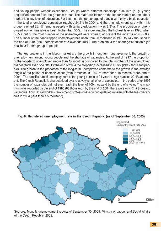
39
and young people without experience. Groups where different handicaps cumulate (e. g. youngunqualified people) face the greatest threat. The main risk factor on the labour market on the labourmarket is a low level of education. For instance, the percentage of people with only a basic educationin the total unemployed population reached 24.6% in 2004 and the unemployment rate within thisgroup reached 26.1% (among people with tertiary education it was 2.3%). The proportion of unem−ployed women has always been higher than 50%. The index reached the highest level in 1998, when56.5% out of the total number of the unemployed were women; at present the index is only 52.8%.The number of the handicapped unemployed has risen from 20 thousand in 1993 to 74.7 thousand atthe end of 2004 (the unemployment rate exceeds 40%). The problem is the shortage of suitable jobpositions for this group of people.
The key problems in the labour market are the growth in long−term unemployment, the growth ofunemployment among young people and the shortage of vacancies. At the end of 1997 the proportionof the long−term unemployed (more than 12 months) compared to the total number of the unemployeddid not reach even one fifth. By the end of 2004 the proportion increased to 40.6% (219.7 thousand peo−ple). The growth in the proportion of the long−term unemployed conforms to the growth in the averagelength of the period of unemployment (from 9 months in 1997 to more than 18 months at the end of2004). The specific rate of unemployment of the young people to 24 years of age reaches 20.4% at pres−ent. The Czech Republic is characterized by a relatively small offer of vacancies. In the period after 1992the number of vacancies did not ever reach the level of 100 thousand by the end of a year. The maxi−mum was recorded by the end of 1995 (88 thousand), by the end of 2004 there were only 51.2 thousandvacancies. Agricultural workers rank among professions requiring qualified workers with the least vacan−cies in 2004 (less than 1.5 thousand).
Fig. 8: Registered unemployment rate in the Czech Republic (as of September 30, 2005)
Sources: Monthly unemployment reports of September 30, 2005. Ministry of Labour and Social Affairsof the Czech Republic, 2005.

40
AGRICULTURE
Agriculture ranked among the most heavily supported sections of the economy within the centrallyplanned socialist system; as a result it was characterized by low economic effectiveness and dispropor−tionate size on the national scale. The transition to market economy meant considerable pressure onagricultural enterprises to adapt to the new economic conditions and to the market opportunities in termsof dimension, structure and efficiency. At the end of 1989 there was virtually no private sector in theCzech agricultrure, two thirds of agricultural land was cultivated by co−operative farms (1,024 farms) andone third by state organizations, mainly by state farms (there were 174 of these). The average size ofagricultural land of a co−operative farm was 2,563 hectares, for a state farm the average was 6,259hectares. By the end of 1990, a total of 3,205 natural persons had established agricultural enterprisesin the Czech Republic, they however cultivated less than 1% of agricultural land. The transformationprocess in agriculture underwent a series of legislative measures passed in 1991−93, which led to itsgradual privatisation. Among the main aims of agricultural policy ranked the renewal of land and otheragricultural property rights via restitution, privatisation and transformation, restructuring and relocation ofagricultural production adapted to the market conditions. Long−term aims were particularly orientedtowards the conception of sustainable agriculture under the conditions of gradual liberalization of theworld agricultural market.
The period of transformation of agriculture in the Czech Republic is marked by considerable changesin its enterprise structure. This can be seen in the increased proportion in the number of individual farm−ers and other individual agricultural entrepreneurs, in the agricultural land area cultivated by all agricul−tural enterprises as well as in the dynamic development of trading companies. At the same time thechanges can be seen in the continuing decline in the importance of cooperatives, which presently culti−vate about one fourth of the total agricultural land. At the end of 2004 there were 678 cooperatives, 2,319trading companies, 32,231 natural persons and 180 other subjects active in Czech agriculture.
The total area of the agricultural land resources of the Czech Republic is 4,269 thousand hectares(54.1% of the total area of the country). Its largest part is classified as arable land, even though its areahas been decreasing recently. On the other hand the area of permanent grasslands is increasing. Thischange could be marked as positive in the regions, which have less favourable conditions for intensiveland use. On the basis of the complex soil survey and according to the criteria of the Council of the EUthe bulk of the agricultural land (more than 60%) was classified as less favourable areas (LFA) and as
Wheat is themost widespreadcereal harvestedin the CzechRepublic. (Photo: Dušan Gavenda)

41
areas with ecological restrictions. The common aim for these areas is to ensure such a development ofmultifunctional agriculture that would put in harmony productive and non−productive functions of agri−culture, forestry and water management with respect to the character of natural and socio−economicconditions. It should further contribute to the restoration of the balance between the volume of produc−tion and market capacity, to the ecological, cultural and architectonical preservation of the rural land.
The total agricultural production is gradually decreasing in financial terms. In 2004 the value of grossagricultural production was by 7.4% lower than in 1993. Livestock production slightly predominates overthe crop production, but the proportion of crop production has slightly increased during the last ten years.The structure of crop production has changed. The production of cereals, potatoes and particularly ofsugar beet has decreased; the production of oil−bearing crops (particularly of rape) has increased. As forlivestock production, the numbers of farm animals (especially of cattle) have decreased. This has result−ed in decreased production of meat and milk.
Some characteristics of Czech agriculture gradually draw near to the EU average. For instance theshare of primary sector employees (agriculture, forestry and fishery) can be mentioned. The state−widevalue (4.3%) is greatly exceeded particularly in the Vysočina Region (10.4%). The present conceptionof agrarian policy of the Czech Republic came into effect in 1998 and was divided into two stages. Thefirst stage (revitalization) was finished by the end of 2001 and was aimed particularly at the recovery andstabilization of the agricultural sector in the Czech Republic and at its institutional preparation for thecountry’s EU accession. The conception of the second stage (adaptation) is heading for the quickestadaptation of the agrarian sector of the Czech Republic to the Common Agricultural Policy of the EU inall of its areas (structural, regional, environmental, and rural).
An inseparable part of the Czech agricultural policy is organic farming. A total of 836 farms wereorganic at the end of 2004, cultivating 263.3 thousand hectares (6.2% of the agricultural land). It is a for−ward−looking mode of farming, which is creating a new market for organic farming products, as well asnew job opportunities. Organic farming contributes to the development and maintenance of rural land−scape and to the conservation of all parts of the natural environment.
Czech beer, acknowledged as one of
the best in the world,requires quality hops
and barley malt. (Photo: Dušan
Gavenda)

42
INDUSTRY
Czech industry lost more than 700,000 workers, i.e. one third of the total, from 1989 to 2004. Thedecrease was noticeable in the first stage of the economic transition of the Czech Republic. During1989−93 the number of industrial workers decreased by almost 450 thousand, from 2,113.3 to 1,664.4thousand. Then the pace of employee release was slower. In 1999 the number of industrial workersdecreased for the first time below the level of 1.5 million (1,468.7 thousand). The creation of new jobs inindustrial firms usually spurred by foreign investors on the so−called “green fields” waned after 1999, andhas, for all practical purposes, stopped. The Czech Statistical Office stated that Czech industryemployed 1477.8 thousand workers in 2003.
When compared to 1989 not only the organizational structure of the Czech industry but also the sizestructure of industrial firms has considerably changed. In the centrally planned economy most industrialfirms were centrally managed by the ministries responsible for them. The centrally managed industryemployed 1.75 million workers, more than 350 thousand were employed in cooperatives and communalindustrial workshops. Mining companies (e. g. Ostravsko−karvinský Mining District employed 75 thou−sand workers) and within manufacturing industry engineering and metallurgical industries employed thelargest numbers of workers.
At the end of 1989 eight engineering companies with more than 10 thousand workers existed in theCzech Republic. The largest one was the concern Škoda Plzeň, with 41.5 thousand workers, out ofwhich 33.4 thousand were employed in Plzeň itself. In terms of the number of employees, it was followedby ČKD Prague (28.9 thousand) and car factories AZNP (presently Škoda Auto) Mladá Boleslav (17.7thousand), Tatra Kopřivnice and LIAZ Liberec. More than 10 thousand workers was employed at the endof 1989 also in two companies in Brno – Zetor (tractor production) and Zbrojovka (arm production) – andin Transporta in Chrudim. The Czech engineering industry employed more than 600 thousand workersat the end of 1989.
One of the most important industrial branches is car production. (Photo: Toyota Peugeot Citroen Automobile Czech, s. r. o.)

43
In terms of the number of workers the second most important branch of manufacturing industry wasthe textile production (155.4 thousand workers), however no company employed more than 10 thousandworkers. In the ten largest companies the number ranged between 4−8 thousand. Larger companies ofthat period were active in metallurgy (145 thousand workers). In VŽKG Ostrava 37.6 thousand peoplewere employed, in NHKG Ostrava 23.6 thousand, in Poldi Kladno 19.0 thousand and in Železárny Třinec18.5 thousand. In 1989 another three industrial companies with more than 10 thousand employees exist−ed in other branches (SVIT Zlín with 20.1 thousand workers, Tesla Rožnov with 12.3 thousand workersand Chemické závody in Litvínov with 11.4 thousand workers).
Employee reductions in many industrial enterprises, and the closing of some of the larger compa−nies resulted in the decrease of manufacturing companies with more than 10 thousand employees.While at the end of 1989 there were fifteen such companies, in 2004 only two – Škoda Auto employ−ing 24.1 thousand workers (by 6.4 thousand more than in 1989) and Mittal Steel Ostrava (successorof NHKG) with 11 thousand workers. More than 5 thousand workers were employed in the chemicalgroup Unipetrol (7.2 thousand), Třinecké železárny (5.6 thousand) and the largest clothing companyOděvní podnik Prostějov (almost 6 thousand). Among the ten largest employers in 2004 there were aproducer of jewellery, Preciosa Jablonec nad Nisou; two car component producers, Bosch DieselJihlava and Autopal Nový Jičín; and representatives of chemical industry, Aliachem Pardubice andBarum Continental Otrokovice (which as the tenth largest employer in manufacturing had 4 thousandworkers).
Out of the above mentioned companies only in two was foreign capital not active in a more importantway, which confirms the increase of the amount of the foreign direct investments into industry. While atthe beginning of the transition process the investments were directed towards the building materialindustry and foodstuffs and the tobacco industry, during the last years the investments have flown main−ly into the automotive and electrical industries.
Table 13: Employment branch structure according to industrial branches in 1993 and 2003(in thousands workers)
Industrial branch Workers (thousands) Index 1993 2003 2003/1993 *100
Raw material extraction 105.5 49.8 47.2Manufacturing 1,471.1 1,362.7 92.6Out of which:
Manufacture of food products 152.2 143.2 94.1Manufacture of textile, clothing and leather products 211.7 124.5 58.8Woodworking industry 76.5 75.1 98.2Manufacture of paper and printing products 52.5 64.4 122.7Manufacture of chemical products 107.3 117.6 109.6Manufacture of glass and building materials 88.1 82.8 94.0Manufacture of metallurgical products 102.2 61.9 60.6Manufacture of metal works 154.3 163.7 106.1Manufacture of engineering products 313.1 261.3 83.5Manufacture of electrical engineering products 124.4 185.1 148.8Other 88.8 83.1 93.1
Electricity, gas and water production and distribution 87.8 65.3 74.4Industry in total 1,664.4 1,477.8 88.8
Source: Time series of basic indexes of labour statistics 1948−2003. ČSÚ, Praha 2004.
44
The most important investor into the car and car components production in the Czech Republic andinto electrical engineering are firms located in Germany. Among the largest industrial producers there isŠkoda Auto owned by Volkswagen Group, Siemens Group CZ and Bosch Group CZ. Škoda Auto is notonly the largest industrial enterprise according to the number of employees but also according to salesand export. In 2004 its sales reached EUR 5 billion and the company accounted for by almost 10% ofCzech exports. Siemens Group is made up of 24 companies employing a total of 12.2 thousand work−ers and its sales exceeded EUR 1.6 billion. Seven companies with around 10 thousand workers areactive in the manufacturing. The Bosch Group sales approach EUR 1 billion, in the Czech Republic thegroup employs 8.2 thousand workers in three towns (Jihlava, České Budějovice and Česká Lípa). Inaddition to Škoda Auto and Siemens Group CZ, the companies Unipetrol, Mittal Steel Ostrava andTřinecké železárny have higher sales than Bosch.
In 1993−2004 the representation of workers in individual industrial branches considerably changed.Data for 2004 were not available at the time of writing, thus the 2003 data were used for assessing struc−tural changes in industry. After 1992 the number of employees decreased in the metallurgical industryand in the textile, clothing and leather industry. The highest decline was recorded in the leather indus−try. In 1993 about 32.3 million pairs of shoes were produced in the Czech Republic (73.2 million in 1989),but only 1.2 million pairs in 2003. The sharpest increase in number of workers was recorded in electri−cal engineering.
SERVICES
Considerable changes in the number of employees were recorded in individual branches of theservice sector. Most branches experienced an increase in the number of employees. Transport, com−munications, and education were the exceptions. The field with the largest number of employeesremained in wholesale and retail trade with almost 750 thousand workers.
Table 14: Employment structure according to service branches in 1993 and 2003 (in thousands workers)
Service branch Workers (thousands) Index1993 2003 2003/1993 *100
Wholesale and retail trade 608.7 735.0 120.7Restaurants and accommodation 111.7 184.4 165.1Transport and communications 384.7 360.8 93.8Commerce and insurance 64.6 94.2 145.8Services for companies 1) 303.3 447.2 147.4Public administration and defence 132.7 196.4 148.0Education 323.9 299.8 92.6Health and social care 263.3 285.9 108.6Other services 158.7 167.0 105.2Services in total 2) 2,351.6 2,770.7 117.8
Poznámky:1) Services in real estate, rents, services for companies research and development2) Data on number of employees in services are different from data quoted in Table 12 because of
different methodologySource: Time series of basic indexes of labour statistics 1948−2003. ČSÚ, Praha 2004.

45
THE RETAIL SECTOR
In the Czech Republic the process of nationalization after 1948 also affected the retail sector, thoughnot as quickly as the large industrial enterprises. During “socialism” the retail sector was divided into thestate and cooperative sector. The cooperatives were active mainly in rural areas. Their sales networkwas made up at the end of 1989 of almost 17 thousand shops, i.e. two fifths of all shops in the CzechRepublic.
In the 1990s and 2000s a dynamic change in the retail sector took place. The change in the retailsector was characterised by disintegration of the state trading companies, particularly as a result ofabrupt changes of ownership, newly established trade entities, the involvement of foreign investors,large increase in floor space, increase in the number of employees, modernisation of sales net−works and improvement of service and by gradual improvement of the technical quality of largeshops.
In the whole process of transformation of the Czech retail sector we can see two basic stages.During the first one, marked by the atomization of retail business networks (the first half of 1990s), newretail units experienced dynamic growth; the network of larger shops (self−service shops, departmentstores) was reconstructed. In addition to domestic firms, foreign companies already took part in thisprocess (Julius Meinl, Ahold, Delvita). In fact, large investment activity on the part of foreign firms in thedomestic trade network is obvious since the second half of the 1990s. Among the most active compa−nies rank the German companies Globus, Metro, Tengelmann, Rewe and Schwarz. In addition, everyimportant European trade chain has its representation in the Czech Republic. No company with purelyCzech capital independent from foreign businesses is to be found among the ten largest trade compa−nies. The largest domestic retail chain is the traditional association of consumer cooperatives Jednota –COOP.
Foreign companies run all types of trade in the Czech Republic. After the first stage of the devel−opment of supermarkets the turn of the century was marked by the spread of networks of discountshops and hypermarkets. Measured by the degree of area penetration by hypermarkets (18 units per1 million inhabitants) the Czech Republic occupies one of the first positions in Europe. In the lastyears large regional trade and entertainment centres have been developing very dynamically com−bining numerous functions. Today, the trade environment in the Czech Republic is strongly interna−tional and the degree of its concentration is increasing. The retail sale turnover of the foreign firms isincreasing too, while domestic firms have faced decline, or stagnation for a long time. Expressed interms of their share in retail sales of food stuffs, foreign chains account for over 50% of the Czechmarket.
According to the number of employees the largest retail company is Ahold Czech Republic, which isthe only to employ more than 10 thousand workers in the Czech Republic. A bit smaller Globus andTesco Stores CZ employ more than 5 thousand workers. According to the sales the largest retail traderin the Czech Republic in 2004 was Makro C&C CZ with more than EUR 1.2 billion. The level of EUR1 billion was exceeded also by Ahold Czech Republic (supermarkets Albert and hypermarketsHypernova) and Schwarz (Lidl discount stores and Kaufland hypermarkets).
TOURISM
The importance of tourism for the economy of the Czech Republic has been increasing. Foreigntourism revenues reached EUR 3.6 billion in 2004, made up 3.9% of the GDP and participated by 6.3%in the total export of the Czech Republic. According to the World Travel and Tourism Council (WTTC),in 2004 tourism employed 124.1 thousand persons (direct employment; 2.6% of all employed people

46
in the Czech Republic), while the total employment (including indirect) covered 611.4 thousand labourpositions, i.e. every eighth person was employed in tourism or related branches.
The number of foreign visitors in the Czech Republic has been about 100 million each year since 1992(the maximum of 109.4 million was reached in 1996). Out of 96 million visitors in 2004 the overwhelm−ing majority arrived by road means of transport (88.7 million, i.e. 92.5%), 4.2 million by air, and 3.1 mil−lion by train.
The Czech Statistical Office registered 7,640 accommodation establishments with 433.2 thousandbeds in the Czech Republic by the end of 2004. The total number of beds has been slightly decreasingin the last years, on the other hand the number of quality beds in hotels and pensions has been increas−ing (229.7 thousand). In all collective accommodation establishments (including camps, cottage camps,hostels) 12.2 million persons were accommodated in 2004, out of which foreigners formed one half(6.1 million). An average of 37.0% of the bed capacity of accommodation establishments was utilised bytourists (maximum utilisation of 53.5% was recorded in Prague, minimum of 21.2% in the ÚsteckýRegion).
In comparison with 2003 the number of accommodated foreigners has increased by one million.The foreigners concentrate particularly in Prague (3.5 million foreigners, i.e. 57.3% of all accommo−dated foreigners in the Czech Republic). The Karlovarský Region (387 thousand foreigners),Jihomoravský Region (346 thousand) and Jihočeský Region (318 thousand) are among other attrac−tive destinations in the Czech Republic. According to the country of origin the highest share of theaccommodated foreign visitors was made by the Germans (1,569 thousand persons in 2004), fol−lowed by the British (651 thousand), Italians (391 thousand), Americans (293 thousand) and Dutch(274 thousand). Thanks to low cost air lines the highest increase was recorded with the British (in2000 it was only 237 thousand).
Domestic tourism has been developing dynamically as well. According to the data of CzechTourismagency the Czechs carried out 5.6 million five−and−more−day trips in the Czech Republic in 2004. In com−parison with 2003 the expenditures increased by 12% for domestic trips (by 4% only for foreign trips).The most favourite destination was the Jihočeský Region (almost 780 thousand trips), followed by theKrálovéhradecký Region (680 thousand trips) and the Liberecký Region (580 thousand trips). Activetourism (mountain hiking and biking) has become a trend during the past years. The Czech Republic hasbeen experiencing qualitative changes in tourism. Tourists seek new forms of tourism and thus widerrange of services connected not only with recreation but also with sports activities, education etc. isoffered.
INFRASTRUCTURE
From the point of view of density, the transport infrastructure of the Czech Republic is comparableto that of other EU countries; however, it lags behind considerably in qualitative parameters. The tech−nical state of transport infrastructure is in disrepair and its integration into European transport routes islimited. In the Czech Republic there is more than 55 thousand kilometres of roads and motorways, outof which 2,601 km conform to the standards of E−type European road networks. In the Czech Republic546 km of motorways and 336 km of expressways were completed by the end of 2004. Only one thirdof the planned network of motorways is currently complete. Although regional road network is sufficientlydense, a majority of its roads do not fulfil the technical standards with low−quality surfaces and numer−ous traffic−safety deficiencies. Although the density of roads and motorways is 0.737 km/sq km (in EUcountries it is 0.389 km/sq km), the density of motorways is only 0.006 km/sq km (EU 0.015 km/sq km).As for comparison of the regions the worst equipped are the Zlínský, Královéhradecký and Pardubickýregions. As of the end of 2004 these regions had no motorway or expressway. In the Czech Republicthere is, in comparison with other EU countries, a low density of separated cycling routes. This adverse

47
development is influenced by the high degree of car ownership, which is comparable to the EU coun−tries. Main attention after 1992 has been paid to the construction of motorways, expressways andbypasses.
The railway network consists of 9,612 km of railways, out of which double tracks make up 1,866 km.The Czech Republic has an exceptionally dense railway network (0.120 km/sq km, EU 0.047 km/sq km),but it lags behind in the level of electrification and in the number of double tracks. Also the technical levelof railway infrastructure in the Czech Railways is not sufficient, in terms of speed, railway crossing safe−ty, and the safety equipment for stations, tracks etc. The worst situation is in the Karlovarský andLiberecký regions which are completely without good railway service, and in Jihočeský and Zlínskýregions without sufficient connection with Prague. In recent years primary attention has been paid to themodernization of the railway corridor 1 (Děčín−Praha−Česká Třebová−Brno−Břeclav) and railway corridor2 (Bohumín−Přerov−Břeclav). These high−speed tracks (160 km per hour) have been integrated intoEuropean networks according to international treaties. The modernization of the railway corridors 1 and2 will be finished soon.
The number of passengers transported stagnated in the second half of the 1990s, there was how−ever a considerable change in the type of transport used. There was a significant shift from public toindividual transport. A similar shift was recorded even in the area of transport capacity, where the totalindex increased slightly, however, the capacity of road and railway transport were decreasing infavour of individual car transport of persons. In the 1990s a considerable portion of cargo transportwas shifted from the railways to roads, together with a slight decrease in the total transport of goods,but together with an increase in the total amount of transported materials by one half. The traffic loadon roads and local communications increased very significantly with all the associated negativeimpacts on the environment.
The total length of water routes in the Czech Republic is 664 km, out of which 303 km of the Elbe−Vltava water route serve for international long−distance water transport. Water transport in the CzechRepublic makes up a rather small proportion of overall transport, which is partly due to the fact that theonly connection of the water route network of the Czech Republic to the rest of Europe is through theElbe River, whose navigation parameters are problematic.
Air transport in the Czech Republic is currently experiencing very rapid growth. In the Czech Republicthere are 87 civil airports, out of which 9 are international. The bulk of air traffic, however, goes throughPraha−Ruzyně airport, which accounts for 94% of total air transport of persons and over 84% of cargoair transport. Other major international airports are in Brno, Ostrava and Karlovy Vary. Their capacity isnot currently fully utilised. In 1993 a total of 1.358 million persons were passed through the CzechRepublic’s airports, in 2004 this number was 10.125 million persons.
After 1992 the Czech Republic experienced an improvement in technical infrastructure. Almost90% of the population uses water from the public water supply networks. However, regional differencesexist; in the Středočeský Region only 72.3% of the population uses public supply of water. As much as68.4% of the population lives in houses connected to the sewerage system. While in Prague it is 99.3%,in the Středočeský Region the percentage drops to only half of the population. Almost two thirds ofhouseholds (64.1%) are connected to natural gas. The situation is more favourable in Moravia than inBohemia. The highest number of homes with a gas fixture is in the Jihomoravský Region (82.2%), in theJihočeský Region it is only 35.7%.


Portraits of Regions

50 Capital City of Prague
Area: 496 sq kmPopulation: 1,170,571 (as of January 1, 2005)
out of which54,880 foreigners with temporary residence21,884 foreigners with permanent residence
Population density: 2,360 persons/sq kmNumber of administrative districts: 22 Number of city districts: 57
Land Use(as of December 31, 2004)
Source: Statistická ročenka půdního fondu ČR. ČÚZK, Praha 2005.
other areas35.8%
built−upareas9.8%
arable land31.1%
gardens, orchards, vineyards
9.4%
water bodies2.2%
forests9.9%
permanentgrassland
1.7%
Hlavní město Praha(Capital City of Prague)

51Capital City of Prague
NATURAL ENVIRONMENT
Prague is situated in the central part of the Czech Highland largely in the Poberounská geo−morphologic unit, only the smaller north−eastern part lies in the Czech Tableland geomorphologicunit. The present characteristic relief of the city is formed by erosive and accumulative activity ofthe Vltava River along with the varried levels of resistance of the underlying rock. Prague is dis−tinctive of the contrast between flat terrain of the highest parts and deeply cut valleys of the VltavaRiver and its tributaries. As a result of the tectonic uplift of the Czech Massive the Vltava Riverstarted to cut deep into the bedrock during the Quaternary Period, and in the last Ice age it reacheda level 10−12 m below the present river bed. River terraces such as Dejvická, Letenská, Kralupská,Pankrácká or Lysolajská bear evidence to the alterations of the erosion and accumulation periods.
The highest point of the area lies south−west off Zličín (399 m a.s.l.), the lowest point is the VltavaRiver in Suchdol (177 m a.s.l.).
Share of the capital city of Prague in selected country statistical figures
area
forest area
arable land
population
persons aged 65+ 1)
persons with UE 2)
the unemployed 3)
GDP 4)
industry revenues
accomodation facilities 5)
share in the figure for the Czech Republic as a whole (%)Notes: 1) 65+ – persons aged 65 or more2) UE – university level of education 3) the unemployed – number of economically active persons without employment 4) GDP – gross domestic product5) accomodation facilities – number of beds in touristic accomodation facilities
Data sources: ČSÚ (Czech Statistical Office) and ČÚZK (Czech Office for Surveying, Mapping and Cadastre).
Vltava River and theCharles Bridge below
the Prague Castle.(Photo: Dušan
Gavenda)

52 Capital City of Prague
POPULATION AND SETTLEMENT PATTERNS
Prague is a statutory city; for purposes of state administration it has been divided since 2001 into22 administrative districts and for purposes of self−government it is divided to 57 autonomous citydistricts with elected authorities. These city districts are not homogeneous. There are city districtswith the distinct character of a city centre, districts with a predominantly residential character dat−ing back to the 1920s and 1930s, districts with an industrial character, districts with housingestates, districts with a sub−urban character (many of which were created when the surroundingmunicipalities were incorporated into Prague). They differ in the degree of urbanisation, populationdensity, quality of infrastructure, and in social economic living conditions. There are considerabledifferences in the number of inhabitants in individual districts. While the number of inhabitants inthree city districts exceeds 100 thousand, 21 do not reach even 2 thousand and out of the 21 dis−tricts five have less than 500 inhabitants.
At the end of 2004 the average age of the Prague’s population reached 41.7 years, which wasthe highest number in the Czech Republic. The age index exceeded 100 in Prague (the only regionin the Czech Republic), which means that the proportion of persons in pre−productive age (12.5%)was lower than the number of persons in post−productive age (15.7%). The adverse age structureof the population in Prague is reflected in the long term in the negative natural change since the1980s. The greatest decrease of the natural change was recorded in 1995 (5.7 thousand). As lateas in 1992 the migration balance reduced the natural population decrease and thus Prague’s pop−ulation increased. In the years 1993−2001 the population in the capital city decreased. The nega−tive migration balance in the period 1998−2001 resulted from the migration of the population to sub−urban municipalities. After a sharp decline in housing construction in the 1990s, housing construc−tion was revived and it was subsequently reflected in the increase of immigrants. In 2004 the num−ber of finished flats per 10 thousand inhabitants reached 50.8, which was the second highest valuein the Czech Republic (the Středočeský Region ranking first). There was a net increase in immi−gration to Prague; therefore Prague was marked with an increase in population since 2002. During2004 its population increased by 5 thousand inhabitants. This positive migration balance was influ−enced significantly by foreign immigration. Compared to other regions, Prague showed certainunique characteristics. Compared to the national average Prague was more heterogeneous interms of the educational structure of the population. The percentage of persons aged 14+ with ter−tiary education was 22.1%, the share of persons aged 14+ with GCSE reached two fifths.
Old Town Square with a mon−ument to Jan Hus. (Photo:Irena Smolová)

53Capital City of Prague
ECONOMY
Prague takes a unique position in the Czech economy. The GDP per capita is double the nation−al average and reaches 143% of the EU25. Prague is considered to have a degree of investmentstability; it also has low unemployment, a labour force with an above average level of qualification,a large number of commuters (more than 160 thousand) and high wage level (by one fourth high−er than the national average). Prague has a specific economic structure. The share of GDP madeup by manufacturing has fallen below 10%. The only company with more than 1,000 employees isthe rubber−making company of Mitas. The increased importance of the service sector is charac−teristic of the economic development of Prague. Commercial services account the highest propor−tion in the tertiary sector in terms of value added (almost 25%), followed by trade (16.7%), andtransport and communications (13.0%). The largest employers in Prague are institutions involvedin transport and communication. More than 13 thousand persons are employed by the Dopravnípodnik hlavního města Prahy (Prague transit authority). Retail and services are developing verydynamically. Construction of large shopping malls on the outskirts of the city and of new shoppingarcades in the centre has increased the amount of sales space as well as the quality of retail serv−
1993 1994 1995 1996 1997 1998 1999 2000 2001 2002 2003 2004
live
birth
s/d
ea
ths
pe
r 1
,00
0 in
ha
bita
nts
Natural change of population 1993-2004
Sources: Demografická ročenka krajů České republiky 1991-2003. ČSÚ, Praha 2004.Vývoj obyvatelstva ČR v roce 2004. ČSÚ, Praha 2005.
crude birth rate crude death rate natural decrease
0
2
4
6
8
10
12
14
Age structure of population
Age group Unit1993 2004
CZ Region CZ Region
0–14 % 19.4 16.8 14.9 12.5
15–64 % 67.6 67.4 71.0 71.8
65+ % 13.0 15.7 14.0 15.7
mean age years 36.8 39.3 39.8 41.7
old/young ratio – 66.8 93.6 94.0 125.8
Population change
Periodabsolute numbers in ‰ per year
natural migration natural migrationchange balance change balance
1993–1996 −19,495 7,158 −4.0 1.5
1997–2000 −18,326 −5,501 −3.8 −1.2
2001–2004 −12,321 12,416 −2.6 2.6
1993–2004 −50,142 14,073 −3.5 1.0
Sources:Demografická ročenka krajů ČR 1991−2003. Praha, ČSÚ 2004.Vývoj obyvatelstva ČR v roce 2004. Praha, ČSÚ 2005.
Sources:Demografická ročenka krajů ČR 1991−2003. Praha, ČSÚ 2004.Vývoj obyvatelstva ČR v roce 2004. Praha, ČSÚ 2005.

54 Capital City of Prague
ices. The number of guests accomodated in hotels and hostels in 2004 approached 4 million;89.8% of these were foreigners. Prague accounts for more than half of all the overnight stays offoreign visitors to the Czech Republic.
Employers with the greatest number of employees in Prague (civil sector only, as of December 31, 2003)
Employer Branch Emp.
Dopravní podnik hl. m. Prahy City and sub−urban transport 13.0České dráhy Railway transport 7.7Univerzita Karlova Education 7.3Česká pošta State post 7.0Fakultní nemocnice v Motole Health care 5.3Česká spořitelna Finance and insurance 5.1Všeobecná fakultní nemocnice v Praze Health care 4.9Český Telecom Telecommunication 4.5České aerolinie Air transport 4.5Československá obchodní banka Finance and insurance 4.1
Note: Emp. – number of employees in thousands
Source: CRR MU in Brno database, 2005.
Unemployment in 1993−2004
thousands
Source: Trh práce v ČR za roky 1993-2004. ČSÚ, Praha 2005.
number of the unemployed (in thousands)
general unemployment rate (%)
Structure of employment
by the basic sectors of economy
in 1993 and 2004thousands
I – agriculture, forestry and fishing II – industry and constructionIII – services
Source: Trh práce v ČR za roky 1993-2004. ČSÚ, Praha 2005.

55Capital City of Prague
TOURIST ATTRACTIONS
The majority of visitors of Prague are interested in its historical core, which is in terms of areaand number of conserved monuments the largest town monument reserve in the CzechRepublic. In 1992 it was added to the UNESCO’s World Heritage List. Staroměstské náměstí (theOld Town Square) is dominated by the Town Hall built in 1338 as the seat of the Old Town admin−istration. The oldest gothic part of the complex – including the tower, oriel chapel and rich decora−tion – originated in the latter half of the 14th century. The other dominant feature of the Old TownHall is the astronomical clock from the beginning of the 15th century, on which the twelve apostlesappear each hour between 9 and 21 o’clock. The calendar on the lower part of the clock includesthe allegorical depiction of the twelve months of the year painted by Josef Mánes (1865). The cityskyline is crowned by the Pražský hrad (Prague Castle). From the end of the 9th century it servedas the seat of the Přemysl dynasty which ruled Bohemia. The castle experienced an unprece−dented boom during the latter half of the 14th century during the reign of Charles IV, who, after hav−ing been crowned Emperor, made it the seat of the Holy Roman Empire. The royal palace wasrebuilt in grand style, the fortifications were strengthened, and the construction of St VitusCathedral in the French style started within the grounds of the castle. The construction of the cas−tle complex reached its peak during the reign of the Emperor Rudolf II, who made Prague his res−idence in 1583 and started to transform the city into a dignified and monumental centre of theEmpire, which attracted diplomats, artists and scholars. He founded the northern wing of the cas−tle palace with today’s Španělský sál (Spanish Hall) in order to house rich artistic and scientific col−lections. When independent Czechoslovakia was founded in 1918, the Prague castle became theseat of the president. Necessary adjustments were made at that time by the Slovene architectJosip Plečnik. Prague Castle is an outstanding cultural and historic monument. It houses the crownjewels, the remains of the Czech kings, valuable religious relics, artistic treasures and historic doc−uments. Important events have taken place there, the Prague Castle embodies the historic tradi−tion of the Czech state and links the Czech present to the past.
The oldest bridge across the VltavaRiver is the Karlův most (Charles Bridge),originally called Prague or Stone Bridge,only in 1870 was it renamed as a tribute toits founder Charles IV. Originally bothbanks had been connected in the sameplace by a stone Romanesque bridgeerected in 1158−71, which was namedJudita’s after the wife of the king VladislavI. However, it was badly damaged in 1272and 1342 by floods, and had to be replacedby the new gothic bridge in the latter half ofthe 14th century. Gradually from 1683 to1714 the railings of the bridge were deco−rated by thirty statues of the saints by out−standing baroque artists.
Equestrian statue of St Wenceslas (svatýVáclav), patron saint
of the Czech land, in front of the National Museum building
in the Wenceslas Square. (Photo: Dušan Gavenda)

56 Středočeský Region
StředočeskýRegionArea: 11,015 sq kmPopulation: 1,144,071 (as of January 1, 2005)
out of which20,927 foreigners with temporary residence10,161 foreigners with permanent residence
Population density: 103.9 persons/sq kmNumber of municipalities: 1,146
(including 74 towns)Administrative centre:
Prague (outside the territory of the region)Other large towns:
Kladno (69.4 thousand inhabitants, as of January 1, 2005)Mladá Boleslav (43.0 thousand)Příbram (35.1 thousand)Kolín (29.5 thousand)Kutná Hora (21.1 thousand)
Source: Statistická ročenka půdního fondu ČR. ČÚZK, Praha 2005.
otherareas7.9%
built−up areas
1.9%
arable land50.4%
gardens, orchards,hop−gardens,
vineyards3.8%
water bodies 1.9%
forests27.7%
permanent grass−land6.4%
Land Use(as of December 31, 2004)

57Středočeský Region
NATURAL ENVIRONMENT
The terrain of the Středočeský (Central Bohemia) Region is not very mountainous: plains pre−vail in the north and in the south and southwest there are highlands culminating with Tok peak withan altitude of 864 m a.s.l. The Elbe River with numerous meanders and oxbows flows through thefertile central part of the region. The river leaves Central Bohemia near Mělník (at 153 m a.s.l). Theaxis of the western part of the region is made up by the Vltava River, the largest tributary of theElbe River. The Vltava River is dammed several times (the Orlík, Kamýk, Slapy, Štěchovice, Vranédams) and its average flow rate is 150 m3/sec (near Mělník, at the confluence with the Elbe River).Unique landforms are represented by the rock cities in the north and the Czech Karst in the south−west. Low precipitations and rich soils on loess covers and fluvial sediments are typical of thewhole territory of the region. Important hard coal deposits were mined till 2002 in the Kladno region,iron and uranium were extracted in the Příbram region. Presently gravel sand deposits and claysin the Polabí are exploited.
The most valuable natural areas in Central Bohemia are designated as protected landscapeareas. The Kokořínsko PLA with typical rock lids and deep canyons stretches to the northern partof the region. On the beds of the canyons internationally important wetlands are preserved. TheKřivoklátsko PLA stretches to the western part of the region; it is one of the six biospherereserves of the Czech Republic. Vast complexes of the original Hercynian mixed forests and undis−turbed landscape are preserved there. In the Czech Karst PLA the Koněprusy Caves are open tothe public; as are the attractive abandoned limestone quarries. The smallest Blaník PLA is Blaníkpeak of which legend tells is the restiny place of the knights of Blaník, who will ride forth to protectthe Czech lands in their time of greatest need. A part of the Czech Paradise PLA with its charac−teristic rock cities reaches the eastern part of the region.
Share of the Středočeský Region in selected country statistical figures
area
forest area
arable land
population
persons aged 65+ 1)
persons with UE 2)
the unemployed 3)
GDP 4)
industry revenues
accomodation facilities 5)
share in the figure for the Czech Republic as a whole (%)
Notes: 1) 65+ – persons aged 65 or more2) UE – university level of education 3) the unemployed – number of economically active persons without employment 4) GDP – gross domestic product5) accomodation facilities – number of beds in touristic accomodation facilities
Data sources: ČSÚ (Czech Statistical Office) and ČÚZK (Czech Office for Surveying, Mapping and Cadastre).

58 Středočeský Region
POPULATION AND SETTLEMENT PATTERNS
The location of the region influences significantly its social and economic character, for it formsa large hinterland of Prague. It is an important source of labour for the capital city. The specificcharacter of the region was reflected in the 1990s in a different demographic development, forsince 1997 it has experienced a population increase due to migration. In 2004 the migration bal−ance was 9.6 thousand and together with relatively low natural population decrease (–1.3 thou−sand) the population in 2004 increased by 8.3 thousand (7.3‰; followed by Prague with 4.3‰ andthe Ústecký Region with 1.5‰). This migration influences the intensity of housing development,which has been the most intense in the Czech Republic. In 2004, 6.1 thousand flats were finishedand the construction of almost 8 thousand was started.
Immigration favourably influences the age structure of the population. In 1993 the StředočeskýRegion was marked by the highest proportion of the persons of post−productive age after Prague(13.8‰), in 2004 the situation was considerably better (with 14.1‰ it ranked the eighth withinregions). The lower representation of persons with higher education than the national average isdue to the fact that the natural centre of the region, Prague, is an independent region. Inspite ofthis, the proportion of persons with GCSE or tertiary education is higher than in the Ústecký orKarlovarský regions.
In the region there are 1,146 municipalities with an average area of 9.6 sq km and the averagepopulation of 987. Seventy four municipalities have the status of a town. The largest town is Kladnowith almost 70 thousand inhabitants. Another four towns have more than 20 thousand and thirteentowns more than 10 thousand inhabitants. The region is characterized by the high proportion ofmunicipalities with the number of inhabitants below 500. There are 704 such municipalities, i.e.61.4%, with 15% of the population of the whole region.
Town Hall is one of the lastpreserved historic buildings in Kladno.(Photo: archive)

59Středočeský Region
ECONOMY
Diversified economy and the central location of Prague result in the high potential for job cre−ation and in a low unemployment rate. The analysis of the structure of the gross added valueshows different economic orientation from Prague. The two regions act complementarily.Manufacturing is the most important economic branch; it accounts for more than one third of theregion’s added value. Transport, storage, post and telecommunications is the second mostimportant branch with 12.6%, followed by trade (12.4%). The agriculture accounts for 4.2% ofGDP, which exceeds by almost one per cent the mean value for the Czech Republic as a whole(3.3%).
The industry of the region is dominated by the car company Škoda Auto in Mladá Boleslav,which has numerous subcontractors. In 2005 car production was started in Kolín in the companyToyota Peugeot Citroën Automobile Czech, Ltd. There are other important machine tool producersin the region – the largest airplane producer Aero Vodochody, or producer of ammunitionSellier&Bellot in Vlašim. The metallurgy and leather−making industry were considerably reduced
1993 1994 1995 1996 1997 1998 1999 2000 2001 2002 2003 2004
live
birth
s/d
ea
ths
pe
r 1
,00
0 in
ha
bita
nts
Natural change of population 1993-2004
Sources: Demografická ročenka krajů České republiky 1991-2003. ČSÚ, Praha 2004.Vývoj obyvatelstva ČR v roce 2004. ČSÚ, Praha 2005.
crude birth rate crude death rate natural decrease
0
2
4
6
8
10
12
14
Age structure of population
Age group Unit1993 2004
CZ Region CZ Region
0–14 % 19.4 18.8 14.9 15.1
15–64 % 67.6 67.4 71.0 70.8
65+ % 13.0 13.8 14.0 14.1
mean age years 36.8 37.5 39.8 39.8
old/young ratio – 66.8 73.3 94.0 93.6
Population change
Periodabsolute numbers in ‰ per year
natural migration natural migrationchange balance change balance
1993–1996 −12,862 7,956 −2.9 1.8
1997–2000 −13,102 22,906 −3.0 5.2
2001–2004 −8,160 30,640 −1.8 6.8
1993–2004 −34,124 61,502 −2.5 4.5
Sources:Demografická ročenka krajů ČR 1991−2003. Praha, ČSÚ 2004.Vývoj obyvatelstva ČR v roce 2004. Praha, ČSÚ 2005.
Sources:Demografická ročenka krajů ČR 1991−2003. Praha, ČSÚ 2004.Vývoj obyvatelstva ČR v roce 2004. Praha, ČSÚ 2005.

60 Středočeský Region
after 1993. Extraction and processing of raw materials declined as well. Polabí is the most signifi−cant agricultural district in the region due to its excellent natural conditions. The region stands outmostly for its crop production (wheat, barley, sugar beat, in the town hinterlands fruits, vegetablesand flowers). The quantity of the livestock production is not very important in comparison to otherregions.
Employers with the greatest number of employees in the Středočeský Region(civil sector only, as of December 31, 2003)
Employer Branch Emp.
Škoda Auto, Mladá Boleslav Car production 18.9České dráhy Railway transport 8.1Česká pošta State post 4.0Aero Vodochody, Odolena Voda Airplane production 2.2Ahold Czech Republic Trade 1.9Sklárny Kavalier, Sázava Production of glass and glass products 1.8Finanční ředitelství Public administration 1.5Sellier&Bellot, Vlašim Production of armaments and ammunition 1.4Spolana, Neratovice Production of basic chemical materials 1.2VDO Česká republika, Brandýs Production of accessories for the car 1.2nad Labem industryNote: Emp. – number of employees in thousands
Source: CRR MU in Brno database, 2005.
Unemployment in 1993−2004
thousands
Source: Trh práce v ČR za roky 1993-2004. ČSÚ, Praha 2005.
number of the unemployed (in thousands)
general unemployment rate (%)
Structure of employment
by the basic sectors of economy
in 1993 and 2004thousands
I – agriculture, forestry and fishing II – industry and constructionIII – services
Source: Trh práce v ČR za roky 1993-2004. ČSÚ, Praha 2005.

61Středočeský Region
TOURIST ATTRACTIONS
Central Bohemia offers a number of places for recreation, mainly in the valleys of the Berounka,Sázava and Vltava Rivers. The closest surroundings of Prague are used for weekend recreation.Many historic sites are situated in Central Bohemia: Kutná Hora historic core (St. BarboraCathedral, Vlašský dvůr, Hrádek with silver mines, charnel house) which has been on theUNESCO’s World Heritage List since 1995. In addition to Kutná Hora, town monument reserve isto be found in the nearby town of Kolín. The most visited site of the region is Karlštejn, a castleerected by the Czech king Charles IV in 1348−57 to house the coronation jewels, important docu−ments and relics. The castle chapel of the Holy Cross is decorated by gothic panel paintings ofworld significance by Mister Theodorik. Křivoklát, another castle, ranks among the oldest andmost important castles of the Czech princes and kings. Its origins go back to the 12th century: dur−ing the reign of Přemysl Otakar II it was rebuilt as a large royal castle, finished by VladislavJagellonský. Frequently visited castles include Točník, Český Šternberk, Kost or Kokořín, or thechateaux in Konopiště, Žleby, Kačina, Nelahozeves, Mělník and Lány (used as the summer seatof the president). As for natural attractions, the region’s protected landscape areas are among thetop attractions.
The Karlštejn Castle. (Photo: Vítězslav Válka)
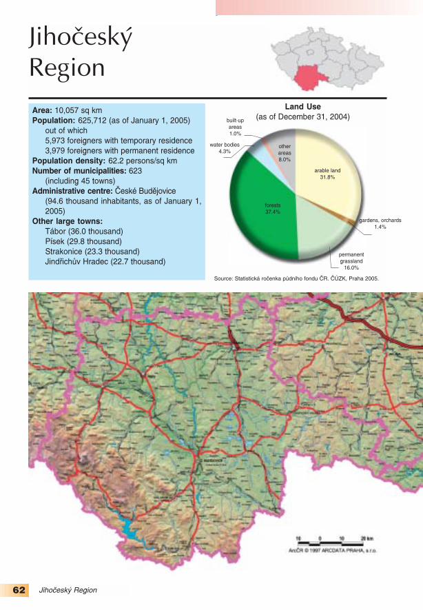
62 Jihočeský Region
Area: 10,057 sq kmPopulation: 625,712 (as of January 1, 2005)
out of which5,973 foreigners with temporary residence3,979 foreigners with permanent residence
Population density: 62.2 persons/sq kmNumber of municipalities: 623
(including 45 towns)Administrative centre: České Budějovice
(94.6 thousand inhabitants, as of January 1,2005)
Other large towns: Tábor (36.0 thousand)Písek (29.8 thousand)Strakonice (23.3 thousand)Jindřichův Hradec (22.7 thousand)
JihočeskýRegion
Source: Statistická ročenka půdního fondu ČR. ČÚZK, Praha 2005.
otherareas8.0%
built−upareas1.0%
arable land31.8%
gardens, orchards1.4%
water bodies 4.3%
forests37.4%
permanentgrassland
16.0%
Land Use(as of December 31, 2004)

63Jihočeský Region
NATURAL ENVIRONMENT
Most of the territory of the Jihočeský (South Bohemia) Region lies on the old igneous rocks cov−ered with younger sediments. The tectonically lowered central part is divided by the Lišov Sill intotwo sedimentary basins – the Českobudějovická Basin in the west with the Vltava River, TřeboňskáBasin in the east with the Lužnice River. The largest pond area in the Czech Republic was found−ed there. The origin of the first ponds date back to the reign of Charles IV; however, fish farmingblossomed in the 16th century on the Rožmberk estate. Most ponds of the Třeboň region are fedby a unique water management masterpiece: the Zlatá stoka canal. Presently more than 7,000ponds covering a total area of over 31 thousand hectares are located in South Bohemia, the threelargest being Rožmberk on the Lužnice River, Horusický near Veselí nad Lužnicí and Bezdrev nearHluboká nad Vltavou. During the latter half of the 20th century new large water works were con−structed: the Lipno Dam (4,870 ha, the largest in the Czech Republic), the Orlík Dam with thelargest capacity in the Czech Republic or the Římov Dam supplying a significant part of the regionwith drinking water. Due to the construction of the Temelín nuclear power station the HněvkoviceDam was constructed on the Vltava River. The combined surface area of these ponds and reser−voirs make up 4% of the total area of the region.
Vast forests, particularly in the Šumava Mts. and Novohradské Mts. are an important naturalresource of the region. Mineral resources of the region include sand and gravel sand deposits,brick clay and other building materials. Deposits of peat are important as well.
Little disturbed natural environment is protected by law in a number of specially designatedareas. Two UNESCO biosphere reserves (Šumava and Třeboňsko) are located in the region. TheŠumava and Třeboň moor lands are protected as internationally important wetlands. In 1991 theŠumava National Park was declared in the south−western part of the region with the area of690 sq km; its buffer zone is the Šumava PLA (940 sq km). Among the most valuable localities ofthe national park are Šumava cirque lakes, canyons of the Křemelná, Vydra and Otava Rivers,
Share of the Jihočeský Region in selected country statistical figures
area
forest area
arable land
population
persons aged 65+ 1)
persons with UE 2)
the unemployed 3)
GDP 4)
industry revenues
accomodation facilities 5)
share in the figure for the Czech Republic as a whole (%)Notes: 1) 65+ – persons aged 65 or more2) UE – university level of education 3) the unemployed – number of economically active persons without employment 4) GDP – gross domestic product5) accomodation facilities – number of beds in touristic accomodation facilities
Data sources: ČSÚ (Czech Statistical Office) and ČÚZK (Czech Office for Surveying, Mapping and Cadastre).

64 Jihočeský Region
Modrava and Kvilda moor lands, Chalupská moor, Vltava mead, Knížecí Pláně, Stožec orTrojmezná. In the Šumava Mts. foothills the Blanský les PLA was declared in 1989 with an areaof 212 sq km. The Třeboňsko PLA is an acknowledged example of the harmonic relationsbetween nature and human activities. The Lužnice River with preserved natural meanders forms anatural axis of the territory with vast wetlands, peat bogs and sand dunes.
POPULATION AND SETTLEMENT PATTERNS
South Bohemia is the least densely populated region in the Czech Republic. Scarcely populat−ed territories have preserved a unique character with a number of cultural and natural monuments.Out of the total number of 623 municipalities 447 (71.2%) have less than 500 inhabitants andalmost 91 thousand persons live in these municipalities. More people are concentrated in theadministrative centre of the region – České Budějovice (94.6 thousand). The towns of Tábor, Písek,Strakonice and Jindřichův Hradec represent other large population centres. More than 10 thousandpeople live also in Český Krumlov and Prachatice.
As late as in 1993 South Bohemia experienced natural population increase, i.e. the number ofbirths exceeded the number of deaths. Since 1994, however, the region has been experiencingnatural decrease; in 1995 and 1996 this even exceeded the level of one thousand persons. On theother hand the region gained population during 1993−2004 via migration. In 1995−1996 and 1999−2001, however, the migration balance did not reach the level of natural decrease and the region asthe whole was losing its population. Since 1993 the total population has slightly increased. Theaverage age increased from 36.4 in 1993 to 39.5 in 2004, which was slightly less than the nation−al average (39.8 years). South Bohemia was one of the regions where the proportion of the popu−lation with GCSE and with the tertiary education exceeded 40% (other than South Bohemia theonly other regions to exceed this level were Prague, the Plzeňský Region and the JihomoravskýRegion).
Přemysl Otakar II Square in České Budějovice is one of the largest in Central Europe, with the size of133 × 133 m. (Photo: Irena Smolová)

65Jihočeský Region
ECONOMY
The employment in the primary sector is the second largest in the Czech Republic. This is a resultnot only of higher employment in agriculture, but also in the forestry and a significant number of per−sons traditionally working in the fish farming industry. The structure of crop area does not differ muchin South Bohemia from that in the Czech Republic as a whole; however the percentage of the arableland is only 64.6% (in the Czech Republic it is 71.6%). On the other hand South Bohemia is markedwith a higher level of livestock production (beef cattle, pigs). Forestry and fish farming occupy animportant position in the region. The region was ranked first in the Czech Republic in the volume oftimber (one sixth of the total volume of timber in the Czech Republic). One half of fish productioncomes from South Bohemia. In comparison to the national average the proportion of the primarysector in the creation of total gross added value made in the region is more than twofold (6.2%).However, the crucial economic sector with the proportion of more than 25% is manufacturing.
Before 1989 South Bohemia was not characterized by a larger concentration of metallurgy andheavy industry; therefore the impact of restructuring was not felt as severely as in other regions ofthe Czech Republic. Thus the situation on the labour market is relatively favourable. Tourism andrelated services have developed successfully. The number of guests in the collective hotels andhostels exceeded one million in 2004 and the region ranked second in the Czech Republic after
1993 1994 1995 1996 1997 1998 1999 2000 2001 2002 2003 2004
live
birth
s/d
ea
ths
pe
r 1
,00
0 in
ha
bita
nts
Natural change of population 1993-2004
Sources: Demografická roèenka krajù Èeské republiky 1991-2003. ÈSÚ, Praha 2004.Vývoj obyvatelstva ÈR v roce 2004. ÈSÚ, Praha 2005.
crude birth rate crude death ratenatural increase natural decrease
0
2
4
6
8
10
12
14
Age structure of population
Age group Unit1993 2004
CZ Region CZ Region
0–14 % 19.4 20.0 14.9 15.3
15–64 % 67.6 67.4 71.0 70.8
65+ % 13.0 12.6 14.0 13.9
mean age years 36.8 36.4 39.8 39.5
old/young ratio – 66.8 63.0 94.0 91.2
Population change
Periodabsolute numbers in ‰ per year
natural migration natural migrationchange balance change balance
1993–1996 −1,545 2,981 −0.6 1.2
1997–2000 −3,435 2,776 −1.4 1.1
2001–2004 −2,598 3,017 −1.0 1.2
1993–2004 −7,578 8,774 −1.0 1.2
Sources:Demografická ročenka krajů ČR 1991−2003. Praha, ČSÚ 2004.Vývoj obyvatelstva ČR v roce 2004. Praha, ČSÚ 2005.
Sources:Demografická ročenka krajů ČR 1991−2003. Praha, ČSÚ 2004.Vývoj obyvatelstva ČR v roce 2004. Praha, ČSÚ 2005.

66 Jihočeský Region
Prague. The construction of the Temelín nuclear power station (in operation since 2002) was thelargest industrial investment in the region. Its opening ended the need to import electricity fromother regions, mainly from ecologically afflicted northern Bohemia. Foreign direct investments weredirected mainly into the car industry. The largest producers of car components and accessories inthe region are two new companies, Robert Bosch and Dura Automotive CZ, and one traditionalcompany, ČZ Strakonice. Eleven industrial enterprises and one construction firm (Hochfief VSB,once Vojenské stavby) with more than 1 thousand employees are active in the region.
Employers with the greatest number of employees in the Jihočeský Region(civil sector only, as of December 31, 2003)
Employer Branch Emp.České dráhy Railway transport 4.6Česká pošta State post 3.0Nemocnice České Budějovice Health care 2.7Robert Bosch, České Budějovice Production of accessories
for the car industry 1.9Madeta, České Budějovice Production of dairy products 1.5ČZ Strakonice Production of accessories
for the car industry 1.5Jihočeská univerzita, České Budějovice Education 1.3Dura Automotive CZ, Blatná Production of accessories
for the car industry 1.2Jitex Písek Production of knitted products 1.2Hochtief VSB Construction 1.2Note: Emp. – number of employees in thousands
Source: CRR MU in Brno database, 2005.
Unemployment in 1993−2004
thousands
Source: Trh práce v ČR za roky 1993-2004. ČSÚ, Praha 2005.
number of the unemployed (in thousands)
general unemployment rate (%)
Structure of employment
by the basic sectors of economy
in 1993 and 2004thousands
I – agriculture, forestry and fishing II – industry and constructionIII – services
Source: Trh práce v ČR za roky 1993-2004. ČSÚ, Praha 2005.

67Jihočeský Region
TOURIST ATTRACTIONS
Natural environment with a high percentage of forest, bodies of water and a number of culturalmonuments (almost six thousand buildings) attract people from all over Czech Republic and fromabroad. During the summer season the Lipno and Orlík dams, the south Bohemian ponds and theŠumava Mts. are the main attractions, in winter the top attractions are mainly the Šumava skiresorts of Churáňov and Zadov.
The folk architecture of the “country baroque” is implicitly connected with the South Bohemia. Thepeculiar architectonic style originated at the turn of the 18th and 19th centuries by translation of thebaroque features from the town houses to the rural folk architecture. In 1995 typical settlements ofKlečany, Komárov, Mažice, Vlastiboř, Zálší and Záluží were declared monument reserves. The sec−ond typical area is the Hlubocká blata moors between Hluboká nad Vltavou, Bosňany and Netolice.The best known village is Holašovice which was listed in 1998 as a UNESCO heritage site.
The historic centres of České Budějovice, Český Krumlov (a UNESCO heritage site since1992), Jindřichův Hradec, Prachatice, Tábor, Třeboň and Slavonice are town monumentreserves. Slavonice is seeking to be added to the UNESCO’s World Heritage List as an exampleof a renaissance town. Balneology is an important part of tourism of the region; spas make use ofrich resources of peat to treat the motor disorders. The towns of Bechyně and Třeboň possess astatus of spa towns. In addition to that there are a number of historic monuments in the region, suchas chateaux in Hluboká nad Vltavou, Český Krumlov, Blatná, Červená Lhota, or the medieval cas−tles Zvíkov, Nové Hrady or Orlík.
The town of Český Krumlov. Photo: Irena Smolová)
Holašovice – an example of rusticbaroque. (Photo: Irena Smolová)

68
Area: 7,562 sq kmPopulation: 549,618
(as of January 1, 2005) out of which7,624 foreigners with temporary residence4,882 foreigners with permanent residence
Population density: 72.7 persons/sq kmNumber of municipalities: 501
(including 46 towns)
Administrative centre: Plzeň (162.6 thousand inhabitants, as of January 1, 2005)
Other large towns: Klatovy (22.9 thousand), Rokycany (13.8 thousand), Tachov (12.5 thousand), Sušice (11.5 thousand), Domažlice (10.8 thousand)
PlzeňskýRegion
Plzeňský Region
Land Use(as of December 31, 2004)
Source: Statistická ročenka půdního fondu ČR. ČÚZK, Praha 2005.
otherareas7.0%
built−up areas1.3%
arable land34.9%
gardens, orchards,hop−gardens
1.8%
water bodies 1.5%
forests39.5%
permanentgrassland
14.0%

69Plzeňský Region
Share of the Plzeňský Region in selected country statistical figures
area
forest area
arable land
population
persons aged 65+ 1)
persons with UE 2)
the unemployed 3)
GDP 4)
industry revenues
accomodation facilities 5)
share in the figure for the Czech Republic as a whole (%)Notes: 1) 65+ – persons aged 65 or more2) UE – university level of education 3) the unemployed – number of economically active persons without employment 4) GDP – gross domestic product5) accomodation facilities – number of beds in touristic accomodation facilities
Data sources: ČSÚ (Czech Statistical Office) and ČÚZK (Czech Office for Surveying, Mapping and Cadastre).
NATURAL ENVIRONMENT
The Plzeňský Region has a hilly character. The central part is occupied by the Plzeňská Basinsurrounded by the hilly terrain of the Plzeňská Upland and Brdy. The Plzeňská Upland is charac−terized by heights formed by resistant rocks (the lydites), which protrude in the form of isolatedtors. The axis of the Plzeňská Basin is formed by the Berounka River; in its valley there arenumerous terraces. The southern and south−western rim of the region consists of the Český lesand Šumava Mts. The Šumava Mts. reaches into the region partly with the Železnorudské Mts.and the Šumavské Plains, which represent vast remnants of the Tertiary peneplain in the altitudeof 900−1100 m a.s.l. with numerous peat bogs. Above the peneplain the highest peaks of theregion rise (Velká Mokrůvka 1370 m a.s.l., Poledník with the glacial corrie of Plešné Lake).
Most of the region falls into the Berounka River drainage basin; the river emerges at the conflu−ence of the Mže and Radbuza Rivers. The Mže River starts in Germany and two dams were erect−ed on it: Lučina near tachov and Hracholusky near Plzeň. The Plzeňská Basin has a centripetaldrainage pattern and is an important confluence area, which makes it prone to floods (e.g. that in2002). Nýrsko Dam built on the Úhlava River in the Šumava PLA server as an important source ofdrinking water. In addition to glacial lakes, the region offers the other unique geological formation,Mladotické Lake, formed in the 19th century as a result of a landslide which created a natural damon the Mladotický Brook. The region has large potential reserves of raw materials (deposits of clay,kaolin and building stone).
The Šumava NP and Šumava PLA extend into the region. They protect vast forest complexes,peat bogs, and periglacial and glacial landforms. In the Český les PLA in the southwest, declaredin 2005, original mixed forests and undisturbed landscape of the Czech−German border are pro−tected. The highest peak is Čerchov (1042 m a.s.l.). A small part of the Slavkovský les PLAextends into the region as well.

70 Plzeňský Region
POPULATION AND SETTLEMENT PATTERNS
The Plzeňský region is the second least populated in the Czech Republic. Population distribu−tion is considerably uneven; almost 30% of inhabitants live in Plzeň, but compared to other regionsthe Plzeňský Region has no large towns (only in Klatovy and Plzeň does the population exceed20 thousand). In 2004 there were 341 municipalities with less than 500 inhabitants, i.e. 68.1% ofthe total number of municipalities, with 12.5% of the population of the region. Since 1993 the pop−ulation of the region has been decreasing due to a high natural decrease, which is not sufficientlycompensated by the migration balance (with the exception of the year 2003). The highest popula−tion decrease was recorded in Plzeň: 173 thousand inhabitants in 1991 and around 10 thousandless people at present.
The aging of the population after 1993, typical of the whole republic, has affected the PlzeňskýRegion very intensely. In 2004 the average age exceeded 40 years (40.2; the second afterPrague), in 2005 the index of age reached 100, i.e. the number of inhabitants in the post−produc−tive age exceeded the number of inhabitants aged 0−14. Recently the level of education hasincreased considerably (the proportion of population with GCSE and the tertiary educationincreased in 1993−2004 from 31% to 40.8%; the highest value after Prague and the JihomoravskýRegion). This favourable development goes hand in hand with the development of education inPlzeň, where the Západočeská University was founded.
Gothic church of St Bartholomew in the centre of Plzeň with the highestchurch tower in the Czech Republic.(Photo: Irena Smolová)

71Plzeňský Region
ECONOMY
In the past the region posessed great natural potential. Rich deposits of iron ore and hard coalformed the basis of the development of Plzeň’s industry. Presently, only the extraction of con−struction materials is of notable importance, in particular the mining of kaolin for the production ofceramic tiles in Horní Bříza and Chlumčany (the company Lasselsberger). For 150 years the econ−omy of the region was almost entirely interlinked with the existence of the greatest machinery com−pany in the Czech Republic – Škoda Plzeň. At the end of 1989 it employed more than 33 thousandworkers. Unsuccessful privatization led to enormous debts and a slump in production. ŠkodaHolding company became a successor of Škoda Plzeň in 2000, financially and administrativelymanaging numerous subsidiaries. The management of the holding decided to restructure the pro−duction through a reduction of productive branches and enhancement of their competitiveness.Beer production has been traditionally associated with Plzeň. The largest Czech producer andexporter – Plzeňský Prazdroj (presently a part of SAB Miller) is located in the city.
1993 1994 1995 1996 1997 1998 1999 2000 2001 2002 2003 20040
2
4
6
8
10
12
14
live
birth
s/d
ea
ths
pe
r 1
,00
0 in
ha
bita
nts
Natural change of population 1993-2004
Sources: Demografická roèenka krajù Èeské republiky 1991-2003. ÈSÚ, Praha 2004.Vývoj obyvatelstva ÈR v roce 2004. ÈSÚ, Praha 2005.
crude birth rate crude death rate natural decrease
Age structure of population
Age group Unit1993 2004
CZ Region CZ Region
0–14 % 19.4 18.8 14.9 14.6
15–64 % 67.6 67.9 71.0 70.8
65+ % 13.0 13.3 14.0 14.6
mean age years 36.8 37.3 39.8 40.2
old/young ratio – 66.8 70.5 94.0 99.9
Population change
Periodabsolute numbers in ‰ per year
natural migration natural migrationchange balance change balance
1993–1996 −4,656 2,291 −2.1 1.0
1997–2000 −5,766 2,575 −2.6 1.2
2001–2004 −4,428 3,242 −2.0 1.5
1993–2004 −14,850 8,108 −2.2 1.2
Sources:Demografická ročenka krajů ČR 1991−2003. Praha, ČSÚ 2004.Vývoj obyvatelstva ČR v roce 2004. Praha, ČSÚ 2005.
Sources:Demografická ročenka krajů ČR 1991−2003. Praha, ČSÚ 2004.Vývoj obyvatelstva ČR v roce 2004. Praha, ČSÚ 2005.

72 Plzeňský Region
The Plzeňský region is attractive for foreign investors due to its location, qualified labour force,and developed research base in technical fields. The majority of foreign direct investments flow intoelectro−technical industry (Panasonic AVC Networks Czech producing televisions, Yazaki WiringTechnologies Czech and Alcoa Fujikura Czech producing electrical wiring for the car industry).
Employers with the greatest number of employees in the Plzeňský Region (civil sector only, as of December 31, 2003)
Employer Branch Emp.České dráhy Railway transport 5.0Fakultní nemocnice, Plzeň Health care 3.7Česká pošta State post 2.6Lasselsberger, Plzeň Production of building materials
and ceramic products 2.3Panasonic AVC Networks Czech, Plzeň Production of TV sets 1.7Yazaki Wiring Technologies Czech, Plzeň Production of accessories
for the car industry 1.6Alcoa Fujikura Czech, Stříbro Production of accessories
for the car industry 1.6Západočeská univerzita, Plzeň Education 1.6Dioss Nýřany Production of batteries,
air conditioners, and metal goods 1.6Plzeňské městské dopravní podniky, Plzeň City transport 1.2Notes: Emp. – number of employees in thousandsŠkoda Holding employed 6.3 thousand persons in the company and its 18 subsidiaries in the region.
Unemployment in 1993−2004
thousands
Source: Trh práce v ČR za roky 1993-2004. ČSÚ, Praha 2005.
number of the unemployed (in thousands)
general unemployment rate (%)
Structure of employment
by the basic sectors of economy
in 1993 and 2004thousands
I – agriculture, forestry and fishing II – industry and constructionIII – services
Source: Trh práce v ČR za roky 1993-2004. ČSÚ, Praha 2005.
Source: CRR MU in Brno database, 2005.

73Plzeňský Region
Foreign investments positively influence the creation of new labour positions. There were only4.8 applicants per vacancy at the end of 2004 (the second lowest after Prague). Manufacturingaccounts for one third of the regional GDP. As for transport and communications, commercialservices, and trade, each account for one tenth of the regional GDP.
The quantity of regional GDP accounted for by the primary sector in the region has fallen below5%, nevertheless this percentage is higher only in the Vysočina, Jihočeský and Olomouckýregions. Forestry is important in the region. Rape has a more significant position in the crop areastructure than in other regions. Favourable natural conditions (high percentage of permanentgrassland) are reflected in the above−average intensity of beef cattle breeding.
TOURIST ATTRACTIONS
The Plzeňský region has uneven potential for the development of the tourist industry. The city ofPlzeň offers many cultural monuments, including its historic underground, which with its 20 km oftunnels if one of the largest in Central Europe. Among the sites of natural interest in Plzeň thereare the Bolevecké Ponds, which form a unique landscape and are considered an outstanding tech−nical achievement dating back from the 15th century.
In the territory of the region there are three town monument reserves. Plzeň was declared onein 1989. Its most important landmark is the St. Bartholomew Cathedral. The Horšovský Týn townmonument reserve on the left bank of the Radbuza River protects a castle rebuilt in the middle ofthe 14th century by the Prague archbishop Arnošt z Pardubic. During the Renaissance the towndeveloped as well. Its square and streets are graced with renaissance or baroque houses. TheDomažlice town monument reserve protects the original historic core of the royal city. The castlewith its tower, the Lower gate with the early gothic portal, and the church rank among the oldestmonuments of the town. In August the folklore festival Chodské slavnosti takes place here. Thebaroque chateau in Manětín and the monastery in Plasy are other cultural monuments of theregion. The ruins of the gothic castles of Rabí and Rabštejn nad Střelou, the water castle of Švi−hov and the monastery in Kladruby are attractive for tourists as well. The Šumava Mts. provideexcellent conditions for both summer and winter recreation. Konstantinovy Lázně aimed at theprevention and treatment of cardiovascular diseases, motor disorders, metabolism and respiratoryorgans, has the spa status.
Glacial lake Laka in the Šumava Mts.
(Photo: Pavel Mentlík)

74 Karlovarský Region
KarlovarskýRegionArea: 3,315 sq kmPopulation: 304,588 (as of January 1, 2005)
out of which5,897 foreigners with temporary residence8,828 foreigners with permanent residence
Population density: 91.9 persons/sq kmNumber of municipalities: 132
(including 28 towns)Administrative centre: Karlovy Vary (51.5thousand inhabitants, as of January 1, 2005)Other large towns:
Cheb (33.5 thousand)Sokolov (24.7 thousand)Ostrov (17.2 thousand)Chodov (14.4 thousand)Mariánské Lázně (14.1 thousand)Aš (12.8 thousand)
Source: Statistická ročenka půdního fondu ČR. ČÚZK, Praha 2005.
other areas16.1%
built−up areas1.0%
arable land17.1%
gardens,orchards
1.1%
waterbodies2.1%
forests43.2%
permanent grassland
19.4%
Land Use(as of December 31, 2004)

75Karlovarský Region
NATURAL ENVIRONMENT
The Karlovarský Region occupies the westernmost part of the Czech Republic. The OhřeRiver forms the axis of the region flowing from the southwest to the northeast through the widedepression of the Podkrušnohorský Rift. The present appearance of the landscape was signif−icantly influenced by the Tertiary neo−tectonic movements, when the central part declined alongthe Krušnohorský and Litoměřický faults. The rift divides the Krušné Mts. and Smrčiny in thenorth and the northwest from the Slavkovský les in the south. In the eastern part the depres−sions of the Chebská and Sokolovská Basins are divided by the volcanic complex of theDoupovské Mts. The Krušné Mts. reach the region at their highest south−western part withKlínovec (1244 m a.s.l.). They are typical of peneplain with peat bogs and peaks protrudingover the level of peneplain, e. g. Božídarský Špičák (1115 m a.s.l.) whose basaltic top ranksamong the largest occurrences of basalt in Central Europe. The southern part consists of theKarlovarská Highland.
The region is noted for its numerous mineral springs with the world−famous triangle of the townsof Karlovy Vary, Mariánské Lázně and Františkovy Lázně. However, vast areas have been dam−aged by brown coal extraction. The Slavkovský les PLA, declared in 1974, protects the naturalhinterland of the spas.
Share of the Karlovarský Region in selected country statistical figures
area
forest area
arable land
population
persons aged 65+ 1)
persons with UE 2)
the unemployed 3)
GDP 4)
industry revenues
accomodation facilities 5)
share in the figure for the Czech Republic as a whole (%)Notes: 1) 65+ – persons aged 65 or more2) UE – university level of education 3) the unemployed – number of economically active persons without employment 4) GDP – gross domestic product5) accomodation facilities – number of beds in touristic accomodation facilities
Data sources: ČSÚ (Czech Statistical Office) and ČÚZK (Czech Office for Surveying, Mapping and Cadastre).
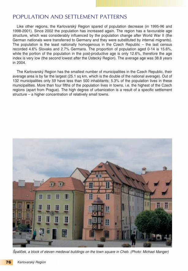
76 Karlovarský Region
POPULATION AND SETTLEMENT PATTERNS
Like other regions, the Karlovarský Region spared of population decrease (in 1995−96 and1998−2001). Since 2002 the population has increased again. The region has a favourable agestructure, which was considerably influenced by the population change after World War II (theGerman nationals were transferred to Germany and they were substituted by internal migrants).The population is the least nationally homogenous in the Czech Republic – the last censusrecorded 4.6% Slovaks and 2.7% Germans. The proportion of population aged 0−14 is 15.6%,while the portion of the population in the post−productive age is only 12.6%, therefore the ageindex is very low (the second lowest after the Ústecký Region). The average age was 38.8 yearsin 2004.
The Karlovarský Region has the smallest number of municipalities in the Czech Republic, theiraverage area is by far the largest (25.1 sq km, which is the double of the national average). Out of132 municipalities only 59 have less than 500 inhabitants; 5.3% of the population lives in thesemunicipalities. More than four fifths of the population lives in towns, i.e. the highest of the Czechregions (apart from Prague). The high degree of urbanization is a result of a specific settlementstructure – a higher concentration of relatively small towns.
Špalíček, a block of eleven medieval buildings on the town square in Cheb. (Photo: Michael Manger)

77Karlovarský Region
ECONOMY
The Karlovarský Region has a specific character which differs significantly from every otherregion. Apart from the smaller area and population (the smallest in the Czech Republic), it is mar−ked by a high degree of forestation, the lowest percentage of arable land, and various naturalresources such as natural and healing springs, brown coal deposits, kaolin and ceramic clay depo−sits and deposits of metal ores (currently unexploited). All this significantly affects the character ofthe region. After abandoning mining of non−ferrous ores, the region’s economy focused on manu−facturing (textile and cloth, chemicals, ceramics etc.) and the brown coal and kaolin mining. Thespas have played an important role in the region for centuries. The spa capacity makes up morethan 40% of spa accommodation facilities in the Czech Republic. The spas account for the longestperiod of stay of foreign visitors – 7.6 days (Prague comes second with 4.1 days). Accommodati−on and food services make up 4.0% of the gross added value of the region, which is unpreceden−ted in other regions.
1993 1994 1995 1996 1997 1998 1999 2000 2001 2002 2003 20040
2
4
6
8
10
12
14
live
birth
s/d
ea
ths
pe
r 1
,00
0 in
ha
bita
nts
Natural change of population 1993-2004
Sources: Demografická roèenka krajù Èeské republiky 1991-2003. ÈSÚ, Praha 2004.Vývoj obyvatelstva ÈR v roce 2004. ÈSÚ, Praha 2005.
crude birth rate crude death ratenatural increase natural decrease
Age structure of population
Age group Unit1993 2004
CZ Region CZ Region
0–14 % 19.4 20.1 14.9 15.6
15–64 % 67.6 69.5 71.0 71.8
65+ % 13,0 10.4 14.0 12.6
mean age years 36.8 35.4 39.8 38.8
old/young ratio – 66.8 51.9 94.0 80.7
Population change
Periodabsolute numbers in ‰ per year
natural migration natural migrationchange balance change balance
1993–1996 835 12 0.7 0.0
1997–2000 −332 −102 −0.3 −0.1
2001–2004 −434 589 −0.4 0.5
1993–2004 69 499 0.0 0.1
Sources:Demografická ročenka krajů ČR 1991−2003. Praha, ČSÚ 2004.Vývoj obyvatelstva ČR v roce 2004. Praha, ČSÚ 2005.
Sources:Demografická ročenka krajů ČR 1991−2003. Praha, ČSÚ 2004.Vývoj obyvatelstva ČR v roce 2004. Praha, ČSÚ 2005.

78 Karlovarský Region
The share of agriculture and forestry in the regional GDP is only 2.4%. Agricultural land makesup only 37.6% of the region, which is the lowest in the Czech Republic; arable land makes up only45.6% of the agricultural land (in the Czech Republic it is 71.6%). Permanent grassland accountsfor more than one half of the agricultural land, but still the beef cattle farming does not match thenational average. In 2004 GDP per capita reached four fifths of the national average. Industry wasthe most important in the creation of the GDP. Mining and raw material processing accounted for6.5% (second after the Moravskoslezský Region), the manufacturing 25.3%, and energy and water
Employers with the greatest number of employees in the Karlovarský Region (civil sector only, as of December 31, 2003)
Employer Branch Emp.Sokolovská uhelná, Sokolov Brown coal extraction 5.4České dráhy Railway transport 2.4Witte Nejdek Production of accessories
for the car industry 1.4Karlovarský porcelán, Karlovy Vary Production of porcelain 1.0Česká pošta State post 1.0Nemocnice, Karlovy Vary Health care 0.9Lázně Františkovy Lázně Health care 0.9Léčebné lázně Mariánské Lázně Health care 0.7Léčebné lázně Jáchymov Health care 0.7Nemocnice Sokolov Health care 0.7Note: Emp. – number of employees in thousands
Source: CRR MU in Brno database, 2005.
Unemployment in 1993−2004
thousands
Source: Trh práce v ČR za roky 1993-2004. ČSÚ, Praha 2005.
number of the unemployed (in thousands)
general unemployment rate (%)
Structure of employment
by the basic sectors of economy
in 1993 and 2004thousands
I – agriculture, forestry and fishing II – industry and constructionIII – services
Source: Trh práce v ČR za roky 1993-2004. ČSÚ, Praha 2005.

79Karlovarský Region
production and distribution 4.1%. The biggest employer in the region is Sokolovská uhelná (browncoal extraction company). Karlovarský porcelain, the biggest Czech producer of utility porcelain,Witte Nejdek, a producer of car components and accessories, and the chemical company of RSMChemacryl in Sokolov, the biggest producer of acrylic acid in Central Europe, rank among biggeremployers in industry. The birthplace of production of musical instruments in the Czech Republicis the town of Kraslice, where string instruments started to be produced as early as the beginningof the 17th century.
TOURIST ATTRACTIONS
The Karlovarský Region is second to Prague in the number of visitors in the Czech Republic.The spas are the main attraction. The largest spa is Karlovy Vary, the youngest MariánskéLázně. The spa Františkovy Lázně is situated north of the town of Cheb. Lázně Kynžvart isassociated with the figure of the Austrian chancellor Metternich. The originally mining town ofJáchymov, founded in the first half of the 16th century near rich silver deposits, has spa status aswell. Pierre and Marie Curie isolated the uranium from the ore there. Motor disorders are treatedin Jáchymov today with the help of mineral and radioactive springs.
Three town monument reserves are located in the region: Františkovy Lázně, Cheb and Loket.Františkovy Lázně represents an architectonically pure spa centre. It was founded in 1793 and thecharacter of a spa town of the turn of the 19th and 20th centuries has been preserved. The historiccore of Cheb experienced large−scale renovation and reconstruction during the 1950s and 1960s.One of the most valuable buildings is the Cheb Castle, including a two−floor Romanesque−gothicchapel, which is the only one of its kind in Europe. Cheb’s town symbol is the Špalíček, a block ofhistoric half−timbered houses dating back to the 13th century. The town of Loket was wetablishedaround the year 1240 during the reign of Wenceslas I. The royal castle of Loket with itsRomanesque rotunda stands on a dramatic bend of the Ohře River. The castle was renovated dur−ing the reign of Wenceslas IV.
A fountain fed by the Vřídlo thermal spring, the hottest (73°C) in the spa of Karlovy Vary.
(Photo: Stephen Eric Wood / DHD Multimedia Galery)

80 Ústecký Region
Area: 5,335 sq kmPopulation: 822,133 (as of January 1, 2005)
out of which8,931 foreigners with temporary residence10,772 foreigners with permanent residence
Population density: 154.2 persons/sq kmNumber of municipalities: 354 (including 46 towns)Administrative centre: Ústí nad Labem
(93.9 thousand inhabitants, as of January 1, 2005)
Other large towns:Most (67.8 thousand)Děčín (51.8 thousand)Teplice (51.2 thousand)Chomutov (50.2 thousand)Litvínov (27.0 thousand)Litoměřice (24.4 thousand)Jirkov (21.2 thousand)
ÚsteckýRegion
Source: Statistická ročenka půdního fondu ČR. ČÚZK, Praha 2005.
other areas14.6%
built−upareas1.7%
arable land34.9%
gardens, orchards,hop−gardens,
vineyards4.1%
water bodies1.9%
forests29.8%
permanent grassland13.1%
Land Use(as of December 31, 2004)

81Ústecký Region
NATURAL ENVIRONMENT
The landscape of the region is quite varied. Along the border with Germany the region is iso−lated by the belt of the Krušné Mts., the Labské Sandstones, and the Lužické Mts. The KrušnéMts. were in the past an important mining area. Rivers and sterams descending the slopes of themountains provide a source of water for the population and industry of the Podkrušnohoří region.The southern part of the region consists of vast plains of the Czech Cretaceous Tableland withisolated examples of neo−volcanic hills (Říp 459 m a.s.l. or Házmburk 418 m a.s.l.). From timeimmemorial Mt. Říp has been one of the ultimate symbols for the Czech nation. On its top thereis the Romanesque rotunda of St. George. The České středhohoří with the highest peak of theregion, Milešovka (837 m a.s.l.), was created by volcanic activity during the Tertiary Period.Today, it is a distinct feature of the landscape. The largest river of the region is the Elbe, whichenters the region in a deep canyon called Porta Bohemica (The Gate of Bohemia). The ElbeRiver takes in the Ohře and Bílina Rivers from the left, and the Ploučnice and Kamenice Riversfrom the right. The largest body of water is the Nechranická Dam on the Ohře River, built in the1960s.
The north−eastern part of the region has large protected areas. In the České ŠvýcarskoNational Park unique landforms of the sandstone rock cities are protected. The Labsképískovce PLA plays a protective role for the national park. In the Lužické Mts. PLA and Českéstředohoří PLA landscapes with typical neo−volcanic knobs are protected. The KokořínskoPLA with typical landforms of rocks cities and the so−called rock lids stretches to the region atits northern part. The Střední Poohří PLA is currently being prepared to be added to the list ofCzech PLAs.
Share of the Ústecký Region in selected country statistical figures
area
forest area
arable land
population
persons aged 65+ 1)
persons with UE 2)
the unemployed 3)
GDP 4)
industry revenues
accomodation facilities 5)
share in the figure for the Czech Republic as a whole (%)
Notes: 1) 65+ – persons aged 65 or more2) UE – university level of education 3) the unemployed – number of economically active persons without employment 4) GDP – gross domestic product5) accomodation facilities – number of beds in touristic accomodation facilities
Data sources: ČSÚ (Czech Statistical Office) and ČÚZK (Czech Office for Surveying, Mapping and Cadastre).

82 Ústecký Region
POPULATION AND SETTLEMENT PATTERNS
The population of the Ústecký Region decreased by 4.2 thousand inhabitants, i.e. by 0.5%, dur−ing the last intercensal period (1991−2001). The decrease was, however, by one half lower than inthe 1980s. The main cause of the population decrease at that time was the relatively high level ofemigration from the region to other regions, while in the 1990s the main cause of the populationdecrease was a steep decline in the birth rate. Since 1993 the population has been increasing. Theregion predominates in the number of live births. Since 2002 the crude fertility rate has exceededthe level of 10‰. Age and education structure of the population is very similar to the KarlovarskýRegion (predominance of the persons aged 0−14 over the persons in the post−productive age, andthe low proportion of persons with higher education). In the Ústecký Region, the proportion of per−sons in post−productive age is the lowest in the Czech Republic (12.4% at the end of 2004) andthe average age of the population was 38.8 years, which was one year less than the national aver−age. In the inter−regional comparison the Ústecký Region was in the last position in 2004 as for thepercentage of the population with tertiary education (only 5.1% persons older than 14 years) andit occupied a similar position in the proportion of persons with GCSE (28.1%). In the long run theregion is marked also by high divorce and abortion rates. Some unfavourable demographic char−acteristics of the region are related with the higher proportion of the Romany population.
The population is significantly concentrated in the Podkrušnohorská Basin. The population den−sity in the Louny and Litmoměřice regions is considerably lower. The population is concentrated in354 municipalities, out of which the 46 have town status and account for 79.3% of the populationof the region. The settlement structure is dominated by relatively large towns; five of them havemore than 50 thousand inhabitants (a similar situation is to be found only in the MoravskoslezskýRegion). Only 6.2% of population lives in municipalities with less than 500 inhabitants (190 munic−ipalities). The industrial development during the 20th century and particularly brown coal extractioncontributed to the depopulation (in some case even abandonment) of small villages and to the con−centration of the population into towns.
Modern suspension Marian Bridge over the Elbe River in Ústí nad Labem. (Photo: Daniel Neuwirth)

83Ústecký Region
ECONOMY
The Ústecký Region ranks among the most industrialized regions not only in the CzechRepublic but also in Central Europe. The detrimental impact on the environment, particularly inthe latter half of the 20th century, was a consequence of more than 200 years of industrialization(concentration of chemical factories and coal mining). The impact has been considerably less inrecent years. The economic development was also influenced by historic−social factors – expul−sion of the Czech population before World War II and the transfer of the German nationals afterWWII together with the immigration of the inland population. The region is relatively rich in natu−ral potential: apart from the large deposits of brown coal, deposits of glass and foundry sands andbuilding stone can be found here.
The regional GDP per capita in 2004 increased to 84.5% of the national average and reached60% of the EU level. The manufacturing industry is crucial for the creation of regional GDP(28.5%). Compared to other regions, the proportion of extraction and raw material processing ismore than fourfold (4.8%) and the proportion of the energetics more than double (8.9%). Twobrown coal mining companies rank among the biggest employers in the region (Mostecká uhel−
1993 1994 1995 1996 1997 1998 1999 2000 2001 2002 2003 20040
2
4
6
8
10
12
14
live
birth
s/d
ea
ths
pe
r 1
,00
0 in
ha
bita
nts
Natural change of population 1993-2004
Sources: Demografická roèenka krajù Èeské republiky 1991-2003. ÈSÚ, Praha 2004.Vývoj obyvatelstva ÈR v roce 2004. ÈSÚ, Praha 2005.
crude birth rate crude death ratenatural increase natural decrease
Age structure of population
Age group Unit1993 2004
CZ Region CZ Region
0–14 % 19.4 20.0 14.9 15.9
15–64 % 67.6 68.4 71.0 71.7
65+ % 13.0 11.6 14.0 12.4
mean age years 36.8 35.8 39.8 38.8
old/young ratio – 66.8 57.7 94.0 77.6
Population change
Periodabsolute numbers in ‰ per year
natural migration natural migrationchange balance change balance
1993–1996 −1,534 1,894 −0.5 0.6
1997–2000 −4,230 5,709 −1.3 1.7
2001–2004 −3,291 5,044 −1.0 1.5
1993–2004 −9,055 12,647 −0.9 1.3
Sources:Demografická ročenka krajů ČR 1991−2003. Praha, ČSÚ 2004.Vývoj obyvatelstva ČR v roce 2004. Praha, ČSÚ 2005.
Sources:Demografická ročenka krajů ČR 1991−2003. Praha, ČSÚ 2004.Vývoj obyvatelstva ČR v roce 2004. Praha, ČSÚ 2005.

84 Ústecký Region
ná and Severočeské doly). Only three companies employing more than one thousand workersare active in the region presently: chemical companies Chemopetrol and the Spolek prochemickou a hutní výrobu in Ústí nad Labem, and the largest producer of flat glass in the CzechRepublic Glaverbel Czech in Teplice. The Ústecký region is structurally afflicted and the unem−ployment rate is high. The proportion of agriculture in the creation of GDP is only 1.9%, which is
Employers with the greatest number of employees in the Ústecký Region (civil sector only, as of December 31, 2003)
Employer Branch Emp.České dráhy Railway transport 9.5Mostecká uhelná společnost, Most Brown coal extraction 4.6Severočeské doly, Chomutov Brown coal extraction 3.9Česká pošta State post 2.9Chemopetrol, Litvínov Production of basic chemicals 2.7ČEZ Electricity production 2.1Masarykova nemocnice, Ústí nad Labem Health care 2.1Finanční ředitelství Public administration 1.7Nemocnice s poliklinikou, Most Health care 1.5Severočeské vodovody a kanalizace, Adjustment and distribution of drinking 1.3Teplice and service water Note: Emp. – number of employees in thousands
Source: CRR MU in Brno database, 2005.
Unemployment in 1993−2004
thousands
Source: Trh práce v ČR za roky 1993-2004. ČSÚ, Praha 2005.
number of the unemployed (in thousands)
general unemployment rate (%)
Structure of employment
by the basic sectors of economy
in 1993 and 2004thousands
I – agriculture, forestry and fishing II – industry and constructionIII – services
Source: Trh práce v ČR za roky 1993-2004. ČSÚ, Praha 2005.

85Ústecký Region
lower than the national average. Livestock production rate in theústecký Region is the lowest ofall regions in the country. Crop production is more important. The region dominates in hop cul−tivation (58.3% of the total area of hop−fields in the Czech Republic), fruit, vegetable and winecultivation are important as well (the area of local vinyeards cannot compete with that of SouthMoravia, though).
TOURIST ATTRACTIONS
The Ústecký Region has many historic monuments: e.g. the rotunda on Říp, gothic church inMost, baroque chateau in Duchcov, monasteries in Osek and Doksany, and chateaux inPloskovice and Libochovice. The historic cores of Litoměřice, Úštěk, Roudnice nad Labem andTerezín were declared town monument reserves. The Terezín citadel was founded by the EmperorJosef II in 1780. The core of fortification is formed by the Great stronghold and the total area of thefortification is 398 ha. In Marie Terezie’s honour it was renamed Theresienstadt. In February 1942Terezín became a Nazi concentration camp and eventually a main deportation point from whichCzech Jews were transported to extermination camps, mainly to Auschwitz. The town wasrenewed after WWII.
At the confluence of the Elbe and Ohře Rivers the town of Litoměřice is situated. It was onceone of the most important settlements in Bohemia. Its square belongs among the largest in theCzech Republic (1.8 ha). Every year a horticultural exhibition Zahrada Čech (The Garden ofBohemia) takes place here. Settlement in the area of Úštěk dates back to the 10th to 13th centuries.Old trade routes passed through the place, connecting Litoměřice with Lusitania. The town corehas been preserved around the Church of St Peter and Paul.
The natural beauties of the České Švýcarsko National Park with the Pravčická brána rockarch, other rock cities (Tiské stěny, Děčínské stěny) and the Porta Bohemica river gorge are themain attractions of the region. A horse−racing establishment in Most, a motor−racing circuit and agolf course are available. The Krušné Mts. and Lužické Mts. have good conditions for skiing.
Tiské stěny rock walls.(Photo: Daniel Neuwirth)

86 Liberecký Region
Area: 3,163 sq kmPopulation: 427,563 (as of January 1, 2005)
out of which5,634 foreigners with temporary residence5,032 foreigners with permanent residence
Population density: 135.2 persons/sq kmNumber of municipalities: 215
(including 36 towns)Administrative centre: Liberec (97.4 thousand
inhabitants, as of January 1, 2005)Other large towns:
Jablonec nad Nisou (44.6 thousand)Česká Lípa (38.8 thousand)Turnov (14.4 thousand)Nový Bor (12.2 thousand)
LibereckýRegion
Source: Statistická ročenka půdního fondu ČR. ČÚZK, Praha 2005.
otherareas8.2%
built−up areas1.6%
arable land21.9%
gardens, orchards,hop−gardens,
2.8%
water bodies1.5%
forests44.2%
permanentgrassland
19.7%
Land Use(as of December 31, 2004)

87Liberecký Region
NATURAL ENVIRONMENT
In the north the Liberecký Region is mountainous, whereas the territory in the Ploučnice Riverdrainage basin is less dissected. The highest peak of the region is Kotel in the Krkonoše Mts.(1435 m a.s.l.) near Rokytnice nad Jizerou in the Semily region, the lowest point is the SmědáRiver at the point it leaves Czech territory (208 m a.s.l.). The most famous peak of the region isJeštěd (1012 m a.s.l.), other notable peaks include Smrk (1124 m a.s.l.) and Jizera (1122 ma.s.l.). The region is divided by the main European watershed, parting waters that run to the NorthSea and the Baltic Sea. The Jizera, Smědá, Lužická Nisa Rivers start in the Jizerské Mts., thePloučnice River on the slopes of Ještěd. There are numerous mineral springs in the region (e.g.Lázně Libverda). Abundant sources of surface water in the mountainous areas and of groundwater, particularly in the Severočeská cretaceous sheet, make the Liberecký Region perspectivedrinking and service water reservoir of national importance. The protected areas of natural accu−mulation of water in the Jizerské Mts., Krkonoše Mts and Severočeská cretaceous basin make upalmost 60% of the area of the region.
The natural potencial of the Liberecký Region includes quality glass and foundry sands.Decorating and building stone has been quarried in the region for a long time (e.g. the Liberecgranite, Železnobrodské roofing slates, quality basalts and quartzites). Uranium ore extraction inStráž pod Ralskem near Česká Lípa brought about significant economic, social and environmen−tal changes in the past thirty years. In 1990 the deep mining of uranium ore was abandoned, andin 1993 the chemical extraction of uranium was decided to be terminated as well (the cleanup ofthe site is supposed to take several decades).
The region is characterized by a large degree of ecosystem diversity and high concentrationof protected areas. There are five protected landscape areas in the region and the Krkonošský
Share of the Liberecký Region in selected country statistical figures
area
forest area
arable land
population
persons aged 65+ 1)
persons with UE 2)
the unemployed 3)
GDP 4)
industry revenues
accomodation facilities 5)
share in the figure for the Czech Republic as a whole (%)
Notes: 1) 65+ – persons aged 65 or more2) UE – university level of education 3) the unemployed – number of economically active persons without employment 4) GDP – gross domestic product5) accomodation facilities – number of beds in touristic accomodation facilities
Data sources: ČSÚ (Czech Statistical Office) and ČÚZK (Czech Office for Surveying, Mapping and Cadastre).

88 Liberecký Region
National Park, the oldest in the Czech Republic, stretches to the eastern part of the region. Inthe České středohoří PLA neo−volcanic landforms are protected; the Jizerské Mts. PLA is anexample of preserved mixed forests and varied cryogenic landforms. The Lužické Mts. PLA isa borderline mountain range; rock cities are protected within the Czech Paradise PLA andKokořínsko PLA.
POPULATION AND SETTLEMENT PATTERNS
Apart from Prague, the Liberecký Region is the smallest region and in terms of population isthe second smallest (after the Karlovarský Region). The population has not significantly changedbetween 1993 and 2004 (the total increase was 154 persons). The natural population decrease(since 1994) was substituted by active migration balance. The natural decrease was the smallest(only 37 persons) in 2004 and the crude natural increase rate reached –0.1‰ in the same year.In 2004 the crude fertility rate exceeded 10 ‰ for the first time since 1994. The level of infant mor−tality has been lower than the national average. The average age of the population in 2004 was39.2 years, which was less than the national average. The age structure differs on the local level.While in the Česká Lípa region the population is among the youngest in the Czech Republic, inthe Semily and Turnov region it is one of the oldest.
The population density is average for the country. Almost 78% of inhabitants lived in townsat the end of 2004 (in the Czech Republic as a whole it was 70.2%). The highest populationconcentration is in the Liberec−Jablonec agglomeration. There are 215 municipalities with lessthan 500 inhabitants in the region, i.e. 46.3%, and only 6.2% of population lives in such com−munitites.
Tors in the Jizerské Mts. (Photo: Irena Smolová)

89Liberecký Region
ECONOMY
As early as in the latter half of the 19th century the region ranked among the most industrializedregions of the Austrio−Hungarian Empire. The industrial character of the region has been pre−served, but the structure changed. The importance of mining and raw material processing hasdeclined. Until recently radioactive material deposits in the Česká Lípa region were considered asthe main natural resource of the region, today the extraction and processing of decorating andbuilding stone are more important. Chemical extraction of uranium ended in 1993; nowadays onlyrecultivation of landscape which was changed by mining takes place. Manufacturing is the mostimportant: it makes up 38.4% of the regional GDP, which is the greatest value in the CzechRepublic. The importance is documented in the table of “Top 10” employers in the region. Amongthe largest companies there are glass and jewelry producers, mainly Preciosa Jablonec and thenewly formed Jablonex Group, created by merging of five glass companies in 2005. The foreigndirect investments, however, flow mainly into the car industry (production of components).Traditional textile industry has become less important over the last few years and the number ofworkers decreased after 1989 from 19.2 thousand to less than one third of that level.
1993 1994 1995 1996 1997 1998 1999 2000 2001 2002 2003 20040
2
4
6
8
10
12
14
live
birth
s/d
ea
ths
pe
r 1
,00
0 in
ha
bita
nts
Natural change of population 1993-2004
Sources: Demografická roèenka krajù Èeské republiky 1991-2003. ÈSÚ, Praha 2004.Vývoj obyvatelstva ÈR v roce 2004. ÈSÚ, Praha 2005.
crude birth rate crude death ratenatural increase natural decrease
Age structure of population
Age group Unit1993 2004
CZ Region CZ Region
0–14 % 19.4 20.0 14.9 15.7
15–64 % 67.6 67.7 71.0 71.4
65+ % 13.0 12.3 14.0 13.0
mean age years 36.8 36.1 39.8 39.2
old/young ratio – 66.8 61.6 94.0 82.7
Population change
Periodabsolute numbers in ‰ per year
natural migration natural migrationchange balance change balance
1993–1996 −367 2,090 −0.2 1.2
1997–2000 −1,941 1,934 −1.1 1.1
2001–2004 −1,135 451 −0.7 0.3
1993–2004 −3,443 4,475 −0.7 0.9
Sources:Demografická ročenka krajů ČR 1991−2003. Praha, ČSÚ 2004.Vývoj obyvatelstva ČR v roce 2004. Praha, ČSÚ 2005.
Sources:Demografická ročenka krajů ČR 1991−2003. Praha, ČSÚ 2004.Vývoj obyvatelstva ČR v roce 2004. Praha, ČSÚ 2005.

90 Liberecký Region
The size of the primary sector has already decreased to 2%, even if forestry considerably con−tributes to the gross added value of the region. The Liberecký Region is the first in terms of the for−est percentage in the total area (44.2%). The region is important for tourism, particularly in the win−ter season.
Employers with the greatest number of employees in the Liberecký Region (civil sector only, as of December 31, 2003)
Employer Branch Emp.Preciosa, Jablonec nad Nisou Production of jewellery 4.0České dráhy Railway transport 2.6Delphi Packard Electric ČR, Česká Lípa Production of electrical equipments
for cars 2.6Krajská nemocnice, Liberec Health care 1.9Crystalex, Nový Bor Production of glass 1.7Česká pošta State post 1.5Johnson Controls Production of accessories automobilové součástky, Česká Lípa for the car industry 1.5Diamo, Stráž pod Ralskem Extraction and processing of uranium ore 1.4Železnobrodské sklo, Železný Brod 1) Production and processing of glass 1.2Ornela, Zásada 1) Production of glass 1.2Note: 1) in October 2005 the companies Železnobrodské sklo, Ornela, Bižuterie Česká Mincovna, Jablo−nex, and Bohemian Jewelry merged into Jablonex Group, Jablonec nad Nisou (3.5 thousand employees)Emp. – number of employees in thousands
Source: CRR MU in Brno database, 2005.
Unemployment in 1993−2004
thousands
Source: Trh práce v ČR za roky 1993-2004. ČSÚ, Praha 2005.
number of the unemployed (in thousands)
general unemployment rate (%)
Structure of employment
by the basic sectors of economy
in 1993 and 2004thousands
I – agriculture, forestry and fishing II – industry and constructionIII – services
Source: Trh práce v ČR za roky 1993-2004. ČSÚ, Praha 2005.

91Liberecký Region
TOURIST ATTRACTIONS
The Liberecký Region is a frequently visited recreational area. Mountain resorts of the KrkonošeMts. (Harrachov, Rokytnice nad Jizerou or Vysoké nad Jizerou) and Jizerské Mts. (Bedřichov,Josefův Důl, Desná, Hejnice or Bílý Potok) are among the top attractions. In Liberec the world cupin ski jump takes place.
Bozkovské Dolomite Caves are open to the public. In the summer season Doksy, MáchovoLake and the Czech Paradise are among important tourist sites.
Castles and chateaux, such as Bezděz, Zákupy, Lemberk, Frýdlant, Sychrov, Hrubý Rohozec,Valdštejn, and a number of religious monuments are historic landmarks and thus are frequently vis−ited. Two spas are located in the region: Lázně Libverda and Lázně Kundratice, where motordisorders, heart diseases, circulatory problems, and rheumatism are treated.
Harrachov ski resort in the Krkonoše Mts. (Photo: Irena Smolová)

92 Královéhradecký Region
Area: 4,758 sq kmPopulation: 547,296 (as of January 1, 2005)
out of which5,513 foreigners with temporary residence4,336 foreigners with permanent residence
Population density: 115.0 persons/sq kmNumber of municipalities: 448 (including
43 towns)Administrative centre: Hradec Králové
(94.7 thousand inhabitants, as of January 1, 2005)
Other large towns:Trutnov (31.2 thousand)Náchod (21.2 thousand)Jičín (16.2 thousand)Dvůr Králové nad Labem (16.2 thousand)
KrálovéhradeckýRegion
Source: Statistická ročenka půdního fondu ČR. ČÚZK, Praha 2005.
other areas6.8%
built−up areas2.0%
arable land40.7%
gardens, orchards, vineyards
3.3%
water bodies1.5%
forests30.9%
permanent grassland
14.8%
Land Use(as of December 31, 2004)

93Královéhradecký Region
NATURAL ENVIRONMENT
The landscape of the region is typified of great altitudinal differences. It rises from the lowlandsin the south to the north. Two mountain ranges, the Krkonoše Mts. and the Orlické Mts. are in thenorth and north east, both with many attractions for summer and winter holidays. The KrkonošeMts. include the highest peak in the Czech Republic, Sněžka (1602 m a.s.l.), and a number of otherpeaks exceed the altitude of 1000 m a.s.l. Žacléř and Broumov regions are also rather mountain−ous with old volcanic ranges (Vraní Mts. and Javoří Mts.). The mountains change into low hills inthe south. The southern and central parts of the region are filled with the Cretaceous sedimentswith typical rock cities. The largest is the Adršpašsko−teplické Rock City; the Czech Paradise isalso frequently visited.
The Elbe River (Labe in Czech) rising in the Krkonoše Mts. forms the axis of the region. Itsimportant tributaries are the Úpa, Metuje, Orlice and Cidlina Rivers. In order to regulate the out−flow two dams were erected on the Elbe River: the Labská Dam in Špindlerův Mlýn and the LesKrálovství Dam near Dvůr Králové nad Labem. The Rozkoš Dam secures water for irrigation. It isone of the largest in the Czech Republic (1,001 ha). The region has important reserves of groundwater. The eastern part of the Krkonošský National Park, the oldest national park in the CzechRepublic, stretches into the region. Unique glacial landforms (corries, troughs), peat bogs, water−falls or endemic species are protected in the area. In 1955 the Czech Paradise PLA wasdeclared to protect the rock cities. The area has been recently enlarged. In 1991 theBroumovsko PLA was declared; it is an example of harmonic cultural landscape with rock citiesand baroque religion structures. The Orlické Mts. PLA protects virgin mixed forests, peat bogs,and deeply cut valleys.
Share of the Královéhradecký Region in selected country statistical figures
area
forest area
arable land
population
persons aged 65+ 1)
persons with UE 2)
the unemployed 3)
GDP 4)
industry revenues
accomodation facilities 5)
share in the figure for the Czech Republic as a whole (%)
Notes: 1) 65+ – persons aged 65 or more2) UE – university level of education 3) the unemployed – number of economically active persons without employment 4) GDP – gross domestic product5) accomodation facilities – number of beds in touristic accomodation facilities
Data sources: ČSÚ (Czech Statistical Office) and ČÚZK (Czech Office for Surveying, Mapping and Cadastre).

94 Královéhradecký Region
POPULATION AND SETTLEMENT PATTERNS
Apart from border areas the region is relatively uniformly and densely populated. A character−istic feature of the settlement is a number of middle sized and smaller settlements. There are285 small municipalities with 12.5% of the population. 68% of the population of the region lives intowns. Nine towns have more than 10 thousand inhabitants, but only three of them exceed20 thousand inhabitants.
The Královéhradecký Region is one of the regions where the population has decreased since1994. The highest measured decrease was recorded in 2001, when the region lost 1,563 inhabi−tants. The decrease is a result of the negative natural change since 1994 and in 2000 and 2002 bya negative migration balance as well. The above mentioned population change results in the age−ing of the population. In 1993 the average age of the population in the Královéhradecký Regionreached 37.1 years. Over a period of only 11 years it increased to 40.1 years and the value wasthe third highest after Prague and the Plzeňský Region. The level of the age index approaches 100(equal proportions of persons in pre−productive and post−productive age). Thanks to a high pro−portion of persons older than 65 years (14.7%; the second highest value in the Czech Republicafter Prague) the age index of the population reached 97.5 at the end of 2004. The life expectan−cy is above−average compared to the Czech Republic (men – 73.1 years, the second highest in theCzech Republic; women – 78.8 years the sixth highest). Average level of educational of the popu−lation is higher. The proportion of persons with GCSE and tertiary education was 32.8% in 1993and 39.6% in 2004. Higher proportions of these persons were recorded in 2004 only in Prague,Jihomoravský, Plzeňský, and Jihočeský regions.
Town square in Nové Město nad Metují. (Photo: Irena Smolová)

95Královéhradecký Region
ECONOMY
The share of agriculture and forestry in the regional GDP is decreasing as in other regions andpresently is at the level of about 5%. Livestock production is a little more important. In the level ofpig farming the Královéhradecký region ranks fourth and in the beef cattle farming the regionranks fifth in the Czech Republic. In 2005 there were 39.1 cows per 100 ha of agricultural land (inthe Czech Republic as a whole it was 32.8 cows) and 108.3 pigs per 100 ha of agricultural land(in the Czech Republic it was 94.2 pigs). The proportion of cereals in the crop area was 55%,which was by 5% less than the national average. The Královéhradecký Region is an importantproducer of sugar beet (almost 15% of the total production). The region has large areas oforchards, which take up 1.3% of agricultural land (the second highest proportion after Jihomo−ravský Region).
Manufacturing accounts for most of the gross added value (30.9%). The number of employeesin this branch decreased in 2004 to 74.6 thousand (almost 30% of all employed), nevertheless it isstill the largest employer in the region. The top ten employers in the region include České dráhy(Czech Railways), the largest employer, the teaching hospital, the state post, and seven compa−
1993 1994 1995 1996 1997 1998 1999 2000 2001 2002 2003 20040
2
4
6
8
10
12
14
live
birth
s/d
ea
ths
pe
r 1
,00
0 in
ha
bita
nts
Natural change of population 1993-2004
Sources: Demografická roèenka krajù Èeské republiky 1991-2003. ÈSÚ, Praha 2004.Vývoj obyvatelstva ÈR v roce 2004. ÈSÚ, Praha 2005.
crude birth rate crude death ratenatural increase natural decrease
Age structure of population
Age group Unit1993 2004
CZ Region CZ Region
0–14 % 19.4 19.2 14.9 15.1
15–64 % 67.6 67.2 71.0 70.1
65+ % 13.0 13.6 14.0 14.7
mean age years 36.8 37.1 39.8 40.1
old/young ratio – 66.8 70.7 94.0 97.5
Population change
Periodabsolute numbers in ‰ per year
natural migration natural migrationchange balance change balance
1993–1996 −2,082 1,410 −0.9 0.6
1997–2000 −3,724 1,122 −1.7 0.5
2001–2004 −3,096 −500 −1.4 −0.2
1993–2004 −8,902 2,032 −1.3 0.3
Sources:Demografická ročenka krajů ČR 1991−2003. Praha, ČSÚ 2004.Vývoj obyvatelstva ČR v roce 2004. Praha, ČSÚ 2005.
Sources:Demografická ročenka krajů ČR 1991−2003. Praha, ČSÚ 2004.Vývoj obyvatelstva ČR v roce 2004. Praha, ČSÚ 2005.

96 Královéhradecký Region
nies from the manufacturing industry. In the private sector two subsidiaries of Škoda Auto in theKrálovéhradecký Region (Vrchlabí, Kvasiny) employ more people than any other employer and therubber making company of Rubena Hradec Králové, established in 1999 through the merger of thetwo independent companies of Rubena Náchod and Gumokov Hradec Králové, employs almostthe same number as Škoda Auto. Traditional textile companies are still important employers, even
Employers with the greatest number of employees in the Královéhradecký Region(civil sector only, as of December 31, 2003)
Employer Branch Emp.České dráhy Railway transport 4.3Fakultní nemocnice, Hradec Králové Health care 3.9Škoda Auto, závody Kvasiny a Vrchlabí Production of cars 2.3Rubena, Hradec Králové Production of rubber products 2.2Česká pošta State post 2.0Veba, Broumov Weaving of cotton fabric 1.5Tiba, Dvůr Králové nad Labem Weaving of cotton fabric 1.4Juta, Dvůr Králové nad Labem Weaving of jute fabric 1.4Continental Teves Czech Republic, Production of accessories Jičín for the car industry 1.1Mileta, Hořice Weaving of cotton fabric 1.0Note: Emp. – number of employees in thousands
Source: CRR MU in Brno database, 2005.
Unemployment in 1993−2004
thousands
Source: Trh práce v ČR za roky 1993-2004. ČSÚ, Praha 2005.
number of the unemployed (in thousands)
general unemployment rate (%)
Structure of employment
by the basic sectors of economy
in 1993 and 2004thousands
I – agriculture, forestry and fishing II – industry and constructionIII – services
Source: Trh práce v ČR za roky 1993-2004. ČSÚ, Praha 2005.

97Královéhradecký Region
if they do not employ as many workers as at the end of the 1980s. More than one thousandemployees work in Tiba and Juta (both companies in Dvůr Králové nad Labem), Veba in Broumovand Mileta in Hořice. The Královéhradecký Region is marked by the lowest inflow of foreign directinvestments per capita. This fact is reflected in the relatively less extensive construction of “greenfield” plants. The largest investment project in the region was the Continental Teves CzechRepublic in Jičín, a company producing brake systems for cars.
In 2004, 54.5% of all employed persons of the region worked in the tertiary sector. Most of themwere employed in trade, which was the second most important branch after the manufacturingindustry with regard to the creation of the GDP (10.6%).
TOURIST ATTRACTIONS
The region ranks among the richest in the Czech Republic as for the number and importanceof the natural and cultural landmarks. The most valuable natural areas are the KrkonošskýNational Park and the protected lanscape areas, mentioned above. The region has numerouscultural sites as well. Many chateaux are open to the public. Among the most frequented is thechateau in Ratibořice with the nearby national natural reserve of Babiččino údolí, other chateauxin the region include Hrádek u Nechanic, Chlumec nad Cidlinou, Náchod, Nové Město nadMetují, Opočno or Častolovice. The medieval castles of Kost or Potštejn are accessible as well.Historic cores of a number of towns were declared town monument reserves: Hradec Králové,Nové Město nad Metují, Jičín and Josefov. The latter is a baroque fortification at the conflu−ence of the Elbe and Metuje Rivers erected in 1780−89 as a defense against the Prussian army.Another most frequented site is the chateau in Kuks with outstanding baroque statues by M. B.Braun. Velichovky, Janské Lázně in the Krkonoše Mts. and Lázně Bělohrad have the statusof spa towns.
The Kost Castle near Sobotka in the romantic landscape of the Czech Paradise. (Photo: Irena Smolová)

98 Pardubický Region
Area: 4,519 sq kmPopulation: 505,285 (as of January 1, 2005)
out of which3,411 foreigners with temporary residence2,443 foreigners with permanent residence
Population density: 111.8 person/sq kmNumber of municipalities: 452 (including
32 towns)Administrative centre: Pardubice
(88.2 thousand inhabitants, as of January 1, 2005)
Other large towns:Chrudim (23.5 thousand)Svitavy (17.3 thousand)Česká Třebová (16.7 thousand)Ústí nad Orlicí (15.0 thousand)
PardubickýRegion
Source: Statistická ročenka půdního fondu ČR. ČÚZK, Praha 2005.
otherareas7.0%
built−up areas1.6%
arable land44.5%
gardens, orchards 2.9%
water bodies1.4%
forests29.4%
permanent grassland
13.2%
Land Use(as of December 31, 2004)

99Pardubický Region
NATURAL ENVIRONMENT
The landscape of the region consists of both fertile lowlands and dissected terrain of the bor−derline mountain ranges. The Elbe River with its tributaries forms the axis of the region. Theyare typical of wide alluvial plains and low terraces. The Kunětická Hill, a basaltic knob nearPardubice, dominates the region. Towards the rim the Bohemian sheet rises and forms cuestas.The rock walls have been dissected by fluvial action into bizarre landforms. The Žďárské Hills,formed by resistant granite rocks, and the Železné Mts. stretch into the southern part of theregion. The highest elevations are in the eastern part of the region: Orlické Mts. and KrálickýSněžník with the highest peak of the region. Its upper part is protected by unique karst phe−nomena in the marble, preserved mixed and beech forests and a number of rock landforms. Themassive forms an important water source and on Klepý Hill three main European watershedsmeet. The Pardubický Region is an important area of surface and ground water accumulation.Several dams were constructed on the upper reaches of the rivers. The Pardubický Region isalso an important fish farming area. Gravel sands and limestone are extracted in the region. Inthe Orlické Mts. PLA, Železné Mts. PLA, and Žďárské Hills PLA preserved natural land−scapes are protected.
Share of the Pardubický Region in selected country statistical figures
area
forest area
arable land
population
persons aged 65+ 1)
persons with UE 2)
the unemployed 3)
GDP 4)
industry revenues
accomodation facilities 5)
share in the figure for the Czech Republic as a whole (%)
Notes: 1) 65+ – persons aged 65 or more2) UE – university level of education 3) the unemployed – number of economically active persons without employment 4) GDP – gross domestic product5) accomodation facilities – number of beds in touristic accomodation facilities
Data sources: ČSÚ (Czech Statistical Office) and ČÚZK (Czech Office for Surveying, Mapping and Cadastre).

100 Pardubický Region
POPULATION AND SETTLEMENT PATTERNS
The population of the Pardubický Region increased in 1993 for the last time. Since then it hasseen a decrease every year – the same situation is in the Královéhradecký Region. The greatestdecrease was recorded in 2001 (1,085 persons, out of which the natural decrease made up 587and emigration 488). In 2001 the fewest children were born (4,481, i.e. 8.8‰), since that year thebirth rate has increased. The average age is 39.6 years and it can be assumed that at the end of2005 the population over 65 years of age will predominate over the population aged 0−14 in theregion. Compared to the national average the life expectancy in the Pardubický Region is higher(the fourth highest figure for men). The adverse demographic situation is starting to improve atpresent. The educational structure approaches the national average. Education index (i.e. theproportion of population with GCSE and tertiary education per 100 inhabitants older than 24) waslower in 2004 than the national average.
The population density of the Pardubický Region is lower than the national average due to theless populated mountain and highland areas in the east. Pardubice considerably dominates thesettlement structure with its almost 90 thousand inhabitants. There are other eight towns with morethan 10 thousand inhabitants. In all towns (32) of the region 61.2% of the population lives (in theCzech Republic it is 70.2%). A relatively high proportion of the population (13.8%) lives in munici−palities with less than 500 inhabitants (289) – it is exceeded only in the Vysočina, Středočeský andJihočeský regions.
Medieval walls preserved in the historical core of Polička. (Photo: Martin Jurek)

101Pardubický Region
ECONOMY
A relatively important proportion of the primary sector in the creation of the regional GDP comesfrom intensive agriculture (due to the favourable climatic and soil conditions in the Polabí region).Crop production dominates agricultural production. However, the share of agricultural land devot−ed to the production of cereals is the lowest in the Czech Republic. On the other hand the sharesof oil plants, legumes and sugar beet are above the national average. The region predominates inthe crop area of curative herbs (46.3% of the national crop area) and of flax (21.3%). With greateraltitude the proportion of livestock production increases (beef cattle farming is the most important).
As for other branches the highest share in the regional GDP is made up by manufacturing(33.3%), trade (11.8%), and transport and communications (10.6%). Apart from machinery manu−facturing in the past centered on electrical engineering and chemistry. On the list of the ten largestemployers there were three companies with foreign capital in 2003, which did not construct newplants in the so−called “green fields” during the first phase, but made use of the existing buildingsof Tesla (AVX in Lanškroun – producer of tantalum and ceramic condensers and connectors,Kiekert−CS in Pardubice with its production plant in Přelouč – producer of central lock car systems,
1993 1994 1995 1996 1997 1998 1999 2000 2001 2002 2003 20040
2
4
6
8
10
12
14
live
birth
s/d
ea
ths
pe
r 1
,00
0 in
ha
bita
nts
Natural change of population 1993-2004
Sources: Demografická roèenka krajù Èeské republiky 1991-2003. ÈSÚ, Praha 2004.Vývoj obyvatelstva ÈR v roce 2004. ÈSÚ, Praha 2005.
crude birth rate crude death ratenatural increase natural decrease
Age structure of population
Age group Unit1993 2004
CZ Region CZ Region
0–14 % 19.4 20.0 14.9 15.6
15–64 % 67.6 67.1 71.0 70.0
65+ % 13.0 12.9 14.0 14.4
mean age years 36.8 36.5 39.8 39.6
old/young ratio – 66.8 64.5 94.0 92.8
Population change
Periodabsolute numbers in ‰ per year
natural migration natural migrationchange balance change balance
1993–1996 −1,681 1,191 −0.8 0.6
1997–2000 −2,243 1,002 −1.1 0.5
2001–2004 −2,260 −716 −1.1 −0.4
1993–2004 −6,184 1,477 −1.0 0.2
Sources:Demografická ročenka krajů ČR 1991−2003. Praha, ČSÚ 2004.Vývoj obyvatelstva ČR v roce 2004. Praha, ČSÚ 2005.
Sources:Demografická ročenka krajů ČR 1991−2003. Praha, ČSÚ 2004.Vývoj obyvatelstva ČR v roce 2004. Praha, ČSÚ 2005.

102 Pardubický Region
and Foxconn CZ in Pardubice – producer of computers). A subsidiary of the Taiwan company ofFoxconn presently employs more than 3,500 persons in Pardubice. The inflow of foreign invest−ments has also been noted in the machinery as well (in companies such as Rieter CZ in Ústí nadOrlicí, producer of textile machinery, and Karosa in Vysoké Mýto). Synthesia, formerly the largestemployer in the region, became a part of the chemical holding of Aliachem, together with FatraNapajedla and Technoplast Chropyně. České dráhy (Czech Railways) is the largest employer inthe region. Pardubice is one of the most important transport hubs in the Czech Republic.
Employers with the greatest number of employees in the Pardubický Region(civil sector only, as of December 31, 2003)
Employer Branch Emp.České dráhy Railway transport 5.7Aliachem, Pardubice Production of basic chemicals 2.9Česká pošta State post 2.5AVX Czech Republic, Lanškroun Production of electrical components 2.5Foxconn CZ, Pardubice Production of computers 2.1Karosa, Vysoké Mýto Production of buses 1.7Nemocnice Pardubice Health care 1.7Rieter CZ, Ústí nad Orlicí Production of textile machinery 1.4OEZ, Letohrad Production of electrical switching
equipment 1.2Kiekert−CS, Pardubice Production of accessories
for the car industry 1.1Note: Emp. – number of employees in thousandsSource: CRR MU in Brno database, 2005.
Unemployment in 1993−2004
thousands
Source: Trh práce v ČR za roky 1993-2004. ČSÚ, Praha 2005.
number of the unemployed (in thousands)
general unemployment rate (%)
Structure of employment
by the basic sectors of economy
in 1993 and 2004thousands
I – agriculture, forestry and fishing II – industry and constructionIII – services
Source: Trh práce v ČR za roky 1993-2004. ČSÚ, Praha 2005.

103Pardubický Region
TOURIST ATTRACTIONS
The tourist attractions of the Pardubický Region include the Orlické Mts. and their foothills andthe area of Králický Sněžník. During the summer season the Sečská Dam and its surroundingsare popular recreation areas. Agrotourism has been developing in the region primarily drawingon the region’s horse−breeding tradition. In the castle in Slatiňany there is a museum devoted tohorses and the National stud farm is situated in Kladruby nad Labem. The region offers manyhistoric monuments. The Historic cores of Litomyšl, Moravská Třebová and Pardubice weredeclared town monument reserves. The castle in Litomyšl has been a UNESCO heritage sitesince 1999. The folk architecture is protected near Hlinsko in the open air museum of Vysočinain Veselý Kopec. Tourists also frequently visit the late gothic castle of Kunětická hora, the cas−tle of Svojanov or the African museum in Holice dedicated to a local native, the explorer EmilHolub. Near Pardubice there is the spa town of Lázně Bohdaneč where motor disorders aretreated.
In Pardubice the Great Steeplechase takes place every year. The first race was run inNovember 1874; in 2005 it was run for the 115th time. A long tradition of motor−racing has beencontinued by the race called O Zlatou přilbu České republiky (For the Golden Helmet of the CzechRepublic).
The Orlické Mts. offer opportunities for both summer and winter recreation. (Photo: Martin Jurek)

104 Vysočina Region
Area: 6,790 sq kmPopulation: 510,114 (as of January 1, 2005)
out of which4,074 foreigners with temporary residence1,807 foreigners with permanent residence
Population density: 75.1 persons/sq kmNumber of municipalities: 704 (including
33 towns)Administrative centre: Jihlava (49.9 thousand
inhabitants, as of January 1, 2005)Other large towns:
Třebíč (38.7 thousand)Havlíčkův Brod (24.3 thousand)Žďár nad Sázavou (24.0 thousand)
VysočinaRegion
Source: Statistická ročenka půdního fondu ČR. ČÚZK, Praha 2005.
other areas6.1%built−up areas
1.2%
arable land46.9%
gardens, orchards, vineyards
1.6%
water bodies1.7%
forests30.4%
permanent grassland
12.1%
Land Use(as of December 31, 2004)

105Vysočina Region
NATURAL ENVIRONMENT
The Vysočina region is situated in the central part of the Czech Republic on the historic borderbetween Bohemia and Moravia. Most of the region consists of the Českomoravská Highland,which is characterized by mildly undulating terrain with numerous depressions (troughs andbasins). The highest part is the Hornosvratecká Highland in the northwest with the highest peakof Devět skal (836.3 m a.s.l.) and the Javořická Highland in the southwest with Javořice (836.5 ma.s.l.). Important Bohemian and Moravian rivers rise in the region, and the main European water−shed runs between the Doubrava, Sázava and Želivka Rivers on one side and the Svratka,Oslava, Jihlava and Moravská Dyje Rivers on the other. Several dams were erected on the rivers;some of them are of national importance: the Švihov Dam and the Vír Dam supply Prague andBrno respectively with drinking water. The Dalešice Dam on the Jihlava River is the tallest dam inthe Czech Republic. The region has also many ponds, the largest being Velké Dářko. TheVysočina region ranks among the coldest parts of the Czech Republic with annual mean temper−ature of 5−7°C. The peat bogs are an important landscape component, e.g. in Padrtiny near VelkéDářko.
Two protected landscape areas are situated in the region. The Žďárské Hills PLA wasdeclared in 1970 where the harmonic cultural landscape with the significant representation of thenatural ecosystems is protected. The Železné Mts. PLA was declared in 1991 and comprisesa rock block dissected by rivers (the Chrudimka and Doubrava Rivers).
Share of the Vysočina Region in selected country statistical figures
area
forest area
arable land
population
persons aged 65+ 1)
persons with UE 2)
the unemployed 3)
GDP 4)
industry revenues
accomodation facilities 5)
share in the figure for the Czech Republic as a whole (%)
Notes: 1) 65+ – persons aged 65 or more2) UE – university level of education 3) the unemployed – number of economically active persons without employment 4) GDP – gross domestic product5) accomodation facilities – number of beds in touristic accomodation facilities
Data sources: ČSÚ (Czech Statistical Office) and ČÚZK (Czech Office for Surveying, Mapping and Cadastre).

106 Vysočina Region
POPULATION AND SETTLEMENT PATTERNS
The settlement pattern of the region is very scattered due to the natural environment. It is char−acterized by a high number of small settlements. The settlements are integrated into 704 munici−palities; the average area of a municipality is only 9.6 sq km, and the average population is only725 inhabitants. Both figures are the lowest in the Czech Republic. Almost 80% of municipalitieshave less than 500 inhabitants and one fifth of the region’s population lives there. The level ofurbanization is relatively low since only 60% of the population lives in towns. There is no town withmore than 50 thousand inhabitants; the population of Jihlava fell below this level in 2004. Apartfrom Jihlava, three other towns with populations of between 20−50 thousand (Třebíč, HavlíčkůvBrod, Žďár nad Sázavou) and four towns with 10−20 thousand inhabitants (Pelhřimov, VelkéMeziříčí, Humpolec and Nové Město na Moravě). On the other hand in the Vysočina Region thereare five towns where the number of inhabitants does not reach 2 thousand (the smallest is Habrywith 1,300 inhabitants).
The Vysočina Region ranks among the regions which have seen an annual decrease inpopulation in recent years. This is caused not only by the negative natural balance but also bynegative migration balance (the year 2003 was an exception when 505 persons immigrated tothe region). The life expectancy in the Vysočina Region is relatively high (for men 72.9 years– the third highest value, for women 79.0 years – the second highest value). The age struc−ture of the population is favourable. The percentage of the population aged 0−14 (15.8%) isconsiderably higher than the percentage of the population in the post−productive age (14.3%).The education structure is worse: the percentage of the persons with GCSE and tertiary edu−cation is lower.
The pilgrimage church of St. John ofNepomuk in Zelená hora near Žďár nadSázavou. (Photo: archive)
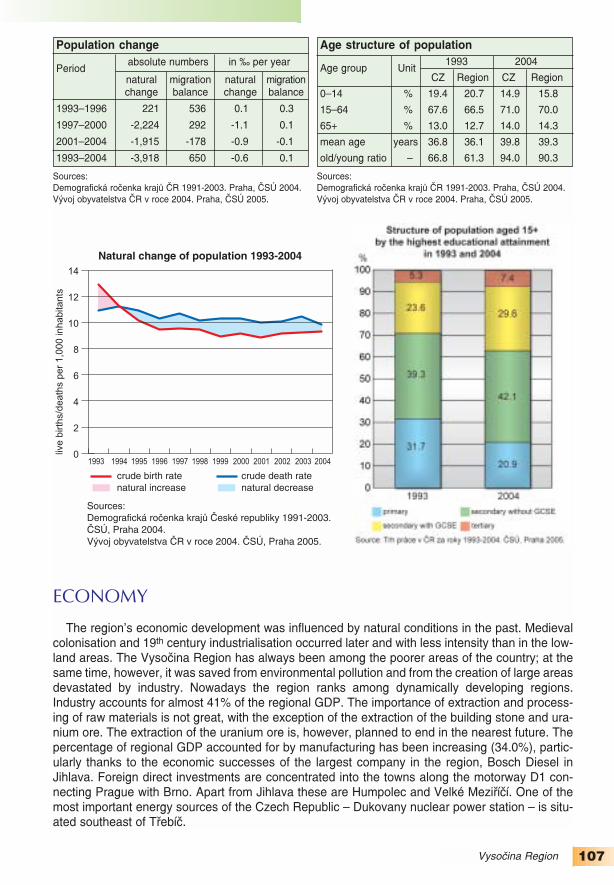
107Vysočina Region
ECONOMY
The region’s economic development was influenced by natural conditions in the past. Medievalcolonisation and 19th century industrialisation occurred later and with less intensity than in the low−land areas. The Vysočina Region has always been among the poorer areas of the country; at thesame time, however, it was saved from environmental pollution and from the creation of large areasdevastated by industry. Nowadays the region ranks among dynamically developing regions.Industry accounts for almost 41% of the regional GDP. The importance of extraction and process−ing of raw materials is not great, with the exception of the extraction of the building stone and ura−nium ore. The extraction of the uranium ore is, however, planned to end in the nearest future. Thepercentage of regional GDP accounted for by manufacturing has been increasing (34.0%), partic−ularly thanks to the economic successes of the largest company in the region, Bosch Diesel inJihlava. Foreign direct investments are concentrated into the towns along the motorway D1 con−necting Prague with Brno. Apart from Jihlava these are Humpolec and Velké Meziříčí. One of themost important energy sources of the Czech Republic – Dukovany nuclear power station – is situ−ated southeast of Třebíč.
1993 1994 1995 1996 1997 1998 1999 2000 2001 2002 2003 20040
2
4
6
8
10
12
14
live
birth
s/d
ea
ths
pe
r 1
,00
0 in
ha
bita
nts
Natural change of population 1993-2004
Sources: Demografická roèenka krajù Èeské republiky 1991-2003. ÈSÚ, Praha 2004.Vývoj obyvatelstva ÈR v roce 2004. ÈSÚ, Praha 2005.
crude birth rate crude death ratenatural increase natural decrease
Age structure of population
Age group Unit1993 2004
CZ Region CZ Region
0–14 % 19.4 20.7 14.9 15.8
15–64 % 67.6 66.5 71.0 70.0
65+ % 13.0 12.7 14.0 14.3
mean age years 36.8 36.1 39.8 39.3
old/young ratio – 66.8 61.3 94.0 90.3
Population change
Periodabsolute numbers in ‰ per year
natural migration natural migrationchange balance change balance
1993–1996 221 536 0.1 0.3
1997–2000 −2,224 292 −1.1 0.1
2001–2004 −1,915 −178 −0.9 −0.1
1993–2004 −3,918 650 −0.6 0.1
Sources:Demografická ročenka krajů ČR 1991−2003. Praha, ČSÚ 2004.Vývoj obyvatelstva ČR v roce 2004. Praha, ČSÚ 2005.
Sources:Demografická ročenka krajů ČR 1991−2003. Praha, ČSÚ 2004.Vývoj obyvatelstva ČR v roce 2004. Praha, ČSÚ 2005.

108 Vysočina Region
Agriculture is a traditional source of livelihood in the Vysočina Region. Agriculture and forestryaccount for 9.6% of the regional GDP, which is an unusual value compared with other regions.High employment in the primary sector (25 thousand, i.e. 10.4%) reflects this fact. The region leadsin the production of potatoes (34% of the Czech production) and in the livestock production (pigfarming). Meat processing plants are associated with the livestock production, the largest isKostelecké uzeniny.
Employers with the greatest number of employees in the Vysočina Region(civil sector only, as of December 31, 2003)
Employer Branch Emp.Bosch Diesel, Jihlava Production of accessories
for the car industry 4.5ŽĎAS, Žďár nad Sázavou Production of iron and steel 3.0České dráhy Railway transport 2.7Motorpal, Jihlava Production of accessories
for the car industry 2.0Sklo Bohemia, Světlá nad Sázavou Production of crystal glass 1.6Česká pošta State post 1.5ČEZ, Praha Electricity production 1.5Kostelecké uzeniny, Kostelec Production of meat products 1.3Nemocnice Jihlava Health care 1.3Pleas, Havlíčkův Brod Production of underwear 1.2Note: Emp. – number of employees in thousandsSource: CRR MU in Brno database, 2005.
Unemployment in 1993−2004
thousands
Source: Trh práce v ČR za roky 1993-2004. ČSÚ, Praha 2005.
number of the unemployed (in thousands)
general unemployment rate (%)
Structure of employment
by the basic sectors of economy
in 1993 and 2004thousands
I – agriculture, forestry and fishing II – industry and constructionIII – services
Source: Trh práce v ČR za roky 1993-2004. ČSÚ, Praha 2005.

109Vysočina Region
TOURIST ATTRACTIONS
Out of a number of monuments in the Vysočina Region, three of them are on the UNESCO’sWorld Heritage List. The town monument reserve of Telč (since 1992) consists of the historic coreof the town with late gothic fortification and gates. The square is surrounded by a unique set ofgothic and renaissance arcaded houses and renaissance, baroque and classical gables. The ren−aissance chateau dating from the 16th century dominates the town. The baroque pilgrimage churchof St. John of Nepomuk on the Zelená hora near Žďár nad Sázavou was inscribed on the list in1994. The town of Třebíč, another UNESCO heritage site since 2003, is known for its St.Procopius’ Basilica and the well−preserved Jewish ghetto and Jewish cemetery.
The historic cores of two other towns are protected as town monument reserves – Jihlava andPelhřimov. The centre of Jihlava is surrounded by the remnants of gothic city walls. Its under−ground has 25 km of tunnels.
The Vysočina Region is attractive all year round. It has good conditions for both summer andwinter recreation; it also has many valuable cultural and historic monuments. Nové Město naMoravě often hosts the world cup in nordic skiing.
Telč. (Photo: Irena Smolová)

110 Jihomoravský Region
Area: 7,196 sq kmPopulation: 1,130,240 (as of January 1, 2005)out of which
15,566 foreigners with temporary residence8,335 foreigners with permanent residence
Population density: 157.1 persons/sq kmNumber of municipalities: 672 (including
47 towns)Administrative centre: Brno (367.7 thousand
inhabitants, as of January 1, 2005)Other large towns:
Znojmo (35.2 thousand)Hodonín (26.3 thousand)Břeclav (25.7 thousand)Vyškov (22.3 thousand)Blansko (20.3 thousand)
JihomoravskýRegion
Source: Statistická ročenka půdního fondu ČR. ČÚZK, Praha 2005.
other areas8.0%
built−up areas2.0%
arable land50.3%
gardens, orchards, vineyards
5.9%
water bodies2.1%
forests27.8%
permanentgrassland
4.0%
Land Use(as of December 31, 2004)

111Jihomoravský Region
NATURAL ENVIRONMENT
The character of the landscape is determined by its location on the dividing line between twobasic geological systems: the Czech Massive and the Carpathians. The border between the twounits is formed by a wide belt of the Outer Carpathian depression comprising the Dyjsko−svrateckýand Dolnomoravský vales and Vyškovská Gate. The northern outlet of the Vienna Basin with richpetroleum and natural gas deposits stretches to the south−eastern part of the region.
The vales rank among the most fertile areas in the Czech Republic thanks to favourable climat−ic conditions and quality soils. Grapes and other thermophile plants are grown there. The borderareas are marked by dissected hilly terrain. A unique landscape is protected in the Bílé KarpatyPLA, which is also a UNESCO biosphere reserve together with the Pálava PLA, where karst land−forms of the Pavlovské Hills are protected.
The north−western part of the region is cmposed of the rocks of the Czech Massive and with itshigher altitude has a colder climate. This marks the edge of the Českomoravská and DrahanskáHighlands. The Moravian Karst is a part of the Drahanská Highland. It is one of the most importantkarst areas in Central Europe. The Moravian Karst PLA was established as early as in 1956 andcontains the longest cave system in the Czech Republic (the Amatérská Cave with a total lengthof almost 35 km). The landscape of the Českomoravská Highland is characterized by mildly undu−lating terrain with a mosaic of fields, forests and pastures dissected by the deep, prevailingly forest−ed valleys of the Svratka, Oslava, Jihlava, Rokytná, Jeviškovka, Dyje Rivers and their tributaries.A part of the Dyje River valley is protected as the Podyjí National Park for its outstanding land−scape and bilogical richness.
The whole region lies in the Morava River basin. Most of its territory is drained by its most impor−tant right bank tributary: the Dyje River. The lowest point in the terrain lies at the confluence of theDyje and Morava Rivers. A number of the river’s valleys have been transformed by the construc−
Share of the Jihomoravský Region in selected country statistical figures
area
forest area
arable land
population
persons aged 65+ 1)
persons with UE 2)
the unemployed 3)
GDP 4)
industry revenues
accomodation facilities 5)
share in the figure for the Czech Republic as a whole (%)
Notes: 1) 65+ – persons aged 65 or more2) UE – university level of education 3) the unemployed – number of economically active persons without employment 4) GDP – gross domestic product5) accomodation facilities – number of beds in touristic accomodation facilities
Data sources: ČSÚ (Czech Statistical Office) and ČÚZK (Czech Office for Surveying, Mapping and Cadastre).

112 Jihomoravský Region
tion of a system of dams – the Nové Mlýny Dams and the Vranovská Dam on the Dyje River andthe Brněnská Dam on the Svratka River.
POPULATION AND SETTLEMENT PATTERNS
In 1994 the number of deaths for the first time exceeded the number of births in the Jihočeský(South Moravia) Region, but due to the high active migration balance (2,010 persons) the regionhas not yet experienced a decrease in the number of inhabitants. The first decrease was experi−enced in 1995 and South Moravia continued to lose its population until 2002. The highest decreas−es were recorded in 2001 and 2002, when the region was losing population even through emigra−tion. In the following two years and during the first half of 2005 the population increased. The aver−age age of the population has increased from 37 years in 1993 to 40 in 2004; its position within theCzech Republic did not change (a higher average age was recorded in Prague and in the Plzeňskýand Královéhradecký regions). On the other hand the population of South Moravia stands out forits educational structure. The proportion of persons older than 14 years with GCSE and tertiaryeducation reached 42.4% in 2004 (only Prague experienced a higher value). Not only the educa−tional structure but also the age structure of the region is strongly influenced by the populationstructure of the city of Brno.
Almost one third of the population of the region lives in Brno, the second largest city of the CzechRepublic. Combined together the 47 towns of the region account for 62.8% of the population of theregion, which is one of the lowest values in the Czech Republic. Only 7.4% of the population livesin small municipalities of less than 500 inhabitants (322 municipalities). The region has a varied set−tlement structure. The South Moravian vales are typified by large rural settlements, often with sev−eral thousands inhabitants, situated at quite a distance from one another. In the Hodonín regionthere are even six municipalities with more than 3 thousand inhabitants without the status of thetown. The dissected Českomoravská Highland is characterized by a number of small settlementsnot farther than 2−3 km from one another. The Drahanská Highland is characterized by middle sizedsettlements, founded later probably due to higher altitude of the area. Since the middle of the 1990sthe process of suburbanisation has become a distinct phenomenon. It affects mainly the Brno hin−terland; the population for various reasons leaves the city and settles in neighbouring villages.
Brno. (Photo: DavidProcházka)

113Jihomoravský Region
ECONOMY
The economic structure of South Moravia changed considerably during the years 1993−2004.The decrease in workers in the production sector started after 1989. In agriculture the number ofemployees decreased from 44.9 thousand in 1993 to 22.8 thousand in 2004 (the proportion in thetotal employmed population is 4.5%, together with forestry and fishing it makes up 5.1%). The man−ufacturing industry experienced a decrease in the number of employees as well: from 164.4 thou−sand to 132.1 thousand (25,9%). On the other hand the number of employees in most branches ofthe tertiary sector increased. The highest absolute increase was recorded in trade and the highestrelative increase in the banking and insurance sector. The proportions of individual branches in thecreation of the gross added value changed as well. Agriculture and forestry accounts for 3.9% ofthe regional GDP (in the Czech Republic it is 3.3%), manufacturing for 23.6% (25.9% respective−ly). The structure of the gross added value of South Moravia differs from the structure of the CzechRepublic primarily in the building industry and commercial services. In the former (the buildingindustry) the proportion is 8% and it is the second highest figure in the Czech Republic after theLiberecký Region, in the latter (commercial services) the proportion is 15.7% and it is the secondhighest figure after Prague. In 2004 the per capita GDP in South Moravia reached 93.9% of the
1993 1994 1995 1996 1997 1998 1999 2000 2001 2002 2003 20040
2
4
6
8
10
12
14
live
birth
s/d
ea
ths
pe
r 1
,00
0 in
ha
bita
nts
Natural change of population 1993-2004
Sources: Demografická roèenka krajù Èeské republiky 1991-2003. ÈSÚ, Praha 2004.Vývoj obyvatelstva ÈR v roce 2004. ÈSÚ, Praha 2005.
crude birth rate crude death ratenatural increase natural decrease
Age structure of population
Age group Unit1993 2004
CZ Region CZ Region
0–14 % 19.4 19.5 14.9 14.7
15–64 % 67.6 66.8 71.0 70.7
65+ % 13.0 13.6 14.0 14.6
mean age years 36.8 37.0 39.8 40.0
old/young ratio – 66.8 69.8 94.0 99.1
Population change
Periodabsolute numbers in ‰ per year
natural migration natural migrationchange balance change balance
1993–1996 −6,094 5,428 −1.3 1.2
1997–2000 −9,815 5,439 −2.1 1.2
2001–2004 −6,966 2,135 −1.5 0.5
1993–2004 −22,875 13,002 −1.7 1.0
Sources:Demografická ročenka krajů ČR 1991−2003. Praha, ČSÚ 2004.Vývoj obyvatelstva ČR v roce 2004. Praha, ČSÚ 2005.
Sources:Demografická ročenka krajů ČR 1991−2003. Praha, ČSÚ 2004.Vývoj obyvatelstva ČR v roce 2004. Praha, ČSÚ 2005.

114
level of the Czech Republic and 67% of the level of the EU25. In the Czech Republic only Pragueshows higher figures but these are practically incomparable with other regions (201.8% and143.0%).
Agriculture has become less important for the economy of the region but still its position withinthe agriculture of the Czech Republic is often exceptional. The percentage of arable land reaches83.6% (the highest in the Czech Republic). The proportion of the crop area devoted to cereals is
Jihomoravský Region
Employers with the greatest number of employees in the Jihomoravský Region(civil sector only, as of December 31, 2003)
Employer Branch Emp.České dráhy Railway transport 7.7Fakultní nemocnice Brno Health care 4.7Česká pošta State post 4.5Masarykova univerzita, Brno Education 3.1Statutární město Brno Public administration 3.0Dopravní podnik města Brna, Brno City transport 3.0Fakultní nemocnice u sv. Anny, Brně Health care 2.6Vysoké učení technické, Brno Education 2.4Tyco Electronics Czech, Kuřim Production of electrical equipment
for cars 1.9Finanční ředitelství Public administration 1.8Note: Emp. – number of employees in thousands
Source: CRR MU in Brno database, 2005.
Unemployment in 1993−2004
thousands
Source: Trh práce v ČR za roky 1993-2004. ČSÚ, Praha 2005.
number of the unemployed (in thousands)
general unemployment rate (%)
Structure of employment
by the basic sectors of economy
in 1993 and 2004thousands
I – agriculture, forestry and fishing II – industry and constructionIII – services
Source: Trh práce v ČR za roky 1993-2004. ČSÚ, Praha 2005.

115Jihomoravský Region
66.9%, which is the second highest figure after the Ústecký Region. However, the area of theÚstecký Region is far smaller, therefore the yields of cereals in tons are double in South Moravia.91.6% of vineyards and 25.2% of orchards in the Czech Republic are concentrated in the region.The region is first in the level of pig breeding. On the other hand, the importance of industry of theregion has decreased considerably even within the Czech Republic. Afflicted was mainly machin−ery in Brno. While in Zetor (known for its production of tractors) and in Zbrojovka (production ofarmaments) more than 10 thousand workers were employed in 1989, at the end of 2004 there wasno factory in Brno with more than one thousand employees. The largest industrial employer wasthe electronics company of Tyco Electronics Czech. About 1.5 thousand workers are employed intwo manufacturing companies: the rubber making company of Gumotex in Břeclav and furnituremaking company of Tusculum in Rousínov. Companies active in the tertiary sector are by far thelargest employers in the region. The unemployment rate in South Moravia is higher than the nation−al average.
TOURIST ATTRACTIONS
The region includes the Podyjí National Park and the unique Moravian Karst with the famousMacocha Abyss and four accessible cave systems. Out of a number of attractive places twoUNESCO heritage sites – the Lednicko−valtický area and Villa Tugendhat in Brno – take excep−tional positions. Twenty historically important localities and buildings have the status of nationalcultural monuments. The centres of Brno, Znojmo and Mikulov are town monument reserves andother 11 were declared town monument zones. Rural architecture is valuable and attractive as well.The memorial battlefield zone near Slavkov (Austerlitz) enjoys a large numbers of foreign visitors.
Visitors from the Czech Republic and abroad are also attracted by important cultural, social,sports and trade events traditionally held in the region – the Brno international fairs, folklore festi−vals, athletics competitions, car races and others. The fair ground in Brno is the largest in theCzech Republic.
Hodonín has the status of a spa town, only recently Lednice and Pasohlávky in the Břeclavregion have acquired the status as well. Seasonal recreational boat transport is offered on theVranovská and Brněnská reservoirs and on the renewed Baťa’s Canal.
Lednice−Valticelandscape
area. (Photo:Irena Smolová)

116 Olomoucký Region
Area: 5,268 sq kmPopulation: 639,423 (as of January 1, 2005)
out of which 3,413 foreigners with temporary residence3,644 foreigners with permanent residence
Population density: 121.4 persons/sq kmNumber of municipalities: 397 (including 27 towns)Administrative centre: Olomouc (100.8 thousand,
as of January 1, 2005)Other large towns: Prostějov (47.2 thousand), Přerov
(46.9 thousand), Šumperk (28.5 thousand)
OlomouckýRegion
otherareas9.1%
built−up areas1.6%
arable land40.4%
gardens,orchards,
hop−gardens,vineyards
3.1%
water bodies1.1%
forests34.7%
Land Use(as of December 31, 2004)
permanent grassland10.0%
Source: Statistická ročenka půdního fondu ČR. ČÚZK, Praha 2005.

117Olomoucký Region
NATURAL ENVIRONMENT
The terrain of the northern part of the region is mountainous with the Jeseníky Mts. and its high−est peak of Praděd (1491 m a.s.l.). The southern part consists of the lowlands of Haná. The MoravaRiver forms the axis of the central and southern parts of the region. The Olomoucký Region lies onthe divide between the Czech Highland and the Western Carpathians and has varied environ−mental features. A larger part of the region belongs to the older Czech Highland with a typical blockstructure. The landscape was considerably transformed by continental and alpine glaciers duringthe early Quaternary Era. The central and south−eastern part of the region belongs to the OuterCarpathian depression.
A considerable altitudinal span is reflected in the character of the vegetation: from the alluvialforests of the Morava River floodplain to the sub−alpine vegetation above the timberline in theHrubý Jeseník Mts. The karst areas with five cave systems open to the public are unique in theregion. The longest cave system in the region is the Javoříčské Caves near Olomouc with rich drip−stone decoration. The hydrothermal Zbrašovské Aragonite Caves are the warmest in the CzechRepublic. The deepest abyss in the Czech Republic is situated in the region – the Hranická Abysshas been measured as being 274.5 m deep, but it is probably much deeper. The most valuablesegments of the landscape are protected by law. The remains of the alluvial forests along the cen−tral reaches of the Morava River have been protected since 1991 as the Litovelské PomoravíPLA. The mountain ecosystems with vast peat bogs have been protected since 1969 as theJeseníky PLA. Cryogenic landforms (such as tors or felsenmeers) are remarkable in the moun−tain range.
Share of the Olomoucký Region in selected country statistical figures
area
forest area
arable land
population
persons aged 65+ 1)
persons with UE 2)
the unemployed 3)
GDP 4)
industry revenues
accomodation facilities 5)
share in the figure for the Czech Republic as a whole (%)
Notes: 1) 65+ – persons aged 65 or more2) UE – university level of education 3) the unemployed – number of economically active persons without employment 4) GDP – gross domestic product5) accomodation facilities – number of beds in touristic accomodation facilities
Data sources: ČSÚ (Czech Statistical Office) and ČÚZK (Czech Office for Surveying, Mapping and Cadastre).

118 Olomoucký Region
POPULATION AND SETTLEMENT PATTERNS
The Olomoucký Region ranks among regions with a relatively high population decrease. Thepopulation decreased by 15 thousand between the years of 1993 and 2004. The yearly decreas−es often exceeded the level of one thousand persons thanks to unfavourable natural change andnegligible immigration. The age structure is slightly better than in the Czech Republic as a whole,thanks to a higher proportion of the age category of 0−14 years. The average age at the end of2004 was 39.6 years (in the Czech Republic it was 39.8 years). The proportion of persons with ter−tiary education and with GCSE does not reach the national average.
The average population density of 121 persons per 1 sq km approaches the national average.However, within the region there are distinct local differences. The Jeseník region has the lowestpopulation density (less than 60 persons/sq km). On the other hand, fertile vales have an above−average population density. Despite the fact that there are ten towns with more than 10 thousandinhabitants, including the administrative centre of Olomouc with 100 thousand inhabitants, the levelof urbanisation is not high. Only some 58% of the population lives in towns (in the Czech Republicas a whole it is 70.2%). Small municipalities with less than 500 inhabitants (180 municipalities)make up less than one half of all municipalities and 51.2 thousand persons lives there (8.1% of thepopulation).
ECONOMY
During the last five years the regional GDP per capita has been the lowest in the CzechRepublic. In 2004 it was 78% of the national average and only 55% of the EU25 average. Thestructure of gross added value in the region differs from the structure of the Czech Republic main−ly by the above−average proportion of the manufacturing industry, transport and communications,and health and social services. Thanks to the very fertile south and central parts of the region(Haná) the share of the primary sector is above−average. Fertile soils are used intensively forgrowing crops; the crop production dominates the agriculture of the region. Traditional sugar beetcultivation is important (one fourth of the production of the Czech Republic). Yields per hectare of
Horní náměstí(Upper Square) in Olomouc withthe Holy TrinityColumn and thegothic Town Hall,complementedwith a peculiarastronomicalclock. (Photo:Dušan Gavenda)

119Olomoucký Region
barley, wheat and rape are significantly above the national average as well. In the central part ofthe region (around Tršice) one of the hop growing areas is situated (one tenth of hop gardenacreage of the Czech Republic). Manufacturing of food products is interlinked with agriculture.Limestone and gravel sands are mined in the region.
The largest employer in the region is, as in other regions, České dráhy (Czech Railways).Other large employers include the teaching hospital and the second oldest university in theCzech Republic, Palacký University, both situated in Olomouc. Olomouc, Přerov, Mohelnice andProstějov are the industrial centres of the region. The largest industrial employer in the region,Oděvní podnik in Prostějov, is one of the most important European producers of men’s andwomen’s ready−made clothes. Traditional companies of UNEX in Uničov producing miningmachinery, MORA in Hlubočky producing domestic appliance (cookers, boilers), and new“green−field” investments rank among the largest companies. An example of such a “green−field”investment is LG.Phillips Displays CR, Ltd. in Hranice, a company producing TV displays, thelargest investment in the region which started its production in 2001. Siemens, investing inMohelnice, is another large employer in the region. The amount of foreign direct investments
1993 1994 1995 1996 1997 1998 1999 2000 2001 2002 2003 20040
2
4
6
8
10
12
14
live
birth
s/d
ea
ths
pe
r 1
,00
0 in
ha
bita
nts
Natural change of population 1993-2004
Sources: Demografická roèenka krajù Èeské republiky 1991-2003. ÈSÚ, Praha 2004.Vývoj obyvatelstva ÈR v roce 2004. ÈSÚ, Praha 2005.
crude birth rate crude death ratenatural increase natural decrease
Age structure of population
Age group Unit1993 2004
CZ Region CZ Region
0–14 % 19.4 20.0 14.9 15.1
15–64 % 67.6 67.3 71.0 70.9
65+ % 13.0 12.7 14.0 14.0
mean age years 36.8 36.3 39.8 39.6
old/young ratio – 66.8 63.8 94.0 92.9
Population change
Periodabsolute numbers in ‰ per year
natural migration natural migrationchange balance change balance
1993–1996 −1,933 1,693 −0.7 0.7
1997–2000 −4,554 608 −1.8 0.2
2001–2004 −3,133 −1,440 −1.2 −0.6
1993–2004 −9,620 861 −1.2 0.1
Sources:Demografická ročenka krajů ČR 1991−2003. Praha, ČSÚ 2004.Vývoj obyvatelstva ČR v roce 2004. Praha, ČSÚ 2005.
Sources:Demografická ročenka krajů ČR 1991−2003. Praha, ČSÚ 2004.Vývoj obyvatelstva ČR v roce 2004. Praha, ČSÚ 2005.

120
reached some USD 2,000 per capita by the end of 2003, which was one of the lowest rates inthe Czech Republic. This fact may have an influence on the low average wages in the region(lower wages are found only in the Karlovarský Region).
Olomoucký Region
Employers with the greatest number of employees in the Olomoucký Region(civil sector only, as of December 31, 2003)
Employer Branch Emp.České dráhy Railway transport 6.6Oděvní podnik, Prostějov Production of clothes 3.7Fakultní nemocnice Olomouc Health care 3.3Česká pošta State post 2.4Univerzita Palackého, Olomouc Education 2.3Siemens Elektromotory, Mohelnice Production of electromotors,
generators and transformers 1.9UNEX, Uničov Production of mining
and building machines 1.5Meopta Přerov Production of optical
and photographic appliances 1.4LG.Philips Displays, Hranice Production of electron tubes
and electrical components 1.3Mora Moravia, Hlubočky−Mariánské Údolí Production of domestic appliances 1.2Note: Emp. – number of employees in thousands
Source: CRR MU in Brno database, 2005.
Unemployment in 1993−2004
thousands
Source: Trh práce v ČR za roky 1993-2004. ČSÚ, Praha 2005.
number of the unemployed (in thousands)
general unemployment rate (%)
Structure of employment
by the basic sectors of economy
in 1993 and 2004thousands
I – agriculture, forestry and fishing II – industry and constructionIII – services
Source: Trh práce v ČR za roky 1993-2004. ČSÚ, Praha 2005.

121Olomoucký Region
TOURIST ATTRACTIONS
Five cave systems are open to the public: Javoříčské Caves, Mladečské Caves, ZbrašovskéAragonite Caves, Na Pomezí Caves, and Na Špičáku Caves. The castles of Bouzov, Helfštýn andthe chateaux in Šternberk, Úsov, Tovačov, Velké Losiny, Jánský vrch and Náměšť na Hané areamong the most frequented sites. Well−known pilgrimage sites are situated in the region, such asthe Basilica of Our Lady’s Visitation on Svatý Kopeček near Olomouc. Many folk traditions havebeen preserved in the region, brought closer to the public during several festivals, e.g. in Náměšťna Hané, Prostějov or Kojetín. Several ski resorts are frequently visited in the Jeseníky Mts., suchas the Červenohorské sedlo, Petříkov, Ostružná or Ramzová.
Two town monument reserves are to be found in the region: Olomouc and Lipník nad Bečvou.The former is the second largest in the Czech Republic. The streets following the medieval planare lined with baroque palaces and houses. The Holy Trinity column has been a UNESCO monu−ment since 2001. It is 35 m high and was erected in between the years of 1716−54, and is one ofthe last such columns built in the baroque style. The city walls were replaced by the green belt sur−rounding a large part of the historic core.
In Teplice nad Bečvou cardiovascular diseases are treated, Velké Losiny is known for its hotsulphur springs, Bludov and Slatinice have the status of spa towns. Jeseník has the status of aclimatic spa with the longest tradition of hydrotherapy in the world.
Pilgrimage basilica of Our Lady’s Visitation on the Svatý Kopeček hill. (Photo: Dušan Gavenda)

122 Zlínský Region
Area: 3,964 sq kmPopulation: 590,706 (as of January 1, 2005)
out of which3,429 foreigners with temporary residence2,943 foreigners with permanent residence
Population density: 149.0 person/sq kmNumber of municipalities: 304 (including
30 towns)Administrative centre: Zlín (78.6 thousand
inhabitants, as of January 1, 2005)Other large towns:
Kroměříž (29.0 thousand)Vsetín (28.4 thousand)Valašské Meziříčí (27.4 thousand)Uherské Hradiště (26.3 thousand)
ZlínskýRegion
Source: Statistická ročenka půdního fondu ČR. ČÚZK, Praha 2005.
otherareas7.9%
built−up areas1.8%
arable land31.8%
gardens, orchards, vineyards
3.5%
water bodies1.3%
forests39.6%
permanentgrassland
14.1%
Land Use(as of December 31, 2004)

123Zlínský Region
NATURAL ENVIRONMENT
The terrain of the Zlínský Region has a dissected character. It is mainly made up of uplandsand highlands. In the west of the region the fertile lowland Haná is situated. The MoravskoslezskéBeskydy Mts. stretch to the north part of the region. The mountain ranges in the eastern part formthe border with Slovakia – the Javorníky Mts. (with Velký Javorník, 1071 m a.s.l. as thehighestpeak) and the Bílé Karpaty Mts. (Velká Javořina, 970 m a.s.l.). The western part is transected bythe Morava River with partly preserved natural meanders, oxbows and alluvial forests. The riverflows through the wide depression of the Dolnomoravský Vale, which is the most fertile andwarmest part of the region. The mountainous parts of the region are plagued by landslides, main−ly in the flysch structures in the Vsetín and Zlín regions.
Almost one third of the region is made up of protected areas. Two landscape protected areasstretch into the region. The Beskydy PLA was declared in 1973 and is the largest PLA in theCzech Republic (1,160 sq km, the highest peak is Lysá hora, 1323 m a.s.l.). It protects vast virginforest complexes, pseudokarst phenomena or rock formations. The Bílé Karpaty PLA is also aUNESCO reserve. It is characterized by the Carpathian meadows and the harmonic cultural land−scape of the Czech−Slovak border.
Share of the Zlínský Region in selected country statistical figures
area
forest area
arable land
population
persons aged 65+ 1)
persons with UE 2)
the unemployed 3)
GDP 4)
industry revenues
accomodation facilities 5)
share in the figure for the Czech Republic as a whole (%)
Notes: 1) 65+ – persons aged 65 or more2) UE – university level of education 3) the unemployed – number of economically active persons without employment 4) GDP – gross domestic product5) accomodation facilities – number of beds in touristic accomodation facilities
Data sources: ČSÚ (Czech Statistical Office) and ČÚZK (Czech Office for Surveying, Mapping and Cadastre).

124 Zlínský Region
POPULATION AND SETTLEMENT PATTERNS
Since 1994, the population in the Zlínský Region has been decreasing. It is caused both by anatural decrease and since 2001 by a negative migration balance, therefore yearly populationdecreases have been rather high in recent years. In 2003 and 2004 the total population decreasewas greater than one thousand persons. However, during the first half of 2005 the populationdecrease was only 222 persons, which means that the negative trend of a deep decrease in thenumber of inhabitants was stopped. The age structure of the Zlínský Region is similar to otherregions in the Czech Republic. In 2004 the average age was 39.6 years (in the Czech Republic asa whole it was 39.8 years). The life expectancy of women reached 79.0 years (the average valueof the years of 2001 and 2002). Higher life expectancy in the Czech Republic was recorded onlythe Jihomoravský Region (by 0.2 year more). The life expectancy of men was the same as thenational value (72.1 years). The educational structure of the Zlínský Region is more favourable aswell. Even if the proportion of persons with tertiary education does not reach the republic average(the Zlínský Region 8.5%, the Czech Republic 9.9%), higher proportions are recorded only inPrague and the Jihomoravský, Plzeňský and Jihočeský regions. The Zlínský Region is character−ized by a high proportion of religious people (55.2%). The average for the whole Czech Republicis 32.1% and thus the Zlínský Region is the only region where the proportion of religious peopleexceeds half of the total population. In the Uherské Hradiště region, the number even reachesalmost two thirds. This fact is reflected positively in some population characteristics (low divorceand abortion rates).
The Zlínský Region, together with the Vysočina Region, rank among regions with most stablepopulation, i.e. with a high proportion of natives. The population density is above average as well.The population is concentrated in the fertile Moravian vales. The settlement structure is dominat−ed by the Zlín agglomeration with more than 100 thousand inhabitants. Otherwise the populationis concentrated mainly in middle sized and larger settlements. Only 5.5% of population lives insmall municipalities with less than 500 inhabitants (the third lowest proportion after theMoravskoslezský and Karlovarský regions). The proportion of urban population in the region is only61.2%, which is only a little more than in the “least urban regions” (the Olomoucký and Vysočinaregions). Nine towns with more than 10 thousand inhabitants are situated in the region.
The modern townof Zlín owes itsdevelopment tothe entrepreneurialactivities of Tomáš Baťa.(Photo: IrenaSmolová)

125Zlínský Region
ECONOMY
In the recent past the Zlínský Region was rightly considered an economically strong regionwith substantial concentration of large industrial companies, many of which were founded byTomáš Baťa (production of shoes, tyres, machine tools and airplanes). Products associated withsuch companies were traditionally produced in Zlín and its hinterland. During the 1990s the eco−nomically stable position of Zlín and of the whole of eastern Moravia started to change as a con−sequence of a slump in production in a number of formerly prosperous industrial branches (pro−duction of shoes experienced the most severe decline). Dynamic development of the region isimpeded by its peripheral location within the Czech Republic. The break up of Czechoslovakiahad negative impacts on the economic success of some industrial companies of the region, asmany such companies traded with Slovakia before the break up of the federation. Manufacturing,however, still plays the most important role in the regional GDP (38.5%, which is the secondhighest value in the Czech Republic after the Liberecký Region). Other branches of economymake up less than 10% od GDP, with the exception of trade (11.9%) and commerce services(11.7%).
1993 1994 1995 1996 1997 1998 1999 2000 2001 2002 2003 20040
2
4
6
8
10
12
14
live
birth
s/d
ea
ths
pe
r 1
,00
0 in
ha
bita
nts
Natural change of population 1993-2004
Sources: Demografická roèenka krajù Èeské republiky 1991-2003. ÈSÚ, Praha 2004.Vývoj obyvatelstva ÈR v roce 2004. ÈSÚ, Praha 2005.
crude birth rate crude death ratenatural increase natural decrease
Age structure of population
Age group Unit1993 2004
CZ Region CZ Region
0–14 % 19.4 20.1 14.9 15.0
15–64 % 67.6 67.4 71.0 70.7
65+ % 13.0 12.5 14.0 14.3
mean age years 36.8 36.3 39.8 39.6
old/young ratio – 66.8 62.1 94.0 95.6
Population change
Periodabsolute numbers in ‰ per year
natural migration natural migrationchange balance change balance
1993–1996 −1,799 2,416 −0.7 1.0
1997–2000 −4,126 1,813 −1.7 0.8
2001–2004 −3,464 −853 −1.5 −0.4
1993–2004 −9,389 3,376 −1.3 0.5
Sources:Demografická ročenka krajů ČR 1991−2003. Praha, ČSÚ 2004.Vývoj obyvatelstva ČR v roce 2004. Praha, ČSÚ 2005.
Sources:Demografická ročenka krajů ČR 1991−2003. Praha, ČSÚ 2004.Vývoj obyvatelstva ČR v roce 2004. Praha, ČSÚ 2005.

126 Zlínský Region
The proportion of agriculture and forestry in the gross added value is 3.9%, which is more thanthe national average. Agricultural land takes up 49.4% of the area of the Zlínský Region (in theCzech Republic it is 54.1%). The intensity of livestock and crop production is relatively lower. In
Employers with the greatest number of employees in the Zlínský Region(civil sector only, as of December 31, 2003)
Employer Branch Emp.Barum Continental, Otrokovice Production of rubber casings and tubes 3.9České dráhy Railway transport 2.9Baťova nemocnice Zlín Health care 2.0Aliachem 1), plants in Napajedla and Chropyně Production of basic chemicals 1.8Česká zbrojovka, Uherský Brod Production and repair of armaments
and ammunition 1.8ON Semiconductor Czech Republic, Production of electronicsRožnov pod Radhoštěm and electrical components 1.7TON, Bystřice pod Hostýnem Production of furniture 1.7TCT, Vidče Production of electrons
and electrical components 1.3MITAS 2), plants in Zlín and Otrokovice Production of rubber casings and tubes 1.2Delphi Czech Republic 3), plants in Production of electrical equipment Slušovice and Vizovice for cars 1.2Notes: 1) seat in Pardubice 2) seat in Prague 3) seat in Bakov nad JizerouEmp. – number of employees in thousandsSource: CRR MU in Brno database, 2005.
Unemployment in 1993−2004
thousands
Source: Trh práce v ČR za roky 1993-2004. ČSÚ, Praha 2005.
number of the unemployed (in thousands)
general unemployment rate (%)
Structure of employment
by the basic sectors of economy
in 1993 and 2004thousands
I – agriculture, forestry and fishing II – industry and constructionIII – services
Source: Trh práce v ČR za roky 1993-2004. ČSÚ, Praha 2005.

127Zlínský Region
2004 only 8 thousand persons were employed in agriculture. The largest employer was the indus−trial sector with 99.2 thousand workers. This fact was reflected in the top 10 regional employers –eight such employers belonged to the manufacturing industry.
The existing industrial potential of the region is based on the formerly key machine tool compa−nies. Manufacturing, chemical industry, rubber making and food processing are of considerableimportance. They still rank among the leading suppliers of consumer goods on the Czech market.The largest employer is the producer of tyres Barum Continental in Otrokovice.
TOURIST ATTRACTIONS
The region has very different conditions for tourist development. Kroměříž, a UNESCO heritagesite since 1998 and a town monument reserve, was the property of the bishops of Olomouc, whobuilt their summer residence there. Thanks to the number of monuments it is also sometimesreferred to as the Athens of Haná.
The largest spa in Moravia and the fifth largest in the Czech Republic – Luhačovice – is sit−uated in the region. Fifteen springs are used for the treatment of various diseases. The build−ings by Dušan Jurkovič give the town a distinct character. In addition to Luhačovice, OstrožskáNová Ves with sulphur springs used for the treatment of motor disorders has the status of aspa town.
One of the most frequented sites of the region is the open air folk museum in Rožnov podRadhoštěm, and recently the Baťa Canal, constructed between Otrokovice and Rohatec in 1936−38, has become a popular destination. It is used for recreational boating.
The most frequented castles and chateaux are Buchlov, Buchlovice, Valašské Meziříčí, Vsetínor Uherský Ostroh. The history of the pilgrimage site of Velehrad is connected with the arrival ofthe Slavic priests Constantine and Methodius to Moravia. Folk festivals take place regularly in theregion – Haná feast in Chropyně or the procession of king in Vlčnov.
Statues of preachers Constantine and Methodius on the top of Radhošť,
a pilgrimage mountain in the Beskydy Mts.
(Photo: Jan Kašpárek)

128 Moravskoslezský Region
Area: 5,428 sq kmPopulation: 1,253,257 (as of January 1, 2005)
out of which7,942 foreigners with temporary residence10,385 foreigners with permanent residence
Population density: 230.9 persons/sq kmNumber of municipalities: 299 (including
39 towns)Administrative centre: Ostrava (311.4 thousand
inhabitants, as of January 1, 2005)Other large towns: Havířov (84.8 thousand),
Karviná (63.4 thousand), Frýdek−Místek (59.9thousand), Opava (59.8 thousand), Třinec(38.2 thousand), Orlová (34.0 thousand),Nový Jičín (26.3 thousand), Český Těšín (26.1thousand), Krnov (25.4 thousand), Kopřivnice(23.4 thousand), Bohumín (23.1 thousand)
MoravskoslezskýRegion
Source: Statistická ročenka půdního fondu ČR. ČÚZK, Praha 2005.
otherareas8.9%
built−up areas2.2%
arable land32.2%
gardens,orchards
3.3%
water bodies2.0%
forests35.5%
permanentgrassland
15.9%
Land Use(as of December 31, 2004)

129Moravskoslezský Region
NATURAL ENVIRONMENT
The western part of the region is formed by the Hrubý Jeseník Mts. with the highest peak ofPraděd (1491 m a.s.l.). In 1969 the Jeseníky PLA was declared. The upper parts of the mountainregion are formed by peneplain with numerous peat bogs and cryogenic landforms (tors, cryopla−nation terraces). To the east the Hrubý Jeseník Mts. pass into the lower Nízký Jeseník Mts., wherethe water courses cut deeply. Landform types are enriched by several volcanic cones, which wereactive as early as in the older Quaternary. The largest of them, the stratovolcano of Velký Rudný(780 m a.s.l.) looms over the Slezská Harta Dam.
The central part of the region is characteristic of the densely populated lowlands of the MoravianGate, the Ostrava Basin and the Opava Lowland. Towards the east the terrain is again mountain−ous and on its eastern border with Slovakia the Moravskoslezské Beskydy Mts. are situated withLysá hora (1323 m a.s.l.) with numerous pseudokarst phenomena and vast virgin forest complex−es. The protected mountain range is known as the Beskydy PLA, with its 1,160 sq km being thelargest PLA in the Czech Republic. The Beskydy are also an important reservoir of drinking andservice water for the Ostrava agglomeration. The north−eastern border is formed by the SlezskéBeskydy Mts. with Velká Čantoryje (995 m a.s.l.).
The Odra River, the axis of the Moravskoslezský Region, starts in the Nízký Jeseník Mts. andflows through the Moravian Gate towards the Ostrava Basin, where several important tributariesfrom the Jeseníky and Beskydy Mts. run into it. In the Nízký Jeseník Mts and in part of the MoravianGate the Odra River has preserved its natural character with meandering parts and remains of thealluvial forests and wetlands, which have been protected since 1991 as the Poodří PLA. In theOstrava Basin the Odra River is affected by the sewage water. In the Odra River drainage basinseveral dams were constructed in order to supply factories with water (the Kružberk, SlezskáHarta, Olešná, Žermanice, Těrlicko dams). The natural potential of the region is enhanced bydeposits of hard coal, natural gas, limestones, marble and gravel sands.
Share of the Moravskoslezský Region in selected country statistical figures
area
forest area
arable land
population
persons aged 65+ 1)
persons with UE 2)
the unemployed 3)
GDP 4)
industry revenues
accomodation facilities 5)
share in the figure for the Czech Republic as a whole (%)Notes: 1) 65+ – persons aged 65 or more2) UE – university level of education 3) the unemployed – number of economically active persons without employment 4) GDP – gross domestic product5) accomodation facilities – number of beds in touristic accomodation facilities
Data sources: ČSÚ (Czech Statistical Office) and ČÚZK (Czech Office for Surveying, Mapping and Cadastre).

130 Moravskoslezský Region
POPULATION AND SETTLEMENT PATTERNS
The Moravskoslezský (Moravian−Silesian) Region ranks among regions with decreasing popu−lation. From 1993 to 2004 the number of inhabitants decreased by almost 36 thousand (by 2%),which was the second highest decrease in the Czech Republic after Prague. Permanent popula−tion decrease was caused not only by natural decrease but also by the prevalence of emigrationover immigration. The highest decrease by natural change occurred in 2003 (1,830 persons) andthe highest decrease by emigration in 2001 (2,086 persons). The negative migration balance wasone of the reasons for the lower intensity of housing construction in the region. The number of fin−ished flats per 10 thousand inhabitants in 2004 reached 15.9 (fewer flats were finished only in theÚstecký Region). The decrease in infant mortality is viewed positively, but its level is still abovethe national average. The Moravskoslezský Region was marked in the past by a higher propor−tion of children and youth. During recent years the age structure of the region has started toresemble the structure of the Czech Republic. The average age of the population in the region in2004 reached 39.1 years, which was only by 0.7 year less than the national average. In 1993 theMoravskoslezský Region ranked second (after the Ústecký Region) in the lowest proportion ofpersons with GCSE or tertiary education. This proportion was 28.7%. In 2004 this figure increasedto 36.1% and thus the Moravskoslezský Region’s position was taken over by the KarlovarskýRegion (34.9%).
The population in the region is distributed very unequally. The Jeseníky and Beskydy mountainranges are very scarcely populated; on the other hand, the Ostrava Basin is densely populated.The settlement structure is marked by a minimum representation of small municipalities with lessthan 500 inhabitants, where around 2% of the population lives. Almost two thirds (62%) of the pop−ulation live in towns with more than 20 thousand inhabitants; every fourth inhabitant lives in theregional capital of Ostrava. The settlement structure is dominated by relatively large towns, 5 of
them have more than 50 thousand inhab−itants (comparable to the ÚsteckýRegion). Sixteen towns have more than10 thousand inhabitants. The averagearea of municipalities (18.1 sq km) is verylarge in the Czech Republic – with regardto the national average the value is high−er by almost a half.
The New Town Hall in Ostrava. (Photo: Dušan Gavenda)

131Moravskoslezský Region
ECONOMY
Manufacturing accounts for the largest proportion in the GDP of the Moravskoslezský Region(31.6%). In the structure of the GDP the remaining basic industrial branches are significantly repre−sented: both the processing of raw materials and the production and distribution of electricity. Theproportion of agriculture is very low (2.1%), the lowest in the Czech Republic after Prague and theLiberecký Region. The Ostrava Basin with deposits of top quality hard coal, metallurgy and heavymachinery is the industrial centre of the region. The largest employer of the region is the mining com−pany of OKD, which nowadays employs far fewer workers than at the end of the 1980s. The region,as the republic metallurgy centre, accounts for 100% of the production of raw iron, 92% of the pro−duction of steel and 98% of the production of coke. The largest metallurgical company in the CzechRepublic is Mittal Steel Ostrava (formely ISPAT Nová huť), other companies with metallurgical tradi−tion are Třinecké železárny and ŽDB Bohumín. Despite a slump in the mining industry, more than onethird of the economically active population works in mining and metallurgy. Energetics and the chem−ical industry take an important position in the region. Important chemical companies are located inOstrava, Bohumín, Paskov and Odry. Metallurgy is largely linked with machinery. Autopal Nový Jičín,a producer of car lighting systems, cooling appliances and air−conditioning components ranks amongregion’s largee companies in terms of the number of employees, output, export and production.
1993 1994 1995 1996 1997 1998 1999 2000 2001 2002 2003 20040
2
4
6
8
10
12
14
live
birth
s/d
ea
ths
pe
r 1
,00
0 in
ha
bita
nts
Natural change of population 1993-2004
Sources: Demografická roèenka krajù Èeské republiky 1991-2003. ÈSÚ, Praha 2004.Vývoj obyvatelstva ÈR v roce 2004. ÈSÚ, Praha 2005.
crude birth rate crude death ratenatural increase natural decrease
Age structure of population
Age group Unit1993 2004
CZ Region CZ Region
0–14 % 19.4 20.5 14.9 15.5
15–64 % 67.6 68.3 71.0 71.6
65+ % 13.0 11.2 14.0 12.9
mean age years 36.8 35.6 39.8 39.1
old/young ratio – 66.8 54.8 94.0 83.5
Population change
Periodabsolute numbers in ‰ per year
natural migration natural migrationchange balance change balance
1993–1996 886 −1,510 0.2 −0.3
1997–2000 −5,649 −3,697 −1.1 −0.7
2001–2004 −6,412 −5,684 −1.3 −1.1
1993–2004 −11,175 −10,891 −0.7 −0.7
Sources:Demografická ročenka krajů ČR 1991−2003. Praha, ČSÚ 2004.Vývoj obyvatelstva ČR v roce 2004. Praha, ČSÚ 2005.
Sources:Demografická ročenka krajů ČR 1991−2003. Praha, ČSÚ 2004.Vývoj obyvatelstva ČR v roce 2004. Praha, ČSÚ 2005.

132
The structure of the branches of economy in the Moravskoslezský Region is a source of severeproblems, especially a high unemployment rate, which is the second highest in the CzechRepublic. Particularly long−term unemployment is a problem as well as unfortunate ratio betweenthe number of unemployed and the number of vacancies. Presently the region is not linked to themotorway system, which is another handicap of the region.
Moravskoslezský Region
Employers with the greatest number of employees in the Středočeský Region(civil sector only, as of December 31, 2003)
Employer Branch Emp.OKD, Ostrava Hard coal extraction 17.5ISPAT Nová huť, Ostrava 1) Production of iron and steel 11.2České dráhy Railway transport 8.7Třinecké železárny, Třinec Production of iron and steel 5.8Česká pošta State post 5.1Autopal, Nový Jičín Production of accessories
for the car industry 4.1Českomoravské doly, Kladno Hard coal extraction and production
of hard coal briquettes 3.5Fakultní nemocnice s poliklinikou, Ostrava Health care 3.4Statutární město Ostrava Public administration 3.0Vítkovice Strojírenství, Ostrava 2) Heavy machinery 3.0Notes: 1) presently Mittal Steel Ostrava 2) presently Vítkovice Heavy Machinery, OstravaEmp. – number of employees in thousands
Source: CRR MU in Brno database, 2005.
Unemployment in 1993−2004
thousands
Source: Trh práce v ČR za roky 1993-2004. ČSÚ, Praha 2005.
number of the unemployed (in thousands)
general unemployment rate (%)
Structure of employment
by the basic sectors of economy
in 1993 and 2004thousands
I – agriculture, forestry and fishing II – industry and constructionIII – services
Source: Trh práce v ČR za roky 1993-2004. ČSÚ, Praha 2005.
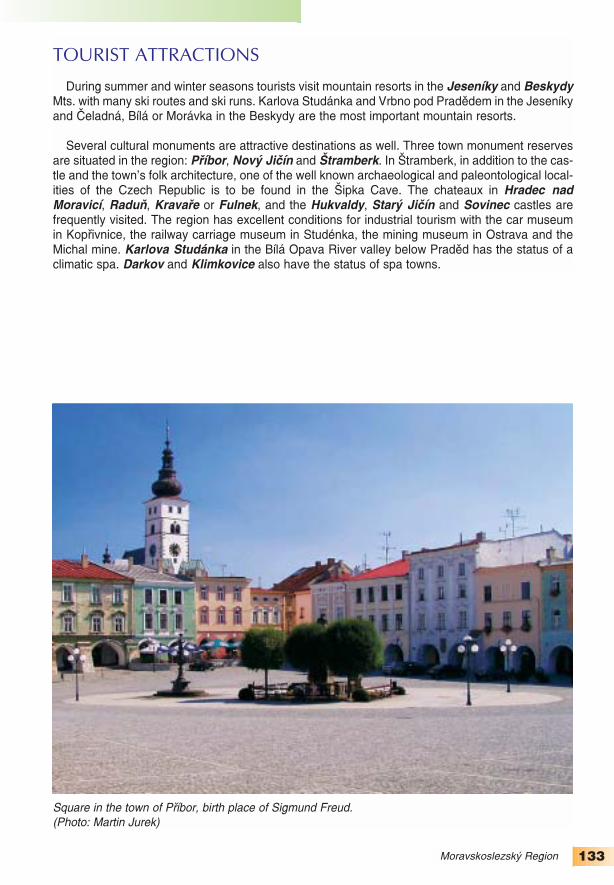
133Moravskoslezský Region
TOURIST ATTRACTIONS
During summer and winter seasons tourists visit mountain resorts in the Jeseníky and BeskydyMts. with many ski routes and ski runs. Karlova Studánka and Vrbno pod Pradědem in the Jeseníkyand Čeladná, Bílá or Morávka in the Beskydy are the most important mountain resorts.
Several cultural monuments are attractive destinations as well. Three town monument reservesare situated in the region: Příbor, Nový Jičín and Štramberk. In Štramberk, in addition to the cas−tle and the town’s folk architecture, one of the well known archaeological and paleontological local−ities of the Czech Republic is to be found in the Šipka Cave. The chateaux in Hradec nadMoravicí, Raduň, Kravaře or Fulnek, and the Hukvaldy, Starý Jičín and Sovinec castles arefrequently visited. The region has excellent conditions for industrial tourism with the car museumin Kopřivnice, the railway carriage museum in Studénka, the mining museum in Ostrava and theMichal mine. Karlova Studánka in the Bílá Opava River valley below Praděd has the status of aclimatic spa. Darkov and Klimkovice also have the status of spa towns.
Square in the town of Příbor, birth place of Sigmund Freud. (Photo: Martin Jurek)

134
LITERATURE
BIČÍK, I. a kol.: Druhé bydlení v Česku. Univerzita Karlova, Praha 2001, 167 s.
CULEK, M. a kol.: Biogeografické členění České republiky. Agentura ochrany přírody a krajiny ČR,Praha 2005, 590 s.
CZUDEK, T.: Reliéf Moravy a Slezska v kvartéru. SURSUM, Tišnov 1997, 213 s.
CZUDEK, T.: Vývoj reliéfu krajiny České republiky v kvartéru. Moravské zemské muzeum, Brno 2005,238 s.
DEMEK, J.: Geomorfologie českých zemí. Nakladatelství ČSAV, Praha 1965, 335 s.
DEMEK, J. (ed.): Zeměpisný lexikon ČSSR. Hory a nížiny. Academia, Praha 1987, 584 s.
DEMEK, J., NOVÁK, V. a kol.: Vlastivěda moravská. Neživá příroda. Muzejní a vlastivědná společnostv Brně, Brno 1992, 242 s.
DVOŘÁK A., NOUZA, R.: Ekonomika přírodních zdrojů a surovinová politika. Vysoká škola ekonomickáa Oeconomica, Praha 2002, 164 s.
HAMPL, M. a kol.: Geografická organizace společnosti a transformační procesy v České republice. PřFUK, Praha 1996, 341 s.
HAMPL, M. a kol.: Regionální vývoj: specifika české transformace, evropská integrace a obecná teorie.PřF UK, Praha 2001, 428 s.
HÄUFLER, V.: Ekonomická geografie Československa, Academia, Praha 1984, 639 s.
CHLUPÁČ, I. a kol.: Geologická minulost České republiky. Academia, Praha 2002, 436 s.
CHYTRÝ, M., KUČERA, T., KOČÍ, M. (ed.): Katalog biotopů České republiky. Agentura ochrany přírodya krajiny ČR, Praha 2003, 304 s.
JANČÁK, V., GÖTZ, A.: Územní diferenciace českého zemědělství a její vývoj, PřF UK, Praha 1997, 81 s.
JANSKÝ, B., ŠOBR, M. a kol.: Jezera České republiky. Univerzita Karlova, Praha 2003, 216 s.
KOMÁREK, V. a kol.: Prognóza a program. Academia, Praha 1990, 319 s.
KUžVART, M. (ed.): Ložiska nerudních surovin ČR II. Univerzita Karlova, Praha, 1992, 631 s.
MACKOVČIN, P., SEDLÁČEK, P. (ed.): Chráněná území ČR. Svazek I – XIV, Praha: Agentura ochranypřírody a krajiny, 2002–2005.
MACHONIN, P., TUČEK, M. a kol.: Česká společnost v transformaci. Sociologické nakladatelství, Praha1996, 364 s.
MAKARIUS R. (ed.): Hornická ročenka 2003. Český báňský úřad, vydavatelství Montanex, Ostrava2004, 294 s.
MAKARIUS R. (ed.): Hornická ročenka 2004. Český báňský úřad, vydavatelství Montanex, Ostrava2005, 300 s.
MOLDAN, B. a kol.: Životní prostředí České republiky: Vývoj a stav do konce roku 1989. Academia,Praha 1990, 281 s.
NEČAS, C.: Romové v České republice včera a dnes. Univerzita Palackého v Olomouci, Olomouc 2002,129 s.
PAVLÍK, Z. a kol.: Populační vývoj České republiky 1990–2002. DemoArt, Praha 2002, 98 s.
QUITT, E.: Klimatické oblasti ČSSR. Studia Geographica 16: 1–79, GgÚ ČSAV, Brno 1971, 73 s.
REICHMANN, F. (ed.): Horninové prostředí ČR – jeho stav a ochrana. Český geologický ústav, Praha2000, 189 s.
ŘEHÁK, S.: Aktuální problémy ČR – 6. díl – Doprava. Schola forum, Ostrava 1997, 25 s.
SPĚVÁČEK, V. a kol.: Transformace české ekonomiky: politické, ekonomické a sociální aspekty. Linde,Praha 2002, 525 s.

135
SRHOLEC, M.: Přímé zahraniční investice v České republice. Linde, Praha 2004, 171 s.
STARÝ, J., KAVINA P. (ed.): Surovinové zdroje České republiky. Ministerstvo životního prostředí, Českágeologická služba−Geofond, Praha 2004, 204 s.
SZCZYRBA, Z.: Maloobchod v České republice po roce 1989 – vývoj a trendy se zaměřením nageografickou organizaci. Univerzita Palackého v Olomouci. Olomouc 2005, 145 s.
ŠIŠKOVÁ, T. (ed.): Menšiny a migranti v České republice. Portál, Praha 2001, 188 s.
ŠVEJNAR, J. a kol.: Česká republika a ekonomická transformace ve střední a východní Evropě.Academia, Praha 1997, 359 s.
TOMÁŠEK, M.: Půdy České republiky. Česká geologická služba, Praha 2003, 67 s.
TOUŠEK, V., VANČURA, M.: Aktuální problémy ČR: Díl 1, Průmysl. Scholaforum, Ostrava 1996, 25 s.
VEČERNÍK, J. (ed.): Zpráva o vývoji české společnosti 1989–1998. Academia, Praha 1998, 364 s.
VITURKA, M. a kol.: Regionální vyhodnocení kvality podnikatelského prostředí v České republice. ESFMU, Brno 2003, 141 s.
VLČEK, V. (ed.): Zeměpisný lexikon ČSSR. Vodní toky a nádrže. Academia, Praha 1984, 315 s.
SOURCES
Analýza stavu maloobchodní sítě na území ČR. ČSÚ, Praha 2000.
Cestovní ruch 2000–2005. ČSÚ, Praha 2005.
Cizinci v České republice 2004. ČSÚ, Praha 2005.
Časové řady základních ukazatelů statistiky práce 1948–2003. ČSÚ, Praha 2004.
Česká republika v číslech 2005. ČSÚ, Praha 2005.
Databáze CRR MU v Brně, 2005.
Databáze Českého báňského úřadu a Těžební unie, 2005.
Definitivní údaje o sklizni zemědělských plodin za rok 2004. ČSÚ, Praha 2005.
Demografická příručka 2004. ČSÚ, Praha 2005.
Demografická ročenka krajů České republiky 1991–2003. ČSÚ, Praha 2005.
Hrubá zemědělská produkce za rok 2004. ČSÚ, Praha 2005.
Informace o životním prostředí v ČR (1999–2004). ČSÚ, Praha 2005.
Kapacita hromadných ubytovacích zařízení cestovního ruchu k 31. 12. 2004. ČSÚ, Praha 2005.
Kraje České republiky 2003. ČSÚ, Praha 2004.
Měsíční výkazy zaměstnanosti k 31. 9. 2005. MPSV ČR, Praha 2005.
Náboženské vyznání obyvatelstva. ČSÚ, Praha 2003.
Národnostní složení obyvatelstva. ČSÚ, Praha 2003.
Okresy České republiky za rok 2004. ČSÚ, Praha 2005.
Počet obyvatel v obcích České republiky k 1. 1. 2005. ČSÚ, Praha 2005.
Pohyb obyvatelstva v ČR za rok 2004. ČSÚ, Praha 2005.
Projekce obyvatelstva ČR do roku 2050. ČSÚ, Praha 2003.
Regionální národní účty 2004. ČSÚ, Praha 2005.
Regionální portréty. ČSÚ, Praha 2005.
Seznam zvláště chráněných území ČR. Agentura ochrany přírody a krajiny ČR, Praha 2005.

136
Souhrnná zpráva 2004, Ministerstvo zemědělství ČR, Praha 2005.
Soupis ploch osevů k 31. 5. 2005. ČSÚ, Praha 2005.
Sčítání lidu, domů a bytů k 1. 3. 2001, dojížďka a vyjížďka. ČSÚ, Olomouc 2004.
Statistická ročenka České republiky 2004. ČSÚ a Scientia Praha 2004.
Statistická ročenka půdního fondu České republiky. Český úřad zeměměřičský a katastrální, Praha2005.
Statistický lexikon obcí České republiky 2005. ČSÚ a Ministerstvo vnitra ČR, Ottovo nakladatelství,Praha 2005.
Trh práce v ČR za roky 1993−2004. ČSÚ Praha 2005.
Věkové složení obyvatelstva ČR v roce 2004. ČSÚ, Praha 2005.
Vývoj obyvatelstva ČR v roce 2004. ČSÚ, Praha 2005.
Zaměstnanost a nezaměstnanost v České republice podle výsledků výběrového šetření pracovních silza 4. čtvrtletí 2004. ČSÚ, Praha 2005.
Zemědělství 2004. Ministerstvo zemědělství ČR, Praha 2005.
Zpráva o stavu lesa a lesního hospodářství ČR. Ministerstvo zemědělství ČR, Praha 2004.
AUTHORS OF PHOTOGRAPHS
Cover: Jan Kašpárek (alluvial forest in Poodří)Vítězslav Válka (Prague astronomical clock)Werner Braun (Telč)
Imprint: Dušan Gavenda (Petřín outlook tower)
pp. 48−49: Dušand Gavenda (autumn on Velký Kosíř, town square in Nový Jičín)