d-a124 498 the foote house rn historic ...d-a124 498 the foote house (is-ar-96) rn historic...
TRANSCRIPT

D-A124 498 THE FOOTE HOUSE (iS-AR-96) RN HISTORIC ARCHAEOLOGICAL 1/2COMPLEX IN THE BOISE RIVER CANYON IDAHO(U) IDAHO UNIVNOSCON LAB OF ANTHROPOLOGY R KNUDSON ET AL. 1982
UNCLSSIFIED DACM68-77-C-085 F/G 5/1 N
m||||||EE||iII uuuuun|nu..uo|m1Dh||1|im|M|I-.-m||hhBhhE
I mmmmmmu|mui|iI flfflffllfllfflffl

, . 1 . . . i . i . , L . _ - , , . , . . . . ,1 - - . ' - -' - . . r --.. , ; : : .---*r . -w r -: . - . - . -.
.77.
I I
1 1.
t: .MICROCOPY RESOLUTION TEST CHART
! .,.! NAIONAL BUREAU OF STANDARDS-1963-A
.7.4

0) THE FOOTE HOUSE (1O-AA-96), AN HISTORIC ARCHAEOLOGICAL COMPLEX
K IN THE BOISE RIVER CANYON, IDAHO
by
Ruthann Knudson, Timothy W. Jones, and Robert Lee Sappington
let
4UNIVERSITY OF IDAHO ANTHROPOLOGICAL RESEARCH MANUSCRIPT SERIES, NO. 72
0... ~Laboratory of Anthropology 98
University of Idaho
LUMo scowE
1982
C..2
4 djxtribw-'oan L jxiit"d

'4 i TY CL ASIF ICA' T F Tw_' .5 E 1;4 ra- F., ... d) -- .-
___RULOi COCUMENTATICN4 PAGE ___- BEcREDIN 'P!1:!,),14S
1. (EPRT NUMB9ER OVT ACCESSION NO. 3. RECIPIENT'SCATAt 'NG R
4. TITLE (w.id Subtitle) S. TYPE OF REPORT & PER;OD COVi7RFD
I' Foote Poase (l0-A .- 6) An iStor-LC
Archiaeolooical 0c-,)ex in thie 1soise r .-,-.on, Final PRe- OrtL~~aao. 6. PERFORMING RPOT UME
7. AUTHOR(.) 8. CONTRACT OR GRANT NUMBER ()
Puthann K~nudson, Ti7-,othy 1W. Jone's, andRo'uart Lee Sappington DA~:37-C-0Y35
9. PERFORMING ORGANIZATION NAME AND ADDRESS 10. PROGRAM ELEMENT. PROJECT. TASKAREA & WORK UNIT NUMBERS
Laboratory of Antliro'pologyUniversity of Ili'ho'-Oscow,_Idaho 33343______________
III. CONTROLLING OFFICE NAME AND ADDRESS 12. REPORT DATE
U.S. Army Corps of Engineers, Tal alla District 1982Bidg. 602, City-County Airport 13. NUMBER OF PAGES
'1alla Walla, !,-A 99362 9514. MONITORING AGENCY NAME & ADDRESS(I1 different from Controlling* Office) I5. SECURITY CLASS. (of this report)
Unclass ifijedI~.DECLASSIFICATIN 'DOWNGRADING-
SCHEDULE
16. DISTRIBUTION STATEMENT (of this Report)
Approved for public release; distribution unlimiited.17. DISTRIBUTION STATEMENT (of the abstract entered in Block 20, it different from Report)
Approved for public release; distribution unlimnited.1S. SUPPLEMENTARY NOTES
19. KEY WORDS (Continue on reverse side it necessary and Identify by block number)
Froote '!ouse -_ary hal Lock Foote,listoric arc: aeolo-ical coiaplex I~alho iniiw andc IrrP-a tion Coimpaayarcal4tecture 73oise River CanvonArthtur De '..it F7oote Lticky reali Damn
20. ABSTRACT (Continue on reverse side If necowsary and Identify by block number)
A re port on the archival research and test c.:cnvations conducted on the ",iSLoriCFoote Ilouse site. Ttie archival record suip1::-cteac with arch~aeological daitaindicates that the site is a significant historic relinant. T1he Foote iioase ispresently conser-ved in ?lace and is th-e pre[flrred r,.anagerient techniql.e forotilePresent time. Consideration is given' to thae po,-sible partiai develop,).ont ofthe area in the form of a sm~all interprttive center.,,-_
DD IA M 7 3 1413 EDITION OF NOV 65 IS OBSOLETE
SECURITY CLASSIFICATION OF THIS PAGE t1N7-,Do! 17a? '.d)
THE FOOTE HOUSE (10-AA-96), AN HISTORIC ARCHAEOLOGICAL COMPLEX
*; IN THE BOISE RIVER CANYON, IDAHO
by
Ruthann Knudson, Timothy W. Jones, and Robert Lee Sappington
A Report in Fulfillment of Contract No. DACW68-77-C-0085,U.S. Army Corps of Engineers, Walla Walla District
UNIVERSITY OF IDAHO ANTHROPOLOGICAL RESEARCH MANUSCRIPT SERIES, NO. 12
S Accession For
Ob NTIS GRA&I
o DTIC TAB E
I'.I
Unannounced ELaboratory of Anthropology Justification
University of Idaho By - -_____
Distribift ionMoscow Availability Codes
!Avn i o1982DistI Spec ial
,..°" .S.Ary C rps ofEng nee sWal a W ll D i r:i .

ABSTRACT
The Foote House site (10-AA-96) is located in the Boise River Canyonsome ten miles upriver from the city of Boise, and is an architectural andarchaeological remnant of late nineteenth century life in that area. TheN first recorded occupation of the site was prior to 1882, by a miner namedLytell who built a frame cabin there. In late 1882 the water rights wereacquired by Arthur De Wint Foote, who patented the property in 1919 andapparently sold it in the mid-1920s. The property was deserted and all itsstructures dismantled by 1949. The site appears to represent two periods ofoccupation, one in the 1800s and the other in the 1910s to 1920s. Of mostsignificance is the earlier of these inhabitations by the Foote family andthe Idaho Mining and Irrigation Company.
Foote was Chief Engineer for the Idaho Mining and Irrigation Company,who envisaged and initiated the development of the broad Boise Valleyirrigation project but was never able to raise the capital to keep theventure going. When the Company ran into financial problems in 1885, Footemoved his family and company field headquarters to the 10-AA-96 property.Here, he built a moderately sized bungalow of basalt blocks and his owncement, with two-foot thick walls, deep verandas, and large open fireplacesinside. The Lytell cabin became a workshop, and other outbuildings andgardens were constructed. The stone structure housed A. D. Foote, his wifeMary Hallock Foote, their three children, the IMIC engineer Tompkins, andthe children's governess and nurse. There was also a Chinese cook, whoapparently lived in an outbuilding. Mary Hallock Foote was a writer andillustrator of national prominence, who continued to compose her creativework throughout their stay in the house. The house construction was
* completed in December 1885, was occupied by the entire family until spring1889 when they moved into Boise, and was then reused as the IMIC fieldheadquarters during 1890 and early 1891 when the company was heavilyinvolved in construction of the New York Canal.
There is a significant archival record of the architecture, functions,and inhabitants of the Foote House site, and that is now supplemented witharchaeological data which indicate that the site is a significant historicremnant. Thus it appears eligible for nomination to the National Registerof Historic Places and merits affirmative management from the owners, theU.S. Government.
~iii
. ,.
i . : : .. .

• • • -. . . - . - • . . ' . . - %'
p MANAGEMENT SUMMARY
Though the Foote House archaeological site (10-AA-96) was originallyinvestigated because of proposed U.S. Army Corps of Engineers constructionin the site area, such construction plans have now been discarded. The sitedoes appear to be eligible for nomination to the National Register ofHistoric Places. It is currently backfilled and conserved in place, and isnot being significantly vandalized. This conservation is the scientificallypreferable management technique, though it merits regular monitoring.Further, a 1974 Corps of Engineers recommendation of a developed
recreational facility focused around the Foote House is appropriate.Inclusion of an historic interpretive device in such a facility, withinformation about the prehistoric Lydle Gulch site as well as its companionhistoric Foote House, would return to the public the information value ofthe funded investigations.
v..
_mv

3ACKNOWLEDGEMENTS
The University of Idaho's test excavations at the Foote House sitei%; (10-AA-96) were conducted under contract DACW68-77-C-0085 with the Walla. Walla District, U.S. Army Corps of Engineers. Ruthann Knudson, then
Resource Management Archaeologist at the University, served as PrincipalInvestigator; LeRoy V. Allen, Archaeological Coordinator for the Walla WallaDistrict, was the project's Contracting Officer's Representative. Allen'soriginal and continuing support for the evaluation of this historic property(which included setting the barbed-wire fence around it) has beenappreciated by all those involved.
Robert Lee Sappington served as Field Director for this testingprogram, and would have completed the analysis and reporting of the work ifhe had not become so completely immersed in the Lydle Gulch site evaluationthat was concurrent with the work at the Foote House. In lieu of hiscontinued participation in the project, Michael P. Benson and Mary AnneDavis assisted in the artifact analysis before Timothy W. Jones came to therescue to finish the laboratory work and draft portions of this report.Jone's subsequent involvement in further excavations of the trash dump atthe Foote House site was a boon in allowing him to gain rapid control ofinformation from the first testing program.
The excavation crew who spent two weeks of their life making the firstevaluations of the Foote House and Lydle Gulch sites included Sappington asField Director, Jonathan M. Hayt as architectural technician and mapper, andcrew members Cynthia Lee Pilon, Janine Clayton, Robert Friestadt, KatherineNorane Appling, and Mary Anne Davis. Christine McGlinchy, David Howard, andMichael Benson did much of the tedious laboratory preparation of theartifacts; Russell Schauer cleaned the metal items, and Michael Bensoncompleted the artifact photographs. Hayt drafted the master project areamap, and Pamela Liggett and William P. Eckerle completed other draftingchores. Ruthann Knudson completed the historical review and the archivalsearch for property records and photographs, with the welcomed assistance ofthe Ada County Clerk, the Idaho State Historical Society, and the HuntingtonLibrary in San Marino, California. The latter institutions providedpermission to reproduce in this report photographs from their collections.Marian F. (Mrs. Raymond) Conway, granddaughter of Arthur D. and Mary H.Foote, provided some information about her family's life in the Boise Rivercanyon, and that personal note is appreciated. Diana Rigg and ChristinFuhrman provided assistance with the management of the project, June Berryand Claire Worth kept the financial records straight, and Catherine Lubbentyped the draft and final manuscripts. David Brownell, Lucky Peak ProjectManager for the Corps of Engineers, was of particular assistance to us inthe field. The comments and advice of Thomas Green, Idaho StateArchaeologist, Merle Wells, Idaho State Historian and Historic PreservationOfficer, and Roderick Sprague, Director of the University's Laboratory ofAnthropology, have been helpful. Finally, much of the credit forunderstanding the organization and significance of the Foote House site goesto one of its original occupants, Mary Hallock Foote, whose personalreminisces provided so much valuable information to complement thearchaeological record.
vii

TABLE OF CONTENTS
Page
ABSTRACT . . ........ ..
MANAGEMENT SUMMARY .* vi:ABACKOWEDE.................................................viii
°."
LISTNAGMOF ILSTRMATIN..........................................vITACKNOWLEDGEMENT ............ ............................. vii
LIST OF ILLUSTRATIONS ......... ......................... xiLIST OF TA L S . .. . . . . .. . . .. .. . . . . . . . . . . . .. xiii
1. . INTRODUCTION . . . . . . .. . . . . . . . . . . .. . . . . . . .i
The Problem .......... ........................... .i.The Physical Environment, Past and Present ...... ............ 7Local Culture, Prehistory, and History ....... .............. 8Historical Documentation of the Foote House Inhabitation ....... 15
2. PROJECT METHODS AND TECHNIQUES ...... .................. ... 25
Field mapping and Test Excavations ..... ................ ... 25Laboratory Analysis and Curation;
Literature and Archival Review ...... ................. . 28
3. THE FOOTE HOUSE ARCHAEOLOGICAL SITE (10-AA-96) ............ . 29
The General Area and Its Stratigraphy ... .............. ... 29The Artifacts ......... .......................... 33The Site as a Cultural Historical Remnant .. ............ ... 37
4. MANAGEMENT RECOMMENDATIONS ....... .................... ... 45
REFERENCES CITED. ............................. 49
APPENDICESA. ARCHAEOLOGICAL EVALUATION OF THE LUCKY PEAK SPILLWAY NO. 2, ADA
COUNTY, IDAHO (Green 1976] ....... ................... 53
B. PROPOSAL CONTRACT, LUCKY PEAK SPILLWAY NO.2 ARCHAEOLOGICAL TESTEXCAVATIONS [1977] ......... ....................... 63
" C. FIELDWORK LETTER REPORT [R. Knudson, 18 June 1977] ........ . 67
D. DEED RECORDS OF THE FOOTE HOUSE AND RELATED PROPERTIES OWNED BY
ARTHUR DE WINT FOOTE ........ ...................... 71
E. ARTIFACT AND DOCUMENT INVENTORY, 1977 FOOTE HOUSE TESTEXCAVATION ........... ........................... 85
ix
4. - - . .o. . . . -

LIST OF ILLUSTRATIONS
Fig. Page
1. Physiographic map of southern Idaho ....... ............... 2
2. U.S. Army Corps of Engineers general plan ...... ............ 3
3. The Foote House and New York Canal ........ ............... 4
4. Topographic map of Lucky Peak Dam vicinity ...... ............ 5
5. Sites 10-AA-96 and 10-AA-72 in relationship to centerline ofproposed second outlet.................... 6
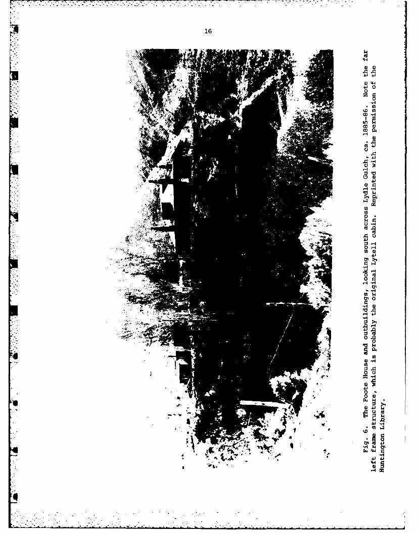
6. The Foote House and outbuildings ..... ................. ... 16
7. Historic photographs of Foote House .... ............... ... 17
8. Foote House at the turn of the century .... .............. ... 18
9. The Foote House in the 1910s or 1920s ... .............. ... 19
10. Foote House site before excavation ..... ................ ... 26
11. Topographic map of 10-AA-96 ...... ................... ... 27
12. Test pits 1 and 2 ......... ........................ . 30
13. Test pits 3-5 .......... .......................... . 32
14. Test pits 6-9 .......... .......................... . 34
15. Recovered glass and ceramic artifacts .... ............. ... 36
16. Recovered metal and cement artifacts .... ............... ... 37
17. Time lines illustrating possible Foote House site occupation ... 43
18. Section of Lucky Peak Spillway No. 2 project map ............ ... 54
19. Mouth of Lydle Gulch where it joins the Boise River ....... ... 56
20. Photographs from "A Victorian Gentlewoman in the Far West" . ... 58
7. 21. Illustrations from "A Victorian Gentlewoman in the Far West" . 60
xi

LIST OF TABLES
Table Page
1. Percentages of cut and wire nails. .................. 39
2. Datable Foote House artifacts. .................... 42
3. Inventory of artifacts and samples collected. ............. 86
xii

1. INTRODUCTION
The Problem
The Lucky Peak Project is a U.S. Army Corps of Engineers water-control(dam and reservoir) system without facilities for hydroelectric productionon the Boise River in Ada, Elmore, and Boise counties, Idaho (Figs. 1-5).The Project is administered by the Walla Walla District of the North PacificDivision of the Corps, and began operation in 1955. A briefpre-construction archaeological reconnaissance of the project area wasconducted by the Smithsonian Institution's River Basin Surveys, with itsattention focused on prehistoric resources. Subsequent reconnaissance alsowas directed only to the identification of prehistoric sites. None wasfound during either of these surveys, though some isolated artifacts andevidence of talus burials were noted. Through it all, there was no apparentperception of the significance of the historic structural remains justdownstream from the Lucky Peak Dam and within the project boundaries.
In 1974 the Corps of Engineers, working with Barton, Stoddard,Milhollin, and Higgins of Boise as consultants, published a draft masterplan for the Lucky Peak project. This draft plan correctly identifiedwithin the project area the presence of the foundations of the latenineteenth century residence of the Foote family. The plan thus defined thesite was a significant historic locale, and recommended that the area bedeveloped as a small park and interpretive center. The site had been soidentified as an historic resource by the Idaho State Historic Sites Survey(Idaho State Historical Society) since 1972. However, no detailedreconnaissance of the house foundations and associated area had been
conducted and the park idea was not supported further. The FinalEnvironmental Impact Statement for the operation and maintenance of theLucky Peak Project (U. S. Army Corps of Engineers 1976b) was published inNovember 1976 and mentions the Foote House as a site of local significance,but goes no further.
The idea of developing electrical generation capabilities at Lucky PeakDam has been around for some time, and in 1976 it became strong enough tosupport the completion of a Lucky Peak Dam and Lake Modification Study (U.S.Army Corps of Engineers 1976c) and a Draft Environmental Impact Statement,Lucky Peak Modification (U. S. Army Corps of Engineers 1976a). Both ofthese presumed that previous cultural resource investigations in the projectarea, which had resulted in no resource identifications, were adequate forassessing the proposed development's impacts.
In the meantime, LeRoy V. Allen, Walla Walla Corps DistrictArchaeological Coordinator, was advised of the proposed development at LuckyPeak Dam and became concerned the Corps had not as yet acquired an adequatecultural resource data base there. In reviewing proposed construction mapshe no 3d that a second outlet was being planned that would debauch into the
~~~~..•..,..............................' i

AN
~~o*wn,
. ~ ~ ~ ~ ~ ~ k 41 4 4. i ' 74 t tt.,k
rep, '40"" 4
41
~- 44 r
cc-,t '* - - - - - - - - - - - - - - - .4
0010
/j v 00
-V 4
E'C
-- r
010

3
cr-
0 L-J
0 M Z00z
or U0 000-i x 0
0 0)
)
>1
U)

4
Fig. 3. The Foote House and New York Canal about 1900, looking north.Arrow points to Lucky Peak Dam location (Idaho State Historical Society
photograph No. 2508).

4
Q, 0
r4-
.44 4)
0 at.
co -H U)-6fl

q 6
,.,,
IIleN9
!.o y
FOOTE HOUSE AND LYDLE GULCH CONTOURS-2FT 18" SCALE:•
_ _.= DIRT ROAD M N -0
SITE NO. IOAA96 & IOAA72 ... STREAM.i I ,,TsN 15M 0 {
Fig. 5. Archaeological sites 10-AA-96 (Foote House) and 10-AA-72(Lydle Gulch) in relationship of the centerline of the proposed U.S. Corps
14 of Engineers second outlet.

4 7
Boise River below the modern outlet near a point identified on theconstruction maps as "ruins", "stage coach stop" (Fig. 2). The origin ofthe identification of the foundations with a stage route is unknown and itseems to occur only on the Corps map. However, it was enough of a signalthat Allen, in the fall of 1976, asked the University of Idaho's Laboratoryof Anthropology to conduct a preliminary reconnaissance of the proposeddevelopment area.
That reconnaissance resulted in the identification of the prehistoricLydle Gulch site (10-AA-72) in line with the proposed second outlet, and thehistoric Foote House site (10-AA-96) adjacent to the planned work area. Thenew information was reported to the Corps in a letter report, Appendix A,(Green 1976). On the basis of the resource identifications the Corpsfurther contracted with the Laboratory to evaluate the site's significance(i.e., eligibility for the National Register of Historic Places) and provideinformation to assist in the future management of the properties (AppendixB). The evaluation of the prehistoric Lydle Gulch site became a major and
" complex project (Appendix A), and is reported elsewhere (Sappington 1981).%The evaluation of the historic Foote House is reported here, and subsequent
investigations of its dump are also presented elsewhere (Jones 1981).
Site 10-AA-96 is located in Ada County, Idaho (U.S.G.S. 7.5 min.) LuckyPeak topographic map (1972), at: Legal: SEk of SW of SWk of NEk, Sec. 11,T2N, R3E, B.M. (measured from the southern border of the section); UTM:Zone 11, 4819240 northing, 575800 easting; Geogzaphical: I16o3 '45'' westlongitude, 43031'25 ' north latitude; Elevation: 2856 ft. (870.5 m); BoiseRiver Mile: 63.
At present the Foote House site (l0-AA-96) consists of the low (1-2 ft.high) foundations of the stone house within a fenced area, no structuralremnants of any of the other buildings, and one or more trash dumps in anarchaeological context. The site appears to be eligible for inclusion inthe National Register of Historic Places, and is now clearly identified as aresource requiring affirmative management in Corps of Engineers planning andoperations.
The Physical Environment, Past and Present
The Foote House site is located on a Pleistocene alluvial terraceoverlooking the Boise River some 10 mi. east of the city of Boise, Idaho.This section of the river is situated in a steep basalt walled valley at theconvergence of several physiographic regions: the Boise River drainage, theNorth Rocky Mountain Province to the north and east, and the desert to thesouth. The environment of the site vicinity and region is described indetail in Sappington (1981) and will only be briefly discussed here.
The oldest rocks in the area are those of the Idaho Batholith, whichform the mountains of the Boise Front and are heavily eroded (Savage1958:23). Abutting this is a series of Pleistocene volcanos, the SnakeRiver Eruptives, which have been faulted and eroded in the formation of themodern Boise River Canyon. Set into the canyon are the Ten Mile Gravels

8
themselves now eroded by the heavy late Pleistocene alluviation. Furthererosion, especially of the higher terraces, was caused by overflows frompluvial Lake Bonneville that caused the Boise River to back up (Savage1958:41). Today the sedimentary deposition in the Lydle Gulch area isprimarily aeolian loess, though seasonal runoff and reduced naturalvegetative cover results in some slope-wash and wind deflation (Sappington1981).
The climate of the area remained much like that of today over the last
10,000 years. Presently the area exhibits a typical upland continentalclimate in the summer. During most winters there are alternating periods ofcloudy or stormy weather and mild weather. Air masses from the Pacific area major influence for this variable winter weather (Ada Council ofGovernments 1974:17).
The summer usually maintains regional warm but not excessively hot
temperatures. A few days in August or July will reach 100°F (380C) orhigher but most nights are cool with the temperature rapidly dropping aftersunset. Winters are generally mild though cold periods do occur maintainingtemperatures below 00F (-180C) for a number of days (Ada Council ofGovernments 1974:17) The microclimate at the Foote House is somewhat moredeverse, with hotter summer days as the high canyon walls contain andreflect the heat.
Most precipitation occurs in the region as winter rain or snow.
Snowfall occurs at the higher elevations throughout the year, but isheaviest in January; August is the only month without even a recorded tracesince 1884.
The Boise River marks the boundry between two major Desert and Foothillhabitats, with the Boise River Floodplain representing a third habitat.
* Vegetation in the immediate vicinity of the Foote House site ispredominantly big sagebrush (Artemisia tridentata) interspersed with grassesincluding blue bunch wheat grass (Agropyron spicatum), Idaho fescue (Festucaidahoensis), and Indian ricegrass (Oryzopsis hymenoides). Vegetation in the
* river bottom includes rabbitbrush (Chrysothamnus nauseosus), hopsage(Atriplex spinosa), and willow (Salix amygdaloides). Mammals such as deer,antelope, rabbits, a variety of rodents, and sage and sharp-tailed grouseinhabit the area (Caldwell and Wells 1974:12-13).
* Local Culture, Prehistory, and History
The following is a brief outline of the prehistory of the area. Mostof the information is from the Lydel Gulch site report (Sappington 1981)where a more detailed account is provided.
4

il! 9
Prehistory
Except for the excavation of the Dry Creek Rockshelter in 1974 and 1975(Webster 1978) and the Lydle Gulch site in 1977 (Sappington 1981) there hasbeen little prehistoric archaeological excavation completed in the Boisevicinity. Information on the aboriginal lifestyle and chronology in theprehistoric period is thus scanty.
Excavation at the Dry Creek Rockshelter, located 24 km (15 mi.)northwest of the Foote House along the Boise Front, revealed a 2800 yearsequence from ca. 4150 to 1300 BP. The styles and temporal order ofrecovered projectile points, which were ascribed to the NorthernSide-Notched, Humboldt, Pinto, and Elko types; follow that of the GreatBasin Archaic in northern Nevada and California (Webster 1978:28). Latercomponents at the site, dating from 2400 to 1300 BP, also contained pointssimilar to the Rose Spring and Eastgate series from the western Basin.
Excavation at the Lydle Gulch site (Sappington 1981) immediatelyadjacent to the Foote House revealed a series of temporary occupationsdating over the last six thousand years. Projectile points, which range instyle from basal-notched lanceolate to small side-notched forms, andceramics recovered there are similar to those found in the Northern GreatBasin over the last 6000 years.
Information on the prehistoric lifeways in the Boise vicinity isderived from ethnographic and historical analogies. This informationsuggests that the people occupying the area in the late prehistoric andearly historic periods included both Northern Shoshoni and Northern Paiutegroups. These inhabitants probably subsisted on salmon, root crops such ascamas, some large and medium-sized game, berries, small mammals, insects,and occasional seeds. An extended discussion of this settlement andsubsistence system is presented in Sappington (1981).
History
The first documented Euroamerican to visit the Boise area arrived in1811 (Hunt 1935:294). The Astorian party, representing the Pacific FurCompany, had come to trap beaver (Stuart 1'35:82). This expedition was thebeginning of a series of yearly trapping expeditions by the BritishNorthwest Company and later the Hudson's Bay Company that would continueinto the 1850s. From the late 1830s into the 1850s numerous Americanspassed through the area following the Oregon Trail to points farther west.
In 1862 gold was discovered in the Boise Basin. Thousands of minersi4 poured into the area marking the beginning of permanent Euroamerican
settlement (Neil 1954:4). The native population resisted the intrusion andin July 1863 Fort Boise was established to protect the Euroamericans. BoiseCity was also established at this time near the fort.
---

410
ra.History in the immediate vicinity of the Foote House begins in 1864with the construction of a toll road from Boise to Idaho City. This roadran along the north side of the Boise River across from the Foote Houselocale (Winther 1969:258). Along with the miners came farmers who settledin the Boise Valley, and from the beginning irrigation was an indispensibleaspect of their farming. As early as 1864 much of the Boise Valley river
' bottom land was under irrigation (Beal and Wells 1959 [11]:181). Interest* in irrigation grew through the years and in 1883 it brought Arthur De Wint
and Mary Hallock Foote and their family to Boise.
*The Footes
Arthur De Wint Foote (1849-1933) was born into a prominent Episcopalianrural Connecticut family and after completion of high school enrolled atYale's Sheffield Scientific School to study engineering (Foote 1934). Afterlittle more than a year's study he was advised by an oculist that his eyeswere permanently damaged, and he consequently dropped out of school andsupported himself raising oranges in the South for two years. He returned
* to New York in the winter of 1872-73 (Paul 1972:76-80; Johnson 1980:24),where his eyes were re-examined and pronounced only in need of strongerglasses. It was at this time, at a New Year's Day reception, that he methis future wife. He also, during this period, made a decision to make up inpractical experience what he had missed by not completing his Yale degree.
Foote's professional engineering career, which spanned forty years,focused around two major activities--deep mineral mining and irrigationdevelopments. His mining engineering days, which occupied most of hiscareer, were facilitated through his association with his sister's husband,James D. Hague. Hague was a graduate of Harvard, Gottingen, and the RoyalMining Academy in Frieberg, Saxony, and he was a successful international
" •mining consultant and owner first in San Francisco and later in New York.When Foote left New York in 1874 to learn engineering first-hand he headedfor Nevada and then California where he spent the next year or so working onvarious construction projects. In 1875, with the assistance of Hague, Footewas made resident engineer of the New Almaden Quicksilver Mines south of SanFrancisco (Paul 1972:103). Soon after he married and established a familyin California.
Foote worked at New Almaden for several years, then moved to Deadwood,*' South Dakota, and then to Leadville, Colorado, to work in mines and then
with the U. S. Geological Survey there in 1879 and 1880. In 1881 he and hiswife travelled in Mexico while he inspected mining properties, then returned
. to New York state while he searched for work. In 1882 Foote travelled tothe Wood River valley, Idaho, to manage the Wolftone Mine (Paul1972:262-263), and he soon became intrigued with the possibilities ofdeveloping irrigation systems in the southern Idaho area. He spent the nextdozen years in irrigation development in the Boise Valley ard southernIdaho, fighting against the economic tides as he tried to create a regionalwater system. It was during this period that he, his family, and hiscompany lived on the 10-AA-96 property. Finally in 1895, again with JamesHague's assistance, he became associated with the North Star Mine in GrasoValley, California, and moved his family there. Foote served as residentsuperintendent of the North Star for the rest of his career, retiring as
.~ . *- . - * - - *-

general manager in 1913, but continuing to serve as a consulting engineer atthe North Star until 1932 (Foote 1934:1450). Throughout his lifetime hecollected a large library on irrigation, engineering, mining, and historyand was a member of groups such as the American Society of Civil Engineers(where he was a director, 1910-1912), the Mining and Metallurgical Societyof America, and the National Geographic Society (Foote 1934:1452).
Mary Haviland Hallock (Molly) Foote (1847-1938) was born on a "worn-outfarm outside the Hudson River town of Milton, near Poughkeepsie" (Paul1972:4-5), into a large and close-knit Quaker family. Herson (Foote1934:1452) cites her maiden name as being Mary Anna Hallock. She completedhigh school at the Poughkeepsie Female Collegiate Seminary, and in 1864entered the Cooper Union School (or Institute) of Design in New York City.By the 1870s she was becoming recognized as a professional illustrator, anunusual role for a women at that time, though she lived in and worked out ofthe family home. She developed a close friendship wit: Celema de Kay, a
socially prominent New Yorker, and with Helena's husbana, Jtchard WatsonGilder, who was an important editor, critic, and poet. Her ties to theGilders continued throughout her life and kept her in touch with the easternand European intellectual world even when living in frontier mining camps
throughout the west.
In 1876 Mary married Arthur Foote and left New York for a life in thewest. The Gilders encouraged her to write of her experiences there in
addition to her illustration activities. Information about the west, andabout the new profession of engineering, was of wide interest. Mary HallockFoote's first text-plus-illustration publications appeared in 1878, based inthe first instance from cut-and-pasted comments that the Gilders abstractedfrom her letters from the mining community of New Almaden, California(Armstrong 1900:134) . She spent 1879 and 1880 in Leadville, Colorado,during which time she completed short stories, illustrations, and her firstnovels all based on "local color." Their publication established herreputation as a western writer (Armstrong 1900; Quinn 1971:645; Johnson1980:51, 155-158).
After the Foote's travel in Mexico in 1881, they returned to the east(Maine, New York) where Mary and her son Arthur B. ("Sonny," born 1877)remained until 1884. Arthur Foote closed up their business ties in Coloradoafter returning from Mexico, spent the winter of 1881-82 in New York Cityjob-hunting, and that spring went out to Idaho (Paul 1972:262-263). Marystayed at her parents home in New York, where her daughter Elizabeth (Betty)was born in the fall of 1982. Arthur Foote returned to New York in February1983 full of enthusiasm for a new venture of irrigation engineering in theBoise River Valley (after year of experience in deep mining), and theFoote's course to the stone hnouse in the canyon became set (Paul 1972:266).
Mary Foote and her family lived in Idaho for nearly a decade. Theirhistory during that period is outlined in the following section. From Boisethey eventually moved to Grasso Valley, California, as has been mentionedpreviously, and spent the rest of their lives there. Mary Hallock Footecontinued her writing career, and in the 1920s composed a lengthy set of"Reminises" (Paul 1972) that included a long and detailed discussion of the

12
family's life in Idaho. Her memoir, her son's obituary of his father (Foote1934), and other historical discussions of both Arthur D. and Mary HallockFoote provide a strong framework for assessing the significance of the IdahoFoote House as a cultural resource ot wide interest.
The Idaho Mining and Irrigation Company
Irrigation agriculture had been conducted in southern Idaho and theBoise River valley from the 1860s, but there were no large-scale projectsinitiated there until the development of Arthur Foote's scheme. The latterenvisioned the construction of up to 75 mi. of irrigation canals (the NewYork and Idaho canals) that would generally run from the Boise River at itsopening from the Boise front. Irrigation water would be provided for some350,000 acres (Foote [1934:1449] says 600,000 acres) in the rough trianglebordered by the Boise and Snake rivers and the canals (Paul 1972:270, 326).Foote had in late 1882 acquired a deed to the water rights for a location inthe approximate area of the 10-AA-96 site (Appendix D). The project was tobe developed under the auspices of the Idaho Mining and Irrigation Company(IMIC) (Foote 1883) formed in 1883 with General Charles H. Tompkins aspresident and Arthur Foote as chief engineer. General Tompkins was at thattime president of the American Diamond Rock Boring Company of New York, andwas to serve as the major fund-raiser; Foote was to design and oversee theconstruction of the canal (Paul 1972:21-22). Foote also provided thecritical water-rights for the Boise River (Appendix D). As originallyplanned the project needed $1.5 million to finance the first constructionstage, and the preliminary work of obtaining water rights, rights-of-way,and survey cost some $4,000 each month (Paul 1972:21-22). The plan was tofind financial backers to start the project, and eventually return theirinvestments in part by gold derived from placer mining under company claimsand water rights. The original financial supporters of the project were theeastern firm of Pope and Cole, and on the basis of their involvement theFoote family moved to Boise in 1884.
The family's first residence, where they lived with John and Elizabeth(Bessie) Sherman and the two Sherman children, was the Father Mesplie home
* outside of Boise near Fort Boise (Paul 1972:276-277). Bessie was Mary- Foote's older sister, and John Sherman worked for the IMIC from 1883 to*" 1885. The Company had set up its engineering headquarters in the Boise River
canyon property acquired by Foote in 1882, in a board shack and framed tent(Paul 1972:278). Construction was begun immediately on the proposed NewYork Canal, beginning in the vicinity of the headquarters, but most of thework effort was concentrated on acquisition of water rights and otherauthorities (Foote 1884). Then disaster struck in 1885.
Pope and Cole, the company's eastern backers, failed in the depressionof 1883-85 and their assets (including the IMIC) were acquired by the Keysersteel and iron interests of Baltimore (Keyser Bros. & Co., and BaltimorpCooper Smelting and Rolling Co. (Paul 1972:277, 285]). In June 1885 R.Brent Keyser, president of Baltimore Copper, visited the Boise valley toinspect the irrigation project and advise his family interests as to thewisdom of supporting it. His review appeared to be positive when he leftIdaho, but upon returning to the east he fell seriously ill and was not ableto complete his report. Consequently Roberet Garrett, then president of the
q

13
Baltimore and Ohio Railroad, was sent back to Boise in the fall to completethe review; his advice to the Keyser interests, which was accepted, was towithdraw from the venture (Paul 1972:286).
With the withdrawal of the Keyser interests, retrenchment was required.The decision was made to move the family and company operation back into theBoise Canyon, to the deeded property, and maintain only so much constructioneffort on the New York Canal as was required to maintain the water right(Paul 1972:277, 285). The Sherman family went to New York for a while,though they soon returned to Boise. The fall of 1885 was spent by ArthurFoote and his engineers constructing a large stone house adjacent to the oldshack that had served as the engineering headquarters; the house was to beboth residence and company offices. The residents of the house during itsprimary occupation, from December 1885 to early summer 1889, included Arthurand Mary Foote; their children Arthur B., Betty, and Agnes (born in 1886);their children's teacher and companion, Ellen Wade (Nellie) Linton; nurseElma (Paul 1972:301); the Chinese cook Charlie Moy (Paul 1972:289); and ayoung engineer, Charles H. (Harry) Tompkins, Jr., (Paul 1972:295). TheSherman family were frequent visitors, but the Foote family was generallyisolated from much social contact during their years in the canyon house.Arthur Foote received little if any salary from the company during theretrenchment years, with almost all support for the family and minimalcompany operations coming from income derived from the sale of Mary HallockFoote's articles, books, and illustrations.
With the withdrawl of the Keyser interest in the Company, GeneralTompkins continued to search for other backers, and in 1887 Henry Villardexpressed an interest in supporting it. However, because of other financialproblems of his own he did not follow through (Paul 1972:302-303). Thesearch continued. In the meantime Congress in October 1888 authorized aFederal irrigation survey of western lands, to be administered through theU.S. Geological Survey. The irrigation survey's first chief, CaptainClarence E. Dutton, solicited Arthur Foote's participation and in the springof 1889 Foote signed on as director of the Snake River Valley Surveys (Paul1972:307-308). He continued to serve as an unsalaried consulting engineerto the Idaho Mining and Irrigation Company, where the junior Tompkins tookhis place as chief engineer. With Foote's plans to spend much of the comingseason travelling, the family closed up the Boise River canyon home andmoved in to town with the Shermans. Mary Foote took the children and spentthe summer in Victoria, British Columbia, and in the fall young Arthur wenteast to enroll at St. Paul's School in Concord, New Hampshire (Paul1972:309). The rest of the family travelled east for the 1889-90 holidayseason, to visit family and friends while Arthur senior reported to theU.S.G.S. in Washington, D.C. Then suddenly the irrigation company returnedto life.
During the Footes' 1890 New Year's visit with the Tompkinses in NewYork, the two families heard that the IMIC paper had been bought by a
consortium of New York and London capitalists represented by solicitor EnochHarvey of New York (Paul 1972:310). On the basis of that the Footesreturned to Boise where they resided with the Shermans, began major newconstruction on the New York Canal, and filed on nearly 3000 acres (a
° . , ., .. . .

14
pre-emption claim, a tree claim, and a desert claim) of land on a mesa 2.5mi. outside of Boise. Arthur built another house there, with ambitiousagricultural and silvicultural plans, and oversaw the new constructionproject (Paul 1972:321). The canyon house (10-AA-96) was opened again andused as a headquarters for the engineers, and below it constructioncontinued on the New York Canal (Idaho State Historical Society photo
* 69-25.5; Paul 1972:322) that was to have a capacity of 4000 CFS (Foote1934:1449). However, the burst of new activity was not to last long.
In the fall of 1890 Enoch Harvey, the solicitor who served as theliason between the IMIC and its New York and London backers, was killed inan accident. Without an intervenor to communicate to the financial backersthe long-range possibilities of a project such as the Boise Valleyirrigation scheme, the English became disenchanted and withdrew and the New
*York contingent was unable to carry it alone (Paul 1972:327-328). Withoutany funds for salary support or to pay construction costs, work stopped with
*[ only 6 mi. of the New York Canal completed. The work had been contracted- out to a large Denver firm, W. C. Bradbury Company, and in July 1891
Bradbury filled a mechanic's lien against the IMIC. When he received nocompensation for that he filed suit against the company in 1893, and inFebruary 1894 purchased the New York Canal at an Ada County sheriff's sale(Murphy 1953:180). In the meantime, the Foote family was living first intheir new mesa house outside of Boise, and then at the Sherman familyboarding house in Boise until they eventually moved to California in 1895.
During and subsequent to the Foote family's stay in the Boise area,Mary Hallock Foote published several books and articles about life there.The Chosen Valley (1892) is a novel about the development of an irrigationproject and a family living in the Boise Canyon, and The Desert and the Sown(1902) is a further novel using Fort Boise as the background setting. Her"Reminisces" (Paul 1972) include an extensive discussion of the Footes' lifein Idaho, particularly during 1884-1891. Her life within the basalt canyonwalls around the Foote House, complemented by her husband's geologicalinterests, led her to see parallels between the "angle o. repose" of thebasalt talus slopes and the development of human lives (Paul 1972:306, 309).This theme was eventually picked up by Wallace Stegner in his 1971 PulitzerPrize winning novel, Angle of Repose, which is strongly modelled on theFoote memoir. It was further developed in Andrew Imbrie's opera of the same
4 name, which is based on Stegner's novel and premiered with the San FranciscoOpera in 1976 (Commanday 1976). Thus the remnants of the house in the canyonrepresent a family, a company, a major economic development, and animportant theme in American literature and art (Johnson 1980).
To return to the nineteenth century, the Bradbury Company was notinterested in completing and operating a major water irrigation project inIdaho. Thus in 1896 the Company sold the New York Canal (and apparently theassociated water rights) to a group of Boise Valley farmers whoreconstructed much of its course (Murphy 1953:180). In addition theyconstructed a Farmers Lateral ditch (Fig. 3) (Idaho State Historical Societyphotographs nos. 228, 2507, 2508, 2509, 61-165.1) that had a deflecting damand headgate in the Boise River at the same location as the modern LuckyPeak Dam. The ditch ran along the south side of the Boise River past the

j! 15
front of the Foote House, and flowed into the New York Canal where it nowheads out of the modern Boise Diversion Dam (Fig. 4). Drawdown of theDiversion Dam waters in 1978 exposed the structural uprights of the FarmersLateral ditch, making it clear that it ran along the river edge just infront of the modern reservoir beach at the mouth of Lydle Gulch. The NewYork Canal was formally opened in 1909 (Paul 1972:376-377) after the 1908completion of the Diversion Dam under the aegis of the new U. S. ReclamationService (Bureau of Reclamation) (Idaho Department of Water Resources1977:52). Capture of the Boise River waters behind the new dam would haveflooded the Farmers Lateral ditch since it created relative slackwater tothe approximate location of the modern Lucky Peak Dam.
Since this was only a limited testing program, a complete archivalsearch of the property title to the Foote House was not completed. There isan Ada County record of a patent in the name of Arthur Foote dated 18February 1914 for property located in Sec. 11, T2N, R3E (Appendix D). Thisprobably includes the Foote House site. The 1917 Ada County assessmentrolls record taxes paid by Arthur D. Foote on the same land. However, the1927 Ada County assessment rolls note that W. E. Johnston, Jr., of 1101Franklin St., Boise, was taxed on this property. We did locate a record ofa land transfer from Arthur B. and Mary Hallock Foote to Mary E. JohnstonDonaldson, dated March-April 1923 for Lot 7 of Sec. 2, T3N, R2E for aconsideration of $1 (Appendix D). This apparently applies to the Foote's1890s "mesa house" (in the vicinity of Table Rock?) and is a pro formarecord of an earlier purchase. Mary Donaldson may have been related to theMr. Johnston, who apparently acquired the Foote house property. We did notfind any record of the transfer of the 10-AA-96 area from private to puolicownership when the Lucky Peak project was developed in the late 1940s, butthe house was almost completely destroyed and its vicinity was denuded ofvegetation by 1949 (Sappington 1981:Fig.11). Jones did find a notation thatthe U.S. Corps of Engineers acquired an easement for the Foote House landfrom the U. S. Bureau of Reclamation on 23 May 1957, but this cannot bedocumented.
Historical Documentation of the Foote Site Inhabitation
From comments in Mary Hallock Foote's reminisces (Paul 1972) and areview of her published illustrations (many of which used the stone house asa model), as well as comments in Arthur B. Foote's (1934) obituary of his _.
father and historical photographs (Figs. 3, 6-9), it is possible to glean asignificant body of information about the Foote House's construction,layout, functions, and associated features.
The first documented Euraoamerican occupation of 10-AA-96 was by aminer named Lytell (Paul 1972:295), but the date of the construction of hishome and the period of its occupancy is unknown. It is likely that Lytellbuilt a single room wooden frame building, and that it served as the IMICengineering headquarters from 1883 until late 1885. The structures on the
site in 1884-L5 were described by Molly Foote as "a board shack with astovepipe hole through the roof and a tent" (Paul 1972:278, 283). Thisstructure was converted to a workshop after construction of the Footes'
i- .' . i .- ." ..
16
44
44
.00
0c
r) l
*02
0V
'U
oin.
0otoH -d
4)
tho
:44

17
a
b
Fig. 7. Historic photographs of the Foote House. a, the house afterconstruction in late 1885, from the south-southwest (Idaho State HistoricalSociety photograph No. 2505-A) the child is probably Elizabeth (Betty) Footeaccompanied by Nellie Linton; b, a later occupation, perhaps in the late1890s, looking northwest from the hill above the house. The frame structurein the right center may be the original Lytell cabin.
*. 'm~ N(

4! 18
a
..
b
Fig. 8. The Foote House at the turn of the century. a, front view ofthe house ca. 1897-1898 (Idaho State Historical Society photograph No.60-64); b, the house ca. 1900-1910, looking northeast (Idaho StateHistorical Society photograph No. 2505-B).
"4
.- . --P-•- - - -

19
a 9
b
Fig. 9. The Foote House. a, the house, 20 June 1900, [sic., the canalwas opened in 1909], during the New York Canal opening day festivities,looking north (Idaho State Historical Society photograph No. 2505); b, the -Foote House in the 1910s or 1920s, looking north (Idaho State HistoricalSociety photograph No. 70-10.267).

q 20
stone house in late 1885 (Paul 1972:295), and is probably the buildingillustrated in Figs. 6 (left center) and 7b (right center).
The Foote House was constructed in the fall and early winter of 1885,when it was obvious that the IMIC was in financial trouble and that therewould be little income to support the company or the Foote family. Thehouse was entirely built by Arthur Foote and with the assistance of hisengineering assistants, A. J. Wiley and Harry Tompkins plus Molly Foote andNellie Linton. It was located on the 30 ft. Pleistocene terrace on the eastside of the Boise River just south of Lydle Gulch, and was minimallyaccessible from the south by horseback trail (Paul 1972:291) that "huggedthe shore at the base of the basalt bluffs" on a "wagon road [that] climbedthe bluffs themselves" that was said to be a "mere track" (Paul 1972:300).The track apparently went west from the house along the river and thenclimbed the canyon wall through the drainage 0.25 mi. west of the 10-AA-96;there are remnants of such there today. The trail would then have tied intothe Oregon Trail atop the basalt pediment approximately 1 mi. southwest of
*- the Foote House.
Much more travelable was the Boise-Idaho City road (now S. H. 21) thatran along the north and west of the Boise River across from the Foote House.The Footes soon built a wire suspension bridge across the river that "usedthe natural rock abutments where the future dam was to go in, anchoring two
* wire cables to these bridge piers" (Paul 1972:291). It is our understandingthat the dam had always been intended by Foote to be located at the BoiseCanyon mouth, where the present Diversion Dam is placed. A bridge placedthere would have required a 1.5-2 mi. walk or horseback ride along the southshore from the crossing to the house. However, when the Diversion Damreservoir was drawn down in 1978, iron rings set into the basalt bedrock on
the east side of Discovery Park were visible. We think we also saw a ring- in the basalt on the east side of the river directly across from the Park,
just to the north of the mouth of Lydle Gulch. This location is a much morefunctional site for the Foote suspension bridge, and the Dicovery Park flatwould have been an appropriate location for the Foote stables. Thus, most
*. of the transportation to and from the Foote House from 1886 until the early1890s was by way of the bridge and the Idaho City road.
The house itself was an architectural witness to A. D. Foote'sexperience in California, Mexico, and Idaho, and was of a bungalow style(Figs. 6-9) that was the first such in the area (Idaho Statesman, 3 December1916, 2nd sec., p. 1). It is described by son, Arthur B. Foote (1934:1449)thus:
For headquarters and a home, with characteristic originality,[Arthur D. Foote] built a house near the site of the diversiondam, of the materials at hand, with walls two feet thick, of the
rough basalt rock, using mud for mortar and for plastering theinterior walls and partitions.
.a

21
The basalt was quarried from local sources, the quarring effortundoubtedly being little more than collection of material from the extensivetalus slopes at the base of the basalt canyon walls. The thick walls wereset into trenches of undescribed depth (Paul 1972:292). The "mud" used formortar was probably a Portland cement made from materials at hand. Foote in1887 had been involved witn the unsuccessful development of a Portlandcement plant near Santa C:<uz, California, and was very familiar with themanufacturing requirements of the material (Foote 1934:1449). Molly Footecommented that he made "a perfect wall plaster out of the native earth westood on, of its own soft color and a better cement than any we could haveput into the walls themselves" (Paul 1972:292).
The thick walls, deepset windows, and broad sheltered, low-walkedverandas on the south and west sides of the house are reminiscent ofCalifornia and Mexican styles, and were particularly appropriate in the hotBoise Canyon. The supplemental veranda posts and upper chimneys were madeof brick, probably purchased from Boise Valley kilns. The metal for theroof, chimney stacks, and the window panes also had to be purchased. Mostof the rest of the construction materials were made or found as rawmaterials by the Footes and their helpers.
The porches stretched the full length of the house front, and along 3/4of the south side. They were bounded on the outside edge by low masonrywalls that appear to have been about 15 in. (38 cm) high on their innerside, and probably had a floor of planks laid parallel to their width (Paul1976:3, 6). They appear to have had only a single entrance which had asingle low wooden step leading to it in the center of the front path (Fig.7a) (Paul 1972:297; 1976:3).
Inside the house, the lower level was apparently divided into four orperhaps five basic rooms, three of which opened into one another (Paul1972:293). The main front entrance faced west, and consisted of low stepsup the veranda and entrance into a sitting room in the southwest quarter ofthe house where Molly Foote had her writing desk. Opening from that in thecenter of the southern half of the house was the dining room (Appendix A,Fig. 20a). An illustration that accompanies the publication of The ChosenValley (Foote 1892:72) suggests that the kitchen was in the far southeastcorner of the house, in the ell with the high window that provided a view ofthe downriver Boise Canyon. The function of the northeast corner room ispresently unknown. However, it might also have been the office of A. D.Foote, similar to another Chosen Valley illustration (Foote 1892:704). Itmay thus have been walled off from the family activity area in the southernhalf of the house. The northwest corner, which was walled off (and perhapsto provide a bearing wall for the upper story) was the "Junior's room" (Paul1972:308) or the "engineer's office" (Paul 1972:295) complete with "stowaway
4 places." This apparently was the residence of Harry Tompkins, and may alsohave been the office from with A. D. Foote operated though it is more likelythe later had his own separate workspace.
All of the rooms downstairs had low ceilings, with doors just above 6ft. 4 in., deep window seats, long casement windows, and open fireplaceswith chimneys of basalt. The fireplaces were apparently all set into the

IL
*22
rr exterior walls, at either end of the north and south sides (Fig. 7a). The
* wooden floors were all stained, and there were home-constructed seats,cupboards, and bookshelves with closets below for storage (Paul 1972:295).Several Mary Hallock Foote illustrations (Foote 1892:702; Paul 1972:294)suggest that there was wainscotting around the outer walls reaching upperhaps 4 ft. from the floor. She herself comments that the walls werefawn-colored plaster, with sage green painted woodwork (Paul 1972:293).
Some sort of cellar may have been constructed under the southeastcorner of the building, since there was apparently an air vent set into thebase of the southern wall toward the east end (Fig. 6) (Paul 1972:297).
The upstairs had at least two rooms built under the sloping roof withdormer windows extending to the north, west, and south. There is noindication of the location of the staircase. The senior Footes bedroomincluded either the southern or the western dormer (Paul 1972:300), andthere was a "neat room" in which the children slept (Paul 1972:300-301).The upper story apparently had a single wood-burning stove toward thenortheast corner, since there was a stovepipe there (Fig. 7a). WhetherNellie Linton and the nurse slept in the same room with the children (whichis likely) or had their own room is not documented. Further, there is nodocumentation as to where the cook, Charlie Moy, was housed; he probably washoused in an outbuilding.
. Molly Foote's descriptions of the canyon house indicate that it was awell constructed, functionally well designed structure that was energyefficient and easy to maintain while still being relatively comfortable. As
a home for five adults (assuming the cook slept elsewhere) and three small* children, it clearly afforded little individual privacy. However, despite
their minimal income (most of it derived from the sale of her writings andillustrations) it was a gracious home with a sophisticated library andpaintings on the walls. It was also an efficient office, and with theworkshops behind served as a location for engineering experiments andbookbinding activities.
Winter firewood and fencepost raw material were provided by driftwoodfrom the Boise River (Paul 1972:290). The men constructed a waterhole andhomemade windmill nearby, perhaps back up the gulch, with a ditch thatwatered a kitchen garden (Paul 1972:284, 298). There was a wooden post andwire fence constructed down in the gulch (Fig. 6) (Paul 1972:291), but nodocumentation of its purpose though perhaps it was to keep horses coralled
."or protect the garden. Sheep were occasionally moved through the area,K higher up the Lydle Creek drainage, and when they came through theydisturbed the water flow down the gulch and affected the Foote's private
irrigation system (Paul 1972:298). The whole operation was relativelyself-sufficient, though relying on food supplies, mail, and visitors fromtown; it was a haven in which to wait out the economic storm.
There is an historical record of the Foote family's occupation of thehouse from late 1885 until early 1889, and of its use again as an
4 engineering headquarters in 1890-91. We have found no other written
K information of its inhabitation. However, there is a photographic record of

23
the site that indicates that it was lived in after the IMIC collapsed. Onephotograph (Fig. 7b) may have been taken in the late 1890s and suggests thatthe house was being occupied again. The vegetation had grown significantlysince the building's construction (Figs. 6, 7a). There also appear to havebeen some structural changes, with the southeast chimney having been painteda light color and the sheet iron stacks having been removed from thenortheast and southeast chimneys. In addition, the Boise River, in thebackground appears to be free-flowing, with a ditch cut along its easternshore. However, another photo with an ascribed 1887-1889 date (Fig. 8a)suggests that the house was abandoned then. In this illustration thesouthwest corner chimney is collapsed and the structure appears generallydeteriorated. The same general appearance is evident in the undated photoillustrated as Fig. 3, which because of the lateral ditch in front of itmust date between 1896 and 1908. Note that there is no bridge crossing theriver in front of the house and a well used road goes from the house westalong the south side of the river. Two other photos (Figs. 8b, 9a) areascibed to 1909 and again suggest that the structure was uninhabited thenand was easily accessible.
The apparently most recent photograph of the Foote House as an intactstructure (Fig. 9b) is undated but includes three individuals whose clothingstyles suggest the period 1910-1920. The edge of a tent showing behind thehouse further suggests that the complex was being occupied, and thesouthwest chimney was intact with its stack in place. It should be notedthat Fig. 7b, with its tent behind the house, intact southwest chimney, andmature vegetation may illustrate this same time period; the poor quality ofthe latter photo makes identifications difficult. At the same time, thereis a description of the house published in the Idaho Statesman on 3 December1916 (2nd sec., p. 1) that states that the house was then deserted.
There is thus clear historic documentation for the occupation of10-AA-72 during the Lytell period and during the Foote/IMIC period. After1891, there are photographic suggestions that the house was reoccupied onceor twice, perhaps in the late 1890s and again in the 1910s to 1920s. Thebasic function of the complex has always been domestic, though there havebeen mining and engineering activities associated with it over time.

2. PROJECT METHODS AND TECHNIQUES
Field Mapping and Test Excavations
Test excavations in and around the Foote House site (Fig. 5) wereconducted from 7 June through 18 June 1977. Test pits 1-9 were all directlyassociated with the Foote House, and their stratigraphy and contents aredescribed and analyzed in detail in this report. Test units were also
" placed in the beach deposits at the mouth of Lydle Gulch (Pit z). The Gulchfloor northeast of the Foote House (Pit y, 10-AA-72 Test pits 1 and 2), andatop the Pleistocene terrace remnant well north of the Foote House (Pit x).These latter units were part of a search for an in situ deposit ofprehistoric cultural materials that might be adversely impacted by theproposed second outlet construction. Pits x, y, and z proved to beculturally sterile. The 10-AA-72 testing program grew to be a complexventure, and is presented in detail elsewhere (Sappington 1981).
Approximately 30 work-days of field effort were devoted to the historicsite investigation around 10-AA-96. The purpose of the testing program wasto determine the location, condition, contents, and integrity of thearchitectural and archaeological materials at the site. An additional goalwas to recover by recordation or collection those cultural resourcespresently exposed on the surface. To accomplish this a topographic map ofthe site vicinity was drafted (Fig. 5) and a more specific map of thefoundation was drawn (Fig. 10). Surface artifacts were collected frominside the structure, in the yard around it, and in the thinly deposted dumparea along the gulch slope north of the house. In complement, test pitswere placed in these three functional areas.
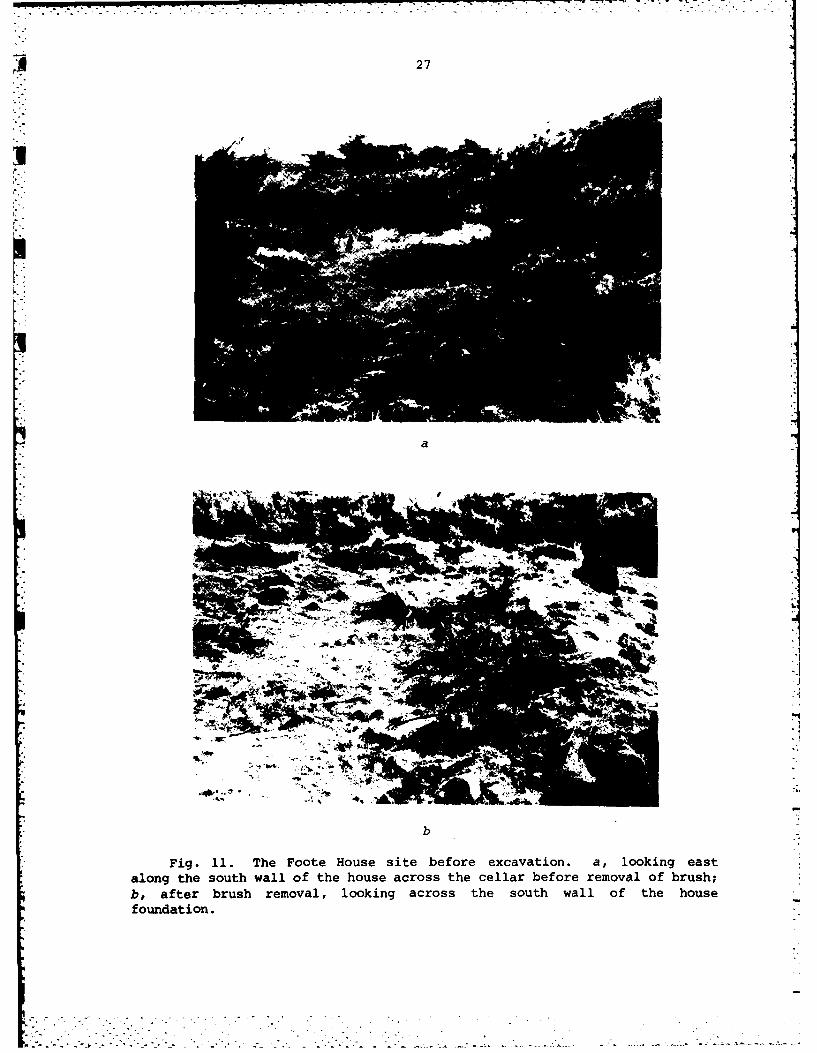
A site datum was established 4 m north of the northwest corner of thehouse foundation (Fig. 10). The site was then laboriously cleared ofsagebrush using axes and hatchets (Fig. lla, b). Nine test units were laidout from the site datum, oriented to architectural or slope constraints
rather than to cardinal directions in most cases. The pits were of varyingdimensions from 1 to 4 m2 in area. Excavation was generally in 10 cm levels(again varying because of architectural and slope constraints) to the baseof the historic occupation. Both trowelling and skim shovelling werestandard techniques, and all sediments were dry screened through 1/4 in.hardward mesh.
Four areas in or adjacent to the Foote House were tested to providestructural and (if possible) functional information (Fig. 10). Test Pit 1was placed inside the northeast corner of the foundation to provide detailsabout the foundation construction and perhaps about the function of thisarea. Test Pit 2 was on the outside of the northwest corner of thebuilding, on the western side in an area presumed to have been the floor ofthe verandas. Unit 3 was located inside the foundation, in the southeastcorner of the north-western corner structure that was presumed to represent
25

26
044-4
4-)
41)
41
U
44
S- 04
4b 00 0I.-4
-9-
0 0 0
IL u
27
a
1': 414
b
Fig. 11. The Foote House site before excavation, a, looking eastalong the south wall of the house across the cellar before removal of brush;b, after brush removal, looking across the south wall of the housefoundation.

428
"the Junior's room." Finally test pits 6, 7, and 8 crosscut the main houseexterior wall, and the veranda floor in the southwest corner of thestructure.
To the rear (east) of the structure, Test Pit 9 (Fig. 10) was a searchfor information about possible outbuildings. Our archival search has notbeen complete enough yet to identify the specific location of the Lytellcabin/workshop or other structures around the house, hence Test Pit 9 wasrather randomly placed. Two additional units were excavated into the slopenorth of the site because (1) that area would be most vulnerable to damageby the proposed outlet construction, and (2) there was a thin litter oftrash on the surface and it might have subsurface integrity as an historicdump.
Field records include sketch maps and photographs of each unit, generalsites maps and photos, and a supervisor's log of work.
A4'ter conpl,.ti, of the testing program all excavations were coveredwith perfirated nlack plastic sheeting and were backfilled. In addition, abarbed wire fence wa placed around the structural remains and the areaposted to keep out trespassers.
Laboratory Analysis and Curation; Literature and Archival Review
All archaeological materials recovered from the fieldwork were returnedto the Laboratory of Anthropolgy where they were cleaned, inventoried,identified, and bagged or boxed for long-term curation. Metal items werecarefully cleaned and preserved. Artifact numbers were assigned in thelaboratory using a trinomial designation keyed to piece provenience so thatit identifies master 'Unit and level and laboratory and individual number.The artifact collection, with associated field notes, photographs, and otherrecords will be kept on permanent file with the Southwestern Idaho RegionalArchaeological Center, Idaho State Historical Society, Boise.
Despite the limitations of funds and time, some search was made ofarchival records of the Foote House occupation. Deed and tax assessmentrecords for Ada County were reviewed, as were the photographic files of theIdaho State Historical Society. The reminisces of Mary Hallock Foote (Paul1972) were particularly gleaned for information about the Foote House. More
* * detailed searches of these records and those of the Foote family, which arenow held by the Huntington Library, San Marino, California, are appropriate.
P4

3 3. THE FOOTE HOUSE ARCHAEOLOGICAL SITE (10-AA-96)
The General Area and Its Stratigraphy
The Foote House site is generally characterized by thin archaeological- deposits associated with architectural features that are only minimal
structural expressions of the buildings as they are historically describedand illustrated. The main house walls are presently represented by lowmounds of rubble that cover relatively stable wall bases perhaps 0.5-1.5(north wall) ft. high. The cellar in the southeast corner of the house iscollapsed in on itself, and the rubble there presumably protects relativelyintact masonry or earthen walls. Test pits excavated into the house or backyard (nos. 1-3, 6-9) exhibited a generally homogeneous weakly developed soilof tan sandy aeolian silt over the gravel of the basal Pleistocene terrace.Some levels in the house had a layer of compact melted mortar. Finally,test pits 4 and 5 in the trash area along the gulch has a thin black greasyhumic soil over the gravel terrace slope.
Test Pit 1
This 2 x 2 m pit was excavated inside the northeast corner of the FooteHouse (Fig. 10). The first two levels, to a depth of 20 cm, cleared theentire square. Basalt masonry blocks from the exterior walls were collapsedacross the surface of the unit, and were first cleared off. Similarmaterials extended down into the soil matrix through the first excavationlevel, to 10 cm depth. At this level, in the northwest quadrant of theunit, a thin layer of charcoal was encountered that overlay a layer of anadobe-like material that was probably melted plaster or mortar, and wasapproximately 2 cm thick. Removal of this hard layer exposed the top of ahorizontal panel of 5 x 75 in. wooden boards (Fig. 12a) that were again .
i- approximately 2 cm thick. The panel in some cases was coated on its uppersurface with a thin layer of a tar-like substance, with another thin layeror pieces of paper on that; there was no discernible pattern on the paper.The boards were held together by cut nails drived both down into the boardsor to connect adjacent pieces, and there were two thin metal disks held tothe wood with center tacks. The panel rested directly on fine silty soil.Whether the wooden remnants are of first story flooring, wainscotting, theupper story ceiling/flooring, or roofing materials is indeterminate.
The northeast quadrant of Test Pit 1 was excavated to a total depth of95 cm to uncover the inner face of the basal portions and foundation of theexterior house walls (Fig. 12b). The wall extended to 60 cm depth and wasof rectangularly dressed basalt blocks of varying sizes and some graniticand quartizitic alluvial cobbles, all held together with a relatively sandymortar. The foundation, of more irregularly shaped basalt cobbles andboulders that appeared less formally shaped, was 6-9 cm wider than the wallabove it, the added width providing a footing ledge. The foundation mortar
29

30
a
,';.4: w
• C
b
Fig. 12. Test pits 1 and 2. a, Test Pit 1, looking east across thewooden panel; the unit has been cleared to 20 cm depth; b, Test Pit 1,northeast corner exposed to 95 cm depth, with inner face of upper exteriorwall resting on the wider basalt foundation so as to provide a footingledge; c, Test Pit 2, looking east at the outside profile of the porchfoundation (30 cm depth). Scale is in 1 in. increments.
,"

31
was less sandy, more silty. The foundation was 30-35 cm in height,extending to a depth of 90-95 cm where it rested on an apparentlyundisturbed silty C horizon.
Few artifacts were found within this test pit, most of them being cutnails. There was no evidence of the specific function of this area of thestructure.
* Test Pit 2
This 2 x 2 m unit was excavated outside the northwest corner of thepresumed porch foundation to 30 cm depth. The foundation was exposed alongthe east wall of the pit (Fig. 12c) and consisted of dressed basalt blockswith some river cobbles overlying (at 30 cm depth) the apparentlyundisturbed silty terrace sediments. There were again few associatedartifacts, most of them being cut nails or glass fragments, but there was a
" scatter of small chert, obsidian, and quartzite debitage flakes throughoutthe unit.
Test Pit 3
This 2 x 2 m unit was placed in the southeast corner of what waspresumed to be the northwest room of the house, adjacent to a large pile ofbasalt blocks that was probably the rubble of, and surrounding the lowerportion of, an interior masonry wall. No such interior wall was found. At10 cm depth the apparent end of a concrete slab was exposed extending out ofthe southern test pit wall (Fig 13a). The slab was 5.5 cm (2 in.) thick and76 cm (30 in.) wide, and exposed for some 40 cm (16 in.) of its length. Theslab's function could not be determined, and while it may have served as afireplace foundation or mantle it is not associated with known fireplacelocations.
Excavations were continued in this unit to a total depth ofapproximately 70 cm (Fig. 13a); the lower levels to 60 cm depth had onlysparse artifact associations and the 60-70 cm level appeared to be into theupper apparently undisturbed Pleistocene terrace deposits.
Test Pit 4
This 2 x 2 m unit was excavated at the top of the Lydle Gulch slopenorth of the house (Fig. 10), in a thin soil with some surface litter oftrash that suggested there might be an historic dump there that would beimpacted by the proposed construction. The unit was excavated only to 10-20cm depth depending on the slope and had no features and only a minimalartifact association (Fig. 13b).
4jo
4

32
a
Fig. 13. Test pits 3-5. a, Test Pit 3 within the Foote House, lookingwest across the unit excavated to approximately 60 cm depth, with theconcrete slab exposed in the southern wall; b, Test Pit 4, looking south
4across its base at 10-20 cm depth; c, Test Pit 5, looking downslope(northeast) across its 10 cm depth.

. 33
Test Pit 5
This 1 x 2 m unit was excavated into the southern slope of Lydle Gulchto the northeast of the Foote House (Figs. 5, 10) to test for a possible
U dump location. The pit was dug only to 10 cm depth before apparentlyundisturbed Pleistocene gravels were encountered; there were no features inthe unit and few associated artifacts (Fig. 13c).
Test Pits 6, 7, and 8
These adjacent units were extended as a I x 4 m excavation to the southfrom the southeast corner of the Foote House, from what was presumed to bethe west end of the southern exterior wall across the porch floor and thefoundation of the porch wall (Figs. 7a, 10). Test unit 6 was a minimalexcavation, being primarily a clearing of the surface rubble to expose theapparent core of the exterior wall (Fig. 14a). The excavation of Test Pit7, to the south of unit 6, resulted in the exposure of the southern face ofthe exterior wall (Fig. 14b) and the excavation into a hard compacted soilunit that is presumed to have been the porch or veranda floor. Noassociated wood planking or basalt block surface was in evidence there, andthe area extended 1.7 m (5.5 ft.) to the south netween the exterior wall andthe inner face of a southern porch wall foundation. Test Pit 8 was afurther southern exposure of the exterior of the porch wall, which wasconstructed of masonry blocks and alluvial cobbles (Fig. 14c) and wasapproximately 45 cm (18 in.) wide. Unit 8 was excavated to approximately 50cm depth in its southern section to expose the 30 cm high porch foundation,and there were few artifacts (though including both prehistoric lithicdebitage and historic metal items) in association with the entire 6-8 unitcomplex.
Test Pit 9
This 2 x 2 m unit was located just east of the Foote House (Fig. 10) insearch of evidence of outbuildings or special use areas. No evidence ofthese was found, and there were few associated artifacts. There wereconcentrations of charcoal in the upper 10 cm, but these did not extendfurther through the deposits. £he unit was excavated to a total depth of 55cm where apparently undisturbed terrace gravels were encountered (Fig. 14d).
The Artifacts
A total of 3481 artifacts, most of them fragments, were recovered fromthe Foote House test excavations (Appendix E) and were analyticallyseparated into four major categories based on their material: glass,ceramic, nail, and "other." It should be noted that the "other material"category included 43 small lithic flakes that were found scattered acrossthe deposits. Marian F. Conway has commented (letter to R. Knudson, 25 May1977) about her grandfather: "You asked about arrowheads. There was a nicecollection of A. D. Foote's and I remember he told us some came from Idaho."

34
a
A A
K,•.
cb
d
Fig. 14. Test pits 6-9, the rubble of the exterior wall core. a, TestPit 6, the face of the southern exterior wall, looking north; b, Test Pit 7,and the outer face of the southern porch wall, looking north; c, Test Pit 8,
looking north; d, Test Pit 9 at 55 cm depth, looking south.
-.-

4 35
However, it is unlikely that the small tertiary reduction flakes foundaround the Foote House represent an historic example of curation. They aremore likely the remnants of some prehistoric use of the terrace area,perhaps in association with the Lydle Gulch site occupations, but are oflimited scientific significance.
Most of the 1644 glass artifacts recovered were from bottle fragmentsthough a number of chimney and window pane fragments were also found. Somebottle bases are embossed with the bottler's initials (Fig. 15a-d). Theseinclude "A.M.F. & C2", dating 1895-1911 (Toulouse 1971:44); "Wis G Co.MILW," dating 1881-1885 (Toulouse 1971:54) (Fig. 15b); and "A.B.CO." dating1905-1916 (Toulouse 1971:30) (Fig. 15d). One proprietary medicine bottlefragment is embossed "NG's COVER SUMPT" on the body (Fig. 15f), and was amedicinal known as "Dr. King's New Discovery for Consumption" produced in1885-1895 (Wilson 1971:53, 124).
The 99 ceramic artifacts were divided into three groups based on thepaste type. These types are earthenware, stoneware, and porcelain.
Earthenware is fired at a lower temperature than stoneware andporcelain. The paste is less vitreous and therefore has greater porosity.Of the 49 earthenware artifacts recovered, most are white glazed thoughbrown, blue, and green transferwares are represented. The only potter'smark recovered was on a white earthenware fragment found on the surface.This mark on a plate base reads "HOMER LAUGHLIN HOTEL CHINA" (Fig. 14e).The manufacturer, located in Liverpool, Ohio, used this mark from 1898 untilat least 1909 (Barber 1976:111).
Stoneware is fired at hotter temperatures than is earthenware, makingit more vitreous though still having a granular appearing paste. It isimpervious to water and was usually used for storage vessels. Most of the33 stoneware artifacts from the site were crock fragments (Fig. 15h, i)though one ginger jar lid (Fig. 15g) was recovered.
Porcelain is fired at a high temperature melting the paste until it isglass-like. Seventeen fragments of this ceramic type were recovered,including an electrical insulator, a button, and dinerware vessel fragments.All but one of the latter, which had a gray transfer design, were whiteglazed.
The 1490 metal artifacts are listed in three categories: iron, brass,and white. White includes grayish to white metals such as zinc, lead, tin,and aluminum, since it is often difficult to differentiate these metalsvisually.
Iron artifacts were the most common (96%) metal items. Most of thesewere cut (421) or wire (211) nails, though hinge fragments, locks (Fig.16a), farm tools, cans, and a clock (Fig. 16b) were also recovered.
Most of the 52 brass artifacts were cartridges of shotgun shell bases(Fig. 16d-k), including (with headstamps):

36
IN0
o 2 3
pC,
Fig. 15. Recovered glass and ceramic artifacts, a, aqua bottle withthree dots and line; b, aqua bottle base with "WIS G Co MILW;" c. brownbottle base with "& CO;" d, aqua bottle base with "A.B.Co;" e, aqua bottlebody fragment with "NG'S COVER SUMPT;" f, white earthenware plate basefragment with "HOMER LAUGHLIN HOTEL CHINA;" g, unglazed stoneware ginger jarlid fragments; h, grey glazed stoneware crock fragments; i, brown glazedstoneware crock fragment. Artifacts a and d (lot C.1.73) and f (lot C.1.16)are from the surface collection made in the Gulch dump area; all others arefrom Test Pit 5, from lots 5.1.4 (g), 5.1.5 (h,i), 5.1.12 (e), and 5.1.13
-. (b,c).

C W,
°
Fig. 16. Recovered metal and cement artifacts. a, iron mortise doorlock; b, iron and brass clock frame and gears; c, iron key for tumbler lock;d, .40-.70 centerfire brass cartridge; e, .38 S & W brass cartridge; f, .32centerfire brass cartridge; g, .30 centerfire brass cartridge; h, .22 longrimfire brass cartridge; i, .50 rimfire brass cartridge; j, 12 ga. brassshotgun shell base with "W.R.A. Co. RIVAL;" k, 12 ga. brass shotgun shellbase with "W.R.A. Co. NEW CLUB;" 1, concrete piece without incised number;m, concrete fragment with incised "2;" n, concrete fragment with incised"117." Most of these came from surface collections to the east of the housefoundations (e,f [lot A.1.1], in the house itself (a (B.1.10], b (B.1.11], c(B.1.6], i, (B.1.4]), or from the trash area at the edge of the gulch (j[C.1.11]). The concrete pieces (1, m. n) are from the surface either to theeast of the house [A.1.4] or along the gulch edge [C.1.12). Pieces foundwithin the test pits include d (5.1.17], h [3.2.91J, and k (2.2.4].
. . . . . .. . .

38
Shotgun shell bases
12 gauge"W.R.A. Co. RIVAL"
"U.M.C. Co."16 gauge"REMINGTON EXPRESS"
Cartridges
.22 cal. rim firelong"U, P, SUPER X, US"short.25 cal. centerfire
"U.M.C. Co.""US".30 cal. centerfire"W.R.A. Co.".32 cal. centerfire"W.R.A. Co.".38 cal. centerfire
"Smith & Wesson"
"U.M.C. Co.".40-.70 centerfire"W.R.A. Co."
The other artifacts include a host of materials such as stone, bone,leather, paper, wood, shell, mortar and cement, and graphite. All 33leather fragments were from shoes. Nine of the 16 mortar and cementartifacts were approximately 1 in. thick and shaped like a bow tie if notbroken (Fig. 15 1-n). Each was made of a different mixture of silt and sandand all but one were broken in the center. Each fragment has an incisednumeral on the top. These may have been produced as mortar mixture testsand could be the remains of Arthur D. Foote's house construction experimentsto develop a mortar out of local materials.
The Nails
Both cut and wire nails were recovered in the 10-AA-96 testexcavations. Cut nails are those formed by being cut from plate iron(Nelson 1968:4), and are rectangular in cross section. Wire nails areformed by cutting round wire stock to the desired length and then heading it(Nelson 1968:9).
Both wire and cut nails have been produced since the late 1700s butnails produced for use in construction in North America were generally cutuntil the 1890s. However, the relative proportions of cut anid wire nailproduction in North America in the late nineteenth and early twentieth
14 centuries varied significantly (Priess 1974:25).

_ 39
Year Cut (million kegs) Wire (million kegs)
1886 8.0 94 0.5 61890 5.0 65 3.0 351900 1.5 17 7.25 831913 1.0 7 13.0 93
For a number of reasons, wire nail production did not predominate untilafter 1890. First, tests conducted in 1884 showed cut nails to have better
holding power than wire nails (Priess 1974:25). In addition to this therewas the prejudice against a new product, as opposed to the known reliabilityand trust in cut nails.
The vertical distribution of cut and wire nail percentages in the FooteHouse excavation is presented in Table 1.
TABLE 1
Percentages of cut and wire nails recovered at theFoote House in 1977 test excavations
TestPit Level 1 Level 2 Level 3 Level 4
I% % % % % % % %
cut wire cut wire cut wire cut wire
1 0 0 67 33 65 35 N N2 38 62 54 46 50 50 100 03 83 17 80 20 76 24 20 804 36 64 N N N N N N5 18 82 N N N N N N6 63 37 N N N N N N7 93 7 80 20 N N N N8 83 17 83 17 N N N N9 54 46 33 67 67 33 N N
Note: Levels are each approximately 10 cm in depth; N an unexcavated"" level.
The nail distribution suggests that there is significance of the
archaeological deposits, thin as they are. Test Pits 4 and 5, on the LydleGulch slope, have highest frequencies of more recent wire nails. Unit 1 inthe house produced a very high frequency of cut nails, which would be evenmore obvious if the nails observed in the wooden panel and left in placewere to be counted here. Test Pit 3, in the "Junior's room," is again
predominated by cut nails; the higher frequency of wire nails in Level 4 isa reflection of a small sample size (one cut, four wire, three fragments).Test Pit 2, in the front of the house, has mostly cut nails at the base ofthe units and more wire nails toward the top; Test Pit 9, at the rear of the

40
house, reflects the same pattern. Finally, test pits 6-8 across thesouthern porch are predominated by cut nails.
The Site as a Cultural Historical Remnant
The architecture of the Foote House has been generally described on thebasis of archival records, and the archaeological evidence from the limitedtesting program reported here can be little other than confirmatory. Thenearly complete absence of features other than the wall bases andfoundations suggests that the house was deliberately dismantled at somepoint, probably for its materials. There seems to be no record of its useafter the early 1920s and in the late 1940s it was only an empty foundation.The charcoal found in some of the test excavations is minimal and certainlydoes not suggest that the structure suffered a major fire. Local informantscomment that the site has been a favorite picnicking area for Boiseans sincethe 1890s, but surely the structure would not have been so thoroughlydismantled if the action was only by occasional souvenir collectors.
Without more thorough clearing of rubble from around the walls thedimensions of the structure are only speculative. However, its exteriorsize appears to be approximately 30 ft. (9 m) from front to back along thenorth wall (excluding the porch) with the east or back wall beingapproximately 36 ft. (11 m) long. The front porch or veranda must have beenapproximately 33 ft. (10 m) across, the house front itself was ca. 28 ft.(8.5 m) wide. The far southwest corner of the structure had a large cellarunderneath it and as discussed previously may have been the kitchen; we didnot investigate that area since to do so would have involved complicatedexcavation outside of the scope of our contract. We did not actuallyencounter an interior masonry wall running east-west through the front ofthe house, but cannot exclude the existence of such a structure since thereis a concentration of masonry blocks piled up in a linear arrangement inthat area.
In general the wall construction was of masonry blocks (with somealluvial cobbles) laid to form flat exterior faces, with a heavy masonry andblock core. The exterior walls rested on a wider foundation, the extrawidth providing a footing ledge for flooring. The exterior walls were saidby A. B. Foote to be 2 ft. thick, and our trenching of the porch indicatedthat the outer porch wall was approximately 12-15 in. wide. Somewherewithin the house, either as flooring, roofing (including soffitting), orwainscotting, panels of 5 x 0.75 in. wood were used. Samples taken acrossthe area suggest that a sandier mortar matrix was used in the wallconstruction, and that a siltier, finer textured plaster covered theinterior walls. The house appears to have been constructed almost
exclusively with cut nails, though wire nails may have been used for repairsto the structure during post-1891 use of the building.
No evidence of outbuildings was found, nor was a major dump located.The latter was discovered in 1980 lying on the Boise River slope southwestof the house, and its contents are reported elsewhere (Jones 1981).

41
As discussed earlier, archival evidence suggests that the Foote Housesite had several periods of historic occupation. Few datable artifacts wererecovered during the 1977 archaeological testing program to confirm or denythis. Those few that do provide some temporal controls of stratigraphiccontexts are indentified in Table 2, and their temporal assignments areillustrated in Fig. 17.
There is no specific evidence of the site's inhabitation by the minerLytell some time prior to 1883. Considering that the Lytell cabin was stillin good habitable shape in 1883, to provide housing for the IMIC engineers,it was probably of relatively recent construction. Thus, evidence of itsuse would be difficult to differentiate from that of the Foote family andIMIC operations of the 1883-1891 period. The archival informationcomplemented by the temporal markers from the testing program suggest thatwe group the 1881-1900 period of use of 10-AA-96 as "Occupation 1" (Fig.17).
The evidence for re-occupation of the Foote House complex after theturn of the century is quixotic. There is a photographic suggestion of itsinhabitation in the 1910s-1920s; there are artifacts manufactured duringthis period that are found in archaeological contexts. There is also aclear record of the site's use as a casual picnicking area throughout thisperiod, and the human agency behind the artifact's disposition in and aroundthe site is indeterminate. Thus, on the basis of the presently gatheredinformation we suggest that this period be identified as "Occupation 2"(Fig. 17) and that there be a more thorough archival review of the questionof twentieth century occupancy of 10-AA-96.
The archaeological evidence from the 1977 testing program would supportthe archival suggestion that the Foote House complex was almost exclusivelyused for domestic functions. Those operations of the IMIC that wereconducted at the site must have been more cerebral and record-keeping thanotherwise, since they left little if any physical evidence behind.
!1
.*1

42
0 444) 0
rL) cti *l :.LA O 0.0 OD . et r- 0 0 4.)
0. %D w' CJ r- -
0 ) a% a% -.4 -1 a% m) (d* V
w H- H ON H4 H 44 (D
0H rq 9 0: 0 0) 04.4 to 0 0
0 -4 w 4 0 '(2~- 4U ' J ~ ~ Z~
$4 0 2 a) H) W .)0 0 ;i r.t
E4 E-4 u ~ H 0
a) 4.) 4.) 4P$
-4 N4 0 0 0 0) '4J 02 E LA H1 LA 0 (A 02
4-) m 1-4 OD 0 0) (D0) 0i $ 00 (n co (n w. 4 N 0
4.) 4.4 1 I I I':3 (n LA LA LA H- 0 N- 0 (Nr. V4 0 H- CD m) OD m) CC) H 0(a (d' ON a% OD a) co 02 O m) m
o4-04$ 4.)o- 0 02
4.) 04
W 4 >4
40
m 0 o040(d4 U4 -1 02 2 0)
4.4 'U 0 0U >
-. .4 U), U 00 044.) 4. H .0 4) N
(d 01 ) 0 . (D 0 04'U :I r .g 4 Z: H 0 m 4-;0 3 4 - 'U P,. ( a r. 0 0
4.) H 13 0 04 4o4 -1 -1 :3 0~ V
4. 0 u 04 N Z C* H 0) U D(a (d mU 0 0 '4 : IdU t
04 0 4H 0(a04.)
1- N- Hq H H H -4 ZV . 4.) 4.) 4.) 4.)
02 4.) 4. 4.) ) 4 4. V r. 0+
0)0 0 0 0
41)0'U1
4.) rH C4 (N (N LA LA IV' 0402 H- N H N N (
(n 1- -4 4 *4 4)
or 14 N LA LA LA LA LA LA .

A 43
-EO
:j
441
0
0
00
* 0
U)
0
.4-
0 0 0n
0
0
c 0 U)
0
o 040 0N
u ~4
4 0'-
qr U 1

4. MANAGEMENT RECOMMENDATIONS
National Register of Historic Places Status
The 1977 test excavations at 10-AA-96 and associated archival researchwere conducted under the authority of the U.S. Army Corps of Engineers toprovide sufficient information for and evaluation of the property'seligibilility for nomination of the National Register of Historic Places.This action was in general response to E. 0. 11593, which requires such
' inventory and evaluation. It was also necessitated by a then-currentproposal to construct a second spillway for the Lucky Peak Project (Fig.2),since that construction could have adversely impacted the identified Foote
- House site. Over the past four years those construction plans have been" delayed and modified and are now not being reconsidered for implementation.
As far as we are aware, the Foote House site has never been formallyreviewed by the Secretary of the Interior to determine its eligibility fornomination to the National Register of Historic Places. In 1978 theAdvisory Council on Historic Preservation advised the U. S. Army Corps of
* Engineers that the site "appear[s] to be eligible for inclusion in theNational Register . . ." (letter from Louis S. Wall to LeRoy V. Allen, 23May 1979) on the basis of information provided to the Council in a Corps'request for general advice on the management of the adjacent Lydle Gulchsite. Because construction plans were delayed at that time, no further
* request for a formal eligibility determination was prepared.
It is our recommendation that the site is indeed eligible for Registernomination, in terms of several of the criteria listed in 36 CFR 1202.6.The site is associated with the early large-scale irrigation of the BoiseRiver valley, an "event that [has] made a significant contribution to thebroad patterns of our history." It is associated with A. D. and MaryHallock Foote, who as engineer and illustrator/author are "personssignificant in our past" (Foote 1934; Johnson 1980). The foundationremnants have significant integrity and could be stablized as part of apublic interpretive center; they do "embody the distinctive characteristicsof a type, period, or method of construction . . . a significant anddistinguishable entity whose components may lack individual, distinction."Finally, the site has yielded information important in hist.i- through thisreport and Jones (1981) and is likely to yield more though the property maybe significant more for its historical associations than as a residue ofarchaeological information.
Management Recommendations
In February 1978 the U.S. Army Corps of Engineers completed afeasibility report recommending construction of a 75-mw generating plant atLucky Peak Dam that would use the existing intake structure and outlet
45
. . . . . . . . .

46
tunnel. Both the Laboratory of Anthropology and the Idaho State HistoricPreservation Office (letter from Thomas J. Green to Colonel C. J. Allaire, 7November 1978) reviewed the Revised Draft Environmental Impact Statement(RDEIS) on the Lucky Peak modifications and concluded that the new
* "construction proposals would have no effect on the cultural resources in thei- Lydle Gulch area. That RDEIS made no mention of a proposed second outlet.* In February 1979 the Boise Project Board of Control (BPBC) filed an
application with the Federal Energy Regulatory Commission for a license toconstruct and operate power facilities at Lucky Peak Dam, and such a licensewas subsequently issued. The BPBC is currently negotiating with the IdahoPower Company to buy the generated power, and if those negotiations aresuccessful the proposed construction should be initiated soon.
In 1979 we informed the BPBC of the presence and significance of theFoote House site, and at our suggestion they invited Thomas Green of theIdaho State Historic Preservation Office to visit the proposed constructionarea and evaluate the possible impacts on the identified cultural resource.Since the current proposals include a second outlet that is parallel to thefirst, well away from the Foote House, Green (letter of BPBC, 18 May 1979)concluded that "your project will not affect . . the remains of the MaryHallock Foote House." The recommendations in the 1981 report are thus basedon the assumption of no construction impacts to the site.
In 1974 a draft Master Plan for Lucky Peak Lake was completed by a U.S. Army Corps of Engineers contractor; we are not aware of a final versionof this. The draft plan included several suggested recreationaldevelopments, one of them to be a Foote Park (U.S. Army Corps of Engineers1974:VIII-9,-i0, Pl. 5). This park was designed to be a picnic and playarea along Lydle Gulch and down on the riverfront, with permanent shelters,vault toilets, and parking accommodations north and south of the gulch.
* Construction of an interpretive device relating to the historicalsignificance of the Foote House was also recommended. We strongly supportsuch a recommendation, with additional accommodation for conserving andinterpreting the Lydle Gulch site.
The Foote House's construction centennial is rapidly approaching, andwith it the centennial of the true beginnings of the Boise Valley irrigationproject of which the Lucky Peak Project is a part. It is an appropriate
4opportunity for implementing an affirmative management program for the10-AA-96 site, and providing the public with an opportunity to understandand appreciate the life and contributions of the Footes to Idaho. Arelatively low budget but effective exhibit (constructed in conjunction withthe Idaho State Historical Society, and the Idaho Department of Parks and
*L Recreation) might involve stabilization of the remaining Foote Housefoundation elements, and development of low maintenance permanent markerthat identifies the significant site areas. An additional interpretivedevice might be the construction of a steel framework over the foundationrepresenting the dimensions of the Foote House, as has been done soeffectively at the Philadephia site of Ben Franklin's house (Cotter and Orr1975:2). The construction of ground markers indicating the location of theoutbuildings and features such as the dump or gardens, and the suspension
bridge (as the Franklin Court, or at the small low-maintenance city park
,,-

47
along Cienaga Wash on the east edge of Tucson [developed by the Universityof Arizona Museum]) would also enhance the historical experience. Finally,a nature/historical trail from the site south along the canyon, perhaps upthe old Foote wagon trail to the Oregon Trail atop the bluffs, could also bea low expense-low maintenance feature that would provide furtherunderstanding of the Foote's life and contributions.
The Foote House site is presently conserved in place, except for theinformation and materials recovered during the 1977 testing program and the1980 work at the dump. This is the scientifically most preferablemanagement technique for the present time. However, it returns little tothe general public in return for the considerable sums spent on the recoveryprojects, and is really not a management program. The Lucky Peak Projectand associated units such as Discovery Park are heavily used by Boise arearesidents. This includes the Foote House and Lydle Gulch vicinity, which iseasily accessible from the dam-top road over a variety of unimproved dirttracks. The area appears to be a favorite picnicking, fishing, and eveningpartying or camping spot. The barbed wire fence presently constructedaround the house foundations is little deterrent to visitors and souvenircollectors. Even without full formal development of the Foote Park as waoproposed in 1974, partial development of the area with a small interpretivecenter and restrooms would provide visitors with the information about theprehistoric and historic use of the Boise River canyon and offer asignificant recreational opportunity. Affirmative management of the FooteHouse site should involve more than its scientific protection, and should insome way return to the public the publicly acquired information about theproperty.
l4

U REFERENCES CITED
. Ada Council of Governments1974 Ada County Ecology: A Reconnaissance Survey With Management
Implications. Ada Council of Government, EnvironmentalReport, No. 9. Boise.
Armstrong, Regina1900 Representative American Women Illustrators: The Character
Workers--II. The Critic, 37:131-141.
Barber, Edwin A.1976 Marks of American Potters. Ann Arbor: ARS Ceramics.
°" Beal, Merrill D. and Merle W. Wells
1959 History of the State of Idaho, Vol. 2. New York: Lewis Historical
Publishing Company.
hI Benn, Mary Lou
1955 Mary Hallock Foote; Pioneer Woman Novelist. Master's thesis,University of Wyoming, Laramie.
Brosnan, Cornelius J.1948 History of the State of Idaho. New York: Scribner and Sons.
Caldwell, H. H. and Merle Wells1974 Economic and Ecological History Support Study. Idaho Water
Resource Board in cooperation with Idaho Water Resources ResearchInstitute, OWRT Title II Project. Moscow: Idaho Water ResourcesResearch Institute.
Can Manufactures Institute1950 The History of the Metal Can and Its Service to Man. Washington:
Can Manufacturers Institute.
Commanday, Robert1976 San Francisco "Angle of Repose." Opera News, 41(5):54-56.
Cotter, John L. and David Orr1975 Historical Archaeology of Philadelphia. Historical Archaeology,
9:1-10.
Davidson, Levette Jan and Prudence Bostwick1939 The Literature of the Rocky Mountain West, 1803-1903. Caldwell:
Caxton Printers.
49
% * ...

4 50
Delisio, Mario P. and B. Robert Butler with Sally Harris1973 Report on an Archaeological Survey of Lucky Peak Reservoir. Report
to the National Park Service; on file, Archive of Pacific NorthwestArchaeology, University of Idaho, Moscow.
Foote, Arthur B.1934 Memoir of Arthur DeWint [sic] Foote. Transactions of the American
Society of Civil Engineers, 99:149-1452.
Foote, Arthur D.1883 Report on the Feasibility of Irrigating and Reclaiming Certain
Desert Lands Between the Snake and Boise Rivers. New York: IdahoMining and Irrigation Company, (the collections of the HuntingtonLibrary, San Marino).
1884 The Idaho Mining and Irrigation Company. Report. 1884. New York:Idaho Mining and Irrigation Company, (the collections of theHuntington Library, San Marino).
Foote, Mary Hallock1892 The Chosen Valley. Century Magazine, 44 (n.s. 22):106-119,
206-218, 400-413, 524-535, 702-712, 823-833, (Published in 1893 asa single volume by Houghton-Mifflin Co., New York).
1902 The Desert and the Sown. New York: Houghton-Mifflin Co.
Green, James P.1976 Archaeological Evaluation of the Lucky Peak Spillway No. 2, Ada
County, Idaho. Letter Report No. 76-12a, Laboratory ofAnthropology, University of Idaho.
Hunt, Wilson P.1935 The Discovery of the Oregon Trail. New York: Scribner and Sons.
Idaho Department of Water Resources.1977 Inventory of Dams in Idaho. Boise: Idaho Department of Water
Resources.
Johnson, Lee Ann1980 Mary Hallock Foote. Boston: G. K. Hall.
Jones, Timothy W.1981 Excavation of the Foote Site Dump (10-AA-96). University of Idaho
Anthropological Research Manuscript Series, No. 68. Moscow.
Keuchel, Edward F.1970 The Development of the Canning Industry in New York State to 1960.
Doctoral dissertation, Cornell University, Ithaca. Ann Arbor:University Microfilms.
| .
4 : .. ". . . .. . .

~51
Lorrain, Dessamae1968 An Archaeologist's Guide to Nineteenth Century American Glass.
Historical Archaeology, 2:35-44.
Murphy, Paul L.1953 Early Irrigation in the Boise Valley. Pacific Northwest Quarterly,
44:177-184.
Neil, Carl1954 Idaho City: A Study of the American Mining Frontier in the 1860s
as Developed at Boise Basin, Idaho. Term thesis, Yale University,New Haven.
Nelson, Lee H.1968 Nail Chronology as an Aid to Dating Old Buildings. History News,
j 24(11), Technical Leaflet, No. 11. Nashville.
Osborne, Douglas1948 Appraisal of the Archeological Resources of Lucky Peak Reservoir,
Elmore, Ada, and Boise Counties, Idaho. Report of the ColumbiaRiver Project, River Basin Surveys, Smithsonian Institution,Eugene.
Paul, Rodman W.1976 When Culture Came to Boise: Mary Hallock Foote in Idaho. Idaho
Yesterdays, 20(2) :2-12.
Paul, Rodman W., editor1972 A Victorian Gentlewoman in the Far West. San Marino: Huntington
Library.
Preiss, Peter J.1974 Wire Nails in North America. Society for Historical Archaeology
Newsletter, 7(l) :22-28.
* Quinn, Arthur H.1971 The Literature of the American People. New York: Appleton-Century
Crofts.
Sappington, Robert L.1981 The Archaeology of the Lydle Gulch Site (10-AA-72): Prehistoric
Occupation in the Boise River Canyon, Southwestern Idaho.University of Idaho Anthropological Research Manuscript Series, No.66. Moscow.
Savage, C. N.1958 Geology and Mineral Resources of Ada and Canyon Counties. Idaho
Bureau of Mines and Geology, County Report, No. 3. Moscow.
Stegner, Wallace1981 The Angle of Repose. New York: Doubleday.

52
Stuart, Robert1935 The Discovery of the Oregon Trail. New York: Scribner and Sons.
Toulouse, Julian H.1971 Bottlemakers and Their Marks. New York: Thomas Nelson.
U. S. Army Corps of Engineers1974 Lucky Peak Lake Master Plan; Draft. Walla Walla: U.S. Army Corps
of Engineers, Walla Walla District, (as prepared by Barton,Stoddard, Milhollin, and Higgins: Boise).
1976a Draft Environmental Impact Statement, Lucky Peak Modification,Boise River, Idaho. Walla Walla: U.S. Army Corps of Engineers,Walla Walla District.
1976b Final Environmental Impact Statement, Lucky Peak Modification,Boise River, Idaho. Walla Walla: U.S. Army Corps of Engineers,Walla Walla District.
1976c Lucky Peak Dam and Lake Modification Study (CRT): Final DraftReport. Walla Walla: U.S. Army Corps of Engineers, Walla WallaDistrict.
Webster, Gary S.1978 Dry Creek Rockshelter: Cultural Chronology in the Western Snake
River Region of Idaho ca. 4150 BP-1300 BP. Tebiwa, No. 15.i Wilson, Bill and Betty Wilson "
1971 Nineteenth Century Medicine in Glass. Amador City: 19th CenturyHobby and Publishing.
Winther, Oscar Osburn1969 The Old Oregon Trail. New York: Kraus.
7.

APPENDIX A
ARCHAEOLOGICAL EVALUATION OF THE LUCKY PEAK SPILLWAY NO. 2,ADA COUNTY, IDAHO
1
James P. Green
Lucky Peak Dam on the Boise River was built and is administered by theU.S. Army Corps of Engineers-Walla Walla District, and currently has onlyone spillway. Construction of Spillway No. 2, to empty just above the mouthof Lydle Gulch, is now proposed and requires an assessment of the project'senvironmental (including cultural resource) impact. The dam and currentproject area (NEA, Sec 11, T2N, R3E, Boise Meridian) are approximately ninemiles southeast of Boise, Idaho on State Highway 21 (Fig. 1). TheLaboratory of Anthropology, University of Idaho was requested to conductfield and archival reconnaissance of the Spillway No. 2 project, to assessits impact on prehistoric and historic archaeological resources, and thisreport is in fulfillment of that reconnaissance contract.
Prior to initiating the reconnaissance reported here, archives in theOffice of the Idaho State Archaeologist (Idaho State Historical Society,Boise) and in the Office of Archeology and Historic Preservation,Interagency Archeological Services-San Francisco, were searched forinformation relevant to the Lucky Peak Project. The State office had recordof a prehistoric site (10-AA-72) located at the foot of Lydle Gulch, in thedirect path of the proposed new spillway, but little detailed informationabout the distribution and intensity of the site materials. The SanFrancisco office yielded copies of previous archaeological surveys in thegeneral Lucky Peak project, including reports by Osborne (1948) and Delisioand Butler with Harris (1973), but none of these explicitly incorporatedcomments on the area to be impacted by the new spillway construction.Finally, a project map made available to the Laboratory of Anthropology byLeRoy Allen included notation of the "ruins" of a "stage coach depot" on arise just above Lydle Gulch, in proximity to the proposed spillway (Fig.18).
Field Reconnaissance
James P. Green conducted a surface reconnaissance of the proposedspillway area in September 1976 with the cooperation of David Brownwell of
the Lucky Peak Dam Project Office; Ruthann Knudson also reviewed thelocality with the Acting Idaho State Archaeologist, Thomas Green, on 25September 1976. A project map marking the proposed spillway corridor wasprovided by LeRoy Allen and was used as the basis for locating the criticalarea. The route also had on-site core markers and survey stakes. Thiscorridor essentially follows the course of the present surface overflowspillway and is generally aligned with a natural drainage that was
intermittently dry in pre-dam days. Lydle Gulch currently has running water
53

54
gI
D -43
. Water Surface 8 July 9442821,3
i RIVER :
Fig. 18. Section of Lucky Peak Dam Spillway No. 2 project map,indicating Lydle Gulch and the "Stage Coach Depot."
FF

: 55
that appears to be enhanced by seepage from the surface overflow spillway.A foot survey was conducted along and adjacent to the proposed spillwaycorridor with particular attention being paid to the lower elevations closerto the original river bed. The spillway exit area is just upstream from theconfluence of Lydle Gulch and the Boise River and will have a variable -3impact on the surrounding sediments and topography depending on the kind ofdischarge facility and range of construction activities.
Site 10-AA-72
This site was located in 1973 by an anthropology student at Boise State.College [University) and is focused on the alluvial fan of Lydle Gulch Creek
where it empties into the Boise River (Fig. 19). Additional chipped stone*" flakes and tools were found on the fan, in the lower drainage of Lydle Gulch
Creek, and on the adjacent terrace remnants above the fan surface during therecent Laboratory of Anthropology reconnaissance. These prehistoricmaterials are rather scanty at present, but the area has been disturbed bylocal collectors, coring activity, and natural events. The position ofmaterials on the terrace and within the drainage suggests that the culturalremains are eroding out of the upper levels, perhaps from the flat benchalong the creek and then being washed down. At present, roads crosscut thearea of distribution of the prehistoric stone fragments, and there has beencoring in the area.
Site 10-AA-96
A basalt masonry foundation, including wall bases, a chimney base,and a cellar are present on the terrace remnant just south of Lydle Gulch,well within the area of influence of the proposed spillway project (Fig.
19). This is the structure indicated as "ruins," "stage coach depot" on thesubject maps (Fig. 18). The foundation is quite overgrown, but the outlineof the building and the lower walls still have integrity. A few pieces ofchina and some tin cans were found in proximity to the structure, and a dirtroad passes close to the structure on the downstream (west) side.
Archival Research
Following initiation of the current reconnaissance, it was discoveredthat a Lucky Peak Master Plan had been drafted for the Corps of Engineers bya Boise consulting firm (U. S. Army Corps of Engineers 1974), but has as yetnot been given final acceptance. The plan made no note of the prehistoricsite recorded at the mouth of Lydle Gulch (10-AA-72) but did identify thebasalt foundations as belonging to a private residence known as the "MaryHallock Foote" house. A copy of the comments from the draft plan areappended to this report [draft plan deleted], in that they proposedevelopment of a park and interpretive center in Lydle Gulch to be builtaround those foundations. The draft plan makes no comment about a proposedSpillway No. 2 through the Lydle Gulch area, but instead recommends that

--C -.
456
10AA96
* "
* -Fig. 19. Mouth of Lydle Gulch where it enters the Boise River, Ada*County, Idaho. The Lucky Peak Dam is north, (to the left) of the gulch.* A prehistoric site, 1Q-AA-72, is located along the lower bench and at
- the mouth of the Gulch and the Foote House (lO-AA-96) is represented byfoundations on the bench to the south of the Gulch. The proposed LuckyPeak Spillway No. 2 will debauch just on the northern edge of 10-AA-72and impact the whole Lydle Gulch mouth area.

S"57
Interpretive facilities, signs, and other educational displaysshould become a highly-visible part of the project area. Ofparticular importance would be the interpretation of Boise Rivercontrol efforts, irrigation development, project operations, andthe history of the Arthur and Mary Hallock Foote House [p:XIV-41].
3 Mary Hallock and Arthur De Wint Foote (Fig. 20)The Foote House is now an historic archaeological site, listed in the
Idaho State Archaeological Survey as site 10-AA-96, and is currently inprocess of being nominated to the National Register of Historic Places. Itwas built in the winter of 1885-86 as a residence by Arthur Foote and hisemployees and was occupied for four years (Paul 1972:295). It was builtalmost entirely "of the materials at hand, with walls two feet thick, of therough basalt rock, using mud for mortar and for plastering the interiorwalls and partitions" (Foote 1934:1449). The house has historicalsignificance on several levels, both in terms of its occupants and as anarchitectural entity in and of itself. Little is known at present about thehistory of the building after the Foote family moved out, though its mudmortar would have made it susceptible to rather early collapse.
Arthur De Wint Foote was a civil engineer, arriving in Idaho in 1882 asthe Chief Engineer of the Idaho Mining and Irrigation Company. The BoiseValley irrigation system was his conception and task for a decade during thelate nineteenth century, but he never was able to put together the capitalto actually see the completion of the storage reservoirs, dams, and canalsthat he had planned. The Lydle Gulch house was a refuge, built in 1885-86to house a family and a company when the irrigation project backers pulledout their financial support. As such, its function as a companyheadquarters was secondary to its use as a residence by Mr. and Mrs. Foote,their three young children, and several employees. Foote left Boise in the1890s, and his project (including Arrowrock Dam, the Diversion Dam, and theNew York Canal) was eventually finished by the U.S. Reclamation Service[Bureau of Reclamation].
Mary Hallock Foote was an illustrator and author and was one of thefirst Western writers to realistically portray the settings around her(Davidson and Bostwick 1939:47-48; Benn 1955:22; Quinn 1971:645). Sheillustrated for Henry Wadsworth Longfellow and others, publishing from 1867into the 1930s, and began to publish articles as well as drawings during the1870s. She wrote four novels and nine short stories based on her decade inthe Boise Valley, and "The Chosen Valley" (Foote 1892) is a close portrayalof life in the "Stone House" at Lydle Gulch and the problems of irrigationcompany financing. Her reminisces were recently published (Paul 1972), andthey in turn have served as the basis for Wallace Sterner's PulitzerPrize-winning novel, "Angle of Repose" (Stegner 1971). The San FranciscoOpera Company has commissioned an opera based on the Stegner novel, to be

584
a
ab
T/e Vie 'u ian gendi,vonan in the. fBois- 141i tr Cafiorl $
Fig. 20. From "A Victorian Gentlewoman in the Far West," edited by
Rodman W. Paul, facing pp. 1 and 282 (a and b, respectively).

s59
presented during the 1976-77 season (Judith Austin, Idaho Historical Society1976: personal communication). It is notable that, in a recent articlepublished in Idaho Yesterday, Rodman Paul commented:
Boise has shown a good deal of pride in Mary Hallock Foote.Twice the city has staged "Mary Hallock Foote Day" at the local
public library, and on both occasions the principle newspaper,the Idaho Statesman, has put out special commemorative issues ofreminiscence and comment. There is even a chance that the U. S.Army Corps of Engineers . . . will propose making a public park
out of the site of the stone house that the Foote family built inthe Boise River canon. This country club where we met tonight[in Boise] stands on the site of a later house built by theFootes. In other words, in Boise there is more than a passing
-: interest in the lady [Paul 1976:31.
Thus, the Lydle Gulch stone foundations have significance in terms ofboth Arthur De Wint and Mary Hallock Foote and also serve as an example ofnineceenth century engineering and architectural concepts coupled withnative materials and necessities. Excellent exterior photographs of thehouse remain today (Figs. 3, 6-9) and the house served as a model backgroundin many of Mary Foote's illustrations (Fig. 21). There is little doubt thatthe site will be nominated to the National Register of Historic Places andthat many people are concerned about the final disposition of the locality.
Conclusions of the Current Reconnaissance
Any construction in the area of sites 10-AA-72 and 10-AA-96 will haveimpact on those locations. Intensive test excavations of both areas and "thorough architectural rendering of the remains of the foundations at10-AA-96 will be necessary before the significance of these two localitiescan be fully evaluated and before the relative merits of proposed SpillwayNo. 2 construction vs. site preservation can be assessed.
Recommendations
In order to fully assess the cultural resources in the Lydle Gulch area
subject to impact by the proposed Lucky Peak Spillway No. 2, we recommendthe following actions.
1. Test excavations should be conducted in the alluvial fan and up onthe lower benches above the gulch, to determine the depth and extent ofprehistoric cultural remains. The area has apparently been a favorite campand picnic site for at least a century and was occupied by a family ofinquisitive adults and children for several years (Fig. 20a); most of thematerials visible on the surface of the area have probably been collected.
:.-. . .

60
~-,
a
b
Fig. 21. From "A Victorian Gentlewoman in the Far West," edited byRodm~an W. Paul, pp. 294 and 297 (a and b, respectively).

A 61
Annual freezing and thawing of the sediments may have caused some
disturbance of the deposits, along with the various construction activities,but these cannot be evaluated until there are actually some testexcavations.
2. The Foote House foundations need clearing by trained historicalarchaeologists, and accurate drawings of the remaining structares need to berendered by historical archaeologists or architects. Tests should beconducted in the vicinity of the obvious remnant structure to determine ifthere is evidence of other outbuildings, since these are depicted in some ofthe late nineteenth century photos (e.g., Fig. 5) and Mary Foote commentsthat the "old Lytell house" on the premises in 1885 was turned into aworkshop when the Foote House was built (Paul 1972:295). Artifacts ofhistorical significance may also have been left around the buildings, andlimited testing should be carried out in search of these.
3. A more extensive, though still limited, search needs to beconducted through historical records to determine what happened to the houseafter the Footes left it and whether or not it or associated buildingsindeed ever served as a stagecoach depot.
Supplemental Information
An assessment of archaeological information from the Lucky Peak projectareas suggests that little is known of the cultural resources in the area.Several land use studies for areas adjacent to the Reservoir have been filedby the Boise National Forest, Boise, Idaho. The Middle Fork River PlanningUnit and the Shafer Butte Planning Unit state that no inventory surveys havebeen conducted to identify cultural values in these areas.
As Idaho Zone Archaeologist (June-November 1975), for the USDA ForestService based in Boise, Idaho, I became aware that, with the exception of afew small specific projects, no inventory surveys have been initiated by theBoise National Forest on lands that they administer. It is thereforedifficult to make management or planning decisions without knowing thenumber and locations of the r-sources in question.
I also participated in the planning of the Twin Springs Dam, proposedfor the upper portion of the Middle Fork of the Boise River.Recommendations regarding necessary survey and subsequent mitigationmeasures were made to Mr. John Kincheole of the Boise National Forest whowas working up the planning study for this project.
In the course of my work for the Forest Service, I was also asked toevaluate an inhouse archaeological survey report written by an employee ofthe Boise Ranger District. The survey was not an intensive one but waslimited to Road 168 and adjacent areas along the Middle Fork of the BoiseRiver from near Troutdale to Atlanta, Idaho. This limited survey resulted
in the identification of a surprising number of sites along the river.Thus, the Boise River drainage obviously was heavily used in aboriginaltimes, and the intensity and duration of this use can only be determined byinventory survey and controlled excavations throughout the area.

* 62
*'. A final comment regards prior survey reports on the Lucky PeakReservoir pool area. The 1948 Osborne survey report suffers in theinterpretations because of the prehistoric conceptions of the day.There is little we can do about this today but be more cautious in ourarchaeological evaluations. In addition, a 50% coverage is not adequateregardless of the terrain. From prior experience in the area and theknowledge that many sites have been located in the Boise River drainagewe would concur with Delisio and Butler's 1973 comment that sites wereprobably present along the floodplain and at the mouths of tributarystreams in pre-dam days. The Mores Creek confluence is noted by several
* local people as a site of some size. It is likely that material wascollected from here leaving little for the archaeologist to find on thesurface. I have also been told by Boise National Forest Personnel that
*artifactual material could be found at the Lucky Peak Nursery whichoverlooks the Morse Creek confluence.
The discipline of archaeology has grown in its data base and- techniques since 1948. Like many older works, new information and time
* often modify or entirely change original interpretations. It is forthis reason that resurveys need to be undertaken to aid the various
S14 agencies in the stewardship of their cultural values.
-.Endnote
lOriginal figure numbers from the Green Letter Report 76-12a havebeen changed to fit the style of the test excavation report, and thosefigures included within the main body of the latter have been deletedfrom this reprint. In addition, the appendix of the original letterreport has been deleted here.
ro
0

APPENDIX B
PROPOSAL/CONTRACT, LUCKY PEAK SPILLWAY NO. 2ARCHAEOLOGICAL TEST EXCAVATIONS
1977
1. Description of Project
The Laboratory of Anthropology, University of Idaho, proposes toconduct test excavations of two archaeological sites subject to impact bythe proposed construction of Spillway No. 2, Lucky Peak Dam, Ada County,Idaho. The sites are the prehistoric locality 10-AA-72 and historic site10-AA-96, the Foote House (Green 1976). The Foote House has been placed innomination to the National Register of Historic Places. The testexcavations will be conducted by a crew of six, working in the field for twoweeks.
2. Justification of Project
Federal law, particularly the National Historic Preservation Act of1966 (P.L. 89-665, 16 U.S.C. 470), the National Environmental Policy Act of1969 (P.L. 91-190, 42 U.S.C. 4321), and Executive Order 11593 (3 CFR 1971),require that all historic and prehistoric archaeological properties onfederal lands be identified and their significance evaluated, and that anyimpact on them be minimized or mitigated. Archaeological site 10-AA-72 hasbeen identified (Green 1976) and its eligibility for National Registernomination has been evaluated and cannot be determined without testexcavations in the site area. These tests must be extensive enough todefine the site's boundaries, and to evaluate the site's significance interms of federal guidelines. The "Procedures for the Protection of Historicand Cultural Properties" (936 CFR 800.4) as set forth by the AdvisoryCouncil on Historic Preservation recommend that such identification andevaluation be done as early as possible in the project planning and designstage, so as to avoid any unnecessary impact on project delay because ofrequired mitigation. This is particularly important when cultural resourceshave been identified within a project area such as Lucky Peak, and wherethat project is of such economic value as to place those economic values inclear priority to preservation of the cultural resources in situ. Onlythrough test excavations can one define the cultural values well enough thatfinal mitigation measures can be proposed and implemented.
The Foote House, site 10-AA-96, has been identified and evaluated asbeing significant enough for nomination to the National Register of Historic *1Places by the State Historic Preservation Officer of Idaho (Merle Wells1977:personal communication). Thus, the Foote House is now subject to therequirements of Section 106 of the National Register Preservation Act, asamended. This section requires that, prior to the expenditure of funds fora project such as the Lucky Peak Spillway No. 2, an evaluation of the impact
63

q 64
of that project on National Register Properties must be made andprovided to the Advisory Council on Historic Preservation for comment.
*In order to be able to make that evaluation, and define the specificimpact of a construction project, the boundaries, depth, and general
* content of the archaeological site must be known. That information cancome only from excavation of a site such as the Foote House, which is
- presently known only from archival data and a view of ground surface" evidence. Such test excavations are themselves an impact of the site,
but are necessary to fully assess the site so that appropriatemitigation measures can be taken before approval of construction fundsfor the Lucky Peak Spillway No. 2.
3. Research Methods and Procedures
It is proposed that, under the general direction of the Principalinvestigator, Dr. Ruthann Knudson, a field crew supervisor, and five
*field crew members test excavate the archaeological sites 10-AA-72 and10-AA-96 within the Lucky Peak Project. Dr. Knudson will submit thenecessary case report for Advisory Council review prior to initiation ofthe testing program. The field work itself will take two weeks, to becarried out in late May or early June, and all artifacts and documentaryrecords will be returned to the Laboratory of Anthropology for descriptionand curation. A final report to be submitted to the Corps will include adescription of the work conducted under this contract, and recommendationsfor mitigation of construction impact on the cultural resources in the areaof Lucky Peak Spillway No. 2.
4. PersonnelA. The testing program will be under the overall direction of the
principal investigator, Dr. Ruthann Knudson (Resource ManagementArchaeologist/Assistant Research Professor, University of Idaho).Dr. Knudson is a member of the Society of ProfessionalArchaeologists (SOPA) and the Idaho Advisory Council of ProfessionalArchaeologists, has graduate degrees in history and anthropology(with emphasis on archaeology), and has participated in excavations,surveys, and the administration of archaeological work since 1964.A partial list of her research work is included.
B. A field supervisor will oversee the testing at all times, and will
6 participate in preparing the final report to the Corps of Engineers.This individual has as yet not been designated but will be agraduate student with training in both prehistoric and historicarchaeology, and preferably with some training in history and/orarchitecture.
C. Five field crew members will carry out the testing program, underthe general supervision of the Principal Investigator and thedirect attention of the field supervisor. These individuals willbe all experienced archaeological excavators, and one of them will
* have additional experience in architectural rendition (for theFoote House site). One person will be hired to clean and curatethe excavated artifacts, and a typist will assist in final report
preparation. None of these individuals has been designated as yet.
.

q65
5. Cooperative Agreement
A. Personal Services
Principal Investigator's salary
B. Institutional Facilities
Field equipment
Laboratory equipment useArtifact and document curationTelephone, mail, incidental secretarial services
C. Overhead
6. Cost Schedule
A. Salaries and Wages
1 field/lab supervisor, 4 weeks5 field crew members, 2 weeks1 lab worker, 2 weeks1 typist, 1 week
B. Transportation
Vehicle mileage, 2500 mi.Per diem, principal investigator, 10 daysField per diem, 6 field workers, 10 days
C. Supplies
Field and lab suppliesReport preparation
D. Overhead
7. How Result Will be Used
This testing and research program will gather data vital to evaluationof the sites subject to impact by construction of Lucky Peak Spillway No. 2,for development of a mitigation design.
4
~J

APPENDIX CFIELDWORK LETTER REPORT
18 June 1977
LeRoy Allen, Archaeological CoordinatorWalla Walla District, Corps of Engineersp. Building 602, City-County AirportWalla Walla, WA 99362
RE: Contract DACW68-77-C-0085Site Testing and Evaluation of
Cultural Resources in the Vicinityof the Proposed Second Outlet atLucky Peak Dam
Dear LeRoy:
This is to notify you that the Laboratory of Anthropology, UniversityA: of Idaho, completed its field testing program of archaeological sites
10-AA-72 (Lydle Gulch) and 10-AA-96 (Foote House), Lucky Peak Dam Project,today.
The historical archaeological testing program consisted of detailedmapping, excavation of seven test pits in and around the Foote Houseexposing architectural foundation details, and screening of all excavatedsediments. The outbuildings were not located, but the dump area was locatedand tested. The artifact assemblage from the Foote House excavation wasrather sparse and mundane, apparently a consequence of several factors suchas the short occupation of the structure, the leisurely move of the Footefamily from the residence (taking their goods with them), and the 85 yearsof local collecting off of the site since the Footes' departure. In anyevent, the Foote House structure is still clear in its outlines, with0.5-1.0 m high walls retaining their integrity throughout the site. Ifthere is any way in which this National Register site may be preservedduring the proposed Spillway No. 2 construction, we would recommend itsfuller excavation, stabilization, and development as an historicinterpretive area.
One 1 x 2 m test excavation was made in the prehistoric Lydle Gulchsite, 10-AA-72. This site was located up the gulch from where the originalflake scatter was first identified, and is a significant cultural resourcefor the Lucky Peak Project and the region in general. The site location wasidentified by the obsidian debitage, mollusc shells, basalt chopper, andrich mollic soil eroding from the gulch bank just above the stream. Ourtest pit, set a couple of meters back from the gulch bank, was excavated toa depth of 1 m and was still producing cultural material when our projectended. All sediments from the test pit were fine screened, and we haverecovered a rich assemblage of artifacts and paleo-subsistence data-obsidian
67

q68
and chert debitage and tools, fragmentary and whole projectile points(including one 8 cm long obliquely flaked stemmed obsidian lanceolate),a thin finely worked bone fragments (probably of medium or largemammal), well preserved fine bird and microfaunal bones, hackberry(Celtis sp.) seeds, and mollusc shells. There is one apparently burnedsoil zone with associated cultural material in the upper level of thesite, and there appears to be a vertically and temporally separate
*artifact level toward the test pit bottom.
The Lydle Gulch site is small (ca. 50 cm , a remnant of alluvialsediments and soils set into a bend in the gulch bottom (that is
-" generally being heavily impacted by cattle that winter in the LydleGulch area and gain access to the stream bottom by two steep trails thatcut the east and west ends of the archaeological locality. We alsowitnessed a heavy rain and accompanying small flash flood down LydleGulch on Friday, 10 June 1977, and noted that even that one event causedsignificant erosion of the site's cutbank along the stream. Inaddition, there have been many visitors to our project in the past twoweeks, and there is now local awareness of both the Foote House and the
Lydle Gulch site. Thus, this small but extremely rich archaeologicalresource is now being impacted or potentially affected by cattle,erosion, and local collectors, and needs immediate protection orsalvage. It is also well within the proposed spillway construction
7--. zone.
* In addition to testing the two previously identified sites, weexcavated one test pit on the river beach just at the proposed spillwaymouth. That pit was culturally sterile. Another test pit was excavated
near the survey station "DH-78" as indicated on the Corps of EngineersLucky Peak Spillway No. 2 project map, on a terrace remnant 21 m (70ft.) above Lydle Gulch and site 10-AA-72. A dozen small flakes of chertor obsidian had been recovered in in that locality over the past year,
but a 2 x 2 m excavation down to 40 cm depth yielded only fragments of alarge mammal tooth (or teeth?) and a few debitage flakes. We would notrecommend any further archaeological consideration of the beach or highterrace localities along the spillway route.
Thus, the testing program being preliminarily reported hereindicates that both sites 10-AA-96 and 10-AA-72 are rich cultural
- resources, the Foote House for its architectural as well as its* historical data and the Lydle Gulch site for its prehistoric temporal,
technological, and paleo-subsistence information. In leaving theproject, we have fenced off the sites for their protection (2 strandbarbed wire fence, with federal property signs attached). We are mostconcerned about the ongoing destruction by neglect of the prehistoric
*" site, and strongly urge the Corps to take steps to mitigate this* - situation in any manner possible. The destruction of the Lydle Gulch- site is an immediate problem with which the Corps should deal, not
necessarily as part of any proposed spillway construction in the area.
4 We again thank you for providing us with this opportunity ofK, assessing our historic and prehistoric resources, and for obtaining data

q 69
about the largely unknown prehistory of the Boise River drainage. We aremost appreciative of your personal efforts and concern on this contract, inbeing on the project and personally assessing the archaeological materials,in providing the fencing supplies, and in generally serving as liasonbetween the University and the Corps. David Brownell and his staff at theLucky Peak Project Office have been extremely helpful in providingequipment, a telephone, and their general interest and encouragement of our
r- K work on the project. It all helps our work go much more smoothly.
A final report on this testing program will be submitted to your officeas specified in the contract, and in the meantime we urge some immediateaction to mitigate the ongoing destruction of site 10-AA-72. Thanks for all
your help with this.
Sincerely,
Ruthann KnudsonPrincipal InvestigatorResource Management Archaeologist
RK:jb
cc: UI Controllers OfficeThomas Green, Idaho State Archaeologist
4"
"..................

I APPENDIX D
DEED RECORDS OF THE FOOTE HOUSE AND RELATED PROPERTIESOWNED BY ARTHUR DE WINT FOOTE
The following are transcriptions of Deed Records for the Foote Houseand for other related Boise Canyon properties owned by Arthur De Wint Foote,the records being on file at the Ada County Courthouse, Boise, Idaho.
A. Ada County Deed Record for 1884, Sec. 6, pp. 10-11
This Indenture, Made the Fourteenth day of August in the year onethousand Eight hundred and Eighty four, Between Arthur D Foote, some-timesdescribed as of the State of New York or of New York city but now of BoiseCity, Ada County, Idaho Territory party hereto of the first part and theIdaho Mining and Irrigation Company a corporation duly incorporated,organized and existing under laws of the state of New York and having itsprincipal office in the City of New York, party hereto of the second part,Witnesseth's that the said party of the first part for and in considerationof other valuable considerations and of Five dollars lawful money of theUnited State of America, to him in hand paid by the said party of the second
- part at or before the ensealing and delivery of these presents, the receiptwhereof is hereby acknowledged, has granted, bargained, sold, aliened,remised, released, conveyed and confirmed and by these presents do grant,bargain, sell, alien, remiss, release, convey and confirm, unto the saidparty of the second part, and to their successors and assigns forever, Allthat certain undivided Seven eights (7/8ths) interest of, in and to thatcertain Water Right and Location of one hundred and Fifty thousand (150,000)inches of the Waters of the Boise River, in Ada County, Idaho Territory,above Boise City in Said Territory, Made, located, claimed and appropriatedby John H Burns, November 13, 1882 and of which the location notice wasrecorded November 14th 1882, in the Recorders Office in said Ada County in
JBook one of Water Rights at page 133, Wherein the said location is describedto be situated "about one and one half (1 1/2) Miles above the mouth of theCation above Boise City and which said certain undivided Seven Eights (7/8th)interest hereby granted and conveyed, of, in and to Said certain Water Rightand Location, was demised, released, and forever quitclaimed unto saidArthur D Foote, party hereto of the first part by said John H Burns, by deedmade and delivered December 21, 1882, and Recorded in said Recorders office
7.' January 17, 1883 in Record 9 of Deeds at page 444, And also all thatcertain, undivided Seven Eights (7/8th) interest remaining unto said ArthurD Foote of in and to that certain Water Right and Location of Seventy fivethousand (75,000) additional inches of the Waters of said Boise River, inAda County, Idaho Territory above said Boise City in Said Territory, madelocated, and appropriated by Said Arthur D Foote, October 26, 1883, of whichthe location notice was recorded October 26, 1883 in said Recorders officein Book one of Water Rights at page 160, Wherein the said location isdescribed to be situated, "about ten miles above Boise City, and about twomiles above the lower end of the first Caion of the River above Said Boise
71
! -

I 72
city" Which Said certain undivided Seven E. .hs (7/8th) interest herebygranted and conveyed, of in and to said cert tin Water Right and location
last mentioned, is all the remaining right, title and interest of saidArthur D Foote of in and to said Water Right and location being all ofsaid Water Right and Location except the certain undivided one eighth(1/8th) interest of in and to the same which was granted, bargained,sold, aliened, remised, released, conveyed and confirmed by him toCharles H Tompkins then described as of New York City by deed made anddelivered October 26, 1883 and recorded in said Recorders office,October 29, 1883 in Book 10 of Deeds at page 21.
Together with all and singular the tenements, hereditaments andappurtenances, thereunto belonging or in anywise appertaining and thereversion and reversion, remainder and remainders, rents, issues andprofits thereof.
To Have and to hold, all and singular the above mentioned anddescribed premises together with the appurtenances unto the said partyof the second part, their successors and assigns forever. And the saidArthur D Foote for himself his heirs Executors and administrators doeshereby covenant, promise and agree to and with the said party of thesecond part, their successors and assigns, that he has not made, done,committed executed or suffered any ac, or acts thing or thingswhatsoever whereby or by means whereof, the above mentioned anddescribed premises or any part or parcel thereof now are or at any timehereafter, Shall or may be impeached charged or encumbered in any manneror way whatsoever.
In Witness whereof, the said party of the first part has hereuntoset his hand and seal the day and year . . .[remainder not available].
9
h" .'

73
B. Ada County Deed Record for 1886, Sec. 6, pp. 24-25F-IIr This Indenture made the Twelfth day of Sept. in the year of our Lord
one thousand Eight hundred and Eighty four Between Arthur D Foote Sometimesdescribed as of the State of New Jersey, Sometimes described as of the Cityand County and State of New York, or of New York City but now of Boise City,Ada County, Idaho Territory, party hereto of the first part and the IdahoMining and Irrigation Company, a corporation duly incorporated, organizedand existing under Laws of the State of New York and having its principal
I office in the City of New York, party hereto of the second part, Witnesseth
that the said party of the first part for and in consideration of othervaluable considerations and of Five Dollars lawful money of the UnitedStates of America to him in hand paid by the said party of the second part,at or before the ensealing and delivery of these presents, the receiptwhereof is hereby acknowledged has remised, released and quitclaimed and bythese presents does remise release and quit-claim unto the said party of the
second part and to their successors and assigns forever All the right, tileand interest of the party hereto of the first part in, to or under thatcertain Water Right and Location of one hundred and fifty thousand (150,000)Inches of the waters of the Boise River in Ada County, Idaho Territory,
above Boise City in said Territory, made, located, claimed and appropriatedby John H Burns, November 13, 1882, and of which the Location Notice wasrecorded November 14th 1882, in the Recorders office of said Ada County inBook one of Water Rights at page 123, wherein the said location is describedto be situated "about one and one half (1 1/2) miles above the mouth of theCafion above Boise City," And also all the right, title and interest of theparty hereto of the first part, in, to or under the certain Water Right andLocation of Seventy Five thousand (75,000) additional Inches of the Watersof said Boise River in Ada County, Idaho Territory, above said Boise City insaid Territory made, located, claimed, appropriated by said Arthur D FooteOctober 26, 1883, and of which the Location notice was recorded October 26,1883 in said Recorders office in Book one of Water Rights at page 160.Wherein the said Location is described to be situated "about Ten miles aboveBoise City" and "about two miles above the lower end of the first Cafion of -
the River above said Boise City."
Together with all and singular the tenements, hereditaments and
appurtenances thereunto belonging, or in anywise appertaining and thereversion and reversions remainder and remainders rents, issues and profitsthereof.
And also all the estate, right tile, interest, property, possession,claim and demand whatsoever as well in law as in equity of the said party,of the first part, of in or to the above described premises and every partand parcel thereof with the appurtenances, To Have and to hold all andsingular the above mentioned and described premises, together with theappurtenances unto the side party of the second part, their successors andassigns forever.
In Witness Whereof, the said party of the first part has hereunto set
his hand and seal the day and year first above written.

'8 74
Signed Sealed and Delivered)in the presence of
John S Gray AkthuA D Foote Seal
Territory of Idaho)ssCounty of Ada.
On this Twelfth day of September A.D. one thousandEight hundred and Eighty four personally appeared before me John S Graya Notary Public in and for the County of Ada Arthur D Foote whose nameis subscribed to the annexed instrument as party thereto, personallyknown to me to be the same person described in and who executed the saidannexed instrument as a party thereto and he, (Arthur D Foote) dulyacknowledged to me that he executed the same freely and voluntarily andfor the uses and purposes therein mentioned.
In witness whereof I have hereunto set my hand andSeal affixed my official seal the day and year in this
certificate first above written.
John S GrayNotary Public
Recorded at the request of A.D. Foote Sept 12th 1884 at 30 min past oneoclock P.M.
B S PricketRecorder
[.
.4
4'

~75
C. Ada County Deed Record for 2884, Sec. 6, pp. 26-27
This Indenture, Made the 12th day of September in the year of our Lordone thousand eight hundred and Eighty four Between, Arthur D Foote of BoiseCity Idaho Territory party of the first part and the Idaho mining andIrrigation Company of New York City a corporation organized and existingunder the laws of the state of New York the party of the Second part,Witnesseth, that the said party of the first part, for and in considerationof the sum of one dollar lawful money of the United States of America to himin hand paid by the said party of the second part the receipt whereof ishereby acknowledged does by thes presents grant, bargain, sell, remise,release and forever quitclaim unto the said party of the second part and toits successors, All those certain Placer mining Claims or locations situatelying, and being along and near Snake River in the County of Ada Territoryof Idaho numbered and described as follows, viz: numbers 1, 4, 5, 7, 8, 9,10, 11, 12, 13, 14, 15, 16, 17, 18, 19, 20, 21, 22, 23, 24, 25, 26, 27, 31,32, 36, 36, 44, 185, 186, 187, 188, 189, 190, 191, 192, 193, 194, 195, 196,197, 198, 199, 200, 201, 202, 203, 204, 205, 206, 207, 208, 209, 210, 211,212, 213, 214, 215, 216, 217, 218, 219, 220, 221, 222, 223, 224, 225, 226,227, 228, 229, 230, 231, 232, 233, 234, 235, 236, 237, 238, 239, 240, 241,242, 243, 244, 245, 246, 247, 248, 249, 250, 251, 252, 253, 254, 255, 256,257, 258, 259, 260, 261, 262, 263, 264, 265, 266, 267, 268, 269, 270, 271,272, 273, 274, 275, 276, 277, 278, 279, 280, 281, 282, 283, 284, 285, 286,287, 288, 289, 290, 291, 292, 293, 294, 295, 296, 297, 298, 299, 300, 301,302, 303, 304, 305, 306, 307, 308, 309, 310, 311, 312, 313, 314, 315, 316,317, 318, 319, 320, 404, 405, 406, 407, 408, 409, 410, 411, 412, 413, 414,415, 416, 417, 418, 419, 420, 421, 422, 423, 424, 425, 426, 427, 428, 429,430, 431, 432, 433, 434, 435, 436, 437, 438, 439, 440, 441, 442, 443, 444,445, 446, 447, 448, 449, 450, 451, 452, 453, 454, 455, 456, 457, 458, 459,460, 461, 462, 463, 464, 465, 466, 467, 468, 469, 470, 471, 472, 473, 475,476, 477, 478, 479, 480, 481, 482, 483, 484, 485, 486, 487, 488, 489, 490,491, 492, 493, 494, 495, 496, 497, 498, 499, 500, 501, 502, 503, 504, 505,506, 507, 508, 509, 510, 511, 512, 513, 514, 515, 516, 517, 518, 519, 520,521, 522, 523, 524, 525, 526, 527, 528, 529, 530, 531, 532, 533, 534, 535,536, 537, 538, 539, 540, 541, 542, 543, 544, 545, 546, 547, 548, 549, 550,551, 552, 553, 554, 555, 556, 557, 558, 559, 560, 561, 563, 565, 567, 569,571, 573, 575, 577, 579, 581, 583, 585, 587, 589, 591, 593, 595, 596, 597,598, 599, 600, 601, 602, 603, 604, 605, 606, 607, 608, 609, 610, 611, 612,613, 614, 615, 616, 617, 618, 619, 620, 621, 622, 623, 624, 625, 626, 627,628, 629, 630, 631, 632, 633, 634, 635, 636, 637, 638, 639, 640, 641, 642,643, 644, 645, 646, 647, 648, 649, 650, 651, 652, 653, 654, 655, 656, 657,
658, 659, 660, 661, 662, 663, 664, 665, 666, 667, 668, 669.
Together with all the - - and also all the metals, ores, gold and
silver bearing quartz, rock, and earth therein, and all the rights,privileges and fra.ichises thereto incident, appendant and appurtenant, ortherewith usually had and enjoyed, and also all and singular the tenementshereditament.; and appurtenances thereunto belonging, or in anywiseappertaining and the rents, issues and profits thereof;
To Have and to Hold, all and singular the said premises, together withthe appurtenances and privileges thereunto incident, unto the said party ofthe second part its successors and assigns forever.

- !
76
In witness whereof, the said party of the first part has hereunto-: set his hand and seal the day and year first above written.
Signed Sealed and Delivered) AkthuL D Foote Sealin the presence of
John S Gray
Territory of Idaho)County of Ada )
On this fifteenth day of September A.D. one thousandEight hundred and Eighty four personally appeared before one John S GrayNotary Public in and for the County of Ada, Arthur D Foote whose name issubscribed to the annexed instrument as party thereto, personally knownto me to be the same person described in and who executed the saidannexed instrument as a party thereto and he (Arthur D Foote) dulyacknowledged to me that he executed the same freely and voluntarily andfor the uses and purposes therein mentioned.
In witness whereof, I have hereunto set my hand andSeal affixed my official seal the day and year in this
certificate first above written.
John S GrayNotary Public
Recorded at the request of A.D. Foote Sept 15th 1884 at 10 min past 12oclock PM.
B S PrtiekttRecorder
L%.4

. -f. _ -. " "
77
D. Ada county Deed Record for 1884, Sec. 6, pp. 28-29
This Indenture, Made the 12th day of September in the year of our Lordone thousand Eight hundred and Eighty four Between Arthur D Foote of BoiseCity, Idaho Territory of the first part and the Idaho Mining and IrrigationCompany of New York City, a corporation, organized, and existing under thelaws of the state of New York, the part of the second part, Winesseth that
? the said party of the first part, for and in consideration of the sum of onegdollar lawful money of the United States of America to him, in hand paid by
the said party of the second part, the receipt whereof is herebyacknowledged, does by these present, grant, bargain, sell, remise, releaseand forever quitclaim unto the said party of the second part and to itssuccessors and assigns, all those certain Placer Mining Claims and locationssituate lying and being along and near Snake River in the County of Ada,Territory of Idaho numbered and described as follows, viz: Numbers 562,566, 568, 570, 572, 574, 576, 578, 580, 582, 584, 586, 588, 590, 592, 594,670, 6701, 672, 673, 674, 675, 676, 677, 678, 678, 679, 680, 681, 682, 683,684, 685, 686, 687, 688, 689, 690, 691, 692, 693, 694, 695, 696, 697, 698,699, 700, 701, 702, 703, 704, 705, 706, 707, 708, 709, 710, 711, 712, 713,714, 715, 716, 717, 718, 719, 720, 721, 722, 723, 724, 725, 726, 727, 728,729, 730, 731, 732, 733, 734, 735, 736, 737, 738, 739, 740, 741, 742, 743,744, 745, 746, 747, 748, 749, 750, 751, 752, 753, 754, 755, 756, 757, 758,759, 760, 761, 762, 763, 764, 765, 766, 767, 768, 769, 770, 771, 772, 773,774, 775, 776, 777, 778, 779, 780, 781, 782, 783, 784, 785, 786, 787, 788,789, 790, 791, 792, 793, 794, 795, 796, 797, 798, 799, 800, 801, 802, 803,804, 805, 806, 807, 808, 809, 810, 811, 812, 813, 814, 815, 816, 817, 818,819, 820, 821, 822, 823, 824, 825, 826, 827, 828, 829, 830, 831, 832, 833,834, 835, 836, 837, 838, 839, 840, 841, 842, 843, 844, 845, 846, 847, 848,849, 850, 851, 852, 853, 854, 855, 856, 857, 858, 859, 860, 861, 862, 863,864, 865, 866, 867, 868, 869, 870, 871, 872, 873, 874, 875, 876, 877, 878,879, 880, 881, 882, 883, 884, 885, 886, 887, 888, 889, 890, 891, 892, 893,894, 895, 896, 897, 898, 899, 900, 901, 902, 903, 904, 905, 906, 907, 908,909, 910, 911, 912, 913, 914, 915, 916, 917, 318, 919, 920, 921, 922, 923,924, 925, 926, 927, 928, 929, 930, 931, 932, 933, 934, 935, 936, 937, 938,939, 940, 941, 942, 943, 944, 945, 946, 947, 948, 949, 950, 951, 952, 953,954, 955, 956, 957, 958, 959, 960, 961, 962, 963, 964, 965, 966, 967, 968,
969, 970, 971, 972, 973, 974, 975, 976, 977, 978, 979, 980, 981, 982, 983,L 984, 985, 986, 987, 988, 989, 990, 991, 992, 993, 994, 995, 996, 997, 998,999, 1000, 1001, 1002, 1003, 1004, 1005, 1006, 1007, 1008, 1009, 1010, 1011,1012, 1013, 1014, 1015, 101, 1017, 1018, 1019, 1020, 1021, 1022, 1023,1024, 1025, 1026, 1027, 1028, 1029, 1030, 1031, 1032, 1033, 1034, 1035,1036, 1037, 1038, 1039, 1040, 1041, 1042, 1043, 1044, 1045, 1046, 1047,
I- 1048.
Together with all the - - and also all the metal, ores, gold and silverbearing and earth therein; and all the rights privileges and franchisesthereto incident, appendant and appurtenant, or therewith usually had andenjoyed, and also all and singular the tenements, hereditaments andappurtenances thereunto belonging, or in anywise appertaining and the rentsissues and profits thereof;

78
To Have and to Hold, all and singular the said premises togetherwith the appurtenances and privileges thereunto incident unto the saidparty of the second part, its successors or assigns forever.
* In witness whereof, the said party of the first part, has hereunto
0 set his hand and seal the day and year first above written
. Signed Sealed and Delivered) A'tthwt D Foote Sealin the presence of
John S Gray
; Territory of Idaho)County of Ada )
On this fifteenth day of September A D one thousandEight hundred and Eighty four personally appeared before me John S GrayNotary Public in and for the county of Ada Arthur D Foote whose name issubscribed to the annexed instrument as a party thereto, personallyknown to me to be the same person described in and who executed thissaid annexed instrument as a party thereto and he (Arthur D Foote) dulyacknowledged to me that he executed the same freely and voluntarily andfor the uses and purposes therein mentioned.
In witness whereof, I have hereunto set my hand andSeal affixed my official seal, the day and year in this
certificate first above written.
John S G'uza1Notary Public
Recorded at the request of A D Foote Sept 15th 1884 at 10 min past 12oclock PM.
B S PtickettRecorder
4
I -

.79
E. Ada County Deed Record for 1884, Sec. 6, pp. 73-74
This Indenture made the third day of November in the year of our Lordone thousand Eight and Eighty four Between Arthur D Foote of Boise CityTerritory of Idaho party of the first part and the Idaho Mining andIrrigation Ditch Company a corporation in the City of New York dulyincorporated under the laws of the state of New York the party of the secondpart Witnesseth that the said party of the first part and in considerationof the sum of one dollars lawful money of the United States of America tohim in hand paid by the said party of the Second part-the receipt-Whereof ishereby acknowledged does by these presents grant bargain sell remise,release and forever quitclaim unto the said party of the second part and toits assigns all that certain Placer Mining Claim Known as "Number 270"Situated in Ada County, Idaho Territory Being near Snake River also beingone of a number of Similar claims deeded to the party of the first part by CH Thompkins Jr and P J Kinney together with all the metals ores and silverbearing Rock, of Quartz, and earth therein and all the rights privileges andfranchises thereto incident, appendant and appurtenant or therewith usuallyhad and enjoyed and also all and singular the tenements herditaments andappurtenances whereunto belonging or in anywise appertaining and the rentsissues and profits thereof;
To Have and to hold, all and singular the said premises together withthe appurtenances and privileged thereunto incident and the said party ofthe Second part
On the Witness whereof the said party of the first part has hereuntoset his hand and seal the day and year first above Written.
Signed, Sealed and Delivered) AJLthWu D Foote Sealin the presence of
John S Gray
Territory of Idaho)County of Ada
)
On this Fifth day of November A.D. one thousand Eighthundred and Eighty four personally appeared before me John S Gray a NotaryPublic in and for the County of Ada Arthur D Foote whose name is subscribedto the annexed instrument as a party thereto personally known to me to bethe person described in and who executed the said annexed instruments as aparty thereto, and he the said Arthur D Foote duly acknowledged to me thathe executed the same freely and voluntarily and for the use and purposestherein mentioned

4 80
In witness thereof, I have hereunto set my hand and Seal(seal) affixed my official seal the day or year in this
certificate first above written
John S Gray
Notary Pulic
Recorded at the request of A. D. Foote Nov 5th 1884 at 30 min past 10 A M.
B S PrickWttB S Pricke-ttRecorder
I4

- 81
F. Ada County Deed Record for 1914, Patent Number 401658
WHEREAS, a Certificate of the Register of the Land Office as Boise,
Idaho, has been deposited in the General Land Office, whereby it appears
that full payment has been made by the zlaimant Arthur D. Foote according to
the provisions of the Act of Congress of April 24, 1820, entitled "An Act
making further provision for the sale of the Public Lands" and the acts
supplemental thereto, for the south half of the southeast quarter, the
northeast quarter of the southeast quarter, and the Lots four, six, seven,
and eight of Section twelve in Township two north of Range three east of the
Boise Meridian, Idaho, containing five hundred nine and
fifty-nine-hundredths acres,
according to the Official Plat of the Survey of the said Land, returned to
the GENERAL LAND OFFICE by the Surveyor-General:
NOW KNOW YE, That the UNITED STATES OF AMERICA, in consideration of thepremises, and in conformity with the several Acts of congress in such casemade and provided, HAS GIVEN AND GRANTED, and by these presents DOES GIVEAND GRANT, unto the said claimant and to the heirs of the said claimant theTract above described; TO HAVE AND TO HOLD the same, together with all therights, privileges, immunities, and appurtenaces, of whatsoever naturethereunto belonging, unto the said claimant and to the heirs and assigns ofthe said claimant forever; subject to any vested and accrued water rights,as may be recognized and acknowledged by the local customs, laws, anddecisions of courts; and there is reserved from the lands hereby granted, aright of way thereon for ditches or canals constructed by the authority ofthe United States.
IN TESTIMONY WHEREOF, I, Woodrow WilsonPresident of the United States of
America, have caused these letters to'I be made Patent, and the Seal of the
General Land Office to be hereuntoaffixed, GIVEN under my hand, at theCity of Washington, the TWENTY-NINTHday of APRIL in the year of our Lord

82
(Seal) one thousand nine hundred and FOURTEENand of the Independence of the UnitedStates the one hundred andTHIRTY-EIGHTH.
By the President: WOOdtOW Wiaon
by M.O. LeRoy Secretary,
L.Q.C. Lama.
Recorder of the General Land Office.
a
.-. .°

83
G. Ada County Deed Record, No. 156 [1923], P. 466 (Item 70 0054)
Arthur D. Foote et ux.
to Instrument Number 105041
Mary E. Johnston Donaldson
THIS INDENTURE, Made this 30th day of March in the year of our Lord onethousand nine hundred and twenty-three (1923) between Arthur D. Foote andMary H. Foote, his wife, formerly of Boise City, Idaho, County of Ada, Stateof Idaho, parties of the first part, and Mary E. Johnston Donaldson ofBoise, Ada County, Idaho, party of the second part. (The Foote of aforesaidnow of Grass Valley, County of Nevada, State of California.)
WITNESSETH, That the said parties of the first part, for and inconsideration of the sum of One Dollar, lawful money of the United States ofAmerica, to them in hand paid by the said part of the second part, thereceipt whereof is hereby acknowledged, have by these presents remise
releaseand forever QUITCLAIM , unto the said party of the second part, andto her heirs and assigns forever all the following certain lots, piece orparcelof land, situate, lying and being in the County of Ada, State ofIdaho, bounded and particularly described as follows, to-wit: Lots numberedseven (7) of section two (Sec. 2)d Township Three (3) North of Range TwoEast (2E.) of Boise Meridian, according to the official plat of the surveyof said land returned to the general land office by the Surveyor General ofIdaho.
This deed is made for the purpose of releasing all rights that firstparties may have by virtue of a certain agreement for sale, recorded onAugust 3rd 1892 in Book 2 of Agreement Page 340.
TOGETHER With all and singular the tenements, hereditaments andappurtenances thereunto belonging or in anywise appertaining, and thereversion and reversions, remainders, rents, issues and profits thereof.
TO HAVE AND TO HOLD, All and singular, the said promises, together withthe appurtenances, unto the said party of the second part and to her heirsand assigns forever.
IN WITNESS WHEREOF, The said partof the first part hashereunto set-hand and seal the day and year first above written.
Signed, Sealed and Delivered in) A4JJAA D. Foote (seal)
the presence of---- -)-
State of California) MaAy HaJ.ock Foote (seal)County of Nevada )
* . . .-.

84
On this fourth day of April in the year 1923, before me John
Mulroy, a Notary Public in and for said County, Personally appeared ArthurD. Foote and Mary Hallock Foote, his wife, known to me to be the personswhose names are subscribed to the within instrument and acknowledged to methat they executed the same, and on this fourth day of April in the year1923, before me, the officer above described personally appeared MaryHallock Foote known to me to be the person whose name is subscribed to thewithin instrument, described as a married woman; and upon an examinationwithout the hearing of her husband I made her acquainted with the contentsof the instrument, and thereupon she acknowledged to me that she executedthe same, and that she does not wish to retract such execution.
IN WITNESS WHEREOF, I have hereunto set my hand and affixed myofficial seal, the day and year in this certificate first above written.
John Mutroy
Notary Public in and for(Seal) the County of Nevada
State of California
Recorded at request of Henry Konrad at 10 minutes past 12 o'clock P.M.,, •this 9th day of April, 1923.
-1
.
I
4-.
q..
* . -- . . ..- -- - - - - - - -

APPENDIX E
ARTIFACT AND DOCUMENT INVENTORY, 1977 FOOTE HOUSE TEST EXCAVATIONS
Some 3521 individual items of archaeological value were collectedduring the 1977 test excavations of the Foote House, 10-AA-96 (Table 3).Most of these were glass (45%) or iron (38%), and the bulk of these werefragments of little diagnostic value. There were also pieces of leather,paper, and wood with a relatively small sample of historic ceramics. All
." these were appropriately cleaned and labelled to professional curatorialstandards and are permanently curated by the Southwestern Idaho RegionalArchaeological Center, Idaho State Historical Society, Boise.
In addition to these artifacts, the following documents andphotographic materials from this project are curated in the Center:
Artifact register, photo and slide record sheets
Black/white negatives and contract sheets; slides
Excavation level records, supervisor's log, miscellaneous records
Site base map.
85

[iii86
.'4
TABLE 3
Inventory of artifacts collected from Foote House Test Excavation(10-AA-96) in 1977 by the University of Idaho
Laboratory of Anthropology asU.S.C.E. contractor
;:"i..:RegistrationRgno.a Quantity Materialb Description
1.1.3 2 M White metal fragments1.1.6 21 G Brown fragments1.1.6 1 G Brown bottleneck and finish
1.2.1 1 M-I Horseshoe w/4 nails1.2.4 1 M-I Wire fragment1.2.4 2 M-I Roofing nails1.2.4 1 M-I Hinge fragment1.2.4 2 M-I Unidentified small fragments1.2.4 5 M-I Wire nails1.2.4 10 M-I Cut nails
1.2.4 9 M-I Cut nail fragments1.2.4 3 M-I Wire nail fragments1.2.4 1 M-I Horseshoe nail
1.2.11 17 G Brown fragments
1.2.11 2 G Clear Chimney glass1.2.11 8 G Clear fragments
1.2.11 1 G Brown base1.2.11 1 G Clear neck and finish
1.3.3 1 G Chimney glass fragment1.3.8 1 M-I Roofing nail cap
1.3.8 2 M-I Cut roofing nails
1.3.8 7 M-I Wire nails
1.3.8 15 M-I Cut nails
1.3.8 8 M-I Cut nail fragments
1.3.9 1 M White metal bottle-cork cover
1.3.14 1 G Clear fragment1.3.17 3 M-I Cut roofing nails
1.3.17 16 M-I Cut nails1.3.17 10 M-I Cut nail fragments1.3.17 5 M-I Cut tacks
1.3.17 2 M-I Tacks
1.3.17 12 M-I Wire nails
1.3.17 2 M-I Wire nail fragments
1.3.18 1 M-I Wood screw
2.1.2 2 G Chimney glass fragments
2.1.2 10 G Window plate fragments
2.1.2 1 G Dark blue fragments
2.1.2 143 G Brown fragments
2.1.2 1 G Brown lip fragment
2.1.2 1 G Brown neck fragment
2.1.2 1 G Brown base
2.1.2 19 G Clear fragments

87
TABLE 3 continued
Registrationno. a Quantity Materialb Description
2.1.2 1 G Light green fragment2.1.3 8 M-I Wire nailsV 2.1.3 3 M-I Cut roofing nails2.1.3 1 M-I Wire fragment
2.1.3 2 M-I Cut nails* 2.1.3 3 M-I Cut tacks
2.1.3 1 M-I Small staple2.1.3 1 M-I Large staple2.1.4 1 M-I Nut2.1.4 1 M-I Horseshoe tobacco plug end2.1.4 1 M-? Cap on graphite for battery2.1.5 10 M-I Sheet metal fragments2.1.6 1 M-I Lug lid2.1.6 1 M-I can2.1.6 1 M-I Can fragment2.1.8 2 M-I Cut roofing nails2.1.8 5 M-I Cut tacks2.1.8 2 M-I Cut nails2.1.8 1 M-I Cut nail fragment2.1.8 7 M-I Wire nails2.1.9 1 G Dark blue fragment2.1.9 1 G Light blue fragment2.1.9 1 G Plate window fragment2.1.9 2 G Light green fragments2.1.9 1 G Aqua fragment2.1.9 3 G Brown fragments2.1.9 2 G Brown neck fragments2.2.5 6 M-I Cut roofing nails2.2.5 9 M-I Cut nails2.2.5 1 M-I Cut nail fragment
* 2.2.5 4 M-I Cut tacks2.2.5 13 M-I Wire nails2.2.6 10 M-I Roofing nail caps2.2.7 1 M-I Coat hook2.2.8 1 M-I Threaded hook2.2.11 14 G Plate-window fragments2.2.11 2 G Chimney lamp fragments2.2.11 32 G Clear fragments2.2.11 13 G Aqua fragments2.2.11 8 G Green fragments2.2.11 19 G Brown fragments2.2.13 1 M-I Roofing nail cap *-

88
TABLE 3 continued
Registrationno. a Quantity Materialb Description
* 2.2.13 2 M-I Cut nails, 2.2.14 1 G Brown fragment
2.2.14 1 G Green fragment2.2.14 1 G Clear to aqua fragment2.3.5 2 M-I Cut nails2.3.5 2 M-I Wire nails2.3.5 1 M-I Cut nail fragment2.3.6 4 M-I Roofing nail caps2.3.6 1 M-I Buckle2.3.6 1 M-I Wire2.3.7 1 G Blue fragment2.3.7 1 G Brown fragment2.3.7 6 G Green fragments2.3.7 13 G Clear fragments2.3.7 7 G Aqua fragments2.3.7 1 G Aqua bottle with finish and cork2.3.7 6 G Window plate fragments2.4.1 1 M-I Cut nail2.4.1 1 M-I Cut nail fragment
3.1.1 79 M-I Cut nails3.1.1 14 M-I Cut tacks3.1.1 3 M-I Cut roofing nails3.1.1 22 M-I Cut nail fragments3.1.1 1 M-I Horseshoe nail3.1.1 17 M-I Wire nails3.1.1 1 M-I Wire nail fragments3.1.2 3 M-I Wood screws3.1.2 1 M-I Cut nail fragment3.1.3 10 M-I Roofing nail caps3.1.3 1 M-B Shoe eye3.1.3 1 M-B Wire fragment3.1.3 2 M-I Wire fragments3.1.3 1 M-I Cast fragment3.1.3 2 M-I Tobacco plug ends3.1.3 1 M-I Unidentified3.1.5 1 M-I Watch gear
. 3.1.6 2 M-I Can lids3.1.6 1 M-I Can3.1.7 1 M Unidentified button object
- 3.1.9 83 G Clear fragments3.1.9 4 G Aqua fragments
................. .. '.... '--.... ..................... N

89
TABLE 3 continued
Registrationno.a Quantity Materialb Description
3.1.9 1 G Clear base fragment3.1.9 10 G Plate fragments3.2.4 92 M-I Cut nails3.2.4 12 M-I Cut tacks3.2.4 4 M-I Cut roofing nails3.2.4 32 M-I Cut nail fragments3.2.4 24 M-I Wire nails3.2.4 1 M-I Flathead wood screw3.2.4 1 M-I Wire fragment3.2.4 1 M-I Sheet fragments3.2.5 1 M-I File3.2.6 1 M-I Harness buckle3.2.7 3 M-I Wood screws3.2.8 14 M-I Roofing nail caps3.2.8 1 M-I Tobacco plug end3.2.8 2 M-I Sheet fragments3.2.8 1 M-I Unidentified cast fragment3.2.13 3 G Brown fragments3.2.13 5 G Aqua fragments3.2.13 21 G Clear fragments3.2.13 9 G Window plate fragments3.3.5 19 G Window plate fragments3.3.5 4 G Clear fragments3.3.5 2 G Brown fragments3.3.5 4 G Aqua fragments3.3.6 1 M-I Rivet3.3.7 6 M-I Roofing nail caps3.3.7 3 M-I Cut roofing nails3.3.7 1 M Rivet3.3.7 14 M-I Wire nails3.3.7 25 M-I Cu, nail fragments3.3.7 42 M-I Cut nails3.3.7 3 M-I Cut tacks3.3.7 2 M-I Tacks3.3.7 4 M Sm.-.i sheet fragments3.3.7 1 M-A? Foil fragment3.3.7 1 M-I Handcut bolt3.3.8 1 M-I Cut bolt3.3.8 1 M-I Hinge arm with screw end3.3.9 1 M Tin can top3.3.10 1 M-B Safety pin -
• " • . 7 . "

90
TABLE 3 continued
Registrationno.a Quantity Materialb Description
4.1.3 14 G Brown fragments4.1.3 3 G Blue fragments
* 4.1.3 38 G Bluo ae fragments4.1.3 1 G Milk glass fragment4.1.3 28 G Window plate fragments4.1.3 3 G Chimney glass fragments4.1.3 10 G Aqua fragments4.1.3 20 G Purple fragments4.1.3 1 G Clear bottleneck and finish4.1.3 52 G Clear fragments4.1.3 1 G Purple base fragment4.1.3 5 G Green fragments4.1.7 1 M-I Horseshoe nail4.1.7 2 M-I Roofing nail caps4.1.7 4 M-I Cut roofing nails4.1.7 2 M-I Wire fragments4.1.7 1 M-I Twisted wire4.1.7 1 M-I Tobacco plug end fragment4.1.7 12 M-I Cut nails4.1.7 5 M-I Cut nail fragments4.1.7 5 M-I Cut tacks4.1.7 1 M-I Wire nail fragment4.1.7 28 M-I Wire nails4.1.8 2 M-I Tobacco plug end fragments4.1.8 2 M-I Roofing nail caps4.1.8 9 M-I Sheet fragments4.1.8 3 M-I Unidentified painted fragments4.1.9 1 M-I Plate4.1.10 1 M-I Knife handle4.1.11 1 M-I? Spoon fragment4.1.12 1 M-I Buckle4.1.13 3 M-B Shoe eyes4.1.13 1 M Rivet4.1.13 1 M Fastener
5.1.7 6 G Clear bottle fragments5.1.7 1 G Purple fragment5.1.7 1 G Goblet base fragment5.1.8 18 G Green fragments5.1.9 16 G Aqua fragments5.1.10 56 G Brown fragments5.1.11 1 G Brown fragment5.1.11 22 G Aqua fragments5.1.11 1 G Light green fragment
.... ........... ... , ,. - .

91
TABLE 3 continued
:I
Registrationno.a Quantity Materialb Description
5.1.11 132 G Clear fragments5.1.11 2 G Window plate fragme.:ts5.1.12 1 G Aqua fragment5.1.12 1 G Clear fragment5.1.12 1 G Aqua fragment5.1.12 3 G Clear fragments5.1.12 1 G Light green fragment5.1.13 1 G Clear rectangular base fragment5.1.13 1 G Clear base fragment, pumpkin flask5.1.13 1 G Clear round base fragment5.1.13 2 G Clear round bases5.1.13 2 G Brown base fragments5.1.13 1 G Brown base5.1.13 2 G Aqua base fragments5.1.14 1 G Brown neck and finish5.1.14 2 G Aqua canning jar lip fragments5.1.14 3 G Clear jar rim fragments5.1.14 1 G Clear applied neck and finish5.1.14 1 G Clear applied lip5.1.14 1 G Clear to purple neck and finish
w/applied lip5.1.14 1 G Clear neck and finish fragment5.1.14 1 G Clear neck fragment5.1.14 1 G Purple rim fragment5.1.18 1 M-I Eyelet5.1.18 1 M-I Cut nail5.1.18 1 M-I Cut nail fragment5.1.18 9 M-I Wire nails5.1.19 1 1 Strap5.1.20 1 M-I Brace5.1.21 1 M-I Bailing strap5.1.22 2 M-I Eyelets5.1.22 1 M-I Hook5.1.23 1 M-I Rivet button5.1.24 14 M-I Can side seams5.1.24 12 M-I Can ends5.1.24 52 M-I Can end seams5.1.24 2 M-I can end and side seams5.1.24 2 M-I Sardine can like end seams5.1.24 3 M-I Can tops with holes5.1.24 1 M-I Roofing nail cap5.1.24 1 M-I Cut nail

q 92
TABI E 3 continued
Registrationno.a Quantity Materialb Description
5.1.24 1 M-I Wire nail fragment5.1.24 3 M-I Knife handle fragments5.1.24 7 R Small fragments5.1.24 2 L Small fragments5.1.24 1 M-B? Cartridge, pressed flat5.1.25 67 M-I Can end seam fragments5.1.25 26 M-I Can side seam fragments5.1.25 25 M-I Can side and end seams5.1.25 3 M-I Sardine can side fragments w/end seams5.1.25 3 M-I Can ends5.1.25 6 M-I Almost whole cans5.1.25 21 M-I Cans with hole in top5.1.25 2 M-K Can top flakes showing hole5.1.25 1 M-I Cap on a bucket handle5.1.26 10 M-I Whole cans with hole in top5.1.26 1 M-I Whole can
6.1.1 7 G Window plates6.1.1 7 G Clear bottle fragments6.1.1 2 G Clear bottle neck fragments6.1.1 54 G Brown bottle fragments6.1.1 3 G Brown base fragments6.1.1 2 G Brown neck fragments for screw on caps6.1.4 3 M-I Wire nails6.1.4 3 M-I Cut nails6.1.4 2 M-I Cut nail heads6.1.4 2 M-I Cut tacks6.1.4 2 M-I Unidentified nail fragments6.1.4 6 M-I Small unidentified fragments
7.1.1 22 G Clear fragments7.1.1 58 G Brown fragments7.1.1 5 G Brown base fragments
* 7.1.5 1 M-I Can side seam7.1.5 1 M-I Can body fragment7.1.5 4 M-I Cut roofing nails7.1.5 3 M-I Roofing nail caps7.1.5 1 M-I Wire fragment7.1.5 2 M-I Wire nails
4 7.1.5 5 M-I Cut tacks7.1.5 4 M-I Cut nail fragments7.1.5 22 M-I Cut nails