dakota access pipeline project us fish and wildlife service
TRANSCRIPT
DAKOTA ACCESS PIPELINE PROJECT
U.S. FISH AND WILDLIFE SERVICE
ENVIRONMENTAL ASSESSMENT
GRASSLAND AND WETLAND EASEMENT CROSSINGS
December 2015
ii
TABLE OF CONTENTS
1.0 PROJECT INTRODUCTION ............................................................................................. 5
2.0 PURPOSE AND NEED ....................................................................................................... 7
3.0 PROJECT SUMMARY ....................................................................................................... 7
Project Construction ....................................................................................................... 11 3.1
Project Timeline ............................................................................................................. 11 3.2
4.0 ALTERNATIVES.............................................................................................................. 12
Route Alternatives Considered....................................................................................... 12 4.1
4.1.1 Route Alternative 1 ................................................................................................. 12
4.1.2 Route Alternative 2 (Preferred) .............................................................................. 12
Alternatives Considered and Dismissed ......................................................................... 14 4.2
4.2.1 No Action Alternative ............................................................................................. 14
4.2.2 System Alternatives ................................................................................................ 14
4.2.3 Trucking Transportation Alternative ...................................................................... 14
4.2.4 Rail Transportation Alternative .............................................................................. 15
5.0 AFFECTED ENVIRONMENT ......................................................................................... 16
Grassland Easements ...................................................................................................... 16 5.1
Wetland Easements ........................................................................................................ 17 5.2
6.0 RESOURCES WITHIN AFFECTED ENVIRONMENT ................................................. 18
Vegetation ...................................................................................................................... 18 6.1
Water Quality ................................................................................................................. 19 6.2
Air Quality...................................................................................................................... 19 6.3
Threatened and Endangered Species .............................................................................. 20 6.4
Cultural Resources ......................................................................................................... 27 6.5
7.0 MITIGATIVE MEASURES .............................................................................................. 30
8.0 POTENTIAL FUTURE IMPACTS FROM OPERATIONS ............................................ 32
9.0 COORDINATION AND CONSULTATION ................................................................... 32
USFWS Section 106 Consultation ................................................................................. 35 9.1
Public Comments Considered ........................................................................................ 36 9.2
REFERENCES ............................................................................................................................. 37
iii
LIST OF TABLES
Table 4-1 USFWS Wetland Management Districts Crossed by the Dakota Access Pipeline
Project ........................................................................................................................................... 13
Table 6-1 Federally Threatened and Endangered Species within the Dakota Access North Dakota
and South Dakota USFWS Easements Project Area .................................................................... 21
Table 6-2 Archaeological Sites Revisited in North Dakota .......................................................... 29
Table 6-3 Archaeological Sites and Historical Structures Identified............................................ 30
Table 9-1 Dakota Access Pipeline Project Environmental/Regulatory Permits ........................... 32
LIST OF FIGURES
Figure 1. Vicinity Map of Project area. ......................................................................................... 6
Figure 2. USFWS Easement Density Map of North Dakota and South Dakota with Project
centerline. ........................................................................................................................................ 8
Figure 3. North Dakota USFWS Easements Overview within Project Area. ................................ 9
Figure 4. South Dakota USFWS Easements Overview within Project Area. .............................. 10
LIST OF APPENDICES
Appendix A- List of Datasets Utilized in the GIS Routing Program for the Dakota Access
Project; USFWS Easements Route Alternative Maps
Appendix B- North Dakota and South Dakota Project Maps with USFWS Easements; Air
Bridge Sketch
iv
ACRONYMS AND ABBREVIATIONS
BMPs best management practices
bopd barrels of oil per day
cm centimeters
Company Energy Transfer Company
EA Environmental Assessment
FRP Facilities Response Plan
GIS Geographic Information System
HDD horizontal directional drill
km kilometers
L/R launcher and receiver
m meters
MP milepost
NHPA National Historic Preservation Act
NPDES National Pollutant Discharge Elimination System
NRHP National Register of Historic Places
NWR National Wildlife Refuge
PHMSA Pipeline and Hazardous Materials Safety Administration
Project Dakota Access Pipeline Project
ROW right-of-way
SDNHP South Dakota Natural Heritage Program
SHPO State Historic Preservation Officer
SUP Special Use Permit
T&E threatened and endangered
USACE U.S. Army Corps of Engineers
USFWS U.S. Fish and Wildlife Service
WMD Wetland Management District
5
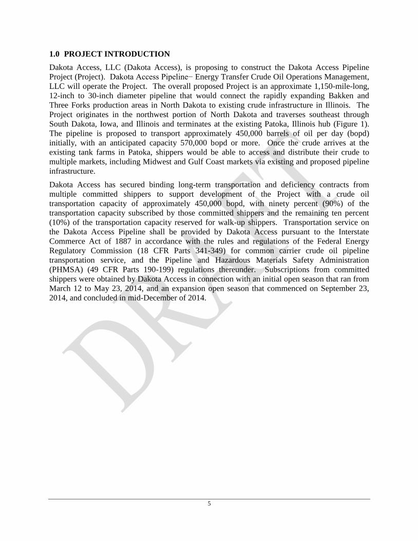
1.0 PROJECT INTRODUCTION
Dakota Access, LLC (Dakota Access), is proposing to construct the Dakota Access Pipeline
Project (Project). Dakota Access Pipeline− Energy Transfer Crude Oil Operations Management,
LLC will operate the Project. The overall proposed Project is an approximate 1,150-mile-long,
12-inch to 30-inch diameter pipeline that would connect the rapidly expanding Bakken and
Three Forks production areas in North Dakota to existing crude infrastructure in Illinois. The
Project originates in the northwest portion of North Dakota and traverses southeast through
South Dakota, Iowa, and Illinois and terminates at the existing Patoka, Illinois hub (Figure 1).
The pipeline is proposed to transport approximately 450,000 barrels of oil per day (bopd)
initially, with an anticipated capacity 570,000 bopd or more. Once the crude arrives at the
existing tank farms in Patoka, shippers would be able to access and distribute their crude to
multiple markets, including Midwest and Gulf Coast markets via existing and proposed pipeline
infrastructure.
Dakota Access has secured binding long-term transportation and deficiency contracts from
multiple committed shippers to support development of the Project with a crude oil
transportation capacity of approximately 450,000 bopd, with ninety percent (90%) of the
transportation capacity subscribed by those committed shippers and the remaining ten percent
(10%) of the transportation capacity reserved for walk-up shippers. Transportation service on
the Dakota Access Pipeline shall be provided by Dakota Access pursuant to the Interstate
Commerce Act of 1887 in accordance with the rules and regulations of the Federal Energy
Regulatory Commission (18 CFR Parts 341-349) for common carrier crude oil pipeline
transportation service, and the Pipeline and Hazardous Materials Safety Administration
(PHMSA) (49 CFR Parts 190-199) regulations thereunder. Subscriptions from committed
shippers were obtained by Dakota Access in connection with an initial open season that ran from
March 12 to May 23, 2014, and an expansion open season that commenced on September 23,
2014, and concluded in mid-December of 2014.
6
Figure 1. Vicinity Map of Project area.
7
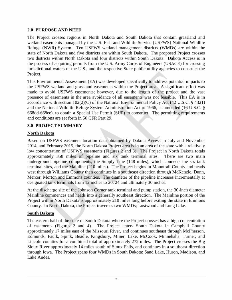
2.0 PURPOSE AND NEED
The Project crosses regions in North Dakota and South Dakota that contain grassland and
wetland easements managed by the U.S. Fish and Wildlife Service (USFWS) National Wildlife
Refuge (NWR) System. Ten USFWS wetland management districts (WMDs) are within the
state of North Dakota and five districts are within South Dakota. The proposed Project crosses
two districts within North Dakota and four districts within South Dakota. Dakota Access is in
the process of acquiring permits from the U.S. Army Corps of Engineers (USACE) for crossing
jurisdictional waters of the U.S., and the respective State public utility agencies to construct the
Project.
This Environmental Assessment (EA) was developed specifically to address potential impacts to
the USFWS wetland and grassland easements within the Project area. A significant effort was
made to avoid USFWS easements; however, due to the length of the project and the vast
presence of easements in the area avoidance of all easements was not feasible. This EA is in
accordance with section 102(2)(C) of the National Environmental Policy Act (42 U.S.C. § 4321)
and the National Wildlife Refuge System Administration Act of 1966, as amended (16 U.S.C. §
668dd-668ee), to obtain a Special Use Permit (SUP) to construct. The permitting requirements
and conditions are set forth in 50 CFR Part 29.
3.0 PROJECT SUMMARY
North Dakota
Based on USFWS easement location data obtained by Dakota Access in July and November
2014, and February 2015, the North Dakota Project area is in an area of the state with a relatively
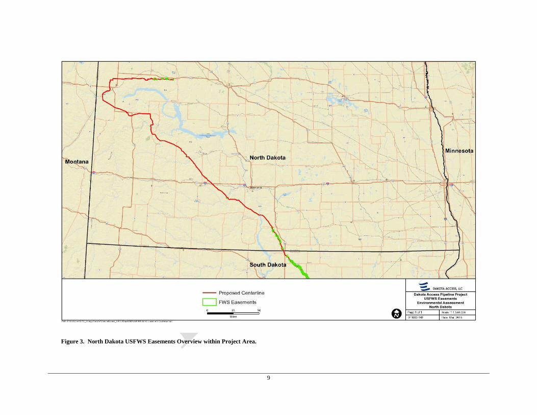
low concentration of USFWS easements (Figures 2 and 3). The Project in North Dakota totals
approximately 358 miles of pipeline and six tank terminal sites. There are two main
underground pipeline components, the Supply Line (148 miles), which connects the six tank
terminal sites, and the Mainline (210 miles). The Project begins in Mountrail County and heads
west through Williams County then continues in a southeast direction through McKenzie, Dunn,
Mercer, Morton and Emmons counties. The diameter of the pipeline increases incrementally at
designated tank terminals from 12 inches to 20, 24 and ultimately 30 inches.
At the discharge site of the Johnson Corner tank terminal and pump station, the 30-inch diameter
Mainline commences and heads into a generally southeast direction. The Mainline portion of the
Project within North Dakota is approximately 210 miles long before exiting the state in Emmons
County. In North Dakota, the Project traverses two WMDs; Lostwood and Long Lake.
South Dakota
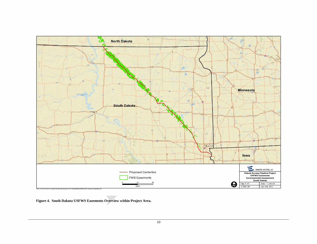
The eastern half of the state of South Dakota where the Project crosses has a high concentration
of easements (Figures 2 and 4). The Project enters South Dakota in Campbell County
approximately 17 miles east of the Missouri River, and continues southeast through McPherson,
Edmunds, Faulk, Spink, Beadle, Kingsbury, Miner, Lake, McCook, Minnehaha, Turner, and
Lincoln counties for a combined total of approximately 272 miles. The Project crosses the Big
Sioux River approximately 14 miles south of Sioux Falls, and continues in a southeast direction
through Iowa. The Project spans four WMDs in South Dakota: Sand Lake, Huron, Madison, and
Lake Andes.
8
Figure 2. USFWS Easement Density Map of North Dakota and South Dakota with Project centerline.
9
Figure 3. North Dakota USFWS Easements Overview within Project Area.
10
Figure 4. South Dakota USFWS Easements Overview within Project Area.
11
Project Construction 3.1
Pipeline
Construction of the new pipeline would require a typical construction ROW width of 125 feet in
uplands, 100 feet in non-forested wetlands, 85 feet in forested areas (wetlands and uplands), and
up to 150 feet in agricultural areas. Following construction, a 50-foot wide permanent easement
would be retained along the pipeline. Where necessary, Dakota Access would utilize additional
temporary workspace outside of the construction ROW to facilitate specialized construction
procedures, such as horizontal directional drills (HDD); railroad, road, wetland, waterbody, and
foreign utility line crossings; tie-ins with existing pipeline facilities; areas with steep side slopes;
and pipeline crossovers.
Aboveground Facilities
In North Dakota, six tank terminals/pump stations are located along Supply Line in Mountrail,
Williams and McKenzie counties. There is only one pump station located within the state of
South Dakota, in Spink County, approximately seven miles southeast of Redfield. All tank
terminals and pump stations have been sited outside of USFWS easements.
Valves used to isolate specific sections of pipeline and minimize crude release in the event of an
emergency would be located throughout the pipeline, including 20 throughout the Supply Line in
North Dakota, 25 throughout the Mainline in North Dakota, and 40 along the pipeline in South
Dakota. The permanent valve sites would be constructed within the 50-foot permanently
maintained ROW, and be approximately 75-feet-long and 50-feet-wide. The spacing intervals
between the valves along the ROW are based upon the location of the high consequence areas,
federal regulations, and permit requirements. All valves would have remote actuators so that in
the unlikely event of an emergency, these valves can be quickly activated from the operational
control room to isolate sections of the pipeline to minimize environmental impacts. All valves
have been situated outside of USFWS grassland easements and USFWS protected wetland basins
within USFWS wetland easements to avoid permanent impacts.
All pipeline segments will allow the passage of internal inspection devices (i.e. pig), which are
capable of detecting internal and external anomalies in the pipe such as corrosion, dents, and
scratches. Pipeline internal inspection technology has improved significantly in recent years.
Pig launcher/receivers (L/Rs) are designed to launch and receive internal inspection devices for
routing maintenance during operation of the system. A total of six L/Rs would be located along
the pipeline within North Dakota (at four of the six tank terminal sites and two along the
mainline), and a total of three L/Rs would be installed in South Dakota. L/Rs are 200-feet-wide
by 400-feet-long. These L/R stations are not located within USFWS grassland easements or
USFWS protected wetland basins within wetland easements to avoid permanent impacts.
Project Timeline 3.2
Dakota Access anticipates starting construction in 2015 as soon as applicable permits and
approvals have been issued. Commissioning of the facilities should occur in September 2016
for in-service in November. Restoration activities will continue as necessary to ensure proper
restoration of the disturbed areas.
12
4.0 ALTERNATIVES
Route Alternatives Considered 4.1
Dakota Access utilized a sophisticated and proprietary Geographic Information System (GIS)
based routing program to determine the baseline pipeline route based on multiple publicly
available and purchased datasets. Datasets utilized during the Project GIS routing analysis
included engineering (e.g., existing pipelines, railroads, karst, and power lines, etc.),
environmental (e.g., critical habitat, fault lines, state parks, national forests, brownfields, national
registry of historic places, etc.), and land (e.g., dams, airports, cemeteries, schools, mining,
and military installations, etc.).
Each of these datasets were weighted based on the risk (e.g., low, moderate, or high; however on
a scale of 0 to 1000) associated with crossing or following certain features. Appendix A includes
a list of every dataset utilized in the GIS routing program and the weight scale set for each
dataset for the Project. In general, the preferred route for the pipeline would follow features
identified as low risk, avoid or minimize crossing features identified as moderate risk, and
exclude features identified as high risk. For example, the existing pipelines dataset was weighted
as a low risk feature in the GIS routing program so that the routing tool followed existing
pipelines to the extent possible to minimize potential impacts. An example of a high risk feature
of the datasets utilized in the GIS routing program is the federally designated critical habitat
dataset. Since federally designated critical habitat was weighted for this Project as high risk, the
GIS routing program excluded any critical habitat from the baseline pipeline route to avoid
impacts.
4.1.1 Route Alternative 1
Dakota Access obtained USFWS easement location data in July 2014 when identified during the
Project fatal flaw analysis and initial coordination with the USFWS. The baseline centerline
route (Route Alternative 1) (Appendix A) was the output of the GIS routing analysis described
above in Section 4.1, and was submitted to the USFWS WMDs in September 2014 for initial
review of grassland and wetland easements crossed by the pipeline based on the July 2014
easement location data. The baseline route crossed 131 USFWS easements (seven easements
within North Dakota and 124 easements within South Dakota). Dakota Access and the lead
USFWS WMD (Sand Lake WMD) had an intensive route review in October 2014 of the baseline
route and easements crossed to determine avoidance and minimization. During this review, the
USFWS made recommendations on avoiding and minimizing impacts to the easements crossed
by the Project. Grassland easements were prioritized for avoidance. At the time of investigation
of Route Alternative 1, the USFWS did not have field verified data on protected wetland basins
within the wetland easements. However an attempt was made by the USFWS and Dakota
Access to identify potential wetland basins within the wetland easements through desktop
analysis. Extensive coordination and review identified areas where Dakota Access could make
route modifications to avoid and minimize potential impacts to USFWS easements (Appendix
A).
4.1.2 Route Alternative 2 (Preferred)
Route Alternative 2 (Appendix A) is the preferred route which is the result of incorporating route
modifications based on USFWS avoidance and minimization recommendations of potential
impacts to grassland and wetland easements of Route Alternative 1. The Project crosses an area
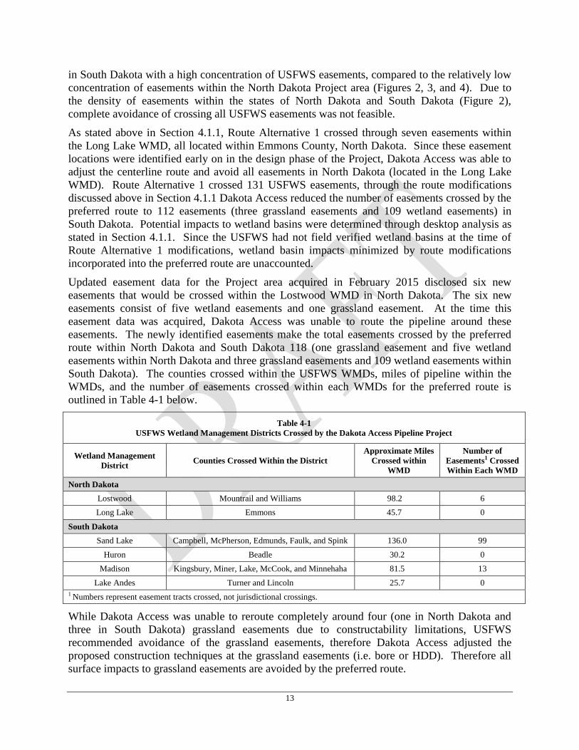
13
in South Dakota with a high concentration of USFWS easements, compared to the relatively low
concentration of easements within the North Dakota Project area (Figures 2, 3, and 4). Due to
the density of easements within the states of North Dakota and South Dakota (Figure 2),
complete avoidance of crossing all USFWS easements was not feasible.
As stated above in Section 4.1.1, Route Alternative 1 crossed through seven easements within
the Long Lake WMD, all located within Emmons County, North Dakota. Since these easement
locations were identified early on in the design phase of the Project, Dakota Access was able to
adjust the centerline route and avoid all easements in North Dakota (located in the Long Lake
WMD). Route Alternative 1 crossed 131 USFWS easements, through the route modifications
discussed above in Section 4.1.1 Dakota Access reduced the number of easements crossed by the
preferred route to 112 easements (three grassland easements and 109 wetland easements) in
South Dakota. Potential impacts to wetland basins were determined through desktop analysis as
stated in Section 4.1.1. Since the USFWS had not field verified wetland basins at the time of
Route Alternative 1 modifications, wetland basin impacts minimized by route modifications
incorporated into the preferred route are unaccounted.
Updated easement data for the Project area acquired in February 2015 disclosed six new
easements that would be crossed within the Lostwood WMD in North Dakota. The six new
easements consist of five wetland easements and one grassland easement. At the time this
easement data was acquired, Dakota Access was unable to route the pipeline around these
easements. The newly identified easements make the total easements crossed by the preferred
route within North Dakota and South Dakota 118 (one grassland easement and five wetland
easements within North Dakota and three grassland easements and 109 wetland easements within
South Dakota). The counties crossed within the USFWS WMDs, miles of pipeline within the
WMDs, and the number of easements crossed within each WMDs for the preferred route is
outlined in Table 4-1 below.
Table 4-1
USFWS Wetland Management Districts Crossed by the Dakota Access Pipeline Project
Wetland Management
District Counties Crossed Within the District
Approximate Miles
Crossed within
WMD
Number of
Easements1 Crossed
Within Each WMD
North Dakota
Lostwood Mountrail and Williams 98.2 6
Long Lake Emmons 45.7 0
South Dakota
Sand Lake Campbell, McPherson, Edmunds, Faulk, and Spink 136.0 99
Huron Beadle 30.2 0
Madison Kingsbury, Miner, Lake, McCook, and Minnehaha 81.5 13
Lake Andes Turner and Lincoln 25.7 0
1 Numbers represent easement tracts crossed, not jurisdictional crossings.
While Dakota Access was unable to reroute completely around four (one in North Dakota and
three in South Dakota) grassland easements due to constructability limitations, USFWS
recommended avoidance of the grassland easements, therefore Dakota Access adjusted the
proposed construction techniques at the grassland easements (i.e. bore or HDD). Therefore all
surface impacts to grassland easements are avoided by the preferred route.
14
The preferred route most closely meets the objectives of the Project, while minimizing potential
impacts to the environment and USFWS easements. Dakota Access has coordinated with the
USFWS throughout the Project design phase to avoid and minimize potential impacts to USFWS
grassland and wetland easements. Additional details on the preferred route and potential impacts
to grassland and wetland easements are provided in Section 5.0.
Alternatives Considered and Dismissed 4.2
The following alternatives were considered but immediately dismissed due to the reasons
described below for each alternative.
4.2.1 No Action Alternative
The proposed Project would not be built if the “no action” alternative were pursued. The “no
action” alternative would not provide the infrastructure necessary to transport light sweet crude
oil to refining facilities. In northwest North Dakota, exploration and production of oil is a major
economic activity, with crude oil production being the primary mineral resource of interest.
Although the “no action” alternative itself would not incur environmental impacts, it would also
not address the existing demand to transport crude oil to refining facilities, likely leading to
alternative pipeline project development proposals.
4.2.2 System Alternatives
The parent company of Dakota Access, Energy Transfer Company (Company) is one of the
largest and most diversified investment grade limited partnerships in the United States with
approximately 71,000 miles of pipeline assets today (Energy Transfer, 2014). The Company and
its partners have a presence in more than half of the contiguous United States; however, the
Company does not own or operate any existing facilities in North or South Dakota. The Project
will be the Company’s first asset in the Dakotas. For this reason, the manipulation of operating
pressures to increase transport capacity in pipelines or altering existing infrastructure to increase
storage and transport capacity are not viable options to meet the Project’s objectives or shippers’
demands.
4.2.3 Trucking Transportation Alternative
Currently, due to a lack of transport capacity in the Williston Basin, approximately 1% of the
crude oil is moved via truck (Kringstad, 2014). While trucking is instrumental in the gathering
and distribution of crude on a limited scale, trucking as an alternative for transporting the volume
of crude oil the distances planned for the Project is not viable. Factors such as road safety,
roadway capacity, and a lack of reliability due to seasonal constraints, in addition to other
logistical issues involving availability of labor force, trailer truck capacity, and economics, all
contribute to truck transportation not being a realistic alternative.
A sharp increase in traffic on North Dakota roads as a result of the rapid expansion in the number
of commercial trucks linked to the oil industry speaks to the issues associated with road safety.
In 2012, the Federal Motor Carrier Safety Administration reported a traffic fatality rate in North
Dakota of 0.48 per million vehicle miles traveled, with 48 deaths involving a bus or large truck,
far surpassing any other state (U.S. Department of Transportation, 2014). In the pre-boom years
of 2001 to 2005, there was an average of only 13 annual deaths involving commercial trucks.
Furthermore, the economic cost of severe truck crashes has more than doubled between 2008 and
2012. Much of the increase in the fatality rate can be attributed to the energy production boom,
15
along with the fact that the state’s infrastructure still consists of single-lane, rural, and unpaved
roads in many areas (Bachman, 2014). Harsh winter weather and seasonal road restrictions
compromise the reliability of truck transportation even further.
To meet shippers’ demands, Dakota Access plans to transport 450,000 bpd approximately 1,150
miles across four states. A pipeline is a safer and more economical alternative than trucking for
the volumes transported and distances covered by the Project. Assuming the average oil tanker
truck is capable of holding about 220 barrels of oil, the transportation of 450,000 bpd would
require a total of 2,045 (450,000/220) full trucks to depart the proposed tank terminals daily;
more than 85 (2,045/24) trucks would have to be filled every hour with a 24-hour/day operation.
Time spent in transit, loading/offloading, and additional time for maintenance would add to the
number of trucks needed to offset for the Project.
Analysis of infrastructure considerations (the burden of thousands of additional trucks on county,
state, and interstate highways, as well as the loading and offloading facilities that would have to
be constructed), economic considerations (e.g., labor costs, purchase and maintenance of hauling
equipment, fuel, public infrastructure, etc.), and reliability considerations (e.g., weather,
mechanical, manpower, road closures) all contribute to making the truck transportation
alternative unviable.
4.2.4 Rail Transportation Alternative
Reliance on rail as a transportation method in the Williston Basin has drastically increased in
recent years, carrying a negligible percentage of the overall market share as recently as 2010 to
nearly 60% of the overall market share by mid-2014 (Kringstad, 2014). The rise in the use of
rail as a primary transportation method has been driven in large part by the rapid increase in
production of crude oil coupled with a lack of pipeline capacity to account for additional
supplies.
Negative impacts from the growth in popularity of rail as a method of long-distance
transportation of crude oil include delays that disrupt the agricultural sector, reductions in coal-
fired power plant inventories, and significant production issues in the food production industry.
In August 2014, reports filed with the federal government indicated that the Burlington Northern
Santa Fe Railway had a backlog of 1,336 rail cars waiting to ship grain and other products while
Canadian Pacific Railway had a backlog of nearly 1,000 cars (Nixon, 2014). For industries, such
as those listed, in which the use of pipelines is not an option the only viable alternative would be
increased reliance on trucking, which would exacerbate some of the issues listed in the section
above.
Assuming a carrying capacity of 600 barrels per car, a total of 750 rail cars would be required to
depart the tank terminal daily to transport 450,000 barrels of crude oil to its final destination.
Loading and offloading 750 rail cars in a day would require servicing more than 31 rail cars per
hour. With an assumption of 125 rail cars per train, 6 trains would have to depart the tank
terminal every day; with 10 to 12 trains currently leaving the state per day carrying Bakken
crude, the Project would represent a 50 to 60% increase in the number of trains transporting
crude oil out of the state, likely exacerbating issues with delays (Howarth and Owings, 2014).
Rail operations on the scale of the Project do not exist in the United States. An oil-by-rail
facility designed to handle an average of 360,000 bpd has been proposed in the Port of
Vancouver, Washington. Known as the Vancouver Energy proposal, the project would be the
16
largest rail terminal in the country (Florip, 2014). A rail transportation alternative to handle the
volumes of the Project would require the design and construction of 125 to 158% of that of the
Vancouver Energy proposal.
From a safety standpoint, railroad transport consistently reports a substantially higher number of
transportation accidents than pipelines (USDOT, 2015). A series of major accidents taking place
in 2013 to 2014 in Canada and the United States has heightened concern about the risks involved
in shipping crude by rail (Fritelli, 2014).
While rail tanker cars are a vital part of the short-haul distribution network for crude oil,
pipelines are a more reliable, safer, and more economical alternative for the large volumes
transported and long distances covered by the Project. As such, the rail transportation alternative
is not considered a viable alternative.
5.0 AFFECTED ENVIRONMENT
The Project crosses both grassland and wetland easements within North Dakota and South
Dakota. Grassland easements are an agreement between the landowner and the USFWS to keep
their land in grass and limit the time of year for mowing, haying and grass seed harvest. Wetland
easements are an agreement between the landowner and the USFWS to protect wetlands from
being drained, leveled, filled, or burned. Both grassland and wetland easements are to provide
and protect waterfowl habitat, and other wildlife that utilize similar habitats. In addition to
habitat, these easements aim to protect the functions and values that these habitats provide to the
surrounding areas.
Grassland Easements 5.1
As stated previously, initial coordination between USFWS and Dakota Access identified
avoidance of grassland easements as priority. Dakota Access adjusted the Project alignment to
avoid crossing all grassland easements, except for three within South Dakota and one within
North Dakota.
The three South Dakota grassland easements are located in Campbell County at milepost (MP)
235.3, Spink County at MP 330.2, and one in Minnehaha County at MP 438.5 (Appendix B,
pages 12, 42, and 51). However, due to USFWS concerns regarding potential impacts to the
grassland easements, Dakota Access changed the proposed construction methods at these
crossings to avoid surface disturbance and potential impacts. The grassland easements in
Campbell (MP 235.3), Spink (MP 330.2), and Minnehaha counties (MP 438.5) are crossed at the
corner of the easement tracts and adjacent to road crossings. Dakota Access modified the
construction methods at these three locations and plans to bore under the road and continue the
bore under the grassland easement to avoid surface impacts. Therefore, impacts to these three
grassland easements identified early in the design phase within South Dakota will be avoided.
An additional grassland easement was identified in the February 2015 USFWS easement data
located in Mountrail County, North Dakota at Supply Line MP 12.3 (Appendix B, page 6). This
grassland easement is large in size and no reasonable route around it is available; however,
through coordination with the USFWS, Dakota Access has adjusted the centerline to route
through the shortest distance of the grassland easement, and proposes to cross this easement via
HDD. Due to the size of this easement, transporting equipment across the easement to facilitate
construction of the Project is required. To minimize potential impacts to the grassland easement,
Dakota Access will install air bridge matting (Appendix B, page 53 includes an air bridge sketch)
17
to be utilized as the designated travel lane for construction equipment. The air bridge travel lane
will be located on an existing two-track road, approximately 250 feet north of the centerline.
The use of air bridge matting will avoid potential soil compaction and ruts from equipment
transport. Therefore, no adverse surface impacts to this grassland easement will result from the
Project.
All surface impacts to grassland easements in North Dakota and South Dakota have been
avoided by route modifications or construction methods.
Wetland Easements 5.2
Throughout the design and permitting process, Dakota Access coordinated with the USFWS to
minimize crossing wetland easements to the extent practicable. As stated previously in Section
4.1.2, all easements were completely routed around and avoided within North Dakota initially.
However, the February 2015 easement data revealed five new wetland easements within the
Project area on the Supply Line in North Dakota. The five wetland easements within North
Dakota have been verified (through both field and desktop reviews) by the USFWS, and
electronic files of these wetland basins were provided to Dakota Access. Four of the five
wetland easements crossed contain protected wetland basins (11 wetland basins within Project
footprint) within the Project area, and total approximately 2.5 acres of protected wetland basins
to be temporarily impacted by the Project within North Dakota (Appendix B, pages 3-8).
The USFWS field verified all wetland basins within easements within South Dakota and
provided electronic files of these wetland basins to Dakota Access. This data was utilized to
further minimize potential impacts of the preferred route to wetland basins through Project
design to the extent practicable, which is illustrated in Appendix B (pages 9-52) mapping.
In South Dakota, the preferred route crosses 109 wetland easements with approximately 200
wetland basins field verified by the USFWS within the Project area (Appendix B, pages 9-52).
Draft workspace in February of 2015 avoided approximately 36 of these basins. Utilizing the
USFWS field verified wetland basins data; Dakota Access further edited workspace and was able
to avoid an additional 18 basins. This avoidance and minimization through Project design
reduced the total number of basins crossed to 146. At approximately 40 of the 146 wetland basin
locations Project delineated wetlands, based on the Regional Supplements to the Corps of
Engineers Wetland Delineation Manual: Great Plains and Midwest Regions (USACE, 2010) and
the routine determination guidelines provided in the USACE Wetland Delineation Manual
(Technical Report Y-87-1), matched with the USFWS wetland basins. Potential impacts at these
locations were minimized through reduction in workspace (i.e. neckdown the construction
corridor width from 150 feet to 100 feet), therefore minimizing impacts to these areas. Of the
109 wetland easements crossed in South Dakota, the Project crosses protected wetland basins at
only 60 of the wetland easements. Wetland basins were avoided at the remaining 49 wetland
easement crossed by the Project. Incorporating the avoidance and minimization of all wetland
basins within South Dakota, Project construction would temporarily impact a total of
approximately 69.3 acres of wetland basins within USFWS easements through construction.
Total temporary impacts to wetland basins within USFWS easements in North Dakota and South
Dakota is 71.8 acres. The total temporary impacts to the wetland basins (71.8 acres) would be
less than 0.6 percent of the entire North Dakota and South Dakota Project footprint.
18
6.0 RESOURCES WITHIN AFFECTED ENVIRONMENT
The following sections evaluate the resources and potential impacts within the affected
environment within the scope of this EA; including vegetation, water quality, air quality,
threatened and endangered species, and cultural resources. Each section includes a conclusion
on potential impacts to the resources discussed.
Vegetation 6.1
Vegetation community types that occur within the affected environment were identified,
described, and delineated based on field activities and aerial photography. The vegetation
communities crossed within the affected environment include agriculture, native grassland, and
wetlands. Dominant species identified within the grassland easement in North Dakota included
Kentucky bluegrass (Poa pratensis), smooth brome (Bromus inermis), crested wheatgrass
(Agropyron cristatum), little bluestem (Schizachyrium scoparium), western snowberry
(Symphoricarpos occidentalis), and prairie rose (Rosa arkansana). Dominant species within the
grassland easements crossed in South Dakota included Kentucky bluegrass, smooth brome,
yellow sweetclover (Melilotus officinalis), intermediate wheatgrass (Thinopyrum intermedium),
and curlycup gumweed (Grindelia squarrosa). Dominant wetland vegetation identified within
the wetland basins in North Dakota included broadleaf cattail (Typha latifolia), prairie cordgrass
(Spartina pectinata), foxtail barley (Hordeum jubatum), sedge (Carex sp.), slimstem reedgrass
(Calamagrostis stricta), water smartweed (Persicaria amphibia), and reed canarygrass (Phalaris
arundinacea). The dominant species identified within the South Dakota wetland basins included
prairie cordgrass, spikerush (Eleocharis sp.), foxtail barley, sedge, rough barnyardgrass
(Echinochloa muricata), American water plantain (Alisma subcordatum), and swamp smartweed
(Polygonum hydropiperoides). Upland vegetation including Kentucky bluegrass, smooth brome,
alfalfa and agricultural crop (soybeans) were also identified within the South Dakota USFWS
wetland basins.
Temporary impacts to vegetation will occur during construction. To protect the terrain of the
Project area, Dakota Access will restore the areas affected by pipeline construction to pre-
construction contours, mitigation measures to limit disturbance of vegetation within grassland
and wetland easements are discussed further in Section 7.0.
Noxious Weeds
The state of North Dakota has 11 state listed noxious and invasive weeds. The species listed are:
Russian knapweed (Acroptilon repens), absinth wormwood (Artemisia absinthium), musk thistle
(Carduus nutans), diffuse knapweed (Centaurea diffusa), yellow toadflax (Linaria vulgaris),
spotted knapweed (Centaurea maculosa), Canada thistle (Cirsium arvense), leafy spurge
(Euphorbia esula), dalmatian toadflax (Linaria dalmatica), purple loosestrife (Lythrum
salicaria), and saltcedar (Tamarix chinensis). These state invasive species are regulated under
North Dakota Law (North Dakota Century Code § 4.1-47-02).
The South Dakota state noxious weed list is found in South Dakota Codified Law (Chapter 38-
22). There are currently seven noxious weeds on the state list, which include Russian knapweed,
whitetop (Cardaria draba), Canada thistle, leafy spurge, purple loosestrife, saltcedar, and
perennial sowthistle (Sonchus arvensis). Under the law, it is a landowner’s legal responsibility
to manage noxious weeds on their lands. Local county governments have the responsibility for
the implementation and enforcement of weed management.
19
Construction activities resulting in surface disturbance may contribute to the spread of noxious
weeds. Noxious weeds have the potential to increase in disturbed areas along the ROW where
construction occurs. Mitigation measures to limit disturbance of vegetation are discussed further
in Section 7.0.
Water Quality 6.2
Dakota Access has submitted Nationwide Permit 12 Pre Construction Notifications to the
USACE for authorization to discharge fill within USACE jurisdictional wetlands and
waterbodies under Sections 404/401 of the Clean Water Act. Additionally, specialized methods
for crossing wetlands and waterbodies including expedited timing for construction and
restoration and implementation of erosion control devices are utilized to minimize impacts
within and adjacent to the wetland basins, these are discussed further in Section 7.0. Further,
Dakota Access will acquire any required state and local water quality permits to construct the
Project. Therefore, impacts beyond direct, temporary construction impacts to water quality due
to the Project are not anticipated.
PHMSA administers the national regulatory program to ensure safe transportation of crude oil
and other hazardous materials by pipelines. PHMSA develops safety regulations and risk
management approaches to encompass safety in pipeline design, construction, testing, operation,
maintenance, and pipeline facilities emergency response. Dakota Access has asked for no
waivers from PHMSA for the construction and operation of the pipeline. Dakota Access will
meet or exceed all federal laws and regulations.
PHMSA prescribes pipeline design and operational requirements that limit the risk of accidental
crude oil releases from pipelines. Dakota Access will submit a Project-specific Facilities
Response Plan (FRP) prior to operation to PHMSA for approval in accordance with applicable
regulations.
In the unlikely event of a pipeline release, Dakota Access will initiate its FRP to contain and
clean up the spill. To minimize impacts to aquatic resources, appropriate remedial measures will
be implemented to meet federal and state standards designed to ensure protection of aquatic
biota.
Compliance with federal regulations, the location of valves, spill containment measures, and the
FRP will minimize adverse effects to public safety and to the environment. PHMSA
promulgates and enforces federal pipeline safety standards for hazardous liquids pipelines at 49
CFR Parts 194 and 195. These regulations are intended to ensure public protection and to
prevent accidents and failures. 49 CFR Part 195 specifically addresses petroleum pipeline safety
issues and specifies material selection, qualification, minimum design requirements; and
protection from internal, external, and atmospheric corrosion.
In conclusion, wetland and waterbody construction crossing methods, implementation of erosion
control devices, and PHMSA requirements would minimize potential impacts to water quality
from construction and operation of the Project.
Air Quality 6.3
Air quality impacts within the scope of this EA include potential air emissions during
construction. Potential emissions during construction would be from mobile sources. Mobile
sources of emissions are the tailpipe emissions from employee commuter vehicles and
construction equipment to be used during construction of the pipeline. No permitting is
20
required for mobile sources. Mobile source emissions from construction of the pipeline would
be temporary; therefore impacts to air quality from the construction of the Project are not
anticipated.
Threatened and Endangered Species 6.4
Dakota Access is continuing consultation for federally threatened and endangered (T&E) species
with the local USFWS Ecological Services Field Offices in Bismarck, North Dakota, Pierre,
South Dakota, and the Rock Island Ecological Services Field Office in Moline, Illinois, the lead
for federally listed species for the entire Dakota Access Project. For the purpose of this EA, only
species that are listed within the counties crossed by the Project within North Dakota and South
Dakota where easements are crossed will be discussed, since all USFWS easement crossings for
the Project only occur within these states.
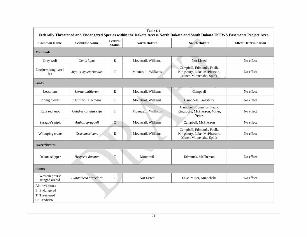
A total of 9 T&E species are listed as threatened, endangered or candidate within the North
Dakota and South Dakota Project area that crosses USFWS easements. Table 6-1 below
provides a comprehensive list of listed species, counties they are listed in, and effect
determination for the affected environment. No critical habitat is crossed by the Project within
the affected environment. Based on the habitat requirements for the 9 federally listed T&E
species, it has been determined that the Project would have no effect on any of the listed species
within the affected environment. Of the 9 listed species, the whooping crane (Grus americana)
and the piping plover (Charadrius melodus) may utilize habitat on wetland easements, and the
Dakota skipper (Hesperia dacotae) and Sprague’s pipit (Charadrius melodus) may utilize the
grassland easement habitats. Therefore these four species and their habitat requirements are
described further below and provide justification for the no effect determination. The T&E
species information will be updated throughout pre-construction and construction based on
continued consultations.
21
Table 6-1
Federally Threatened and Endangered Species within the Dakota Access North Dakota and South Dakota USFWS Easements Project Area
Common Name Scientific Name Federal
Status North Dakota South Dakota Effect Determination
Mammals
Gray wolf Canis lupus E Mountrail, Williams Not Listed No effect
Northern long-eared
bat Myotis septentrionalis T Mountrail, Williams
Campbell, Edmunds, Faulk,
Kingsbury, Lake, McPherson,
Miner, Minnehaha, Spink
No effect
Birds
Least tern Sterna antillarum E Mountrail, Williams Campbell No effect
Piping plover Charadrius melodus T Mountrail, Williams Campbell, Kingsbury No effect
Rufa red knot Calidris canutus rufa T Mountrail, Williams
Campbell, Edmunds, Faulk,
Kingsbury, McPherson, Miner, Spink
No effect
Sprague’s pipit Anthus spragueii C Mountrail, Williams Campbell, McPherson No effect
Whooping crane Grus americana E Mountrail, Williams
Campbell, Edmunds, Faulk,
Kingsbury, Lake, McPherson, Miner, Minnehaha, Spink
No effect
Invertebrates
Dakota skipper Hesperia dacotae T Mountrail Edmunds, McPherson
No effect
Plants
Western prairie
fringed orchid Platanthera praeclara T Not Listed Lake, Miner, Minnehaha No effect
Abbreviations:
E: Endangered
T: Threatened
C: Candidate
22
Whooping Crane
Biology
The whooping crane was federally-listed as endangered under the ESA on March 11, 1967
(USFWS, 2012a). The crane is a large migratory bird species with a long neck and legs,
reaching a height of 51 to 63 inches (Esch, 2012). Whooping cranes have primarily white
plumage with black primary wing feathers and legs. The crown, lore, and malar areas consist of
bare skin covered with few short black bristly feathers (USFWS, 2015a). This species has a
bright red crown and the lore and malar areas are generally dark grayish black with some red.
Juveniles are distinct with blotches of cinnamon or brown in their white plumage and visible
feathers on their heads, contrary to bare skin observed on adults’ heads. The bills of whooping
cranes have a gray or olive coloration with a pinkish base. Differentiating between male and
female whooping cranes is difficult since they share similar physical characteristics, but males
(16 pounds) on average weigh more than females (14 pounds) (Esch, 2012).
There are currently four distinct populations of whooping cranes in the wild, with the only
natural population migrating between Wood Buffalo National Park in Alberta, Canada and the
Aransas National Wildlife Refuge along the Texas coast. The other three populations consist of
the following: 1) an experimental population migrating between Wisconsin and Florida; 2) a
reintroduced experimental non-migratory population in central Florida; and (3) a non-migratory
population in Louisiana (USFWS, 2012a). The previously mentioned natural population has
steadily increased an average of 4.6 percent annually (USFWS, 2012a). Historically, this
population wintered solely in the Aransas National Wildlife Refuge, but recent reports have
spotted whooping cranes in other suitable Texas coastal areas and even inland Central Texas
(Texas Parks and Wildlife Department, 2014). As of the spring of 2011, this population of
whooping cranes consisted of 279 individuals (USFWS, 2012a).
The natural whooping crane population travels a defined migration corridor between summer and
winter habitats. This corridor begins in the Northwest Territories of Canada and passes southeast
through the center of North Dakota, South Dakota, Nebraska, Kansas, Oklahoma, and ends at the
Texas coast (USFWS, 2012a). Autumn migrations run from mid-September until mid-
November, whereas the spring migration begins in late-March or early April and lasts until early
May (USFWS, 2015a). Throughout its journey, whooping cranes inhabit various areas,
including croplands and palustrine wetlands reaching less than four hectare in size. During the
nesting season in the summer, this species relies on poorly drained potholes and wetlands for
nesting areas. In the winter, estuarine marshes, bays, and tidal flats are primary habitat (USFWS,
2012a). In general, whooping cranes prefer open areas near water and vegetation (Esch, 2012).
Reproduction occurs once a year during the summer in late April to mid-May, with chicks
hatching about a month after eggs are laid (USFWS, 2015a). Generally, two eggs are laid per
nest and parents will take turns incubating the nest. The chicks will be cared for until they are
nine months old, feeding on worms and insects provided by the parents. At two or three years of
age whooping cranes choose a mate for life, and can sexually reproduce between four and five
years old (Esch, 2012). Once mature, this species consumes a variety of foods. In the winter,
whooping cranes will eat primarily blue crabs, wolfberry fruits, and clams, occasionally
consuming acorns, snails, crayfish, and insects when food is scarce. In the summer, whooping
cranes eat insects, frogs, rodents, small birds, minnows, and berries. During migration, this
23
species consumes a combination of foods eaten in the winter and summer, in addition to plant
tubers and agricultural grains (USFWS, 2015a).
The whooping crane’s population numbers are low primarily due to human population growth.
The construction of roads, buildings, power lines, towers, and wind turbines have drained crucial
wetlands utilized by this species in its migration corridor. In addition, a decrease in river flows
has contributed to habitat degradation of riverine migration habitat (USFWS, 2012a).
Furthermore, efforts to introduce birds raised in captivity with hopes of steadily increasing
whooping crane numbers in the wild have struggled when it comes time for breeding and raising
chicks (USFWS, 2012a).
Habitat Assessment
The North Dakota and South Dakota Project area is within the migratory range of this species
(Cornell Lab of Ornithology, 2014). Based on South Dakota Natural Heritage Program
(SDNHP) and North Dakota Heritage Inventory (NDNHI) data, only one whooping crane
occurrence record is located in Kingsbury County, South Dakota approximately one mile from
the Project area (NDNHI and SDNHP, 2014). While the Project area within North Dakota and
South Dakota may provide suitable stopover habitat for migrating whooping cranes, this species
is highly mobile and would likely avoid construction. Therefore, no effect on this species within
the affected environment is anticipated.
Sprague’s Pipit
Biology
The Sprague’s pipit was listed to the USFWS Candidate Species List on September 15, 2010
(USFWS, 2009). This species is a small prairie bird, approximately 4 to 6 inches in length with
sandy brown feathers with black streaks and two blurred white wing bars. Sprague’s pipit has a
large eye-ring and a short, thin bill (USFWS, 2014a). The upper mandible is black, while the
lower mandible is light tan with a black tip. Male and female Sprague’s pipit are similar in
appearance, however the males fly high in the air for a territorial flight display (USFWS, 2014a).
The Sprague’s pipit breeds in the northern prairies of the Great Plains and winters from
September-April in Arizona, New Mexico, Texas, Oklahoma, Arkansas, Mississippi, Louisiana,
and Northern Mexico (National Audubon Society, 2014). This species prefers grassland with
good drainage, few shrubs, and high visibility. Native grasses like wheatgrass, June grass, blue
grama, Canby blue, green needle grass, smooth brome, and crested wheat are ideal for the
Sprague’s pipit (Javier, 2007). Native grasslands with at least 75 percent native cover, and an
approximate minimum grassland size requirement of 358 acres. This species has not been
observed in grasslands less than approximately 72 acres in size (USFWS, 2014a). Non-native
pasturelands and cultivated lands are not likely to be utilized for nesting by the Sprague’s pipit
(USFWS, 2010). The Sprague’s pipit is well camouflaged in the prairie grasses and will walk or
run while foraging or avoiding predators, unless flushed from the grass and forced to flight
(Javier, 2007). This species primarily consumes arthropods, but will eat seeds during migration
and wintering (National Audubon Society, 2014).
Breeding habitat range includes parts of Canada, Montana, North Dakota, and the northern
portions of South Dakota. Breeding season can extend from April through mid-May (USFWS,
2010). This species is a ground nesting bird that utilizes mid-height grasslands with little bare
ground during and creates nests of dead grass within depressions in the ground (NatureServe,
24
2015). Sprague’s pipit raise one to two broods with an approximate clutch size is four or five
eggs (NatureServe, 2015). Brooding and incubation is mainly by females, although males may
also brood and incubate the eggs and clutch (USFWS, 2010).
Sprague’s pipit migratory habitat includes the Great Plains and south to Mexico. The majority of
the population is believed to winter in Mexico, most of the U.S. migratory sightings have been in
Texas (USFWS, 2014a). The migratory habitat may include grassland areas similar to breeding
habitat, agricultural areas, and pasture (USFWS, 2010).
The loss of native prairie habitat from conversion to agricultural uses is identified as one of the
main reasons for decline of this species (Cornell Lab of Ornithology, 2014).
Habitat Assessment
All of the North Dakota Project area is within the breeding range of this species. Only a small
northern portion of the South Dakota Project area is within the breeding range, while the
majority of the South Dakota Project area is within the migratory range of the Sprague’s pipit.
Dakota Access has avoided impacts to all grassland easements crossed by the Project within
North Dakota and South Dakota by adjusting the pipeline alignment and incorporating
alternative crossing methods (i.e. boring, HDD) at these locations so that there are no surface
impacts to potential breeding habitat within the grassland easements. Since the grassland
easement crossings are adjacent to existing roads and disturbance, indirect impacts from noise
during construction is not anticipated. As stated previously, since the migratory habitat of this
species may include agricultural areas and pasture, the majority of the South Dakota Project area
may provide suitable migratory habitat (USFWS, 2010). While the Project area within South
Dakota may provide suitable stopover habitat for migrating Sprague’s pipit, this species is highly
mobile and would likely avoid construction. Therefore, no effect on this species within the
affected environment is anticipated.
Piping Plover
Biology
The piping plover was listed to the USFWS Threatened and Endangered Species List on
December 11, 1985 (USFWS, 2009). The classification of threatened or endangered status is
dependent on location, where Northern Great Plains and the Atlantic Gulf Coast populations are
listed as threatened, while the Great Lakes population is listed as endangered. All three
populations are considered threatened throughout their wintering range (USFWS, 2009). The
piping plover is a robin sized shorebird characterized in the summer by a black neck band and
black forehead ring, a sandy colored back, a white underside, thin featherless orange legs, and a
robust black and orange beak. During the winter and non-breeding months, both the neck band
and forehead ring are difficult to observe and the legs may take on a more yellowed color
(USFWS, 2013; USFWS, 2012b).
There are three geographically distinct breeding populations of piping plover found in the
Northern Great Plains, the Great Lakes, and the Atlantic Coast (USFWS, 2009). All three
populations share a common coastal wintering range which extends from the Carolinas, south to
the Yucatan (USFWS, 2009). In 2001 and 2002, critical habitat was designated for the Great
Lakes and Northern Great Plains breeding populations, as well as for all wintering areas within
the U.S. (USFWS, 2009). The Great Lakes critical habitat spans 201 miles of shoreline within
the states that border the Great Lakes. Critical habitat for the Northern Great Plains population
25
was created in 2005, and spans about 183,000 acres and 1,200 miles of river from Montana to
Minnesota, south to Nebraska (USFWS, 2009). In 2012, research found about 1,300 pairs of
piping plovers present in the Northern Great Plains population (USFWS, 2009). There were
about 60 pairs in Montana, 650 pairs in North Dakota (located mainly on the Missouri River),
approximately 150 pairs in each South Dakota and Nebraska, two pairs in Minnesota, and less
than ten pairs in Colorado, Kansas, and Iowa combined (USFWS, 2009). The piping plover
inhabits areas near water, preferring river sandbars and alkali wetlands for nesting in the Great
Plains and gravelly shorelines in the Great Lakes region (USFWS, 2013). For wintering, the
piping plover resides on large coastal sand or mudflats near a sandy beach (USFWS, 2013).
Breeding season for the piping plover spans from late March through April (Texas Parks and
Wildlife Department, 2015). The birds make nests on the ground on thinly vegetated sand or
gravel beaches and dunes approximately 150 to 300 feet apart (USFWS, 2009; USFWS, 2013).
The nests for the Northern Great Plains population are generally located along alkali lakes,
rivers, and reservoir shorelines that are gravelly and lack sand dunes (USFWS, 2009). The
piping plover has been documented utilizing vegetated nesting sites on occasion, nesting within
cottonwood saplings along the Missouri River (USFWS, 2009). Typically, this species nests at
the water’s edge, but during drought years they have been noted to nest as far as 1,000 feet away
from the edge of the water (USFWS, 2009). Each nest contains three to four eggs that are
incubated by both sexes and hatch in approximately 30 days. In the event that eggs are destroyed
early in the breeding season, oftentimes a second batch of eggs will be laid. Protective behavior
is often exhibited by the piping plover, feigning a broken wing to lead a predator away when it
comes too close to the nest. Chicks will also make use of natural camouflage and hide in the
event that danger presents itself. Both the male and female feed the young a diet consisting of
freshwater and marine invertebrates until about four weeks after hatching, at which point the
chicks will fledge (National Park Service, 2015; Texas Parks and Wildlife Department, 2015;
USFWS, 2013).
The diet of piping plovers consists of worms, fly larvae, beetles, crustaceans, mollusks, and other
invertebrates (USFWS, 2013). Birds forage near lakeshore or ocean, plucking prey out of the
sand (USFWS, 2013). Studies suggest that food availability is dependent on the specific habitat
used by the bird; however, more research is needed to determine the exact diets of these birds
(USFWS, 2009).
The piping plover has declined due to habitat loss and degradation. Development of coastal
beaches has led to a loss of traditional nesting locations, and the increased presence of people in
these environments contributes to piping plover nest abandonment or accidental crushing of eggs
and young by vehicular or pedestrian traffic. Pet harassment and an increase in predation from
raccoons, gulls, foxes and other opportunistic species that readily adapt to man’s development
activities are also detrimental to piping plover populations (National Park Service, 2015;
USFWS, 2001).
Habitat Assessment
Dakota Access conducted baseline habitat assessments and identified some alkaline wetlands
within the North Dakota Project area that could provide potentially suitable piping plover habitat.
However, none of these alkaline wetlands are located within the wetland easements; therefore,
no effect on this species within the affected environment is anticipated.
26
Dakota Skipper
Biology
The Dakota skipper was listed under the ESA on October 23, 2014 (USFWS, 2015c). This
species is a small to medium-sized butterfly with a one to 1.3-inch wingspan (Xerces Society,
2015). Like other species of skippers, it has a thick body, recurved antennae and fast powerful
flight patterns (USFWS, 2014b). The upper side of the male’s wing is tawny-orange to brown
color with a prominent mark on the forewing; the lower surface is dusty yellow-orange. The
upper side of the female’s wing is darker brown with tawny-orange spots and a few white spots
on the forewing margin; the lower side is gray-brown with a faint white spot band across the
middle (USFWS, 2014b). The Dakota skipper is often confused with the Ottoe skipper
(Hesperia ottoe), however the Ottoe skipper is larger overall with longer wings (Xerces Society,
2015).
Historically, scientists recorded Dakota skippers from northeast Illinois to Southern
Saskatchewan; however, their actual historical range is not known due to extensive destruction of
native prairies that preceded biological surveys. The species likely lived throughout the
unbroken, vast grasslands of the north-central United States and south-central Canada (USFWS,
2014b). The Dakota skipper is now extirpated in Illinois and Iowa. The last remaining
stronghold for the species in the United States appears to be in western Minnesota, northeastern
South Dakota, and most of North Dakota (United States Geological Survey [USGS], 1995). It is
now scattered throughout this range in small isolated communities where undisturbed native
prairie remains. The most significant populations are in areas that straddle the border between
tallgrass and mixed-grass prairies (USFWS, 2014b).
Dakota skippers have specific habitat requirements for untilled, remnant high quality prairie
habitats that are dominated by native grasses that contain a high diversity of native forbs
(USFWS, 2014c). The species live in two types of prairies. Moist bluestems prairies,
characterized by smooth camas (Zygadenus elegans), wood lily (Lilium philadephicum), and
harebell (Campanula rotundifolia), and upland prairies, characterized by bluestem, needlegrass
and purple coneflower (Echinacea angustifolia) (USFWS, 2014b). The species depends on a
diversity of native plants endemic to tallgrass and mixed-grasses prairies. Adult butterflies feed
on nectar from native prairie wildflowers and coneflowers (USGS, 1995). Therefore, when
nonnative and woody plant species become dominate, populations decline due to insufficient
sources of larval food and nectar for adults (USFWS, 2014c).
The Dakota skipper changes from the larva state to the butterfly state in mid-June. Once the
butterflies have mated, females lay eggs on a variety of plants from approximately mid-June
through early July. The eggs then hatch in seven to ten days (USGS, 1995). The Dakota skipper
butterfly then dies around the end of June; only one generation is produced each year (USGS,
1995).
Habitat destruction is the primary threat to Dakota skipper populations, which have declined
dramatically due to the widespread conversion of native prairie to farms, ranches and other land
uses. Along with conversion of native prairies, grazing by livestock can have devastating effects
on skipper populations. If not properly managed, long-term grazing can easily destroy the prairie
grasses vital to skipper habitat. Along with the above mentioned threats to native habitats the
introduction and development of wind energy farms have become a new threat to Dakota skipper
populations (MNDNR, 2015). The USFWS along with state agencies are working with private
27
landowners to conserve native prairie habitats through a variety of management tools including
haying, prescribed burns and managed grazing practices (USFWS, 2014b).
Habitat Assessment
Dakota Access has avoided impacts to all grassland easements crossed by the Project within
North Dakota and South Dakota by adjusting the pipeline alignment and incorporating
alternative crossing methods (i.e. boring, HDD) at these locations so that there are no surface
impacts. Therefore no effect on this species within the affected environment is anticipated.
Cultural Resources 6.5
The cultural resources assessment was conducted in compliance with provisions of the
following:
National Historic Preservation Act (NHPA) of 1966 (as amended);
North Dakota Century Code 23-06-27;
North Dakota State Historic Preservation Office (SHPO) Guidelines Manual for Cultural
Resource Inventory Projects (State Historic Society of North Dakota 2012);
South Dakota Codified Law 1-19A-11.1(11.1), and;
South Dakota Guidelines for Compliance with the NHPA (South Dakota State Historical
Society 2012).
The objective of these investigations was to identify and record the extent and temporal
affiliation of cultural resources and to assess their potential eligibility for inclusion in the
National Register of Historic Places (NRHP).
Methods
Literature Review
A site files check of the South Dakota SHPO Historic Sites Survey, the South Dakota State
Historical Society’s Cultural Resource Geographic Research Information, and the Archaeology
and Historic Preservation Division of the State Historical Society of North Dakota for previous
cultural resources surveys, previously recorded archaeological sites, cemeteries, bridges,
structures, and historic districts within a 1.6-kilometer (km) (1.0-mile) radius of the project area
was conducted prior to the commencement of fieldwork. Subsequent literature reviews were
conducted for route variations.
Field Surveys
The research goals include the identification of historic properties significant at the national,
state, regional, or local level within the Project area and collecting sufficient site-specific data to
utilize in project planning. Each archaeological resource documented within project corridor
during the course of this Phase I survey was evaluated using the NRHP criteria for evaluation (36
CFR 60.4).
Archaeological field methods during the Class III (North Dakota) / Level III (South Dakota)
intensive cultural resources survey consisted of a combination of systematic shovel testing and
pedestrian survey with visual inspection within the 400-foot-wide Project corridor.
Where surface visibility was less than 30%, shovel tests were positioned at 30-meters (m) (98-
feet) intervals along four linear transects spaced 30 m (98 feet) apart. Radial shovel tests were
28
excavated at an interval of 5 to 10 m (16 to 33 feet) from positive shovel tests along the
periphery of each identified site to determine the site boundaries within the project corridor. All
shovel tests were excavated to a depth of at least 10 centimeters (cm) (3.9 inches) into the
underlying subsoil. Removed soils were screened through 0.625-cm (0.25-inches) hardware
cloth, with all recovered artifacts bagged and recorded by shovel test number. All artifacts
recovered from shovel tests were bagged in accordance with provenience. A profile of every
shovel test was drawn, and artifact contents were recorded for all positive shovel tests. The
location of all shovel tests also was recorded using the ArcGIS Collector Application with an
iPad and a hand-held GPS unit.
Areas in which the surface visibility exceeded 30% or slope exceeded 15% were subjected to a
pedestrian survey with visual inspection. The ground surface was inspected at the same intervals
as that described above for shovel testing. When cultural material was encountered, the survey
interval was reduced to between 10 and 15 m (33 and 50 feet) to help delimit site boundaries.
Artifacts recovered during visual inspection were bagged according to provenience and artifact
locations and/or concentrations and the site boundaries were mapped using the ArcGIS Collector
Application with an iPad and a hand-held GPS unit.
Results – North Dakota
Literature Review
The Class I Literature Review determined that 33 archaeological sites are mapped within a mile
radius of the USFWS wetland and grassland easements. These sites consist of 19 historic or
prehistoric artifact scatters, 3 historic farmsteads, and 11 site leads (historic mines or quarries)
that have not been formally assessed to determine NRHP eligibility. Of these sites, only four
(32MNx334, 32MN1339, 32MN1340, and 32MNx929) are mapped within the Project survey
corridor, and all of these sites were recommended as unevaluated pending additional survey
investigations.
Field Surveys
A Class II/III cultural resources inventory of the USFWS wetland and grassland easements in
Mountrail and Williams Counties, North Dakota was conducted between August of 2014 and
April of 2015. The surveys resulted in the revisit of four previously recorded sites. Of these
sites, no evidence of site 32MN334 was encountered. The other three resources (32MN0929,
32MN1339 and 32MN1340) are stone features that are unevaluated for listing in the National
Register of Historic Places. The field surveys verified the boundaries of these three sites within
the survey corridor, and the Project workspace was subsequently modified to avoid impacts to
these sites. To ensure the protection of these sites, exclusionary fencing will be placed along the
outer workspace boundary, and an Environmental Inspector (EI) will monitor construction
activities to ensure that no impacts occur to these features. No additional cultural resources were
encountered during the field efforts, and no further work is recommended for the USFWS
wetland and grassland easements traversed by the Project in North Dakota (Table 6-2).
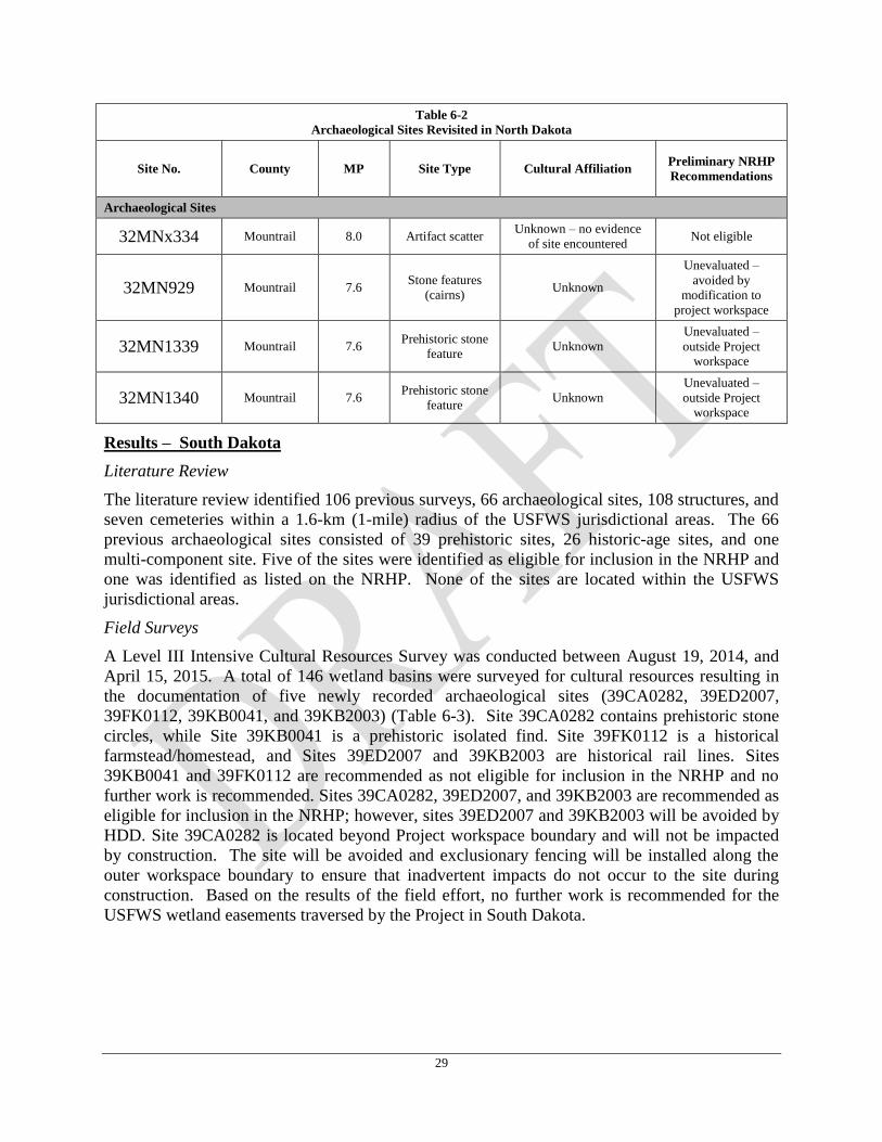
29
Table 6-2
Archaeological Sites Revisited in North Dakota
Site No. County MP Site Type Cultural Affiliation Preliminary NRHP
Recommendations
Archaeological Sites
32MNx334 Mountrail 8.0 Artifact scatter Unknown – no evidence
of site encountered Not eligible
32MN929 Mountrail 7.6 Stone features
(cairns) Unknown
Unevaluated –
avoided by
modification to
project workspace
32MN1339 Mountrail 7.6 Prehistoric stone
feature Unknown
Unevaluated –
outside Project workspace
32MN1340 Mountrail 7.6 Prehistoric stone
feature Unknown
Unevaluated –
outside Project workspace
Results – South Dakota
Literature Review
The literature review identified 106 previous surveys, 66 archaeological sites, 108 structures, and
seven cemeteries within a 1.6-km (1-mile) radius of the USFWS jurisdictional areas. The 66
previous archaeological sites consisted of 39 prehistoric sites, 26 historic-age sites, and one
multi-component site. Five of the sites were identified as eligible for inclusion in the NRHP and
one was identified as listed on the NRHP. None of the sites are located within the USFWS
jurisdictional areas.
Field Surveys
A Level III Intensive Cultural Resources Survey was conducted between August 19, 2014, and
April 15, 2015. A total of 146 wetland basins were surveyed for cultural resources resulting in
the documentation of five newly recorded archaeological sites (39CA0282, 39ED2007,
39FK0112, 39KB0041, and 39KB2003) (Table 6-3). Site 39CA0282 contains prehistoric stone
circles, while Site 39KB0041 is a prehistoric isolated find. Site 39FK0112 is a historical
farmstead/homestead, and Sites 39ED2007 and 39KB2003 are historical rail lines. Sites
39KB0041 and 39FK0112 are recommended as not eligible for inclusion in the NRHP and no
further work is recommended. Sites 39CA0282, 39ED2007, and 39KB2003 are recommended as
eligible for inclusion in the NRHP; however, sites 39ED2007 and 39KB2003 will be avoided by
HDD. Site 39CA0282 is located beyond Project workspace boundary and will not be impacted
by construction. The site will be avoided and exclusionary fencing will be installed along the
outer workspace boundary to ensure that inadvertent impacts do not occur to the site during
construction. Based on the results of the field effort, no further work is recommended for the
USFWS wetland easements traversed by the Project in South Dakota.
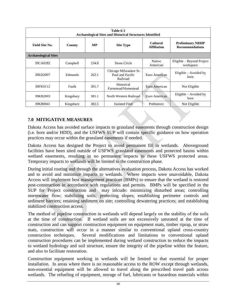
30
Table 6-3
Archaeological Sites and Historical Structures Identified
Field Site No. County MP Site Type Cultural
Affiliation
Preliminary NRHP
Recommendations
Archaeological Sites
39CA0282 Campbell 234.8 Stone Circle Native
American
Eligible – Beyond Project
workspace
39ED2007 Edmunds 262.1
Chicago Milwaukee St.
Paul and Pacific Railroad
Euro American Eligible – Avoided by
bore
39FK0112 Faulk 301.7 Historical
Farmstead/Homestead Euro American Not Eligible
39KB2003 Kingsbury 381.1 North Western Railroad Euro American Eligible – Avoided by
bore
39KB0041 Kingsbury 382.5 Isolated Find Prehistoric Not Eligible
7.0 MITIGATIVE MEASURES
Dakota Access has avoided surface impacts to grassland easements through construction design
(i.e. bore and/or HDD), and the USFWS SUP will contain specific guidance on how operation
practices may occur within the grassland easements if needed.
Dakota Access has designed the Project to avoid permanent fill in wetlands. Aboveground
facilities have been sited outside of USFWS grassland easements and protected basins within
wetland easements, resulting in no permanent impacts to these USFWS protected areas.
Temporary impacts to wetlands will be limited to the construction phase.
During initial routing and through the alternatives evaluation process, Dakota Access has worked
and to avoid and minimize impacts to wetlands. Where impacts were unavoidable, Dakota
Access will implement best management practices (BMPs) to ensure that the wetland is restored
post-construction in accordance with regulations and permits. BMPs will be specified in the
SUP for Project construction and may inlcude: minimizing disturbed areas; controlling
stormwater flow; stabilizing soils; protecting slopes; establishing perimeter controls and
sediment barriers; retaining sediment on site; controlling dewatering practices; and establishing
stabilized construction access.
The method of pipeline construction in wetlands will depend largely on the stability of the soils
at the time of construction. If wetland soils are not excessively saturated at the time of
construction and can support construction equipment on equipment mats, timber riprap, or straw
mats, construction will occur in a manner similar to conventional upland cross-country
construction techniques. Several modifications and limitations to conventional upland
construction procedures can be implemented during wetland construction to reduce the impacts
to wetland hydrology and soil structure, ensure the integrity of the pipeline within the feature,
and also to facilitate restoration.
Construction equipment working in wetlands will be limited to that essential for proper
installation. In areas where there is no reasonable access to the ROW except through wetlands,
non-essential equipment will be allowed to travel along the prescribed travel path across
wetlands. The refueling of equipment, storage of fuel, lubricants or hazardous materials within
31
100 feet of a wetland is not to be conducted unless no reasonable alternative exists and additional
containment measures are implemented. Additionally, the USFWS SUP will contain specific
guidance on refueling sites and how potential spills will be handled.
Erosion control devices such as silt fence and staked straw bales will be installed and maintained
as necessary to minimize the potential for sediment runoff into wetlands. Sediment barriers will
be installed across the full width of the construction ROW at the base of slopes adjacent to
wetland boundaries. Silt fence and/or straw bales installed across the working side of the ROW
may be removed during active construction but will be replaced after each pass or at the end of
the working day. In some cases a compacted earthen berm (drivable berms) may be suitable as a
sediment barrier adjacent to the wetland in lieu of removable sediment barriers. Compacted
earthen berms would be constructed in a manner that would allow vehicles and equipment to
cross the sediment barrier without damaging the berms effectiveness to minimized sediment
runoff. If an earthen berm is breached by the crossing of heavy equipment, the berm would be
repaired immediately or gaps would be closed by the installation of temporary sediment barriers
(i.e. silt fence and/or straw bales). Sediment barriers will also be installed within wetlands along
the edge of the ROW, where necessary, to minimize the potential for sediment to run off the
construction ROW and into wetland areas outside the work area. If trench dewatering is
necessary in wetlands, silt-laden trench water will be discharged into an energy
dissipation/sediment filtration device, such as a geotextile filter bag or straw bale structure, to
minimize the potential for erosion and sedimentation.
Where wetland soils are saturated and/or inundated, the pipeline may be installed using the push-
pull technique. The push-pull technique will involve stringing and welding the pipeline outside
of the wetland and excavating and backfilling the trench using a backhoe supported by
equipment mats or timber riprap. The prefabricated pipeline will be installed in the wetland by
equipping it with buoys and pushing or pulling it across the water-filled trench. After the
pipeline is floated into place, the floats will be removed and the pipeline will sink into place.
Most pipe installed in wetlands will be coated with concrete or equipped with set-on weights to
provide negative buoyancy. Additionally, trench plugs will be installed as needed at the entry
and exit points of the feature to facilitate restoration of the subsurface hydrology and prevent the
pipeline trench from inadvertently draining the feature.
Because little or no grading will occur in wetlands, restoration of contours will be accomplished
during backfilling. Prior to backfilling, trench plugs will be installed where necessary to prevent
subsurface drainage of water from wetlands. In areas where topsoil has been segregated from
subsoil, the subsoil will be backfilled first, followed by the topsoil. Construction in wetlands
under wet conditions may require use of equipment mats, timber riprap, gravel fill, geotextile
fabric, and/or straw mats which will be removed following backfilling.
Where wetlands are located at the base of slopes outside of cultivated fields, permanent slope
breakers will be constructed across the ROW in upland areas adjacent to the wetland boundary.
Temporary sediment barriers will be installed where necessary until revegetation of adjacent
upland areas is successful as defined within the USFWS SUP. Once revegetation is successful,
sediment barriers will be removed from the ROW and disposed of properly.
In order to mitigate the spread of any noxious weeds, Dakota Access will likely implement
BMPs and weed control practices during construction and operation. Mitigation measures may
include: treating known noxious weed infestations prior to ground disturbance, immediately
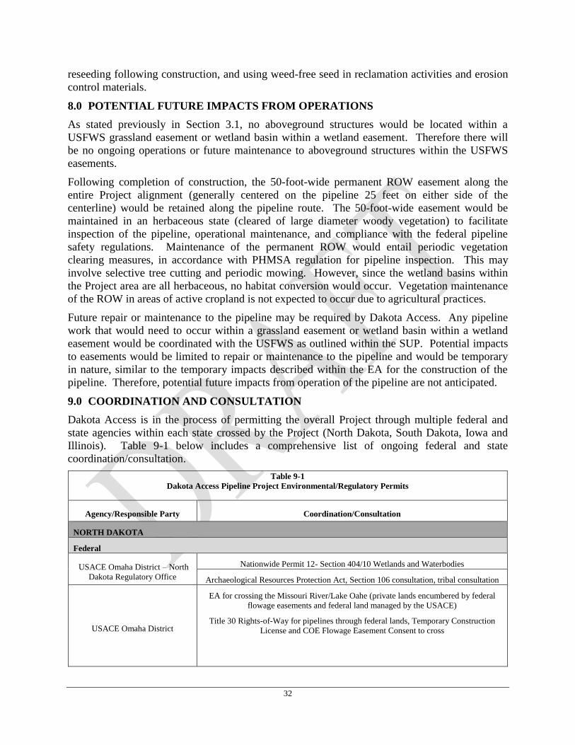
32
reseeding following construction, and using weed-free seed in reclamation activities and erosion
control materials.
8.0 POTENTIAL FUTURE IMPACTS FROM OPERATIONS
As stated previously in Section 3.1, no aboveground structures would be located within a
USFWS grassland easement or wetland basin within a wetland easement. Therefore there will
be no ongoing operations or future maintenance to aboveground structures within the USFWS
easements.
Following completion of construction, the 50-foot-wide permanent ROW easement along the
entire Project alignment (generally centered on the pipeline 25 feet on either side of the
centerline) would be retained along the pipeline route. The 50-foot-wide easement would be
maintained in an herbaceous state (cleared of large diameter woody vegetation) to facilitate
inspection of the pipeline, operational maintenance, and compliance with the federal pipeline
safety regulations. Maintenance of the permanent ROW would entail periodic vegetation
clearing measures, in accordance with PHMSA regulation for pipeline inspection. This may
involve selective tree cutting and periodic mowing. However, since the wetland basins within
the Project area are all herbaceous, no habitat conversion would occur. Vegetation maintenance
of the ROW in areas of active cropland is not expected to occur due to agricultural practices.
Future repair or maintenance to the pipeline may be required by Dakota Access. Any pipeline
work that would need to occur within a grassland easement or wetland basin within a wetland
easement would be coordinated with the USFWS as outlined within the SUP. Potential impacts
to easements would be limited to repair or maintenance to the pipeline and would be temporary
in nature, similar to the temporary impacts described within the EA for the construction of the
pipeline. Therefore, potential future impacts from operation of the pipeline are not anticipated.
9.0 COORDINATION AND CONSULTATION
Dakota Access is in the process of permitting the overall Project through multiple federal and
state agencies within each state crossed by the Project (North Dakota, South Dakota, Iowa and
Illinois). Table 9-1 below includes a comprehensive list of ongoing federal and state
coordination/consultation.
Table 9-1
Dakota Access Pipeline Project Environmental/Regulatory Permits
Agency/Responsible Party Coordination/Consultation
NORTH DAKOTA
Federal
USACE Omaha District – North
Dakota Regulatory Office
Nationwide Permit 12- Section 404/10 Wetlands and Waterbodies
Archaeological Resources Protection Act, Section 106 consultation, tribal consultation
USACE Omaha District
EA for crossing the Missouri River/Lake Oahe (private lands encumbered by federal
flowage easements and federal land managed by the USACE)
Title 30 Rights-of-Way for pipelines through federal lands, Temporary Construction
License and COE Flowage Easement Consent to cross
33
Table 9-1
Dakota Access Pipeline Project Environmental/Regulatory Permits
Agency/Responsible Party Coordination/Consultation
USFWS, North Dakota Ecological
Services Field Office and NWR
Endangered Species Act (ESA) Section 7 Consultations
EA for Wetland and Grassland Easement crossings – SUP for construction
NHPA Section 106 review and consultation for USFWS Easement crossings
U.S Bureau of Reclamation Letter of consent to cross irrigation works
State
North Dakota Public Service
Commission (PSC)
North Dakota Energy Conversion and Transmission Facility Siting Act: Certificate of
Corridor and Route
North Dakota Department of
Health, Division of Water Quality
National Pollutant Discharge Elimination System - Stormwater Construction General
Permit
National Pollutant Discharge Elimination System – General Permit for Discharges of
Hydrostatic Test Water, if into waters of the U.S.
§401 Individual Water Quality Certification
North Dakota State Water
Commission
Surface Water Withdrawal Permit
Sovereign Land Permit
State Historical Society of North
Dakota; SHPO
Inventory Permit required for State-owned lands (North Dakota Century Code [NDCC]
53-03) ; Section 106 of NHPA consultation/compliance
SOUTH DAKOTA
Federal
USACE, Omaha District – South
Dakota Regulatory Office Nationwide Permit 12- Section 404 Wetlands and Waterbodies
USFWS, South Dakota Ecological
Services Field Office and NWR
ESA Section 7 Consultation
EA for wetland and grassland easement crossings – SUP for construction
NHPA Section 106 review and consultation for USFWS easement crossings
State
South Dakota Public Utilities
Commission Energy Conversion and Transmission Facilities Act- Siting Permit
South Dakota Department of
Environment and Natural
Resources
National Pollutant Discharge Elimination System (NPDES) General Permit for
Discharges of Hydrostatic Test Water
Surface Water Withdrawal Permit
South Dakota State Historical
Society; SHPO
NHPA (Archeological and Historic Preservation Act), Section 106 consultation
34
Table 9-1
Dakota Access Pipeline Project Environmental/Regulatory Permits
Agency/Responsible Party Coordination/Consultation
IOWA
Federal
USACE, Rock Island District Nationwide Permit 12- Section 404/10 Wetlands and Waterbodies
USFWS, Rock Island Ecological
Services Field Office ESA Section 7 Consultation
State
Iowa Utilities Board Hazardous Liquid Pipeline Authorization
Iowa Department of Natural
Resources
Sovereign Lands Permits
Floodplain Permit
Protected species consultation
Temporary water withdrawal permit
Hydrostatic test discharge permit
Iowa (SHPO) NHPA, Section 106 consultation
ILLINOIS
Federal
USACE, Rock Island District Nationwide Permit 12- Section 404/10 Wetlands and Waterbodies
USACE, St. Louis District Nationwide Permit 12- Section 404/10 Wetlands and Waterbodies
EA for Section 408, Illinois River levees crossing and USACE Flowage Easements
USFWS, Rock Island Ecological
Services Field Office ESA Section 7 Consultation
State
Illinois Commerce Commission Certificate of Public Convenience and Necessity
Illinois Environmental Protection
Agency
NPDES Individual Permit for Discharges of Hydrostatic Test Water into waters of the
U.S.
Illinois Department of Natural
Resources State Listed Threatened and Endangered Species Consultation/Clearance
Illinois Historic Preservation
Agency (IHPA-Illinois SHPO)
Consultation and Inventory Permit required for State-owned lands (20 ILCS 3435/3);
Section 106 of NHPA consultation/compliance
As listed in Table 9-1 above, there are multiple federal actions occurring concurrently as a result
of the Project. The USACE-Omaha District is the lead federal agency for the USACE interests
in the Project, although all impacts to jurisdictional wetlands and waterbodies are also
coordinated through the respective local USACE offices.
In addition to the EA for the USFWS wetland and grassland easement SUP in North Dakota and
South Dakota, an EA for the USACE in North Dakota is currently out for public comment for the
crossing of private lands encumbered by federal flowage easements and land owned by the
federal government under the management by the USACE. Also, the Project crosses USACE
35
levees and flowage easements at the Illinois River within the St. Louis District; therefore an EA
is currently being drafted for these crossings. Section 106 consultations are occurring for each
USACE Project area included within the scope of the EAs, in addition to the federal and state
permitting processes (Table 9-1) as required. The Section 106 consultation process for USFWS
is described in detail below.
USFWS Section 106 Consultation 9.1
Consultation for purposes of Section 106 begins with a federal agency’s determination whether
the proposed Federal action is an undertaking as defined at 36 CFR Section 800.16(y), and if so,
whether it is the type of activity that has the potential to affect historic properties.
Undertaking means a project, activity, or program funded in whole or in part under the direct or
indirect jurisdiction of a Federal agency, including those carried out by or on behalf of a Federal
agency; those carried out with Federal financial assistance; and those requiring a Federal permit,
license or approval.
With regard to the Project, the proposed USFWS action that is subject to Section 106 review is
the issuance of a SUP allowing the Project to extend across USFWS grassland easements and
wetland basins – the areas for which rights were conveyed to the USFWS from landowners for
protective purpose.
The Advisory Council on Historic Preservation (ACHP) has provided guidance clarifying that
consultation regarding permitting, licensing and assistance actions can differ from federal
property management undertakings in terms of the limitations of a federal agency to control the
actions of applicants (ACHP, 2008). These consultation limitations pertain to a federal agency’s
ability to influence the applicant’s actions and decisions outside the agency’s permitting or
approval authorities. The federal agency can consult within the full meaning of Section 106
review for purposes of assessing the effects of issuing permits allowing the Project to cross
easements, but the agency is constrained by its limited jurisdiction and authority to assume
responsibility for considering effects of the Project on historic properties situated outside its
easements – those areas for which rights have not been conveyed to USFWS for protection of
wetlands or grasslands.
Therefore, USFWS’s obligations to conduct Section 106 consultation and to consider the effects
of the Project are substantially constrained to historic properties found within the jurisdictional
areas of the USFWS easements and to the extent that USFWS permits dictate the location of the
Project’s approaches to the ingress and immediately beyond the egress points of USFWS
easements. These areas, for all intents and purposes, constitute the Areas of Potential Effects
(APE) defined at Section 800.16(d) as: “…the geographic area or areas within which an
undertaking may directly or indirectly cause alterations in the character or use of historic
properties, if any such properties exist. The area of potential effects is influenced by the scale
and nature of an undertaking and may be different for different kinds of effects caused by the
undertaking.”
USFWS’s APEs are those segments of the Project that are under the direct jurisdiction of the
USFWS which as a consequence of its actions - the issuance of a SUP – may result in alterations
in the character or use of historic properties. Therefore, in the event a historic property is
identified within an USFWS jurisdictional area, the entirety of that resource shall be considered
whether within or beyond the USFWS’s jurisdictional limits.
36
Consistent with Section 106 of the NHPA, Dakota Access has initiated review with the USFWS
Regional Historic Preservation Officer (Region 6). The Class II/III draft report for North Dakota
and the Level III draft report for South Dakota were submitted to the regional USFWS
archaeologist on May 5, 2015 and May 6, 2015, respectfully. Revised cultural reports based on
USFWS comments were submitted to USFWS on October 27, 2015. In compliance with Section
106 consultation procedures, the USFWS is responsible for initiating formal consultation with
the respective SHPOs and tribal entities. The USFWS has initiated Section 106 consultation via
letter dated October 23, 2015 to 21 tribes. In addition, the USFWS has initiated consultation via
letter dated October 29, 2015 to the North Dakota and South Dakota SHPOs, the Advisory
Council on Historic Preservation, and the USACE. The following tribes were sent consultation
letters:
Assiniboine and Sioux Tribes Omaha Tribe of Nebraska
Crow Nation Santee Sioux Nation
Cheyenne River Sioux Tribe Sisseton-Wahpeton Oyate
Flandreau Santee Sioux Tribe Turtle Mountain Band of Chippewa
Crow Creek Sioux Tribe Spirit Lake Tribe
Lower Brule Sioux Tribe Winnebago Tribe
Lower Sioux Indian Community Standing Rock Sioux Tribe
Ponca Tribe of Nebraska Yankton Sioux Tribe
Northern Cheyenne Tribe Three Affiliated Tribes
Prairie Island Indian Community Oglala Sioux Tribe
Rosebud Sioux Tribe
Public Comments Considered 9.2
To be compiled following the conclusion of the public comment period.
37
REFERENCES
Bachman, J. 2014. North Dakota’s Downside to the Oil Boom: Traffic Deaths. Businessweek.
http://www.businessweek.com/articles/2014-06-09/north-dakotas-downside-to-the-oil-
boom-traffic-deaths.
Cornell Lab of Ornithology. 2014. All About Birds. http://www.allaboutbirds.org/guide/search.
Accessed November and December 2014 and June 2015.
Energy Transfer. 2014. Company Overview
http://www.energytransfer.com/company_overview.aspx. Accessed November 2014.
eBird. 2014. eBird Observation Maps. http://ebird.org/ebird/map/. Accessed November and
December 2014.
Esch, J. 2012. Animal Diversity Web: Grus Americana.
http://animaldiversity.org/accounts/Grus_americana/. Accessed February 2015.
Florip, E. 2014. Proposed Oil Terminal Would Be Biggest In Volume. The Columbian.
http://www.columbian.com/news/2014/nov/24/proposed-oil-terminal-biggest-volume-
vancouver/.
Fritelli, J. 2014. U.S. Rail Transportation of Crude Oil: Background and Issues for Congress.
Congressional Research Service. http://fas.org/sgp/crs/misc/R43390.pdf.
Horwath, B. and Owings, C. 2014. No Keystone XL Means More Oil By Rail, Report Says. Oil
Patch Dispatch. http://oilpatchdispatch.areavoices.com/2014/01/31/no-keystone-xl-means-
more-oil-by-rail-report-says/.
Javier, R. 2007. Animal Diversity Web: Anthus spragueii.
http://animaldiversity.ummz.umich.edu/accounts/Anthus_spragueii/. Accessed November
2014.
Kringstad, J. 2014. Energy Development and Transmission Committee. North Dakota Pipeline
Authority. https://ndpipelines.files.wordpress.com/2012/04/kringstad-edt-7-8-2014.pdf.
Minnesota Department of Natural Resources. 2015. Rare Species Guide: Dakota Skipper
(Hesperia dacotae).
http://www.dnr.state.mn.us/rsg/profile.html?action=elementDetail&selectedElement=IIL
EP65140. Accessed February 2015.
National Audubon Society. 2014. The Online Guide to North American Birds.
http://birds.audubon.org/birdid. Accessed November 2014.
National Park Service. 2015. Sleeping Bear Dunes: Nature & Science: Piping Plovers.
http://www.nps.gov/slbe/naturescience/pipingplover.htm. Accessed February 2015.
38
NatureServe. 2014. NatureServe Explorer. http://explorer.natureserve.org/. Accessed
December 2014.
Nixon, R. 2014. Grain Piles Up, Waiting For A Ride, As Trains Move North Dakota Oil. New
York Times. http://www.nytimes.com/2014/08/26/us/grain-piles-up-waiting-for-a-ride-as-
trains-move-north-dakota-oil.html.
North Dakota Natural Heritage Inventory. 2014. North Dakota Parks and Recreation
Department. Occurrence data within 2 miles of pipeline route. Received December
2014.
South Dakota Natural Heritage Program. 2014. South Dakota Game, Fish, and Parks, Wildlife
Diversity Program. Occurrence data within 2 miles of pipeline route. Received July
2014.
Texas Parks and Wildlife Department. 2015. Wildlife Fact Sheets: Piping Plover (Charadrius
melodus). https://tpwd.texas.gov/huntwild/wild/species/piplover/. Accessed February
2015.
Texas Parks and Wildlife Department. 2014. Whooping Cranes Beginning Their Fall Journey to
Texas. http://tpwd.texas.gov/newsmedia/releases/?req=20141008d. Accessed February
2015.
The Xerces Society for Invertebrate Conservation. 2015. Skippers: Dakota Skipper (Hesperia
dacotae). http://www.xerces.org/dakota-skipper/. Accessed February 2015.
U.S. Army Corps of Engineers. 2010. Regional Supplements to Corps Delineation Manual.
Great Plains Supplement and Mid-West Supplement.
U.S. Department of Transportation. 2014. Pocket Guide to Large Truck and Bus Statistics.
Federal Motor Carrier Safety Administration.
http://www.fmcsa.dot.gov/sites/fmcsa.dot.gov/files/docs/FMCSA%20Pocket%20Guide%
20to%20Large%20Truck%20and%20Bus%20Statistics%20-%202014%20-
%20508C.pdf.
U.S. Department of Transportation. 2015. Transportation Accidents by Mode. Office of the
Assistant Secretary for Research and Technology.
http://www.rita.dot.gov/bts/sites/rita.dot.gov.bts/files/publications/national_transportation
_statistics/html/table_02_03.html.
U.S. Fish and Wildlife Service. 2015a. Environmental Conservation Online System: Species
Profile for Whooping Crane (Grus americana).
http://ecos.fws.gov/speciesProfile/profile/speciesProfile.action?spcode=B003. Accessed
February 2015.
U.S. Fish and Wildlife Service. 2015b. Endangered Species: Dakota skipper (Hesperia
dacotae). http://www.fws.gov/midwest/Endangered/insects/dask/index.html. Accessed
February 2015.
39
U.S. Fish and Wildlife Service. 2014a. U.S. Fish and Wildlife Service Species Assessment and
Listing Priority Assignment Form.
http://ecos.fws.gov/docs/candidate/assessments/2014/r6/B0GD_V01.pdf. Accessed
November 2015.
U.S. Fish and Wildlife Service. 2014b. Dakota Skipper (Hesperia dacotae) Fact Sheet.
https://www.fws.gov/midwest/endangered/insects/dask/daskFactSheet.html. Accessed
February 2015.
U.S. Fish and Wildlife Service. 2014c. Federal Register: Endangered and Threatened Wildlife
and Plants; Threatened Species Status for Dakota Skipper and Endangered Species Status
for Poweshiek Skipperling, Final rule.
http://www.fws.gov/midwest/Endangered/insects/dask/pdf/FRButterflyFinalListing24Oct
2014.pdf. Accessed February 2015.
U.S. Fish and Wildlife Service. 2013. South Dakota Field Office: Piping Plover Charadrius
melodus. http://www.fws.gov/southdakotafieldoffice/PLOVER.HTM. Accessed
February 2015.
U.S. Fish and Wildlife Service. 2012a. Whooping Crane (Grus americana) 5-Year Review:
Summary and Evaluation. http://ecos.fws.gov/docs/five_year_review/doc3977.pdf.
Accessed February 2015.
U.S. Fish and Wildlife Service. 2012b. Endangered Species: Piping Plover.
http://www.fws.gov/mountain-prairie/species/birds/pipingplover/. Accessed February
2015.
U.S. Fish and Wildlife Service. 2010. Sprague’s Pipit (Anthus spragueii) Conservation Plan.
http://www.fws.gov/mountain-prairie/species/birds/spraguespipit/SpraguesJS2010r4.pdf.
Accessed June 2015.
U.S. Fish and Wildlife Service. 2009. Piping Plover (Charadrius melodus) 5-Year Review:
Summary and Evaluation.
http://www.fws.gov/northeast/endangered/pdf/piping_plover_five_year_review_and_sum
mary.pdf. Accessed February 2015.
U.S. Fish and Wildlife Service. 2001. Piping Plover Fact Sheet.
http://www.fws.gov/midwest/endangered/pipingplover/pipingpl.html. Accessed
February 2015.
U.S. Geological Survey. 2014. Northern Prairie Wildlife Research Center.
http://www.npwrc.usgs.gov/resource/wildlife/nddanger/species/platprae.htm. Accessed
December 2014.
U.S. Geological Survey. 2013. Northern Prairie Wildlife Research Center: Dakota Skipper

40
Butterfly (Hesperia dacotae).
http://www.npwrc.usgs.gov/resource/wildlife/nddanger/species/hespdaco.htm. Accessed
February 2015.