daniels run stream restoration, fairfax, … stream... · daniels run stream restoration, fairfax,...
TRANSCRIPT
DANIELS RUN STREAM RESTORATION, FAIRFAX, VIRGINIA: FLOODPLAIN ANALYSIS REPORT
By: Conor C. Shea
Stream Habitat Assessment and Restoration Program U.S. Fish and Wildlife Service Chesapeake Bay Field Office CBFO-S07-01
Prepared in cooperation with: Army-Navy Country Club, Fairfax, Virginia
Annapolis, MD March 2007
Daniels Run Stream Restoration: Floodplain Analysis Report
TABLE OF CONTENTS
I. PURPOSE .......................................................................................................................................... 1
II. PREVIOUS STUDIES ...................................................................................................................... 1
III. HYDROLOGY .................................................................................................................................. 1
IV. HDYRAULIC ANALYSIS ............................................................................................................... 3
A. Model Development......................................................................................................................... 3
B. Model Results .................................................................................................................................. 3
V. CONCLUSIONS ............................................................................................................................... 4
REFERENCE
APPENDIX A: WATER SURFACE PROFILES
U. S. Fish and Wildlife Service March 2007 Chesapeake Bay Field Office Page ii of ii
Daniels Run Stream Restoration: Floodplain Analysis Report
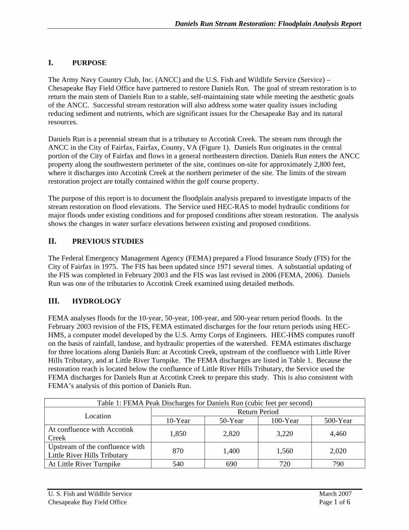
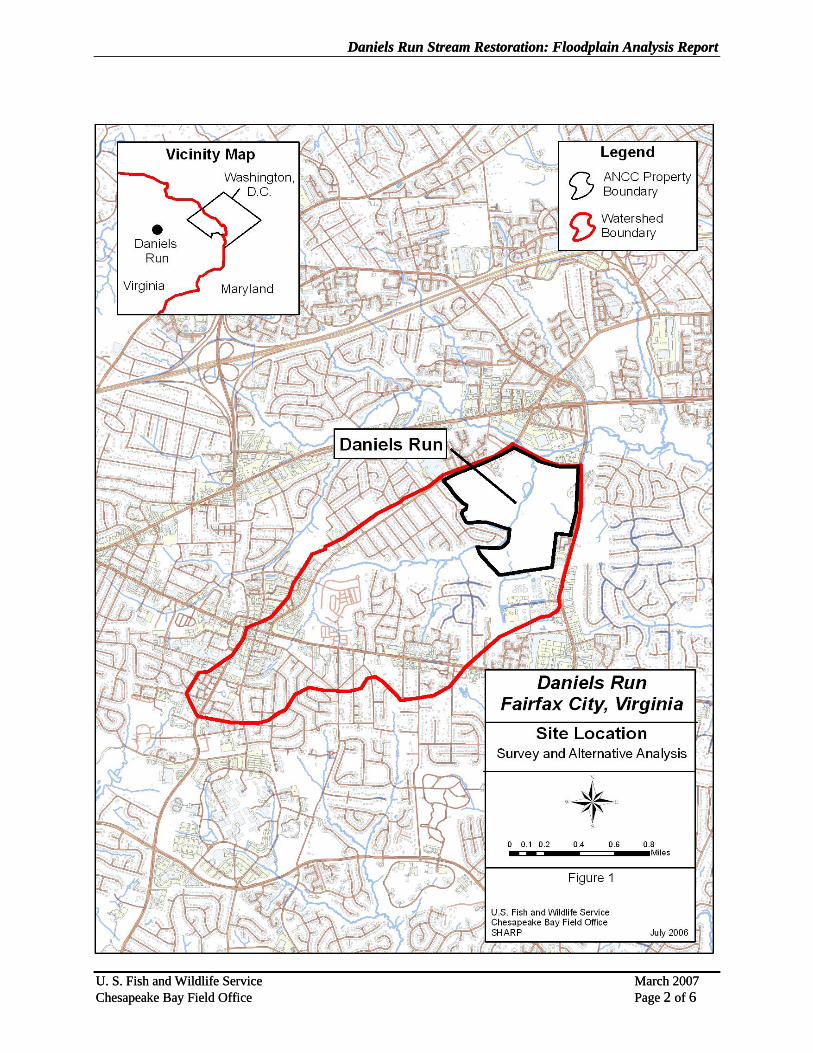
I. PURPOSE The Army Navy Country Club, Inc. (ANCC) and the U.S. Fish and Wildlife Service (Service) – Chesapeake Bay Field Office have partnered to restore Daniels Run. The goal of stream restoration is to return the main stem of Daniels Run to a stable, self-maintaining state while meeting the aesthetic goals of the ANCC. Successful stream restoration will also address some water quality issues including reducing sediment and nutrients, which are significant issues for the Chesapeake Bay and its natural resources. Daniels Run is a perennial stream that is a tributary to Accotink Creek. The stream runs through the ANCC in the City of Fairfax, Fairfax, County, VA (Figure 1). Daniels Run originates in the central portion of the City of Fairfax and flows in a general northeastern direction. Daniels Run enters the ANCC property along the southwestern perimeter of the site, continues on-site for approximately 2,800 feet, where it discharges into Accotink Creek at the northern perimeter of the site. The limits of the stream restoration project are totally contained within the golf course property. The purpose of this report is to document the floodplain analysis prepared to investigate impacts of the stream restoration on flood elevations. The Service used HEC-RAS to model hydraulic conditions for major floods under existing conditions and for proposed conditions after stream restoration. The analysis shows the changes in water surface elevations between existing and proposed conditions. II. PREVIOUS STUDIES The Federal Emergency Management Agency (FEMA) prepared a Flood Insurance Study (FIS) for the City of Fairfax in 1975. The FIS has been updated since 1971 several times. A substantial updating of the FIS was completed in February 2003 and the FIS was last revised in 2006 (FEMA, 2006). Daniels Run was one of the tributaries to Accotink Creek examined using detailed methods. III. HYDROLOGY FEMA analyses floods for the 10-year, 50-year, 100-year, and 500-year return period floods. In the February 2003 revision of the FIS, FEMA estimated discharges for the four return periods using HEC-HMS, a computer model developed by the U.S. Army Corps of Engineers. HEC-HMS computes runoff on the basis of rainfall, landuse, and hydraulic properties of the watershed. FEMA estimates discharge for three locations along Daniels Run: at Accotink Creek, upstream of the confluence with Little River Hills Tributary, and at Little River Turnpike. The FEMA discharges are listed in Table 1. Because the restoration reach is located below the confluence of Little River Hills Tributary, the Service used the FEMA discharges for Daniels Run at Accotink Creek to prepare this study. This is also consistent with FEMA’s analysis of this portion of Daniels Run.
Table 1: FEMA Peak Discharges for Daniels Run (cubic feet per second) Return Period Location 10-Year 50-Year 100-Year 500-Year
At confluence with Accotink Creek 1,850 2,820 3,220 4,460
Upstream of the confluence with Little River Hills Tributary 870 1,400 1,560 2,020
At Little River Turnpike 540 690 720 790
U. S. Fish and Wildlife Service March 2007 Chesapeake Bay Field Office Page 1 of 6
Daniels Run Stream Restoration: Floodplain Analysis Report Daniels Run Stream Restoration: Floodplain Analysis Report
U. S. Fish and Wildlife Service March 2007 Chesapeake Bay Field Office Page 2 of 6
U. S. Fish and Wildlife Service March 2007 Chesapeake Bay Field Office Page 2 of 6
Daniels Run Stream Restoration: Floodplain Analysis Report
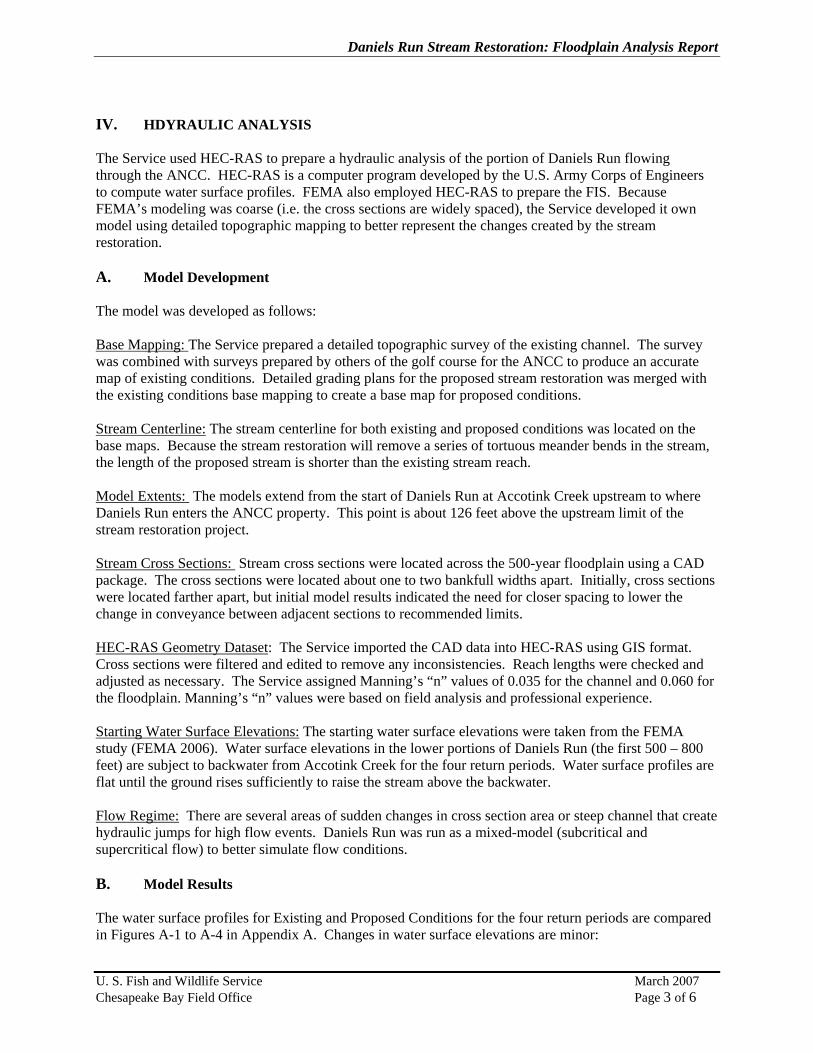
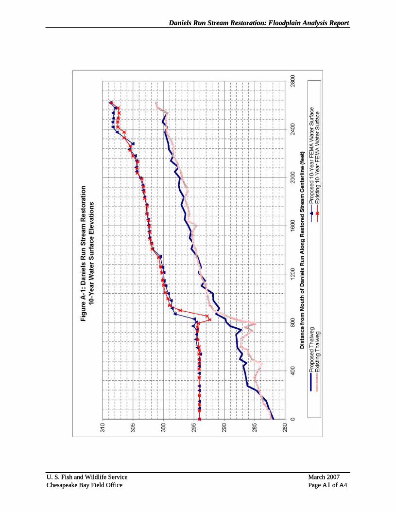
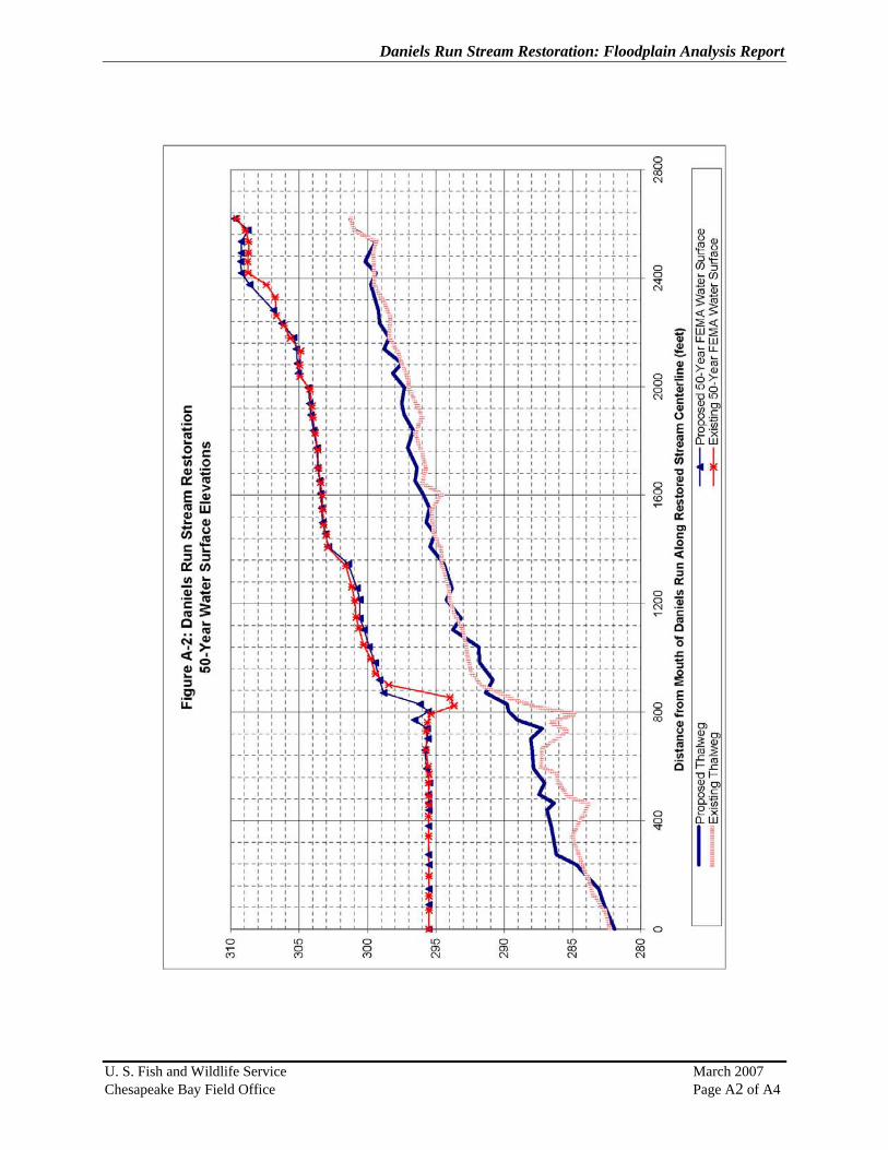
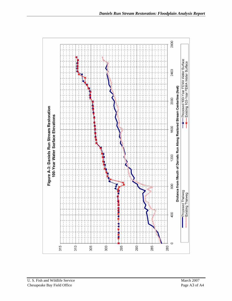
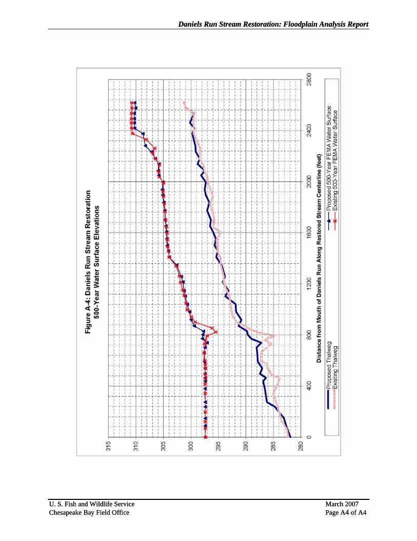
IV. HDYRAULIC ANALYSIS The Service used HEC-RAS to prepare a hydraulic analysis of the portion of Daniels Run flowing through the ANCC. HEC-RAS is a computer program developed by the U.S. Army Corps of Engineers to compute water surface profiles. FEMA also employed HEC-RAS to prepare the FIS. Because FEMA’s modeling was coarse (i.e. the cross sections are widely spaced), the Service developed it own model using detailed topographic mapping to better represent the changes created by the stream restoration. A. Model Development The model was developed as follows: Base Mapping: The Service prepared a detailed topographic survey of the existing channel. The survey was combined with surveys prepared by others of the golf course for the ANCC to produce an accurate map of existing conditions. Detailed grading plans for the proposed stream restoration was merged with the existing conditions base mapping to create a base map for proposed conditions. Stream Centerline: The stream centerline for both existing and proposed conditions was located on the base maps. Because the stream restoration will remove a series of tortuous meander bends in the stream, the length of the proposed stream is shorter than the existing stream reach. Model Extents: The models extend from the start of Daniels Run at Accotink Creek upstream to where Daniels Run enters the ANCC property. This point is about 126 feet above the upstream limit of the stream restoration project. Stream Cross Sections: Stream cross sections were located across the 500-year floodplain using a CAD package. The cross sections were located about one to two bankfull widths apart. Initially, cross sections were located farther apart, but initial model results indicated the need for closer spacing to lower the change in conveyance between adjacent sections to recommended limits. HEC-RAS Geometry Dataset: The Service imported the CAD data into HEC-RAS using GIS format. Cross sections were filtered and edited to remove any inconsistencies. Reach lengths were checked and adjusted as necessary. The Service assigned Manning’s “n” values of 0.035 for the channel and 0.060 for the floodplain. Manning’s “n” values were based on field analysis and professional experience. Starting Water Surface Elevations: The starting water surface elevations were taken from the FEMA study (FEMA 2006). Water surface elevations in the lower portions of Daniels Run (the first 500 – 800 feet) are subject to backwater from Accotink Creek for the four return periods. Water surface profiles are flat until the ground rises sufficiently to raise the stream above the backwater. Flow Regime: There are several areas of sudden changes in cross section area or steep channel that create hydraulic jumps for high flow events. Daniels Run was run as a mixed-model (subcritical and supercritical flow) to better simulate flow conditions. B. Model Results The water surface profiles for Existing and Proposed Conditions for the four return periods are compared in Figures A-1 to A-4 in Appendix A. Changes in water surface elevations are minor:
U. S. Fish and Wildlife Service March 2007 Chesapeake Bay Field Office Page 3 of 6
Daniels Run Stream Restoration: Floodplain Analysis Report
• Generally, water surface elevations are similar under Existing and Proposed conditions because
the stream restoration is modifying the bankfull channel. Under the FEMA discharges (i.e., major floods), the topography of the floodplain controls water surface elevations along Daniels Run. The stream restoration plans do not call for large scale changes in the floodplain, so water surface elevations are similar.
• Water surface elevations for the 100-year and 500-year return period are lower at the upstream end of the project area. There are small increases of less than 0.2 feet for the 10-year and 50-year return period.
• There is one location (i.e., station 8+00) on the longitudinal profile (Appendix A) where the water surface elevation increases more than one foot for the 100-year return period. There is a scour hole at this location and this section of stream channel is entrenched under existing conditions. However, under proposed conditions, a series of step-pools will replace the scour hole and the channel elevation will be raise to restore the stream to its historic floodplain. The water surface increase occurs over a limited distance and the water surface elevation decreases under proposed conditions upstream of the scour hole.
V. CONCLUSIONS The restoration of Daniels Run will create only minor changes in water surface elevation for major floods (i.e. FEMA 10-year, 50-year, 100-year, and 500-year discharges). Changes for the 100-year discharge are local in nature and do not extend off-site.
U. S. Fish and Wildlife Service March 2007 Chesapeake Bay Field Office Page 4 of 6

Daniels Run Stream Restoration: Floodplain Analysis Report
REFERENCES
FEMA (2006). Flood Insurance Study, City of Fairfax, Independent City, Flood Insurance Study Number 515524V000B, Revised June 2, 2006.
U. S. Fish and Wildlife Service March 2007 Chesapeake Bay Field Office
Daniels Run Stream Restoration: Floodplain Analysis Report
APPENDIX A: WATER SURFACE PROFILES
U. S. Fish and Wildlife Service March 2007 Chesapeake Bay Field Office
Daniels Run Stream Restoration: Floodplain Analysis Report Daniels Run Stream Restoration: Floodplain Analysis Report
U. S. Fish and Wildlife Service March 2007 Chesapeake Bay Field Office Page A1 of A4 U. S. Fish and Wildlife Service March 2007 Chesapeake Bay Field Office Page A1 of A4
Daniels Run Stream Restoration: Floodplain Analysis Report
U. S. Fish and Wildlife Service March 2007 Chesapeake Bay Field Office Page A2 of A4
Daniels Run Stream Restoration: Floodplain Analysis Report
U. S. Fish and Wildlife Service March 2007 Chesapeake Bay Field Office Page A3 of A4
Daniels Run Stream Restoration: Floodplain Analysis Report Daniels Run Stream Restoration: Floodplain Analysis Report
U. S. Fish and Wildlife Service March 2007 Chesapeake Bay Field Office Page A4 of A4
U. S. Fish and Wildlife Service March 2007 Chesapeake Bay Field Office Page A4 of A4